addendum - california · state of california -- the natural resources agency edmund g. brown, jr.,...
TRANSCRIPT

STATE OF CALIFORNIA -- THE NATURAL RESOURCES AGENCY EDMUND G. BROWN, JR., Governor
CALIFORNIA COASTAL COMMISSION SAN DIEGO AREA
7575 METROPOLITAN DRIVE, SUITE 103
SAN DIEGO, CA 92108-4402
(619) 767-2370
W11a
Addendum May 10, 2016 To: Commissioners and Interested Persons From: California Coastal Commission San Diego Staff Subject: Addendum to Item W11a, City of Carlsbad LCP Amendment Request No.
LCP-6-CAR-15-0034-2 (General Plan Update/LCP Map Revisions), for the Commission Meeting of May 11, 2016
________________________________________________________________________ Staff recommends the following changes be made to the above-referenced staff report.
1. Add to Exhibit No. 8 – Public Correspondence received since publication of the May
6, 2016 addendum to the staff report.
(G:\San Diego\Reports\LCPs\Carlsbad\LCP-6-CAR-15-0034-2 (General Plan Update/LCP Map Revisions) Addendum2.docx)


STATE OF CALIFORNIA -- THE NATURAL RESOURCES AGENCY EDMUND G. BROWN, JR., Governor
CALIFORNIA COASTAL COMMISSION SAN DIEGO AREA
7575 METROPOLITAN DRIVE, SUITE 103
SAN DIEGO, CA 92108-4402
(619) 767-2370
W11a
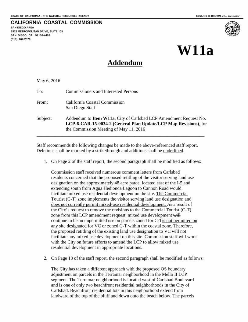
Addendum May 6, 2016 To: Commissioners and Interested Persons From: California Coastal Commission San Diego Staff Subject: Addendum to Item W11a, City of Carlsbad LCP Amendment Request No.
LCP-6-CAR-15-0034-2 (General Plan Update/LCP Map Revisions), for the Commission Meeting of May 11, 2016
________________________________________________________________________ Staff recommends the following changes be made to the above-referenced staff report. Deletions shall be marked by a strikethrough and additions shall be underlined.
1. On Page 2 of the staff report, the second paragraph shall be modified as follows: Commission staff received numerous comment letters from Carlsbad residents concerned that the proposed retitling of the visitor serving land use designation on the approximately 48 acre parcel located east of the I-5 and extending south from Agua Hedionda Lagoon to Cannon Road would facilitate mixed use residential development on the site. The Commercial Tourist (C-T) zone implements the visitor serving land use designation and does not currently permit mixed-use residential development. As a result of the City’s request to remove the revisions to the Commercial Tourist (C-T) zone from this LCP amendment request, mixed use development will continue to be an unpermitted use on parcels zoned for C-Tis not permitted on any site designated for VC or zoned C-T within the coastal zone. Therefore, the proposed retitling of the existing land use designation to VC will not facilitate any mixed use development on this site. Commission staff will work with the City on future efforts to amend the LCP to allow mixed use residential development in appropriate locations.
2. On Page 13 of the staff report, the second paragraph shall be modified as follows:
The City has taken a different approach with the proposed OS boundary adjustment on parcels in the Terramar neighborhood in the Mello II LCP segment. The Terramar neighborhood is located west of Carlsbad Boulevard and is one of only two beachfront residential neighborhoods in the City of Carlsbad. Beachfront residential lots in this neighborhood extend from landward of the top of the bluff and down onto the beach below. The parcels

Addendum to LCP-6-CAR-15-0034-2 (General Plan Update/LCP Map Revisions) Page 2
in the Terramar neighborhood are currently designated for both Residential Low Medium density (RLM) and Open Space (OS). The City has historically described the existing inland boundary of the open space designation on these lots as drawn through existing residences on the top of the bluff and extending from the bluff edge to the seaward parcel boundary, while the residential land use designation applies to the portion of the parcels on top of the bluff and extending to the street. Commission staff reports have historically described the delineation as the bluff edge. After consultation with property owners in this neighborhood, the City proposes to shift the OS boundary on the LCP Land Use Map down the bluff face to a line generally in alignment with existing shoreline protection devices that front the residential development along this stretch of coastline. This approach is different from the City’s efforts elsewhere to adjust open space boundaries to more accurately reflect topographic and natural features.
3. On Page 14 of the staff report, the second paragraph shall be modified as follows:
The City proposes to redesignate several parcels as Visitor Commercial (VC) that are currently designated for non-visitor serving uses and that do not currently contain any visitor serving uses onsite. The City proposes to redesignate the Encina Power Station and SDG&E service center parcels from Public Utilities (U) to a combination of Visitor Commercial (VC) and Open Space (OS) (APNs 210-010-46 and 210-010-40). These parcels extend from the south shore of Agua Hedionda Lagoon to Cannon Road between the rail corridor and Carlsbad Boulevard. The power plant is scheduled to be decommissioned in 2017, and after it is demolished the site will eventually be redeveloped by the City. Although the City is eliminating combination designations elsewhere in the coastal zone, it is proposing a combination of Visitor Commercial (VC) and Open Space (OS) on these parcels to guide future redevelopment plans. The City indicates that any future redevelopment of these parcels would be subject to a comprehensive planning process to identify development standards and the appropriate mix, type, and location of visitor serving and open space uses here.
4. Add Exhibit No. 9 – Letter of Support from the City of Carlsbad
5. Add to Exhibit No. 8 – Public Correspondence received since publication of the staff
report. All five letters object to the City’s rezoning of the Encina Power Station and SDG&E service center parcels from Public Utilities (PU) to Commercial Tourist (C-T)/Open Space (OS) zones (APNs 210-010-46 and 210-010-40). These parcels are located within the Agua Hedionda Lagoon LCP segment, which is an area of deferred certification. As explained in Part V.B.6 on pages 27-28 of the staff report, because there is no implementation plan for this area, the Commission cannot certify any zoning changes in this location.
(G:\San Diego\Reports\LCPs\Carlsbad\LCP-6-CAR-15-0034-2 (General Plan Update/LCP Map Revisions) Addendum.docx)

May 5, 2016 California Coastal Commission San Diego Coast District Office 7575 Metropolitan Drive, Suite 103 San Diego, CA 92108 SUBJECT: ITEM W11a - LCP AMENDMENT NO. LCP-6-CAR-15-0034-2 – CARLSBAD GENERAL PLAN
UPDATE/LCP MAP REVISIONS Dear Commissioners: The City of Carlsbad supports your staff's recommendation on the above referenced LCP amendment application and the city respectfully requests your approval of the amendment as recommended. Below is information in response to comments your staff received from Carlsbad residents expressing their concerns about: A) the proposed zoning change on the power plant site from Public Utility (PU) to Commercial Tourist/Open Space (CT/OS); and B) the proposed revisions to the city's Tourist Recreation Commercial (TR) land use designation and Commercial Tourist (CT) zone. A. Zone change on power plant site
This LCP amendment includes a proposal to change the land use designation on the power plant site (east of Carlsbad Boulevard and north of Cannon Road) from Utility (U) to Visitor Commercial/Open Space (VC/OS), and to change the zoning from Public Utility (PU) to Commercial Tourist/Open Space (CT/OS). Carlsbad residents submitted letters to the Coastal Commission expressing the preference to zone the power plant site as Open Space (OS) rather than the proposed Commercial Tourist (CT) zone. In January 2014, the City of Carlsbad and Carlsbad Municipal Water District, Cabrillo Power I LLC and Carlsbad Energy Center LLC, and San Diego Gas and Electric Company entered into an agreement that requires the existing power plant (excluding the desalination plant) to be decommissioned and demolished. Through the city’s General Plan update process, which involved extensive community outreach and input, the community identified that the preferred future use of the site is visitor commercial and open space. The proposed LCP amendment will designate the site with land use and zoning designations (VC/OS land use and CT/OS zoning) that are consistent with the community’s envisioned future use of the site. The proposed land use and zoning designations are also consistent with priority land uses identified by the Coastal Act. In addition to the proposed land use and zoning designations, the city’s new General Plan includes policies that:

LCP-6-CAR-15-0034-2 – CARLSBAD GENERAL PLAN UPDATE/LCP MAP REVISIONS May 5, 2016 Page 2
Require the power plant to be decommissioned and demolished pursuant to the agreement mentioned above.
Require that the desalination plant remain on the site (this area of the site is proposed to be designated for “Public (P)” land use).
Require the site to be redeveloped with a mix of visitor-serving commercial uses and community-accessible open spaces along Agua Hedionda Lagoon and Carlsbad Boulevard (encouraging community gathering spaces, outdoor dining, and other features to maximize potential views of the ocean and the lagoon).
Require a comprehensive planning process (e.g. specific plan or master plan) to determine specific uses, development standards, infrastructure, public improvements, site planning and amenities.
Require the city to work with SDG&E to identify a mutually acceptable alternative location for SDG&E’s north coast service center and an alternative site for the Encina substation.
The power plant site is located within the Agua Hedionda segment of the city’s LCP, and there currently is no certified implementation plan for this segment. Therefore, as recommended by the commission’s staff, the proposed zone change on the power plant site has been removed from this LCP amendment and will be deferred and incorporated with the city’s comprehensive LCP update (currently in process). For this LCP amendment, commission staff recommends that the commission approve the proposed land use designation (VC/OS). Until the Coastal Commission certifies an implementation plan for this segment of the city’s LCP, any future coastal development permit proposal on this site will be reviewed by the Coastal Commission and will be subject to the approved land use designation; the city’s zoning (CT/OS) will be referred to as a guide in the commission’s consideration of the coastal development permit.
B. Revisions to Tourist Recreation Commercial (TR) land use designation and Commercial Tourist (CT)
zone
Land use designation title change
The title “Travel Recreation Commercial (TR)” is proposed to be replaced with “Visitor Commercial (VC)”. The title change does not change the primary intent of the land use designation. In fact, the new “Visitor Commercial (VC)” title is intended to be more intuitive and user-friendly by more directly describing the intended land use of the designation. The title change also more directly reflects the expressed Coastal Act land use priority, and more clearly represents how the designation is different than the city’s other commercial land use designations (Local Shopping Center (L), General Commercial (GC), and Regional Commercial (R)). Whether the designation is titled TR or VC, the primary difference when compared to the other commercial designations is the focus on visitor-serving commercial and recreation uses.
Proposal to allow residential as mixed use in the CT zone
As part of the city's General Plan update (approved in September 2015), changes were made to the General Plan description of typical land uses allowed in the VC land use designation. The changes added the ability to include residential uses in combination with a visitor commercial development, provided the primary use of the property is visitor-serving. To implement this provision of the General Plan, the city proposes to add residential mixed use as a permitted use in the CT zone. While the General Plan is not part of the city's LCP, and not the subject of this proposed LCP amendment, the CT zone is part of the city's LCP implementation plan and the


STATE OF CALIFORNIA -- THE NATURAL RESOURCES AGENCY EDMUND G. BROWN, JR., Governor
CALIFORNIA COASTAL COMMISSION SAN DIEGO AREA
7575 METROPOLITAN DRIVE, SUITE 103
SAN DIEGO, CA 92108-4421
(619) 767-2370
W11a April 29, 2016 TO: COMMISSIONERS AND INTERESTED PERSONS FROM: SHERILYN SARB, DEPUTY DIRECTOR, SD COAST DISTRICT GABRIEL BUHR, COASTAL PROGRAM MANAGER, SD COAST DISTRICT ERIN PRAHLER, COASTAL PROGRAM ANALYST, SD COAST DISTRICT SUBJECT: STAFF RECOMMENDATION ON CITY OF CARLSBAD LCP AMENDMENT
NO. LCP-6-CAR-15-0034-2 (General Plan Update/LCP Map Revisions) for Commission Meeting of May 11-13, 2016
SYNOPSIS The City of Carlsbad’s Local Coastal Program (LCP) land use and implementation plan amendment LCP-6-CAR-15-0043-2 was submitted on November 9, 2015 and filed as complete on December 14, 2015. The Commission granted a one-year extension on March 9, 2016; therefore, the Commission must act on this amendment request no later than the March 2017 hearing. This report addresses the entire submittal. SUMMARY OF AMENDMENT REQUEST LCP Amendment request no. LCP-6-CAR-15-0034-2 involves revisions to both the Land Use Plan (LUP) and Implementation Plan (IP) components of the certified LCP. The City recently updated its General Plan and now proposes numerous land use and zoning map revisions to make the LCP Land Use and Zoning Maps consistent with land use and zoning designations completed as part of this Citywide update. These proposed designation changes are intended to: better reflect existing development on the ground; remove combination designations in most of the coastal zone; retitle the residential land use designations; retitle and streamline the number of visitor serving commercial and public land use designations; adjust the boundaries of existing open space designations; designate parcels as open space that are already mapped as hardline habitat in the City’s Habitat Management Plan or that have existing open space or conservation restrictions; increase the net acreage of property designated for open space and for visitor serving commercial use; and increase the density and amount of land designated for residential uses. Finally, the City proposes to make text revisions to several Zoning Code sections to eliminate references to the Regional Housing Needs Assessment (RHNA) base density requirement; reduce the minimum density of mixed-use developments within the Neighborhood Commercial (C-1), General Commercial (C-2) and Local Shopping Center (C-L) zones from 20 dwelling units per acre to 15 dwelling units per acre; and allow professional care facilities in the Office (O) zone with a conditional use permit.

LCP-6-CAR-15-0034-2 (General Plan Update/LCP Map Revisions)
Page 2 As originally submitted, the City’s amendment request also included land use and zoning designation changes for the Marja Acres site (an over 20 acre site with historic agricultural operations located east of Agua Hedionda Lagoon), zoning changes for all six areas of deferred certification that remain within the City’s Coastal Zone, and revisions to the Commercial Tourist (C-T) zone to allow mixed use residential development. After several months of coordination, the City agreed to remove these items from this amendment request, acknowledging that these items required more substantive review beyond the mapping update changes that are the focus of this subject LCP amendment submittal (Exhibit 1). Commission and City staff will continue to work on these items as part of future LCP amendment requests. The City is in agreement with Commission staff’s recommendation on this amendment request, as modified. Commission staff received numerous comment letters from Carlsbad residents concerned that the proposed retitling of the visitor serving land use designation on the approximately 48 acre parcel located east of the I-5 and extending south from Agua Hedionda Lagoon to Cannon Road would facilitate mixed use residential development on the site. As a result of the City’s request to remove the revisions to the Commercial Tourist (C-T) zone from this LCP amendment request, mixed use development will continue to be an unpermitted use on parcels zoned for C-T. Therefore, the proposed retitling of the existing land use designation to VC will not facilitate any mixed use development on this site. Commission staff will work with the City on future efforts to amend the LCP to allow mixed use residential development in appropriate locations. SUMMARY OF STAFF RECOMMENDATION Staff is recommending denial of the land use plan and implementation plan amendment as submitted, and instead recommends approval of the LCP amendment with seven suggested modifications. Staff recommends the Commission find the majority of the proposed land use designation and zoning changes and the proposed text revisions to the Neighborhood Commercial (C-1), General Commercial (C-2), Local Shopping Center (C-L) and Office (O) zones consistent with Chapter 3 and the certified LUPs. However, staff recommends suggested modifications that would require the City to designate two hotels with the Visitor Commercial (VC) land use and the Commercial Tourist (C-T) zone, revise the LCP Zoning Map to correct two mapping errors, and add map notes on the LCP Land Use and Zoning Maps related to the Open Space (OS) land use designation and zoning in the Terramar neighborhood and to clarify that zoning shown within the six areas of deferred certification are not certified by the Commission and that the Commission continues to retain permitting jurisdiction in these areas. The appropriate resolutions and motions begin on page 5. ADDITIONAL INFORMATION Further information on the City of Carlsbad’s LCP amendment no. LCP-6-CAR-15-0034-2 may be obtained from Erin Prahler, Coastal Planner, at (619) 767-2370.

LCP-6-CAR-15-0034-2 (General Plan Update/LCP Map Revisions)
Page 3 EXHIBITS Exhibit 1 – Letter from City of Carlsbad Planning Director, Don Neu, to Coastal
Commission Staff, dated April 27, 2016 Exhibit 2 – Resolution Exhibit 3 – Ordinance Exhibit 4 – Proposed Land Use Changes Listed by Assessor Parcel Number Exhibit 5 – Proposed Zone Changes Listed by Assessor Parcel Number Exhibit 6 – Proposed LCP Land Use Map Exhibit 7 – Proposed LCP Zoning Map Exhibit 8 – Public Correspondence APPENDICES Appendix A – Substantive File Documents

LCP-6-CAR-15-0034-2 (General Plan Update/LCP Map Revisions)
Page 4 PART I. OVERVIEW
A. LCP HISTORY The City of Carlsbad’s certified LCP contains six geographic segments as follows: Agua Hedionda, Mello I, Mello II, West Batiquitos Lagoon/Sammis Properties, East Batiquitos Lagoon/Hunt Properties, and Village Area. Pursuant to Sections 30170(f) and 30171 of the Public Resources Code, the Coastal Commission prepared and approved two portions of the LCP, the Mello I and II segments in 1980 and 1981, respectively. The West Batiquitos Lagoon/Sammis Properties segment was certified in 1985. The East Batiquitos Lagoon/Hunt Properties segment was certified in 1988. The Village Redevelopment Area LCP was certified in 1988; the City has been issuing coastal development permits there since that time. On October 21, 1997, the City assumed permit jurisdiction and has been issuing coastal development permits for all segments except Agua Hedionda. The Agua Hedionda LCP segment is a deferred certification area until an implementation plan for that segment is certified. This amendment request affects all the LCP segments. B. STANDARD OF REVIEW The standard of review for land use plans, or their amendments, is found in Section 30512 of the Coastal Act. This section requires the Commission to certify an LUP or LUP amendment if it finds that it meets the requirements of and conforms with Chapter 3 of the Coastal Act. Specifically, it states: Section 30512
I The Commission shall certify a land use plan, or any amendments thereto, if it finds that a land use plan meets the requirements of, and is in conformity with, the policies of Chapter 3 (commencing with Section 30200). Except [for determination of substantial issue], a decision to certify shall require a majority vote of the appointed membership of the Commission.
Pursuant to Section 30513 of the Coastal Act, the Commission may only reject zoning ordinances or other implementing actions, as well as their amendments, on the grounds that they do not conform with, or are inadequate to carry out, the provisions of the certified land use plan. The Commission shall take action by a majority vote of the Commissioners present. In those cases when a local government approves implementing ordinances in association with a land use plan amendment and both are submitted to the Commission for certification as part of one LCP amendment, pursuant to Section 13542(c) of the Commission’s regulations, the standard of review of the implementing actions shall be the land use plan most recently certified by the Commission. Thus, if the land use plan is conditionally certified subject to local government acceptance of the suggested modifications, the standard of review shall be the conditionally certified land use plan.
LCP-6-CAR-15-0034-2 (General Plan Update/LCP Map Revisions)
Page 5 C. PUBLIC PARTICIPATION The City has held Planning Commission and City Council meetings with regard to the subject amendment request. All of those local hearings were duly noticed to the public. Notice of the subject amendment has been distributed to all known interested parties. PART II. LOCAL COASTAL PROGRAM SUBMITT–L - RESOLUTIONS Following a public hearing, staff recommends the Commission adopt the following resolutions and findings. The appropriate motion to introduce the resolution and a staff recommendation are provided just prior to each resolution. I. MOTION: I move that the Commission certify Land Use Plan Amendment
No. LCP-6-CAR-15-0034-2 for the City of Carlsbad as submitted. STAFF RECOMMENDATION OF DENIAL OF CERTIFICATION: Staff recommends a NO vote on the motion. Failure of this motion will result in denial of the land use plan amendment as submitted and adoption of the following resolution and findings. The motion passes only by an affirmative vote of a majority of the appointed Commissioners. RESOLUTION TO DENY CERTIFICATION OF LAND USE PLAN AMENDMENT AS SUBMITTED: The Commission hereby denies certification of the Land Use Plan Amendment for the City of Carlsbad as submitted and finds for the reasons discussed below that the submitted Land Use Plan Amendment fails to meet the requirements of and does not conform to the policies of Chapter 3 of the California Coastal Act. Certification of the plan would not comply with the California Environmental Quality Act because there are feasible alternatives or mitigation measures that would substantially lessen any significant adverse impact which the Land Use Plan Amendment may have on the environment.

LCP-6-CAR-15-0034-2 (General Plan Update/LCP Map Revisions)
Page 6 II. MOTION: I move that the Commission certify Land Use Plan Amendment
No. LCP-6-CAR-15-0034-2 for the City of Carlsbad as submitted if modified in accordance with the suggested changes set forth in the staff report.
STAFF RECOMMENDATION: CERTIFICATION IF MODIFIED AS SUGGESTED: Staff recommends a YES vote on the motion. Passage of the motion will result in certification with suggested modifications of the submitted land use plan amendment and the adoption of the following resolution and findings. The motion passes only by an affirmative vote of a majority of the appointed Commissioners. RESOLUTION TO CERTIFY SUBMITTED LAND USE PLAN AMENDMENT IF MODIFIED AS SUGGESTED: Subject to the following modifications, the Commission hereby certifies the Land Use Plan Amendment for the City of Carlsbad as submitted and finds for the reasons discussed herein that, if modified as suggested below, the submitted Land Use Plan Amendment will meet the requirements of and conform to the policies of Chapter 3 of the California Coastal Act. Certification of the plan if modified as suggested below complies with the California Environmental Quality Act because either 1) feasible mitigation measures and/or alternatives have been incorporated to substantially lessen any significant adverse effects of the plan on the environment, or 2) there are no further feasible alternatives or mitigation measures which could substantially lessen any significant adverse impact which the Land Use Plan Amendment may have on the environment. III. MOTION: I move that the Commission reject Implementation Program
Amendment No. LCP-6-CAR-15-0034-2 for the City of Carlsbad as submitted.
STAFF RECOMMENDATION OF REJECTION: Staff recommends a YES vote. Passage of this motion will result in rejection of the Implementation Program Amendment and the adoption of the following resolution and findings. The motion passes only by an affirmative vote of a majority of the Commissioners present. RESOLUTION TO DENY CERTIFICATION OF THE IMPLEMENTATION PROGRAM AMENDMENT AS SUBMITTED: The Commission hereby denies certification of the Implementation Program Amendment submitted for the City of Carlsbad and adopts the findings set forth below on grounds that the Implementation Program Amendment as submitted does not conform with, and is not adequate to carry out, the provisions of the certified Land Use Plans. Certification of the

LCP-6-CAR-15-0034-2 (General Plan Update/LCP Map Revisions)
Page 7 Implementation Program Amendment would not meet the requirements of the California Environmental Quality Act as there are feasible alternatives and mitigation measures that would substantially lessen the significant adverse impacts on the environment that will result from certification of the Implementation Program Amendment as submitted IV. MOTION: I move that the Commission certify Implementation Program
Amendment No. LCP-6-CAR-15-0034-2 for the City of Carlsbad if it is modified as suggested in this staff report.
STAFF RECOMMENDATION: Staff recommends a YES vote. Passage of this motion will result in certification of the Implementation Program Amendment with suggested modifications and the adoption of the following resolution and findings. The motion passes only by an affirmative vote of a majority of the Commissioners present. RESOLUTION TO CERTIFY THE IMPLEMENTATION PROGRAM AMENDMENT WITH SUGGESTED MODIFICATIONS: The Commission hereby certifies the Implementation Program Amendment for the City of Carlsbad if modified as suggested and adopts the findings set forth below on grounds that the Implementation Program Amendment with the suggested modifications will conform with, and is adequate to carry out, the provisions of the certified Land Use Plans. Certification of the Implementation Program Amendment if modified as suggested complies with the California Environmental Quality Act, because either 1) feasible mitigation measures and/or alternatives have been incorporated to substantially lessen any significant adverse effects of the Implementation Program Amendment on the environment, or 2) there are no further feasible alternatives and mitigation measures that would substantially lessen any significant adverse impacts on the environment. PART III. SUGGESTED MODIFICATIONS Staff recommends the following suggested revisions to the proposed LCP be adopted. The underlined sections represent directions to the City as to what modifications it should make to its Land Use and Zoning Maps as originally submitted. Land Use Plan:
1. Add the following note to the City of Carlsbad LCP Land Use Map regarding the Open Space boundary in the Terramar neighborhood: “The location of this Open Space boundary shall be refined during the process to update the Carlsbad Local Coastal Program (LCPA 15-07). The boundary may be adjusted to more accurately reflect beach and bluff areas that are undevelopable pursuant to California Coastal Act and city policies.”

LCP-6-CAR-15-0034-2 (General Plan Update/LCP Map Revisions)
Page 8
2. Revise the City of Carlsbad LCP Land Use Map to apply the Visitor Commercial (VC) land use designation to APNs 214-450-17 and 214-450-31 (720 and 751 Macadamia Drive). Implementation Plan:
3. Add the following note to the City of Carlsbad LCP Zoning Map regarding the
Open Space boundary in the Terramar neighborhood: “The location of this Open Space boundary shall be refined during the process to update the Carlsbad Local Coastal Program (LCPA 15-07). The boundary may be adjusted to more accurately reflect beach and bluff areas that are undevelopable pursuant to California Coastal Act and city policies.”
4. Revise the City of Carlsbad LCP Zoning Map to apply the Commercial Tourist (C-T) zoning designation to APNs 214-450-17 and 214-450-31 (720 and 751 Macadamia Drive).
5. Revise the City of Carlsbad LCP Zoning Map to retain the existing One-Family Residential (R-1) zoning designation on properties along Willow Place (APNs 212-230-01 to 14).
6. Revise the City of Carlsbad LCP Zoning Map to retain the existing Open Space (OS) zoning designation on the northern portions of Batiquitos Lagoon (APN 216-140-34).
7. Add the following note to the City of Carlsbad LCP Zoning Map regarding Deferred Certification Areas: “Within the deferred certification areas, the zoning classifications shown on this map are not certified by the California Coastal Commission. Until a Local Coastal Program implementation plan is certified by the California Coastal Commission for these areas, the California Coastal Commission retains authority to issue coastal development permits for development on these properties. The California Coastal Commission will utilize the city’s zoning, as shown on this map, as a guide when evaluating proposed coastal development permits within these areas.”

LCP-6-CAR-15-0034-2 (General Plan Update/LCP Map Revisions)
Page 9 PART IV. FINDINGS FOR DENIAL OF CERTIFICATION OF THE CITY OF
CARLSBAD LUP AMENDMENT, AS SUBMITTED, AND FINDINGS FOR APPROVAL OF THE CITY OF CARLSBAD LUP AMENDMENT, IF MODIFIED AS SUGGESTED
A. AMENDMENT DESCRIPTION The City proposes to retitle the residential land use designations and to retitle and streamline the number of visitor serving commercial and public land use designations. The existing land use designation titles are listed on the left in the table below and, where the City proposes to retitle land use designations, the new title is listed to the right.
Existing Title Proposed Title Residential
RLM – Low Medium Density (0-4 du/ac) R-4 (Residential 0-4 du/ac) RM – Medium Density (4-8 du/ac) R-8 (Residential 4-8 du/ac) RMH – Medium High Density (8-15 du/ac) R-15 (Residential 8-15 du/ac) RH – High Density (15-23 du/ac) R-23 (Residential 15-23 du/ac) R-30 (Residential 23-30 du/ac)
Non-Residential N (Neighborhood Commercial) C (Community Commercial) GC (General Commercial) L (Local Shopping Center) T-R (Travel Recreation Commercial)
VC (Visitor Commercial) T-S (Travel Services Commercial) RC (Recreation Commercial) O (Office) OS (Open Space) PI (Planned Industrial) U (Public Utility)
P (Public)
E (Elementary School) H (High School) J (Junior High School) P (Private School) G (Government CF (Community Facilities) V (Village) In addition to retitling and streamlining the number of land use designations, the City proposes to modify a substantial number of land use designations throughout the coastal zone. Exhibit 4 provides a list of the proposed land use designation modifications by Assessor Parcel Number and the proposed LCP Land Use Map is shown in Exhibit 6.

LCP-6-CAR-15-0034-2 (General Plan Update/LCP Map Revisions)
Page 10 Most parcels currently designated for residential use will remain residential under the new residential land use titles that clearly reflect the allowed density range. For example, properties designated for Residential Low Medium density (RLM) will be retitled as R-4, continuing to limit density of development to 0-4 dwelling units per acre. However, the City also proposes to increase or decrease the density of existing residential land uses on some parcels and to redesignate parcels from non-residential land uses to residential. These proposed changes in density and increase in residentially designated lands are generally intended to resolve inconsistencies between the existing land use and zoning designations, to better reflect the development on the ground, and to accommodate the projected population growth in the City. The City proposes to apply an Open Space (OS) designation to many parcels that are currently designated for other uses. Most of these proposed Open Space (OS) designations are on parcels with existing open space or conservation easements or that represent areas that are already mapped as hardline habitat areas in the City’s Habitat Management Plan. Some parcels are already designated for Open Space (OS) and another use (for example, residential, planned industrial, or office) and the City is proposing to adjust the boundaries of the open space designation to better reflect natural features, including steep slopes and existing habitat present on the site. As a result of adjusting the boundaries of existing OS designations and redesignating many parcels to OS, the City reports a net increase in the amount of land designated for open space in the coastal zone. Also proposed are a variety of changes related to visitor serving land use designations. In addition to streamlining the number of designations from three existing designations (Travel/Recreational Commercial (T-R), Travel Services Commercial (TS) and Recreation Commercial (RC)) into a single Visitor Commercial (VC) designation, the City also proposes to eliminate existing combination designations where parcels are designated for both visitor serving and another non-visitor serving use (including residential, office, and commercial uses). The City will eliminate these combination designations by changing these parcels to either solely VC or another non-visitor serving designation. Finally, the City proposes to redesignate five parcels as VC that are currently designated for non-visitor serving uses and are not developed with visitor serving uses (existing development include power plant and church uses). As a result of the proposed land use designation changes, the City reports a net increase in the acreage of land that will be designated for visitor serving land uses. The City’s proposal will eliminate the Unplanned Area (UA) land use designation by redesignating parcels for General Commercial (GC) or for higher density residential uses (R-23 and R-30). Finally, the City is proposing modifications to the location of parcels designated for Planned Industrial (PI), Office (O), and General Commercial (GC) land uses. B. CONFORMANCE WITH SECTION 30001.5 OF THE COASTAL ACT The Commission finds, pursuant to Section 30512.2(b) of the Coastal Act, that portions of the Land Use Plan as set forth in the preceding resolutions, are not in conformance

LCP-6-CAR-15-0034-2 (General Plan Update/LCP Map Revisions)
Page 11 with the policies and requirements of Chapter 3 of the Coastal Act to the extent necessary to achieve the basic state goals specified in Section 30001.5 of the Coastal Act which states:
a) The legislature further finds and declares that the basic goals of the state for the Coastal Zone are toa) Protect, maintain and, where feasible, enhance and restore the overall quality of the coastal zone environment and its natural and manmade resources.
b) Assure orderly, balanced utilization and conservation of coastal zone resources taking into account the social and economic needs of the people of the state. c) Maximize public access to and along the coast and maximize public recreational opportunities in the coastal zone consistent with sound resource conservation principles and constitutionally protected rights or private property owners. d) Assure priority for coastal-dependent and coastal-related development over other development on the coast. e) Encourage state and local initiatives and cooperation in preparing procedures to implement coordinated planning and development for mutually beneficial uses, including educational uses, in the coastal zone. The Commission therefore finds, for the specific reasons detailed below, that the land use plan does not conform with Chapter 3 of the Coastal Act or the goals of the state for the coastal zone with regards to LCP Amendment Request No. LCP-6-CAR-15-0034-2. C. CONFORMITY ANALYSIS WITH CHAPTER 3 AND FINDINGS The potential Coastal Act issues raised by some of the City’s proposed land use designation changes include protection of environmentally sensitive habitat areas and visitor and recreational facilities.
1. Open Space Section 30240 states:
(a) Environmentally sensitive habitat areas shall be protected against any
significant disruption of habitat values, and only uses dependent on those resources shall be allowed within those areas.
(b) Development in areas adjacent to environmentally sensitive habitat areas and
parks and recreation areas shall be sited and designed to prevent impacts which would significantly degrade those areas, and shall be compatible with the continuance of those habitat and recreation areas.

LCP-6-CAR-15-0034-2 (General Plan Update/LCP Map Revisions)
Page 12 Section 30251 states:
The scenic and visual qualities of coastal areas shall be considered and protected as a resource of public importance. Permitted development shall be sited and designed to protect views to and along the ocean and scenic coastal areas, to minimize the alteration of natural land forms, to be visually compatible with the character of surrounding areas, and, where feasible, to restore and enhance visual quality in visually degraded areas…
Section 30253 states:
New development shall do all of the following: (a) Minimize risks to life and property in areas of high geologic, flood, and fire
hazard. (b) Assure stability and structural integrity, and neither create nor contribute
significantly to erosion, geologic instability, or destruction of the site or surrounding area or in any way require the construction of protective devices that would substantially alter natural landforms along bluffs and cliffs.
The City proposes to dramatically increase the acreage of land designated as Open Space (OS) throughout the coastal zone by redesignating many parcels that are subject to existing open space or conservation easements, or that are already mapped as habitat areas in the City’s Habitat Management Plan. The City is also proposing to adjust the boundaries of open space designations on parcels that are designated for both open space and another use. These boundary adjustments are generally based on improved mapping and will more accurately reflect topographic and natural features, including steep slopes and existing habitat, on individual parcels. As such, the proposed redesignations to the OS land use and OS boundary adjustments are consistent with Section 30240. One example that represents how the City’s proposed boundary adjustments are intended to better reflect existing conditions is parcel number 211-040-26 located along Paseo del Norte. This vacant parcel is currently designated for Open Space (OS). The parcel to the northwest is developed with an office building and parking (APN 211-040-25). The northwest side of the vacant parcel is at a similar grade with the office building, but then slopes steeply down to Encinas Creek. The portion of the parcel at lower elevation surrounding the stream is valuable riparian and wetland habitat, while the steep slope and top of slope is largely unvegetated. The steep slope on the parcel creates a natural buffer between the adjacent development and the vegetation below. The City proposes to adjust the OS boundary to apply to the slope and riparian and wetland habitat portion of the site and apply an Office (O) designation on the area at the top of slope closest to the neighboring office building on the adjacent property. By following the top of slope, the proposed OS boundary will more accurately reflect sensitive habitat features consistent with Section 30240. This land use designation change will also make the LCP Land Use Map consistent with the City’s Habitat Management Plan which identifies the slope and

LCP-6-CAR-15-0034-2 (General Plan Update/LCP Map Revisions)
Page 13 riparian and wetland habitat areas on this parcel as existing hardline habitat area. Any proposed development in the portion of the site designated for Office (O) would have to meet development standards required by the Mello II LCP and pursuant to the City’s Habitat Management Plan, consistent with Section 30240. The City has taken a different approach with the proposed OS boundary adjustment on parcels in the Terramar neighborhood in the Mello II LCP segment. The Terramar neighborhood is located west of Carlsbad Boulevard and is one of only two beachfront residential neighborhoods in the City of Carlsbad. Beachfront residential lots in this neighborhood extend from landward of the top of the bluff and down onto the beach below. The parcels in the Terramar neighborhood are currently designated for both Residential Low Medium density (RLM) and Open Space (OS). The City has historically described the existing open space designation on these lots as extending from the bluff edge to the seaward parcel boundary, while the residential land use designation applies to the portion of the parcels on top of the bluff. After consultation with property owners in this neighborhood, the City proposes to shift the OS boundary on the LCP Land Use Map down the bluff face to a line generally in alignment with existing shoreline protection devices that front the residential development along this stretch of coastline. This approach is different from the City’s efforts elsewhere to adjust open space boundaries to more accurately reflect topographic and natural features. Although the City’s proposal would relocate the OS boundary down the bluff face (reducing the total amount of land designated as OS in this area), the City’s Mello II LCP segment policies related to shoreline development and protection of scenic resources would continue to restrict development on the bluff face regardless of the OS boundary changes as proposed by the City. As a result, this proposed OS boundary adjustment is consistent with Section 30251 and Section 30253. However, residential development in this neighborhood is currently subject to coastal hazards, including bluff erosion that will likely be accelerated under future sea level rise conditions, and revetments and seawalls already protect many of the homes along the bluff top. With support from a 2015 Coastal Commission LCP grant, the City is currently undertaking a vulnerability assessment to inform a comprehensive update of its LCP that would address coastal hazards, including sea level rise. The City commits to reassess the Open Space (OS) boundary in its forthcoming comprehensive LCP update based on anticipated impacts from sea level rise. Suggested modification [1] requires the City to indicate through a map note on the LCP Land Use Map that the OS boundary on these parcels as currently depicted is temporary, and that it will be refined as a part of the City’s comprehensive LCP update.
2. Visitor Serving Section 30213 states:
Lower cost visitor and recreational facilities shall be protected, encouraged, and, where feasible, provided. Developments providing public recreational opportunities are preferred.

LCP-6-CAR-15-0034-2 (General Plan Update/LCP Map Revisions)
Page 14 The City proposes to replace the Travel/Recreation Commercial (T-R), Travel Services Commercial (TS) and Recreation Commercial (RC) land use designations with a new Visitor Commercial (VC) designation. Most properties that are currently designated as T-R, TS, or RC will continue to be designated for visitor serving commercial uses in the new VC designation. The City proposes to redesignate several parcels that are currently designated for multiple uses – for example, visitor serving and residential, commercial or office uses – as Visitor Commercial (VC) to eliminate any shared, combination designations. These parcels are already developed with visitor serving uses, including hotels, restaurants, and mixed use residential uses. Renaming the T-R, TS and RC land use designations to Visitor Commercial (VC) is consistent with Section 30213 because it will continue to protect, encourage, and facilitate provision of visitor serving and recreational facilities. The City’s proposal to redesignate parcels solely for Visitor Commercial (VC) use that are currently designated for multiple uses is also consistent with Section 30213 because the elimination of the non-visitor serving designations will protect, encourage and facilitate provision of additional visitor and recreational facilities on these properties. The City proposes to redesignate several parcels as Visitor Commercial (VC) that are currently designated for non-visitor serving uses and that do not currently contain any visitor serving uses onsite. The City proposes to redesignate the Encina Power Station and SDG&E service center parcels from Public Utilities (U) to a combination of Visitor Commercial (VC) and Open Space (OS) (APNs 210-010-46 and 210-010-40). These parcels extend from the south shore of Agua Hedionda Lagoon to Cannon Road between the rail corridor and Carlsbad Boulevard. The power plant is scheduled to be decommissioned in 2017, and after it is demolished the site will eventually be redeveloped by the City. Although the City is eliminating combination designations elsewhere in the coastal zone, it is proposing a combination of Visitor Commercial (VC) and Open Space (OS) on these parcels to guide future redevelopment plans. The City indicates that any future redevelopment of these parcels would be subject to a comprehensive planning process to identify development standards and the appropriate mix, type, and location of visitor serving and open space uses here. In the block immediately north of Tamarack Avenue and east of the I-5, the City is proposing to redesignate three parcels to VC that are developed with two churches and a parochial school. These parcels are currently designated Travel Services Commercial (TS)/Residential Low-Medium Density (RLM), Private School (P)/Residential Low-Medium Density (RLM), and Residential Low-Medium Density (RLM) (APNs 205-270-43, 205-270-44, and 205-270-09). To the east, the surrounding neighborhood is currently designated as RLM (Residential Low-Medium Density) and will continue to be designated for 0-4 dwelling units per acre with the new title R-4. Parcels at either end of this block are designated for and developed with visitor serving uses (a motel, gas station, and restaurant). Churches and religious schools are not visitor-serving uses, so the proposed Visitor Commercial (VC) land use designation does not protect or provide a visitor-serving use at this time. Although the City suggests that these parcels are ideally located for visitor serving uses and the Visitor Commercial (VC) land use designation will encourage redevelopment of these sites to visitor serving uses in the future, in

LCP-6-CAR-15-0034-2 (General Plan Update/LCP Map Revisions)
Page 15 Commission staff’s experience, churches rarely redevelop into non-faith based uses. For this reason, the proposed visitor serving designation does not provide a meaningful addition of land protected for visitor serving uses at this time and is unlikely to in the future. In connection with this LCP amendment request, the City did not assess, and this staff report does not address, the adequacy of the existing stock of visitor serving designated property within the City’s coastal zone. The Commission recommends that the City undertake a comprehensive assessment of the City’s stock of visitor serving uses in connection with future LCP amendment requests. That assessment should consider whether existing development on parcels designated for visitor serving uses provides meaningful opportunities now and in the future for increasing and enhancing the City’s stock of visitor and recreational facilities. In this case, Commission staff does not think that these parcels should be counted as part of the City’s stock of visitor and recreational facilities until and unless redevelopment is proposed. At such time, it would be appropriate to consider redevelopment plans and the location of these parcels in relation to other visitor serving uses. As proposed, the City’s amendment would result in a net increase of acreage in the visitor-serving designation. Even if the power plant and church parcels are not included in the acreage of land designated for visitor serving uses, the City reports a net increase in land designated for visitor serving uses. As a result, designation of these sites as visitor serving, even in the absence of current or proposed visitor serving uses, can be found consistent with Section 30213. Finally, the City proposes to remove the existing visitor serving designation from several properties. All of these parcels are currently designated for multiple uses – visitor serving and Village (V), Office (O), Community Commercial (C), Residential High Density (RH) or Open Space (OS). The following table summarizes the existing and proposed land use designations and describes the existing use on the ground for parcels that the City proposes to remove from a visitor serving land use designation. APN/Address Existing Use Existing LCP Land
Use Designation Proposed LCP Land Use Designation
203-250-26 (3136 Carlsbad Blvd)
Hotel (being built) V – Village T-R – Travel/Recreation Commercial
V – Village
203-250-08 (3155 Lincoln Street)
Hotel (being built) T-R – Travel/Recreation Commercial RH – Residential High Density
V – Village
211-050-09 (6100 Paseo del Norte)
Pacific Sales TS/O – Travel Services Commercial/Office
GC – General Commercial
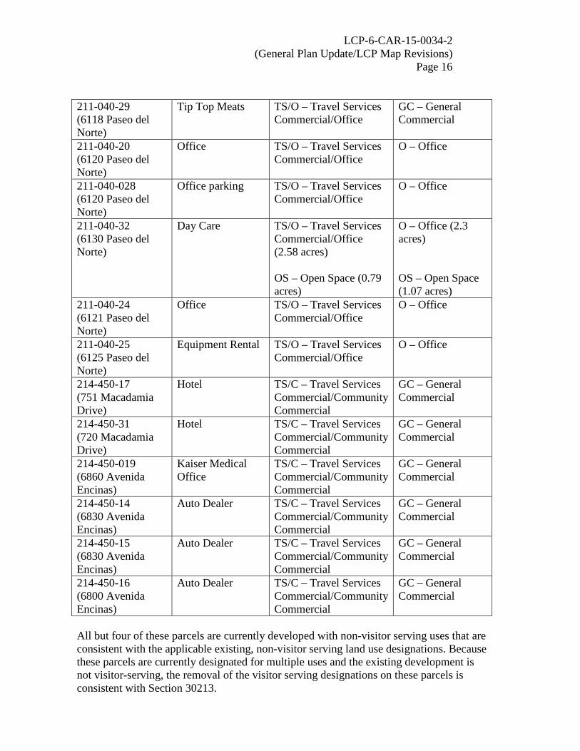
LCP-6-CAR-15-0034-2 (General Plan Update/LCP Map Revisions)
Page 16 211-040-29 (6118 Paseo del Norte)
Tip Top Meats TS/O – Travel Services Commercial/Office
GC – General Commercial
211-040-20 (6120 Paseo del Norte)
Office TS/O – Travel Services Commercial/Office
O – Office
211-040-028 (6120 Paseo del Norte)
Office parking TS/O – Travel Services Commercial/Office
O – Office
211-040-32 (6130 Paseo del Norte)
Day Care TS/O – Travel Services Commercial/Office (2.58 acres) OS – Open Space (0.79 acres)
O – Office (2.3 acres) OS – Open Space (1.07 acres)
211-040-24 (6121 Paseo del Norte)
Office TS/O – Travel Services Commercial/Office
O – Office
211-040-25 (6125 Paseo del Norte)
Equipment Rental TS/O – Travel Services Commercial/Office
O – Office
214-450-17 (751 Macadamia Drive)
Hotel TS/C – Travel Services Commercial/Community Commercial
GC – General Commercial
214-450-31 (720 Macadamia Drive)
Hotel TS/C – Travel Services Commercial/Community Commercial
GC – General Commercial
214-450-019 (6860 Avenida Encinas)
Kaiser Medical Office
TS/C – Travel Services Commercial/Community Commercial
GC – General Commercial
214-450-14 (6830 Avenida Encinas)
Auto Dealer TS/C – Travel Services Commercial/Community Commercial
GC – General Commercial
214-450-15 (6830 Avenida Encinas)
Auto Dealer TS/C – Travel Services Commercial/Community Commercial
GC – General Commercial
214-450-16 (6800 Avenida Encinas)
Auto Dealer TS/C – Travel Services Commercial/Community Commercial
GC – General Commercial
All but four of these parcels are currently developed with non-visitor serving uses that are consistent with the applicable existing, non-visitor serving land use designations. Because these parcels are currently designated for multiple uses and the existing development is not visitor-serving, the removal of the visitor serving designations on these parcels is consistent with Section 30213.

LCP-6-CAR-15-0034-2 (General Plan Update/LCP Map Revisions)
Page 17 Of the four parcels with hotels (either existing or under construction), the City proposes to redesignate two parcels (APNs 203-250-26 and 203-250-08) as Village (V). Both of these parcels straddle two LCP segments – the portions of these parcels already designated for Village (V) are included within the Village Redevelopment Area LCP segment, while the portions of the parcels currently designated for Travel/Recreation Commercial (T-R) and Residential High Density (RH) are located within the Mello II LCP segment. The proposed redesignation would incorporate both parcels entirely in the Village Redevelopment Area LCP segment. Although these parcels would not be designated for Visitor Commercial (VC), the Village Redevelopment LCP segment does prioritize and protect visitor-serving uses. As a result, this redesignation is also consistent with Section 30213. Macadamia Drive, located north of Poinsettia Lane and immediately west of the I-5, is developed with hotels and restaurants. Two of these hotel parcels are currently designated for both Travel Services Commercial (TS) and Community Commercial (C) (APNs 214-450-17 and 214-450-31). Rather than redesignate these parcels for Visitor Commercial (VC), the City is proposing to redesignate the parcels to General Commercial (GC). Because these two parcels are already developed with hotels, the proposed redesignation of these parcels to General Commercial (GC) will not protect existing visitor and recreational facilities and is not consistent with Section 30213. To protect the existing visitor serving uses on these parcels consistent with Section 30213, suggested modification [2] requires the City to redesignate these parcels as Visitor Commercial (VC). Note about 48 acre site subject to Measure A. The approximately 48 acre parcel located east of the I-5 and extending south from Agua Hedionda Lagoon to Cannon Road was the subject of a failed voter initiative associated with a shopping center proposal (Measure A) earlier this year. The site is currently designated as Travel Services Commercial (TS). The City proposes to retitle this land use designation Visitor Commercial (VC). Commission staff received numerous comment letters from Carlsbad residents concerned with the proposed redesignation from TS to VC on this parcel (Exhibit 8). The comment letters cite Table 2-4 from the newly adopted General Plan which describes mixed use residential development as an allowable use on visitor serving properties. All the comments received state that mixed use development is inappropriate on this site in light of the failure of Measure A earlier this year. The City’s General Plan is not part of the certified LCP. Although LCP land use designations indicate in general terms which uses are appropriate, it is the zoning designation that specifies the permitted uses and development standards applicable to each parcel. The City’s existing visitor serving land uses (T-R, TS, and RC) are implemented through the Commercial Tourist (C-T) zone. The proposed Visitor Commercial (VC) land use designation will also be implemented through the Commercial Tourist (C-T) zone. Mixed use development is not currently permitted within the Commercial Tourist (C-T) zone. As submitted, this LCP amendment request

LCP-6-CAR-15-0034-2 (General Plan Update/LCP Map Revisions)
Page 18 did originally propose to revise the Commercial Tourist (C-T) zone (Section 21.29 of the Zoning Code) to allow mixed use residential developments on parcels zoned for C-T. However, at Commission staff’s request, the City amended its request to remove the proposed revisions to the C-T zone and those changes are no longer before the Commission (Exhibit 1). Approval of this LCP amendment request will not permit mixed use developments within the C-T zone. As a result, the proposed land use designation change from T-R, TS and RC to VC will not facilitate any mixed use development on visitor serving parcels and is consistent with Section 30213 of the Coastal Act. Commission staff will work with the City on future efforts to amend the LCP to allow mixed use residential development in appropriate locations.
3. Residential
Section 30210
In carrying out the requirement of Section 4 of Article X of the California Constitution, maximum access, which shall be conspicuously posted, and recreational opportunities shall be provided for all the people consistent with public safety needs and the need to protect public rights, rights of private property owners, and natural resource areas from overuse.
Section 30250
(a) New residential, commercial, or industrial development, except as otherwise provided in this division, shall be located within, contiguous with, or in close proximity to, existing developed areas able to accommodate it or, where such areas are not able to accommodate it, in other areas with adequate public services and where it will not have significant adverse effects, either individually or cumulatively, on coastal resource…
The City proposes to retitle existing residential land use designations to more clearly reflect the allowed density range and most residential parcels will remain residential with the same density limits. However, the City also proposes to increase or decrease the density of existing residential land uses on some parcels and to redesignate parcels from non-residential land uses to residential. These proposed changes in density and increase in residentially designated lands are generally intended to resolve inconsistencies between the existing land use and zoning designations, to better reflect the development on the ground, and to accommodate the projected population growth in the City. Two examples of sites that the City proposes to convert from non-residential land uses to meet anticipated housing needs include the Aviara Farms or Ukegawa parcel (APN 212-040-56) and a vacant parcel in the Ponto area (APN 216-140-43). The Ukegawa parcel is located near El Camino Real (the inland coastal zone boundary) south of Palomar Airport Road. The property is currently designated for Planned Industrial (PI) and the City proposes to redesignate this site for R-30, allowing a density range of 23-30 dwelling

LCP-6-CAR-15-0034-2 (General Plan Update/LCP Map Revisions)
Page 19 units per acre. The area immediately west and south of this site is already designated for and developed with low and medium density residential uses. Office development is located immediately north of the site and to the west is protected open space area. The City also proposes to redesignate a large vacant parcel in the Ponto area that is currently designated as Unplanned Area (UA). This parcel is located just north of Avenida Encinas and Batiquitos Lagoon, between Carlsbad Boulevard and the rail corridor. The City proposes to redesignate the smaller portion of the parcel west of Ponto Drive as General Commercial (GC) and the larger portion of the parcel on the east side of Ponto Drive as R-23. The proposed General Commercial land use designation and associated C-2 zone designation would also allow some mixed use residential on the western portion of the site. Parcels east side of the rail corridor and immediately north of this site are designated for multi-family residential uses. The large, undeveloped parcel to the south is designated for visitor serving use, while Carlsbad Boulevard and the South Carlsbad State Beach are located west of this site. The proposed land use designations are consistent with development and land use designations of the surrounding area and with Section 30250(a). Finally, potential impacts to public access and coastal resources will be evaluated with project proposals. PART V. FINDINGS FOR REJECTION OF THE CITY OF CARLSBAD IP
AMENDMENT, AS SUBMITTED, AND FINDINGS FOR APPROVAL OF THE CITY OF CARLSBAD IP AMENDMENT, IF MODIFIED AS SUSTED
A. AMENDMENT DESCRIPTION
The proposed changes to the Implementation Plan (IP) component of the certified LCP includes rezoning numerous parcels throughout the coastal zone and text revisions to several sections of the City’s Zoning Code. The Zoning Map changes include changes to the acreage and location of open space, visitor serving, commercial, office, agricultural and residential zones. The proposed map revisions would: make the LCP zoning designations consistent with the recently updated General Plan zoning designations; better reflect development on the ground; resolve existing inconsistencies between the current land use and zoning designations; eliminate most combination zones; adjust the boundaries of existing open space zones; rezone as open space parcels that are mapped as hardline habitat in the City’s Habitat Management Plan or that have existing open space or conservation restrictions; and increase the net acreage of property designated for open space and for visitor serving commercial use. Exhibit 5 provides a list of the proposed zone modifications by Assessor Parcel Number and the proposed LCP Zoning Map is shown in Exhibit 7. The amendment also includes text revisions to Section 21.26.015.C (Chapter 21.26 – C-1 Neighborhood Commercial Zone), Section 21.28.015.C (Chapter 21.28 – C-2 General Commercial Zone), and Section 21.31.065.C (Chapter 21.31 – C-L Local Shopping

LCP-6-CAR-15-0034-2 (General Plan Update/LCP Map Revisions)
Page 20 Center Zone) to eliminate the phrase “RHNA base density” and reduce the minimum density for mixed use in these commercial zones from 20 dwelling units per acre to 15 dwelling units per acre. The City also proposes to revise the text of Section 21.53.230.e (Chapter 21.53 – Uses Generally) to remove references to the “RHNA base.” Finally, the amendment includes text revisions to Section 21.27.020 (Chapter 21.27 – Office Zone) to allow professional care facilities within the Office zone, subject to a conditional use permit.
B. CONSISTENCY ANALYSIS WITH CITY OF CARLSBAD LUP AND FINDINGS
The standard of review for LCP implementation submittals or amendments is their consistency with and ability to carry out the provisions of the certified LUP. The majority of the zone changes proposed in this amendment request conform with, and are adequate to carry out, the provisions of the certified LUPs. However, five suggested modifications are necessary for the Commission to approve this implementation plan amendment request. The City proposes to add the Open Space (OS) zone to the seaward portion of beachfront parcels in the Terramar neighborhood, but unlike other open space zone boundary adjustments proposed in this LCP amendment request, the zone boundaries here do not reflect any topographic or habitat feature. To ensure consistency between the land use plan, as modified, and the implementation plan, two hotel parcels should be rezoned Commercial Tourist (C-T). The City’s amendment request included two mapping errors on the submitted LCP Zoning Map that should be corrected. Finally, as submitted, the City’s amendment request originally included zone changes applicable to all six of the City’s areas of deferred certification. Because there is no certified implementation plan for these areas, the Commission cannot approve zoning changes in these areas. The City submitted a letter requesting that these zone changes be removed from this amendment request (Exhibit 1), and as a result, the proposed changes are not before the Commission in this amendment request. However, the LCP Zoning Map should make clear that the Commission retains permitting jurisdiction over these areas and that any zones shown within these areas are not certified by the Commission.
a) Purpose and Intent of the Ordinance. The purpose and intent of the proposed implementation plan amendment is to revise the certified LCP zoning map and to revise the text of several sections of the City’s certified zoning code. b) Major Provisions of the Ordinance. Ordinance No. CS-287 provides for amendment of the LCP Zoning Map to reflect numerous zone changes throughout the City’s coastal zone. The proposed text revisions include changes to Section 21.26.015.C (Chapter 21.26 – C-1 Neighborhood Commercial Zone), Section 21.28.015.C (Chapter 21.28 – C-2 General Commercial Zone), and Section 21.31.065.C (Chapter 21.31 – C-L Local Shopping Center Zone) to eliminate the phrase “RHNA base density” and reduce the minimum density for mixed use in these commercial zones from 20 dwelling units per acre to 15 dwelling units per acre. The City also proposes to revise the text of Section 21.53.230.e (Chapter 21.53 – Uses Generally) to remove references to the “RHNA base.”

LCP-6-CAR-15-0034-2 (General Plan Update/LCP Map Revisions)
Page 21 Finally, the amendment includes text revisions to Section 21.27.020 (Chapter 21.27 – Office Zone) to allow professional care facilities within the Office zone, subject to a conditional use permit. Ordinance No. CS-287 also describes revisions to Chapter 21.29 (C-T Commercial Tourist Zone) that would allow mixed use residential development within the C-T zone. At staff’s request, the City removed these changes from its amendment request to allow further coordination on appropriate changes to the C-T zone to allow mixed use residential development (Exhibit 1). c) Adequacy of the Ordinance to Implement the Certified LUP Segments. The standard of review for LCP implementation submittals or amendments is their consistency with and ability to carry out the provisions of the certified LUPs (i.e., the Mello I, Mello II, Village Redevelopment Area, Agua Hedionda Lagoon, East Batiquitos Lagoon, and West Batiquitos Lagoon LUPs). The proposed mapping changes and text revisions are described below with relevant LUP policies.
1. Open Space
Mello I Policy 7-1.2 Environmentally Sensitive Habitat Areas (ESHA)
Pursuant to Section 30240 of the California Coastal Act, environmentally sensitive habitat areas, as defined in Section 30107.5 of the Coastal Act, shall be protected against any significant disruption of habitat values, and only uses dependent on those resources shall be allowed within those areas.
Mello II Policy 3-1.2 Environmentally Sensitive Habitat Areas (ESHA)
Pursuant to Section 30240 of the California Coastal Act, environmentally sensitive habitat areas, as defined in Section 30107.5 of the Coastal Act, shall be protected against any significant disruption of habitat values, and only uses dependent on those resources shall be allowed within those areas.
Policy 4-1 Subsection IV. Undevelopable Shoreline Features
No development shall be permitted on any sand or rock beach or on the face of any ocean bluff, with the exception of accessways to provide public beach access and of limited public recreation facilities.

LCP-6-CAR-15-0034-2 (General Plan Update/LCP Map Revisions)
Page 22 Policy 8-1 Site Development Review
The Scenic Preservation Overlay Zone should be applied where necessary throughout the Carlsbad coastal zone to assure the maintenance of existing views and panoramas. Sites considered for development should undergo review to determine if the proposed development will obstruct views or otherwise damage the visual beauty of the area. The Planning Commission should enforce appropriate height limitations and see-through construction, as well as minimize alterations to topography.
The City proposes to dramatically increase the acreage of land zoned as Open Space (OS) by rezoning many parcels that are subject to existing open space or conservation easements, or that are already mapped as habitat areas in the City’s Habitat Management Plan. The City is also proposing to adjust the boundaries of open space zones on parcels that are zoned for both open space and another use. These boundary adjustments are generally based on improved mapping and will more accurately reflect topographic and natural features, including steep slopes and existing habitat, on individual parcels. As such, the proposed changes to the OS zone and OS boundary adjustments are consistent with Policy 7-1.2 of the Mello I and Policy 3-1.2 of the Mello II LUPs. Within the Mello II LCP segment, the City proposes to split zone the beachfront residential parcels in the Terramar neighborhood, applying the OS zone to the seaward portion of the lots. The boundaries of the new OS zone would align with the proposed OS land use designation boundaries described in Part IV.C of this staff report. These properties have historically been zoned solely for residential development and the City proposes to add the OS zone to make the zoning consistent with the existing Residential Low Medium density (RLM) and Open Space (OS) land use designations. Mello II LCP policies related to shoreline development and protection of visual resources will continue to restrict development on the bluff face. As a result, the proposed OS zone is consistent with Policy 4-1 and Policy 8-1 of the Mello II LUP. However, as described previously, the City will reassess the OS boundary in its forthcoming comprehensive LCP update based on anticipated impacts of sea level rise. Suggested modification 3 requires the City to indicate through a map note on the LCP Zoning Map that the OS boundary on these parcels will be refined in the City’s comprehensive LCP update.
2. Visitor Serving Mello I Occidental Land, Inc. Policy 1 Land Uses
(4) The area located west of Interstate 5 and north of Poinsettia Lane shall be designated for visitor-serving or neighborhood commercial development according to Chapter 21.26 of the Carlsbad Zoning Ordinance, provided that a minimum of 35% is developed as visitor serving uses.

LCP-6-CAR-15-0034-2 (General Plan Update/LCP Map Revisions)
Page 23 Mello II Policy 6-6 Additional Visitor-Serving Facilities at Elm Avenue and Carlsbad Boulevard
Provision should be made for additional visitor-serving facilities, as well as retaining existing visitor uses, at the western terminus of the Elm Avenue corridor in the coastal zone.
The City proposes to rezone parcels for Commercial Tourist (C-T) consistent with the proposed land use designation changes described previously in Part IV.C. These changes include eliminating split zones by identifying them solely as either a C-T or a non-visitor serving zone, or by making the zoning consistent with existing visitor serving land use designations where parcels are currently zoned for other uses. For example, parcel number 203-233-03 is currently designated for Travel Services Commercial (TS), but zoned for Multi-Family Residential (R-3). The City proposes to retitle the land use designation Visitor Commercial (VC) and rezone the property as C-T. This parcel is located in the Mello II segment at the northeast corner of Carlsbad Village Drive (previously Elm Avenue) and Ocean Street and is developed with a hotel. The rezone to C-T is consistent with Policy 6-6 of the Mello II LUP because it will protect an existing visitor use in that location. Part IV.C of this staff report describes suggested modification 2 requiring the City to designate two existing hotel parcels as Visitor Commercial (VC) instead of the proposed General Commercial (GC) land use. To carry out the VC land use designation, suggested modification 4 requires the City to rezone these parcels (APNs 214-450-17 and 214-450-31) from General Commercial (C-2) to Commercial Tourist (C-T). By protecting the existing hotel development, this zone change is also consistent with Policy 1(4) of the Mello I LCP related to the Occidental Land, Inc. properties, which requires that a minimum 35% of this area be developed with visitor serving uses.
3. Coastal Agriculture Mello II Policy 2-3 Lands Historically In Agriculture Yet Not Designated Coastal Agriculture
The following properties which have been in agricultural production in the past shall be permitted to convert to urban uses. Because of unique circumstances associated with these parcels, conversion to urban uses would not create any significant adverse impact on the area’s agricultural economy, directly or indirectly, and such conversion would therefore not require the mitigation… (c) Ukegawa Parcel. The 13.98 acre parcel (APN 212-040-25) owned by Ukegawa, located on the south side of Palomar Airport Road, may be converted to industrial uses that

LCP-6-CAR-15-0034-2 (General Plan Update/LCP Map Revisions)
Page 24
should be supportive of the agricultural economy. The site has not been in use for field crop production for many years, and has been the subject of numerous authorized and unauthorized fills in recent years. Because of the substantial importation of fill dirt, the site cannot be designated as possessing agricultural soils. Because of the access available to Palomar Airport Road on the parcel, and its location between agricultural lands and developed industrial uses to the east, the site shall be designated for Planned Industrial use, and should be developed for agricultural processing purposes. Conversion of these parcels to urban uses will complete the development of established developed areas, thereby contributing to the creation of stable urban/rural boundaries. Such conversion should reduce market pressures for the conversion to urban uses of other agricultural lands suitable for continued agricultural production.
Policy 2-4 Small Scattered Ineffective Agricultural Lands
Approximately 100 acres of agricultural use are located in scattered parcels along El Camino Real both north and south of Agua Hedionda Lagoon. The small individual size of these parcels, together with the fact that they are not contiguous, precludes their effective use as agricultural land in the future. These lands are therefore designated for residential development, at a maximum density of one dwelling unit per acre as rural residential estate Section 21.09 or as residential agriculture zone, Section 21.08 of Carlsbad Zoning Ordinance. No further land divisions shall be allowed in the area under current agricultural production except in compliance with these policies.
The City proposes to modify the zoning on several parcels with existing agricultural or residential agricultural zoning designations to non-agricultural zones. The first is the Aviara Farms or Ukegawa parcel (APN 212-040-56 *note: this APN has been changed since certification of the LUP policy above, however the parcel that it references remains the same), currently zoned for Exclusive Agriculture (E-A). The City proposes to change the zoning to Residential Density – Multiple (RD-M). Policy 2-3(c) of the Mello II LCP segment describes this parcel as unsuitable for agricultural use. Although Policy 2-3 calls for agricultural processing uses here, this parcel is clearly identified in the certified LCP as no longer suitable for agricultural production. Policy 2-3 also indicates that the site was envisioned to convert to urban uses, allowing growth in the City while protecting and preserving other land more suitable for coastal agriculture. Population growth in the City has continued since certification of the LCP, further increasing housing needs. The rezoning of this site for higher density housing will enable the City to meet this housing demand without converting land suitable for agricultural use. The area immediately west and south of this site is already designated for and developed with one- and multi-family residential uses. Office development is located immediately north of the site and to the west is protected open space area. As a result, rezoning this site to medium density residential is consistent with the character of the surrounding area. The City also proposes to rezone a total of nine parcels that are currently zoned for Residential Agriculture (R-A) within the Mello II LCP segment to either residential or

LCP-6-CAR-15-0034-2 (General Plan Update/LCP Map Revisions)
Page 25 open space designations. Policy 2-4 of the Mello II LCP segment describes approximately 100 acres located along El Camino Real both north and south of Agua Hedionda Lagoon that are inappropriate for future agricultural use due to their small size and lack of contiguity. Policy 2-4 indicates these parcels should be zoned for Rural Residential Estate or Residential Agriculture to allow residential development along with small scale agricultural uses. Although Policy 2-4 does not identify specific parcels, eight of the nine Residential Agriculture (R-A) parcels the City proposes to rezone are located north and south of Agua Hedionda Lagoon close to El Camino Real. The City proposes to rezone three parcels located immediately north of Tamarack Avenue and west of El Camino Real (APNs 207-073-09, -10, and -12) to One-Family Residential with a minimum lot size of 15,000 square feet. The proposed zone change will require a larger lot size than currently required (15,000 square feet instead of 10,000 square feet) and is consistent with the zoning in the neighborhood immediately to the west of these lots. The City also proposes to rezone a single parcel (APN 207-083-18) located south of El Camino Real along Telescope Avenue, in a neighborhood zoned for R-A-10000. Lots immediately west of this neighborhood are zoned for R-1-15000 and this parcel is currently split zoned (R-A-10000 on the eastern portion and R-1-15000 on the western portion). The City proposes to eliminate the split zoning by rezoning this parcel to R-1-10000. Each of these parcels is developed with a single-family dwelling, and except for home gardens, the City reports that no agricultural use exists. In addition, “agricultural crops” and some farm animals are permitted within the One-Family Residential (R-1) zone, allowing continued small scale agricultural use of these parcels. Because the larger lot sizes will be maintained and agricultural uses associated with residential development will continue to be permitted, the rezone of these four parcels from Residential Agriculture to One-Family Residential with a minimum lot size of 10,000 or 15,000 square feet is consistent with the intent of Policy 2-4. The City also proposes to rezone four parcels from R-A-10000 to Open Space (OS) that are located near El Camino Real. One of these parcels (APN 207-385-48) is located on the south side of Tamarack Avenue, a few blocks southwest of El Camino Real and is dedicated as an open space lot on the recorded subdivision map (Map No. 10925). The other three parcels (APNs 208-170-36, -37, and -38) are located along El Camino Real on either side of Crestview Drive and an open space easement is recorded against these lots (Map No. 13753). Due to the open space restrictions here, these lots cannot be used for residential uses and the rezoning will clarify that they are protected for open space. Finally, the City proposes to rezone parcel number 210-100-10 located at the northeast corner of the Palomar Airport Road and Carlsbad Boulevard intersection, immediately west of the rail corridor, from R-A-10000 to OS. This site is not located near El Camino Real and Policy 2-4 does not apply. The lot is owned by the State and currently has an OS land use designation. Because the zoning is inconsistent with the land use designation, a residential use could not occur here currently and the proposed rezone to OS will make the zoning consistent with the existing land use designation. The rezone to OS is also consistent with zoning of the area immediately north of this parcel.

LCP-6-CAR-15-0034-2 (General Plan Update/LCP Map Revisions)
Page 26
4. Residential Mello II Policy 1-1. Allowable Land Uses
Allowable uses are those that are consistent with both the General Plan and the Local Coastal Program.
Policy 1-2 Maximum Density of Development
Residential densities shall be permitted and based on the underlying LCP land use designation. The residential land use designations shall represent the maximum density permitted subject to application of requested density bonuses pursuant to Chapter 21.86 of the Carlsbad Municipal Code and the applicable resource protection provisions of the certified LCP.
Policy 7-10. Parking
Parking standards set forth within the City of Carlsbad Zoning Ordinance are appropriate for the future development of various land uses.
Policy 8-3. Infill Development Design Review
While the Scenic Preservation Overlay Zone can be used to enhance the character of new development, the City of Carlsbad should adopt a policy whereby the unique characteristics of older communities…can be protected through their redevelopment scheme. This policy should reflect design standards which are in accordance with the flavor of the existing neighborhood.
The City proposes to rezone properties located within the Mello II segment that are currently zoned for residential use to increase or decrease the density of residential development and to rezone some parcels from non-residential zones to residential. The proposed changes in density and increase in land zoned for residential development are generally intended to resolve inconsistencies between the existing land use and zoning designations, to better reflect development on the ground, and to accommodate projected population growth in the City. For example, the City proposes to rezone parcels located on either side of Carlsbad Boulevard between Hemlock Avenue to the north and Tamarack Avenue to the south from Two-Family (R-2) Residential to Residential Density-Medium (RD-M). The R-2 zone is intended to implement the Residential Medium Density (RM) land use designation while the RD-M zone is intended to implement the Residential Medium Density (RM), Residential Medium-High Density (RMH) and the Residential High Density (RH) land use designations. These parcels are designated for the RH land use, which the City proposes to retitle R-23 with the same density limits. The proposed zoning designation is consistent with and will better

LCP-6-CAR-15-0034-2 (General Plan Update/LCP Map Revisions)
Page 27 implement the existing RH land use designation and will, therefore, comply with Policy 1-1 and Policy 1-2 of the Mello II LUP. The development standards (established in the City of Carlsbad Zoning Ordinance) applicable to the RD-M zone will remain unchanged, along with the applicable parking standards which are also set forth within the City’s Zoning Ordinance. Additionally, any new development or redevelopment of these parcels would still be subject to a coastal development permit, pursuant to Chapter 21.201 of the Zoning Ordinance. This means that adequate parking, consistent with Policy 7-10 of the Mello II LCP segment, will be required in conjunction with any new development resulting from the proposed amendment. Also, in adherence with Policy 8-3 of the Mello II LCP segment, residential development standards such as building height limits, setback requirements, and lot coverage restrictions will be maintained, which will ensure that any future development will be compatible with the neighborhood. This amendment request does not propose to change the coastal development permit requirement or the standards applicable to review of coastal development permits. As a result, future development on any of the parcels rezoned through this amendment request will be thoroughly assessed for consistency with the certified Mello II LCP segment through the coastal development permitting process.
5. Mapping Errors The City submitted a zoning map showing the proposed zoning changes with this LCP amendment request. While reviewing the submittal, Commission and City staff identified two mapping errors where incorrect zoning was shown on several parcels. The City did not intend to change the zoning in these two locations and because these incorrect zoning designations were included in the new zoning map approved by the City Council, they must be corrected. The City Council approved zoning map shows fourteen residential parcels along Willow Place in the Mello II LCP segment as One Family Residential with a minimum lot size of 10,000 square feet (R-1-10000-Q). The correct zoning for these parcels is One-Family Residential (R-1). Suggested modification 5 requires the City to retain the R-1 zoning for parcel numbers 212-230-01 to -14. The second mapping error applies to a parcel located immediately north of Batiquitos Lagoon, within the West Batiquitos Lagoon/Sammis Properties LCP segment. The City Council approved zoning map shows this parcel as zoned for Planned Community (P-C), however the correct zoning for this parcel is Open Space (OS). Suggested modification 6 requires the City to retain the OS zoning for parcel number 216-140-34.
6. Deferred Certification Areas There are six areas of deferred certification within the City of Carlsbad’s coastal zone. These areas include (1) the entire Agua Hedionda Lagoon segment; (2) two parcels located at the northwest corner of the intersection of the I-5 and Tamarack Avenue; (3) one parcel located at the southwest corner of the intersection of I-5 and Tamarack Avenue; (4) two parcels located at the northeast corner of the I-5 and Tamarack Avenue
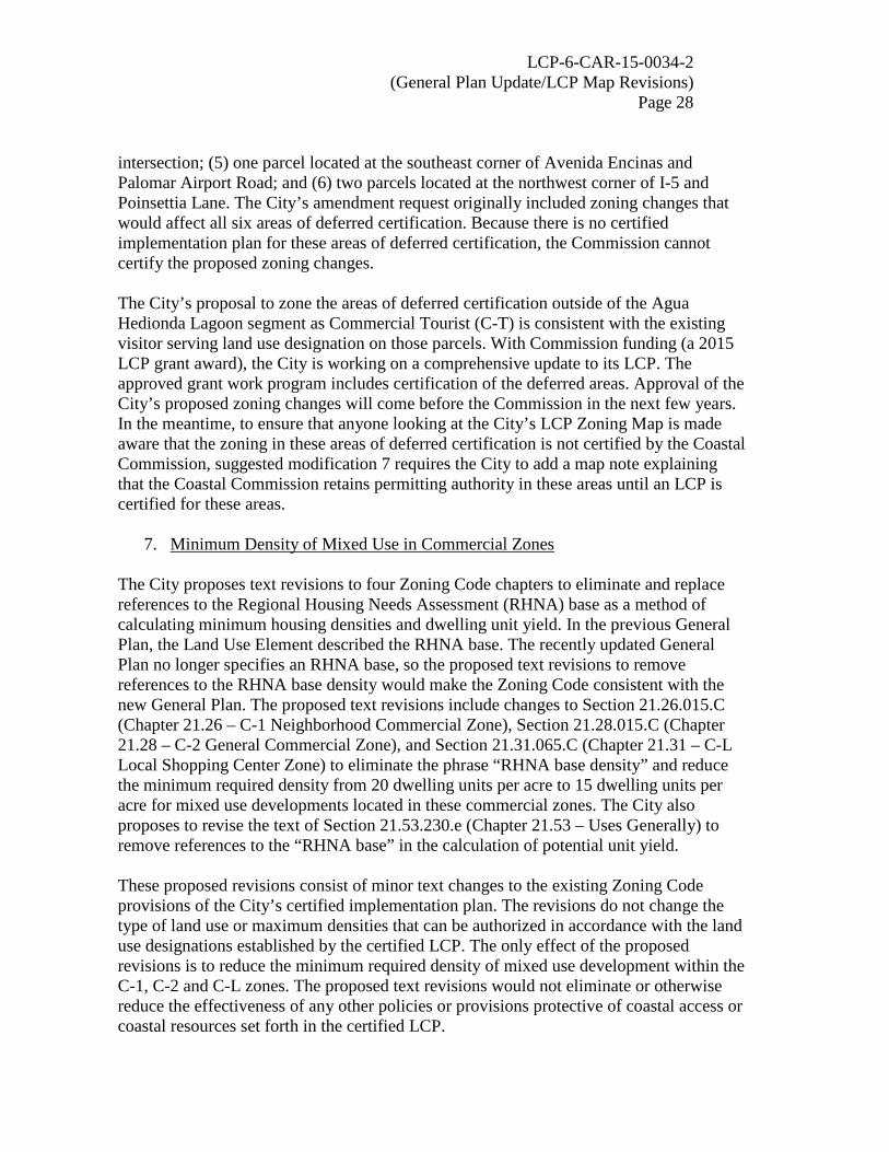
LCP-6-CAR-15-0034-2 (General Plan Update/LCP Map Revisions)
Page 28 intersection; (5) one parcel located at the southeast corner of Avenida Encinas and Palomar Airport Road; and (6) two parcels located at the northwest corner of I-5 and Poinsettia Lane. The City’s amendment request originally included zoning changes that would affect all six areas of deferred certification. Because there is no certified implementation plan for these areas of deferred certification, the Commission cannot certify the proposed zoning changes. The City’s proposal to zone the areas of deferred certification outside of the Agua Hedionda Lagoon segment as Commercial Tourist (C-T) is consistent with the existing visitor serving land use designation on those parcels. With Commission funding (a 2015 LCP grant award), the City is working on a comprehensive update to its LCP. The approved grant work program includes certification of the deferred areas. Approval of the City’s proposed zoning changes will come before the Commission in the next few years. In the meantime, to ensure that anyone looking at the City’s LCP Zoning Map is made aware that the zoning in these areas of deferred certification is not certified by the Coastal Commission, suggested modification 7 requires the City to add a map note explaining that the Coastal Commission retains permitting authority in these areas until an LCP is certified for these areas.
7. Minimum Density of Mixed Use in Commercial Zones The City proposes text revisions to four Zoning Code chapters to eliminate and replace references to the Regional Housing Needs Assessment (RHNA) base as a method of calculating minimum housing densities and dwelling unit yield. In the previous General Plan, the Land Use Element described the RHNA base. The recently updated General Plan no longer specifies an RHNA base, so the proposed text revisions to remove references to the RHNA base density would make the Zoning Code consistent with the new General Plan. The proposed text revisions include changes to Section 21.26.015.C (Chapter 21.26 – C-1 Neighborhood Commercial Zone), Section 21.28.015.C (Chapter 21.28 – C-2 General Commercial Zone), and Section 21.31.065.C (Chapter 21.31 – C-L Local Shopping Center Zone) to eliminate the phrase “RHNA base density” and reduce the minimum required density from 20 dwelling units per acre to 15 dwelling units per acre for mixed use developments located in these commercial zones. The City also proposes to revise the text of Section 21.53.230.e (Chapter 21.53 – Uses Generally) to remove references to the “RHNA base” in the calculation of potential unit yield. These proposed revisions consist of minor text changes to the existing Zoning Code provisions of the City’s certified implementation plan. The revisions do not change the type of land use or maximum densities that can be authorized in accordance with the land use designations established by the certified LCP. The only effect of the proposed revisions is to reduce the minimum required density of mixed use development within the C-1, C-2 and C-L zones. The proposed text revisions would not eliminate or otherwise reduce the effectiveness of any other policies or provisions protective of coastal access or coastal resources set forth in the certified LCP.

LCP-6-CAR-15-0034-2 (General Plan Update/LCP Map Revisions)
Page 29
8. Professional Care Facilities in the Office Zone Mello I Policy 4 Parking
Parking shall be in conformance with the requirements of the City of Carlsbad Zoning Ordinance.
Policy 7-1.2 Environmentally Sensitive Habitat Areas (ESHA)
Pursuant to Section 30240 of the California Coastal Act, environmentally sensitive habitat areas, as defined in Section 30107.5 of the Coastal Act, shall be protected against any significant disruption of habitat values, and only uses dependent on those resources shall be allowed within those areas.
Mello II Policy 1-1 Allowable Land Uses
Allowable uses are those that are consistent with both the General Plan and the Local Coastal Program.
Policy 3-1.2 Environmentally Sensitive Habitat Areas (ESHA)
Pursuant to Section 30240 of the California Coastal Act, environmentally sensitive habitat areas, as defined in Section 30107.5 of the Coastal Act, shall be protected against any significant disruption of habitat values, and only uses dependent on those resources shall be allowed within those areas.
Policy 7-10 Parking
Parking standards set forth within the City of Carlsbad Zoning Ordinance are appropriate for the future development of various land uses.
Agua Hedionda Policy 3-13-1.2 Environmentally Sensitive Habitat Areas (ESHA)
Pursuant to Section 30240 of the California Coastal Act, environmentally sensitive habitat areas, as defined in Section 30107.5 of the Coastal Act, shall be protected against any significant disruption of habitat values, and only uses dependent on those resources shall be allowed within those areas.

LCP-6-CAR-15-0034-2 (General Plan Update/LCP Map Revisions)
Page 30 Policy 5.2 Parking
Parking standards set forth in the City of Carlsbad Zoning Ordinance, shall be applied to future developments.
The final proposed text revision would amend Section 21.27.020 (Chapter 21.27 – Office Zone) to allow professional care facilities, including assisted living and nursing facilities, within the Office (O) zone, subject to a conditional use permit. All parcels currently zoned for, and proposed in this amendment request to be rezoned for, Office (O) are currently only located in the Mello II LCP segment. The Office zone typically acts as a buffer between residential uses and more intensive industrial or commercial uses. Other uses that are permitted and conditionally permitted within the Office zone include general office uses, doctor offices, farmworker housing, hospitals, hotels, and restaurants. According to City review, the only two care facilities in City limits currently located within an Office zone are outside of the coastal zone. The conditional use permit requirement in combination with existing development controls will allow professional care facilities within the zone where compatible with residential uses and other office, industrial or commercial uses. Due to existing setback requirements, any allowed professional care facility within the coastal zone would be unlikely to significantly impact public access or coastal resources. In addition, all new development, including any proposed professional care facility must comply with the City’s LCP policies protecting ESHA. Finally, Chapter 21.44 (Parking) of the City’s Zoning Code requires 0.45 parking space for each bed in a professional care facility. Therefore, the proposed addition of professional care facilities as a conditionally permitted use within the Office zone is consistent with Policy 4 and Policy 7-1.2 of the Mello I LUP, with Policy 1-1, Policy 3-1.2, and Policy 7-10 of the Mello II LUP, and with Policy 3-13-1.2 and Policy 5.2 of the Agua Hedionda LUP. Although the Agua Hedionda LCP segment is not certified, approval of this proposed change to the Office zone will not prejudice the City’s ability to prepare a Local Coastal Program for San Clemente that is consistent with the Chapter 3 policies of the Coastal Act as required by Section 30604(a). PART VI. CONSISTENCY WITH THE CALIFORNIA ENVIRONMENTAL
QUALITY ACT (CEQA) The City prepared and certified EIR No. 13-02 on September 23, 2015 for its General Plan Update. The EIR concluded that, with mitigation, most environmental impacts associated with the proposed General Plan Update (and by association this proposed LCP amendment) would be reduced to less than significant levels. However, the EIR did conclude that the General Plan Update would have significant adverse impacts that could not be reduced through mitigation to less than significant levels. Thus, the City adopted a Statement of Overriding Consideration for these impacts. The unavoidable adverse

LCP-6-CAR-15-0034-2 (General Plan Update/LCP Map Revisions)
Page 31 impacts identified were related to air quality and transportation and are not at issue for this submittal. Section 21080.9 of the California Environmental Quality Act (CEQA) exempts local government from the requirement of preparing an environmental impact report (EIR) in connection with its local coastal program. Instead, the Coastal Commission acts as lead agency for the purposes of fulfilling CEQA. The Commission's LCP review and approval program has been found by the Resources Agency to be functionally equivalent to the EIR process. Thus, under CEQA Section 21080.5, the Commission is relieved of the responsibility to prepare an EIR for each LCP submission. Under the regulatory process, the Commission must respond to significant environmental points raised during the review process. Nevertheless, the Commission is required in an LCP submittal or, as in this case, an LCP amendment submittal, to find that the LCP, or LCP, as amended, does conform with CEQA provisions. The City’s amendment request consists of a Land Use Plan amendment and an Implementation Plan amendment. The Land Use Plan amendment as originally submitted raises two concerns regarding the Chapter 3 policies of the Coastal Act and thus cannot be found to be consistent with and adequate to carry out the Chapter 3 policies of the Coastal Act. The Commission, therefore, has suggested modifications to bring the Land Use Plan amendment into full conformance with the requirements of the Coastal Act. As modified, the Commission finds that approval of the Land Use Plan amendment will not result in significant adverse environmental impacts under the meaning of the California Environmental Quality Act. Further, the Commission finds that approval of the Implementation Plan amendment with the suggested modifications to implement the Land Use Plan would not result in significant adverse environmental impacts under the meaning of CEQA. Absent the incorporation of these suggested modifications, such a finding could not be made. Therefore, the Commission finds that approval of the LCP amendment conforms to the applicable provisions of CEQA as there are no feasible alternatives or feasible mitigation measures available that would substantially lessen any significant adverse impact which the activity may have on the environment.
APPENDIX A – SUBSTANTIVE FILE DOCUMENTS
• City of Carlsbad City Council Resolution No. 2015-242 • City of Carlsbad Planning Commission Resolution No. 7111 • City of Carlsbad Planning Commission Resolution No. 7112 • City of Carlsbad Planning Commission Resolution No. 7114 • City of Carlsbad LCPA LCP-6-CAR-15-0034-2 submittal • City of Carlsbad certified LCP
(G:\San Diego\Reports\LCPs\Carlsbad\LCP-6-CAR-15-0034-2 (General Plan Update/LCP Map Revisions) stf rpt.docx)


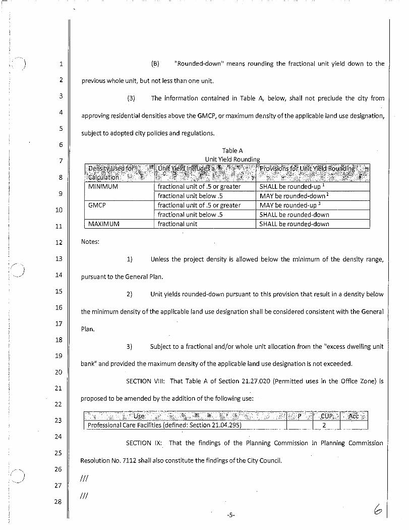


APN AssessorSitusAddress ExistingGPLU NewGPLU1560311100 2248 JEFFERSON ST OS/RLM R-4/OS1560311200 2240 JEFFERSON ST OS/RLM R-4/OS1563500200 2305 PIO PICO DR RLM/OS R-4/OS1560511800 RLM/OS R-4/OS1552210900 2361 BUENA VISTA CR RLM/RMH R-41560512400 0 HIGHLAND DR RLM/OS R-4/OS1560310900 2300 PIO PICO DR RLM/OS R-4/OS1560311000 2256 JEFFERSON ST RLM/OS R-4/OS1560511900 OS/RLM R-41563500100 PIO PICO OS/RLM R-4/OS1563501200 PIO PICO DR RLM/OS R-4/OS1563510100 OS/RLM R-4/OS1552211400 2461 BUENA VISTA CR RMH/O R-151552211500 2451 BUENA VISTA CR RMH/O R-151552210900 2361 BUENA VISTA CR RLM/RMH R-41552231800 624 LAGUNA DR RMH/O R-151552211300 590 LAGUNA DR RMH/O O1552232001 LAGUNA DR RMH/O R-151552232003 LAGUNA DR RMH/O R-151552232004 LAGUNA DR RMH/O R-151552232002 LAGUNA DR RMH/O R-151552232101 LAGUNA DR RMH/O R-151552232102 LAGUNA DR RMH/O R-151552232103 LAGUNA DR RMH/O R-151552232105 LAGUNA DR RMH/O R-151552232106 LAGUNA DR RMH/O R-151552232107 LAGUNA DR RMH/O R-151552232110 LAGUNA DR RMH/O R-151552232112 LAGUNA DR RMH/O R-151552232104 LAGUNA DR RMH/O R-151552232108 LAGUNA DR RMH/O R-151552232111 LAGUNA DR RMH/O R-151552232109 LAGUNA DR RMH/O R-152032502500 3180 CARLSBAD BL RH/V V2040101400 TC/V TC2032310100 2855 CARLSBAD BL V/RMH V2032502600 3136 CARLSBAD BL TR/V V2032510500 3037 OCEAN ST OS/RH OS2032500800 3155 LINCOLN ST TR V2052704500 3700 PIO PICO DR TR/O VC2052704300 3780 PIO PICO DR TR/O/RLM VC2052700900 3821 ADAMS ST RLM VC2052704400 3801 ADAMS ST RLM/P VC2052203300 MAGNOLIA AVE J P2070102700 VALLEY ST J P2070731000 4056 SKYLINE RD RM R-4
Proposed Land Use Designation Changes by APN

2070731200 4080 SKYLINE RD RM/RLM R-42073833400 POINTE AVE EAST RM OS2070731100 SKYLINE RD RM R-42071305600 J P2073813800 POINTE AVE EAST RM OS2052203300 MAGNOLIA AVE J P2070102700 VALLEY ST J P2073854800 RLM OS2070730900 4060 SKYLINE RD RM R-42073833400 POINTE AVE EAST RM OS2073854800 RLM OS2042703700 308 TAMARACK AV RH R-42042704100 234 TAMARACK AV RH R-42060803800 265 CHINQUAPIN AV RMH R-232042704600 360 REDWOOD AV RH R-42042703200 390 TAMARACK AV RH R-42042703400 370 TAMARACK AV RH R-42042703900 260 TAMARACK AV RH R-42042704500 370 REDWOOD AV RH R-42042703000 371 REDWOOD AV RH R-42042702600 301 REDWOOD AV RH R-42042703500 350 TAMARACK AV RH R-42042702900 351 REDWOOD AV RH R-42042704000 250 TAMARACK AV RH R-42042701300 350 REDWOOD AV RH R-42042702700 321 REDWOOD AV RH R-42042703300 380 TAMARACK AV RH R-42042701700 290 REDWOOD AV RH R-42042701400 330 REDWOOD AV RH R-42042701600 300 REDWOOD AV RH R-42042701800 270 REDWOOD AV RH R-42042702500 291 REDWOOD AV RH R-42042701900 250 REDWOOD AV RH R-42042701500 320 REDWOOD AV RH R-42042703100 391 REDWOOD AV RH R-42042703800 270 TAMARACK AV RH R-42042703600 310 TAMARACK AV RH R-42042702300 251 REDWOOD AV RH R-42042702800 331 REDWOOD AV RH R-42042702400 271 REDWOOD AV RH R-42060803902 249 CHINQUAPIN AVE RMH/RH R-232060803903 245 CHINQUAPIN AVE RMH/RH R-232060803905 237 CHINQUAPIN AVE RMH/RH R-232060803906 233 CHINQUAPIN AVE RMH/RH R-232060803904 241 CHINQUAPIN AVE RMH/RH R-232060803901 253 CHINQUAPIN AVE RMH/RH R-232060800800 4058 GARFIELD ST RMH R-23
Proposed Land Use Designation Changes by APN

2060912500 OLIVE AVE RMH OS2060803800 265 CHINQUAPIN AV RMH R-232061204000 1085 CHINQUAPIN AV RMH/RLM R-42060800900 4062 GARFIELD ST RMH R-232100104600 CARLSBAD BLVD U P/VC/OS2060803902 249 CHINQUAPIN AVE RMH/RH R-232060803903 245 CHINQUAPIN AVE RMH/RH R-232060803905 237 CHINQUAPIN AVE RMH/RH R-232060803906 233 CHINQUAPIN AVE RMH/RH R-232060803904 241 CHINQUAPIN AVE RMH/RH R-232060803901 253 CHINQUAPIN AVE RMH/RH R-232062001200 4523 ADAMS ST RM R-42062001100 4529 ADAMS ST RH R-42062001300 ADAMS ST RM/RH R-42074204300 HORIZON DR RLM OS2074125500 4445 SUNNYHILL DR RLM OS2062000100 ADAMS ST RLM/OS R-42074204200 HORIZON DR RLM OS2073851200 HIGH RIDGE RD RM OS2081604600 FROST AVE RM OS2081840700 CANNON RD RMH/OS OS2080204300 EL CAMINO REAL RLM/OS OS2071013300 PARK DR RLM OS2072410100 E P2081840300 HEMINGWAY DR RLM/OS OS2081617100 ASHBERRY RD RM OS2071013700 L/RLM GC2071013500 4901 EL CAMINO REAL RLM R-152081604600 FROST AVE RM OS2081623300 FROST AVE RM OS2081623200 MERWIN DR RM OS2081703800 CRESTVIEW DR RLM OS2081616900 CIARDI CT RM OS2081623500 JEFFERS PL RM OS2081604700 ASHBERRY RD RM OS2081617000 FROST AVE RM OS2081840300 HEMINGWAY DR RLM/OS OS2081617100 ASHBERRY RD RM OS2081604800 ASHBERRY RD RM OS2081703600 CRESTVIEW DR RLM OS2081703700 CRESTVIEW DR RLM OS2081623400 EL CAMINO REAL RM OS2121520100 FROST AVE RLM/OS OS2121503500 KEATS PL RLM OS2121520100 FROST AVE RLM/OS OS2121503500 KEATS PL RLM OS2121503600 FROST AVE RLM OS
Proposed Land Use Designation Changes by APN

2121433400 JACKSPAR DR RLM OS2121603000 JACKSPAR DR RLM OS2100104600 CARLSBAD BLVD U P/VC/OS2100104200 CARLSBAD BLVD U P2071013400 PARK DR RM OS2062001300 ADAMS ST RM/RH R-42074302900 RMH/OS OS2081840700 CANNON RD RMH/OS OS2071013400 PARK DR RM OS2081860200 HEMINGWAY DR RMH OS2081824200 STEINBECK CT RLM OS2081840700 CANNON RD RMH/OS OS2081850900 TOLKIEN WAY RMH/OS OS2081824100 DICKINSON DR RLM OS2081833200 STEINBECK CT RLM OS2081850600 WHITMAN WAY RMH OS2081840300 HEMINGWAY DR RLM/OS OS2081833300 TOLKIEN WAY RLM OS2121603000 JACKSPAR DR RLM OS2121401600 MILTON RD RLM OS2100311500 5061 SHORE DR RLM/OS R-4/OS2100201500 5015 TIERRA DEL ORO ST RLM/OS R-4/OS2100104000 CANNON RD U VC/OS2100320600 5133 CARLSBAD BL RLM R-152100610700 5229 SHORE DR RLM/OS R-4/OS2100611300 5263 SHORE DR RLM/OS R-4/OS2100620900 CARLSBAD BLVD RLM R-152100621100 5185 CARLSBAD BL RLM R-152100201400 5019 TIERRA DEL ORO ST RLM/OS R-4/OS2100611100 5185 SHORE DR RLM/OS R-4/OS2100201800 5005 TIERRA DEL ORO ST RLM/OS R-4/OS2100610600 5243 SHORE DR RLM/OS R-4/OS2100621000 5195 CARLSBAD BL RLM R-152100311100 5157 SHORE DR RLM/OS R-4/OS2100311400 5115 SHORE DR RLM/OS R-4/OS2100620700 5236 SHORE DR RLM R-152100610800 5215 SHORE DR RLM/OS R-4/OS2101203200 CARLSBAD BLVD RLM/OS R-4/OS2100621200 5171 CARLSBAD BL RLM R-152100611000 5195 SHORE DR RLM/OS R-4/OS2100202300 5001 TIERRA DEL ORO ST RLM/OS R-4/OS2101203100 CARLSBAD BLVD RLM/OS R-4/OS2100201100 5029 TIERRA DEL ORO ST RLM/OS R-4/OS2100201600 TIERRA DEL ORO ST RLM/OS R-4/OS2100610500 5257 SHORE DR RLM/OS R-4/OS2100104400 CARLSBAD BLVD OS/U OS2100201700 5009 TIERRA DEL ORO ST RLM/OS R-4/OS
Proposed Land Use Designation Changes by APN

2100201000 5031 TIERRA DEL ORO ST RLM/OS R-4/OS2100104600 CARLSBAD BLVD U P/VC/OS2100200800 5039 TIERRA DEL ORO ST RLM/OS R-4/OS2100320700 5115 CARLSBAD BL RLM R-152100311000 5143 SHORE DR RLM/OS R-4/OS2100201200 5025 TIERRA DEL ORO ST RLM/OS R-4/OS2100104200 CARLSBAD BLVD U P2100611200 5171 SHORE DR RLM/OS R-4/OS2100202200 5003 TIERRA DEL ORO ST RLM/OS R-4/OS2100320800 5097 CARLSBAD BL RLM R-152100310600 5067 SHORE DR RLM/OS R-4/OS2101203400 CARLSBAD BLVD RLM/OS R-4/OS2100310700 SHORE DR RLM/OS R-4/OS2100200900 5035 TIERRA DEL ORO ST RLM/OS R-4/OS2100201300 5021 TIERRA DEL ORO ST RLM/OS R-4/OS2100620800 5225 CARLSBAD BL RLM R-152100610900 5201 SHORE DR RLM/OS R-4/OS2100310800 5099 SHORE DR RLM/OS R-4/OS2101202700 5305 CARLSBAD BL RLM/OS R-4/OS2101203300 CARLSBAD BLVD RLM/OS R-4/OS2100320501 CARLSBAD BLVD RLM R-152100320502 CARLSBAD BLVD RLM R-152110222600 5770 ARMADA DR O/PI PI2110231600 5355 ARMADA DR O/PI PI2111000100 5740 FLEET ST O/PI PI2110222500 5759 FLEET ST O/PI PI2111001000 FLEET ST O/PI PI2110231700 5345 ARMADA DR O/PI PI2110222600 5770 ARMADA DR O/PI PI2110231600 5355 ARMADA DR O/PI PI2111000100 5740 FLEET ST O/PI PI2110222500 5759 FLEET ST O/PI PI2110222000 5790 ARMADA DR O/PI PI2110230700 UA P2111001100 LEGO DR O/PI/OS PI/OS2111001000 FLEET ST O/PI PI2111001300 5780 FLEET ST O/PI PI2110231700 5345 ARMADA DR O/PI PI2111000200 5770 FLEET ST O/PI PI2110500800 G P2111000400 FLEET ST O/PI PI2110402000 6120 PASEO DEL NORTE TR/O O2110403200 6130 PASEO DEL NORTE TR/O/OS O/OS2110222000 5790 ARMADA DR O/PI PI2110500900 6100 PASEO DEL NORTE TR/O GC2110222800 5805 ARMADA DR TR/C VC2110402900 6118 PASEO DEL NORTE TR/O GC
Proposed Land Use Designation Changes by APN

2110402800 PASEO DEL NORTE TR/O O2110223000 5801 ARMADA DR TR/C VC2111000400 FLEET ST O/PI PI2111000600 5800 ARMADA DR O/PI PI2110222000 5790 ARMADA DR O/PI PI2110223200 5803 ARMADA DR TR/C VC2120406600 6005 HIDDEN VALLEY RD PI/OS O/OS2121813000 HIDDEN VALLEY RD RM OS2120407000 1000 AVIARA PARKWAY PI/OS O/OS2110222800 5805 ARMADA DR TR/C VC2111001000 FLEET ST O/PI PI2111001300 5780 FLEET ST O/PI PI2122102300 EBB TIDE ST RM OS2120405600 6145 LAUREL TREE LN UA R-302122111800 TOPMAST DR RM/OS OS2122200900 1262 MARIPOSA RD RLM R-82122205700 1270 MARIPOSA RD RLM R-82121905800 SAPPHIRE DR RLM OS2121100800 PALOMAR OAKS WAY WEST PI OS2122200700 1274 MARIPOSA RD RLM R-82122200400 1286 MARIPOSA RD RLM R-82121100300 PALOMAR OAKS WAY WEST PI/OS PI2121100400 PALOMAR OAKS WAY WEST PI/OS PI2121905200 RLM OS2120407100 LAUREL TREE LN OS/PI O/OS2122200200 1294 MARIPOSA RD RLM R-82122200300 1290 MARIPOSA RD RLM R-82122501500 1399 SAPPHIRE DR RL OS2120407000 1000 AVIARA PARKWAY PI/OS O/OS2122200500 1282 MARIPOSA RD RLM R-82121905100 RLM OS2120406400 PALOMAR AIRPORT RD PI/OS O/OS2122201000 1258 MARIPOSA RD RLM/RM R-82122200100 1298 MARIPOSA RD RLM R-82121100700 PALOMAR OAKS WAY WEST PI/OS PI/OS2121905000 RLM OS2121100600 PALOMAR OAKS WAY WEST PI/OS PI/OS2122200800 1266 MARIPOSA RD RLM R-82120405600 6145 LAUREL TREE LN UA R-302121100500 PALOMAR OAKS WAY WEST PI/OS PI/OS2122200600 1278 MARIPOSA RD RLM R-82110401800 PASEO DEL NORTE N O2110402500 6125 PASEO DEL NORTE TR/O O2142418700 RM OS2110402000 6120 PASEO DEL NORTE TR/O O2110403200 6130 PASEO DEL NORTE TR/O/OS O/OS2110402400 PASEO DEL NORTE TR/O O
Proposed Land Use Designation Changes by APN

2142419000 RM OS2142418900 RM OS2110401700 6175 PASEO DEL NORTE N GC2142515700 RM OS2110402600 PASEO DEL NORTE OS O/OS2110300800 U P2142418800 RM OS2110300600 U P2140109500 AVENIDA ENCINAS U P2110401800 PASEO DEL NORTE N O2142418700 RM OS2145315300 HIDDEN VALLEY RD E P2142523800 RM OS2141404500 CAMINO DE LAS ONDAS E P2143000300 RM OS2145800100 PLUM TREE RD RM OS2143831100 6790 PASEO DEL NORTE RM OS2142419000 RM OS2142418900 RM OS2121813000 HIDDEN VALLEY RD RM OS2143713800 RM OS2142515600 CAMINITO VERDE RM OS2143000800 PASEO DEL NORTE RM OS2142515700 RM OS2145800300 PLUM TREE RD RM OS2110720600 SEA GATE RD RM OS2145313700 1022 LIGHTHOUSE RD RM OS2141403900 OS/RM OS2110710800 6555 SEA GATE RD RM OS2145315200 HIDDEN VALLEY RD RM OS2142418800 RM OS2122212100 6468 PYRUS PL RLM R-82122212900 6459 PYRUS PL RLM R-82122213100 1179 MARIPOSA RD RLM R-82122202700 6426 TORREYANNA CR RLM R-82122200900 1262 MARIPOSA RD RLM R-82122211700 1166 MARIPOSA RD RLM R-82122205700 1270 MARIPOSA RD RLM R-82122006100 SAPPHIRE DR RLM OS2122203200 6406 TORREYANNA CR RLM/RM R-82122203300 6402 TORREYANNA CR RLM/RM R-82122203400 6398 TORREYANNA CR RLM/RM R-82145402000 6557 CONEFLOWER DR RM R-42145402500 1254 PLUM TREE RD RM/RLM R-82145520300 6736 CAMPHOR PL RM/RLM R-42145523000 6705 BARBERRY PL RM R-42145522600 6714 BARBERRY PL RM R-4
Proposed Land Use Designation Changes by APN

2145400200 6560 CONEFLOWER DR RM/RLM R-42145400300 6564 CONEFLOWER DR RM/RLM R-42145400100 6556 CONEFLOWER DR RLM/RM R-42145411400 6579 PETUNIA PL RLM/RM R-42145411700 6580 CONEFLOWER DR RM/RLM R-42145523500 6723 BARBERRY PL RM R-42145524100 6747 BARBERRY PL RM R-42145413200 6569 CONEFLOWER DR RM R-42145414000 6587 PETUNIA PL RLM/RM R-42145402600 1258 PLUM TREE RD RM/RLM R-82145511200 1262 VERONICA CT RM R-42145511400 1270 VERONICA CT RLM/RM R-42145511500 1274 VERONICA CT RM/RLM R-42145520800 6708 CAMPHOR PL RLM/RM R-42145520900 6705 CAMPHOR PL RM R-42145520500 6726 CAMPHOR PL RM/RLM R-42145400400 6568 CONEFLOWER DR RM/RLM R-42145521100 6713 CAMPHOR PL RM R-42122212500 6452 PYRUS PL RLM R-82122213000 6463 PYRUS PL RLM R-82122200700 1274 MARIPOSA RD RLM R-82122212400 6456 PYRUS PL RLM R-82145411300 6583 PETUNIA PL RLM/RM R-42145521000 6709 CAMPHOR PL RM R-42145401900 6561 CONEFLOWER DR RM R-42122203000 6414 TORREYANNA CR RLM R-82122212300 6460 PYRUS PL RLM R-82122212600 6448 PYRUS PL RLM R-82145413300 6565 CONEFLOWER DR RM R-42122004500 SAPPHIRE DR RLM OS2145522800 6706 BARBERRY PL RM R-42122016400 TURQUOISE DR RLM OS2145402200 6549 CONEFLOWER DR RM R-42145413000 6577 CONEFLOWER DR RM R-42122200400 1286 MARIPOSA RD RLM R-82122212200 6464 PYRUS PL RLM R-82122004400 SAPPHIRE DR RLM OS2145522200 6734 BARBERRY PL RM R-42122213200 1183 MARIPOSA RD RM/RLM R-82145522300 6728 BARBERRY PL RM R-42145523300 6715 BARBERRY PL RM R-42122016900 TURQUOISE DR RLM OS2122204400 1263 MARIPOSA RD RLM/RM R-82121905200 RLM OS2122211800 1162 MARIPOSA RD RLM R-82145521500 6729 CAMPHOR PL RM R-42145712700 DAYLILY DR RLM OS
Proposed Land Use Designation Changes by APN

2122204100 1251 MARIPOSA RD RLM/RM R-82145523700 6731 BARBERRY PL RM R-42122200200 1294 MARIPOSA RD RLM R-82122212000 6472 PYRUS PL RLM R-82122203500 6394 TORREYANNA CR RLM/RM R-82145521900 6746 BARBERRY PL RM R-42122213400 1191 MARIPOSA RD RLM/RM R-82122200300 1290 MARIPOSA RD RLM R-82122212700 6451 PYRUS PL RLM R-82145522700 6710 BARBERRY PL RM R-42145523900 6739 BARBERRY PL RM R-42145521300 6721 CAMPHOR PL RM R-42145521800 6750 BARBERRY PL RM R-42145411900 6588 CONEFLOWER DR RM/RLM R-42122211400 1178 MARIPOSA RD RM/RLM R-82122204200 1255 MARIPOSA RD RLM/RM R-82145522400 6722 BARBERRY PL RM R-42145411800 6584 CONEFLOWER DR RM/RLM R-42145521700 6737 CAMPHOR PL RLM/RM R-42122200500 1282 MARIPOSA RD RLM R-82122203100 6410 TORREYANNA CR RLM/RM R-82145523600 6727 BARBERRY PL RM R-42121905100 RLM OS2145524000 6743 BARBERRY PL RM R-42145523100 6707 BARBERRY PL RM R-42145522900 6701 BARBERRY PL RM R-42145402100 6553 CONEFLOWER DR RM R-42145410100 6572 CONEFLOWER DR RM/RLM R-42122201000 1258 MARIPOSA RD RLM/RM R-82145511300 1266 VERONICA CT RM R-42145410200 6576 CONEFLOWER DR RM/RLM R-42122202900 6418 TORREYANNA CR RLM R-82122200100 1298 MARIPOSA RD RLM R-82122016500 TURQUOISE DR RLM OS2145412000 1269 BELLEFLOWER RD RM R-42122202800 6422 TORREYANNA CR RLM R-82146312200 LEMON LEAF DR RLM OS2122211900 6476 PYRUS PL RLM R-82145522500 6718 BARBERRY PL RM R-42122213300 1187 MARIPOSA RD RM/RLM R-82145412400 1253 BELLEFLOWER RD RM R-42145412200 1261 BELLEFLOWER RD RM R-42145523800 6735 BARBERRY PL RM R-42145521200 6717 CAMPHOR PL RM R-42122200800 1266 MARIPOSA RD RLM R-82122212800 6455 PYRUS PL RLM R-82122204300 1259 MARIPOSA RD RLM/RM R-8
Proposed Land Use Designation Changes by APN

2145522000 6742 BARBERRY PL RM R-42145521600 6733 CAMPHOR PL RM R-42122211600 1170 MARIPOSA RD RM/RLM R-82145520600 6720 CAMPHOR PL RM/RLM R-42145520700 6716 CAMPHOR PL RLM/RM R-42145521400 6725 CAMPHOR PL RM R-42122204500 1267 MARIPOSA RD RLM R-82145520400 6732 CAMPHOR PL RM/RLM R-42145413100 6573 CONEFLOWER DR RM R-42122200600 1278 MARIPOSA RD RLM R-82121916100 RLM OS2145522100 6738 BARBERRY PL RM R-42145412100 1265 BELLEFLOWER RD RM R-42145412300 1257 BELLEFLOWER RD RM R-42145523200 6711 BARBERRY PL RM R-42145523400 6719 BARBERRY PL RM R-42122211500 1174 MARIPOSA RD RM/RLM R-82122016600 TURQUOISE DR RLM OS2150751200 1590 TRITON ST RLM OS2150811300 1691 FISHERMAN DR RLM OS2122016800 TURQUOISE DR RLM OS2159503800 CORTE ORCHIDIA RLM OS2150220300 RMH/RH/OS OS2150830900 5980 BLACK RAIL RD OS/RLM OS2122016700 TURQUOISE DR RLM OS2150822100 5944 BLACK RAIL RD RLM OS2122016500 TURQUOISE DR RLM OS2150751300 POINSETTIA LN RLM OS2150220801 RMH/RH/OS R-152150220808 RMH/RH/OS R-152150220802 RMH/RH/OS R-152150220809 RMH/RH/OS R-152150220805 RMH/RH/OS R-152150220806 RMH/RH/OS R-152150220807 RMH/RH/OS R-152150220803 RMH/RH/OS R-152150220804 RMH/RH/OS R-152150220810 RMH/RH/OS R-152150221106 RMH/RH/OS R-152150221105 RMH/RH/OS R-152150221108 RMH/RH/OS R-152150221109 RMH/RH/OS R-152150221110 RMH/RH/OS R-152150221102 RMH/RH/OS R-152150221103 RMH/RH/OS R-152150221101 RMH/RH/OS R-152150221104 RMH/RH/OS R-15
Proposed Land Use Designation Changes by APN

2150221107 RMH/RH/OS R-152150221202 RMH/RH/OS R-152150221203 RMH/RH/OS R-152150221208 RMH/RH/OS R-152150221201 RMH/RH/OS R-152150221205 RMH/RH/OS R-152150221207 RMH/RH/OS R-152150221209 RMH/RH/OS R-152150221204 RMH/RH/OS R-152150221210 RMH/RH/OS R-152150221206 RMH/RH/OS R-152150221302 RMH/RH/OS R-152150221304 RMH/RH/OS R-152150221311 RMH/RH/OS R-152150221308 RMH/RH/OS R-152150221305 RMH/RH/OS R-152150221306 RMH/RH/OS R-152150221309 RMH/RH/OS R-152150221303 RMH/RH/OS R-152150221307 RMH/RH/OS R-152150221310 RMH/RH/OS R-152150221301 RMH/RH/OS R-152158810300 BLUEGRASS LN RM OS2158801000 CASSIA RD RM OS2150202400 EL CAMINO REAL RM/RLM OS2158800200 KALMIA CIR RM OS2150220300 RMH/RH/OS OS2150220600 RH/OS R-232150220205 FAIRLEAD AVE RH/RMH/OS R-232150220206 FAIRLEAD AVE RH/RMH/OS R-232150220202 FAIRLEAD AVE RH/RMH/OS R-232150220204 FAIRLEAD AVE RH/RMH/OS R-232150220201 FAIRLEAD AVE RH/RMH/OS R-232150220203 FAIRLEAD AVE RH/RMH/OS R-232150220801 RMH/RH/OS R-152150220808 RMH/RH/OS R-152150220802 RMH/RH/OS R-152150220809 RMH/RH/OS R-152150220805 RMH/RH/OS R-152150220806 RMH/RH/OS R-152150220807 RMH/RH/OS R-152150220803 RMH/RH/OS R-152150220804 RMH/RH/OS R-152150220810 RMH/RH/OS R-152150220706 RMH/RH/OS R-152150220701 RMH/RH/OS R-152150220703 RMH/RH/OS R-15
Proposed Land Use Designation Changes by APN

2150220710 RMH/RH/OS R-152150220704 RMH/RH/OS R-152150220708 RMH/RH/OS R-152150220709 RMH/RH/OS R-152150220705 RMH/RH/OS R-152150220702 RMH/RH/OS R-152150220707 RMH/RH/OS R-152150220906 RMH/RH/OS R-152150220911 RMH/RH/OS R-152150220904 RMH/RH/OS R-152150220907 RMH/RH/OS R-152150220910 RMH/RH/OS R-152150220901 RMH/RH/OS R-152150220905 RMH/RH/OS R-152150220909 RMH/RH/OS R-152150220902 RMH/RH/OS R-152150220903 RMH/RH/OS R-152150220908 RMH/RH/OS R-152150221302 RMH/RH/OS R-152150221304 RMH/RH/OS R-152150221311 RMH/RH/OS R-152150221308 RMH/RH/OS R-152150221305 RMH/RH/OS R-152150221306 RMH/RH/OS R-152150221309 RMH/RH/OS R-152150221303 RMH/RH/OS R-152150221307 RMH/RH/OS R-152150221310 RMH/RH/OS R-152150221301 RMH/RH/OS R-152146136000 EMBARCADERO WAY RMH R-82146130700 SANDSIDE CT RMH R-82146131300 SEAWARD AVE RMH R-82146131600 SEAWARD AVE RMH R-82146131700 SEAWARD AVE RMH R-82146121700 SALTGRASS AVE RMH R-82146122500 STRAND ST RMH R-82146122700 STRAND ST RMH R-82146123200 STRAND ST RMH R-82146123300 CLEARWATER ST RMH R-82146122400 STRAND ST RMH R-82146122900 STRAND ST RMH R-82146126200 STRAND ST RMH R-82146125300 CLEARWATER ST RMH R-82146120600 SALTGRASS AVE RMH R-82146121000 SALTGRASS AVE RMH R-82146132500 SEAWARD AVE RMH R-82146123400 CLEARWATER ST RMH R-8
Proposed Land Use Designation Changes by APN

2146132600 SEAWARD AVE RMH R-82146125400 CLEARWATER ST RMH R-82146126000 SALTGRASS AVE RMH R-82146130100 SANDSIDE CT RMH R-82146130200 SANDSIDE CT RMH R-82146134400 SANDSIDE CT RMH R-82146134800 SANDSIDE CT RMH R-82146500400 EMBARCADERO LN TR/RH VC2146133900 SEAWARD AVE RMH R-82146134200 SANDSIDE CT RMH R-82146133800 SEAWARD AVE RMH R-82146134000 SEAWARD AVE RMH R-82146123100 STRAND ST RMH R-82146131000 SANDSIDE CT RMH R-82146132100 SEAWARD AVE RMH R-82146132700 SEAWARD AVE RMH R-82146130400 SANDSIDE CT RMH R-82146134700 SANDSIDE CT RMH R-82146105800 CORAL REEF AVE RM/RMH OS2146125100 CLEARWATER ST RMH R-82146120800 SALTGRASS AVE RMH R-82141500800 6511 AVENIDA ENCINAS RM/O P2146130600 SANDSIDE CT RMH R-82146123000 STRAND ST RMH R-82146135700 SANDSIDE CT RMH R-82146130500 SANDSIDE CT RMH R-82146500500 EMBARCADERO LN TR/RH VC2146135600 SEAWARD AVE RMH R-82146130900 SANDSIDE CT RMH R-82146122100 STRAND ST RMH R-82144501600 6800 AVENIDA ENCINAS C GC2146122600 STRAND ST RMH R-82146132000 SEAWARD AVE RMH R-82146132800 SEAWARD AVE RMH R-82146120700 SALTGRASS AVE RMH R-82146121600 SALTGRASS AVE RMH R-82146122300 STRAND ST RMH R-82146500200 EMBARCADERO LN TR/RH VC2146134900 SANDSIDE CT RMH R-82146135000 SANDSIDE CT RMH R-82146134500 SANDSIDE CT RMH R-82146134600 SANDSIDE CT RMH R-82146130300 SANDSIDE CT RMH R-82146126100 STRAND ST RMH R-82146121200 SALTGRASS AVE RMH R-82146122200 STRAND ST RMH R-82146133500 SEAWARD AVE RMH R-8
Proposed Land Use Designation Changes by APN

2146135500 CLEARWATER ST RMH R-82146132200 SEAWARD AVE RMH R-82146132400 SEAWARD AVE RMH R-82146121400 SALTGRASS AVE RMH R-82146131900 SEAWARD AVE RMH R-82146131100 SANDSIDE CT RMH R-82146121900 CLEARWATER ST RMH R-82146133700 SEAWARD AVE RMH R-82146120900 SALTGRASS AVE RMH R-82146131400 SEAWARD AVE RMH R-82146132300 SEAWARD AVE RMH R-82146131200 SEAWARD AVE RMH R-82146122000 CLEARWATER ST RMH R-82146131800 SEAWARD AVE RMH R-82146121300 SALTGRASS AVE RMH R-82146131500 SEAWARD AVE RMH R-82146135800 SEAWARD AVE RMH R-82146133400 SEAWARD AVE RMH R-82146134100 SEAWARD AVE RMH R-82141502000 COSTA BLVD RM/O P2146130800 SANDSIDE CT RMH R-82146122800 STRAND ST RMH R-82146134300 SANDSIDE CT RMH R-82146121800 SALTGRASS AVE RMH R-82146121100 SALTGRASS AVE RMH R-82146125200 CLEARWATER ST RMH R-82146135900 BAY LN RMH R-82146133600 SEAWARD AVE RMH R-82141501200 TC TC/OS2146121500 SALTGRASS AVE RMH R-82146500101 6797 EMBARCADERO LN TR/RH VC2146500102 6801 EMBARCADERO LN TR/RH VC2145213300 BATIQUITOS DR RM OS2145252300 ASPEN CT RM OS2146136000 EMBARCADERO WAY RMH R-82145046200 ALDERWOOD DR RM OS2144730600 LAZARETTE WAY RM OS2145315300 HIDDEN VALLEY RD E P2142523800 RM OS2141404500 CAMINO DE LAS ONDAS E P2145063500 PEAR TREE DR RM OS2144945500 WATERCOURSE DR RM OS2144945600 HARBOR POINT RD RM OS2144934700 WATERCOURSE DR RM OS2143831100 6790 PASEO DEL NORTE RM OS2146133200 SEAWARD AVE RMH R-82146125300 CLEARWATER ST RMH R-8
Proposed Land Use Designation Changes by APN

2146124000 WATERS END DR RMH R-82146123500 WATERS END DR RMH R-82146133000 SEAWARD AVE RMH R-82146123600 WATERS END DR RMH R-82146124500 WATERS END DR RMH R-82146124700 WATERS END DR RMH R-82146125400 CLEARWATER ST RMH R-82146125600 CLEARWATER ST RMH R-82146125500 CLEARWATER ST RMH R-82145075300 PEAR TREE DR RM OS2146136100 SEAWARD AVE RMH R-82146125100 CLEARWATER ST RMH R-82144418200 RM OS2146123800 WATERS END DR RMH R-82146135400 WATERS END DR RMH R-82146132900 SEAWARD AVE RMH R-82144501600 6800 AVENIDA ENCINAS C GC2146133100 SEAWARD AVE RMH R-82146132800 SEAWARD AVE RMH R-82146123900 WATERS END DR RMH R-82146135100 WATERS END DR RMH R-82144501400 AVENIDA ENCINAS C GC2146134900 SANDSIDE CT RMH R-82146124300 WATERS END DR RMH R-82144501700 751 MACADAMIA DR C GC2146135000 SANDSIDE CT RMH R-82146133300 SEAWARD AVE RMH R-82146125700 CLEARWATER ST RMH R-82145026100 QUIET COVE DR RM OS2144727400 BATIQUITOS DR RM OS2145046100 ALDERWOOD DR RM OS2145016100 WHITECAP DR RM OS2146124900 WATERS END DR RMH R-82146135200 WATERS END DR RMH R-82144945400 PASEO DEL NORTE RM OS2143713800 RM OS2146135500 CLEARWATER ST RMH R-82146125000 WATERS END DR RMH R-82146124200 WATERS END DR RMH R-82146135300 WATERS END DR RMH R-82146123700 WATERS END DR RMH R-82142523700 RM OS2146124100 WATERS END DR RMH R-82144503200 MACADAMIA DR C GC2145252400 BRIARWOOD DR RM OS2145016000 POINSETTIA LN RM OS2144503100 720 MACADAMIA DR C GC
Proposed Land Use Designation Changes by APN

2144733100 LAZARETTE WAY RM OS2144927600 SKYSAIL AVE RM OS2146124800 WATERS END DR RMH R-82144717700 POINSETTIA LN RM OS2144947200 SEASPRAY LN RM OS2144934600 PASEO DEL NORTE RM OS2145026200 WHITECAP DR RM OS2144501500 6830 AVENIDA ENCINAS C GC2145015900 SANDCASTLE DR RM OS2146133400 SEAWARD AVE RMH R-82146126300 MACADAMIA DR RMH R-82144915900 SKYSAIL AVE RM OS2145036800 PEAR TREE DR RM OS2145036900 PEAR TREE DR RM OS2145015800 SANDCASTLE DR RM OS2145036700 PEAR TREE DR RM OS2146125200 CLEARWATER ST RMH R-82146124400 WATERS END DR RMH R-82146125800 CLEARWATER ST RMH R-82144501900 6860 AVENIDA ENCINAS C GC2146124600 WATERS END DR RMH R-82146136200 AVENIDA ENCINAS RMH R-82145213300 BATIQUITOS DR RM OS2145252300 ASPEN CT RM OS2145252100 BRIARWOOD DR RM OS2145512300 1250 VERONICA CT RM R-42146421400 7012 CINNAMON TEAL ST RM OS2145524100 6747 BARBERRY PL RM R-42156431100 KESTREL DR RLM OS2145511200 1262 VERONICA CT RM R-42145511400 1270 VERONICA CT RLM/RM R-42146436100 7049 MARSH WREN ST RM OS2145511100 1258 VERONICA CT RM R-42145512100 1257 VERONICA CT RLM/RM R-42145075300 PEAR TREE DR RM OS2145242500 BRIARWOOD DR RM OS2145222300 MAPLE LEAF DR RM OS2145262500 BRIARWOOD DR RM OS2146435400 7077 MARSH WREN ST RM OS2145232800 BRIARWOOD DR RM OS2156423500 AVIARA PKY RLM OS2145512000 6765 LONICERA ST RM OS2145511000 1254 VERONICA CT RM R-42145252400 BRIARWOOD DR RM OS2156430800 KESTREL DR RLM OS2146422600 7033 MARSH WREN ST RM OS2145512200 1253 VERONICA CT RLM/RM R-4
Proposed Land Use Designation Changes by APN

2145511300 1266 VERONICA CT RM R-42145232700 BRIARWOOD DR RM OS2145510600 1261 VERONICA CT RLM/RM R-42146312200 LEMON LEAF DR RLM OS2145036900 PEAR TREE DR RM OS2156413300 1381 NIGHTSHADE RD RLM OS2145213200 BATIQUITOS DR RM OS2146423500 MARSH WREN ST RM OS2145512400 LONICERA ST RLM/RM R-42158301500 BLACK RAIL CT RM OS2159602000 AVENA CT WEST RM OS2157301100 AMBROSE LN RM OS2150411100 DOCENA RD RLM OS2159503800 CORTE ORCHIDIA RLM OS2158301200 BLACK RAIL CT RM OS2159602400 AVENA CT EAST RM OS2159602300 AVENA CT EAST RM OS2150411000 CABELA PL RLM OS2159602100 AVENA CT EAST RM OS2158301400 BLACK RAIL CT RM OS2150507400 6880 AMBROSIA LN E P2156413300 1381 NIGHTSHADE RD RLM OS2158301600 BLACK RAIL CT RM OS2157301200 AMBROSE LN RM OS2150431300 OCEAN CREST AVE RLM OS2159213400 POINSETTIA LN RLM OS2150202400 EL CAMINO REAL RM/RLM OS2156316100 ALGA RD OS/RLM OS2150507400 6880 AMBROSIA LN E P2141603700 PONTO DR RMH/TR VC2145900100 CARLSBAD BLVD RMH OS2141501200 TC TC/OS2144837600 LINDEN TER RM OS2141603900 PONTO DR RMH/TR VC2165203700 BINNACLE DR RM OS2160100100 RMH GC2161404300 AVENIDA ENCINAS UA R-23/GC2165712200 WINDROSE CIR RM OS2165701000 NEPTUNE DR RM OS2165203900 MARINE PL RM OS2141603700 PONTO DR RMH/TR VC2160100200 RMH GC2165712800 WINDROSE CIR RM OS2165203800 BUOY AVE RM OS2160100300 RMH GC2165700900 WINDROSE CIR RM OS2144837400 BATIQUITOS DR RM OS
Proposed Land Use Designation Changes by APN

2165712300 MERMAID LN RM OS2144727400 BATIQUITOS DR RM OS2165701100 AVENIDA ENCINAS RM OS2165103600 DORY LN RM OS2165101200 ANCHORAGE AVE RM OS2141603800 PONTO DR RMH/TR VC2165505100 RM OS2144825400 BATIQUITOS DR RM OS2165302600 CAPSTAN DR RM OS2144717700 POINSETTIA LN RM OS2144837700 LANTANA TER RM OS2160100500 RMH GC2141501200 TC TC/OS2160100400 RMH GC2156431100 KESTREL DR RLM OS2156430800 KESTREL DR RLM OS2158603100 MELODIA TER RLM OS2157700900 HUMMINGBIRD RD RM OS2157301300 AMBROSE LN RM OS2158310100 BLACK RAIL CT RM OS2157400600 TANAGER DR RM OS2156710200 AVIARA PKY OS/RM OS2155922800 KINGFISHER PL OS/TR VC2159410800 KINGFISHER LN RM OS2156025400 AVIARA PKY RLM OS2158301300 7189 SURFBIRD CR RM OS2157400700 ROBIN PL RM OS2159411000 KINGFISHER LN RM OS2158301400 BLACK RAIL CT RM OS2150507400 6880 AMBROSIA LN E P2158301600 BLACK RAIL CT RM OS2157301200 AMBROSE LN RM OS2157700900 HUMMINGBIRD RD RM OS2156710200 AVIARA PKY OS/RM OS2156025400 AVIARA PKY RLM OS2157400700 ROBIN PL RM OS2161211700 7555 BATIQUITOS DR RM/OS OS2156025300 AVIARA PKY RLM/OS OS2156316100 ALGA RD OS/RLM OS2155921600 LUPINE RD OS/RLM OS2150507400 6880 AMBROSIA LN E P2157701000 HUMMINGBIRD RD RM OS2155033713 1816 COTTONWOOD AV RM/RLM/OS R-8/OS2155033711 1832 COTTONWOOD AV RM/RLM/OS R-8/OS2155033712 1820 COTTONWOOD AV RM/RLM/OS R-8/OS2155033714 1812 COTTONWOOD AV RM/RLM/OS R-8/OS2155033715 1808 COTTONWOOD AV RM/RLM/OS R-8/OS
Proposed Land Use Designation Changes by APN

2155033716 1804 COTTONWOOD AV RM/RLM/OS R-8/OS2155033717 1790 COTTONWOOD AV RM/RLM/OS R-8/OS2155033720 1778 COTTONWOOD AV RM/RLM/OS R-8/OS2155033718 1786 COTTONWOOD AV RM/RLM/OS R-8/OS2155033719 1782 COTTONWOOD AV RM/RLM/OS R-8/OS2155033722 1766 COTTONWOOD AV RM/RLM/OS R-8/OS2155033723 1762 COTTONWOOD AV RM/RLM/OS R-8/OS2155033725 1754 COTTONWOOD AV RM/RLM/OS R-8/OS2155033727 1801 COTTONWOOD AV RM/RLM/OS R-8/OS2155033732 7005 GOLDENROD WY RM/RLM/OS R-8/OS2155033733 7009 GOLDENROD WY RM/RLM/OS R-8/OS2155033734 7013 GOLDENROD WY RM/RLM/OS R-8/OS2155033705 7008 GOLDENROD WY RM/RLM/OS R-8/OS2155033701 7028 GOLDENROD WY RM/RLM/OS R-8/OS2155033704 7012 GOLDENROD WY RM/RLM/OS R-8/OS2155033706 7004 GOLDENROD WY RM/RLM/OS R-8/OS2155033707 1848 COTTONWOOD AV RM/RLM/OS R-8/OS2155033708 1844 COTTONWOOD AV RM/RLM/OS R-8/OS2155033709 1840 COTTONWOOD AV RM/RLM/OS R-8/OS2155033736 7019 GOLDENROD WY RM/RLM/OS R-8/OS2155033729 1809 COTTONWOOD AV RM/RLM/OS R-8/OS2155033731 1817 COTTONWOOD AV RM/RLM/OS R-8/OS2155033702 7024 GOLDENROD WY RM/RLM/OS R-8/OS2155033710 1836 COTTONWOOD AV RM/RLM/OS R-8/OS2155033730 1813 COTTONWOOD AV RM/RLM/OS R-8/OS2155033724 1758 COTTONWOOD AV RM/RLM/OS R-8/OS2155033726 1750 COTTONWOOD AV RM/RLM/OS R-8/OS2155033728 1805 COTTONWOOD AV RM/RLM/OS R-8/OS2155033735 7015 GOLDENROD WY #35 RM/RLM/OS R-8/OS2155033721 1774 COTTONWOOD AV RM/RLM/OS R-8/OS2155033703 7020 GOLDENROD WY RM/RLM/OS R-8/OS2161404400 AVENIDA ENCINAS TR/C/OS VC/OS2165712700 NAVIGATOR CIR RM OS2161404300 AVENIDA ENCINAS UA R-23/GC2165712400 SEASHELL CT RM OS2165606300 RM OS2164200100 NAVIGATOR CIR RM OS2165302500 CAPSTAN DR RM OS2165712900 NAVIGATOR CIR RM OS2165712800 WINDROSE CIR RM OS2165712300 MERMAID LN RM OS2165712500 NEPTUNE DR RM OS2161403900 WINDROSE CIR RMH OS2165103600 DORY LN RM OS2165505100 RM OS2165103700 AVENIDA ENCINAS RM OS2165606600 WINDROSE CIR RM OS
Proposed Land Use Designation Changes by APN

2165302600 CAPSTAN DR RM OS2165606200 RM OS2160100500 RMH GC2165712600 NAVIGATOR CIR RM OS2158012800 BATIQUITOS DR RLM P2157901600 BATIQUITOS DR RLM OS2155922800 KINGFISHER PL OS/TR VC2157901600 BATIQUITOS DR RLM OS2161211700 7555 BATIQUITOS DR RM/OS OS2550121600 1961 BUCKTHORN CT C/O/RMH R-152550121400 CALLE BARCELONA C/O/RMH/OS OS2550122000 LEVANTE ST C/O/RMH R-152550121900 LEVANTE ST C/O/RMH R-152550121300 EL CAMINO REAL C/O/RMH/OS OS2550120300 CALLE BARCELONA OS/R/O/RMH OS2550121600 1961 BUCKTHORN CT C/O/RMH R-152550120500 CALLE BARCELONA C/O/RMH/OS R/OS2550121400 CALLE BARCELONA C/O/RMH/OS OS2550121500 1950 CALLE BARCELONA C/O/RMH R-152550122000 LEVANTE ST C/O/RMH R-152550121900 LEVANTE ST C/O/RMH R-152550120400 0 CALLE BARCELONA R/O/RMH R
Proposed Land Use Designation Changes by APN

APN AssessorSitusAddress ExistingZoning NewZoning1560311100 2248 JEFFERSON ST R-1 R-1/OS1560311200 2240 JEFFERSON ST R-1 R-1/OS1563500200 2305 PIO PICO DR R-1 R-1/OS1560511800 R-1 R-1/OS1552210900 2361 BUENA VISTA CR R-1-10000/R-3 R-1-100001560512400 0 HIGHLAND DR R-1 R-1/OS1560310900 2300 PIO PICO DR R-1 R-1/OS1560311000 2256 JEFFERSON ST R-1 R-1/OS1563500100 PIO PICO R-1 R-1/OS1563501200 PIO PICO DR R-1 R-1/OS1563510100 R-1 R-1/OS1552513800 925 BUENA PL R-3 R-11552211400 2461 BUENA VISTA CR R-P RD-M1552211500 2451 BUENA VISTA CR R-P RD-M1552210900 2361 BUENA VISTA CR R-1-10000/R-3 R-1-100001552231800 624 LAGUNA DR R-3 RD-M1552211300 590 LAGUNA DR R-P O1552232001 LAGUNA DR R-3 RD-M1552232003 LAGUNA DR R-3 RD-M1552232004 LAGUNA DR R-3 RD-M1552232002 LAGUNA DR R-3 RD-M1552232101 LAGUNA DR R-3 RD-M1552232102 LAGUNA DR R-3 RD-M1552232103 LAGUNA DR R-3 RD-M1552232105 LAGUNA DR R-3 RD-M1552232106 LAGUNA DR R-3 RD-M1552232107 LAGUNA DR R-3 RD-M1552232110 LAGUNA DR R-3 RD-M1552232112 LAGUNA DR R-3 RD-M1552232104 LAGUNA DR R-3 RD-M1552232108 LAGUNA DR R-3 RD-M1552232111 LAGUNA DR R-3 RD-M1552232109 LAGUNA DR R-3 RD-M2032510600 3053 OCEAN ST R-3 R-3/OS2032510800 3075 OCEAN ST R-3 R-3/OS2032502500 3180 CARLSBAD BL R-3/V-R V-R2032510200 3009 OCEAN ST R-3 R-3/OS2032310100 2855 CARLSBAD BL V-R/R-3 V-R2032510700 3065 OCEAN ST R-3 R-3/OS2032502600 3136 CARLSBAD BL C-T/V-R V-R2032510300 3015 OCEAN ST R-3 R-3/OS2032510100 3001 OCEAN ST R-3 R-3/OS2032330300 2950 OCEAN ST R-3 C-T2032500800 3155 LINCOLN ST C-T V-R2032510400 3021 OCEAN ST R-3 R-3/OS2032510902 3085 OCEAN ST R-3 R-3/OS
Proposed Zone Changes

2032510901 3083 OCEAN ST R-3 R-3/OS2032511001 3093 OCEAN ST R-3 R-3/OS2032511002 3095 OCEAN ST R-3 R-3/OS2032511003 3097 OCEAN ST R-3 R-3/OS2052704500 3700 PIO PICO DR C-T-Q C-T2052704300 3780 PIO PICO DR C-T-Q/R-1 C-T2052700900 3821 ADAMS ST R-1 C-T2052704400 3801 ADAMS ST C-T-Q/R-1 C-T2052703600 3890 PIO PICO DR C-1 C-T2071307400 3990 HIGHLAND DR R-1/R-1-10000 R-1-100002070731000 4056 SKYLINE RD R-A-10000 R-1-150002070731200 4080 SKYLINE RD R-A-10000/R-1-15R-1-150002070731100 SKYLINE RD R-A-10000 R-1-150002073813800 POINTE AVE EAST P-C OS2070633100 3801 ALDER AV R-1-15000 R-1-15000/OS2073854800 R-A-10000 OS2070730900 4060 SKYLINE RD R-A-10000 R-1-150002070632400 3800 ALDER AV R-1-15000 R-1-15000/OS2071307400 3990 HIGHLAND DR R-1/R-1-10000 R-1-100002042531400 3862 CARLSBAD BL R-3 RD-M2042532000 3878 CARLSBAD BL C-2 C-T2042700100 3840 GARFIELD ST R-2 RD-M2042531600 REDWOOD AV R-3 RD-M2060800200 4016 GARFIELD ST R-2 RD-M2042530600 150 TAMARACK AV R-3 RD-M2042530700 148 TAMARACK AV R-3 RD-M2042520500 3839 GARFIELD ST R-2 RD-M2060120600 3950 GARFIELD ST R-2 RD-M2042700600 265 HEMLOCK AV R-3 RD-M2042520300 3825 GARFIELD ST R-2 RD-M2042521900 159 HEMLOCK AV R-3 RD-M2042522000 167 HEMLOCK AV R-3 RD-M2042704800 355 HEMLOCK AV R-3 RD-M2042530300 3881 GARFIELD ST R-2 RD-M2042522100 3840 CARLSBAD BL R-3 RD-M2060120700 3960 GARFIELD ST R-2 RD-M2060120400 3930 GARFIELD ST R-2 RD-M2042700500 245 HEMLOCK AV R-3 RD-M2042520200 3815 GARFIELD ST R-2 RD-M2042520100 3805 GARFIELD ST R-2 RD-M2042521800 151 HEMLOCK AV R-3 RD-M2042531300 3870 CARLSBAD BLVD R-3 RD-M2042530400 3895 GARFIELD ST R-2 RD-M2042700800 305 HEMLOCK AV R-3 RD-M2042700900 315 HEMLOCK AV R-3 RD-M2042702200 3878 GARFIELD ST R-2 RD-M2042521600 131 HEMLOCK AV R-3 RD-M
Proposed Zone Changes

2042520800 148 REDWOOD AV R-3 RD-M2042520700 150 REDWOOD AV R-3 RD-M2042700400 3806 GARFIELD ST R-3 RD-M2042531800 159 REDWOOD AV R-3 RD-M2042520400 3831 GARFIELD ST R-2 RD-M2042520600 152 REDWOOD AV R-3 RD-M2042520900 146 REDWOOD AV R-3 RD-M2042531900 167 REDWOOD AV R-3 RD-M2042700700 285 HEMLOCK AV R-3 RD-M2042521000 144 REDWOOD AV R-3 RD-M2042700200 3832 GARFIELD ST R-2 RD-M2060201100 330 CHINQUAPIN AV R-1 RD-M2042704200 3884 GARFIELD ST R-2 RD-M2042530800 140 TAMARACK AV R-3 RD-M2042704300 3894 GARFIELD ST R-2 RD-M2042531500 REDWOOD AV R-3 RD-M2042521700 141 HEMLOCK AV R-3 RD-M2060800100 4008 GARFIELD ST R-2 RD-M2042530500 160 TAMARACK AV R-3 RD-M2042530100 3861 GARFIELD ST R-2 RD-M2042702100 3870 GARFIELD ST R-2 RD-M2042530900 130 TAMARACK AV R-3 RD-M2060120500 3940 GARFIELD ST R-2 RD-M2042521300 3824 CARLSBAD BL R-3 RD-M2042521500 3810 CARLSBAD BL R-3 RD-M2042702000 3860 GARFIELD ST R-2 RD-M2060120800 3968 GARFIELD ST R-2 RD-M2042531700 151 REDWOOD AV R-3 RD-M2042530201 3877 GARFIELD ST R-2 RD-M2042530202 3875 GARFIELD ST R-2 RD-M2042700301 3812 GARFIELD ST R-2 RD-M2042700302 3812 GARFIELD ST R-2 RD-M2042704701 335 HEMLOCK AV R-3 RD-M2042704702 333 HEMLOCK AV R-3 RD-M2042704703 331 HEMLOCK AV R-3 RD-M2042521401 3820 CARLSBAD BL #A R-3 RD-M2042521402 3820 CARLSBAD BL #B R-3 RD-M2042521404 3820 CARLSBAD BL #D R-3 RD-M2042521403 3820 CARLSBAD BL #C R-3 RD-M2042704911 HEMLOCK AVE R-3 RD-M2042704901 HEMLOCK AVE R-3 RD-M2042704902 HEMLOCK AVE R-3 RD-M2042704903 HEMLOCK AVE R-3 RD-M2042704905 HEMLOCK AVE R-3 RD-M2042704906 HEMLOCK AVE R-3 RD-M2042704907 HEMLOCK AVE R-3 RD-M2042704908 HEMLOCK AVE R-3 RD-M
Proposed Zone Changes

2042704909 HEMLOCK AVE R-3 RD-M2042704904 HEMLOCK AVE R-3 RD-M2042704910 HEMLOCK AVE R-3 RD-M2060921900 GARFIELD ST R-2 RD-M2060911800 DATE AV R-2 RD-M2060912100 353 DATE AV R-2 RD-M2060912500 OLIVE AVE R-2 OS2060920200 231 OLIVE AV R-2 RD-M2060920900 315 OLIVE AV R-2 RD-M2060911700 DATE AV R-2 RD-M2060910200 4078 GARFIELD ST R-2 RD-M2060910300 4084 GARFIELD ST R-2 RD-M2060910600 220 OLIVE AV R-2 RD-M2060910800 236 OLIVE AV R-2 RD-M2060910900 305 DATE AV R-2 RD-M2061204000 1085 CHINQUAPIN AV RD-M-Q/R-1 R-12060802600 358 DATE AV R-2 RD-M2060802200 354 DATE AV R-2 RD-M2060802300 334 DATE AV R-2 RD-M2060911400 393 DATE AV R-2 RD-M2060911900 335 DATE AV R-2 RD-M2060910400 4090 GARFIELD ST R-2 RD-M2060911200 327 DATE AV R-2 RD-M2060912400 346 OLIVE AV R-2 RD-M2060801900 395 CHINQUAPIN AV R-2 RD-M2060910100 4072 GARFIELD ST R-2 RD-M2060912300 338 OLIVE AV R-2 RD-M2060801800 385 CHINQUAPIN AV R-2 RD-M2060921800 GARFIELD ST R-2 RD-M2060921600 217 OLIVE AV R-2 RD-M2060911500 352 OLIVE AV R-2 RD-M2060912000 349 DATE AV R-2 RD-M2060201100 330 CHINQUAPIN AV R-1 RD-M2060911100 306 OLIVE AV R-2 RD-M2060911000 260 OLIVE AV R-2 RD-M2060910500 4092 GARFIELD ST R-2 RD-M2060202400 390 CHINQUAPIN AV R-1 RD-M2060912200 324 OLIVE AV R-2 RD-M2060802400 314 DATE AV R-2 RD-M2042804000 548 TAMARACK AV R-1 RD-M2042804100 546 TAMARACK AV R-1 RD-M2042801500 3880 HIBISCUS CR R-1 RD-M2042802300 438 TAMARACK AV R-1 RD-M2042801700 600 TAMARACK AV R-1 RD-M2060922000 241 OLIVE AVE R-2 RD-M2060802503 DATE AVE R-2 RD-M2060802505 DATE AVE R-2 RD-M
Proposed Zone Changes

2060802506 DATE AVE R-2 RD-M2060802507 DATE AVE R-2 RD-M2060802508 DATE AVE R-2 RD-M2060802501 DATE AVE R-2 RD-M2060802502 DATE AVE R-2 RD-M2060802504 DATE AVE R-2 RD-M2061923900 4470 ADAMS ST R-T R-1-150002061920500 4510 ADAMS ST R-T R-1-150002070831800 4639 TELESCOPE AV R-A-10000/R-1-15R-1-100002061924000 4480 ADAMS ST R-T R-1-150002081604600 FROST AVE R-1 OS2081840700 CANNON RD R-3-Q OS2081840300 HEMINGWAY DR R-1-Q OS2081617100 ASHBERRY RD R-1 OS2071013700 C-2-Q/C-2/R-A-10C-22071013500 4901 EL CAMINO REAL R-A-10000 RD-M2081604600 FROST AVE R-1 OS2081840200 5200 HEMINGWAY DR RD-M-Q RD-M-Q/OS2081623300 FROST AVE R-1 OS2081623200 MERWIN DR R-1 OS2081703800 CRESTVIEW DR R-A-10000 OS2081616900 CIARDI CT R-1 OS2081623500 JEFFERS PL R-1 OS2081604700 ASHBERRY RD R-1 OS2081617000 FROST AVE R-1 OS2081840300 HEMINGWAY DR R-1-Q OS2081617100 ASHBERRY RD R-1 OS2081604800 ASHBERRY RD R-1 OS2081703600 CRESTVIEW DR R-A-10000 OS2081703700 CRESTVIEW DR R-A-10000 OS2081623400 EL CAMINO REAL R-1 OS2121503500 KEATS PL R-1 OS2081840100 HEMINGWAY DR R-1-Q OS2121503500 KEATS PL R-1 OS2121503600 FROST AVE R-1 OS2121433400 JACKSPAR DR R-1 OS2121603000 JACKSPAR DR R-1 OS2110103100 CANNON RD P-U/OS OS2081840700 CANNON RD R-3-Q OS2081860200 HEMINGWAY DR R-3-Q OS2110103100 CANNON RD P-U/OS OS2081824200 STEINBECK CT R-1-Q OS2081840200 5200 HEMINGWAY DR RD-M-Q RD-M-Q/OS2081840700 CANNON RD R-3-Q OS2081840500 HEMINGWAY DR R-3-Q OS2081850900 TOLKIEN WAY R-3-Q OS2081824100 DICKINSON DR R-1-Q OS
Proposed Zone Changes

2081850400 STEINBECK CT R-1-Q OS2081833200 STEINBECK CT R-1-Q OS2081850600 WHITMAN WAY R-3-Q OS2081850200 TOLKEN WAY R-1-Q OS2081840300 HEMINGWAY DR R-1-Q OS2081850100 TOLKEN WAY R-1-Q OS2081833300 TOLKIEN WAY R-1-Q OS2081840100 HEMINGWAY DR R-1-Q OS2121603000 JACKSPAR DR R-1 OS2121401600 MILTON RD R-1 OS2120503700 SLIPPERY HILL LN L-C R-12120503800 SLIPPERY HILL LN L-C R-12120503900 SLIPPERY HILL LN L-C R-12120501300 L-C R-12120503600 SLIPPERY HILL LN L-C R-12100311500 5061 SHORE DR R-1 R-1/OS2100201500 5015 TIERRA DEL ORO ST R-1 R-1/OS2100320600 5133 CARLSBAD BL R-2 RD-M2100610700 5229 SHORE DR R-1 R-1/OS2100611300 5263 SHORE DR R-1 R-1/OS2100620900 CARLSBAD BLVD R-2 RD-M2100621100 5185 CARLSBAD BL R-2 RD-M2100201400 5019 TIERRA DEL ORO ST R-1 R-1/OS2100611100 5185 SHORE DR R-1 R-1/OS2100201800 5005 TIERRA DEL ORO ST R-1 R-1/OS2100610600 5243 SHORE DR R-1 R-1/OS2100621000 5195 CARLSBAD BL R-2 RD-M2100311100 5157 SHORE DR R-1 R-1/OS2100311400 5115 SHORE DR R-1 R-1/OS2100620700 5236 SHORE DR R-2 RD-M2100610800 5215 SHORE DR R-1 R-1/OS2101203200 CARLSBAD BLVD R-1 R-1/OS2100621200 5171 CARLSBAD BL R-2 RD-M2100611000 5195 SHORE DR R-1 R-1/OS2100202300 5001 TIERRA DEL ORO ST R-1 R-1/OS2101203100 CARLSBAD BLVD R-1 R-1/OS2100201100 5029 TIERRA DEL ORO ST R-1 R-1/OS2100201600 TIERRA DEL ORO ST R-1 R-1/OS2100610500 5257 SHORE DR R-1 R-1/OS2100201700 5009 TIERRA DEL ORO ST R-1 R-1/OS2100201000 5031 TIERRA DEL ORO ST R-1 R-1/OS2100200800 5039 TIERRA DEL ORO ST R-1 R-1/OS2100320700 5115 CARLSBAD BL R-2 RD-M2100311000 5143 SHORE DR R-1 R-1/OS2100201200 5025 TIERRA DEL ORO ST R-1 R-1/OS2100611200 5171 SHORE DR R-1 R-1/OS2100202200 5003 TIERRA DEL ORO ST R-1 R-1/OS
Proposed Zone Changes

2100320800 5097 CARLSBAD BL R-2 RD-M2100310600 5067 SHORE DR R-1 R-1/OS2101203400 CARLSBAD BLVD R-1 R-1/OS2100310700 SHORE DR R-1 R-1/OS2100200900 5035 TIERRA DEL ORO ST R-1 R-1/OS2100201300 5021 TIERRA DEL ORO ST R-1 R-1/OS2100620800 5225 CARLSBAD BL R-2 RD-M2100610900 5201 SHORE DR R-1 R-1/OS2100310800 5099 SHORE DR R-1 R-1/OS2101202700 5305 CARLSBAD BL R-1 R-1/OS2101203300 CARLSBAD BLVD R-1 R-1/OS2100320501 CARLSBAD BLVD R-2 RD-M2100320502 CARLSBAD BLVD R-2 RD-M2110222600 5770 ARMADA DR O-Q/P-M-Q P-M-Q2110231600 5355 ARMADA DR O-Q/P-M-Q P-M-Q2111000100 5740 FLEET ST O-Q/P-M-Q P-M-Q2110222500 5759 FLEET ST O-Q/P-M-Q P-M-Q2111001000 FLEET ST O-Q/P-M-Q P-M-Q2110231700 5345 ARMADA DR O-Q/P-M-Q P-M-Q2110222600 5770 ARMADA DR O-Q/P-M-Q P-M-Q2110231600 5355 ARMADA DR O-Q/P-M-Q P-M-Q2111000100 5740 FLEET ST O-Q/P-M-Q P-M-Q2110222500 5759 FLEET ST O-Q/P-M-Q P-M-Q2110222000 5790 ARMADA DR O-Q/P-M-Q P-M-Q2111001100 LEGO DR O-Q/P-M-Q P-M-Q/OS2111001000 FLEET ST O-Q/P-M-Q P-M-Q2111001300 5780 FLEET ST O-Q/P-M-Q P-M-Q2110231700 5345 ARMADA DR O-Q/P-M-Q P-M-Q2111000200 5770 FLEET ST O-Q/P-M-Q P-M-Q2110103100 CANNON RD P-U/OS OS2111000400 FLEET ST O-Q/P-M-Q P-M-Q2110402000 6120 PASEO DEL NORTE R-P O2110403200 6130 PASEO DEL NORTE R-P/OS O/OS2110222000 5790 ARMADA DR O-Q/P-M-Q P-M-Q2110500900 6100 PASEO DEL NORTE R-P C-22110222800 5805 ARMADA DR C-T-Q/C-2-Q C-T-Q2101001000 R-A-10000 OS2110402900 6118 PASEO DEL NORTE R-P C-22110402800 PASEO DEL NORTE R-P O2110223000 5801 ARMADA DR C-T-Q/C-2-Q C-T-Q2111000400 FLEET ST O-Q/P-M-Q P-M-Q2111000600 5800 ARMADA DR O-Q/P-M-Q P-M-Q2110222000 5790 ARMADA DR O-Q/P-M-Q P-M-Q2110223200 5803 ARMADA DR C-T-Q/C-2-Q C-T-Q2120406600 6005 HIDDEN VALLEY RD P-M-Q/OS O/OS2121813000 HIDDEN VALLEY RD R-1-Q OS2120407000 1000 AVIARA PARKWAY P-M-Q/OS O/OS
Proposed Zone Changes

2110222800 5805 ARMADA DR C-T-Q/C-2-Q C-T-Q2111001000 FLEET ST O-Q/P-M-Q P-M-Q2111001300 5780 FLEET ST O-Q/P-M-Q P-M-Q2122102300 EBB TIDE ST R-1-Q OS2120405600 6145 LAUREL TREE LN E-A RD-M2122111800 TOPMAST DR R-1-Q OS2122205700 1270 MARIPOSA RD R-1-10000-Q RD-M-Q2121905800 SAPPHIRE DR R-1 OS2121100800 PALOMAR OAKS WAY WESTP-M OS2122200700 1274 MARIPOSA RD R-1-10000-Q RD-M-Q2122200400 1286 MARIPOSA RD R-1-10000-Q RD-M-Q2121905200 R-1 OS2120407100 LAUREL TREE LN P-M-Q O/OS2122200200 1294 MARIPOSA RD R-1-10000-Q RD-M-Q2120402600 PALOMAR AIRPORT RD P-M-Q P-M-Q/OS2122200300 1290 MARIPOSA RD R-1-10000-Q RD-M-Q2122501500 1399 SAPPHIRE DR R-1-10000 OS2120407000 1000 AVIARA PARKWAY P-M-Q/OS O/OS2120407200 LAUREL TREE LN P-M-Q OS2122200500 1282 MARIPOSA RD R-1-10000-Q RD-M-Q2121905100 R-1 OS2120406400 PALOMAR AIRPORT RD P-M-Q/OS O/OS2122200100 1298 MARIPOSA RD R-1-10000-Q RD-M-Q2121100700 PALOMAR OAKS WAY WESTP-M P-M/OS2121905000 R-1 OS2121100600 PALOMAR OAKS WAY WESTP-M P-M/OS2122200800 1266 MARIPOSA RD R-1-10000-Q/RD- RD-M-Q2120405600 6145 LAUREL TREE LN E-A RD-M2121100500 PALOMAR OAKS WAY WESTP-M P-M/OS2122200600 1278 MARIPOSA RD R-1-10000-Q RD-M-Q2110402500 6125 PASEO DEL NORTE R-P O2140210200 6461 SURFSIDE LN R-1-10000 R-12140223000 6489 FRANCISCAN RD R-1-10000 R-12140223300 6488 SURFSIDE LN R-1-10000 R-12140223400 6494 SURFSIDE LN R-1-10000 R-12140230400 6468 FRANCISCAN RD R-1-10000 R-12140230800 6492 FRANCISCAN RD R-1-10000 R-12140211200 6485 SURFSIDE LN R-1-10000 R-12140222900 6476 SURFSIDE LN R-1-10000 R-12140222600 6453 FRANCISCAN RD R-1-10000 R-12110402000 6120 PASEO DEL NORTE R-P O2110403200 6130 PASEO DEL NORTE R-P/OS O/OS2140231400 6456 FRANCISCAN RD R-1-10000 R-12110402400 PASEO DEL NORTE R-P O2140222800 6477 FRANCISCAN RD R-1-10000 R-12140220200 6458 SURFSIDE LN R-1-10000 R-12140230300 6462 FRANCISCAN RD R-1-10000 R-1
Proposed Zone Changes

2140211100 6479 SURFSIDE LN R-1-10000 R-12140223100 6495 FRANCISCAN RD R-1-10000 R-12140210100 6455 SURFSIDE LN R-1-10000 R-12140230700 6486 FRANCISCAN RD R-1-10000 R-12140230900 6498 FRANCISCAN RD R-1-10000 R-12140221500 6483 FRANCISCAN RD R-1-10000 R-12140221700 6471 FRANCISCAN RD R-1-10000 R-12140221800 6465 FRANCISCAN RD R-1-10000 R-12110402600 PASEO DEL NORTE R-P O/OS2140220300 6464 SURFSIDE LN R-1-10000 R-12140210400 6473 SURFSIDE LN R-1-10000 R-12140231300 FRANCISCAN RD R-1-10000 R-12140210300 6467 SURFSIDE LN R-1-10000 R-12140220400 6470 SURFSIDE LN R-1-10000 R-12140231100 6480 FRANCISCAN RD R-1-10000 R-12140230500 6474 FRANCISCAN RD R-1-10000 R-12140222700 6459 FRANCISCAN RD R-1-10000 R-12140211300 6491 SURFSIDE LN R-1-10000 R-12140220100 6452 SURFSIDE LN R-1-10000 R-12140220600 6482 SURFSIDE LN R-1-10000 R-12140109700 AVENIDA ENCINAS P-M/O/P-U P-M/O2145800100 PLUM TREE RD RD-M-Q OS2121813000 HIDDEN VALLEY RD R-1-Q OS2145440500 PLUM TREE RD RD-M-Q OS2145800300 PLUM TREE RD RD-M-Q OS2145432900 1202 PLUM TREE RD RD-M-Q RD-M-Q/OS2122212100 6468 PYRUS PL R-1-10000-Q RD-M-Q2122212900 6459 PYRUS PL R-1-10000-Q/RD- RD-M-Q2122213100 1179 MARIPOSA RD R-1-10000-Q/RD- RD-M-Q2122202700 6426 TORREYANNA CR R-1-10000-Q RD-M-Q2122211700 1166 MARIPOSA RD R-1-10000-Q RD-M-Q2122205700 1270 MARIPOSA RD R-1-10000-Q RD-M-Q2122006100 SAPPHIRE DR R-1 OS2145402000 6557 CONEFLOWER DR RD-M-Q R-1-10000-Q2145402500 1254 PLUM TREE RD RD-M-Q/R-1-1000RD-M-Q2145520300 6736 CAMPHOR PL RD-M-Q/R-1-1000R-1-10000-Q2145523000 6705 BARBERRY PL RD-M-Q R-1-10000-Q2145522600 6714 BARBERRY PL RD-M-Q R-1-10000-Q2145400200 6560 CONEFLOWER DR RD-M-Q/R-1-1000R-1-10000-Q2145400300 6564 CONEFLOWER DR RD-M-Q/R-1-1000R-1-10000-Q2145411700 6580 CONEFLOWER DR RD-M-Q/R-1-1000R-1-10000-Q2145523500 6723 BARBERRY PL RD-M-Q R-1-10000-Q2145524100 6747 BARBERRY PL RD-M-Q R-1-10000-Q2145413200 6569 CONEFLOWER DR RD-M-Q R-1-10000-Q2145402600 1258 PLUM TREE RD RD-M-Q/R-1-1000RD-M-Q2145511200 1262 VERONICA CT RD-M-Q R-1-10000-Q2145511400 1270 VERONICA CT RD-M-Q R-1-10000-Q
Proposed Zone Changes

2145511500 1274 VERONICA CT RD-M-Q/R-1-1000R-1-10000-Q2145511600 1278 VERONICA CT RD-M-Q/R-1-1000R-1-10000-Q2145520900 6705 CAMPHOR PL RD-M-Q/R-1-1000R-1-10000-Q2145520500 6726 CAMPHOR PL RD-M-Q/R-1-1000R-1-10000-Q2145400400 6568 CONEFLOWER DR RD-M-Q/R-1-1000R-1-10000-Q2145521100 6713 CAMPHOR PL RD-M-Q R-1-10000-Q2122212500 6452 PYRUS PL R-1-10000-Q RD-M-Q2122213000 6463 PYRUS PL R-1-10000-Q/RD- RD-M-Q2122200700 1274 MARIPOSA RD R-1-10000-Q RD-M-Q2122212400 6456 PYRUS PL R-1-10000-Q RD-M-Q2145521000 6709 CAMPHOR PL RD-M-Q R-1-10000-Q2145401900 6561 CONEFLOWER DR RD-M-Q R-1-10000-Q2122203000 6414 TORREYANNA CR R-1-10000-Q/RD- RD-M-Q2122212300 6460 PYRUS PL R-1-10000-Q RD-M-Q2122212600 6448 PYRUS PL R-1-10000-Q RD-M-Q2145413300 6565 CONEFLOWER DR RD-M-Q R-1-10000-Q2122004500 SAPPHIRE DR R-1 OS2145522800 6706 BARBERRY PL RD-M-Q R-1-10000-Q2122016400 TURQUOISE DR R-1 OS2145402200 6549 CONEFLOWER DR RD-M-Q/R-1-1000R-1-10000-Q2145413000 6577 CONEFLOWER DR RD-M-Q R-1-10000-Q2122200400 1286 MARIPOSA RD R-1-10000-Q RD-M-Q2122212200 6464 PYRUS PL R-1-10000-Q RD-M-Q2122004400 SAPPHIRE DR R-1 OS2150704400 EL CAMINO REAL L-C R-12145522200 6734 BARBERRY PL RD-M-Q R-1-10000-Q2122213200 1183 MARIPOSA RD R-1-10000-Q/RD- RD-M-Q2145522300 6728 BARBERRY PL RD-M-Q R-1-10000-Q2145523300 6715 BARBERRY PL RD-M-Q R-1-10000-Q2122016900 TURQUOISE DR R-1 OS2122204400 1263 MARIPOSA RD RD-M-Q/R-1-1000RD-M-Q2121905200 R-1 OS2122211800 1162 MARIPOSA RD R-1-10000-Q RD-M-Q2145521500 6729 CAMPHOR PL RD-M-Q R-1-10000-Q2145712700 DAYLILY DR R-1-10000-Q OS2145523700 6731 BARBERRY PL RD-M-Q R-1-10000-Q2150700400 6595 BLACK RAIL RD L-C R-12122200200 1294 MARIPOSA RD R-1-10000-Q RD-M-Q2122212000 6472 PYRUS PL R-1-10000-Q RD-M-Q2145521900 6746 BARBERRY PL RD-M-Q R-1-10000-Q2122200300 1290 MARIPOSA RD R-1-10000-Q RD-M-Q2122212700 6451 PYRUS PL R-1-10000-Q RD-M-Q2145522700 6710 BARBERRY PL RD-M-Q R-1-10000-Q2145523900 6739 BARBERRY PL RD-M-Q R-1-10000-Q2150703700 6591 BLACK RAIL RD L-C R-12145521300 6721 CAMPHOR PL RD-M-Q R-1-10000-Q2145521800 6750 BARBERRY PL RD-M-Q R-1-10000-Q
Proposed Zone Changes

2145411900 6588 CONEFLOWER DR RD-M-Q/R-1-1000R-1-10000-Q2122211400 1178 MARIPOSA RD R-1-10000-Q/RD- RD-M-Q2145522400 6722 BARBERRY PL RD-M-Q R-1-10000-Q2145411800 6584 CONEFLOWER DR RD-M-Q/R-1-1000R-1-10000-Q2145521700 6737 CAMPHOR PL RD-M-Q R-1-10000-Q2122200500 1282 MARIPOSA RD R-1-10000-Q RD-M-Q2122203100 6410 TORREYANNA CR RD-M-Q/R-1-1000RD-M-Q2145523600 6727 BARBERRY PL RD-M-Q R-1-10000-Q2150703800 EL CAMINO REAL L-C R-12121905100 R-1 OS2145524000 6743 BARBERRY PL RD-M-Q R-1-10000-Q2145523100 6707 BARBERRY PL RD-M-Q R-1-10000-Q2145522900 6701 BARBERRY PL RD-M-Q R-1-10000-Q2145402100 6553 CONEFLOWER DR RD-M-Q R-1-10000-Q2145410100 6572 CONEFLOWER DR RD-M-Q/R-1-1000R-1-10000-Q2145511300 1266 VERONICA CT RD-M-Q R-1-10000-Q2145410200 6576 CONEFLOWER DR RD-M-Q/R-1-1000R-1-10000-Q2122202900 6418 TORREYANNA CR R-1-10000-Q/RD- RD-M-Q2122200100 1298 MARIPOSA RD R-1-10000-Q RD-M-Q2145440600 PLUM TREE RD R-1-10000-Q OS2122016500 TURQUOISE DR R-1 OS2145412000 1269 BELLEFLOWER RD RD-M-Q/R-1-1000R-1-10000-Q2122202800 6422 TORREYANNA CR R-1-10000-Q RD-M-Q2146312200 LEMON LEAF DR L-C OS2122211900 6476 PYRUS PL R-1-10000-Q RD-M-Q2145522500 6718 BARBERRY PL RD-M-Q R-1-10000-Q2122213300 1187 MARIPOSA RD R-1-10000-Q/RD- RD-M-Q2145412400 1253 BELLEFLOWER RD RD-M-Q R-1-10000-Q2145412200 1261 BELLEFLOWER RD RD-M-Q R-1-10000-Q2145523800 6735 BARBERRY PL RD-M-Q R-1-10000-Q2150704300 EL CAMINO REAL L-C R-12145521200 6717 CAMPHOR PL RD-M-Q R-1-10000-Q2122200800 1266 MARIPOSA RD R-1-10000-Q/RD- RD-M-Q2122212800 6455 PYRUS PL R-1-10000-Q/RD- RD-M-Q2150704800 AVIARA PKY R-1-Q OS2150704500 EL CAMINO REAL L-C R-12145522000 6742 BARBERRY PL RD-M-Q R-1-10000-Q2145521600 6733 CAMPHOR PL RD-M-Q R-1-10000-Q2122211600 1170 MARIPOSA RD R-1-10000-Q/RD- RD-M-Q2145520600 6720 CAMPHOR PL RD-M-Q/R-1-1000R-1-10000-Q2145521400 6725 CAMPHOR PL RD-M-Q R-1-10000-Q2122204500 1267 MARIPOSA RD R-1-10000-Q/RD- RD-M-Q2145520400 6732 CAMPHOR PL RD-M-Q/R-1-1000R-1-10000-Q2145413100 6573 CONEFLOWER DR RD-M-Q R-1-10000-Q2122200600 1278 MARIPOSA RD R-1-10000-Q RD-M-Q2121916100 R-1 OS2145522100 6738 BARBERRY PL RD-M-Q R-1-10000-Q
Proposed Zone Changes

2145412100 1265 BELLEFLOWER RD RD-M-Q R-1-10000-Q2145412300 1257 BELLEFLOWER RD RD-M-Q R-1-10000-Q2145523200 6711 BARBERRY PL RD-M-Q R-1-10000-Q2145523400 6719 BARBERRY PL RD-M-Q R-1-10000-Q2122211500 1174 MARIPOSA RD R-1-10000-Q/RD- RD-M-Q2122016600 TURQUOISE DR R-1 OS2150751200 1590 TRITON ST R-1 OS2150700800 6579 BLACK RAIL RD L-C R-12150702300 BLACK RAIL RD L-C R-12150702400 6583 BLACK RAIL RD L-C R-12150811300 1691 FISHERMAN DR R-1 OS2150200700 EL CAMINO REAL L-C R-12122016800 TURQUOISE DR R-1 OS2159503800 CORTE ORCHIDIA R-1-Q OS2150700400 6595 BLACK RAIL RD L-C R-12150220300 RD-M/OS OS2150703700 6591 BLACK RAIL RD L-C R-12150830900 5980 BLACK RAIL RD R-1-Q/OS OS2122016700 TURQUOISE DR R-1 OS2150822100 5944 BLACK RAIL RD R-1-Q OS2122016500 TURQUOISE DR R-1 OS2150704500 EL CAMINO REAL L-C R-12159505500 1629 ZEPHYR CT R-1/OS OS2150751300 POINSETTIA LN R-1 OS2150220801 RD-M/OS RD-M2150220808 RD-M/OS RD-M2150220802 RD-M/OS RD-M2150220809 RD-M/OS RD-M2150220805 RD-M/OS RD-M2150220806 RD-M/OS RD-M2150220807 RD-M/OS RD-M2150220803 RD-M/OS RD-M2150220804 RD-M/OS RD-M2150220810 RD-M/OS RD-M2150221106 RD-M/OS RD-M2150221105 RD-M/OS RD-M2150221108 RD-M/OS RD-M2150221109 RD-M/OS RD-M2150221110 RD-M/OS RD-M2150221102 RD-M/OS RD-M2150221103 RD-M/OS RD-M2150221101 RD-M/OS RD-M2150221104 RD-M/OS RD-M2150221107 RD-M/OS RD-M2150221202 RD-M/OS RD-M2150221203 RD-M/OS RD-M2150221208 RD-M/OS RD-M
Proposed Zone Changes

2150221201 RD-M/OS RD-M2150221205 RD-M/OS RD-M2150221207 RD-M/OS RD-M2150221209 RD-M/OS RD-M2150221204 RD-M/OS RD-M2150221210 RD-M/OS RD-M2150221206 RD-M/OS RD-M2150221302 RD-M/OS RD-M2150221304 RD-M/OS RD-M2150221311 RD-M/OS RD-M2150221308 RD-M/OS RD-M2150221305 RD-M/OS RD-M2150221306 RD-M/OS RD-M2150221309 RD-M/OS RD-M2150221303 RD-M/OS RD-M2150221307 RD-M/OS RD-M2150221310 RD-M/OS RD-M2150221301 RD-M/OS RD-M2158810300 BLUEGRASS LN RD-M-Q OS2158801000 CASSIA RD RD-M-Q OS2150200700 EL CAMINO REAL L-C R-12150202400 EL CAMINO REAL RD-M-Q OS2158800200 KALMIA CIR RD-M-Q OS2150220300 RD-M/OS OS2150220600 RD-M/OS RD-M2150220205 FAIRLEAD AVE RD-M/OS RD-M2150220206 FAIRLEAD AVE RD-M/OS RD-M2150220202 FAIRLEAD AVE RD-M/OS RD-M2150220204 FAIRLEAD AVE RD-M/OS RD-M2150220201 FAIRLEAD AVE RD-M/OS RD-M2150220203 FAIRLEAD AVE RD-M/OS RD-M2150220801 RD-M/OS RD-M2150220808 RD-M/OS RD-M2150220802 RD-M/OS RD-M2150220809 RD-M/OS RD-M2150220805 RD-M/OS RD-M2150220806 RD-M/OS RD-M2150220807 RD-M/OS RD-M2150220803 RD-M/OS RD-M2150220804 RD-M/OS RD-M2150220810 RD-M/OS RD-M2150220706 RD-M/OS RD-M2150220701 RD-M/OS RD-M2150220703 RD-M/OS RD-M2150220710 RD-M/OS RD-M2150220704 RD-M/OS RD-M2150220708 RD-M/OS RD-M
Proposed Zone Changes

2150220709 RD-M/OS RD-M2150220705 RD-M/OS RD-M2150220702 RD-M/OS RD-M2150220707 RD-M/OS RD-M2150220906 RD-M/OS RD-M2150220911 RD-M/OS RD-M2150220904 RD-M/OS RD-M2150220907 RD-M/OS RD-M2150220910 RD-M/OS RD-M2150220901 RD-M/OS RD-M2150220905 RD-M/OS RD-M2150220909 RD-M/OS RD-M2150220902 RD-M/OS RD-M2150220903 RD-M/OS RD-M2150220908 RD-M/OS RD-M2150221302 RD-M/OS RD-M2150221304 RD-M/OS RD-M2150221311 RD-M/OS RD-M2150221308 RD-M/OS RD-M2150221305 RD-M/OS RD-M2150221306 RD-M/OS RD-M2150221309 RD-M/OS RD-M2150221303 RD-M/OS RD-M2150221307 RD-M/OS RD-M2150221310 RD-M/OS RD-M2150221301 RD-M/OS RD-M2140223300 6488 SURFSIDE LN R-1-10000 R-12140223400 6494 SURFSIDE LN R-1-10000 R-12140230800 6492 FRANCISCAN RD R-1-10000 R-12140210900 6503 SURFSIDE LN R-1-10000 R-12140221000 6506 SURFSIDE LN R-1-10000 R-12140210800 6497 SURFSIDE LN R-1-10000 R-12146105800 CORAL REEF AVE RD-M OS2140223100 6495 FRANCISCAN RD R-1-10000 R-12140231200 FRANCISCAN RD R-1-10000 R-12140230900 6498 FRANCISCAN RD R-1-10000 R-12140222500 6501 FRANCISCAN RD R-1-10000 R-12140211300 6491 SURFSIDE LN R-1-10000 R-12141501200 T-C T-C/OS2140231000 6510 FRANCISCAN RD R-1-10000 R-12140223500 6507 FRANCISCAN RD R-1-10000 R-12140223600 6512 SURFSIDE LN R-1-10000 R-12145213300 BATIQUITOS DR RD-M OS2145252300 ASPEN CT RD-M OS2145046200 ALDERWOOD DR RD-M OS2144730600 LAZARETTE WAY RD-M-Q OS2145063500 PEAR TREE DR RD-M OS
Proposed Zone Changes

2145075300 PEAR TREE DR RD-M OS2144418200 RD-M OS2143531100 RD-M OS2145046100 ALDERWOOD DR RD-M OS2145252400 BRIARWOOD DR RD-M OS2144733100 LAZARETTE WAY RD-M-Q OS2143532200 SEASCAPE DR RD-M OS2145036800 PEAR TREE DR RD-M OS2145036900 PEAR TREE DR RD-M OS2145036700 PEAR TREE DR RD-M OS2145213300 BATIQUITOS DR RD-M OS2145252300 ASPEN CT RD-M OS2145252100 BRIARWOOD DR RD-M OS2145512300 1250 VERONICA CT RD-M-Q R-1-10000-Q2146421400 7012 CINNAMON TEAL ST RD-M-Q OS2145524100 6747 BARBERRY PL RD-M-Q R-1-10000-Q2145510500 1265 VERONICA CT RD-M-Q/R-1-1000R-1-10000-Q2145511200 1262 VERONICA CT RD-M-Q R-1-10000-Q2145511400 1270 VERONICA CT RD-M-Q R-1-10000-Q2146436100 7049 MARSH WREN ST RD-M-Q OS2145511100 1258 VERONICA CT RD-M-Q R-1-10000-Q2145512100 1257 VERONICA CT RD-M-Q R-1-10000-Q2145075300 PEAR TREE DR RD-M OS2145242500 BRIARWOOD DR RD-M OS2145222300 MAPLE LEAF DR RD-M OS2145262500 BRIARWOOD DR RD-M OS2150700400 6595 BLACK RAIL RD L-C R-12146435400 7077 MARSH WREN ST RD-M-Q OS2145232800 BRIARWOOD DR RD-M OS2145512000 6765 LONICERA ST RD-M-Q OS2145511000 1254 VERONICA CT RD-M-Q R-1-10000-Q2145252400 BRIARWOOD DR RD-M OS2146422600 7033 MARSH WREN ST RD-M-Q OS2145512200 1253 VERONICA CT RD-M-Q R-1-10000-Q2145511300 1266 VERONICA CT RD-M-Q R-1-10000-Q2145232700 BRIARWOOD DR RD-M OS2145510600 1261 VERONICA CT RD-M-Q R-1-10000-Q2146312200 LEMON LEAF DR L-C OS2145036900 PEAR TREE DR RD-M OS2145213200 BATIQUITOS DR RD-M OS2146423500 MARSH WREN ST RD-M-Q OS2145512400 LONICERA ST RD-M-Q R-1-10000-Q2150501200 EL CAMINO REAL L-C R-1/OS2150200700 EL CAMINO REAL L-C R-12159503800 CORTE ORCHIDIA R-1-Q OS2150700400 6595 BLACK RAIL RD L-C R-12150502200 EL CAMINO REAL L-C R-1/OS
Proposed Zone Changes

2150502100 EL CAMINO REAL L-C R-1/OS2150504700 EL CAMINO REAL R-1 R-1/OS2150504400 EL CAMINO REAL R-1 R-1/OS2159505500 1629 ZEPHYR CT R-1/OS OS2150431300 OCEAN CREST AVE R-1-Q OS2150501200 EL CAMINO REAL L-C R-1/OS2150504500 EL CAMINO REAL R-1 R-1/OS2159213400 POINSETTIA LN R-1-Q OS2150200700 EL CAMINO REAL L-C R-12150202400 EL CAMINO REAL RD-M-Q OS2150502200 EL CAMINO REAL L-C R-1/OS2150502100 EL CAMINO REAL L-C R-1/OS2150504600 EL CAMINO REAL R-1 R-1/OS2150504700 EL CAMINO REAL R-1 R-1/OS2150504400 EL CAMINO REAL R-1 R-1/OS2150505700 1781 SKIMMER CT L-C R-12141603700 PONTO DR C-T-Q/RD-M-Q C-T2145900100 CARLSBAD BLVD RD-M OS2141501200 T-C T-C/OS2141603900 PONTO DR C-T-Q/RD-M-Q C-T2160100100 RD-M-Q C-22141603700 PONTO DR C-T-Q/RD-M-Q C-T2160100200 RD-M-Q C-22160100300 RD-M-Q C-22141603800 PONTO DR C-T-Q/RD-M-Q C-T2160100500 RD-M-Q C-22141501200 T-C T-C/OS2160100400 RD-M-Q C-22155041100 7020 MANZANITA ST RD-M RD-M/OS2155033713 1816 COTTONWOOD AV RD-M RD-M/OS2155033711 1832 COTTONWOOD AV RD-M RD-M/OS2155033712 1820 COTTONWOOD AV RD-M RD-M/OS2155033714 1812 COTTONWOOD AV RD-M RD-M/OS2155033715 1808 COTTONWOOD AV RD-M RD-M/OS2155033716 1804 COTTONWOOD AV RD-M RD-M/OS2155033717 1790 COTTONWOOD AV RD-M RD-M/OS2155033720 1778 COTTONWOOD AV RD-M RD-M/OS2155033718 1786 COTTONWOOD AV RD-M RD-M/OS2155033719 1782 COTTONWOOD AV RD-M RD-M/OS2155033722 1766 COTTONWOOD AV RD-M RD-M/OS2155033723 1762 COTTONWOOD AV RD-M RD-M/OS2155033725 1754 COTTONWOOD AV RD-M RD-M/OS2155033727 1801 COTTONWOOD AV RD-M RD-M/OS2155033732 7005 GOLDENROD WY RD-M RD-M/OS2155033733 7009 GOLDENROD WY RD-M RD-M/OS2155033734 7013 GOLDENROD WY RD-M RD-M/OS2155033705 7008 GOLDENROD WY RD-M RD-M/OS
Proposed Zone Changes

2155033701 7028 GOLDENROD WY RD-M RD-M/OS2155033704 7012 GOLDENROD WY RD-M RD-M/OS2155033706 7004 GOLDENROD WY RD-M RD-M/OS2155033707 1848 COTTONWOOD AV RD-M RD-M/OS2155033708 1844 COTTONWOOD AV RD-M RD-M/OS2155033709 1840 COTTONWOOD AV RD-M RD-M/OS2155033736 7019 GOLDENROD WY RD-M RD-M/OS2155033729 1809 COTTONWOOD AV RD-M RD-M/OS2155033731 1817 COTTONWOOD AV RD-M RD-M/OS2155033702 7024 GOLDENROD WY RD-M RD-M/OS2155033710 1836 COTTONWOOD AV RD-M RD-M/OS2155033730 1813 COTTONWOOD AV RD-M RD-M/OS2155033724 1758 COTTONWOOD AV RD-M RD-M/OS2155033726 1750 COTTONWOOD AV RD-M RD-M/OS2155033728 1805 COTTONWOOD AV RD-M RD-M/OS2155033735 7015 GOLDENROD WY #35 RD-M RD-M/OS2155033721 1774 COTTONWOOD AV RD-M RD-M/OS2155033703 7020 GOLDENROD WY RD-M RD-M/OS2161404000 L-C OS2161403900 WINDROSE CIR L-C OS2160100500 RD-M-Q C-22161103200 LA COSTA AVE L-C OS2161103400 LA COSTA AVE L-C OS2161103700 LA COSTA AVE L-C OS2161104100 LA COSTA AVE L-C OS2161103400 LA COSTA AVE L-C OS2161103200 LA COSTA AVE L-C OS2161222500 LA COSTA AVE L-C OS2550121200 EL CAMINO REAL P-C OS
Proposed Zone Changes
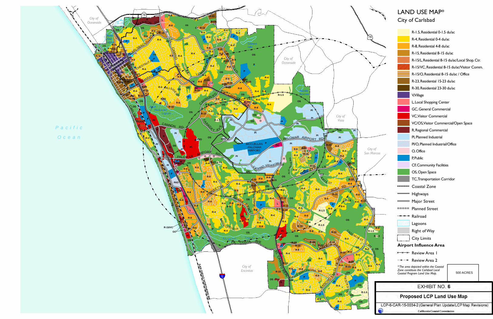
!!
!
!!
!
!!
!
!!
!
!!
!
!!
!
!!
!
!!
!
!!
!
!!
!
!!
!
!!
!
!!
!
!!
!
!!
!
!!
!
!!
!
!!
!
!!
!
!!
!
!!
!
!!
!
!!
!
!!
!
!!
!
!!
!
!!
!
!!
!
!!
!
!!!!!!!!!!!!!!!!!!!!!!!!!!!!!!!!!!!!!!!!!!!!!!!!!!!!!!!!!!!!!!!!!!!!!!!!!!!!!!!!!!!!!!!!!!!!!!!!!!!!!!!!!!!!!!!!!!!!!!!!!!!!!!!!!
!!
!
!!
!
!!
!
!!
!
!!
!
!!
!
!!!
!!
!
!!
!
!!
!
!!
!
!!
!
!!
!
!!!
!!!
!!!
!!!
!!!
!!!
!!!
!!!
!!!
!!!
!!!!!!!!!
!!
!
!!!
!!!
!!
!
!!
!
!!
!
!!!
!!
!
!!
!
!!
!
!!
!
!!
!
!!!
!!!
!!
!
!!
!
!!
!
!!
!
!!
!
!!
!
!!
!
!!
!
!!
!!
!!
!!
!!
!!
!!
!
!!
!
!!
!
!!
!
!!
!
!!
!
!!
!
!!
!
!!
!
!!
!
!!!
!!!
!!!
!!
!
!!
!
!!
!
!!
!
!! !
! ! !
! ! !
! ! !
! ! !
! ! !
! ! !
! ! !
! ! !
! ! !
! ! !
! ! !
! ! !
! ! !
! ! !
! ! !
! ! !
! ! !! ! ! ! ! !
! ! !
! ! !
! !!
!!
!
!!
!
!!
!
!!
!
!!
!
!!!
!!
!
!! !
!!
!
!!
!
! !!
! !!
!! !
!!
!
!!
!
!!
!
! !!
!! !
!! !
!!
!
!!
!
! !!
! !!
!! !
!! !
!!
!
!!
!
! !!
! !!
!! !
!! !
!!
!
!!
!
! !!
! !!
!! !
!! !
!!
!
!!
!
! !!
! !!
!! !
!! !
!!
!
}}}}
}}}}
}}}}
}}}}
}}}}
}}}}
}}
}}}}
}}}}
}}}}}}}}}}}}}}}}}}}}}}}}}}}}}}}}}}}}
}}}}
}}
}}
}}}}
}}}}
}}}}}}
}}
}}}}
}}
}}}}
}}}}
}}}}
}}
}}
}}}}
}}}}
}} }} }} }} }} }} }} }} }} }} }} }} }} }} }} }} }}}}
}}}}
}}
}}
}}}}
}}}}
}}
}} }} }}
!!!!!!!!!!!!
!
! !
!!
!
!!!!!
!!!
!!!
!!
!!!!
!!
!!!
!!!!!!! !!!!!!!!!!!!
!!
!!!!!!!!!!
!!!!!!!!!
!!!!
!!!!!!!!
!!!!!!!!!!!!
!!!!!!!! !!!!
!!!!!!
!!!!
!!!!!!!!! !!!!!!!!!! !
!
!!!!
!!!!!!!!!!!!
!!!!
!!!
!!!!!!!! !!!!!!!!!!!!!!!!
!!!!!!!!!!!!!!!!!!
!!!!!!
!
!
!!!! !
!!!!!!!!!!!!
!!!!!!!!!!!!!!!!
!!!!!!!!!!!!!!
!!!!!!!
!
!!!!!!!!!!!
!!!!!!!!
!!!!!!!!!!!!!!!!!!
!
!
!!!!!
!!
!!!!!!!!
!!!!!!!!!!!!!!!!!!!!!!!
!!!!!!!
!!!!!!!!!!!!!!!!!!!!!!!!!!!!!!!!!!!!!!!!!!!!!!!!!!!!!!!!!!!!!!!!!!!!!!!!!!!!!!!!!!!!!!!!!!!!!!!!!!!!!!!
!!!!!!!!!!!!!
!!!!
!!
OCEANSIDE
SAN MARCOS
ENCINITAS
}}78
VC
PI/O
R-15/LR-4 R-4
R-4
R-4
R-4
P
OS
OS
OSR-4
MELRO
SE DR
ALGA RD
RANCHO
SAN
TAFE
RD
LA COSTA AVE
ELCAM
INO
REAL
LA COSTA AVE
SANDIEGO
NORTHERNRR
CAR
LSBADBLV
D
POINSETTIA
LN
PALOMAR AIRPORT RD
C A M INO VID A ROBLE
AVIARAPK
WY
POINSETTIA LN
PALOMAR AIRPORT RD
ELCAMINO
REAL
TAMARACK AVE
EL
CA
MIN
OR
EAL
TA MARAC
KAV
E
COLLEG
EBLV
D
M ARRON RD
CARLSBAD VILLA
GE DR
CANNON RD
CAR
LSBADBLVD
§̈¦5
}}78
BATIQ
UITOS D R
ELFU
ERT E ST
CFALI
CAN
TE
RD
CAM
JUNIPE
RO
CAL
LE
AC
ERVO
CAD ENCIA ST
AMBR
OS
IALN
CHESTNUT AV
CALLE BARCELONA
HILLSIDEDR
R-8
OS
OS
OS
FA
RADA Y AV
E
CANNON R D
City of Oceanside
City of Vista
City of San Marcos
City of Encinitas
B a t i q u i t o s L a g o o n
MCCLELLAN-PALOMARAIRPORT
Agua Hed ionda
Lagoon
Buena VistaLagoon Calavera
Lake
MaerkleReservoir
P a c i f i cO c e a n
City of Oceanside
CF
GC
L
OS
P
R-1.5
R-15
R-23VC
R-8
R-8P
PR-4
R-23R-15
L
R-8 R-4
OSR-15
R-15
R-4R-15
R-23
R-4
R-8
P
R
V
R-15/VC
ROS
P
R-4
R-4R-15
R-1.5R-8
OS
OS
PP
P R-1.5
R-4
R-4
R-8
L
R-15R-23
R-23
VCR-15
R-4 R-8
R-1.5
R-8
OS
GC
R-8
R-8
R-4
R-8
LP
PP
P
R-4
OSR-4
R-4
R-23
R-8R-15
R-4
GC
OS
R-23
VCVC
R-8
OS
R-4
R-8
R-8
R-8
R-4
OS
R-4
R-8
R-23R-30O
R-8
OS
VC
VC
VC
R-8R-8
R-4
R-4
R-8
R-8
R-15 R-8
R-4R-15
PP
LR-23
PIPI
PIR-8
R-4R-4
R-4R-4
OS
R-8
R-4
PI
PI
POS
OSO
R-8R-23 R-4
R-1.5
OS
OS
OSR-4
R-8R-4
R-8R-8
R-8
R-23
R-8
R-23O
CF
R-23O
GC
OS
OS PI/OP
L GCR-15
R-1.5 R-4P
R-8R-15
R-4
R-8
R-15
R-8
PR-1.5
PIRPGC
VC
R-15
VCVC
PI
R-4
VC/OS
RPI
RVC
VCPI
OS
VCP
R-4
R-15
R-8
R-15
R-23CF
R-4
R-8
OSR-4R-4
R-4
R-1.5
R-4
R-8R-4
R-30R-15
R-8P
L
R-4
R-4
R-8 R-23
OS
OS
P
R-4
R-4
R-8R-4
R-15R-8R-4
PI/OP
GCR-15
P
P
R-15R-8OS
R-4R-4
P R-4R-8
R-23
R-8
P
PP
R LR-8
OR-15
R-23R-23
CF
CFCF
R-4R-15R-8
P
OS
R-4
OS
OS
R-15
R-4
R-23
OSVC
P R-15R-23
R-30
R-15P VC
R-30
R-15
R-4 R-4R-15
OSP
VC
LR-23R-15
R-8
VCR-8R-15/OR-15
R-23R-15
R-4
O
O
P
OS
R-8
R-4
R-8
OSOS
R-23 R-8
O
PI
VC
OOGCR-8O
VC
VC
R-23R-4
R-8
R-4
VC R-23 R-8R-15
R-4
R-4
R-8R-8
R-4
R-15GCO
O
O
R-4
P
P
R-23
O
R-23R-15CF
P
CF
PI
PI
GC
R-15
R-4
P
R-15
R-8 R-4R-4
VC R-8
R-23
R-8 R-8R-15
R-8R-4
R-8
R-4
R-4R-4
R-4
R-15
L
R-4
R-4R-15
R-4
R-4
R-8
R-4
R-1.5
O
R-1.5
OS
OS
OS
OS
OS
OS
OS
R-4
R-4
R-4
P
OS
OS
OS
OS
R-8
R-8
R-4
CF
CFO
O
O
P
PI
PI
PI
R
R-15
R-4
R-8
R-8V
V
CF
R-4
OS
!!!!!!!!!! Coastal ZoneHighwaysMajor StreetPlanned StreetRailroadLagoonsRight of WayCity Limits
Airport Influence Area}} }} }} Review Area 1! ! ! ! ! ! Review Area 2
0 1 20.5
Miles
Source: City of Carlsbad, 2013; SANDAG, 2013; Dyett & Bhatia, 2013.
500 ACRES
100ACRES
R-1.5, Residential 0-1.5 du/acR-4, Residential 0-4 du/acR-8, Residential 4-8 du/acR-15, Residential 8-15 du/acR-15/L, Residential 8-15 du/ac/Local Shop. Ctr.R-15/VC, Residential 8-15 du/ac/Visitor Comm.R-15/O, Residential 8-15 du/ac / OfficeR-23, Residential 15-23 du/acR-30, Residential 23-30 du/acV, VillageL, Local Shopping CenterGC, General CommercialVC, Visitor CommercialVC/OS, Visitor Commercial/Open SpaceR, Regional CommercialPI, Planned IndustrialPI/O, Planned Industrial/OfficeO, OfficeP, PublicCF, Community FacilitiesOS, Open SpaceTC, Transportation Corridor
* The area depicted within the CoastalZone constitues the Carlsbad LocalCoastal Program Land Use Map.
City of CarlsbadLAND USE MAP*

!!!!!!!!
!!
!!!!!
!
!!!
!!
!!!
!
!!!
!!!!!!!
!!
!!!!!!
!!!!!
!! !
!!!!!
!!!!!!
! ! ! ! ! ! !!!!!!!!! ! ! ! ! !
!!!! ! !
!
!!!
!!!!!!
!!!!!!!!!! ! ! ! ! ! ! !
!!!! ! ! !
! ! !!!! !
!!
!
!!!!
!!!!!!
!!!!
!!!!!!
!!
!!!!!!
!!!!!
!!!!!!
!
!!!!!
!!!!!!!!!! !
!!! !
!!!!!
! ! ! ! ! ! ! ! ! ! ! ! ! !!
! ! ! !!!!
!!!!!!!!!!!!!!
!!
!!!!!!!!!!!!!
!!
!!
!!
!!!!!!!!!
!!!!!!!!!!!!!!
!!!!!!!!
!!!
!
OCEANSIDE
SAN MARCOS
ENCINITAS
}}78
RD-M
C-2
C-2
C-2
C-2
C-2-Q
C-L
C-L
C-M
C-T
C-T
R-T
C-T
C-T
C-T
O
O
O
OS
OS
OS
OS
OS
OS
OS
OS
OS
OS
OS
P-U
R-1-20000
OS
RD-M-Q
OSP-U
L-C
OS
P-CP-C
P-C
P-CP-C
P-C
P-C
P-C
P-CP-C
P-CP-C
P-C
P-C
P-CP-C
P-C
P-C
P-CP-C
P-M
P-MP-M
P-M
P-M
P-M
P-M-Q
R-1
R-1
R-1
R-1
R-1
R-1R-1
R-1
R-1R-1
R-1
R-1R-1
R-1
R-1
R-1
R-1
R-1
R-1
R-1 R-1
R-1
R-1
R-1
R-1
R-1-10000
R-1
-100
00
R-1-10000
R-1-10000
R-1-10000
R-1-15000
R-1-25000
R-1-8000
R-1-8000
R-1-9500
R-1-QR-1-Q
R-1-Q
R-1-Q
R-1-Q
R-3
R-3
R-3
R-A-10000
R-A-10000
R-A-10000
RD-M RD-M
RD-M
RD-M
RD-M
RD-M
RD-M
RD-M
RD-M
RD-M
RD-M
RD-M-Q
RD-M-Q
RD-M-Q
RD-M-Q
RD-M-QRD-M-Q
RD-M-Q
RMHP
RMHP
V-R
V-R
C-T
R-2
P-C
P-M-Q
R-1-30000
RD-M-Q
OS
C-MR-A-10000
C-2-Q
C-2
C-2
RD-M
OS
R-1
RD-M
L-C
R-1-0.5-Q
R-1
R-1
OS
C-2
C-2-Q
P-C
P-C
R-1
R-1R-1-30000
RD-M
M-Q
C-2-Q
V-R
RD-M-Q
RD-M
RD-M
RD-M-Q
O
R-1
R-1-10000
RD-M
P-C
P-MP-M
R-1-Q
RD-MRMHP
C-2OS
R-1
R-1
R-1
R-1-9000
R-1
C-L
P-C
C-LR-3
RD-M
R-1R-1
R-W
C-T
C-T-Q
C-T-Q
O
OS
OS
P-C
P-C
R-3
C-2-Q
R-T
OS
RD-M
P-C
RMHPP-M
RD-M
C-T RD-M
P-C
RD-M-Q
P-U
RD-M-Q
P-C
RD-M
M-Q M
OS
R-A-10000
C-2
O
E-A P-M/O
O
C-T-Q
P-M
P-M/O
C-M
O
C-M
P-M
M
OS
RD-M-Q
OS
OS
OS
OS
OS
OS
P-C
RD-M-Q
OS
RD-MR-1-0.5-Q
R-1-0.5-Q
OS
R-A-10000
L-C
OS
P-U
L-C
R-A-2.5
P-C
OSP-C
R-1
OS
P-M
R-3-Q
P-C
OS OS
P-C
R-EL-C
R-3
O
R-1-10000
M
P-C
P-U
P-C
C-2
OS
OS
C-T/OS
P-M/O
C-2
RMHP
R-1
P-C P-C
P-C
P-C
T-C
P-C
P-M-Q
OS
C-T
C-TRD-M
RD-M-Q/C-T-Q
RD-M
C-T
RMHP
C-T-Q C-T-Q
C-T-Q
RD-M-Q
R-1
R-1-Q
R-1R-1-Q
R-1-Q
R-1-10000-Q
RD
-M-QR-1-10000-Q
R-1-10000-Q
R-1-10000-Q
RD-M/C-L
RD-M
OS
R-1-10000
R-1-10000
OS
C-L
RD-M
P-U
P-U
RD-M
P-M
O
R-1
R-1R-1-Q
L-C
RD-M
RD-M
R-1
V-R
R-P-Q
R-3
OO
O
OS
O
R-P-Q
R-1
R-1
R-1R-1-10000
RD-M
R-A-10000
R-A-10000-Q
R-1
P-U
OS
R-1-8000
R-1-9000
R-1-10000
R-1
-800
0
R-1-10000
R-1-8000
R-A
-100
00
R-1-9500
R-1
R-1
R-1-15000
R-1-10000
R-1R-1-15000
P-C
R-1-10000
R-1-10000
R-1
R-1
R-1RD-M R-3
RD-M-Q
R-1R-1-10000
R-1
R-1-10000
R-1
R-1-10000
RD-M-QR-A-10000
R-1-
9000
R-1
R-1-10000RD-M
RD-MR-1
R-1-15000
R-1
R-1
RD-M
P-C
RD-M
P-C
OS
OS
OS
R-1-0.5-Q
R-3
R-1
R-1-10000
R-2
RD-M
RD-M-Q
C-L
C-T-Q
O
OS
OS
P-C
P-M
R-1
R-1
RD-M
R-A-10000
RD-M
! ! ! ! ! ! Coastal ZoneHighwaysMajor StreetPlanned StreetRailroadLagoonsRight of WayCity Limits
0 1 20.5
Miles
Source: City of Carlsbad, 2013; SANDAG, 2013; Dyett & Bhatia, 2013.
E-A, Exclusive AgricultureR-A, Residential AgricultureR-E, Rural Residential EstateR-1, One Family ResidentialR-2, Two Family ResidentialR-3, Multi Family ResidentialRD-M, Residential Density - MultipleRD-M/C-L, Res Density - Multiple/Local Shop. Ctr.RMHP, Residential Mobile Home ParkR-T, Residential TouristR-W, Residential WaterwayR-P-Q, Residential ProfessionalO, OfficeC-L, Local Shopping CenterC-2, General Neighborhood CommercialC-T, Commercial TouristC-T/OS, Commercial Tourist/Open SpaceRD-M/C-T, Comm Tourist/Res Density - MultipleC-M, Heavy CommercialM, IndustrialP-M, Planned IndustrialP-M/O, Planned Industrial/OfficeP-U, Public UtilityV-R, Village ReviewP-C, Planned CommunityL-C, Limited ControlOS, Open SpaceT-C, Transportation Corridor
City of CarlsbadZONING MAP*
500 ACRES
100ACRES
* The area depicted within the CoastalZone constitues the Carlsbad LocalCoastal Program Zoning Map.