state of california -- california natural · pdf filestate of california -- california natural...
TRANSCRIPT
STATE OF CALIFORNIA -- CALIFORNIA NATURAL RESOURCES AGENCY EDMUND G. BROWN JR., Governor DEPARTMENT OF WATER RESOURCES 1416 NINTH STREET, P.O. BOX 942836 SACRAMENTO, CA 94236-0001 (916) 653-5791
December 12, 2014
TO: Long Range Weather Forecasting Committee Members
SUBJECT: Winter & Spring 2014-15 Forecasts
Finally, a substantial early-December storm added about 0.5 million acre-feet estimated storage to our Northern California reservoirs, which has been boosted now by one of the biggest storms in several years. Wetter watersheds are producing much more runoff in this second storm. The recent water year 2014 has been deemed the 4th driest runoff year on record in California in over a century of runoff records. WY 1977 was the driest, followed by 1924 as second, and 1931 was third. However, on the San Joaquin River portion, the southern four of the Central Valley 8-river system, runoff during the last 3 water years has been the driest 3-year period in a 114 year record (but just slightly drier than 1929-31). Statewide reservoir storage has been largely depleted by the two preceding dry years in 2012 and 2013 and now, after a dismal 2014 season, water storage in the state’s major reservoirs at the end of November was only about 30 percent of capacity. The current storm will improve the outlook, but more than one storm is needed in this new water year. Happily, the long range forecasts are indicating a wetter winter and spring.
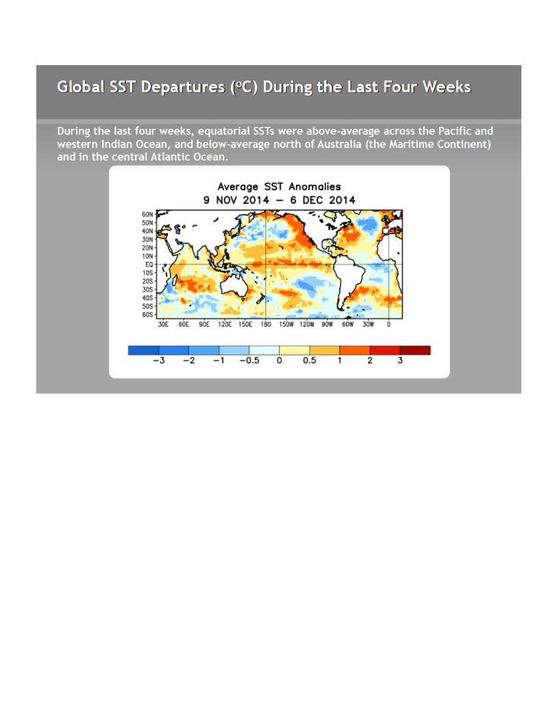
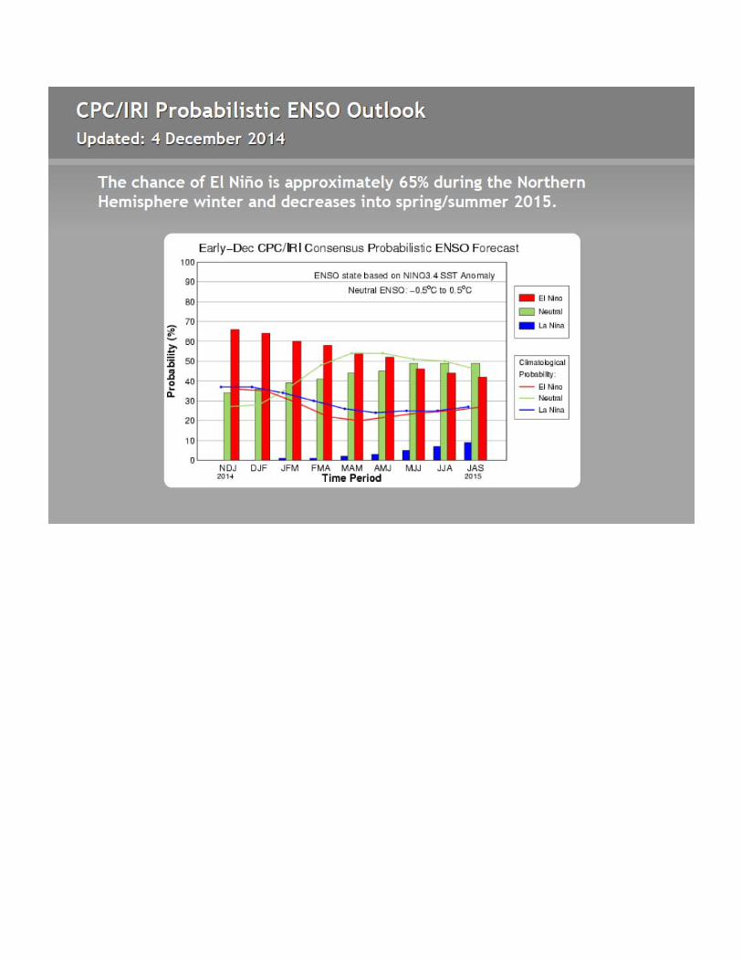
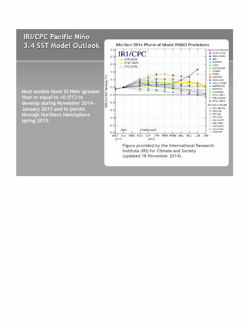
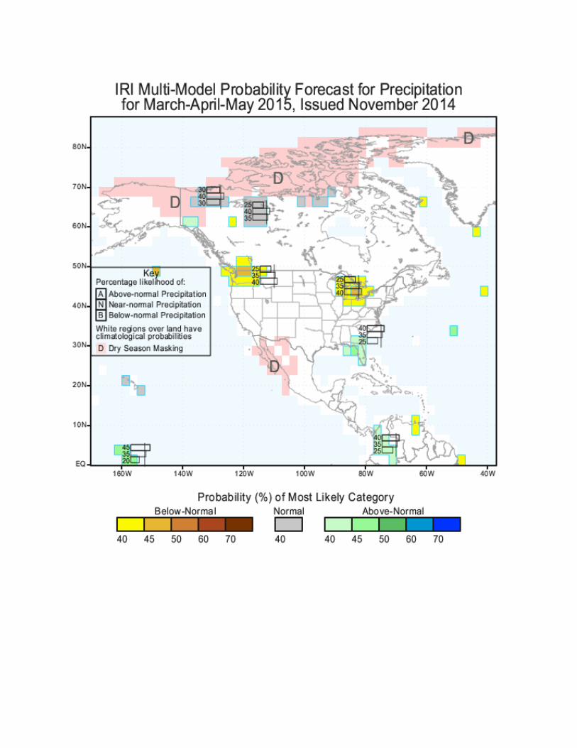
Attached are several charts of current Pacific Ocean conditions from the Climate Prediction Center (CPC). The first shows ocean temperatures, which are generally warmer than last year over the eastern North Pacific. The El Nino regions near the equator are warmer too, and would indicate a weak El Nino for this winter (which doesn’t provide much forecast skill). The next two charts are the Nino box and the IRI forecasts of a weak El Nino this winter. The Pacific Decadal Oscillation (PDO) was negative last fall, but turned positive this year in January with a 1.49 value in October, as reported by the University of Washington. Last year in October this index was -0.87 (negative).
The CPC forecasts for the coming seasons arrived in November with little change from recent months calling for a wet winter for the southern U. S. from California to the Mississippi River and somewhat dry in the Pacific Northwest, while wetter than average in the Southwest—a classic El Nino signal. Later in the spring, the CPC is looking for drier conditions in most of the country.
Dr. Art Douglas, former head of the Meteorology Department of Creighton University in Omaha and now retired in southeastern Arizona, sent me a set of charts which are the next attachments. He is more optimistic, with a wetter and warmer California in the winter and a wet spring, including Arizona. He feels that the overall Pacific pattern is that of a good El Nino, even though the particular Nino boxes on the equator don’t show a strong signal because warming there has been inhibited. He said his analog forecasts have been showing a wet winter for months now with good moisture in northern
Long Range Weather Forecasting Committee Members December 12, 2014 Page 2
California in the February through April time-frame, but he does expect a dry spell in January.
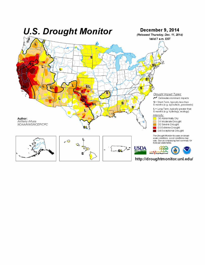
The drought monitor map is attached near the end of the package. California, western Nevada, and the southern plains continue to be the large dry areas in the nation, with the bull’s eye on California.
If you have any questions or comments, please feel free to call me at (916) 574-2625, or e-mail me at [email protected].
Sincerely,
Maurice Roos Chief Hydrologist (Part-Time) Division of Flood Management
Attachments
cc: (See attached page)
Long Range Weather Forecasting Committee Members December 12, 2014 Page 3
cc: Dr. Daniel Cayan Scripps Institution of Oceanography Climate Research Division, D224 La Jolla, California 92093-0224
Ms. Belinda Gatti California Public Utilities Commission Energy Division 505 Van Ness Avenue San Francisco, California 94102
Mr. Henry White, General Manager Georgetown Divide Public Utilities District Post Office Box 4240 Georgetown, California 95634
Mr. Steven Onken Yuba County Water Agency 1220 F Street Marysville, California 95901
Mr. Stein Buer 3912 El Ricon Way Sacramento, California 95864-3044
Mr. Steve Johnson San Joaquin Associates 96 Burgan Avenue Clovis, California 93611
Mr. Paul Hendrix General Manager Tulare Irrigation District 6826 Avenue 240 Tulare, California 93274
Mr. Paul Scantlin Department of Water and Power Room 1468, JFB City of Los Angeles Post Office Box 51111 Los Angeles, California 90051-0100
Mr. Richard Reinhardt MBK Engineers 1771 Tribute Road, Suite A Sacramento, California 95815
Mr. Tom Ryan Metropolitan Water District of Southern California Post Office Box 54153 Los Angeles, California 90054-0153
Dr. Jon Skindlov Water Resource Operations PAB120, SRP Post Office Box 52025 Phoenix, Arizona 85072-2025
Mr. Wayne Johnson Sacramento District U.S. Army Corps of Engineers 1325 J Street Sacramento, California 95817
Mr. Edward F. McCarthy Meteorology Department Pacific Gas and Electric Company 3400 Crow Canyon Road San Ramon, California 94583
Mr. Phillip Mensonides Northern California Power Agency 651 Commerce Drive Roseville, California 95678
Mr. Toby GoddardCity of Santa Cruz212 Locust Street, Suite ASanta Cruz, California 95060

Long Range Weather Forecasting Committee Members December 12, 2014 Page 4
cc: Mr. Richard Myers Energy Division California Public Utilities Commission 505 Van Ness Avenue San Francisco, California 94102
Mr. Steve Haugen Kings River Water Association 4888 East Jensen Avenue Fresno, California 93725
Mr. Tim O’Halloran, General Manager Yolo County Flood Control & Water Conservation 34274 State Highway 16 Woodland, California 95695
Mr. Dudley McFadden SMUD Power Generation, MS B355 Post Office Box 15830 Sacramento, California 95852
Mark W. Cowin, CDWR Gary Bardini, CDWR Keith Swanson, CDWR Eric Koch, CDWR Arthur Hinojosa, CDWR Jon Ericson, CDWR David Roose, CDWR Elissa Lynn, CDWR Matt Winston, CDWR Steven Nemeth, CDWR Michael Anderson, CDWR Jeanine Jones, CDWR Jose Faria, CDWR Peter Coombe, CDWR Laura King-Moon, CDWR


Art Douglas, December 4, 2014
EXTENDED RANGE OUTLOOK
DECEMBER THROUGH FEBRUARY 2015
SYNOPSIS
Equatorial warming has strengthened over the past few weeks and a moderate El Nino event is firmly
in place. Additional equatorial warming is likely through early January and this warming will
strengthen the split jet stream pattern across the country. Under the split jet expect the northern
tier of states to remain warmer than normal while the Southwest and California will drift towards
much wetter weather late winter through spring. Abnormally warm water off the West Coast has
promoted early winter rains but El Nino induced ridging in the Pacific Northwest will tend to keep
rainfall amounts near normal until later in the winter when strong storms will impact California and
the desert Southwest. Snow packs in the northern Rockies and northern Plains will remain at below
seasonal normals. With an active southern jet across the south storms will be forced offshore
towards Bermuda. This will lower the chances of repeat Nor’easters in early and mid‐winter along
the eastern sea board.
California, the Southwest and southern Plains will be the main regions benefitting from El Nino with
the strongest storm activity expected from late January through late March. Heavy wet snows are
likely across winter wheat areas of the central plains with the greatest threat from February through
March. Feed lots in this region will become increasingly muddy and cloudy‐wet weather will impact
weight gains of fed cattle. From central Nebraska northward, winter weather conditions will be
better than normal. Texas and the southern plains are already experiencing an increase in late fall
moisture and this will gradually spread westward into Arizona and California by late January. Heavy
rains across the region are likely to peak in February and March with heavy snow packs developing
across the southern Rockies. The Pacific Northwest will tend to have a dry winter but the severity of
the dry pattern will not approach that of other El Niño’s when the West Coast was cooler.
The split jet stream pattern will keep the northern two‐thirds of the Corn Belt in mild‐dry weather
through late winter. The spring forecast indicates that this dry pattern will persist across the
northern Rockies and into the northern Corn Belt. This will help initiate early spring field work and
planting across the region. The region from Kansas into the lower Ohio Valley is likely to be cool and
wet for the planting season and this will slow field work progress.

REGIONAL OUTLOOKS
Region 1. Mild weather is forecast with rainfall slipping to below normal levels by mid‐winter. Far
southern sections will see a gradual increase in moisture by February with wetter than normal
conditions forecast late winter through spring. Probably departures: temperatures to +2F;
precipitation 80% interior north and up to 120% southern quarter.
Region 2. This El Nino will not create strong drought conditions across the region due to the impact
of warm West Coast waters. February and April are likely to be the wettest months before the rains
turnoff in late Spring. Probable departures: Temperatures to +3F; precipitation 80% northern third
to 120% southern third winter then 150% south in the spring.
Region 3. Storms will break into the western ridge providing much needed rain early on, but the
heaviest rains will be February through April. Probable departures: temperatures up to +2F west;
precipitation rising to 150% of normal or higher late winter and spring.
Region 4. The southern two‐thirds of the region will remain wet through early spring. Far northwest
mountains will not turn wet until February but heavy snow packs should be in place by early spring.
Probable departures: temperature normal; precipitation to up to 150%.
Region 5. Mild dry weather should persist through mid‐winter with cooler‐wetter weather in the
south by February and March. Snow packs will be below normal due to light winter snowfall and
warm temperatures building later in the winter. Probable departures: temperatures to +4F north;
precipitation 80% normal north to 150% southern quarter.
Region 6. An easy winter is forecast with mild‐dry weather prevailing under a strong westerly flow.
Precipitation for the next 6 months should remain at below normal levels especially in the northern
half. Probable departures: temperatures to +3F; precipitation < 80% normal north.
Region 7. The main impact from El Nino will be farther west this year due to the warm waters off
Baja anchoring storms. Winter temperatures are forecast to drop to below normal levels by late
January with cold weather through early spring. Probable departures: temperatures falling to ‐2F
late winter; precipitation spotty, averaging 80‐110% of normal and wettest far west.
Region 8. The first part of the winter will tend to be mild but by February a deepening trough in the
Ohio Valley will favor cooler‐wetter conditions with heavy wet snows likely. Probable departures:
temperatures dropping from +2F to ‐2F; precipitation 90% normal early rising to 120% late.

Art Douglas