ace crc climate futures for tasmania - department of ...€¦ · ace crc antarctic climate &...
TRANSCRIPT
ACECRC
ANTARCTIC CLIMATE& ECOSYSTEMS CRC
climate futures for tasmania
local climate information for local communities
water and catchments
the summary
water and catchments
climate futures for tasmania
projecting future river flowsGreenhouse emissions scenario
Climate Futures for Tasmania used the A2 (high greenhouse emissions) scenario from the Intergovernmental Panel on Climate Change’s Special Report on Emissions Scenarios for the hydrological modelling. The A2 emissions scenario is the highest emissions scenario for which IPCC GCM projections were available, and best matches recent rates of greenhouse gas emissions.
Dynamical downscaling
Global climate model output, at a resolution of 200 km to 300 km, is too coarse for understanding changes in rainfall and temperature at a catchment scale. In Climate Futures for Tasmania, GCM output was put through another climate model (CCAM) that creates regional climate information. This process is called downscaling. The downscaling was carried out to a 0.1-degree (approximately 10 km) grid.
Bias-adjustment
All climate model simulations have a tendency to under/over-estimate climate variables like rainfall. When errors in climate model outputs occur consistently and predictably they are called biases. These biases have little impact on the climate trends or changes over the entire state, but they mean that the climate simulations are not compatible with the runoff models.
Climate simulations were bias-adjusted to be used in the runoff models, a standard scientific method for handling consistent differences between observations and simulations. For the runoff modelling, climate model outputs were carefully adjusted to be like observations from the SILO dataset.
Find the SILO dataset at:
www.longpaddock.qld.gov.au/silo
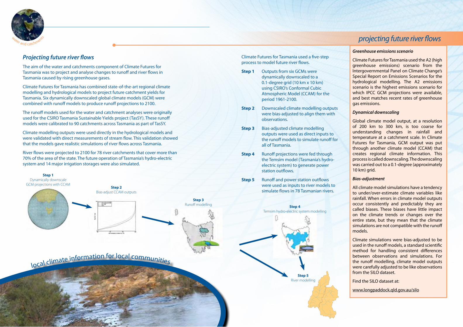
Projecting future river flowsThe aim of the water and catchments component of Climate Futures for Tasmania was to project and analyse changes to runoff and river flows in Tasmania caused by rising greenhouse gases.
Climate Futures for Tasmania has combined state-of-the-art regional climate modelling and hydrological models to project future catchment yields for Tasmania. Six dynamically downscaled global climate models (GCM) were combined with runoff models to produce runoff projections to 2100.
The runoff models used for the water and catchment analyses were originally used for the CSIRO Tasmania Sustainable Yields project (TasSY). These runoff models were calibrated to 90 catchments across Tasmania as part of TasSY.
Climate modelling outputs were used directly in the hydrological models and were validated with direct measurements of stream flow. This validation showed that the models gave realistic simulations of river flows across Tasmania.
River flows were projected to 2100 for 78 river catchments that cover more than 70% of the area of the state. The future operation of Tasmania’s hydro-electric system and 14 major irrigation storages were also simulated.
local climate information for local communities
water and catchments
Climate Futures for Tasmania used a five-step process to model future river flows.
Step 1 Outputs from six GCMs were dynamically downscaled to a 0.1-degree grid (10 km x 10 km) using CSIRO’s Conformal Cubic Atmospheric Model (CCAM) for the period 1961-2100.
Step 2 Downscaled climate modelling outputs were bias-adjusted to align them with observations.
Step 3 Bias-adjusted climate modelling outputs were used as direct inputs to the runoff models to simulate runoff for all of Tasmania.
Step 4 Runoff projections were fed through the Temsim model (Tasmania’s hydro- electric system) to generate power station outflows.
Step 5 Runoff and power station outflows were used as inputs to river models to simulate flows in 78 Tasmanian rivers.
Step 1Dynamically downscale
GCM projections with CCAMStep 2
Bias-adjust CCAM outputs
Step 3Runoff modelling Step 4
Temsim hydro-electric system modelling
Step 5River modelling

climate futures for tasmania
rainfall and evapotranspirationInterpreting climate projections
Using a range of climate models allows us to understand uncertainty in the projections. Runoff and river projections differ between different models. All the climate models used in Climate Futures for Tasmania are equally valid. Averaging projections from the six climate models is a useful way of summarising changes. We call this average the central estimate.
Results shown in this summary all use the central estimate. When interpreting these results, it is important to remember that some climate models will project a drier future than the central estimate, and some will project a wetter future.
Changes to rainfall and evapotranspirationStatewide annual rainfall is not projected to change markedly by the end of the century, however seasonal and spatial distributions of rainfall are projected to change. Rain falling on the central highlands is projected to decrease by the end of the century in all seasons. An increase in rainfall in the east is projected to occur predominantly in summer and autumn. Annual west coast rainfall shows little change overall, however west coast summer rainfall is projected to decrease and west coast winter rainfall is projected to increase.
Water lost from the land surface is both evaporated and transpired by plants. In combination, this is called evapotranspiration. Potential evapotranspiration is projected to increase in all regions of the state but proportionately less in the east and more in the west. These differences are driven by changes to rainfall and solar radiation in summer, the season when most of the annual evapotranspiration occurs.
local climate information for local communities
water and catchments
1961
-199
0
Runoff during the reference period (1961-1990)Average annual and seasonal runoff modelled using climate model inputs to the Simhyd runoff model for the period 1961-1990. This period is used to represent historical runoff, and future changes are compared to this period. Tasmanian runoff distribution follows rainfall distribution, with very high runoff flowing from the western mountains, and much lower runoff in the east.
EvapotranspirationChange in potential evapotranspiration by 2070-2099 compared to 1961-1990. Evapo-transpiration increases proportionally more in the west.
Modelled Historical Runoff
Water and catchments in TasmaniaTasmanian rivers show a diverse range of hydrological characteristics, from high-flowing mountain streams in the west to low-flowing streams in the east. These differences in river flows reflect Tasmania’s rainfall.
Tasmania has experienced a decline in rainfall since the mid-1970s in many areas, leading to a decrease in runoff.
2070
-209
9Annual
Summer Autumn
Winter Spring
Percent change in rainfall
Rainfall
Annual
Summer Autumn
Winter Spring
2070-2099
Potential Evapotranspiration
Percent change in potential evapotranspiration
RainfallChange in annual and seasonal rainfall by 2070-2099 compared to 1961-1990.
Rainfall change varies between regions and between the seasons.
climate futures for tasmania
changes to runoff
local climate information for local communities
water and catchments
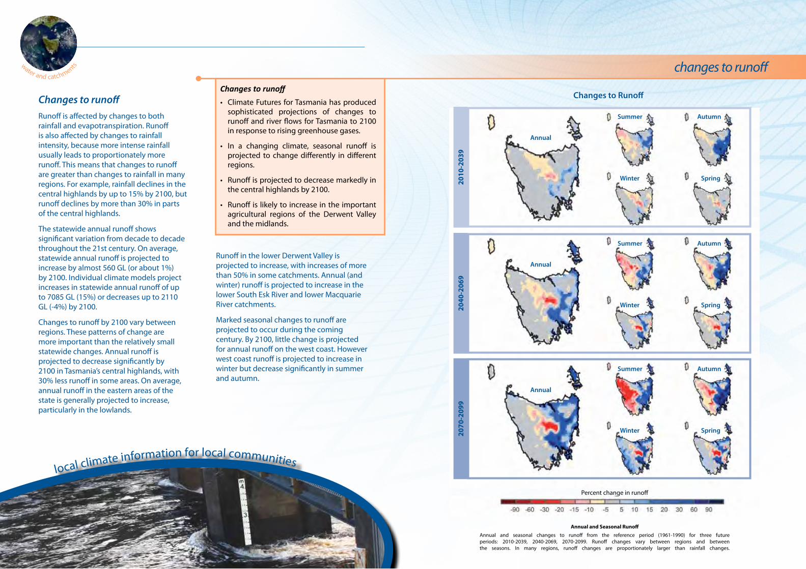
Changes to runoffRunoff is affected by changes to both rainfall and evapotranspiration. Runoff is also affected by changes to rainfall intensity, because more intense rainfall usually leads to proportionately more runoff. This means that changes to runoff are greater than changes to rainfall in many regions. For example, rainfall declines in the central highlands by up to 15% by 2100, but runoff declines by more than 30% in parts of the central highlands.
The statewide annual runoff shows significant variation from decade to decade throughout the 21st century. On average, statewide annual runoff is projected to increase by almost 560 GL (or about 1%) by 2100. Individual climate models project increases in statewide annual runoff of up to 7085 GL (15%) or decreases up to 2110 GL (-4%) by 2100.
Changes to runoff by 2100 vary between regions. These patterns of change are more important than the relatively small statewide changes. Annual runoff is projected to decrease significantly by 2100 in Tasmania’s central highlands, with 30% less runoff in some areas. On average, annual runoff in the eastern areas of the state is generally projected to increase, particularly in the lowlands.
Annual and Seasonal Runoff
Annual and seasonal changes to runoff from the reference period (1961-1990) for three future periods: 2010-2039, 2040-2069, 2070-2099. Runoff changes vary between regions and between the seasons. In many regions, runoff changes are proportionately larger than rainfall changes.
Changes to RunoffChanges to runoff
• Climate Futures for Tasmania has produced sophisticated projections of changes to runoff and river flows for Tasmania to 2100 in response to rising greenhouse gases.
• In a changing climate, seasonal runoff is projected to change differently in different regions.
• Runoff is projected to decrease markedly in the central highlands by 2100.
• Runoff is likely to increase in the important agricultural regions of the Derwent Valley and the midlands.
Runoff in the lower Derwent Valley is projected to increase, with increases of more than 50% in some catchments. Annual (and winter) runoff is projected to increase in the lower South Esk River and lower Macquarie River catchments.
Marked seasonal changes to runoff are projected to occur during the coming century. By 2100, little change is projected for annual runoff on the west coast. However west coast runoff is projected to increase in winter but decrease significantly in summer and autumn.
2010
-203
920
40-2
069
2070
-209
9
Annual
Summer Autumn
Winter Spring
Annual
Summer Autumn
Winter Spring
Annual
Summer Autumn
Winter Spring
Percent change in runoff
climate futures for tasmania
changes to river flowswater and catchments
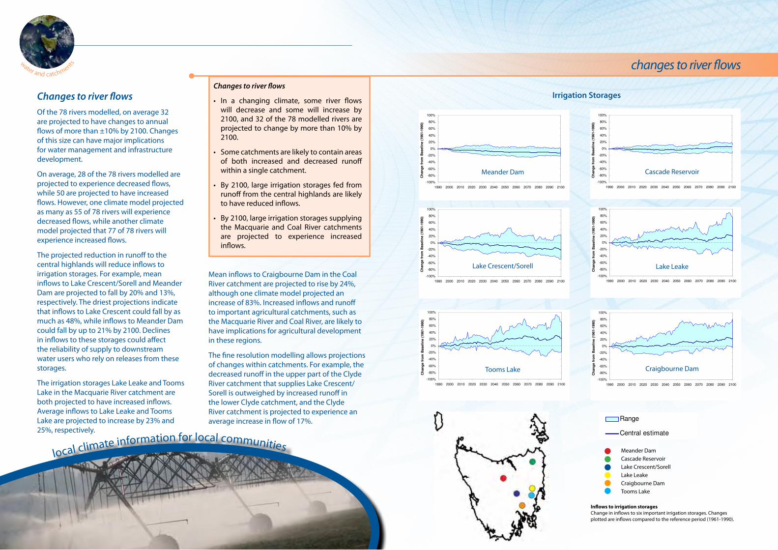
Meander Dam Cascade Reservoir
Lake Crescent/Sorell
Craigbourne DamTooms Lake
Lake Leake
Inflows to irrigation storagesChange in inflows to six important irrigation storages. Changes plotted are inflows compared to the reference period (1961-1990).
Changes to river flowsOf the 78 rivers modelled, on average 32 are projected to have changes to annual flows of more than ±10% by 2100. Changes of this size can have major implications for water management and infrastructure development.
On average, 28 of the 78 rivers modelled are projected to experience decreased flows, while 50 are projected to have increased flows. However, one climate model projected as many as 55 of 78 rivers will experience decreased flows, while another climate model projected that 77 of 78 rivers will experience increased flows.
The projected reduction in runoff to the central highlands will reduce inflows to irrigation storages. For example, mean inflows to Lake Crescent/Sorell and Meander Dam are projected to fall by 20% and 13%, respectively. The driest projections indicate that inflows to Lake Crescent could fall by as much as 48%, while inflows to Meander Dam could fall by up to 21% by 2100. Declines in inflows to these storages could affect the reliability of supply to downstream water users who rely on releases from these storages.
The irrigation storages Lake Leake and Tooms Lake in the Macquarie River catchment are both projected to have increased inflows. Average inflows to Lake Leake and Tooms Lake are projected to increase by 23% and 25%, respectively.
Irrigation StoragesChanges to river flows
• In a changing climate, some river flows will decrease and some will increase by 2100, and 32 of the 78 modelled rivers are projected to change by more than 10% by 2100.
• Some catchments are likely to contain areas of both increased and decreased runoff within a single catchment.
• By 2100, large irrigation storages fed from runoff from the central highlands are likely to have reduced inflows.
• By 2100, large irrigation storages supplying the Macquarie and Coal River catchments are projected to experience increased inflows.
Mean inflows to Craigbourne Dam in the Coal River catchment are projected to rise by 24%, although one climate model projected an increase of 83%. Increased inflows and runoff to important agricultural catchments, such as the Macquarie River and Coal River, are likely to have implications for agricultural development in these regions.
The fine resolution modelling allows projections of changes within catchments. For example, the decreased runoff in the upper part of the Clyde River catchment that supplies Lake Crescent/Sorell is outweighed by increased runoff in the lower Clyde catchment, and the Clyde River catchment is projected to experience an average increase in flow of 17%.
local climate information for local communities Meander Dam Cascade Reservoir Lake Crescent/Sorell Lake Leake Craigbourne Dam Tooms Lake

climate futures for tasmania
about the project
About Climate Futures for Tasmania
Climate Futures for Tasmania is the Tasmanian Government’s most important source of climate change data at a local scale. It is a key part of Tasmania’s climate change strategy as stated in the Tasmanian Framework for Action on Climate Change and is supported by the Commonwealth Environment Research Facilities as a significant project.
This project has used a group of global climate models to simulate the Tasmanian climate. The project is unique in Australia: it was designed from conception to understand and integrate the impacts of climate change on Tasmania’s weather, water catchments, agriculture and climate extremes, including aspects of sea level, floods and wind damage. In addition, through complementary research projects supported by the project, new assessments were made of the impacts of climate change on coastal erosion, biosecurity and energy production, and the development of tools to deliver climate change information to infrastructure asset managers and local government.
As a consequence of this wide scope, Climate Futures for Tasmania is an interdisciplinary and multi-institutional collaboration of twelve core participating partners (both state and national organisations). The project was driven by the information requirements of end users and local communities.
‘The Summary’ is an at-a-glance snapshot of the Water and Catchments Technical Report. Please refer to the full report for detailed methods, results and references.
Climate Futures for Tasmania complements climate analysis and projections done at the continental scale for the Intergovernmental Panel on Climate Change’s Fourth Assessment Report, at the national scale in the Climate Change in Australia Report and data tool, as well as work done in the south-east Australia region in the South Eastern Australia Climate Initiative. The work also complements projections done specifically on water availability and irrigation in Tasmania by the Tasmania Sustainable Yields Project.
Climate changeThere is overwhelming scientific evidence that the earth is warming and that increased concentrations of greenhouse gases caused by human activity are contributing to our changing climate.
Change is a feature of the 21st century global climate. The need to understand the consequences and impacts of climate change on Tasmania and to enable planning for adaptation and mitigation of climate change at a regional level has been recognised by both the state and federal governments.
Increased temperatures are just one aspect of climate change. Global warming also causes changes to rainfall, wind, evaporation, cloudiness and other climate variables. These changes will not only become apparent in changes to average climate conditions but also in the frequency and intensity of extreme events such as heatwaves, flooding rains or severe frosts.
While climate change is a global phenomenon, its specific impacts at any location will be felt as a change to local weather conditions. This means we need regional studies to understand the effects of climate change to specific areas. Climate Futures for Tasmania is one such regional study, producing fine-scale climate change projections that will allow for the analysis of climate impacts at different locations within Tasmania, and of changes to seasonality and extreme events.
local climate information for local communities
water and catchments
Tasmania’s hydro-electric systemTasmania’s hydro-electric system covers a large proportion of the western and central areas of Tasmania. The system stores significant quantities of water in reservoirs and diverts the courses of several rivers, including transferring water between watersheds. The system includes Australia’s largest and sixth largest lakes: Lake Gordon/Pedder (11,000 GL) and Great Lake (3,000 GL). Outflows from Tasmania’s hydro-electric system into Tasmanian rivers depends not only on inflows, but also on energy demand and prices, maintenance schedules, environmental regulations and the national electricity market operating rules. All of these functions contribute to the operation of the system and need to be considered when projecting power station operation and river flows.
There has been an ongoing decline in observed inflows to hydro-electric catchments through the 20th century. Projections indicate that inflows will continue to decline through the 21st century.
Decreased inflows could lead to an overall reduction in power generation capacity by 2100. Declines to inflows in the central plateau catchments could have a marked impact on power generation, because these catchments feed a large capacity, highly efficient power station.
Hydro-electric catchments
Impacts to hydro power generation
• Tasmania’s hydro-electric systems covers a large area of the state and includes two of Australia’s largest reservoirs: Lake Gordon/Pedder and Great Lake.
• By 2100, climate change is likely to reduce inflows to catchments used for hydro-electric power generation and this could reduce the power generation capacity of the Hydro Tasmania hydro-electric system.
Inflows
Inflows to hydro-electric catchmentsHistorical inflows to hydro-electric catchments (black line) have declined during the 20th century. Inflows are projected to continue to decline through the 21st century.
local climate information for local communities
Climate Futures for Tasmania is possible with support through funding and research of a consortium of state and national partners.
Technical Reports
Bennett JC, Ling FLN, Graham B, Grose MR, Corney SP, White CJ, Holz GK, Post DA, Gaynor SM & Bindoff NL 2010, Climate Futures for Tasmania: water and catchments technical report, Antarctic Climate and Ecosystems Cooperative Research Centre, Hobart, Tasmania.
Cechet RP, Sanabria A, Divi CB, Thomas C, Yang T, Arthur C, Dunford M, Nadimpalli K, Power L, White CJ, Bennett JC, Corney SP, Holz GK, Grose MR, Gaynor SM & Bindoff NL in prep, Climate Futures for Tasmania: severe wind hazard and risk technical report, Antarctic Climate and Ecosystems Cooperative Research Centre, Hobart, Tasmania.
Corney SP, Katzfey JJ, McGregor JL, Grose MR, Bennett JC, White CJ, Holz GK, Gaynor SM & Bindoff NL 2010, Climate Futures for Tasmania: climate modelling technical report, Antarctic Climate and Ecosystems Cooperative Research Centre, Hobart, Tasmania.
Grose MR, Barnes-Keoghan I, Corney SP, White CJ, Holz GK, Bennett JC, Gaynor SM & Bindoff NL 2010, Climate Futures for Tasmania: general climate impacts technical report, Antarctic Climate and Ecosystems Cooperative Research Centre, Hobart, Tasmania.
Holz GK, Grose MR, Bennett JC, Corney SP, White CJ, Phelan D, Potter K, Kriticos D, Rawnsley R, Parsons D, Lisson S, Gaynor SM & Bindoff NL 2010, Climate Futures for Tasmania: impacts on agriculture technical report, Antarctic Climate and Ecosystems Cooperative Research Centre, Hobart, Tasmania.
McInnes KL, O’Grady JG, Hemer M, Macadam I, Abbs DJ, White CJ, Bennett JC, Corney SP, Holz GK, Grose MR, Gaynor SM & Bindoff NL in prep, Climate Futures for Tasmania: extreme tide and sea level events technical report, Antarctic Climate and Ecosystems Cooperative Research Centre, Hobart, Tasmania.
White CJ, Sanabria LA, Grose MR, Corney SP, Bennett JC, Holz GK, McInnes KL, Cechet RP, Gaynor SM & Bindoff NL 2010, Climate Futures for Tasmania: extreme events technical report, Antarctic Climate and Ecosystems Cooperative Research Centre, Hobart, Tasmania.
Citation for this document
ACE CRC 2010, Climate Futures for Tasmania water and catchments: the summary, Antarctic Climate and Ecosystems Cooperative Research Centre, Hobart, Tasmania.
Project reports and summaries are available for download from:www.climatechange.tas.gov.au
Enquiries
Find more information about Climate Futures for Tasmania at:
www.acecrc.org.au
To access the modelling outputs:
www.tpac.org.au
Private Bag 80 Hobart Tasmania 7001
Tel: +61 3 6226 7888Fax: +61 3 6226 2440
water and catchments
Disclaimer
The material in this report is based on computer modelling projections for climate change scenarios and, as such, there are inherent uncertainties in the data. While every effort has been made to ensure the material in this report is accurate, Antarctic Climate & Ecosystems Cooperative Research Centre (ACE) provides no warranty, guarantee or representation that material is accurate, complete, up to date, non-infringing or fit for a particular purpose. The use of the material is entirely at the risk of a user. The user must independently verify the suitability of the material for its own use.
To the maximum extent permitted by law, ACE, its participating organisations and their officers, employees, contractors and agents exclude liability for any loss, damage, costs or expenses whether direct, indirect, consequential including loss of profits, opportunity and third party claims that may be caused through the use of, reliance upon, or interpretation of the material in this report.