accessibility for pedestrians: evaluation of school area in the ... · abnt nbr 9050: 2015...
TRANSCRIPT

2327
ISSN 2286-4822
www.euacademic.org
EUROPEAN ACADEMIC RESEARCH
Vol. VI, Issue 5/ August 2018
Impact Factor: 3.4546 (UIF)
DRJI Value: 5.9 (B+)
Accessibility for Pedestrians: Evaluation of school
area in the Northern Zone of Manaus
RONDINELLE DOS SANTOS ANDRADE1
MARCO ANTONIO GUERREIRO PRADO FILHO2
CHARLES RIBEIRO DE BRITO3
Abstract:
The pedestrian circulation system is composed about several
structures and elements. These structures must be accessible so that
every citizen, according with or without disabilities, it can safely travel
and to exercise their rights for the people in this way to come and to go
whatever place. In this sense, this article demonstrates the process
about implementation of infrastructure of tours in a school area
localized in the Northern Zon Manaus city, in order to meet the
necessity found in the community. The lack of infrastructure of the
locality causes pedestrians and vehicles to share the same space, with
risks of eminent accidents. According the NBR 9050: 2015 lays down
parameters of distances should be obeyed so that there is accessibility
and mobility for all types of people, within the system of pedestrian
circulation. The federal Law n. 12,587, dated January 3, 2012,
established a policy for urban mobility in Brazil, whose purpose to
integrate the different modes of transportation, improving accessibility
and mobility among them. Throughout this work, for contribute to the
development of the subject in question, both at the municipal and
national levels, and that the public power be aware of the current
problem and take measures to improve the lives about citizens.
Key words: Accessibility, Pedestrians, Pedestrian Circulation
System, Sidewalks.
¹ Bachelor of Engineering from Laureate International Universities/UNINORTE (Brazil)
² Teacher at Federal University of Amazonas - UFAM (Brazil)
³ Teacher at Laureate International Universities/UNINORTE (Brazil).

Rondinelle dos Santos Andrade, Marco Antonio Guerreiro Prado Filho, Charles Ribeiro
de Brito- Accessibility for Pedestrians: Evaluation of school area in the
Northern Zone of Manaus
EUROPEAN ACADEMIC RESEARCH - Vol. VI, Issue 5 / August 2018
2328
1 INTRODUCTION
The Free Zone Model of Manaus (ZFM) was conceived by
Federal Deputy Francisco Pereira da Silva and instituted
through Decree-Law No. 288 of February 28, 1967, during the
military dictatorship, under the policy of import substitution.
Its objective was to promote the development of the northern
region of Brazil, hampered by its great distance from the
production centers and vulnerable to bordering countries due to
its low demographic density and occupation.
In the most diverse cities of the world, extensive
networks of circulation structures interconnect the most diverse
environments. These traffic structures, along with other
elements, such as traffic lights, walkways, pedestrian lanes, are
responsible for the primary circulation of a city and thus form
the Pedestrian Circulation System (SCP).
The SCP is composed of several elements, in which the
walk, commonly known as sidewalk, is of fundamental
importance, both for the circulation of the individuals, as for
the drainage of rainwater, besides contributing in other
aspects.
The walk, because it is a structure of circulation of
practically all pedestrians and other means of locomotion, must
present, besides safety and durability, dimensions that are
consistent with the characteristics of pedestrian flow.
ABNT NBR 9050: 2015 establishes distance parameters
to be obeyed so that there is accessibility and mobility for all
types of people. Figures 1, 2 and 3 show the minimum distances
in meters prescribed by the standard for free movement in a
straight line.
Figure 1 - A person in a wheelchair - Front view and Superior. Source: NBR 9050: 2015

Rondinelle dos Santos Andrade, Marco Antonio Guerreiro Prado Filho, Charles Ribeiro
de Brito- Accessibility for Pedestrians: Evaluation of school area in the
Northern Zone of Manaus
EUROPEAN ACADEMIC RESEARCH - Vol. VI, Issue 5 / August 2018
2329
Figura 2 – Uma pessoa em cadeira de rodas e um pedestre. Vista Frontal e
Superior. Fonte: NBR 9050:2015
Figure 3 - Two people in a wheelchair. Front and Top View. Source: NBR
9050: 2015
The problem is that in many places the ride, or sidewalk, is not
adequately as prescribed by NBR 9050: 2015. The walks have
several irregularities, such as varying levels, smaller than
minimum dimensions, lack of accessibility for wheelchairs,
dumps and posts in the middle of the passage, among others.
All these obstacles make the pedestrian get out of the ride and
move on the road, a place intended for car traffic. According to
data from the World Health Organization (WHO),
approximately 1.3 million people die each year from reckless
driving. Of the survivors, about 50 million live with sequelae.
The survey was conducted in 2009 in 178 countries. In addition,
traffic is the ninth largest cause of death on the planet. Brazil
ranks fifth among countries in traffic deaths behind India,
China, the United States and Russia. That is why the
Pedestrian Circulation System needs to be in line with what
recommends standards, anywhere, to prevent tragedy and
provide dignity to its users. Industry, commerce, public

Rondinelle dos Santos Andrade, Marco Antonio Guerreiro Prado Filho, Charles Ribeiro
de Brito- Accessibility for Pedestrians: Evaluation of school area in the
Northern Zone of Manaus
EUROPEAN ACADEMIC RESEARCH - Vol. VI, Issue 5 / August 2018
2330
authorities, schools, universities, places of interest, residences
and any other functional structure of a city are connected
through this system, which is essential for all urban mobility.
The accessibility of this system is an essential condition for all
individuals to live in society (BAPTISTA, 2010).
Accessibility is described, according to ABNT NBR 9050:
2015, as a possibility and reach condition for the use, with
security and autonomy of the spaces, furniture and urban
equipments of the buildings of the transport and of the systems
and means of communication by people with deficiencies or
with reduced mobility.
As we live in society, it is necessary that the
environments are adequate and that they have easy access to
all human beings and not only to a single individual.
Human beings are different in many characteristics, and
according to BAPTISTA (2010), in addition to dimensional
differences between humans, there is still a great variability of
physical, sensory and cognitive abilities and restrictions. These
variables are present in human life due to several processes,
ranging from aging (child, adult, elderly), diseases, congenital
malformation and also accidents that resulted in a loss or
anomaly of an anatomical structure or function , physiological
or psychological.
Knowing that people have the most diverse
characteristics, and that the coming and going is a right for all,
Brazilian law states that every person, including those with
disabilities, has the right to access to education, health, leisure
and work . In this way, people must be perceived with equality,
thus leading to the recognition and attendance of specific needs.
Every day, thousands of people use the SCP moving
from their homes to their daily activities (work, study, leisure).
The most used modality for the displacement in this system is
the pedestrian, since it constitutes the most natural and direct
form of individual provision of means of transport, and
Rondinelle dos Santos Andrade, Marco Antonio Guerreiro Prado Filho, Charles Ribeiro
de Brito- Accessibility for Pedestrians: Evaluation of school area in the
Northern Zone of Manaus
EUROPEAN ACADEMIC RESEARCH - Vol. VI, Issue 5 / August 2018
2331
according to Vasconcellos (2001), represents the only human
ability of displacement equally distributed, being the comfort
and safety of foot movement mainly linked to accessibility of
sidewalks and specific signaling of transverse routes.
The objective of this study is to analyze a place in the
city of Manaus, with the purpose of evaluating and, if
necessary, prescribing recommendations for improving
accessibility, since it is a section that comprises 2 (two) State
Schools and which has about 400 students, in turn, traveling
daily, outside the other users of the road, whose lives are at
risk, due to lack of infrastructure for pedestrians.
In addition, streets without gutters and gutters make
rainwater accumulate and create holes in the pavement.
It makes with which the vehicles that travel in the lane
deviate of the holes, directly threatening the pedestrians who
are traveling by the way of rolling due to lack of infrastructure
of the Pedestrian Circulation System.
The choice to carry out this article is to emphasize the
importance of accessibility and urban mobility, thus promoting
respect and dignity to the whole society. Without urban
mobility there is no possibility of a city or community being
developed, after all, everything is interconnected through
transport.
Pedestrians and especially disabled people suffer from
the lack of accessibility in various places, and with this their
mobility is greatly impaired. If it is already difficult to walk the
streets in a wheelchair, with obstacles and inaccessible
structures, it gets much worse.
It is hoped that the topics discussed here contribute to
improving the quality of life of the population of the analyzed
place, that the subject be dissipated by the country, thus
contributing to the improvement of the quality of life of all,
besides serving as a basis for consultations , research and
support material for technicians, technologists and future civil

Rondinelle dos Santos Andrade, Marco Antonio Guerreiro Prado Filho, Charles Ribeiro
de Brito- Accessibility for Pedestrians: Evaluation of school area in the
Northern Zone of Manaus
EUROPEAN ACADEMIC RESEARCH - Vol. VI, Issue 5 / August 2018
2332
engineers, who will certainly contribute in a positive way to
social and technological progress in the formation of knowledge
in our country.
2 BIBLIOGRAPHICAL REVIEW
2.1 Accessibility and Mobility
There are many concepts that these two terms can achieve.
Although similarities, accessibility and mobility are two
different things, however, interconnected existence of both.
"In the literature one can often find a certain confusion
regarding conceptualization and its measures of accessibility
and mobility, especially when these measures relate only to
the question of ease or impedance in the displacements. In
this situation, accessibility is interpreted as an attribute that
is solely dependent on the transport system without
considering the degree of attraction of the opportunities
offered in the potential destination zones, and the concepts of
mobility and accessibility are mixed "(ULYSSÉA NETO and
SILVA, 2004: p. 774).
According to ABNT NBR 9050: 2015, accessibility is the
possibility and condition of reach, perception and
understanding for the use, with security and autonomy of
buildings, urban equipment, buildings, transportation,
information and communication, including their systems and
technologies, as well as such as other services and facilities
open to the public, for public or private use for collective use,
both in urban and rural areas, by persons with disabilities or
reduced mobility.
JONES (1981) relates accessibility with the opportunity
that an individual possesses to participate in an activity in a
given place, being such potentiality made available by the
transportation system and the use of the ground, which would
allow different types of people to develop their activities.
Rondinelle dos Santos Andrade, Marco Antonio Guerreiro Prado Filho, Charles Ribeiro
de Brito- Accessibility for Pedestrians: Evaluation of school area in the
Northern Zone of Manaus
EUROPEAN ACADEMIC RESEARCH - Vol. VI, Issue 5 / August 2018
2333
SATHISAN & SRINIVASAN (1998) point out that
accessibility is associated with the ability to reach a particular
place, while mobility is related to the ease with which the
displacement can be achieved.
2.2 Pedestrian Flow Characteristics
Similar to vehicle flow parameters, pedestrian flow parameters
are defined according to HOEL, (2011):
• Pedestrian speed: This is the average walking speed of the
pedestrian which is generally about 1.2m / s, but varies with
the age and purpose of the walk.
• Pedestrian flow: Refers to the number of pedestrians
crossing a line across the width of an infrastructure
perpendicular to the pedestrian route per unit of time (p / min).
The pedestrian flow / unit width is equal to that of pedestrians
divided by the effective width of pedestrian infrastructure in
pedestrian / min / m (p / mm / m) units.
• Pedestrian Density: It is calculated as the average number
of pedestrians / unit area of pedestrian infrastructure (w / m²)
• Pedestrian space: Refers to the average area available for
each pedestrian. It is equal to the inverse of the density,
expressed in units of square meters / pedestrian (m² / p).
The parameters quoted above are related to each other. The
greater the number of pedestrians using the infrastructure
assigned to them, the lower the traffic speed, causing possible
congestion, if the dimensioning of the width of the
infrastructure is done in the wrong way. This relationship is
known as Service Levels.
2.3 Service Levels for Displaced Pedestrians
The service levels are classified as follows:
• Service Level A - Free Flow (Density 0.2 p / m2, Flow 16 p /
min / m)

Rondinelle dos Santos Andrade, Marco Antonio Guerreiro Prado Filho, Charles Ribeiro
de Brito- Accessibility for Pedestrians: Evaluation of school area in the
Northern Zone of Manaus
EUROPEAN ACADEMIC RESEARCH - Vol. VI, Issue 5 / August 2018
2334
Pedestrians move along the desired path without being forced
to alter their movements by the proximity of others. Their
velocities are freely chosen and there is little likelihood of
conflict.
Service Level B - Fairly free flow (Density 0.3-0.2 p / m2,
Flow 16-23 p / min / m)
Pedestrians freely choose their speeds, but their paths already
demand attention from others.
Service Level C - Stable Flow (Density 0.5-0.3 p / m2, Flow
23-33 p / min / m)
Pedestrians can move at normal speed and overtake other
pedestrians in the same direction. Opposite flows and changes
in trajectories begin to cause conflict. There is some reduction
in flows.
Service Level D - Flow near instability (Density 0.7-0.5 p /
m 2, Flow 33-49 p / min / m)
Pedestrians have their speed restricted and find it difficult to
overtake other pedestrians. Opposite flows and trajectory
changes greatly increase the likelihood of conflict. One can still
consider a reasonable fluidity in the displacements.
Service Level E - Unstable Flow / Capacity (Density 1.3-
0.7 p / m2, Flow 49-75 p / min / m)
Pedestrians are often forced to adjust their speeds. The
available space is insufficient to allow the passing of more
leisurely pedestrians. Movements of contrary currents and
changes in trajectories are extremely difficult. At the limit of
this level, the displacement is dragged, with stops and
interruptions of the flow.
Service Level F - Forced Flow (Density 1.3 p / m2,
Variable Flow w / min / m)
The movement of pedestrians is dragged. Physical contact is
frequent and inevitable. Changes in trajectories and flows of
opposing meanings are virtually impossible. The flow is
sporadic.
Rondinelle dos Santos Andrade, Marco Antonio Guerreiro Prado Filho, Charles Ribeiro
de Brito- Accessibility for Pedestrians: Evaluation of school area in the
Northern Zone of Manaus
EUROPEAN ACADEMIC RESEARCH - Vol. VI, Issue 5 / August 2018
2335
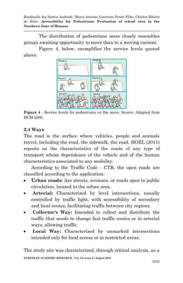
The distribution of pedestrians more closely resembles
groups awaiting opportunity to move than to a moving current.
Figure 4, below, exemplifies the service levels quoted
above:
Figure 4 - Service levels for pedestrians on the move. Source: Adapted from
HCM 2000.
2.4 Ways
The road is the surface where vehicles, people and animals
travel, including the road, the sidewalk, the road. HOEL (2011)
reports on the characteristics of the roads of any type of
transport whose dependence of the vehicle and of the human
characteristics associated to any modality.
According to the Traffic Code - CTB, the open roads are
classified according to the application:
Urban roads: Are streets, avenues, or roads open to public
circulation, located in the urban area.
Arterial: Characterized by level intersections, usually
controlled by traffic light, with accessibility of secondary
and local routes, facilitating traffic between city regions.
Collector's Way: Intended to collect and distribute the
traffic that needs to change fast traffic routes or in arterial
ways, allowing traffic.
Local Way: Characterized by unmarked intersections
intended only for local access or in restricted areas.
The study site was characterized, through critical analysis, as a

Rondinelle dos Santos Andrade, Marco Antonio Guerreiro Prado Filho, Charles Ribeiro
de Brito- Accessibility for Pedestrians: Evaluation of school area in the
Northern Zone of Manaus
EUROPEAN ACADEMIC RESEARCH - Vol. VI, Issue 5 / August 2018
2336
local route, because it is within a neighborhood, has unsealed
intersections, as well as the traffic capacity of the road that is
not large.
Figure 5, below, shows an excerpt from the pathway of the
study site, located between the two schools.
Figure 5 - Public thoroughfare at the study site. (Av. Santa Marta, Jesus me
Deus Community, Colônia Terra Nova, Manaus, Amazonas). Source: Own
Author.
2.5 Tours
According to the Brazilian Traffic Code (CTB), the sidewalk is a
part of the sidewalk or the runway, separated in the latter case
by painting or separating physical element, free of interference,
intended for the exclusive circulation of pedestrians and,
exceptionally, of cyclists.
They are associated with a public road system and in
them also different signs are implanted, favoring a safe and
accessible environment for the mobility of all the people.
The rides must be continuous, without abrupt level
changes or inclinations that impede the safe transit of
pedestrians, observed, whenever possible, the immediate levels
of the neighboring rides already executed.
They should comply with the accessibility standards, in
particular ABNT NBR 9050: 2015, offering possibility and
condition of reach, perception and understanding for use with

Rondinelle dos Santos Andrade, Marco Antonio Guerreiro Prado Filho, Charles Ribeiro
de Brito- Accessibility for Pedestrians: Evaluation of school area in the
Northern Zone of Manaus
EUROPEAN ACADEMIC RESEARCH - Vol. VI, Issue 5 / August 2018
2337
safety and autonomy, with a continuous, clear and signaled
path. The location of ramps to be accessed by pedestrians must
be approved by the Municipal Planning Department and
comply with the accessibility regulations, Code of Postures and
current Municipal Legislation.
Another possible unevenness between the walk and the
ground (such as access ramps, steps or leveling) should be
accommodated inside the property, ie after the limit of
alignment. No steps can be taken on the ride, except when the
slope permits.
There are also several conditions so that the tours are
actually accessible and also promote real mobility to people,
such as not having obstacles such as poles, residential and
commercial dumps, trees, be in good state of conservation,
among others. This is a major challenge for large cities and the
study site because there is no real control of how the
infrastructure of the pedestrian circulation system is located in
all areas of the city, especially those farthest from the central
perimeter.
In addition to contributing directly to urban mobility,
the sidewalks also contribute to the surface runoff of the waters
because, through their proper slopes, both longitudinal and
transverse, they lead the water to other runoff elements. Its
role in surface drainage is of fundamental importance.
2.6 Superficial drainage
The surface drainage of a road has the objective of intercepting
and capturing the waters coming from its adjacent areas and
those that precipitate over the body, safeguarding its safety and
stability (BRASIL, 2011).
Some elements that make up the superficial drainage
are described below, in order to clarify and identify such
elements that are in some way associated with pedestrian
circulation structures.
Rondinelle dos Santos Andrade, Marco Antonio Guerreiro Prado Filho, Charles Ribeiro
de Brito- Accessibility for Pedestrians: Evaluation of school area in the
Northern Zone of Manaus
EUROPEAN ACADEMIC RESEARCH - Vol. VI, Issue 5 / August 2018
2338
2.6.1 Guides and Cables
According to the norm of DNIT 020/2006, the yarns are physical
limiters of the road platform, with several purposes, in which
we can highlight the function of protecting the edge of the
runway from the effects of erosion, which is caused by the water
runoff precipitated on the platform that, due to the transverse
slope, tend to pour on the slopes of the embankments. In this
way, the midwires have the function of intercepting this flow,
leading the deflúvios to the points previously chosen for launch.
Also in the norm DNIT 020/2006, the guides are devices with
the function of limiting the area of the platform of the marginal
lands, mainly in segments where it becomes necessary the
orientation of the traffic as: central bed, intersections, works of
art and other singular points, thus fulfilling an important
safety function, besides guiding surface drainage.
2.6.2 Gutters
According to standard DNIT 018/2006, gutters are longitudinal
drainage devices constructed laterally to the runways and
staging platforms, intended to intercept the deflúvios, that
flowing by the slope or marginal lands, can compromise the
stability of the slopes, floor integrity and traffic safety, and
generally have triangular or semicircular shape for safety
reasons.
It is worth mentioning that the walks, together with the
guides and the gutters must fulfill an entire path so that the
rainwater has correct destination throughout its trajectory. The
topography has a fundamental role, because it is through it that
the necessary services will be realized to obtain the desired
result for rainwater.
2.7 Topography
According to DOUBEK (1989), Topography aims to study the
instruments and methods used to obtain the graphical

Rondinelle dos Santos Andrade, Marco Antonio Guerreiro Prado Filho, Charles Ribeiro
de Brito- Accessibility for Pedestrians: Evaluation of school area in the
Northern Zone of Manaus
EUROPEAN ACADEMIC RESEARCH - Vol. VI, Issue 5 / August 2018
2339
representation of a portion of the terrain on a flat surface.
It is of basic, fundamental importance, the contribution of
Topography in any work of Engineering, Architecture and other
branches of activities. With regard to Engineering and
Architecture, in a summary way, a correct study and knowledge
of the terrain where the future work is to be implanted is
indispensable. (ALMEIDA et al., P.2).
A planialtimetric topographic survey was carried out in
the study area, in order to obtain real data for the elaboration
of projects for abstraction and drainage of surface waters,
projects for asphaltic recapping, signaling for pedestrians,
among others, since the study site is located in a region of many
hills and curves.
2.8 Concrete and its Characteristics
According to Chust (2001), the concrete is obtained by means of
the appropriate mixture of cement, fine aggregate, aggregate
and water. In some situations are incorporated chemicals or
other components such as polymers, microsilica. Additions have
the purpose of improving some properties, such as: improving
workability and strength.
The standard governing the designs of concrete
structures is ABNT NBR 6118: 2014, and through it,
preliminary data were obtained that will appear in the
structure of the pavements. These data are of paramount
importance as they are a guarantee of the durability of the
structures over time if they are performed correctly.
Concrete is the most used material in civil construction
due to its excellent water resistance, practicality in handling
and easy to obtain in the construction market. The
characteristic resistance of concrete to compression (fck) is one
of the main properties of concrete. Since it is associated with
the curing time of the concrete. The cure is the last step of the
concrete production process. The concrete must be well

Rondinelle dos Santos Andrade, Marco Antonio Guerreiro Prado Filho, Charles Ribeiro
de Brito- Accessibility for Pedestrians: Evaluation of school area in the
Northern Zone of Manaus
EUROPEAN ACADEMIC RESEARCH - Vol. VI, Issue 5 / August 2018
2340
executed, because the greater the care with concrete curing, the
better its mechanical performance and its resistance to the
aggressive agents of the environment. (CRISTINA et al., 2014)
NBR 6122: 2010, which establishes criteria for foundations,
says that the minimum resistance to be adopted for foundation
structures is 20MPa. As the sidewalks can be considered as
foundations, because they are supported directly on the ground,
then this minimum resistance value is adopted for the concrete
to be used in the project.
3 MATERIALS AND METHODS
3.1 Technical Assumptions
3.1.1 Technical Reference Standards
For the development of this article, we adopted the quantitative
and qualitative method where field surveys were carried out to
evaluate the implementation of pedestrian infrastructure.
Table 1 below identifies the main standards used in the
preparation of this article.
Rules Title
ABNT NBR
9050: 2015
Accessibility to buildings, furniture, spaces and
urban equipment
ABNT NBR
6118: 2014
Concrete Structures Project - Procedure
ABNT NBR
6122: 2010
Foundation Design and Execution
ABNT NBR
12655: 2006
Portland cement concrete - Preparation, control and
receipt and acceptance - Procedure
Table 1 - Technical Reference Standards. Source: Own Author.

Rondinelle dos Santos Andrade, Marco Antonio Guerreiro Prado Filho, Charles Ribeiro
de Brito- Accessibility for Pedestrians: Evaluation of school area in the
Northern Zone of Manaus
EUROPEAN ACADEMIC RESEARCH - Vol. VI, Issue 5 / August 2018
2341
3.2 Topographical Survey
A topographic survey was carried out to delimit the project
area. Three sections were defined that require intervention in
the structures of the Pedestrian Circulation System (SCP).
With this improvement, users and locals will have improved
accessibility and mobility. The students of the State School
Rafael Henrique and the Educational Center of Integral Time
(CETI) Dr Zilda Neumann, will also benefit. It is worth
mentioning that the track will have to go through maintenance
processes to improve the infrastructure of the site.
Figures 6, 7 and 8 below show the stretches in which the
walks will be constructed.
Figure 6 - Excerpt delimitation 1. Source: Adapted from Google Maps
Length: 460,87m
Width of the walk: 1,20m
Figure 7 - Outline delimitation 2. Source: Adapted from Google Maps
Length: 206,65m
Width:2.20m

Rondinelle dos Santos Andrade, Marco Antonio Guerreiro Prado Filho, Charles Ribeiro
de Brito- Accessibility for Pedestrians: Evaluation of school area in the
Northern Zone of Manaus
EUROPEAN ACADEMIC RESEARCH - Vol. VI, Issue 5 / August 2018
2342
Figure 8 - Delimitation of the Section 3. Source: Google Maps
• Length: 85.13m
• Width: 2.20m
The total data of the project sections can be seen in table 2,
below: PARTS
Length (m) Width of the
Walk (m)
Height of the
Walk (m)
Part 1 460,87 1,00 0,10
Part 2 206,65 2,20 0,10
Part 3 85,13 2,20 0,10
Table 2 - General data of the project sections. Source: Own Author.
3.2 Executive Processes
The actions to be taken to carry out the project will be divided
into 4 stages, described and summarized below, for better
clarification:
3.2.1 Preliminary Services
The preliminary services to be executed for the realization of
the project, are included in the Installation of the Job Board
and the sidings.
•Plates = 2 units
•Tapes Length = 752,65m
•Height of the Tapes = 1,20m
• Total Area of Tapes = 903,18m²
Rondinelle dos Santos Andrade, Marco Antonio Guerreiro Prado Filho, Charles Ribeiro
de Brito- Accessibility for Pedestrians: Evaluation of school area in the
Northern Zone of Manaus
EUROPEAN ACADEMIC RESEARCH - Vol. VI, Issue 5 / August 2018
2343
The work board must be digitally printed on canvas, to identify
the work, containing the information necessary for its
characterization and installed in a place of easy visualization to
all users of the public highway.
3.2.2 Earthwork
Grounding must comply with the following sequence of
operations, so that there is no interference in the processes,
thus avoiding wastage of material and time.
• Cleaning
• Manual Excavation of Land
•Regularization and Compression
• Reallocation of Poles
• Landfill of excavated areas
The first step of the work on land consists of clearing the land
with a backhoe, removing the roots, debris, and materials that
may disrupt the execution of the rides. After cleaning, excavate
the land with pickaxes and xibancas, throughout the length of
the sidewalks, for future settlement of the guides and gutters
and future relocation of the posts.
At the end of the manual excavation, regularization and
compacting of the terrain, either manually or automated,
preferably with steel sockets, should be carried out throughout
the area of the pavements, until sufficient resistance is not
present posts.
With all the post holes made and compacted, start the
process of withdrawing the 14 posts of section 1 and installing
them in section 2. This process of reallocation of the posts
happens because 'Section 1' is only one meter wide for execution
of the tour. If there are posts in this section, the tour will be
unviable for pedestrians, as recommended by ABNT NBR 9050:
2015. Figure 9, below, shows the current situation of section 1:

Rondinelle dos Santos Andrade, Marco Antonio Guerreiro Prado Filho, Charles Ribeiro
de Brito- Accessibility for Pedestrians: Evaluation of school area in the
Northern Zone of Manaus
EUROPEAN ACADEMIC RESEARCH - Vol. VI, Issue 5 / August 2018
2344
Figura 9 – Postes sobre o passeio (Trecho 1). Fonte: Google Maps
This service must be performed by the electric utility, with
prior request prior to construction, for the safety of all users of
the public highway. At the end of the relocation, finish the
movements on land with the backfill of the open spaces of the
open ditches, up to the level of the walk.
3.2.3 Rides and Drainage Elements.
The services of this stage consist of running the tours, with
their proper inclinations, heights, exits and signs, as prescribed
by ABNT NBR 9050: 2015, as well as to install the guides and
gutters, to improve the surface drainage of the place, as
prescribed by the standards of the National Department of
Land Infrastructure (DNIT).
Lay the guides one by one, aligned with the track,
spaced 3 centimeters apart. The guides should be 13 cm below
the floor level, as shown in figure 10, below:
13 c
m
GUIA
PAVIMENTO
PASSEIO
Figure 10 - Level for laying the guides. Source: Own Author.

Rondinelle dos Santos Andrade, Marco Antonio Guerreiro Prado Filho, Charles Ribeiro
de Brito- Accessibility for Pedestrians: Evaluation of school area in the
Northern Zone of Manaus
EUROPEAN ACADEMIC RESEARCH - Vol. VI, Issue 5 / August 2018
2345
After the guides have been fully laid, make a cement and sand
mortar joint to connect the elements.
The process of making the gutters begins, in locu,
applying concrete on the ground, in order to obtain a difference
of 4cm from the level of the pavement to the guide, in all the
extension of the pavements to be constructed, according to
figure 11, below:
10
cm
6 c
m
SARJETA
GUIA
PAVIMENTO
PASSEIO
30 cm
Figure 11 - Trasnversal Section of Gutter. Source: Own Author.
Immediately after the construction of the gutters, install the
forms of the sidewalks, obeying the slopes defined in item
6.12.3, letter b, of ABNT NBR 9050: 2015, of 3% in the cross
section, according to figure 12,
i = 3%SARJETA
GUIA
PASSEIO
TELA Q92
10 c
m
Figure 12 - Transverse inclination of the sidewalk. Source: Own Author.
With the forms in place, position the welded screens, according
to figure 12, obeying the cover necessary so that they do not
come in direct contact with the ground, which, in this case, is
4.5 cm, as prescribed in NBR 6118: 2014, for elements in direct
contact with the ground.

Rondinelle dos Santos Andrade, Marco Antonio Guerreiro Prado Filho, Charles Ribeiro
de Brito- Accessibility for Pedestrians: Evaluation of school area in the
Northern Zone of Manaus
EUROPEAN ACADEMIC RESEARCH - Vol. VI, Issue 5 / August 2018
2346
Once the screens have been installed, begin the concrete casting
process. Concrete must be cast so that it can be rolled and
drawn. After concrete pick time, the wood forms must be
carefully removed and then the concreting is completed. Obey
concrete curing time for release of ride use. Observe the
ambient temperature, and if it is very high, the temperature of
the concrete should be softened by water, thus avoiding
cracking of the concrete by the effect of retraction.
3.2.4. Cleaning and Finishing
At the end of the concreting, before the time of picking the
concrete, to begin a process of 'polishing' the same, in order to
make its surface less rough, which facilitates the life of
wheelchairs, for example, that can come to use the rides.
Last but not least, start the process of final cleaning of
the work, removing and depositing the material in dump
collection boxes, in order to provide the correct disposal of the
garbage, without aggression to the environment.
4. RESULTS AND DISCUSSIONS
4.1 Comparative results between the years 2016 and
2018.
The photographic report below shows a comparative of the
excerpts in the years 2016 and 2018, of the place of study and
serves as a basis for analysis of the result. The photos will be
paired, for comparison of similar passages.
Figure 13.1 - Section 1 (left) and 2 (right). Next to the State School Rafael Henrique.
Source: Own Author. Year: 2016.

Rondinelle dos Santos Andrade, Marco Antonio Guerreiro Prado Filho, Charles Ribeiro
de Brito- Accessibility for Pedestrians: Evaluation of school area in the
Northern Zone of Manaus
EUROPEAN ACADEMIC RESEARCH - Vol. VI, Issue 5 / August 2018
2347
Figure 13.2 - Section 1 (right) and 2 (left). Next to the State School
Rafael Henrique. Source: Own Author. Year: 2018.
Figure 14.1 - Section 1 (right) and 2 (left), near the Rafael Henrique
School. Source: Own Author. Year: 2016
Figure 14.2 - Section 1 (right) and 2 (left), near the Rafael Henrique
School. Source: Own Author. Year: 2018

Rondinelle dos Santos Andrade, Marco Antonio Guerreiro Prado Filho, Charles Ribeiro
de Brito- Accessibility for Pedestrians: Evaluation of school area in the
Northern Zone of Manaus
EUROPEAN ACADEMIC RESEARCH - Vol. VI, Issue 5 / August 2018
2348
Figure 15.1 - Section 1 (left) and 2 (right) near the Church of the
Saints of the Last Days. Source: Own Author. Year: 2016.
Figure 15.2 - Section 1 (right) and 2 (left), near the Church of the
Saints of the Last Days. Source: Own Author. Year: 2018.
Figure 16.1 - Section 3 (right), near CETI Dr. Zilda Neumann. Source:
Own Author. Year: 2016.

Rondinelle dos Santos Andrade, Marco Antonio Guerreiro Prado Filho, Charles Ribeiro
de Brito- Accessibility for Pedestrians: Evaluation of school area in the
Northern Zone of Manaus
EUROPEAN ACADEMIC RESEARCH - Vol. VI, Issue 5 / August 2018
2349
Figure 16.2 - Section 3 (right), near CETI Dr. Zilda Neumann. Source:
Own Author. Year: 2018.
Figures 13.1 and 13.2 present the same excerpts and we can see
that there were changes, but nothing significant. The
pedestrians still continue to travel on the road, since the rides
still do not have continuity.
In figures 14.1 and 14.2, a clear change can be noticed,
since in the period of the photos (2016 to 2018) a shed was
erected near the school, and with that, the company made the
infrastructure in front of its land. Of course this helps in parts,
but it is not a definitive solution to the problem, since the poles
are still present on the tour, and the rides still do not have
continuity along their route.
What is portrayed by Figures 15.1 and 15.2 is also
interesting. Pedestrians use tract 2 much more to travel, since
it has dimensions closer to what NBR 9050: 2015 determines.
Pedestrians even walk on the ride without the proper
infrastructure. In 2016 (Figure 15.1), there were no indications
that there would be continuity in the existing ride at that time.
Now in 2018, it can be seen in figure 15.2, that in the extension
of the wall up to a certain distance, one already has the
projection of where the tour will be and how it will help to
improve the mobility of the users of the system.
Figure 16.1 and 16.2 show section 3, which is practically
unchanged. In 2016, the existing tour in Figure 16.2 already

Rondinelle dos Santos Andrade, Marco Antonio Guerreiro Prado Filho, Charles Ribeiro
de Brito- Accessibility for Pedestrians: Evaluation of school area in the
Northern Zone of Manaus
EUROPEAN ACADEMIC RESEARCH - Vol. VI, Issue 5 / August 2018
2350
existed, and it was not continued until CETI Dr Zilda
Neumann.
4.2 Accessibility Assessment Worksheet
Next, Tables 3 and 4 present the Worksheet for Assessing the
Accessibility of the excerpts from the study site and the Result
of the excerpts.
This worksheet will indicate some results, through
questions developed in accordance with what NBR 9050: 2015
recommends. These results will serve as a basis for discussion
of the final outcome.
ITEMS TO BE CHECKED (BY SECTION)
Is the stretch paved?
Is the floor of the stretch regular?
Does the deck have holes?
Does the stretch have steps?
Does the stretch have a transverse slope less than 3%?
Does the longitudinal inclination of the section follow the slope of the street and
does not exceed 8.33%?
The smallest part of circulation has free width, without obstacles of 1.20m
(minimum)?
Is it possible to navigate the passage without encountering obstacles?
If there are obstacles, are they marked with tactile floor for the visually
impaired?
Throughout the excerpt are there signs with tactile alert and directional
flooring to guide the visually impaired?
In the rainy season in the stretch, is there any point of flooding?
Are there ramps in the stretch?
Is the minimum ramp width 1,20m?
Is the slope in accordance with NBR 9050: 2015?
Are there pedestrian lanes to assist in crossing the road?
Are the sidewalks lowered along the pedestrian crossings?
Are there sidewalks on the corners, on the court yards, and on the slopes?
Are there sidewalks recessed on both sides of the track to allow people in
wheelchairs to pass through the safety strip?
Table 3 - Accessibility Assessment Worksheet. Source: Own Author.
GENERAL EVALUATION OF THE ARTICLE
Fully accessible section. (All conditions accepted)
Excerpt with barriers that are easy to remove
Excerpt with severe barriers and difficult to remove
Inaccessible Excerpt
Table 4 - Final Results. Source: Own Author

Rondinelle dos Santos Andrade, Marco Antonio Guerreiro Prado Filho, Charles Ribeiro
de Brito- Accessibility for Pedestrians: Evaluation of school area in the
Northern Zone of Manaus
EUROPEAN ACADEMIC RESEARCH - Vol. VI, Issue 5 / August 2018
2351
4.2.1 Results of the Accessibility Assessment Worksheet
The study excerpts (1, 2 and 3), when confronted with the
questions in Table 3, present several irregularities.
Although they are paved, they have uneven holes and surfaces
during the whole course. The stretches of access to the walks do
not have ramps for wheelchair users. The transverse and
longitudinal inclinations are in accordance with NBR 9050:
2015.
It is possible to walk in some parts of the sections
without finding obstacles or something that can intervene in
the normal process of pedestrian circulation, but, due to the
lack of continuity, when it is shown in figure 17, it is impossible
to continue traveling on the walk, especially for those who have
less favorable mobility conditions.
Figure 17 - Excerpt 1 - Lack of continuity of the ride and several
obstacles on it. Source: Own Author. Year: 2018
It can be seen from Table 3 that the pedestrian circulation
system of the study site differs greatly from what is expressed
in the legislation and in the other documents referenced at the
beginning of this article, not presenting in its entirety many of
the attributes such as: accessibility to promote user mobility,
continuity of tours, lack of basic infrastructure, among other
aspects that are listed in Table 3.

Rondinelle dos Santos Andrade, Marco Antonio Guerreiro Prado Filho, Charles Ribeiro
de Brito- Accessibility for Pedestrians: Evaluation of school area in the
Northern Zone of Manaus
EUROPEAN ACADEMIC RESEARCH - Vol. VI, Issue 5 / August 2018
2352
We have as a result that the places of study do not meet the
minimum accessibility conditions, prescribed by law, and must
be immediately recovered, so that the items in table 3 and other
items that NBR 9050: 2015 recommends are respected.
They are classified, according to Table 4, as sections with severe
barriers and difficult to remove, which are, in this case, the
posts.
3 CONCLUSION
This article evaluated the accessibility of the pedestrian
circulation system in the study section, based on the application
of the accessibility assessment worksheet. Considering the
current characteristics of the study section and the data
collected from the spreadsheet, it is clear that it does not
present minimum conditions of accessibility and mobility for
individuals who travel daily at this location.
It is necessary to adapt the study section with due
urgency, so that students can use it for the good use and benefit
of the population.
It is observed that the works in execution in the study
section are contributing to the mobility, but they are still not
sufficient to supply the needs of the place. Note that because
the place is uninhabited, it still does not have the free range of
pedestrian circulation, which forces the user to circulate next to
the vehicles. Thus, it is indicated the elaboration of a term of
adjustment of conduct between the city halls and the
constructors, so that measures based in accordance with the
NBR 9050: 2015, that they value for the safety of the
pedestrians circulation are established. The accessibility
assessment carried out on the route pointed out deficiencies in
the pedestrian circulation system of the avenue, but many of
the users' indications came to collaborate with this result.
Rondinelle dos Santos Andrade, Marco Antonio Guerreiro Prado Filho, Charles Ribeiro
de Brito- Accessibility for Pedestrians: Evaluation of school area in the
Northern Zone of Manaus
EUROPEAN ACADEMIC RESEARCH - Vol. VI, Issue 5 / August 2018
2353
Through the application of the questionnaire it was
verified that the users do not qualify positively the condition of
the route in the way, due to the lack of sidewalks, walks and
signs.
In order to address such issues, it is recommended that
an urban mobility plan be developed and implemented for the
accessibility of pedestrians, such as: accessibility and
infrastructure of sidewalks, signaling, and that there is
considerable free movement of pedestrians and sidewalks, so
that the free track is not obstructed by weeding according to the
figures above.
Regarding the limitations faced during the research, it is
worth highlighting the transformations through which the
Avenue is passing through works, which in the future provokes
the emergence of new circulation structures, a fact that
occurred the field research in need of constant updates.
Given these possibilities, we can see that there is still a
lot to do in order to improve the accessibility of the public space,
and a planning that incorporates these issues is necessary,
since it is necessary to promote efficient spaces that bring
quality, comfort and safety.
As a step after this work, we intend to study and
continue the evaluation of the place of study, and not only this
one, but of other places of the city of Manaus that need
accessibility, in order to enrich the themes discussed here,
serving as information base / consult all interested in the topics
covered here.
REFERENCES
[1] ASSOCIAÇÃO BRASILEIRA DE NORMAS TÉCNICAS.
NBR 9050: Acessibilidade a edificações, mobiliário, espaços e
equipamentos urbano. Rio de Janeiro, 2015.

Rondinelle dos Santos Andrade, Marco Antonio Guerreiro Prado Filho, Charles Ribeiro
de Brito- Accessibility for Pedestrians: Evaluation of school area in the
Northern Zone of Manaus
EUROPEAN ACADEMIC RESEARCH - Vol. VI, Issue 5 / August 2018
2354
[2] ______.NBR [3] 12655:2006: Concreto de cimento Portland –
Preparo, controle e recebimento e aceitação – Procedimento
[3] ______.NBR 6118: Projeto de estruturas de concreto -
Procedimento. Rio de Janeiro, 2014.
[4] ______.NBR 6122: Projeto e execução de fundações. Rio de
Janeiro, 2010.
[5] ALMEIDA, L.M.; et all. Desenvolvimento topográfico.
Universidade Federal de Santa Catarina. 1999. 2 p.
[6] BAPTISTA, A.H; Critérios para uma teoria da
acessibilidade efetiva: Um novo olhar para o projeto: a
ergonomia no ambiente construído. Rio de Janeiro, 2011.
[7] BRASIL. Ministério da Saúde. Acidentes com pedestres
2006-2010. Brasília. DF, p.56-60, 2012.
[8] CHUST, R.C; Estruturas de Concreto Armado. 4.Ed. São
Paulo: 2014. 26 p.
[9] CRISTINA, M.F; et all. Estudo do desenvolvimento de
concreto auto – andensável com areia artificial em pré –
fabricados. Patp Branco: 2014.
[10] CTB, Código De Trânsito Brasileiro. 5Ed. Brasília:
2013.
[11] DOUBECK, A. Topografia. Curitiba: Universidade
Federal do Paraná, p. 30, 1989.
[12] DNIT, Departamento Nacioonal de Infra – Estrutura
de Transportes. 3 Ed. Rio de Janeiro: 2006
[13] HOEL, L.A.; GARBER, N.J, S.A.W. Engenharia de
Infraestrutura de Transportes. São Paulo: Cengage
Learning, 2011.
[14] VASCONCELOS, E.A. Transporte Urbano, Espaço e
Qualidade: Análise de políticas. São Paulo: Annablume, 2001.
218p.
[15] SATHISAN, S.K, S.N. Evaluation of acessibility of
urban transportation networks. 1998. 78-83 p.
[16] SPC, Sistema de Circulação de Pedestres. Manual de
orientação do pedestre. São Paulo. 1999.