a systems dynamics approach to conflict resolution …€¦ · a systems dynamics approach to...
TRANSCRIPT

A SYSTEMS DYNAMICS APPROACH
TO
CONFLICT RESOLUTION IN WATER RESOURCES:
THE MODEL OF THE LERMA-CHAPALA WATERSHED
Juan M. Huerta, PhD
Prospective Decision Models, Inc.
& PDM de México, S.A. de C.V.
ABSTRACT:
A System Dynamics simulation model of the Lerma-Chapala watershed, in Mexico, was built to
develop an improved Surface Water Distribution Agreement among five states of the Mexican Re-
public and the national water authorities. The model, the main analytical tool in a politically
charged and confrontational water resources allocation, has proven to be very useful for conflict
resolution because:
▪ it presents an objective vision of the complex reality being analyzed that enables its user
to focus on the watershed behavior;
▪ it allows the stakeholders of this process to test the policies that they deemed most im-
portant to their own states.
KEYWORDS:
Integrated Water Resources Management, Policy Analysis, Conflict Resolution
1. BACKGROUND
During the second half of the 20th
century Mexico’s population increased rapidly therefore produc-
ing the need to achieve a comparably rapid social and economic growth. Under these circumstances,
the Mexican government’s planning approach encouraged the use - sometimes excessive - of the
country natural resources, including water. Among the water programs that flourished at that time
were the creation of large irrigation districts and the exploitation of the country’s aquifers to supply
the growing population and industry. Over time, an ever increasing water demand, that perhaps was
not foreseen, compared to a bounded water supply has proven that the water programs mentioned
are not sustainable. This situation has left unfulfilled economic and social commitments among the
watershed’s water users with the attendant problems. In addition, severe environmental problems
have been created.
Several river watersheds in Mexico are facing the consequences of the ambitious development pro-
grams of the past, among them the Lerma–Chapala river basin. The River Lerma runs from the
Toluca Valley, just west of Mexico City, to Lake Chapala, near the city of Guadalajara, in the west-
ern state of Jalisco, for a total span of about 750 kilometers. The river impacts 3% of the central

2
part of the national territory of Mexico (55,511 km2), with 12.5% of the nation’s population, 13% of
the agricultural production and 35% of the industrial product of the country (Marañon 2002, 232).
With a per capita water availability of only 1,000 cubic meters per year, the Lerma-Chapala water-
shed is considerably lower than the national average that stands at 4,997 cubic meters per year.
And, since population in the watershed will continue to grow as a reflection of the country’s popula-
tion growth as projected by the Comisión Nacional de Población, the per capita water availability
will fall even lower unless some action is taken in the near future to prevent this from happening.
Today, the Lerma river water supply is below the level it was 20 years ago. In addition to the ba-
sin’s population driven demand for drinking, agricultural and industrial uses, at the source of the
river, water continues to be extracted and pumped over the mountains to supply drinking water to
Mexico City. Another significant, and sometimes overlooked contributing factor to Lake Chapala’s
low volumes, has been the relentless growth of the Metropolitan Zone of Guadalajara (MZG). This
zone, geographically adjacent to Lake Chapala, drives the demand for drinking, industrial and agri-
cultural waters that are extracted from the Lake and also from the Lerma River before it discharges
in the Lake.
In an effort to stop the deteriorating condition of the Lerma-Chapala watershed, a Surface Water
Distribution Agreement elaborated by the National Water Authority of Mexico (CNA) and the five
states located within the boundaries of the basin - Estado de Mexico, Queretaro, Michoacan, Gua-
najuato and Jalisco - was implemented in 1991. (Acuerdo de Coordinación Especial Sobre la Dis-
ponibilidad, Distribución y Usos de la Aguas Superficiales de Propiedad Nacional de la Cuenca
Lerma-Chapala)
This agreement had two main objectives:
1) to improve the distribution of the Lerma River’s water among the many users, and
2) to restore the volume of Lake Chapala and other water bodies within the basin.
The distribution agreement was derived from heuristic rules of operation among water engineers
that were knowledgeable about the Lerma-Chapala watershed. The Agreement is a specific set of
rules that govern the yearly allocation of the river’s waters on the basis of:
1) the level of Lake Chapala on November 1,
2) the levels of the eight largest dams in the watershed system,
3) the expected agricultural use (forecasted)
4) the specific urban use set in the Agreement
From the water engineering standpoint, the performance of the Surface Water Distribution Agree-
ment has been adequate in stopping the desiccation of Lake Chapala, in spite of some persistent
problems such as:
1) the lack of control over small irrigated agricultural areas,
2) the need of a better definition of Lake Chapala’s role within the watershed, and
3) the pernicious use of discretionary power by the authorities that allow deviations from the
letter of the Agreement to accommodate special interest groups.

3
2. THE SOURCE OF CONFLICT
Although the Mexican Altiplano (high plateau in center of republic) is for the most part a semi-arid
region, over the years the Lerma River watershed located in the southwest portion of this region has
flourished as one of Mexico’s premier agricultural producers because of the waters of the Lerma
River. At the same time, the region has experienced continuous urban growth, primarily in the
MZG. These two main users of the Lerma-Chapala waters, agricultural and urban, have very dif-
ferent objectives when it comes to determining how to use the waters. The question in contention is
which of the two sector is entitled to the water and why?
In accordance with the Mexican constitution, the Federal Government is charged with the admini-
stration of all waters in Mexico. Both sectors would like the federal government to intervene and
make the decision as to how the conflict will be resolved since, until recently, that had been the tra-
ditional way of solving similar conflicts in Mexico. However, this time the national water authori-
ties are taking a more cautious approach since they realize that the resolution of the problem must
be “fair” for all those involved in order to be permanently accepted by both sectors. Thus, fairness
is the key concept upon which a workable solution to the use of the waters of the Lerma-Chapala
watershed has to be found. With the many stakeholders involved – common citizens, agricultural
production organizations, environmentalists, NGO’s – the solution hinges upon finding a formula
that gives each stakeholder the “right amount of fairness” that will satisfy them and make the con-
flict disappear, not only in the present but in years to come. In other words, a “win-win” solution is
required to resolve the disagreement on a permanent basis.
The agricultural producers which are located along the entire basin claim that they have been im-
proving the efficiency of their productive processes so that water demand for agriculture per hectare
planted has decreased. A recent internal investigation of this sector, done by CNA, seems to con-
firm the claim of the agricultural producers. At the same time, in years of water abundance, these
same producers have managed to use water volumes that are above the stipulations of the Agree-
ment.
The urban sector has chosen a strategy of not clearly defining the uses of the waters of Lake Cha-
pala while at the same time maintaining that the Lake is a patrimony of Mexico and deserves to be
preserved in its original state (i.e. same size and same volume of water). They have also adopted an
aggressive posture of blaming the Lake’s low levels in recent years on the inefficient use of water
by the agricultural sector up river but without having scientific proof of this claim.
3. METHODOLOGICAL APPROACH
The Lerma–Chapala watershed is overseen by a council comprised of the governors of the five
states located within its boundaries as well as representatives of the agricultural, industrial and do-
mestic water uses within the region. The council has as one of its responsibilities to advise the
CNA on matters pertaining to the future of the water resources. Within the council there is an inter-
disciplinary group of hydrologists, water engineers, sociologists and economists that has been
charged with the task of developing an improved Surface Water Distribution Agreement. The first
goal of this group was to take into consideration the changes that have occurred in the watershed
since the decade of the 1990s when the current Agreement was deployed.

4
Water Demand
Water Resources
To develop the improved Agreement, the group decided to create a 20 point road map that goes
from a diagnostic of the situation in the Lerma-Chapala watershed, to the construction of policy
analysis tools to examine the causes of the watershed problems, and finally, to a proposal for an
improved Agreement. This group has agreed that the improved Agreement should satisfy the objec-
tives of the current one.
Among the initial tasks that the group undertook was to characterize the current and future situa-
tions of the watershed. As stated above, it is known that population on the watershed will continue
to grow and that the water supply is bounded so that the only line of action is “to make more effi-
cient use” of the water available (see Figure 1 below). What this means is that it is necessary to
reach a state of sustainability in the watershed such that “…there will be enough water resources for
generations to come”. This “efficiency”, another one of the goals to be met with the improved
Agreement, has not been completely defined but it has been agreed that it needs to grow as fast as
the water uses, so that the limited resource available can satisfy over time the developing demand.
Volume
(Mm3)
Time
Figure 1. Water supply and demand situation in the Lerma-Chapala watershed
An additional important fact about the Lerma–Chapala watershed is that since the problem of
growth is not a confined to one area, the concept of efficiency must be developed for the entire wa-
tershed. From this discussion two important characteristics emerge in the Lerma–Chapala water-
shed situation:
1) that the problem being analyzed has a temporal characteristic since it will be impossible to
ascertain how sustainable the watershed is and can be without taking a long view of its
evolving situation, and,
2) that the problem is spatially distributed since it affects all parts of the watershed but differ-
ently in each case.
The search for a basic methodology to support the development of analytical tools to tackle the
problem being examined quickly identified System Dynamics (SD) as the appropriate approach to
use. It was an obvious choice since SD can be used to model and simulate the temporal behavior of
problems, and also because a reasonable spatial resolution can be achieved by decomposing the

5
problem into smaller sub problems. One additional element in selecting SD was the existence of
previous experience in using this approach to examine watershed problems in Mexico.
3.1 Previous experience using SD modeling for water resources planning: The state of Gua-
najuato long term planning initiative
At the beginning of the decade of the 1990s, the Government of the State of Guanajuato, Mexico,
set as one of its highest priorities the need to change the direction of the state development. To do
so an effort to identify the strengths and weaknesses of the state was undertaken. Between 1991
and 1994 the project Guanajuato XXI Century (Huerta 2001, Chapter 14), was developed, having as
its objective to “find a new mechanism to direct the state development”, and also, to “generate pos-
sible long term futures that will indicate what actions to take in the present to reach the desirable
future”. An integral part of this project was the State Foresight Study and, for its preparation a sys-
tem dynamics simulation model of the state of Guanajuato, called ProEstado–Guanajuato, was built.
Espousing Gaston Berger’s idea that the forces that shape the future can be found in today’s reality,
ProEstado-Guanajuato: (a) portrays Guanajuato’s current “reality”, (b) identifies the forces that are
immersed in this reality and (c) makes the reality and the forces interact to create the future change.
Originally built to examine the then Governor Vicente Fox’s statewide policies in search of sustain-
ability, ProEstado-Guanajuato was instrumental at uncovering important weaknesses in some of
Guanajuato’s realities, one of them water resources.
Confronted with an uncertain future for state water resources, the State Water Commission required
a planning approach based on two ideas:
1) the view that water resources planning and management is a part of a much broader system
made up of natural, technical, social, economic, political, environmental and institutional
“realities”, that had all to be taken into account concurrently in order to understand the true
roots of problems and,
2) the need to take a systemic, long view (20 to 30 years) of water resources, because only by
looking at the distant future will it be possible to evaluate what policy will make the
resources sustainable.
To implement this planning approach, Guanajuato’s State Water Commission combined:
1) an integrated water resources management framework as the platform for the
implementation of its planning approach and
2) system thinking as the paradigm for viewing the future and generating the requisite
scenarios.
The state model, ProEstado–Guanajuato, was used as a starting point for designing and building
MAUA (in Spanish, Modelo de Abasto y Uso del Agua, that translates into Water Supply and Use
Model). However, a drastic adaptation of ProEstado-MAUA was required to convert it from an
aggregate state level model to a watershed specific model. The SD approach of ProEstado-MAUA
breaks the single-water use analysis paradigm and focuses on a more important subject, the final use
and control of the resource, regardless of who uses it. Once directed towards this central objective,
ProEstado-MAUA pinpoints flaws in policies that are being designed to “solve the problems” and
6
that, contrary to their intended purpose, may even reinforce the existence of the problem.
ProEstado-MAUA provided a solid platform for water resources planning since:
1) it has the capability of integrating into a single model the visions of the various water uses
that go beyond the traditional single-water use approach,
2) it provides the means to visualize what happens when we simulate the implementation of a
policy, and this capability, when shared with others, serves the purpose of improving our
communications, and,
3) it handles physical as well as social variables in the same model, helping us to determine the
impacts on both sides that result from the implementation of policies over an extended
period of time.
ProEstado-MAUA was employed to develop a 25-year state water plan that provides Guanajuato
with a road map to stay the course in years to come. It was also utilized to examine the implications
on the state of Guanajuato of restricting the volumes of water of the Lerma River, the very subject
of the present report but on that occasion viewed from a state perspective. At the end of Guanajuato
project the watershed SD modeling and simulation technology was transferred from the state of
Guanajuato to the National Water Commission (CNA). In turn, CNA requested that the Mexican
Institute of Water Technology (IMTA is the institute’s acronym in Spanish) learn from the develop-
ers the techniques that made possible the construction and operation of ProEstado-MAUA. The SD
model of the Lerma-Chapala watershed discussed here has been built by IMTA under the supervi-
sion of the developers of the Guanajuato project.
3.2 Model Description
The Lerma-Chapala watershed SD model LERMA is based on experts’ knowledge and field visits
to establish the “Ground Truth”; that is, what actually exists on the terrain, as far as natural and
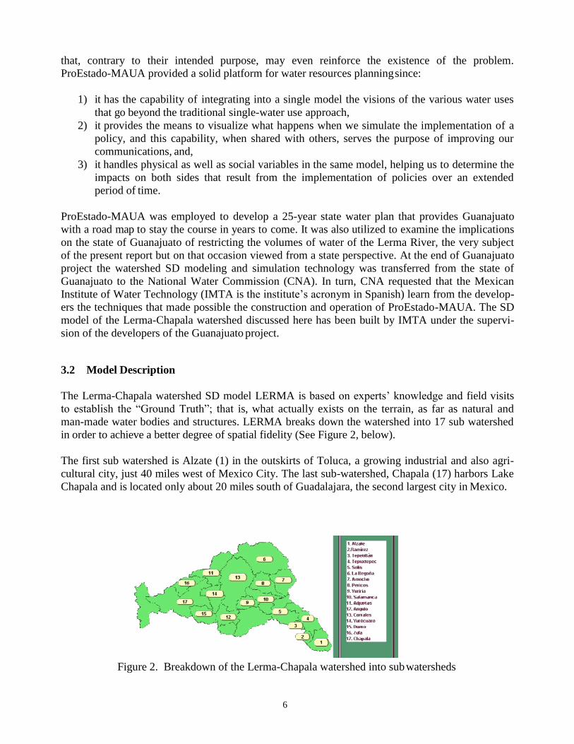
man-made water bodies and structures. LERMA breaks down the watershed into 17 sub watershed
in order to achieve a better degree of spatial fidelity (See Figure 2, below).
The first sub watershed is Alzate (1) in the outskirts of Toluca, a growing industrial and also agri-
cultural city, just 40 miles west of Mexico City. The last sub-watershed, Chapala (17) harbors Lake
Chapala and is located only about 20 miles south of Guadalajara, the second largest city in Mexico.
Figure 2. Breakdown of the Lerma-Chapala watershed into sub watersheds
7
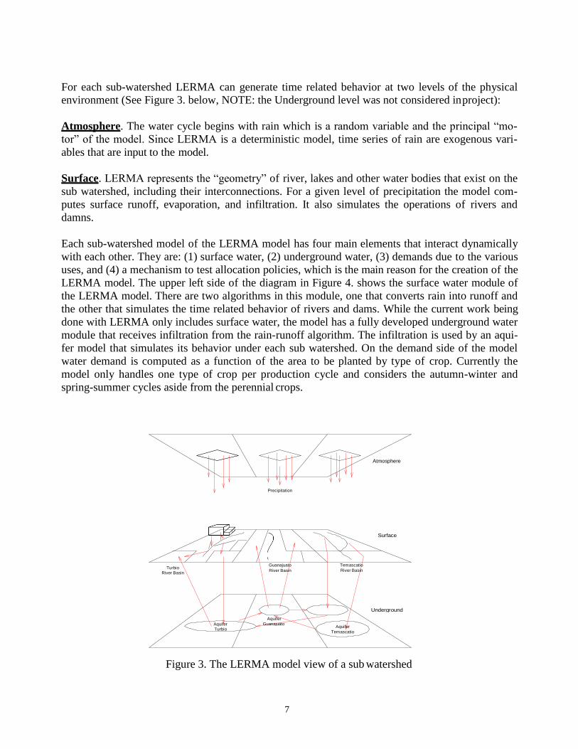
For each sub-watershed LERMA can generate time related behavior at two levels of the physical
environment (See Figure 3. below, NOTE: the Underground level was not considered in project):
Atmosphere. The water cycle begins with rain which is a random variable and the principal “mo-
tor” of the model. Since LERMA is a deterministic model, time series of rain are exogenous vari-
ables that are input to the model.
Surface. LERMA represents the “geometry” of river, lakes and other water bodies that exist on the
sub watershed, including their interconnections. For a given level of precipitation the model com-
putes surface runoff, evaporation, and infiltration. It also simulates the operations of rivers and
damns.
Each sub-watershed model of the LERMA model has four main elements that interact dynamically
with each other. They are: (1) surface water, (2) underground water, (3) demands due to the various
uses, and (4) a mechanism to test allocation policies, which is the main reason for the creation of the
LERMA model. The upper left side of the diagram in Figure 4. shows the surface water module of
the LERMA model. There are two algorithms in this module, one that converts rain into runoff and
the other that simulates the time related behavior of rivers and dams. While the current work being
done with LERMA only includes surface water, the model has a fully developed underground water
module that receives infiltration from the rain-runoff algorithm. The infiltration is used by an aqui-
fer model that simulates its behavior under each sub watershed. On the demand side of the model
water demand is computed as a function of the area to be planted by type of crop. Currently the
model only handles one type of crop per production cycle and considers the autumn-winter and
spring-summer cycles aside from the perennial crops.
Figure 3. The LERMA model view of a sub watershed
Atmosphere
Precipitation
Guanajuato
River Basin
Surface
Turbio River Basin
Temascatio
River Basin
Underground
Aquifer Turbio
Aquifer
Guanajuato Aquifer
Temascatio

8
The mechanism to test allocation policies has as inputs
1) the volumes demanded by the agricultural producers,
2) the levels of the various reservoirs in the watershed, including Lake Chapala, the last date of
October of every year, and 3) the rain forecasts based on climatology.
With these inputs, the current Surface Water Distribution Agreement evaluates a set of allocation
rules to determine the volumes of water that will be allocated for the next agricultural production
year.
Figure 4. The LERMA sub watershed structure
The construction of LERMA is based on the system dynamics approach that considers the behaviors
of individual systems components as well as the dynamic interactions among them. These two ef-
fects are simultaneous. Under this paradigm of analysis, time is considered the independent vari-
able and it is also the axis along which the simulated phenomenon is being observed. To simulate
time-related behavior, the model utilizes a system of differential equations of the form:
(Equation 1)……dX(t)/dt = A(t)X(t) + B(t)U(t)
Where t: time is the independent variable and
X(t): the “state” vector variable that defines the status of the system at time t.
dX(t)/dt: the rate of change of the “status” in the time interval t +∆t.
A(t): vector variable of parameters, used to specify the “reality” of the modeled system.
B(t): vector variable of coupling parameters for policies implemented in modeled system.
U(t): a vector variable that contains the policy being tested.

9
4. MODEL COMPUTER IMPLEMENTATION
For the computer implementation of LERMA, the dynamic simulation environment Stella Research
®, Version 7.0, for Windows was selected. The Stella diagram shown in Figure 5 below presents
an overview of the more than 35 modules that represent sub watersheds, irrigation districts, aqui-
fers, potable and industrial water supply and demand. In all, there are over 240 state variables that
represent the water levels of the dams and Lake Chapala, agricultural production, potable and indus-
trial water demands for the 17 sub watersheds in which the Lerma-Chapala watershed was broken
down. There are also a large number of accumulators and counters to report the execution of a
simulation in ways that are similar to the water reporting format in real life.
Figure 5. LERMA model overview
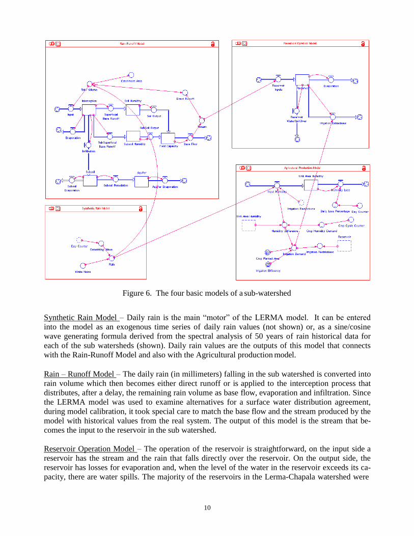
The model behavior is generated at the sub watershed level by the following four models: (1) syn-
thetic rain, (2) rain-runoff, (3) reservoir operation and, (4) agricultural production. These four mod-
els are interconnected as shown in the Stella diagram of Figure 6, below.
10
Figure 6. The four basic models of a sub-watershed
Synthetic Rain Model – Daily rain is the main “motor” of the LERMA model. It can be entered
into the model as an exogenous time series of daily rain values (not shown) or, as a sine/cosine
wave generating formula derived from the spectral analysis of 50 years of rain historical data for
each of the sub watersheds (shown). Daily rain values are the outputs of this model that connects
with the Rain-Runoff Model and also with the Agricultural production model.
Rain – Runoff Model – The daily rain (in millimeters) falling in the sub watershed is converted into
rain volume which then becomes either direct runoff or is applied to the interception process that
distributes, after a delay, the remaining rain volume as base flow, evaporation and infiltration. Since
the LERMA model was used to examine alternatives for a surface water distribution agreement,
during model calibration, it took special care to match the base flow and the stream produced by the
model with historical values from the real system. The output of this model is the stream that be-
comes the input to the reservoir in the sub watershed.
Reservoir Operation Model – The operation of the reservoir is straightforward, on the input side a
reservoir has the stream and the rain that falls directly over the reservoir. On the output side, the
reservoir has losses for evaporation and, when the level of the water in the reservoir exceeds its ca-
pacity, there are water spills. The majority of the reservoirs in the Lerma-Chapala watershed were

11
built to supply water to adjacent irrigation districts that were created from the 1950’s to the 1970’s
as a major piece of a long term development plan of the Mexican government that sought to ration-
ally develop the agricultural sector of the economy.
Agricultural Production Model – The dynamics of this model is produced by the continuous balance
between the humidity of a plot of agricultural land where a crop has been planted and the humidity
requirements at each instant by the type of crop planted. As it can be seen in Figure 6, humidity is
naturally increased by rain, but it can also be increased with irrigation. Since irrigation demands are
dependent on the water available in the reservoir, a Restriction (0=<restriction=<1.0) is utilized to
reduced the volume demanded if this is grater than the water available in the reservoir.
5. MODEL USE
The LERMA model, as described in previous section, represents the processes that take place in the
Lerma-Chapala watershed with emphasis on the hydrological cycle; the operation of the river, dams
and lake Chapala; and agricultural production, since this last activity alone utilizes about 85% of all
surface water available in the watershed. These selected processes which are incorporated into the
LERMA model are the “plant”, as it is called in control engineering, that provides the “realistic
picture” of the watershed behavior to enable analysts to examine the problem at hand and to pro-
pose solutions to it. The LERMA model has also been provided with a set of control variables (U(t)
in equation 1 above) whose purpose is to control the behavior (generation of trajectories) of the
plant in search of solutions that satisfy a given criteria, such as sustainability. The table below pre-
sents the control variables associated with the LERMA model.
Table 1. Sub models of the LERMA and their control variables
Sub Model Control Variable
Surface Water Supply Annual Irrigation Supply
Agricultural Production Cultivated Area
Irrigation Technology
Domestic & Industrial Demand Population Growth Rate
Demand Per Capita
Demand Per Unit of Industrial Output
From the available control variables, the Annual Irrigation Supply and the Cultivated Area have
been tested with the LERMA model as two separate control approaches on the water supply and
water demand sides respectively. The other control variables have not yet been utilized. The An-
nual Irrigation Supply was used to simulate the current Surface Water Distribution Agreement
which is a set of rules to allocate water to the various sub watershed, taking into account the previ-
ous year’s runoff and the level of Lake Chapala at the time that the allocation takes place. The Cul-
tivated Area control variable was utilized as part of a tracking control mechanism. In this case, val-
ues of water body levels through one full year (measured daily), when the operation of all water
12
bodies in the watershed was considered near optimal, were utilized as the reference pattern to be
followed year after year by the tracking algorithm. The operation of this control is the following:
1) For every agricultural year, the objective is to utilize the water stored in a dam for irrigation
in a form that at the end of the year the level of the dam will be as close as possible as it was
at the beginning of the year. If it is possible to attain this level, sustainability is ensured.
This process takes into consideration a precipitation forecast that becomes modeled as future
runoff that will recharge the dam and will increase the humidity of the agricultural soils.
2) To match the daily reference pattern, the user of the model increases (decreases) the Culti-
vated Area in order to increase (decrease) the water demand which in turn increases (de-
creases) the water extraction from the dam. The objective of this process is to reduce the er-
ror that exists between the daily reference values and the simulated values. Since the
LERMA model is not equipped with a dynamic minimization algorithm, there is no auto-
matic procedure to perform the calculation of the difference, which is therefore performed
by trial and error. A set of minimization rules has been deployed that facilitates the ana-
lyst’s work.
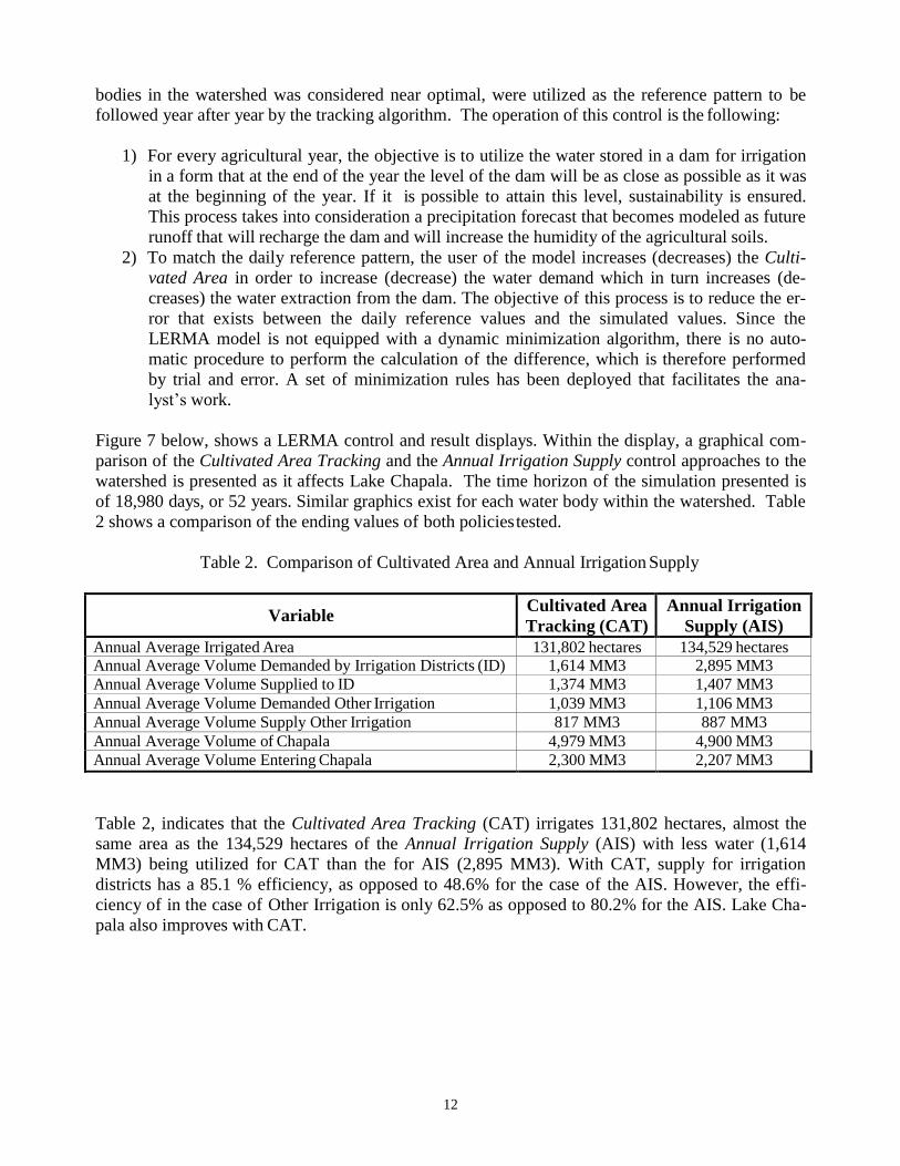
Figure 7 below, shows a LERMA control and result displays. Within the display, a graphical com-
parison of the Cultivated Area Tracking and the Annual Irrigation Supply control approaches to the
watershed is presented as it affects Lake Chapala. The time horizon of the simulation presented is
of 18,980 days, or 52 years. Similar graphics exist for each water body within the watershed. Table
2 shows a comparison of the ending values of both policies tested.
Table 2. Comparison of Cultivated Area and Annual Irrigation Supply
Variable Cultivated Area
Tracking (CAT)
Annual Irrigation
Supply (AIS)
Annual Average Irrigated Area 131,802 hectares 134,529 hectares Annual Average Volume Demanded by Irrigation Districts (ID) 1,614 MM3 2,895 MM3
Annual Average Volume Supplied to ID 1,374 MM3 1,407 MM3
Annual Average Volume Demanded Other Irrigation 1,039 MM3 1,106 MM3
Annual Average Volume Supply Other Irrigation 817 MM3 887 MM3
Annual Average Volume of Chapala 4,979 MM3 4,900 MM3
Annual Average Volume Entering Chapala 2,300 MM3 2,207 MM3
Table 2, indicates that the Cultivated Area Tracking (CAT) irrigates 131,802 hectares, almost the
same area as the 134,529 hectares of the Annual Irrigation Supply (AIS) with less water (1,614
MM3) being utilized for CAT than the for AIS (2,895 MM3). With CAT, supply for irrigation
districts has a 85.1 % efficiency, as opposed to 48.6% for the case of the AIS. However, the effi-
ciency of in the case of Other Irrigation is only 62.5% as opposed to 80.2% for the AIS. Lake Cha-
pala also improves with CAT.

13
Figure 7. One of the Stella Control Displays of the LERMA Model
6. PROJECT FINDINGS
There several aspects of this project deserve to be highlighted. Two are presented here.
6.1 The Lerma – Chapala Watershed Behavior
The LERMA model, as the principal analytical tool of this project, yielded a much needed under-
standing of the watershed behavior. It was possible to understand that:
1) The Lerma-Chapala watershed is dynamically fragile. A ten year simulation test with
LERMA showed that any brisk operational change, such as a sudden water transfer (of about
200 MM3 from up river dams to Lake Chapala), could produce a sharp oscillation in the sys-
tem that would take considerable time to dissipate and whose intensity and duration affects
the future operation of the watershed.

14
2) The application of any policy that favors one part of the watershed above the others would
produce only a temporary advantage that some time in the future could reverse itself to be-
come a liability. For example, a water transfer from up river dams to Lake Chapala may re-
sult sometime later in low water levels for the entire watershed; this would hamper irrigation
as well as additional transfers to Lake Chapala.
3) The watershed breaks down naturally into two main sections: (1) an upper section that goes
from the Lerma river source to the Solis dam, less that mid course, and (2) the other, that
goes from Salamanca (about 50 miles down river from Solis) to Lake Chapala. The LERMA
model showed that the large volumes of water that Lake Chapala requires to maintain a level
over the 2,000 MM3 are generated mainly by precipitation that falls from Salamanca on
down. The upper section of the river contributes very little to these volumes. This state-
ment, together with (1), suggests that water transfers from Solis to Lake Chapala in condi-
tions other than emergencies are not going to save the lake from desiccation. This is be-
cause the lake needs about more than 2,000 MM3 yearly, while water transfers can only be
of 200 MM3.
6.2 The Use of a System Dynamics Model in a Conflict Resolution Situation
When the multidisciplinary group of the Lerma-Chapala water council was convened to undertake
the development of the improved Surface Water Distribution Agreement, each state representative
seemed to interpret his/her role in the group to be a strong voice of his/her state view point, with the
additional purpose of making it prevail over the others. This was not an auspicious beginning of a
process in which the only satisfactory outcome of the ensuing negotiations had to produce a “win-
win” outcome for all stakeholders in the watershed.
At that time it became clear that the goals of the various states participating in the project were far
apart. For example, Guanajuato, a prime agricultural producer, claimed that its irrigated districts
were in compliance with the current Agreement and, that programs already in place to improve irri-
gation efficiency were producing results and would continue to do so as part of a continuous proc-
ess improvement plan. As a result, Guanajuato was unwilling to give up additional volumes of their
continuously decreasing water allocation to Lake Chapala. Meanwhile, Jalisco claimed that Lake
Chapala was close to dissecation as a result of the diminishing volume entering the Lake, and
blamed upstream agriculturists for their wasteful use of water. In accordance to Jalisco, the remedy
was to transfer, as soon as possible, all surplus water in the watershed to Lake Chapala, with little
regard for the fact that this could jeopardize the agricultural production in the states of Guanajuato
and Michoacan.
Realizing that endlessly arguing one state position against the others was not going to result in an
improved water agreement, the multidisciplinary group agreed to develop the system dynamics
methodology described above. The methodology enabled the members of the group to focus on a
common understanding of the time related behavior of the Lerma-Chapala watershed. Armed with
this understanding, the group was able to elaborate the improved agreement through the design and
testing of water distribution policies. Although it was never clearly stated, it was assumed that the
chosen methodology would also provide a mechanism to examine the conflicting objectives of the
various states and find a “win-win” solution.
One of the limitations encountered by the multidisciplinary group was the lack of the requisite “SD
culture” that would enable the team members to understand precisely the functioning of the

15
LERMA model and the results it would produce. This problem, present in many similar situations,
stemmed in this case from the fact that the majority of the members of the group were seasoned
“managerial-engineers” with no recent water resources modeling experience. Only the members of
the state of Guanajuato were “analytical-engineers” with deeper knowledge of SD modeling. Al-
though this issue was widely discussed from the onset of the project, the consensus reached was,
that due to the superiority of LERMA model over other analytical paradigms, it was better to con-
tinue the development of this model despite the limitations of the group. Nevertheless, the lack of
this common SD culture among the group member has produced misunderstandings and an uneven
participation by the group members. It has also produced continuous delays that have pushed back
the final delivery of the model results by six months.
7. CONCLUDING REMARKS
The use of an SD model of a large scale river watershed as the center piece of a confrontational wa-
ter resources allocation has proven to be very useful for the following reasons:
1) it presents a unified vision of the complex reality being analyzed,
2) it allows the stakeholders in this allocation process to test the policies that they deemed
most important to their state interest and to compare them with the results of the policy
testing of other states, and
3) it provides the analysis required to elaborate a new and improved distribution agreement
of the Lerma river water utilization.
In a politically charged situation the SD modeling approach brought focus on the behavior of the
watershed and away from the issued representing the individual agendas of the stakeholders. In this
sense the SD modeling diminished dramatically the level of confrontation producing instead a better
climate for collaboration.
The lack of an adequate SD culture among the multidisciplinary group members as well as among
the recipients of the reported work has created at times credibility concerns and distrust. As it was
said before this is by no means the exception since SD methodologies are not well known by many.
On the other hand, it will be difficult to identify an alternate approach that can accomplish as much
in the time that the multidisciplinary group dedicated to this project.
ACKNOWLEDGEMENTS:
Montserrat Serra-Martínez
Comisión Estatal del Agua de Guanajuato
Abraham Soto-Avila
Comisión Estatal del Agua de Guanajuato,
Ricardo Sandoval-Minero
Comisión Estatal del Agua de Guanajuato
Javier Altamirano-Márquez Basin de México, S.A. de C.V.
BIBLIOGRAPHY

16
Marañon, Boris. “La Viabilidad de la Organización de los Usuarios para el Manejo del Agua Subte-
rranea en la Cuenca Lerma-Chapala, Mexico.” In Los Estudios del Agua en la Cuenca Lerma-
Chapala-Santiago, 2002. Edited by Brigitte Boehm, Juan Manuel Durán, Martín Sánchez and
Alicia Torres. Guadalajara, Mexico: El Colegio de Michoacán and Centro Universitario de
Ciencias Sociales y Humanidades, Universidad de Guadalajara.
Huerta, Juan M., Serra, Monserrat, and Sandoval, Ricardo. 2001. ProEstado–MAUA, A Systems
Dynamics Approach for the Design of Sustainable Water Use Strategy in the Middle Lerma –
Chapala Basin. In The Lerma–Chapala Watershed, Evaluation and Management, 2001. Edited
by Anne M. Hansen and Manfred van Afferden. Dordrecht, The Netherlands: Kluwer Aca-
demic/Plenum Publishers.