a study of data components and knowledge … · kajian komponen data dan komponen pengetahuan ......
TRANSCRIPT

A STUDY OF DATA COMPONENTS AND KNOWLEDGE COMPONENTS FOR
PLANT BIODIVERSITY AREA BY USING SPATIO-TEMPORAL DATA
MODEL TECHNIQUES
KAJIAN KOMPONEN DATA DAN KOMPONEN PENGETAHUAN UNTUK
KAWASAN TUMBUHAN BIODIVERSITI DENGAN MENGGUNAKAN
TEKNIK MODEL SPATIO-TEMPORAL DATA
Mohd Taib Wahid
PM Abd Mannan
PM Dr. Harihodin Selamat
Pn Norhidayati Zakaria
Research Vote No: 75164
Jabatan Sistem Maklumat Fakulti Sains Komputer Dan Sistem Maklumat
Universiti Teknologi Malaysia
2006
VOT 75164
ii
ACKNOWLEDGEMENT
In the name of Allah, the Most Gracious, the Most Merciful, for giving me the
determination and will to complete this study.
We would like to express our sincere thanks and appreciation to researcher for
their advisors PM Abd Mannan Ahmad, Associate Professor Dr. Harihodin Selamat, and
Pn Norhidayati Zakaria for their continuous advice, guidance, support, and have patiently
guided me through the steps of this research. We thank them for being co-researchers.
We would like to thank to my research assistant, practical students who work in
database lab, colleagues, friends, staff, and lecturers in the Faculty of Computer Science
and Information Systems for their help, facilities and for providing who have extended
their fullest cooperation and encouragement.
Last not least, We would like to thank to Research Management Centre (RMC)
for providing us research grand to carry on the research.
.
iii
Abstract
The economic importance and uses of the large number of biodiversity plant species of
Malaysia make it essential for their biodiversity to be conserved. The complexity of
natural history collection information and similar information within the scope of
biodiversity informatics poses significant challenges for effective management of plant
biodiversity data. In order to undertake the steps for biodiversity conservation such as
identification of species, monitoring climate conditions, it is essential to efficiently
manage the vast amount of biodiversity related data. This project discussed about the
object-relational conceptual design of biodiversity data model for long term stewardship
of biodiversity information. In this research design a biodiversity data model that better
facilitates the exploration and analysis of spatio-temporal biodiversity data by using
object relational data model techniques. The conceptual model that is efficient for data
management and able to integrate diverse set of spatio-temporal data for analysis, and
monitoring biodiversity data. Moreover, forest department, land and agricultural
management and other related research organization could be benefited from this
research.
iv
Abstrak
Kepentingan ekonomi dan penggunaan spesis tumbuhan biodiversity yang terdapat dalam
Malaysia dalam kuantiti yang besar membuatkan ia perlu diperlihara. Sejarah maklumat
dikumpul yang kompleks dan maklumat yang sama dalam skop maklumat biodiversity
merupakan cabaran untuk membuat pengurusan yang efektif. Sejajar dengan itu, langkah
pemuliharaan perlu di ambil seperti butiran pengenalan spesis, mengawal keadaan cuaca
kerana ia penting untuk mengurusakan jumlah data biodiversity yang besar. Tesis ini
membincangkan tentang rekabentuk konseptual model data object-relational untuk
memenuhi keperluan maklumat biodiversity. Kajian ini juga merekabentuk model data
untuk biodiversity mempunyai fasiliti yang baik untuk pencarian data dan analisis untuk
data biodiversity spatio-temporal menggunakan model data object-relational. Model
konseptual yang efisyen untuk pengurusan data dan boleh diintergrasikan dengan set data
spatio-temporal dan melihat data biodiversity. Tambahan, organisasi perhilitan, tanah dan
pengurusan agrikultur dan beberapa organisasi yang terlibat boleh menerima kebaikan
daripada kajian ini.

v
TABLE OF CONTENT
CHAPTER TITLE PAGE NUMBER 1 Introduction 1
1.0 Introduction 1
1.2 Problem Background 2
1.2.1 Technical Problem I: Large Amount of data 2
1.2.2 Technical Problem II: Biodiversity Data Models 3
1.2.3 Technical problem III: Spatio-temporal Data Models 5
1.3 Specific Objectives 7
1.4 Scope of the project 7
2 Literature Review 9
2.0 Introduction 9
2.1 Malaysian Biodiversity Data 10
2.2 Biodiversity Data and Conservation 12
2.3 Space and Time Factors in Biodiversity Data 13
2.4 Geographical Information System (GIS) 17
2.5 Graphical Interface for Biodiversity 18
2.6 Storage Structure for Biodiversity Data 19
2.7 Query Processing for Biodiversity Databases 21
2.8 Summary 22
3 Research Methodology 25
vi
3.0 Introduction 25
3.1 Operational Framework 25
3.1.1 Problem Formulation (Phase 1) 26
3.1.2 Data Model Development (Phase 2) 26
3.2 Method Used 27
3.2.1 Pyramid Framework and Event-based Approach 27
3.2.2 Spatio-Temporal Object-Relational Model 30
3.3 Object Relational Model 30
3.4 Modeling BIODI with Classical Characteristics 31
3.4.1 Object Characteristics 31
3.4.2 Object- relation Data Model Techniques 33
3.4.2.1 Objects Types: 33
3.4.2.2 Abstraction mechanism 35
3.4.2.3 Generalization and specialization 35
3.4.2.4 Association 36
3.4.2.5 Aggregation 37
3.4.2.6 Constraint 39
3.5 Modeling Object Behavior of STOP BIODI Model 39
3.6 Spatio-Temporal Abstract Data Types (ADT) 40
3.6.1 Data Type “Date” 41
3.7 Temporal Object System 42
3.7.1 Object in Time 42
3.8 Spatio-temporal Object 42
3.9 Object-relational Features 43
3.10 Object-relational Application Development 48
3.11 Conceptual Biodiversity Data Model Structure 50
4 Experiments and Results 53
4.0 Introduction 53
4.1 Experimental Setup 54
4.2 Overview Structure of the Stop-BDM 55
vii
4.3 Create standard query for biodiversity data 57
4.4 Queries 58
Conclusion 61
References 63
Papers and Publication 69
viii
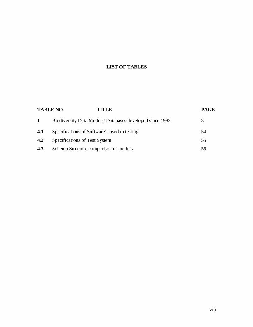
LIST OF TABLES
TABLE NO. TITLE PAGE
1 Biodiversity Data Models/ Databases developed since 1992 3
4.1 Specifications of Software’s used in testing 54
4.2 Specifications of Test System 55
4.3 Schema Structure comparison of models 55
ix
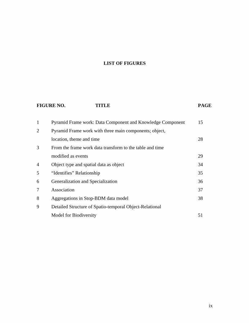
LIST OF FIGURES
FIGURE NO. TITLE PAGE
1 Pyramid Frame work: Data Component and Knowledge Component 15
2 Pyramid Frame work with three main components; object,
location, theme and time 28
3 From the frame work data transform to the table and time
modified as events 29
4 Object type and spatial data as object 34
5 “Identifies” Relationship 35
6 Generalization and Specialization 36
7 Association 37
8 Aggregations in Stop-BDM data model 38
9 Detailed Structure of Spatio-temporal Object-Relational
Model for Biodiversity 51

x
LIST OF ABBREVIATIONS
ADT Abstract Data Type
APASD Asian-Pacific Alien Species Database
APMIS
ASC Association for Survey Computing
ASEAN Association South East Asian Nation
ASP Active Server Page
BCIS Biodiversity Conversation Information System
BD Biodiversity Feature
BDBMS Biodiversity Database Management System
BF Biodiversity Feature
BODHI Biodiversity Object Database System
CBD Convention on Biological Diversity
DBMS Database Management System
DNA Deoxyribonucleic acid
ESTDM An Event-Based Spatio Temporal Data Model
GIS Geographical Information System
GLOBIO Global Methodology for Mapping Human Impacts on the Biosphere
IOPI International Organization for Plant Information
IT IS Intergrated Taxonomic Information System
IUCN International Union of Conservation of Nature and Natural Resources

xi
MACRES Malaysian Centre for Remote Sensing
MARDI Malaysian Agricultural Research and Development Institute
MONRE Ministry of Natural Resources and Environment
MOSTI Ministry of Science, Technology and Innovation
MS ACCESS Microsoft Access
MS dot net Microsoft dot Net
NGO Non Government Organization
OBM Object Behavior Model
OID Object Identity
OODBMS Object Oriented Database Management System
OR Object Relational
ORDBMS Object-Relational Database Management System
ORM Object Relational Model
OSHADHI
RDB Relational Database
RDBMS Relational Database Management System
SD Spatial Data
SQL Structured Query Language
Stop-BDM
Stop-BIODI Spatio Temporal Object Relational Plant Biodiversity
TD Temporal Data
UKM Universiti Kebangsaan Malaysia
UM Upper Model
VB.net Visual Basic dot Net
WWF World Wildlife Fund
XML Extensiblel Markup Languange
XP Microsoft XP
INTRODUCTION
1.0 Introduction
Over the last couple of years, there has been phenomenal growth in the area of
bio-diversity studies, largely motivated by the economic and humanitarian potential that
underlines the understanding of biodiversity dynamics. New area has been arisen which
is called Bio-prospecting, which focus is solely on shifting through biodiversity data to
locate potentially profitable biological sources (Srikant et al., 2000).
The major difficulty was faced by biodiversity scientist, is the effective
management and the access of large amounts and varied types of data arise in their
studies, ranging from micro-level biological information (genetic makeup of organism
and plants) to macro-level information (including ecological and habitat characteristics of
species).
Biological diversity plays an important role in our lives. The interaction of species
within highly diverse ecosystems performs ecological functions that are extremely
important to many human activities. Ecosystems function to maintain hydrological
cycles, regulate climate and recycle essential nutrients in the soil to maintain its fertility.
Researchers have been given various definitions on biodiversity data. Perhaps, the
best definition of biodiversity is the following (adapted from the Keystone Dialogue on
2
Biodiversity in Federal Lands by Noss and Cooperrider (1994): Simply put, biodiversity
is the assortment of different types of organisms that co-occur in time and space.
Biodiversity should facilitate abstract representations of real world objects which are
understandable and easy to use.
Despite having this importance, humanity imposes serious negative impacts on
biodiversity at multiple scales of time and space. The popular media regales us with
stories and reports of the ongoing destruction of natural habitats around the world,
impending climate change disasters and other ecological travesties all having potentially
dire consequences upon biodiversity. After more than 150 years of scientific study, it is
still not clear what factors or process lead to observe patterns of biodiversity. If we are
able to mitigate the cost and develop a proper data model with the real or/and potential
loss of biodiversity, we must understand the factors or process to design data model of
biodiversity.
1.2 Problem Background
1.2.1 Technical Problem I: Large Amount of data
In studies of biodiversity data modeling, few problems have been categorized
about biodiversity data modeling. First, large amount of data, biodiversity data is too
large because of the variety of different types of plants species that growth in various
landscape also co-occurs in time and space. Facilitate focus attention on specific area of
plan biodiversity need to conserve. Second, biodiversity data are complex because
biodiversity includes the variety of genes within one species through the complex
interconnection of all life within an environment. There is no stable biodiversity database
system and biodiversity analysis tool to maintain infrastructure and monitoring current
and future data of biodiversity. Third, effective data management system means storing,
retrieve and accessing data from the system. There is no such model designed yet which
can support data management and time consuming accessing data from the system.
3
Fourth, most of the data models are relational data model. Rational data model cannot
support temporal data, only support spatial data. Fifth, there is no proper biodiversity
retrieval system yet to exist. Existed system only provided general information about
biodiversity.
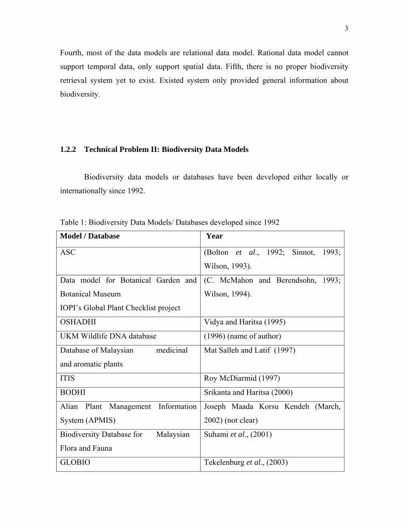
1.2.2 Technical Problem II: Biodiversity Data Models
Biodiversity data models or databases have been developed either locally or
internationally since 1992.
Table 1: Biodiversity Data Models/ Databases developed since 1992
Model / Database Year
ASC (Bolton et al., 1992; Sinnot, 1993;
Wilson, 1993).
Data model for Botanical Garden and
Botanical Museum
IOPI’s Global Plant Checklist project
(C. McMahon and Berendsohn, 1993;
Wilson, 1994).
OSHADHI Vidya and Haritsa (1995)
UKM Wildlife DNA database (1996) (name of author)
Database of Malaysian medicinal
and aromatic plants
Mat Salleh and Latif (1997)
ITIS Roy McDiarmid (1997)
BODHI Srikanta and Haritsa (2000)
Alian Plant Management Information
System (APMIS)
Joseph Maada Korsu Kendeh (March,
2002) (not clear)
Biodiversity Database for Malaysian
Flora and Fauna
Suhami et al., (2001)
GLOBIO Tekelenburg et al., (2003)

4
Relational data models lack the modeling power and extensibility needed for
complex objects and operations used in geographic applications. Most current models do
not have benefit of fully-fledged DBMS features. Some packages in Banking,
commercials GIS marketing use an interface to a relational DBMS to handle spatial and
non-spatial data, but temporal data are not in the DBMS. There is a need for DBMS and
modeling power better than that of relational DBMS. A few object-relational and object-
oriented GISs come to the market based upon spatial analysis. Recently spatio-temporal
object relational data model has been developed based on hydrological data. In relational
DBMS, a table is created for each entity type. An entity is something that has a physical
or conceptual existence. A row or column in a table column corresponds to an entity and
attributes. An attributes is restricted to being a built-in type relation schema ends with
many additional or extra tables, making less easy to depict the relationship of complex
entities in the real world (Weigand, 1994)
Another problem is temporal pattern of Biodiversity data. There are various
aspects of data values with respect to time. Current DBMSs is lack extensibility in
providing for special and temporal application needs. There are no provisions in
traditional systems for adding new data types and methods, add user-defined code or
design new storage methods. Another drawback is that difficult to obtain historical data,
often collected at varied intervals and diverse scales, for temporal events can be
considered as the smallest entity, not easily detected. As a result, a great need for spatio-
temporal data has led to the advent of object-relational spatio-temporal Biodiversity data,
as most existing data models provides only static historical information in a discrete time
structure separated from attribute data. The time at which data values effective is called
valid time. On the other hand, transaction time represents the time a data value is
recorded in the database (R. Snodgrass, 2000). So the time varying data is commonly
represented by time-stamping values. The time-stamps can be time points (Adnan Younas
et al., 2004; Dangermond and J., 1990), time interval (Bellamy and S.P., 1996; Benoit, et
al., 1993), temporal sets (Claramunt and Thériault, 1995) or temporal elements
(Armstrong, and M. P., 1988). Further more, these time-stamps can be added to tuples or
attributes, the two different approaches for handling temporal data in a relational data
5
model. Time points, intervals, temporal elements, and temporal sets are used as attribute
timestamps. Generally, the end points of an interval are added as two separate attributes
to a relation. Time points, time intervals, temporal sets and temporal elements are all
needed in temporal query languages. They all added to the expressive power of a
temporal data model and its query languages (Tansel A. U, 1997)
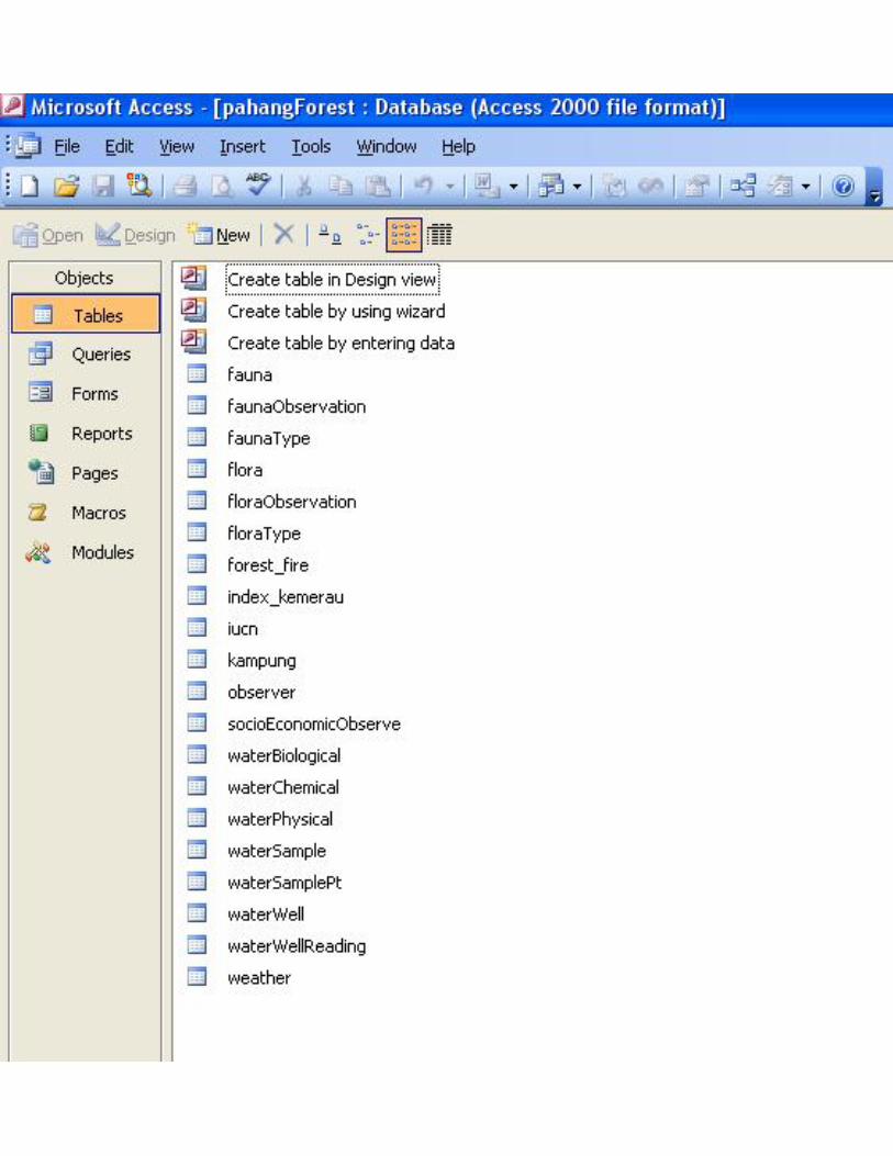
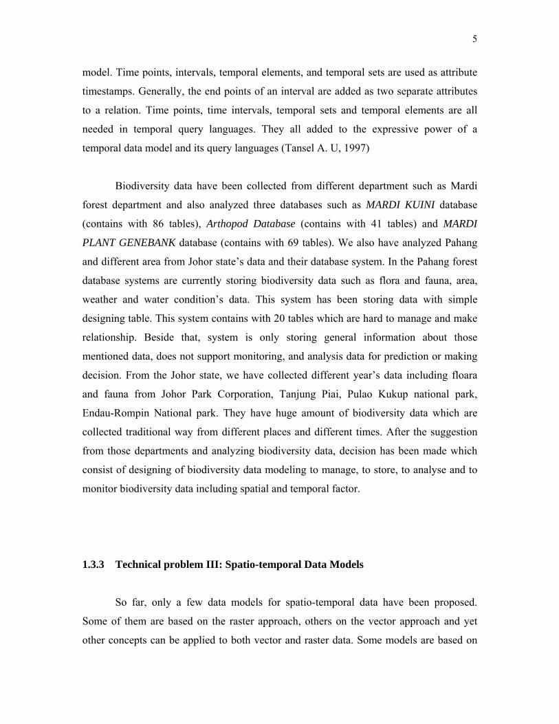
Biodiversity data have been collected from different department such as Mardi
forest department and also analyzed three databases such as MARDI KUINI database
(contains with 86 tables), Arthopod Database (contains with 41 tables) and MARDI
PLANT GENEBANK database (contains with 69 tables). We also have analyzed Pahang
and different area from Johor state’s data and their database system. In the Pahang forest
database systems are currently storing biodiversity data such as flora and fauna, area,
weather and water condition’s data. This system has been storing data with simple
designing table. This system contains with 20 tables which are hard to manage and make
relationship. Beside that, system is only storing general information about those
mentioned data, does not support monitoring, and analysis data for prediction or making
decision. From the Johor state, we have collected different year’s data including floara
and fauna from Johor Park Corporation, Tanjung Piai, Pulao Kukup national park,
Endau-Rompin National park. They have huge amount of biodiversity data which are
collected traditional way from different places and different times. After the suggestion
from those departments and analyzing biodiversity data, decision has been made which
consist of designing of biodiversity data modeling to manage, to store, to analyse and to
monitor biodiversity data including spatial and temporal factor.
1.3.3 Technical problem III: Spatio-temporal Data Models
So far, only a few data models for spatio-temporal data have been proposed.
Some of them are based on the raster approach, others on the vector approach and yet
other concepts can be applied to both vector and raster data. Some models are based on

6
the object-oriented paradigm, an approach that is capable of integrating both vector and
raster data into one data model. Most of the spatio-temporal data models have been
developed for GIS such as snapshot model (Armstrong, 1988), ESTDM (Peuquet, and
Duan, 1995), Spatio-temporal object model with ST-atoms (Worboys, 1992). One of the
problems in adopting the proposed models is that they are based on existing commercial
GIS. Most of the commercial systems are closed systems, which cannot be extended or
modified (Sylvia de Hoop, et al., 1993 as cited by Mioc, et al., 1998).
Research in spatio-temporal data modeling is scattered. Few integrated
approaches exist that can treat the spatio-temporal data in a unified manner. Past research
provides a basis but not a complete design of a spatio-temporal model (Flor Eugenia,
1999). A spatial data model has been generalized to become spatio-temporal (M.
Worboys, 1994). On the other hand, temporal data models have been generalized to
become spatio-temporal and include variants of Gadia’s temporal model (A. U. Tansel, et
al., 1993) which are described by (M. H. et al., 1998; T. S. Cheng and S. K. Gadia,
1994). The main drawback of all these approaches is that they are incapable of modeling
continuous changes of spatial objects over time. The definition of a temporal object in
general is based on the observation that anything that changes over time can be expressed
as a function over time.
Spatio-temporal datasets have some unique characteristics that make them
different from traditional relational and transactional datasets. One important difference
is that changes can be continuous (for example, the position of a moving object).
Traditional database systems assume that data changes through and explicit update. Thus,
to avoid continuous database updates on a spatio-temporal database, we need to store
description of the changes as a function of time (Peuquet, 2001). Spatio-temporal
biodiversity data require complex concepts to describe objects and specify relationships
between them. So pure relational data model is not suitable for spatial data, information
concerning one object is spread over many relations due to the normalization performed
upon the relations, and many join operations have to be performed in order to recreate
complex spatial objects. The relational data model alone cannot provide appropriate
7
indexing and retrieval operations for spatial data (Leonid Stoimenov, et al., 1996).
Because of continuously growing demands for temporal Biodiversity Information System
(BIS) and GIS, Frank explains any object-oriented approach to a property registration
system (1996) and spatial and temporal reasoning (Frank, 1997). More progressive study
is contributed by Al-Taha (1992) based on a relational model associated with temporal
legal changes. Worboys (1992, 1994) emphasizes spatio-temporal elements using object-
oriented techniques. Several geographers (eg, Peuquet, 1994; Yuan, 1994) concentrate on
features (what), event times (when) and locations (where) based on relational
environments.
1.3 Specific Objectives
The main objective of this research is to design and to develop a data model for efficient
management for biodiversity data. This research also aims to achieve the following
objectives:
a) To study about data and knowledge component of plant biodiversity and
spatiotemporal data model techniques.
b) To find out data conservation and data retrieval issues on plant biodiversity.
c) To find out appropriate techniques such as pyramid framework to support spatio-
temporal data for plant biodiversity data model.
1.4 Scope of the project
This research focuses on exploring methods to support temporal data with
biodiversity data model. Thus the scope of this research involves:

8
Scope of the study will focus data conservation, data modeling and data retrieval
issue on plant biodiversity. Initial research would be focused on plant biodiversity
to find out current research issues on plant biodiversity. The study also will enfold
on pyramid frame work to support spatio-temporal temporal data with plant
biodiversity data modeling.
9
CHAPTER 2
LITERATURE REVIEW
2.0 Introduction
This chapter presents a review of the literature covering data management issues
in biodiversity informatics. The review of the literature begins with a definition of key
terms used in this document, and then gives as overview of the content of the literature. It
continues to review the requirements for the design of a spatio-temporal biodiversity data
model. Biodiversity is the main issue in the recent world. It is very important for a wide
uses, including scientific study, resources management and policy planning and
education. Many researchers and developers are working to measure biodiversity data
and establishing a core set or framework of biodiversity indicators. In the previous
chapter, we have been discussed about the biodiversity data, biodiversity of Malaysia,
problem background of biodiversity data models. This literature survey only focuses on
biodiversity data model include time factor to build biodiversity data model. This chapter
also elaborates data models background, classification of biodiversity data, spatio-
temporal data and data models. This research comparison among data model has done to
find out best data model can be suited to the biodiversity.

10
2.1 Malaysian Biodiversity Data
Malaysia has been endowed with vast amount of natural resources including
luxuriant tropical forest which is one of the most diverse and complex ecosystems of the
world. Malaysia is undoubtedly one of the richest rain forests in the world with diverse
floristic composition and complex ecosystems. Malaysia is thought to have about 40,000
species, which is concludes 12,500 species of flowering plants (Mat Salleh and Latif,
1997), about 1,200 (10%) species of medicinal plants. The flora and fauna of Malaysia
are exceedingly rich and unique, has mixture of the greater Malaysian elements, Asiatic
elements and Australian Elements as well as the Pacific elements (Keng, 1970). This
mixture of plants species itself is benefited to the region as they share many common
medicinal species. Malaysia shares many common medicinal plant species with India
and Indonesia. Keng (1970) estimated that over 8,019 species of speed plants occur in
Peninsular Malaysia. Estimate for the whole country could be about 12,000 species.
However, this estimation is still under process and that is area in Sabah and Sarawak has
not been actively surveyed botanically. The above estimation has been holding since 16th
century by the colonist and recently introduced by plant importers (Mohamad Bin Osman
and Zaki, 2002).
More than three decades Malaysia experienced as extremely rapid socio-
economic growth. Malaysia has been losing much of its natural resources including
plants and animal species through ecosystem and degeneration. Several organizations all
over the country are working on the implementation of the biodiversity conservation
measures. One of the major hurdles faced by the conservation scientists and researchers
is the management of vast amount of biodiversity related information that available. This
information includes data on species characters (e.g., flora, fauna, peat swamp, and
habitat), endangered species, species of medical value, climate conditions (e.g.,
temperature, rainfall), soils and land use, geographic distribution of species, botanical
garden and herbariums, geographic regions, expert related fields and a host of others
information.

11
University Kebangsaan Malaysia (UKM) launched first online biodiversity
information system supported by Malaysia-Japan Tropical Bioresearches Project in 1996.
Currently, the server hosts number of databases, which are available and targeted to
different segments of biodiversity stakeholders. These include the checklist of Malayan
Vascular Plants, the Herbarian UKMB Online, Plant Systematic, Conservation and
Ecology Reference Online, Ethnobotany of Malaysia Plants, Native Edible Plants of
Sabah, The Flora of Fraser’s Hill & Bangi Permanent Forest Reserve, and UKM’s
Wildlife DNA Database (Suhami Napis et al., 2001). In Early 1999, Singapore Botanical
Gardens, Forest Research Institute Malaysia and UKM hosted a joint online catalogue of
more than 9,000 species of vascular plants. From this database, any one can list the
species occurring in the country also possible to query species from any imaged-mapped
states in the Peninsular Malaysia and Singapore. Even the basic information can be
searched from the menu and others information will display next to pictures or
illustration of that particular species.
Ethno-botany of Malaysia Plants online complemented all these databases to
develop a comprehensive database for Malaysian (Peninsular Malaysia, Sabah, and
Sarawak) medicinal, poisonous, and aromatic plants. These web base systems are having
nearly 16,000 native plan names from about 400 species and being updated regularly with
new information (Mat Salleh and Latif, 1997; Suhami Napis et al., 2001). Later on, this
system was planning to enhance this category with GIS and other data, as it is available
(Suhami Napis et al., 2001).
To achieve the objective of designing biodiversity data model, several problems
are needed to overcome; these are related to biodiversity data pattern, data analysis,
landscape structure and representation of space and time, estimate species richness, query
language, query processing algorithms, geographical user interfaces, storage structures
and query plan approach and finally architectures of Biodiversity Database Management
System (BDBMS).
12
2.2 Biodiversity Data and Conservation
Humanity depends on biological diversity, or biodiversity for the very sustenance
of life. Adequate data on species diversity, populations, location and extent of habitat,
major threats to different species, etc.; and changes in these aspects over time are not
available to design a proper strategy for conservation. Given our extensive diversity,
ecological surveys and taxonomic investigations need to be intensified, particularly for
plants and insects. For conducting ecological studies, species for such studies can be
prioritized including keystone species, large mammals, migratory species, etc. The
country's wildlife institutions need to network and coordinate their activities so that
priority issues and areas are identified. The Ministry of Environment and Forests through
the Botanical Surveys of Malaysia and the Zoological Survey of Malaysia could play a
guiding role by preparing a list of priority issues and areas for circulation to relevant
institutions, based on a countrywide consultation of experts. Funding for these prioritized
projects could be stepped up to ensure that research focuses on these issues. They are
organizing seminars, conferences to protect the biodiversity data. Recently, MACRES,
MOSTI, KAS and MONRE (write full name one time) organized workshop on various
issues. One of the key issues was national spatial biodiversity database development.
Those departments must set up a database for the country as a whole. There are many
organizations and NGO’s working on biodiversity such as Biodiversity Conservation
Information Systems (BCIS) working on information security and decision making on the
conservation and sustainable use of living resources, while Asia Specific Alien Species
regulate invasive alien species and development database to minimize economic damage.
Locally WWF (World Wildlife Fund) Malaysia is working for forest, marine, wetlands,
and species education and awareness. In addition, Global Biodiversity Information
Facility develops an electronic catalogue for taxonomy names. There are over 486,000
scientific names, 217 common names listed with the word with tentative position
taxonomy.
Various organizations nationwide and internationally have been involved with
biodiversity data and databases. Currently, World Wildlife Fund (Malaysia, China,
13
Indochina etc.) has been working on various projects such as forest, marine costal,
wetlands, species, education and awareness. ASEAN (write full name one time) regional
center for Biodiversity Conservation and ASEAN Review of Biodiversity and
Environmental Conservation (CBD) are also working on Conservation, Genetic
Resources, Technology, and Bio-technology. CBD is also developing biodiversity smart
partnership database. In addition to this, IUCN- Asia Biodiversity Program is the world’s
largest and most important conservation network.
After studying and analyses of biodiversity data, we can see that many
organizations, NGO’s have been working on biodiversity data and also have been
developing database system to store biodiversity data. Those biodiversity data contains
only general information about biodiversity data. Some organizations only have 2 tier
web systems. Those systems have database systems which are not well designed and do
not support analysis and all kind of data. Example is Asian Specific Alien Species
(APASD) database system, has developed for all kinds of alien species. This database
only contains general information about the species and does not support analysis and
monitoring biodiversity data.
2.3 Space and Time Factors in Biodiversity Data
Time and space are important aspects of all real world phenomena. Database
applications must capture the time and space varying nature of the phenomena they
model. For example, biodiversity data collector needs to maintain a record of the data,
collected from various areas with time. This information certainly varies over the times
and the data collected during particular time may be collected same body and some where
else; and also data collects should be periodically such as daily, monthly and yearly.
Many applications demand for spatial temporal support (Spaccapietra, 2001), such as
biodiversity applications, GIS applications, traffic management systems computing traffic
network and traffic volume at different time, forecast-prediction systems recording
14
weather change process, etc. The amount of spatial and temporal information is growing
very rapidly. To satisfy the need of applications, different systems have been developed
for various sub-areas related to multidimensional data. Among them, biodiversity
information systems constitute a large field of interest. But existing database techniques
couldn’t support spatial temporal information management well (Tryfona and Jensen,
1999).
After almost two decades research, representation of space and time in databases
and functional applications are still problematic (Peuquet, 2001). This paper presents a
universal object-relational framework for spatial temporal data modeling. Spatial
temporal data modeling aims to extend the existing data models to include space and time
in order to better describe our dynamic real world.
Numbers of issues and various aspects have been identified by many researchers
in the development of biodiversity data model including spatio-temporal data model,
query languages and data accessing method. Various issues have been discussed in this
thesis with literature review, results and discussion, conclusions and recommendations
for future work. After being literature review, it was noted that, to develop a pattern bio-
data; is not easy and structural model is not suitable to store the data. There are several
spatial (location), temporal (time) data model exists, which are having problem with
storing and retrieving data from different location beside that temporal model have time
period problem (present, past and future data). According to “statement problem”, it is
difficult to retrieve and analyze the data. In the Geographical Information System (GIS),
although many data model already existed but those data models are not related to
biodiversity and cannot fit with the biodiversity data model and its characteristics.
After literature review of related to biodiversity data model. Most of the
biodiversity and GIS modeling is relational data model. Those models can not support
complex data, data analysis, and data retrieval. Also relational data model only can
support spatial data not temporal data. After analysis of all models developed since 1993,
most of the models are using to collect plant data, plant listing, and plant conservation but
15
Taxonomy
Theme
Time Location
Object What is it?
Where is it?
When is it?
What is it made of?
T1 T2 T3
Data Component
XY
Knowledge Component
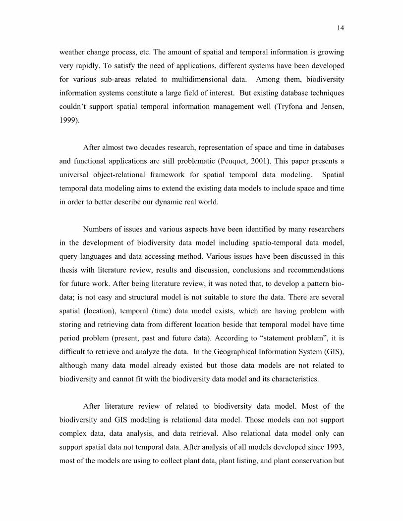
Figure 1: Pyramid Frame work: Data Component and Knowledge Component
there is no data yet to design which can support data analysis, data retrieval, temporal
data (time). Early 2000, internet based biodiversity object database system (BODHI)
developed also has mentioned above paragraph to handling plant taxonomies. To support
spatial and temporal of biodiversity data, one robust data model is required to developed.
The purpose of this paper is to develop data model that better facilitates the exploration
and analysis of biodiversity data with time factor. The goals of this research, to manage
and integrates diverse sets of spatio-temporal plant diversity data together with a county-
level geographic information system to build a biodiversity mapping data model and
information retrieval system for plant. So that those data may be required, visualized and
entered into statistical analysis. Also, allow the explicit representation of plant
taxonomies, dynamic process, relationship that compose the biodiversity system in a
manner that is intuitive and useful to the researcher. Meeting these goals demands a
database model that not only efficiently manages large quantities of biodiversity data, but
also retrieve data from data base so that researcher can make analysis.
As we point out, researchers have been trying to incorporate the time component
in these data models while maintaining their original design (Peuquet & Daun, 1995).
The challenge consist in the design a biodiversity data model to support spatio-temporal
data, we have chosen pyramid frame work to support a biodiversity data model design.
More description about pyramid framework is discussed next page:
16
A conceptual frame work (also know as pyramid frame work) was designed
which guide the implementation of the semantic GIS database model [10]. This frame
work is interrelated with two separate parts one is data component and another is
knowledge component shown in Figure 1. Data component can be divided into three
categories: location (position in the spatial three dimensions), time (position alone a time
line) and theme (a set of observations, measurements, or attribute values associated with
a particular location and time). Data components stores spatio-temporally referenced
observational data such as spectral, climate, vegetation and other environmental
attributes.
Data component can be computerized as a multi-dimensional, spatio-temporal
referenced ‘hyper-cube’ of observational data that is similar to the ‘feature space’ concept
commonly cited in analysis of remote sensing imagery. Knowledge component stores
information about higher-level semantic ‘objects’ the geographic entities such as location
and space All the objects are also placed within two hierarchical relationship structures
central to cognitive knowledge representational and object-oriented modeling, plant
taxonomy (generalization). The plant taxonomy structures groups similar objects within a
category and stores a rule-base that describes how those objects may be identified within
the data space.
Model represents, in fact, a frame work of many existing model (e.g. IMAGE 2.2,
Alcamo et. al. 1998) and several new ones. In the biodiversity model we have chosen
pyramid framework concept because its combination of object-oriented modeling and
Artificial Intelligence (AI) knowledge representation techniques [14, 16]. Many
programming languages such as Java and C++ are object oriented. Integration between
the two would provide easier abstraction for developers who programs in object-oriented
languages and required to ‘program’ in SQL [20]. Such integration would also relieve the
necessity of constant translation between databases table and object-oriented data
structures.
17
However, modeling the spatio-temporal phenomenon remains a complex task due
to the large diversity of the entities and phenomena and their possible evolution in the
real world. We need a data model and corresponding technologies to depict the dynamic
entities and phenomena. Basically, models of this kind should treat an entity as a whole
and can provide us as much more rich information as possible, not only data about its
current state, but also other data about its past evolution.
Spatiotemporal data models have received much attention in the database research
community because of their practical importance and the interesting technical challenges
they pose. In the literature review the discussed previous research that most influenced
our work on spatiotemporal data modeling. Much previous work focuses on temporal
information or spatial information, rather than both.
The main reason for the lack of universal data model is that, models were not
originally designed to support time. Researchers have been trying to incorporate the time
component in data models while maintaining their original design. The challenge
consists in the design of a spatio-temporal biodiversity data model, in parallel with the
development of appropriate databases, the development of efficient spatio-temporal
biodiversity query languages
2.4 Geographical Information System (GIS)
There are countless definitions for GIS, each based on the type of user and
application domain. GIS definitions perhaps based on functions, toolbox, data,
technology or decision support system. Roughly, GIS is a database system that using for
storing georeferenced data. GIS is an information system consists of input; process and
output function for georeferenced data. The term input refers to data about the storing
data into the database. The term process includes capture, modeling, manipulating,
retrieval and analysis of geographically referenced data, instead output were displaying

18
and presentation of georeferenced data. Georeferenced refers to data about geographic
phenomena associated with its location, spatially referenced to the Earth.
Geographical data can represent into following method; points is a single node
with NO area (e.g. building), lines is a connection of nodes beginning with a “to” and
ending with a “from” (e.g. road, river) and polygon is a series of arc(s) that close around
a “label” point (e.g. town, a district). Geographic data component can be classified into
three main categories:
2.5 Graphical Interface for Biodiversity
Biodiversity is uniquely characterized by its multi-dimensional attributes, though
it has been conventionally prototyped on various plant image or map sheets. To reach a
good graphical interfaces and effecting query, and the display of plant data include
geographical data should be in multi-dimensional mode and be interacted preferably from
various sites.
This aim can be reached by integrating advance in computer graphics and web
technology. Advance graphical tools such as ArcInfo, Manifold, ArcView, GIS software
digitalize the image and later on stored in database as different image layers makes it
possible to develop effective model and increase capability to operate large database on
biodiversity. In addition, Andrei Ju, Korolyuk used ArcInfo to evaluate biodiversity in
Southern Siberia. Most of the graphical tools (ArcView, ArcSDE) support various
RDBMS platforms like DB2, SQL Server, and Oracle 9i. Acquisition of image of plant
will be collecting from various places also the temporal data. These images provide
digital mosaic of spatial attributes and plant types liable to computer processing.
As stated in (de By, 2000), a database is a repository capable of storing large
amounts of data, equipped to facilitate concurrent use, storage optimization, data

19
integrity, query facility and query optimization. GIS systems are not very good at these.
However, the strength of GIS lies in its ability to operate on spatial data, and allows
analyses that are inherently geographic in nature. A GIS software package like ArcView
has powerful but highly flexible tools for map production of both hard and digital types.
ArcView combines in various ways the attributes of plant invasion, the management
practices in place, with spatial data layers, undertake spatial analysis and produce the
results for visualization mostly through maps.
On the other hand, web technology is widely used as a platform to distribute,
query, visualize and process taxonomy and geographical data. Integrating graphical
software with web technology enables a simultaneous interaction with the display in
global and local level.
2.6 Storage Structure for Biodiversity Data
A model for a database system, that provides a standardized environment for
submission, storage, and retrieval environmental data such as geographical and
biodiversity data (Scott, J.M, Davis, F.W, Scuti, 1993). Adopting a relational view, such
databases are collections of entities which have either spatial attributes (e.g., geographic
databases) or temporal attributes (e.g., medical databases) or combinations thereof (e.g.,
multimedia databases). Spatial attributes can be viewed as 1D, 2D, or 3D positions in a
“space,” either the physical one (e.g., map objects) or an artificial one such as a computer
screen (e.g., multimedia objects). Temporal attributes capture the temporal existence of
entities and in the general case can be represented as time points or time intervals [12].
The preliminary model is based on spatio-temporal data model techniques and is suitable
for not only storing data, digital images, landscape map, but also for modeling domain
knowledge associated with plant based data include spatial and temporal data.

20
Significant researches have been done to study of storage structure. Existed
database only support spatial data not temporal data. Database should efficiently support
retrieval of data based on the spatio-temporal extents data. Multi-dimensional access
method is required to achieve this database. Many researchers has already initiated their
work in this area such as approaches that extended R-trees and Quad tress (Scott, J.M,
Davis, F.W, Scuti, 1993) alone with extensive experiments on a variety of synthetic data
sets.
Spatial structures and efficient spatial access methods based on hierarchical
regular decomposition of the space for images containing multiple non-overlapping or
overlapping features were proposed. Regarding temporal structures, overlapping B+-trees
were used for transaction-time in implementation of time access method. B-tree
supporting transactions were proposed in optimal multiversion B-tree (] B. Becker, S.
Gschwind, T. Ohler, B. Seeger, P. Windnayer, 1996). Spatio-temporal indexing method
appeared in: 3D-trees, MR-trees and RT-trees, and HR-trees (Mohamad Bin Osman and
A.H Zaki, 2002). All these methods are suitable for spatial objects and not suitable for
representing regional data. Indexing method also employed in large biodiversity and
multimedia database (Vazirgiannis, et al., (1998), (] M. Miick and M. Polaschek, (1997).
M., Theodoridis, Y., And Sellis, T., (1998)used query for (1) search in the complete
inheritance hierarchy rooted at PlantSpecies and return object of type PlantSpecies and
MedicinalPlants associated with the GeoRejion, (ii) search object of only PlantSpecies
type associated with given GeoRegion, without searching for MedicinalPlants. To
efficiently support both types of queries, the Multi-key Type Index (MT-index) (M.
Miick and M. Polaschek, 1997) approach used in BODHI. The basic idea behind TM-
index is a mapping algorithm, called Linearization Algorithm. TM-index over type
hierarchy, turn out to be a multi-dimensional index with type as a dimension, after the
linearization of the inheritance hierarchy as proposed in (M. Miick and M. Polaschek,
1997). SHORE storage manager already provides a multi-dimensional index, R+-tree.

21
From the above discussion, application-oriented discipline of biodiversity
mapping and geographic information systems, in particular algorithms, spatial and
temporal data structures will have significant practical impact in the near future.
2.7 Query Processing for Biodiversity Databases
There are few processes and optimization has focused on (i) development of
efficient strategies for processing biodiversity, spatial, temporal data, (ii) efficient
modeling cost for query processing optimization purpose and (iii) study about
biodiversity data include spatial and temporal constraint databases.
The query processor of BODHI (Srikant B.J, Jayant R. Haritsa, 2000) integrates
the features provided by the service modules through extended ODL/OQL for modeling
and querying the database. In addition, it optimizes the queries using the metadata and
indexed information, and as part of the Client Index Framework it facilitates
transformation of query results into an interchangeable format as request by the user.
Example of query is written in the BODHI system, using OQL, as follows:
Select * from species1 in PlantSpecies,
species2 in PlantSpecies,
where species1.flowerchar.inflochar=species2.flowchar.inflochar
and
species1.georegion overlaps species2.georegion
For query optimization purpose, analytical models that estimate the cost
(Theodoris, et al., 1998), nearest neighbor (Papadopoulos A. and Y. Monolopoulos,
(1997), and similarly (Papadopoulos A. and Y. Monolopoulos, 1998) queries involving
R-tree indexed spatial data were introduced. Analytical models also used as a platform to
support direction (e.g. north, north-east) between two dimension objects. Problem studied
22
about parallel and distributed similarity search in a shared –nothing multi-computer
architecture, where an R-tree is dispersed among the site of the network (Papadopoulos
A. and Y. Monolopoulos, (1996). Similar query processing techniques retaining low
response times during query processing. DeokHwan Kim and ChinWan Chung, 2003)
proposed content based image retrieval method using adaptive classification and cluster
merging to find multiple cluster of a complex image query. In addition, this proposed
technique provides significant improvement over the query point movement and the
query expansion in terms of retrieval quality.
Query processing is lacking in biodiversity applications, where the data and query
objects changes their locations. To support biodiversity data for high retrieval quality,
accurate data and without losing time need a robust query processing techniques
2.8 Summary
This chapter discusses details issues related to the undergone research of
biodiversity data management, biodiversity data models, spatial and temporal application,
spatio-temporal data models and query languages. After analysis proposed models based
on biodiversity data, models are designed either spatial or temporal. But most of the
models are designed for commercial applications.
Problem with previous data models is that spatial and temporal aspects of
databases are modeled separately (Sellis, T. (1999), (Martin Erwig, 1999). Spatial
database focuses on supporting geometries (Guting, R. H., 1994), while temporal
databases focus on the past state (Tansel, A. U. and J. Clifford, 1993). But in many
circumstances, such as environmental monitoring, resource management, transportation
scheduling, etc, spatial and temporal attributes should be connected together. Many
current systems can handle only one aspect of space and time. Spatial systems always fail
to cater for many temporal aspects in a dynamic environment (Abraham, T. and J. F.

23
Roddick, 1999). Though many researchers have found the necessity of integration of
space and time in one environment, by far, little such work has been done.
The structures of space and time are identified as essential for the realization of
cognitive systems (Freksa, C., 1998). According to Donna J. Peuquet and her group
(Peuquet, D. J., 2001), models of spatial temporal data in geographical database
representations must incorporate human cognitive principles. Human knowledge of the
dynamic geographical world comprises of three different (and interrelated) subsystems
that handle what, where and when aspects of object properties (Mennis, Peuquet et al.
2000), (Sinto 1978). Theme-based model, location-based model and time-based model
separately describe one subsystem. From this view, these 3 kinds of model are all single
semantic models. According to human cognitive principle, the model we build should
cover all of these 3 subsystems. Donna J. Peuquet and her group's pyramid framework
show how to incorporate three subsystems of human cognition into data modeling. From
above analysis, we should build a unified infrastructure that integrate space and time,
mediate discrete and continuous representation, describe when/where/what
systematically, and be extensible to various applications. A multi-semantic model cannot
ultimately be generated from extension of current single semantic models such as ER
model and location/time/theme-based model. Object relational approach with its
characteristic of inheritance and aggregation is capable of capturing the various notions
of space and time and reflecting them into a single framework extensible to different
applications.
Many database systems concentrate on the definition of a particular spatial
temporal model that is related to certain application. The result is that more and more
different models appeared. Each model focuses on a specific set of spatial temporal
features [9]. When encountering other features and applications, the model doesn't work.
So what we should do is to build an overall framework that can be extended to various
applications, not driven by various applications generating different models (Mennis, J.
L., D. J. Peuquet, et al., 2000). Furthermore, application specific modeling will be more
efficient if it is based on a generic model (Raza, A. and W. Kainz, 1999).
24
In particular, we propose a conceptual object-relational spatial temporal data
model based on Donna J. Peuquet's pyramid framework. However, even in the latest
generation of OR (Object Relational) systems, extensibility comes with many limitations
and requires significant expertise and programming effort. Indeed, the main extensibility,
mechanism of OR (Object Relational) systems is allow SQL queries to call external
functions coded in a procedural language (such as C or Java). Spatio-temporal queries are
expressed by user defined aggregates, such as duration and during temporal relationships.
Therefore, query language (such as SQLST) or other relational languages are required to
support spatio-temporal queries for biodiversity data. In addition, spatio-temporal
primitives and SQLST allows user to introduce additional extensions to the data model
and query language.
25
Research Methodology
3.0 Introduction
This research framework contains with several phases, which have been identified
upon completing this research. Framework also divided into two major phases. In the first
phase, consist of literature review on biodiversity data model designing, problem
definition can be done after analysis and study behavior of biodiversity data. Data
behavior is divided into data pattern, data element and elements which are effective to the
data. In the second phase, data model development will be done according to problem
statement stated in the first chapter.
3.1 Operational Framework
The purpose of this operational framework is to develop a data model for
biodiversity include temporal data. The operational framework has been divided into two
main phases. The following subsections describe the methods, steps and procedure for
proposed system. The detail steps involve in the system development will be discussed in
the next section.
26
3.1.1 Problem Formulation (Phase 1)
In this phase, main contribution has been done such as investigation of
biodiversity data, behaviors of data pattern, data elements and its effectiveness. Beside
the study about biodiversity data, study about spatio-temporal database and architecture
of temporal data model.
At this phase, literature review has been done two separate ways. Firstly,
researchers need to study about the Biodiversity especially plant data behavior,
Biodiversity is the assortment of different types of organisms that co-occur in time and
space (spatial and temporal). Time element is very important to analysis in Biodiversity
data such as predicting and historical analysis. On the other hand, another issue need to
study is complexity of spatial and temporal data. Secondly, researchers need to study
about the existed data model if there is any. In this phase, data collects from Pahang
forest department, Mardi, Johor Park according to our research requirements.
3.1.2 Data Model Development (Phase 2)
In order to develop a data model a systematic approach needed. This is where we
need to determine which data model development methodology to use. In this phase,
firstly we have to analyze the existed model. In this part, researchers need to study user
requirements in Biodiversity Applications. The investigation process from user
requirement will focus on the Biodiversity systems in the market and specifically in the
Biodiversity applications. The purposed of the study, is to cater requirement need in the
data storage and retrieval and biodiversity analysis requirements. After completion of the
investigation and study review on biodiversity, researchers have come out with a
resolution to design a new data model to achieve the objective, design a data model for
Biodiversity. This phase also identify data elements and data components of the model.
After identified all the components a new data model has been developed.

27
3.2 Method Used
3.2.1 Pyramid Framework and Event-based Approach
In the design of object-relational biodiversity data model to support spatio-
temporal data, pyramid frame can make enhancement to support a biodiversity data
model design. A conceptual framework (also known as pyramid framework) was
designed which guide the implementation of the semantic geographical information
system (GIS) data model (M. Bouzeghoub, 1994). Conceptual frame work is interrelated
with two separate parts one is data component and another is knowledge component
(Figure 2). Data component can be divided into three categories: location (position in the
spatial three dimensions), time (position alone a time line) and theme (a set of
observations, measurements, or attribute values associated with a particular location and
time). Data components stores spatio-temporally referenced observational data such as
spectral, climate, vegetation and other environmental attributes that maybe queried and
visualized to reveal embedded spatio-temporal pattern and relationships. Data component
can be computerized as a multi-dimensional, spatio-temporal referenced ‘hyper-cube’ of
observational data that is similar to the ‘feature space’ concept commonly cited in
analysis of remote sensing imagery.
Knowledge component stores information about higher-level semantic ‘objects’
the geographic entities or process that are describe by the data. Information concerning
on object’s location, time and composition. All the objects are also placed within two
hierarchical relationship structures central to cognitive knowledge representational and
object-oriented modeling, plant taxonomy (generalization) and partonomy (aggregation).
The taxonomy structures groups similar objects within a category and stores a rule-base
that describes how those objects may be identified within the data space. These rules may
be derived from expert knowledge or from inductive analysis of the observation data. In
an object-relational data model consists of a set of object classes (of different types or
schemas). Each object class has an associated set of objects; each object has a number of

28
Figure 2 Pyramid Frame work with three main components; object,location, theme and time
Theme
Time Location
Object What is it?
Where is it?
When is it? T1 T2 T3
X
Y
attributes with values drawn from certain domains or atomic data types. Of course, there
are additional features, such as object valued attributes (Oid), methods, object class
hierarchies, etc. Besides objects, attributes describing geometries including time are of
particular interest. Hence we would like to define collections of abstract data types, or in
fact many-sorted algebras containing several related types and their operations, for
spatial values changing over time. This section presents a simple and expressive system
of abstract data types, comprising data types and encapsulating operations, which may be
integrated into a query language, to yield a powerful language for querying spatio-
temporal data.
To support temporal data, system require additional model such as event-based
model. Pyramid system is a model to support multi-dimensional, spatio-temporal and
geographic objects (such as location and space). All the objects are also placed within
two hierarchical relationship structures central to cognitive knowledge representational
and object-oriented modeling, plant taxonomy (generalization). The plant taxonomy
structures groups of similar objects within a category and stores a rule-base that describes
how those objects maybe identified within the data space. Pyramid framework consists of
main three components; objects, location, theme and time. These features will be referred

29
Theme
Time Location
Object
T1 T2 T3
X
Y
to accessed data from the database. This framework can be converted to table in stated
Figure 3.
After the framework conversion as a table, we can see that each object has
attributes of theme, space (location) and time. Theme attributes record the information of
“what is this object” and other related property information. For example, if the theme of
this object is “Forest”, a Forest must have attributes such as Area or Province it belongs
to, Forest Size, and Forest Type, etc. Theme can be inherited according to certain
classification hierarchy. For example, theme can be classified as natural resources (forest,
earth quake, and rainfall), transportation (rail and highway), settlement (country, city),
water system (river, lake, and pool), and cadastre etc.
Location attributes record space information of the object, such as whether it is a
point, line, or polygon, and its location. Location attributes can be inherited into
subclasses such as the point class, line class and polygon class.
Figure 3: From the frame work data transform to the table and time modified as events
Object Location Time Value n Value n+1
……… Event 1 Event n Event 2

30
3.2.2 Spatio-Temporal Object-Relational Model
Commercial GIS and Biodiversity related software support spatial object data,
some times temporal objects data models based on RDBMS/OODBMS environments.
However, temporal data always exists in and around daily life, in business, GIS and
forest areas. Since spatio-temporal object-relational model might be new approach to
biodiversity area, there are few commercial packages within the full capabilities of
temporal object systems. Although there is growing demand for temporal data to be
incorporated into biodiversity data, system administrators and system managers
experience difficulty n responding to temporal system request because present reliability
of working circumstances for temporal applications put time into secondary status.
Biodiversity data is associated with Area, forest, park, marine, flora, fauna, etc.
biodiversity data can be interpreted as a digital map/picture that is equivalent to spatial
data. This chapter not only examines the objects of flora playing a major role in temporal
factors,
This chapter focuses fundamental aspects of the spatio-temporal domain, covering
concepts such as objects, properties, relationship, attribute, method, generalization,
specialization, association, and aggregation. Based on these, in the object-relational
approach, present a small set of constructs aimed at improving the ability to conveniently
design a spatio-temporal object relation model for biodiversity. Incorporate the proposed
modeling constructs into the object-relation model, resulting in the semantically richer
Spatio-temporal Object Relational Plant Biodiversity (STOP Biodi) Data Model.
3.3 Object Relational Model
Object relational databases provide a higher abstraction of spatial data by
incorporating concepts closer to humans’ perception of space. This is accomplished by
31
incorporating the object oriented concept of a user-defined abstract data type (ADT) and
associated functions. When using the Object-relational Model (ORM) for a particular
system analysis, we introduce the ORM to explain generic characteristics of objects. This
model is based upon a bottom up approach. We first present objects and classes and then
show how groups of objects and relationships constitute object classes and relationship
sets. The ORM consists of objects, object classes, relationships relationship sets, and
constraints, only describing common terms of notion of object-orientation.
Object features such as abstract data type and Object relational Database
Management System (ORDBMS) is a promising approach to extend the matured feature
of Relational Database (RDB). Vendors such as Oracle, Informix, and Microsoft SQL
Server have extended their RDBMS to support objects features (R.S. Devarakonda,
2001). Basically, the ORDBMS is the RDBMS with the object-oriented fatures.
ORDBMS becomes popular because of the limitations of ODBMSs, such as lack of
support for new types and lack of support for composite data values that can prevent it
from taking enterprise-wide task. Therefore, by storing objects in the object side of the
ORDBMS but keeping the simpler data in the relational side, user may approach the best
of both worlds.
3.4 Modeling BIODI with Classical Characteristics
3.4.1 Object Characteristics
From the viewpoint of software development, the first programs were written in
machine code, becoming dependent on the architecture of the computers on which they
were implemented. Programming language techniques have naturally evolved towards a
more clear-cut division between the concepts manipulated in programs and their internal
representation.

32
There are many definitions of an object. Booch (1991) discusses the state,
behavior, and identity of an object: the structure and behavior of similar objects defined
in their common class and the interchangeable terms of instance and object. This is a
classical language definition, as defined in (Coplien, 1992), where classes play a central
role in the object model. Booch also insisted that the term “object” was first formally
applied in the Simula language, and objects typically existed in Simula programs to
simulate some aspect of reality. Martin (1992) defines an object as anything to which a
concept applies and a concept is a shared idea or notion that applies to certain objects
within normal awareness. Rumbaugh (1991) notes that an object is defined as a concept,
abstraction or thing with crisp boundaries and meaning for the problem at hand. Shlaer
and Mellor (1988) define an object as an abstraction of a set of real world things such
that: all of the real-world things in the set of the instances have the same characteristics.
All instances are subject to and conform to the same rules.
In the face of the increasing complexity of the problems tackled, it was apparent
that software systems needed to be better structured. A program is considered to be a set
of procedures together with a separate set of data on which the procedures operate.
Related design methods consist of “divide and rule”. The splitting up of tasks to be
carried out into a set of independent modules is known as black boxes. This is called
procedure-oriented programming. However, the slightest change in the data structures
can lead to a complete reorganization of these procedures. The idea of information hiding
(sometimes called encapsulation) obviates this difficulty because the data and the
procedures manipulating it are incorporated into the same entity, namely the object. An
object includes a static part, a set of data, and a dynamic part, a set of procedures
manipulating this data. An object is defined by its behavior, and represented by the set of
its procedures, rather than by its structure.
An object has a set of attributes (Instance variables), and relationships with other
objects. An attribute models the state of an object. Procedures define its behavior.
Procedures are considered to be messages. We say that procedures encapsulate the
behavior of the object. They define the interface to the object, and can be used to
33
maintain the hidden internal structures and states of the object. Consequently, procedures
may define the only available way to communicate with an object and access its
attributes. Procedures are sometimes referred to as functions or methods.
3.4.2 Object- relation Data Model Techniques
The object relational model (ORM) is a way of describing or representing objects,
classes of objects, relationships between objects and classes, and real world
memberships. The ORM can be considered the static part of object-oriented systems
modeling. That is, the ORM describes the “database” of a model: what objects may
exists, what objects classes they belong to and what relationships exists between objects.
In the object-relational model also consists of object, object classes, relationships
relationship sets and constraints.
3.4.2.1 Objects Types:
An object includes a static part, a set of data, and a dynamic part, a set of
procedures manipulating this data. An object is defined by its behavior, and represented
by the set of its procedures, rather than by its structure. An object has a unique and
immutable identified that differentiates it from other objects. An object identity (OID)
comes into being when the object is created and can never be confused with that on an
other object even if the original object has been deleted. The OID never changes even if
all the properties of the object change. It is depend on the object’s state. An object
identifier further has the following characteristics: 1) it identifies an object not only in an
extension of a class, but also in database, 2) it is constant throughout the lifetime of the
object, 3) it is not visible to the user, and 4) it is created and maintained by the system.
34
An object has a set of attributes (Instance variables), and relationship with other
objects. An attribute models the state of an object. Spatial and/or temporal information
may be associated to objects, independently from the characteristics of their attributes.
Consequently, an object type can be plain (neither spatial nor temporal), spatial,
temporal, or spatio-temporal. The term object, however, is fundamentally different from
the term entity. Entity is concerned merely with data. We typically store a record from
each entity. Object concerned with data and the methods with which it is manipulated.
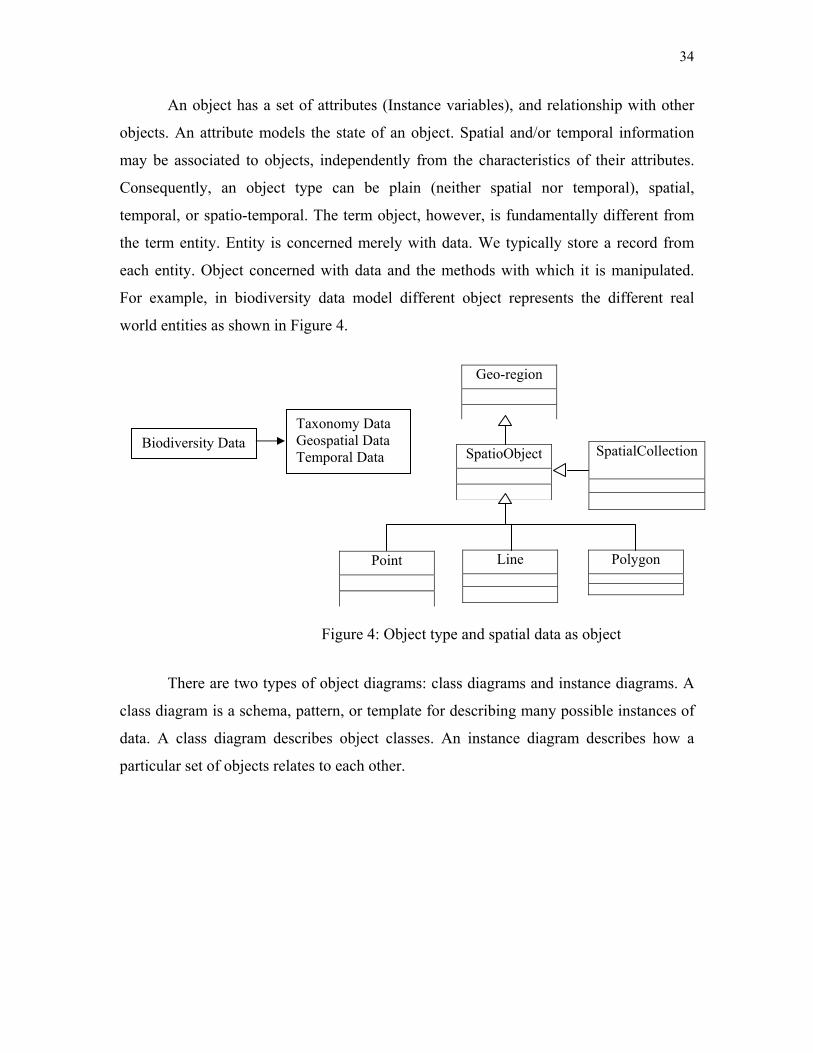
For example, in biodiversity data model different object represents the different real
world entities as shown in Figure 4.
There are two types of object diagrams: class diagrams and instance diagrams. A
class diagram is a schema, pattern, or template for describing many possible instances of
data. A class diagram describes object classes. An instance diagram describes how a
particular set of objects relates to each other.
Biodiversity Data Taxonomy Data Geospatial Data Temporal Data
Point
Line
Polygon
SpatioObject
Geo-region
Figure 4: Object type and spatial data as object
SpatialCollection

35
3.4.2.2 Abstraction mechanism
The object-relational data model is built on few basic concept of abstraction:
relationship, generalization, association and aggregation. These abstraction concepts may
be described by the means of relationship sets. A relationship set is a set of relationships,
all of which have the same role to between objects. In an object-relational diagram, a
relationship set is represented by lines connecting associated objects. As for objects,
relationship may be located in space and time, via two attributes. In this case they are
referred to as spatial and/or temporal relationships. Figure 5 shows identify relationship
between two objects.
3.4.2.3 Generalization and specialization
Generalization and specialization represents the “Is-a” relationship set, an
essential element of object-relational paradigm. The main idea in generalization and
specialization is that one object class (specialization) is a subset of another (the
generalization). The process of generalization consists of putting classes together in what
BiodiversityID
Name Time ReffSate
IdentificationID
IdentificationType
Identification
Identifies
Objects_ID IdentifiedBy Date_of_ident
TaxonID
Taxon_name IdentfiedBy Date
CollectionObjects
Taxon
Identifies
BiodiversityData
Figure 5: “Identifies” Relationship
36
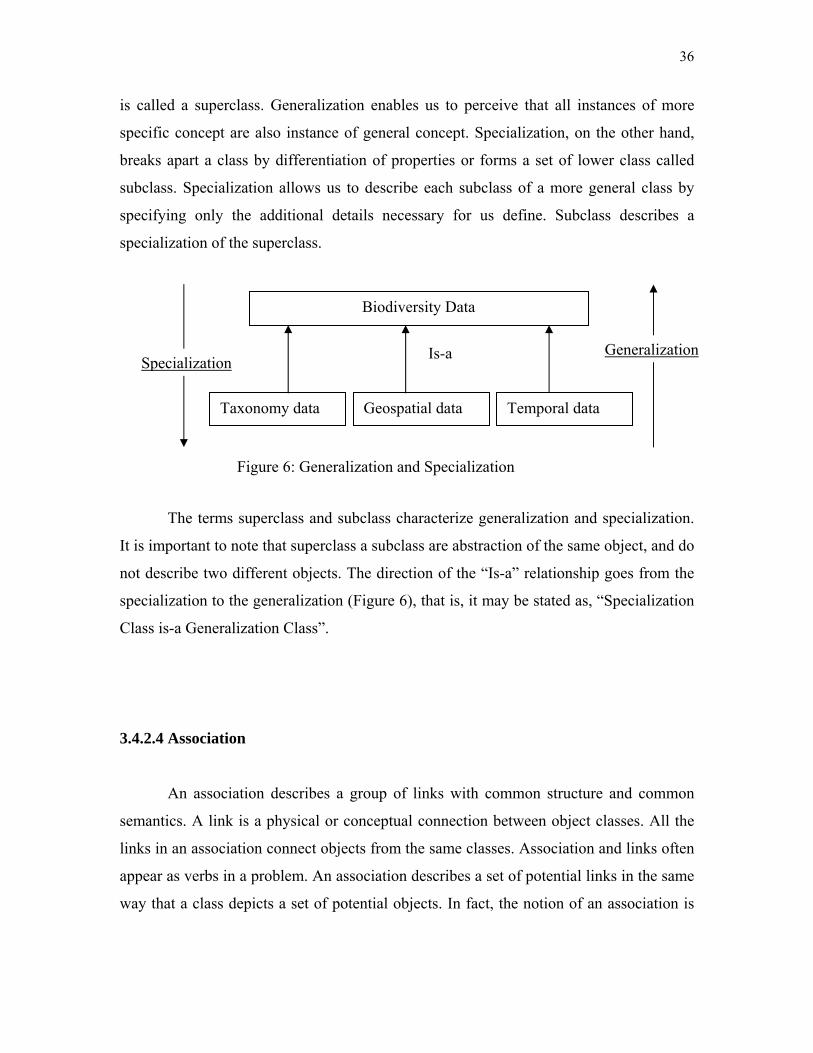
is called a superclass. Generalization enables us to perceive that all instances of more
specific concept are also instance of general concept. Specialization, on the other hand,
breaks apart a class by differentiation of properties or forms a set of lower class called
subclass. Specialization allows us to describe each subclass of a more general class by
specifying only the additional details necessary for us define. Subclass describes a
specialization of the superclass.
The terms superclass and subclass characterize generalization and specialization.
It is important to note that superclass a subclass are abstraction of the same object, and do
not describe two different objects. The direction of the “Is-a” relationship goes from the
specialization to the generalization (Figure 6), that is, it may be stated as, “Specialization
Class is-a Generalization Class”.
3.4.2.4 Association
An association describes a group of links with common structure and common
semantics. A link is a physical or conceptual connection between object classes. All the
links in an association connect objects from the same classes. Association and links often
appear as verbs in a problem. An association describes a set of potential links in the same
way that a class depicts a set of potential objects. In fact, the notion of an association is
Biodiversity Data
Taxonomy data Geospatial data Temporal data
Is-a GeneralizationSpecialization
Figure 6: Generalization and Specialization
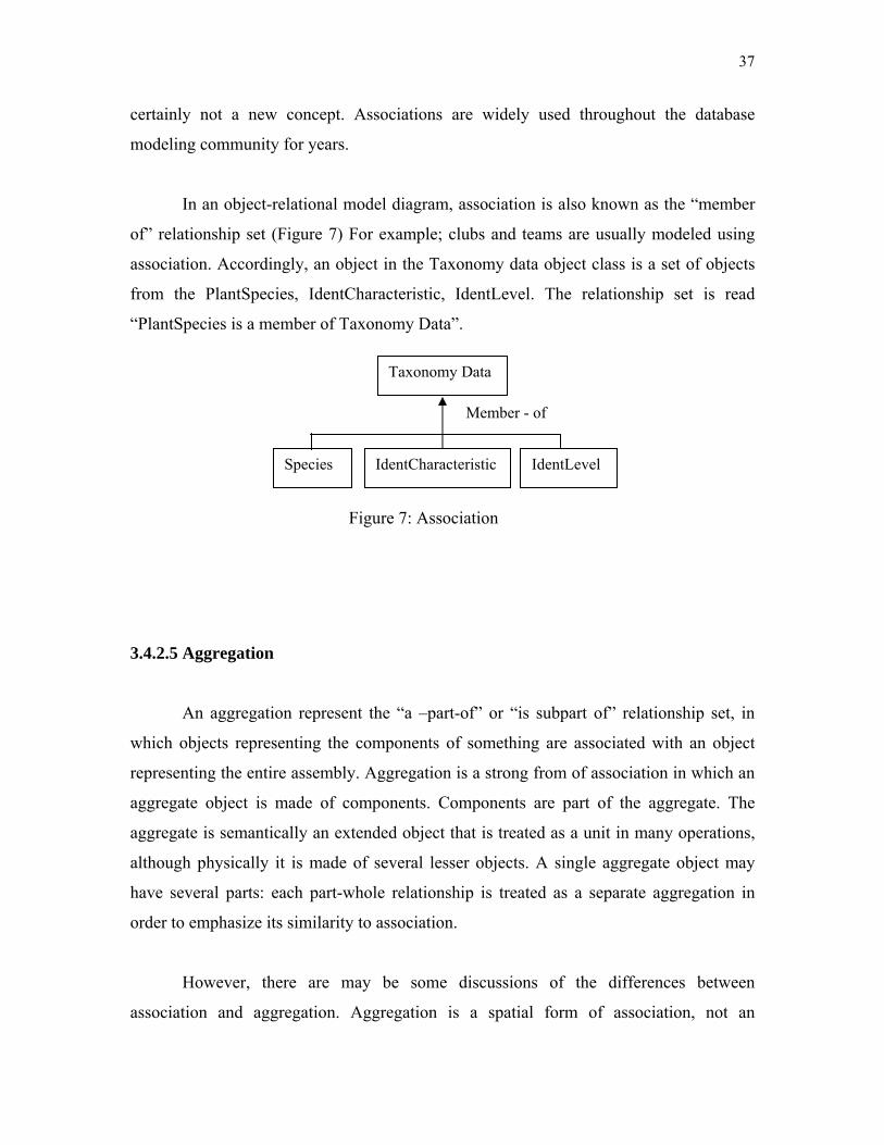
37
certainly not a new concept. Associations are widely used throughout the database
modeling community for years.
In an object-relational model diagram, association is also known as the “member
of” relationship set (Figure 7) For example; clubs and teams are usually modeled using
association. Accordingly, an object in the Taxonomy data object class is a set of objects
from the PlantSpecies, IdentCharacteristic, IdentLevel. The relationship set is read
“PlantSpecies is a member of Taxonomy Data”.
3.4.2.5 Aggregation
An aggregation represent the “a –part-of” or “is subpart of” relationship set, in
which objects representing the components of something are associated with an object
representing the entire assembly. Aggregation is a strong from of association in which an
aggregate object is made of components. Components are part of the aggregate. The
aggregate is semantically an extended object that is treated as a unit in many operations,
although physically it is made of several lesser objects. A single aggregate object may
have several parts: each part-whole relationship is treated as a separate aggregation in
order to emphasize its similarity to association.
However, there are may be some discussions of the differences between
association and aggregation. Aggregation is a spatial form of association, not an
Taxonomy Data
Species IdentCharacteristic IdentLevel
Member - of
Figure 7: Association
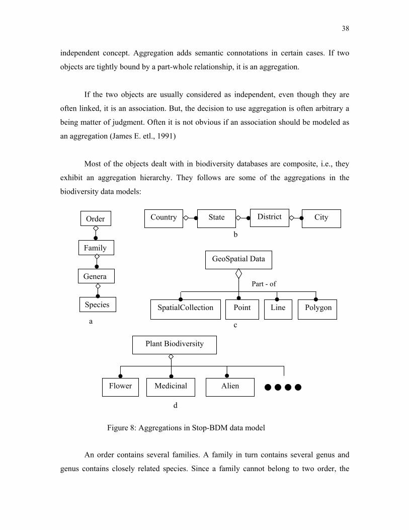
38
independent concept. Aggregation adds semantic connotations in certain cases. If two
objects are tightly bound by a part-whole relationship, it is an aggregation.
If the two objects are usually considered as independent, even though they are
often linked, it is an association. But, the decision to use aggregation is often arbitrary a
being matter of judgment. Often it is not obvious if an association should be modeled as
an aggregation (James E. etl., 1991)
Most of the objects dealt with in biodiversity databases are composite, i.e., they
exhibit an aggregation hierarchy. They follows are some of the aggregations in the
biodiversity data models:
An order contains several families. A family in turn contains several genus and
genus contains closely related species. Since a family cannot belong to two order, the
c
b
Figure 8: Aggregations in Stop-BDM data model
GeoSpatial Data
SpatialCollection Point Polygon
Part - of
Line
Order
Family
Genera
Species
Country State District City
Plant Biodiversity
Flower Medicinal Alien
a
d
39
order-family relationship is modeled as an aggregation rather han an association. Similar
arguments hold for genera and species also. Hence, taxonomy hierarchy is modeled as a
four level containment hierarchy in Stop-BDM (figure 8a)
A country contains number of states, each states is made up of districts and
districts made up of cities. The relationship is also modeled as a four level containment
hierarchy. Similarly, the association between a city and the forest department in the city
and the association between a country and a forest are modeled as aggregations (figure
8b).
Figure 8c is an example of an aggregation. Geospatial object in as aggregation of the
SpatialCollection, point, line and polygon that are the part of it.
3.4.2.6 Constraint
Most of the system can be model with objects, objects classes, and relationship
sets. Constraints are functional relationships between entities of an object relationship
model. Constraints provide one certain for measuring the quality of an object relational
model. In object relational model, a constraint restricts the membership of one or more
object classes and relationship sets. The object relational model allows analysis to
express several different types of constraints. However, in the object behavior model and
interaction model, it may be useful to use this constraint in order to describe some
restricted condition.
3.5 Modeling Object Behavior of STOP BIODI Model
The object-relational diagram is a powerful tool for representing objects and
relationships. However, it does not allow us to model the behavior of objects. We need a

40
behavior model to document the way objects in a system function, respond or perform.
We use the Object Behavior Model (OBM) to describe the behavior of the objects in a
system. The OBM is a means of describing the behavior of objects. As we know that a
database consists of a set of object classes (of different types or schemas). Each object
class has an associated set of objects; each object has a number of attributes with values
drawn from certain domains or atomic data types.
In this chapter, thesis describes three steps of object processes pertaining to
evolution and relationships of objects, and structural changes of objects. Basic processes
of spatio-temporal objects are essential to portray physical phenomena, arising from the
fact that object behaviors are unpredictable. These processes prove that objects move and
interact with other objects in a specific place at a given time. Object attributes are
continuously changed when space interacts with time. In order to depict object process in
space and time, we examine five spatio-temporal data models, ranging from a cube model
to an object model.
In addition, three kinds of data domain are reviewed to understand current
temporal GIS developments and technologies because there is no agreement on a spatio-
temporal framework, based upon the three-legged approach to location (where), feature
type (what), and event time (when). An event can be describes in two ways one in the
field and another within the system. Event change in reality when transaction goes in the
field by some one and event change within the system which includes the creation or
deletation of object or relationships, the starting or stopping of an activity and the
reception of a message from other objects.
3.6 Spatio-Temporal Abstract Data Types (ADT)
One of the basic ideas behind spatio-temporal data models is that, in addition to
the normal built-in data type defined as “date”, user-defined types may also be employed.
41
These types may be used in the same way as built-in types. For example, columns in
relational tables may be defined as taking values of user-defined types, as well as built-in
types. A user-defined Abstract Data Type (ADT) definition encapsulates attributes and
operations in a single entity. An abstract data type (ADT) is defined by specifying a set of
declarations of the stored attributes that represent the value of the ADT, the operations
that define the equality and ordering relationships of the ADT, and the operations that
define the behavior (and any virtual attributes) of the ADT. ADTs can also be defined as
subtypes of other ADTs. A subtype inherits the structure and behavior of its supertypes
(multiple inheritance is supported). Instances of ADTs can be persistently stored in the
database by storing them in columns of tables. Points, line, and polygons in the
Georelational data model are examples of spatial ADT stored in table columns. Spatio-
temporal ADT is a research topic that attracts many researchers, and is represented by the
Event-based Spatio-temporal Data Model, the STComposite data model, and the
Worboys data model.
3.6.1 Data Type “Date”
One easy way of developing spatio-temporal data types within spatial data models
is to use data type “date.” Applications adopting the data type “date” are mostly built on
relational or object-relational DBMSs. The data type “date” specifies user-defined time
attributes and timestamp attributes in spatial data model schemas, which means that
timestamps are defined either as attributes of a relational table or time instants assigned
as a timestamp of a relational table (Armstrong, 1988; Clifford, 1983; Hunter and
Williamson, 1990; Lum et al., 1984; Snodgrass and Ahn, 1985; Stickler et al., 1992).
This method is simple, but it has problems in terms of its data maintenance and
efficiency. The lack of direct query support for spatio-temporal data leads to complex
query operations, which in turn results in the difficulty of maintaining the data model. It
is also unable to solve data redundancy from the snapshot spatial data model, which
manages time-varying spatial data with separate GIS layers.
42
3.7 Temporal Object System
3.7.1 Object in Time
When describing the modeling of time in temporal database, there have been
many efforts to model temporal data. As depicted above, time is a linear and discrete
collection of time units, of which the smallest one is considered as chronons. An interval
is represented by two chronons (e.g., moment, instant) indicating the beginning and end
of the interval. In view of temporal issues, transaction time can be one of multiple past
states of an object. Chakravarthy and Kim (1993) argue that there nay be multiple
interpretations for the temporal behavior (validity) of class of data objects. Using the idea
of temporal validity, they define the notion of history as being a representation of the
evolution of an object along a one-dimension time. The significance of temporal validity
is associated with each individual property, that an object has its own characteristics as
temporal attributes (or data values) related to the temporal behaviors of data objects.
3.8 Spatio-temporal Object
Time provides a class for the general concept of a temporal object, including all
points, volumes, and undivided wholes, etc with temporal dimensions. Time points,
which are non-decomposable in the style of zero dimensional points in time, and a single
explicit subtype, are defined here as zero dimensional time (zero-D-time). Zero
dimensional points are usually referred to using a preposition such as “at”. Time as a
general undecomposable substance, is the combination of temporality and substance
(Bateman et al., 1995), used as an analogous spatial concept that might support, for
example, selection of the interrogative form “when”. Time-interval is a one, two, or three
dimensional, set of time points. It is also an ordered-object. Two subclasses (or subtypes)
are differentiated by linguistic grammar as one or two-D-time and three-D-time. A three-

43
D-time is a portion of time that is being viewed on a sufficiently large scale as if it were a
volume within which a thing occurred (e.g, in “1996”) rather than a plane on which a
thing occurred (e.g, “on that day”). A one-or-two-D-time is a temporal object that is
associated with time intervals or smaller scale successions of time instants, e.g, a day (as
opposed to a year).
The spatio-temporal sub-hierarchy is organized along a number of dimensions,
which combine to form specific categories of relationships between entities and locations
in space and time. The Upper Model (UM) (Bateman et al., 1994) delineates that most
spatio-temporal subclasses are responsible for the appearance of specific prepositions
within prepositional phrases generated by the grammar to express spatio-temporal
relationships. According to the UM, spatio-temporal linguistics includes relations
associated with time, space, directions, and extents. In principle, there are two level
distinctions between locating and extents. In English, the extent-dimension is responsible
for the selection of prepositional phrases involving prepositions such as for, along during,
as in the prepositional phrases: “for six days”, “for three miles”, “across the bridge”,
“along the street”, “during the seminar”, etc.
3.9 Object-relational Features
As we know that within the classic relational database model there are only scalar
but no complex data types. With the introduction of object types the definition and
composition of abstract data types is possible. An abstract data type can be comprised of
a multitude of scalar types and again of user-defined complex types and enhances
consistency when creating database models.
create or replace type Address_TY as object (
City VARCHAR2 (30),
Sate VARCHAR2 (30),
Area_code NUMBER (8),
44
Country VARCHAR2 (30));
Here create or replace the Address_TY data type after that create Org_Address_TY by
using Address_TY data type.
create or replace type Org_Address_TY as object (
Org_name VARCHAR2 (30),
Address Address_TY,
Org_url VARCHAR2 (50),
Phone NUMBER (12),
Email VARCHAR2 (30));
Data types only represent descriptions of data structures. To ensure persistency a
table must be bound to the data type. A relation with column objects can be created that is
a set of Observer_ID with Observer_name, Observer_org and Observer_Address as:
create or replace type Observer as object (
Observer_ID VARCHAR2 (15),
Observer_name VARCHAR2 (30),
Observer_org VARCHAR2 (50),
Observer_Address Org_Address_TY );
Object views allow user to treat relationally data as they allow synthesizing object
from data that continues to be stored in relational tables. Object views have similar
functionality like object tables. They can have methods, belongs to collections, reference
one another, have object identity and can be accessed from SQL. In addition tables are
assigned to object views can be uploaded by using special instead of triggers. Any
instance (row) of an object class contains a unique ID called Object_ID (ID). Generally
OIDs are system-generated but can also be derived from a primary key column or can be
user-defined.
Relationships between objects can be defined using reference types. A reference
column stores OIDs of associated (row) objects since column objects do not have
inherent OIDs and therefore cannot be referenced. Row objects that belong to a reference
45
can be selected and dereferenced using the DEREF VALUE operator. Modeling object
relationships with OIDs and REFs is often compared with foreign key relationships inside
the relational model but implicates some benefits like the ability to distinguish between
equal and identical objects. Objects are identical if they have one common OID. They are
equal if they have different OIDs but coincide with their attributes and values.
In the classical Entity-Relationship-Model aggregations and compositions are
modelled through master-detail-relationships. Object-relational dbms provide collection
types that contain multiple elements and thus are suitable to express 1: N relationships
directly. Each element or value for a collection has the same substitutable data type. The
most popular collection types are varrays and nested tables.
A varying array contains a variable number of ordered elements. Varying array
data types can be used as a column of a table or as an attribute of an abstract type. Named
table types can be created in an Oracle database using SQL. These table types can be
used as nested tables to provide the semantics of an unordered collection. As with varray
a nested table type can be used as a column of a table or as an attribute of an object type.
Named table types can be created in an Oracle database using SQL. These table
types can be used as nested tables to provide the semantics of an unordered collection. As
with varray a nested table type can be used as a column of a table or as an attribute of an
object type.
Create type Address_TY as table of Org_Address_TY;
Multi-Level-Collections that lead to multiple nested tables can be realized if
useful for applications but it’s up to the user to balance – a more intuitive representation
of data vs. higher complexity of accessing the data.
An object type declaration can also include methods that are defined on values of
that type. When using these objects types in tables their methods are also applied to the
data of these tables. The method is declared in the create type command and the code for

46
the function itself (the definition of the method) is in a separate create type body
command.
create or replace type Taxon_TY as object (
Taxon_Lname VARCHAR2 (20),
Tanon_Ename VARCHAR2 (20),
Taxon_Species Species_TY,
Taxon_family Family_TY,
Taxon_area Area_TY,
Taxon_description VARCHAR2 (50),
Taxon_start_date DATE,
Taxon_end_date DATE,
Member function DURATION (start_date, end_date in Date) return Number);
Names the function that is a “member” of the Taxon_TY datatype. Since Duration
will return a value, it is a fuction. To define DURATION function, use the create body
command, whose full syntax is shown in the Alphabetic Reference.
Let’s create the Duration function as a member function within the Taxon_TY
datatype. The DURATION function will return duration, in days, of the taxon.
create or replace type body Taxon_TY as
member function DURATION (start_date, end_date DATE)
return NUMBER is
begin
return totaldays (start_date + end_date );
end;
The following query executes the duration method in the data type Taxon_TY and
returns the duration of all collection objects in relation Observation. Values of
components of an object (attributes and methods) are accessed with the dot notation.
Select Taxon_ID, O.Taxon_Area, Duration (O.start_date, O.end_date)
47
from Observation O ;
Object types can be mapped to the prevalent OO languages like C++ and Java.
Thus object type instances in the database can be accessed and modified to and from
C++, Java applications (Lee, G., 2003).
In the current version Oracle database 10g native data types for storing raster and
persistent topology data were added to further extend possibilities to model real world
objects based on object-relational database structures. The completeness and therefore the
quality of spatial features’ descriptions can be further enhanced with the introduction of a
new system-defined data type XMLType that can be used as the datatype for columns in
tables and views to create, extract, and index XML data. A feature’s position and spatial
representation is then modeled by using vector resp. raster types, its characteristics are
captured by (complex) attributes and any further information on the spatial object, that
cannot be structured to be kept in the data types mentioned, is maintained in xml-
documents, all stored natively within the database.
For modeling highly dynamic changes of real world objects the SQL type
TIMESTAMP can be used which is a high-precision time and date type that allows storing
fractions of a second (Qian, L., 2004). The timestamp values are basically points on a
linear time axis. For slower changes in state we can use DATE or create own adapted
abstract data types that can express discrete dates or times intervals. The data types can
be flexibly extended to meet an application’s accuracy requirements and provide
attributes to express the fuzziness of a time record, for instance if a time interval cannot
be determined as accurate as the data type could store (Plabst. S., 2001).
create or replace type TIME_TY as object (
year NUMBER (4,0),
month NUMBER (2,0),
day NUMBER (2,0),
hour NUMBER (2,0));
create or replace type TIME as object (
48
start_date TIME_TY,
end_date TIME_TY,
start_date_per NUMBER (1,0),
end_date_per NUMBER (1,0));
3.10 Object-relational Application Development
In terms of Biodiversity data of Malaysia, object-relational database technology
can be used to model different applications, e.g. the spatio-temporal process of flora or
fauna based on its influencing factors or real time deer tracking.
For the development biodiversity data model some major influencing factors have
been proved to be crucial. In the model we have judged like data should be natural to
human. The structures of space and time are identified as essential for the realization of
cognitive systems. Models of spatial temporal data in geographical database
representations must incorporate human cognitive principles. Finally model support
human knowledge of the dynamic geographical world comprises of three different (and
interrelated) subsystems that handle what, where and when aspects of object properties.
create or replace type Position_TY as object (
Map VARCHAR2 (30),
Grid25 NUMBER (4),
Grid100 NUMBER (4).
Create or replace type SpatialData as object (
Forest_ID NUMBER (6),
Forest_name VARCHAR2 (30),
Forest_area AREA_TY,
Forest_position Position_TY);

49
Based on this type an object view is created and OIDs are assigned to the spatial
datasets of the corresponding forest area:
create or replace view Forestdetails_OV of Position_TY
with object identifier (ForestID) as
select Forest_name, position,
from Forest_area
where AreaName = Johor;
The columns of the relational base tables are now accessible as row objects
through their corresponding object views. Any detail tables of the underlying relational
model could now be simulated by further object views with references that could point to
the row objects of the particular upper object view, to allow accessing the data in either
way.
Projection operations on moving objects map either to their spatial or to their
temporal aspect. Assume that we are interested in the geometric locations where the data
was changed at the year January 20, 1990. These can be obtained by:
SELECT Flora_ID, AreaName
FROM Flora, Area
WHERE (((Forest_area =#Johor# AND #01/20/1990#));
This operation computes the spatial projection of a spatio-temporal object for the
Johor forest area. For an evolving region the trajectory operation returns an object of the
spatial type region which results from projecting the union of the region values for the
Date 20th January, 1990.
The following query inquires about the largest collection of flora areas.
SELECT Area (max (Extent)) FROM ForestArea
WHERE Type = "Flora"

50
The query demonstrates an example of a spatio-temporal aggregation operation
max which is an extension of the well known aggregation operator in SQL of the same
name. It is here applied to a collection of evolving regions contained in a relation column
and computes a new evolving region. Internally, this operator is based on a binary
function MAXST applied to two evolving regions R1 and R2 'and yielding a new evolving
region in the following way:
MAXST (R1, R2):= {(t, r) |t Є time r MAXgeo (R1 (t), (R2 (t))}
This definition uses a function MAXgeo which is applied to two regions R1 and R2 and
which returns larger of both regions.
MAXgeo(R1, R2)= ⎩⎨⎧
2
1
rr
Altogether this means that for 2 evolving regions R1,…, Rn we first compute the evolving
region R = MAXst (R1,….MAXst(Rn-1, Rn )..). Afterwards, we apply the raise area of R,
which computes the area of R at all times as a temporal real number.
3.11 Conceptual Biodiversity Data Model Structure
After explanation of several components of object relational model, this section
shows some relationships among the components of object relational model for
biodiversity.
If area (r1) > area (r2)
Otherwise

51
The proposed spatio-temporal data model is described by means of collection of
one or more class diagrams that form the object model and connected with its related
relational tables to form an object-relational data model.
The class diagram which describes the structural characteristics of the proposed
spatio-temporal data model is presented in Figure 9. It shows that five major classes were
identified and incorporated into the data model: BiodiversityFeature (BF),
BiodiversityData (BD), Spatial Data (SD), Taxonomy Data, and Temporal Data (TD).
Figure 9: Detailed Structure of Spatio-temporal Object-Relational Model for Biodiversity
TemporalData
TemporalD[1]:IdentificationType TemporalReferencing:Reference TemporalResulution:
SpatialData SpatialDataID[1]: IdentifierType SpatialDataName[1]:NameType Color[1]: ColorType
TaxonomyData TaxonName[1]:NameType TaxonID[1]: identifierType TaxonValue[1]: AttributeType TxonDataType[0..1]:NameType TaxonIdntDate[1..*]:DateType
BiodiversityFeature BioFeatureID: IdentifierType BioFeatureName: NameType
BiodiversityData
BiodiversityID1[]: identifierType BiodiversityName[1..*]:NameType
Date Time Day Hour Month Minute year Second
Interval
YearMonth Interval
DayTime Interval
Month Days Year Hours Minutes Seconds Milliseconds
DateTime
Biodiversity Data
Taxonomy Data
Biodiversity Feature
Spatial Data
52
To conclude the description of the model diagram illustrated in Figure 4.9 and
noted that each class has two common attributes: identifier and the name. But some
classes are having more than two attributes especially in taxonomy data and temporal
data objects. Each one of these attributes can have a single value and the identifier
attribute is unique for every object of each class. The value of the identifierType and
NameType domains will depend on the implementation of the object model. A time class
carries a time value, an interval, a duration, or a collection of such values. Date and 24
hour time maybe used separately or together, in which case the object carrying both
values is considered a timestamp. Two kinds of intervals are recognized as YearMonth
intervals and DayTime intervals. YearMonth intervals and DayTime intervals can be
viewed as objects types. In temporalData Object, we can specify the relationship among
objects.
53
EXPERIMENTS AND RESULTS
4.0 Introduction
In this chapter, model testing is involved in the implementation of STOP-Biodi
using an object-relational database management system. As a part of the testing,
implementation and evaluation, a biodiversity data set covering more than 5 years data
from different private and government organizations forest departments such mardi,
pahang and johor national park’s data loaded onto the database. This thesis describes the
STOP-Biodi and its realization in an object-relational architecture, and outlines the
benefits we perceived in experiments i.e. efficient retrieval, better support of space and
time, complexity handling, data integrity, cost, data redundancy etc.
This chapter summarizes and discusses the performance test results of the
research. A number of interesting issues are presented. The discussion of the proposed
model is also presented.
The physical model is developed by defining spatial and temporal versions of
datatypes. For spatial and temporal datatypes as combinations of spatio-temporal and
standard datatypes, queries can be differentiated by which dimensions the desired results
are restricted to, and whether they query for a range in a dimension or a point. Therefore
experiments on different spatio-temporal queries were performed with several different
selectivities.
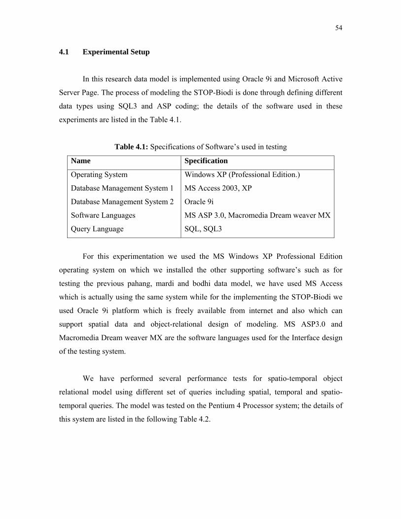
54
4.1 Experimental Setup
In this research data model is implemented using Oracle 9i and Microsoft Active
Server Page. The process of modeling the STOP-Biodi is done through defining different
data types using SQL3 and ASP coding; the details of the software used in these
experiments are listed in the Table 4.1.
Table 4.1: Specifications of Software’s used in testing
Name Specification
Operating System
Database Management System 1
Database Management System 2
Software Languages
Query Language
Windows XP (Professional Edition.)
MS Access 2003, XP
Oracle 9i
MS ASP 3.0, Macromedia Dream weaver MX
SQL, SQL3
For this experimentation we used the MS Windows XP Professional Edition
operating system on which we installed the other supporting software’s such as for
testing the previous pahang, mardi and bodhi data model, we have used MS Access
which is actually using the same system while for the implementing the STOP-Biodi we
used Oracle 9i platform which is freely available from internet and also which can
support spatial data and object-relational design of modeling. MS ASP3.0 and
Macromedia Dream weaver MX are the software languages used for the Interface design
of the testing system.
We have performed several performance tests for spatio-temporal object
relational model using different set of queries including spatial, temporal and spatio-
temporal queries. The model was tested on the Pentium 4 Processor system; the details of
this system are listed in the following Table 4.2.

55
Table 4.2: Specifications of Test System
Name Specification
Processor
System RAM
Graphics Card
Intel Pentium 4 1.7 GHz
256 MB
NVADIA GeForce4 MX 440
We have mentioned earlier that biodiversity data has been collected from pahang
forest deopartment, mardi and johor national park. Pahang forest department developed
database management system which is developed by Microsoft access.
4.2 Overview Structure of the Stop-BDM
In this section we describe the overview of structure of the STOP-BDM. This will
help to understand the model at physical level in order to manipulate with the spatio-
temporal data. With the description of the structure of STOP-BDM a relational schema is
also prescribed, so as to briefly discuss the structural approach as shown in the Table 4.3
below
Table 4.3: Schema Structure comparison of models
Flora relation
Attribute Data type
Flora_id (PK) Varchar2
Local_name Varchar2
Eng_name Varchar2
Species Varchar2
Family Varchar2
Type_id Varchar2
Description Varchar2
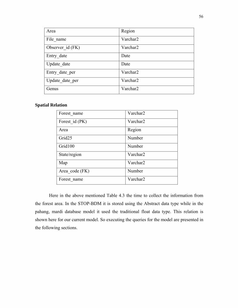
56
Area Region
File_name Varchar2
Observer_id (FK) Varchar2
Entry_date Date
Update_date Date
Entry_date_per Varchar2
Update_date_per Varchar2
Genus Varchar2
Spatial Relation
Forest_name Varchar2
Forest_id (PK) Varchar2
Area Region
Grid25 Number
Grid100 Number
State/region Varchar2
Map Varchar2
Area_code (FK) Number
Forest_name Varchar2
Here in the above mentioned Table 4.3 the time to collect the information from
the forest area. In the STOP-BDM it is stored using the Abstract data type while in the
pahang, mardi database model it used the traditional float data type. This relation is
shown here for our current model. So executing the queries for the model are presented in
the following sections.

57
4.3 Create standard query for biodiversity data
In this phase we have created standard query for biodiversity data. Some example of
standard query stated bellow:
a) This query collects information about flora information and when data collected
and updated
SELECT flora.flora_id, flora.flora_engname, flora.flora_family, flora.flora_species,
flora.flora_entry_dt, flora.flora_typeid, flora.flora_upd_dt, floraObservation.flora_count,
floraObservation.observer_id
FROM flora INNER JOIN floraObservation ON flora.flora_id =
floraObservation.floraobs_id;
b) User also can find information about data collector by using web-based system. User
also can see the retrieval time after retrieving data from the system.

58
Above queries examine the spatio-temporal data handling by our proposed model.
The proposed model Stop-BDN supports well the spatio-temporal data to perform spatio-
temporal queries.
In this investigation we used a Malaysian Plant Biodiversity data such as pahang
forest data, mardi plane genebank data, and johor national park data. For implementation
and testing of spatio-temporal object-relational plant biodiversity data model, we define a
set of different relations which can contain and handle the biodiversity data.
4.4 Queries
This experiment is made for the measurement of the execution time of queries,
which we have applied on the model. We used traditional queries to measure the time,
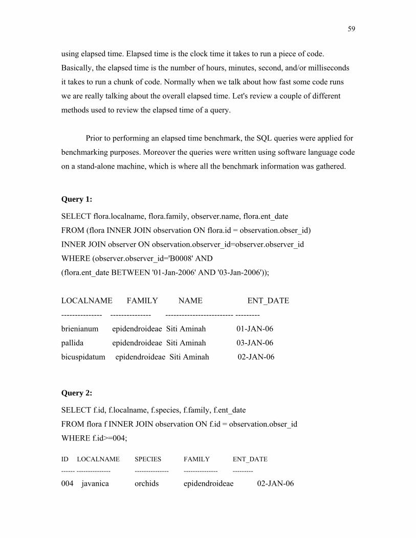
59
using elapsed time. Elapsed time is the clock time it takes to run a piece of code.
Basically, the elapsed time is the number of hours, minutes, second, and/or milliseconds
it takes to run a chunk of code. Normally when we talk about how fast some code runs
we are really talking about the overall elapsed time. Let's review a couple of different
methods used to review the elapsed time of a query.
Prior to performing an elapsed time benchmark, the SQL queries were applied for
benchmarking purposes. Moreover the queries were written using software language code
on a stand-alone machine, which is where all the benchmark information was gathered.
Query 1: SELECT flora.localname, flora.family, observer.name, flora.ent_date
FROM (flora INNER JOIN observation ON flora.id = observation.obser_id)
INNER JOIN observer ON observation.observer_id=observer.observer_id
WHERE (observer.observer_id='B0008' AND
(flora.ent_date BETWEEN '01-Jan-2006' AND '03-Jan-2006'));
LOCALNAME FAMILY NAME ENT_DATE
--------------- --------------- ------------------------- ---------
brienianum epidendroideae Siti Aminah 01-JAN-06
pallida epidendroideae Siti Aminah 03-JAN-06
bicuspidatum epidendroideae Siti Aminah 02-JAN-06
Query 2: SELECT f.id, f.localname, f.species, f.family, f.ent_date
FROM flora f INNER JOIN observation ON f.id = observation.obser_id
WHERE f.id>=004; ID LOCALNAME SPECIES FAMILY ENT_DATE
------ --------------- --------------- --------------- ---------
004 javanica orchids epidendroideae 02-JAN-06

60
008 pallida orchids epidendroideae 03-JAN-06
005 major orchids epidendroideae 02-JAN-06
006 parviflora orchids epidendroideae 02-JAN-06
007 bicuspidatum orchids epidendroideae 02-JAN-06
009 wallichi orchids epidendroideae 03-JAN-06
010 nuda orchids epidendroideae 03-JAN-06
Query 3:
SELECT forest_id, forest_name, grid25, grid100, state
FROM spatial
WHERE map !='perak';
FOREST_ID FOREST_NAME GRID25 GRID100 STATE
---------- --------------- ---------- ---------- -------------------
F0001 Hutan Bayu 2 1 hulu langat
F0002 Hutan Merah 4 7 kuantan
F0004 Hutan Paifik 6 77 miri
F0005 Hutan Aneh 2 4 hulu langat
F0006 Hutan Pelik 6 54 miri
F0008 Hutan Da 4 7 kuantan
F0009 Hutan Ayu 6 65 miri
F0010 Hutan Nya 6 13 miri
61
CONCLUSION
This research work provides an integrated conceptual model that partially
overcomes some problems of spatio-temporal data model. Indeed, an analysis of existing
model shows that such a basis is weakly defined. Spatial models use ad hoc ways of
embedding space within data structures. Beside that temporal models tend to be poor in
the supported data structures and include unnecessary constrains. Few models address
both space and time, showing similar drawbacks. Based on human cognition, the model
linked together the event-based space and time concepts. Such structure allows integrated
operations on space and time, such as navigation, tracking and query. In this paper
describes a new type of object-relational spatio-temporal data model for plant
biodiversity. The data model consists of a data structure, operators and consistency rules.
The conceptual schema (data structure) has been devised by the aggregating of three
components of reality, i.e., space, time and attribute (each is considered as a class). By
using biodiversity model forest department will be able to efficient management and
integrates diverse set of spatio-temporal data that maybe required to analysis, monitoring
biodiversity data. Biodiversity data model validation can be carried out to meet user
requirements which are functionally created. To validate biodiversity data model few
steps have been carried out.
1. We validate data model for supporting biodiversity data especially plant
biodiversity collected from different biodiversity area such as Johor forest
department, Pahang forest department and Mardi biodiversity data.
2. Data model is being tested for spatio-temporal object relational model using
different set of queries including spatial, temporal and spatio-temporal queries.
For this experimentation we will use the MS Windows XP Professional Edition
62
operating system on which we installed the other supporting software’s such as
Oracle 9i platform which is freely available from internet and also which can
support spatial data and object-relational design of modeling. MS dot net and
VB.net are the software languages used for the Interface design of the testing
system.
3. Also set of defined queries used for performing different tests such as checking
the model’s Suitability for handling the spatial, temporal and spatio-temporal
data

63
REFERENCES
M Clair Horner-Devine, “pattern of Diversity & Community Composition”, may 2004,
PhD Thesis, Stanford University.
Shattri MANSOR, Mohammed Abu SHARIAH, Lawal BILLA, Iwan SETIAWAN and
Fisal JABAR, “Spatial Technology for Risk Management” FIG Working Week 2004,
Athens, Greece, May 22-27, 2004
DeokHwan Kim and ChinWan Chung, (2003), “Qcluster: Relevance Feedback Using
Adaptive lustering for ContentBased Image Retrieval”, ACM SIGMOD 2003, June 9-12,
2003
Date, C. J. 2003. An Introduction to Database Systems. 8th Edition. Addison-Wesley,
Reading, Mass.
adnan yunus, M.N. Sap, Mohd Taib, (Dec 2003), “A research Perspective Spatio-
temporal Databases for Geographic Information System, Journal: Information Technolgy,
Vol-15, No-2,
Momose Kuniyasu_ and Shimamura Tetsuya, June 2002, “Environments and People of
Sumatran Peat Swamp Forests I:Distribution and Typology of Vegetation”, Southeast
Asian Studies, Vol 40, No.1 June 2002
V. Katri, S. Ram, R.T. 2002. Snodgrass and G. O’Brien. Supporting User Defined
Granularities and Indeterminacy in a Spatiotemporal Conceptual Model. Special Issues of
64
Annals of Mathematics and Artificial Intelligence on Spatial and Temporal Granularity,
36(1-2). 195-23
V. Katri, S. Ram, R.T. 2002. Supporting User Defined Granularities and Indeterminacy
in a Spatiotemporal Conceptual Model. Special Issues of Annals of Mathematics and
Artificial Intelligence on Spatial and Temporal Granularity, 36(1-2). 195-232.
Suhami Napis, Kamarudin, Khairudin & A.Latif, (2001), “Biodiversity Database for
Malaysian Flora and Fauna: Update” University Putra Malaysia
Michel B. Thomas, Nan Lin and Howard W. Beck, (September 2-8, 2001), “A Database
model for Integrating and Facilitating Collaborative Ethnomedicinal Research”,
University of Florida
Dimitris Papadia, Nikos Mamoulis, Vasilis Delis, (January 2001), “Approximate Spatio-
Temporal Retrieval”, ACM Transactions on Information Systems, Vol. 19, No. 1
Srikant B.J, Jayant R. Haritsa, (2000), “Design and implementation of Biodiversity
Information Management System” database lab,Indian Institute of Science, Bengalor,
India.
Spery L, et al. 2001. A spatio-temporal model for lineage metadata. Geoinformatica 5:51-
70.
Gueting RH, Böhlen et al. 2000. A foundation for representing and querying moving
objects. ACM Transactions on Database Systems 25: 1-42.
Jeremy L. Mennis, Donna J. Peuquet Diansheng Gua, (2000), “A semantic GIS Database
Model for he Exploration of Spatio-temporal Environmental Data”, 4th international conf.
on Integrating GIS and Environmental Modeling (GIS/EMA4)
65
Gueting RH, Böhlen et al. 2000. A foundation for representing and querying moving
objects. ACM Transactions on Database Systems 25: 1-42.
Tzouramanis, T., Y. Monolopoulos and N. Lorentzos, (2000), “Overlapping +B tree – an
Implementation of a Transaction Time Access Method. Data & Knowledge Engineering”
T. Bittner and B. Smith. 2001. “A Unified Theory of Granularity, Vagueness and
approximation”, In Proc. of COSIT Workshop on Spatial Vagueness, Uncertain and
Granularity.
OMG. 2000. Unified Modelling Language Specification, Version 1-3. Object
Management Group.
Huang B, et al. 2000. A spatio- temporal object model and query language (extended
abstract). In: GIScience 2000: First International Conference on Geographic Information
Science. 28-31 Octover, Savannah, Georgia, USA
Cattell R and Barry D. 2000. The Object Data Standard: ODMG 3.0. San Francisco,
Morgan Kaufmann Publishers Inc.
Floor Eugnia Narciso, (April 1999), “A Spatiotemporal Data Model for Incorporating
Time in Geographic Information Systems”
Theodoris, T., E. Stefanakis, and T. Sellis, (1998) “Cost Models for Join Queries in
Spatio Database” Proc. 14th IEEE Conf. On Data Engineering, Orlando, Florida
Papadopoulos A. and Y. Monolopoulos, (1998), “Similarity Query Processing using Disk
Arrays, Proc. ACM SIGMOD Conf. ACM SIGMOD Record, 27920

66
Tzourramanis, Vassilakopoulos, M., Monolopouslos, Y., (1998) “Overlapping Linear
Quadtress: a Spatiotemporal Access Method, 6th ACM int. Workshop on Geographical
Information Systems,
Vazirgiannis, M., Theodoridis, Y., And Sellis, T., (1998) “Spatio-Temporal Composition
and Indexing for Large Multimedia Applications”, Multimedia Syst. 6, 4, 284–298
Papadopoulos A. and Y. Monolopoulos, (1997), “Performance of Nearest Neighbor
Queries in R-trees” Proc. 6th int. Conf. On Database Theory
Seidl, T. And Kriegel, H.-P., (1997), “Efficient User-Adaptable Similarity Search In
Large Multimedia Databases”, In Proceedings Of The 23rd International Conference On
Very Large Data Bases (Vldb ’97, Athens, Greece, Aug.). 506–515
Mat Salleh, K. & A Latif., (1997), “Towords a comprised database of Malaysian
medicinal and aromatic plants “
Andrei Ju, Korolyuk, 1997, Using ArcInfo to Evaluate Plant Biodiversity in Southern
Siberia.
M. Miick and M. Polaschek, (1997) “A configurable Type Hierarchy Index for oodb,
VLDB”, journal 6(4)
Michael J. Conroy And Barry R. Noon, (1996), Mapping Of Species Richness For
Conservation Of Biological Diversity: Conceptual And Methodological Issues1,
Ecological Applications, 6(3), 1996, pp. 763-773 © 1996 by the Ecological Society of
America
B. Becker, S. Gschwind, T. Ohler, B. Seeger, P. Windnayer, (1996), “An Asymptotically
Multiversion B-tree, The VLDB Journal 5(4)
67
Vazirgiannis, Theodoris, Y., M., Sellis, (1996), “Spatio-temporal Indexing for large
Multimedia Applications”, 3rd IEEE Conf. on Multimedia Computing and Systems,
ICMCS’96, Hiroshima, Japan
Nabil, M., Ngu, A. and Shepherd, J., (August, 1996), “Picture similarity retrieval using
2D projection interval representation. IEEE Trans. Knowl. Data Eng. 8, 4, 533–539.
Papadopoulos A. and Y. Monolopoulos, (1996), “Parallel Processing of Nearest Neighbor
Queries in Declusteres Spatial Data”, Proc. 4th ACM GIS,
Smith, J. And Chang, S.,( 1996) “Searching For Images And Videos On The World-Wide
Web”. Cu/Ctr 459-96-25
R. Vidya, Jayant R. Harisa, (1995), “Oshadhi: A Biodiversity Information System. In
Proc. Of the International Conference on Management of Data”, Indian Institute of
Science, Bengalor, India
Peuquet, Donna J. and Niu Duan., (1995),"An Event-Based Spatio-Temporal Data Model
for Geographic Information Systems," International Journal of Geographical
Information Systems, 9(1):7-24
Claramunt C, Thériault M. 1995. Managing time in GIS: an event-oriented approach. In:
Clifford J, Tuzhilin A (eds) Recent Advances in Temporal Databases. Springer-Verlag.
Peuquet D, Duan N. 1995. “An event-based spatio-temporal data model (ESTDM) for
temporal analysis of geographical data”, International Journal of GIS 9: 7-24.
Stonebraker, M.,( 1995), “Chabot: Retrieval from a Relational Database of Images”.
IEEE Computer 28, 9, 40–48.

68
Worboys, M., (1994), “A unified model for spatial and temporal information”, The
Computer Journal, 37(1): 26-34.
Faloutsos, C., Barber, R., Flickner, M., Hafner, J., Niblack, W., Petkovic, D., & Equitz,
W., (July, 1994), “Efficient And Effective Querying By Image Content.” J. Intell. Inf.
Syst. 3, 3/4, 231–262
Langran G. 1992. Time in Geographic Information Systems. Taylor & Francis, London
Open GIS Consortium Inc.
Codd, E. F. 1970. A Relational Model of Data for Large Shared Data Banks. CACM 13
(6).

69
PUBLICATIONS
Journals
1. Mohd Taib Wahid, A.Z.M Kamruzzaman, Abdul Rashid Mohammed Shariff
“Comparative Study of Plant Biodiversity Data Modeling in Research
Perspective" Journal, Information Technology, Vol.16, No. 2, University
Technology Malaysia, December 2004
2. Mohd Taib Wahid, A.Z.M Kamruzzaman, Abdul Rashid Mohamed Shariff,
Harihodin Selamat, (2005), “Object-relation Data Model (ORDM) for Malaysian
Biodiversity Data” Journal, Information Technology, University Technology
Malaysia, Vol.17, No. 1, June 2005,
3. Mohd Taib Wahid, A.Z.M Kamruzzaman, Abdul Rashid Mohamed Shariff,
Harihodin Selamat, (2005), “Spatio-temporal Data Model and Query Language
for Biodiversity Data”, Journal, Information Technology, University Technology
Malaysia, Vol.17, No. 2, December 2005
International Conference / Symposium
4. Mohd Taib Wahid, A.Z.M Kamruzzaman , Abdul Rashid Mohamed Shariff and
Harihodin Selamat, “Steps of Designing Biodiversity Data Model Using Object-
Relational Data Model Techniques”, The 4th International Multiconference on
Computer Science and Information Technology (CSIT2006), Amman, Jordan,
Vol. 2. Page 56, April 5-7 2006
70
5. Mohd Taib Wahid, Sarazmin Abd Razak, A.Z.M Kamruzzaman, Raja Baharudin
Anom, “Learning Presentation Approach Using Multi-Criteria Decision Support
System in A Mobile Behavior”, The 8th International Conference on Quality in
Research (QIR2005), University of Indonesia, Depok, Jakarta, Indonesia, 8th to
10th August 2005
6. Mohd Taib Wahid, A.Z.M Kamruzzaman, Abdul Rashid Mohamed Shariff,
Harihodin Selamat (2005), “Biodiversity Data Model (BIDaM) Using Object
Relational Approach: Conceptual Framework”, An International Conference on
Biogeography and Biodiversity: Wallace in Sarawak 150 years later, Sarawak
Tourism Complex, Kuching, Sarawak, 13th – 15th July 2005
7. Mohd Taib Wahid, A.Z.M Kamruzzaman, Abdul Rashid Mohammed Shariff
"Preliminary Plant Biodiversity data modeling and Spatio-temporal data model"
International Symposium and Geographical Information System (ISG04), Hotel
Istana, Kuala Lumpur, Malaysia, 21st - 3rd September 2004
8. Mohd Taib Wahid, A.Z.M Kamruzzaman, Abdul Rashid Mohamed Shariff,
Harihodin Selamat, "Conceptual Spatio-temporal data model design for plant
biodiversity" Malaysian Science and Technology Congress(COSTAM), CitiTel
MID Valley, Kuala Lumpur, Malaysia, 18th-20th April 2005
9. Mohd Taib Wahid, A.Z.M Kamruzzaman, Abdul Rashid Mohamed Shariff,
Harihodin Selamat, "Biodiversity Data Model for the Exploration of Spatio-
Temporal Data”, First International Symposium on bio-inspired Computing
(BIC’05) Puteri pan pacific hotel, Johor Bahru, Malaysia, September 5 - 7, 2005
University Level Conference
10. A.Z.M Kamruzzaman, Mohd Taib Wahid, Harihodin Selamat, “Conceptual
Design Of Biodiversity Data Model (Bidam) Using Object Relational And Event
Based Approach”, FSKSM Postgraduate Annual Research Seminar (PARS 05),
D07, FSKSM, University Technology Malaysia, May 17-18, 2005

71
11. A.Z.M Kamruzzaman, Mohd Taib Wahid, Harihodin Selamat, “Object-relational
Features for modeling and analysis of Spatio-temporal Data”, FSKSM
Postgraduate Annual Research Seminar (PARS 06), D07, FSKSM, University
Technology Malaysia, May 24-25, 2006
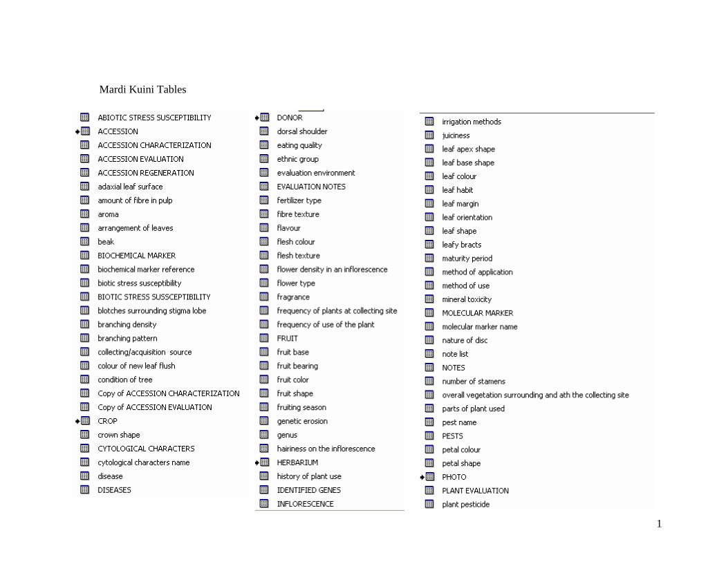
1
Mardi Kuini Tables
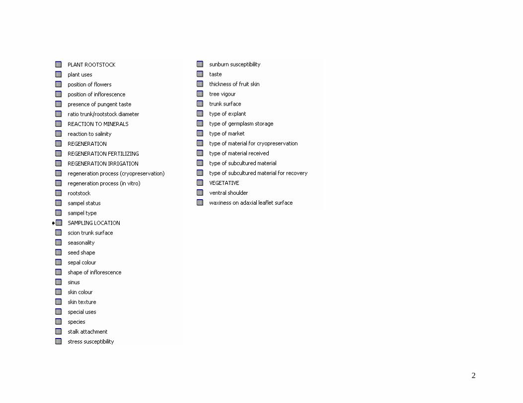
2

3
Arthropod Collection System: Tables
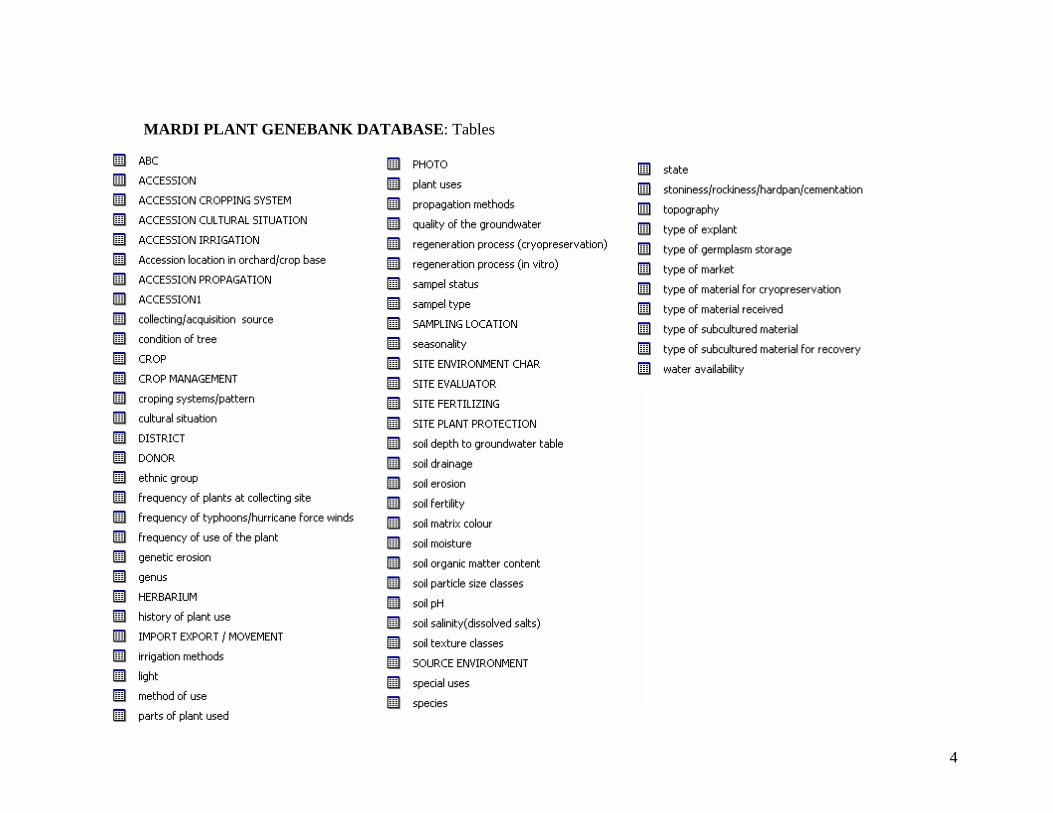
4
MARDI PLANT GENEBANK DATABASE: Tables