a seafloor observatory to monitor gas hydrates in the gulf of
TRANSCRIPT

A Seafloor Observatory to Monitor Gas Hydrates in the Gulf of Mexico Background Gas hydrates are solid structures composed of gas molecules encased in cages of water molecules. Most interesting to the energy community are hydrates that contain hydrocarbon gases. In the northern Gulf of Mexico, hydrates of this type form in water depths greater than 450m and often occur in mounds located where faults intersect the sea floor. Typically, these hydrates consist of sea water from which the salt has been excluded and gases that have migrated up faults from buried hydrocarbon reservoirs. In addition to the hydrates, the mounds contain large amounts of calcium carbonate and various other minerals precipitated by microbes that extract energy from the hydrocarbon fluids. It has been observed that microbial activity is an order of magnitude greater in the vicinity of mounds containing hydrate outcrops than elsewhere on the sea floor. The proliferation of microbes around gas hydrate sites is not coincidental; it is the result of a synergistic relationship between hydrocarbon gas hydrates and microbes, i.e. the carbon-rich gases within hydrates provide sustenance for the microbes and biosurfactants produced by the microbes enhance the formation of hydrates. Recent laboratory experiments have shown that small concentrations of biosurfactants in the water wetting porous mineral surfaces have the effect of increasing the formation rates and decreasing the induction times of hydrates substantially. Moreover, biosurfactants exhibit surface specificities for particular mineral surfaces; that is, biosurfactant adsorption on a specific mineral surface results in hydrates nucleating and emanating from that surface. Surfaces of smectite clay, common in the northern Gulf, serve this purpose particularly well. Hydrates outcropping at the sea floor are in direct contact with large volumes of sea water. They are stable only marginally because salt, in sufficient concentration, impedes hydrate formation. For this reason hydrate outcrops can be ephemeral; significant changes may occur within rather short periods of time. In the absence of pressure fluctuations, whether the outcrops accumulate or dissociate is determined by variations in water temperature and rate of gas flow. Water temperature in the northern Gulf is influenced greatly by warm eddies shed from the Loop Current which enters the Gulf between the Yucatan Peninsula and Cuba (fig.1). These eddies drift slowly westward along the continental slope and can raise bottom-water temperatures by several degrees Celsius. Observations (Roberts et al., 1998) confirm that gas activity correlates with water temperature; gas flow increasing a few hours after the temperature increases (fig.2). Where hydrates occur within sediments, they are stable under the proper conditions of pressure, temperature, gas composition and salinity of pore fluid. If gas migrating up a fault encounters appropriate conditions as well as sediments of sufficient permeability, hydrates can form within the pore spaces and act to cement the sediment grains. This increases the shear modulus of the sediment and, thereby, the bearing capacity. For a particular gas composition, the greatest depth at which hydrates are stable is determined largely by the geothermal gradient. As ongoing deposition increases their depth of burial, hydrated sediments are subjected to increasingly higher temperatures until the hydrates
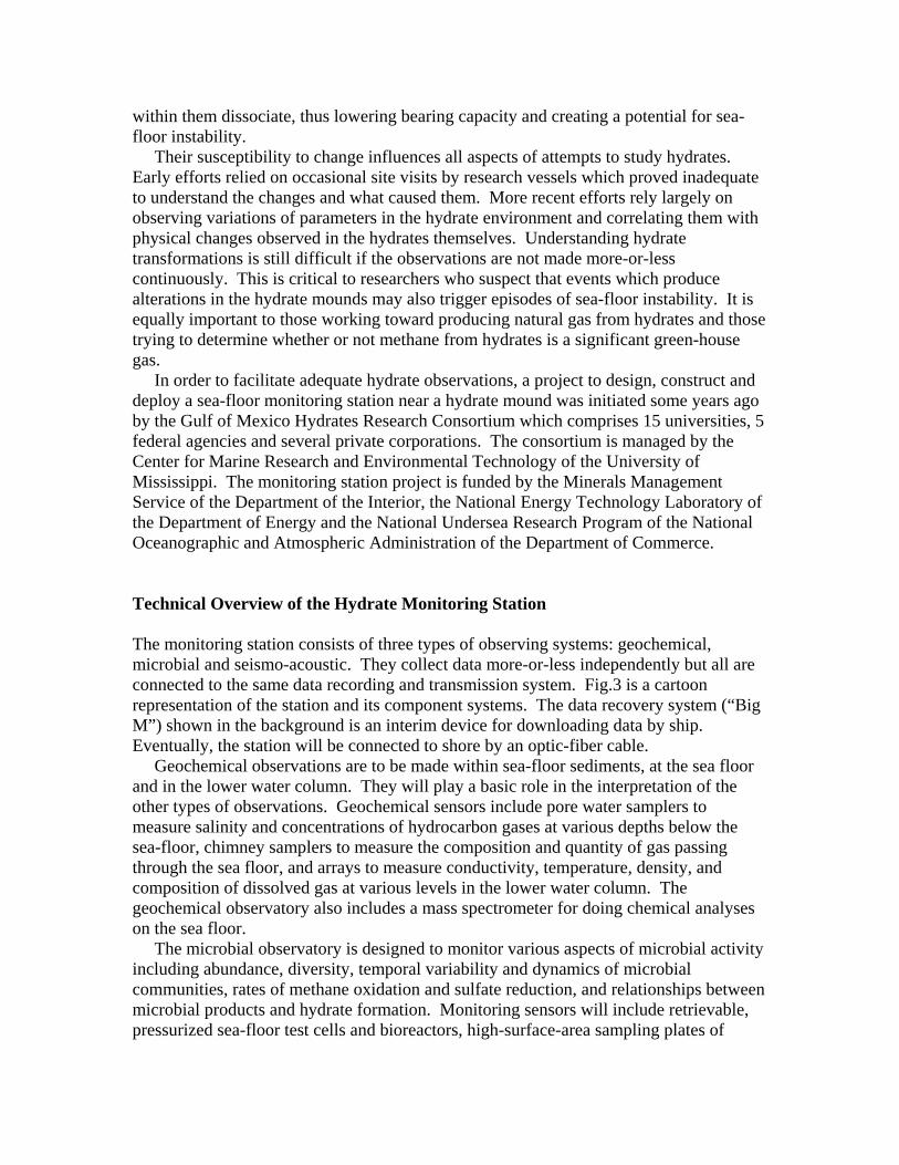
within them dissociate, thus lowering bearing capacity and creating a potential for sea-floor instability. Their susceptibility to change influences all aspects of attempts to study hydrates. Early efforts relied on occasional site visits by research vessels which proved inadequate to understand the changes and what caused them. More recent efforts rely largely on observing variations of parameters in the hydrate environment and correlating them with physical changes observed in the hydrates themselves. Understanding hydrate transformations is still difficult if the observations are not made more-or-less continuously. This is critical to researchers who suspect that events which produce alterations in the hydrate mounds may also trigger episodes of sea-floor instability. It is equally important to those working toward producing natural gas from hydrates and those trying to determine whether or not methane from hydrates is a significant green-house gas. In order to facilitate adequate hydrate observations, a project to design, construct and deploy a sea-floor monitoring station near a hydrate mound was initiated some years ago by the Gulf of Mexico Hydrates Research Consortium which comprises 15 universities, 5 federal agencies and several private corporations. The consortium is managed by the Center for Marine Research and Environmental Technology of the University of Mississippi. The monitoring station project is funded by the Minerals Management Service of the Department of the Interior, the National Energy Technology Laboratory of the Department of Energy and the National Undersea Research Program of the National Oceanographic and Atmospheric Administration of the Department of Commerce. Technical Overview of the Hydrate Monitoring Station The monitoring station consists of three types of observing systems: geochemical, microbial and seismo-acoustic. They collect data more-or-less independently but all are connected to the same data recording and transmission system. Fig.3 is a cartoon representation of the station and its component systems. The data recovery system (“Big M”) shown in the background is an interim device for downloading data by ship. Eventually, the station will be connected to shore by an optic-fiber cable. Geochemical observations are to be made within sea-floor sediments, at the sea floor and in the lower water column. They will play a basic role in the interpretation of the other types of observations. Geochemical sensors include pore water samplers to measure salinity and concentrations of hydrocarbon gases at various depths below the sea-floor, chimney samplers to measure the composition and quantity of gas passing through the sea floor, and arrays to measure conductivity, temperature, density, and composition of dissolved gas at various levels in the lower water column. The geochemical observatory also includes a mass spectrometer for doing chemical analyses on the sea floor. The microbial observatory is designed to monitor various aspects of microbial activity including abundance, diversity, temporal variability and dynamics of microbial communities, rates of methane oxidation and sulfate reduction, and relationships between microbial products and hydrate formation. Monitoring sensors will include retrievable, pressurized sea-floor test cells and bioreactors, high-surface-area sampling plates of
different materials, low-light digital cameras, and devices to retrieve samples under in-situ conditions. Goals include documenting the stability and persistence of gas hydrate outcrops, determining whether methane oxidation and sulfate reduction occur within hydrates without dissociation, characterizing the structure and functions of microbial communities, and identifying biogeochemical controls on and ecological roles of certain bacterial mats. Fine-grained magnetic sulfides that originate with magnetotactic bacteria and then accumulate in gas hydrates will be monitored as possible locators of hydrate deposits. Seismo-acoustic observations, the data which will allow automatic monitoring of the mound’s configuration by computer, are to be collected from six linear sensor arrays; two vertical and four horizontal. One vertical array will extend from the sea floor upward 200m into the water column. It consists of 16 hydrophones spaced 12.5m apart and is equipped with inclinometers and compasses to facilitate locating each hydrophone when the array deviates from the vertical due to water currents. The other vertical array will be in a borehole and extend 150m into the sea floor. It consists of 13 hydrophones spaced 12.5m apart and 7 three-component accelerometers. The accelerometers are located at alternate hydrophones, thus providing 7 four-component sensors with 25m spacing. Each horizontal array is 400m long and consists of 16 hydrophones spaced 25m apart and 8 three-component accelerometers at alternate hydrophone locations. This configuration provides four-component sensors at 50m intervals. The horizontal arrays will be deployed in an orthogonal cross of 800m total dimension. In all arrays, the signal from each hydrophone will be digitized to 16 bits at a rate of 10,000 samples per second and the signal from each accelerometer component will be digitized to 24 bits at a rate of 1,000 samples per second. Timeline of Station Development and Installation By the late 1990s, researchers had begun discussing the possibility of installing a multi-sensor observatory on the sea floor of the northern Gulf of Mexico that would monitor continuously a mound where gas hydrates outcrop. In March, 1999, a workshop entitled “New Concepts in Ocean, Atmosphere and Seafloor Sensor Technologies for Gas Hydrate Investigations and Research” was sponsored by the Center for Marine Resources and Environmental Technology of the University of Mississippi and the Institute for Marine Sciences of the University of Southern Mississippi. Participation was international. One day of the workshop was devoted to discussing practical aspects of assembling and deploying an observatory capable of monitoring the formation and dissociation of gas hydrates. In October, 1999, a group of interested parties met to discuss the design of observatory components, to plan field activities for testing designs, and to begin looking for an appropriate test site. That group evolved into the Gulf of Mexico Hydrate Research Consortium whose principal focus is the design, construction, installation and operation of the monitoring station. At a meeting in October, 2004, the consortium considered a number of recommendations of its site selection committee and members voted to install the monitoring station near a hydrate mound in water more than 800m deep in Mississippi

Canyon Lease Block 118 (fig.4). The mound to be monitored is visible in the bathymetry as distorted contours in the lower part of the figure. The Minerals Management Service of the Department of the Interior has since reserved a large portion of that block (the “MMS Reserve Boundary” in fig.4) for exclusive use of the monitoring station and associated research. Pre-installation surveys began in January, 2005. The first observing systems, a pore-fluid sampler and an array of sub-bottom thermisters, were installed in May, 2005. Installation will continue in stages until the monitoring station is complete. Completion is expected in 2007. Data Recovery, Data Archiving and Seismo-Acoustic Monitoring When fully operational, the observatory will generate about nine gigabytes of data per hour. These data will be transmitted to a shore facility via optic fiber. The data will be sorted by type, quality controlled to check that the station is operating properly, and archived in a data base. It will be possible to access the data online. The overall configuration of the mound will be monitored in near-to-real time by computer processing of the seismo-acoustic data. First, a conventional image of the mound will be obtained by inversion of data acquired using conventional seismic sources at known locations. Monitoring will consist of comparing the conventional image to images obtained using ambient noise as the energy source. As long as there is a good fit between the conventional image and the ambient images, it will be assumed that no substantial change in overall configuration has occurred. An obvious misfit, however, will be considered evidence that the configuration of the mound has changed significantly. The geochemical and microbial data sets can then be examined to determine circumstances accompanying the change. At that time, it may be considered prudent to resurvey the mound with conventional sources to determine a new image to be used in subsequent monitoring. A procedure for imaging the mound using the noise of nearby ships is under development. It utilizes the station’s hydrophone data and is based on a well established technique known as Matched Field Inversion. It may well be possible to obtain images using other types of ambient noise, particularly the noise of wind-driven waves at the sea surface and the background noise of micro-seismic events. Cross-correlation techniques for producing tomographic images on the basis of any random, isotropic wave field have been described in the literature but have not yet been specialized for use with the monitoring station. Responsible Organizations A number of organizations have assumed responsibility for various aspects of the monitoring station project: Project management - University of Mississippi
Site selection - Louisiana State University, Texas A&M University. Geochemical aspects - Woods Hole Oceanographic Institution, University of North Carolina (Chapel Hill), Florida State University, Texas A&M University. Microbial aspects - Mississippi State University, University of Georgia, University of North Carolina (Chapel Hill), Texas A&M University, Droycon Bioconcepts Inc., Specialty Devices Inc. Seismo-acoustic aspects - University of Victoria (British Columbia), University of Texas (Austin), University of Mississippi, University of South Carolina (Columbia), Specialty Devices Inc., Barrodale Computing Systems Ltd., Lookout Geophysical Company. Data quality control and archiving - University of Texas (Austin), Barrodale Computing Systems Ltd. Reference Roberts, H.H., W.J. Wiseman,Jr., J. Hooper, and G.D. Humphrey, 1998, Surficial gas hydrates of the Louisiana continental slope-Initial results of direct observations and in situ data collection: Proceedings Offshore Technology Conference, OTC Paper 10770, p1-15.

Fig.1 - Illustration of a warm-water eddy shed from the Loop Current in the Gulf of Mexico.
Fig.2 - Correlation between water temperature and gas activity (from Harry Roberts et al., 1998).
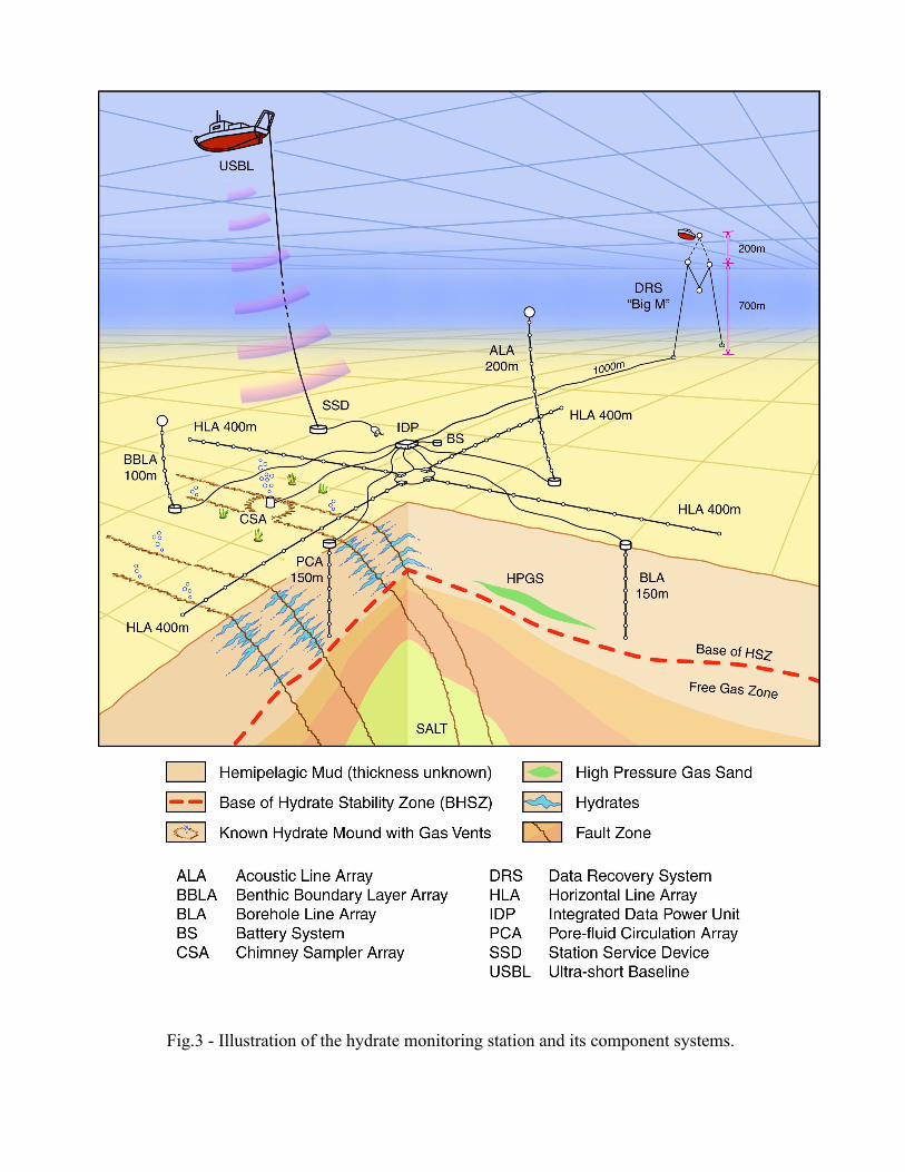
Fig.3 - Illustration of the hydrate monitoring station and its component systems.
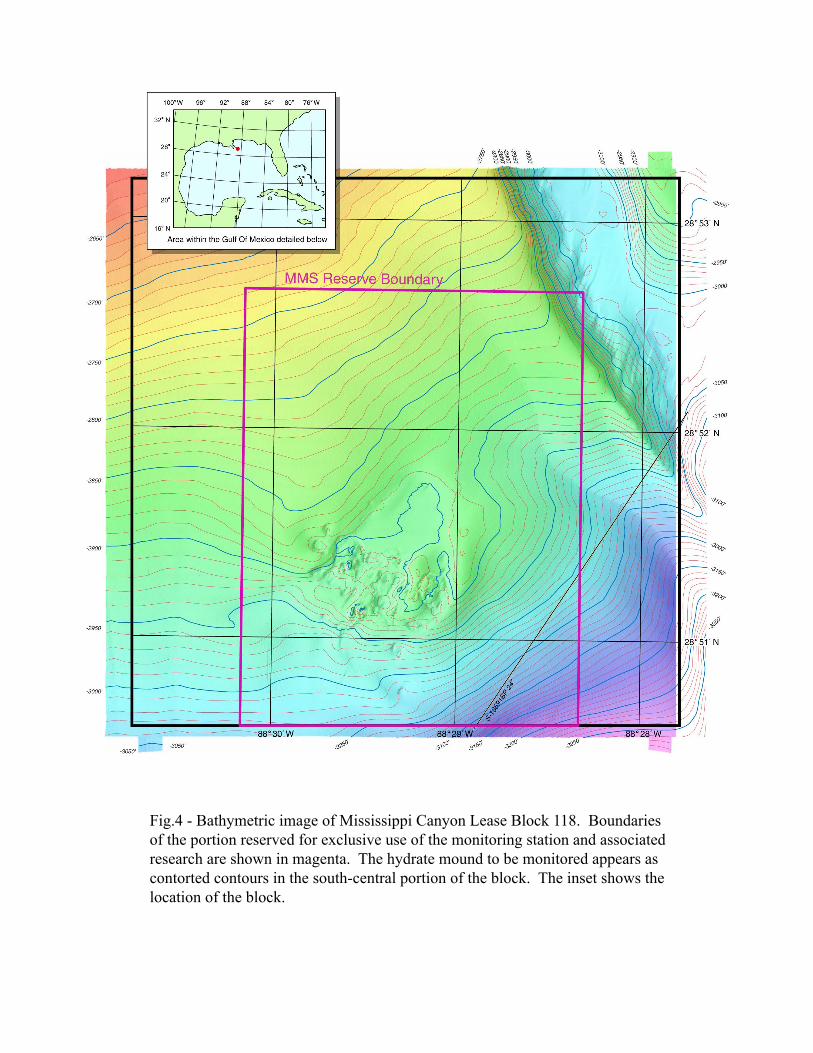
Fig.4 - Bathymetric image of Mississippi Canyon Lease Block 118. Boundaries of the portion reserved for exclusive use of the monitoring station and associated research are shown in magenta. The hydrate mound to be monitored appears as contorted contours in the south-central portion of the block. The inset shows the location of the block.