a review of petroleum engineering aspects of qatar's oil
TRANSCRIPT

Engineering Journal of the University of Qatar, Vol. 11, 1998, p. II- 45
A REVIEW OF PETROLEUM ENGINEERING ASPECTS OF QATAR'S OIL AND GAS
Ahmed AI-Siddiqi* and Richard A. Dawe** *Manager Reservoir & Field Development
Qatar General Petroleum Corporation, Doha, Qatar **Occidental Chair in Petroleum Engineering, College of Engineering
Qatar University, Doha, Qatar
ABSTRACT
This paper reviews, from a petroleum engineering point of view, the 60 years of discovery and development of the oil and gas resources within the boundaries ofthe State of Qatar.
Up to 1990 there were four major hydrocarbon producing areas:-• one onshore the Dukhan area on the west coast of Qatar (with three
major oil producing reservoirs almost on top of each other and underneath these oil reservoirs one non-associated gas reservoir),
• three major offshore producing area of oil and associated gas fields, • the Idd El Shargi, Maydan Mahzam and Bul Ranine Fields to the east of
Qatar, • the giant North Field of non-associated gas to the north. Qatar also
shares with Abu Dhabi the offshore Al-Bunduq oilfield to the south east of Qatar which straddles the Qatar-UAE sea boundary line.
Although a number of other onshore areas have been explored by seismic survey and by drilling, no further commercial oil has yet been discovered. However offshore there has been much further exploration around the current producing areas and more fields have been discovered. Since 1990 the AlKhalij, Al-Rayyan and Al-Shaheen fields have been considered commercial and are being developed, even under the present global economic uncertainties due to low oil prices. Most probably more finds will be made, with some possibly straddling Qatar's territorial boundaries. These fields will have to be appraised, evaluated, and whenever they are considered commercial, efficient, fair production plans will have to be agreed between governments.
11

A. Al-Siddiqi and R. A. Dawe
Units
The petroleum industry uses a variety of units and conversion from one unit to another is often necessary. The major conversions for this paper are:-1 metre= lm = 3.28 ft. "F =9/5°C+32 1m3 = 6.29 bbl (barrels) = 35.3 scf 1 metric tonne oil::=:: 7.5 bbl standard conditions, represented as scf and sm3
, are 60 "F and 14.7 psi or 15 oc and 1 bar MM represents 1 million. M represents 1 thousand • Oil volumes 1,000,000 bbls = 1 MM bbls = 159,000 m3
::::: 120,000 metric tonnes 1 MM bbl/day ::::: 50 MM metric tonnes/year • Gas volumes 1000 MM scf gas = 1 billion scf = 28.3 MM sm3
1,000,000 MMscf = 1 trillion scf 1 MM scf/day = 10 MM sm3 /year::::: 7500 metric tonnes LNG/year
INTRODUCTION
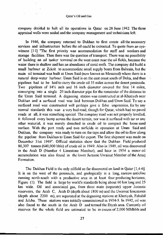
Qatar occupies a peninsula of carbonates of about 11,500 sq km jutting from the east coast of the Arabian mainland northward into the Arabian Gulf. It is approximately 160 km long and 80 km wide at its widest point. It has four seaward neighbours, Iran, United Arab Emirates (UAE), Saudi Arabia and Bahrain and one landward, Saudi Arabia, (Figure 1). The area around Qatar is a good example of a hydrocarbon producing area [1-4) as it has all the factors favourable for major oil accumulations:-• abundant source beds laid down in suitable environments, • thick, permeable reservoir beds, and • very large anticline structures formed at the right time to provide traps.
Oil was first discovered in Qatar near Dukhan in 1939 (Figure 1). Since 1949, oil and gas have been produced from these reservoirs. In 1960, oil was discovered offshore to the north east of the peninsula. This oil and gas started to be produced in 1964. Then, in 1971 large non-associated sour gas finds were discovered in the offshore North Field, which is also off the north eastern part of the peninsula. This gas is now being produced, part to be used for local consumption and the rest to be converted to liquid natural gas (LNG) for export. In 1997 shipments of LNG to Japan were started. There is much current exploration, particularly offshore, and a number of smaller finds have been made, declared commercial and are now being
12

··- .. 27·N
/
/
/
/
/
BAHRAIN
Qatar's Oil and Gas
-··,:,··-··-··-··- ' / '
'
.. -·· - .~-··
IRAN
' '
'
'··· '·.BAHRAM
' '
' \
•
/
/
A-S~
AL KARKARA I I ~-· ..1 ..
-··""
, .... , __ ,.,~ \ . ..
• • GAS FIELD
OIL FIELD
PIPELINES UNITED ARAB EMIRATES
Fig. 1. Map of Qatar
13
27·N
50Km

A Al-Siddiqi and R. A Dawe
produced with modern production technology, particularly by horizontal and multilateral wells.
This paper is concerned solely with the discovery and development of the oil and gas resources within the boundaries of Qatar. There is no political comment or discussion of the reserves of other Arabian Gulf states, nor what happens to the hydrocarbons once they leave the upstream production pipelines and travel to the refinery or processing plant, nor the effects on the economics of the State due to variations in the oil and gas selling prices. These in1portant topics are dealt with elsewhere in the literature [5,6].
STATISTICS OF QATAR'S OIL AND GAS
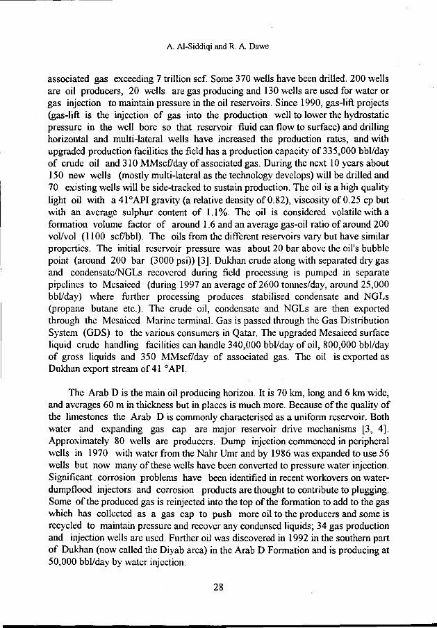
The estimate of Qatar's proven crude oil reserves at the end of 1997, according to the 1998 statistics [5-8], are 3.7 billion bbls (about 0.4% ofthe world's known oil reserves). Reserves are defined as the quantity of hydrocarbon which geological and engineering data demonstrate with reasonable certainty that can be recovered by current technically feasible methods at current economic values from the known reservoir. They are usually presented as if they were at the sellable standard stock tank conditions, and is the volume corrected from the reservoir conditions to the stock tank conditions - a shrinkage because the temperature and pressure are lower and the associated gas has come out of solution. The initial total volume of hydrocarbon in place in the reservoir, also calculated at surface conditions, is termed the Stock Tank Oil (or Gas) Initially In Place, STOIIP or GIIP. The recovery factor is the ratio of (reserves/STOIIP). The average production in 1997 was 650,000 bbl/day and the reserves production (r/p) ratio was 16 (i.e. if the reservoirs continued to be produced at the current rate the reserves would last 16 years). As a result of improved reservoir management, Qatar's oil production has risen to over 700,000 bbllday (~100,000 m3/day, ~ 35 MM tonnes/year) *,representing about 0.9% of the world's production. Since 1949, Qatar has produced in total over 5.9 billion bbls from some 400 wells, Figure (2). The oil reserves are distributed approximately equally onshore and offshore. Most of the oil produced (95%) is exported, mainly to Asia, as less than 40,000 bbl/day is consumed in Qatar.
Natural gas is found either associated with crude oil, 'associated gas', or in gas reservoirs with no oil present, 'non-associated gas'. Associated gas is so named because the gas is found with oil (dissolved in the oil at the high pressures of the
• in March 1998 oil production was 735,000 bbllday
14

Qatar's Oil and Gas
reservoir) and comes out of solution as the pressure on the oil is released, either in the reservoir or as the oil travels up the wellbore to the production facilities. Most of
800 700 600
>- 500 C'G ~ en 400 :a .a 300 :::iE
200 100
0
I
I 1\ I
I VV\ A.} / \ .... I
J v v ...r--
/
1950 1960 1970 1980 1990 2000 2010
Fig. 2. Oil production since 1950, M bbls/day
Qatar's gas reserves are non-associated gas. For gas, the reserves are quoted as being at least 380 trillion scf which is about 5% of the known gas reserves ofthe world [5]. Qatar could supply the whole of the world with gas for about four years. The 1997 production was 1.4 billion scf/day (18 billion m3/year), which is 0.6% of the world's production, and the r/p ratio is over 100. The gas production is currently planned to increase rapidly to perhaps 2.8 billion scf/day [5,6] with the development of the Ras Laffan LNG projects, discussed later. Gas provides 80% of Qatar's internal energy needs [6]. All these figures are approximate because the natural gas liquids, NGLs, which condense from the gas or evaporate from the oil are not always included and the statistics do not always identify them. In 1997 exports of NGL condensates were ofthe order of 100,000 bbl/day. NGLs are most important in the economics of gas sales, since they are the profit earners. Most of the gas and condensate production is exported to Asia. Figure (3) shows the historic gas production.
In Qatar, oil is converted into petrochemicals, refined to liquid fuels, or burnt for heating for industry or producing electricity. Natural gas is an environmentally friendly, safe and reliable important source of energy but has to be cleaned, desulphurised, processed to remove condensable components, and then exported by pipe, or liquefied. Particularly valuable is the upgrading of the hydrocarbons to value-added products such as plastics and fertiliser, or the production of products needing a cheap and plentiful energy supply such as steel and cement. In Qatar, in the 1970's, much gas
15

A Al-Siddiqi and R. A Dawe
was flared but now most gas is used profitably. Gas is now being used for producing electricity, boiling saline water to produce drinking water in desalination plants, producing LNG use as a basic raw material for petrochemicals for ethylene, polyethylene for polythene vinyl chloride etc or chemical products such as urea for fertilisers, methanol and fuel additives (MTBE - methyl tertiary butyl ether) and soon, catalytic conversion into liquid fuels [5,6].
2000
1600 >. CIS 1200 "' ;;:: u Ill 800
== == 400
0 1965 1970 1975 1980 1985 1990 1995 2000 2005
Fig. 3. Gas production since 1965, MM scf/day
Since 1974 the State of Qatar has had full control of its hydrocarbon industry after it created its own national oil corporation, Qatar General Petroleum Corporation (QGPC). The hydrocarbon sector contributes over 80% of general export revenue for the State of Qatar, so the economic development of the State will depend on how well its resources of oil and natural gas are exploited. The oil and gas selling prices are very important factors when selling on the open market and can fluctuate dramatically, so affecting project viability and profitability as well as the economic climate for the State.
PETROLEUM ENGINEERING
Petroleum engineering [3] involves the application of earth and physical sciences to the evaluation, exploitation and initial processing of natural hydrocarbon resources. After exploration sites have been suggested by geologists and geophysicists, petroleum engineers explore, find, evaluate, develop and produce the hydrocarbon reservoirs so that the fluids can be transported to a refinery for chemical and process engineers to convert them to useful saleable products.
16

Qatar's Oil and Gas
Petroleum exploitation is an economic activity and engineers are required to ensure that a field design will generate a surplus of revenues over costs even with these uncertainties. The problems of forecasting the productivity of a petroleum reservoir and the perpetual uncertainty concerning oil and gas prices create many challenges. The complexity of the geological strata involved in the flow in reservoir and production systems creates problems requiring sophisticated numerical techniques for their solution. Petroleum Engineers also need a deep understanding of the fluids' behaviour, both underground and at the surface (termed PVT thermodynamics). In the practical topics of drilling and production engineering, new problems requiring engineered solutions are continually being raised and solved. These points will be continuously mentioned throughout this paper.
PETROLEUM RESERVOIRS AND FLUIDS- BACKGROUND
Petroleum fluids, oil and/or gas, are found trapped in microscopic rock pores within reservoirs at depths in the range of 300 to 8,000 metres below the earth's surface. Such reservoirs may extend to tens or thousands of square kilometres in area and to tens or hundreds of metres in thickness, with hydrocarbon fluids dispersed irregularly and discontinuously throughout their volume. A number of such reservoirs may be stacked on top of each other and may or may not be in communication with each other so that fluids can or cannot pass from one to another. This has important implications when producing the individual reservoir horizons. The whole complex is usually known as a field [1-4].
Communication to the reservoir from the Earth's surface is by means of wells, typically less than 25 em in diameter, which have to be drilled to reach predetermined target locations safely and efficiently by passing through the various overlying rock layers and geological hazards (e.g. gas pockets creating blowouts). For Qatar, the reservoirs are at depths of2000-4000 m, which is quite shallow in comparison to reservoirs world-wide, and it is therefore relatively less expensive to drill and produce. Recent developments have enabled multiple wells to be drilled at variable deviation angles, from vertical to horizontal, and any direction through the reservoir. In Qatar there are some horizontal wells of over 5,000 m in length. Subsurface measurement and control systems must be designed to operate within an environment with pressures up to 500 bar (7,500 psi) and the possibility of high temperatures (up to 150°C) and corrosive fluids (including formation waters with salinity of up to 250,000 ppm, which is seven times more saline than sea waters).
Each reservoir is unique. Its performance as it is being produced is always uncertain because of the geometrical complexity, but for oil reservoirs, on average
17

A. Al-Siddiqi and R. A. Dawe
less than 35 % of STOIIP is economically recoverable, although improving best practice, particularly the use of horizontal and multi-lateral wells, is increasing this recovery factor. Recovery from gas reservoirs however is often over 80% ofGIIP.
Reservoir formations are commonly characterised in terms of their porosity and permeability. Porosity is a measure of the volumes of pore spaces relative to the bulk volume of the rock. This is the part in which the hydrocarbons can exist. Porosity values of viable reservoir rocks typically lie between 5 and 30%, although values outside this range are possible (up to 45%). Permeability is a measure of the ease with which fluid can pass through a rock and is measured in milli-Darcies (md). For oil, viable reservoir rocks typically have permeabilities in the range 1 to 5000 md. For gas, viable reservoir rocks typically have permeabilities in the range 0.1 to 5000 md.
Oil is a mixture of hydrocarbons. The light components (methane- propane) are gases and the rest are the heavier liquid components. Production of hydrocarbons from the subsurface reservoir to the surface involves a reduction in pressure and temperature. As a result, hydrocarbons originally present as liquid will separate into liquid and gas at the surface, and hydrocarbons originally present as gas underground will generally produce some liquid at the surface. The separation of gas and liquid at the surface is done mechanically using a gas separator (de-gassing facilities) and the volumes ofliquid and gas are usually measured separately.
Crude oil is the liquid petroleum obtained from an oil reservoir when the gaseous constituents have been removed or have escaped. Most petroleum liquid products and crude oils are lighter than water and their density is often expressed in degrees API (American Petroleum Institute),
0 API 141.5 13 5 . . . = --- 1. , where SG = specific gravity relative to water. SG
Water has a specific gravity of 1, so its 0API is 10. A crude oil with an °API greater than 30 is called light oil and its specific gravity is less than 0.88. Much of Qatar's oil is light oil with an ° API gravity of around 40. The country has two primary export oil streams, Dukhan (41 °API) and Marine (36 °API).
Natural gas is the constituent of petroleum fluid which remains gaseous at room temperature and pressure, and is mainly methane. It usually contains small amounts of non-hydrocarbon gases such as nitrogen, carbon dioxide and hydrogen sulphide. Natural gas is of great importance not only as a source of energy but also as a basic raw material for the petrochemical industry. Non-associated gas is from (gas) reservoirs where there is no oil present. Qatar's non-associated gas lies onshore
18

Qatar's Oil and Gas
in the KhuffFormation in Dukhan at around 3,000-3,500 m underlying the oilfields and offshore in the giant North Field [5,6]. Associated gas is produced along with oil from oil reservoirs and as Qatar's oil, both onshore and offshore, has gas-oil ratios mostly in the range of 140 to 400 m3/m3 (or in field units 700-2000 scf/bbl) substantial amounts of associated gas are produced. This gas has been used in Qatar since the 1960s to generate electricity and potable water for the city of Doha as well as the chemical plants at Mesaieed (Umm Said). Associated gas often has a relatively high concentration of ethane, the prime feedstock for ethylene production. It is therefore very important in the economy of Qatar. Energy supplies are often quoted in Barrel of Oil Equivalent (boe). The energy contained in 6000 scf (170 sm3
) of gas is about equivalent to that in one barrel of oil (0.16 sm3), so for an oil
with a gas-oil ratio of 1500 scflbbl (266 m3/m3), 25% of the energy from the
reservoir is contained in the produced gas. Thus for Qatar, approximately 25% of the energy from its oilfields is contained in the associated gas.
Dry natural gas does not contain readily condensable hydrocarbons. A typical dry natural gas has a methane content in the range 85 to 95%. Wet natural gas is one that contains 1 or more volumes of condensable hydrocarbon liquids per 4,000 volumes of gas at standard conditions (:= >50 bbl!MMscf, or in field language, 2 or more gallons of liquid per 1000 ft3
). A wet gas will have a lower methane content than dry gas but contains products ,natural gas liquids (NGL). which can be recovered economically by condensation in a processing plant and sold separately. They are:-• Liquefied petroleum gas (LPG), which consists of propane and/or butane, and is
liquid at normal temperature under light pressure (up to 5 bar). Liquid propane and butane are used as standby and peak-load supplements for municipal and industrial complexes, and a complete gas supply in some communities and industries.
• Natural gasoline, which is a highly volatile liquid at normal temperature and pressure, consists of a mixture of butane and heavier hydrocarbons such as pentanes and hexanes. It is normally added to motor gasoline to raise its vapour pressure and increase the ease of starting in cold weather. Natural gasoline is also used as a petrochemical feedstock to provide isobutane and isopentane for alkylation processes.
• Liquefied Natural Gas (LNG), which is natural gas liquefied by cooling to -161°C (-258°F) under atmospheric pressure and is reduced to 1/600 ofits volume at atmospheric temperature and pressure. It is transported in insulated tankers to be delivered to special receiving terminals where it is 'regasified' and then distributed as natural gas to utilities, independent power plants and commercial users. Qatar exports huge quantities of LNG.
19

A. Al-Siddiqi and R. A. Dawe
• Condensate (Distillate), is a pale straw coloured liquid with specific gravity 0.80 to 0.68 e API of 45 to 75) produced at the separators from both the reservoir oil and gas.
As will be seen later Qatar has developed its natural gas liquids processing facilities, which will make the production of its North Field commercial.
Sour natural gas contains an appreciable amount ofhydrogen sulphide and carbon dioxide. Oil or gas is considered sweet if it contains few sulphur components. If there is any measurable sulphur content (more than one part per million) then the sulphur components, particularly hydrogen sulphide (H2S), can cause considerable damage to the production facilities unless designed for, are poisonous to humans, and lower the commercial value of the oil or gas. They therefore have to be extracted, but can be converted to sulphur and sold on as a useful product. Most of Qatar's oil and gas is sour with up to 1.5% H2S and the State exports a considerable tonnage of sulphur, mainly to the far East and Pakistan.
IMPROVED OIL RECOVERY AND DEVELOPMENTS
Qatar carries out many Improved Oil Recovery (lOR) operations [3,5]. For instance reservoir pressure maintenance by water or gas injection is often used to avoid the problems of declining well production rates and increasing gas-oil ratios associated with the drop in reservoir pressure. Suitable water may be injected into the reservoir by pumping from the surface. Alternatively in some fields, a water-containing formation above the reservoir may be perforated to allow the water to flow directly into the oil layer after the pressure of the oil layer has been lowered. This process is known as waterdump flooding. Water dumping is practised in Qatar because it has operational and economic attractions, however controlling and monitoring the volumes of injected water and where it is going is difficult and a challenge to the reservoir engineers. In the past, water injection was often adopted late in the life of a field when primary production by natural depletion was about at an end. The term secondary recovery was applied. Nowadays water injection is often implemented much earlier in the life of an oil field and the term supplementary recovery is more applicable. In Qatar, this is termed by some as 'Enhanced Oil Recovery'.
Gas injection is also carried out in Qatar and is important if liquid condensation has occurred in the reservoir (particularly appropriate for gas condensate reservoirs [3,5,6]). This process is known as 'gas recycling' .. For oil reservoirs, the injected gas
20

Qatar's Oil and Gas
can dissolve in the oil and lower the oil viscosity and density and possibly the restraining capillary forces so ultimately enabling more of the liquid in the reservoir to flow to the wellbore and be recovered. The injected gas, often dried produced associated gas with the liquids stripped from it, allows some of the condensate liquid to evaporate back into the gas stream and so to be produced Sometimes gas injection is carried out to conserve the gas in the reservoir for future recovery because otherwise it would be flared (burnt).
Over the last decade there have been many revolutionary developments in the industry, particularly in drilling and seismic technology. Because of improved drilling methods, particularly steerable tools and measurement-whilst-drilling (MWD) techniques, horizontal and now multi-lateral wells can be drilled. (Previously reservoirs were exploited by mainly vertical wells.) Consequently, it is now technically feasible to extract more of the STOUP, and the reserves credited to a field can be increased (sometimes by considerable amounts). Horizontal and multilateral wells are now the drilling norm both for new and infill wells in Qatar and cost little more than the earlier vertical wells. Seismic surveys are used to 'see' into the subsurface structures to identify possible hydrocarbon traps. The 3/4-D seismic methodologies and interpretations have dramatically improved in the last few years and have enabled clearer reservoir description, particularly the interpretation of geological detail of facies distributions and structures, for reservoir simulation. Most on- and off-shore Qatar have been covered by recent (or are having) seismic surveys carried out [5].
Computational techniques and reservoir modelling and simulation are continually being upgraded as management tools. Additionally there have been gross changes in attitudes by all the major oil companies, with inter-company sharing of information and joint ventures in field development. The companies themselves have been restructured with downsizing of personnel and outsourcing of requirements [5,6]. Finally because of the public attitude and world views there has been a much stronger positive concern on health, safety and environmental effects of hydrocarbon extraction. All these advances have been applied to the exploitation of reservoirs in Qatar [5]. Unfortunately, the varying price of oil and gas greatly affect both exploration and exploitation plans and employment, particularly if the price movement is downwards, as at present. The impacts can be seen in oil company annual reports.
21

A. Al-Siddiqi and R. A. Dawe
GEOLOGICAL OVERVIEW OF QATAR'S FIELDS
Sedimentary rocks are normally laid down as horizontal layers (strata) [2]. Further deposition then occurs so that a sequence of layers occurs with the oldest rock deepest. Each of these layers is formed over many millions of years during which the climate and nature of the Earth's surface has been undergoing substantial changes. Then events such as earthquakes, landslips and general plate tectonic movements distort and fracture these layers. Climate changes, weather, wind, glaciers, volcanic eruptions, river flooding and other natural forces can change, deposit on or erode the surface rocks. As a result of all these processes the depths, thickness and tilt of the layers varies from place to place, and some layers do not appear everywhere. Buried layers of salt, precipitated by the evaporation of seas and lakes, can be squeezed by pressure load, made fluid with heat and due to its relative low density compared to other rocks, salt will flow and rise so distorting the layers; for example salt of various shapes gave rise to the various elliptical dome structures which contain major oil and gas accumulations in Qatar e.g. the Idd El Shargi field. All these subsurface movements and changes can create traps which, if the timing and other factors such as temperature and pressure are optimal, can create hydrocarbon reservoirs [ 1-4].
When an area is being drilled, the cuttings from nearJy the entire length of all exploration and appraisal wells are examined. Analysis of the rock cuttings include fossil and minerals content including clays, geochemical content and physical appearance description of the rock (e.g. shape and size distribution of rock grains) and provides important clues as to the rock's age and depositional environment. Most wells have petrophysical logs routinely taken. Petrophysical logs are measurements of various electrical, nuclear and acoustical properties recorded as a function of depth and are made with special tools in boreholes. Extracting cores (coring) is less frequent because of cost and difficulty of obtaining good unbroken lengths of material, so core analyses are used as a calibration of the logs and as information for reservoir modelling. Thus cuttings, cores and logs are the production geologist's primary source of data and enables them to describe the nature of the rocks that have been drilled (the stratigraphy- the sedimentary sequence in terms of lithological characteristics and rock properties).
A stratigraphic chart of the types and age of rocks can be created. The typical stratigraphic chart for Qatar is presented in Table 1. Different nomenclatures have been used on-shore and off-shore Qatar and by different geologists to describe the same age and type of rock found in other parts of the Arabian Peninsula and elsewhere [1,4]. The important time periods for Qatar's oil and gas are from the Permian, the oldest of -250 million years ago, through Triassic, Jurassic to the
22

Qatar's Oil and Gas
youngest, the Cretaceous of -70 million years. Each of these periods is divided into distinctive sub-period epochs and then ages, Table 1. The rock characteristics can also be grouped by changes in rock type. For instance in the early Jurassic period the Hith, Arab, Jubaila, Diyab and Hanifa Formations can be found. The formations can be dated by the fossils including pollens found in them. The depositional environments, together with the diagenesis (changes after deposition) are reflected in the characteristics of the rocks (e.g. how the sand sorting or grain sizes or the permeability changes with depth). Several different distinctive rock types can be usually identified in the depositional layers, each is termed a facies. Changes occurring over a few metres at a particular point in the reservoir give clues as to what was happening at that point at that particular time in the Earth's history e.g. a river delta, lagoon, sea shore or desert deposit. Each of these depositional environments creates the properties of porosity, permeability and reservoir continuity with their own pattern, which in tum affect reservoir performance and ultimate hydrocarbon recovery .. Detailed facies analysis is used by petroleum geologists to derive a model of the subsurface i.e. a reservoir description [1-4]. This model of the multilayered reservoir is essential for the reservoir engineers when designing an optimum well completion or reservoir development and production policy. For instance for the Arab Formation, there are four major intervals, A to D, separated by thin seals of impermeable anhydrite (calcium sulphate). The Arab D can be further differentiated into four major facies of various dolomitic and limestones created in different depositional and diagenetic environments. (The Arab D is one of the most productive carbonate reservoir horizons in the world (carbonate rocks are discussed below), and Arab C the next.) The upper part of the Arab C consists of a complex of carbonate rock types and has wide ranging very variable properties. The Arab A and B reservoirs are heterogeneous dolomitic limestone, have low porosity and poor permeability so they have not been very productive with vertically drilled wells
Most of Qatar's reservoir intervals are located in large carbonate beds, between which anhydrite (calcium sulphate) and shale (clay) layers act as seals (seals prevent the hydrocarbons migrating further upwards [2,4,9]). Carbonates are formed from accumulations of skeletal fragments of carbonate-secreting plants and animals and chemical precipitation and are composed of mainly calcium carbonate (CaC03). The plants, particularly blue-green and red algae were a major food source for marine micro-organisms and control the distribution of carbonate sediments. The Jurassic carbonate beds particularly the Hanifa, Jubailah, Arab and Hith Formations form a triplet of source-reservoir-seal that have created the world's richest hydrocarbon habitat in the Middle East.
23

A. Al-Siddiqi and R. A. Dawe
Table 1. Generalized Stratigraphic Column for Qatar
AB=Al-Bunduq, AK=AI-Khalij, AR=AI-Rayyan, AS=AI-Shaheen, B=Bul Hanine, D=Dukltan, I= ldd El Shargi, M=Maydan-Mahzam, N=North Field. The major pay zones in fields are in Bold. ~ fi. rfa uncon onru!.}'_ su ces
approx Geological Age MM Formation lithology pay zones in fields deptb,m years
0 Eocene DAMMAM
60 RUS 400 Paleocene lll\1M ER...J!A..Q!!UM.A
SIMSIMA FIQA
1000 Upper 80 HALUL Cretaceous
LAFFAN anhydrite and shales seal caprock
M_ISHRJ_!"_ carbonate oi/AK,AS KHATIYAH carbonate oil AS MAUD DUD oil AS
Middle 100 NAHRUMR sand/shale oil D, I, AS Cretaceous
SHU AIDA carbonate oil D, I 1200 HAWAR shale seal
KHARAlB ..... chalky limestone oil D, /,AS 120 LE!GIWAIR
YAMAMA Late SULAIY Cretaceous Upper Jurassic 150 HITH anhydrite seal
1500 ARAB A,B,C,D carbonate oil D(C+D), I (C+D), with anhydrite seals often jAB(C+D), AR (A+(.J thick formations BH(C+D),MM(C+D)
JUBAILA carbonate DIYAB carbonate- source oi/D
180 HANIFA -- mudstone - source 2000 l!!.!!'_ER ARAEJ oil D,l,MM
Lower Jurassic UWAINAT carbonate oil B,BH,D,I,MM 210 LOWERARAEJ thin zones oil D,l
2300 IZHi\.BA, oi/BH U_l!l!_er Triassic @_LAILAH Lower Triassic 220 KHAIL anhydrite seal
2700 SUD AIR 3000 Permian 250 KHUFF KI TO K3 gasD,N
UPPER ANHYDRITE KHUFFK-4 .-. jgasD,N
3500 260 HAUSHI anhydrite
24

Qatar's Oil and Gas
There are a number of different carbonate rock classification systems. The most widely used, that devised by Dunham (in 1962), concentrates on the features which control porosity and permeability, i.e. grain-matrix relationships and mud content. The terms boundstone, grainstone, packstone, wackestone, mudstone are used and describe the amount matrix and visible grainy material that can be seen (under the microscope). In general boundstone and grainstone are often good reservoir rock with visible grains whilst mudstone is of poor porosity and permeability, although chalk which is a mudstone according to Dunham can have very high porosity. As would be expected the reservoir performance for carbonate rocks is strongly affected by the type of rock present. The reservoir producing zones have to be examined in detail and accurately characterised i.e. facies analysis [2-4] before major production decisions are made. Even so, carbonate rocks do not usually become reservoirs unless fractured or affected by dolomitisation. Dolomite is a highly-ordered mineral consisting of calcium and magnesium ions in separate layers alternating with carbonate ions. The chemical transformation of calcite (CaC03) into dolomite CaMg(C03)2 results in a reduction in the volume of the rock by up to 17%. This commonly gives rise to fracturing creating cracks in the rock which can significantly affect (often improve but can sometimes reduce) reservoir porosity and permeability [2, 4]. This conversion process may occur at any time in the diagenetic history of a rock sequence from soon after sediments have been deposited to long after deposition, when cementation has already affected the rock. Thus it can be difficult to predict the effects of dolomitisation without petrophysical examination of the rock itself. The amount of fracturing and faulting within the carbonate rocks is critical to the reservoir performance. In Qatar this is of major importance in most reservoirs.
Seals [4]; the reservoir seals are mainly anhydrite and shale. They occur both as complete formations of regional extent as well as smaller areas covering the reservoirs. The Mishrif and Khatiyah Formations are capped by the Laffan Shale. The Nahr Urnr is the seal for the Shuaiba and lower Cretaceous reservoirs. However it also acts as a minor oil reservoir. The Arab Formation is sealed by the Hith Formation. The Khuff reservoirs are sealed by the dense limestones of the Triassic Sudair Formation, Table 1. Tarmat [ 4 ]; the presence of an almost immobile tar layer at the bottom of some oil reservoirs is a common feature in the Gulf area. Most of the Qatar fields have a tarmat in at least one horizon. A tarmat poses several problems. It can act as a partial or a complete barrier to any aquifer influx, a sizeable portion of the recoverable oil can be sandwiched between the tarmat and the up-dip injectors and a tarmat at the base of the oil column can cover a sizeable area which can represent in its own right a hydrocarbon reserve that could be very significant, but unfortunately methods of economical recovery have not yet been developed. Aquifers; various aquifers found in the higher Formations are used as water sources for powered water injection or water-dump flooding. In particular the
25

A Al-Siddiqi and R. A Dawe
water in the Nahr Umr sandstone layer is used, but also the water in the Y amama, Sulaiy and the shallow Umm er Radhuma Formations if the strength of the Nahr Umr Formation water is weak in the area.
In Qatar, hydrocarbon accumulations are widely dispersed throughout the stratigraphic column, and all the fields have more than one interval that contains oil or gas. Prolific oil and associated gas reservoirs are found in Qatar's middle and upper Jurassic Arab Formations and the lower Araej Formations at depths of 1565 to 2500 m and fair to good reservoirs, source rocks and seals are found in the younger and shallower Cretaceous Shuaiba and Kharaib Formations (carbonates), lower sandstones of the Nahr Umr Formation and Khatiyah/MishrifFormations (carbonates), at depths ranging from 940 to 1875 m. The deepest of Qatar's reservoirs are in the dolomitic carbonate of the Permian KhuffFormation at around 3000-4000 m. These reservoir beds range in thickness from 400 to 600 m and have an average permeability of less than 30 md and contain vast quantities of sour condensate gas. Further geological details are given elsewhere [4, 9].
ONSHORE OIL AND GAS RESERVOIRS -DUKHAN
The first geological investigation of Qatar was undertaken in 1933 by British geologists. In 1935, the Qatar Petroleum Company (QPC), a consortium of companies including the IPC group (Anglo-Iranian Petroleum Company - British Petroleum, and Shell), obtained a 75-year concession for exploration of the entire onshore territory of Qatar. The story of the negotiations for these concession rights and for others in the Arabian Gulf makes fascinating reading. They have been well summarised in Yergin's book 'The Prize' [10], but the original sources and other reviews are certainly not dull [e.g. 11-13].
Drilling began in October 1938 on a site near Zekritjust north ofDukhan on the west coast, Figure (1). This area was chosen by the explorationists because the surface topography suggested a classical anticline structure, as indeed it is. In October 1939 the first slight show of oil was seen. In January 1940 an appraisal well at a depth of 5685 feet (1733 m) began to flow with oil, at around 5000 bbVday (795 m3/day) and the test was reported to have been 'highly satisfactory'. Oil had been found in the Arab C (named then as the Upper Jurassic Number 3 Limestone Member of the Qatar Formation). This well is now a field display site in Dukhan. Two more appraisal wells were drilled, one 18 km south and the other 4 km east to confirm the quantity and quality of the reserves in order to ensure that production would be commercially viable. However because of the Second World War, the
26
Qatar's Oil and Gas
company decided to halt all its operations in Qatar on 28 June 1942. The three appraisal wells were sealed and the company management and technicians left.
In 1946, the company returned to Dukhan to first create all the necessary services and infrastructure before the oil could be extracted. To quote from an eyewitness [ 11] "The first priority was accommodation for staff and workers and storage facilities. Then there was the question of transport. There was no possibility of building an oil tanker terminal on the west coast near the oil fields, because the water there is shallow and has an abundance of coral reefs. The company did build a small harbour at Zekrit to accommodate small supply boats from Bahrain, but the main oil terminal was built at Umm Said (now known as Mesaieed) where there is a natural deep-water harbour. Umm Said is on the east coast south of Doha, and thus pipelines had to be laid to carry the crude oil 35 miles across the desert peninsula. Two pipelines of 14Y2 inch and 16 inch diameter covered the first 14 miles, converging into a single 20 inch diameter pipe for the remainder of the distance to the Umm Said terminal. A degassing station was constructed at ai-Khatiyeh near Dukhan and a surfaced road was laid between Dukhan and Umm Said. To say a surfaced road was constructed will perhaps give a false impression, for by any normal standards this was a very bad road, though for Qatar, which had no paved roads at all, it was something special. The company road was not properly levelled, it followed every bump across the desert terrain, nor was it surfaced with tar or any other material, it was merely drenched in crude oil to compact the loose sand surface. With the port ready and two airfields in operation at Umm Said and Dukhan, the company was ready to tum on the taps and allow the oil to flow along the pipeline from Dukhan to Umm Said for export. The first shipment was made on December 31st 1949". Official statistics show that the Dukhan Field produced 80,307 tonnes (640,000 bbls) of crude oil in 1949. Also in 1949, oil was discovered in the Arab D (Number 4 Limestone Member), and later in 1954 a minor oil accumulation was also found in the lower Jurassic Uwainat Member of the Araej Formation.
The Dukhan Field is the only oilfield so far discovered on land in Qatar [1,4-6]. It is on the west of the peninsula, and geologically is a long, narrow anticline running north-south with a productive area in at least four producing horizons, Figure (1). The field is large by world's standards being about 60 km long and 25 km wide. Oil and associated gas, from three main (separate) upper Jurassic reservoirs, the Arab C, Arab D (depth about 1800 m) and the Uwainat limestones (depth about 2200 m), are separated at the degassing stations at Khatiyah, Fahahil and Jeleha. These stations were initially commissioned in 1954-5. In 1992, oil was also found to the south in the Arab D and termed the Diyab area. Currently oil reserves for the whole field are estimated to be in excess of 2,000 MMbbls and
27
A. Al-Siddiqi and R. A. Dawe
associated gas exceeding 7 trillion scf. Some 370 wells have been drilled. 200 wells are oil producers, 20 wells are gas producing and 130 wells are used for water or gas injection to maintain pressure in the oil reservoirs. Since 1990, gas-lift projects (gas-lift is the injection of gas into the production well to lower the hydrostatic pressure in the well bore so that reservoir fluid can flow to surface) and drilling horizontal and multi-lateral wells have increased the production rates, and with upgraded production facilities the field has a production capacity of 335,000 bbVday of crude oil and 310 MMscf/day of associated gas. During the next 10 years about 150 new wells (mostly multi-lateral as the technology develops) will be drilled and 70 existing wells will be side-tracked to sustain production. The oil is a high quality light oil with a 41°API gravity (a relative density of0.82), viscosity of0.25 cp but with an average sulphur content of 1.1 %. The oil is considered volatile with a formation volume factor of around 1.6 and an average gas-oil ratio of around 200 voVvol (1100 scf/bbl). The oils from the different reservoirs vary but have similar properties. The initial reservoir pressure was about 20 bar above the oil's bubble point (around 200 bar (3000 psi)) [3]. Dukhan crude along with separated dry gas and condensate/NGLs recovered during field processing is pumped in separate pipelines to Mesaieed (during 1997 an average of2600 tonnes/day, around 25,000 bbl/day) where further processing produces stabilised condensate and NGLs (propane butane etc.). The crude oil, condensate and NGLs are then exported through the Mesaieed Marine terminal. Gas is passed through the Gas Distribution System (GDS) to the various consumers in Qatar. The upgraded Mesaieed surface liquid crude handling facilities can handle 340,000 bbl/day of oil, 800,000 bbl/day of gross liquids and 350 MMscf/day of associated gas. The oil is exported as Dukhan export stream of 41 o API.
The Arab D is the main oil producing horizon. It is 70 km, long and 6 km wide, and averages 60 min thickness but in places is much more. Because of the quality of the limestones the Arab D is commonly characterised as a uniform reservoir. Both water and expanding gas cap are major reservoir drive mechanisms [3, 4]. Approximately 80 wells are producers. Dump injection commenced in peripheral wells in 1970 with water from the Nahr Umr and by 1986 was expanded to use 56 wells but now many of these wells have been converted to pressure water injection. Significant corrosion problems have been identified in recent workovers on waterdumpflood injectors and corrosion products are thought to contribute to plugging. Some of the produced gas is reinjected into the top ofthe formation to add to the gas which has collected as a gas cap to push more oil to the producers and some is recycled to maintain pressure and recover any condensed liquids~ 34 gas production and injection wells are used. Further oil was discovered in 1992 in the southern part of Dukhan (now called the Diyab area) in the Arab D Formation and is producing at 50,000 bbl/day by water injection.
28

Qatar's Oil and Gas
The Arab C reservoir is the second major oil producing horizon. It is about 50 km long by 5 km wide and averages 30m in thickness. The Arab Cis a very complex, fractured and highly stratified carbonate formation with the reservoir rock being generally less permeable on the flanks. The upper reservoir section contains over 40% of the STOUP but the lower section has higher permeability and 90% of the total production, and acts as a conduit through which most of the oil is produced. Production from the Arab C started in the late 1940's principally from the lower section. Initial production indicated a limited water drive because of stylolitic growths (thin impermeable layers) which have been dated as late Cretaceous, a time when the reservoir rock was already largely oil-permeated. As a result of these styloylites, much of the oil in-place is isolated in porous lenses which are consequently difficult to develop. Dump-flooding and powered waterflood injection schemes have been successful, with the Nahr Umr Formation being the main water source. Currently there are about 9 powered water injection and controlled waterdump injection wells for Arab C pressure maintenance. A tarmat is present in the bottom of the formation which has not yet been fully mapped. Nevertheless, production has been prolific and with horizontal wells more reserves are being booked and production increased.
The Uwainat reservoir has a reservoir thickness of 60-100 m and lies deeper, at around 2300 m and the reservoir temperature is 95 °C. The upper 44 m of the reservoir has an average porosity and permeability of 18% and 15 md respectively. The reservoir contains a relatively thin oil rim with an overlying gas cap. Poor well productivity led to a closing down of early production in 1975 but after water injection facilities were installed in 1983 production was restarted.
In 1960 sour gas was discovered in the deeper Permian KhuffFormation of dolomite at a depth of about 3100 m. The initial pressure was around 400 bar ( 6000 psi). It was brought on stream in 1978. This reservoir is discussed in the section on gas. In May 1997 two further gas reservoirs were discovered in the southern part of Dukhan [5] where the reservoir pay zones were intersected at 2,800 m and 3,333 m respectively and are stated to be of modest size compared to the North Field. These discoveries will make the gas injection and gas-lift programs for the southern part of the field more attractive [5]. Deeper drilling to test if there is gas deeper than the Khuff has been carried out, so far to a depth of 5,200 m (in 1985). Hydrocarbons have been found but the reserves have not yet been disclosed [6].
In summary, the onshore Dukhan Field produces light crude oil, associated gas, condensate and non-associated gas in significant quantities. For the petroleum engineer, a fantastic experience of so many different types of reservoir in one area!
29

A. Al-Siddiqi and R. A. Dawe
OFFSHORE OIL
The first concession for offshore exploration to be awarded in the Gulf was to the Shell Company Qatar (SCQ) who on 29 November 1952 and after much haggling, gained the rights to explore offshore Qatar [ 11]. The concession was for a period of seventy-five years and the company in return was to pay the Ruler an annual fee of £231,976, a rental of £75,415 until exports began and £37,707 thereafter until the expiry of the Agreement, a royalty of 4 shillings and sixpence (in current UK currency, £0.23) per ton and 50% of the profits from oil exports.
A gravity survey was begun in June 1953, followed by seismic reflection surveys six months later. The structural interpretation of the seismic record showed that the eastern area is dominated by salt movements, whereas the northern area is very flat and featureless. Shell decided to drill the salt tectonic area. Operational headquarters were set up at Ras Abu Abboud east of Doha. After the shore preparations were complete, the company brought out a special· drilling platform rig for offshore exploration in water depths of around 70 m. The first two appraisal wells produced no results; in fact, today we know that the first well drilled between the two domes of Idd El Shargi 95 km east ofthe northern tip of Qatar, reached a depth of 3714 m but was considered 'non-commercial'. Towards the end of 1956 Shell suffered a set-back when a heavy storm destroyed the rig. The company then acquired a much stronger structure capable of withstanding the rare but vicious Gulf storms. In January 1959 drilling operations resumed and after extensive efforts and an outlay of more than 100 million Indian Rupees, a well was drilled in about 30m water depth on the Idd El Shargi northern dome of the structure to a depth of2600 m in December 1959 and found oil in the upper Jurassic Arab C and Arab D Formations, the middle Jurassic Araej Formation and also in the deeper Uwainat. The field covers 3 8 sq km, and the reserVoirs depths are from 1400 to 2600 m. In March 1961, well No. 4 on the southern dome proved oil in the lower Cretaceous Shuaiba Formation. On 9 January 1964, the company started production from its Idd El Shargi North Field from the Shuaiba, Arab C and Arab D Formations.
Also, in 1964, a second discovery was made 30 km to the north-east ofldd El Shargi at Maydan Mahzam, where the Arab D limestone was found to be the largest producing bed. Its discovery well, drilled in July 1963 to a total depth of 2811 m, had also found oil in the Arab C Formation. Oil has now also been found in the Uwainat strata. A third offshore field, Bul Hanine, was discovered in March 1969 and was brought on stream in 1972. Bul Hanine has been the most prolific ofthe three offshore oil fields, producing from the upper Jurassic Arab D, middle Jurassic Araej and Uwainat Formations [5,6].
30

Qatar's Oil and Gas
An operational base was established on Halul Island near the oil fields in 1965 (Figure 1). The island was fonned by salt extrusion pushing up the fonnations. It is some 1.5 km long and 1.0 km wide and has 9 storage tanks for 3.4 MMbbls (enough for 2 weeks production), pumping stations and desalination equipment as well as staff accommodation. Oil exported from Halul is a high quality crude of about 36 0 API (the Marine export blend stream) and a sulphur content of 1.5% created from a blend of the crudes produced from Idd El-Shargi, Maydan Mahzam and Bul Hanine with oil gravities of 30, 38, aAd 35 o API respectively and now also oil from Al-Khalij. The reservoir oil is volatile with gas-oil ratios over 150 sm3/sm3
(>700 scf/bbl) so there is also substantial condensate and associated gas production which is separated in the fields and piped to Mesaieed.
ldd El-Shargi
The Idd El Shargi Field [14] consists oftwo domal structures separated by a saddle. The traps were created by a rising salt plug. The North (ISND) and South (ISSD) Domes have four major productive reservoirs, those in the Shuaiba, Arab C and D and in the Uwainat Fonnations but have somewhat different structural and sedimentological features [4,14]. The ISND is estimated to have a STOUP of3.8 billion bbl but from 1964 to 1994 only 6% had been recovered. The ISSD fonnations have complex geology, particularly fracturing and are estimated to have 1.1 billion bbl STOUP but have only recently been considered commercial, as discussed later. In 1995, the Idd El-Shargi North Dome (ISND) was handed over to Occidental Petroleum of Qatar Ltd. in a Development and Production Sharing Agreement, DPSA. With improved oil recovery and refurbishment of existing facilities the production rate has been raised from 30,000 bbllday to over 120,000 bbllday [14]. The field's main reservoirs are being redrilled with horizontal and multi-lateral wells (up to 80 wells), and the rate should increase to a plateau of 160,000 bbllday. Dual openhole laterals are simultaneously exploiting the Shuaiba A and B reservoirs. As discussed below, long tenn field development plans are being optimised using the new well data and pilot results and full field reservoir models for the Shuaiba, Arab C and D reservoirs.
The Shuaiba reservoir is the shallowest of the current producing reservoirs in the field and lies between 1500-1700m (4500-5100 ft) and contains an estimated STOUP of 2.3 billion bbl sour oil, trapped in predominantly tight, chalky reservoir rock, with the central crest area containing 1.2 billion bbl and the flank a further 1.1 billion bbl. It covers an area of 6500 hectares (km2
) (16,000 acres), and averages 120 m in gross thickness. It is multi-layered with low penneability zones between some productive layers. Well productivity, except for wells at the crest, is poor because of the poor fonnation penneability, despite relatively high average porosity
31

A. Al-Siddiqi and R. A. Dawe
ranging from 18 to 26% across four distinct reservoir members (A, B, C, and D) which contain 40, 30, 15 and 15% STOUP respectively. The permeabilities and heterogeneity vary over the reservoir with variations in the crestal area from 50 -200 md and in the flank areas much poorer from~- 50 md. The whole reservoir is thought to be extensively fractured with a varihble magnitude of fracture/fault sealing implying that the reservoir is difficult to deplete. Hence, to date, only 2.3% STOUP has been recovered, and three-quarters ofthis from the crestal area [14]. The initial reservoir pressure and temperature were 2380 psi and 71°C (160 °F) respectively and as the bubble point pressure is 1660 psi the reservoir was initially 720 psi undersaturated. The reservoir fluid is an asphaltene rich, 27 °API oil with a solution gas-oil ratio of 300 scf/bbl and has an oil viscosity of 2.5 cp.
Originally the reservoir was produced under gas/oil gravity drainage with general production rates low, <1000 bbllday. Due to the faulting, waterflooding vertically was considered unlikely to be of great benefit, but after simple matrix acid jobs the crestal wells showed some improved production performance [ 14]. The Shuaiba reservoir has low permeability and is multi-layered with very low permeability sealing sections between some layers, so the newly developed retrievable multi-lateral system allowing completion of a single well with two or more horizontal wellbore sections improve production. Such advanced drilling and completion technology should enable cost effective optimisation of ultimate recovery by providing closely spaced horizontal well bores throughout reservoir. This drilling and completion method provides adequate flexibility to produce both sections simultaneously or each section individually, particularly for production monitoring purposes. Thus horizontal and multi-lateral wells are proving to be very beneficial for simultaneously producing the Shuaiba A and B layers. Additional production from the Shuaiba C and D is however unlikely due to the water saturations being in excess of 65%, making these zones non-commercial over much of the field area [14].
Since 1994, there has been intense upgrading offacilities, with the installation of Shuaiba gas and water injection pilot projects. The gas injection pilot, includes one gas injector and three surrounding producers, uses gas from the Arab A zone (at a depth of2200 m) flowing naturally into the upper Shuaiba layer (1300 m) through the same producer/injector well. The producers are one deviated well and two short reach horizontal wells. The performance of the gas pilot is being closely monitored for pressure, gas breakthrough and production to determine its effectiveness. The water injection pilot includes two long-reach horizontal injectors and two adjacent horizontal producers that have up to 2900m long open hole pay zones. Source water for this project comes from the Yamama and Sulaiy Formations which are considered the best water sources. The water is lifted by a subsurface jet pump and reinjected after extensive filtering, to assure high quality. Once the results of both
32

Qatar's Oil and Gas
Shuaiba injection pilots are evaluated, installation of an optimum improved recovery scheme for the reservoir will be carried out [ 14].
The Arab C reservoir has an oil column averaging 30m and is estimated to contain 250 MM bbl STOUP of 27 ° API oil with a gas-oil ratio of 700 scflbbl. By year-end 1997, 9% of STOUP had been produced. The initial reservoir pressure was around 240 bar (3500 psi) (hydrostatic) but production has now lowered the reservoir pressure to below the bubble point. The production mechanism is ga5- cap expansion and solution gas drive. Extra horizontal producers are planned to optimise oil recovery from this reservoir [ 14].
The Arab D reservoir depth is around 2500 m and reservoir thickness is 40-70 m. It contains an estimated 1 billion bbl STOUP of sour 33 ° API oil with a gas-oil ratio of 750 scflbbl. By year-end 1997, 18% of STOUP had been produced. The reservoir's primary production mechanisms are gas cap expansion and solution gas drive. This is currently being supplemented with water injection via dumpflooding and approximately 90,000 bbl/day of water are being injected through 14 injector wells and produced by horizontal producer wells. This is because significant aquifer influx is prevented by a massive tar column over 90 m thick zone.
The upper Araej/Uwainat reservoir is found at 2600-2700 m at an initial pressure of 240 bar and 110 oc and reservoir thickness of some 50 m with porosity varying between 5 and 20% and permeability between 1-1600 md [4]. Its STOUP is estimated at 220 MM bbl and some 21% had been recovered by year end 1997. The oil is light at 39 °API with a gas-oil ratio of 1070 scflbbl and has a low viscosity of 0.2 cp. the reservoir has a very active natural water drive and is being produced through four producers [14]. Oil has also been found in two further zones, the Kharaib and Nahr Umr reservoirs, with a potential STOIIP of perhaps 500 MM bbl. These have not yet been produced, but the drilling of appraisal horizontal wells is currently underway.
Bul Ranine
The Bul Ranine Field is a dome structure of 11.5 km by 6 km with the crest at about 2800 m [4}. It has sour oil in the Arab C and D, the Upper Araej and the Uwainat. The oil in the Arab D is 35 °API with a viscosity of0.5 cp and in the Uwainat 37 °API and 0.4 cp. Some 40% of its STOUP of2.3 billion bbls has been extracted and is currently producing at around 70,000 bbl/day. The Arab D reservoir in the But Ranine Field has been the most prolific of the offshore reservoirs [4]. It consists of a number of distinguishable layers. The lowermost section of mudstones (from 140 to 170m thick) generally having permeabilities ranging from
33
A Al-Siddiqi and R. A Dawe
0.1 to 40 md and interbedded dolomites (predominantly occurring at specific horizons in the northern part of the field), which have permeabilities from 1 to 500 md. These mudstones and dolomites are overlain by grainstones and packstones (muddy sands) usually 20 to 30m thick. Above this, grainstones form the dominant reservoir intervals and have permeabilities ranging from 1000 to 3500 md with occasional values as high as 11,000 md. A tarmat is present at the base of the reservoir. In 1980 contrary to earlier predictions, water-breakthrough occurred along discrete intervals of the reservoir in a crestal well. The Upper Araej reservoir is gas bearing and is relatively thin and overlies the more significant Uwainat reservoir sequence. It has a low to moderate porosity and low to very low permeability no more than tens of millidarcies. The Uwainat is at a depth of about 2800 m and has an average thickness of 55 m, with a porosity of 10-23% and permeability between 2 to 300 md.
Field redevelopment is being carried out, particularly in the relatively tight upper units of the Arab D reservoir and the Uwainat rim reservoir, through the drilling of horizontal wells [5,6]. By the year 2002, 75-80 new wells are to be drilled, up to nine new wellhead jackets and a gas recycling project installed for developing the Arab C condensate gas cap to boost condensate reserves by 100 MMbbls in a manner similar to the Dukhan Arab 'D' Recycling Project mentioned earlier.
Maydan Mahzam
In the Maydan Mahzam Field about 80% of the STOUP is located in the Arab Formations, particularly the Arab C and Arab D (which has 84%) with most of the remainder in the upper Araej and the Uwainat [ 4]. The field is interpreted as an elliptical dome 8.5 km by 6.0 km. Tar exists at the bottom of the oil zone in the Arab D horizon. The upper Araej reservoir has a low to moderate porosity and low to very low permeability of no more than 30 md. It contains gas and producible oil. The crest ofthe Uwainat is around 2650 m with an oil column of85 m. Because of the structure in the Uwainat, the oil is in a rim of thickness 55 m and has an oilwater contact at some 2735 m depth. This reservoir has a porosity of I 0-23% with permeability between 2 and 300 md. The average net offtake per well from the thin oil rim was less than 800 bbVday of 38 °API oil. 40% of the field's reserves are estimated to have been extracted, and the ultimate recovery is expected to reach 55% through the continued use of water injection. Other improved oil recovery techniques are to be applied in order to maintain output above 40,000 bbl/day.
Both the Bul Hanine and Maydan Mahzam Fields are now at their mature stage. Production was at its highest in 1973 and has since declined so that output
34

Qatar's Oil and Gas
was down to 200,000 bbl/day by 1981 and 110,000 bbl/day by 1997, when Bul Ranine produced at 70,000 bbl/day and Maydan Mahzam at 40,000 bbl/day. Remaining reserves are estimated for Bul Ranine at 690 MMbbls and for Maydan Mahzam at 550 MMbbls. They have some 4.4 trillion scfassociated gas between them. Their production facilities are being upgraded with the installation of enhanced recovery systems to prevent further declines in flow rates and to maximise recovery rates. lOR was first brought into use at Bul Ranine in 1978, when three water dumpflood wells and three additional producers were completed, increasing the field's production potential by 40,000 bbl/day. Dumpflooding techniques have since been extended to the Maydan Mahzam and Idd El Shargi fields. Gas injection was installed at the Bul Ranine Field in 1987-88 with modified equipment on existing platforms, then installing a new platform for housing a booster compressor, and finally adding another gas production platform. Current development of the fields to maintain recovery rates includes the revamping of production facilities, the installation of water injection systems to maintain reservoir pressure as well as drilling a number of horizontal wells.
AI-Bunduq
The Al-Bunduq Field was discovered in 1968 and is located offshore to the east of Qatar and straddles the Qatar-Emirates sea boundary line. After a border adjustment agreement in 1969 between Qatar and the United Arab Emirates, it was agreed with Abu Dhabi that they should each have an equal interest in the production. Thus, Qatar is entitled to half the oil produced.
The Al-Bunduq Field is a domal structure of 6 km width and 11 km length trending northeast to southwest. It was named Al-Bunduq (hazelnut in Arabic) after its shape. The Arab D Formation is the main reservoir at a depth of around 3000 m. It consists of 100 to 150m of carbonates overlain by 7m of anhydrite. There are two distinct dolomite layers of high permeability and a complex facies which greatly affect the reservoir properties. A continuous bitumen zone above the present oilwater contact in the Arab D Formation acts as a barrier to aquifer water inflow, as evidenced by a pressure difference above and below the bitumen zone of over 15 bar. Above this the Arab C zone is also oil bearing, but has complex characteristics which can be further subdivided into layers with the bottom one being the most permeable. The Arab A and B Formations consist of several cycles of anhydrite, limestones and dolomite beds. The carbonate layers are thin, mostly less than 7 m, but are hydrocarbon bearing zones of very low permeability, often only a few md. The overlying Rith Formation acts as its seal as it is composed mainly of anhydrite. There is also some oil in the Uwainat formation 400 m below the Arab D.
35

A Al-Siddiqi and R. A Dawe
The field went into production in 1976 at an initial rate of30,000 bbl/day of 40 0API oil (with 1% sulphur), but output declined to only 4,000 bbl/day early in 1979. Production was then halted as a result of continued difficulties with an increasing oil/gas ratio and falling reservoir pressure. However, at the end of 1980 $330 million was invested in a secondary water injection programme to improve recovery from the Arab D reservoir and bring the Arab C reservoir into production. Production started again during 1983. The development of the Arab C reservoir required the drilling of two producing wells and four sea water injectors from an offshore complex which includes water injection, central collector, living quarters and gas sweetening platforms. Production from the Arab C wells started towards the end of 1987 boosting the field's total output to 30,000 bbl/day in 1988 and around 50,000 bbl/day in 1989, but has dropped to around 24,000 bbl/day (18,000 from Arab D, 5,000 from Arab C and 500-1000 bbl/day from the Uwainat) in 1998. The field had produced 140 MMbbl by 1998. The oil is exported via the Das Island terminal in Abu Dhabi waters to Japan.
GAS PRODUCTION
The story of Qatar's gas is in two sections; before and after the development of the North Field, which was brought into full service in 1997. The key impetus for gas development has been the world's attitude towards gas from, initially (the early days), a by-product that had largely a nuisance value and requiring disposal by flaring, to a fuel for local application (1970-95) and now to a sought-after export product. However, economists express a note of caution since gas requires a far greater capital investment per unit of energy production when considering the whole supply chain from field to transport to delivery network. This means that, unlike oil which is almost always economic at market prices and is heavily taxed, gas development is driven by economics (the selling price of gas) and not taxation policy. Gas economics are complicated but gas is not a great currency earner that some might first think it will be. Huge investments are needed in the infrastructure of a processing plant and pipelines etc. There is rarely a huge surplus 'economic rent' available for the producing country so it has to derive any benefit from the exploitation of its gas by accumulating secondary benefits - development of infrastructure such as steel, plastics etc. or from the liquid NGL's and sale of sulphur [6]. The case of Qatar illustrates the importance of gas liquids. Gas from the North Field is "wet" i.e. has condensable components (sec the earlier discussion) so that the impact of NGL recovery upon the project economics is profound - the net value of the NGL's may possibly be greater than the probable income for the (liquid) methane from the LNG plant. However for Qatar, the development of this gas
36

Qatar's Oil and Gas
potential, particularly the use of gas as a cheap and plentiful source of energy, is paramount in any plan.
Associated Gas
We mentioned earlier that when crude oil is produced from a reservoir, gas comes out of solution - this is associated gas. Thus, associated gas has been produced in the Dukhan region ever since oil production began in 1949, but it was originally used solely in field operations or flared. The gas began to be used for power generation in 1962 after the first gas pipeline across the country had been completed, enabling 25 MMscf/day of gas to be transported from Dukhan to Doha. Gas is now separated and compressed at field degassing and compressor stations then flows to Fahahil where there is a stripping plant (capacity 340 MMscf/day). After the heavy ends are liquefied and removed, the lean gas (230 MM scf/day) is passed to the gas distribution system. The natural gas liquids (NGL) stream separated at Fahahil are separately piped to a fractionation plan• in Masaieed (see the pipeline layout in Figure 1). In the off-shore fields the associated gas produced along with the oil is separated from its crude oil on the Idd El-Shargi, Maydan Mahzam, and Bul Ranine platforms and then compressed and brought ashore through an 85 km under-water common-carrier pipeline to a second NGL plant at Masaieed, although the fractionators are interconnected so that each can process liquids from either the onshore or the offshore fields. At Masaieed, the ethane-rich gas is used as feedstock to the petrochemical complex and fertiliser industries the LPG and condensate are produced for export, and the dry gas is transported to the seawater desalination plant and power station at Ras Abu Fontas for fuel. Some 1,400 tonnes/day of ethane-rich (58%) gas, 1,300 tonnes/day of propane, 850 tonnes/day ofbutane and 600 tonnes/day of natural gasoline can be produced.
Reserves of onshore and off-shore associated gas are estimated at about 5.5 and 4.5 trillion scfrespectively.
Non-Associated Gas Onshore non-associated (Khuft) gas In 1960, non-associated gas was discovered in the Permian KhuffFormation under the Dukhan oilfield at depths below 3100 m. This reservoir was put on production in 1978 and was the main source of supply for Qatar's domestic gas fuel requirements and local industry for its power and desalination complexes. The reservoir is capable of delivering 800 MMscf/day from its 10 dual purpose injection/ production and 7 production wells. Dew-point reduction and drying is carried out by low temperature separation plants located at the wellhead and the gas then passes to one of the three separation plants at Khatiya, Fahahil and Jaleha. Over 1,500 billion scfhave been
37

A. Al-Siddiqi and R. A. Dawe
produced. By 1996 the Dukhan Field had stopped regular gas production because of the North Field, (discussed below). It is now used as a buffer store for any unsold (surplus gas) from the North Field and as a strategic reserve if the North Field has problems. Dukhan will now only produce to Qatar's gas distribution system if the North Field supply is interrupted. Thus the average production in 1996 was only 40 MMscf/day. The volume ofNorth Field gas injected in 1996 was 290 MMscf/day. The remaining reserves are however about 0.6 trillion scf (also being increased with new drilling).
North Gas Field
The North Field, discovered by Shell in 1971, lies mainly offshore to the northeast of Qatar's Peninsula towards the Iranian sector of the Gulf in water depths ranging from 15 to 70 metres (Figure 1). It covers an area of more than 6,000 sq km, which is about half the State of Qatar's land area. The field contains unassociated sour gas trapped in the carbonate series of the Permo-Triassic Khuff Formation in four beds between depths of2500 and 3900 m with pressures up to 390 bar (5,800 psi). The recoverable reserves are estimated to be about 380 trillion scf (approximately 10% in Khuff 1, 40% in Khuff 2-3, and 50% in Khuff 4) and total gas in place exceeding 500 trillion scf. The North Gas Field is considered to be the largest single gas reservoir in the world so far discovered. As stated earlier, it has about 6% of the world's gas reserves, sufficient to supply the whole world for about 4 years at current gas usage [6]. The sour gas is rich in hydrocarbon condensates, which adds to its value in terms of potential revenue. The gas composition is not constant over the whole field so its behaviour on pressure depletion may also vary. In some areas it may be a retrograde condensate which, if so, care has to be taken on pressure depletion because some of the valuable condensate (perhaps higher than 45 bbls/MMscf) could drop-out within the reservoir matrix and unlikely to be produced. A pressure maintenance or dry gas injection (C~ or Nz) scheme may then have to be implemented. Other challenges include the handling of the fairly noxious gas which contains corrosive and poisonous constituents such as 0.5-1% H2S, 4% C02 and the brine, all at reservoir pressures exceeding 300 bar (4500 psi).
The massive reserves of the North Field and the merits of natural gas as a clean, safe and reliable source of energy has created the development of the North Field, so far since 1987 in two stages [5,6].
38

Qatar's Oil and Gas
North Gas Field Development 1987- 1997
The first development project, Stage 1, started in mid-1987, to produce nonassociated gas to be piped to Mesaieed to serve local industry became operational in September 1991. The design capacity was for 800 MM scf/day of wellhead gas yielding 750 MM scf/day of lean dry gas and about 50,000 bbl/day ofliquefied petroleum as LPG)-naphthas or xport. he our et as ames rom the Khuff 4 reservoir layers. The offshore production complex is approximately 80 km from Ras Laffan and consists of 8 platforms installed in 50 m water depth. The gas stream is brought onshore at Ras Laffan through two pipelines: one for dehydrated gas and the other for the condensates, and then on to Mesaieed for processing. There is another pipeline from Mesaieed to the Dukhan area, for reinjecting any lean gas which is surplus to domestic requirements into the Khuff reservoir in Dukhan Field.
North Gas Field Development after 1997
The field has now been further developed in stage 2. The aim is to produce dry gas for export as liquefied gas to neighbour or world markets and/or as dry gas by pipeline. Phase 2 became operational in February 1997 with shipments of LNG to Japan in specially constructed ships taking 135,000 m3 (3.1 billion set) ofLNG per load, so that Qatar became a major LNG gas exporter. The ultimate production capacity will be dependent on the availability of export markets [6], but is currently producing feed gas at around 1200 MMscf/day. The offshore facilities are located about 75 km from Ras Laffan ( 10 km south east ofthe stage 1 development, in 50 m water depth, and currently consists of six platforms including two well-head platforms, each with eight producing wells and an additional well (some 20 deviated wells). Special care is needed in the design ofwellbore and equipment to take into account the sour nature of the gas. The average production capacity of each well is around 60 MM scf/day. The remaining four platforms are a riser platform for receiving the production pipeline, the surface valves and the gauges, a production, a utilities, and an accommodation platform. The wet gas is transported from the offshore complex to a landfall at Ras Laffan by a single 32" multiphase pipeline.
The Ras Laffan onshore facilities include 3 identical LNG process trains for processing the gas and condensates produced from the North Gas Field (the number of trains can be increased). The capacity of each is 450 MMscf/day of feed gas. At Ras Laffan, most of the gas is liquified into LNG, sulphur impurities and acid components are removed, and liquid components such as naphtha, gasoline, propane and butane separated and treated. The LNG and other products can be shipped from the Ras Laffan port. If necessary some gas can be piped to Mesaieed for use in energy generation and for operating electricity plants and/or from Mesaieed to the
39

A Al-Siddiqi and R. A Dawe
Dukhan area, for reinjecting any surplus lean (dry) gas into the Khuffreservoir in the Dukhan Field. The design life of the whole on- and off-shore Ras Laffan /North Field production complex is at least 50 years. So far this massive project has had ten years of planning, five years of construction and some $4.7 billion of investment. Currently downstream industrial projects of petrochemicals, fertiliser, methanol etc are being developed rapidly at Mesaieed, however to achieve optimum use of gas resources from the North Field another industrial zone is being planned at Ras Laffan. A fuller discussion of the facilities being developed both offshore and at Ras Laffan for the production of LNG production, the negotiations for selling the gas in the future converting it to chemical products particularly liquid fuel by the Sasol or the ACG-21 Exxon processes can be found elsewhere [5,6].
OPERATION DEVELOPMENTS SINCE 1990
In the 1970's and 80's finds were announced but no commercial discoveries were made in Qatar, and between 1970 and 1990 no new oilfields were brought into production. However since 1991, three oilfields have been developed.
AI-Khalij
The Al-Khalij Field was discovered by wildcat drilling after extensive 2-D seismic activity in January 1991 and confirmed by further drilling on 1st June 1991. It was the first discovery in Qatar for 20 years. It lies to the east of the North Field and runs along Qatar's maritime border with Iran. Seven exploratory/appraisal wells were drilled by September 1993 to appraise the stratigraphic trap. It is 41m thick in the Mishrif Formation (Upper Cretaceous) at a depth of 1,200 m. It is of wide ranging quality carbonate rocks. The results ofthree wells led to estimates ofthe field's probable recoverable reserves of 200 MMbbls with the field producing at 30,000-50,000 bbVday. Appraisal was completed during 1995/1996. The field was brought onto production by mid-1997 with the production rate reaching 30,000 bbVday of28 °API sweet crude with nine production wells. The crude oil is pumped the 42 km to Halul Island by a 12" subsea pipeline and uses the process facilities there and is mixed with the Marine export blend. Power for the field is generated on Halul Island and transmitted by subsea cable. This is evidence of the recent attitudes to cost reduction by careful field management by using available resources.
Al-Rayyan
The Al-Rayyan Field, discovered in 1976, is located approximately 70 km north-northeast of the Qatar peninsula where the water depth is 33 m and is
40

Qatar's Oil and Gas
overlying part of the North Field. It is an oil-bearing reservoir in the Jurassic Arab A and C Formations in a zone above the North Field that was thought to be essentially gas-bearing. The layers are thin, probably not much more than 20 m thick. An appraisal well drilled to confirm the fmd was tested in September 1995 and produced around 10,000 bbl/day of a heavy, sour crude (24 °API and 3.4% sulphur). The Arab A and C Formations were cored, logged, and tested in a vertical pilot hole. Three more production wells were drilled into the Arab Formation using horizontal well technology and low invasion drilling fluids. This low invasion drilling fluid enabled good quality core to be obtained. This core was very important in understanding the reservoirs' properties. Estimates of STOUP vary but may be as high as 1.3 billion bbl and 40 trillion scf of associated gas. The field was brought on stream in mid-November 1996 at a rate of around 10,000 bbl/day. Production rose to 32,000 bbl/day by mid 1997 using horizontal production wells through the Arab A and C zones. The oil is sold separately as Al-Rayyan crude and is priced in relation to Saudi Arab Heavy. The reservoir cannot produce at sufficient rates without ·pumping. A novel method has been developed where an electrical pump is placed downhole at the reservoir depth and being held in place on 6 em diameter coiled tubing (a long length of seamless and continuous steel hosepipe). This tubing can be reeled down a well from a special rig, so removing the need for a full (expensive) drilling rig and drillpipe. The electrical power cable is run inside the tubing so ensuring that the cable life is extended because it is not exposed to the HzS (otherwise leaded cable would have to be used). Output is scheduled to level off at 30,000 bbl/day for the next few years when the jack-up rig and offshore tanker loading facilities may be replaced by permanent production platforms and onshore tanker loading facilities at, probably, Ras Laffan.
AI-Shaheen
The Al-Shaheen Field was discovered whilst appraising the North Field in 1974 on the edge of the North Field at a depth of 1,100 min the mid Cretaceous Kharaib Formation. The structure is flat and on further appraisal, oil was also found in smaller volumes in the Khatiyah, Mauddud and Shuaiba carbonates as well as the Nahr Umr sandstone. All five reservoirs are complex thin low permeability oilbearing layers of 4-12 m thickness. Due to these thin layers, horizontal wells are being used to gain maximum oil production with minimum wellbore problems created by water coning and fines production. This field was only considered commercial after the development of the new well technology. It started up in late 1994 and was the first new oilfield to have been brought into production for 20 years in Qatar. It produces heavy, sour 30 °API crude with 1.9% sulphur and is due to produce at least at 100,000 bbl/day by 2000. The drilling programme is now developing the production and water injection wells as well as delineating the five
41
A. Al-Siddiqi and R. A. Dawe
Kharaib thin formation layers in the field to maximise oil production. As part of the full-field development, 70 producing (mainly horizontal multilateral) wells are being drilled. Considerable directional steering is needed to keep the wells in the oil horizons. The Al-Shaheen 2 well set a world record for lateral drilling, since it included a horizontal section of 4120 m, and in September 1995, another appraisal well drilled to further test the Kharaib Formation, included a horizontal section of 4,200 m at a continuous deviation of over 86°. The crude is exported directly by tanker from single point mooring facilities. It is sold separately as AI-Shaheen crude and is priced in relation to Dubai crude.
EXPORT TERMINALS
Crude oil, oil products and gas are exported from Qatar, particularly to the Far East. Oil and condensates are shipped from terminals on Halul Island, Mesaieed; some refined products from Ras Abu Abboud and, since 1997, and the LNG exports from the gas liquefaction plant in the Ras Laffan industrial zone of the gas from the North Field development from Ras Laffan [6].
THE FUTURE
The Qatar petroleum exporting industry is 50 years old and in that time there have been tremendous achievements. Qatar is rich in hydrocarbons and for the next 25 years is comforted by the fact that the alternatives for many of the products from oil, including renewable energy, are not yet viable. The consequence is that production of light oil from Qatar is expected to achieve production levels from the onshore and offshore fields of over 700,000 bbl/day and over 2 billion scf/day of gas and NGL products for at least 30 years. Since 1978 Qatar has been producing value-added products including fertiliser, steel, cement, power, desalinated water, petrochemicals, plastics , methanol and NGLs all based on oil, associated gas and its huge non-associated gas reserves.
There are new exploration targets, particularly the small, satellite reservoirs which exist near the current producers, including the development of the geologically difficult heterogeneous South Dome of Idd El-Shargi (ISSD) and the A-Structure and AI Karkara area west of the AI Bunduq Field. The ISSD oil field offshore Qatar lies about 24 km south of the Idd El Shargi North Dome (ISND) oil Field. The ISSD Field is of complex geology, with much of the formations being of poor quality reservoir carbonate rock and heavily fractured [ 14]. It is estimated to hold 1.1 billion bbls of oil in place with ultimate gross recoverable reserves put at 200 to 300 MM
42

Qatar's Oil and Gas
bbls. A development investment of some $450 MM in capital over the life of the project is planned. The ISSD Field will be operated as a satellite of the ISND probably with unmanned platforms in order to keep operating costs per unit bbl down. The current development plan has the drilling of 36 wells from three platforms, including 21 producers, 13 injectors and 2 water-disposal wells. Two pipelines, one for oil and one for gas, linking the ISSD Field to the processing facilities on the main ISND production platform will be built. Clearly such activities depend on the continued existence of a parent platform for economic success.
Since 1991, there has been much offshore exploration activity. Developments in 3-D seismic interpretation are giving much clearer images of the reservoir architecture. Such geophysical work has enabled seismic maps of the whole of Qatari territory to be made, including unified seismic maps illustrating the thickness of geological strata. These studies suggest the possible existence of stratigraphic traps between the North Field and other known offshore structures. Much drilling activity in recent years has been carried out to confirm the possibilities. Ultimately for these fields, after they have been discovered, there will have to be appraisal, evaluation and some agreement on efficient, fair, equitised production ifthey cross an international boundary. Horizontal drilling with multi-lateral features is becoming common in all the development plans so that a smaller number of wells, and consequently a smaller number of well slots on the platforms, and yet greater productivity from each well is expected. With further developments in horizontal and multi-lateral well technology some of these fields will become commercial. New field production systems will use innovative and cost reducing ideas, with offshore lightweight jackets, integrated topsides, and greater use of floating and subsea systems tied into existing facilities with unmanned platforms. All these technologies are being tested elsewhere in the world. This keeps operating costs down, but much depends on the oil and gas prices and whether the hydrocarbons can be lifted and sold to market at a commercial margin. Safety features have increased and are being incorporated into every new and upgraded development plan.
POSTSCRIPT
The two original concession holders, British Petroleum (BP) and Shell, who discovered most of the hydrocarbon reservoirs are not currently operationally active in Qatar. BP had been one of the most active foreign companies in Qatar. However, of the five wildcats it drilled between 1987 and 1989, none struck hydrocarbons in commercial quantities. The second of them, Al-Karkara, (Figure 1) was the only one to find oil, yielding a promising flow of 2,000 bbl/day of crude from a pay zone at a depth of 3,300 m. But a subsequent appraisal well did not confirm the discovery and
43

A. Al-Siddiqi and R. A. Dawe
BP decided not to continue exploration operations in the area and inJanuary 1992 withdrew, blaming delays in implementation and rising estimates for future costs. (Because of the advancement in horizontal and multi-lateral drilling and completion technology the field is now considered commercial and is to be developed). The Shell Oil of Qatar (Offshore) concession expired on December 31st 1991 and they then withdrew from Qatar.
ACKNOWLEDGEMENTS
We thank all who have discussed aspects of this paper as well as Occidental Petroleum of Qatar Ltd for obtaining some of the papers and Sharmila Melvin of Chevron (Qatar) for preparing Figure (1). We thank the management ofQGPC for permission to publish this paper.
REFERENCES
1. Tiratsoo E N, 1984. Oilfields ofthe World, Scientific Press, Beaconsfield, UKISBN 0-901360-14-7, p. 392.
2. Norman J. Hyne, 1995. Nontechnical Guide to Petroleum Geology, Exploration, Drilling and Production, Penwell Books, Tulsa,USA, ISBN 0-87814-438-2, p. 536.
3. Dawe R. A, 1999. Editor of Modern Petroleum Technology, Institute of Petroleum, London UK.
4. Alsharhan, A. S. and Nairn, A. E. M., 1997. Sedimentary Basins and Petroleum Geology of the Middle East, Elsevier Science, ISBN 0-444-82465-0, p. 942.
5. Qatar General Petroleum Corporation, 1997. New Horizons-2nd edition, QGPC Report (see www.qgpc.com.qa)
6. Arab Oil and Gas Directory, Arab Petroleum Research Center, Paris, Published Yearly.
7. International Petroleum Encyclopaedia, PenWell Publishing Co. Tulsa, USA, Published Yearly.
44

Qatar's Oil and Gas
~· British Petroleu?1 Statistics, Published Yearly (see www.bp.com).
9. AI-Siddiqi A and Dawe R A, 1999. Qatar's Oil and Gas Reservoirs, J Petroleum Ge<>Togy, to be Pu61ished.
10. Yergin D, 199. The Prize- The Epic Quest for Oil Money and Power, Simon and Schuster, New York, p. 950.
11. AI-Othman Nasser, 1984. With their Bare Hands, Longman, UK, ISBN0-582-78375-5, p. 227.
12. Records of Qatar,. Primary Documents 1820-1960, 1991, Edited Penelope Tuson, Archive Edition, Redwood Press, Melksham, UK. ISBN 1-85-207-300-4, particularly Vols. 5-7.
13. Zahlan Rosemarie Sai-d----1:979. The creation of Qatar, Croon Helm, London, ISBN 0;:06-497905-2, 170:
14. Wottge K R, 1998. Developin~ the Idd El Shargi North Dome ana South Dome Fields Offshore Qatar; -in_Conference 'Oil , Gas & Petrochemicals in Qatar', IBC Gulf Conferenc~s, Dubai, 19-21 April 1998, Doha, Qatar
There are many other papers: some can be found by the SPE masterdisk (www .SPE.org)~ a search for instance under Qatar, Shuaiba or Khuff will give a long list. A useful start for oil information is the UK Institute of Petroleum website www.petroleum.co.uk, or United States Energy Information Administration, which for Qatar is http://www.eia.doe.gov/emeu/cabs/qatar.html further addresses are given within these sites.
45