a report to the new south wales - office of environment ... · a report to the new south wales...
TRANSCRIPT

A report to the New South Wales Department of Environment and Climate Change on the consultancy: ‘Kangaroo Monitoring: Hunter and Central Tablelands Commercial Harvest Zones Design and Analysis of Helicopter Survey’.
S. C. Cairns1, G. W. Lollback1 and D. Bearup2 April, 2009 1Zoology, School of Environmental & Rural Sciences, University of New England, Armidale, NSW, 2351 2New South Wales National Parks and Wildlife Service, P.O. Box 4189, Forster, NSW, 2428

Contact
Dr Stuart Cairns Zoology, School of Environmental & Rural Sciences, University of New England, Armidale, New South Wales, 2351
Telephone: (02) 67732170 (W)
(02) 67727638 (AH)
0427 454344 (M)
Fax: (02) 67733814
email: [email protected]

Summary
1. Helicopter surveys for kangaroos were conducted using line transect sampling in three
proposed new kangaroo management zones: the Hunter-Mudgee zone, the Central Tablelands
zone and the SE NSW (Young) zone. The population estimates derived from these surveys
were intended to be used to set quotas for a commercial harvest of eastern grey kangaroos
(Macropus giganteus) from within these zones. The first two of these proposed zones were
intended to be managed separately, the third was to be incorporated into the existing South
East NSW kangaroo management zone.
2. In conducting these surveys, each proposed zone was subdivided into three strata of
increasing kangaroo density in order to facilitate the design process. The two strata identified
as possibly supporting the highest numbers of kangaroos were surveyed. The third stratum
was not. The surveys were designed using an automated survey design algorithm (Strindberg
et al. 2004).
3. These surveys were designed with the aim of obtaining eastern grey kangaroo population
estimates with coefficients of variation of 20%. The coefficients of variation of the population
estimates obtained for eastern grey kangaroos were in the range 18-22%.
4. Eastern grey kangaroo densities were estimated as 14.74 ± 2.64 km-2 in the proposed Hunter-
Mudgee zone, 23.18 ± 5.13 km-2 in the Central Tablelands zone and 11.22 ± 2.12 km-2 in the
SE NSW (Young) zone. These densities correspond to population estimates of
433,030 ± 77,533 kangaroos in the proposed Hunter-Mudgee zone and 535,600 ± 118,607
kangaroos in the Central Tablelands zone.

2
1. Introduction
Core to all the kangaroo management programs in operation throughout mainland Australia is
the management for commercial harvesting of all or some of the four large species of
kangaroo that are variously widespread and abundant throughout much of the continent
(Pople & Grigg 1998). In New South Wales (NSW), all four of these species, the red
kangaroo (Macropus rufus), the eastern grey kangaroo (M. giganteus), the western grey
kangaroo (M. fuliginosus) and the common wallaroo or euro (M. robustus) are harvested from
at least some of the 12 current kangaroo management zones (Anon. 2006).
It is a legislative requirement that any commercial harvesting of kangaroos be
conducted on a sustainable basis (Pople & Grigg 1998). In order to set harvest quotas with
the intention of ensuring sustainability, it is necessary to obtain reasonably accurate estimates
of the sizes of the kangaroo populations proposed to be harvested. Eight of the kangaroo
management zones in NSW are on the western plains of the state. Estimates of the
kangaroo populations within these zones are obtained from broad-scale aerial surveys
conducted annually using fixed-wing aircraft and strip transect sampling (Payne 2007). The
other four kangaroo management zones are based on the Great Dividing Range and its
western slopes (see Fig. 1). Because of the general relief of the landscape of these
management zones, the kangaroo populations there cannot be monitored using fixed-wing
aircraft surveys. Hence, alternative methods of estimating kangaroo population densities
have had to be considered. Helicopter line transect sampling is used to monitor the kangaroo
populations in these zones. The suitability and effectiveness of this method has been
demonstrated by Clancy et al. (1997), Clancy (1999) and Southwell and Sheppard (2000).
Eastern grey kangaroo and the eastern subspecies of the common wallaroo
(M. r. robustus) are harvested commercially from the three kangaroo management zones in
the Northern Tablelands region of northern NSW (NSW National Parks & Wildlife Service
2001). Eastern grey kangaroos are harvested from the South East management zone (see
Fig. 1). The kangaroo populations in these management zones are monitored using
helicopter line transect surveys. These surveys are conducted on a triennial basis, a survey
frequency option considered to be safe to use to monitor kangaroo populations in mesic as
opposed to semi-arid rangeland environments (Pople 2003; Payne 2007). According to Pople
(2008), conducting kangaroo surveys on such a basis in areas defined as having a mesic
3 environment is of low risk with regard to quasiextinctions resulting from the implementation of
a particular harvesting program.
The first of helicopter line transect surveys used to monitor kangaroo populations in
NSW were conducted in the Northern Tablelands management zones in 2001 (Cairns 2003).
Subsequent surveys of the three management zones have since been conducted in 2004
(Cairns 2004a; Cairns et al. 2008) and 2007 (Cairns 2007a). The design of the second and
third of these surveys were improved over the design of the first through the use of area
stratification and the automated design capabilities of the DISTANCE analysis program
(Thomas et al. 2005). This design capability is GIS based and incorporates a range of
algorithms that can be used to design line transect surveys (Strindberg et al. 2004; Thomas et
al. 2005).
Following the conduct of the first helicopter survey of the Northern Tablelands
kangaroo management zones (Cairns 2003), a feasibility study was undertaken by Pople et
al. (2003) into conducting a similar survey in southeastern NSW as a precursor to the
establishment of a sustainable kangaroo harvesting program there. Following this feasibility
study, the initial survey of what was to become the South East NSW kangaroo management
zone was undertaken in 2003. This survey was stratified on the basis of the five Rural Lands
Protection Board (RLPB) districts that comprised the new kangaroo management zone, with
further stratification being applied to each of these districts in relation to kangaroo density
(Cairns 2004b). The basis upon which these density strata were defined was a combination
of landscape definition obtained through the use of geographical information systems (GIS),
knowledge of the ecology of eastern grey kangaroos (Scott-Kemmis 1979; Hill 1981a, b) and
broad information provided by NSW National Parks & Wildlife Service (NPWS) and RLPB
personnel on the distribution of kangaroos within the region (Pople et al. 2003). Survey effort
(km of transect) was allocated to the respective strata in proportion to the anticipated
densities of kangaroos within them; these densities being derived in relation to those reported
for the Northern Tablelands region by Cairns (2003). Following on from the conduct of the
initial survey which has led to the establishment of the new South East kangaroo
management zone, a second survey was conducted in 2006 Cairns 2007b). This second
survey was designed using the automated design capabilities of the DISTANCE analysis
program (Thomas et al. 2005).

4
With the continued successful management of the harvest in the Northern Tablelands
kangaroo management zones and the successful establishment of the South East NSW
kangaroo management zone, in response to a proposal put to it by the NSW Farmers
Association and the Rural Lands Protection Boards, NSW DECC has moved to explore the
possibility of opening two new kangaroo management zones, one based upon the Central
Tablelands and near central western slopes, and the other based upon the Hunter-Mudgee
region of NSW. To provide baseline information for deciding whether or not to proceed with
the establishment of these two new management zones, helicopter line transect surveys of
the kangaroo populations in these regions were conducted in September, 2008. Conducted
in association with these two surveys was a survey of the Young RLPB district with the
intention that it be included in an expanded South East NSW management zone. Reported
here are the designs and results of these three surveys.
2. Survey Areas
The two proposed new kangaroo management zones (KMZ) are within the non-commercial
zone between the existing Upper Hunter management zone (KMZ 14) in the north and the
South East NSW zone in the south (KMZ 16) (Fig. 1). The South East NSW zone will be
expanded by the incorporation into it of the Young RLPB district. The Young RLPB district
will be referred to hereafter as SE NSW (Young).
The proposed Hunter-Mudgee zone extends south from Liverpool Range that marks its
boundary with the Upper Hunter zone to its boundary with the Central Tablelands zone which
lies in a line immediately south of the town of Kandos. Its eastern boundary lies east of
Singleton and just west of Branxton in the Hunter Valley. Its western boundary lies southwest
of Wellington. This proposed new zone includes the Hunter, Mudgee-Merriwa and the
eastern part of the Dubbo RLPB districts (Fig. 2). It is bounded in the west by the existing
Coonabarabran kangaroo management zone (Fig. 1).
The proposed Hunter-Mudgee zone takes in parts of four biogeographic regions. In
the northeast, is a small portion of the North Coast Biogeographic Region (IBRA), while the
rest of the east of the zone is made up of part of the Hunter subregion of the Sydney Basin
Biogeographic Region (IBRA) (Sahukar et al. 2003). In the west, the zone comprises part of
the Brigalow Belt South Biogeographic Region (IBRA) in the north and part of the South

5 Western Slopes Biogeographic Region (IBRA) in the south (Sahukar et al. 2003). The
characteristic landforms of this zone extend from steep, hilly and undulating ranges to rolling
hills and wide valleys. There are no particularly prominent geodiversity features present like
those found in the Northern Tablelands management zones (Cairns, 2007a).
The proposed Central Tablelands zone extends south from its boundary with the new
Hunter-Mudgee zone to its boundary with the Young RLPB district in the north of the
expanded South East NSW zone. Its eastern boundary lies east of Bathurst, in line with
Wallerawang. Its western boundary is to the east of Parkes and Forbes. This proposed new
zone includes the Central Tablelands RLPB district, the eastern two-thirds of the Molong
RLPB district and the eastern half of the Forbes RLPB district (Fig. 2). It is bounded in the
west by the existing Griffith kangaroo management zone (Fig. 1).
Fig. 1. The 12 current kangaroo management zones administered by NSW DECC.
6
The proposed Central Tablelands zone takes in parts of two biogeographic regions. In
the east, it includes part of the South Eastern Highlands Biogeographic Region (IBRA), while
in the west, it includes part of the South Western Slopes Biogeographic Region (IBRA)
(Sahukar et al. 2003). The topography of the South Eastern Highlands Biogeographic Region
comprises the western fall of the Great Dividing Range, with relatively steep, hilly and
undulating terrain in the east giving way to hilly ranges and peaks set in wide valleys in the
west. The topography of the South Western Slopes Biogeographic Region also comprises
the western fall of the Great Dividing Range, with relatively steep, hilly and undulating terrain
in the east giving way to hilly ranges and peaks set in wide valleys in the west. Perhaps the
most important defining feature of the geodiversity of this zone is the Canobolas volcanic field
of the South Eastern Highlands Biogeographic Region (Sahukar et al. 2003).
Fig. 2. The proposed new kangaroo management zones and their constituent RLPB districts. See text for details on the proposed zone boundaries.
7
The Young RLPB district of the South East NSW zone, SE NSW (Young), is directly to
the south of the Central Tablelands and Forbes RLPB districts (Fig. 2). It is entirely within the
South Western Slopes Biogeographic Region (IBRA) (Sahukar et al. 2003).
Most of the land in these three survey areas is freehold, with some state forests,
gazetted reserves and national parks comprising small proportions of their total areas. The
principal land use practised is the grazing of domestic livestock, with the growing of grain and
oilseed crops being a prominent secondary land use. Horticulture and coal mining also
feature as significant forms of land use in the Hunter-Mudgee and Central Tablelands
management zones.
For the purpose of conducting kangaroo surveys, those parts of the two proposed
management zones and SE NSW (Young) dominated by cultivation or mining, along with
those dominated by rocky outcrops and some steep, timbered country were deemed to be
areas supporting zero to very low densities of kangaroos. The remainder was divided into
areas likely to support either medium or high densities of kangaroos. For the areas of the
three kangaroo management zones, see Table 1.
3. Survey Design
As has been the case with the most recent aerial surveys conducted in the Northern
Tablelands kangaroo management zones (Cairns 2007a) and South East NSW kangaroo
management zone (Cairns 2007b), the surveys reported on here were designed using the
automated design capabilities of DISTANCE 5.0 (Thomas et al. 2005). In order to do this,
kangaroo density strata, based essentially upon land capability attributes, were defined within
each of the proposed management zones, and survey effort determined in relation to the
precision of surveys conducted previously in other kangaroo management zones with habitat
that is broadly similar to the habitat of the three new survey areas.
3.1 Zone Stratification
GIS shape files for the three survey areas showing land capability attributes were obtained
from NSW DECC. These files contained eight categories of land capability which extend from
cultivation, through to mixed farming and grazing, through to grazing only with decreasing
levels of grazing intensity, through to steep, timbered country, through to rocky outcrops.

8 They also contained some information on state forests, reserves and gazetted national parks
which were all excluded from the survey areas. The eight categories of land capability were
merged to form the basis of the three strata to be used in the survey design process.
Categories 1 and 2, which are representative of areas dominated by cultivation
practices, were merged with category 8, which is representative of rocky outcrops, and some
of Category 7 (steep, timbered country) to form the basis of the likely low kangaroo density
stratum within each proposed zone. Categories 3 and 4, which are representative of areas of
grazing and low intensity cropping, were merged to form the basis of the designated medium
density kangaroo strata. Categories 5 and 6, which are representative of grazing land, and
some of Category 7, were merged to form the basis of the high density strata. The
boundaries of the merged strata were redigitised to create final, simpler versions of the three
density strata within each of the proposed management zones.
The breakdowns of the areas of the three kangaroo management zones into their constituent
strata are given in Table 1. In the proposed Hunter-Mudgee zone, 35% of the area formed
the high density stratum, 51% formed the medium density stratum and 14% formed the low
density stratum. The low density stratum included parts of the Goulburn River and the
Wollemi National Parks. The medium density stratum was divided for the purpose survey
design into two sub-strata of approximately equal size which were identified as Mudgee-
medium (7,646 km2) and Hunter-medium (7,406 km2). A large tract of land dominated by
open cast coal mining was excluded from the Hunter-medium sub-stratum. In the proposed
Central Tablelands zone, this breakdown was 36% high density, 62% medium density and
2% low density. In SE NSW (Young), the breakdown was 36% high density, 38% medium
density and 26% low density. For visual representation of the stratification of the zones, see
Figs. 3-5.
3.2 Survey Effort
In line transect sampling, survey effort is defined as the total length of transect surveyed.
Although ultimately constrained by cost, survey effort is generally determined in relation to
some desired level of precision (the ratio of standard error to mean). In the conduct of
surveys such as those reported upon here, setting the level precision at 20% would appear to
be realistic and cost-effective (Pople et al. 2003; Cairns et al. 2008).

9
Table 1. Areas (km2) of the three kangaroo management zones (KMZ) divided into three survey strata representing likely high, medium and low kangaroo density. The survey areas comprise the medium and high density strata.
Kangaroo management zone Stratum Hunter-Mudgee Central Tablelands SE NSW (Young)
Total area 29,379 23,102 8,884 High density 10,274 8,254 3,185 Medium density 15,052 14,378 3,353 Low density 4,053 470 2,346 Survey area 25,326 22,632 6,358
For the proposed Hunter-Mudgee and Central Tablelands zones, the respective survey
efforts were determined broadly in relation to a target level of precision of 20% for estimating
eastern grey kangaroo densities. This condition was relaxed to 30% in relation to the SE
NSW (Young) zone. The reason for this was that this zone will be surveyed again in 2009 as
part of the triennial survey of the whole of the SE NSW management zone. This being the
case, the outcome of the present survey can become the pilot survey for the 2009 survey.
To determine the effort required to attain the target levels of precision, the following
equation from Buckland et al. (2001) was used:
ˆ
ˆ2
0 02
t
L {cv (D)}L ={cv (D)}
(1)
where, L is the required survey effort for a target level of precision of ˆtcv (D) , and 0L and
cv (D)0ˆ are the survey effort and attained level of precision, respectively, from a previous or
pilot survey.
In the case of the proposed Hunter-Mudgee management zone, the most recent
survey conducted in the Upper Hunter management zone (Fig. 1: KMZ14) (Cairns 2007a)
was used as the pilot survey for determining survey effort. The precision of that survey was
combined with a survey effort that had been scaled up from the actual effort of the survey
conducted in that zone. The scaling up of the pilot survey effort was by the ratio of the areas

10 of the combined high and medium density strata of the proposed Hunter-Mudgee zone to the
combined area of those two strata in the Upper Hunter zone. In the case of the proposed
Central Tablelands management zone, this same process was followed using the most recent
survey conducted in the Armidale management zone (Fig.1: KMZ 9) (Cairns 2007a) as the
pilot survey. Similarly, for the SE NSW (Young), this process was followed using the most
recent survey conducted in the Gundagai RLPB district of the SE NSW management zone
(Fig. 1: KMZ 16) (Cairns 2007b) as the pilot survey. Selection of the particular sets of pilot
survey information was based upon the broad landscape and land use similarities between
management zones for which the required information already existed and the proposed new
management zones.
For the proposed Hunter-Mudgee zone, the pilot survey information was 0L = 330 km,
0ˆcv (D) = 19%, while for the proposed Central Tablelands zone, the pilot survey information
was 0L = 474 km, 0ˆ( )cv D = 21.0% (Cairns 2007a). For SE NSW (Young) zone, it was 0L =
334 km, 0ˆ( )cv D = 28% (Cairns 2007b). For all three surveys, ˆ
tcv (D) was set at 20%.
Once the survey efforts for the planned surveys were settled upon, they were divided
and allocated proportionally to the high density and medium density strata of each of the three
proposed zones (Table 2). No effort was allocated to the low density strata of any of the
zones. Low density strata, which comprised either areas dedicated to cropping or areas of
heavily timbered and rugged terrain, were thought to support only trace numbers of
kangaroos (Southwell et al. 1995; Cairns 2007b). Note that the survey efforts (L) given in
Table 2 are not exact as determined by Eqn. (1), but are rounded values derived from the
exact values.
3.3 Automated Survey Design
The principal aim of designing a survey is to obtain optimal estimates of abundance,
preferably with high precision and low bias (Strindberg et al. 2004). Achieving this is not
straightforward, particularly when designing a survey by hand. However, taking advantage of
GIS and using automated design algorithms such as those offered by DISTANCE 5.0
(Thomas et al. 2005) increases the likelihood that an optimal design will be achieved
(Strindberg et al. 2004).

11
DISTANCE 5.0 offers four different classes of survey design for surveys of the type to
be undertaken here: parallel random sampling, systematic random sampling, systematic
segmented trackline sampling and systematic segmented grid sampling (Thomas et al. 2005).
According to Buckland et al. (2001) and Strindberg et al. (2004), systematic designs give
smaller variation in density estimation from one realisation to the next and avoid any problems
associated with overlapping samplers (transects). Hence, a survey design incorporating
systematic segmented grid sampling with a buffer zone around the boundary of each survey
stratum was selected as the most likely design option for the present surveys. It was tested
for survey coverage against a systematic random sampling option. As well as this, the option
of maintaining the integrity of individual samplers (transects) was tested against the option of
using split samplers.
Systematic segmented grid sampling randomly superimposes a systematic set of
segmented parallel lines onto the survey region (Thomas et al. 2005). Inclusion of a buffer in
the design guards against the problem arising whereby the distribution of objects from the
transect line is not in general uniform out to the truncation distance if the transect line
intersects the stratum boundary (Strindberg et al. 2004). Inclusion of a buffer of unspecified
size (determined by the algorithm) results in what is termed minus sampling (Thomas et al.
2005). The buffers in adjacent strata do not overlap.
Surveys were designed separately for the high and medium density strata of each of the three
proposed management zones using the nominal survey efforts given in Table 2. For each
survey, a series of 99 simulations was run in relation to a 2-km square coverage grid to
assess the evenness of the coverage probability of the various survey designs selected for
comparison (Strindberg et al. 2004; Thomas et al. 2005). Following this, once it had been
confirmed that the systematic segmented grid sampling design with split samplers provided
the most even coverage of the survey area, a single realisation of that selected design was
generated for each survey stratum within each management zone.
For the Hunter-Mudgee zone, the selected survey design allocated 16 transects with
nominal lengths in the range of 5-10 km to the high density stratum, 13 transects with nominal
lengths in the range of 5-12 km to the Hunter-medium density stratum and 16 transects with
nominal lengths in the range of 6-10 km to the Mudgee-medium density stratum (Fig. 3). For
the Central Tablelands zone, the survey design allocated 21 transects with nominal lengths
12
Table 2. Survey effort (L) determined for each of the three proposed kangaroo management zones (KMZ), the proportion (%) of survey effort allocated to high and medium density strata and the translation of these proportions to actual effort (Lhigh and Lmedium). All survey effort measures are in km.
KMZ
Proportional allocation L High Medium Lhigh Lmedium
Hunter-Mudgee 390 40 60 150 240 Central Tablelands 525 55 45 290 235 SE NSW (Young) 320 60 40 180 140
in the range of 4-15 km to the high density stratum and 14 transects with nominal lengths in
the range of 9-15 km to the medium density stratum (Fig. 4). For the SE NSW (Young), the
selected survey design allocated 12 transects with nominal lengths in the range of 5-15 km to
the high density stratum and 11 transects with nominal lengths in the range of 6-15 km to the
medium density stratum (Fig. 5). The nominal total survey efforts used in the design process
along with the total survey efforts of the realised survey designs are given in Table 3.
4. Survey Methods
The aerial surveys of these three proposed management zones were conducted as helicopter
surveys during the period 8-16 September, 2008. The surveys were undertaken in
accordance with the survey designs developed above (see Section 3.3), with each proposed
management zone being considered a separate entity and subdivided into three strata based
upon likely kangaroo densities, modulated by land use capability. The high and medium
strata within each zone were surveyed. The method of line transect sampling was used. In
the original design for this survey, there was a total of 103 transects to be flown across the
three proposed management zones. All of these transects were flown in this survey.
All surveys were conducted within either the two to three-hour period following sunrise
or the two to three-hour period before sunset. David Bearup (DECC), Scott Seymour (DECC)
and Stuart Cairns (UNE) were the observers. Mike Saunders (DECC) joined the survey as a
trainee observer and, after an initial period of training, replaced one of the trained observers
as an observer on some transects flown during the later stages of the survey. The helicopter

13
Fig. 3. The proposed Hunter-Mudgee kangaroo management zone. Shown are the three survey strata; the medium kangaroo density stratum being divided two sub-strata (see legend: Medium and Hunter Medium). The open-cast coal mining area of the Hunter Medium sub-stratum was not considered as part of the survey area (white). Shown also are the population centres (towns) and the placement of the survey transects within the high and medium kangaroo density strata. Note that no survey transects were placed into the low density stratum.

14
Fig. 4. The proposed Central Tablelands kangaroo management zone. Shown are the three survey strata, the population centres (towns) and the placement of the survey transects within the high and medium kangaroo density strata. Note that no survey transects were placed into the low density stratum.

15
Fig. 5. SE NSW (Young), the Young RLPB district section of the South East NSW kangaroo management zone. Shown are the three survey strata, the population centres (towns) and the placement of the survey transects within the high and medium kangaroo density strata. Note that no survey transects were placed into the low density stratum.

16
Table 3. The survey effort allocated to the design process (Lalloc) and the actual survey effort (Lactual) resultant from the design process for the high and medium density strata of the three Northern Tablelands KMZs. All survey effort measures are in km.
KMZ
High density stratum
Medium density stratum
Lalloc Lactual Lalloc Lactual Hunter-Mudgee 150 142 240 271 Central Tablelands 290 253 235 195 SE NSW(Young) 180 155 140 139
was chartered from EPS Helicopters, Yagoona NSW. Paul Caristo was the pilot. The seating
of the observers (left- and right-hand side) was allocated randomly for each survey session.
4.1 Helicopter Line Transect Surveys
In conducting the survey, the helicopter, a Bell JetRanger, with the two rear doors removed
was flown along each transect line at a ground speed of 93 km h-1 (50 kts) and at a height of
61 m (200 ft) above the ground. Navigation was by a global positioning system (GPS)
receiver (Garmin GPSMAP 275c©). The two observers occupied the two rear seats of the
helicopter and counted the kangaroos seen on either side of the aircraft. Sightings of
kangaroos were recorded into the 0-20 m, 20-40 m, 40-70 m, 70-100 m and 100-150 m
distance classes, perpendicular to the transect line. The distance classes were delineated on
metal booms extending from either side of the helicopter.
The survey transects varied in nominal length from 4-15 km. Data in the form of the
numbers of clusters (groups of one or more) of eastern grey kangaroos, common wallaroos,
red-necked wallabies and swamp wallabies seen in the different delineated distance classes
from the helicopter were recorded into micro-cassette tape recorders. The presence of other,
non-target species was noted. Tapes were transcribed at the end of each survey session.
4.2 Data Analysis Data from the helicopter line transect surveys were analysed using DISTANCE 5.0 (Thomas

17 et al. 2005). The analysis of distance sampling data such as those collected here involves
estimation of the detection probability of clusters of animals within the covered region (the
designated survey strip), then the estimation of the density of animals within the covered
region given this detection probability and, finally, the estimation of the number of animals in
the survey region given the density of animals in the covered region (Borchers & Burnham
2004). In order to estimate the probability (Pa) that a cluster of animals within the covered
area of width w is detected, the detection function g(x) representing the probability that a
cluster at perpendicular distance x from the survey transect is detected (where 0≤x≤w and
g(0) = 1) needs to be modelled and evaluated at x = 0 (Thomas et al. 2002).
Following the recommendations of Buckland et al. (2001), six detection function
models were considered in the analysis. Each model comprised a key function that, if
required, can be adjusted by a cosine or polynomial series expansion containing one or more
parameters. The different models considered were: a Uniform key function, plus either a
Cosine or Simple Polynomial series expansion; a Half-normal key function, plus either a
Cosine or Hermite Polynomial series expansion; and a Hazard-rate key function, plus either a
Cosine or Simple Polynomial series expansion. The number of adjustment terms
incorporated into the model was determined through the sequential addition of up to five
terms (the nominal default). The model with the lowest value for a penalised log-likelihood in
the form of Akaike's Information Criterion (AIC = -2 x log-likelihood + 2[p +1]; where p is the
number of parameters in the model) was generally selected as the detection function. In
selecting the final model, however, some consideration was also given to goodness-of-fit and
the shape criterion of the detection function, with those models with an unrealistic spike at
zero distance rather than a distinct 'shoulder' near the transect line, being likely to be rejected.
Because the data were collected in fixed, broad distance categories, no manipulation
of the grouping intervals was possible in order to improve the fitting of the detection function
model. However, the procedure could be improved by giving consideration to a right-hand
truncation of the data, i.e. narrowing the survey strip width (w) from 150 m to 100 m.
The density estimates of clusters of kangaroos ( ˆsD ) were determined as:
ˆˆsa
n.f(0) nD = =2L 2wLP
(2)

18 where, n is the number of sightings, f(0) is the probability density function (the detection
function rescaled to integrate to unity) of the perpendicular density data at zero distance from
the survey transect, L is the total length of the survey transect, w is the truncation point (or
half width of the survey strip) and aP is the probability that a randomly selected object (in this
case a cluster of kangaroos) in the survey strip is detected (Buckland et al. 2001). The area
surveyed is defined by 2wL. Variance estimates for the cluster densities were calculated as:
ˆ ˆ 2 2 2s svar(D ) = D {[CV(n)] + [CV{f(0)}] } (3)
where, CV(n) is the coefficient of variation for the number of sightings across the replicate
survey lines and C{(f(0)} is the coefficient of variation of the probability density function of the
perpendicular density data at zero distance (Buckland et al. 2001). Despite the problems that
may be associated with small sample sizes, the use of cluster sightings in preference to
individual sightings ensures against overestimation of the true variance (Southwell & Weaver
1993).
Dependence of the determination of cluster size on the perpendicular distance from the
transect line was assessed by regressing the natural logarithm of the cluster size (si) on the
estimated value g(x) , the detection function (i.e. the probability that a cluster at perpendicular
distance x from the transect line will be detected) that is estimated from the fit of the selected
model to the data. If the regression is significant at a very liberal significance level of α =
0.15, then the size-biased estimate of the mean cluster size ( E(s) ) is determined as that
value when detection is certain, i.e. when g(x)= 1.0. If the regression is not significant at
α = 0.15, then the mean cluster size is determined as the sample mean of the animals in the
observed clusters (s ).
If the size of a detected cluster is independent of the distance from the transect line
(i.e. if g(x) does not depend upon s), then the estimation of the density of individuals ( D ) is
simply determined as:
ˆ ˆsD = D xs (4)

19 where, the sample mean s is taken as an unbiased estimator of the mean size (E(s)) of the n
clusters in the study area. The variance of this estimate is determined as:
ˆ ˆ 2 2 2 2svar(D) = D {[CV(n)] + [CV{f(0)}] + [CV(s)] } (5)
where, cv(s) is the coefficient of variation of s , an unbiased estimator of the mean size (E(s))
of the n clusters in the study area. If, however, the cluster size is dependent upon distance
from the transect line (i.e. g(x) is dependent upon s), then s and CV(s) are replaced by
regression estimators designated as E(s)and ˆCV(E(s)) (Buckland et al. 2001).
Data were analysed to produce density estimates for the medium density and high
density strata and density and population estimates for each of the three proposed kangaroo
management zones. Where sample sizes within strata were large enough (>40), data were
post-stratified on the basis of observer, seating position within the helicopter and side-of-
aircraft (north or south) in relation to the flight along particular transects. Where sample sizes
within strata were small (<40), data were appropriately pooled.
Post-stratification was used in analysing the eastern grey kangaroo data for the high
density strata in all three proposed management zones. It was also used in analysing the
data for the medium density strata in proposed Central Tablelands management zone.
Limited sample sizes precluded the use of post-stratification in analysing the data for the two
medium sub-strata in the proposed Hunter-Mudgee zone. This was also the case for the
medium density stratum in SE NSW (Young). Further, because the number of sightings of
eastern grey kangaroos in the medium density stratum in SE NSW (Young) fell well short of
the recommended minimum number required for analysis, these data were combined with
those from the high density stratum in order to fit a global detection function. This global
detection function was then used to determine the density of eastern grey kangaroos in the
medium density stratum. The density of eastern grey kangaroos in the high density stratum
of SE NSW (Young) was determined using only data from that stratum.

20 5. Results and Discussion
Each of the three regions surveyed was subdivided into three strata based upon land
capability and likely eastern grey kangaroo densities (see Section 3.1). Of the three strata
within each region, only the high and medium kangaroo density strata were surveyed. The
low density stratum was assumed to support zero to only trace numbers of kangaroos. The
numbers of macropod sightings on each transect and the total raw counts of each species
comprising these sightings are given in Table 4.
In the proposed Hunter-Mudgee management zone (Fig. 2), 16 transects comprising 142 km
of survey effort were flown across the high density stratum. On these transects, 402 eastern
grey kangaroos were counted along with four wallaroos, four red-necked wallabies (M.
rufogriseus) and two swamp wallabies (Wallabia bicolor). Sixteen transects comprising 143
km of survey effort were flown across the medium density stratum. On these transects, 173
eastern grey kangaroos were counted along with five wallaroos and one swamp wallaby.
Thirteen transects comprising 127 km of survey effort were flown across the Hunter-medium
density stratum. On these transects, 216 eastern grey kangaroos were counted along with 15
wallaroos, one red-necked wallaby and one swamp wallaby. In the proposed Central
Tablelands zone (Fig. 3), 21 transects comprising 253 km of survey effort were flown across
the high density stratum. On these transects, 891 eastern grey kangaroos were counted
along with 19 wallaroos, two red-necked wallabies and 19 swamp wallabies. Fourteen
transects comprising 195 km of survey effort were flown across the medium density stratum.
On these transects, 471 eastern grey kangaroos were counted along with four wallaroos, four
red-necked wallabies and 19 swamp wallabies. In SE NSW (Young) (Fig. 4), 12 transects
comprising 155 km of survey effort were flown across the high density stratum. On these
transects, 512 eastern grey kangaroos were counted along with 12 wallaroos, one red-necked
wallaby and 17 swamp wallabies. Eleven transects comprising 139 km of survey effort were
flown across the medium density stratum. On these transects, 78 eastern grey kangaroos
were counted along with one swamp wallaby.

21
Table 4. The total number of sightings of macropods and the raw counts of eastern grey kangaroos (EGK), common wallaroos (CW), red-necked wallabies (RNW) and swamp wallabies (SW) for each of the transects surveyed within the three regions surveyed. The transect lengths given are the actual rather than nominal lengths and each transect is identified in relation to survey stratum by the second letter of its identification code (H = high, M = medium).
Transect
Length (km)
No. of sightings
Raw counts EGK CW RNW SW
Hunter-Mudgee
MH01 10.0 14 69 - - - MH02 10.0 4 16 - - - MH03 4.7 2 3 1 - - MH04 10.0 1 2 - - - MH05 10.0 1 2 - - - MH06 10.0 12 33 - - 1 MH07 10.0 3 10 - - - MH08 10.0 21 45 - - - MH09 10.0 - - - - - MH10 10.0 4 14 - 1 - MH11 10.0 5 7 1 - 1 MH12 6.6 - - - - - MH13 7.6 22 100 - - - MH14 10.0 26 93 - - - MH16 4.3 3 5 - 1 - MH17 8.8 5 3 2 2 - HM02 12.0 2 3 1 - - HM03 12.0 8 25 - - - HM04 5.6 6 21 - - - HM05 12.0 8 19 1 - - HM06 12.0 23 59 5 1 - HM07 6.7 2 5 - - - HM08 6.8 3 7 - - - HM09 12.0 11 28 2 - - HM10 12.0 3 1 1 - 1 HM11 5.1 4 11 - - - HM12 12.0 7 12 - - - HM13 12.0 3 9 - - - HM14 7.4 6 16 5 - - MM01 10.0 4 7 - - - MM02 10.0 5 5 - - - MM03 5.8 1 5 - - - MM04 10.0 1 1 - - - MM05 10.0 - - - - - MM06 10.0 4 14 1 - - MM07 10.0 3 7 - - -

22
MM08 10.0 12 37 3 - 1 MM09 10.0 1 1 - - - MM10 10.0 2 7 - - - MM11 7.6 1 5 - - - MM12 7.9 2 7 - - - MM13 6.3 8 19 1 - - MM14 10.0 4 48 - - - MM15 5.8 2 13 - - - MM16 10.0 1 4 - - - Central Tablelands CH02 15.0 22 84 2 - - CH03 15.0 19 46 2 - - CH04 15.0 6 21 - - 1 CH05 15.0 10 50 - - - CH06 15.0 31 83 5 - - CH07 8.3 7 29 - - - CH08 15.0 10 31 - - - CH09 5.6 2 7 - - - CH10 10.0 18 66 - - 1 CH11 15.0 12 36 - - - CH12 15.0 12 38 1 2 - CH13 14.0 47 168 - - 1 CH14 4.1 - - - - - CH15 9.5 13 20 - - 3 CH16 14.9 34 85 7 - - CH17 9.3 10 24 - - 3 CH18 3.6 - - - - - CH19 14.1 11 30 1 - 8 CH20 15.0 15 27 - - 2 CH21 10.0 7 6 1 - - CH22 15.0 14 40 - - - CM01 15.0 - - - - - CM02 15.0 - - - - - CM03 11.3 5 22 - - - CM04 15.0 2 4 - - - CM06 10.1 12 19 - 1 1 CM07 15.0 4 8 - - - CM08 8.9 12 127 - - 2 CM09 14.8 11 29 - 2 1 CM10 15.0 1 - - - 1 CM11 15.0 29 89 3 1 1 CM12 15.0 - - - - -
CM14 15.0 2 6 - - - CM15 15.0 3 14 - - - CM16 15.0 33 153 1 - -

23
SE NSW(Young) YH01 15.0 18 46 - - 2 YH02 13.3 5 1 2 1 1 YH03 15.0 14 58 - - - YH04 15.0 47 119 - - 2 YH05 15.0 20 37 2 - 6 YH06 15.0 9 27 - - 1 YH07 15.0 8 6 1 - 2 YH08 15.0 21 62 1 - - YH09 12.4 14 73 3 - - YH10 9.4 2 11 - - - YH11 5.2 9 41 3 - 3 YH12 9.7 9 31 - - - YM01 15.0 - - - - - YM02 9.4 - - - - - YM03 15.0 - - - - - YM04 13.8 3 6 - - - YM05 15.0 9 28 - - - YM06 9.7 1 1 - - - YM07 15.0 4 29 - - - YM08 14.1 - - - - - YM09 15.0 3 4 - - 1 YM10 11.2 3 6 - - - YM11 6.2 3 4 - - -
Population and density estimates were determined for eastern grey kangaroos only.
With only 27 sightings of clusters of common wallaroos, nine sightings of red-necked
wallabies and 24 sightings of swamp wallabies across all three proposed management zones
(Table 4), there was insufficient data to determine reliable population and density estimates
for these three species.
In determining population estimates for each of the proposed new management zones,
where possible, the data were analysed separately for the high and medium density strata
and the results combined to produce whole-zone population and density estimates. This was
able to be done for all three proposed zones, although in the case of the proposed SE NSW
(Young) zone, the survey results (Table 4) had to be combined across the high and medium
strata in order to fit a global detection function that could then be used to determine the
density of eastern grey kangaroos in the medium density stratum. There were enough

24 sightings to allow the results for the high density stratum of this proposed zone to be analysed
separately.
Densities in the low density strata of each of the proposed new management zones
were assumed to be equivalent to zero. For the high and medium density strata, analyses
were first conducted with the within-stratum survey results pooled and then with these data
post-stratified on the basis of observer and side-of-aircraft. Post-stratification was only used
when the number of observations within each of the levels of post-stratification were >40.
With this being the case, post-stratification was used in analysing the survey results for the
high density strata of the proposed Hunter-Mudgee zone, the high and medium density strata
of the proposed Central Tablelands zone and the high density stratum of the proposed SE
NSW (Young) zone. Limited sample sizes precluded post-stratification from being used in the
remaining strata (see n in Table 5).
The results of the analyses for eastern grey kangaroos are given in Table 5. In each
stratum of each proposed new zone, the strategy for modelling the detection function that
produced the lowest AIC value was that of first modelling the combined data for a stratum
without any form of post-stratification, and then applying separately the two post-stratification
options.
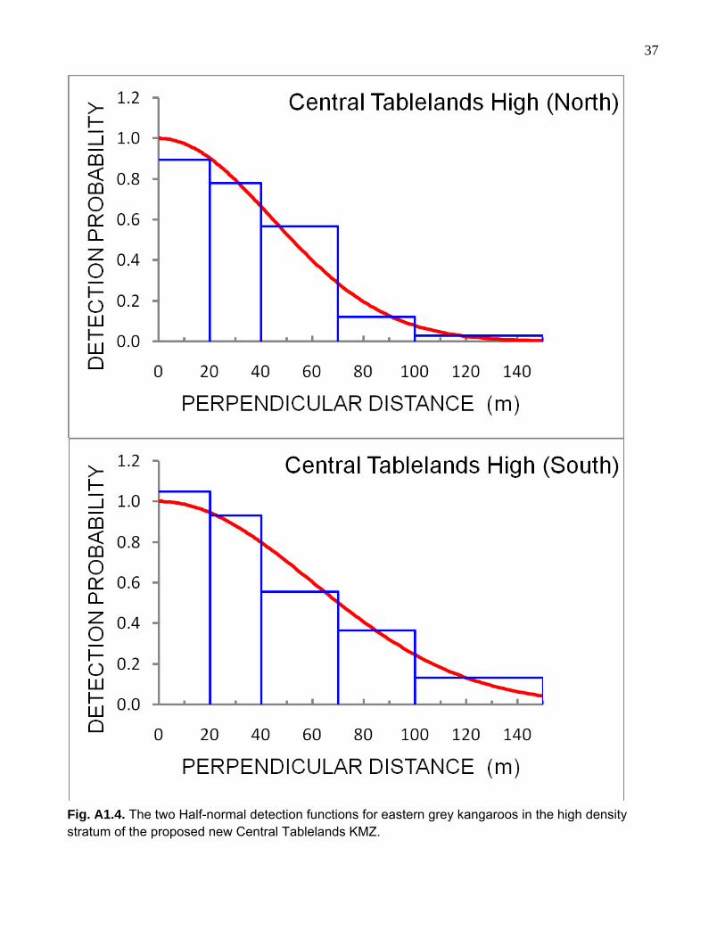
The detection functions were of the form of a Uniform, Half-normal or a Hazard-rate key
function. Where an adjustment was made to the key function to improve the fit to the survey
results, it was with a Cosine adjustment term (Table 5). The forms of the detection functions
derived using data from each of the two strata within each of the three proposed management
zones are shown in Figs. A1.1-A1.7 of the Appendix 1. The values of Pa, the probability that
a randomly placed cluster of eastern grey kangaroos within the covered region of the survey
strip (here, a survey strip 150 m wide) would be detected (Buckland et al. 2001), showed little
variation (<10%) within the proposed Hunter-Mudgee zone. Contrary to this, greater variation
between side-of-aircraft and observer (<32%) was observed in the proposed Central
Tablelands zone, and to some extent between side-of-aircraft (<16%) in the proposed SE
NSW (Young) zone (Table 5).
The densities of eastern grey kangaroos within the two strata of each of the three
proposed kangaroo management zone are given in Table 5. In the proposed Hunter-Mudgee

25
Table 5. Results of the helicopter line transect surveys of eastern grey kangaroos conducted in the prospective Hunter-Mudgee, Central Tablelands and SE NSW (Young) KMZs in September, 2008. Given along with the areas of the strata surveyed within each zone, are survey effort, the number of clusters of kangaroos sighted (n), the detection function models, the probability that a cluster of is detected if it is in the covered region (Pa) and the estimated density (±1SE) of eastern grey kangaroos for each stratum along with its associated coefficient of variation (CV%). Where post-stratification has been used in the analysis, it has either been by survey aspect (N = north, S = south) or observer (DB and SS).
Kangaroo management zone Area (km2) Effort (km) n Model Pa Density (km-2) CV (%)
Hunter-Mudgee
High 10,274 142.0 61 50
Uniform/Cosine (N) Hazard-rate (S)
0.32 0.28
22.30 ± 6.57 29.4
Medium 7,646 143.4 44 Half-normal 0.27 7.38 ± 2.14 29.0
Hunter medium 7,406 127.5 74 Half-normal/Cosine 0.29 19.92 ± 4.67 22.4
Central Tablelands
High 8,254 253.4 42 59
Half-normal (N) Half-normal (S)
0.37 0.49
20.76 ± 2.95 14.2
Medium 14,378 195.1 121155
Half-normal (DB) Hazard-rate (SS)
0.41 0.26
25.33 ± 8.07 31.9
SE NSW (Young)
High 3,185 155.0 78 67
Half-normal/Cosine (N) Half-normal/Cosine (S)
0.38 0.27
26.29 ± 5.65 21.5
Medium 3,353 139.4 26 Half-normal/Cosine 0.33 4.76 ± 1.67 35.0

26
zone, densities were essentially the same within the high density stratum and the Hunter-
medium stratum (z = 0.29, P = 0.77; Buckland et al. 2001, p. 85). Both these densities were
significantly higher than the density in the medium density stratum (medium versus high:
z = 2.15, P = 0.03; medium versus Hunter-medium: z = 2.44, P = 0.01). These results provide
some support for the stratification that was used in design of the survey conducted in this
proposed zone (Fig. 2). The Hunter-medium was included as a separate stratum because it
was thought that with relatively small landholding probably making up most of its area,
eastern grey kangaroo densities would perhaps be lower than in the high density stratum.
Although this appears not to be the case, it does not negate the stratification used.
Stratification is an effective tool ensuring good coverage in designing a survey. In the
proposed Central Tablelands zone, no difference was found between the densities of eastern
grey kangaroos in the designated high and medium density strata (z = 0.53, P = 0.60).
Although stratifying a large area as part of a survey design is always a worthwhile exercise, in
this instance, now that information is available in the form of transect line counts of kangaroos
(Table 4), the opportunity exists to reconsider the stratification used in the present survey
design (Fig. 3). In the proposed SE NSW (Young), a difference was found between the
densities of eastern grey kangaroos in the designated high and medium density strata
(z = 3.65, P << 0001). This result provides some support for the stratification that was used in
the design of the survey conducted in this proposed zone (Fig. 4).
The whole-zone population estimates for eastern grey kangaroos in the three proposed
new management zones are given in Table 6. These estimates have been determined by
summing the population estimates for the two strata of each zone surveyed. The standard
errors given with these estimates were derived from pooling the variances for the strata.
Given also with these estimates is a combined estimate for the total population of eastern
grey kangaroos in the survey area that lays between the existing Upper Hunter and South
East NSW zones (Fig. 1). The surveys of the three proposed new zones were designed with
the intention of producing population estimates of eastern grey kangaroos with coefficients of
variation of around 20%. This was essentially achieved.
Whole-zone densities for eastern grey kangaroos were derived from the population
estimates in Table 6 and are given in Table 7. These were determined in relation to the three
types of survey strata in each proposed zone, i.e. the low, the medium and the high density

27 strata. The low density stratum of each zone was assumed to support zero to negligible
numbers of eastern grey kangaroos.
Both the proposed Hunter-Mudgee and Central Tablelands management zones are
larger than the three Northern Tablelands management zones, but each is comparable in size
to the current South East NSW management zone (Fig. 1). Both support larger, higher
density populations of eastern grey kangaroos than do the three Northern Tablelands
management zones (see Table 9, Cairns 2007). Eastern grey kangaroo density in the
proposed Hunter-Mudgee zone is twice that in the Upper Hunter management zone
immediately to its north. The proposed Central Tablelands zone supports the largest eastern
grey kangaroo population of all survey areas/management zones based on the Great Dividing
Range and its western slopes. It is some 60% higher in density than the population in the
proposed Hunter-Mudgee zone and some 65% higher than the population in the South East
NSW management zone. This might warrant this proposed new management zone being
managed separately rather than in combination with the proposed Hunter-Mudgee zone. The
proposed SE NSW (Young) zone, which will likely be combined with the existing SE NSW
management zone to form an expanded zone supports an eastern grey kangaroo population
comparable in density to those supported in the adjacent Yass and Gundagai RLPB districts
of the existing SE NSW zone (see Table 6, Cairns 2007b).
In a submission made to NSW DECC on behalf of the NSW Farmer’s Association and
the Dubbo, Hunter, Forbes, Central Tablelands, Molong and Young RLPBs requesting the
area comprising these RLPB districts be opened up for commercial kangaroo harvesting
(Mulligan 2007), figures were provided on the number of non-commercial (121) culling
licences issued during the period 2000-2007. In two of these RLPB districts, namely Forbes
and Molong, very few licences have been issued, with the result being that only a small
number of eastern grey kangaroos having been culled from these districts during the period
2002-2007; about 620 per district per year. Only negligible numbers have been culled from
the Dubbo and Young districts. Contrary to this, however, an average of 11,000 eastern grey
kangaroos, along a much smaller number of wallaroos, has been culled from the Central
Tablelands RLPB district each year. In the Hunter RLPB district, an average of 5,600 eastern

28 Table 6. Estimated total numbers (N ± 1SE) of eastern grey kangaroos in the three prospective KMZs, based upon the helicopter line transect surveys conducted in September, 2008. Given also are the coefficients of variation (CV %) for these estimates.
Kangaroo management zone Area (km2) N (± 1SE) CV (%)
Hunter-Mudgee 29,379 433,030 ± 77,533 17.9
Central Tablelands 23,105 535,600 ± 118,607 22.1
SE NSW (Young) 8,884 99,698 ± 18,841 18.9
Hunter-Mudgee/Central Tablelands combined
52,484 968,630 ± 141,700 14.6
Table 7. Estimated densities (±1SE) of eastern grey kangaroos in the three prospective KMZS based upon the helicopter line transect surveys conducted in September, 2008. These densities have been derived in relation all strata (high, medium and low density) comprising each management zone.
Kangaroo management zone Area (km2) Eastern grey kangaroos (km-2)
Hunter-Mudgee 29,379 14.74 ± 2.64
Central Tablelands 23,105 23.18 ± 5.13
SE NSW (Young) 8,884 11.22 ± 2.12
Hunter-Mudgee/Central Tablelands combined
52,484 18.46 ± 2.70
grey kangaroos, along a much smaller number of wallaroos, have been culled annually, while
in the Mudgee-Merriwa district, an average of some 22,000 eastern grey kangaroos have
been culled each year. Harvest quotas set at 15% will exceed these numbers given the
estimated sizes of the eastern grey kangaroo populations in the proposed new Hunter-
Mudgee and Central Tablelands management zones (Table 6) and should lead to a
substantial fall in the number of animals culled non-commercially. This has occurred in the
South East NSW management zone which was first opened for commercial harvesting in
2004 (N. Payne, pers. comm.).
29 6. Acknowledgements
As with any project, the job is never completed without the support of others who are either
wittingly or unwittingly drawn in to provide assistance. For his invaluable GIS support, Greg
Lollback has been included as a co-author of this report, as has David Bearup who put in
considerable effort each evening in helping the pilot plan the next day’s surveys. Paul Caristo
provided excellent and obliging service as the pilot. His attention to OH&S issues was well
appreciated. Scott Seymour obliged by acting as one of the observers during the course of
the survey. As well as beginning his training as an observer, Mike Saunders contributed
valuable logistical support during the survey.
7. References
.Anon. (2006). New South Wales Commercial Kangaroo Management Plan 2007-2011.
Department of Environment and Conservation. 63 pp.
Borchers, D.L & Burnham, K. P. (2004). General formulation for distance sampling. In:
Advanced Distance Sampling (eds. S. T. Buckland, D. A. Anderson, K. P. Burnham, J. L.
Laake and L. Thomas). Pp. 6-30.
Buckland, S. T., Anderson, D. A., Burnham, K. P., Laake, J. L., Borchers, D. L. and Thomas,
L. (2001). Introduction to Distance Sampling: estimating abundance of biological populations.
Oxford University Press, Oxford.
Cairns, S. C. (2003). A report to the New South Wales National Parks & Wildlife Service on
the consultancy: Kangaroo Monitoring New England Tablelands Helicopter Survey.
Unpublished report to New South Wales National Parks & Wildlife Service, Dubbo, NSW.
18 pp.
Cairns, S. C. (2004a). A report to the New South Wales Department of Environment and
Conservation on the consultancy: Kangaroo Monitoring – Redesign and Analysis of the
Northern Tablelands Region Helicopter Survey. Unpublished report to New South Wales
National Parks and Wildlife Service, Dubbo, NSW. 45 pp.

30 Cairns, S. C. (2004b). A report to the New South Wales National Parks & Wildlife Service on
the consultancy: Kangaroo Monitoring – South East New South Wales Helicopter Survey.
Unpublished report to New South Wales National Parks and Wildlife Service, Dubbo, NSW.
19 pp.
Cairns, S. C. (2007a). A report to the New South Wales Department of Environment and
Climate Change on the consultancy: ‘Kangaroo Monitoring – Design and Analysis of the
Northern Tablelands Region Helicopter Survey’. Unpublished report to New South Wales
National Parks and Wildlife Service, Dubbo, NSW. 40 pp.
Cairns, S. C. ( 2007b). A report to the New South Wales Department of Environment and
Climate Change on the consultancy: Kangaroo Monitoring – South East New South Wales
Helicopter Survey. Unpublished report to New South Wales Department of Environment and
Climate Change, Dubbo, NSW. 30 pp.
Cairns, S. C., Lollback, G. W. & Payne, N. (2008). Design of aerial surveys for population
estimation and management of macropods in the Northern Tablelands of New South Wales,
Australia. Wildlife Research 35: 331-339.
Clancy, T. F. (1999). Choice of survey platforms and technique for broad-scale monitoring of
kangaroo populations. Australian Zoologist 31: 367-274.
Clancy, T. F., Pople, A. R. & Gibson, L. A. (1997). Comparison of helicopter line transects
with walked line transects for estimating densities of kangaroos. Wildlife Research 24: 397-
409.
Hill, G. J. E. (1981a) Distribution of grey kangaroos in south, inland Queensland. Australian
Rangeland Journal 3: 58-66.
Hill, G. J. E. (1981b) A study of the habitat preferences in the grey kangaroo. Australian
Wildlife Research 8: 245-254.
Mulligan, A. (2007). Application for New Kangaroo Commercial Zone. Mudgee-Merriwa Rural
Lands Protection Board. 10 pp.
New South Wales National Parks & Wildlife Service. (2001). The New South Wales
Kangaroo Management Program. A management program for the utilisation of four kangaroo
species in NSW. (New South Wales National Parks and Wildlife Service: Sydney) http://www.nationalparks.nsw.goc.au/npws.nsf/Contents/Kangaroo+management+program

31 Payne, N. (2007). Population Monitoring Methods for the NSW Kangaroo Management
Program. Department of Environment and Conservation, NSW. 17 pp.
Pople, A. R. ( 2003). Harvest Management of Kangaroos during Drought. Unpublished
report to New South Wales National Parks & Wildlife Service, Dubbo, NSW. 27 pp.
Pople, A. R. (2008). Frequency and precision of aerial surveys for kangaroo management.
Wildlife Research 35: 340-348.
Pople, A. R. & Grigg, G. C. (1998). Commercial harvesting of kangaroos in Australia.
Environment Australia, Canberra. http://www.ea.gov.au/biodiversity/trade-use/wild-
harvest/kangaroo/harvesting/index.html
Pople, A. R., Cairns, S. C. & Menke, N. (2003). Monitoring Kangaroo Populations in
Southeastern New South Wales. Unpublished report to New South Wales National Parks &
Wildlife Service, Dubbo, NSW. 24 pp.
Sahukar, R., Gallery, C., Smart, J. & Mitchell, P. (2003). The Bioregions of New South
Wales: their biodiversity, conservation and history. National Parks and Wildlife Service
(NSW).
Scott-Kemmis, D. (1979). The distribution and abundance of grey kangaroos in relation to
environment in arid and semi-arid areas of New South Wales. M.Sc. thesis, University of
Sydney, Sydney.
Southwell, C. J., & Sheppard, N. (2000). Assessing harvested populations of the euro
(Macropus robustus erubescens) in the Barrier Ranges of western NSW. Australian
Mammalogy 21, 165-171.
Southwell, C. J., Weaver, K. E., Cairns, S. C., Pople, A. R., Gordon, A. N., Sheppard, N. W. &
Broers, R. (1995). Abundance of macropods in north-eastern New South Wales, and the
logistics of broad-scale ground surveys. Wildlife Research 22: 757-766.
Strindberg, S., Buckland, S. T. & Thomas, L. (2004). Design of distance sampling surveys
and Geographic Information Systems. In: Advanced Distance Sampling (eds. S. T. Buckland,
D. A. Anderson, K. P. Burnham, J. L. Laake and L. Thomas). Pp. 190-228.

32 Thomas, L., Laake, J. L., Strindberg, S., Marques, F. F. C., Buckland, S. T., Borchers, D. L.,
Anderson, D. R., Burnham, K. P., Hedley, S. L., Pollard, J. H., Bishop, J. R. B. & Marques, T.
A. (2005). Distance 5.0 Release “x”. Research Unit for Wildlife Population Assessment,
University of St. Andrews, UK. www.ruwpa.st-and.ac.uk/distance/

33
Appendix 1
The detection function models for eastern grey kangaroos (M. giganteus)
in the three proposed new kangaroo management zones.

34
Fig. A1.1. The Uniform/Cosine (top) and Hazard-rate (bottom) detection functions for eastern grey kangaroos in the high density stratum of the proposed new Hunter-Mudgee KMZ.

35
Fig. A1.2. The Half-normal detection function for eastern grey kangaroos in the medium density stratum of the proposed new Hunter-Mudgee KMZ.

36
Fig. A1.3. The Half-normal detection function for eastern grey kangaroos in the Hunter-medium stratum of the proposed new Hunter-Mudgee KMZ.
37
Fig. A1.4. The two Half-normal detection functions for eastern grey kangaroos in the high density stratum of the proposed new Central Tablelands KMZ.

38
Fig. A1.5. The Half-normal and Hazard-rate detection functions for eastern grey kangaroos in the medium density stratum of the proposed new Central Tablelands KMZ. DB and SS represent two different observers.

39
Fig. A1.6. The two Half-normal/Cosine detection functions for eastern grey kangaroos in the high density stratum of the proposed new SE NSW (Young) KMZ.

40
Fig. A1.7. The Half-normal/Cosine detection function for eastern grey kangaroos in the medium density stratum of the proposed new SE NSW (Young) KMZ.

41
Appendix 2
General performance in terms of detection function models of the four
observers used in the surveys of the three proposed new kangaroo
management zones:
• David Bearup – Hazard-rate
• Scott Seymour – Half-normal
• Stuart Cairns – Half-normal
• Mike Saunders – Half-normal

42

43