a qualitative data collection strategy for africa · qualitative data, ida developed a qualitative...
TRANSCRIPT

I N S T I T U T E F O R D E F E N S E A N A L Y S E S
IDA Paper P-4942
February 2013
A Qualitative Data Collection Strategy for Africa
Ashley N. Bybee, Project LeaderDominick E. Wright
INSTITUTE FOR DEFENSE ANALYSES4850 Mark Center Drive
Alexandria, Virginia 22311-1882
Approved for public release;distribution is unlimited.
Log: H 12-001540

About This PublicationThe work was conducted by the Institute for Defense Analyses (IDA) under contract DASW01-04-C-0003, Task AI-55-3061, “Designing a Qualitative Data Collection Strategy for Africa,” for the Assistant Secretary of Defense for Research and Engineering. The views, opinions, and findings should not be construed as representing the official position of either the Department of Defense or the sponsoring organization.
Approved for public release; distribution is unlimited.
Copyright Notice© 2013 Institute for Defense Analyses4850 Mark Center Drive, Alexandria, Virginia 22311-1882 • (703) 845-2000.
This material may be reproduced by or for the U.S. Government pursuant to the copyright license under the clause at DFARS 252.227-7013 (NOV 95).

I N S T I T U T E F O R D E F E N S E A N A L Y S E S
IDA Paper P-4942
A Qualitative Data Collection Strategy for Africa
Ashley N. Bybee, Project LeaderDominick E. Wright

1
Executive Summary
Sponsor and Objectives In this study, sponsored by the Rapid Reaction Technology Office (RRTO) in the
Office of the Deputy Assistant Secretary of Defense for Rapid Fielding (DASD/RF), for the Assistant Secretary of Defense for Research and Engineering (ASD/R&E), IDA examined qualitative data available for use in models, simulations, and other computational tools (MS&T) for analysis of Africa. Through the identification of gaps in qualitative data, IDA developed a Qualitative Data Collection Strategy (QDCS) to address the most significant qualitative data gaps pertaining to Africa. In doing so, we sought to:
• Improve the USG’s qualitative data collection efforts by increasing availability and awareness of accurate and valid data available to analysts.
• Coordinate among the communities of interest to avoid duplication of data collection efforts.
• Ensure the most efficient allocation of resources to fill in gaps in qualitative data.
By most definitions, qualitative data comprise any non-numeric description of a person, place, thing, event, activity, or concept. A qualitative factor is one that typically represents structural assumptions that are not naturally quantified. This study combines these two key features to produce a definition that includes all descriptions of persons, places, things, events, activities, or concepts that are not numerical or not naturally numerical. This amendment recognizes that many quantified data are inherently qualitative in nature, requiring some subjective interpretation when coding into an ordered (or ordinal) scale. By this definition, IDA includes unstructured and entirely textual data (e.g., focus group data collected through open discussions or anthropological methods) as well as structured (coded) data (e.g., quantized public opinion data collected through various sampling methods used in polling and surveys). This definition includes what is commonly referred to as socio-cultural data (e.g., descriptions of ethnicity, culture, beliefs) but may also include other types of qualitative data such as geographic (e.g., qualitative designations of soil and terrain types along with geo-located socio-cultural data), humanitarian (e.g., reports describing wellbeing and needs), and health-related data (e.g., disease risk propensities for locales).
The long-term goal of this line of inquiry is to facilitate more accurate social science modeling, which this study contributes to by identifying existing qualitative data sources
2
that may be unknown to members of the MS&T and broader analytic communities, describing possible methodologies to address or fill identified gaps, and identifying synergies with existing efforts where collaboration can occur to support the development of a community standard.
Improving the performance of MS&T through the incorporation of better data inputs not only increases their value to consumers of these analytic products, but ultimately improves the ability of policy-makers to make well-informed decisions. There are high stakes involved when considering whether to enter a foreign country, either in a civilian capacity or a military one. Either way, the decision to do so might come down to insights and considerations offered using qualitative data. Improving the analyses that inform these decisions by using better data in MS&T translate into an enriched understanding of complex environments.
Findings and Recommendations IDA’s findings stem from two phases of preliminary research focused on a) the
analysis of existing MS&T used by analysts of Africa, and b) engagement with African scholars and other Africa-based researchers to identify the types of data that have the greatest explanatory power in the African context. The associated recommendations fall into three broad categories, which reflect immediate process improvements, some near-term actions to address the most pressing data gaps, and a long-term plan to ensure a sustainable flow of needed data.
Immediate Process Improvements
Finding 1: There are a number of qualitative data sources that are available but unknown to many analysts. IDA has compiled a list of the sources encountered during the course of this
research, which can be incorporated into existing data portals. This list has been compared with the datasets contained in DataCards (a catalog of indexed information on available quantitative and qualitative datasets, as well as portals to general information) and the Cultural Knowledge Consortium (CKC, a Socio-cultural Knowledge Infrastructure (SKI) to facilitate access among multi-disciplinary, worldwide, social science knowledge holders that fosters collaborative engagement in support of socio-cultural analysis needs,) so that it avoids duplication with sources that have already been captured through those portals.
Recommendation 1: Disseminate list of qualitative data sources. IDA recommends this list be provided to the DataCards Program Manager and
disseminated as widely as possible among the community of interest.

3
Finding 2: There are several existing portals for socio-cultural data, two of which are DataCards and the CKC. Of the two (described in finding 1), DataCards is currently best-suited to serving
immediate data needs for analysts seeking information on topics and issues throughout Africa.
Recommendation 2: Raise awareness and increase use of DataCards. Because DataCards is accessible to users outside of DoD (including academia, the
intelligence communities, and even some international entities, with wide usage encouraged) it has the potential to become the central portal for all socio-cultural datasets. As such, IDA recommends raising awareness of the tool to attract more contributors.
Finding 3: Some data producers have holdings that are only partially observable by USG consumers. Some of the data available through DataCards are comparatively less discoverable
relative to other records because their entries contain less descriptive information. This impedes the discovery and use of valuable data that might suit specific needs.
Recommendation 3: Improve methods to connect stakeholders to rigorous collection centers. Just as some private survey organizations have made their survey questions
available to the public (excluding the raw data that is available for a fee), the USG can similarly develop a technological solution that maintains a searchable catalog of all data available to data consumers. Once identified, these data could then be obtained upon request.
Finding 4: There are some qualitative data gaps that will persist regardless of the resource levels invested to fill them. Regardless of the time and resources spent collecting data, there will always be
some data gaps that persist, either because they are too sensitive or they might be obsolete by the time the data are collected. Rather than excluding unknown variables or substituting them with potentially inaccurate data, analysts need to apply methodologies to control or adjust the model or simulation accordingly.
Recommendation 4: Survey the M&S community for “best practices” when imputing unknown data. OSD should facilitate the collection of ideas and perspectives on how end-users
account for or otherwise impute unknown parameter values into M&S and what
4
techniques they have determined to be “best” for their purposes. These findings should be captured in a “living document” and continually updated based on technological changes and the constant stream of new insights within the M&S community
Near-term Actions to Address the Most Pressing Data Gaps
Finding 5: There are a large number of qualitative data needs and only limited resources to fill them. Given the limited resources available for collection amid a clear demand signal for
specific data points, a prioritization of these data needs would assist the government in allocating the appropriate level of resources to the collection of the highest priority data needs. More fundamentally, IDA notes the absence of an officially vetted and approved list of socio-cultural data requirements. To date, there has not been a systematic approach to documenting what socio-cultural information is relevant for the military.
Recommendation 5: Establish qualitative data requirements and prioritize them. In the interim, prioritize qualitative data needs. IDA recommends OSD lead the process for formally vetting, approving, and
prioritizing qualitative data requirements for MS&T. In the interim, OSD could lead a practical prioritization of the qualitative data needed by DoD organizations tasked with analysis of Africa. Ascertaining the most frequently cited data gaps would help OSD to determine those data points that would have the maximum utility for all. Discussions should address geographic priorities, thematic priorities, and any other relevant characterization of data as identified by stakeholders.
Finding 6: There is potential for proven methodologies to yield previously unavailable qualitative data from Africa. Various unconventional qualitative data collection techniques have been applied in
other regions that have the potential to yield valuable data from Africa. It is worth testing these promising qualitative data collection methodologies in Africa, specifically those that have proven to be fruitful in other regions or contexts.
Recommendation 6a: Cultivate collaborative research networks for improved access to local data. IDA recommends that DoD test promising qualitative data collection methodologies
in Africa, specifically those that have proven to be fruitful in other regions or contexts. One such example that has been an effective approach in southeast Asia are collaborative research networks convening non-official partners, e.g., traditional authorities, youth groups, religious institutions, the private sector, academia, or NGOs, to discuss topics of

5
mutual concern. As a result of the research-based engagement in this region, the USG has augmented its knowledge base and now has a deeper understanding of the nuances and complexities that characterize the region.
Recommendation 6b: Engage diaspora communities residing in CONUS. The African diaspora that resides in the U.S. is a largely untapped source of
qualitative data. Not only are the diaspora a resource geographically convenient to U.S.-based researchers (negating the need to make costly data collection trips to Africa), but engaging them in the U.S. overcomes many of the challenges of bureaucracy and corruption often associated with data collection in Africa. Moreover, this is a valuable method to elicit critical data from population samples that may serve as useful proxies for otherwise inaccessible populations in Africa.
Finding 7: There are several new DoD initiatives and methodologies under way for collecting socio-cultural data in Africa. Special Operations Command (SOCOM), the Defense Intelligence Information
Enterprise (D2IE), the Joint Staff J-7, among others, are all investigating new methodologies to collect socio-cultural data. Each has its own, subjective need but alternate methods for collection should prove universally-applicable across a number of them.
Recommendation 7: Work with the interagency to support experimentation and deployment of new methodologies for socio-cultural data collection. Where opportunities exist to collaborate with DoD and other interagency partners to
experiment with the deployment of new methodologies for socio-cultural data collection, IDA recommends RRTO participate in these activities to facilitate the development of technologies to support these methodologies.
Finding 8: There is a need to facilitate personal contacts and raise awareness of qualitative data sources among the community of interest. The use of one data portal, such as DataCards, will increase awareness and access of
all data across the community. Knowledge of these data sources, however, will always be contingent on the degree of use of such a portal. Moreover, there will always be new data sources coming online that will not be captured in such a portal. A secondary mechanism to track and raise awareness of such data collection efforts would be beneficial to ensure maximum exposure across the community of analysts and other stakeholders.

6
Recommendation 8: Partner with NDU to hold regular conferences convening data collectors and owners of qualitative data. Given the overlapping interests among data consumers and data producers, there is a
potential synergy to be gained by convening these communities in a mutually beneficial forum. The regular Socio-Cultural Data Evaluation Summits (otherwise referred to as “Data Summit”) organized by NDU are an ideal opportunity to assemble these different communities that have very similar interests. This forum would be a prime opportunity to convene data producers alongside data consumers to showcase collection efforts currently under way that will yield new data sources in the near future.
Long-term Plan to Ensure a Sustainable Flow of Needed Data
Finding 9: Local capacity for qualitative data collection is low. In Africa, scarce resources are focused on high priority activities, with less vital
activities (such as data collection) often left by the wayside. Moreover, the requisite skills to administer surveys, conduct interviews, and other qualitative methodologies are severely lacking. As a result, qualitative data collection is typically performed by external actors on an ad hoc basis to serve immediate data needs. Data are not collected in a sustainable fashion or using a consistent methodology at regular intervals over time, which contributes to the problem of poor time series data. So that the USG (and others) can leverage the data collected by Africans without continuing to invest massive resources indefinitely, it should consider building local capacity for this collection. Such investments could have a strategic payoff (access to data), while contributing to DoD’s partnership capacity building mission. In areas in which DoD could benefit from more and improved qualitative data (socio-cultural data that could assist with counter-terrorism operations), it would be appropriate for OSD to support the growth of local capacity for qualitative data collection.
Recommendation 9: Increase technical training for local qualitative data collection, especially capacity to execute national censuses. There are several avenues through which OSD can contribute to this endeavor. IDA
recommends that DoD partner with local data collection organizations that have the capacity themselves to run technical training programs for local Africans. Independent, African-based survey firms such as Afrobarometer; academic institutes such as the Centre for Social Science Research at the University of Cape Town; or multinational organizations such as the UN Office on Drugs and Crime (UNODC), the UN Institute for Training and Research (UNITAR) or the UN’s Economic and Social Council (ECOSOC) are among some reputable organizations and potential partners for this activity. Building upon the work and achievements of African data collection institutions in the region is
7
not only efficient, but it prevents the problem often encountered by Western institutions whose prescriptive approach is resented by Africans. IDA also recommends facilitating collaboration among such institutions to leverage each other’s capabilities and share lessons learned.
Training should be focused in the areas of survey administration, including mobile phone surveys, and the administration of national censuses. The International Programs Center for Technical Assistance at the U.S. Census Bureau, has already worked with some African partners to improve census processes.


9
Contents
1. Introduction ............................................................................................................. 1-1 A. Background ..................................................................................................... 1-2 B. Objective ......................................................................................................... 1-4 C. Study Approach and Methodology .................................................................. 1-4 D. Scope ............................................................................................................... 1-6
1. Models, Simulations, and Tools (MS&T) ................................................. 1-6 2. Qualitative Data ......................................................................................... 1-6
E. Document Outline ........................................................................................... 1-8 2. Conceptual Framework ........................................................................................... 2-1
A. The MS&T Marketplace ................................................................................. 2-1 B. Actors and Elements ........................................................................................ 2-1 C. The Data-MS&T Continuum ........................................................................... 2-2 D. Data Attributes ................................................................................................ 2-3 E. Application to Findings and Recommendations ............................................. 2-3
3. Immediate Process Improvements ........................................................................... 3-1 4. Near-Term “Surge” in the Collection of the Most Critical Data ............................ 4-1 5. Long-Term Plan to Grow Local Capacity ............................................................... 5-1 Appendix A: MS&T Survey ........................................................................................... A-1 Appendix B: Spreadsheet of Data Sources ......................................................................B-1


1-1
1. Introduction
In this study, sponsored by the Rapid Reaction Technology Office (RRTO) in the Office of the Deputy Assistant Secretary of Defense for Rapid Fielding (DASD/RF), for the Assistant Secretary of Defense for Research and Engineering (ASD/R&E), IDA examined qualitative data available for use in models, simulations, and other computational tools (MS&T) for analysis of Africa. Since discovery of gaps or instances where available data could not satisfy informational needs for MS&T was inevitable, RRTO asked IDA to propose a strategy for filling at least some of the gaps discovered during its survey.1 OSD recognizes the value MS&T have to support decision-making and practice at the strategic, operational, and tactical levels, while acknowledging the limitations inherent in any social science modeling that depends heavily on indeterminate and variable human behavior. The value of MS&T, therefore, is contingent on the availability of high-quality data input to the system.2 Use of MS&T applied toward the study and analysis of Africa is likely to prove unsatisfactory because of the comparatively low level of data from the continent relative to other regions. One concern of the U.S. Government (USG) is that many of the problem sets and possible contingencies that Africa presents involve more socio-cultural dynamics than physics-based ones. A paucity of relevant data therefore impairs the utility of MS&T to answer questions concerning current and future trends or events on the continent. High-quality, validated data used in computational modeling will greatly improve utility of MS&T analyses by providing a more accurate portrayal of the social, cultural, political, and even economic landscapes in various African regions.
Because this study focuses exclusively on the African continent, IDA sees the Africa Command (AFRICOM), its components, and other USG organizations with 1 Many of the findings and recommendations in this paper refer to data needs, which are fundamentally
different from data requirements. The former include information that is needed for the successful application of MS&T. These may include developer-stated needs (which they may refer to as requirements but are different from official DoD requirements.) The latter are formally vetted needs that have been approved by both technical and governance bodies. This is a critical differentiation and it is worth noting the absence of socio-cultural data requirements in DoD, despite a litany of data needs.
2 There is some debate over the necessity of high-quality data to achieve the results that will suffice for DoD’s needs, particularly in light of the difficulty and high cost in attaining such high-quality data. Many analysts argue that mediocre and even low-quality data may be sufficient to provide an acceptable result, i.e., within a certain confidence level or within acceptable parameters given the inherent accuracy of the program itself. It is therefore important to note that data needs are subjective, and the highest quality data are not always necessary or even appropriate for all MS&T, but the findings and recommendations in this report assume that, given the subtle nuances contained within much qualitative data, the use of high-quality qualitative data in MS&T will significantly improve the performance of those programs.

1-2
activities in Africa as primary beneficiaries of this research. This paper presents a Qualitative Data Collection Strategy (QDCS) for Africa based on IDA’s previous findings and subsequent analysis of the most significant qualitative data gaps pertaining to Africa.3
A. Background Data collection in Africa is a painstaking and expensive process, but there appears
to be universal appreciation for its importance and for maintaining the integrity of the process. There are many reasons for the dearth of both qualitative and quantitative data on Africa and much of the developing world. The capacity of the public sector to conduct data collection in Africa is noticeably less robust than in much of the developed world. This is particularly true when comparing data collected from different strata or levels of society. Whereas developed countries routinely collect data at the national, state/provincial, city, neighborhood, household, and individual levels, developing countries (including most in Africa) collect relatively lower volumes of data at each of these levels. National-level data are perhaps the best represented, with decreasing numbers of data available as one progresses toward higher levels of fidelity, i.e., the individual. Moreover, the limited resources that any government is willing to invest in such a massive, complex continent have also precluded extensive data collection. Since there is very limited data collection by local (African) research organizations, most academic and policy-related research relies heavily on qualitative data produced by Western-educated social scientists, anthropologists, and political scientists. These researchers tend to lack an African perspective on their research agenda and data collection, which can militate against cultural bias inherent in a Western approach. As a result, it is difficult to gauge the relevance of many qualitative data or to know whether the data have sufficient explanatory power in the African context. Even where the data exist, they are often not captured in written texts or are available only in outdated colonial texts. Rather most relevant data are held within the minds of African people where the only means of access is through oral discussions, which is a very time consuming and costly to collect.
Moreover, the sensitive nature of many “taboo” research areas such as sexual behavior, religious practices, lifestyle habits, and drug consumption, as well as important security issues such as illicit trafficking (e.g., small arms/light weapons, weapons of mass destruction, drugs, humans), and the nexus of each with terrorism have precluded meaningful discussion in these areas and the elicitation of native perceptions of these
3 IDA’s findings are documented in: Ashley Bybee and Dominick Wright, IDA Document D-4629,
Designing a Qualitative Data Collection Strategy (QDCS) for Africa – Phase I: A Gap Analysis of Existing Models, Simulations, and Tools Relating to Africa, June 2012, and an informal report delivered to the sponsor titled “Phase II: Qualitative Data Gaps from the African Perspective,” August 29, 2012.
1-3
issues. As a result, these qualitative data points are currently, and understandably, absent for much of Africa.
From a data user’s perspective, there are additional concerns relating to the supply, format, and quality of qualitative data that affect their ability to be used in MS&T. A common concern voiced by researchers is the difficulty in identifying subject matter experts (SMEs) who can provide reliable, high quality data. Another issue is consistent access, which many data users lack. For example, they may receive one or two qualitative data sources that represent valuable “snapshots” at a given point in time, but they do not have access to those same data over time. This absence of sufficient “time series” data makes it difficult or even impossible to understand overarching trends that are so critical for researchers to determine causal relationships and associations with other examined variables. Moreover, without some indigenous insight into local geo-political and environmental conditions, it is inordinately more difficult for outsiders to know how relevant and valid data are over time, or how applicable the data might be across a span of operational contexts. Finally, although there is a DoD data standard within the context of M&S (DoD Directive 5000.59, 2007), it contains no specification for socio-cultural data and adherence to its prescriptions is variable. Combine this with the fact that data used for alternate purposes have alternate standards as well, and the problem of regularity in critical data features, such as format, becomes clear. As a result, qualitative (and quantitative) data lack consistency in critical features, such as format and unit of measurement, which makes it difficult to achieve seamless inputs into MS&T.
To address these challenges (among numerous others) is not just important on academic or philosophical grounds. There are actual implications for all of the MS&T IDA encountered during its initial survey. (Appendix A provides a full list and description of these MS&T.)4 The following are just a few of the MS&T used for the analysis of the African continent whose designers have stated would benefit from some improved qualitative data:
• Competitive Influence Game (U.S. Army)
• Cultural Geography (U.S. Training and Doctrine Command)
• Geospatial Information Awareness/Infection Disease (GIA/ID) (Naval Research Laboratory)
• HOA-Viewer (Department of State’s Humanitarian Information Unit)
• Composite Vulnerability Map (University of Texas)
4 For the associated gap analysis, see Ashley Bybee and Dominick Wright, IDA Document D-4629,
Designing a Qualitative Data Collection Strategy (QDCS) for Africa – Phase I: A Gap Analysis of Existing Models, Simulations, and Tools Relating to Africa, June 2012.
1-4
• RiftLand (George Mason University’s Center for Social Complexity).
B. Objective The immediate objective of this study is to design a QDCS that will:
• Improve the USG’s qualitative data collection efforts by increasing availability and awareness of accurate and valid data available to analysts.
• Coordinate among the communities of interest to avoid duplication of data collection efforts.
• Ensure the most efficient allocation of resources to fill in gaps in qualitative data.
Achieving these objectives will unquestionably improve the value of MS&T to support USG decision-making by presenting a more accurate socio-cultural landscape to inform policy-makers. One must recognize, however, the limitations inherent in any social science modeling that depends heavily on indeterminate and variable human behavior. Because it is highly unlikely that qualitative MS&T will ever perform accurately enough to reliably and consistently predict reality, users must treat them as one tool within a larger toolkit. At this point, therefore, MS&T should be used to motivate thought and discussions, rather than serving as a prediction or forecasting tool. The MS&T IDA surveyed are all intended to characterize complex socio-cultural-economic-political dynamics rather than identify the result of a given scenario. In doing so, they reveal possible interactions, inform the decision-making process, and provide a point of departure for further discussion, research, and analysis. Moreover, unlike hard scientific models that will generate a clear answer, social science models require some expertise for interpretation.5 These are all critical functions that warrant continued expenditures in and improvements to qualitative MS&T.
The long-term goal of this line of inquiry is therefore to facilitate more accurate social science modeling, which this study contributes to by identifying existing qualitative data sources that might be unknown to members of the community, describing possible methodologies to address or fill identified gaps, and identifying synergies with existing efforts where collaboration can occur to support the development of a community standard.
C. Study Approach and Methodology IDA approached this project in three distinct phases:
5 Lisa Costa, “Sudan Strategic Assessment: Understanding the Dynamics of Complex Socio-Cultural
Environments” October 26, 2007, and Joshua Busby and Jennifer Hazen, “Mapping and Modeling Climate Security Vulnerability: Workshop Report,” Robert Strauss Center for International Security and Law, October 2011.

1-5
The first phase entailed a survey of the existing MS&T used to analyze the African continent to develop a keen sense of what capabilities are most used and most desired by the community of Africa analysts. The methodology employed for this first phase of research included an extensive literature review of known reports and articles on the subject of M&S in an effort to identify those applicable to Africa and suitable for further study. IDA reviewed DoD’s M&S Catalog6 and, with guidance from OSD, contacted several individuals leading projects relevant to the study. IDA also surveyed M&S currently used by USG organizations and some in development in academia. Additional recommendations and points of contacts were provided, which enlarged IDA’s pool of interviewees to a sufficient sample size. For each of the projects, IDA interviewed the owners/administrators of the MS&T and sought the following information: types/sources of qualitative data used, data collection/validation methodologies, assessment of data quality, format of data, challenges to collection/analysis, and gaps in qualitative data. During this phase of data collection, IDA observed the execution of the U.S. Army’s Asymmetric Warfare Group’s Competitive Influence Game (CIG) in Vicenza, Italy, in January 2012. During this three-day simulation, which focused on violent extremist organizations, radicalization, and piracy in the Horn of Africa, IDA conducted interviews with software designers as well as the SMEs to understand how this particular simulation used qualitative data and how it addressed gaps in those data.
The second phase of the task involved engagement with African scholars and other Africa-based researchers with whom IDA’s team of Africa experts have existing academic contacts.7 IDA views this step as a critical feature of a data collection strategy, because it takes into account indigenous insights into African issues. While U.S.-based researchers and designers of M&S have clear data needs for their systems, such data might not have the most explanatory power in the African context. As a result, researchers might find that they are analyzing data that do not reveal new insights or shed new light on emerging trends. Soliciting input from Africans on what they perceive to be the most salient information to capture to explain certain phenomena, while identifying emerging trends that might not be on Americans’ radar, represents a strategic investment with immediate and long-term returns. Moreover, including Africans as active participants in this phase of strategizing will better position the USG and research institutions to engage Africans on issues of mutual concern in the future and cultivate long-term partnerships that yield new data (including real-time data) for both the U.S. and its African partners.
6 https://mscatalog.osd.mil/intro/index.aspx 7 The findings from this phase of research were delivered to the sponsor in an informal report titled
“Qualitative Data Gaps from the African Perspective” and are available upon request.

1-6
The research and analyses conducted in phases 1 and 2 culminated in the development of QDCS, which is presented in this paper. This strategy takes into consideration the needs of MS&T pertaining to Africa while ensuring that data needs are attuned to the interests of African partners.
D. Scope
1. Models, Simulations, and Tools (MS&T) The computer applications included for analysis in this study consisted of models,
simulations, and some relevant tools. Models are “physical, mathematical, or otherwise logical representations of a system, entity, phenomenon, or process.”8 They are simplified representations of a system for which designers have implicitly or explicitly specified the conditions (e.g., time and space) under which it might appropriately be used to understand a “real” (i.e., empirically observable) system. Simulations are “methods for implementing models over time.”9 Whereas application of a model might provide an answer for a specific set of temporal and spatial conditions, a simulation extends these results over a time or space continuum. Adjunct tools (hereafter referred to as tools) are “software and/or hardware used to provide part of a simulation environment or to transform and manage data used by or produced by a simulation environment.”10 They differ from models and simulations in that they are not, and do not mean to be, logical representations of systems. Instead, they are used to manage, store, and represent information produced from models and simulations along with other origins (including other tools). The main MS&T targeted by IDA were those currently being used by the USG for the analysis of Africa. Because the actual number of MS&T used by the USG was not as high as expected, IDA broadened the scope of the study to include some MS&T used in academia, since their qualitative data gaps are also helpful data points.
2. Qualitative Data Qualitative data comprise any “non-numeric description of a person, place, thing,
event, activity, or concept.”11 A qualitative factor is one “that typically represents structural assumptions that are not naturally quantified.”12 This study combines these two key features to produce a definition that includes all descriptions of persons, places, things, events, activities, or concepts that are not numerical or not naturally numerical. This amendment recognizes that many quantified data are inherently qualitative in nature,
8 M&S Glossary, Retrieved on October 8, 2012. Available at: http://www.msco.mil/MSGlossary.html. 9 Ibid. 10 Ibid. 11 Ibid. 12 Ibid.
1-7
requiring some subjective interpretation when coding into an ordered (or ordinal) scale. By this definition, IDA includes unstructured and entirely textual data (e.g., focus group data collected through open discussions or anthropological methods) as well as structured (coded) data (e.g., public opinion data collected through quantitative methods such as polling of respondents selected by multi-stage, random and stratified sampling). Conversely, quantitative data are inherently “numerical expressions that use numbers, upon which mathematical operations can be performed.”13 In terms of collection methodologies, qualitative data are typically collected directly (e.g., field research and observation studies, focus group discussions, surveys) while naturally occurring quantitative data are usually collected indirectly via instruments (e.g., census survey instruments producing counts of households in housing tracts as well as imagery data producing satellites).
Consider, for example, a consumer who must decide between two brands of a product. Quantitative data distinguishing between the two might include price and quantitative descriptions of their alternate compositions (e.g., chemical make-up, mechanical configuration). Price data offer a straightforward way to compare the two brands. What is difficult to determine is the degree to which a consumer prefers one brand to the other. Even more difficult to determine is the reason that preference exists. Does the consumer prefer Brand A to Brand B because it is cheaper (easily quantified) or somehow “better” (difficult to quantify even when the degree of preference rests on a survey instrument, such as a Likert scale).14 Examples such as this one illustrate that, by comparison, quantitative data are conceptually easier to grasp and measure. For these same reasons, quantitative data are also easier to collect, irrespective of collection conditions. As a result, the majority of data usable in MS&T are mostly quantitative. There is relatively less qualitative information available to characterize elements of systems that are difficult to represent but no less important to understand.
This is especially true in the developing world, where fewer resources and assets are available for data collection.15 Nonetheless, the security challenges associated with the post-9/11 geo-political environment have only increased calls for more African data. IDA’s casual observations suggest that a number of data needs are associated with the perceived plights of Africans, which over time could translate into major security
13 Ibid. 14 The Likert scale is the most widely used approach to survey research where responses are chosen among
a ranking of multiple categories 15 Baisch Jürgen, “Data Shortage in Africa.” 2008. Retrieved on October 8, 2012. Available at:
http://www.water-for-africa.org/tl_files/content/download_public/IWFA-Data_Shortage_in_Africa.pdf. and Eileen Hoal, “Famine in the Presence of the Genomic Data Feast,” Science. February 18, 2011. Vol, 331 (6019): 874.
1-8
concerns where basic human needs are not met.16 This appears to be the impetus for many climate and water data collection efforts.17 Analyses of these data are focused on how climate change and water levels affect migratory flows that could in turn indicate potential human insecurity or outright conflict. Efforts to collect quantitative data (such as water levels, GPS coordinates, and even the number of news events associated with these observations) are all critically important. These data can answer questions such as:
• Who is affected by climate change?
• What is the impact of decreasing water levels on a given population?
• Where are populations moving in order to access more water?”
Most analysts agree, however, that only qualitative data can answer questions such as: “Why are populations choosing to move to certain locations, over others?” and “how are they choosing to move?”18 Without qualitative data, analysts run the risk of over-assigning importance to quantitative data simply because they are available. The focus for IDA, therefore, is to develop a strategy for complementing the quantitative data that answer the “who?” “what?” and “where?” questions with qualitative data that can relate the “why?” and “how?” also associated with these topics.
E. Document Outline This document is organized as follows: After this Introduction chapter, Chapter 2
presents the conceptual framework that was used to identify findings and assess recommendations. Chapters 3, 4, and 5 present IDA’s findings and recommendations and describe some possible initiatives that might be adopted to fill or address the qualitative data gaps identified in IDA’s initial report. These recommendations and initiatives fall into three categories that reflect immediate process improvements (Chapter 3), some near-term solutions for the most pressing data gaps (Chapter 4), and a long-term plan to ensure a sustainable stream of needed data (Chapter 5).
16 The “January 2012: Special Issue on Climate Change and Conflict,” published by the Journal of Peace
Research is but one example of the emphasis on physical data. The issue is available at: http://jpr.sagepub.com/cgi/collection/special_issue_on_climate_change_and_conflict.
17 Ochieng’ Ogodo, “Africa Facing Climate Data Shortage.” November 11, 2009. Retrieved on October 8, 2012. Available at: http://www.scidev.net/en/news/africa-facing-climate-data-shortage.html. See also the Institute Water for Africa (IWAF) website at: http://www.water-for-africa.org/en/home_articles/articles/africa-isnt-only-suffering-from-water-shortage.html.
18 Answering the “why?” and “how?” questions are qualitative in that they are assessments made by individuals and asserted in the form of attitudes. The fact that the data are qualitative does not preclude the use of quantitative methods for analyzing it. For example, a representative sample of attitudes describing why a population would choose to move to a certain location over others, coupled with the qualitative attributes of respondents would lend itself to a variety of statistical methods used to understand the correlation between individual characteristics and predilections for moving.

2-1
2. Conceptual Framework
A. The MS&T Marketplace The findings and recommendations contained in this strategy are presented in terms
of a conceptual framework that describes an “MS&T marketplace.” DoD data (qualitative and quantitative) and the MS&T Marketplace (hereafter referenced as the marketplace) contain both a supply of data and MS&T as well as a demand for these two items. Since the focus of this paper is on data, specifically qualitative data, the conceptual framework here treats supply of MS&T as outside current scope and therefore determined externally.
This conceptual framework is useful for establishing the difference between the findings (the status quo) and recommendations (to achieve an ideal end state). As outlined, the conceptual framework will serve as an instrument for assessing data-related aspects of the DoD data and MS&T marketplace with respect to analyses of African topics. Although this study is explicitly focused on MS&T used for the analysis of Africa, the marketplace is not unique to Africa. It is region-neutral, which facilitates the ability of analysts to apply findings and recommendations within a context of identified gaps in available products, functions, and so forth. Situating findings and recommendations within alternate aspects of the marketplace will facilitate decision-making capabilities regarding where and how to proceed in the effort to make it a robust center for exchange and creation of high-quality, analytic products.
B. Actors and Elements The DoD marketplace for data and MS&T includes actors performing any one of
four, non-mutually exclusive roles:
• Data producer: Data producers are those who generate factual information (i.e., empirical observations) through various means of collection and recording.
• MS&T producer: MS&T producers are individuals or organizations who develop, both conceptually and technically, the models, simulations, or tools that are used for analysis of a specified issue.
• Data consumer: Data consumers are the analysts who require qualitative and quantitative data in order to carry out their daily duties. They may use data for an array of purposes, such as conducting assessments or informing strategic planning.
• MS&T consumer: MS&T consumers are also analysts who use these automated programs to assist in their analyses.

2-2
The marketplace also includes the products generated by these actors, most notably Data (D), Models (M), Simulations (S), and Tools (T).
C. The Data-MS&T Continuum Within the marketplace, there exists a continuum that can be used to describe the
way in which consumers use data and MS&T. Depending on the duties and assignments of a given analyst, he or she will make use of these elements in different ways. The decision is made once an analyst is presented with a task that requires an answer or “output” that can be derived from some use or manipulation of data with MS&T. Alternate pairings of data with MS&T create a continuum of use describing the combination of means used to complete an assigned task. Table 1 describes how data and MS&T might be used along this continuum.
Table 1. The MS&T Continuum
Marketplace Elements
Generic Task Description Example Question
D References raw data only.
How many ethnic groups and people identifying with each are present in region X of country Y?
D+T Manipulating data in a form of organization (e.g., charts) without extracting additional meaning.
What is the geographical distribution of people identifying with alternate ethnicities in region X of country Y?
D+MS Manipulating data into a secondary output by applying logic to extract additional meaning.
What are the rates of change associated with distributions of people identifying with alternate ethnicities in region X of country Y from period 1 – period 3? What is the forecasted distribution of period 5?
D+MST Manipulating data into a secondary output by applying logic and organizing the extracted meaning (e.g., charts).
What is the geographical distribution of observed and forecasted transition rates for people identifying with alternate ethnicities in region X of country Y?
Data (D), Tools (T), Models (M), and Simulations (S)
The use of these elements requires consumers to be familiar with the availability of each or know where to look for the needed information. Knowledge portals and repositories come in numerous forms but universally share one quality: they do not capture the entire supply of available data. Data supply is constantly increasing as a result new needs and injections of resources to collect those data priorities. Knowledge portals and repositories capture what is available and known to their administrators. To the extent that data producers generate products that are available yet unknown, there will always be a “gap” to close by making them available.

2-3
D. Data Attributes Across the Data-MS&T continuum, the need for certain data attributes will remain
constant:
• Phenomenon: the social (human-driven) and/or physical (nature-driven) topics of interest such as:
– Water availability
– Ethnic group maps
– Occurrence of violent conflict
– Patterns of electoral support
– Public goods provision or governance
• Time: the period of interest
• Area: the geographical area or areas of interest
• Format: requirements describing form of the data such as:
– Structured or unstructured
– Quantified or textual.
These four attributes are not an exhaustive list of data characteristics, but they do represent a high-level abstraction at which all data are comparable. In an ideal marketplace, a consumer would be able to articulate a data need along these dimensions, the supply of data would contain one or more products satisfying that need, and a mechanism for exchange would quickly identify and link the consumer with the appropriate set of products. Thus the critical elements of the ideal marketplace would include a supply of data products that satisfies all data needs (or data demand) and a mechanism for exchange that is fully aware of all available data products.
E. Application to Findings and Recommendations Where appropriate, the findings and recommendations presented in the next chapter
are characterized in terms consistent with the MS&T marketplace described above. In addition to outlining the time horizon required until a benefit is realized and the expected cost, the QDCS also describes where within the marketplace IDA has identified a shortcoming and how the recommendation addresses it.


3-1
3. Immediate Process Improvements
OSD and interested stakeholders can adopt several simple process improvements to enhance their access to qualitative data on Africa. The following findings and associated recommendations do not require additional resources to be expended by the USG and could be adopted immediately.
Finding 1: There are a number of qualitative data sources that are available but unknown to many analysts. The process of interviewing individuals and organizations has revealed a number of
qualitative data sources and collection efforts currently under way that might not be well known among the community of analysts and other stakeholders. Many contain survey data while others present findings of anthropological research in certain specific communities that help analysts to understand unfolding developments in a given country. For example, the “Master Narratives” produced by the Open Source Center present historically grounded stories that reflect a community’s identity and experiences, and explain their hopes, aspirations, and concerns. Vital data sources like these represent valuable additions to the pool of available and readily discoverable data.
Appendix B (an Excel spreadsheet) lists all such qualitative data sources encountered by IDA, including several descriptive details about the datasets themselves. This list has been compared with the datasets contained in DataCards and the data provided by the Cultural Knowledge Consortium (CKC) to avoid duplication with data sources that have already been captured through those portals. The spreadsheet is formatted in such a way and contains the appropriate fields to facilitate entry into the DataCards portal. (See Finding 2.)
Recommendation 1: Disseminate List of Qualitative Data Sources. IDA recommends this list be provided to the DataCards Program Manager and
disseminated as widely as possible among the community of interest, so all parties may benefit from datasets they might otherwise not know of.
Finding 2: There are several existing portals for socio-cultural data, two of which are DataCards and the Cultural Knowledge Consortium. Of the two, DataCards is currently best-suited to serving immediate data needs for analysts seeking information on topics and issues throughout Africa. The Center for Technology and National Security Policy (CTNSP) at National
Defense University (NDU) is currently coordinating a project called “DataCards,” which
3-2
serves as a repository of information on available quantitative and qualitative datasets, as well as portals to general information.19 According to the DataCards website:
DataCards is a structured collection tool that indexes data sources that relate to irregular warfare, assessment, or can be used for socio-cultural modeling... These cards provide a summary description and evaluation of the content, quality, intended purposes, and potentially appropriate uses of each source.20
Although the program initially focused on Afghanistan, it subsequently widened its collection strategy to include information from across the globe with a large concentration effort geared toward Africa. As a result, the DataCards website (www.datacards.org) now contains more than 367 cards for Africa (approximately 22 percent of the 1,655 currently available). Each data card consists of a profile describing the data and links to the original source by listing a URL or a POC. An ongoing effort pursued by the DataCards team includes appending each record with the actual data. Currently, it is unclear how many records possess these attachments, but it is reasonable to think a plurality of them will be of the quantitative and quantified sort.
Datacards is somewhat unique in that it encourages users from beyond DoD, e.g., academia, the intelligence communities, and even some international users. Since DoD is not the obvious source of socio-cultural data for non-DoD researchers (and probably never will be), there is wisdom in granting access of unclassified data to other government agencies, the NGO community, academia, and even foreign users. This encourages reciprocation and increases the likelihood these communities will provide additional socio-cultural data for DoD’s benefit.
The CKC, administered by the U.S. Army Training and Doctrine Command (TRADOC) Analysis Center (TRAC) at Fort Leavenworth, Kansas, is another DoD effort to serve the socio-cultural needs of the combatant commands. According to the CKC website:
The Cultural Knowledge Consortium (CKC) provides a Socio-cultural Knowledge Infrastructure (SKI) to facilitate access among multi-disciplinary, worldwide, social science knowledge holders that fosters collaborative engagement in support of socio-cultural analysis
19 Several findings and recommendations in this report refer to a portal, which is fundamentally different
from a repository. A repository refers to the actual source of the data, while a portal (also known as a catalog or brokering system) refers to a list of references or a system for easily accessing remote data provided by the data owner. The latter, i.e., a portal with links to datasets, is preferable as it allows data owners to update their data as appropriate while the portal will automatically capture the most recent revisions without the expense of maintaining yet another database. Datacards is currently a portal for socio-cultural data, though it is seeking to acquire raw data, thus positioning itself as a repository as well.
20 https://www.datacards.org/, Accessed 20120927.
3-3
requirements. The CKC supports U.S. government and military decision-makers, while supporting collaboration and knowledge sharing throughout the socio-cultural community.21
As the CKC mission statement clearly articulates, the general goal of the effort is to enhance awareness and by extension usage of socio-cultural data throughout the DoD community. In spirit, it does not differ significantly from the DataCards effort. In form, however, the two differ considerably.22 CKC operates more as a portal, where interested parties can connect with CKC-vetted SMEs (i.e., regional and functional scholars), read blogs, gain awareness of upcoming events, and so forth. A capability the organization aspires to offer in the future includes access to a sanitized version of the Distributed Common Ground System - Army (DCGS-A),23 which will extend its unclassified offerings to include discoverable, searchable, and exploitable databases.24
DataCards, on the other hand, is a meta-database (an alternate term for a catalog serving as a database of databases). For example, it does not currently purport to include listings of SMEs, as CKC does. Once DCGS-A capabilities become part of the CKC UNCLASSIFED holdings, there will be some overlap between its offerings and those of DataCards. Until that time, IDA views DataCards as the better option within the UNCLASSIFIED arena for servicing the preliminary qualitative data needs of analysts focused on topics throughout Africa.
Recommendation 2: Raise awareness and Increase Use of DataCards. Because DataCards is accessible to users outside of DoD (including academia, the
intelligence communities, and even some international entities, with wide usage encouraged) it has the potential to become the central portal for all socio-cultural datasets, IDA recommends raising awareness of the tool to attract more contributors. IDA can do its part by formatting the list of data sources that it has compiled throughout this project for easy entry into DataCards and advertise those additions to all those interviewed. Incorporating IDA’s list of qualitative data sources with this existing portal will ensure maximum benefit of OSD investments.
21 https://culturalknowledge.org/, Accessed 20120927. 22 Comparison of the two information portals will focus on their offerings presented in the unclassified
arena, which IDA recognizes as only a partial representation of the overall capabilities possessed. 23 https://secureweb2.hqda.pentagon.mil/VDAS_ArmyPostureStatement/2011/information_papers/
PostedDocument.asp?id=151 Accessed on 20120927. 24 https://www.culturalknowledge.org/data-brokering.aspx Accessed on 20120927.
3-4
Finding 3: Some data producers have holdings that are only partially observable by USG consumers. Some data providers have records in DataCards, but their data are comparatively
less discoverable relative to other records because their entries contain less descriptive information. Currently, this is not an efficient system because these records are not searchable by, for example, country, time period, or subject matter.
In interviews, IDA learned of several data collection centers that tend to serve a narrow consumer base. These data purveyors do not deliberately limit their distribution, but due to the absence of a system in which their data may be discovered and searched by the broader community, its existence is unknown to many. For example, the State Department’s Office of Opinion Research (OOR) collects opinion data worldwide and has three analysts dedicated to sub-Saharan Africa. OOR’s staff comprises methodologists trained in survey methods and statistical analysis, who have some regional expertise. OOR has been collecting data as requested and providing them to the Strategic Communication Division at AFRICOM, yet there is currently no mechanism for other offices and directorates within the Command to search or discover these data.
IDA learned that some data collectors are at times reluctant to make their data available publicly out of concern the data might be misused. They prefer for those interested data consumers to contact them directly with a request for data on a certain topic. Through discussions with potential consumers, OOR can determine which survey questions might be of interest, and then devote resources toward conducting analyses that service the expressed interest. This process hinges on questions survey collectors have at their disposal and internal resources available to conduct associated analyses.
Recommendation 3: Improve methods to connect stakeholders to rigorous collection centers. Unlike Gallup, Pew, and other private industry survey firms, OOR and similar
organizations do not treat their questions as proprietary and part of a business model. Nonetheless, IDA suggests that (similar to these organizations) it is possible to develop a technological solution that maintains a searchable catalog of survey questions, countries surveyed, the appropriate level of analysis (e.g., country, county or state, city), and the period covered.25 Such a solution satisfies the survey collector concern over misuse while making the community more fully aware of polling questions available for analysis.
25 Survey collectors can determine whether they want to post aggregate, descriptive statistics for others in
the community to review.

3-5
Finding 4: There are some qualitative data gaps that will persist regardless of the resource levels invested to fill them. One fundamental truth that must be acknowledged when analyzing African
phenomena is that regardless of the time and resources spent collecting data, there will always be some data gaps that remain. These data may be unavailable because they are too sensitive and therefore difficult to collect by “outsiders” such as Western researchers. More likely, the data could be obsolete by the time it is collected. In these cases, it might be counterproductive to use one’s “best guess” or “next best thing,” lest the data be inaccurate and possibly affect the results of the model or simulation.
Rather than excluding unknown variables or substituting them with poor quality or potentially inaccurate data, analysts need to acknowledge that there will be data gaps that remain and apply methodologies to control or adjust the model or simulation accordingly. This sometimes involves making educated guesses where data are unavailable, although there are several techniques that M&S designers and users can use to do this. For example:
• Establish the initial conditions (e.g., population distributions, inter-group relations, socio-economic indicators) used as empirical anchors for synthetic populations.26 This technique still involves making assumptions regarding the relationships between variables, but at least their starting values have empirical origins.
• Use proxy data elicited from SMEs combined with crowdsourcing techniques to derive values for empirically unavailable quantities of interest, such as the likely response of groups to kinetic and non-kinetic courses of action.27 This technique amounts to relying upon experts to provide proxy data describing everything from “initial conditions” values to relationships between variables (e.g., conditional behavioral response, marginal elasticities – or regression slopes).
• Apply multiple runs, i.e. “Monte Carlo sampling” to determine how sensitive results are to changes in the unknown variable.28 Rather than impute values for missing data, this technique requires analysts to conduct multiple runs of a model or simulation. This method enables researchers to determine the robustness of
26 This is the technique used by the U.S. Army’s Asymmetric Warfare Group (AWG) in cycle 6 of the
Competitive Influence Game (CIG), which IDA observed. 27 This is the technique used in Irregular Warfare simulations by TRADOC-TRAC and the Marine Corps
Combat Development Command (MCDC) in conjunction with the Cost Assessment and Program Evaluation (CAPE).
28 This technique may also be used to address the debate over the necessity of high-quality data by determining the quality of data needed to produce a result of acceptable credibility. For example, if a range of input values produce the same output value, expending resources to pinpoint the exact input value does not provide the return one would expect for that investment.
3-6
analytic estimates conditioned on alternate values of the missing data.29 One output from these techniques includes an assessment of analytic result stability along with the estimated importance of the missing data. For example, if estimated results are relatively consistent across large subsets of missing variable values, then there is support for the inference that the missing variable is not substantively important. Alternatively, if estimated results depend heavily on certain values of the missing variable, then it is substantively significant and the situation warrants some additional effort toward collecting empirical information. Researchers can systematically apply these methods for all missing variables, interactions between missing and known variables, as well as interactions between jointly missing variables; however, doing so involves increasing levels of analytic complexity.
• Establish a method for monitoring the quality of data input into the system and assessing levels of confidence associated with the aggregate outputs. Such a method would likely begin with incorporating values for measurement error associated with variables possessing values, an attribute potentially extracted from ratings DataCards plans to incorporate within its holdings. This system would allow researchers to identify what data are of the highest quality and therefore apply datasets appropriately to the analysis at hand.
Recommendation 4: Survey the M&S Community for “Best Practices” when Imputing Unknown Data IDA recommends a broad USG M&S community survey (regardless of regional
application) to learn:
• How end-users account for or otherwise impute unknown parameter values
• Which types of M&S they are using and how data imputation of various types combines with variables having known values in their analyses
29 The technical process for Monte Carlo sampling requires researchers to take the following steps: a)
establish boundaries for a missing data point, which should reflect some empirically determined values to ensure results are reasonable and realistic; this boundary-setting is synonymous with establishing “initial conditions” values, as described previously; b) select the appropriate mathematical distributions (e.g., normal, Poisson, beta, and so forth) characterizing relative density of values throughout the population; this is the “distribution space”; c) establish the “parameter space,” which is the range of values associated with each distribution (e.g., the mean and standard deviation of a normal distribution or the combined mean and variance shaping a Poisson distribution). Treating the boundary values as fixed or constant, while iteratively and systematically sampling distribution and parameter spaces provides input values for use in constructive and statistical models and a means for researchers to apply appropriate methods (e.g., topology) for reviewing results according to “pooling” and “separating” tendencies. Further analysis of the estimated results contributes toward assessing the substantive importance and impact of the variable in question.

3-7
• What techniques, such as those described above, they have determined to be “best” for their purposes.
Upon completion of such a survey, IDA recommends capturing findings in a document detailing the best practices currently used by the USG for imputing unknown data into M&S. This would enable OSD to normalize currently disparate data imputation efforts while improving the quality of analysis throughout the M&S community. Given rapid technological changes and the constant stream of exceptional insights within the M&S community, IDA recommends this be an ongoing process to ensure the USG is always aware of new techniques to address data gaps.
Once the USG’s MS&T community has a sound understanding of these methods, it might consider expanding this survey to include techniques employed by academia and private industry. Because they have large financial interests in potentially volatile regions such as Africa, many private sector companies use models that help them to assess stability and other local dynamics. For example, oil and gas companies need to identify risks that could potentially affect their planned or ongoing operations in resource-rich host countries. Their assessments are based entirely on real-world scenarios so one must presume they have developed techniques to overcome or address gaps in qualitative data. Similarly, academics have likely developed their own techniques for overcoming these issues. By leveraging the insights of these two research communities, the USG would be better positioned to refine and improve its own best practices.


4-1
4. Near-Term “Surge” in the Collection of the Most Critical Data
With modest funding, OSD can initiate a near-term “surge” in the collection of a targeted set of frequently cited or “low-hanging” data gaps. A prioritization of these data needs needs to occur first, after which OSD can test one or more of the methodologies described below to collect the needed data.
Finding 5: There are a large number of qualitative data needs and only limited resources to fill them. Throughout this process, IDA found many aspects of MS&T that could benefit from
the infusion of new or improved qualitative data. These gaps are documented in the first phase of the research.30 Many gaps are not unique to the specific MS&T, i.e., they represent similar data needs among many within the community of modelers and Africanists.31 Given the limited resources available for collection amid a clear demand signal for specific data points, a prioritization of these data needs would assist the government in allocating the appropriate level of resources to the collection of the highest priority data needs.
More fundamentally, IDA notes the absence of an officially-vetted and approved list of socio-cultural data requirements. To date, there has not been a systematic approach to documenting what socio-cultural information is relevant for the military. Although the DoD community has been operating with unofficial data needs (versus official data requirements), establishing a list of formal socio-cultural data requirements would be a logical first step in the prioritization process. The figure below depicts the hierarchy of general data needs, software requirements, and the specific DoD-vetted data requirements for M&S.
30 Ashley Bybee and Dominick Wright, IDA Document D-4629, Designing a Qualitative Data Collection
Strategy (QDCS) for Africa – Phase I: A Gap Analysis of Existing Models, Simulations, and Tools Relating to Africa, June 2012.
31 Formal discussions with AFRICOM were not held to ascertain the Command’s most pressing data gaps; however, IDA did infer through informal discussions with other analysts and researchers, that the Command’s research priorities are highly diverse in total yet extremely narrow in focus and therefor require an array of very specific data.

4-2
Hierarchy of Data Needs and Requirements
Recommendation 5: Establish qualitative data requirements and prioritize them. In the interim, prioritize qualitative data needs. IDA recommends OSD lead the process for formally vetting, approving, and
prioritizing qualitative data requirements for MS&T. In the interim, OSD may lead a practical prioritization of the qualitative data needed by DoD organizations tasked with analysis of Africa. This would require in-depth discussions with relevant stakeholders to improve understanding of their respective qualitative data needs. In some cases, detailed qualitative data requirements might not be known or clear to analysts. In such cases, ascertaining their broad operational priorities in conjunction with the processes and means used to achieve them might help isolate specific data needs. This process would also afford DoD an opportunity to refine the definition of these data needs to a level of detail that would facilitate collection.
Prioritization can occur in different ways, depending on the consumer of the data. The individual M&S could be prioritized themselves based on the USG’s assessment of their utility. Because M&S are idiosyncratic, data needs would be derived from an identification of each M&S’s missing inputs. This would obviate the need for a larger discussion among the broader community of interest, yet would only serve the needs of that particular model or simulation. Thus such a case-by-case approach would ensure the exact specifications of data needs are known (such as formatting requirements) but this approach could become quite costly without considering efficiencies with other M&S.
A more cost-effective approach would be further collaboration among DoD organizations, incorporating the inputs of as many stakeholders as possible including but not limited to AFRICOM, U.S. Special Operations Command (SOCOM), TRAC at Fort Leavenworth (TRAC-FLVN), Undersecretary of Defense for Intelligence (USDI), and other relevant stakeholders. Ascertaining the most frequently cited data gaps would help OSD to determine those data points that would have the maximum utility for all. Once collected, these could satisfy the needs of numerous stakeholders.
General Data Needs
Software Requirements
Data Requirements for M&S
4-3
Discussions should address geographic priorities (e.g., Horn of Africa (HOA), Sahel, west, central, south), thematic priorities (e.g., relationship-mapping, public opinion/attitude, demographic), and any other relevant characterization of data as identified by stakeholders. Following such an analysis, OSD can officially prioritize the community’s qualitative data requirements
Finding 6: There is potential for proven methodologies to yield previously unavailable qualitative data from Africa. Through discussions with historians, anthropologists, and social scientists, IDA
learned of various unconventional qualitative data collection techniques that have the potential to yield valuable data from Africa. For example, a group of analysts within IDA have a proven track record using one such methodology in Southeast Asia where it has successfully formed collaborative research networks that facilitate access to local data. As a result of IDA’s engagement in this region, we have been able to augment the USG’s existing knowledge base for Southeast Asia and contribute to a deeper understanding of the nuances and complexities that characterize the region.
Recommendation 6a: Cultivate collaborative research networks for improved access to local data. IDA recommends that DoD test promising qualitative data collection methodologies
in Africa, specifically those that have proven to be fruitful in other regions or contexts. The features of one such network that has facilitated the effective elicitation of sensitive information (otherwise inaccessible to the USG) include:
• A focus on “track 2 engagement” with participation from non-official counterparts, e.g., traditional authorities, civil society, youth groups, religious institutions, the private sector, or academia. Individuals from such backgrounds represent purposive samples, i.e., samples that are “information rich,” which provide the greatest insight into the data being sought.32
• A sustained engagement that cultivates trust, strengthens relationships, and encourages collaboration – all in support of shared interests. Almost all qualitative research methodologies require the development and maintenance of relationships with research subjects, which is important for effective sampling and for the credibility of the research.33
32 Kelly Devers and Richard Frankel, “Study Design in Qualitative Research—2: Sampling and Data
Collection Strategies” Education for Health, Vol. 13, No. 2, 2000, 263–271. And Miles & Huberman (1994, p. 34)
33 Frankel, R.M. and Devers, K.J., (2000a). Qualitative research: a consumer’s guide. Education for Health, 13, 113–123.
4-4
• A “strategic listening” approach, whereby U.S. participation is minimal, encouraging a comfortable venue for frank and open dialogue among local participants. This approach allows U.S. observers/listeners to absorb insights relating to the nature of the environment through local lens.
• A discussion on topics of mutual concern. The most detailed and insightful data can be drawn from discussions where all participants have a vested interest. Often, Western-led discussions in Africa revolve around Western notions of security, democratization, institution-building, or other topics that are the focus of Western research in Africa. As phase 2 of this task revealed, African perspectives on such issues often do not correspond with Western perspectives. The value of the forum described in this methodology is that it elicits African perspectives without the overlay of U.S. concerns.
Recommendation 6b: Engage diaspora communities residing in CONUS. The African diaspora that resides in the U.S. is a largely untapped source of
qualitative data. Preliminary IDA research suggests that African communities, such as a large Somali diaspora residing in Minneapolis or Washington DC, can provide invaluable qualitative data for U.S.-based researchers.34 Not only are the diaspora a resource geographically convenient to U.S.-based researchers (negating the need to make costly data collection trips to Africa), but engaging them in the U.S. overcomes many of the challenges of bureaucracy and corruption often associated with data collection in Africa.35
IDA recommends that the DoD test qualitative data collection methodologies that target African diaspora communities residing in the U.S. This is a cost-efficient way to elicit critical data points from population samples that might serve as useful proxies for otherwise inaccessible populations in Africa.
There will, however, be some challenges when engaging African diaspora in the U.S. First, as with the previous recommendation, members of the African diaspora (as well as Africans who reside in their home countries) are likely to be reluctant to engage with the USG. Based on IDA’s previous experiences, foreign nationals residing in the U.S., particularly those from the Middle East and Africa, often sense suspicion from the USG who they feel might be monitoring actions that could be construed as extremist activity. Conversely, academia and independent research institutes have enjoyed success
34 Janette Yarwood, “A New Threat: Radicalized Somali-American Youth,” IDA Research Notes, Summer
2012. Available at: https://www.ida.org/upload/research%20notes/researchnotessummer2012.pdf 35 Ashley Bybee and Dominick Wright, IDA Document D-4629, Designing a Qualitative Data Collection
Strategy (QDCS) for Africa – Phase I: A Gap Analysis of Existing Models, Simulations, and Tools Relating to Africa, June 2012.
4-5
in engaging foreign populations. This is one key to eliciting sensitive information that otherwise remains unavailable to the USG. Secondly, diaspora populations tend to be inherently biased in many ways based on their decisions to leave their native countries and reside in the U.S. Their loyalty to, allegiance to, or perceptions of their native countries will likely differ from citizens who continue to reside in Africa based on experiences that may have prompted them to emigrate (e.g., persecution, oppression, desire for greater opportunities). Therefore the data collected from these individuals must be carefully assessed for potential bias and applied appropriately. This requires the objective assessment of a trained researcher familiar with the region from which they come who can differentiate subtle differences in attitudes.
Finding 7: There are several new DoD initiatives and methodologies under way for collecting socio-cultural data in Africa. IDA discovered several recent initiatives and possible new methodologies currently
deployed for collecting socio-cultural data. Special Operations Command (SOCOM), for example, is currently experimenting with remote sensing (i.e., sensor-based methodologies for data collection in the Sahel and Uganda, for tracking AQIM and the Lord’s Resistance Army (LRA), respectively). The National Reconnaissance Office (NRO) is looking to deploy an instantiation of Savanna (the primary analytic interface currently used by AFRICOM to display Serengeti data) with more than a thousand licenses for use throughout the community as part of the Defense Intelligence Information Enterprise (D2IE). The Joint Staff J-7 is working with the geographical combatant commands (GCC) to draft a CONOPS for civil information fusion centers (CIFCs). Each GCC has its own subjective data needs, but alternate methods for collection should prove universally-applicable across a number of them.
Recommendation 7: Work with the interagency to support experimentation and deployment of new methodologies for socio-cultural data collection. IDA recommends that OSD consider working with these nascent initiatives and
existing organizations to develop an overall strategy for data collection and storage from which the entire community can benefit. Where opportunities exist to collaborate with DoD and other interagency partners to experiment with the deployment of new methodologies for socio-cultural data collection, IDA recommends OSD partake in these activities to maximize efficiencies across the government.
Finding 8: Need to facilitate personal contacts and raise awareness of qualitative data sources among the community of interest. As stated in finding one, IDA finds that the community of qualitative data
consumers has varying levels of awareness and access to currently available data. We

4-6
attribute these differences to the client-driven and therefore ad hoc nature of many data collection efforts. The use of one data portal, such as DataCards, will make great strides toward increasing awareness and access of all data across the community. Knowledge of these data sources, however, will always be contingent on the degree of use of such a portal. Moreover, there will always be new data sources coming online that will not be captured in such a portal. A secondary mechanism to track and raise awareness of such data collection efforts would be beneficial to ensure maximum exposure across the community of analysts and other stakeholders.
Recommendation 8. Partner with NDU to hold regular conferences convening data collectors and owners of qualitative data. Given the overlapping interests among data consumers and data producers, there is a
potential synergy to be gained by convening these communities in a mutually beneficial forum. The regular Socio-Cultural Data Evaluation Summits (otherwise referred to as “Data Summit”) organized by NDU are ideal opportunities to assemble these different communities that have very similar interests. These summits have, to date, discussed the current state of the DataCards database as well as larger substantive issues pertaining to socio-cultural data (e.g., definitions, applications, integration into platforms). Given the heavy focus of DataCards on AFRICOM’s Area of Responsibility (AOR) due to a higher level of sponsorship from that Command than other partners, IDA believes there are major benefits to be gained by those interviewed for this task by including them in these events.
This forum would also be a prime opportunity to convene data producers alongside data consumers to showcase collection efforts currently under way that will yield new data sources in the near future.
5-1
5. Long-Term Plan to Grow Local Capacity
A near-term “surge” in the collection of the most pressing data gaps should be accompanied by a long-term plan that ensures a sustainable flow of those and other desired data. Given that one of the most frequently cited data gaps is the time series data, which enables analysts to track trends (trends that often signal imminent instability), ensuring a constant and reliable stream of these data should be a top policy priority for the USG. This aspect of the QDCS will require the greatest investment of resources, but the return on that investment is invaluable not only for MS&T but for all analysis of African trends.
Finding 9: Local capacity for qualitative data collection is low. Broadly speaking, and with few exceptions, the local technical capacity in Africa for
data collection is extremely low. As with most developing regions, scarce resources (from national governments and donors) are focused on high priority activities, with less vital activities (such as data collection) often left by the wayside. Moreover, the requisite skills to administer surveys, conduct interviews, and other qualitative methodologies are severely lacking. In other words, very few Africans know how to collect qualitative data, even if they had the financial resources to do so. (It should be noted, however, that although local capacity for data collection is low, there are a handful of professional firms in Africa with trained, competent staff. These firms are typically sub-contracted by western or international organizations to collect data, and do so efficiently and effectively.)
As a result, targeted qualitative data collection is typically performed by external actors (mostly Western) on an ad hoc basis to serve immediate data needs, usually for academic purposes. Data are not collected in a sustainable fashion or using a consistent methodology at regular intervals over time, which contributes to the aforementioned problem of poor time series data. As a result, data consumers, including but not limited to DoD and other U.S. government agencies, do not have the qualitative data they require to populate their MS&T and perform various other types of analyses.
The solution is to grow the technical capacity of local data collectors, so that the USG (and others) can eventually leverage the data collected by Africans without continuing to invest massive resources indefinitely. Such investments could have a strategic payoff (access to data), while contributing to DoD’s partnership capacity building mission. In areas where DoD could benefit from more and improved qualitative data (socio-cultural data that could assist with counter-terrorism operations), it would be

5-2
appropriate for OSD to support the growth of local capacity for qualitative data collection. There are several avenues through which OSD can contribute to this endeavor, which are described next.
Recommendation 9. Increase technical training for local qualitative data collection, especially capacity to execute national censuses. IDA recommends DoD partner with local data collection organizations that have the
capacity themselves to run technical training programs for local Africans. These may be government institutions, private African organizations, or multinational organizations operating in Africa. All can benefit from improved training, but building upon the work and achievements of African data collection institutions in the region is not only efficient, but it prevents the problem often encountered by Western institutions whose prescriptive approach is resented by Africans. Recognizing the initiative and progress of local institutions ensures an “African solution to an African problem.” IDA also recommends facilitating collaboration among such institutions to leverage each other’s capabilities and share lessons learned.
Independent, African-based survey firms such as Afrobarometer, academic institutes such as the Centre for Social Science Research at the University of Cape Town, or multinational organizations such as the UN Office on Drugs and Crime (UNODC),the UN Institute for Training and Research (UNITAR) or the UN’s Economic and Social Council (ECOSOC) are among some reputable organizations and potential partners for this activity. With guidance from DoD and its African or international counterparts, these training programs can be tailored to ensure both parties benefit by targeting mutually agreed-upon data requirements. Mutual benefit is essential to ensure the sustained flow of data after training is complete or funding ceases.
There are numerous substantive areas in which technical training can be concentrated. Given the rapid expansion of cell phone usage in Africa in recent years, training for mobile phone surveys would be one important area of focus.36 Yet the most critical area to build local capacity for data collection should support the administration of national censuses. Currently census data are available for some African countries that have achieved a certain level of technical capacity for data collection. A common complaint among the M&S community, however, is that in many countries, censuses may not be publicly unavailable, they may be unreliable (due to poor collection techniques or official manipulation), or they may be absent altogether. The absence of critical socio-economic and demographic data, which are essential for public policy analyses, also 36 Benjamin Loevinsohn, “Collecting Household Level Data in South Sudan Through the Use of Mobil
Phone Surveys Cluster Leader,” The World Bank, Power Point Presentation delivered at the World-Wide Human Geography Data Working Group, U.S. Geological Survey, Reston, VA, 27-28 March 2012.

5-3
impedes the effective execution of established survey methodologies (i.e., Primary Sampling Units stratified by population size).
IDA recommends DoD work with the International Programs Center for Technical Assistance, Population Division, U.S. Census Bureau, U.S. Department of Commerce, to coordinate training for African government census takers. The U.S. Census Bureau has already worked with the National Bureau of Statistics (NBS) of the Republic of South Sudan to enhance its statistical capacity.37
37 Oliver P. Fischer, “U.S. Census Bureau in Sudan,” International Programs Center for Technical
Assistance, Population Division, U.S. Census Bureau, Power Point Presentation delivered at the World-Wide Human Geography Data Working Group, U.S. Geological Survey, Reston, VA, 27-28 March 2012.

A-1
Appendix A: MS&T Survey
Competitive Influence Game (CIG) Producer: Johns Hopkins University, Applied Physics Lab (APL)
Type: Simulation (Independent & Federated) – CIG is an “independent” simulation because it can run entirely on its own when provided sufficient amounts of data inputs. It also has the ability to federate (i.e., the ability to combine with multiple model or simulation inputs), as it is equipped with a Federation Object Model (FOM), which describes the shared object, attributes and interactions for the whole federation. It is unclear at this time whether the CIG FOM satisfies governmental, High Level Architecture (HLA) standards.
Purpose: Currently used to support exercises and high-level wargaming (e.g., the AOWG/AWG Cycles), its developers at APL originally conceived of it as an attempt to provide a generalized behavioral model characterized after the fictional Seldon equations (the one elaborated upon by Isaac Asimov in the 1951 novel, The Foundation). Asimov described the Seldon equations as essentially statistical models with historical data of a sufficient size and variability that they are collectively representative of the population under consideration. The intent is not to provide point predictions that accurately capture the behavior of an individual but instead to generate accurate forecasts of how populations will behave in the aggregate. CIG adheres to the spirit of Seldon equations in structure but variation in the number, quality, and empirical anchoring of inputs causes it to differ in form.
Inputs: Generation of behavioral outcomes in CIG is similar to that of tabletop board games, such as Risk and others that model probabilistic outcomes using die rolls. Although probability distributions are always normal or “bell curves,” their shape (i.e., location of mean values and population variance) results from the conditional mapping of behavioral outcomes within the game. Currently, the setting of “initial conditions” or starting values for data in the simulation along with the properties governing values for the conditional mappings occurs primarily according to subjective inputs from SMEs. While all of the SME-elicited relational estimates are qualitative, the nature of “initial conditions” inputs describing existing conditions varies between quantitative and qualitative.
Composite Vulnerability Map Producer: University of Texas, Climate Change and African Political Stability Program (CCAPS)
Type: Web-Based Tool
Purpose: The Composite Vulnerability Map models which parts of Africa are most vulnerable to climate change in the mid-21st century range. It provides scholars, policymakers, analysts, and those supporting them with the ability to visualize imagery,

A-2
events (from human behavior), and other types of related data in the effort to characterize the relationship between various physical and social environmental variables and human conflict. Its most mature capability is the ability to generate layered visualizations containing imagery data, such as precipitation, and a large variety of violent events (i.e., sub-nationals against sub-nationals, states against sub-nationals, and sub-nationals against the state). Data on governance characteristics will eventually extend beyond that available in other datasets (e.g., PolityIV) to describe state features of constitutional processes and other manner of non-quantitative and subjective information. Besides making visualization tools accessible by the public, the project also provides links for downloading the represented data.
Inputs: Imagery data (e.g., drawn from NASA, NGA, and other similar sources) and originally collected, spatio-temporal (i.e., geo-located and time-coded) event data from systematically coded news events. Maintaining updated imagery information is an external matter for the project and characterizing historical processes leading to socio-political events, such as referenda and drafting, are fixed, historical features of countries requiring only one pass to provide information (unless the feature in question changes). On the other hand, event data in the tool suffers from a lag between social processes generating events on a daily/weekly/monthly/quarterly rate (depending on the nature of conflict in the specific locale) and the ability to code them into datasets.
Cultural Geography (CG)38 Producer: United States Training and Doctrine Command (TRADOC), Analysis Center (TRAC)-Monterey
Type: Pseudo-Agent Based Model (ABM)
Purpose: The purpose of CG is to provide a platform for considering the consequences of kinetic and non-kinetic actions taken by military actors within simulated socio-cultural environments. It is part of the Social Impact Model (SIM) system, which is a type of model federation described as “a tool for irregular warfare adjudication, analysis, and validation.” Given that the capability hails from TRADOC, its primary purpose is to support training in areas such as the selection and prioritization of courses of action (COAs) within the context of a COIN socio-cultural environment.
Inputs: CG possesses the ability to model micro-level agents, but the complexity of its architecture and vastness of its parameters has in practice led to the modeling of “representative agents.” Examples of such actor agents include a community, a government, an ethnic group, an insurgent, and so forth. Individually, requisite inputs include data on the preferences these actors hold over a variety of outcomes, prior beliefs about the preferences of other actors, relational mappings for actions and changes to the environments as indirect influences on outcome evaluations, and so forth. Social network
38 The IDA team received access to the code and other documentation for CG. Additionally, IDA
coordinated with National Defense University which is overseeing a validation project for CG and ATHENA. Working through the complex architecture and processes of CG is an extensive effort extending beyond the scope of IDA’s tasking, so the team has relied upon available documentation as well as interviews with TRAC-Monterey and NDU to complete this entry in the report.

A-3
components in the model require data on the relationships between groups, i.e., who shares a connection with whom and the relative value of this relationship. These are just some of the numerous data inputs for calibrating parameters in the model.
Geospatial Information Awareness/Infection Disease (GIA/ID) Producer: Naval Research Lab (NRL)
Type: Computational Analytic Model
Purpose: Africa is a continent where the emergence and spread of disease are persistent threats. Enhancing geospatial information for the purpose of situational awareness has gained traction and considerable development throughout the West. GIA/ID is an initiative led by NRL to expand the community of interest and practice throughout Africa. As an initial step, GIA/ID is a “proof-of-concept” attempt to demonstrate the ability to identify the emergent flash point of a disease (geo-referenced), to track its spread (geographically and temporally), and to identify factors—including social and environmental – associated with these empirical trends. The hope is that if conducted successfully, analysis of these three components will provide indicators and warnings for American and partnering forces. Additionally, outputs from GIA/ID should identify interventions tailored to the specific socio-environmental conditions responsible for identified pandemics, limiting the need to rely upon “cookie cutter” solutions commonly applied under conditions characterized by low information.
Inputs: Current inputs to GIA/ID include an extensive surveying of the population in the Sierra Leoneon town of Bo, used to establish what NRL analysts described as the denominator. Specifically, the denominator is a geo-referenced count of the population on a grid-by-grid basis across the territory. This required extensive resources to collect. Another input is the counting of diseased individuals, which constitutes the numerator. At the time IDA discussed the project with NRL, the identification of cases was relatively accurate (i.e., use of a university-donated, genomic analyzer facilitated the efficient identification of pathogens in blood serum), as too was its temporal tagging (i.e., association of the identified case with a date of collection – though there is a difference between identifying when transmission of a pathogen took place versus when a patient makes it to a clinic or hospital). What the data lacked was an implemented means to geo-reference the reported incidence of disease within the grids established during the initial surveying of the population. Territory in Bo is not systematically organized in a manner that residents can readily provide meaningful addresses, which was the primary culprit for this initial lack of geo-referenced cases. A proposed solution at the time of the interview included having doctors present maps of the area to patients for them to use when identifying their place of residence.
HOA-Viewer Producer: Department of State (DoS), Humanitarian Information Unit (HIU)
Type: Web-Based Tool
Purpose: Intentions for the HOA-Viewer are twofold. First, HIU wants the tool to equip users (e.g., analysts, service providers, policymakers, and so forth) with the ability to
A-4
visualize and interact with data in a manner that exploits geospatial and temporal characteristics of humanitarian crises (both the crisis events themselves as well as the circumstances preceding and following them). HIU also aspires for HOA-Viewer to be an analytic support tool by eventually infusing it with qualitative and quantitative methodological functions.
Inputs: HOA-Viewer inputs include a broad array of imagery data (theoretically, the system can capture any level of imagery data available), United Nations Humanitarian Crisis (UNHCR) Reports (unstructured text), and other geospatial data (e.g., ethnicity and population size polygons as well as event point data). Metadata each input includes geospatial and temporal components, which enable the viewer to visualize on maps various patterns of events (currently, the focus is on the representation of climate imagery data).
Information Velocity 2.0 (IV2) Producer: Office of the Secretary of Defense, Science and Technology
Type: Web Information Harvesting Tool
Purpose: Surveying populations is an effective means for tracking attitudes and sentiment, but it is a timely process with uncertainty surrounding the conditions producing responses. Rather than survey populations directly, Web 2.0 products, such as Twitter and Facebook, provide the opportunity to track attitudes and sentiments in a populous, as expressed directly by individuals (i.e., without the response and construction biases of surveys but also without their controllability). IV2, which is currently under development as a governmental specification for currently, “commercial off the shelf” (COTS) products, plans to tap into this resource in the effort to provide AFRICOM (and by extension other global combatant commands) with the ability to track and potentially predict the occurrence of flash points associated with mass unrest throughout the African area of operations. [IV2 and similar capabilities under development, such as Mitre’s Social Radar, use the examples of the London riots and the Arab Spring as cases in point for harnessing Web 2.0 technologies]. IV2 developers envision that automated reference extractions from Web 2.0 associated with Web 1.0 (e.g., newsfeeds along with company and individual profile webpages among others) will result in a broader contextual understanding, higher situational awareness, and potential ability to act than either capability alone provides.
Inputs: IV2 inputs will include Web 2.0 (e.g., Twitter, and Facebook) feeds in addition to Web 1.0 targeted page scraping, conditioned on Web 2.0 extractions. Importantly, when thinking about the application of IV2 and similar technologies, it is important to consider the informational austerity of the population in question and the targeted objective of the capability. Public opinion polling, which – when done well (e.g., according to standards followed by AfroBarometer, Gallup, and the State Department Office of Opinion Research among others) – is representative of the population in question with an identifiable degree of uncertainty (i.e., with confidence intervals on reported percentages). If the goal is to use the IV2 capability as an alternative to public opinion polling, then it will be necessary to use it on online populations that are accurate subsets of the entire population (i.e., randomly available online in a manner similar to

A-5
samples generated from randomized, stratified sampling used to construct survey populations) or to at least have determined the systematic bias distinguishing expressed online sentiments from those counterfactually gathered in person.
RiftLand Producer: Center for Social Complexity, George Mason University
Type: Agent Based Model (ABM)
Purpose: Generally speaking, RiftLand models humanitarian crises in East Africa. Based on the description of its predecessor, RebeLand, the analytic goal of the model is to study conditions of political stability, specifically the ability of a system to withstand, various forms of stress, such as social, economic, political, or environmental. The name of the model implies that it focuses on the area in Kenya known as the Rift Valley. Following the 2007 Presidential elections, the Rift Valley was one of the areas that erupted into violence as disputed election results resonated with a long history of inter-ethnic rivalry and conflict among residents. Numerous violent events and large-scale internal displacement resulted in widespread instability throughout the Rift region. IDA infers that one goal of RiftLand is to identify regional or functional areas where government action may help to prevent future instability.
Inputs: RiftLand, as a “real world” version of RebeLand, is an attempt at modeling an entire polity. According to documentation for RebeLand, some of the basic inputs required for doing this include a range of geospatial information (e.g., provincial boundaries, topography and land cover, location and size of cities, location as well as type and amount of natural resources), location along with type and composition of military (state and non-state) forces, climate data (e.g., rainfall/drought, wind, and temperature), hydrology, and so forth.39 Corresponding data requirements for RiftLand, beyond the basic descriptive characterizations of the local population, are not yet documented for public consumption.
Modeling societal effects of naturally-occurring or manmade phenomena require values for those actions as well as data on the relational mapping between changes in these values and outcomes of interest. Other implicit inputs to RebeLand include how changes in community context and individual wellbeing affect recruitment of rebel and other anti-state groups. Authors emphasize the characterization of community issues relative to government activity. Abstractly, it is possible to work through the analysis of this problem without “real world” data, but linking the two (i.e., determining what the definition of an issue and its relevant dimensions are for coding in a dataset for ingestion to the model) is necessary for accurate modeling. Documentation for RebeLand does not explicitly identify contextual and relational data as necessary inputs, but it is clear that the utility of RiftLand depends upon capturing this information along with the descriptive data already identified as inputs.
39 Claudio Cioffi-Revilla and Mark Rouleau, “MASON RebeLand: An Agent-Based Model of Politics,
Environment, and Insurgency” International Studies Review 12, 31-52, 2010.

A-6
Unnamed Producer: Naval Postgraduate School (NPS), Operations Research Department
Type: Web-Based Data Visualization Tool (with future possibilities for analysis development)
Purpose: This tool under development at NPS intends to make survey data more accessible to end-users who are not well versed in the handling and exploitation of survey data. Currently, exploitation of raw, survey data requires some facility with software tools, such as those in the Microsoft Office suite (Excel and Access) or more traditional statistical analysis platforms (e.g., R, Stata, SPSS, and Gauss to name a few). Even those capable of using such programs find it difficult to visualize and understand calculated results geographically, because doing so necessitates the additional skills required to work either mapping functionalities within the aforementioned platforms (mainly the alternate packages available in R) or to import and manipulate them within a geospatial analysis platform, such as Esri’s ArcGIS suite. The product under development at NPS seeks to overcome both hurdles for end-users who do not have time to develop the necessary skill sets but nonetheless need the data and the insights it brings.
Inputs: The tool ingests survey data, which makes the quality of its outputs entirely dependent upon that of its inputs. This means it is sensitive to common survey data issues, such as sample construction, question validity, timeliness, along with a host of others. Efforts made to resolve these problems will translate directly into the quality of insights the NPS visualization tool provides.
B-1
Appendix B: Spreadsheet of Data Sources
This spreadsheet contains a list of the data sources that the IDA team encountered over the course of this study. These are sources that were a) cited by developers as inputs they used for their MS&T; b) referenced by interviewees as known data sources; or c) discovered by IDA in its research and attendance at various Africa-related events. While this project focuses on qualitative data, there were numerous quantitative data sources that were identified during the course of the study. They are also included in this list in an effort to capture as many data sources as possible.
The descriptive data in this spreadsheet has been organized to facilitate the entry of each data source into the Datacards portal. The columns, for example, correspond with the fields required by Datacards. The sources in this list have been compared with Datacards holding, and, where they are already included, they are indicated as such to prevent duplication. They are nonetheless included here in case this list offers any additional descriptive information that may be added to the Datacards entry. Entries are ordered first by inclusion in DataCards (those which are not included are listed first), then by the scope of their geographic coverage (those which contain data for Africa only are listed first, followed by entries that contain worldwide data).
The list presented below (in hard copy) shows the most important descriptive fields where the most information is known. The electronic file includes the remaining fields that exist in Datacards. Due to time constraints, IDA did not populate most of these fields, though where the information was easily available, it is included.

B-2
Title
Re
cogn
ized
auth
ority
Da
ta C
ateg
ory
Scop
e of
geog
raph
ic co
vera
ge
Data
sour
ce
form
at(s
) De
scrip
tion
of d
ata
Data
stor
age l
ocat
ion
Lim
ita-
tions
on
Acce
ss
to th
e da
ta
sour
ce
In
Data
-ca
rds?
92 su
rveys
Da
taFirs
t Re
sour
ce
Unit,
Unive
rsity
of Ca
pe T
own
Publi
c Per
cepti
on/
Atmo
sphe
rics
Afric
a
Conta
ins di
gital
arch
ive of
92 su
rvey
datas
ets.
www.
dataf
irst.u
ct.ac
.za/ho
me/
Varie
s No
Lang
uage
Re
sour
ces
Open
La
ngua
ge
Arch
ives
Comm
unity
Relig
ion/C
ultur
e/ La
ngua
ge/E
thnici
ty Af
rica
Th
e Ope
n Lan
guag
e Arch
ives C
ommu
nity
is an
inter
natio
nal p
artne
rship
of ins
titutio
ns an
d ind
ividu
als w
ho ar
e cre
ating
a wo
rldwi
de vi
rtual
libra
ry of
langu
age r
esou
rces b
y: (i)
deve
loping
co
nsen
sus o
n bes
t cur
rent
prac
tice f
or th
e dig
ital a
rchivi
ng of
lang
uage
reso
urce
s, an
d (ii)
deve
loping
a ne
twor
k of
inter
oper
ating
repo
sitor
ies an
d ser
vices
for
hous
ing an
d acc
essin
g suc
h re
sour
ces.
www.
langu
age-
arch
ives.o
rg/ar
ea/af
rica
Publi
c No
Inter
activ
e Inf
rastr
uctur
e At
lases
Afric
an
Deve
lopme
nt Ba
nk G
roup
Infra
struc
ture/
Cons
tructi
on/
Tech
nolog
y Te
rrain
Afric
a Ge
o-PD
Fs,
ARCG
IS .s
hp
Geo-
PDFs
conta
ining
a lar
ge nu
mber
of
infra
struc
ture l
ayer
s tha
t can
be sw
itche
d on
and o
ff in a
ny de
sired
comb
inatio
n to
create
a ma
p cus
tomize
d to t
he us
er’s
inter
est. F
or ex
ample
, the u
ser c
ould
create
a ma
p sho
wing
ICT
and p
ower
tra
nsmi
ssion
infra
struc
ture o
nly, o
r a m
ap
show
ing th
e loc
ation
of ro
ad an
d rail
ne
twor
ks. In
addit
ion to
the m
aps,
ArcG
IS
files h
ave b
een p
laced
on th
e web
site.
http:/
/www
.infra
struc
turea
frica
.org/t
ools/
data
Publi
c No
Glob
al Ad
minis
trativ
e Ar
eas
Robe
rt Hi
jman
s Te
rrain
Afric
a Sh
apefi
le,
ESRI
, Go
ogleE
arth
(kmz),
R
(Spa
tialP
olygo
nsD
ataFr
ame)
GADM
is a
spati
al da
tabas
e of th
e loc
ation
of th
e wor
ld's a
dmini
strati
ve
area
s (or
admi
nistra
tive b
ound
aries
) for
us
e in G
IS an
d sim
ilar s
oftwa
re.
Admi
nistra
tive a
reas
in th
is da
tabas
e are
co
untrie
s and
lowe
r leve
l sub
divisi
ons
such
as pr
ovinc
es, d
epar
tmen
ts, bi
bhag
, bu
ndes
lande
r, da
erah
istim
ewa,
fivon
dron
ana,
krong
, land
svæ
ðun,
opšti
na, s
ous-p
réfec
tures
, cou
nties
, and
tha
na. G
ADM
desc
ribes
whe
re th
ese
admi
nistra
tive a
reas
are (
the "s
patia
l fea
tures
"), an
d for
each
area
it pr
ovide
s so
me at
tribute
s, su
ch as
the n
ame a
nd
varia
nt na
mes.
www.
gadm
.org/h
ome
Publi
c No
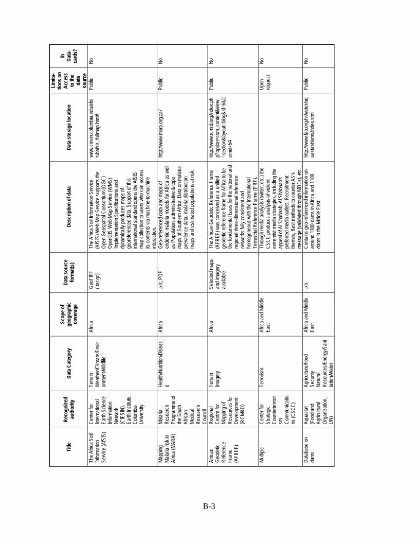
B-3
Title
Re
cogn
ized
auth
ority
Da
ta C
ateg
ory
Scop
e of
geog
raph
ic co
vera
ge
Data
sour
ce
form
at(s
) De
scrip
tion
of d
ata
Data
stor
age l
ocat
ion
Lim
ita-
tions
on
Acce
ss
to th
e da
ta
sour
ce
In
Data
-ca
rds?
The A
frica S
oil
Infor
matio
n Se
rvice
(AfS
IS)
Cente
r for
Int
erna
tiona
l Ea
rth S
cienc
e Inf
orma
tion
Netw
ork
(CIE
SIN)
, Ea
rth In
stitut
e, Co
lumbia
Un
iversi
ty
Terra
in W
eathe
r/Clim
ate/E
nvir
onme
nt/W
ildlife
Afric
a Ge
oTIF
F (.t
ar.gz
) Th
e Afric
a Soil
Infor
matio
n Ser
vice
(AfS
IS) W
eb M
ap S
ervic
e sup
ports
the
Open
Geo
spati
al Co
nsor
tium
(OGC
) Op
enGI
S W
eb M
ap S
ervic
e (W
MS)
Imple
menta
tion S
pecif
icatio
ns an
d dy
nami
cally
prod
uces
map
s of
geor
efere
nced
data.
Sup
port
of thi
s int
erna
tiona
l stan
dard
open
s the
AfS
IS
map c
ollec
tion t
o use
rs wh
o can
acce
ss
its co
ntents
via m
achin
e-to-
mach
ine
inter
actio
n.
www.
ciesin
.colum
bia.ed
u/afsi
s/bafs
is_ful
lmap
.htm#
Publi
c No
Mapp
ing
Malar
ia ris
k in
Afric
a (MA
RA)
Malar
ia Re
sear
ch
Prog
ramm
e of
the S
outh
Afric
an
Medic
al Re
sear
ch
Coun
cil
Healt
h/Nutr
ition/D
iseas
e Af
rica
.xls,
Geo-
refer
ence
d data
and m
aps o
f en
demi
c mala
ria m
odels
for A
frica a
s well
as
Pop
ulatio
n, ad
minis
trativ
e & to
po
maps
of S
outhe
rn A
frica.
Data
on m
alaria
pr
evale
nce d
ata, m
alaria
distr
ibutio
n ma
ps an
d esti
mated
popu
lation
s at r
isk.
http:/
/www
.mar
a.org
.za/
Publi
c No
Afric
an
Geod
etic
Refer
ence
Fr
ame
(AFR
EF)
Regio
nal
Centr
e for
Ma
pping
of
Reso
urce
s for
De
velop
ment
(RCM
RD)
Terra
in Im
ager
y Af
rica
Selec
ted m
aps
and i
mage
ry av
ailab
le
The A
frican
Geo
detic
Refe
renc
e Fra
me
(AFR
EF) w
as co
nceiv
ed as
a un
ified
geod
etic r
efere
nce f
rame
for A
frica t
o be
the fu
ndam
ental
basis
for t
he na
tiona
l and
re
giona
l thre
e-dim
ensio
nal re
feren
ce
netw
orks
fully
cons
isten
t and
ho
moge
neou
s with
the I
ntern
ation
al Te
rrestr
ial R
efere
nce F
rame
(ITR
F).
http:/
/www
.rcmr
d.org
/inde
x.ph
p?op
tion=
com_
conte
nt&vie
w=s
ectio
n&lay
out=
blog&
id=6&
Item
id=54
Publi
c No
Multip
le Ce
nter f
or
Stra
tegic
Coun
terter
rori
sm
Comm
unica
tions
(CSC
C)
Terro
rism
Afric
a and
Midd
le Ea
st
Thro
ugh m
edia
analy
sis (t
witte
r, etc
.) the
CS
CC pr
oduc
es an
alysis
of vi
olent
extre
mist
media
stra
tegies
, inclu
ding t
he
appe
al of
Al S
haba
ab, A
l Sha
baab
's pr
eferre
d med
ia ou
tlets,
Rec
ruitm
ent
theme
s, Be
st me
thods
to co
unter
AS’
s me
ssag
e (va
lidate
d thr
ough
MOE
s), et
c.
Up
on
requ
est
No
Datab
ase o
n da
ms
Aqua
stat
(Foo
d and
Ag
ricult
ural
Orga
nizati
on,
UN)
Agric
ultur
e/Foo
d Se
curity
Na
tural
Reso
urce
s/Ene
rgy/S
ani
tation
/Wate
r
Afric
a and
Midd
le Ea
st .xl
s Co
ntains
geo-
refer
ence
d info
rmati
on on
ar
ound
1300
dams
in A
frica a
nd 11
00
dams
in th
e Midd
le Ea
st
http:/
/www
.fao.o
rg/nr
/wate
r/aq
uasta
t/dam
s/ind
ex.st
m Pu
blic
No

B-4
Title
Re
cogn
ized
auth
ority
Da
ta C
ateg
ory
Scop
e of
geog
raph
ic co
vera
ge
Data
sour
ce
form
at(s
) De
scrip
tion
of d
ata
Data
stor
age l
ocat
ion
Lim
ita-
tions
on
Acce
ss
to th
e da
ta
sour
ce
In
Data
-ca
rds?
Inter
natio
nal
Politi
cal
Inter
actio
ns
(IPI)
Proje
ct
Vi
olenc
e/Sec
urity
Mi
litary
Oper
ation
s/Acti
vities
/Cap
abilit
ies
Afric
a: Ni
geria
, De
mocra
tic
Repu
blic o
f Co
ngo,
Zimba
bwe
Asia:
Indo
nesia
, Pa
kistan
, Sou
th Ko
rea
Latin
Ame
rica:
Arge
ntina
, Bra
zil,
Chile
, Colo
mbia,
Me
xico,
Vene
zuela
Eu
rope
: Belg
ium,
Hung
ary
.csv,
.xls
The I
PI pr
oject
was d
esign
ed to
mea
sure
po
litica
l con
flict a
nd co
oper
ation
with
in so
cietie
s thr
ough
the c
oding
of po
litica
l ev
ent r
epor
ts fro
m int
erna
tiona
l, reg
ional,
an
d loc
al so
urce
s. Th
ese e
vents
wer
e co
ded o
n two
ten p
oint s
cales
whic
h re
flect
the se
verity
of va
rious
coop
erati
ve
and c
onflic
ting s
tatem
ents
and a
ction
s. Th
is sc
aled e
vents
data
can b
e use
d to
calcu
late t
he vo
lume a
nd in
tensit
y of
politi
cal c
onflic
t and
coop
erati
on w
ithin
the do
mesti
c poli
ty. In
addit
ion to
fac
ilitati
ng th
e calc
ulatio
n of g
ener
al lev
els of
politi
cal c
onflic
t, the
IPI c
oding
sc
heme
allow
s the
exam
inatio
n of th
e dy
nami
cs of
inter
actio
n amo
ng sp
ecific
gr
oups
with
in the
socie
ty. IP
I give
s sc
holar
s the
abilit
y to t
rack
inter
actio
ns
amon
g soc
ial gr
oups
and b
etwee
n the
sta
te an
d soc
ial gr
oups
.
http:/
er.fs
u.edu
/~wh
moor
e/gar
net-
whmo
ore/i
pi/ca
ses.h
tml
Publi
c No
State
De
partm
ent
Surve
ys
Offic
e of
Opini
on
Rese
arch
(O
OR),
U.S.
De
partm
ent o
f St
ate
Publi
c Per
cepti
on /
Atmo
sphe
rics
As re
ques
ted
OOR
colle
cts op
inion
data
world
wide
and
has t
hree
analy
sts de
dicate
d to s
ub-
Saha
ran A
frica.
Quan
titativ
e and
qu
alitat
ive da
ta ar
e coll
ected
and O
OR
has r
ecen
tly be
gun s
ome e
ditor
ial op
inion
an
alysis
of lo
cal n
ews s
ource
s. Tim
e ran
ge is
snap
shots
. How
ever
, ther
e ar
e cer
tain q
uesti
ons w
hich a
re in
clude
d in
most
surve
ys, w
hich a
ddre
ss:
perce
ption
s of th
e U.S
., the
mos
t urg
ent
issue
in a
given
coun
try (a
nswe
r is th
e ec
onom
y), et
hnic
toler
ance
, amo
ng
other
s. Th
ese a
re ty
picall
y ask
ed on
an
annu
al ba
sis, o
r how
ever
often
OOR
co
nduc
ts re
sear
ch in
that
coun
try. A
s su
ch, th
ey ar
e able
to in
fer so
me ge
nera
l tre
nds i
n opin
ion, b
ut the
ir meth
odolo
gy
for co
llecti
ng th
ese d
ata ar
e not
near
ly as
rig
orou
s as G
allup
.
OOR'
s gov
ernm
ent w
ebsit
e.
“Opin
ion
Analy
sis”
avail
able
to US
G on
re
ques
t. Ra
w da
ta no
t av
ailab
le du
e to
licen
sing
restr
ictio
ns bu
t ex
cerp
ts an
d an
alysis
av
ailab
le on
re
ques
t.
No
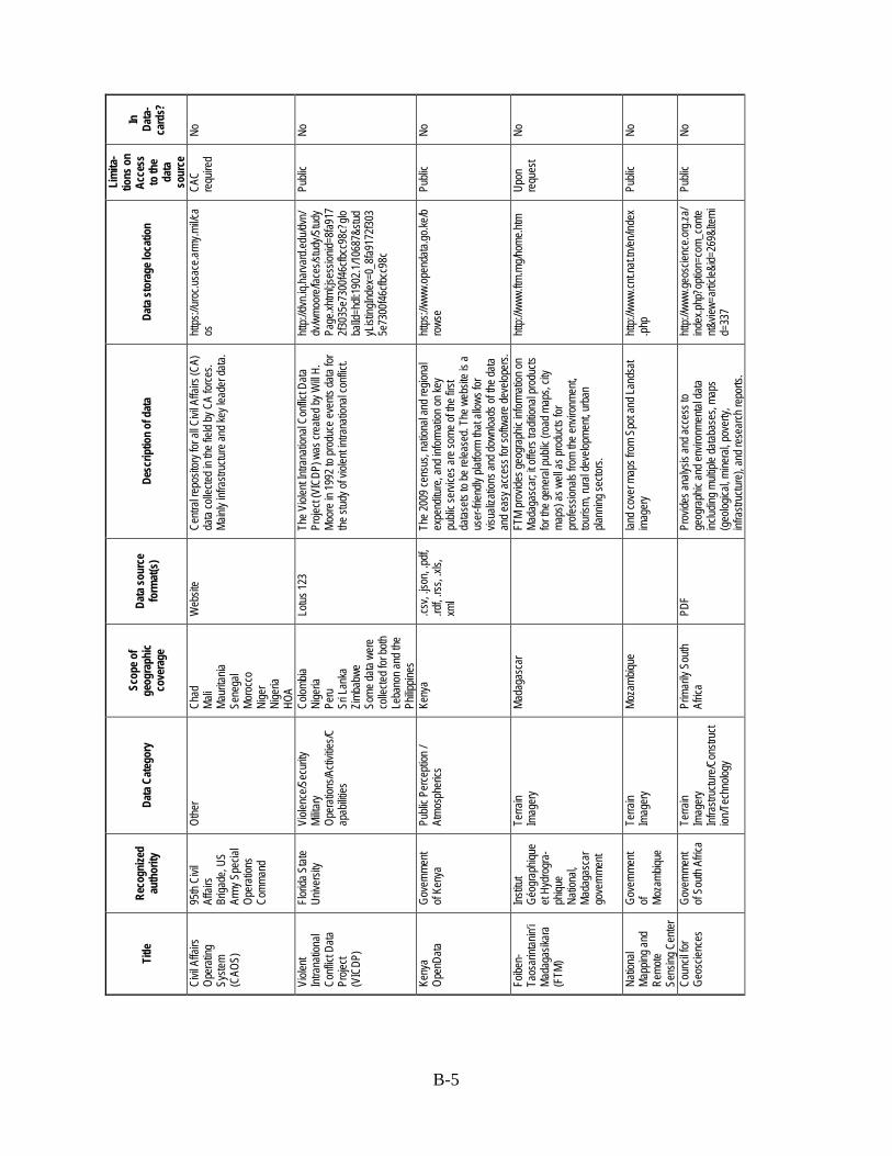
B-5
Title
Re
cogn
ized
auth
ority
Da
ta C
ateg
ory
Scop
e of
geog
raph
ic co
vera
ge
Data
sour
ce
form
at(s
) De
scrip
tion
of d
ata
Data
stor
age l
ocat
ion
Lim
ita-
tions
on
Acce
ss
to th
e da
ta
sour
ce
In
Data
-ca
rds?
Civil
Affa
irs
Oper
ating
Sy
stem
(CAO
S)
95th
Civil
Af
fairs
Briga
de, U
S Ar
my S
pecia
l Op
erati
ons
Comm
and
Othe
r Ch
ad
Mali
Maur
itania
Se
nega
l Mo
rocc
o Ni
ger
Nige
ria
HOA
Web
site
Centr
al re
posit
ory f
or al
l Civi
l Affa
irs (C
A)
data
colle
cted i
n the
field
by C
A for
ces.
Mainl
y infr
astru
cture
and k
ey le
ader
data.
https
://uro
c.usa
ce.ar
my.m
il/ca
os
CAC
requ
ired
No
Viole
nt Int
rana
tiona
l Co
nflict
Data
Pr
oject
(VIC
DP)
Florid
a Stat
e Un
iversi
ty Vi
olenc
e/Sec
urity
Mi
litary
Oper
ation
s/Acti
vities
/Cap
abilit
ies
Colom
bia
Nige
ria
Peru
Sr
i Lan
ka
Zimba
bwe
Some
data
were
co
llecte
d for
both
Leba
non a
nd th
e Ph
ilippin
es
Lotus
123
The V
iolen
t Intra
natio
nal C
onflic
t Data
Pr
oject
(VIC
DP) w
as cr
eated
by W
ill H.
Mo
ore i
n 199
2 to p
rodu
ce ev
ents
data
for
the st
udy o
f viol
ent in
trana
tiona
l con
flict.
http:/
/dvn.i
q.har
vard
.edu/d
vn/
dv/w
moor
e/fac
es/st
udy/S
tudy
Page
.xhtm
l;jses
sionid
=8fa9
172f3
035e
7300
f46cfb
cc98
c?glo
balId
=hdl:
1902
.1/10
687&
stud
yList
ingInd
ex=0
_8fa9
172f3
035e
7300
f46cfb
cc98
c
Publi
c No
Keny
a Op
enDa
ta Go
vern
ment
of Ke
nya
Publi
c Per
cepti
on /
Atmo
sphe
rics
Keny
a .cs
v, .js
on, .p
df,
.rdf, .
rss, .x
ls,
xml
The 2
009 c
ensu
s, na
tiona
l and
regio
nal
expe
nditu
re, a
nd in
forma
tion o
n key
pu
blic s
ervic
es ar
e som
e of th
e firs
t da
tasets
to be
relea
sed.
The w
ebsit
e is a
us
er-fr
iendly
platf
orm
that a
llows
for
visua
lizati
ons a
nd do
wnloa
ds of
the d
ata
and e
asy a
cces
s for
softw
are d
evelo
pers.
https
://www
.open
data.
go.ke
/bro
wse
Publi
c No
Foibe
n-Ta
osar
intan
in’i
Mada
gasik
ara
(FTM
)
Institu
t Gé
ogra
phiqu
e et
Hydr
ogra
- ph
ique
Natio
nal,
Mada
gasc
ar
gove
rnme
nt
Terra
in Im
ager
y Ma
daga
scar
FTM
prov
ides g
eogr
aphic
infor
matio
n on
Mada
gasc
ar; it
offer
s tra
dition
al pr
oduc
ts for
the g
ener
al pu
blic (
road
map
s, cit
y ma
ps) a
s well
as pr
oduc
ts for
pr
ofess
ionals
from
the e
nviro
nmen
t, tou
rism,
rura
l dev
elopm
ent, u
rban
pla
nning
secto
rs.
http:/
/www
.ftm.m
g/hom
e.htm
Up
on
requ
est
No
Natio
nal
Mapp
ing an
d Re
mote
Sens
ing C
enter
Gove
rnme
nt of Mo
zamb
ique
Terra
in Im
ager
y Mo
zamb
ique
lan
d cov
er m
aps f
rom
Spot
and L
ands
at im
ager
y htt
p://w
ww.cn
t.nat.
tn/en
/inde
x.ph
p Pu
blic
No
Coun
cil fo
r Ge
oscie
nces
Go
vern
ment
of So
uth A
frica
Terra
in Im
ager
y Inf
rastr
uctur
e/Con
struc
tion
/Tec
hnolo
gy
Prim
arily
Sou
th Af
rica
Prov
ides a
nalys
is an
d acc
ess t
o ge
ogra
phic
and e
nviro
nmen
tal da
ta inc
luding
mult
iple d
ataba
ses,
maps
(g
eolog
ical, m
inera
l, pov
erty,
inf
rastr
uctur
e), a
nd re
sear
ch re
ports
.
http:/
/www
.geos
cienc
e.org
.za/
index
.php?
optio
n=co
m_co
ntent&
view=
artic
le&id=
269&
Itemi
d=33
7
Publi
c No
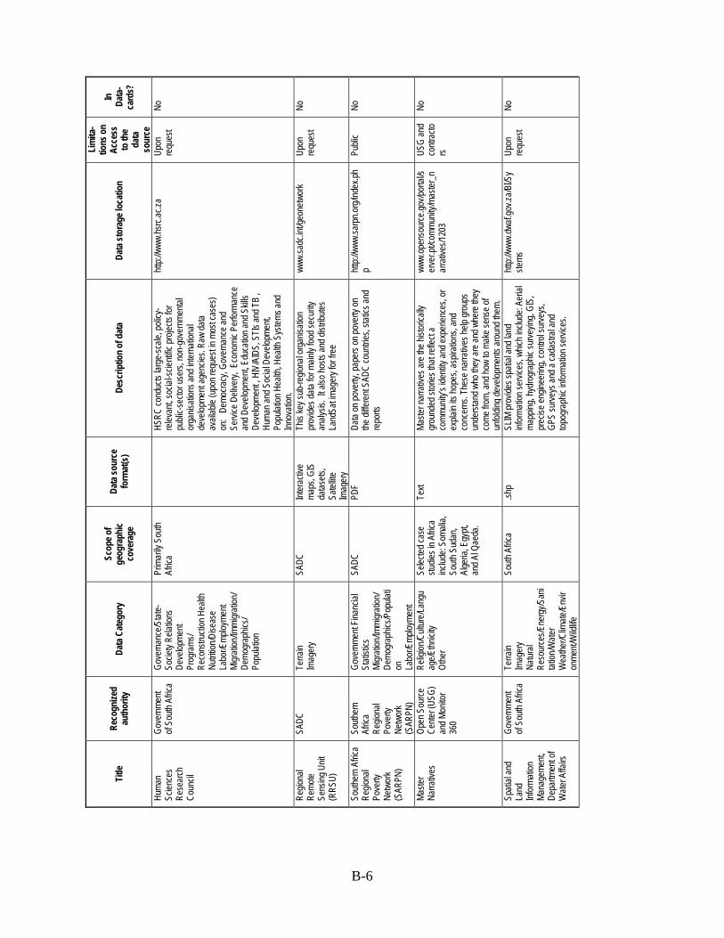
B-6
Title
Re
cogn
ized
auth
ority
Da
ta C
ateg
ory
Scop
e of
geog
raph
ic co
vera
ge
Data
sour
ce
form
at(s
) De
scrip
tion
of d
ata
Data
stor
age l
ocat
ion
Lim
ita-
tions
on
Acce
ss
to th
e da
ta
sour
ce
In
Data
-ca
rds?
Huma
n Sc
ience
s Re
sear
ch
Coun
cil
Gove
rnme
nt of
South
Afric
a Go
vern
ance
/Stat
e-So
ciety
Relat
ions
Deve
lopme
nt Pr
ogra
ms/
Reco
nstru
ction
Hea
lth
Nutrit
ion/D
iseas
e La
bor/E
mploy
ment
Migr
ation
/Immi
grati
on/
Demo
grap
hics/
Popu
lation
Prim
arily
Sou
th Af
rica
HS
RC co
nduc
ts lar
ge-sc
ale, p
olicy
-re
levan
t, soc
ial-sc
ientifi
c pro
jects
for
publi
c-sec
tor us
ers,
non-
gove
rnme
ntal
orga
nisati
ons a
nd in
terna
tiona
l de
velop
ment
agen
cies.
Raw
data
avail
able
(upo
n req
uest
in mo
st ca
ses)
on:
Demo
cracy
, Gov
erna
nce a
nd
Servi
ce D
elive
ry, E
cono
mic P
erfor
manc
e an
d Dev
elopm
ent, E
duca
tion a
nd S
kills
Deve
lopme
nt , H
IV/A
IDS,
STI
s and
TB
, Hu
man a
nd S
ocial
Dev
elopm
ent,
Popu
lation
Hea
lth, H
ealth
Sys
tems a
nd
Innov
ation
.
http:/
/www
.hsrc.
ac.za
Up
on
requ
est
No
Regio
nal
Remo
te Se
nsing
Unit
(R
RSU)
SADC
Te
rrain
Imag
ery
SADC
Int
erac
tive
maps
, GIS
da
tasets
, Sa
tellite
Im
ager
y
This
key s
ub-re
giona
l org
anisa
tion
prov
ides d
ata fo
r main
ly foo
d sec
urity
an
alysis
. It a
lso ho
sts an
d dist
ribute
s La
ndSa
t imag
ery f
or fr
ee
www.
sadc
.int/g
eone
twor
k Up
on
requ
est
No
South
ern A
frica
Regio
nal
Pove
rty
Netw
ork
(SAR
PN)
South
ern
Afric
a Re
giona
l Po
verty
Ne
twor
k (S
ARPN
)
Gove
rnme
nt Fin
ancia
l St
atisti
cs
Migr
ation
/Immi
grati
on/
Demo
grap
hics/P
opula
tion
La
bor/E
mploy
ment
SADC
PD
F Da
ta on
pove
rty, p
aper
s on p
over
ty on
the
diffe
rent
SADC
coun
tries,
static
s and
re
ports
http:/
/www
.sarp
n.org
/inde
x.ph
p Pu
blic
No
Maste
r Na
rrativ
es
Open
Sou
rce
Cente
r (US
G)
and M
onito
r 36
0
Relig
ion/C
ultur
e/Lan
guag
e/Ethn
icity
Othe
r
Selec
ted ca
se
studie
s in A
frica
includ
e: So
malia
, So
uth S
udan
, Al
geria
, Egy
pt,
and A
l Qae
da.
Text
Maste
r nar
rativ
es ar
e the
histo
ricall
y gr
ound
ed st
ories
that
refle
ct a
comm
unity
’s ide
ntity
and e
xper
ience
s, or
ex
plain
its ho
pes,
aspir
ation
s, an
d co
ncer
ns. T
hese
narra
tives
help
grou
ps
unde
rstan
d who
they
are a
nd w
here
they
co
me fr
om, a
nd ho
w to
make
sens
e of
unfol
ding d
evelo
pmen
ts ar
ound
them
.
www.
open
sour
ce.go
v/por
tal/s
erve
r.pt/c
ommu
nity/m
aster
_nar
rativ
es/12
03
USG
and
contr
acto
rs
No
Spati
al an
d La
nd
Infor
matio
n Ma
nage
ment,
De
partm
ent o
f W
ater A
ffairs
Gove
rnme
nt of
South
Afric
a Te
rrain
Imag
ery
Natur
al Re
sour
ces/E
nerg
y/San
itat
ion/W
ater
Wea
ther/C
limate
/Env
iron
ment/
Wild
life
South
Afric
a .sh
p SL
IM pr
ovide
s spa
tial a
nd la
nd
infor
matio
n ser
vices
, whic
h inc
lude:
Aeria
l ma
pping
, hyd
rogr
aphic
surve
ying,
GIS,
pr
ecise
engin
eerin
g, co
ntrol
surve
ys,
GPS
surve
ys an
d a ca
dastr
al an
d top
ogra
phic
infor
matio
n ser
vices
.
http:/
/www
.dwaf.
gov.z
a/BI/S
yste
ms
Upon
re
ques
t No

B-7
Title
Re
cogn
ized
auth
ority
Da
ta C
ateg
ory
Scop
e of
geog
raph
ic co
vera
ge
Data
sour
ce
form
at(s
) De
scrip
tion
of d
ata
Data
stor
age l
ocat
ion
Lim
ita-
tions
on
Acce
ss
to th
e da
ta
sour
ce
In
Data
-ca
rds?
South
Afric
an
boun
darie
s Mu
nicipa
l De
marca
tion
Boar
d, Go
vern
ment
of So
uth
Afric
an
Othe
r (ad
minis
trativ
e bo
unda
ries)
South
Afric
a Go
ogle
earth
file
s, PD
F W
ard,
distric
t, mun
icipa
l, and
prov
incial
bo
unda
ries.
http:/
/www
.dema
rcatio
n.org
.za
Publi
c No
Tanz
ania'
a So
cio
Econ
omic
Datab
ase
Natio
nal
Bure
au of
St
atisti
cs,
Gove
rnme
nt of
Tanz
ania
Migr
ation
/Immi
grati
on/
Demo
grap
hics/P
opula
tion
La
bor/E
mploy
ment
Tanz
ania
TS
ED is
a co
mpre
hens
ive so
cio-
econ
omic
datab
ase s
ystem
whe
re th
e da
ta is
orga
nized
by se
ctors
and t
heme
s an
d pro
vides
upda
ted tim
e-se
ries a
s well
as
mult
iple e
stima
tes fr
om va
rious
so
urce
s, dis
aggr
egate
d data
down
to
distric
t, War
d, Vi
llage
leve
l, by s
ex an
d ur
ban/r
ural
strata
whe
reve
r the
se ar
e av
ailab
le. T
SED
also a
llows
for u
ser-
friend
ly an
alysis
, thro
ugh t
able,
grap
h and
ma
p opti
ons a
nd pr
ovide
s an o
ppor
tunity
to
calcu
late c
ompo
site i
ndice
s.
http:/
/www
.tsed
.org/h
ome.a
spx
Publi
c No
The P
enn
State
Eve
nt Da
ta Pr
oject
(For
merly
Ka
nsas
Eve
nt Da
ta Sy
stem
(KED
S))
Penn
Stat
e Vi
olenc
e/Sec
urity
Mi
litary
Oper
ation
s/ Ac
tivitie
s/ Ca
pabil
ities
Wor
ldwide
Nomi
nal o
r ord
inal c
odes
reco
rding
the
inter
actio
ns be
twee
n inte
rnati
onal
actor
s),
proje
ct pa
pers.
http:/
/even
tdata.
psu.e
du/da
ta.htm
l Pu
blic
No
Wor
ld Po
ll Ga
llup
Publi
c Per
cepti
on /
Atmo
sphe
rics
Wor
ldwide
Colle
cts ba
sic da
ta on
law
and o
rder
, food
an
d she
lter,
institu
tions
and i
nfras
tructu
re,
jobs,
well-b
eing a
nd br
ain ga
in.
Addit
ional
Afric
a-or
iented
surve
y.
Da
taset
file
avail
able
at co
st
No
Glob
al La
nd
Grab
s Data
set
GRAI
N La
nd O
wner
ship/
Real
Estat
e W
orldw
ide
.xls
This
datas
et do
cume
nts 41
6 rec
ent,
large
-scale
land
grab
s by f
oreig
n inv
estor
s for
the p
rodu
ction
of fo
od cr
ops.
The c
ases
cove
r nea
rly 35
milli
on
hecta
res o
f land
in 66
coun
tries.
http:/
/www
.grain
.org/a
rticle/
entrie
s/447
9-gr
ain-re
lease
s-da
ta-se
t-with
-ove
r-400
-glob
al-lan
d-gr
abs
Publi
c No
Findin
gs on
the
Wor
st Fo
rms o
f Ch
ild La
bor
U.S.
De
partm
ent o
f St
ate
Blac
k Ma
rkets/
Traff
icking
(D
rug/A
rms/H
uman
)/ Pr
ostitu
tion
Wor
ldwide
PD
F Th
e rep
ort c
over
s 144
coun
tries a
nd
territo
ries a
nd pr
ovide
s info
rmati
on on
wo
rst fo
rms o
f chil
d lab
or in
good
s and
se
rvice
s, as
well
as in
forma
tion o
n co
untry
effor
ts, in
cludin
g law
s, en
force
ment,
polic
ies an
d pro
gram
s. In
2009
, the r
epor
t beg
an to
offer
findin
gs
and r
ecom
mend
ed ac
tions
to pr
even
t or
redu
ce th
e wor
st for
ms of
child
labo
r.
http:/
/www
.dol.g
ov/ila
b/pro
gra
ms/oc
ft/tda
.htm
Publi
c No

B-8
Title
Re
cogn
ized
auth
ority
Da
ta C
ateg
ory
Scop
e of
geog
raph
ic co
vera
ge
Data
sour
ce
form
at(s
) De
scrip
tion
of d
ata
Data
stor
age l
ocat
ion
Lim
ita-
tions
on
Acce
ss
to th
e da
ta
sour
ce
In
Data
-ca
rds?
Gatew
ay to
La
nd an
d W
ater
Infor
matio
n
Asia-
Pacif
ic Ne
twor
k on
Integ
rated
Pl
ant N
utrien
t Ma
nage
ment
(API
PNM)
Terra
in Na
tural
Reso
urce
s/Ene
rgy/
Sanit
ation
/Wate
r
Wor
ldwide
The p
urpo
se of
Gate
way i
s to p
rovid
e inf
orma
tion o
n the
sta
te, co
nditio
n and
tren
ds of
rura
l land
an
d wate
r res
ource
s at
natio
nal, r
egion
al an
d glob
al sc
ales.
This
netw
ork e
ssen
tially
cons
ists o
f land
an
d wate
r “re
ports
”. Re
ports
are c
ompil
ed at
diffe
rent
levels
(g
lobal,
regio
nal, n
ation
al, an
d sub
-na
tiona
l) and
are l
inked
toge
ther a
s par
t of
a glob
al sy
stem
of inf
orma
tion o
n the
Int
erne
t. Gate
way a
cts as
clea
ringh
ouse
an
d fac
ilitato
r, pr
ovidi
ng a
usefu
l entr
y po
int fo
r land
and w
ater in
forma
tion,
includ
ing F
AO’s
datab
ases
on S
oil, A
gro-
ecolo
gical
Zone
, Fer
tilize
r and
W
ater/I
rriga
tion (
AQUA
STAT
).
http:/
/www
.apipn
m.or
g/swl
wpnr
/repo
rts/rc
_cod
es.ht
m#sf
Publi
c No
Inter
net D
ata
Sour
ces f
or
Socia
l Sc
ientis
ts
Data
War
ehou
se /
Repo
sitor
y
Porta
l for s
ocial
sc
ience
data
Wor
ldwide
The C
ISER
Data
Arch
ive m
aintai
ns a
colle
ction
of so
cial a
nd ec
onom
ic da
tasets
, abo
ut 27
,000 o
nline
files
and
thous
ands
of st
udies
on C
D-RO
Ms an
d DV
Ds. I
t's a
centr
alize
d sou
rce fo
r nu
meric
data
files:
their a
cquis
ition,
stora
ge, m
ainten
ance
, and
use.
We
supp
ort th
e res
earch
activ
ities o
f soc
ial
scien
ce fa
culty
, stud
ents,
and s
taff a
t Co
rnell
Univ
ersit
y. T
he co
llecti
on
includ
es fe
dera
l or s
tate c
ensu
ses,
files
base
d on a
dmini
strati
ve re
cord
s, pu
blic
opini
on su
rveys
, eco
nomi
c and
socia
l da
ta fro
m na
tiona
l and
inter
natio
nal
orga
nizati
ons,
and s
tudies
comp
iled b
y ind
ividu
al re
sear
cher
s.
www.
ciser
.corn
ell.ed
u/ASP
s/data
sour
ce.as
p Pu
blic
No
Crow
dvoic
e Cr
owds
ource
d Ci
vil S
ociet
y/Non
-Go
vern
menta
l Or
ganiz
ation
s Ci
vil S
trife/P
rotes
ts Mi
grati
on/Im
migr
ation
/De
mogr
aphic
s/Pop
ulati
on
Child
ren/Y
outh
Othe
r
Wor
ldwide
W
ebsit
e Cr
owdV
oice i
s a us
er-p
ower
ed se
rvice
tha
t trac
ks vo
ices o
f pro
test fr
om ar
ound
the
wor
ld by
crow
dsou
rcing
infor
matio
n.
www.
crowd
voice
.org/
Publi
c No

B-9
Title
Re
cogn
ized
auth
ority
Da
ta C
ateg
ory
Scop
e of
geog
raph
ic co
vera
ge
Data
sour
ce
form
at(s
) De
scrip
tion
of d
ata
Data
stor
age l
ocat
ion
Lim
ita-
tions
on
Acce
ss
to th
e da
ta
sour
ce
In
Data
-ca
rds?
Datab
ase o
f W
orld
Rive
rs an
d the
ir Se
dimen
t Yi
elds
Aqua
stat
(Foo
d and
Ag
ricult
ural
Orga
nizati
on,
UN)
Agric
ultur
e/Foo
d Se
curity
Na
tural
Reso
urce
s/Ene
rgy/S
ani
tation
/Wate
r
Wor
ldwide
.xl
s Th
is da
tabas
e con
tains
data
on an
nual
sedim
ent y
ields
in w
orldw
ide riv
ers a
nd
rese
rvoirs
, sea
rchab
le by
river
, cou
ntry
and c
ontin
ent.
The d
ataba
se w
as co
mpile
d fro
m dif
feren
t so
urce
s by H
R W
alling
ford,
UK, o
n beh
alf
of the
FAO
Land
and W
ater D
evelo
pmen
t Di
vision
.
http:/
/www
.fao.o
rg/nr
/wate
r/aq
uasta
t/sed
imen
t/inde
x.asp
Publi
c No
Earth
Tre
nds
Wor
ld Re
sour
ces
Institu
te
Agric
ultur
e/Foo
d Se
curity
Na
tural
Reso
urce
s/Ene
rgy/S
ani
tation
/Wate
r
Wor
ldwide
Earth
Tren
ds is
a co
mpre
hens
ive on
line
datab
ase,
maint
ained
by th
e Wor
ld Re
sour
ces I
nstitu
te, th
at foc
uses
on th
e en
viron
menta
l, soc
ial, a
nd ec
onom
ic tre
nds t
hat s
hape
our w
orld
www.
wri.o
rg/pu
blica
tions
/data
-sets
Publi
c No
Marin
e Cor
ps
Coun
try
Hand
book
s
Marin
e Cor
ps
Intell
igenc
e Ac
tivity
(M
CIA)
Gove
rnan
ce/S
tate-
Socie
ty Re
lation
s Re
ligion
/Cult
ure/
Lang
uage
/Ethn
icity
Milita
ry Op
erati
ons/A
ctivit
ies/
Capa
bilitie
s Ec
onom
ics/B
ankin
g/ Fin
ance
Mi
grati
on/Im
migr
ation
/De
mogr
aphic
s/ Po
pulat
ion
Wor
ldwide
W
ebsit
e Ha
ndbo
oks p
rovid
e bas
ic re
feren
ce
infor
matio
n on c
ounti
es, in
cludin
g ge
ogra
phy,
histor
y, go
vern
ment,
milit
ary
force
s, an
d com
munic
ation
s and
tra
nspo
rtatio
n netw
orks
. This
infor
matio
n is
inten
ded t
o fam
iliariz
e milit
ary
perso
nnel
with
local
custo
ms an
d are
a kn
owled
ge to
assis
t them
durin
g the
ir as
signm
ents
over
seas
.
https
://www
.intel
ink.go
v/mcia
/ha
ndbo
ok.ht
m US
G an
d co
ntrac
-tor
s
No
Quali
ty of
Elec
tions
Da
taset
(QED
)
Duke
Un
iversi
ty Po
litics
/Voti
ng/
Elec
tions
W
orldw
ide
SAS,
SPS
S,
Stata
, ASC
II. Th
is da
ta se
t cod
es th
e qua
lity of
natio
nal
level
legisl
ative
and p
resid
entia
l elec
tions
in
172 c
ountr
ies fr
om 19
78 to
2004
. The
ov
erall
elec
tion q
uality
varia
bles a
s well
as
the s
even
categ
ories
of vi
olenc
e and
irr
egula
rities
in th
e pre
-elec
tion p
eriod
an
d on E
lectio
n Day
are t
he sa
me
categ
ories
as w
ere a
lso co
ded i
n the
DI
EM da
ta se
t.
http:/
/sites
.duke
.edu/k
elley
/data/
Publi
c No
The P
ost-
Inter
nal W
ar
Acco
mmod
a-tio
n and
Re
pres
sion
(PIW
AR) D
ata
Proje
ct Pa
ge
Colle
ge of
W
ooste
r Vi
olenc
e/Sec
urity
Mi
litary
Oper
ation
s/Acti
vities
/ Ca
pabil
ities
Wor
ldwide
.xl
s Pr
ovide
s data
on ac
comm
odati
on,
repr
essio
n, op
posit
ion ac
tivity
, ethn
ic fra
ction
aliza
tion a
nd ot
her c
onflic
t data
.
http:/
/www
3.woo
ster.e
du/po
lisci/
mkra
in/PI
WAR
.html
Publi
c No

B-10
Title
Re
cogn
ized
auth
ority
Da
ta C
ateg
ory
Scop
e of
geog
raph
ic co
vera
ge
Data
sour
ce
form
at(s
) De
scrip
tion
of d
ata
Data
stor
age l
ocat
ion
Lim
ita-
tions
on
Acce
ss
to th
e da
ta
sour
ce
In
Data
-ca
rds?
Elec
toral
Comm
ission
of
Zamb
ia
Gove
rnme
nt of
Zamb
ia Po
litics
/Voti
ng/
Elec
tions
Za
mbia
Zamb
ian el
ectio
n res
ults i
nclud
ing:
• Pu
blic N
otice
- Pr
eside
ntial
Elec
tion
Resu
lt •
Publi
c Noti
ce -
Natio
nal A
ssem
bly
Elec
tions
Res
ults
• Su
mmar
y - A
lloca
tion o
f Nati
onal
Asse
mbly
Seats
•
List o
f Elec
ted M
Ps
• 20
11 LG
E Re
sults
•
2011
Sum
mary
of Al
locati
on of
Loca
l Go
vern
ment
Seats
•
2011
Cer
tified
Reg
ister
of V
oters
http:/
/www
.elec
tions
.org.z
m/in
dex.p
hp
Publi
c No
Natio
nal W
ater
Supp
ly an
d Sa
nitati
on
Coun
cil
Gove
rnme
nt of
Zamb
ia Na
tural
Reso
urce
s/Ene
rgy/S
ani
tation
/Wate
r
Zamb
ia PD
F Re
sear
ch-b
ased
repo
rts on
the Z
ambia
n wa
ter se
ctor
http:/
/www
.nwas
co.or
g.zm/
index
.php
Publi
c No
Zimba
bwe
Admi
nistra
tive
Boun
darie
s
Gove
rnme
nt of
Zimba
bwe
Othe
r (ad
minis
trativ
e bo
unda
ries)
Zimba
bwe
ArcIn
fo Zim
babw
e Adm
inistr
ative
Bou
ndar
ies
http:/
/www
.grida
.no/pr
og/gl
obal/
cgiar
/dif/G
NVd1
129.h
tm
Upon
re
ques
t No
Natur
al (A
gro-
Ecolo
gical)
re
gions
of
Zimba
bwe
Gove
rnme
nt of
Zimba
bwe
Natur
al Re
sour
ces/E
nerg
y/San
itat
ion/W
ater
Wea
ther/C
limate
/Env
iron
ment/
Wild
life
Zimba
bwe
ArcIn
fo Na
tural
(Agr
o-Ec
ologic
al) re
gions
of
Zimba
bwe
http:/
/www
.grida
.no/pr
og/gl
obal/
cgiar
/dif/G
NVd1
128.h
tm
Upon
re
ques
t No
Arme
d Con
flict
Loca
tion a
nd
Even
t Data
set
(ACL
ED)
Trini
ty Co
llege
Vi
olenc
e/Sec
urity
50
deve
loping
co
untrie
s .xl
s Th
ese d
ata co
ntain
infor
matio
n on:
• Da
tes an
d loc
ation
s of c
onflic
t eve
nts,
• Sp
ecific
type
s of e
vents
inclu
ding
battle
s, civ
ilian k
illing
s, rio
ts, pr
otests
an
d rec
ruitm
ent a
ctivit
ies
• Ev
ents
by a
rang
e of a
ctors,
inclu
ding
rebe
ls, go
vern
ments
, milit
ias, a
rmed
gr
oups
, pro
tester
s and
civil
ians;
• Ch
ange
s in t
errito
rial c
ontro
l •
Fatal
ities
www.
acled
data.
com/
trend
s Pu
blic
Yes

B-11
Title
Re
cogn
ized
auth
ority
Da
ta C
ateg
ory
Scop
e of
geog
raph
ic co
vera
ge
Data
sour
ce
form
at(s
) De
scrip
tion
of d
ata
Data
stor
age l
ocat
ion
Lim
ita-
tions
on
Acce
ss
to th
e da
ta
sour
ce
In
Data
-ca
rds?
Afro
baro
meter
Af
roba
rome
ter
Publi
c Per
cepti
on /
Atmo
sphe
rics
Afric
a Sp
read
shee
t W
eb-b
ased
St
atisti
cal
softw
are
The A
froba
rome
ter is
an in
depe
nden
t, no
npar
tisan
rese
arch
proje
ct tha
t me
asur
es th
e soc
ial, p
olitic
al, an
d ec
onom
ic atm
osph
ere i
n Afric
a. Af
roba
rome
ter su
rveys
are c
ondu
cted i
n mo
re th
an a
doze
n Afric
an co
untrie
s and
ar
e rep
eated
on a
regu
lar cy
cle. B
ecau
se
the in
strum
ent a
sks a
stan
dard
set o
f qu
estio
ns, c
ountr
ies ca
n be
syste
matic
ally c
ompa
red.
Tren
ds in
publi
c att
itude
s are
trac
ked o
ver t
ime.
http:/
/www
.afro
baro
meter
.org
Publi
c Ye
s
Clim
ate
Chan
ge an
d Af
rican
Poli
tical
Stab
ility
(CCA
PS)
Mapp
ing T
ool
Unive
rsity
of Te
xas
Wea
ther/C
limate
/ En
viron
menta
l/Wild
life
Othe
r
Afric
a
The C
CAPS
map
ping t
ool p
rovid
es an
on
line d
ata po
rtal to
enab
le re
sear
cher
s an
d poli
cyma
kers
to vis
ualiz
e data
on
clima
te ch
ange
vulne
rabil
ity, c
onflic
t, and
aid
, and
to an
alyze
how
these
issu
es
inter
sect
in Af
rica.
The m
appin
g too
l, wh
ich us
es E
sri te
chno
logy,
allow
s use
rs to
selec
t and
laye
r any
comb
inatio
n of
CCAP
S da
ta on
to on
e map
to as
sess
ho
w my
riad c
limate
chan
ge im
pacts
and
resp
onse
s inte
rsect.
By i
ntegr
ating
the
vario
us lin
es of
CCA
PS re
sear
ch, a
s well
as
othe
r exis
ting d
atase
ts, th
e CCA
PS
mapp
ing to
ol aim
s to p
rovid
e the
mos
t co
mpre
hens
ive vi
ew ye
t of c
limate
ch
ange
and s
ecur
ity in
Afric
a. CC
APS
and i
ts pa
rtner
AidD
ata w
ill re
lease
the
matic
map
ping t
ools
throu
ghou
t the
sprin
g and
summ
er of
2012
. Clim
ate
Chan
ge D
ata, D
isaste
r Res
pons
e Data
. Al
l data
colle
cted b
y CAP
PS w
ill be
mad
e av
ailab
le in
the pu
blic d
omain
, inclu
ding
quali
tative
case
stud
ies th
at co
llect
gove
rnan
ce da
ta on
gove
rnme
nt str
uctur
es, p
olitic
al pr
oces
ses,
budg
et da
ta, an
d disa
ster in
frastr
uctur
e to a
sses
s the
capa
city a
nd re
silien
ce of
Afric
an
states
. SCA
D wi
ll be a
dded
to th
is ma
pping
tool
in sp
ring 2
012
http:/
/ccap
s.aidd
ata.or
g/ Pu
blic
Yes

B-12
Title
Re
cogn
ized
auth
ority
Da
ta C
ateg
ory
Scop
e of
geog
raph
ic co
vera
ge
Data
sour
ce
form
at(s
) De
scrip
tion
of d
ata
Data
stor
age l
ocat
ion
Lim
ita-
tions
on
Acce
ss
to th
e da
ta
sour
ce
In
Data
-ca
rds?
EIS-
AFRI
CA
The
Envir
onme
ntal
Infor
matio
n Sy
stems
(EIS
) Pr
ogra
m
Terra
in Af
rica
, .xls
EIS-
AFRI
CA is
a pa
n-Af
rican
orga
nizati
on
deve
loping
Afric
an ca
pacit
y to g
ener
ate,
mana
ge, d
issem
inate
and u
se ge
o-sp
atial
and e
nviro
nmen
tal in
forma
tion t
o enr
ich
polic
y deb
ate an
d sup
port
decis
ion-
makin
g.
http:/
/www
.eis-a
frica.o
rg
Publi
c Ye
s
Map L
ibrar
y Ma
p Mak
er
Trus
t Te
rrain
Imag
ery
Afric
a Ma
p Mak
er
DRA,
ESR
I Sh
ape f
ile,
MapIn
fo MI
F, or
Go
ogleE
arth
KMZ.
Lat/L
ongs
in
TIFF
.
The M
ap Li
brar
y is a
sour
ce of
publi
c do
main
basic
map
data
conc
ernin
g ad
minis
trativ
e bou
ndar
ies in
deve
loping
co
untrie
s.
www.
mapli
brar
y.org
/stac
ks/A
fric
a/ind
ex.ph
p
Publi
c Ye
s
Fami
ne E
arly
War
ning
Syste
ms
Netw
ork
(FEW
SNET
)
U.S.
Age
ncy
for
Inter
natio
nal
Deve
lopme
nt Un
ited S
tates
Ge
ologic
Se
rvice
(U
SGS)
Huma
nitar
ian
Assis
tance
Na
tural
Reso
urce
s/Ene
rgy/S
ani
tation
/Wate
r Na
tural
Disa
sters
Wea
ther/C
limate
/Env
iron
ment/
Wild
life
Imag
ery
Afric
a .sh
p Th
e U.S
. Age
ncy f
or In
terna
tiona
l De
velop
ment
(USA
ID) F
amine
Ear
ly W
arnin
g Sys
tems N
etwor
k (FE
WS
NET)
is
an in
forma
tion s
ystem
desig
ned t
o ide
ntify
prob
lems i
n the
food
supp
ly sy
stem
that p
otenti
ally l
ead t
o fam
ine or
oth
er fo
od-in
secu
re co
nditio
ns in
sub-
Saha
ran A
frica,
Afgh
anist
an, C
entra
l Am
erica
, and
Hait
i. Th
e USG
S FE
WS
NET
Data
Porta
l pr
ovide
s acc
ess t
o geo
-spati
al da
ta,
satel
lite im
age p
rodu
cts, a
nd de
rived
data
prod
ucts
in su
ppor
t of F
EWS
NET
monit
oring
need
s thr
ough
out th
e wor
ld.
This
porta
l is pr
ovide
d by t
he U
SGS
FEW
S NE
T Pr
oject,
part
of the
Ear
ly W
arnin
g and
Env
ironm
ental
Mon
itorin
g Pr
ogra
m at
the U
SGS
Earth
Res
ource
s Ob
serva
tion a
nd S
cienc
e (ER
OS) C
enter
.
www.
fews.n
et/Pa
ges/d
efault
.as
px an
d htt
p://ea
rlywa
rning
.usgs
.gov/f
ews/a
frica/i
ndex
.php
Publi
c Ye
s

B-13
Title
Re
cogn
ized
auth
ority
Da
ta C
ateg
ory
Scop
e of
geog
raph
ic co
vera
ge
Data
sour
ce
form
at(s
) De
scrip
tion
of d
ata
Data
stor
age l
ocat
ion
Lim
ita-
tions
on
Acce
ss
to th
e da
ta
sour
ce
In
Data
-ca
rds?
Afric
an C
entre
of Me
teoro
logica
l Ap
plica
tion f
or
Deve
lopme
nt (A
CMAD
)
Afric
an C
entre
of Me
teoro
logica
l Ap
plica
tion f
or
Deve
lopme
nt (A
CMAD
)
Wea
ther/C
limate
/Env
iron
ment/
Wild
life
Imag
ery
Afric
a Sa
tellite
im
ager
y, W
eathe
r map
s
ACMA
D’s m
ission
is th
e pro
vision
of
weath
er an
d clim
ate in
forma
tion a
nd fo
r the
prom
otion
of su
staina
ble de
velop
ment
of Af
rica (
notab
ly wi
thin t
he co
ntext
of na
tiona
l stra
tegies
for p
over
ty er
adica
tion)
, in th
e fiel
ds of
agric
ultur
e, wa
ter re
sour
ces,
healt
h, pu
blic s
afety
and
rene
wable
ener
gy.
ACMA
D ca
rries
out it
s miss
ion th
roug
h; ca
pacit
y-buil
ding f
or th
e 53 N
ation
al Me
teoro
logica
l Ser
vices
(NMS
s) of
its
Memb
er S
tates
, in w
eathe
r pre
dictio
n, cli
mate
monit
oring
(extr
eme e
vents
…),
trans
fer of
tech
nolog
y (te
lecom
munic
ation
s, co
mputi
ng an
d rur
al co
mmun
icatio
n) an
d in r
esea
rch.
www.
acma
d.net/
index
_en.p
hp
Publi
c Ye
s
Socia
l Con
flict
in Af
rica
Datab
ase
(SCA
D)
Unive
rsity
of No
rth T
exas
an
d the
Co
llege
of
Willi
am an
d Ma
ry
Viole
nce/S
ecur
ity
Afric
a .xl
s SC
AD in
clude
s pro
tests,
riots,
strik
es,
inter
-comm
unal
confl
ict, g
over
nmen
t vio
lence
again
st civ
ilians
, and
othe
r for
ms
of so
cial c
onflic
t not
syste
matic
ally
track
ed in
othe
r con
flict d
atase
ts. S
CAD
curre
ntly i
nclud
es in
forma
tion o
n ove
r 7,9
00 so
cial c
onflic
t eve
nts fr
om 19
90 to
20
11.
http:/
/stra
ussc
enter
.org/s
cad.
html
Regis
trat
ion
Requ
ired
Yes
Deve
lopme
nt W
orks
hop
Publi
catio
ns
Deve
lopme
nt W
orks
hop
Ango
la
Viole
nce/S
ecur
ity
Gove
rnan
ce/S
tate-
Socie
ty Re
lation
s De
velop
ment
Prog
rams
/ Re
cons
tructi
on
Educ
ation
/Tra
ining
Po
litics
/Voti
ng/
Elec
tions
La
nd O
wner
ship
/Rea
l Esta
te Ci
vil S
ociet
y/ No
n-Go
vern
menta
l Or
ganiz
ation
s
Ango
la PD
F De
velop
ment
Wor
ksho
p has
been
en
gage
d in o
ngoin
g res
earch
in a
numb
er
of ar
eas.
Thes
e inc
lude s
uch k
ey is
sues
as
comm
unity
survi
val a
nd co
ping
mech
anism
s, lan
d ten
ure (
helpe
d to
found
the R
ede d
e Ter
ra -
Land
Netw
ork),
ge
nder
and l
ivelih
oods
in th
e info
rmal
secto
r, co
mmun
ity se
rvice
s acc
ess a
nd
peac
e and
confl
ict ris
ks. D
W ha
s acq
uired
a s
trong
capa
city i
n rap
id co
mmun
ity
appr
aisal
techn
iques
and i
s one
of th
e firs
t insti
tution
s in A
ngola
to bu
ild a
geog
raph
ic inf
orma
tion s
ystem
(GIS
) into
their m
onito
ring s
trateg
ies
http:/
/dw.an
gone
t.org
Pu
blic
Yes

B-14
Title
Re
cogn
ized
auth
ority
Da
ta C
ateg
ory
Scop
e of
geog
raph
ic co
vera
ge
Data
sour
ce
form
at(s
) De
scrip
tion
of d
ata
Data
stor
age l
ocat
ion
Lim
ita-
tions
on
Acce
ss
to th
e da
ta
sour
ce
In
Data
-ca
rds?
Botsw
ana
Natio
nal A
tlas
Depa
rtmen
t of
Surve
ys an
d Ma
pping
, Go
vern
ment
of Bo
tswan
a
Crim
inal J
ustic
e De
velop
ment
Prog
rams
/ Re
cons
tructi
on
Huma
n Righ
ts/
Gend
er E
quali
ty Ec
onom
ics/
Bank
ing/F
inanc
e Te
rrain
Botsw
ana
A ge
ogra
phica
l des
cripti
on of
Bots
wana
thr
ough
sets
of the
matic
map
s co
mplem
ented
by ex
plana
tory t
ext,
statis
tical
infor
matio
n in g
raph
ical fo
rm
and p
ictur
es an
d pho
togra
phs
http:/
/www
.atlas
.gov.b
w/
Publi
c Ye
s
CARP
E Da
ta Ex
plore
r Ce
ntral
Afric
a Re
giona
l Pr
ogra
m for
the
En
viron
ment
(CAR
PE)
(USA
ID
prog
ram)
Agric
ultur
e/Foo
d Se
curity
Na
tural
Reso
urce
s/Ene
rgy/
Sanit
ation
/Wate
r Te
rrain
Imag
ery
Data
War
ehou
se/R
epos
itory
Buru
ndi
Came
roon
Ce
ntral
Afric
an
Repu
blic
Demo
cratic
Re
publi
c of th
e Co
ngo
Gabo
n Gu
inea
Repu
blic o
f the
Cong
o Rw
anda
Sa
o Tom
e and
Pr
incipe
Inter
activ
e ma
ps, G
IS
datas
ets,
Satel
lite
Imag
ery
CARP
E an
d its
colla
bora
tors a
re ho
ping
to inc
reas
e the
avail
abilit
y of d
igital
map
s an
d data
for t
he C
entra
l Afric
a reg
ion,
bring
spati
al inf
orma
tion i
nto po
licy
plann
ing an
d dec
ision
-mak
ing, p
rovid
e a
tool fo
r tra
ining
and e
duca
tion,
and r
aise
the qu
ality
of pr
esen
tation
and
comm
unica
tion o
f env
ironm
ental
inf
orma
tion.
The d
ata sh
ould
be us
ed in
co
njunc
tion w
ith hi
gher
reso
lution
data
wher
e ava
ilable
, esp
ecial
ly for
analy
ses
at the
loca
l leve
l.
http:/
/cong
o.iluc
i.org
:8080
/geon
etwor
k/srv/
en/m
ain.ho
me
Publi
c Ye
s
Multip
urpo
se
Afric
over
Da
tabas
es on
En
viron
menta
l re
sour
ces
(MAD
E)
Food
and
Agric
ultur
al Or
ganiz
ation
, UN
Infra
struc
ture/C
onstr
uct
ion/T
echn
ology
W
eathe
r/Clim
ate/E
nvir
onme
nt/W
ildlife
Te
rrain
Buru
ndi
DR C
ongo
Eg
ypt
Eritre
a Ke
nya
Rwan
da
Soma
lia
Suda
n Ta
nzan
ia Ug
anda
.shp
MADE
is th
e bas
eline
infor
matio
n for
GIS
us
ers l
ookin
g for
envir
onme
ntal d
ata.
MADE
is a
a set
of de
tailed
/homo
gene
ous l
and c
over
and
envir
onme
ntal in
forma
tion t
hat c
an be
us
ed by
a lar
ge co
mmun
ity of
spec
ific
end-
user
s. Th
is da
tabas
e is f
uncti
onal
to the
new
datab
ase m
anag
emen
t tren
ds,
redu
ces c
osts
and i
mpro
ves e
fficien
cy at
loc
al, na
tiona
l and
regio
nal le
vels.
http:/
/www
.afric
over
.org
Publi
c Ye
s
HIU
Maps
and
analy
tical
prod
ucts
Huma
nitar
ian
Infor
matio
n Un
it (HI
U),
Depa
rtmen
t of
State
Terra
in Im
ager
y Re
ligion
/Cult
ure/L
angu
age/E
thnici
ty
Focu
s on S
udan
an
d DRC
. Ot
her r
eleva
nt co
untrie
s
PDF,
.csv
, .xls,
.sh
p. HI
U us
es se
cond
ary d
ata fr
om va
rious
so
urce
s (UN
OCHA
, UNH
CR, U
NPKO
, UN
Hab
itat, F
AO, F
ewsn
et, et
c) to
prod
uce m
aps a
nd w
ritten
analy
tical
prod
ucts.
HIU
is an
inter
-age
ncy o
ffice
prov
iding
U.S
. Gov
ernm
ent o
fficial
s and
oth
er ai
d org
aniza
tions
with
geog
raph
ic da
ta an
d ana
lysis
to pr
epar
e for
and
resp
ond t
o com
plex h
uman
itaria
n em
erge
ncies
wor
ldwide
.
https
://hiu.
state.
gov/P
ages
/Ho
me.as
px
Publi
c Ye
s

B-15
Title
Re
cogn
ized
auth
ority
Da
ta C
ateg
ory
Scop
e of
geog
raph
ic co
vera
ge
Data
sour
ce
form
at(s
) De
scrip
tion
of d
ata
Data
stor
age l
ocat
ion
Lim
ita-
tions
on
Acce
ss
to th
e da
ta
sour
ce
In
Data
-ca
rds?
Malaw
i Soc
io Ec
onom
ic Da
tabas
e
Natio
nal
Stati
stics
Of
fice,
Gove
rnme
nt of
Malaw
i
Migr
ation
/Immi
grati
on/
Demo
grap
hics/P
opula
tion
La
bor/E
mploy
ment
Malaw
i
The M
alawi
Soc
io-Ec
onom
ic Da
tabas
e (M
ASED
A) is
the f
irst c
ompr
ehen
sive a
nd
up-to
-date
socio
-eco
nomi
c data
base
on
the si
tuatio
n of h
uman
deve
lopme
nt in
Malaw
i for u
se by
gove
rnme
nt ins
titutio
ns,
the do
nor c
ommu
nity a
nd ci
vil so
ciety
coun
terpa
rts. M
ASED
A wa
s cre
ated b
y UN
ICEF
and t
he N
ation
al St
atisti
cs O
ffice
(NSO
) in co
llabo
ratio
n with
Mala
wi’s
deve
lopme
nt pa
rtner
s. It w
as de
velop
ed to
enab
le the
civil
so
ciety
orga
nisati
ons,
inter
natio
nal
orga
nisati
on, g
over
nmen
t dep
artm
ents,
ac
adem
ic ins
titutio
ns as
well
as po
licy
make
rs to
have
acce
ss to
the i
nform
ation
for
their
own p
urpo
ses p
ertai
ning t
o soc
io-ec
onom
ic de
velop
ment
in Ma
lawi.
http:/
/www
.mas
eda.m
w/
Publi
c Ye
s
Air P
olluti
on
Infor
matio
n Ne
twor
k Afric
a (A
PINA
)
Institu
te of
Envir
onme
ntal
Stud
ies (I
ES)
at the
Un
iversi
ty of
Zimba
bwe
Wea
ther/C
limate
/ En
viron
ment/
Wild
life
Prim
arily
So
uther
n Afric
a; so
me A
PINA
ac
tivitie
s spa
n Af
rica
Th
e main
role
of AP
INA
is to
form
a str
ong l
ink be
twee
n the
air p
olluti
on
scien
tific c
ommu
nity a
nd po
licy m
aker
s at
natio
nal a
nd re
giona
l leve
ls. It
acts
as a
cond
uit of
know
ledge
and d
ata de
rived
in
the sc
ientifi
c pro
gram
mes a
nd ex
isting
re
sear
ch to
influ
ence
polic
y and
decis
ion-
make
rs in
matte
rs re
lated
to ai
r poll
ution
. AP
INA
acts
as a
link b
etwee
n diffe
rent
netw
orks
and p
rogr
amme
s on a
ir poll
ution
in
Afric
a.
http:/
/www
.sei-
inter
natio
nal.o
rg/ra
pidc/a
pina.
htm
Upon
re
ques
t Ye
s
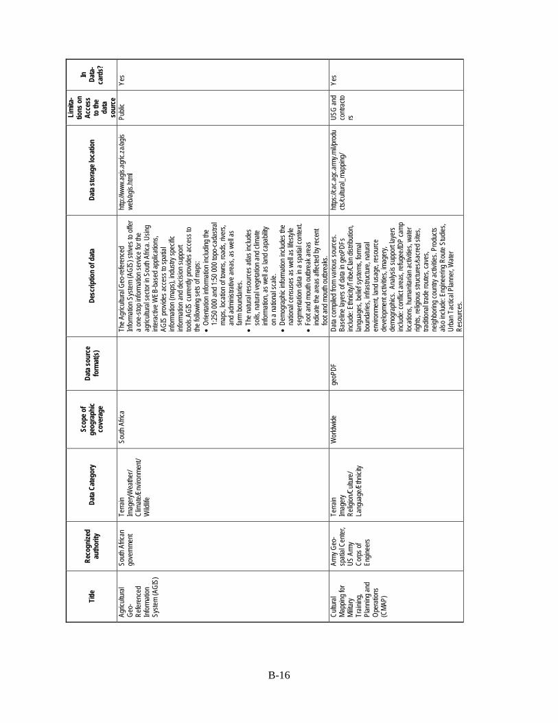
B-16
Title
Re
cogn
ized
auth
ority
Da
ta C
ateg
ory
Scop
e of
geog
raph
ic co
vera
ge
Data
sour
ce
form
at(s
) De
scrip
tion
of d
ata
Data
stor
age l
ocat
ion
Lim
ita-
tions
on
Acce
ss
to th
e da
ta
sour
ce
In
Data
-ca
rds?
Agric
ultur
al Ge
o-Re
feren
ced
Infor
matio
n Sy
stem
(AGI
S)
South
Afric
an
gove
rnme
nt Te
rrain
Imag
eryW
eathe
r/ Cl
imate
/Env
ironm
ent/
Wild
life
South
Afric
a
The A
gricu
ltura
l Geo
-refer
ence
d Inf
orma
tion S
ystem
(AGI
S) st
rives
to of
fer
a one
-stop
infor
matio
n ser
vice f
or th
e ag
ricult
ural
secto
r in S
outh
Afric
a. Us
ing
inter
activ
e WEB
-bas
ed ap
plica
tions
, AG
IS pr
ovide
s acc
ess t
o spa
tial
infor
matio
n (ma
ps),
indus
try sp
ecific
inf
orma
tion a
nd de
cision
supp
ort
tools.
AGIS
curre
ntly p
rovid
es ac
cess
to
the fo
llowi
ng se
ts of
maps
: •
Orien
tation
infor
matio
n inc
luding
the
1:250
000 a
nd 1:
50 00
0 top
o-ca
dastr
al ma
ps, lo
catio
n of to
wns,
road
s, riv
ers,
and a
dmini
strati
ve ar
eas,
as w
ell as
far
m bo
unda
ries.
•
The n
atura
l reso
urce
s atla
s inc
ludes
so
ils, n
atura
l veg
etatio
n and
clim
ate
infor
matio
n, as
well
as la
nd ca
pabil
ity
on a
natio
nal s
cale.
•
Demo
grap
hic in
forma
tion i
nclud
es th
e na
tiona
l cen
suse
s as w
ell as
lifes
tyle
segm
entat
ion da
ta in
a spa
tial c
ontex
t. •
Foot
and m
outh
outbr
eak a
reas
ind
icate
the ar
eas a
ffecte
d by r
ecen
t foo
t and
mou
th ou
tbrea
ks.
http:/
/www
.agis.
agric
.za/ag
iswe
b/agis
.html
Publi
c Ye
s
Cultu
ral
Mapp
ing fo
r Mi
litary
Train
ing,
Plan
ning a
nd
Oper
ation
s (C
MAP)
Army
Geo
-sp
atial
Cente
r, US
Arm
y Co
rps o
f En
ginee
rs
Terra
in Im
ager
y Re
ligion
/Cult
ure/
Lang
uage
/Ethn
icity
Wor
ldwide
ge
oPDF
Da
ta co
mpile
d fro
m va
rious
sour
ces.
Ba
selin
e lay
ers o
f data
in ge
oPDF
s inc
lude:
Ethn
icity/
Tribe
/Clan
distr
ibutio
n, lan
guag
es, b
elief
syste
ms, fo
rmal
boun
darie
s, inf
rastr
uctur
e, na
tural
envir
onme
nt, la
nd us
age,
reso
urce
de
velop
ment
activ
ities,
imag
ery,
demo
grap
hics.
Ana
lysis
supp
ort la
yers
includ
e: co
nflict
area
s, re
fugee
/IDP
camp
loc
ation
s, hu
manit
arian
activ
ities,
water
rig
hts, r
eligio
us st
ructu
res/s
acre
d site
s, tra
dition
al tra
de ro
utes,
cave
s, ne
ighbo
ring c
ountr
y acti
vities
. Pro
ducts
als
o inc
lude:
Engin
eerin
g Rou
te St
udies
, Ur
ban T
actic
al Pl
anne
r, W
ater
Reso
urce
s.
https
://cac
.agc.a
rmy.m
il/pro
ducts
/cultu
ral_m
appin
g/ US
G an
d co
ntrac
tors
Yes

B-17
Title
Re
cogn
ized
auth
ority
Da
ta C
ateg
ory
Scop
e of
geog
raph
ic co
vera
ge
Data
sour
ce
form
at(s
) De
scrip
tion
of d
ata
Data
stor
age l
ocat
ion
Lim
ita-
tions
on
Acce
ss
to th
e da
ta
sour
ce
In
Data
-ca
rds?
AidD
ata
AidD
ata
(Brig
ham
Youn
g Un
iversi
ty, th
e Co
llege
of
Willi
am an
d Ma
ry, an
d De
velop
ment
Gatew
ay)
Wor
ld Ba
nk
Deve
lopme
nt Pr
ogra
ms/R
econ
struc
tion
Wor
ldwide
Geo-
code
d for
eign a
id fun
ding f
lows f
rom
dono
r nati
ons t
o rec
ipien
t cou
ntries
. Inc
ludes
the y
ear,
dono
r, re
cipien
t, title
of
proje
ct, fin
ancia
l com
mitm
ent, p
urpo
se,
and s
ource
of ai
ddata
.
http:/
/www
.aidd
ata.or
g/con
tent/in
dex/d
ata-se
arch
Pu
blic
Yes
Huma
n Righ
ts Re
ports
U.
S.
Depa
rtmen
t of
State
Huma
n Righ
ts/Ge
nder
Eq
uality
W
orldw
ide
Cove
r inter
natio
nally
reco
gnize
d ind
ividu
al, ci
vil, p
olitic
al, an
d wor
ker r
ights
as se
t forth
in th
e Univ
ersa
l Dec
larati
on of
Hu
man R
ights.
http:/
/www
.state
.gov/j
/drl/rl
s/hrrp
t/ Pu
blic
Yes
Traff
icking
in
Perso
ns
Repo
rts
U.S.
De
partm
ent o
f St
ate
Blac
k Ma
rkets/
Traff
icking
(D
rug/A
rms/H
uman
)/Pr
ostitu
tion
Wor
ldwide
PD
F As
sess
es go
vern
ments
on th
eir ef
forts
to co
mbat
traffic
king i
n per
sons
as de
fined
in
the U
N Tr
affick
ing P
rotoc
ol, in
cludin
g co
nduc
t invo
lved i
n for
ced l
abor
and
traffic
king o
f adu
lts an
d chil
dren
for
comm
ercia
l sex
ual e
xploi
tation
.
http:/
/www
.state
.gov/j
/tip/rls
/tipr
pt/
Publi
c Ye
s
Inter
natio
nal
Relig
ious
Free
dom
U.S.
De
partm
ent o
f St
ate
Relig
ion/C
ultur
e/Lan
guag
e/Ethn
icity
Wor
ldwide
PD
F De
scrib
e the
statu
s of r
eligio
us fr
eedo
m,
gove
rnme
nt po
licies
viola
ting r
eligio
us
belie
f and
prac
tices
of gr
oups
, reli
gious
de
nomi
natio
ns an
d ind
ividu
als, a
nd U
.S.
polic
ies pr
omoti
ng re
ligiou
s fre
edom
.
http:/
/www
.state
.gov/j
/drl/rl
s/irf
/ Pu
blic
Yes
Lang
uage
Re
sour
ces
Ethn
ologu
e (a
prop
erty
of SI
L Int
erna
tiona
l, or
igina
lly th
e Su
mmer
Ins
titute
of Lin
guist
ics,
Inc.)
Relig
ion/C
ultur
e/Lan
guag
e/Ethn
icity
Wor
ldwide
Ch
arts/
figur
es
An en
cyclo
pedic
refer
ence
wor
k ca
talog
ing al
l of th
e wor
ld's 6
,909 k
nown
liv
ing la
ngua
ges.
Conta
ins st
atisti
cal
summ
aries
, cou
ntry i
ndice
s, bib
liogr
aphie
s, an
d info
rmati
on on
en
dang
ered
lang
uage
s.
www.
ethno
logue
.com/
home
.asp
Publi
c Ye
s
Mapp
ing fo
r Re
sults
W
orld
Bank
Te
rrain
Deve
lopme
nt Pr
ogra
ms/R
econ
struc
tion
Wor
ldwide
.cs
v, .sh
p Da
ta on
secto
r dist
ributi
on, li
st of
finan
ced
activ
ities,
and n
umbe
r/volu
me of
activ
e fin
ance
d acti
vities
of B
ank f
inanc
ed
activ
ities u
nder
all 1
2 “len
ding”
prod
uct
lines
.
www.
maps
.wor
ldban
k.org
Pu
blic
Yes
MapS
tory
MapS
tory
Terra
in Ot
her
Wor
ldwide
Colle
ction
of an
imate
d map
s dep
icting
se
lected
time s
eries
datas
ets. M
apSt
ory
is a s
ocial
med
ia pla
tform
that
enab
les a
globa
l com
munit
y of e
xper
ts to
crowd
so
urce
socio
-cultu
ral d
ata w
ithin
a ge
ospa
tial a
nd te
mpor
al fra
mewo
rk.
www.
maps
tory.o
rg
Regis
trat
ion
requ
ired
Yes

B-18
Title
Re
cogn
ized
auth
ority
Da
ta C
ateg
ory
Scop
e of
geog
raph
ic co
vera
ge
Data
sour
ce
form
at(s
) De
scrip
tion
of d
ata
Data
stor
age l
ocat
ion
Lim
ita-
tions
on
Acce
ss
to th
e da
ta
sour
ce
In
Data
-ca
rds?
GeoN
etwor
k Fo
od an
d Ag
ricult
ure
Orga
nizati
on
(FAO
), Un
ited
Natio
ns
Terra
in De
velop
ment
Prog
rams
/ Re
cons
tructi
on
Data
War
ehou
se/
Repo
sitor
y
Wor
ldwide
.sh
p, .ly
r, .av
l, .xl
s, .cs
v, .gm
z, Rd
ata, E
SRI
perso
nal
geod
ataba
se,
ESRI
file
geod
ataba
se
The F
AO G
eoNe
twor
k pro
vides
Inter
net
acce
ss to
inter
activ
e map
s, sa
tellite
im
ager
y and
relat
ed sp
atial
datab
ases
ma
intain
ed by
FAO
and i
ts pa
rtner
s.
http:/
/www
.fao.o
rg/ge
onetw
ork/s
rv/en
/main
.home
Publi
c Ye
s
Relie
fWeb
Of
fice f
or th
e Co
ordin
ation
of Hu
manit
arian
Af
fairs
(OCH
A)
Unite
d Nati
ons
Deve
lopme
nt Pr
ogra
ms/
Reco
nstru
ction
Hu
manit
arian
As
sistan
ce
Wor
ldwide
Te
xt, m
aps
Lates
t situ
ation
upda
tes, d
ata on
comp
lex
emer
genc
ies an
d natu
ral d
isaste
rs by
co
untry
, map
s, fin
ancia
l trac
king
datab
ase f
or co
mplex
emer
genc
ies an
d na
tural
disas
ters b
y yea
r.
www.
relie
fweb
.int/c
ountr
ies
Publi
c Ye
s
Envir
onme
ntal
Data
Explo
rer
Unite
d Nati
ons
Envir
onme
nt Pr
ogra
m (U
NEP)
Agric
ultur
e/ Fo
od S
ecur
ity
Natur
al Re
sour
ces/E
nerg
y/ Sa
nitati
on/W
ater
Natur
al Di
saste
rs W
eathe
r/Clim
ate/
Envir
onme
nt/W
ildlife
Te
rrain
Imag
ery
Wor
ldwide
.xl
s Th
e Env
ironm
ental
Data
Exp
lorer
is th
e au
thorita
tive s
ource
for d
ata se
ts us
ed by
UN
EP an
d its
partn
ers i
n the
Glob
al En
viron
ment
Outlo
ok (G
EO) r
epor
t and
oth
er in
tegra
ted en
viron
ment
asse
ssme
nts. It
s onli
ne da
tabas
e hold
s mo
re th
an 50
0 diffe
rent
varia
bles,
as
natio
nal, s
ubre
giona
l, reg
ional
and g
lobal
statis
tics o
r as g
eosp
atial
data
sets
(map
s), co
verin
g the
mes l
ike F
resh
water
, Po
pulat
ion, F
ores
ts, E
miss
ions,
Clim
ate,
Disa
sters,
Hea
lth an
d GDP
. Disp
lay th
em
on-th
e-fly
as m
aps,
grap
hs, d
ata ta
bles o
r do
wnloa
d the
data
in dif
feren
t form
ats.
www.
geod
ata.gr
id.un
ep.ch
/# Pu
blic
Yes
Meas
ure D
HS
U.S.
Age
ncy
for
Inter
natio
nal
Deve
lopme
nt
Healt
h/Nutr
ition/
Dise
ase
Migr
ation
/Immi
grati
on/
Demo
grap
hics/
Popu
lation
Wor
ldwide
ST
ATA
Syste
m file
, Flat
data,
SA
S Sy
stem
file, S
PSS
Syste
m file
.
The D
emog
raph
ic an
d Hea
lth S
urve
ys
(DHS
) pro
gram
has c
ollec
ted, a
nalyz
ed,
and d
issem
inated
accu
rate
and
repr
esen
tative
data
on po
pulat
ion, h
ealth
se
rvice
prov
ision
, mala
ria, H
IV, a
nd
nutrit
ion th
roug
h mor
e tha
n 260
surve
ys
in ov
er 90
coun
tries.
www.
meas
ured
hs.co
m/
Regis
trat
ion
requ
ired
Yes
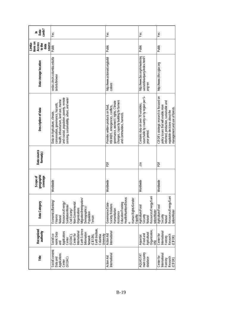
B-19
Title
Re
cogn
ized
auth
ority
Da
ta C
ateg
ory
Scop
e of
geog
raph
ic co
vera
ge
Data
sour
ce
form
at(s
) De
scrip
tion
of d
ata
Data
stor
age l
ocat
ion
Lim
ita-
tions
on
Acce
ss
to th
e da
ta
sour
ce
In
Data
-ca
rds?
Socio
Econ
omic
Data
and
Appli
catio
ns
Cente
r (S
EDAC
)
Socio
Eco-
nomi
c Data
an
d Ap
plica
tions
Ce
nter
(SED
AC),
Cente
r for
Int
erna
tiona
l Ea
rth S
cienc
e Inf
orma
tion
Netw
ork
(CIE
SIN)
, Ea
rth In
stitut
e, Co
lumbia
Un
iversi
ty
Econ
omics
/Ban
king/
Finan
ce
Natur
al Re
sour
ces/E
nerg
y/ Sa
nitati
on/W
ater
Civil
Soc
iety/
Non-
Gove
rnme
ntal
Orga
nizati
ons
Migr
ation
/Immi
grati
on/
Demo
grap
hics/
Popu
lation
Te
rrain
Wor
ldwide
Data
on A
gricu
lture
, clim
ate,
cons
erva
tion,
gove
rnan
ce, h
azar
ds,
healt
h, inf
rastr
uctur
e, lan
d use
, mar
ine
and c
oasta
l, pop
ulatio
n, po
verty
, rem
ote
sens
ing, s
ustai
nabil
ity, u
rban
, and
wate
r
seda
c.cies
in.co
lumbia
.edu/d
ata/
sets/
brow
se
Publi
c Ye
s
Actio
n Aid
Inter
natio
nal
Actio
n Aid
Inter
natio
nal
Gove
rnan
ce/S
tate-
Socie
ty Re
lation
s Hu
manit
arian
As
sistan
ce
Educ
ation
/Tra
ining
He
alth/N
utritio
n/Dise
ase Hu
man R
ights/
Gend
er
Equa
lity
Wor
ldwide
PD
F Pr
ovide
s writt
en pr
oduc
ts on
food
, HI
V/AI
DS, e
merg
encie
s, co
nflict
s, go
vern
ance
, wom
en’s'
rights
, Clim
ate
chan
ges,
capa
city b
uildin
g for
farm
ers
and c
ommu
nities
, har
vests
.
http:/
/www
.actio
naid.
org/p
ubli
catio
ns
Publi
c Ye
s
AQUA
STAT
ma
in co
untry
da
tabas
e
Aqua
stat
(Foo
d and
Ag
ricult
ural
Orga
nizati
on,
UN)
Agric
ultur
e/Foo
d Se
curity
Na
tural
Reso
urce
s/Ene
rgy/S
ani
tation
/Wate
r
Wor
ldwide
.cs
v Co
ntains
data
on ov
er 70
varia
bles,
sear
chab
le by
coun
try or
by re
gion p
er 5-
year
perio
d.
http:/
/www
.fao.o
rg/nr
/wate
r/aq
uasta
t/data
/quer
y/ind
ex.ht
ml?l
ang=
en
Publi
c Ye
s
Cente
r for
Int
erna
tiona
l Fo
restr
y Re
sear
ch
(CIF
OR)
Cente
r for
Int
erna
tiona
l Fo
restr
y Re
sear
ch
(CIF
OR)
Agric
ultur
e/Foo
d Se
curity
Na
tural
Reso
urce
s/Ene
rgy/S
ani
tation
/Wate
r
Wor
ldwide
PD
F CI
FOR'
s stra
tegic
rese
arch
is fo
cuse
d on
polic
y iss
ues t
hat w
ill en
able
more
inf
orme
d, pr
oduc
tive,
susta
inable
and
equit
able
decis
ions a
bout
the
mana
geme
nt an
d use
of fo
rests
.
http:/
/www
.cifor
.cgiar
.org
Publi
c Ye
s
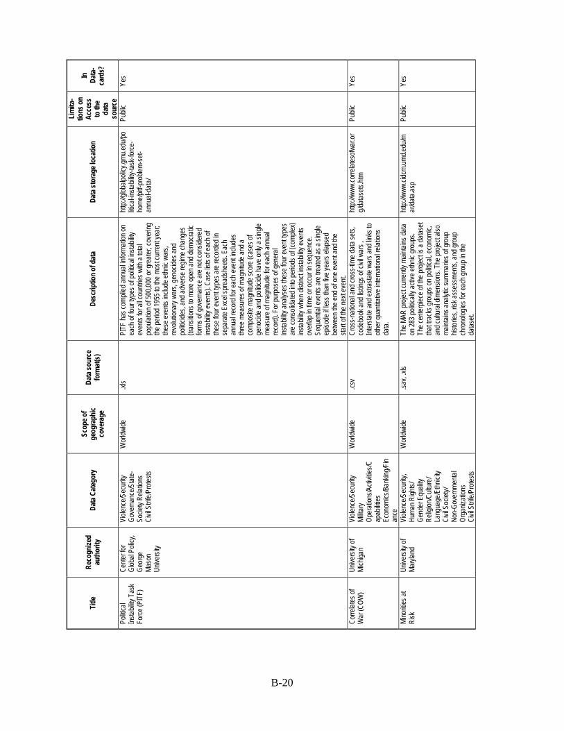
B-20
Title
Re
cogn
ized
auth
ority
Da
ta C
ateg
ory
Scop
e of
geog
raph
ic co
vera
ge
Data
sour
ce
form
at(s
) De
scrip
tion
of d
ata
Data
stor
age l
ocat
ion
Lim
ita-
tions
on
Acce
ss
to th
e da
ta
sour
ce
In
Data
-ca
rds?
Politi
cal
Instab
ility T
ask
Force
(PIT
F)
Cente
r for
Gl
obal
Polic
y, Ge
orge
Ma
son
Unive
rsity
Viole
nce/S
ecur
ity
Gove
rnan
ce/S
tate-
Socie
ty Re
lation
s Ci
vil S
trife/P
rotes
ts
Wor
ldwide
.xl
s PI
TF ha
s com
piled
annu
al inf
orma
tion o
n ea
ch of
four
type
s of p
olitic
al ins
tabilit
y ev
ents
for al
l cou
ntries
with
a tot
al po
pulat
ion of
500,0
00 or
grea
ter, c
over
ing
the pe
riod 1
955 t
o the
mos
t cur
rent
year
; the
se ev
ents
includ
e ethn
ic wa
rs,
revo
lution
ary w
ars,
geno
cides
and
politi
cides
, and
adve
rse re
gime c
hang
es
(tran
sition
s to m
ore o
pen a
nd de
mocra
tic
forms
of go
vern
ance
are n
ot co
nside
red
instab
ility e
vents
). Ca
se lis
ts of
each
of
these
four
even
t type
s are
reco
rded
in
sepa
rate
Exce
l spr
eads
heets
. Eac
h an
nual
reco
rd fo
r eac
h eve
nt inc
ludes
thr
ee m
easu
res o
f mag
nitud
e and
a co
mpos
ite m
agnit
ude s
core
(cas
es of
ge
nocid
e and
politi
cide h
ave o
nly a
single
me
asur
e of m
agnit
ude f
or ea
ch an
nual
reco
rd).
For p
urpo
ses o
f gen
eral
instab
ility a
nalys
es th
ese f
our e
vent
types
ar
e con
solid
ated i
nto pe
riods
of (c
omple
x) ins
tabilit
y whe
n dist
inct in
stabil
ity ev
ents
over
lap in
time o
r occ
ur in
sequ
ence
. Se
quen
tial e
vents
are t
reate
d as a
sing
le ep
isode
if les
s tha
n five
year
s elap
sed
betw
een t
he en
d of o
ne ev
ent a
nd th
e sta
rt of
the ne
xt ev
ent.
http:/
/glob
alpoli
cy.gm
u.edu
/politi
cal-in
stabil
ity-ta
sk-fo
rce-
home
/pitf-
prob
lem-se
t-an
nual-
data/
Publi
c Ye
s
Corre
lates
of
War
(COW
) Un
iversi
ty of
Mich
igan
Viole
nce/S
ecur
ity
Milita
ry Op
erati
ons/A
ctivit
ies/C
apab
ilities
Ec
onom
ics/B
ankin
g/Fin
ance
Wor
ldwide
.cs
v Cr
oss-n
ation
al an
d cro
ss-tim
e data
sets,
co
debo
ok an
d list
ings o
f civi
l war
s ,
Inter
state
and e
xtras
tate w
ars a
nd lin
ks to
oth
er qu
antita
tive i
ntern
ation
al re
lation
s da
ta.
http:/
/www
.corre
lates
ofwar
.org/d
atase
ts.htm
Publi
c Ye
s
Mino
rities
at
Risk
Un
iversi
ty of
Maryl
and
Viole
nce/S
ecur
ity,
Huma
n Righ
ts/
Gend
er E
quali
ty Re
ligion
/Cult
ure/
Lang
uage
/Ethn
icity
Civil
Soc
iety/
Non-
Gove
rnme
ntal
Orga
nizati
ons
Civil
Strif
e/Pro
tests
Wor
ldwide
.sa
v, .xl
s Th
e MAR
proje
ct cu
rrentl
y main
tains
data
on 28
3 poli
ticall
y acti
ve et
hnic
grou
ps.
The c
enter
piece
of th
e pro
ject is
a da
taset
that tr
acks
grou
ps on
politi
cal, e
cono
mic,
and c
ultur
al dim
ensio
ns. T
he pr
oject
also
maint
ains a
nalyt
ic su
mmar
ies of
grou
p his
tories
, risk
asse
ssme
nts, a
nd gr
oup
chro
nolog
ies fo
r eac
h gro
up in
the
datas
et.
http:/
/www
.cidc
m.um
d.edu
/mar
/data.
asp
Publi
c Ye
s
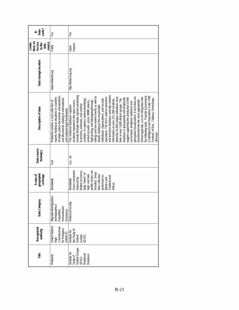
B-21
Title
Re
cogn
ized
auth
ority
Da
ta C
ateg
ory
Scop
e of
geog
raph
ic co
vera
ge
Data
sour
ce
form
at(s
) De
scrip
tion
of d
ata
Data
stor
age l
ocat
ion
Lim
ita-
tions
on
Acce
ss
to th
e da
ta
sour
ce
In
Data
-ca
rds?
Refw
orld
Un
ited N
ation
s Hi
gh
Comm
ission
er
for R
efuge
es
(UNH
CR)
Migr
ation
/Immi
grati
on/
Demo
grap
hics/
Popu
lation
Hu
manit
arian
As
sistan
ce
Wor
ldwide
Te
xt Re
fwor
ld co
ntains
a va
st co
llecti
on of
re
ports
relat
ing to
situa
tions
in co
untrie
s of
origi
n, po
licy d
ocum
ents
and p
ositio
ns,
and d
ocum
ents
relat
ing to
inter
natio
nal
and n
ation
al leg
al fra
mewo
rks.
www.
refw
orld.
org
Publi
c Ye
s
Institu
te for
St
udy o
f Vi
olent
Grou
ps
(ISVG
) Re
lation
al Da
tabas
e
Institu
te for
the
Stud
y of
Viole
nt Gr
oups
(IS
VG)
Viole
nce/S
ecur
ity
Wor
ldwide
Gi
ven c
onstr
aints
impo
sed b
y lim
ited r
esou
rces,
daily
"skim
s" of
hig
h- an
d mid-
profi
le sto
ries a
re
includ
ed. D
eep-
dive c
ollec
tion
perfo
rmed
on
Mexic
o and
Th
ailan
d (no
t Af
rica)
.
.csv,
.xls
This
relat
ional
datab
ase c
aptur
es
incide
nts re
porte
d in t
he op
en so
urce
(m
ostly
thro
ugh m
edia
repo
rts) p
ertai
ning
to ter
roris
t, extr
emist
, and
crim
inal
activ
ities.
It cap
tures
viole
nt (b
ombin
gs,
arme
d ass
aults
, arso
n, W
MD at
tacks
, hig
h-jac
king,
and k
idnap
ping/h
ostag
e tak
ing) a
nd no
n-vio
lent e
vents
as w
ell as
de
tails
relat
ing to
the r
espo
nsibl
e ind
ividu
als, o
rgan
izatio
ns, a
nd se
curity
op
erati
ons.
The I
SVG
violen
t extr
emism
an
d ter
roris
m da
tabas
e cur
rentl
y con
tains
inf
orma
tion o
n ove
r 223
, 000
incid
ents,
wh
ereb
y 43,0
00 un
ique i
ndivi
duals
have
lin
ks to
over
3,00
0 dist
inct g
roup
s. Th
e da
tabas
e is g
eosp
atiall
y and
temp
orall
y tag
ged s
uppo
rting t
he pr
oduc
tion o
f link
as
socia
tion,
tempo
ral, s
tatist
ical a
nd
geos
patia
l visu
aliza
tions
. Eve
nt da
ta ar
e tra
nsfor
med i
nto th
e mos
t app
ropr
iate
forma
t (typ
ically
.csv
) for
integ
ratio
n into
the
follo
wing
tools
: Pala
ntir G
over
nmen
t, i2
Intell
igenc
e-led
Ope
ratio
ns S
uite,
FMS
Senti
nel, n
FiDeL
, Tab
leau,
Omnis
kope
, uR
evea
l.
http:/
/www
.isvg
.org
Upon
re
ques
t Ye
s


REPORT DOCUMENTATION PAGE Form Approved
OMB No. 0704-0188 Public reporting burden for this collection of information is estimated to average 1 hour per response, including the time for reviewing instructions, searching existing data sources, gathering and maintaining the data needed, and completing and reviewing this collection of information. Send comments regarding this burden estimate or any other aspect of this collection of information, including suggestions for reducing this burden to Department of Defense, Washington Headquarters Services, Directorate for Information Operations and Reports (0704-0188), 1215 Jefferson Davis Highway, Suite 1204, Arlington, VA 22202-4302. Respondents should be aware that notwithstanding any other provision of law, no person shall be subject to any penalty for failing to comply with a collection of information if it does not display a currently valid OMB control number. PLEASE DO NOT RETURN YOUR FORM TO THE ABOVE ADDRESS. 1. REPORT DATE (DD-MM-YYYY) 28-02-2013
2. REPORT TYPEIAD Final
3. DATES COVERED (From - To)01-10-2011 – 31-01-2013
4. TITLE AND SUBTITLE
5a. CONTRACT NUMBER DASW01-04-C-0003
A Qualitative Data Collection Strategy for Africa 5b. GRANT NUMBER — — — 5c. PROGRAM ELEMENT NUMBER — — —
6. AUTHOR(S) 5d. PROJECT NUMBER — — —
Ashley N. Bybee, Dominick E. Wright 5e. TASK NUMBER AI-55-3061 5f. WORK UNIT NUMBER— — —
7. PERFORMING ORGANIZATION NAME(S) AND ADDRESS(ES)
8. PERFORMING ORGANIZATION REPORT NUMBER
Institute for Defense Analyses 4850 Mark Center Drive Alexandria, Virginia 22311-1882
P-4942 H 2012-001540
9. SPONSORING / MONITORING AGENCY NAME(S) AND ADDRESS(ES) 10. SPONSOR/MONITOR’S ACRONYM(S)Glenn A. Fogg Director, Rapid Reaction Technology Office (703) 746-1343 2231 Crystal Drive, Suite 900 Arlington, VA 22202
11. SPONSOR/MONITOR’S REPORT NUMBER(S) — — —
12. DISTRIBUTION / AVAILABILITY STATEMENT Approved for public release; distribution is unlimited (18 March 2013).
13. SUPPLEMENTARY NOTES — — —
14. ABSTRACT This document presents a qualitative data collection strategy (QDCS) to address gaps in qualitative data that exist in models, simulations, and relevant tools currently being used to analyze the African continent. It is based on the findings of two previous phases of research that identify the most pressing qualitative gaps and the collection of insights from native African researchers to identify the types of data that have the greatest explanatory power in the African context.
15. SUBJECT TERMS Africa, qualitative, data, social science, models, simulation, data collection
16. SECURITY CLASSIFICATION OF:
17. LIMITATION OF ABSTRACT
18. NUMBER OF PAGES
19a. NAME OF RESPONSIBLE PERSONAshley Bybee
a. REPORT Unclassified
b. ABSTRACT Unclassified
c. THIS PAGEUnclassified
Unlimited 68 19b. TELEPHONE NUMBER (include area code) 703-845-2288
Standard Form 298 (Rev. 8-98)Prescribed by ANSI Std. Z39.18
