a geology tour of the twin cities-guidebook - d.umn.edumille066/outreach/geology tour of the twin...
TRANSCRIPT
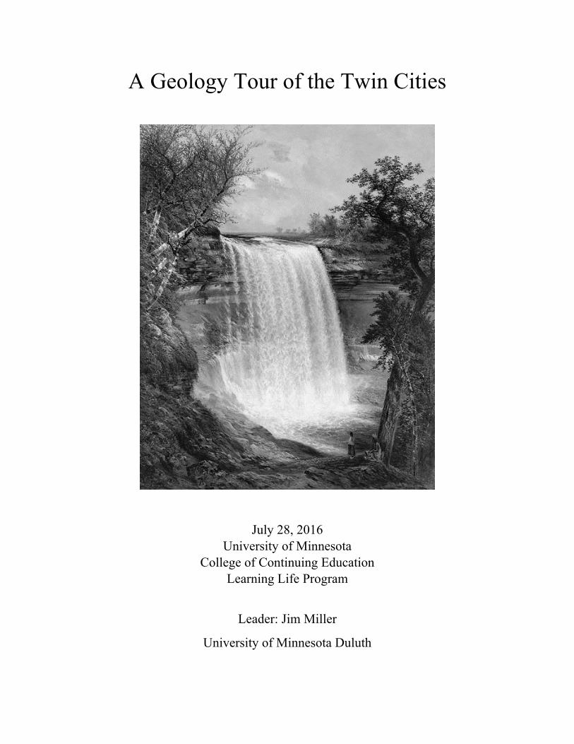
A Geology Tour of the Twin Cities
July 28, 2016 University of Minnesota
College of Continuing Education Learning Life Program
Leader: Jim Miller
University of Minnesota Duluth
Introduction
This one-day Learning Life immersion course is intended to show you the natural history of the Twin Cities through a geologist’s eyes. Geologists are trained to read the rocks and landscapes of the Earth that ancient and awe-inspiring stories of its history and evolution. In the Twin Cities area, two dramatically different stories are told. One occurred about 500 million years ago when shallow tropical seas teaming with marine life covered the area leaving deposits of beach sands and coral reef material. The other story occurred just 12,000 years ago when vast, mile-thick sheets of glacial ice were melting back into Canada; an event that sculpted the landscape of the Twin Cities and much of Minnesota.
This guide is intended to provide a brief overview of these two geological events and describe the five field stops that we will make along the Mississippi River valley which offer evidence of these incredible stories.
The Rise and Fall of Tropical Seas About 500 million years ago, Minnesota was situated much as it is today, in the low-lying interior of the North American continent. However, at this time, the Rocky Mountains had not yet been born, the Appalachian Mountains were just starting to emerge, the entire continent straddled the equator and all life resided in the seas. Also at this time, the world’s oceans were at record high levels (probably because no continents existed at the pole to accumulate glaciers). Because of this high stand of the seas, the interior of North America was repeatedly flooded by shallow seas.
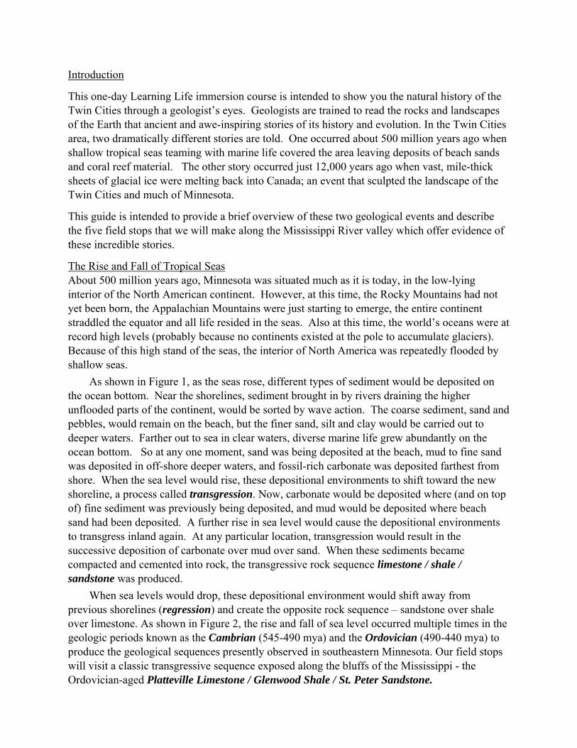
As shown in Figure 1, as the seas rose, different types of sediment would be deposited on the ocean bottom. Near the shorelines, sediment brought in by rivers draining the higher unflooded parts of the continent, would be sorted by wave action. The coarse sediment, sand and pebbles, would remain on the beach, but the finer sand, silt and clay would be carried out to deeper waters. Farther out to sea in clear waters, diverse marine life grew abundantly on the ocean bottom. So at any one moment, sand was being deposited at the beach, mud to fine sand was deposited in off-shore deeper waters, and fossil-rich carbonate was deposited farthest from shore. When the sea level would rise, these depositional environments to shift toward the new shoreline, a process called transgression. Now, carbonate would be deposited where (and on top of) fine sediment was previously being deposited, and mud would be deposited where beach sand had been deposited. A further rise in sea level would cause the depositional environments to transgress inland again. At any particular location, transgression would result in the successive deposition of carbonate over mud over sand. When these sediments became compacted and cemented into rock, the transgressive rock sequence limestone / shale / sandstone was produced.
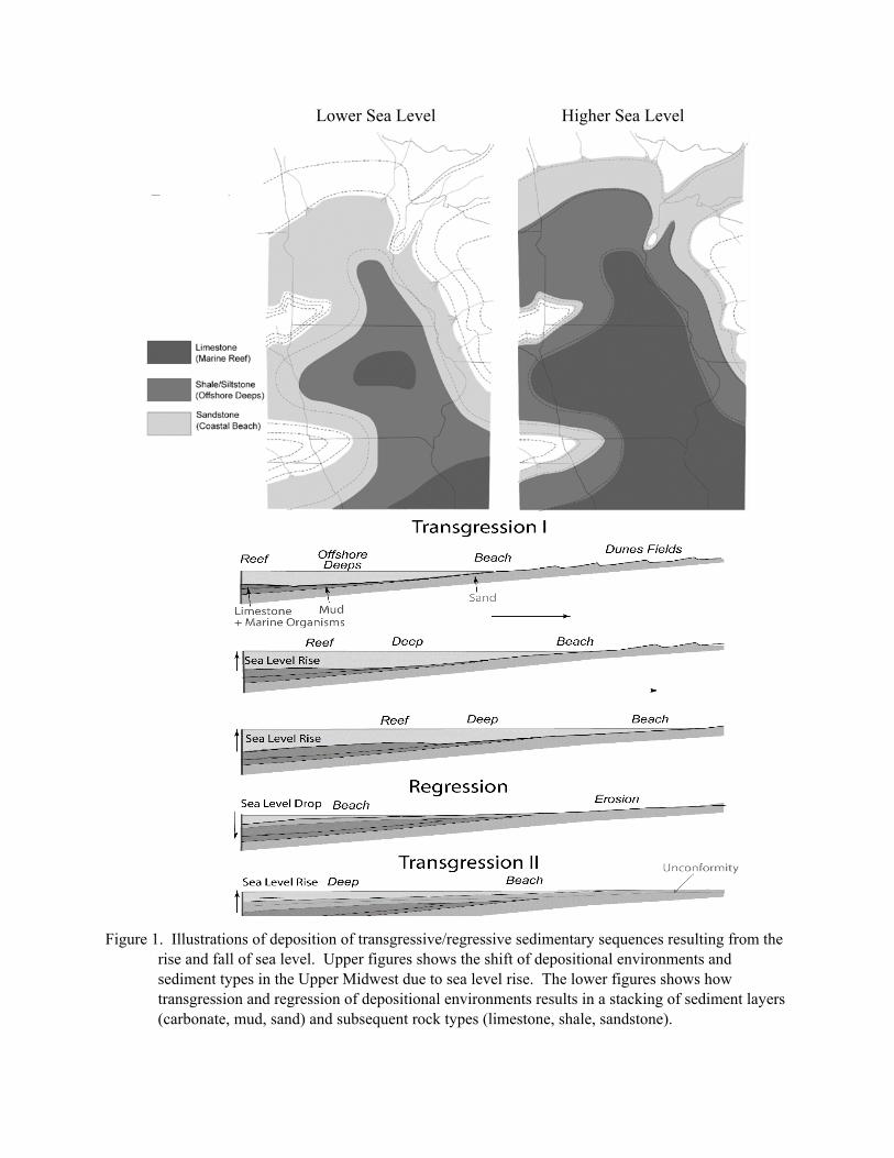
When sea levels would drop, these depositional environment would shift away from previous shorelines (regression) and create the opposite rock sequence – sandstone over shale over limestone. As shown in Figure 2, the rise and fall of sea level occurred multiple times in the geologic periods known as the Cambrian (545-490 mya) and the Ordovician (490-440 mya) to produce the geological sequences presently observed in southeastern Minnesota. Our field stops will visit a classic transgressive sequence exposed along the bluffs of the Mississippi - the Ordovician-aged Platteville Limestone / Glenwood Shale / St. Peter Sandstone.
Lower Sea Level Higher Sea Level
Figure 1. Illustrations of deposition of transgressive/regressive sedimentary sequences resulting from the rise and fall of sea level. Upper figures shows the shift of depositional environments and sediment types in the Upper Midwest due to sea level rise. The lower figures shows how transgression and regression of depositional environments results in a stacking of sediment layers (carbonate, mud, sand) and subsequent rock types (limestone, shale, sandstone).
Figure 2. Stratigraphic sequence of Cambrian and Ordovician rock formations exposed in southeastern
Minnesota deposited during the rise and fall of sea level. The transgressive sequence of the St. Peter Sandstone - Glenwood Shale - Platteville Limestone are well exposed along the bluffs of the Mississippi in the Twin Cities area. Figure from Mossler (1999).
The Advance and Retreat of Continental Glaciers
After the Ordovician, very little of what was happening in southeastern Minnesota was recorded in the rock record. Some sedimentary rocks occurring near the Iowa border indicate that the seas again transgressed the area in the Devonian Period (408-360 mya) and scattered organic-rich clay deposits in western Minnesota indicate that a nearshore lagoonal environment existed during the Cretaceous Period (~100 mya) – a time when dinosaurs must have roamed over Minnesota (but not were preserved). If any other sediments were deposited on the surface of Minnesota since the Ordovician, they have been completed eroded away and washed to the margins of the continent. Indeed, the dominant geological process affecting Minnesota over the past 450 million years has been slow steady erosion and deep weathering of the land surface.
Then beginning about 2 million years ago, the Earth started to experience wild cyclical fluctuation in the solar heating, thought to have been caused by changes in the wobble and eccentricity of Earth’s orbit around the sun. These oscillations in temperature caused the appearance and disappearance of massive continental glaciers, like those that cap Antarctica and Greenland today, about every 100,000 years over the past 2 million years. The most recent cycle of glaciation covering the northern half of North America peaked about 20,000 years ago and was in active retreat starting about 14,000 years. By 11,000 years ago, most of the ice had retreated into Canada, where it completely disappeared by 7,000 years ago.
Twin
Cities
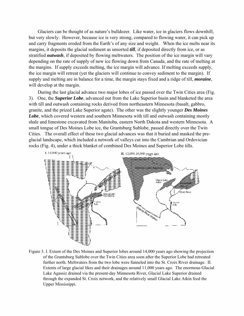
Glaciers can be thought of as nature’s bulldozer. Like water, ice in glaciers flows downhill, but very slowly. However, because ice is very strong, compared to flowing water, it can pick up and carry fragments eroded from the Earth’s of any size and weight. When the ice melts near its margins, it deposits the glacial sediment as unsorted till, if deposited directly from ice, or as stratified outwash, if deposited by flowing meltwaters. The position of the ice margin will vary depending on the rate of supply of new ice flowing down from Canada, and the rate of melting at the margins. If supply exceeds melting, the ice margin will advance. If melting exceeds supply, the ice margin will retreat (yet the glaciers will continue to convey sediment to the margin). If supply and melting are in balance for a time, the margin stays fixed and a ridge of till, moraine, will develop at the margin.
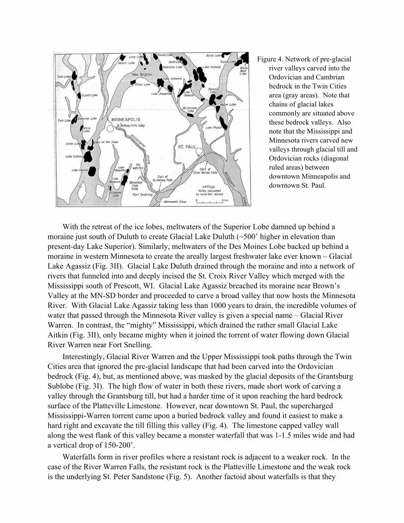
During the last glacial advance two major lobes of ice passed over the Twin Cities area (Fig. 3). One, the Superior Lobe, advanced out from the Lake Superior basin and blanketed the area with till and outwash containing rocks derived from northeastern Minnesota (basalt, gabbro, granite, and the prized Lake Superior agate). The other was the slightly younger Des Moines Lobe, which covered western and southern Minnesota with till and outwash containing mostly shale and limestone excavated from Manitoba, eastern North Dakota and western Minnesota. A small tongue of Des Moines Lobe ice, the Grantsburg Sublobe, passed directly over the Twin Cities. The overall effect of these two glacial advances was that it buried and masked the pre-glacial landscape, which included a network of valleys cut into the Cambrian and Ordovician rocks (Fig. 4), under a thick blanket of combined Des Moines and Superior Lobe tills.
Figure 3. I. Extent of the Des Moines and Superior lobes around 14,000 years ago showing the projection
of the Grantsburg Sublobe over the Twin Cities area soon after the Superior Lobe had retreated further north. Meltwaters from the two lobe were funneled into the St. Croix River drainage. II. Extents of large glacial likes and their drainages around 11,000 years ago. The enormous Glacial Lake Agassiz drained via the present-day Minnesota River, Glacial Lake Superior drained through the expanded St. Croix network, and the relatively small Glacial Lake Atkin feed the Upper Mississippi.
With the retreat of the ice lobes, meltwaters of the Superior Lobe damned up behind a moraine just south of Duluth to create Glacial Lake Duluth (~500’ higher in elevation than present-day Lake Superior). Similarly, meltwaters of the Des Moines Lobe backed up behind a moraine in western Minnesota to create the areally largest freshwater lake ever known – Glacial Lake Agassiz (Fig. 3II). Glacial Lake Duluth drained through the moraine and into a network of rivers that funneled into and deeply incised the St. Croix River Valley which merged with the Mississippi south of Prescott, WI. Glacial Lake Agassiz breached its moraine near Brown’s Valley at the MN-SD border and proceeded to carve a broad valley that now hosts the Minnesota River. With Glacial Lake Agassiz taking less than 1000 years to drain, the incredible volumes of water that passed through the Minnesota River valley is given a special name – Glacial River Warren. In contrast, the “mighty” Mississippi, which drained the rather small Glacial Lake Aitkin (Fig. 3II), only became mighty when it joined the torrent of water flowing down Glacial River Warren near Fort Snelling.
Interestingly, Glacial River Warren and the Upper Mississippi took paths through the Twin Cities area that ignored the pre-glacial landscape that had been carved into the Ordovician bedrock (Fig. 4), but, as mentioned above, was masked by the glacial deposits of the Grantsburg Sublobe (Fig. 3I). The high flow of water in both these rivers, made short work of carving a valley through the Grantsburg till, but had a harder time of it upon reaching the hard bedrock surface of the Platteville Limestone. However, near downtown St. Paul, the supercharged Mississippi-Warren torrent came upon a buried bedrock valley and found it easiest to make a hard right and excavate the till filling this valley (Fig. 4). The limestone capped valley wall along the west flank of this valley became a monster waterfall that was 1-1.5 miles wide and had a vertical drop of 150-200’.
Waterfalls form in river profiles where a resistant rock is adjacent to a weaker rock. In the case of the River Warren Falls, the resistant rock is the Platteville Limestone and the weak rock is the underlying St. Peter Sandstone (Fig. 5). Another factoid about waterfalls is that they
Figure 4. Network of pre-glacial river valleys carved into the Ordovician and Cambrian bedrock in the Twin Cities area (gray areas). Note that chains of glacial lakes commonly are situated above these bedrock valleys. Also note that the Mississippi and Minnesota rivers carved new valleys through glacial till and Ordovician rocks (diagonal ruled areas) between downtown Minneapolis and downtown St. Paul.

migrate up stream. This results from the underlying weak rock being eroded faster and undermining the pedestal that the hard ledge rock is resting on. Consequently blocks of the ledge rock will break away causing the lip of the falls to move upstream. The rate of retreat of the waterfall depends on the volume and sediment load of the water cascading over the falls.
Figure 5. Profile of Ordovician units that form waterfalls in the Mississippi valley of the Twin Cities. The contrasting erodablity of resistant Platteville Limestone and the much weaker Glenwood Shale and St. Peter Sandstone create a niche point in the stream profile – a waterfall. The undermining of the sandstone and shale causes the Platteville ledge to break off in blocks. The effect of this is to cause the waterfall to retreat upstream over time.
The waterfall that started near downtown St. Paul around 12,000 years ago is calculated to have migrated to the confluence of Mississippi-Minnesota/Warren confluence near Fort Snelling, a distance of about 6 miles, in 1,000 years (Fig. 6). Upon reaching the confluence, the waterfall separated with one traveling up the Minnesota/Warren) River and the other migrating up the Mississippi. Because of the greater flow through the Minnesota/Warren channel, the edge of the Platteville Limestone exposure near Shakopee was reached quickly and the waterfall disappeared. Because of the lower volume flowing through the Mississippi, the upstream migration of that waterfall was much slower. It took about another 1,000 years for the Mississippi waterfall to reach the confluence with Minnehaha Creek. Here again, the waterfall split. Over the next 9000 years, the Minnehaha waterfall traveled just a quarter mile upstream, however, most of this distance was probably cover in the first 1000 years when considerable volumes of glacial ice were quickly melting on the surface. The Mississippi waterfall would migrate another 7 miles to its current location at Saint Anthony Falls.
This field trip will begin where the Glacial River Warren Falls started near downtown St. Paul and will follow its migration up the Mississippi River to one of its resting places on Minnehaha Creek. Along the way, we will observe the Ordovician formations that line the steep-walled valley, paying particular attention to the wealth of marine fossils entombed in these 450 million year old rocks.
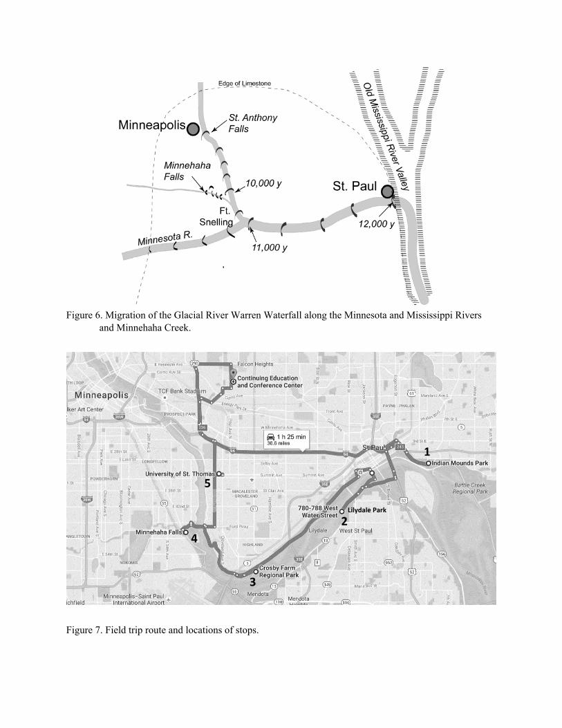
Figure 6. Migration of the Glacial River Warren Waterfall along the Minnesota and Mississippi Rivers
and Minnehaha Creek.
Figure 7. Field trip route and locations of stops.
Lilydale Park
1
2
3
4
5
Field Trip Stop Descriptions
Stop 1: Overlook of Mississippi River Valley near Downtown St. Paul
Location: Indian Mounds Regional Park, Pull-out area off Mounds Blvd. opposite Cherry St.
Description: At this overlook on Mounds Park Boulevard, we have an excellent view upstream (to the west) of the Mississippi River gorge in St. Paul. We also have an excellent view downstream (to the south) of the wide valley beyond the St. Paul Airport. The transition between the two areas is where the river makes a relatively sharp turn southward to flow south in a much wider valley. Examination of the bedrock geology and the depth-to bedrock maps show that a wide buried bedrock valley extends north-south, with the Mississippi River occupying this wide valley downstream from downtown St. Paul.
Glacial River Warren, which was draining the enormous Glacial Lake Agassiz in northwestern Minnesota starting around 12,000 years ago, flowed as a raging torrent across this landscape that was littered with melting blocks of ice that lay entombed in the till that the glaciers had just deposited. The river easily cut through the surface deposits of unconsolidated till, but then had a harder time cutting into the resistant bedrock of Platteville Limestone, which forms the crest of the bluffs on the south side of the river and forms the upper part of the cliff directly below this location. Upon encountering the more-erodable glacial sediment infilling of this north-south bedrock valley (Fig. 6), River Warren made a sharp turn to the south and initiated a large waterfall.
We can get a sense of the enormity of that waterfall which stretched from the bluffs on the south side of the river to the high ground where the Capitol and cathedral are situated – approximately 15 miles across and a vertical drop of 150-200’.
Stop 2: Fossil Hunting in Ordovician Limestone
Location: Lilydale Regional Park, parking area on Water Street 0.6 mi west of Smith Ave bridge.
Caution: While this park is open to the public, fossil collecting, which requires a permit from the City of Saint Paul Parks and Rec Department, is currently not allowed until some safety issues are addressed. As such, this stop will be a “look and see” visit and we will view fossil-bearing rocks in the flat areas along the base of the bluff rather than in the quarry are higher up the slope.. Please feel free to return to this park to collect when permits are again allowed.
Description: Exposes in the bluffs along the south side of the Mississippi River here in Lilydale Park is the classic Ordovician transgressive sequence that progresses up section from the St. Peter Sandstone, the thin Glenwood Shale and the massive Platteville Limestone.
Near the base of the bluff, one can find many caves dug into the poorly cemented St. Peter sandstone, which represents sands deposited in a tropical beach environment some 450 million years ago when Minnesota straddled the equator. The St. Peter is remarkable for being composed almost entirely (95-99%) of well-rounded quartz grains – a property which makes it useful for glass making and, more controversially, for use in fracking.

The Glenwood Shale does not crop out well along this bluff, but we will get a better view of it at Minnehaha Falls. The Platteville Limestone occurs about midway up the slope (if you take the trail to the switchback near a gully, you can see the massive Platteville forming a waterfall in the gully. Surprisingly, the Platteville contains very few fossils. That distinction goes to the formation overlying it – the Decorah Shale.
If you continue climbing upslope from the switchback, you will encounter rounded mounds of gray fine-grained mudstone. Continuing on to the west, the bluff opens up into a large quarry area where the Decorah Shale is exposed. In times of frequent rain, this area can be very muddy. However, this area is also where the best marine fossil samples can be found. Fossils occur in two ways, one is finding individual brachiopod shells and fragments of crinoids and bryozoans and more rare species embedded in the muddy shale mounds. The other is finding limestone slabs (2-5” thick) containing 90% fossils. Interestingly, you will note that the fossils in these slabs are typically fragmented and the rock is commonly referred to as “fossil hash”.
The upward transition from massive limestone to dominantly shale containing beds of fossil hash is interpreted to signify a shallowing of sea-level and the return of a muddy offshore deeps environment replacing a carbonate platform (Fig. 1). The occurrence of fossil hash beds are thought to represent a mass kill of organism-rich areas (coral reefs) caused by hurricanes that ripped across the reefs and tossed the disarticulated organisms into the muddy deeps that flanked the reefs. Our trip will investigate fossil hash slabs occurring in and around an intermittent stream at the base of the bluff.
Additional Informational Material: Illustrations of the types of Ordovician marine organisms that can be found in the Decorah Shale are listed and described in the Minnesota Geological Survey’s MN at a Glance pamphlet on “Fossil Collecting in the Twin Cities Area”. This handout is available on the Learning Life website.
Stop 3: Confluence of the Minnesota and Mississippi Rivers
Location: Crosby Farm Regional Park - ‘Two Rivers’ Overlook, and park road.
Description: At the overlook at the top of the bluff we have an excellent view of the confluence of the Minnesota and Mississippi Rivers. The difference in the widths of their respective valleys is emphasized by the spans of the Mendota Bridge over the Minnesota and the Fort Road Bridge over the Mississippi. It is clear from this vantage point that the “Mighty Mississippi” wasn’t so mightly until it joined in with the Minnesota River that was draining the enormous Glacial Lake Agassiz.
We can also see a marked difference in suspended sediment load between the two rivers. The Minnesota River, which drains clay-rich Des Moines Lobe tills, carries a much higher sediment load than does the Mississippi River, which largely traverses bedrock and sandy deposits of the Superior lobe. Des Moines Lobe till has a near perfect blend of minerals and nutrients to make some of the best agricultural soils in the world. However, this agricultural activity (tilling, tiled fields, and application of pesticides, herbicides and fertilizers), coupled with unchecked run-off, has resulted severe water quality problems in the Minnesota River that is just starting to be addressed

A walk up the hill from the parking area provides another opportunity to investigate a well exposed section of the Ordovician transgressive sequence. Note the blocks of Platteville Limestone scattered across the slope. This is a relict of the upstream march of the Glacial River Warren waterfall that passed this spot about 10,000 years ago and spawned the proto-St. Anthony Falls on the Mississippi River.
This field description is mostly taken from a paper by Pound, Campbell, and Schmitt in the 2011 Field Guidebook for the Annual Geological Society of America Meeting in Minneapolis.
Stop 4: Waterfall on Minnehaha Creek
Location: Minnehaha Falls Park, downstream off the falls
Description: Viewing Minnehaha Falls, the relative erodibility of the resistant Platteville and the less-resistant Glenwood Shale and underlying St. Peter Sandstone are clearly evident. The Platteville tenuously holds up lip of the falls and the underlying Glenwood and St. Peter are wearing away at a much fast rate. Waterfall retreat is accomplished by undercutting the underlying support for the Platteville Limestone leading to periodic collapse of large blocks of the jointed Platteville around the base of the falls. Indeed, large (car-size) blocks of Platteville can be observed mantling the creek bottom all the way down to its merger with the Mississippi a quarter mile downstream.
Walking downstream of the waterfall, a good exposure of all three units can be observed on the south valley wall. For the ambitious and sure-footed, one can scramble up the slope to get a close-up view of the contacts between the sandstone, shale and limestone.
Further downstream where the creek widens to a pool, a wide, flat-floored dry valley is evident to the north. At the head of this valley, one can see another cliff face capped by the Platteville Limestone. There was obviously a running river/stream that created this valley. Given its considerable width, is it thought to have been carved by a secondary channel of the Mississippi that was abandoned when the Mississippi focused its flow on the main primary channel to the east. As such the dry waterfall at the head of the valley is an abandoned cousin of St. Anthony Falls. Minnehaha Creek was a tributary to this now dry channel.
Finally, notice the large rounded boulder adjacent to the stairs leading back up to the parking area. Does it look like any of the rocks we have seen today? If not, how did it get here? Why is it rounded? Why is it in the bottom of this valley.
Stop 5: Fossil-bearing Limestone (optional stop if Lilydale cannot be visited)
Location: War memorial and overlook at west end of Summit Avenue near University of St. Thomas, St. Paul
Caution: this locality is very dangerous and slippery after heavy rains, hence a visit here is weather-dependent. Also, beware of speeding bicycles on bike path!
Description: The entire transgressive sequence can be examined close up in the bluffs below the overlook at the war memorial, although limited space means this should be done in small groups. A well-trodden path leads south from the bluff below the overlook, providing the best access.

Exposed in the lower part of the slope, the St. Peter Sandstone is “painted” with swirling bands of iron staining, a feature called lisegang. The thin Glenwood Shale is exposed and usually appears moist, highlighting its ability to hold water. Variability within the Platteville Limestone is well-displayed here, as it transitions between a lower thick-bedded to an upper thin-bedded unit, both of which are cut by joints (vertical fractures). As at Lilydale, the Decorah Shale is present in the slopes immediately below the overlook and various marine organism can be found in the fossil hash beds interbedded with the shales.
This field description is mostly taken from a paper by Pound, Campbell, and Schmitt in the 2011 Field Guidebook for the Annual Geological Society of America Meeting in Minneapolis.