› ...es_chapter_2_site_description_and_land_use.… · galloper wind farm eastern super grid...
TRANSCRIPT
Galloper Wind Farm Eastern Super Grid Transformer Project
Environmental Statement – Chapter 2 Site Description and Land Use
February 2014 Document Reference – GWF/20/02/2014
Galloper Wind Farm Limited

Galloper Wind Farm – Eastern Super Grid Transformer Project Environmental Statement – Chapter 2 Site Description and Land Use Final February 2014
CONTENTS Page 2 SITE DESCRIPTION AND LAND USE 2.1 Introduction 1 2.2 Location 1
2.3 Land Ownership 1 2.4 Proposed Land Uses within the Development Boundary 1 2.5 Adjacent Land Uses 1 2.6 Surrounding Land Uses 3 2.7 Local Residential Land Uses 5 2.8 Surrounding Transport Links and Significant Routes 7 2.9 Local Recreation and Tourism 7 2.10 Administrative Area 7 FIGURES Figure 2.1 Aerial photograph showing the location of the ESGT Figure 2.2 Current land within the GWF onshore site Figure 2.3 Current land use within the vicinity of the ESGT site showing local place
names
Galloper Wind Farm – Eastern Super Grid Transformer Project Environmental Statement – Chapter 2 Site Description and Land Use Final February 2014
2 SITE DESCRIPTION AND LAND USE
2.1 Introduction
2.1.1 This chapter describes the current land use within the development site and surrounding area, and explains the changes that will take place as a result of the construction of the proposed Eastern Super Grid Transformer (ESGT).
2.2 Location
2.2.1 The ESGT compound will be located within the onshore order limits of the Galloper Wind Farm (GWF). The site is situated in the Suffolk Heritage Coast and in the Suffolk Coast and Heaths Area of Outstanding Natural Beauty (AONB) approximately 1km inland from the village of Sizewell, and 3km west of the town of Leiston. The GWF onshore site is situated to the north of Sizewell Gap Road, and the ESGT compound will be situated to the east of the existing Greater Gabbard Offshore Wind Farm (GGOWF) and Leiston substations.
2.3 Land Ownership
2.3.1 The development site for the ESGT has a total area of 0.83ha and EDF Energy Ltd (EDF) is the current landowner of the proposed site. GWFL will lease the land from EDF for the lifetime of the wind farm (covering construction, operation and decommissioning). National Grid will, in turn, lease the ESGT development site from GWFL for the lifetime of the wind farm.
2.4 Proposed Land Uses within the Development Boundary
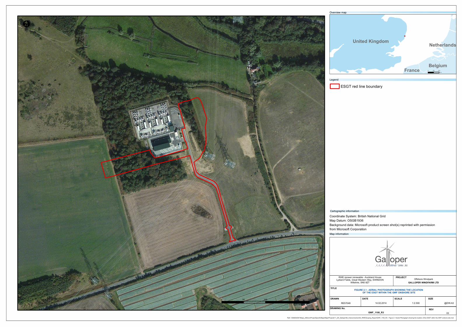
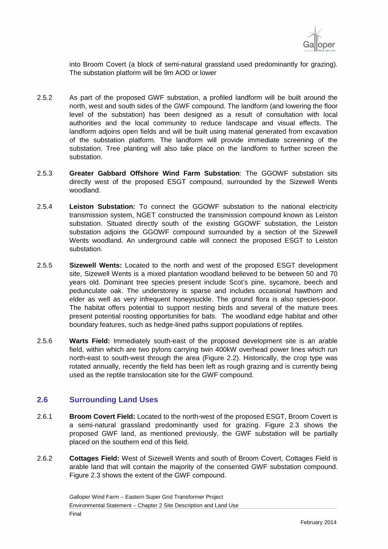
2.4.1 The current land use within the development site and the immediately surrounding area is shown in Figure 2.1. The footprint of the ESGT will sit predominantly within arable land including an area of the eastern side of the Sizewell Wents woodland.
2.4.2 A patch of rough grass exists between the GGOWF substation and the small stretch of woodland reaching south. This rough grass patch is, however, not utilised as foraging land for livestock as it is surrounded by arable fields and situated too close to the substation.
2.5 Adjacent Land Uses
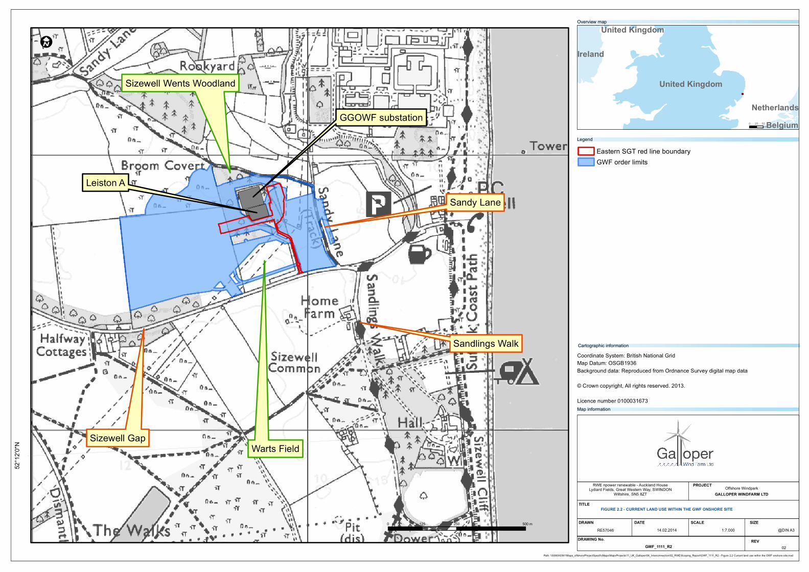
2.5.1 Proposed Galloper Wind Farm onshore site: The GWF substation will be located approximately 1km inland on the Suffolk coast near Sizewell, to the north of Sizewell Gap and west of the existing GGOWF substation. The footprint of the GWF onshore site can be seen in Figure 2.2. It sits predominantly within arable land although it also includes part of a block of woodland (Sizewell Wents) and the access route to the GWF substation will be built through a section of the woodland. In addition, part of the proposed landscape mitigation area for GWF and parts of the GWF substation encroach
I
United Kingdom
Belgium
Netherlands
France
0 100 20050 m
Path: \\S060A0361\Maps_offshore\ProjectSpecificMaps\MajorProjects\11_UK_Galloper\06_Interconnection\02_RWE\Scoping_Report\GWF_1100_R3 - Figure 2.1 Aerial Photograph showing the location of the ESGT within the GWF onshore site.mxd
0 5025km
ESGT red line boundaryLegend
Overview map
Coordinate System: British National GridMap Datum: OSGB1936Background data: Microsoft product screen shot(s) reprinted with permission from Microsoft Corporation
RWE npower renewable - Auckland HouseLydiard Fields, Great Western Way, SWINDON
Wiltshire, SN5 8ZTOffshore Windpark
GALLOPER WINDFARM LTD
DRAWN DATE@DIN A3
SCALE SIZE
PROJECT
TITLE FIGURE 2.1 - AERIAL PHOTOGRAPH SHOWING THE LOCATION OF THE ESGT WITHIN THE GWF ONSHORE SITE
1:2.50014.02.2014RE57046DRAWING No. REV
GWF_1100_R3 03
Map information
Cartographic information
Galloper Wind Farm – Eastern Super Grid Transformer Project Environmental Statement – Chapter 2 Site Description and Land Use Final February 2014
into Broom Covert (a block of semi-natural grassland used predominantly for grazing). The substation platform will be 9m AOD or lower
2.5.2 As part of the proposed GWF substation, a profiled landform will be built around the
north, west and south sides of the GWF compound. The landform (and lowering the floor level of the substation) has been designed as a result of consultation with local authorities and the local community to reduce landscape and visual effects. The landform adjoins open fields and will be built using material generated from excavation of the substation platform. The landform will provide immediate screening of the substation. Tree planting will also take place on the landform to further screen the substation.
2.5.3 Greater Gabbard Offshore Wind Farm Substation: The GGOWF substation sits directly west of the proposed ESGT compound, surrounded by the Sizewell Wents woodland.
2.5.4 Leiston Substation: To connect the GGOWF substation to the national electricity transmission system, NGET constructed the transmission compound known as Leiston substation. Situated directly south of the existing GGOWF substation, the Leiston substation adjoins the GGOWF compound surrounded by a section of the Sizewell Wents woodland. An underground cable will connect the proposed ESGT to Leiston substation.
2.5.5 Sizewell Wents: Located to the north and west of the proposed ESGT development site, Sizewell Wents is a mixed plantation woodland believed to be between 50 and 70 years old. Dominant tree species present include Scot’s pine, sycamore, beech and pedunculate oak. The understorey is sparse and includes occasional hawthorn and elder as well as very infrequent honeysuckle. The ground flora is also species-poor. The habitat offers potential to support nesting birds and several of the mature trees present potential roosting opportunities for bats. The woodland edge habitat and other boundary features, such as hedge-lined paths support populations of reptiles.
2.5.6 Warts Field: Immediately south-east of the proposed development site is an arable field, within which are two pylons carrying twin 400kW overhead power lines which run north-east to south-west through the area (Figure 2.2). Historically, the crop type was rotated annually, recently the field has been left as rough grazing and is currently being used as the reptile translocation site for the GWF compound.
2.6 Surrounding Land Uses
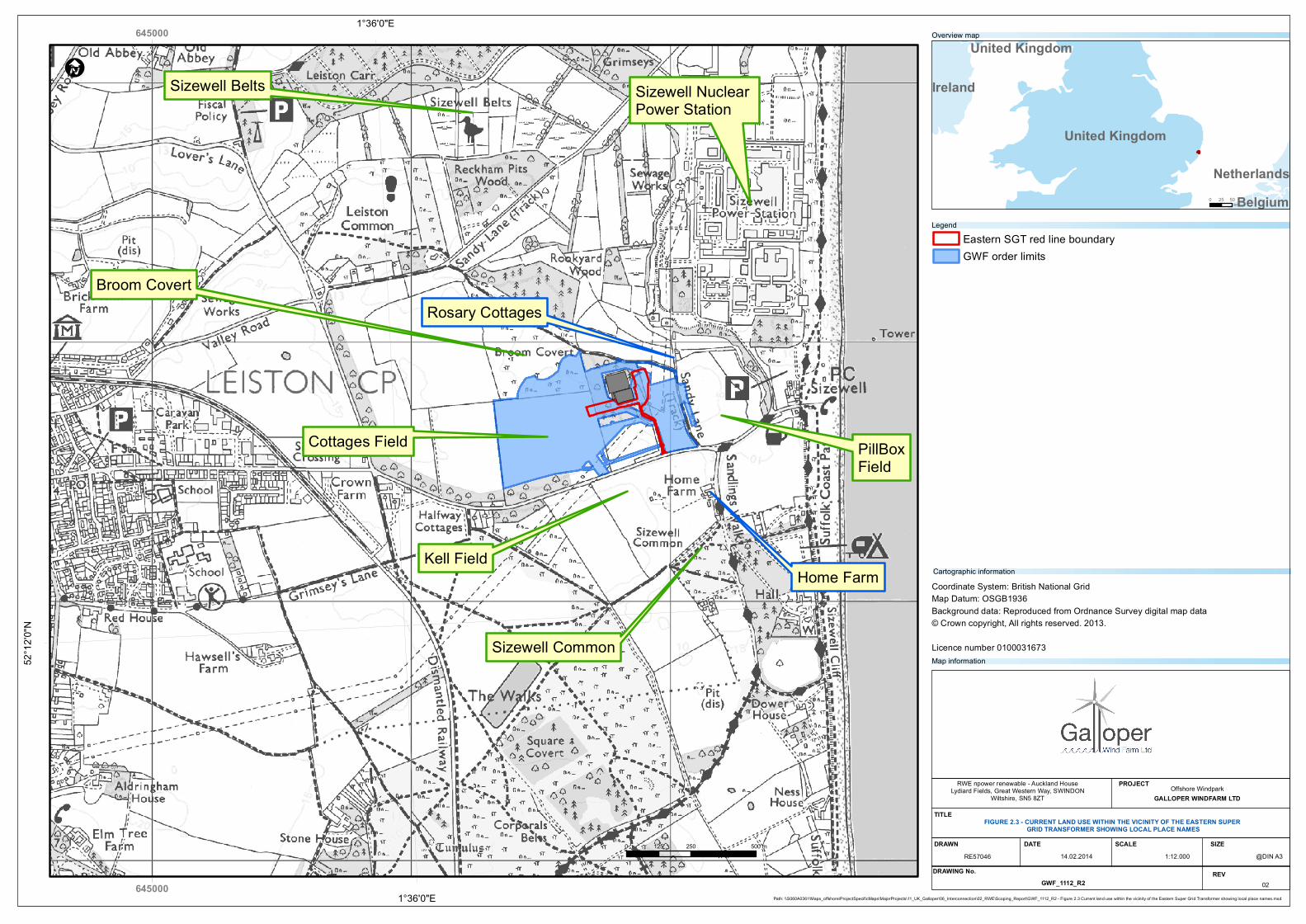
2.6.1 Broom Covert Field: Located to the north-west of the proposed ESGT, Broom Covert is a semi-natural grassland predominantly used for grazing. Figure 2.3 shows the proposed GWF land, as mentioned previously, the GWF substation will be partially placed on the southern end of this field.
2.6.2 Cottages Field: West of Sizewell Wents and south of Broom Covert, Cottages Field is arable land that will contain the majority of the consented GWF substation compound. Figure 2.3 shows the extent of the GWF compound.
52°1
2'0"N
I
United Kingdom
Ireland
BelgiumNetherlands
United Kingdom
0 250 500125 m
Path: \\S060A0361\Maps_offshore\ProjectSpecificMaps\MajorProjects\11_UK_Galloper\06_Interconnection\02_RWE\Scoping_Report\GWF_1111_R2 - Figure 2.2 Current land use within the GWF onshore site.mxd
0 5025km
Eastern SGT red line boundaryGWF order limits
Legend
Overview map
Coordinate System: British National GridMap Datum: OSGB1936Background data: Reproduced from Ordnance Survey digital map data
© Crown copyright, All rights reserved. 2013.
Licence number 0100031673
RWE npower renewable - Auckland HouseLydiard Fields, Great Western Way, SWINDON
Wiltshire, SN5 8ZTOffshore Windpark
GALLOPER WINDFARM LTD
DRAWN DATE@DIN A3
SCALE SIZE
PROJECT
TITLEFIGURE 2.2 - CURRENT LAND USE WITHIN THE GWF ONSHORE SITE
1:7.00014.02.2014RE57046DRAWING No. REV
GWF_1111_R2 02
Map information
Cartographic information
GGOWF substation
Leiston A
Sizewell Wents Woodland
Warts FieldSizewell Gap
Sandy Lane
Sandlings Walk
Galloper Wind Farm – Eastern Super Grid Transformer Project Environmental Statement – Chapter 2 Site Description and Land Use Final February 2014
2.6.3 Pillbox Field: Located east of Warts Field and Sandy Lane track, Pillbox field is arable
land that is situated within the Suffolk Heritage Coast designation (Figure 2.3). Pillbox field is located within the Sizewell C nominated area of land for the proposed nuclear power development. However, it is unlikely that this area will be used for any major construction works. Figure 2.3 shows the area of tree planting which will take place on the western border of Pillbox field.
2.6.4 Sizewell Belts: This is a grassland that lies beyond Sandy Lane to the north of the proposed development site. Sizewell Belts, also known as Sizewell Marshes, is a Site of Special Scientific Interest (SSSI) which is important for its lowland, unimproved wet meadows which supports invertebrates and a nationally significant breeding bird assemblage.
2.6.5 Kell Field: South of Sizewell Gap road, Kell field is mostly arable land with a triangular patch of broadleaved trees and scrub close to its centre. Home Farm is situated at the eastern end of this field.
2.6.6 Sizewell Common: The Countryside and Rights of Way (CRoW) Act 2000 designates Sizewell Common as registered common land, intended to give greater freedom for people to explore open countryside. Figure 2.3 shows the location of Sizewell Common.
2.6.7 Sizewell Nuclear Power Stations: The Sizewell nuclear power stations (Sizewell A and B) are located approximately 500m north-east of the proposed ESGT. In addition to Sizewell A and B, the power station complex is also the location of the Sizewell B Dry Fuel Store which is currently under construction. A new nuclear development (Sizewell C) is proposed to the north of Sizewell B. None of the proposed temporary or permanent land take for the ESGT directly affects any of the assets associated with Sizewell A, B or C.
2.7 Local Residential Land Uses
2.7.1 Local Residencies: Home Farm, a domestic dwelling, east of Kell field and north of Sizewell Common. Sandlings Walk, another route of recreational significance runs in a north-south direction immediately to the east of Home Farm. Rosery Cottages, located to the north-east of the proposed ESGT, are situated at the northernmost point of Sandy Lane as shown in Figure 2.3.
2.7.2 Leiston: Leiston, located less than 3km from the proposed ESGT, is the nearest large residential area with a population of more than 5,400 people. Leiston’s main connection to Sizewell beach is via Sizewell Gap Road which runs south of the proposed ESGT as shown in Figure 2.3.
2.7.3 Sizewell Village: Sizewell is a small fishing village that retains the basic services for tourism such as a public house and the Sizewell Beach Café. It is situated adjacent to Sizewell Beach, 750m east of the proposed ESGT and 3.2km east of Leiston Town. The Sizewell nuclear power stations are located directly north of the village.
645000
6450001°36'0"E
1°36'0"E52
°12'0
"N
I
United Kingdom
Ireland
BelgiumNetherlands
United Kingdom
0 250 500125 m
Path: \\S060A0361\Maps_offshore\ProjectSpecificMaps\MajorProjects\11_UK_Galloper\06_Interconnection\02_RWE\Scoping_Report\GWF_1112_R2 - Figure 2.3 Current land use within the vicinity of the Eastern Super Grid Transformer showing local place names.mxd
0 5025km
Eastern SGT red line boundaryGWF order limits
Legend
Overview map
Coordinate System: British National GridMap Datum: OSGB1936Background data: Reproduced from Ordnance Survey digital map data© Crown copyright, All rights reserved. 2013.
Licence number 0100031673
RWE npower renewable - Auckland HouseLydiard Fields, Great Western Way, SWINDON
Wiltshire, SN5 8ZTOffshore Windpark
GALLOPER WINDFARM LTD
DRAWN DATE@DIN A3
SCALE SIZE
PROJECT
TITLEFIGURE 2.3 - CURRENT LAND USE WITHIN THE VICINITY OF THE EASTERN SUPER
GRID TRANSFORMER SHOWING LOCAL PLACE NAMES
1:12.00014.02.2014RE57046DRAWING No. REV
GWF_1112_R2 02
Map information
Cartographic information
Broom Covert
PillBoxField
Cottages Field
Sizewell Belts
Sizewell Common
Kell Field
Sizewell Nuclear Power Station
Home Farm
Rosary Cottages
Galloper Wind Farm – Eastern Super Grid Transformer Project Environmental Statement – Chapter 2 Site Description and Land Use Final February 2014
2.8 Surrounding Transport Links and Significant Routes
2.8.1 Sizewell Gap Road: Sizewell Gap Road is the main road which links Leiston to the village of Sizewell and provides access to the development site. The access route for the existing GGOWF substation leads off Sizewell Gap perpendicularly and continues north to meet the GGOWF and Leiston substations. Sizewell Gap Road continues east to connect Sizewell Village the two nuclear power stations at Sizewell.
2.8.2 Sandy Lane: Sandy Lane is a bridleway which runs north from Sizewell Gap Road and veers north-west before it connects to Rosery Cottages. The bridleway continues north-west past the area of the proposed ESGT, skirting the northern border of Sizewell Wents before it continues on to connect with Lover’s Lane. The location of Sandy Lane is shown on Figure 2.3.
2.8.3 Lover’s Lane: Lover’s Lane, west of the proposed ESGT. There is only one residential property located on Lover’s Lane. At its southernmost point, Lover’s Lane connects to Sizewell Gap Road.
2.9 Local Recreation and Tourism
2.9.1 To the south of Sizewell Gap, there is an extensive footpath network, some of which forms part of the Aldringham Walks. Sandlings Walk, a 60 mile route between the eastern fringes of Ipswich and Southwold, passes through this area. These paths provide access to areas of open land, including Sizewell Common. There is also an established network of segregated cycle routes in and around the Sizewell area.
2.9.2 The Suffolk Coast and Heath Path is recognised as a feature of national value. This path is a 50 mile long route between Felixstowe and Lowestoft. It runs along the Heritage Coast and Sizewell beach, 750m to the east of the ESGT. It is also expected that this path will be adopted as part of the English coastal route under the Marine and Coastal Access Act.
2.10 Administrative Area
2.10.1 The ESGT development site is situated within the administrative area of Suffolk Coastal District Council (SCDC). SCDC is the authority responsible for determining the planning application which this environmental statement accompanies.