a conservation model for rock art in south …
TRANSCRIPT
A CONSERVATION MODEL FOR ROCK ART IN SOUTH
AFRICA: A MANAGEMENT PERSPECTIVE
Elijah Dumisani Katsetse
#383044
School of Geography, Archaeology and Environmental Studies
A thesis submitted to the Faculty of Science, University of the Witwatersrand,
Johannesburg, South Africa in fulfilment of the requirements for the degree of
Master of Science.
October 2015
ii
Dedication
I dedicate this thesis to my late father Mr. Boy Austin Katsetse
(1952−2013) whose teachings and winning spirit keeps me positive in life.
We started this academic journey together and it made you proud to see me
do well and you were keen on and looking forward to seeing me doing
doctoral studies. Where ever you are, I know you are smiling down on me as
I have taken a huge step toward doctoral studies by completing this Thesis.
“You were born a child of light’s wonderful secret— you return to the beauty
you have always been.” (Aberjhani)
iii
Acknowledgements
To the Lord Heavenly Father who has given me the strength and courage to
come thus further, I am thankful for the grace and blessing.
I would like to thank both my supervisors Dr Catherine Namono and
Professor Benjamin Smith for their assistance which resulted into this thesis.
I would also like to thank my mother Mrs Rose Twala-Katsetse for being
there every step of the way and for encouraging me to keep on fighting after
my father’s passing. My gratitude extends to all the members of my Family
and every single person that contributed directly or indirectly to this study.
This study was made possible through the generous funding of the National
Research Foundation of South Africa.
iv
Contents
DECLARATION ..............................................................................................................................I
DEDICATION ................................................................................................................................II
ACKNOWLEDGEMENTS ..............................................................................................................III
CONTENTS ................................................................................................................................. IV
LIST OF FIGURES ....................................................................................................................... VII
ABSTRACT ................................................................................................................................. IX
CHAPTER 1: INTRODUCTION........................................................................................................ 1
1.1. STATEMENT OF THE PROBLEM ................................................................................................... 2
1.2. THE PROJECT ........................................................................................................................ 3
1.3. AIM OF THE STUDY ................................................................................................................ 5
1.4. MANAGEMENT CONTEXT ........................................................................................................ 6
1.4.1. Cultural context of rock art ........................................................................................ 6
1.4.2. Legislative Framework ............................................................................................... 8
1.4.3. Conservation Protocols ............................................................................................ 11
1.5. ENVIRONMENTAL AND ARCHAEOLOGICAL SETTINGS ..................................................................... 12
1.5.1. Introduction ............................................................................................................ 12
1.5.2. The Drakensberg ..................................................................................................... 13 1.5.2.1. Cultural Context ............................................................................................................ 13 1.5.2.2. Physical Setting ............................................................................................................. 13 1.5.2.2.1. Geology ...................................................................................................................... 14 1.5.2.2.2. Climate ....................................................................................................................... 14 1.5.2.2.3. Flora ........................................................................................................................... 16 1.5.2.2.4. Fauna ......................................................................................................................... 17
1.5.3. The Makgabeng plateau.......................................................................................... 17 1.5.3.1 Cultural context .............................................................................................................. 17 1.5.3.2. Physical Setting ............................................................................................................. 18 1.5.3.2.1. Geology ...................................................................................................................... 18 1.5.3.2.2. Climate ....................................................................................................................... 19 1.5.3.2.3. Flora and Fauna .......................................................................................................... 20
1.5.4. The Cederberg area ................................................................................................. 21 1.5.4.1. Cultural Context ............................................................................................................ 21 1.5.4.2. Physical setting .............................................................................................................. 21 1.5.4.2.1. Geology ...................................................................................................................... 22 1.5.4.2.2. Climate ....................................................................................................................... 22 1.5.4.2.3. Flora ........................................................................................................................... 23 1.5.4.2.4. Fauna ......................................................................................................................... 24
1.6. CONCLUSION ...................................................................................................................... 24
CHAPTER 2 : ROCK ART CONSERVATION ................................................................................... 25
2.1. INTRODUCTION ................................................................................................................... 25
2.1.1. Archaeological conservation .................................................................................... 25 2.1.1.1. Rock art conservation in South Africa ............................................................................. 27
2.2. THEORIES AND PRINCIPLES OF SITE PROTECTION AND MANAGEMENT ............................................... 32
2.2.1. Rock Art Conservation ............................................................................................. 32

v
2.2.1.1. A holistic conservation approach ................................................................................... 35 2.3. CODES OF ETHICS AND LEGISLATIVE FRAMEWORKS ....................................................................... 38
2.3.1. Embedding ethics .................................................................................................... 40
2.4. MANAGEMENT ................................................................................................................... 41
2.4.1. Conservation and Management Practices ................................................................ 43 2.4.1.1. Realms and Spectrums of conservation and management practices ................................ 43 2.4.1.2. Management Tools ........................................................................................................ 44
2.5. CONCLUSION ...................................................................................................................... 47
CHAPTER 3 : ROCK ART DOCUMENTATION................................................................................ 48
3.1. INTRODUCTION ................................................................................................................... 48
3.2. DOCUMENTATION FOR CONSERVATION PURPOSES ....................................................................... 48
3.2.1. Documentation of examination ............................................................................... 50
3.2.2. Treatment Plan ....................................................................................................... 50
3.2.3. Documentation of treatment ................................................................................... 50
3.2.4. Archiving and databases ......................................................................................... 51
3.3. CONSERVATION ASSESSMENT METHODS ................................................................................... 52
3.3.1. Evaluation and Monitoring ...................................................................................... 52
3.3.2. Conservation Standards and Indicators .................................................................... 54
3.3.3. Evaluation based on definition of Criteria ................................................................ 55
3.3.4. Conservation Assessment ........................................................................................ 55
3.3.5. Conservation Assessment Techniques ...................................................................... 57
3.4. CONCLUSION ...................................................................................................................... 59
CHAPTER 4 : ROCK ART DETERIORATION AND TREATMENT ...................................................... 60
4.1. INTRODUCTION ................................................................................................................... 60
4.2. CONTROLS OF DETERIORATION ................................................................................................ 61
4.3. ROCK ART DECAY AND DECAY TREATMENT .................................................................................. 65
4.3.1. Anthropogenic destruction ...................................................................................... 65
4.3.2. Damage Treatment ................................................................................................. 66 4.3.2.1. Water Impact ................................................................................................................ 66 4.3.2.1.1 Drip Lines .................................................................................................................... 68
4.3.2.1.2. CASE STUDIES: SECTION 1 ...................................................................................... 69 4.3.2.2. Surface recession and Surface Pollutants ....................................................................... 78 4.3.2.2.1 Surface consolidation and cleaning systems ................................................................. 79
4.3.2.2.2. CASE STUDIES: SECTION 2 ...................................................................................... 81 4.3.2.2.3. CASE STUDIES: SECTION 3 ...................................................................................... 87
CHAPTER 5: RESULTS AND DISCUSSION ................................................................................... 114
5.1. DATA COLLECTION ............................................................................................................. 114 5.1.1.Phase 1: Preparation: Information gathering prior to assessment ..................................... 114 5.1.2. Phase 2: Information gathering during the assessment: Site observation and Consultation
............................................................................................................................................... 115 5.2. Data Analysis ........................................................................................................... 116
5.2.1. Phase 3: Comparative analysis and Strategies ................................................................. 122 5.3. CONCLUSION .................................................................................................................... 128
CHAPTER 6:A CONSERVATION MODEL .................................................................................... 129
6.1. RECOMMENDATIONS .......................................................................................................... 129
6.2. A WAY FORWARD ............................................................................................................. 135
6.3. FURTHER RESEARCH ........................................................................................................... 136

vi
REFERENCES ............................................................................................................................ 138
APPENDICES ............................................................................................................................ 159
APPENDIX ONE: ROCK ART CONSERVATION ASSESSMENT AND MONITORING INDEX............................. 159
APPENDIX TWO: QUESTIONNAIRE ON PERMIT ISSUING PROCESS FOR UNDERTAKING CONSERVATION
INTERVENTIONS. 165
APPENDIX THREE: LIST OF TABLES ............................................................................................... 167

vii
List of Figures
Figure 1: Rock art study regions and areas ..................................................................... 12
Figure 2: 50 year’s rainfall variability for the Drakensberg,adopted from Nel (2009) ..... 15
Figure 3:Seasonal temperature variability northern and southern Drakensberg, adopted
from Grab (2007) .......................................................................................................... 16
Figure 4:Thirty years mean rainfall variability, adopted from Bharwani et al. (2005) ..... 20
Figure 5:Monthly temperature variability, Limpopo Province, adopted from Tshiala et al.
(2011) ........................................................................................................................... 20
Figure 6:Monthly climate average for the Cederberg between 1950−2000, adopted from
bioval.jrc.ec.europa.eu/PA/pa/32845/PA.report_32845.html (consulted February 2014) 23
Figure 7:A multidisciplinary conservation approach, adopted from Pope et al. (2002).... 34
Figure 8: The conservation process and management plan modified from Letellier (2007);
Castellanos & Descamps (2008) .................................................................................... 49
Figure 9: Factors causing rock art deterioration at BSK 03, Cederberg [Photos by Elijah
Katsetse: 2014] ............................................................................................................. 71
Figure 10: Drip lines interventions at BKS 03................................................................ 72
Figure 11a:Wash zones and damp areas in relation to image clusters [Photos by Elijah
Katsetse: 2014] ............................................................................................................. 73
Figure 12: View of boulder BSK 09, Cederberg [Photo by Elijah Katsetse: 2014] .......... 83
Figure 13: Factors causing deterioration at BKS 09, Cederberg [Photos by Elijah
Katsetse: 2014] ............................................................................................................. 84
Figure 14: 'Varnish application on a rock art surface at BKS 09, Cederberg [Photos by
Elijah Katsetse: 2014] ................................................................................................... 85
Figure 15: Factors causing deterioration at BOE 16, Makgabeng [Photos by Elijah
Katsetse: 2013] ............................................................................................................. 89
Figure 16a: Treatment record for BOE 16, Makgabeng [Photos by Claire Dean: 2012] .. 91
Figure 17: Treatment monitoring at BOE 16, Makgabeng [Photos by Claire Dean: 2012
&Elijah Katsetse: 2013] ................................................................................................ 96
Figure 18: Factors causing deterioration at Main Caves, Drakensberg [Photos by Elijah
Katsetse: 2013] ............................................................................................................. 99
Figure 19: Damage due to an intervention at Main Caves, Drakensberg [Photos by Elijah
Katsetse: 2014] ........................................................................................................... 100
Figure 20: Visitor and dust control interventions at Main Caves, Drakensberg [Photos
from SARADA] .......................................................................................................... 102
Figure 21: Treatment record for Main Caves southeast, Drakensberg [Photos by Claire
Dean: 2013] ................................................................................................................ 104
Figure 22: Treatment record for Main Caves north, Drakensberg [Photos by Claire Dean:
2013] .......................................................................................................................... 105
Figure 23: Various graffiti at Game Pass Shelter, Drakensberg [Photos by Elijah Katsetse:
2013] .......................................................................................................................... 108
Figure 24a: Treatment record for Game Pass Shelter, Drakensberg [Photos by Claire
Dean: 2001] ................................................................................................................ 109
Figure 25a: Treatment monitoring at Game Pass Shelter, Drakensberg [Photos by Claire
Dean: 2001 & Elijah Katsetse: 2013] ........................................................................... 111
Figure 26: The conservation model for rock art in South Africa ................................... 130

viii
Figure 27: Articulation of the model. ........................................................................... 132
ix
Abstract
A call for a more systematic approach to site protection and management has long
been made for rock art conservation in South Africa. This study heeds the call as
it aims to develop a conservation model for rock art in South Africa from a
management perspective. Site protection and management principles that have
been successfully implemented in Australia and America have seldom been
implemented in South Africa. Conservation researchers argue that it is relatively
easy to identify theoretically the requirements of a management or conservation
policy; however, developing a conservation model and policy that will
successfully maximize the conservation opportunities is an abstract task. As such
building a conservation model founded on abstract concepts on conservation
would not lead to an improved conservation practice and would be unsuccessful.
In world heritage systems there are, however, essential agreed upon principles on
assessment, criteria, guidelines, standards, and implementation.
Such systems therefore, underscore that the problem is perhaps not with theory
but with conservation practice in South Africa. This study presents new and
original research on rock art conservation interventions assessment on rock art. As
a point of departure this study investigated the history of conservation practice in
South Africa using a conservation assessment model developed by Kathleen
Dardes (1998) for museums in America. The history on conservation practice has
identified inconsistencies in the management of conservation treatments and
approaches to interventions. Conservation interventions are still based on
inductive, emergency salvage approaches with no thorough understanding of
either site or environmental conditions in South Africa. There is little attention
paid to indigenous sensitivities with conservation practices and there are no
standard systems of monitoring and reporting. While far more data is required to
provide definitive conservation strategies, this study proposes a three step
conservation model for rock art in South Africa from a management perspective.
This model focuses on initiating, planning and controlling conservation projects.
1
Chapter 1: INTRODUCTION
Rock art research in southern Africa has strongly focused on the recording,
interpretation and archaeological value of rock art with a great deal of success
(Meiklejohn 1994).Little is been done to understand the mechanisms of
deterioration of rock art until recently (see Meiklejohn 1994; Hoerlé & Salomon
2004; Hoerlé 2005, 2006; Hall et al. 2007a, b; Arocena et al. 2008; Huneau et al.
2008; Meiklejohn et al. 2009; Hall et al. 2010; Venter 2011). However, there has
been not sufficient investment towards developing preservation techniques to
ameliorate rock art decay. However, a handful of recommendations on how to
improve rock art conservation and management in South Africa were put forward
for implementation beginning in the late 1970s (Mazel 1982, 1983, 1984, 2012;
Loubser 1991; Deacon 1994, 1996, 2006a, b, 2007; Wahl et al. 1998). It has
been suggested that in order to improve rock art conservation and management in
South Africa we should look elsewhere (Australia and America) to see what has
been done and how as well to explore the possible implementation of such
strategies locally (Loubser 1991; Deacon 1994).
Hitherto such calls for systematic management including a national database on
rock art have not been fully heeded. Rock art researchers in South Africa appreciate
that conservation and management approaches successfully implemented in
Australia and America have been least put into practice locally (Loubser 1991;
Deacon 1994).Therefore, rock art conservation management in South Africa has
been characterised by missed opportunities to implement working approaches at a
particular time in history. This failure to implement management and conservation
principles can be attributed either to the poor administration of heritage, the lack of
individual and institutional expertise and capacity, and/or the apparent lack of
interest in rock art conservation (Mazel 1982, 2012; Deacon 2006a, Ndlovu 2014b).
Within a framework of internationally recognised and appropriately applied
2
standards, heritage management is usually the responsibility of a particular
community or custodian group (Deacon 2007). The responsible stewards of rock art
in South Africa have failed to ensure compliance and implementation of site
protection and management principles; failure resulted in bad rock art conservation
management practice.
1.1. Statement of the problem
Rock art conservation globally was once based on the exploitative model that solely
focused on the preservation of cultural heritage resources (Lipe 1974). This model
was founded on the principles of an inductive piecemeal salvage approach.
However, in the late 1960s conservation theory and practice began to take on new
meaning in both archaeology and the conservation sciences (Stipe 1988; Demas &
Agnew 2006). Site protection and management principles show a global shift
toward the value-based approach (Lipe 1974, 1984; Loubser 2001; Demas &
Agnew 2006). The conservation approach is founded on principles of the value
based approach. These elements underscore the following steps for site protection
and management (Loubser 2001: 105; Demas & Agnew 2006: 71):
Preparation and background knowledge of the site
Assessment of values and significance
Assessment of the physical conditions of the site and causes of deterioration
Assessment of the context in which the site will be managed, used and
protected
Review of alternative treatment options and testing of preferred options
Actual intervention
The inefficient management of rock art is mainly due to the fact that conservation
practice in South Africa has not moved beyond the inductive piecemeal salvage
approach. Rock art conservation management under the inductive approach is
unsystematic, irresponsible and ill-considered. This approach draws attention two
practical issues in rock art management. Firstly, rock paintings are in peril and
building research assists in the preservation of rock art (Webb 1980; Van Rijssen
3
1987; Dandridge 2000). Under the value-based approach the first action towards
conservation is to gather background knowledge of the site which includes the
assessment of value, significance, the physical condition of the site and causes of
decay (Philippot 1988; Loubser 2001; Demas & Agnew 2006). However, when
physical interventions are required, the conservation protocol is often not or rarely
followed (Marshall & Tacon 2014). To promote standards of good practice in South
Africa, we therefore, need to gather as much data pertaining to conservation
treatments in order to avoid irresponsible and ill-considered treatment(s) that may
accelerate the deterioration of rock art (Webb 1980; Van Rijssen 1987; Dandridge
2000).
In South African rock art studies there is a paucity of data on the conservation
status of sites and paintings (Meiklejohn 1994; Venter 2011). Assessing the
effectiveness of past interventions can enable the formulation of a library of
conservation treatments, methods, and chemicals that are effective and those that
are harmful (Dandridge 2000). Secondly, a conservation project should be based on
historic knowledge about the site (Jopela 2010; Lage & Lage 2014). Therefore,
conservation interventions should not be undertaken without knowledge of previous
conservation work and the problems it revealed (Lage & Lage 2014).This will help
create a site profile and inventory of the criteria used, significance of the site,
baseline documentation, and establish site conditions. Conservation forms are an
integral part of good management of rock art (Wahl et al. 1998). Thus, a rock art
database is an essential part of the conservation cycle which allows going forward
and backward, thus preserving by record (Janik 2014). Otherwise efforts of
academic archaeology will be in vain if research is not directed towards
preservation of the subject matter (Deacon 1999).
1.2. The Project
This project is inspired by experiences and practical challenges I encountered
whilst conducting my Honours research. The project attempted to identify factors

4
causing deterioration and thereafter develop mitigation strategies for an
engraving site in the North West Province, South Africa. I realised that South
Africa suffers inadequate technical expertise as well as theoretical and practical
examples of success in terms of conservation interventions. Furthermore, there
are no monitoring programs to evaluate conservation interventions (Clark 2001;
Fordred 2011; Venter 2011). This begs the question of what criteria are used to
grant permission for interventions in the absence of a conservation repertoire that
not only details successful interventions but also indicates which techniques have
had negative impacts on rock art.
A range of conservation methods have been applied, from geotextile, hardening of
exposed surfaces, roofing methods, and drainage options of sites on slopes,
boardwalks, and floor paving (Wahl et al. 1998; Deacon 2006a; Matero n.d.).
Conservation is a management strategy to ameliorate decay (Haskovec 1991;
Dandridge 2000; Macleod 2000; Loubser 2001; Mawere et al. 2012; Darvill &
Fernandes 2014; Lage & Lage 2014). Conservation and preservation differ broadly
in theory, methodology and techniques (Lage & Lage 2014), and are infused with
technical, theoretical, and methodological challenges (Haskovec 1991; Dandridge
2000; Macleod 2000; Loubser 2001; Mawere et al. 2012). Site managers have not
adequately addressed conservation. Archaeological conservation is a discourse
characterised by debates and conflict in theory and practice. Debates about
definitions, meanings, standards, approaches, techniques, methodologies, and
conservation ethics define the history of the discipline. The conservation of non-
renewable cultural resources is an element of Cultural Resource Management
(CRM), a term coined in America during the early 1970s (Fowler et al. 2009;
Alonso & Meurs 2012). In this study the terms Conservation and Preservation are
defined as follows:
‘Conservation’is:
a technical study of materials making the rock art (pigments, rock substrate,
environmental) elements aimed at ameliorating decay through the use of direct
intervention measures;
5
And,‘Preservation’is:
indirect measures broadly aimed at managing the destruction of heritage resources
that results from anthropogenic activities through protective legislation, planning,
education, the creation of positive attitudes and programmes that provide
management contexts (people, place, significance).
Rock art management broadly employs the following strategies to ameliorate decay
(Carter & Grimwade 1997: 45):
In situ protection/preservation, including total protection and zero use;
Relocating of the elements to a new setting;
Making the item or site available only to the appreciative and knowledgeable; and
Complete access or use, subject to the management constraints including
technological interference or enhancement.
These strategies highlight international standards and frameworks appropriate for
site protection and management. However, the efficacy and successful
implementation of these strategies are a function of heritage management that is
shaped by the “administrative and legislative framework of the country in which
they operate" (Cleere 1984: 125). Consequently, the application of these strategies
remains a major problem within conservation in South Africa. The loose legislative
framework, lack of funding expertise, and interest in conservation research offer
very little towards the future preservation of rock art. These challenges in rock art
conservation management highlight the need for a conceptual framework. This
study undertook to conduct a conservation assessment of a sample of past
interventions on rock art in South Africa in order to maximise rock art preservation.
1.3. Aim of the Study
This study attempts to develop a conservation model for rock art in South Africa
from a management perspective. Given that in South Africa we do not have enough
personnel trained in appropriate rock art site protection and management principles

6
and contemporary conservation theory is shifting toward principles of preventive
conservation, I argue that a preventive conservation model for rock art conservation
management will be ideal in South Africa. Five public rock art sites (Bushmans
Kloof 03 and 09, Bonne Esperance 16, Main Caves (north and southeast), and
Game Pass Shelter) from across South Africa were identified to assess the
effectiveness of and to document past conservation interventions undertaken in
South Africa over the last 20 years.
These sites provide a representative sample of rock art sites in South Africa. They
provide diverse environmental and rock art site conditions ideal to observe the
effects of conservation interventions under varied site conditions and landscapes
situations. These sites are important in terms of the cultural and scientific values;
they are public sites and therefore, provide an opportunity to develop a model
informed by specific site settings that include micro and macro environments, site
petrology, cultural context, management context, legislative framework and
conservation protocol(s).
1.4. Management Context
1.4.1. Cultural context of rock art
Southern Africa is home to multiple rock art traditions that bring us closer to
understanding their cultural context. Understanding the modern and palaeo-
ethnicity of the authors of rock art is a challenge that has been met with a
reasonable level of success (Rifkin 2009). The rock art community today
appreciates that indigenous communities of South Africa have contributed to the
corpus of rock art. A large body of rock art is associated with the San hunter-
gatherers (Deacon 1999), a considerable amount is attributed to Khoekhoe
herdersas well as Bantu farmers. The amalgamation, interaction, and acculturation
of the San with immigrant groups over the last 2000 years (Prins 2009) has resulted
in rock art today being found in contemporary and multi-ethnic landscapes
(Ndlovu 2005; Deacon 2006b; Prins 2009; Rifkin 2009). The Drakensberg
landscape provides evidence of such contemporary societies with ancestral links to
7
indigenous groups. Contemporary societies with ancestral links to authors of rock
art and those found in the proximity of rock art sites will be referred to here as local
communities.
Contemporary conservation theory is founded on the principles of multi-
stakeholder inclusion and participation. Local communities where most of the rock
art is found have a big role to play in its preservation. However, issues of
ownership always arise regarding rock art attributed to San hunter-gatherers partly
due to the notion advanced by researchers that the San were extinct (Ndlovu 2005,
2009b; Prins 2009).Academic archaeology and heritage management in South
Africa have ignored the complex phenomenon of identities and its implications for
the proper management of cultural resources (Deacon 2006b).
Therefore, locally we must appreciate that rock art in South Africa is a multi-
traditional resource. For example, Thaba-Sione, a rock engraving site attributed to
the San is now an integral part of Tswana heritage and tradition (Ouzman 1995).
The Duma Clan from Kamberg in the Drakensberg is one of the most vocal groups
claiming San ancestry (Ndlovu 2005; Prins 2009). The Duma clan and their
knowledge systems have effected changes in the management of rock art in the
Drakensberg (Prins 2009). The request of the Duma’s to perform a ritual known as
the ‘Eland’s Ceremony’ at Game Pass Shelter was acknowledged by the heritage
authority of Kwazulu-Natal province in 2002 (Ndlovu 2005; Prins 2009). The
‘successes’ of the ‘Eland’s Ceremony' has seen ritual prescriptions of the ceremony
being incorporated into the new Heritage Management Plan of Game Pass Shelter
(Prins 2009). However, the process did not proceed without challenges; some of the
management restrictions from Amafa saw a sacred process being turned into a
public viewing ceremony with outsiders permitted to attend the ritual on site
(Ndlovu 2005).Acknowledging the role of local communities in the management
and conservation of rock art in South Africa is a new and contentious undertaking
(Deacon 2006b). Pigment removal for medicinal purposes highlights the need for
the inclusion of contemporary belief systems in both the interpretation and
management of rock art. Managers of rock art sites consider pigment removal a
8
problem rather than an opportunity to engage with contemporary societies to
explore the reasons for their actions.
Ritual prescriptions of the ‘Eland’s Ceremony’ and the removal of pigments from
sites underscores the significant role local communities have to play in rock art
research and management. A key element of this ritual includes the “protection of
the site from ‘ritual pollution’ carried by outsiders and unexpected visitors” (Prins
2009: 203-204). It is argued elsewhere that conservation interventions such as the
cleaning of artefacts pollutes and affects the spiritual significance of cultural
objects (Ndlovu 2005; Simms 2005). Such revelations do not only make a case for
the inclusion of local communities’ knowledge systems in policy but also
emphasise the need to follow the conservation protocol, implement significance
assessment and consult with local communities prior to any conservation
interventions. This study takes into consideration the role of local communities in
conservation in developing a conservation model for rock art in South Africa. This
will be done in recognition of heritage legislation.
1.4.2. Legislative Framework
Rock art in South Africa have been protected by policy for the past 100 years,
initially under the Bushmen Relics Act (1911). All rock art sites in South Africa
were officially protected under the National Monuments Acts (NMA) of 1969.
Since 1999 all heritage resources have been protected under the National Heritage
Resources Act (NHRA) (25 of 1999). The South Africa Heritage Resources Agency
(SAHRA) as an agency of the Department of Arts and Culture (DAC) is charged
with managing and controlling the implementation of NHRA. The main aim of the
legislation and legal frameworks in the heritage sector is to preserve cultural
resources.
The NHRA states that it ‘aims to promote good management of the national estate,
and to enable and encourage communities to nurture and conserve their legacy so
9
that it may be bequeathed to future generations’ (NHRA 1999: Preamble). The
NHRA provides the management framework for the preservation of cultural
resources through a three-tier management system. The three-tier management
systems denotes that SAHRA is responsible for heritage resources of national
significance designated as Grade I sites. Grade II sites are the responsibility of the
Provincial Heritage Resources Authorities (PHRAs). Where the PHRA is non-
existence SAHRA assumes management responsibilities by default. At local level,
Grade III sites are managed by municipalities. This three-tier system promotes the
management of heritage resource at all levels of governance and society in order to
engage and encourage participation particularly at local level (Ndlovu 2011).
The NHRA is said to have failed in the promotion and inclusion of local
communities in the conservation of heritage resources. The role of local
communities in the conservation of heritage resource has been shown by cases from
Australia (Ndlovu 2005). This study engages with South Africa’s NHRA (25 of
1999) with regards to rock art protection. The fundamental codes of pieces of
legislation are to provide a framework for long-term preservation of heritage
resources. Legislation protects heritage resources from what is deemed
unacceptable levels or causes of damage often as results of anthropogenic forces
(Scheermeyer 2005; Ndlovu 2011). This is done by making provision for the
following legislative tools (Ndlovu 2011: 32):
i. providing a description of what resources are considered significant in a
legislation and should be protected;
ii. setting up a criteria for determining significance and the process of
approving appropriate mitigation measures, where necessary; and
iii. to determine legal means to be taken against those who violate principles
that threaten the protected resources.
NHRA’s aims towards heritage resources management are founded on these three
elements supported by the three-tier system. The NHRA aims to introduce an
integrated and interactive system for the management of the national heritage
resources, lay down general principles for governing heritage resources
10
management throughout the Republic and introduce an integrated system for the
identification, assessment and management of heritage resources of South Africa.
To understand how NHRA relates to rock art conservation interventions and
management I refer to how rock art is defined. Section 2(b) of the Act defines rock
art as:
Being any form of painting, engraving or other graphic representation on a fixed
rock surface or loose rock or stone, which was executed by human agency and
which is older than 100 years, including any area within 10m of such
representation.
Heritage resources are protected under Sections 34 to 38 of the NHRA.
Enforcement of legislation, applications for permits, appeals, offences and penalties
are dealt with under sections 48 to 51 respectively. Rock art conservation and
management is undertaken following principles outlined in the sections 35 and 38
as follows:
Section 35- Archaeology, palaeontology and meteorites
(2) Subject to the provisions of subsection (S) (a), all archaeological objects,
paleontological material and meteorites are the properties of the State. The
responsible heritage authority must, on behalf of the State, at its discretion ensure
that such objects are lodged with a museum or other public institution that has a
collection policy acceptable to the heritage resources authority and may in so doing
establish such terms and conditions as it sees fit for the conservation of such
objects.
(4) No person may, without a permit issued by the responsible heritage resources
authority—
(a) destroy, damage, excavate, alter, deface or otherwise disturb any archaeological
or paleontological site or any meteorite;
(b) destroy, damage, excavate, remove from its original position, collect or own any
archaeological or paleontological material or object or any meteorite;
11
(c) trade in, sell for private gain, export or attempt to export from the Republic any
category of archaeological or paleontological material or object, or any meteorite;
or
Section 38- Heritage Resources Management
Protects heritage resources in the face of development
It outlines the kinds of developments a developer needs to consult with
heritage authorities on the possible impacts (Heritage Impact Assessment (HIA)) of
the development on resources
It also stipulates the minimum level of information required in the HIA.
It is important to note that the provisions of Section 38(8) relating to development
does not apply when a Heritage Impact Assessment is required in terms of the
Environmental Conservation Act (Act 73 of 1989) now replaced by the National
Environmental Management Act (NEMA) Act 107 of 1998 and the Minerals Act
(Act 50 of 1991) now the Minerals and Petroleum Resources Development Act
(MPRDA) Act 28 of 2002.
1.4.3. Conservation Protocols
In South Africa, SAHRA does not have specific conservation protocols to address
rock art conservation interventions nor does it have protocols for the conservation
of any other heritage resources (Namono,pers comm. 2014; Ndlovu, pers comm.
2014; Hollman, pers comm. 2014). Amafa has been committed to the management
of rock art since the late 1970s and rock art is managed under an integrated
management approach known as the ‘CURE Document’ (Wahl et al. 1998; Cure
1998, 2000, 2012; Ndlovu 2005). Comparatively, in Australia rock art resources
and conservation protocols are encapsulated under the concept of ‘caring for
country’ (Lambert 2007; Marshall & Tacon 2014). Both frameworks encourage the
inclusion of local communities in the management and conservation of rock art.
The Australian framework attempts to redress past inequalities experienced by
Aboriginal people (Marshall & Tacon 2014).
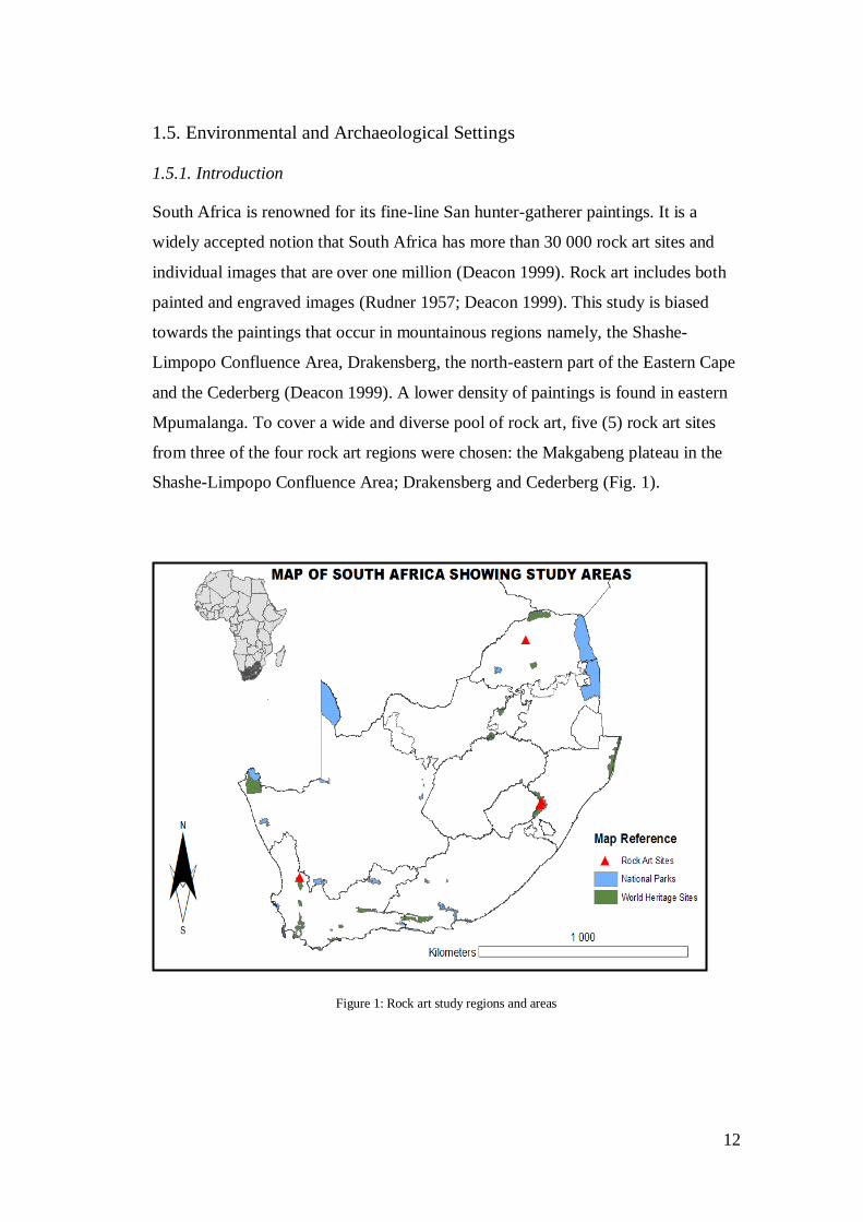
12
1.5. Environmental and Archaeological Settings
1.5.1. Introduction
South Africa is renowned for its fine-line San hunter-gatherer paintings. It is a
widely accepted notion that South Africa has more than 30 000 rock art sites and
individual images that are over one million (Deacon 1999). Rock art includes both
painted and engraved images (Rudner 1957; Deacon 1999). This study is biased
towards the paintings that occur in mountainous regions namely, the Shashe-
Limpopo Confluence Area, Drakensberg, the north-eastern part of the Eastern Cape
and the Cederberg (Deacon 1999). A lower density of paintings is found in eastern
Mpumalanga. To cover a wide and diverse pool of rock art, five (5) rock art sites
from three of the four rock art regions were chosen: the Makgabeng plateau in the
Shashe-Limpopo Confluence Area; Drakensberg and Cederberg (Fig. 1).
Figure 1: Rock art study regions and areas
13
1.5.2. The Drakensberg
1.5.2.1. Cultural Context
The Drakensberg is renowned for its rich natural heritage but it is not an uncultured
landscape (Fordred 2011). It has a deep and rich human history beginning in the
Middle Stone Age (MSA) ca. 250 000-30 000 years ago. The recent history of the
Drakensberg shows evidence of interaction between San hunter-gatherers,
Khoekhoe herders, Bantu farmers and the European settlers (Ndlovu 2005; Prins
2009; Fordred 2011).
The cultural influence on the environment and landscape in the Drakensberg is
approximately between the Later Stone Age (LSA) and historical periods ca. 30
000 years ago to the present (Fordred 2011).30 years of research which includes the
work of Patricia Vinnicombe, David Lewis-Williams, Aron Mazel, and more
recently Frans Prins. The long cultural history of the Drakensberg is characterised
by the production of material culture, exploitation and strategic utilisation of the
natural resources, and human interaction.
1.5.2.2. Physical Setting
The UKhahlamba Drakensberg Park (UDP) is part of the Drakensberg mountain
range and is the focus area of this study. It can be located at 29° 45' E and to the
west extending to 28° 52' E and it runs at 28° 38' S and 28° 46' S from north to
south. The UDP is an amalgamation of Twelve (12) protected areas consisting of
one National Park, four Nature Reserves, six state Forests, and one Game reserve
(Fordred 2011). The first of these protected areas Giant’s Castle was established in
1903 and the latest Kamberg was created in 1970 (Fordred 2011). The UDP was
declared as a World Heritage Site (WHS) in the year 2000 for its majestic and
scenic mountains as well as its rich rock art heritage. The Drakensberg mountain
range is the largest geomorphologic land feature in South Africa ranging from
Mpumalanga through KwaZulu-Natal and into the Eastern Cape Province. From
north to south it covers a distance of 150 kilometres from the Royal National Park
to the Bushmen’s Nek covering an area of 200 202 square kilometres (Fordred
14
2011; Venter 2011). The west boundary of the UDP forms the Lesotho-South
Africa border where the eastern section of the mountain range is called the Maloti
Highlands (Venter 2011). The Drakensberg Mountains at the foothills is as low as
1400m and at its highest it reaches 3482m. The highest mountain of the
Drakensberg is called Thabana Ntlenyana standing at 3482m (Ndlovu 2005).
1.5.2.2.1. Geology
The origin of the Drakensberg can be traced back to the Gondwanaland land mass
(Ndlovu 2005; Leuta 2009; Fordred 2011; Venter 2011). In its current form the
mountain range was created by ancient flowing waters, wind and other related
weathering agents. The mountain range has been shaping and reforming over the
past 250 million years. The geology of the Drakensberg is characterised by two
subgroups of the Karoo supergroup, the Beaufort and Stormberg Groups (Ndlovu
2005; Leuta 2009; Fordred 2011; Venter 2011). The Drakensberg has been
structurally divided into two potions which better explains its geology, the ‘High
and Low Berg’. The Karoo system forms part of the High Berg with the volcanic
basalt that forms the mountain cap. At the foothills of the Drakensberg is the
Beaufort Group which lies beneath the Basaltic lava (Ndlovu 2005). It is here
beneath the Basaltic lava where the Clarens Formation or ‘cave sandstone’ occurs.
This is the less resistant and porous layer of sandstone where rock shelters are
formed at 1600 to 1800m above sea level. Below the sandstone of the Clarens
Formation, is the Elliot Formation which is about 250m thick (Fordred 2011;
Venter 2011).
1.5.2.2.2. Climate
The Drakensberg is an inland mountain range that creates a barrier between inland
and coastal South Africa. This barrier affects and influences the mesoscale climate
of the plateau (Ndlovu 2005). Warm moist air from the Indian Ocean rises above
the escarpment in summer when the inversion layer lifts above plateau (Fordred
2011). Evidence suggests that the climate of the Drakensberg has changed over the

15
years. The climate of the Drakensberg is characterised by moist air rising above the
escarpment bringing summer rainfall. Precipitation occurs high up the mountains
and the resulting run-off accumulates both at the top and foothills (Leuta 2009). As
a result the Drakensberg is one of the least drought-prone areas in southern Africa
(Ndlovu 2005; Fordred 2011; Venter 2011).
Rainfall peaks in summer between November and March with January and
February producing the highest levels of precipitation (Ndlovu 2005; Leuta 2009;
Fordred 2011; Venter 2011). Winters are generally dry and contribute less than
10% of the annual precipitation. The annual precipitation in the Drakensberg ranges
between 10002000mm and summer precipitation contributes 70% of this total
(Venter 2011). Nel (2009) has observed some rainfall variability from 11 weather
stations in the Drakensberg for the period 1955–2000 (Fig. 2).Highest air
temperatures (up to 35°C) are also recorded for the summer months. Temperature
variations have been observed at Sani Pass (northern Drakensberg) and Sentinek
Peak (southern Drakensberg) weather stations (Fig. 3) (Mackellar et al. 2014). The
highest air temperatures are recorded on north-facing slopes. The mean annual
temperature is in the region of 16 °C (Leuta 2009; Fordred 2011; Venter 2011).
With the lowest air temperatures recorded during winter nights. The vegetation of
the Drakensberg is suited to both its geology and climate.
Figure 2: 50 year’s rainfall variability for the Drakensberg,adopted from Nel (2009)

16
Figure 3:Seasonal temperature variability northern and southern Drakensberg, adopted from Grab (2007)
1.5.2.2.3. Flora
The physiography of the Drakensberg and its wetlands promote a diversity of plant
biota (Fordred 2011). The vegetation can be divided into three main regions, the
high altitude, mid altitude, and low altitude (Ndlovu 2005; Leuta 2009; Fordred
2011; Venter 2011). These three regions vary considerably but they do overlap at
certain levels. The high altitude belt is located at 28653500m above sea level. It is
characterised by plants such as the Helichrysum hearth as its main unique plant
community. The mid altitude belt is located between the high and low berg and is
likely to exhibit characteristic of both. Situated at 18302865m above sea level is
the mid altitude belt with PasserinaPhilipiaWeddringtonia Fynbos and grassland
(Ndlovu 2005; Leuta 2009; Fordred 2011; Venter 2011). The Fynbos, scrubland,
and woodland vegetation can also be identified within the mid altitude belt. The
low altitude belt like the mid altitude exhibits characteristics of grassland
vegetation (Ndlovu 2005; Leuta 2009; Fordred 2011; Venter 2011). It is however,
characterised by the Podocarpus latifolius forest community. The low altitude belt
stands at 12801830m above sea level. This diverse plant community supports a
diverse faunal community.
17
1.5.2.2.4. Fauna
The UDP is habitable to over 2153 plant species. Although the UDP is not a Big
Five area it has a lot to offer in terms of wildlife (Ndlovu 2005). Over 300 bird
species can be identified in UDP. Forty-Eight species of mammals which include
the eland, mountain rhebuck, grey rhebok, grey duiker, klipspringer, and bushbuck
can be spotted within the UDP. Common animals within the UDP include the
baboon, rock hyrax, and porcupine. The leopard is also an attraction spotted
amongst other predators like the black backed jackal within the park (Ndlovu 2005;
Fordred 2011). A further 30 species of amphibians, 18 of lizards, and 24 of snakes
provide a glimpse of diversity within the UDP (Fordred 2011).
1.5.3. The Makgabeng plateau
1.5.3.1 Cultural context
Edward Eastwood and colleagues (2002: 1) describe the Makgabeng plateau as the
“fertile ground for both archaeologists and rock art researchers” (2002: 1). Rock art
surveys of the area spanning a period of 11 years have identified and documented
over 460 sites in the Makgabeng plateau and over 600 in the Central Limpopo
Basin (Eastwood et al. 2002; Eastwood 2003; Eastwood & Tlouamma 2006). In the
early 1950s Jean Humphrey undertook the first archaeological excavation on the
plateau (Eastwood et al. 2002; Heritage Statement for the Waterberg Prospecting
Rights Application, Blouberg, Limpopo Province 2013). The archaeology of the
Makgabeng shows evidence of a deep prehistory beginning in the ESA, although
the ESA and MSA are not well researched and understood while the LSA is mostly
associated with rock art. Critical events started by the time of the arrival of both
the Khoekhoe and Bantu farming communities’ ca. 700 AD (Eastwood et al. 2002;
Tomose 2006; Heritage Statement for the Waterberg Prospecting Rights
Application, Blouberg, Limpopo Province 2013).
The population of the Makgabeng mainly comprises the Hananwa, Ndebele, Koni
and Europeans (van Schalkwyk 2009a, b). The dominant Hananwa people have laid
18
claim to the area and were the main ethnic group at Makgabeng (van Schalkwyk &
Moifatswane 1991). The relationship between the locals and European Settlers is
described by many as having been amicable until the Old South African (ZAR)
regime initiated plans to curb African independence which resulted into the
Maleboho War of 1894 (van Schalkwyk & Moifatswane 1991; Heritage Statement
for the Waterberg Prospecting Rights Application, Blouberg, Limpopo Province
2013).
1.5.3.2. Physical Setting
The Makgabeng plateau, the Shashe-Limpopo Confluence Area (SLCA), the
Soutpansberg, and the north-eastern Venda region make up the four rock art regions
of the Central Limpopo Basin (Eastwood et al. 2002; Eastwood 2003; Charteris &
Eastwood 2004). The Makgabeng plateau based on the river is divided into three
regions the eastern, central, and western Makgabeng (Tomose 2006). The central
Makgabeng is divided into farms Millbank, Old Langsine, Langbryde, Millstream,
Gallashiels, Nieuwe Jerusalem, and Too Late. The eastern portion of the
Makgabeng plateau is made up of the farms Mont Blanc, Bonne Esperance,
Rosamond, Disseldorp, and Sweet Home (Tomose 2006; Heritage Statement for the
Waterberg Prospecting Rights Application, Blouberg, Limpopo Province 2013)
while the western region consists of the farms Devilliersdale, De la Roche,
Groenepunt, Kirsternspruit, and Bayswater (Tomose 2006). This study focuses on
the Bonne Esperance 16 in the eastern region, colloquially referred to as ‘The Great
Train Site’. The Makgabeng plateau is a unique region of South Africa where all
three rock art traditions occur or co-occur in one site. The rock art of the area is
largely well preserved but exposed to the elements which are a threat.
1.5.3.2.1. Geology
The Makgabeng plateau is underlain by 2 billion years old Aeolian sediments
believed to have been a result of a Precambrian desert environment. The
Precambrian desert contains cyanobacteria a precursor of life on earth (Eriksson et
al. 2000; Eastwood et al. 2002). The geology of the plateau is made up of the
19
Makgabeng and the Mogalakwena Formations of the Waterberg Group. The
Waterberg Group is of Mongolian age (2070 to 1080 million years ago). The
Makgabeng formation is believed to be best exposed in its structure over the
Makgabeng plateau. Aeolin deposits form a large component of the Makgabeng
Formation (Eriksson et al. 2000). The pebbly Setlaole Formation grades up into the
mature sandstone of the Makgabeng Formation (Eriksson et al. 2000). Lithology
characteristic of the Makgabeng Formation include the fine-to-medium grained
quartz arenites, the finer siliciclastties and pebbly sandstones.
1.5.3.2.2. Climate
Climatic variations have been observed in the past over the plateau (Tomose 2006).
Modern day climate shows that the plateau and surrounding areas experience
summer rainfall with an average of 350 to 650mm per annum (Eriksson et al.
2000). High levels of air temperatures are experienced in summer with the day
temperatures reaching a maximum of 40 ˚C with a monthly average of 21˚C. Low
temperatures are experienced in winter where levels could drop below 0˚C.
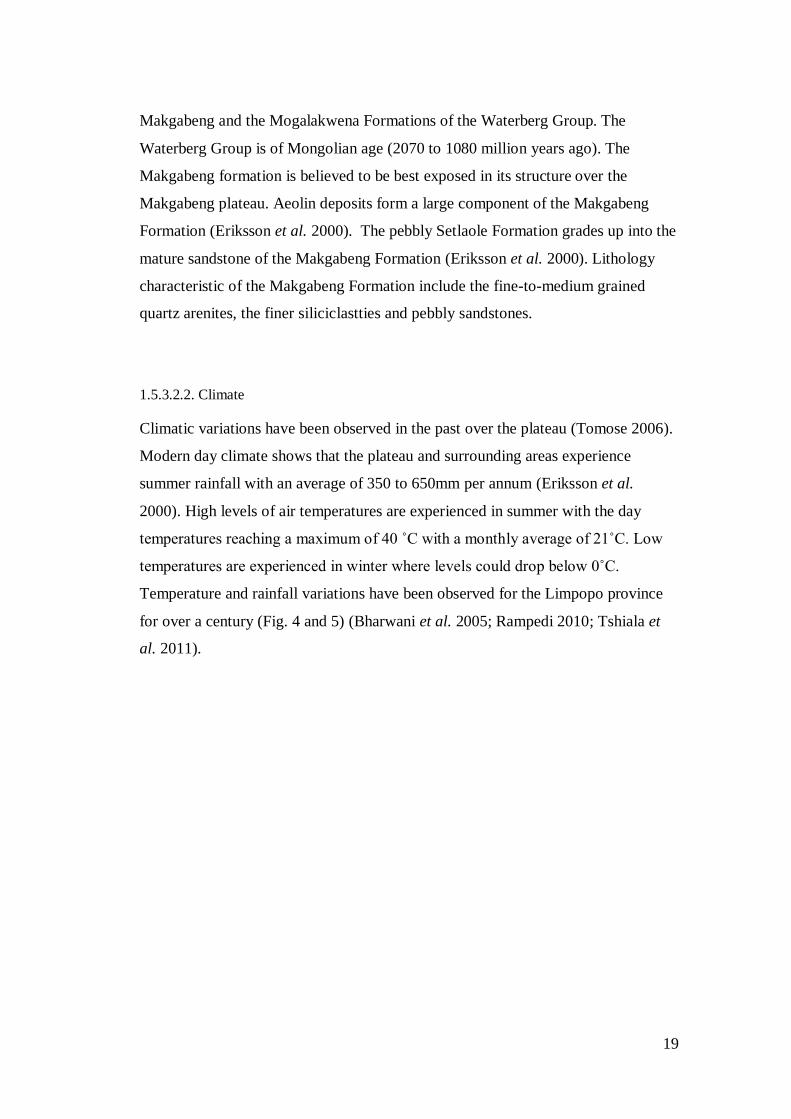
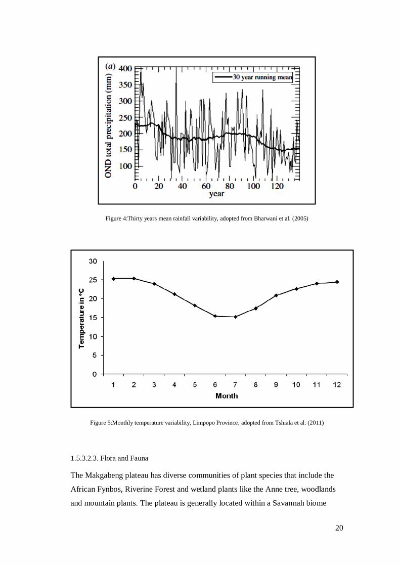
Temperature and rainfall variations have been observed for the Limpopo province
for over a century (Fig. 4 and 5) (Bharwani et al. 2005; Rampedi 2010; Tshiala et
al. 2011).
20
Figure 4:Thirty years mean rainfall variability, adopted from Bharwani et al. (2005)
Figure 5:Monthly temperature variability, Limpopo Province, adopted from Tshiala et al. (2011)
1.5.3.2.3. Flora and Fauna
The Makgabeng plateau has diverse communities of plant species that include the
African Fynbos, Riverine Forest and wetland plants like the Anne tree, woodlands
and mountain plants. The plateau is generally located within a Savannah biome

21
(Eastwood & Tlouamma 2006; Tomose 2006). There is not much of wildlife in the
plateau. Game animal are extinct and domesticates roam freely. The permanent and
highly nutritious sweet grasses located within the gorge and river valleys provide a
staple diet for domesticates (Tomose 2006).
1.5.4. The Cederberg area
1.5.4.1. Cultural Context
The Cederberg area is described as a cultural landscape exhibiting diverse heritage
resources ranging from rock art to historic structures. The rock art of the northern
Cederberg according to Orton and Hart (2005: 10) “is very diverse and perhaps the
most fascinating and visually appealing of heritage resources in the area”. The
archaeology unit at the University of Cape Town has been conducting research in
the area since the beginning of the 1960s. The very appealing rock paintings of the
Cederberg have been subject of research in many publications (see Parkington
2003). The area does not have much to offer in terms of prehistoric occupation
(Orton & Hart 2005). The MSA and LSA offer a lot in terms of the rock art and
material scatter on the floor of rock shelters. The Cederberg is located in a northerly
direction of Clanwilliam one of the oldest historic towns in South Africa (Orton &
Hart 2005). The area thus has a long history of European settlement (Orton & Hart
2005).
1.5.4.2. Physical setting
The Cederberg is located at 32˚ 00'-32˚ 45' S and 18˚ 50'-19˚ 25' E and some
250km north of Cape Town (Boelhouwers et al. 1999; Valsecchi et al.2013). The
range covers a distance of approximately 125km in length with a varying breadth
where it stretches 25km long at its widest point. It stands at 300-2150m (Brown
1991; Smith 2001; Quick et al. 2011). The Wilderness area of the Cederberg
according to Smith (2001) covers 71 000 hectares and was the second to be
declared as a wilderness area in 1973 after the Drakensberg. The mountains lie in
the northern part of the Cape Floristic Region (CFR) and are largely made up of the
22
sandstone of the Table Mountain Group (Moore & Picker 1991; Boelhouwers et al.
1999; Orton & Hart 2005; Valsecchi et al. 2013). The mountains play a crucial role
in the sustenance of life on earth; they are not only part of the Greater Cederberg
Biodiversity Corridor but they provide the catchment area lying in the driest part of
the south-western Cape (Brown 1991; Boelhouwers et al. 1999; Smith 2001; Quick
et al. 2011). The two major rivers forming the catchment of the area are the
Olifants River in the southwest and the Doring River to the northeast (Brown
1991). The physiography of the mountains allows it to be a significant conservation
area globally and this can also be attributed to its geology and climate (Smith 2001;
Valsecchi et al. 2013).
1.5.4.2.1. Geology
The Cederberg is comprised of the Table Mountain Group (Brown 1991;
Boelhouwers et al. 1999; Moore & Pickler 2005; Quick et al. 2011; Valsecchi et al.
2013). The lithologies of the Cederberg are predominantly sedimentary rocks
occurring within the Ordovician to the Devenian supergroup (Quick et al. 2011).
The range is characterised by quartzite sandstones (Quick et al. 2011; Valsecchi et
al. 2013). Traces of the Malmesbury Shales Group and sandstones can be identified
to the west (Quick et al. 2011). To the east of the range there is a clear change in
the underlying geology where the Bokkeveld formation grades in (Quick et al.
2011).
1.5.4.2.2. Climate
The Fynbos biome of the south-western Cape is characterised by a Mediterranean
climate. The climate of this region is said to have been stable over time. The
Cederberg experiences wet and cool winters and dry summers (Archer 2009). The
mean annual rainfall ranges between 500 and 1000mm and the austral winter
contributes 70 to 80% annually. The climate of the south-western Cape is
influenced by the westerly winds and its associated frontal depressions that affect

23
winter patterns (Valsecchi et al. 2013). Temperature and rainfall variation have
been observed in the past over the south-western cape (Fig. 6) (Archer et al. 2009).
Figure 6:Monthly climate average for the Cederberg between 1950−2000, adopted from bioval.jrc.ec.europa.eu/PA/pa/32845/PA.report_32845.html (consulted February 2014)
1.5.4.2.3. Flora
The vegetation of the south-western Cape similar to the climate is characterised by
the Fynbos biome. The mountain Fynbos has high levels of biodiversity and
endemism and this is attributed to the stability of the climate of the region. The high
levels of species richness and endemism makes the mountain Fynbos one of earth’s
biodiversity hotspots (Smith 2001). The evergreen shrubland Fynbos is
characterised by proteoids, asteraceous, restoids and some commercially utilised
trees such as the Widdringtonia cedarbergesis (Smith 2001; Boelhouwers et al.
1999; Valsecchi et al. 2013). The thicket and Fynbos are the major structural and
chronological of the Cederberg; where the thicket can be found in fire protected
areas unlike the fire prone Fynbos. There are 26 plant communities in the area, with
63 that are rare, endangered, and/or endemic plant species (Smith 2001).
Max. Temp
Min.
Temp
24
1.5.4.2.4. Fauna
Wildlife in the Cederberg thrives in the climate stable Fynbos biome 65 species of
mammals, 193 of bird, 8 of amphibians, 48 of reptiles, and 14 of fish are identified
within the length and breadth of the mountain range. According to Smith (2001) the
Cederberg has quite a uniform diversity of fauna but where the range borders with
the Karoo species that are not common to the Fynbos can be identified. These
species include the aardwolf, bat-eared fox, namtap, Clanwilliam yellow fish and
the black eagle (Smith 2001).
1.6. Conclusion
South Africa has a rich rock art heritage albeit this rock art is threatened by
multiple factors that cause its decay. Several attempts in the past have been made to
address the decay of rock art with little success. In this chapter I have outlined the
challenges of implementing strategies for rock art conservation practice. I have also
outlined the archaeological and environmental setting of the study areas as these
have a bearing on the rock art landscape. In the next chapter I situate South Africa
in the broader context of rock art conservation.
25
Chapter 2 : ROCK ART CONSERVATION
2.1. Introduction
Archaeology studies the past through the analysis of material culture exposed to the
elements that threaten their existence. It is therefore vital that archaeology makes
efforts to preserve the subject of its research for future generations. The history of
archaeological conservation shows that the discipline faces challenges of standards
of good practice. This chapter engages with semantics of conservation as well as
the technical, methodological, ethical, legislative and theoretical dilemmas of
heritage conservation management. I situate South Africa within a global context of
rock art conservation management.
2.1.1. Archaeological conservation
It is difficult to pinpoint exactly where and when archaeological conservation began
(Sease n.d.). Conservation discourse suggests that archaeological conservation
began in ancient Rome ca. 100 A.D. and that craftsman and artists undertook the
bulk of restoration work in all major civilizations (Sease n.d.; Caldararo 1987). The
earliest evidence of treatment of paper scrolls is from China ca. 500 A.D.
(Caldararo 1987). The Romans and Chinese observed the adverse effects of time on
antiquities and realised that restoration reversed them (Sease n.d.; Caldararo 1987).
Restoration of antiquities flourished during the Renaissance in Europe with the rise
of antiquarianism (Sease n.d.; Caldararo 1987) particularly with the discovery of
sites of Pompeii and Herculaneum. During the Renaissance restoration work was
only entrusted to people with artistic skills (Sease n.d.). Amongst the well-known
artists, Piaggio and Davy experimented with unrolling of papyrus from

26
Herculaneum (Sease n.d.; Caldararo 1987) and Cellini worked on the Grannmede
statue (Sease n.d.). Cellini was probably the first artist to provide a written account
on restoration methods and procedures (Sease n.d.).
The interest of science in archaeological conservation grew in the eighteenth
century and the involvement of scientists in restoration work resulted in a sharp
scientific focus on procedures and the characterisation of materials (Sease n.d.;
Caldararo 1987; Dandridge 2000). The greatest advancement in the treatment of
antiquities perhaps coincided with the first chemistry conservation laboratory
established in 1888 at the Königlichen Mussen in Berlin, Germany, with Freidrich
Rathagen, a chemist, appointed its director (Sease n.d.; Matero 2006). Rathagen,
perhaps following Davy, introduced a scientific approach to archaeological
conservation when “he sought to understand the processes of deterioration in order
to determine an appropriate method of treatment” (Sease n.d.: 158). This scientific
approach formed the basis of inquiry in Rathagen’s analysis of deterioration and
development of solutions. Rathagen is also credited with the introduction of
synthetic materials in the treatment of artefacts (Sease n.d.).In 1898, Rathagen
published his work in a book entitled Die Konservierung von Altertumsfunden
(Sease n.d.; Matero 2006). The book documents conservation techniques for
treating various artefacts depending on the material constituents of the artefacts
(Sease n.d.). It is this aspect of treatment that is relevant for rock art conservation.
It is difficult to determine where and when the origin of rock art conservation
began. Globally, there appears to be a significant pattern during the nineteenth
century toward the conservation and preservation of rock art in America, Australia
and South Africa (Rudner 1989; Dandridge 2000). In America, according to
Dandridge (2000), the first preservation of rock art occurred with the creation of the
El Morro National Monument in 1906. In South Africa, preservation of rock art
was a concern (Webb 1980; Rudner 1989) and experimentation with treatment
materials on rock art and documentation of panels were of paramount importance
(Rudner 1989; Dandridge 2000). Traditional treatments such as turpentine to
remove painted graffiti were applied to rock art panels without a thorough

27
assessment of site conditions, and clear guidelines, procedures, and/or criteria
(Dandridge 2000). The 1960s saw a shift towards the development and trials of
more systematic investigations on factors affecting the preservation of rock art on a
global scale. In themid-1970s through to the 1980s researchers in Australia,
Canada, France, and South Africa began to devise scientific methods to conserve
rock art (Rudner 1989; Dandridge 2000).
In 1972, under the global spotlight, the significance of conserving rock art and
ancient monuments was recognised at the United Nations Educational, Scientific
and Cultural Organization (UNESCO) in Paris resulting in the creation of the
World Heritage Convention. Subsequently a scientific approach to rock art
conservation gained momentum in South Africa, with a joint project between the
National Building Research Institute (NBRI) and National Monuments Council
(NMC) (hereafter NBRI-NMC project) during the mid-1970s (Loubser & van Ardt
1979; Rudner 1989). Similarly in America, the State Historic Preservation Office
recognised and promoted scientific enquiry into rock art conservation (Dandridge
2000). In the early 1980s researchers in Australia increased efforts on the
conservation of rock art took conservation of rock art to greater heights with the
development of preservation policies and legislative frameworks. In 1981, the
Australian committee to UNESCO met in Burra to discuss measures for the
preservation of archaeological resources. This meeting resulted in
recommendations on measures to preserve cultural heritage contained in what
became known as the Burra Charter. In tandem with the Burra Charter, Australians
became leading researchers in rock art conservation and their publications form the
standard of conservation and preservation globally (Dandridge 2000).
2.1.1.1. Rock art conservation in South Africa
With no real solution to the problems of rock art deterioration, researchers in
South Africa undertook experimental work on conservation treatment. The
inductive approach was employed to resolve common problems such as rock
surface instability and graffiti. Paint removal and surface consolidating agents

28
were trialled in the 1950s in the Drakensberg to determine the ability of these
chemicals to arrest both natural and human induced damage (Rudner 1989).
These investigations were abandoned due to a lack of financial support and
hence, the efficacy of these treatments is not documented. Similar studies were
conducted in America around the same time and also abandoned for similar
reasons (Dandridge 2000). Despite the lack of conclusive results on surface
consolidants, silicon resins and mineral coatings continued to be used in the
Drakensberg (see Chapter 4 on the nature of treatments applied and locations).
With in situ conservation proving to be difficult and rising levels of
anthropogenic threats, conservation enthusiasts had decided to remove several
rock art panels from sites for preservation in presumed safe, sturdy and controlled
environments of museums (Henry 2007). In 1917, the removal of a panel from
Linton farm in the Eastern Cape Province impacted negatively on paintings left in
situ because the environment of the rock face was altered. The removed piece
however remains one of the best preserved pieces of South African rock art
(Namono pers, comm. 2014). However, there are ethical, practical, research-
related issues with removed panels relating to the appropriate context of rock art,
storage and presentation in a secondary context (Henry 2007; Pearce 2010). Panel
removal is widely done in the context of CRM salvage archaeology, for example
the 1973 removal for safe-keeping of rock paintings in the Wepener District
which would have been flooded by the Welbedacht Dam. The removal of
paintings in situ did not provide solutions to the natural weathering of rock art,
thus a more systematic approach was sought.
In the early 1960s through to early 1970s a systematic scientific approach to rock
art conservation in South Africa was introduced to investigate deterioration
factors. During this time researchers were undecided whether an inductive or
deductive approach was best for rock art conservation (Lipe 1974: 214;
Rosendfeld 1988; Dandridge 2000). The first scientific enquiry on rock art in
South Africa was carried out by the NBRI-NMC project from 1970 to 1982. The
NBRI-NMC had three specific terms of reference: first, to assess and determine
mechanisms of rock art decay; second, to develop and laboratory test the means,
29
techniques and treatments to arrest decay; and thirdly, to apply and field test the
developed remedies and subsequently monitor the tests for both positive and
negative feedback (Loubser & Van Ardt 1979; Rudner 1989).
The results of the NBRI-NMC project were inconclusive (Van Rijssen 1887;
Deacon 1994). According to Van Rijssen (1987: 6) the “NBRI reports covering
their research between 1974-1982 established many of the basic problems, but
failed to explain exactly how various transformations occurred and what factors
governed these transformations”. The project suffered a lack of funding and
hence, only two follow up studies were ever made. Therefore, recommendations
for conservation management of the interventions were never implemented.
Monitoring of conservation activities in southern Africa has been ineffective,
hence scant data exists on the mid to long term effectiveness of trials such as
those of the NBRI-NMC project.
There are three notable challenges and potential stumbling blocks to conservation
practice in southern Africa. First, there is no coherent monitoring system for
conservation interventions and observation of their long-term effects on rock art.
I therefore argue that the assessment and monitoring of past interventions is long
over-due. Second, monitoring is compounded by a lack of expertise in rock art
conservation. Finally, limited financial resources in southern Africa for
conservation have meant that there is an over-reliance on external donor funding.
These three fundamental components have characterised rock art conservation in
South Africa for the past 40 years. Deacon (2006: 305) notes that in southern
Africa “the problems are seen to lie not so much with the ‘hardware’ the sites
themselves and the conservation methods used as with the ‘software’ the
intangible heritage, intercommunity relationships, and the decision-making
processes regarding presentation, conservation, and management”. Researchers
in Africa are calling for a shift in management strategies that will see traditional
and ‘old-ways’ (such as taboos) of caring for heritage places incorporated into
current management strategies (Ndoro 2001; Loubser 2006; Clark 2009;
Eboreime 2009; Ndlovu 2009b).Although a shift in management strategies is

30
warranted I argue that we need not separate the mutually exclusive relation of the
tangible and intangible aspects of heritage, but rather manage them
simultaneously. The apparent lack of technical expertise should be classified as
software and this affects proper care of the hardware in conservation
management.
Rock art conservation in southern Africa is inherently inductive and focuses on
emergency salvage of rock art. Lipe (1974: 214) argued that archaeologists
respond to threats on cultural resources “in terms of an exploitative model of
utilisation of archaeological resources”. In South Africa, the declaration of rock
art sites as national monuments between 1936 and 1943 was in response to the
imminent threats of destruction; listing was seen as the best solution for
preservation (Smith 2006). The sites of Nooidtgedacht and Driekopseiland were
declared national monuments between 1936 and 1943 to save them from
destruction resulting from development (Smith 2006: 323). Driekopseiland was
on the verge of being submerged under water due to dam construction and
Nooidtgedacht was threatened by diamond mining (Smith 2006: 323).
Developments are on-going and rock art conservation continues to be carried out
on an ad hoc salvage basis and/or when donor funding is available. Such an
approach is reactive rather than pro-active.
A recent more proactive, but not unproblematic, rock art conservation project was
the Southern African Rock Art Project (SARAP).SARAP, initially funded by
UNESCO, was established in 1998 in Pietermaritzburg, South Africa as a
collaboration between the NMC, National Museums and Monuments of
Zimbabwe, the Getty Conservation Institute (GCI), and the International Centre
for the Study of the Preservation and Restoration of Cultural Property (ICCROM)
(Deacon 2006a: 308) to: raise awareness and understanding of the wealth of rock
art in the subcontinent; enable those unfamiliar with rock art outside their own
countries to get a better perspective on the rock art of the region as a whole;
encourage southern African countries to identify rock art sites in need of
protection and conservation; generate criteria for assessment of southern African
rock art sites as tentative World Heritage listings; develop a collective strategy
31
for conservation and the nomination of rock art sites for the World Heritage List;
and assist member states acquire the necessary skills and expertise to nominate
rock art sites for the World Heritage List and develop management plans.
Through workshops, SARAP trained several rock art professionals in Africa on
rock art documentation, drafting and implementation of management plans
amongst other things. However, I argue that SARAP has not built conservation
capacity for southern Africa. There remains no systematic approach to rock art
conservation nor the development and implementation of monitoring programs.
Three outcomes of SARAP may constitute ingredients for developing a regional
conservation program (Deacon 2006a: 310). They include (i) an external stimulus
(in the form of funding); (ii) guidance on how conservation should be done; and
(iii) the establishment and maintenance of effective infrastructure for
implementation and long-term monitoring of a sites and their management plans.
I posit that (i) and (ii) are short-term objectives, they discourage responsibility,
accountability, and execution on the part of heritage organizations and research
institutions tasked with the preservation of rock art in South Africa. Solely
relying on donor funding and expertise is disempowering and unsustainable in the
long-term and does not build capacity. Ultimately, this impacts outcome (iii) and
management of rock art sites. It is pointless to keep talking about lack of
conservation expertise if no effort is made practically to address the issue in the
long-term. Investing in training of conservation professionals in heritage
institutions is better than sporadic funding stretched between conservation
projects and salvaging rock art from developments.
Having painted a picture of the conservation process in southern Africa and South
Africa in particular, I now turn to the principles of conservation practice globally.
I explore the contemporary conservation process, shifting principles and consider
whether the inductive approach adopted in South Africa, is compatible with the
modern conservation ethic. In practice, contemporary conservation and
32
preservation approaches violate their contexts and their principles reflect the
nature of each context and the culture of local communities (Philippot 1988: 369;
Ouzman 2006: 346; Norsted 2012: 30).
2.2. Theories and Principles of Site Protection and Management
2.2.1. Rock Art Conservation
Researchers are divided about the meaning of conservation (Haskovec 1991;
Dandridge 2000; Macleod 2000; Loubser 2001). Over the years conservation has
been defined on the basis of principles, approaches and theory. The swells of the
conservation discipline are well captured by Loubser (2001: 81) who states that
“conservation is a relative concept that changes through time”. Conservation
theory and method has changed with time but the benefits of conservation are
relatively the same. Although conservation is about protecting cultural heritage, a
persistent challenge is determining what, why, how and for whom. This challenge
is the basis of the dynamic nature of conservation and its fundamental principles.
The conservation process can be divided into two broad categories, the contextual
and administrative approach (Loubser 2001). The contextual approach is “an
assessment of the natural and cultural setting of the rock imagery” (Loubser
2001: 81). The basic principle of this approach is that the rock art is as important
as the landscape and surrounding environment in which it is located. The
contextual assessment must determine the fundamental link between the
geological, chemical, or biological evidence and rock art deterioration (Van
Rijssen 1987; Rosenfeld 1988; Walderhaug-Saetersdal 2000; Pope et al. 2002).
This approach acknowledges that the problems of conservation vary from place-
to-place depending for example, on pigments used, the mineralogy of the rock
surface and its climatic and biological environments. As such there is no
universal blueprint to rock art conservation practice and there are no generic
interventions that can solve problems caused by specific environmental variables
(Rosenfeld 1988; Walderhaug-Saetersdal 2000).
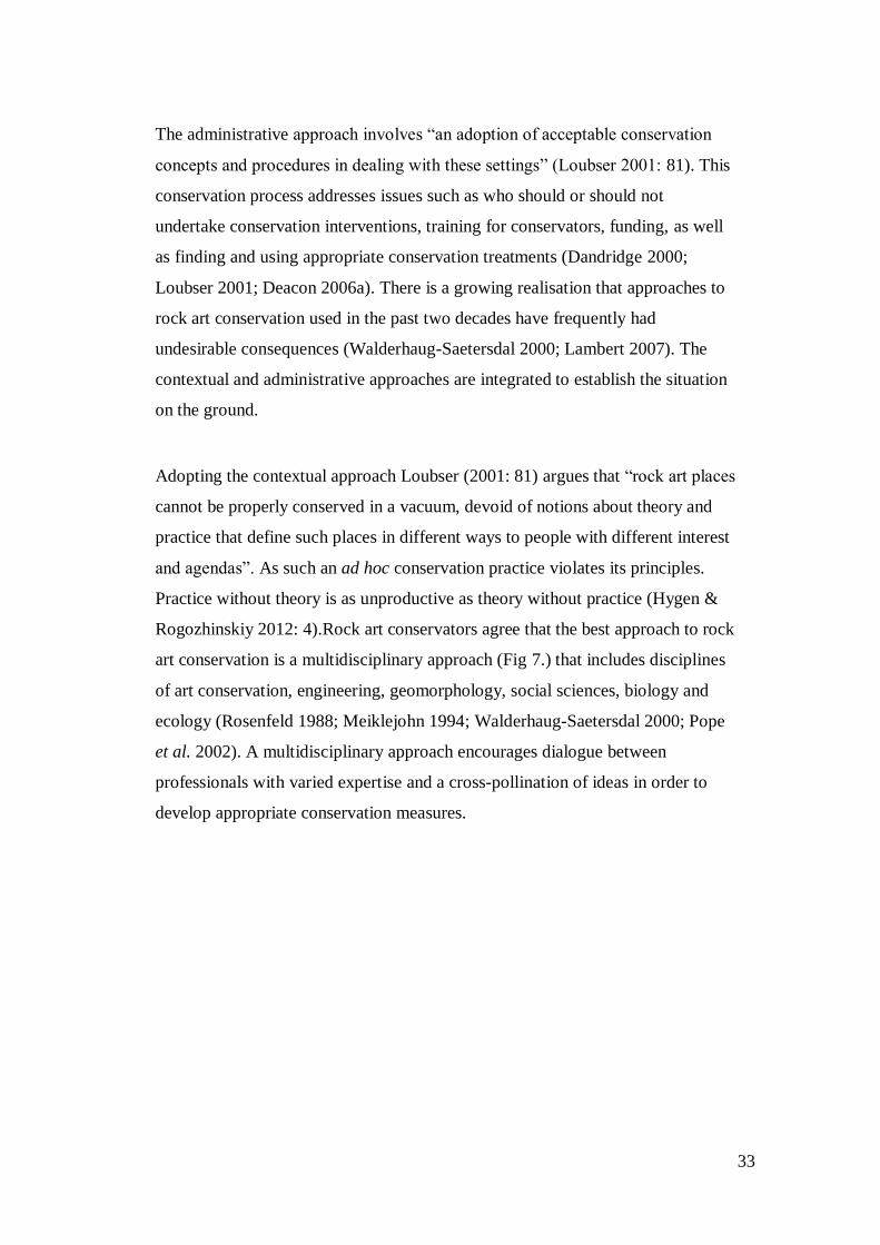
33
The administrative approach involves “an adoption of acceptable conservation
concepts and procedures in dealing with these settings” (Loubser 2001: 81). This
conservation process addresses issues such as who should or should not
undertake conservation interventions, training for conservators, funding, as well
as finding and using appropriate conservation treatments (Dandridge 2000;
Loubser 2001; Deacon 2006a). There is a growing realisation that approaches to
rock art conservation used in the past two decades have frequently had
undesirable consequences (Walderhaug-Saetersdal 2000; Lambert 2007). The
contextual and administrative approaches are integrated to establish the situation
on the ground.
Adopting the contextual approach Loubser (2001: 81) argues that “rock art places
cannot be properly conserved in a vacuum, devoid of notions about theory and
practice that define such places in different ways to people with different interest
and agendas”. As such an ad hoc conservation practice violates its principles.
Practice without theory is as unproductive as theory without practice (Hygen &
Rogozhinskiy 2012: 4).Rock art conservators agree that the best approach to rock
art conservation is a multidisciplinary approach (Fig 7.) that includes disciplines
of art conservation, engineering, geomorphology, social sciences, biology and
ecology (Rosenfeld 1988; Meiklejohn 1994; Walderhaug-Saetersdal 2000; Pope
et al. 2002). A multidisciplinary approach encourages dialogue between
professionals with varied expertise and a cross-pollination of ideas in order to
develop appropriate conservation measures.
34
Figure 7:A multidisciplinary conservation approach, adopted from Pope et al. (2002)
Contemporary conservation approaches are consultative and inclusive of multiple
stakeholders. These approaches strive to create a balance between interest groups
particularly academic research and management, and academic archaeology and
local communities because academic archaeology depends on effective heritage
management for the preservation of the subject of its research. Loubser (2006)
drawing on analogy to highlight the significant role of local communities in
conservation activities, discusses rock art sites as patients in theatre or an
emergency room needing medical care. In this instance, the patient’s family or
closest relatives (locals) have the right to decide if it is necessary to treat (remove
dust, graffiti, and pollutants and/or install a drip line) the patient (Loubser 2006:
344). Conservation specialists should consult local communities prior to
interventions in order to gain a broader understanding of the significance of a
rock art site.
35
However, Loubser (2006) omits the fact that the family of the patient need to
consult the medical practitioner (conservation specialist) for medical advice and
expertise; it is very rarely, the other way around. Today rock art conservation is
undertaken within a holistic conservation and management approach (Clarke
1978; Loubser & Van Ardt 1979; Dandridge 2000; Loubser 2001;
MartínezArkarazo et al. 2009).This approach is inclusive and consultative, it
takes cognisance of necessary variables when undertaking conservation
interventions. The holistic approach is a significant tool in the process of
undertaking conservation interventions and it is imperative that this study reviews
its components as a foundation for assessing past interventions in South Africa.
2.2.1.1. A holistic conservation approach
1. To initiate a holistic approach to the conservation of a site, a site must be
defined; a survey must be undertaken of the site, its surroundings, and
environmental conditions.
A baseline documentation of a site is a crucial step in rock art conservation
because what is not recorded does not get managed (Clarke 1978; George, Jr.
1988; Philippot 1988). The concept of ‘a site’ restricts researchers to consider
what is in front of them; the rock art images (Burra Charter 1999; Loendorf 2001)
and therefore, the notion of ‘a place’ provides a clearer perspective of the context
of an object and its location. The context of an object and/or site clearly defines
the extent of the place and allows researchers to establish the sphere of influence
of the site (Lambert 2007). Documentation of heritage objects should include the
surrounding landscape, landform features and macro and micro-climatic
conditions in order to identify factors causing the deterioration of rock art(Clarke
1978; Rosenfeld 1988; Loendorf 2001; Loubser 2001; Lambert 2007).
The sites’ geological, climatological, geomorphological and biological
environments exert pressure on rock art (Dardes 1998; Avrami 2000; Lambert
2007). Therefore, recording factors of rock art decay is a primary consideration of

36
the conservation process (Rosenfeld 1988). Accurate recording of decay factors
allows for better interpretation, conservation, and management of rock art. This
process also helps with documenting the history of conservation at a site for
future investigation. The conservation history of a site allows for responsible
conservation practice. This history also helps site managers to understand the
objectives of conservation interventions and decide if interventions are ideal for a
particular site (George, Jr. 1988; Philippot 1988; Dardes 1998).
2. Appropriate treatments are to be developed and tested based on
information gathered at the site.
Conservation scientists clean, de-acidify and consolidate different rock substrates
(Chelazzi et al. 2013). Any technique employed in the treatment of rock art
should have minimal impact on images and rock surfaces (Hygen 2006; Joyce
2006; Matero 2006; Ouzman 2006; Mark et al.2009). Conservation treatments
vary and range from simple to complex. As such every conservation intervention
should first consider non-intrusive intervention measures and only consider
intrusive ones as a last resort. The material(s) used in conservation interventions
must be compatible with the original rock substrate. In addition, every
conservation treatment should be reversible to allow future work to remedy any
unforeseen effects of the initial intervention. However, such reversibility is
impossible where chemical treatments are applied in interventions such as salt
removal, graffiti removal, dust removal, and the injection of silica gels into the
surface (Brink 2007).
Conservators have begun to realise this and now argue that “careful consideration
must be given to the long lasting and largely irreversible effects that the
treatments may have on the rock art site (Dandridge 2000; Norsted 2012).The
notion of compatibility and reversibility of conservation treatments is meant to
maintain the authenticity of the fabric. However, cultural resources are made of
matter and will thus deteriorate. The Burra Charter (1999) and Nara document
37
(1994) contribute to our understanding of the concept of authenticity. Modern
conservation theory is based on the principle of re-treatability which states that
all conservation activities should not hinder future treatment. As such choosing
appropriate methods of intervention is underlined by a thorough site condition
survey.
3. Finally, suitable preventive measures should be applied on site and
monitored over time for any adverse impacts.
The most important principle in conservation interventions is perhaps that “all
conservation treatments should be attempted only by persons trained in
appropriate conservation principles” (Dandridge 2000: 1; Loubser 2006: 340).
However, people trained in relevant conservation principles are scarce. In
Australia, America, Mexico and Canada there are conservation institutions with
the skills to produce rock art conservation professionals. In South Africa the
absence of persons trained in appropriate rock art conservation principles means
that enthusiasts often take it upon themselves to do conservation work. According
to Mazel (1982), in South Africa there was a lack of interest in rock art
conservation in the early 1980s. Deacon, an archaeological management
specialist, was interested and she attended a GCI short course on rock art
conservation, site protection and management in Australia in 1989.While
specialised, this diploma course was aimed at vocational training only. Deacon
trained Steven Townley-Bassett in graffiti removal. Both Deacon and Townley-
Bassett gained practical experience of specific aspects of rock art conservation,
but neither claims to be a rock art conservator. South Africa has an urgent need
for trained rock art conservators. Rock art conservation expertise will assist with
establishing of the level of data and information required to develop conservation
project.
Conservation treatments should be regularly monitored to assess the risks
associated with the intervention(s). The intervention must be assessed on merit,
looking at the effectiveness, and appropriateness of treatment in relation to the
surrounding environment (Cezar 1998; Dandridge 2000). Time is an invaluable
38
variable in monitoring conservation interventions. The effects of the treatment
may not be immediately evident and some deterioration agents are resistant to
treatment. Therefore, monitoring becomes a management tool through which
interventions are assessed to ensure that conservation and management objectives
are met. Conservation interventions in the long run may have unforeseen and
sometimes undesirable outcomes that deviate from the initial intervention goals.
Monitoring strategies are therefore essential to track the evolution of rock art so
as to ameliorate any negative effects of the interventions. There is a need to
establish conservation protocols in policy to ensure that the principles of the
value based approached are adhered to in practice.
2.3. Codes of ethics and legislative frameworks
Researchers have been battling with embedding, rethinking, and relocating ethics
in archaeology for close to five decades. The formulation of formal statements
varies from country to country based on the years in which archaeological
associations and institutions were established. However, conservation ethics
became prevalent globally in the early 1970s and were enshrined in legislation
such as the NMA (1969) in South Africa, the National Historic Preservation Act
(1966), the National Environmental Policy Act (1969) in America, the Civic
Amenities Act (1967) and the Ancient Monuments and archaeological Areas Act
(1979) in Great Britain (Cleere 1984; Deacon 1994; Ndlovu 2005; Fowler et al.
2009). Archaeological research is conducted in relation to these laws at local,
provincial, national and international level. In general ethical codes emphasise
and promote a systematic approach to research and heritage management. Ethics
are crucial in research and practice because “they provide organisational,
procedural, and ethical guidance for developing laws, policies, and procedures at
global, translational, and national levels” (Fowler et al. 2009: 410).
Certain codes of ethics and legal instruments specifically respond to the
discipline of heritage conservation (Kristiansen 1984; Princ 1984; Fowler et al.
2009). It is within the framework of such instruments that I consider rock art
39
conservation in South Africa. The main aim of these legal instruments is to
protect heritage resources from anthropogenic deterioration (Brunet et al. 1996).
Codes of ethics and legal instruments serve to provide the legal framework in
archaeology within which conservation is or should be practised (Walderhaug-
Saetersdal 2000). Conservation is a dynamic concept and hence its principles
must also be adaptive and flexible over time. However, when legislation
advances and promotes flawed notions about heritage conservation and
management then there is a problem. This is the case in a number of pieces of
South African legislation.
In South Africa rock art has been protected since 1911 under the Bushmen Relics
Act. Several other pieces of legislation have been developed under different
regimes in the political history of South Africa; the Bushmen Relics Act (1923,
1934) and the NMA (1967, 1969) (For a detailed history on legislation see
Ndlovu 2005). NMA (1969) is evidence of a global trend in the twentieth century
on the concept on monuments. The NMA (1969) was developed in minority-rule
times and only NHRA (25 of 1999) and the National Heritage Council Act (11 of
1999) were developed in a democratic South Africa. However, the organisational
institutions such as DAC, Department of Environmental Affairs and Tourism
(DEAT) and in particular SAHRA have been largely unsuccessful in carrying out
their rock art conservation mandate.
The NHRA and its regulations do not provide a mechanism for how to deal with
ethical issues that arise when conservation is treated as a social phenomenon and
this presents a challenge for sustainable rock art public visitation, conservation
and community archaeology. Heritage management is influenced by the
legislative framework that enforces it and its effective implementation is subject
to the administrative capacity of the enforcing organisation(s). Hence the NHRA
(1999) is considered to have failed in its implementation and archaeologists
propose that it be reviewed. Internationally there are a couple of ethical and legal
instruments that have had a positive feedback on heritage theory and practice and
South Africa can learn from them.
40
2.3.1. Embedding ethics
I posit that embedding ethics in African archaeology means decolonising and
deconstructing archaeology of western ideologies, scientific relativism and the
positivist school of thought; the so-called legacy of colonialism (Pwiti & Ndoro
1999). However, notions of formulating ethical codes for Africa for example,
which respond to the social entities ideal for archaeological practice, may be an
illusion if they are based on theories and principles formulated by researchers of
western descent. Archaeological discourse is suffering from the backdrop of New
Archaeology and the period of scientific entitlement. Archaeologists and
anthropologists alike during the early 1970s were faced with the challenge of
emerging multiple interest groups and one particular voice continues to haunt
archaeological practice: the voice of local communities. Embedding ethics is a
call for both professionalism and social liberation in African archaeology and
heritage practice (Hall 2005).
There are two general heritage conservation and management systems: the
western and traditional indigenous (Ndlovu 2009b). The western system is
inscribed and enforced through legislation; the traditional indigenous system is
oral and enforced through learned behaviour. The western attitude to
conservation is focused on the material aspect of heritage in contrast to the
traditional indigenous system that promotes both the tangible and intangible
aspects of heritage. By legally protecting cultural objects, the care of heritage
resources was both physically and intellectually removed from local communities
and placed into the care of governments and professionals (Ndoro 2001; Ndlovu
2005; Loubser 2006; Meskell & Masuku Van Damme 2008; Eboreime 2009;
Jopela 2011; Mawere et al. 2012). Ethical and pragmatic issues of heritage
management today revolve around the exclusion of local communities in heritage
management.
41
2.4. Management
CRM was founded as a study to safeguard cultural resources (Lipe 1974). The
conservation ethic was born out of CRM (Fowler et al. 2009). Management and
conservation are inextricably linked. CRM protects and salvages heritage objects
from the imminent destruction of development. However, the discipline in its
endeavour to protect heritage has been hamstrung by issues of ethics,
professionalism, stewardship, and a host of other parties staking claim to heritage
recourses. Earlier approaches to site management planning lacked dialogue and
engagement with local communities, neglecting the fact that cultural resources
have histories and they are imbued with meaning, agency, and symbolism. Thus,
heritage practitioners have come to appreciate that there are multiple approaches
to site management planning, implementation, and maintenance.
Heritage management was based on the fundamentals of a value-based approach
influenced by conservation theory (Walderhaug-Saetersdal 2000: 175). The
objective of a management approach derived from the value-based approach is to
protect the cultural significance of a site. This has been the principle and
underlying approach to the conservation of cultural resources since the 1970s.
Within this approach heritage management responds to multiple dimensions of
preservation, conservation and tourism. Historically management planning and
practice was the difference between nature and culture resources conservation
disciplines. Culture conservation has a strong focus on preservation while nature
conservation promotes sustainable use through a representative sample approach
(Lipe 1974; Carter & Grimwade 1997).
Representative samples refer to the preservation of “unique landscapes and bio-
geographic diversity” in protected areas such as National Parks and Games
Reserves in natural heritage conservation (Carter & Grimwade 1997: 46). This
strategy of representative samples may be adopted in cultural heritage
conservation in places and/or sites of less significance (Carter & Grimwade
1997). Ndlovu (2009b: 67) supports the use of representative samples in heritage
management, by arguing that “to bridge the gap between Eurocentric physical
42
and African spiritual approaches, I recommend that sites for tourism should be
identified as such, and those that still have spiritual value should be kept away
from tourists”.
The concept of representative samples is reasonable theoretically but practically it
is marred with technical and socio-political bottlenecks (Carter & Grimwade
1997). Lipe (1974) suggested a conservation model for American archaeology
based on the principle that cultural resources should be left in situ and held in the
stewardship of archaeologists. Although nature and culture conservation differ in
management approaches the same basic principle of conserving resources for
future generations by working against factors that pose threats to resources
applies. Culture conservation can therefore learn from its advanced nature
conservation counter-part. The current approach for managing rock art is top-
down and preservationist, and although tourism has brought notable changes in
the way rock art is presented, “the way rock art is managed has not changed”
(Ndlovu 2009b: 65). Culture tourism however, places a lot of challenges on
conservation because it promotes preservation through use. Heritage resources
are non-renewable and therefore finding a balance between use and preservation
is a challenge. In South Africa, rock art public visitation studies are still grappling
with developing appropriate sustainable strategies.
Heritage management plans should precisely document the history, context and
condition of a site (Sullivan 1995). The history of the site captures information
relating to site use, condition of the paintings and site whereas context could refer
to broader issues of the landscape in which the site is located including the people
and heritage agencies (Clark 2001). Heritage management plans are structural
and systematic tools that capture the natural and human threats to a site to justify
preservation and identify relevant stakeholders (Clark 2001).
Management plans must also be adaptive and responsive to local ideologies,
cognizant of the social, economic and environmental variables in the
43
conservation cycle. The main aim of a conservation management plan however,
is to uphold the cultural significance of a site. Other variables should be
subordinated within this broad aim and only promoted if they are compatible with
preservation (Sullivan 1995). The value based approach captures the significance,
conditions, cultural and management context of the site (Demas & Agnew 2006).
As such it is an essential tool to address issues of ownership in heritage
management thus preventing conflicts and balancing values. A management plan
is a significant element in the repertoire of the conservation process (Clark 2001;
Matero 2006; Demas & Agnew 2006). The significance of following steps of a
management plan is highlighted by incidents such as at Domboshava, Zimbabwe,
where scientific and aesthetic preservation was valued over spiritual or cultural
value (See Chirikure & Pwiti 2008). A management plan is the first
comprehensive documentation that provides site information thereby creating
baseline documentation.
2.4.1. Conservation and Management Practices
2.4.1.1. Realms and Spectrums of conservation and management practices
The current state of management practice globally is founded on the preventive
conservation measures of the Burra Charter (1999). In light of urbanisation and
infrastructure development and the many challenges it presents to the protection
of heritage property, heritage management is arguably framed by the principles
that provide safety nets for heritage properties. Public visitation developments
range from site specific developments to local, and/or regional infrastructural
developments. For the purpose of this study I am only concerned with immediate
site developments which include erecting boardwalks, interpretation panels,
dioramas, and floor plans. A high level of visitor satisfaction has been sought in
the development of heritage sites in order to provide a long lasting and
satisfactory visitor experience (Kolber & Yoder 2014). As such the conservation
approach is stretched to its limits and heritage authorities tend to lose sense of
what matters and priorities shift.
44
The fundamental objective of heritage visitation is education and engagement at
all levels of society. In order to achieve this goal, heritage visitation should
promote dialogue on the archaeological significance and values of heritage places
through communication. Interpretation of heritage objects, places, landscapes has
been identified as a possible way to communicate the archaeological significance
and values of heritage places. Interpretative panels, signage, pamphlets and
booklets are supplementary materials used to convey the message on cultural
significance (Mazel 2012; Kolber & Yoder 2014; Ndlovu 2014b). Interpretation
can also be used as a management tool that could aid in the preservation of
heritage places. In this sense knowledge becomes a variable, people well
informed and who understand the significance of a place are likely not to damage
it but rather protect it. As such the issue becomes what meaning interpretation is
conveying to the people and whether they understand.
Heritage sites are developed and their significance communicated following
particular guidelines and procedures inscribed in conservation and management
policy and legislation. Law enforcement serves as controls in heritage
management to ensure that necessary rules and by-laws are followed when
developing sites and guided tours are provided. Tour guides see to it that visitors
at public sites do not deviate from the designated paths and that they do not
damage heritage sites. Controls are the day-to-day activities of management such
as patrols, monitoring, and path clearing amongst other things. Failure in
controlling developments and communicating the significance of heritage places
results in the damage of heritage sites. The development, commutation, and
controls of site managements provide the baseline from which site management
tools are developed and implemented.
2.4.1.2. Management Tools
Management tools are the technical and methodological frameworks which are
central to conservation and management principles. They are indispensable
45
elements in heritage management. No management tool operates in isolation.
Management tools are derived from a combination of varied activities in data
collection, processing, storage, and interpretation in both theory and practice in
order to create a system (Stovel 1995). Monitoring programs are developed on
the basis of evaluation. Monitoring is a planning and management tool that can
improve conservation and management practices. However, monitoring requires
an adequate amount of data, information management tools, time, responsibility
and innovative as well as creative thinking (Stovel 1995). There has been a drag
in world heritage system to develop monitoring methodologies and it was not
until 1994 that efforts were made for systematic monitoring and reporting
programs at a global scale (Stovel 1995).
Publications on monitoring dates back two decades but the dissemination of such
information have been relatively slow. Monitoring is a central and significant tool
in management practice and has implications for both the success and failure of
conservation and management objectives. Monitoring is a strategy in heritage
management that requires administrative, personnel, and organisational capacity
to ensure its successful implementation (Bonnete 1995; Stovel 1995). Monitoring
is “a systematic procedure designed either to evaluate a particular and sensitive
situation, or to measure the state of such a situation at a particular moment in time
and accurately report on it” (Bonnete 1995: 5). I however, highlight the critical
elements of monitoring mentioned in the definition above, evaluate, measure,
state, time, and report. To fully appreciate the complexity of monitoring in all
its aspects we must acknowledge that it can be simple and/or complex. As such
we expect there would be different methodologies, scales and types of monitoring
can be expected. For the purpose of this study, I dwell specifically on
conservation monitoring.
Conservation monitoring according to Cunliffe (1995: 30) “is the process of
observing and gathering information on conservation activities, their context,
results, and impacts. It is a process that gathers information on the conservation
46
status of a rock art site using standard recording methodologies that can be
repeated timeously. Conservation monitoring can be target specific in such a way
that it could only focus on a lichen problem at a site or the effects of the
boardwalk on site. Its fundamental objective is to track the events of a
conservation intervention by observing the progress, results, and impacts of
treatments on the fabric through the use of indicators to improve conservation
practice (Jamieson 1995). The Burra Charter (1999) makes provision for
conservation monitoring which is carried out in the field through the auspices of
the Department of Environment and Climate Change (Lambert 2007). In South
Africa we have been struggle with monitoring of conservation activities since the
birth of scientific rock art conservation three decades ago (Loubser & Van Ardt
1979; Meiklejohn 1994; Deacon 2006b).
South Africa has eight World Heritage Sites (WHS); the Mapungubwe Cultural
Landscape, Cradle of Humankind, Vredefort Dome, uKhahlamba-Drakensberg
Park, Isimangaliso Wetland Park, Cape Floral Region Protected Area, Robben
Island, Richtersveld Cultural and Botanical Landscape (Fig.1). WHS systematic
monitoring and reporting is determined by UNESCO and these sites follow
UNESCO guidelines on monitoring. WHS are a first point of call in terms
successful monitoring approaches and will assist with developing programs at
regional and local level (Stovel 1995). There are multiple and varied challenges
and problems in managing (WHS). Stovel (1995: 18-19) lists four continuing
challenges in monitoring WHS:
i. Bringing approaches for national and cultural heritage more closely into
harmony
ii. Improving information management within the monitoring system
iii. Ensuring that the values for which cultural heritage sites are inscribed on the
World Heritage List remain at the centre of monitoring assessment
iv. Developing monitoring methodologies
47
To address recurring challenges different types of monitoring methodologies
have been developed during the last two decades. Monitoring methodologies
known as the ‘Limit of Acceptable Change’ and ‘Commemorative integrity’ have
been developed and implemented in various parts of the world. Limit of
Acceptable Change is good for consolidating management as standards and
indicators for monitoring are based on stakeholder concerns (Pedersen 2002).
Commemorative Integrity focuses on conservation of the fabric. Rock art sites are
largely affected by the environment in which they are located. Thus, to fully
understand the mechanisms that affect the state of rock art preservation there is a
need to fully document factors causing decay. Monitoring and recording
techniques are significant elements in heritage conservation.
2.5. Conclusion
In this chapter I explored the global history of rock art conservation within which
I situated the practice of rock art conservation in South Africa. I also explored the
principles of site protection and management and their ethical implications in
conservation. This revealed the three fundamental conservation issues in southern
Africa namely funding, lack of conservation expertise and a systematic approach
to establish, implement and sustain monitoring procedures. Insights into the
history of rock art conservation in southern Africa were drawn from SARAP. In
southern Africa rock art conservation is ad hoc and strongly reliant on external
donor funding. As such rock art research in the sub-continent has not built a
strong body of literature on conservation. In addition, within the region there is
absence of a clear understanding of the environmental, institutional
(professional), cultural and management context with which rock art conservation
is done. As such it is imperative that conservation principles that are tailor-made
for southern African conditions are developed based on the history of rock art
conservation in the sub-continent.
48
Chapter 3 : ROCK ART DOCUMENTATION
3.1. Introduction
Methods and techniques for recording rock art are multiple and varied (Clark 2007;
Dallas 2007). Their use is governed by the objectives of recording, conservation
theory, the cultural background of the recorder and the methodology.
Documentation is a pre-requisite in the assessment of conservation interventions. It
is impossible to assess or monitor the effectiveness of conservation interventions
without documentation (Reichstein 1984; Price & Doehne 2010). In this chapter, I
explore the general principles of documentation and specifically focus on the
principles of documentation for conservation purposes; the underpinning theory,
aims and objectives of conservation documentation and the effectiveness of such
techniques in practice. I approach this segment of documentation from a
management perspective of rock art in South Africa.
3.2. Documentation for conservation purposes
Documentation of the conservation process is based on prevailing conservation
ideology. For the past 40 years documentation of conservation interventions was
based on the principle of minimal intervention (Norsted 2012). Emphasis was
placed on the use of less intrusive methods of documentation and conservation
interventions. Rock art researchers argue that the principle of minimal intervention
is conceptually flawed and colours conservation as a neutral and objective
enterprise (Smith 2006; Norsted 2012). Conservation interventions change rock art
sites, physically or chemically in the process of ameliorating deterioration. The
working ideology in contemporary conservation theory is to accept change that
results due to interventions and to record the ‘new’ state of conditions at the site
(Reichstein 1984; Norsted 2012).
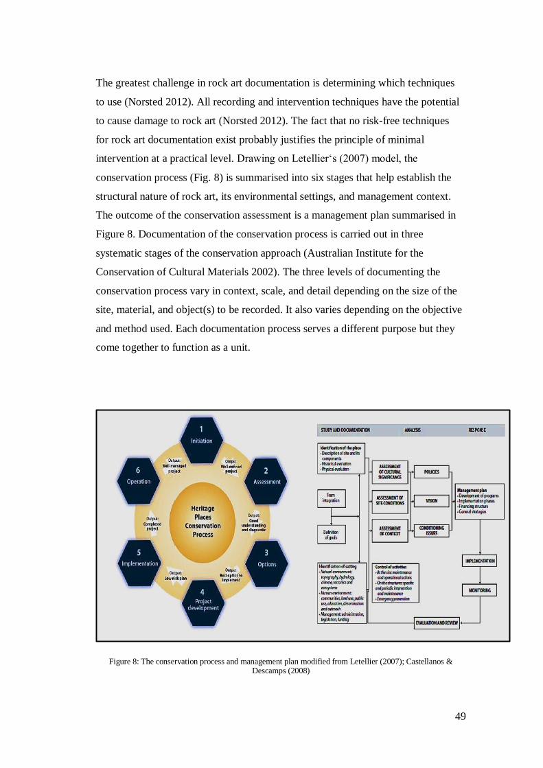
49
The greatest challenge in rock art documentation is determining which techniques
to use (Norsted 2012). All recording and intervention techniques have the potential
to cause damage to rock art (Norsted 2012). The fact that no risk-free techniques
for rock art documentation exist probably justifies the principle of minimal
intervention at a practical level. Drawing on Letellier‘s (2007) model, the
conservation process (Fig. 8) is summarised into six stages that help establish the
structural nature of rock art, its environmental settings, and management context.
The outcome of the conservation assessment is a management plan summarised in
Figure 8. Documentation of the conservation process is carried out in three
systematic stages of the conservation approach (Australian Institute for the
Conservation of Cultural Materials 2002). The three levels of documenting the
conservation process vary in context, scale, and detail depending on the size of the
site, material, and object(s) to be recorded. It also varies depending on the objective
and method used. Each documentation process serves a different purpose but they
come together to function as a unit.
Figure 8: The conservation process and management plan modified from Letellier (2007); Castellanos & Descamps (2008)
50
3.2.1. Documentation of examination
A condition assessment must establish threat(s) to rock art. In-depth assessments
establish the structural qualities of rock art and factors causing its deterioration
(Price & Doehne 2010). The assessment should include a description of the
management context (Lambert 2007). The production of this information usually
includes sketches, tracings, photographs to provide a dimensional, topographic, and
structural record of the rock and site (Letellier 2007).
3.2.2. Treatment Plan
The condition assessment and documentation lead to developing appropriate
conservation interventions. The intervention technique(s) is determined by site
characteristics and conditions (Dandridge 2000; Loubser 2001; Norsted 2012),
weighed against “their potential adverse effects of future examination, scientific
investigation, treatment, function and ageing” (Loubser 2001: 81). Intervention is
frequently intuitive regardless of the confidence behind the choice of each material,
“our action to handle a problem in a good way can lead to the creation of new ones”
(Hygen 2006: 25). It is therefore important to test intervention procedures
exhaustively before application. A treatment plan is an intermediate phase between
condition assessment and application of treatment. Such a plan justifies the eventual
intervention chosen because it outlines and identifies any risks and provides
alternative options (AICCM 2002). Unfortunately, in South Africa conservation
and rock art documentation permits are issued in the absence of treatment plans that
should have formed the basis for permitting. The permitting system will be
discussed later in this study.
3.2.3. Documentation of treatment
Rock art is depicted on actively decaying substrates mostly sandstone which is
subject to continuous change (Van Rijssen 1987). Conservation interventions alter
and modify rock art, substrate, and site parameters hence such interventions are
51
considered a planned change in the life of rock art. Documentation of rock art
before (as-found) and after treatment (created) is important in establishing previous
site conditions and tracking change (Reichstein 1984; AICCM 2002; Letellier
2007). Intervention(s) may alter our understanding and interpretation of rock art
because new information and hidden elements on rock art panels and about the
place may emerge. The after treatment record becomes baseline data because a new
site condition will have been created by the intervention. For the fact that
interventions alter the parameters of heritage places and objects, documentation
provides information about our actions, what we do, how (theory and methodology)
we do it and why (aims and objectives) (Hygen 2006). The documentation of
treatment should further include a description of the materials used, their
composition, techniques and procedures adopted (AICCM 2002).
3.2.4. Archiving and databases
The paucity of data on the preservation status of rock art hinders the assessment and
monitoring of conservation interventions. Recorded information should be kept in
secure facilities where it can be protected and retrieved when the need arises.
Heritage digital repositories serve the conservation process as a cycle where the
history and life of a site can be repeatedly recreated. SAHRA recently created an
easily accessible, user friendly digital database of heritage sites called the South
African Heritage Resources Agency Information System (SAHRIS) not only for
data storage but also for facilitating research. Such a digital database creates and
maintains institutional memory that will exist long after those who created it.
However, the main challenge facing SAHRIS is encouraging researchers to upload
material, making it difficult for SAHRA to keep record of all reports (Price &
Doehne 2010).
A digital record is useful for establishing guidelines and standards in policy for
documentation, monitoring, and reporting (Van Hoff 1995). As such SAHRIS can
be used to track and monitor researchers if they comply or not with SAHRA
standards on permitting and reporting. The request for permit is done online and the
52
record is kept, as such the permitting process should remain flagged until SAHRA
has a report in their archives. Since information is archived based on institutional or
national policy which affects the way data are archived and disseminated, it is
important to provide a framework for managing heritage properties. Information
may get lost if it is badly archived and this will affect conservation management.
3.3. Conservation Assessment Methods
Heritage practitioners and rock art researchers consider conservation assessment as
a form of inquiry (Hurt 1995). The assessment of conservation interventions
depends on evidence of a site’s history to establish existing site conditions. As such
the AICCM (2002) proposes the use of the basic guidelines of documentation as a
method for evaluating conservation interventions. Such evaluation is often impeded
by an inherent need to justify the effectiveness of the intervention; this ethic should
be upheld in practice. Below are some of the commonly used methods for
conservation assessment and associated documentation problems.
3.3.1. Evaluation and Monitoring
Evaluation of heritage relies on baseline condition assessment, assessment of
significance, and recording of the site’s setting (Van Hoff 1995). Scant modern
monitoring methods exist only in developed countries. Most African states
experience an inherent lack of inventories (Eboreime 2009). Past conservation
activities and procedures were either inadequately documented or they were not at
all documented. Throughout the world conservation activities were carried out
without proper documentation in the early twentieth century (Deacon 1994;
Dandridge 2000; Hygen 2006).
Without proper documentation it is impossible to develop monitoring programs.
Most significantly the lack of data affects our ability to assess, monitor, and report
on the performance, results, and impacts of conservation interventions. Monitoring

53
programs can be developed by answering the why, how, and when of monitoring
(Table 1). Reporting is a management tool that can be used to take necessary action
on changes in the state of rock art. Reporting can also be used to communicate
results of our actions to various stakeholders. There are various ways to report on
monitoring procedure but in general a monitoring report should identify and
highlight changes in rock art. The standard procedures of reporting reflect on
monitoring methodologies, standards and performance indicators. Some monitoring
methodologies and models include (Bonnett 1995; Stovel 1995; Pedersen 2002):
Commemorative Integrity (CM), Reactive/Systematic Monitoring (RSM), National
Committee Involvement Monitoring (NCIM), Pilot System Monitoring (PSM) and
Limit of Acceptable Change (LAC) which I will explain in subsequent chapters.
Table 1:Principles of heritage documentation
Why To follow the evolution of a particular and sensitive situation,
or change over time, with respect to established goals, objective,
procedures, and rules
To be aware of deviations occurring in the evolution of such
a situation, and to secure all the information needed to take
appropriate, timely action, if and when, necessary
Improve site management, preventive conservation
Improve policies (World, National and Regional Heritage)
When Depends on the sensitivity of the issue(s)
Established standards and performance indicators
Periodic
Ad hoc
Continuous
How identify what situation is significant, valuable and in need of
a careful follow-up
set clear management objectives, determine how the situation
is expected to behave in time, what results it should produce
identify information needed to indicate change in the state of
the situation or the performance of established procedures and rules

54
3.3.2. Conservation Standards and Indicators
Monitoring is based on simple, repeatable standardised methodologies (Ward 1995:
54). Standardised methodologies depend on indicators to objectively identify,
locate and record change. Evaluation identifies behavioural patterns that indicate
the performance of established procedures. Identified patterns of a situation allow
for strategic performance indicators to be set (Bonnete 1995). Thus, monitoring
programs can be developed with appropriate levels of data (Bonnete 1995).
Standards and indicators do not provide definite answers; they merely provide
means to measure change (Alcántara 2002).
Developing standards and performance indicators is a long standing challenge for
heritage researchers (Zancheti & Similä 2012: v). Researchers distinguish between
two sets of standards, standards in conservation and standards in preventive
conservation (Zancheti & Similä 2012). Standards in preventive conservation
promote and relate to sound management of conservation activities. Standards in
conservation are fundamental in conservation assessments. Standards in
conservation further help with establishing a working theory by setting common
definitions, developing policy to maintain consistency (Zancheti & Similä 2012).
Standards in preventive conservation can be defined as “a set of core principles or
statement of best practice, arrived at by consensus among appropriately qualified
individuals or groups” (Alcántara 2002: 11). The fundamental elements of the
process of establishing standards are that it is inclusive and consultative key factors
in evaluation and monitoring.
The evaluation and monitoring of conservation procedures is also dependent on
identifying and establishing indicators to observe and measure change over time.
Indicators are “qualitative or quantitative factors or variables that provide a simple
and reliable means to measure how well a desired outcome, value, or criterion has
been achieved or fulfilled” (Alonso & Meurs 2012: 2). Indicators play a critical role
in conservation monitoring. Indicators are excellent tools for long-term evaluation
and monitoring of trends in the evolution of a situation (Zancheti & Similä 2012).
They can be used to assess the performance of policy. Standards and performance

55
indicators are most significantly derived from the aims and objectives of the
conservation procedure and reflect the underpinning conservation theory and
method.
3.3.3. Evaluation based on definition of Criteria
It is important to identify the criteria used in the conservation process when
assessing its results, impacts, and effectiveness. The key factor in conservation
assessment is availability of documentation and the lack of it. Rock art recording is
subjective. However, standards and indicators are tools that allow for conservation
interventions to be assessed objectively. I assess and record the performance of past
conservation procedures in South Africa based on the definition of the criteria used,
define and identify aim(s) and objective(s) and the theoretical underpinning of the
aim(s) and objective(s).
3.3.4. Conservation Assessment
The evaluation and monitoring of conservation activities is a standing concern for
heritage researchers. As such generating adequate data to develop monitoring
programs is prioritised. Conservation is an integral management tool for heritage
sites (Burra Charter 1999). Conservation, conservation assessment and management
are considered as elements of preventive conservation, with preventive
conservation being the means of effectively promoting long term preservation of
cultural property (Australian Institute of the Conservation of Cultural Materials
2002). The methods of evaluation and monitoring of conservation activities are
however still in infancy and heritage practitioners have been struggling with
developing sufficient methods for assessing the performance of conservation
activities. Every conservation assessment must be based on a clearly defined
criterion by identifying and defining the aims and objective of such an assessment.
The aim of this study is to develop a conservation model for rock art in South
Africa that will lead to a gradual improvement in management of interventions and
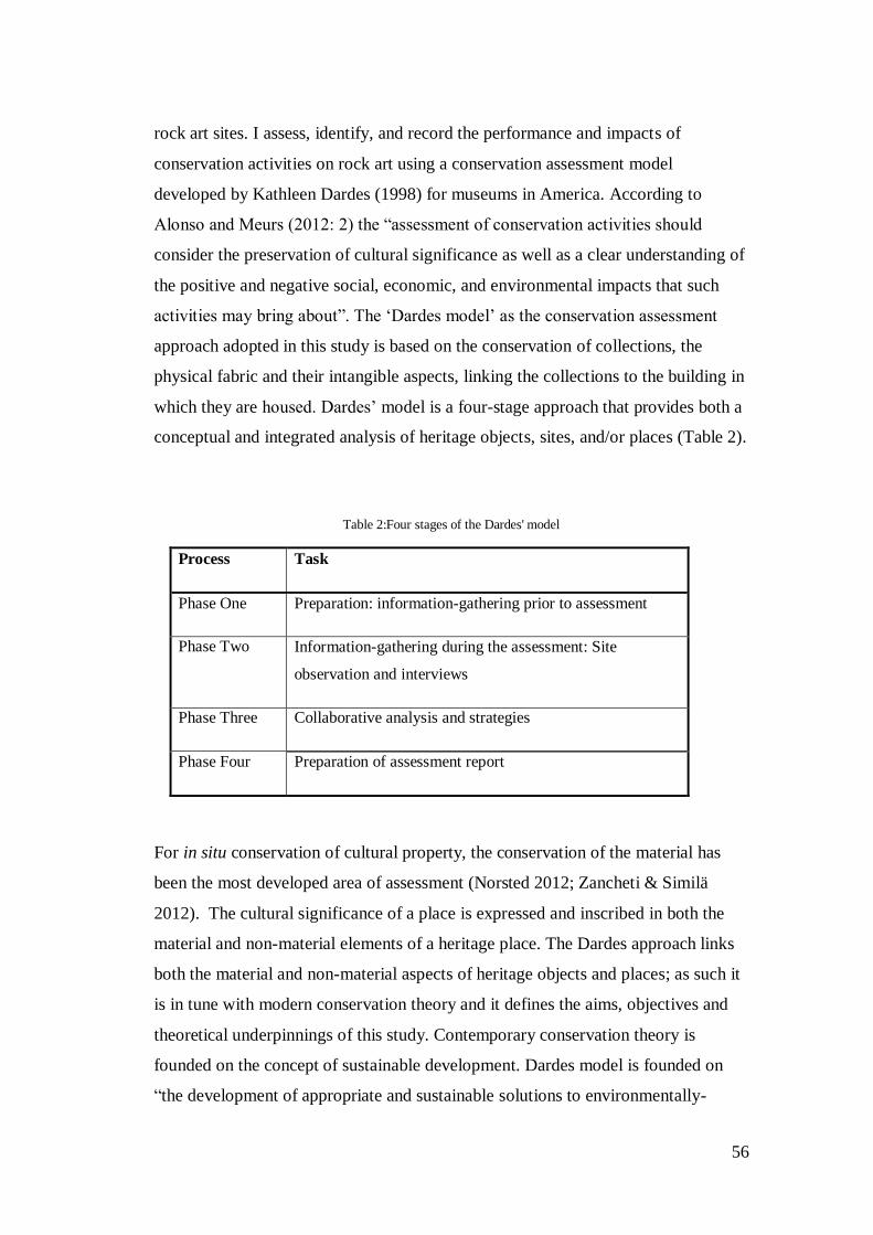
56
rock art sites. I assess, identify, and record the performance and impacts of
conservation activities on rock art using a conservation assessment model
developed by Kathleen Dardes (1998) for museums in America. According to
Alonso and Meurs (2012: 2) the “assessment of conservation activities should
consider the preservation of cultural significance as well as a clear understanding of
the positive and negative social, economic, and environmental impacts that such
activities may bring about”. The ‘Dardes model’ as the conservation assessment
approach adopted in this study is based on the conservation of collections, the
physical fabric and their intangible aspects, linking the collections to the building in
which they are housed. Dardes’ model is a four-stage approach that provides both a
conceptual and integrated analysis of heritage objects, sites, and/or places (Table 2).
Table 2:Four stages of the Dardes' model
Process Task
Phase One Preparation: information-gathering prior to assessment
Phase Two Information-gathering during the assessment: Site
observation and interviews
Phase Three Collaborative analysis and strategies
Phase Four Preparation of assessment report
For in situ conservation of cultural property, the conservation of the material has
been the most developed area of assessment (Norsted 2012; Zancheti & Similä
2012). The cultural significance of a place is expressed and inscribed in both the
material and non-material elements of a heritage place. The Dardes approach links
both the material and non-material aspects of heritage objects and places; as such it
is in tune with modern conservation theory and it defines the aims, objectives and
theoretical underpinnings of this study. Contemporary conservation theory is
founded on the concept of sustainable development. Dardes model is founded on
“the development of appropriate and sustainable solutions to environmentally-
57
induced problems affecting collections (Dardes 1998: 1). Dardes’ model has been
used in museums around the world in countries like Tunisia, Brazil, and America
(Dardes 1998; Teixeira Coelho & Rodegues Carvalho 2012). The model is a
holistic management approach and has all the required elements for a successful
assessment (Dardes 1998: 3-4) because it establishes the conditions, causative
factors and risks are analysed, characterised and prioritised; and the patterns and
relationships that exist amongst the institution’s organisation, its collection, site and
structure, and internal and external environmental conditions.
Dardes’ model is used for an integrated conservation assessment of buildings and
collections derived from preventive conservation (Teixeira et al. 2012). Preventive
conservation has in the past “provided important tools for identifying, monitoring
and evaluating the conditions of cultural property, and impacts of conservation
activities upon them” (Teixeira Coelho & Rodegues Carvalho2012: 82). Dardes’
model offers a management perspective of conservation assessment because it
focuses on museum collections, buildings, and organisational policies and
activities. Conservation assessment from a management perspective involves
establishing the relationship between the object, heritage agency/authority, and its
legislation. This approach enables exploration of different management contexts in
South Africa using case studies of past interventions.
3.3.5. Conservation Assessment Techniques
Techniques for assessing the effectiveness of conservation interventions work
better when integrated because no single technique is sufficient to measure all
forms of decay. A successful conservation assessment is based on a technical
evaluation and critical judgement that goes beyond the observation and
documentation of conditions and their manifestations (Dardes 1998). Technical
observation and analysis is a stage in the process of a conservation assessment. The
process by which all the factors (conditions and risks) that relate to the
effectiveness of the conservation treatment are studied and prioritised is a
conservation assessment (Dardes 1998; Wahl et al. 1998).This study has chosen a
58
process to identify, characterize, and prioritize the causative factors, conditions, and
risks associated with conservation treatment, the Dardes’ model.
Preventive conservation has provided essential tools for assessing the effects of
conservation intervention on heritage objects ranging from below the surface
(molecular) to surface (analytical) techniques (Price & Doehne 2010; Teixeira
Coelho & de Carvalho 2012). The Choice and subsequent use of these techniques,
is based on threats to be monitored. To map surface recession and monitor pigment
and/or surface loss, conservators employ analytical 3D Laser Scanning, X-ray
Fluorescence (XRF), Energy Dispersive X-ray Analysis (XDX), Laser-Induced
Breakdown Spectroscopy (LIBS), and Neutron Activation Analysis (NAA) (see
Kuckova et al. 2005 Hall et al. 2007a; Cotte et al. 2009). Techniques such as
Ultrasonic Measurements, Thermography, Magnetic Resonance Imaging (MRI),
Attenuated Total Reflection (ATR, Raman Spectroscopy, and Diffuse Reflectance
Infrared Fourier Transform (DRIFT) are used to go below the surface and
investigate structural stability and cohesion (see Kuckova et al. 2005; Price &
Doehne 2010; Frost & Palmer 2011). These techniques provide a broad spectrum of
situations to monitor the effects of conservation treatments on rock art.
Techniques mentioned above cannot be used in the assessment of conservation
interventions in South Africa there is no baseline data. I have thus chosen
photography as an analytical tool to assess and monitor the effectiveness of
conservation interventions in South Africa. Photography has a long history of use in
both recording and conservation of rock art in South Africa (Rudner 1989; Deacon
1994; Maggs & Ward 1994; Ward 1997). With the development of digital image
enhancing tools photography has become a chief tool in the assessment of
conservation interventions based on its affordability, safety and the availability of
hundreds to thousands of images (Stuart 1978; Maggs & Ward 1994; Ward 1997;
Brady 2006). The problem with photographic monitoring is the use of uncalibrated
images captured at different times of the year and day (Price & Doehne 2010). The

59
lighting and detail of these photographs varies. This is a major concern in
conservation practice and this study takes cognisance of this challenge.
3.4. Conclusion
This chapter reviewed the basic principles and issues in rock art documentation
based on two hypotheses: one for research, the other for conservation. These two
processes differ in detail, objectives and scope depending on the nature of the rock
art site. The principle of minimal intervention is fundamental in documentation and
all interventions should be guided by it in practice. Contemporary conservation
theory should uphold this ideology. For this project, several conservation
assessment approaches that have been previously used to assess the performance of
conservation activities were considered. I adopt Kathleen Dardes’ (1998)
conservation model developed for museums in America. Although a museum and
in situ environment are different, Dardes’ model is a holistic management approach
for integrated conservation assessment based on the principles of preventive
conservation and is ideal here.

60
Chapter 4 : ROCK ART DETERIORATION AND TREATMENT
4.1. Introduction
In this chapter I explore elements that affect and/or control the state of preservation
of rock art and techniques that can be employed to ameliorate decay. The pigments
mixture used in rock art, rock substrate and the surrounding environment influence
the resistance and deterioration of rock art sites and paintings. The relationship
between rock art and its geological, chemical and biological environment is
important in understanding the processes of deterioration. Conservation studies
distinguish between two types of cultural stone properties (Price & Doehne 2010).
In heritage conservation of stone monuments different consideration is given to the
buildings and to rock art. Rock art is depicted on stone that is actively embedded in
the natural process and is subject to active cycles of hydrology, geology,
climatology, and biology (Pope et al. 2002).
Although buildings are exposed to natural elements they are not actively embedded
in the natural cycle, however, the conservation of stone buildings is more or less
similar to rock art conservation in terms of treatments and conservation intervention
methods used (Pope et al. 2002; Price & Doehne 2010). The conservation of stone
monuments and/or buildings has made significant strides in the treatment of
weathering and decay that rock art conservation can adopt (Price & Doehne 2010).
With reference to Bushmans Kloof 03 and 09, Bonne Esperance 16, Main Caves
(north and southeast), and Game Pass Shelter, I consider how the following
elements act as weathering controls: the pigment mixture and adhesion to the
substrate and how this influences preservation; the composition of rock substrates-
its structure and how this influences the stability or deterioration of paintings; and
the environment and how it affects interfaces between the substrate and paintings
and individually how it affects either the substrate or pigments.

61
4.2. Controls of deterioration
The characterisation of elements making up paintings is imperative in
understanding the long-term preservation of pigments (Johnson 1957). Authors of
rock art around the world commonly used similar minerals in the form of red, black
and white. Other pigments include shades of orange, yellow, brown, and green. Red
pigments are mainly ochre or haematite. The composition of both the white and red
pigments has been identified with relative success while black pigments are
difficult to elucidate (Table 3) (Scott & Hyder 1993).
Table 3:Pigment colours and composition
Pigment Colour(s) Mineral Constituents Chemical Formulae
White Bees wax, punic wax,
huntite, halloysite, shell
white
Mg₃Ca(CO₃)₄
Red Ochre, magnetite, carbon
(heated ochre)
Fe₂O₃; Fe₃O₄; C₄
Black Charcoal, amorphous
carbon, manganese
C₇H₄O; C; Mn
The weathering and resistance of pigments depends on the degree of adhesion of
the painting to the rock, the nature of the pigments and its binders, and the way the
pigments are applied to the rock (Meiklejohn 1994; Rahim & Komally 2011). The
deterioration of paintings based on the physical properties of pigments and their
application can be summarised as follows (Meiklejohn 1994: 5; Rahim & Komally
2011: 275‒ 276);
dry pigments and those applied as a plaster can easily be removed by
rubbing and may rapidly deteriorate;
62
pigments that are more fluid can penetrate deeper into the rock making them
more durable;
paintings that are comprised of large particles are unable to penetrate deeply
into rock pores and are more prone to deterioration; and
small particles can penetrate deeply into the rock pores and are less prone to
deterioration.
The surface on which paintings are applied also plays an active role in the
deterioration of pigments (Hall et al. 2007a, b; Venter 2011). Preparing the rock
surface changes the physical structure of the rock (Hall et al. 2007a, b; Meiklejohn
et al. 2009; Venter 2011). Smoother surfaces are prepared using a grind stone.
Prepared surface allows deeper penetration of paintings into rock pores compared
to rougher surfaces (Hall et al. 2007a, b; Meiklejohn et al. 2009; Venter 2011).
Surfaces are also prepared by adding a plaster layer on the rock. Similarly this
affects the nature of pigment deterioration (Venter 2011). Pigments are themselves
applied using various techniques including fine brushes, twigs and fingers. These
techniques influence the degree of adhesion and penetration of paintings
(Meiklejohn 1994; Rahim & Komally 2011).The durability of pigments is also
influenced by substances used to bind the minerals together (Scott & Hyder
1993).Identifying binding media used in paintings is a complex process that
considers the inclusion of foreign material in the pigment mixture (Scott & Hyder
1993). Animal blood and fat, plant oils and sap have been identified as binding
media (Hall et al. 2007a, b). Ethnographic accounts from the Maloti-Drakensberg
confirm use of blood (particularly that of eland) and animal fat as binding matter
(Hall et al. 2007a, b).
The weathering and resistance of pigments is influenced by the interaction between
the pigment and rock surface and the successive pigment layering. This interplay is
influenced by the behaviour of pigments in different microclimates (Ford et al.
1994; Hall et al. 2007a, b; Arocena et al. 2009; Meiklejohn et al. 2009; Hall et al.
2010). The relationship between pigments and their microclimate is important for
devising appropriate intervention measures (Ford et al. 1994; Hall et al. 2007a, b;
63
Arocena et al. 2009; Meiklejohn et al. 2009; Hall et al. 2010). The nature of
pigments and their exposure to elements shows that changes in environmental
conditions can affect the state of preservation of pigments (Scott & Hyder 1993;
Meiklejohn et al. 2009; Hall et al. 2010). Yellow ochre from several rock art sites
of the Chumash tradition in California, America may have changed to red over time
as a result of long-term exposure to extreme temperatures (Scott & Hyder 1993).
Huntite used in white clay may change to whewellite reacting to both temperature
and moisture (Ford et al. 1994). The reaction of pigments with the rock substrate
may also change mineral composition of paintings. This may be influenced by the
chemical or physical alteration of the rock structure and chemistry.
Weathering of the rock can occur mechanically, chemically and/or biologically
(Rahim & Komally 2011). To study the processes of weathering, the underlying
rock substrate must be characterised in order to understand its resistance and
susceptibility. Stone characterisation is not an end in its self. As such efforts should
be made to quantify decay. According to Price and Doehne (2010: 2) stone may
decay by gradual weathering, leaving a sound surface behind; large scales of rock
drop away in one episode; surface erupting into blisters; and sometimes the stone
loses integrity and simply crumbles away.
The physical structure (pore space, size and geometrical shape) and material
composition of the rock are factors that determine the local balance and the type of
weathering the rock undergoes (Camuffo 1995; Leuta 2009; Meiklejohn et al. 2009;
Price & Doehne 2010; Venter 2011; Rahim & Komally 2011; Bemand et al. 2014).
The majority of rock art is executed on sandstone albeit these differ widely in
material composition and structure (Rosenfeld 1988; Meiklejohn 1994; Leuta 2009;
Venter 2011; Fernandes 2014). Sandstones are principally characterised by core
elements (quartz), material grains, cementation and trace elements (feldspar) as
well as pore spaces (Rosenfeld 1988; Hoerlé 2006; Fordred 2011; Bemand et al.
2014). Sandstones are less resistant and porous (Meiklejohn 1994; Fordred 2011;
Bemand et al. 2014).
64
Weathering of porous stones occurs as a direct or indirect result of water (Bemand
et al. 2014). The hydrological properties and porosity of a rock can induce chemical
and mechanical weathering (Leuta 2009; Venter 2011; Bemand et al. 2014).
Evidence from the Drakensberg suggests that porosity and permeability affect the
rate of sandstone weathering and that of paintings (Leuta 2009; Meiklejohn et al.
2009; Venter 2011). The weathering of sandstone is underlined by the compromise
of the rock’s pore characteristics through increasing the pore sizes, creation of new
pores, and transportation of material solution in pore spaces (Camuffo 1995; Leuta
2009; Venter 2011; Bemand et al. 2014). The porosity of a rock “is defined as the
ratio of the volume of pore space to the bulk of the volume material” (Bemand et
al. 2014: 245). The pore characteristics (size, geometry, connectivity, and infilling)
of a rock provide resistance to environmental elements thus acting as weathering
controls (Bemand et al. 2014).
The geological, climatic, and biological environments influence the deterioration of
rock art (Rosenfeld 1988; Rudner 1989; Fordred 2011; Venter 2011). To elucidate
the processes of decay research on weathering mechanisms should focus on
monitoring environmental variables of temperature and moisture. Until recently
there were no known published works from South Africa focusing on the
monitoring of rock temperature for investigating weathering processes (Meiklejohn
1994; Meiklejohn et al. 2009; Hall et al. 2010). The deterioration of rock art in
southern Africa is largely due to the weathering of the rock where images are
located (Meiklejohn 1994; Arocena et al. 2009), with moisture and temperature
being the main culprits. New observations suggest that there may have been a
misdiagnosis on the deterioration of rock art where images are painted on a clay-
based ground; in this case pigments peel off in layers rather than flaking with the
rock, as a result of the weathering of the rock base (Hall et al. 2007a, b; Meiklejohn
et al. 2009; Hall et al. 2010; Venter 2011).
Recent research has broadened the spectrum on mechanisms of decay by shifting
from investigating the weathering of the rock where paintings are located, to study
the interactions and interface between the rock and pigment and that of pigment to
65
pigment within the paintings (Hall et al. 2007a, b; Arocena et al. 2009; Meiklejohn
et al. 2009; Hall et al. 2010; Venter 2011). To elucidate the active weathering
processes threatening the long-term preservation of rock art a range of
microclimatic variables (see Meiklejohn 1994; Hoerlé 2005, 2006; Hall et al.
2007a, b; Arocena et al. 2009; Meiklejohn et al. 2009; Hall et al. 2010; Venter
2011; Fernandes 2014) have been investigated. These include temperature,
moisture, wind, and solar radiation. Natural and human-induced environmental
change on a local and regional scale influences the weathering of the rock and
paintings. Weathering studies from the Drakensberg show that changes in
temperature and moisture regimes have an effect on rock art deterioration. Changes
in environmental conditions may compromise the stability of the clay-to-rock and
that of clay-to-pigment, thus, making paintings susceptible to other forces of
erosion (Hall et al. 2007a, b; Meiklejohn et al. 2009; Hall et al. 2010; Venter 2011).
4.3. Rock art decay and decay treatment
4.3.1. Anthropogenic destruction
Rock art is described by Lambert (2007: 6) as being “paradoxically both fragile and
enduring”. Factors causing the deterioration of rock art are both natural and human-
induced. Natural and anthropogenic factors causing rock art deterioration have an
equal level of impact because even if management practice can keep vandalism
levels to a minimum, natural weathering and pollutions will still threaten the long-
term preservation of rock art. Natural forces that threaten rock art preservation
include factors such as fire (wild fires), hydrology, micro-organisms, livestock,
insects, temperature and precipitation. Anthropogenic destruction can result due to
infrastructural development, fires (human-induced), vandalism (intentional and
unintentional), neglect, as well as cultural and management use. Anthropogenic
destruction of rock art that results due to management practice is significant in this
study as this reflects on poor management and neglect of heritage resources by
managing authorities. There is however, an ethical and empirical issue that arises
pertaining to the use of rock art and the damage that results.

66
4.3.2. Damage Treatment
Conservation treatments applied to ameliorate decay include physical, mechanical
and chemical methods (Dandridge 2000; Hansen 2003; Martínez-Arkarazo et al.
2010). Conservation treatments can be direct or indirect. Direct conservation
treatments are from the field of conservation sciences and these include the
cleaning, deacidification, and the consolidation of various cultural resources
(Chelazzi et al. 2013). Indirect conservation treatment are said to be originating
from the field of management and this is largely based on the manipulation of the
environment surrounding rock art sites (Clark 1978; Ramírez & Valcarce 2003).
Indirect conservation treatments and intervention measures are grounded in
preventive conservation and are preferred over direct measures (Clark 1978;
Ramírez & Valcarce 2003). However, the natural weathering of the rock substrate
and subsequently the rock art can never be eliminated and so require direct
interventions (Cezar 1998).
4.3.2.1. Water Impact
Major deterioration of sandstones and carbon-based art is due to the direct or
indirect impact of water (Bemand et al. 2014). Water precipitates in various forms
and weathers stone mechanically and chemically. The presence of water also
induces biological weathering through the growth of bio-organisms. Paintings are
generally found in mountainous areas with heavy precipitation. Paintings are
located in shelters where they may be shielded from direct impact of rainfall as
such it is important to consider other sources of moisture such as groundwater,
seepage, mist and humidity (Venter 2011; Bemand et al. 2014). However, some
rock shelters have a degree of exposure tothe elements (Brink 2007; Hall et al.
2007a, b; Arocena et al. 2008; Meiklejohn et al. 2009) and so it is important to
consider all sources of moisture and how they impact on paintings.
Mineral Dissolution and Accretion
67
All minerals have a degree of solubility in water (Walderhaug & Walderhaug
1998). Surfaces exposed to water are dissolved by precipitation (Walderhaug &
Walderhaug 1998). Water percolates through bedding planes dissolving minerals,
washing them out on the rock surface. Acid rain (carbonic and sulphuric) dissolves
minerals into a solution. Hydration and oxidation cause mineral dissolution and
leaching which alters the chemical composition of a rock (Brink 2007), reducing
the strength of the rock. Leached minerals stain and coat rock surfaces often
obscuring paintings (Lambert 2007).In addition, the concentration of minerals on
the rock surface may react chemically with paintings. Evaporation may result in the
deposition of soluble salts on the surface.
Salt Decay
The seepage of snow or rainfall from the surface of the bedrock through bedding
planes and fissure may introduce soluble salts and/or mobilise interstitial salts
(Lambert 2007). Dissolved gypsum in sandstone may be deposited on the rock
surface as a white efflorescence (Venter 2011) through a wetting and drying cycle.
Furthermore, this cycle of salt crystallisation can cause the expansion and
contraction of gypsum more than its size creating instability within the rock
(Lambert 2007). The white efflorescence may also induce chemical reactions when
changes in the environment occur (Bemand et al. 2014).
Direct water erosion
Water running down the surface causes physical erosion of the rock and paintings.
This occurs during sustained periods of rainfall and due to the melting of snow
(Lambert 2007). The exact effects of direct water erosion are difficult to elucidate
but they usually cause loss of pigment and discolouration. Direct water erosion is
often common in high lying areas or mountainous areas and/or plains like the
Drakensberg and Cederberg. Prevention of direct water erosion in shelters is
straightforward and employs simple water diversion techniques and drip lines
(Lambert 2007). Drip line interventions are a common technique employed in
ameliorating water damage to rock art in South Africa. Hence, drip line
68
interventions are a significant part of this study and will be assessed using case
studies from the Cederberg.
4.3.2.1.1 Drip Lines
Conservation treatments for water-related damage constitute indirect or passive
conservation measures. Water runoff is addressed using internal and external water
diversion techniques (Brink 2007). A common technique to deal with direct water
erosion is the artificial drip line (Loubser & van Ardt 1979).Drip lines may be used
to divert water seeping from the roof or along the wall of a rock shelter or panel.
Where the angle of the overhang is obtuse, artificial drip lines are used to improve
the efficiency of the natural drip in a shelter. For drip lines to be effective they must
be strategically placed within the shelter. Placement of drip lines must be guided by
outcomes of a thorough assessment of seepage patterns and site conditions. I now
draw on case studies from around the country to explore the use of drip lines in
South Africa.

69
4.3.2.1.2. CASE STUDIES: SECTION 1
1. Bushmans Kloof 03, Cederberg, Western Cape
Box 1: General Site Information
Site Name: Bushmans Kloof 03 Alternative Name: Sonja’s Lower Cave Site I.D:
BSK 03
Panel #: Main Panel Managing Agency: Heritage Western Cape (HWC) Date:
05/July/2014
Farm Name: Bushmans Kloof 179 GPS File: S 32° 05’ 53.8”, E 19° 06’ 44.8’’
Photos: SARADA
Aspect & Angle: South Facing Site Dimensions: (C: +30m x 4m x 5m) Site
Type: Shelter
Existing Documentation: Full site record filed with the Bushmans Kloof Reserve
Samples: No
Site Description and Material Characterisation
BSK 03 is situated on the northern bank of the Perdekraal River, downstream
several meters from the main reservoir. The site is not easily accessible because, the
river has cut quite deep into the sandstone to form high, steep cliffs on the northern
bank which is characterised by extensive, though shallow, shelters. The site is
located at 416 m above sea level.
There are several vegetation species around the site growing on the edges of the
river. The rainy season in particular induces growth of a variety of species such as
the Metrosideros angustifolia, Brabejum stellatiform, Rhus scytophylla, Cassine
peragua, Heeria argentea, Euclea linearis, and Diaspyros glaba(Mguni 2007). The
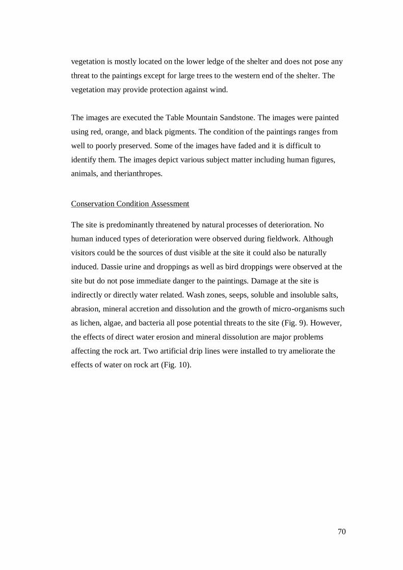
70
vegetation is mostly located on the lower ledge of the shelter and does not pose any
threat to the paintings except for large trees to the western end of the shelter. The
vegetation may provide protection against wind.
The images are executed the Table Mountain Sandstone. The images were painted
using red, orange, and black pigments. The condition of the paintings ranges from
well to poorly preserved. Some of the images have faded and it is difficult to
identify them. The images depict various subject matter including human figures,
animals, and therianthropes.
Conservation Condition Assessment
The site is predominantly threatened by natural processes of deterioration. No
human induced types of deterioration were observed during fieldwork. Although
visitors could be the sources of dust visible at the site it could also be naturally
induced. Dassie urine and droppings as well as bird droppings were observed at the
site but do not pose immediate danger to the paintings. Damage at the site is
indirectly or directly water related. Wash zones, seeps, soluble and insoluble salts,
abrasion, mineral accretion and dissolution and the growth of micro-organisms such
as lichen, algae, and bacteria all pose potential threats to the site (Fig. 9). However,
the effects of direct water erosion and mineral dissolution are major problems
affecting the rock art. Two artificial drip lines were installed to try ameliorate the
effects of water on rock art (Fig. 10).
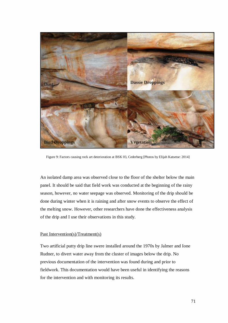
71
Figure 9: Factors causing rock art deterioration at BSK 03, Cederberg [Photos by Elijah Katsetse: 2014]
An isolated damp area was observed close to the floor of the shelter below the main
panel. It should be said that field work was conducted at the beginning of the rainy
season, however, no water seepage was observed. Monitoring of the drip should be
done during winter when it is raining and after snow events to observe the effect of
the melting snow. However, other researchers have done the effectiveness analysis
of the drip and I use their observations in this study.
Past Intervention(s)/Treatment(s)
Two artificial putty drip line swere installed around the 1970s by Jalmer and Ione
Rudner, to divert water away from the cluster of images below the drip. No
previous documentation of the intervention was found during and prior to
fieldwork. This documentation would have been useful in identifying the reasons
for the intervention and with monitoring its results.
Bird Droppings Vegetation
Dassie Droppings Dust
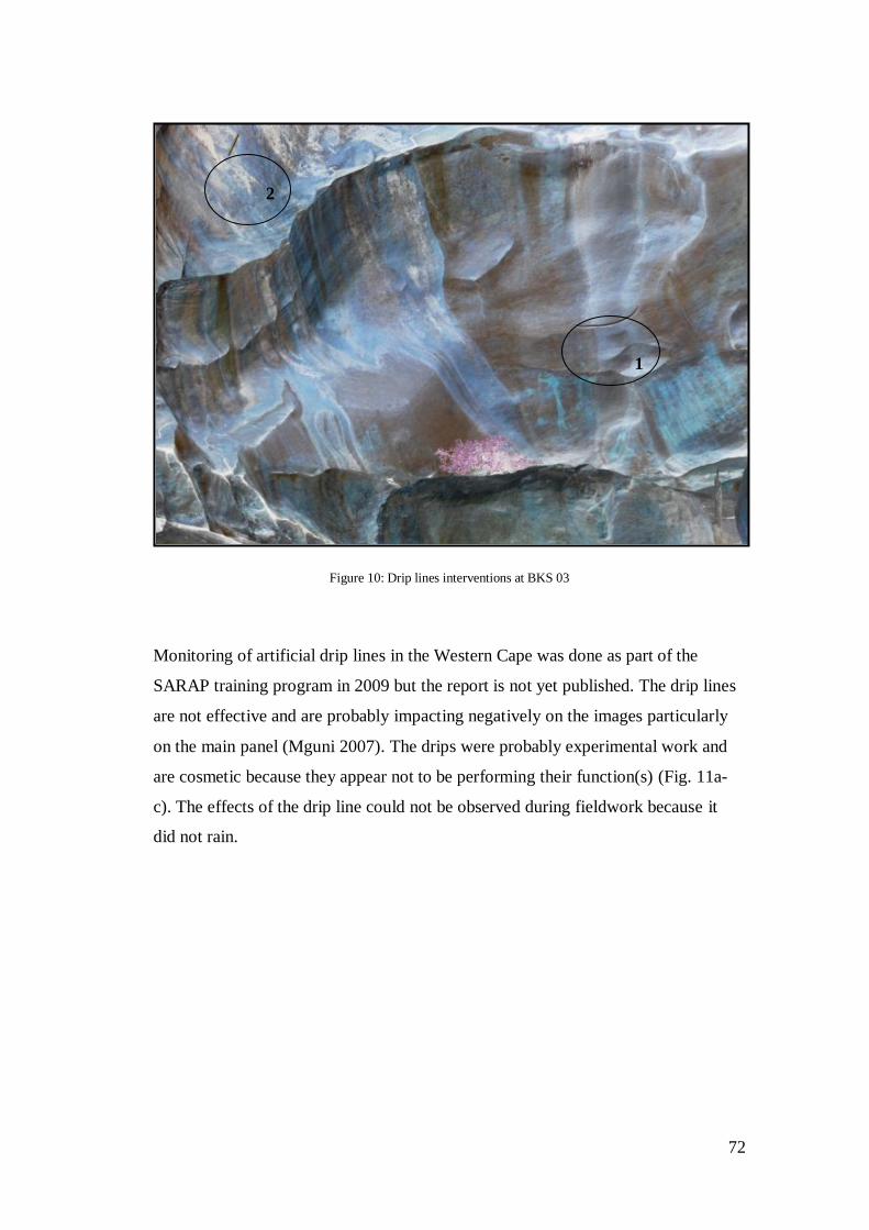
72
Figure 10: Drip lines interventions at BKS 03
Monitoring of artificial drip lines in the Western Cape was done as part of the
SARAP training program in 2009 but the report is not yet published. The drip lines
are not effective and are probably impacting negatively on the images particularly
on the main panel (Mguni 2007). The drips were probably experimental work and
are cosmetic because they appear not to be performing their function(s) (Fig. 11a-
c). The effects of the drip line could not be observed during fieldwork because it
did not rain.
1
2
73
Figure 11a:Wash zones and damp areas in relation to image clusters [Photos by Elijah Katsetse: 2014]
1
2
3
4
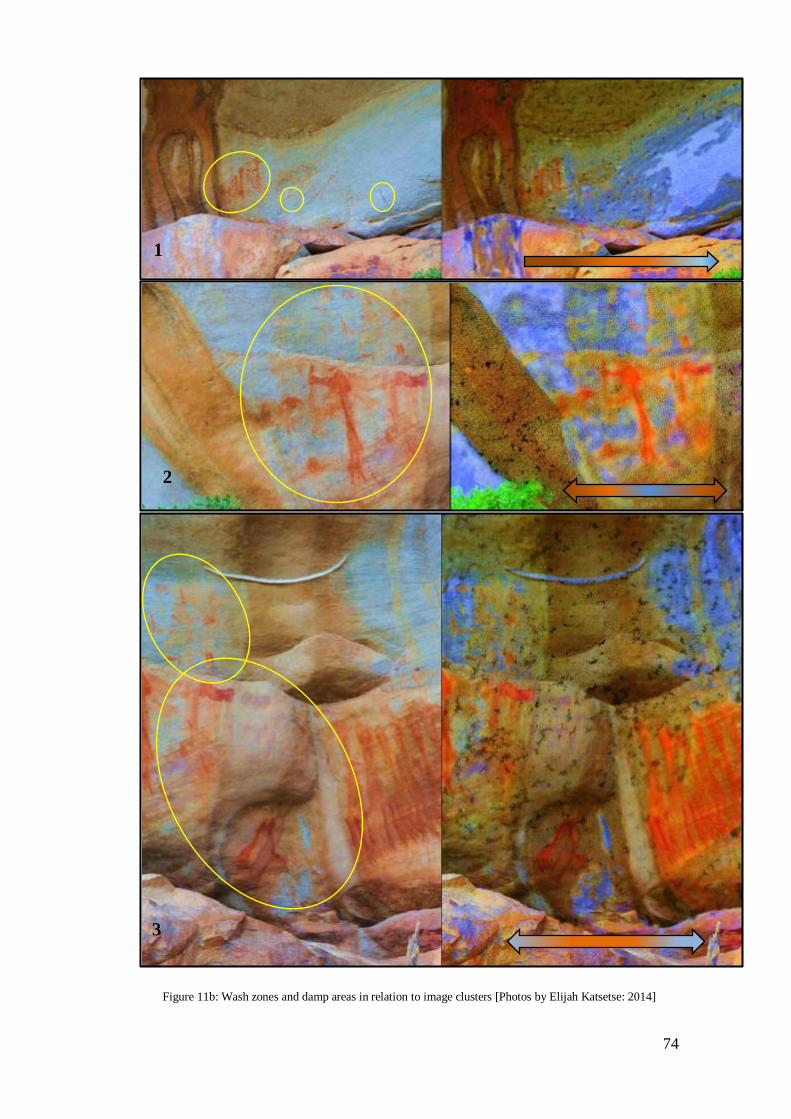
74
Figure 11b: Wash zones and damp areas in relation to image clusters [Photos by Elijah Katsetse: 2014]
1
2
3

75
Figure 11c: Wash zones and damp areas in relation to image clusters [Photos by Elijah Katsetse: 2014]
The Figure11a to c show wash zones, damp areas, and mineral dissolution and highlight the
degree of water related damage on the rock surface. The degree of water related damage
decreases in the direction indicated by the arrow(s). The red circles show image clusters in
relation to water damage. The arrow further show a graduated severity of water related
damage. Wash zones deposit minerals and salts onto the surface thus staining the images
and appears to be causing severe damage to the images. Water flows along the contours of
the rock and is often trapped on the surface and gets absorbed into the rock thus creating
damp areas. Damp areas also stain the surface over time but this is not severe compared to
wash zones.
4
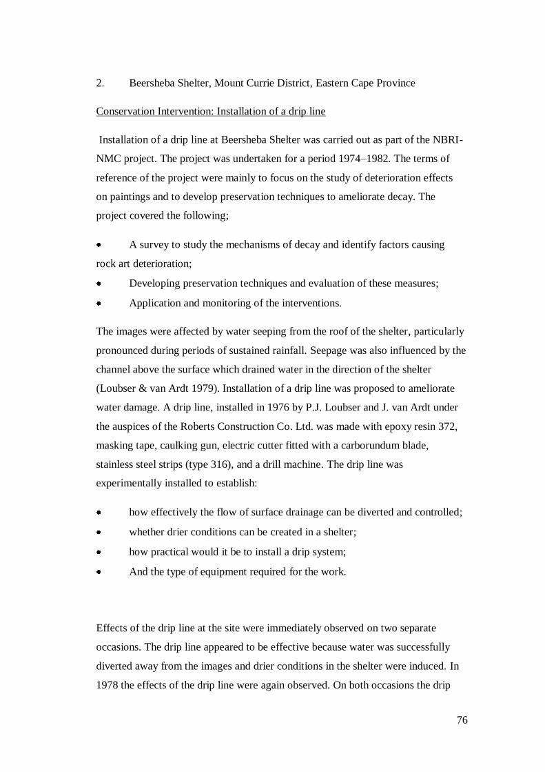
76
2. Beersheba Shelter, Mount Currie District, Eastern Cape Province
Conservation Intervention: Installation of a drip line
Installation of a drip line at Beersheba Shelter was carried out as part of the NBRI-
NMC project. The project was undertaken for a period 1974–1982. The terms of
reference of the project were mainly to focus on the study of deterioration effects
on paintings and to develop preservation techniques to ameliorate decay. The
project covered the following;
A survey to study the mechanisms of decay and identify factors causing
rock art deterioration;
Developing preservation techniques and evaluation of these measures;
Application and monitoring of the interventions.
The images were affected by water seeping from the roof of the shelter, particularly
pronounced during periods of sustained rainfall. Seepage was also influenced by the
channel above the surface which drained water in the direction of the shelter
(Loubser & van Ardt 1979). Installation of a drip line was proposed to ameliorate
water damage. A drip line, installed in 1976 by P.J. Loubser and J. van Ardt under
the auspices of the Roberts Construction Co. Ltd. was made with epoxy resin 372,
masking tape, caulking gun, electric cutter fitted with a carborundum blade,
stainless steel strips (type 316), and a drill machine. The drip line was
experimentally installed to establish:
how effectively the flow of surface drainage can be diverted and controlled;
whether drier conditions can be created in a shelter;
how practical would it be to install a drip system;
And the type of equipment required for the work.
Effects of the drip line at the site were immediately observed on two separate
occasions. The drip line appeared to be effective because water was successfully
diverted away from the images and drier conditions in the shelter were induced. In
1978 the effects of the drip line were again observed. On both occasions the drip

77
appeared to be effectively diverting water away from the images and maintaining
drier conditions in the shelter (Loubser & van Ardt 1979). Loubser & van Ardt
(1978) stated that the drip line should be treated as a long term project because the
effects of the drip at the site could not be observed at the site in the time they were
observed.
The site was not visited during the study due to logistical issues and difficulties
locating the site using documented information at RARI and the African Digital
Archive. The reason being that in the Orange Free State Province there is a site with
a similar name but spelled Bersheba with a single ‘e’. It would have been beneficial
to the study if the site was visited and casual monitoring of the drip line done. The
drip installed at Beersheba is different to the artificial putty drip lines commonly
installed in the Cederberg. This would have afforded me an opportunity to evaluate
the use of different materials to create artificial drip lines.
3. Mount Grenfell, NWS, Australia
Conservation Intervention: Installation of a drip line
The National Parks and Wildlife Services is charged with the administration and
management of Aboriginal relics sought specialists to advise on the rock art
preservation from the Australian Museum Conservation Laboratory and the
Specialist Services and Applied Research section of the Department of Mines
Geological Survey. Acting on advice provided, the National Parks and Wildlife
Services set up a project on rock art preservation in 1976 with the following aims;
to undertake a comprehensive investigation into the causes of deterioration
of rock art;
to initiate field laboratory studies for the development of conservation
treatment;
And to establish practical procedures for the protection of painted and
engraved rock surfaces against physical damage from people, animals, and water.
78
The three rock shelters at Mount Grenfell are relatively low and as such are not
exposed to the elements except for a short period during early hours of the morning
when sunlight comes into the shelter. The difference in thermal expansion causes
exfoliation of the rock surface. However, rock art damage at Mount Grenfell is due
to water percolation from the ceiling of the shelter that directly erodes the images.
Mineral dissolution of the sandstone causes severe damage by depositing soluble
salts and staining the paintings. Installation of a drip line and modification of the
shelter’s drainage were proposed.
The aims of this intervention were to: reduce significantly the amount of water
washing into the shelter and modify the drainage of the shelter. When bituminous
caulking compound was used in the installation of the drip line, the following
intervention plan was employed for surface modification: (i) plotting the contours
of the land overlying and surrounding the shelters; (ii) investigation of the natural
catchment drainage and percolation routes in order to analyse precise drainage
patterns of the sites and (iii) studying the front elevation of the shelter to produce
section drawings. A continuous strip (10 x 7mm) was applied on the contours of the
shelter. This strip was designed to withstand temperatures from -4 to 94˚C. The
effectiveness of the drip was not observed and no results were reported by Walston
and Dolanski (1976).
4.3.2.2. Surface recession and Surface Pollutants
Natural forces causing the destruction of rock art cannot be stopped or ameliorated
(Brink 2007). The effects of water on rock substrate and rock art can be treated
using both direct and indirect measures of conservation. Preservation measures
dealing with water-related damage were discussed in section 4.3.2.1.2. On the other
hand direct conservation measures to treat the effects of water on rock art are
characterised by the stabilisation and cleaning of rock surfaces. Mineral dissolution
can be treated by cleaning the rock surface using chemical agents. Mineral
79
dissolution of sandstone by oxidation and hydration causes loss of surface cohesion
and surface staining (Venter 2011; Bemand et al. 2014).
This process results in the leaching of quartz grains in sandstone and clay minerals
that provide cementation. A multitude of forces including salt crystallisation and
freeze-thaw cycles result in the exfoliation of the surface sand grains. The freeze-
thaw cycles may cause the expansion and contraction of the surface sand grains and
cementing clay minerals close to the surface of the rock thus inducing the
disaggregation of sand grains that may result in the exfoliation, spalling, flaking,
and crumbling of the surface. These processes happen close or near the rock surface
especially in surfaces exposed to the elements. Therefore, this process causes more
rock art deterioration because paintings occur near or on the surface of the rock
(Meiklejohn et al. 2009).
4.3.2.2.1 Surface consolidation and cleaning systems
Surface consolidation and protective material fall into the broad category of surface
coating and include stone protective water repellents, anti-graffiti coatings,
emulsions, salt inhibitors, protective oxalate layers, sacrificial lime coatings,
colloidal silica, biocides, and bio-deterioration treatments (Price & Doehne 2010;
Chelazzi et al. 2013). This is arguably the most varied and complex field of
treatment materials because in requires chemical investigation and is largely
laboratory based. Conservation science deals with damage that results from the
crystallisation of soluble salts within stone, attack of acid gases in the air,
concentration of white efflorescence on rock surfaces, freeze-thaw cycles and the
vandalism of rock art surface consolidation treatment, anti-graffiti coatings and
removal treatments. Surface cleaning systems are commonly applied in South
Africa to address rock art deterioration.

80
Surface Consolidation and protective coatings
Conservation science has improved the use and development of surface
consolidation, cleaning and protective materials (Chelazzi et al. 2013). The
involvement of conservation scientists in heritage has resulted in a shift from the
use of commercial and traditional consolidation treatment materials to laboratory
and tailor-made consolidants (Chelazzi et al. 2013). Conservators suggest that a
good consolidation treatment agent is one that has a low-viscosity and induces
chemical reaction with the substrate in situ, is dissolvable in a solvent and has a
relatively deep level of penetration (Haskovec 1999; Price & Doehne 2010;
Chelazzi et al. 2013). Furthermore, the quality of a surface consolidating or
protective treatment material is determined by several elements that include the
visual quality, ultra-violet stability, surface hardness, depth of penetration, water
permeability, and its flexibility (Haskovec 1999; Price & Doehne 2010). A good
and effective surface consolidating and protective material, is one that, is mostly
liquid at high temperature and hardens at low temperature, is invisible, and is
compatible with the substrate (Haskovec 1999).
The compatibility of a consolidating and protective material goes beyond the visual
quality of the treatment; it goes to the moisture and temperature regimes of the
substrate (Haskovec 1999). The treated surface should have similar temperature and
moisture regimes with the untreated stone. Thus, a treatment should not modify the
porosity and permeability of the substrate. The compatibility of a consolidating and
protective treatment material in this sense will ensure that no internal pressure is
created within the rock and the mechanical stress and the subsequent breakdown of
the rock is not induced. This can be achieved through a careful consideration of the
nature of the material(s) used. Synthetic organic materials have had a negative
effect on stone despite their continued use (Chelazzi et al. 2013). However, the
preparation and precipitation of synthetic inorganic material particularly nano-
particles has improved (Chelazzi et al. 2013).
81
Inorganic materials are more effective compared to synthetic organic material
(Chelazzi et al. 2013). The effectiveness of a surface consolidating and protective
material is influenced by several factors, which include the method of application,
the physical and chemical characteristics of the agent and the substrate.
Conservators thus suggest a step-by-step monitoring of the process of intervention
rather than observing the final product of the intervention (Haskovec 1999;
Chelazzi et al. 2013).
4.3.2.2.2. CASE STUDIES: SECTION 2
4. Bushman Kloof 09, Cederberg, Western Cape
Box 2: General Site Information
Site Name: Bushmans Kloof 09 Alternative Name: Bleeding Nose (BS) Sites
Site I.D: BSK 09 Panel #: Main Panel Managing Agency: HWC
Date: 05/July/2014 Farm Name: Bushmans Kloof 179
GPS File: S 32° 06’ 38.4”, E 19° 06’ 58.5’’ Photos: SARADA
Aspect & Angle: West Facing Site Dimensions: (C: 15 x 2m high x 4-5m long)
Site Type: Boulder
Existing Documentation: Full record with the Bushmans Kloof Reserve
Samples: No

82
Site Description and Material Characterisation
BSK09 are comprised of three sites situated on the eastern bank of the Perdekraal
River upstream, about 2 kilometres from the main reservoir. The site complex is 15
meters long along the edges of the river, occasionally flooded in winter. The small
west facing boulder where conservation experiments were undertaken is the focus
of this study.
The small protective boulder is situated in the middle of a brush of vegetation on
the river bank (Fig. 12). The vegetation around the site includes the Podocarpus
eongetus, Mytenus oleoides, Heeria argentea, Rhus undulata, Rhus dissecta and on
deeper soil above on the flat area, Tycedon paniculatus, Cotyledon orbiculata, and
some Restionaceous reeds. The vegetation does not provide any form of protection
to the images nor does it pose any threat.
The images are executed on the Table Mountain Sandstone. The images were
painted using dark red and brown pigments. Shades of white and yellow can be
observed within the BSK 09 complex. The condition of the paintings ranges from
well to poorly preserved images. Some of the images have faded and it is difficult
to make them out. The images depict various subject matter including human
figures, animals, and therianthropes.
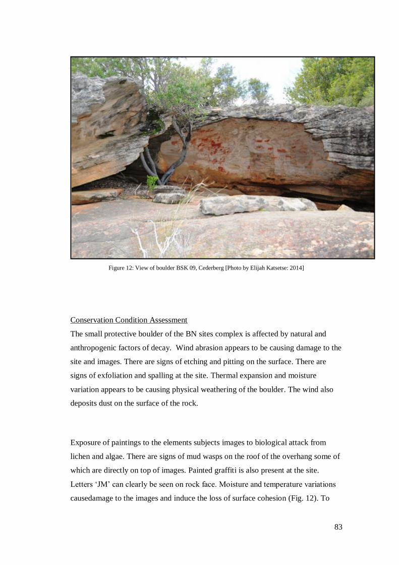
83
Figure 12: View of boulder BSK 09, Cederberg [Photo by Elijah Katsetse: 2014]
Conservation Condition Assessment
The small protective boulder of the BN sites complex is affected by natural and
anthropogenic factors of decay. Wind abrasion appears to be causing damage to the
site and images. There are signs of etching and pitting on the surface. There are
signs of exfoliation and spalling at the site. Thermal expansion and moisture
variation appears to be causing physical weathering of the boulder. The wind also
deposits dust on the surface of the rock.
Exposure of paintings to the elements subjects images to biological attack from
lichen and algae. There are signs of mud wasps on the roof of the overhang some of
which are directly on top of images. Painted graffiti is also present at the site.
Letters ‘JM’ can clearly be seen on rock face. Moisture and temperature variations
causedamage to the images and induce the loss of surface cohesion (Fig. 12). To
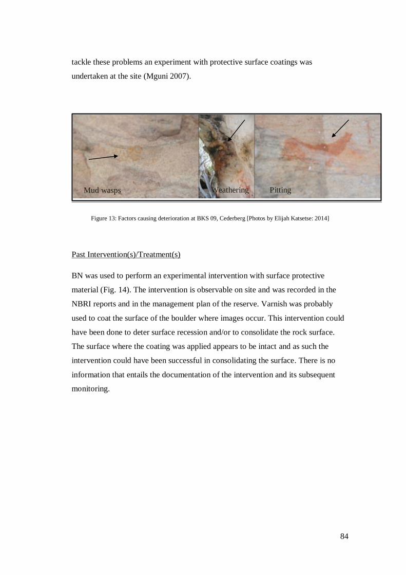
84
tackle these problems an experiment with protective surface coatings was
undertaken at the site (Mguni 2007).
Figure 13: Factors causing deterioration at BKS 09, Cederberg [Photos by Elijah Katsetse: 2014]
Past Intervention(s)/Treatment(s)
BN was used to perform an experimental intervention with surface protective
material (Fig. 14). The intervention is observable on site and was recorded in the
NBRI reports and in the management plan of the reserve. Varnish was probably
used to coat the surface of the boulder where images occur. This intervention could
have been done to deter surface recession and/or to consolidate the rock surface.
The surface where the coating was applied appears to be intact and as such the
intervention could have been successful in consolidating the surface. There is no
information that entails the documentation of the intervention and its subsequent
monitoring.
Mud wasps Weathering Pitting
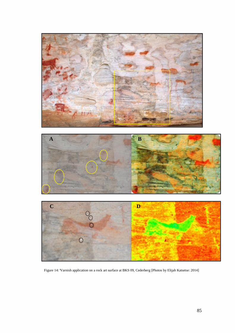
85
Figure 14: 'Varnish application on a rock art surface at BKS 09, Cederberg [Photos by Elijah Katsetse: 2014]
A B
C D
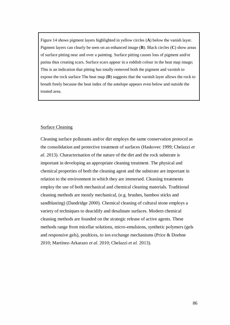
86
Figure 14 shows pigment layers highlighted in yellow circles (A) below the vanish layer.
Pigment layers can clearly be seen on an enhanced image (B). Black circles (C) show areas
of surface pitting near and over a painting. Surface pitting causes loss of pigment and/or
patina thus creating scars. Surface scars appear in a reddish colour in the heat map image;
This is an indication that pitting has totally removed both the pigment and varnish to
expose the rock surface The heat map (D) suggests that the varnish layer allows the rock to
breath freely because the heat index of the antelope appears even below and outside the
treated area.
Surface Cleaning
Cleaning surface pollutants and/or dirt employs the same conservation protocol as
the consolidation and protective treatment of surfaces (Haskovec 1999; Chelazzi et
al. 2013). Characterisation of the nature of the dirt and the rock substrate is
important in developing an appropriate cleaning treatment. The physical and
chemical properties of both the cleaning agent and the substrate are important in
relation to the environment in which they are immersed. Cleaning treatments
employ the use of both mechanical and chemical cleaning materials. Traditional
cleaning methods are mostly mechanical, (e.g. brushes, bamboo sticks and
sandblasting) (Dandridge 2000). Chemical cleaning of cultural stone employs a
variety of techniques to deacidify and desalinate surfaces. Modern chemical
cleaning methods are founded on the strategic release of active agents. These
methods range from micellar solutions, micro-emulsions, synthetic polymers (gels
and responsive gels), poultices, to ion exchange mechanisms (Price & Doehne
2010; Martínez-Arkarazo et al. 2010; Chelazzi et al. 2013).
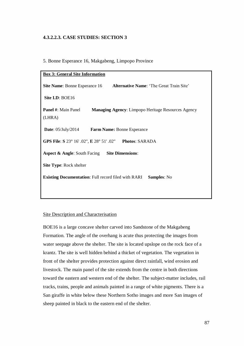
87
4.3.2.2.3. CASE STUDIES: SECTION 3
5. Bonne Esperance 16, Makgabeng, Limpopo Province
Box 3: General Site Information
Site Name: Bonne Esperance 16 Alternative Name: ‘The Great Train Site’
Site I.D: BOE16
Panel #: Main Panel Managing Agency: Limpopo Heritage Resources Agency
(LHRA)
Date: 05/July/2014 Farm Name: Bonne Esperance
GPS File: S 23° 16' .02", E 28° 51' .02" Photos: SARADA
Aspect & Angle: South Facing Site Dimensions:
Site Type: Rock shelter
Existing Documentation: Full record filed with RARI Samples: No
Site Description and Characterisation
BOE16 is a large concave shelter carved into Sandstone of the Makgabeng
Formation. The angle of the overhang is acute thus protecting the images from
water seepage above the shelter. The site is located upslope on the rock face of a
krantz. The site is well hidden behind a thicket of vegetation. The vegetation in
front of the shelter provides protection against direct rainfall, wind erosion and
livestock. The main panel of the site extends from the centre in both directions
toward the eastern and western end of the shelter. The subject-matter includes, rail
tracks, trains, people and animals painted in a range of white pigments. There is a
San giraffe in white below these Northern Sotho images and more San images of
sheep painted in black to the eastern end of the shelter.

88
Conservation Condition Assessment
The site is affected by natural processes of deterioration (Fig 15). Prior to an
intervention by RARI, livestock used the site for shelter to rest and roll in the dust
to clean their coats. This resulted in increased levels of dust. There is evident
exfoliation and granulation probably influenced by the presence of both soluble and
insoluble salts. However, an imminent threat is presented by both birds and bats
excreta.
The structure of the shelter subjects the main panel to the effects of bird droppings
because the back of the shelter protrudes. Ledges above the protruding back wall
provide nesting and roosting shelters for birds and bats. The main panel is heavily
covered with bird droppings accumulated over years into a thick deposit that not
only is unsightly but weathers both the paintings and the rock. Evaporation of the
bird droppings may result in salt concentration on the rock surface and the
transportation of soluble salts that could further cause damage to the images. RARI
called in an expert conservator to address the bird and bat problem at the site.
Assessment of the problem prior to the intervention using dated images shows that
the droppings may have been accumulating since 1999.
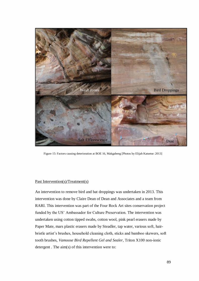
89
Figure 15: Factors causing deterioration at BOE 16, Makgabeng [Photos by Elijah Katsetse: 2013]
Past Intervention(s)/Treatment(s)
An intervention to remove bird and bat droppings was undertaken in 2013. This
intervention was done by Claire Dean of Dean and Associates and a team from
RARI. This intervention was part of the Four Rock Art sites conservation project
funded by the US’ Ambassador for Culture Preservation. The intervention was
undertaken using cotton tipped swabs, cotton wool, pink pearl erasers made by
Paper Mate, mars plastic erasers made by Steadler, tap water, various soft, hair-
bristle artist’s brushes, household cleaning cloth, sticks and bamboo skewers, soft
tooth brushes, Vamoose Bird Repellent Gel and Sealer, Triton X100 non-ionic
detergent . The aim(s) of this intervention were to:
Wash zones
Salt Efflorescence
Bird Droppings
Dust
90
Reduce and wherever possible remove bird droppings from the main panel.
Reduce and wherever possible remove accumulation of bat droppings.
To install some means to deter birds from roosting on the ledges within the
site and thus reduce the further accumulation of droppings.
A pigment solubility test was done prior to the intervention. A condition assessment
and treatment record are archived at RARI. The treatment record includes before
and after treatment images (Fig 16a-c). This indicates good practice and these data
can be used in future conservation and monitoring work. A step-by-step monitoring
of the treatment process was done during the intervention. Observations were also
done at the end of the intervention process to observe the immediate results and
effectiveness of the cleaning agent(s). Both monitoring activities were done by
Claire Dean. The cleaning system was effective (Dean 2013). As a result a
significant quantity of the bird and bat droppings had been either totally removed or
reduced to a residue. The effectiveness and results of this treatment resulted in an
85% improvement both in terms of removal and the visual quality of the main panel
(Dean 2013).
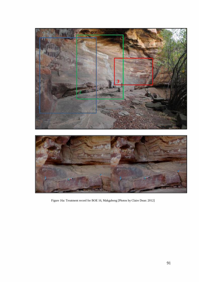
91
Figure 16a: Treatment record for BOE 16, Makgabeng [Photos by Claire Dean: 2012]
1
2
3
1

92
Figure 16b: Treatment record for BOE 16, Makgabeng [Photos by Claire Dean: 2012]
2
2
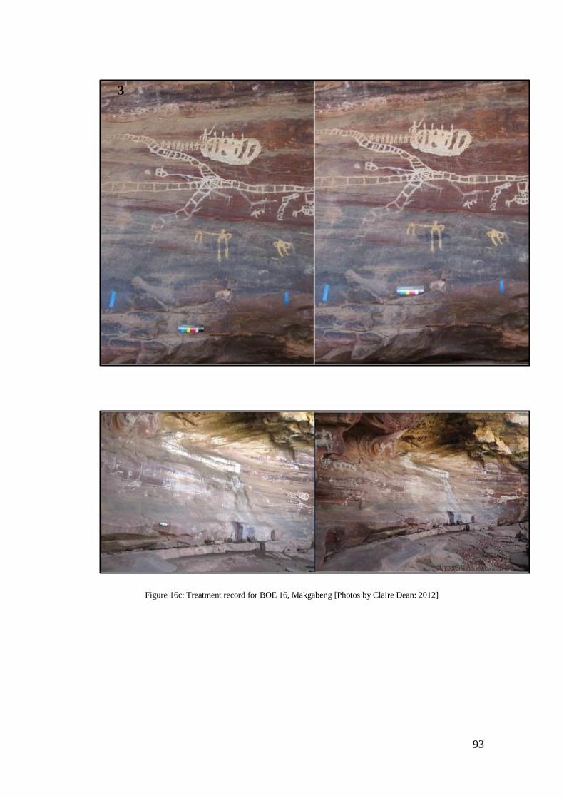
93
Figure 16c: Treatment record for BOE 16, Makgabeng [Photos by Claire Dean: 2012]
3

94
Figure 16 a-c is a Treatment (before and after) record of the intervention at BOE16. Each
area highlighted in the photographs represents the treatment of different factors of decay;
treatment area(s) 1 and 3 in Fig. 16a show the removal of dust and 2 bird dropping and the
application of a gel to deter birds and bats from roosting, while 4 is the general view of
BOE16 before and after treatment. Before images are on the left and after treatment images
are on the right.
In 2013 when I visited the site the droppings had re-emerged (Fig. 17). The
problems of bird droppings and roosting persisted at the site because the Vamoose
Bird Repellent Gel and Seal as well as the small stones put on the ledges to deter
the birds and bats from inhabiting the site were not effective. Therefore, the birds
and bats continue to inhabit the ledges above the main panel and deposit guano.
Dust was successfully removed from the surfaces of the shelter and new
information that was previously obscured was revealed.
Furthermore, an indirect intervention to minimise dust at the site was undertaken by
RARI staff (Benjamin Smith, Catherine Namono and Siyakha Mguni). Small
pebbled stones were collected from areas surrounding the site and carefully laid on
the floor of the shelter. This intervention contained and reduced the dust to a
minimum; it improved the floor of the site significantly, as well as the site visual
appeal since the materials used are compatible with the site surroundings. This
intervention was monitored a year later in 2014 and the results are good.
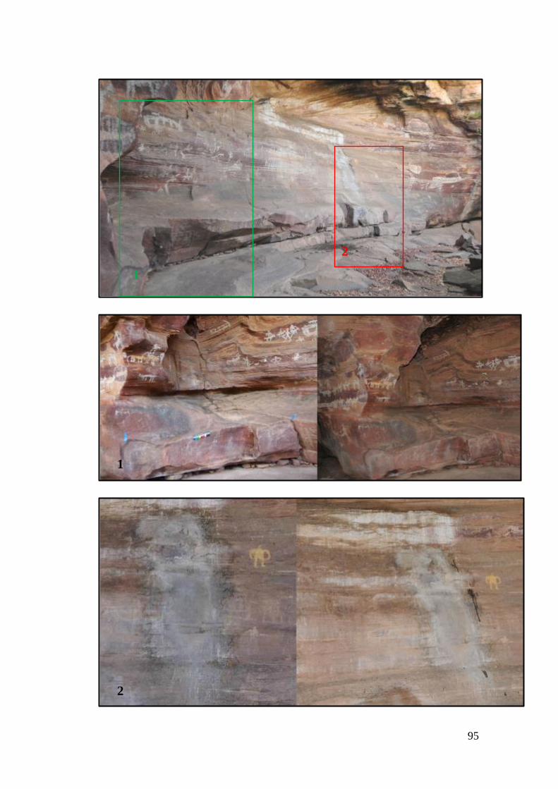
95
1
2
1
2

96
Figure 17: Treatment monitoring at BOE 16, Makgabeng [Photos by Claire Dean: 2012 &Elijah Katsetse: 2013]
The conservation monitoring at BOE16 has had mixed results. The series of images 1−3
show the effectiveness and failures of the intervention at BOE16. The gel application on
ledges has not been successful in deterring birds and bats from roosting at the site thus the
problem is persisting. On the positive side, dust levels have been kept to a minimum. The
original treatment record images are on the left and monitoring images are on the right.
2
97
6. Main Caves (North & South), Drakensberg, KwaZulu-Natal
Box 4: General Site Information
Site Name: Main Cavesnorth Site I.D: MSI1Panel #: Main Panel
Date: 05/July/2014
Managing Agency: Amafa Farm Name: Giant’s Castle
GPS File: S 29° 16' 55", E 29° 30' 55" Photos: SARADA
Site Type: Rock shelter Aspect & Angle: North Facing
Site Dimensions: Record with RARI Samples: No
Existing Documentation: Full site record filed with the RARI
Box 4: General Site Information
Site Name: Main Caves southeast Site I.D: MSI1 Panel #: Main Panel
Date: 05/July/2014
Managing Agency: Amafa Farm Name: Giant’s Castle
GPS File: S 29° 16' 55", E 29° 30' 55" Photos: SARADA Site Type: Rock shelter
Aspect & Angle: Southeast Facing Site Dimensions: Record with RARI
Samples: No
Existing Documentation: Full site record with the RARI
Site Description and Characterisation
The Main Caves Site Museums are found along a trail about two kilometres from
the Giant’s Castle Guest Lodge (rest camp). The famous rock ‘75’ is found along

98
this trail. Main Caves are situated upslope on a krantz line looking down the Two
Dassie River. Main Caves north is located on the southern bank of the Bushman’s
valley. Main Caves north is a rock shelter hidden behind a thicket of trees and
shrubs. The floor leading up to the shelter is covered with soil and large boulders
and slopes up and down towards the front, eventually falling off steeply to the
valley below. A boardwalk was installed on site to allow visitors access into the site
and to provide a good viewing platform. The site has one of the best quality and
complex rock art imagery scenes in the Drakensberg.
The Images are depicted on sandstone of the Clarens Formation. The subject matter
includes animals, therianthropes and human figures. Images of therianthropes on
the main panel are synonymous with the site. There is also a series of panels
depicting snakes which are particularly elaborate compared to paintings of snake
seen elsewhere in South Africa. The preservation quality of the images ranges from
good to poor. Images painted in white in particular appear faint compared to images
in red.
Conservation Condition Assessment
Main Caves has been fenced off since the late 1960s and this has helped limit the
vandalism of the site. Graffiti identified at the site appears to date to the late 1900s.
Letters Jack Hobbs can be seen on the roof of the shelter. A big tree that was
removed when the boardwalk was installed was used as a ladder to reach the roof of
the shelter. The removal of vegetation in front of the shelter may have exacerbated
the deterioration of rock art. The exposure of rock art to the elements may have
increased the weathering of both the sandstone and paintings.
The Main Caves sites have been focus areas for weathering studies since 1990.
These studies show that images are executed on actively decaying sandstone.
Weathering processes pose a major threat to the long-term preservation of images.
Salt efflorescence, wind abrasion, dust, and exfoliation appear to be major threat at
the site(Fig. 18). Ward & Maggs (1995) singled out the effects of exfoliation as the
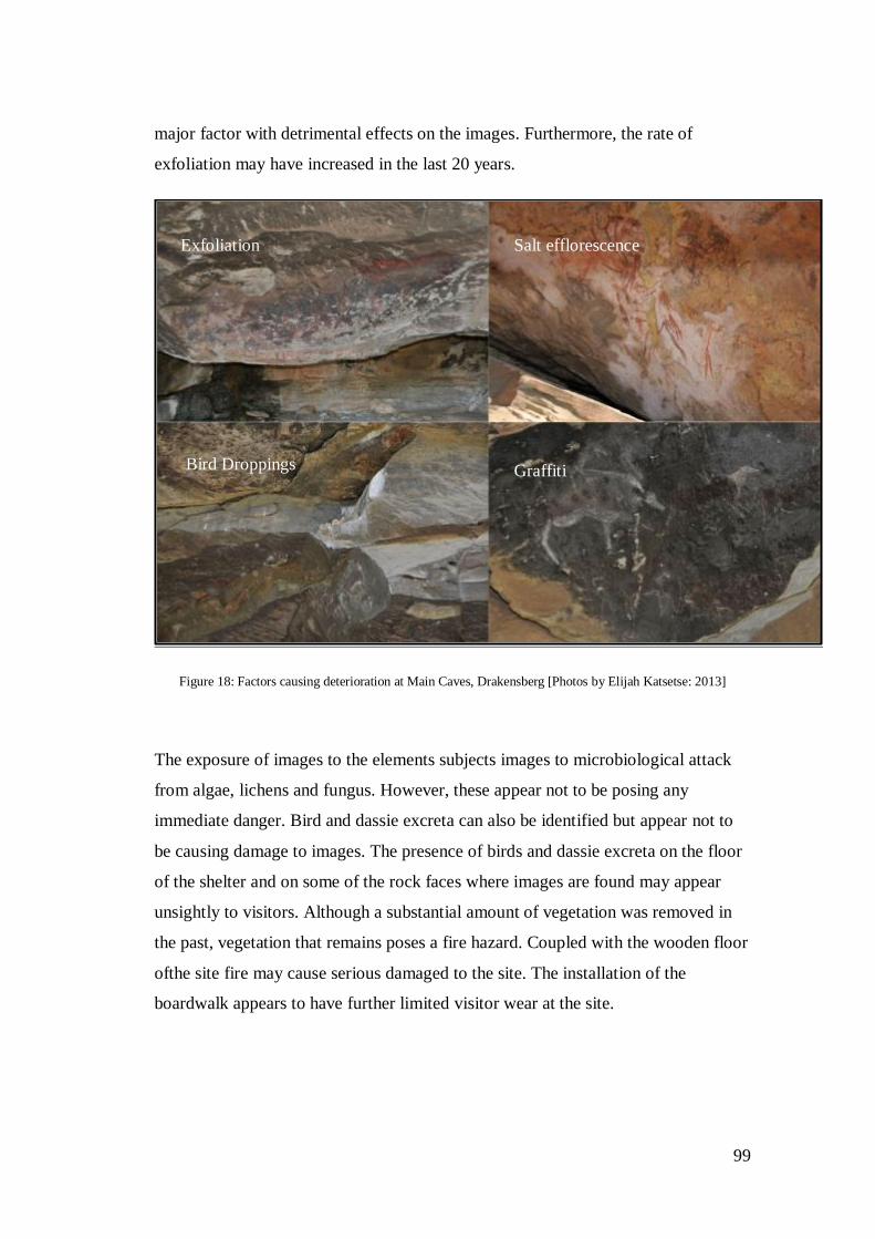
99
major factor with detrimental effects on the images. Furthermore, the rate of
exfoliation may have increased in the last 20 years.
Figure 18: Factors causing deterioration at Main Caves, Drakensberg [Photos by Elijah Katsetse: 2013]
The exposure of images to the elements subjects images to microbiological attack
from algae, lichens and fungus. However, these appear not to be posing any
immediate danger. Bird and dassie excreta can also be identified but appear not to
be causing damage to images. The presence of birds and dassie excreta on the floor
of the shelter and on some of the rock faces where images are found may appear
unsightly to visitors. Although a substantial amount of vegetation was removed in
the past, vegetation that remains poses a fire hazard. Coupled with the wooden floor
ofthe site fire may cause serious damaged to the site. The installation of the
boardwalk appears to have further limited visitor wear at the site.
Exfoliation Salt efflorescence
Bird Droppings Graffiti
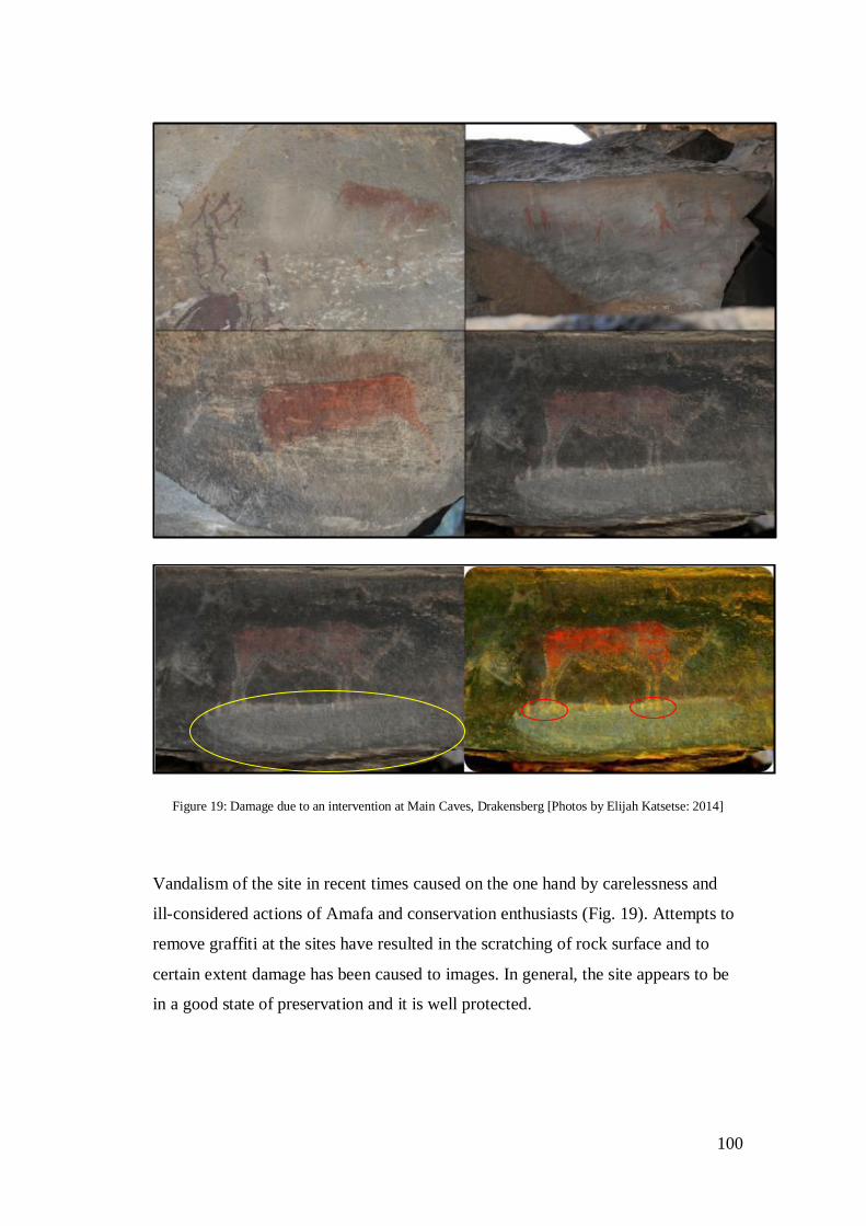
100
Figure 19: Damage due to an intervention at Main Caves, Drakensberg [Photos by Elijah Katsetse: 2014]
Vandalism of the site in recent times caused on the one hand by carelessness and
ill-considered actions of Amafa and conservation enthusiasts (Fig. 19). Attempts to
remove graffiti at the sites have resulted in the scratching of rock surface and to
certain extent damage has been caused to images. In general, the site appears to be
in a good state of preservation and it is well protected.
101
Past Interventions(s)/Treatments
An intervention to remove graffiti at the site was undertaken in the past but no
record of it was found during this study. Instead the effects of this intervention can
be seen on the rock surface and on images. However, no information pertaining to
this intervention exists. It is not clear when and by whom this intervention was
undertaken. However, the aim(s) of the intervention may have been;
to probably mask/hide the negative effects of graffiti
to discourage further vandalism of the site
The attempt to remove graffiti had detrimental effects on the site. It has left
scratches that are unsightly on the rock surface (Fig. 18). The intervention,
probably done by an unsupervised, inexperienced individual is detrimental to the
site. Although the intentions may have been founded on good intentions the results
are negative. In 1967 and 1998 Main Caves site museums were developed for
public visitation .The following modification and additions were done, paved paths,
fence, Bushman Diorama, Display signs, and a boardwalk (Fig. 20). These
interventions were undertaken under the auspices of the Natal Parks Board (now
Ezemvelo KwaZulu-Natal Wildlife) and Amafa. The Natal Parks Board and Amafa
wanted to:
Control access to the site.
Control visitor movement on site
Reduce vandalism and damage of the site.
Allow access to the knowledgeable and appreciative.
Educate the public about rock art and its significance.
Better presentation of the site.
No documentation (Condition assessment or treatment record) of the intervention
was found during and prior to field work. However, information on the
development of the site is available in published material. Amafa does periodic
monitoring of rock art sites but the scope of monitoring is not known. Amafa uses a
card system to monitor rock art sites. It has not methodology to monitor
conservation interventions. The vandalism of the site has been successfully kept to

102
a minimal. No recent graffiti and camping activities have been identified in some
time. The development of the site for public visitation, it can be argued though
good intentioned, may have caused/enhanced the effects of deterioration factors on
images. Public visitation the Drakensberg have failed to deliver on the high
expectations the rock art community had of the sites (Duval & Smith 2013).
Figure 20: Visitor and dust control interventions at Main Caves, Drakensberg [Photos from SARADA]
The presence of bird and guano at Main Caves was noted by Ward (1994) and
Maggs and Ward (1997). In 2013 Claire Dean a conservation specialist, was
brought to remove bird droppings and dust. The Intervention was undertaken by
Claire Dean in collaboration with a team from RARI and was undertaken under
permit: Rock Art 2013/002. This intervention was undertaken under the four rock
art sites conservation project. The following materials were used: polythene
sheeting; blue, low tack painters tape (3m brand), cotton tipped swabs, cotton wool,
1967 1998

103
water, household cleaning cloths, sticks and bamboo skewers, soft tooth brushes,
locally gathered stones. The aim of the intervention was to:
Reduce and wherever possible remove bird droppings from the locations
where they have accumulated near to rock image panels. Other accumulations at
distance from any panels were not scheduled to be treated.
Where necessary and possible, remove/reduce any isolated droppings that
have been deposited on panels.
Install some means to deter birds from roosting on the ledges within the site
and thus reduce the further accumulation of droppings.
A solubility test was done prior to the intervention. A condition assessment and
treatment record are archived at RARI. The treatment record includes before and
after treatment images (Fig. 21 and 22). This will be useful in future conservation
and monitoring work. The effectiveness of treatment was monitored during the
course of the intervention and at the end of the intervention process. Results
presented here are based on observations made by Dean (2013). “On completion of
treatment a significant amount of the bird droppings in the areas treated had been
either totally removed or reduced to a residue. As a percentage it is estimated that a
95% improvement of the areas treated was obtained” (Dean 2013: 17). A large
accumulation of bird droppings was removed successfully and the visual quality of
the site improved substantially.
The accumulation of bird droppings on the rock surface posed no threat to the
images and as such their removal is described as a cosmetic action by Dean (2013).
In certain areas the accumulation of bird guano appears to have etched the rock
surface and left a white residue. It should be kept in mind that the cleaning of bird
droppings was to maintain a uniform visual quality of the site. To allow for a
certain level of compatibility the removal of dust and bird guano had to blend in
with the surrounding site condition.
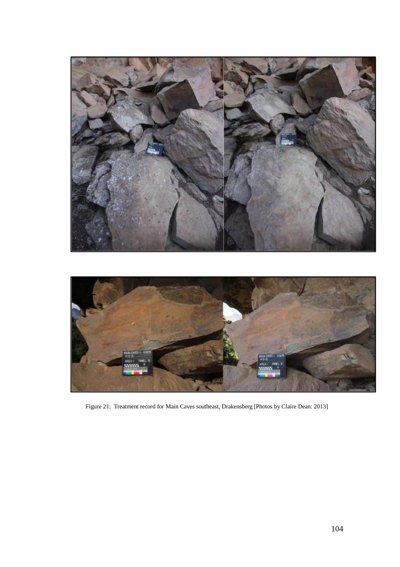
104
Figure 21: Treatment record for Main Caves southeast, Drakensberg [Photos by Claire Dean: 2013]
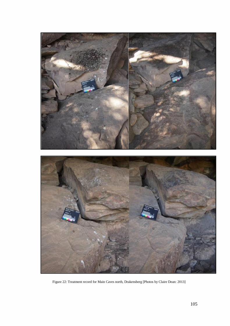
105
Figure 22: Treatment record for Main Caves north, Drakensberg [Photos by Claire Dean: 2013]
106
7. Game Pass Shelter, Drakensberg, KwaZulu-Natal
Box 1: General Site Information
Site Name: Game Pass Shelter Site I.D: Panel #: Main Panel Date: 11 May
2013
Alternative Name: Rosetta Stone Managing Agency: Amafa
Farm Name: Kamberg Nature Reserve Site Type: Rock shelter
GPS File: S29˚ 23' 38.6", E 29˚ 28' 42.8"Photos: SARADA
Aspect & Angle: Northeast Facing Site Dimensions: Record with RARI
Samples: No Existing Documentation: Full site record with RARI
Site Description and Characterization
Game Pass Shelter is located about one kilometre from the main camp and the
Kamberg Rock Art Centre. The site is situated upslope on the cliff of a mountain
forming part of the escarpment. Game Pass Shelter is a wide and long shelter with
imposing size. The shelter is exposed to elements with no form of protection
against incoming sunlight and direct rainfall. The elevation of the shelter at 2040m
above sea level gives it enough elevation to provide a good view of the Kamberg
Nature Reserve. The images in the shelter can be seen from a distance.
The shelter has some of the best quality images in the Drakensberg. The famous
‘Rosetta Stone’ motif used to crack the code of the religious context of paintings in
San mythology and Cosmology is found here. The scene depicting an eland in a
dying posture called the Rosetta Stone is synonymous with the site. Subject matter
includes animals, people, and therianthropes. An estimated 350 motifs can be

107
identified at the site. Game Pass Shelter is arguably one of the most culturally and
spiritually significant sites in the UDP (discussed in chapter one).
The site has been a focus of weathering studies since the early since 2000s (Hoerlé
2005, 2006). The monitoring of environmental conditions at this site is believed to
have significant implications for the preservation of the site. A host of natural
weathering processes affect the preservation of the images.
Conservation Condition Assessment
Physical damage at the site is caused by people, animals, and natural weathering
processes. Weathering processes cause major damage. Exposure of the site to
elements subjects the images to direct solar radiation and rainfall. The difference in
thermal expansion causes exfoliation, flaking and spalling of the surface and
images. Wind erosion causes the etching and pitting of the rock surface. Meteoric
water also causes damage to the site by depositing organic minerals on the rock
surfaces.
Exposure to elements further subjects the site to damage by animals and people.
Dassie and bird excreta can be identified on the surfaces and sometimes over
images. Damp areas at the site also promote the growth of micro-organisms such as
lichens at lower levels of the rock surface. Lichens cover the lower level of the site
and do not appear to be posing any immediate threat to the images. Human induced
impact can also be observed at the site in the form of Graffiti (Fig. 23). The issue of
graffiti at Game Pass Shelter appears to be persistent and serious management
interventions are required.
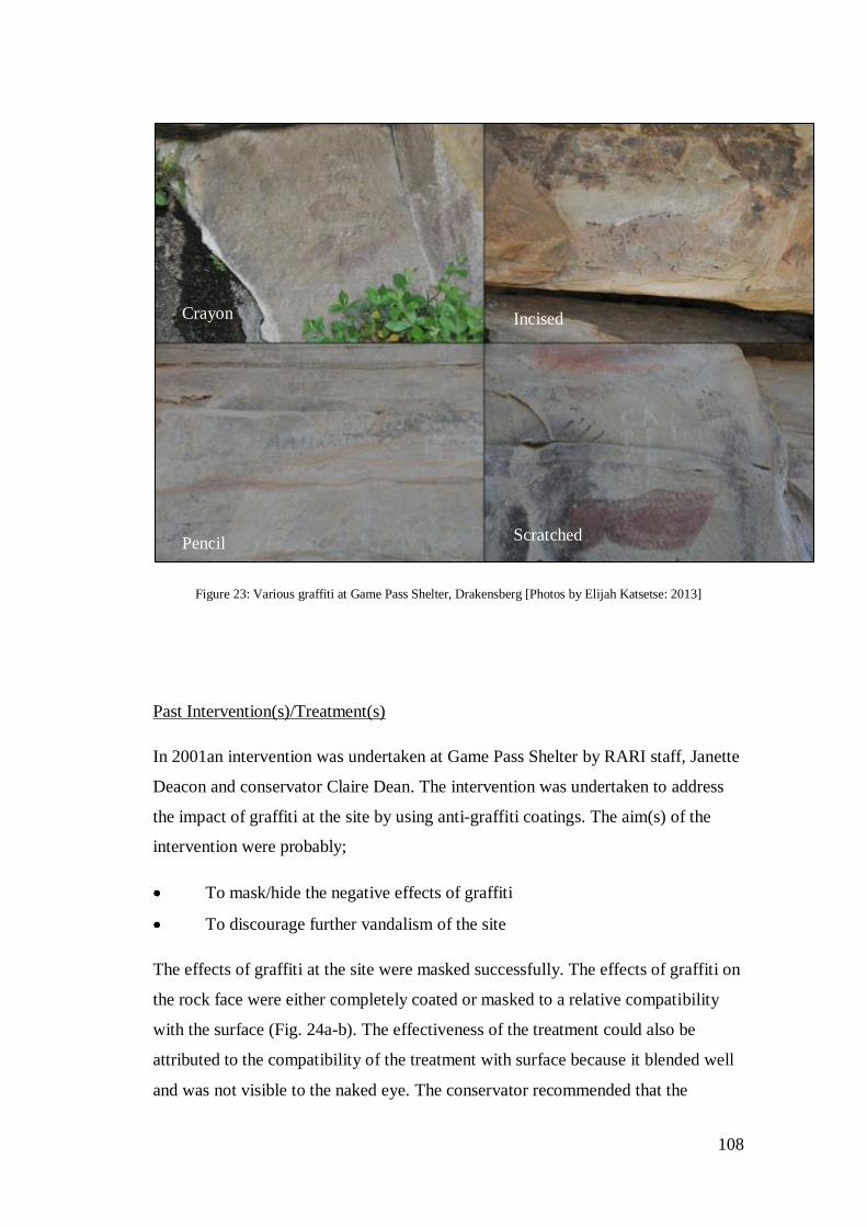
108
Figure 23: Various graffiti at Game Pass Shelter, Drakensberg [Photos by Elijah Katsetse: 2013]
Past Intervention(s)/Treatment(s)
In 2001an intervention was undertaken at Game Pass Shelter by RARI staff, Janette
Deacon and conservator Claire Dean. The intervention was undertaken to address
the impact of graffiti at the site by using anti-graffiti coatings. The aim(s) of the
intervention were probably;
To mask/hide the negative effects of graffiti
To discourage further vandalism of the site
The effects of graffiti at the site were masked successfully. The effects of graffiti on
the rock face were either completely coated or masked to a relative compatibility
with the surface (Fig. 24a-b). The effectiveness of the treatment could also be
attributed to the compatibility of the treatment with surface because it blended well
and was not visible to the naked eye. The conservator recommended that the
Crayon Incised
Pencil Scratched
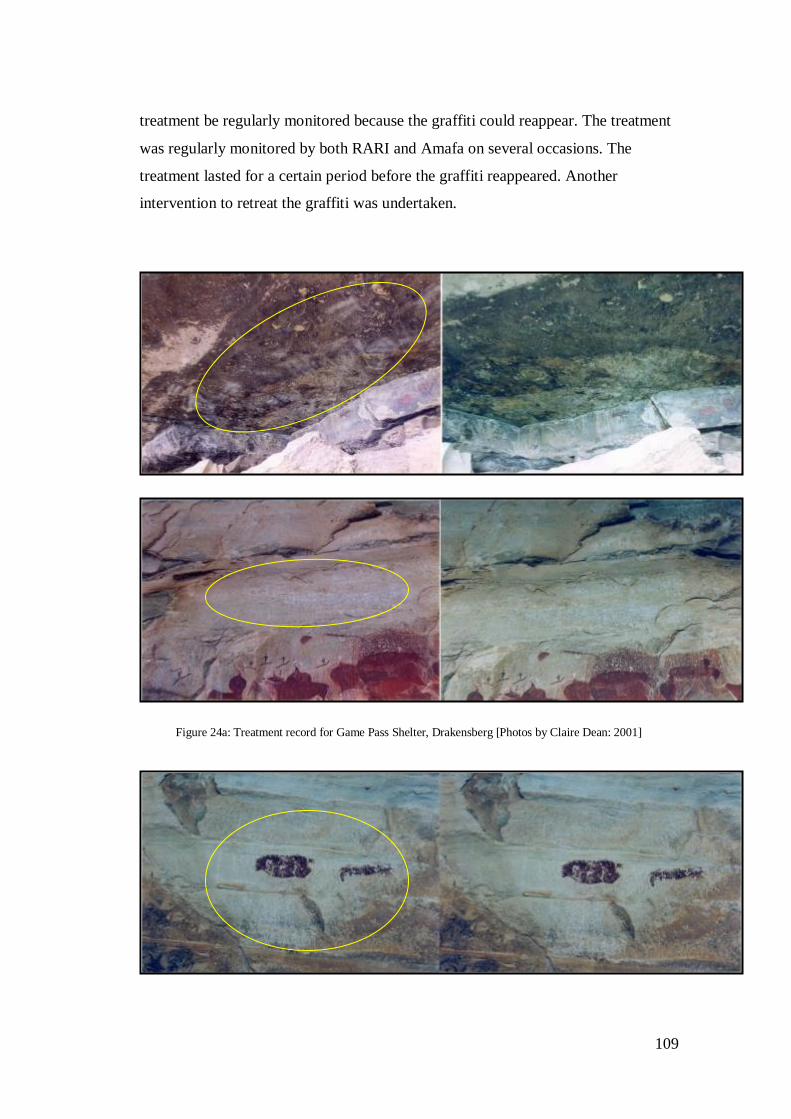
109
treatment be regularly monitored because the graffiti could reappear. The treatment
was regularly monitored by both RARI and Amafa on several occasions. The
treatment lasted for a certain period before the graffiti reappeared. Another
intervention to retreat the graffiti was undertaken.
Figure 24a: Treatment record for Game Pass Shelter, Drakensberg [Photos by Claire Dean: 2001]

110
Figure 24b: Treatment record for Game Pass Shelter, Drakensberg [Photos by Claire Dean: 2001]
Figure 24a shows treated areas on panels 1 and 2. Figure 24b shows treated areas on panels
3 and 4. Figure 24a-b that shows graffiti coating material treatment record for the
intervention of the year 2001. Treated areas are shown in yellow circles. The before images
(left) clearly show the success of the intervention both in terms of the aesthetics and
professionalism.
Graffiti at Game Pass Shelter reappeared and Amafa undertook a retreatment
intervention. The impacts of this treatment were recorded during monitoring of the
treatment in 2013 by me (Fig. 25). It is unclear who undertook this intervention and
when. The reason for the intervention can be determined by studying the images
that relate to treatment areas. However, no information pertaining to this

111
intervention exists. Instead the effects of this intervention can be seen on the rock
surface and on images. The aim(s) of the intervention may have been;
to retreat the negative effects of graffiti
to restore the site to its previous condition
to further discourage vandalism of the site
Figure 25a: Treatment monitoring at Game Pass Shelter, Drakensberg [Photos by Claire Dean: 2001 & Elijah Katsetse: 2013]
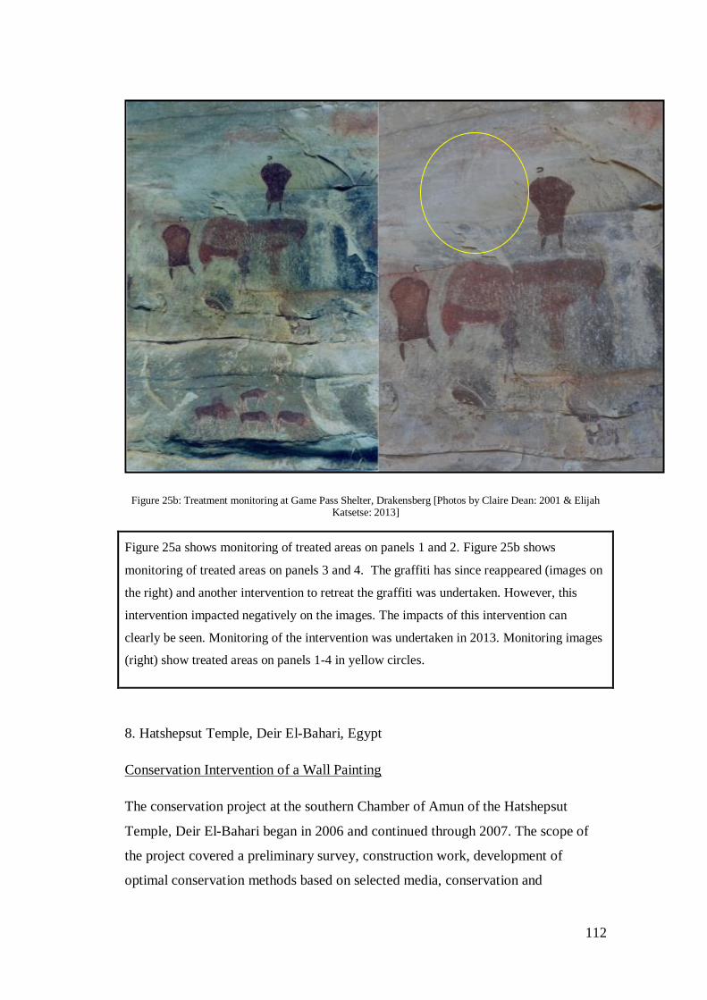
112
Figure 25b: Treatment monitoring at Game Pass Shelter, Drakensberg [Photos by Claire Dean: 2001 & Elijah Katsetse: 2013]
Figure 25a shows monitoring of treated areas on panels 1 and 2. Figure 25b shows
monitoring of treated areas on panels 3 and 4. The graffiti has since reappeared (images on
the right) and another intervention to retreat the graffiti was undertaken. However, this
intervention impacted negatively on the images. The impacts of this intervention can
clearly be seen. Monitoring of the intervention was undertaken in 2013. Monitoring images
(right) show treated areas on panels 1-4 in yellow circles.
8. Hatshepsut Temple, Deir ElBahari, Egypt
Conservation Intervention of a Wall Painting
The conservation project at the southern Chamber of Amun of the Hatshepsut
Temple, Deir ElBahari began in 2006 and continued through 2007. The scope of
the project covered a preliminary survey, construction work, development of
optimal conservation methods based on selected media, conservation and
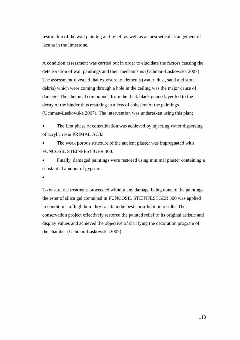
113
restoration of the wall painting and relief, as well as an aesthetical arrangement of
lacuna in the limestone.
A condition assessment was carried out in order to elucidate the factors causing the
deterioration of wall paintings and their mechanisms (UchmanLaskowska 2007).
The assessment revealed that exposure to elements (water, dust, sand and stone
debris) which were coming through a hole in the ceiling was the major cause of
damage. The chemical compounds from the thick black guano layer led to the
decay of the binder thus resulting in a loss of cohesion of the paintings
(UchmanLaskowska 2007). The intervention was undertaken using this plan;
The first phase of consolidation was achieved by injecting water dispersing
of acrylic resin PRIMAL AC33.
The weak porous structure of the ancient plaster was impregnated with
FUNCOSIL STEINFESTIGER 300.
Finally, damaged paintings were restored using minimal plaster containing a
substantial amount of gypsum.
To ensure the treatment proceeded without any damage being done to the paintings,
the ester of silica gel contained in FUNCOSIL STEINFESTGER 300 was applied
in conditions of high humidity to attain the best consolidation results. The
conservation project effectively restored the painted relief to its original artistic and
display values and achieved the objective of clarifying the decoration program of
the chamber (UchmanLaskowska 2007).
114
Chapter 5: Results and Discussion
5.1. Data Collection
Evaluating past intervention measures is a complex task that requires a system that
would maximize the process of data collection. Evaluating and monitoring of past
intervention measures requires knowledge of past conservation assessment
revelations. This study employed an integrated conservation assessment model that
allowed extensive data collection prior to and during field work. Data collection
procedures for this study included a combination of field work, desktop surveys,
and a literature review of conservation management practice in South Africa. The
Dardes’ model was used as a guideline in the process of collecting data for the
study. Phases 1 and 2 provided the framework for data collection.
5.1.1.Phase 1: Preparation: Information gathering prior to assessment
This process provided the skeletal framework of the study. It focused on office and
library preparation for the identification of all institutions and agencies responsible
for the administration and management of rock art resources in situ and ex situ. Past
and present institutions including the NMC, Natal Museum, and McGregor
Museum in Kimberly and the National Museum in Bloemfontein, RARI and
SAHRA were identified and consulted in the early phases of the study. The desktop
study revealed that the NMC (now the SAHRA), RARI, and the African Rock Art
Digital Archives had the material relevant for the analysis of past conservation
interventions in the Country. Thus, the data used in this study was acquired from
the repositories of the RARI, SAHRIS, and the African Rock Art Digital Archives,
National Museums in Bloemfontein. Supplement material were acquired from
private collections from researchers and staff at RARI, including Benjamin Smith,
Catherine Namono, Siyakha Mguni, David Pearce, Jeremy Hollman, and Aron
Mazel. Amafa has also contributed data and material used in this study. This
information enabled me to do a thorough review of past rock art conservation and
management practice as well as familiarise myself with sites prior to field work.

115
5.1.2. Phase 2: Information gathering during the assessment: Site observation and
Consultation
Fieldwork for the project was conducted between March 2013 and July 2014.
During this period over 10 rock art sites were visited, 5 of which have been used a
case studies in this paper. Site visits were random but attention was giving to the
time of the year (season) with which each site was visited. On site images were
taken using a Nikon D-300™ camera and additional images were taken using
Nikon D-3100™ digital cameras. Both the Nikon D-300™ and 3100™ images are
recorded in Tiff files (12.3 mega pixel APS-C sensor and 14.2 mega pixel DX-
format sensor respectively). Images were taken at any time of the day when enough
light was shone onto the images and high quality images could be captured. Rock
art images condition assessment was done using a combination of indices to
produce one rock art conservation assessment and monitoring index which I
designed specifically for this study (Appendix 1).
Fieldwork was supervised by Professor Benjamin Smith and Dr Catherine Namono
at BOE16 in Makgabeng. In the Drakensberg (Main Caves and Game Pass Shelter)
fieldwork was supervised by Dr Catherine Namono. The rock art conservation
aspect of field work both in Makgabeng and the Drakensberg was done under the
guidance of Claire, J. Dean. I was unsupervised when visiting sites in the
Cederberg. This allowed me to evaluate my rock art recording skills. In addition to
rock art recording and site observation, I consulted rock art officers in heritage
agencies and site custodians. This information is crucial and formed part of the
comparative analysis between me and other people who by default spend most of
their time visiting these sites. Site custodians and rock art officers possess more
knowledge about sites and therefore are in a better position to elucidate site
conditions. A questionnaire was used to provide uniformity in the process of
interviewing people (Appendix 2). All site observations and interviews were
analysed and an assessment of past conservation was subsequently done.

116
5.2. Data Analysis
To minimise the level of biasness and to critically and objectively assess the
effectiveness as well as to record past conservation interventions a multi criteria
approach was employed. This multi criteria approach employed the following
elements as guidelines that have previously been used before in evaluating the
effectiveness of conservation interventions:
Evaluation and Monitoring
Conservation Standards and Indicators
Evaluation based on Definition of criteria
A conservation condition assessment was done at all the sites during field work.
Most of these sites if not all of them have been extensively visited and documented
in the past by dozens of researchers. Photographic documentation is a common
technique to record images and site parameters in all the sites visited. However, as
discussed in chapter three the images are uncalibrated. Furthermore, different types
of cameras with different features and qualities are used to record rock art.
Therefore, the quality and content of images is not the same this also makes it
difficult to conduct photographic monitoring. To address this issue I employed an
integrated image enhancing approach whereby a range of digital software was used
to analyse images. Photoshop, Xnview, Imagej, and Picasa 3 were all used to
enhance and analyse the images of past interventions. The nature of past
intervention at Bushmans Kloof 03and 09, Bonne Esperance 16, Main Caves (north
and southeast), and Game Pass Shelter was highlighted above, however, this is not
a complete and detailed history of conservation interventions at these sites. Below I
look at the specific issues encountered and identified at each site with the view of
highlighting some practical challenges and issues affecting rock art conservation in
South Africa.
117
Bushmans Kloof 03 and Bushman Kloof 09
Conservation interventions at BSK 03 and BSK 09 were undertaken by the
Rudner’s probably in 1976. It is unclear whether Boontjieskloof 1A and 2A, refer
to BSK 03 and BSK 09 as these sites detail similar interventions. Treatment
information for Boontjieskloof 1A and 2Ais found in the NBRINMC reports
(1973) and that of BSK 03 and BSK 09 is found in the management plan of the
Bushmans Kloof Reserve (Mguni 2007). Although the interventions at these sites
are documented, the information pertaining to the nature of the treatments, aims and
materials used during the interventions is missing thus making it difficult to assess
their success. These interventions have been monitored twice by Mguni (2007) and
by a team of specialist conservators from the Getty Conservation Institute (GCI)
whose report is pending.
Monitoring by the GCI conservators focused mainly on drip lines as part of an
educational program under SARAP. The drip line at BKS 03 according to Mguni
(2007) has negative effects on the images below it and to the left. The drip line
could be trapping water, thus allowing the surface to absorb this water creating a
ripple effect in the direction of images below it. The negative effects of the drip line
could be due to the positioning and placement of the drip on the ceiling of the
shelter. If indeed the drip line is impacting negatively on the images remedial action
to mitigate these effects should have been taken and should be taken as a matter of
urgency.
A closer look at the wash zones and pigment layers on the surface suggests that the
drip line is not mitigating the impact of water on the images and may indirectly be
exacerbating the problem. The drip lines were probably an experimental installation
that was investigating probable solutions to the problem of direct water erosion.
However, this work was cosmetic and the drip line is not mitigating the impact of
water on the images. Thus, the drip line should not have been installed and it should
be removed. This intervention underscores the significance of monitoring and a
proactive conservation approach and the need for specific principles in policy that

118
address conservation interventions. The specific conservation principles for the
installation and monitoring of drip lines at NSW, Australia provide a good example
for a conservation protocol successfully implemented.
Contrary to the intervention at BSK 03, the consolidation of the surface at BSK 09
appears to have been successful and is performing positively. As discussed in
section 2 of case studies the protective layer of ‘varnish’ appears to exhibit the
qualities of a good consolidation agent. It has not changed the moisture and
temperature regimes of the rock surface. The moisture and temperature regime of
the treated area appears similar to that of the area not treated. Therefore, the layer
of ‘vanish’ allows the surface to breathe freely thereby not creating pressure within
the rock to induce chemical and physical weathering. This intervention at this point
in time indicates the use of appropriate material to address a specific problem.
Bonne Esperance 16
The conservation report produced for the conservation treatment undertaken at the
site makes mention of past interventions at the site. However, no record of these
interventions exists. The knowledge of these interventions lives in the memory of
people particularly staff at RARI. Therefore, the conservation record of BOE16
starts in 2013 with the treatment done by Clare Dean. This is because information
about conservation work extends beyond the treatment itself it goes to the nature of
the intervention, aims, and materials used. Without this information nothing can be
said about such an intervention. The recent intervention at BOE16 was only
effective for a short period. The failure of the treatment could be attributed to the
level of planning involved in intervention and the use of inappropriate techniques.
The condition assessment was done on site, the same day the treatment work began
and intervention techniques were determined on site.
The manner of the intervention at BOE16 appeals to conservation protocols and
policy. SAHRA does not have specific protocols to address rock art conservation as
such; there is no proper and adequate planning prior to interventions. Furthermore,

119
the permitting process is flawed and does not make provision for submission of a
condition assessment with a request for permit to intervene. What is important here
is that funds were provided for the intervention and a conservator was brought in
but management authorities (LHRA) were not prepared and had not adequately
planned for the intervention. As such a ladder was used instead of more stable
scaffolding that would have provided both stability and height to reach ledges
above the main panel where birds and bats are roosting. As a result the problem was
not properly addressed.
Furthermore, the intervention could have been more effective and successful in the
long term had the intervention been adequately and properly planned thereby
undertaking an intervention that would have been well informed by site conditions.
As such proper material and/or preservation techniques could have been used
including amongst others the installing a fine mash net to cover the roof of the
shelter to deter birds and bats from roosting on the ceiling.
Main Caves (north and southeast)
Main Caves’ rock art sites have an extensive and long history of conservation work
since 1958 whenrock surfaces at Main Caves north was treated with resin silicon
(Smith, pers comm. 2014). However, physical alteration of the sites began in 1967
under the auspices of the Natal Parks Board. The sites were extensively altered for
public visitation and to protect them from vandalism. The site wall at Main caves
southeast was dug out and/or quarried for material that was used to pave the floor
of the shelter (Dean, pers comm. 2013). The floors of both sites were paved and a
chain mounted on iron rods was used as railing to reduce dust and control visitor
movement respectively. These interventions were not effective in both reducing the
level of dust and preventing visitors from jumping the chain and touching the
images. In 1998 Amafa and Ezemvelo KwaZulu-Natal Wildlife undertook a project
to install a boardwalk at the sites. This project resulted in the removal of the
120
vegetation in front of the shelter. This vegetation shielded the sites from the
elements of weathering.
Photographic monitoring of weathering at Main Caves done in 1994 (Ward) and
1997 (Ward and Maggs), indicated no significant changes in the condition of the
images. Given that photographs used to monitor image condition changes at Main
Caves were uncalibrated, the observations made could not be accurate and
conclusive. Both studies revealed that exfoliation of the surface were a major threat
to the site particularly the main panel. Recent weathering studies suggest that the
removal of the vegetation in front the shelter may have resulted in increased rates of
exfoliation of the rock surface (Meiklejohn et al. 2009). Furthermore, the
deterioration of the rock substrate where images are located coupled with the
deterioration of the ground clay base where images are located affects the
weathering of paintings. Given these revelations and conditions at the sites, one
would expect the stabilization of the rock substrate and modification of the
vegetation in front of the shelter would be prioritized in conservation decisions.
However, the recent interventions at Main Caves focused on the treatment of dust
and bird droppings. This thus begs the question of the criteria used for prioritizing
the conservation needs of the site and what informs conservation decision taken
about sites.
The question of conservation protocols and criteria used to prioritize conservation
reflect on poor rock art management practice. Poor rock art management in the
Drakensberg is further compounded by the issue of CRM archaeologists who tend
to practice outside their accredited fields of speciality. I am referring here to an
attempt that was made to treat graffiti that resulted in unsightly and bad scratches
on the rock surface and in other areas near images. This work was clearly done by a
conservation enthusiast and an amateur. Amafa has no record of this treatment
which further begs the question, was a permit acquired to undertake such work as
required under section 35 of the NHRA (25 of 1999). The key outcomes of the
assessment at Main Caves show that conservation interventions have been largely
121
influenced by activities to encourage public visitation and need to improve the
experience of visitors. Furthermore, in the Drakensberg there are cases were people
not trained in rock art conservation principles have undertaken conservation work.
Finally, the potential impact of removing vegetation to install the boardwalk could
have on the images underscores the significance of documenting and monitoring
conservation interventions. The attempt to remove graffiti on the hooves of an
eland motif left a stain that gives the impression that the image was depicted on top
of something. This could impact on future interpretation of the image.
Game Pass Shelter
Game Pass Shelter is affected by both natural and anthropogenic factors of
deterioration. However, anthropogenic factors particularly graffiti effects severe
damage to the site. The problem of vandalism at the site has a long history and is
persistent. In 2001 and intervention was undertaken to remove graffiti at the site.
The intervention was successful in hiding and masking the impacts of graffiti.
However, the graffiti has since reappeared because the material used in coating it
had worn out. Certain individuals did not take guidance on this and took it upon
themselves to remove the graffiti. Someone attempted to retreat the graffiti with or
without knowledge of Amafa albeit with detrimental effects. It is unclear what
techniques was used in this intervention or whether this person was trying to copy
the work done by RARI, Janette Deacon, and conservator Claire Dean. A similar
incident was observed at Main Caves which suggests that the problem of
archaeologists who tend to practice outside their fields of speciality is common and
severe in the Drakensberg. This observation has also been made elsewhere and such
deeds go unpunished (Ndlovu 2011). The damage of rock art by conservation
enthusiasts shows that Amafa is failing to enforce the legal principles of heritage
legislation. This therefore, suggests that in areas where the legislation provides
clear guidelines for heritage protection, the lack of accountability and responsibility
of heritage practitioners affects proper care of rock art.
122
5.2.1. Phase 3: Comparative analysis and Strategies
It was important that this study looks elsewhere to see what has been done but how
successful it was, hence I drew case studies from America, Australia, and Egypt
(see Walston & Dolanski 1976; Brink 2007; UchmanLaskowski 2007). I
considered the time taken to conduct a condition assessment and characterization
of materials making up the site, if the conservation protocol was followed, was a
treatment plan outlined, were the results of the intervention monitored, elsewhere
compared to South Africa.
At Main Caves and BOE16the characterisation of the material was not done and the
intervention was done after condition assessment. Regardless of the experience of
the conservator, characterization of materials making up the site is a prerequisite to
any intervention. Therefore the interventions at Main Caves and BOE16 risk
inducing chemical reactions that may alter the chemical composition of pigment
and the substrate, thereby, inducing weathering. Climatic conditions in the study
regions chosen here have not been stable in the past and show a lot of variability
(discussed in chapter one). These changes could have induced accelerated damage
on the images. The possible reaction that could be induced by using water in
cleaning rock art surfaces could occur in one of several ways. Contextual
assessment of the study regions show the images are depicted on sandstone albeit of
different kinds. Sandstones materials, however, have general composition
(discussed in section 4.2). Below I show basic chemical reaction that may be
induced by treating surfaces using water.
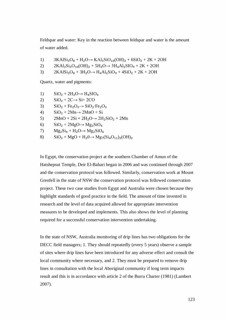
123
Feldspar and water: Key in the reaction between feldspar and water is the amount
of water added.
1) 3KAlSi₃O₈ + H₂O→ KAl₃SiO₁₀(OH)₂ + 6SiO₂ + 2K + 2OH
2) 2KAl₃Si₃O₁₀(OH)₂ + 5H₂O→ 3H₄Al₂SIO₉ + 2K + 2OH
3) 2KAlSi₃O₈ + 3H₂O→ H₄Al₂SiO₉ + 4SiO₂ + 2K + 2OH
Quartz, water and pigments:
1) SiO₂ + 2H₂O→ H₄SIO₄
2) SiO₂ + 2C→ Si+ 2CO
3) SiO₂ + Fe₂O₃→ SiO₂∙Fe₂O₃
4) SiO₂ + 2Mn→ 2MnO + Si
5) 2MnO + 2Si + 2H₂O→ 2H₂SiO₂ + 2Mn
6) SiO₂ + 2MgO→ Mg₂SiO₄
7) Mg₂Si₄ + H₂O→ Mg₂SiO₆
8) SiO₂ + MgO + H₂0→ Mg₇(Si₄O₁₁)₂(OH)₂
In Egypt, the conservation project at the southern Chamber of Amun of the
Hatshepsut Temple, Deir ElBahari began in 2006 and was continued through 2007
and the conservation protocol was followed. Similarly, conservation work at Mount
Grenfell in the state of NSW the conservation protocol was followed conservation
project. These two case studies from Egypt and Australia were chosen because they
highlight standards of good practice in the field. The amount of time invested in
research and the level of data acquired allowed for appropriate intervention
measures to be developed and implements. This also shows the level of planning
required for a successful conservation intervention undertaking.
In the state of NSW, Australia monitoring of drip lines has two obligations for the
DECC field managers; 1. They should repeatedly (every 5 years) observe a sample
of sites where drip lines have been introduced for any adverse effect and consult the
local community where necessary, and 2. They must be prepared to remove drip
lines in consultation with the local Aboriginal community if long term impacts
result and this is in accordance with article 2 of the Burra Charter (1981) (Lambert
2007).

124
The nature of conservation management practice in South Africa and southern
African as a whole has been explored in detail in this study. Major issues affecting
the conservation practice in southern Africa are the lack of funding, a regional
strategy and most of all the lack of expertise. Conservation interventions to address
various factors causing the deterioration of rock art have been undertaken in
southern Africa, South Africa included. The influence of management approaches
and/or of heritage management on rock art has also been investigated and
highlighted in this study. The failure of legislation in contributing to the effective
management of rock art in South Africa has also been discussed with the view
identifying which elements of the legislation are impacting on the management of
heritage resources. Where the legislations provides clear and precise guidelines for
the protection of heritage resources there is a lack of responsible and accountable
personnel to enforce the law. Thus, heritage agencies are failing in the management
and administration of cultural resources.
Heritage management approaches in Africa have not evolved with the conservation
and management discipline. Furthermore, the western management approach is
now operating in democratic societies. Management approaches under the western
system of management lacked dialogue and are discriminative of contemporary
society’s value systems. The colonialism of African states on its own has affected
changes in the management of heritage resources notably a shift from the local
Indigenous management system to the western management system.
The legislation has further transferred ownership (administration and management)
of heritage resources into the hands of the states. This indicates a lack of
coordinated effort from a local level in the conservation and management of
cultural resources. Rock art occurs in diverse landscapes such as private lands,
National Parks, WHS, communal lands where it is exposed to various threats and
governed by multiple laws. The study of rock art interventions using rock art sites
125
from diverse cultural and management landscapes has revealed issues with the three
tier management system of NHRA.
The decentralisation of administration and management roles from national to local
level affects and compromises the protection of rock art. SAHRA has no specific
conservation protocol for undertaking conservation intervention where else Amafa
employs the cure document. Conservation Protocols should be developed at
national level and trickled down to regional and local level. This shows a
coordinated management and protection approach. However, in South Africa there
are no criteria for prioritizing conservation interventions. Without criteria for
undertaking conservation intervention as shown by practical examples makes
conservation intervention a cosmetic and, most importantly; a risky undertaking.
The use of practical examples in the form of case studies has further revealed issues
that can be described as an Achilles heel to rock art conservation practice in South
Africa. The lack of inventories in Africa is still a major issue. The lack of data as it
has been shown makes it difficult, if not impossible to evaluate and monitor results
and effectiveness of past conservation interventions (Table 4). This has been a long
standing issue in South African rock art studies especially when it comes to
monitoring rock art site conditions. Mazel (1982, 1983) has always posed the
question of whether there was enough data to base the monitoring of rock art in the
Drakensberg. Amafa has recently embarked on a project to identify all the
information pertaining to rock art of the Drakensberg with the view of creating a
library that will further aid with conservation work. Furthermore, in 2013 they
listed a contract for a development of a monitoring program for rock art sites in the
Drakensberg. When I enquired about the progress of this work it appeared that
nothing has come of the work as yet and Amafa still uses the old card system
(Celeste Rosouw, pers comm. 2013, 2014). Heritage agencies charged with the
administration and management of rock art lack responsibility and accountability
and this is saddening considering that heritage managers are also conservators
(Dandridge 2000).
126
The lack of expertise in southern Africa rock art conservation is also a long
standing issue. In chapter 2, I critically assessed its causes and effects on the
discipline of rock art conservation in southern Africa. I condemned over reliance on
foreign expertise and funding. I argue that rather, we should have ‘home-grown’
conservation specialists and source conservation specialist from abroad on big
projects to act as facilitators. This strategy will prevent archaeologists from
destroying cultural objects of significance whilst believing they are conserving
them. . Furthermore, archaeologists no longer act as stewards of heritage resources
but as a secondary owner. Archaeologists are secondary owners’ to the state As
such there is a conflict of interest and archaeologists tend to mobilize communities
to take pride in their heritage often when it will benefit archaeology in return
(Ndlovu 2014a). However, when communities want to use cultural objects to
perform rituals to appease the ancestors they are denied access to them on the basis
of complex management approaches. This according to Ndlovu (2014a) is an
unethical stance archaeologists often take.
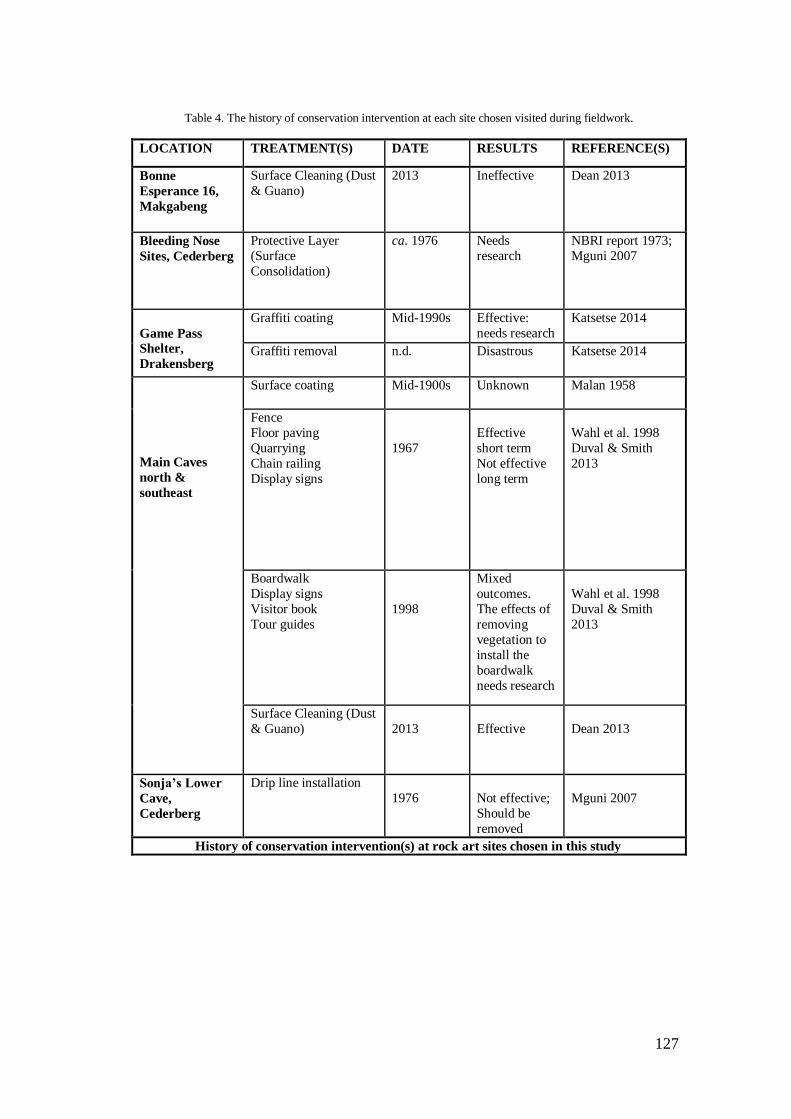
127
Table 4. The history of conservation intervention at each site chosen visited during fieldwork.
LOCATION TREATMENT(S) DATE RESULTS REFERENCE(S)
Bonne
Esperance 16,
Makgabeng
Surface Cleaning (Dust
& Guano)
2013 Ineffective Dean 2013
Bleeding Nose
Sites, Cederberg
Protective Layer
(Surface
Consolidation)
ca. 1976 Needs
research
NBRI report 1973;
Mguni 2007
Game Pass
Shelter,
Drakensberg
Graffiti coating Mid-1990s Effective:
needs research
Katsetse 2014
Graffiti removal n.d. Disastrous Katsetse 2014
Main Caves
north &
southeast
Surface coating Mid-1900s Unknown Malan 1958
Fence
Floor paving
Quarrying
Chain railing
Display signs
1967
Effective
short term
Not effective
long term
Wahl et al. 1998
Duval & Smith
2013
Boardwalk
Display signs
Visitor book
Tour guides
1998
Mixed
outcomes.
The effects of
removing
vegetation to
install the
boardwalk
needs research
Wahl et al. 1998
Duval & Smith
2013
Surface Cleaning (Dust
& Guano)
2013
Effective
Dean 2013
Sonja’s Lower
Cave,
Cederberg
Drip line installation
1976
Not effective;
Should be
removed
Mguni 2007
History of conservation intervention(s) at rock art sites chosen in this study

128
5.3. Conclusion
In this chapter, I identified the materials (pigments, rock substrate and the
surrounding environment) making up rock art in South Africa with the view of
elucidating the mechanisms of deterioration. Major factors causing rock art
deterioration were also identified and possible preservation techniques to
ameliorate them were discussed. The interplay between rock art and their
surrounding geological, biological and meteorological environment is complex and
takes numerous processes in causing rock art deterioration. Moisture and
temperature are identifies as the major factors causing rock art deterioration.
Damage to rock is also caused by human induced factors. Treatments to deal with
decay range from simple to complex. These treatments can be mechanical, physical,
and chemical. The treatment history of rock art in South Africa was further
outlined. The study of the intervention and treatment history of rock art in South
Africa was done using case studies. A comparative analysis of conservation
practice in South Africa and Australia, America, and Egypt in particular was done.
This analysis revealed contrasting difference in the nature of conservation practice
and management approaches.
129
Chapter 6:A CONSERVATION MODEL
6.1. Recommendations
Recommendations are crucial for developing mitigation measures, conservation
measures, protocols, and policy. Recommendations are part of a diagnosis
process guided by results of a thorough assessment of conditions and the situation
on the ground. Often recommendations are made in consultation with relevant
stakeholders which may include the local community, tourism officials and the
managing agency based on the strengths and weaknesses of the managing agency.
I adopted this precept and engaged with researchers, site custodians and heritage
officers to gauge what would constitute an effective conservation model that
would put systems in place to better manage conservation interventions. This
interaction coupled with results from past conservation interventions in South
Africa guided the development of the model.
The history of rock art preservation in South Africa reveals that there is a lack of
conservation intervention planning and research is not directed toward
developing conservation treatments and measures that respond to specific site
conditions. Secondly, conservation intervention projects are often imposed upon
heritage authorities and /or managing authorities. In cases where heritage
agencies have initiated conservation projects they are often blindsided because
they do not have the necessary skills and conservation expertise. Funds to
undertake conservation projects are often not controlled by heritage authorities or
managing agencies. Furthermore, managing authorities do not have measures to
regulate and control the direction of interventions. As such conservation
interventions are often not monitored or properly managed. There is a lack of
compliance and failure to implement recommendations by rock art managing
agencies. As it has been shown elsewhere (Mazel 2012; Ndlovu 2014b), this
failure has had a negative effect on the good and successful management of rock
art. This study has had to battle with this recurring tendency and how it could
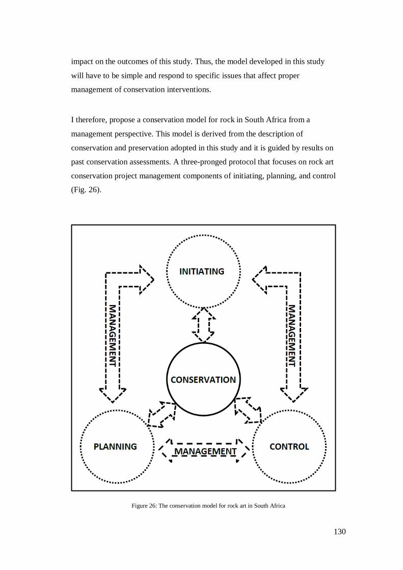
130
impact on the outcomes of this study. Thus, the model developed in this study
will have to be simple and respond to specific issues that affect proper
management of conservation interventions.
I therefore, propose a conservation model for rock in South Africa from a
management perspective. This model is derived from the description of
conservation and preservation adopted in this study and it is guided by results on
past conservation assessments. A three-pronged protocol that focuses on rock art
conservation project management components of initiating, planning, and control
(Fig. 26).
Figure 26: The conservation model for rock art in South Africa

131
Management components are significant in the life of a project and its
successful implication. Project management components include initiating,
planning, executing, closing, and control (Learner Book 2012).Project
management components are similar to the conservation process (Fig. 8). The
impacts of a conservation intervention extend beyond the life of a project and as
such the project cannot be closed. A conservation project is developed with the
view of undertaking an intervention thus a conservation project is in itself
execution. Therefore, I omit closing and execution in the model on rock art
conservation, Thus initiating, planning, and control are important in conservation
intervention management and are in tune with contemporary conservation theory,
the value-based approach, and the scientific approach. These elements revolve
around heritage management plan principles (Fig. 27). Conservation decisions,
interventions, priorties should bedetermined by and in line with principles of the
management plan. This model (Fig. 26) takes cognisance of the elements and
principles of a managemt plan thereby, taking conservation practice back to the
basics of initiating, planning, and controlling.
The model is important and provides measures to improve conservation practice
in South Africa. It addresses policy matters such as permits and requests for
permits, Heritage Impact Asessements, and Archaeological Impacts Assessments.
The model defines conservation on the basis of the physical matter (rock
substrate, pigments, and the surrounding environment) and preservation on the
basis of governance (people, significance, and place). Thus, it is an ideal measure
derived from principles of preventive conservation and elements of NHRA (25 of
1999).

132
Figure 27: Articulation of the model.
133
Project Initiating and Planning:
Conservation as defined in this study sets a precedent that is internationally
recognised for undertaking intervention or restoration work on heritage objects.
The conservation protocol requires that prior to conservation a thorough site
investigation to identify factors causing deterioration and how they manifest
should be done. As discussed in chapter two this investigation should be coupled
with library work that will study past records of the site to see what is available
and what more is required to better understand site conditions. This approach is
adopted internationally and this study has demonstrated its effectiveness in the
case of Mount Grenfell (Australia) and Hatshepsut temple, Deir ElBahari
(Egypt). I argue that if there were proper measures put in place and the
conservation protocol followed in rock art intervention at BSK 03 and BOE 16
the treatment work would have been informed by prevalent site conditions. As a
result adequate mitigation measures would have been developed and
implemented to ensure long-term preservation of rock art.
However, rock art conservation practice in South Africa does not adhere to
intervention principles. The lack of funding and the affordability of conservation
specialists are often cited as the major reason for this misconduct. Conservation
specialists are indeed expensive to hire but this is no reason enough for cutting
corners and risk damaging significant cultural objects. Funds were provided for
both the intervention projects at BOE 16 and Main Caves but treatment work did
not follow the conservation protocol. This indicates even when funds to
undertake conservation work is made available the problem of in conversation
practise still persist. The problem could therefore lie on the lack of conservation
expertise and knowledge on the part of heritage agencies and rock art officers.
The lack of knowledge on what conservation entails is hindering research to build
knowledge on conservation and to develop criteria to prioritise conservation. As a
result the treating of dust and guano at Main Caves was a cosmetic undertaking.
Similarly the installation of a drip lines at BSK 03 was a cosmetic undertaken
because of the lack of knowledge on conservation issues and status of rock art
sites and paintings. The interventions at BSK 03 and Main Caves in particular

134
wasted limited resources because treatment was undertaken on less destructive
factors. Conservation is a sub discipline of CRM and problems that affect
conservation practice originate from CRM. I propose that conservation practice in
South Africa be reconfigured into CRM. I am well aware of the issues that affect
CRM but what I am proposing here, I believe will work if this recommendation is
followed accordingly (Figure 26):
Conservation should be considered as development as defined under
section 38 of the NHRA (25 of 1999).
This will mean any activity that will occur within the 10m prescribed
radius of a rock art site will require a:
Conservation Intervention Proposal
Conservation Impact Assessment
Conservation Treatment Plan
This should be done as part of the Archaeological Impact Assessment
Project Planning and Controlling:
Management as defined in this study responds largely to issues of stewardship,
expertise, local communities, heritage places, and the significance of heritage
places. Results of this conservation assessment indicate that professionalism and
standards of good practice are major issues that need to be addressed. To address
issues of professionalism, ethics, and standards of good practice, SAHRA as the
implementing agency of DAC should make an Act of Parliament that makes it
mandatory for all persons practising archaeology to be registered members of the
Association of Southern African Professional Archaeologists (ASAPA).This way
ASAPA may be in a position to act on those members who do not adhere to its
code of conduct. The scenarios at Main Caves and Game Pass Shelter provide
evidence of unethical practice that is in contravention of section 35 of the NHRA
(25 of 1999). This issue is likely to have been exacerbated by the incompetence
and failure of heritage officers to enforce legislation and compliance.
135
Greater diligence in the permitting process is needed to encourage compliance.
The lack of compliance on the part of conservation professionals in practice could
be encouraging enthusiasts and amateurs to undertake conservation work. Site
managers are in themselves conservators and as such they should promote
responsible conservation practice. The paucity of conservation and rock art
inventories is partly influenced by the lack of compliance on the part of
researchers. The conservation model proposed here partly addresses this issue by
tracking all the steps of the conservation process and giving each phase an
autonomous status that requires a permit for intervention (Fig. 25). This model
does not provide a panacea for the ills of the conservation discipline in South
Africa; it provides a framework to improve conservation management. The way
forward in rock art conservation should be sought in research and developing
preservation techniques.
6.2. A Way Forward
Rock art conservation in South Africa can be improved if management practice
adheres to standards of good practice. Heritage authorities have not been able to
promote ethical conservation due partly to the lack of conservation knowledge
and what it entails. Conservation is employed as a mitigation measure to
ameliorate rock art deterioration as such it is management’s responsibility.
Management objectives and only management objectives should guide
conservation. The protection and administration of rock art is the responsibility of
heritage agencies and these agencies should establish site recording standards, the
level of data required, and establish standards and performance indicators. I thus
propose as a first step heritage agencies should develop rock art recording
techniques that will improve our understanding of rock art and help with
management decisions. Furthermore, there is a need to develop criteria for the
prioritisation of conservation. Management agencies should focus on developing
strategies to deal of the issues of graffiti. The removal of graffiti has had mixed
results and impacts on rock art. Graffiti as an alteration to a site forms part of the

136
site’s history whether removed or left intact. It should be properly recorded and
used in conservation education.
Rock art recording is an integral component of rock art research. Adequate and
proper recording of rock art allows for better interpretation, conservation and
management. However, rock art recording as a function or tool for conservation
management depends on the technique and method used for recording. Theories,
methods and practice have moved beyond the sole focus on rock art imagery to
the site and general surrounding due to conservation needs which also
incorporates the natural landscape (Loubser 2001). Rosenfeld (1988: 14) argues
that “clear and precise records of the condition of the art and general features of
the site are essential in monitoring the stability of rate of decay of rock art”.
6.3. Further Research
This original research on rock art conservation assessment in South Africa indicates
that (see chapter two) conservation assessment is a relatively new subject of
enquiry. Assessing past rock art conservation interventions has proved difficult on a
practical level. Rock art conservation assessment undertaking was restricted by the
paucity of data on the conservation status of rock art sites and paintings. As such a
detailed history of past interventions at BSK 03, BSK 09, BOE 16, Main Caves, and
Game Pass Shelter could not be created. There is a need to build research on
conservation in order to assist with long-term preservation of rock art. I therefore,
propose that a conservation assessment project on past conservation interventions is
undertaken on a national scale to expand the work established by this study.
An outcome of this study is a conservation model and a rock art recording and
monitoring index to improve management tools and recording techniques
(Appendix 2). The recording and monitoring index employed in this study
generated contextual data on site conditions. These contextual data enabled
objective assessment of past interventions at each site. Thus, future research should
focus on improving and developing new rock art recording techniques.

137
138
REFERENCES
Alcántara, R. 2002. Standards in preventive conservation: meanings and applications.
Rome: ICCROM.
Alonso, V. I. & V. M. Meurs. 2012. Assessing the Performance of Conservation
Activities. In:Zancheti, S. M. & Similä, K. (eds) Measuring Heritage Conservation
Performance: 1–14. Rome: ICCROM.
Arocena, J., Hall, K. & Meiklejohn, I. 2008. Minerals provide tints and possible
binder/extender in pigments in San rock paintings (South Africa). Geoarchaeology 23:
293–304.
Australia 1999. The Australian ICOMOS Charter for Places of Cultural Significance (The
Burra Charter). Burwood: ICOMOS Australia.
Australian Institute for the Conservation of Cultural Materials (AICCM) 2002. The code
of ethics and code of practice. Sydney: Institute for the Conservation of Cultural
Materials.
Avrami, E. 2000. Values and heritage conservation. The Getty Conservation Institute
Newsletter 15(2): 19–21.
Beloyannis, N. & Mirtsou, E. 1995. The arch of Garelius in Solanica. Problems created
by pollution, methodology of intervention, works of conservation. The Science of the
Total Environment 167: 181–184.
Bennett, G. 1995. Commemorative Integrity: monitoring the state of Canada’s National
Historic Sites. ICOMOS Canada Bulletin 4(3): 6–8.
Boelhouwers, J.C., Jager, D.F. & De Joode, A. 1999. Application of relative-age dating
methods to openwork debris flow deposits in the Cederberg Mountains, Western Cape,
South Africa. South African Geographical Journal 81 (3): 135–142.
Bonneau, A., Brock, F., Higham, T., Pearce, D.G. & Pollard, A.M. 2011. An improved
pre-treatment protocol for radiocarbon dating black pigments in San rock art.

139
Radiocarbon 52(32): 419–428.
Bonneau, a., Pearce, D.G. Pollard, A.M. 2012. A multi-techniques characterization and
provenance study of the pigments used in San rock art, South Africa. Journal of
Archaeological Science 39: 287–294.
Bonnete, M. 1995. Monitoring: some ideas on the concept. ICOMOS Canada Bulletin
4(3): 4.
Brady, L.M. 2006. Documenting and analyzing rock paintings from Torres Strait, NE
Australia, with digital photography and computer image enhancement. Journal of Field
Archaeology 31(4): 363–379.
Brink, J.W. 2007. Rock art conservation research at Writing-on-stone Provincial Park,
Alberta. Revista de Arqueología Americano 25: 55–99.
Brown, P.J., Manders, P.T. & Bands, D.P. 1991. Prescribed burning as a conservation
management practice: a case history from the Cederberg Mountains, Cape Province,
South Africa. Biological Conservation 56: 133–150.
Brunet, J., Vouvé, J., Vidal, P., Malaurent, P., & Lacazedieu, G. 1996. Theories And
Practice Of The Conservation Of Our Heritage Of Rock Art: Concrete Examples Of
Interventions In Natural Climatic Environment. In: Thorn, A. & Brunet, J. (eds) Theories
And Practice Of The Conservation Of Our Heritage Of Rock Art: Concrete Examples Of
Interventions In Natural Climatic Environment. Cairns: Australian Rock Art Research
Association.
Bumbey, A.J., Eriksson, P.G. & Van Der Merwe, R. 2004. The early Proterozoic
sedimentary record in the Blouberg area, Limpopo Province, South Africa; implications
for the timing of the Limpopo organic event. Journal of African Earth Sciences 39: 123–
131.
Carter, B. & Grimwade, G. 1997. Balancing use and preservation in cultural heritage
management. International Journal of Heritage Studies 3: 45–53.
Castellanos, C. & Descamps, F. 2008. Conservation Management Planning. Los Angeles:
140
The Getty Conservation Institute.
Cezar, T.M. 1998. Calcium Oxalate: a surface treatment for limestone. Journal of
Conservation and Museum Studies 4: 6–8.
Charteris, P. & Eastwood, E. 2004. Rediscovering ‘the Witch Doctor of Makabene’. The
Digging Stick 21(1):9–10.
Chellazi, D., Poggi, G., Jaidor, Y., Toccafondi, N., Giorgi, R. & Baglioni, P. 2013.
Hydroxide nanoparticles for cultural heritage: consolidation and protection of wall
paintings and carbonate materials. Journal of Colloid and Interface Science 392. 42–49.
Chirikure, S. & Pwiti, G. 2008. Community Involvement in archaeology and cultural
heritage management. Current Anthropology 49(3): 467–485.
Chirikure, S. 2013. Heritage conservation in Africa: the good, the bad, and the
challenges. South African Journal of Science 109 (1/2): 1–3.
Chirikure, S., Manyanga, M., Ndoro, W. & Pwiti, G. 2010. Unfulfilled promises?
Heritage management and community participation at some of Africa’s cultural heritage
sites. International Journal of Heritage Studies 16(1-2): 30–44.
Clark, I.D. 2009. Naming sites: names as management tools in indigenous tourism sites-
an Australian case study. Tourism Management 30: 109–111.
Clark, K. 2001. Preserving what matters: value-led planning for cultural heritage sites.
The Getty Conservation Institute Newsletter 16(3): 5–12.
Clark, K. 2007. Informing Conservation. In: Eppich, R. & Chabbi, A. (eds) Recording,
Documentation, and Information Management for the Conservation of Heritage Places:
Illustrated Examples: 3. Los Angeles: the Getty Conservation Institute.
Clarke, J.D. 1978.Conservation and Restoration of Painting and Engraving Sites in
Western Australia. In: Pearson, C. (ed.) Conservation of Rock Art: 89–94. Sydney:
Institute of Conservation of Cultural Material.
Cleere, H. 1984. Great Britain. In: Cleere, H. (ed.) Approaches to the Archaeological
Heritage: A Comparative Study of World Heritage Cultural Resource Management
141
Systems: 54–62. London: Cambridge University Press.
Cleere, H. 1984. World Cultural Resource Management: Problems and Perspectives. In:
Cleere, H. (ed.) Approaches to the Archaeological Heritage: A Comparative Study of
World Heritage Cultural Resource Management Systems: 125–131. London: Cambridge
University Press.
Cotte, M., Susini, J., Dik, J., & Janssens, K. 2009. Synchrotron-Based X-ray absorption
Spectroscopy for art conservation: looking back and looking forward. Accounts of
Chemical Research 43 (6): 705–714.
Cunliffe, S. 1995. Monitoring and Evaluation as practical management tools. ICOMOS
Canada Bulletin 4(3): 29–31.
Dallas, R. 2007. Tools Overview. In: Eppich, R. & Chabbi, A. (eds) Recording,
documentation, and Information management for the Conservation of heritage places: 5–
9. Los Angeles: The Getty Conservation Institute.
Dandridge, D. E. 2000. Overview of conservation treatment applied to rock glyph
archaeological sites. Unpublished MA Thesis. Texas: Texas T & A University.
Dardes, K. 1998. The Conservation Assessment: A Proposed Model for Evaluating
Museum Environmental Management Needs. Los Angeles: The Getty Conservation
Institute.
Deacon, J. 1994. Management guidelines for rock art sites in two wilderness area in the
Western Cape, Department of Environmental Affairs and Tourism. Pretoria: Government
Press.
Deacon, J. 1996. A regional management strategy for rock art heritage in southern Africa.
The Digging Stick 13(3): 3–4.
Deacon, J. 2006a. Sharing resources: Issues in regional archaeological conservation
strategies in Southern Africa. In: Agnew, N. & Bridgland, J. (eds) Of the Past, for the
Future: Integrating Archaeology and Conservation. Proceedings of the Conservation
Theme of the 5th World Archaeological Congress Washington D.D., 2226 June: 306–

142
311. Los Angeles: The Getty Conservation Institute.
Deacon, J. 2006b. Rock art conservation and tourism. Journal of Archaeological Theory
and Method 13(4): 379-399.
Deacon, J. 1999. South African San rock art. Evolutionary Anthropology 8(2): 48–64.
Dean, J.C. 2013. Main Caves 1(north and south), Giant’s Castle, Ukhahlamba-
Drakensberg Park World Heritage Site, Republic of South Africa: rock image
conservation record. Unpublished Conservation record report. Johannesburg: Rock Art
Research Institute.
Archer, E., Conrad, J., Munch, Z., Opperman, D., Tadross, M. & Venter, J. 2009.
Climate change, groundwater and intensive commercial farming in the semiarid
northern Sandveld, South Africa. Journal of Integrated Environmental Science
6(2): 139‒ 155.
Bemand, E., Liang, H. & Bencsik, M. 2014. Non-Invasive Methods for In Situ
Assessing and Monitoring of the Vulnerability of Rock Art. In: Darvill, T. &
Fernandes, A.P.B (eds) Open Air Rock Art Conservation and Management: State
Of The Art And Future Perspective. Proceeding of the 16th
Meeting of the
European Association of Archaeologists, September: 244‒ 258.Walnut Creek:
Altamira Press.
Bharwani, S., Bithel, M., Downing, T.E., New, M., Washington, R. & Ziervogel,
G. 2005. Multi-agent modelling of climate outlooks and food security on a
community garden scheme in Limpopo, South Africa. Philosophical
Transactions of the Royal Society 360: 2183‒ 2194.
Bioval.jrc.ec.europa.eu/PA/pa/32845/PA.report_32845.html (consulted February
2014).
Caldararo, N.L. 1987. An outline history of conservation in archaeology and
Anthropology as presented through its publications. Journal of the American
Institute for Conservation 26(2): 85–105.
Darvill, T. & Fernandes, A.P.B. 2014. Open Air Rock Art Preservation and
Conservation: A Current State of Affairs. In: Darvill, T. & Fernandes, A.P.B
143
(eds) Open Air Rock Art Conservation And Management: State Of The Art And
Future Perspective. Proceeding of the 16th Meeting of the European Association
of Archaeologists, September: 1‒ 16. Walnut Creek: Altamira Press.
Demas, M. & Agnew, N. 2006. Decision making of the conservation of
archaeological sites: The example of Laetoli Hominid Trackway, Tanzania: In:
Agnew, N. & Bridgland, J. (eds) Of the Past, for the Future: Integrating
Archaeology and Conservation. Proceedings of the Conservation Theme of the 5th
World Archaeological Congress Washington D.C., 2226 June: 64–72. Los
Angeles: The Getty Conservation Institute.
Digby Wells Environmental. 2013. Heritage statement for the Waterberg
prospecting rights application, Blouberg, Limpopo Province. Unpublished
heritage report: Digby Wells & Associates. Pretoria.
Dorn, R. I., Whitley, D.S., Cerveny, N.V., Gordon, S.J., Allen, C.D. & Gutbrod,
G. 2008. The Rock Art Stability Index: A new strategy for maximizing the
sustainability of rock art. Heritage Management 1 (1): 37–70.
Duval, M. & Smith, B. 2013. Rock art tourism in the uKhahlamba/Drakensberg
World Heritage Site: obstacles to the development of sustainable tourism.
Journal of Sustainable Tourism 21(1): 134–153.
Duval, M. & Smith, B. 2014. Seeking sustainable rock art tourism: the example
of the Maloti-Drakensberg Park World Heritage Site. South African
Archaeological Bulletin 69: 34–48.
Eastwood, E. & Tlouamma, J. 2006. The Makgabeng rock art survey-five years
on. The Digging Stick 23(1): 9–11.
Eastwood, E., van Schalkwyk, J. & Smith, B. 2002. Archaeological and rock art
survey of the Makgabeng plateau, Central Limpopo Basin. The Digging Stick 19
(1): 1–3.
Eboreime, J. 2009. Challenges of Heritage Management Africa. In: Ndoro, W.,
Mumma, A. & Abungu, G. (eds) Cultural Heritage and the Law Protecting
144
Immovable Heritage in English-Speaking Countries of Sub-Saharan Africa: 1-6.
Rome: ICCROM.
Eriksson, P.G., Simpson, E.D., Eriksson, K.A., Bumbey, A.J., Steyn, G.L. &
Sarkar, S. 2000. Muddy roll-up structures interdune beds of the c. 1.8 Ga
Waterberg Group, South Africa. PALAOIS 15(3): 177–183.
Fernandes, A.P.B. 2014. Aspect and Rock Art Conservation: Preliminary
Meteorological Data Regarding the Côa Valley, Portugal, Open Air Rock Art
Complex. In: Darvill, T. & Fernandes, A.P.B (eds) Open Air Rock Art
Conservation And Management: State Of The Art And Future Perspective.
Proceeding of the 16th Meeting of the European Association of Archaeologists,
September: 125‒ 141. Walnut Creek: Altamira Press.
Ford, B., MacLeod, I. & Haydock, P. 1994. Rock art pigments from Kimberly
region of Western Australia. Identification of the minerals and conversion
mechanisms. Studies in Conservation 39(1): 57–69.
Fordred, C.L. 2011. The management and conservation of rock art sites and
paintings in the UKhahlamba-Drakensberg Park, KwaZulu-Natal, South Africa.
Unpublished MG Thesis: University of Pretoria. Pretoria.
Fowler, D. D., Jolie, E. A. & Salter, M. 2009. Archaeological Ethics in Context
of Practice. In: Bentley, R. A., Maschner, H. D. G. & Chippindale, C (eds)
Archaeological Theories: 409–422. Walnut Creek: Altamira Press.
George, Jr., W.E. 1988. Historic Buildings: Procedures for Restoration. In:
Preservation and conservation: Principles and practice. Proceedings of the
North American international regional conference Williamsburg, Va., and
Philadelphia, Pa., 1016 September: 397–402. Washington, D.C. The
Preservation Press.
Giesen, M.J., Mazol, A.D., Graham, D.W. & Warke, D.A. 2014. The
Preservation and Care of Rock Art in Changing Environments: A View from
Northeastern, United Kingdom. In: Darvill, T. & Fernandes, A.P.B (eds) Open

145
Air Rock Art Conservation and Management: State Of The Art and Future
Perspective. Walnut Creek: Altamira Press.
Gomes, H., Rosina, P., Holakkoei, P., Solomon, T. & Vaccaro, C. 2013.
Identification of pigments used in rock art paintings at Gode Roriso-Ethiopia
using Micro-Raman spectroscopy. Journal of Archaeological Science 15: 1–10.
Grab, S. 2007: Rock-surface temperatures of basalt in the Drakensberg alpine
environment, Lesotho. Geografiska Annaler 89 A (3): 185–193.
Hall K., Meiklejohn I. and Arocena J. 2007a. The thermal responses of rock art
pigments: Implications for rock art weathering in southern Africa.
Geomorphology 91: 132–145.
Hall, K., Meiklejohn, I., Arocena, J., Prinsloo, L., Sumner, P. & Hall, L. 2007b.
Deterioration of San rock art: new findings, new challenges. South African
Journal of Science 103: 361-362.
Hall, K., Meiklejohn, I., Sumner, P. & Arocena, J. 2010. Light penetration into
Clarens sandstone and implication for deterioration of San rock art.
Geoarchaeology 25(1): 122–136.
Hall, M. 2005. Situational Ethics and Engaged Practice: A Case of Archaeology
in Africa. In: Meskell, L. & Pels, P. (eds) Beyond ethics:Anthropological
Moralities on the Boundaries of the Public and the Professional: 169-194.
London: Berg Press.
Hansen, E., Doehne, E., Fidler, J., Larson, J., Martin, J., Matteini, M., Rodriguez-
Navarro, C., Pardo, E.S., Price, C., de Tagle, A., Teutonico, J.M. & Weiss, N.
2003. A review of selected inorganic consolidants and protective treatments for
porous calcareous materials. Reviews in Conservation 4: 13–25.
Haskovec, I.P. 1991. On some non-technical issues of conservation. In Pearson,
C. & Swart Jr, B.K. (eds) Rock Art and Posterity: Conserving, Managing, And
Recording Rock Art: 97–99. Melbourne: Occasional Australian Rock Art
Research Association Publication.
146
Henry, L. 2007. A history of rock art removing in South Africa. TheSouth African
Archaeological Bulletin 62: 44–48.
Hoerlé, S. & Salmon, A. 2004. Microclimatic data and rock art conservation at
Game Pass Shelter in the Kamberg Nature Reserve, KwaZulu-Natal. South
African Journal of Science 100: 340–341.
Hoerlé, S. 2005. A preliminary study of the weathering activity at the rock art site
of Game Pass Shelter (KwaZulu-Natal, South Africa) in relation to its
conservation. South African Journal of Geology 108: 297–308.
Hoerlé, S. 2006. Rock temperatures as an indicator of weathering processes
affecting rock art. Earth Surface Processes and Landforms 31: 383–389.
Hoerlé, S., Betrand, L., Mguni, S. & Jacobson, J. 2010. Microanalysis dating for
rock art studies: toward a common analytical strategy. South African
Archaeological Bulletin 65:221–228.
Huneau, F., Hoerlé, S., Denis, A. & Salomon, A. 2008. First use of geological
radar to assess the conservation of South African rock art site: Game Pass Shelter
(Kwa-Zulu Natal). South African Journal of Science 104: 251–253.
Hurt, L. 1995. Performance Measurement: an Alberta perspective. ICOMOS
Canada Bulletin 4(3): 24–25.
Hygen. 2006. Protection of rock art: the rock art project 19962005; Unpublished
Final report. Oslo. Directorate for cultural heritage archive.
http://www/.riksantikvaren.no/filestore/rockartprojectfinalreport.pdf.
ICCOMOS. 1990. Charter for the protection and management of the
archaeological heritage. International Council on Monuments and Sites.
Jamieson, W. 1995. The use of Indicators in monitoring: the economic impacts of
cultural tourism initiatives. ICOMOS Canada Bulletin 4(3): 39–42.
Janik, L. 2014. Preservation by Record: The Case from Eastern Scandinavia. In:
Darvill, T. & Fernandes, A.P.B (eds) Open Air Rock Art Conservation And
147
Management: State Of The Art And Future Perspective. Proceeding of the 16th
Meeting of the European Association of Archaeologists, September: 112‒ 124.
Walnut Creek: Altamira Press.
Johnson, T. 1957. An experiment with cave-painting media (Clanwilliam Area,
Cape Province). The South African Archaeological Bulletin 12: 98–101.
Jopela, A. P. J. 2011. Traditional Custodianship: a useful framework for heritage
management in Southern Africa? Conservation and Management of
Archaeological Sites 12 (2-3): 103–122.
Jopela. A. 2010. Toward a condition motoring of rock art sites: the case of BNE
1in the Free State Province, South Africa. South African Archaeological Bulletin
65: 58‒ 66.
Joyce, R.A. 2006. The Monument and the Trace: Archaeological Conservation
and the Materiality of the Past. In: Agnew, N. & Bridgland, J. (eds) Of the Past,
for the Future: Integrating Archaeology and Conservation. Proceedings of the
Conservation Theme of the 5th World Archaeological Congress Washington D.D.,
2226 June: 13–18. Los Angeles: The Getty Conservation Institute.
Kallithrakas-Kontos, N. & Maravelaki-Kalaitzaki, P. 2004. EDXRF as an
analytical tool in art: case studies from pigment identification and treatment
assessment. Journal of Radioanalytical and Nuclear Chemistry26(3): 713–719.
Keck, C.K. 1988. The Role of the Conservator. In: Preservation and
conservation: Principles and practice. Proceedings of the North American
international regional conference Williamsburg, Va., and Philadelphia, Pa.,
1016 September: 25–34. Washington, D.C. The Preservation Press.
Keitumetse, S.O. 2011. Sustainable development and cultural heritage
management in Botswana: Towards sustainable communities. Sustainable
Development 19 (1): 49–59.
Kolber, J. & Yoder, D. 2014. Conservation Programs in Chaco Cultural National
Historic Park, USA: Outgrowths and Consequences of Rock Art Recording
148
Projects In: Darvill, T. & Fernandes, A.P.B (eds) Open Air Rock Art
Conservation And Management: State Of The Art And Future Perspective.
Proceeding of the 16th Meeting of the European Association of Archaeologists,
September: 167‒ 173. Walnut Creek: Altamira Press.
Kristiansen, K. 1984. Denmark. In: Cleere, H. Approaches to the Archaeological
Heritage: A Comparative Study of World Cultural Resource Management
Systems: 21–36. London: Cambridge University Press.
Kuckova, S., Nemec, I., Hynek, R., Hradilova, J., & Grygar, T. 2005. Analysis of
organic colouring and binding component in colour layer of art works. Analytical
and Bioanalytical Chemistry 382: 275–282.
Lambert, D. 2007. Introduction to Rock Art Conservation: A Guide to the
Preservation of Aboriginal Rock Art. Department of Environment and Climate
Change. New South Wales: DECC (NSW).
Learner Book. 2012. Project management training: understanding project
management NQF Level 4. Unpublished Teaching Material: Hudisa Business
School. Johannesburg.
Letellier, R. 2007. Recording, Documentation, And Information Management for
the Conservation of Heritage Places: Guiding Principles. Los Angeles: The
Getty Conservation Institute.
Leuta, T. 2009. Evaluating the rate of rock art deterioration in the UKhahlamba-
Drakensberg Park, KwaZulu-Natal. Unpublished MG Thesis: University of
Pretoria. Pretoria.
Lipe, W.D. 1974. A conservation model for American archaeology. Journal of
South-western Anthropology and History 39 (3/4): 213–245.
Lipe, W.D. 1984. Value and Meaning in Cultural Resources. In: Cleere, H. (Ed.)
Approaches to the Archaeological Heritage: A Comparative Study Of World
Cultural Resource Management Systems: 1–11. London: Cambridge University
Press.
149
Loendorf, L. 2001. Rock Art Recording. In: Whitley, D.S. (ed.) Handbook of
Rock Art Research: 55–79. Walnut Creek: Altamira Press.
Loubser, J. 1991. The Conservation of Rock Paintings in Australia and its
Applicability to South Africa. Navorsinge van die Nasionale Museum
Bloemfontein 7:113–143.
Loubser, J. 2001. Management Planning for Conservation: In: Whitley, D.S. (ed.)
Handbook of Rock Art Research: 80–115. Walnut Creek: Altamira Press.
Loubser, J. 2006. The conservation of Non-Western Rock Art sites using a
holistic medical approach. In: Agnew, N. & Bridgland, J. (eds) Of the Past, for
the Future: Integrating Archaeology and Conservation. Proceedings of the
Conservation Theme of the 5th World Archaeological Congress Washington D.D.,
2226 June: 340–345. Los Angeles: The Getty Conservation Institute.
Loubser, P, J. & van Aardt, J. H. P. 1979. Preservation of rock art: installation of
a drip system at the Beersheba Shelter, Griqualand East District. South African
Archaeological Bulletin 34: 54–56.
Macleod, I. 2000. Rock art conservation and management: the past, present, and
future options. Reviews in Conservation 1: 32–45.
Mark, R., Loubser, J. & Billo, E. 2009. Cultural resources inventory of rock
imagery at Big Spring State Park, Howard County, Texas: report submitted to
Texas Parks and Wildlife Department. Texas: Texas Depository Libraries.
Marshall, M. & Tacon, P.S.C. 2014. Past and Present, Traditional and Scientific:
The Conservation and Management of Rock Art Sites in Australia. In: Darvill, T.
& Fernandes, A.P.B (eds) Open Air Rock Art Conservation And Management:
State Of The Art And Future Perspective. Proceeding of the 16th
Meeting of the
European Association of Archaeologists, September: 214‒ 228. Walnut Creek:
Altamira Press.
Martínez-Arkarazo, I., Sarmiento, A., Maguregui, M, Castro, K., & Madariaga, J.
M. 2010. Portable Raman monitoring of modern cleaning and consolidation of
150
artworks on mineral support. Analytical and Bioanalytical Chemistry 397: 2717–
2725.
Matero, F. 2006. Making archaeological sites. Conservation as interpretation of
an excavated site. In: Agnew, N. & Bridgland, J. (eds) Of the Past, for the
Future: Integrating Archaeology and Conservation. Proceedings of the
Conservation Theme of the 5th World Archaeological Congress Washington D.D.,
2226 June: 55–63. Los Angeles: The Getty Conservation Institute.
Matero, F.G. n.d. Heritage, conservation and archaeology: an introduction
(accessed January 2014). AIA Site Preservation Program.
http://www.archaeology.org/pdfs/Matero.pdf
Mawere, M., Sugiya, M.E. & Mabuya, T.R. 2012. Conservation conversations
and community participation in the management of heritage of heritage sites in
Zimbabwe. Greener Journal of Environment Management and Public Safety
2(3): 7–16.
Mazel, A. 1982. Principles for conserving the archaeological resources of the
Natal Drakensberg. South African Archaeological Bulletin 37: 7–15.
Mazel, A. 1983. Toward the conservation of archaeological resources of the Natal
Drakensberg. Lantern 32(4): 3–8.
Mazel, A. 2012. Safeguarding a Fragile Heritage: Managing Ukhahlamba-
Drakensberg Rock Art. In: McDonalds, J. & Veth, P. (eds) A Companion to Rock
Art: 515–531.Hoboken, NJ: Wiley Blackwell.
Mazel, A.D. 1981. Up and down the little Berg: Archaeological resource
management in the Natal Drakensberg. Report to the Department of Water
affairs, Forestry and EnvironmentalConservation. Sub-project code 23/1/2-
1/3/10/03/02. Unpublished report.
Mazel, A.D. 1982. Principles for conserving the archaeological resource of the
Natal Drakensberg. South African Archaeological Bulletin. 37: 7–15.
151
Mazel, A.D. 1984. Archaeological survey in the Natal Drakensberg, Natal.
Journal of Field Archaeology, 11: 345–356.
Mckercher, B., Ho, P.S.Y. & du Cros, H. 2005. Relationship between tourism and
cultural heritage management: evidence from Hong Kong. Tourism Management
26: 539–548.
Meiklejohn, K.I., Hall, K. & Davis, J.K. 2009. Weathering of two rock art sites in
the Kwa-Zulu Natal Drakensberg, southern Africa. Journal of Archaeological
Science 36: 973–979.
Meskell, L. & Masuku Van Damme, L.S. 2008. Heritage Ethics and Descendant
Communities. In: ColwellChanthaphonh, C. & Ferguson, T.J (eds)
Collaborating in Archaeological Practice: Engaging Descendant Communities:
131–150. Walnut Creek: Altamira Press.
Meskell, L. 2005. Sites of Violence: Terrorism, Tourism, and Heritage in the
Archaeological Present. In: Meskell, L. & Pels, P. (eds) Beyond ethics:
Anthropological Moralities on the Boundaries of the Public and the Professional:
1–25. London: Berg Press.
Mguni, S. 2007. Bushman Kloof Rock art management plan. Unpublished report.
Clanwilliams District: Bushman Kloof Wilderness Reserve and Retreat.
Ndlovu, N. 2005. Incorporating indigenous management in rock art sites in
KwaZulu-Natal. Unpublished MA Thesis. Grahamstown: Rhodes University.
Ndlovu, N. 2009b. Access to rock art sites: a right or a qualification? The South
African Archaeological Bulletin 64: 61–68.
Ndlovu, N. 2011. Legislation as an instrument in South African heritage
management: is it effective? Conservation and Management of Archaeological
Sites 13(1): 31–57.
Ndlovu, N. 2014a. Contract archaeology in South Africa: some ethical concerns.
Archaeological Research in Africa 49(2): 203–217.

152
Ndlovu, N. 2014b. Challenges of Conserving Rock Art at the Ukhahlamba
Drakensberg Park, KwaZulu-Natal, South Africa In: Darvill, T. & Fernandes,
A.P.B (eds) Open Air Rock Art Conservation And Management: State Of The Art
And Future Perspective. Proceeding of the 16th Meeting of the European
Association of Archaeologists, September: 229‒ 243. Walnut Creek: Altamira
Press.
Ndoro, W. 2001. Communities and their heritage. The Getty Conservation
Institute Newsletter 18(3): 20–23.
Nel, W. 2009. Rainfall trends in the KwaZulu-Natal Drakensberg region of South
Africa during the twentieth century. International Journal of Climatology 29:
1634‒ 1641.
Niezen, R. 2010. A New Global Phenomenon. In: Bruchac, M.M., Hart, S.M. &
Wobst, H.M. (eds) Indigenous Archaeologies: A Reader on Decolonization: 33–
37. Walnut Creek: Altamira Press.
Ouzman, S. & Smith, B. 2004. Southern Africa’s KhoeKhoen herder rock art.
The Digging Stick 21(3): 1–4.
Ouzman, S. 1995. Spiritual and political uses of a rock engraving site and its
imagery by San and Tswana-Speakers. South African ArchaeologicalBulletin 50:
55–67.
Ouzman, S. 2006. Why “Conserve”? Situating Southern African Rock Art in the
Here and Now. In: Agnew, N. & Bridgland, J. (eds) Of the Past, for the Future:
Integrating Archaeology and Conservation. Proceedings of the Conservation
Theme of the 5th World Archaeological Congress Washington D.D., 2226 June:
346–352. Los Angeles: The Getty Conservation Institute.
Parkington, J.E. 2003. Cederberg rock paintings. Follow the San Series. Cape
Town: Clanwilliam Living Landscape Project.
153
Pearce, D.G. 2010. Management and conservation of collapsing rock paintings:
three sites in Maclear District, Eastern Cape Province, South Africa. The
Southern African Archaeological Bulletin 65: 96–103.
Pedersen, A. 2002. Managing Tourism at World Heritage Sites: A Practical
Manual for World Heritage Site Managers. France: UNESCO World Heritage
Centre.
Phillipot, P. 1988. Historic Preservation: Philosophy, criteria, Guidelines. . In:
Preservation and Conservation: Principles and Practice. Proceedings of the
North American international regional conference Williamsburg, Va., and
Philadelphia, Pa., 1016 September: 367–382. Washington, D.C. The
Preservation Press.
Plenderleith, H.J. 1988. Preservation and conservation: Introductory Statement.
In: Preservation and Conservation: Principles and Practice. Proceedings of the
North American international regional conference Williamsburg, Va., and
Philadelphia, Pa., 1016 September: xvii–xxi. Washington, D.C. The
Preservation Press.
Pope, G.A., Meierding, T.C. & Paradise, T.R. 2002. Geomorphology’s role in the
study of weathering of cultural stone. Geomorphology 47: 211–225.
Price, C.A. & Doehne, E. 2010. Stone Conservation: A Current Review of
Research. Los Angeles: The Getty Conservation Institute.
Princ, M. 1984. Czechoslovakia. Approaches to the Archaeological Heritage: A
Comparative Study of World Cultural Resource Management Systems: 12–20.
London: Cambridge University Press.
Pwiti, G. & Ndoro, W. 1999. The legacy of colonialism: perceptions of the
cultural heritage in Southern Africa, with special reference to Zimbabwe. African
Archaeological Reviews 16(3): 143–153.
Rahim, S.A.A. & Kamally, H.B. 2011. Deterioration of rock art painting at
unfinished obelisk quarry in Aswan. Journal of American Science 7(4): 275–281.

154
Ramírez, F.C. & Valcarce, R.F. 2003. The protection and management of
megalithic art of Galicia, Spain. Conservation and Management of
Archaeological Sites 6: 1–14.
Rampedi, I. 2010. Indigenous plants in the Limpopo province: potential for their
commercial beverage production. Unpublished PhD Thesis. University of South
Africa: Pretoria.
Rechstein, J. 1984. Federal Republic of Germany. In: Approaches to the
archaeological heritage: A Comparative Study of World Cultural Resource
Management Systems: 37–47. London: Cambridge University Press.
Rifkin, R.F. 2009. Identity Engraved: artistic endeavour and ethnic entities in
central South Africa. Unpublished MA Thesis. University of the Witwatersrand:
Johannesburg.
Roders, A.P. & van Oers, R. 2011. Editorial: bridging cultural heritage and
sustainable development. Journal of Cultural Heritage and Sustainable
Development 1(1): 5–14.
Rosenfeld, A. 1988. Rock Art Conservation in Australia. Canberra. Australian
Government Publication Services.
Rudner, I. 1989. The Conservation of Rock Art in Southern Africa. Cape Town:
National Monuments Council.
Scheermeyer, C. 2005. A changing and challenging landscape: heritage resource
management in South Africa. The South African Archaeological Bulletin 182:
121–123.
Schnapp, A. 1984. France. In: Cleere, H. Approaches to the archaeological
heritage: A Comparative Study of World Cultural Resource Management
Systems: 48–53. London: Cambridge University Press.
Scott, D.A. & Hyder, W.D. 1993. A study of some Californian Indian rock art
pigments. Studies in Conservation 38(3): 155–173.
155
Sease, C. n.d. A short history of archaeological conservation. In: Archaeological
Conservation and its Consequences. Conference Proceedings Copenhagen, 26–
30 August: 157−161.
Simms, S.J. 2005. A polluting concept of culture: Native artefacts contaminated
with toxic preservatives. International Journal of Heritage Studies 11(4): 327–
339.
Smith, B. 2006. Rock art tourism in Southern Africa: Problems, Possibilities, and
Poverty Relief: In: Agnew, N. & Bridgland, J. (eds) Of the Past, for the Future:
Integrating Archaeology and Conservation. Proceedings of the Conservation
Theme of the 5th World Archaeological Congress Washington D.D., 2226 June:
322–330. Los Angeles: The Getty Conservation Institute.
South Africa. 1999. National Heritage Council Act, No. 11. Government Gazette
19974. Pretoria. Government Printer.
Stovel, H. 1995. Monitoring World Cultural Heritage Sites. ICOMOS Canada
Bulletin 4(3): 15–20.
Stuart, D.R. 1978. Recording south-western rock art sites. Journal of South-
western Anthropology and history 43 (3/4): 183–199.
Sullivan, S. 1995. A Planning Model for the Management of Archaeological
Sites. In: De La Torre, M. (ed.) The Conservation of Archaeological Sites In the
Mediterranean Region: 15–24. Los Angeles: The Getty Conservation Institute.
Texeira Coelho, A.M. & de Carvalho, R. 2012. The Conservation Assessment as
a Tool for Cultural Heritage Identification, Monitoring, and Evaluation. In:
Zancheti, S.M. & Similä, K. (eds) Measuring Heritage Conservation
Performance: 82–89. Rome: ICCROM.
Tomose, N. 2006. The potential role of GIS in rock art research: a case study of
the Makgabeng plateau, Limpopo Province, South Africa. Unpublished Honours
Dissertation. University of the Witwatersrand: Johannesburg.
156
Tshiala, M.F., Olwoch, J.M. & Engelbrecht, F.A. 2011. Analysis of temperature
trends over Limpopo Province, South Africa. Journal of Geography and Geology
3(1): 13‒ 21.
Uchman-Laskowska, I. 2007. Conservation and restoration of the wall painting in
the southern chamber of Amun of the Hatshepsut Temple in Dier El-Bahari.
Polish Archaeology in the Mediterranean 19: 285–295.
UNESCO. 1994. The Nara Document on Authenticity (consulted May 2013)
http://whc.unesco.org/archive/2013/may/nara94.htm
Valsecchi, V., Chase, B.M., Slingby, J. A., Carr, A.S., Quick, L.J., Meadows,
M.E., Cheddadi, R. & Reimer, P.J. 2013. A high resolution 15,600-year pollen
and microcharcoal record from the Cederberg Mountains, South Africa.
Palaeogeography, Palaeoclimatology, Palaeocology 387: 6–16.
Van Hooff, H. 1995. The monitoring and reporting of the state of properties
inscribed on the World Heritage List. ICOMOS Canada Bulletin 4(3): 12–14.
Van Rijssen, W. J. J. 1978. Paintings in peril. TheSouth African Archaeological
Bulletin 42: 5–9.
van Schalkwyk, J.A. 2009a. The Makgabeng/Blouberg Heritage Tourism.
Unpublished Tourism Plan: Blouberg Municipality, Capricorn District. Limpopo
Province.
van Schalkwyk, J.A. 2009b. The Makgabeng/Blouberg Heritage Tourism.
Unpublished Management-Conservation Plan: Blouberg Municipality, Capricorn
District. Limpopo Province.
Venter, G. 2011. Surface preparation and the effects on rock art deterioration.
Unpublished MG Thesis. University of Pretoria: Pretoria.
Wahl, E.J., Mazel, A.D. & Roberts, S.E. 1998. Participation and education:
developing a cultural resource management plan for the Natal Drakensbeg Park,
KwaZulu-Natal, South Africa. Natal Museum Journal of Humanities 10: 151–
170.

157
Waldehaug Saetersdal, E. M. 2000. Ethics, politics and practices in rock art
conservation. Public Archaeology 1: 163–180.
Walderhaug, O. & Walderhaug, E.M. 1998. Weathering of Norwegian rock art–a
critical review. Norwegian Archaeological Review 31(2): 119–139.
Walston, S. & Dolanski, J. 1976. Two painted and engraved sandstone site in
Australia. Studies in Conservation 21(1): 1–17.
Ward, J. 1995. Cultural heritage sites monitoring: towards a systematic, periodic,
comparative approach. ICOMOS Canada Bulletin 4(3): 54–56.
Ward, V. & Maggs, T. 1994. Changing appearances: a comparison between early
copies and the present state of rock paintings in the Natal Drakensberg as an
indication of rock art deterioration. Natal Museum Journal of Humanities 6: 153–
178.
Ward, V. 1997. A Century of Change: rock art deterioration at the Natal
Drakensberg, South Africa. Natal Museum Journal of Humanities 9: 75–97.
Webb, R.E. & Rossi, A.M. 2008. How was Mulka's Cave, an Aboriginal rock art
site near Hyden, in south central Western Australia, used by the people who
decorated its walls, when the present entrance was much smaller. Records of
Western Australian Museum24: 307–318.
Webb, T.L. 1980. Building research assists in the preservation of rock art. South
African Archaeological Bulletin 35: 58–59.
Wobst, H.M. 2010. Indigenous Archaeologies: A Worldwide Perspective on
Human Materiality and Human Rights. In: Bruchac, M.M., Hart, S.M. & Wobst,
H.M. (eds) Indigenous Archaeologies: A Reader on Decolonization: 17–28.
Walnut Creek: Altamira Press.
Wylie, A. 2005. The Promise and Perils of an Ethic of Stewardship. In: Meskell,
L. & Pels, P. (eds) Beyond ethics: Anthropological Moralities on the Boundaries
of the Public and the Professional: 1–25. London: Berg Press.
158
Zancheti, S.M. & Similä, K. 2012. Measuring Heritage Conservation
Performance: The Seminar. In: Zancheti, S.M. & Similä, K. (eds) Measuring
Heritage Conservation Performance: v–vi. Rome: ICCROM.
(Benjamin Smith, pers comm. 2013, 2014)
(Catherine Namono, pers comm. 2013, 2014)
(Celeste Rosouw, pers comm. 2014)
(Claire Dean, pers comm. 2013)
(Janette Deacon, pers comm. 2013)
(Jeremy Hollman, per comm. 2014)
(Ndukuyakhe Ndlovu, pers comm. 2014)
(Siyabonga Mbata, pers comm. 2013)
(Siyakha Mguni, pers comm. 2014)

159
APPENDICES
Appendix one: Rock art conservation assessment and monitoring
index
ROCK ART CONSERVATION ASSESSMENT AND MONITORING INDEX
Condition and Conservation Record
General Site Information
Site Name
General Site Information
Site ID
Panel#
Managing Agency
Site Type District
General Site Information
GPS Recordings
General Site Information
Painting(s)/Engravings
Site Dimension: Height: Width : Other :
Painting(s) Technique(s)
Engravings Technique(s)
Aspect & Angle
Paintings Colour(s) Substrate
Condition Assessment Details
Assessment Level: Basic: Intermediate: Detailed: Date
Condition Assessment Details
Time Weather Temp. & RH
Topography/General Site Description
General Description of Images And Conditions
160
Factors Causing And/or Contributing To Rock Art Deterioration Observation
Natural Deterioration
Artificial/Cultural Deterioration
General Comments:
161
Conservation Intervention Assessment & Monitoring
Treatment/Intervention Observation
Past/Present Treatment:
Type of Intervention:
Aim(s) of Intervention:
Treatment/Intervention Observation
Date
Season/Time
Existing Documentation
Samples Taken
Treatment/Intervention Observation
Material(s) Used during Intervention:
Name of agent(s) used:
Chemical Formulae of agent(s):
Treatment/Intervention Observation
Previous use of agent(s)
Properties of agent(s) (Physical &
Chemical):
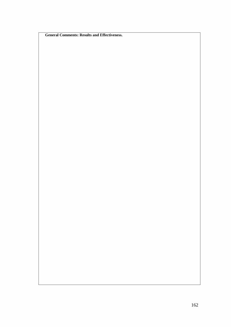
162
General Comments: Results and Effectiveness.
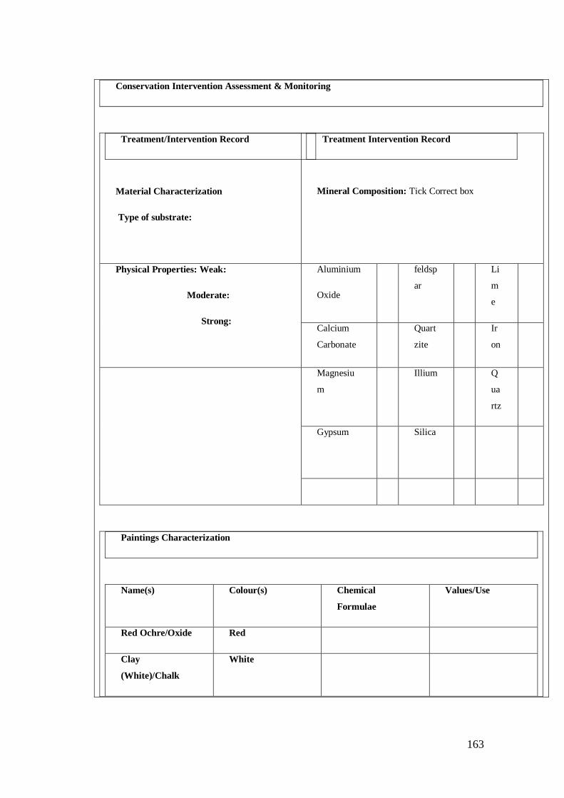
163
Conservation Intervention Assessment & Monitoring
Treatment/Intervention Record
Material Characterization
Type of substrate:
Treatment Intervention Record
Mineral Composition: Tick Correct box
Physical Properties: Weak:
Moderate:
Strong:
Aluminium
Oxide
feldsp
ar
Li
m
e
Calcium
Carbonate
Quart
zite
Ir
on
Magnesiu
m
Illium Q
ua
rtz
Gypsum
Silica
Paintings Characterization
Name(s) Colour(s) Chemical
Formulae
Values/Use
Red Ochre/Oxide Red
Clay
(White)/Chalk
White
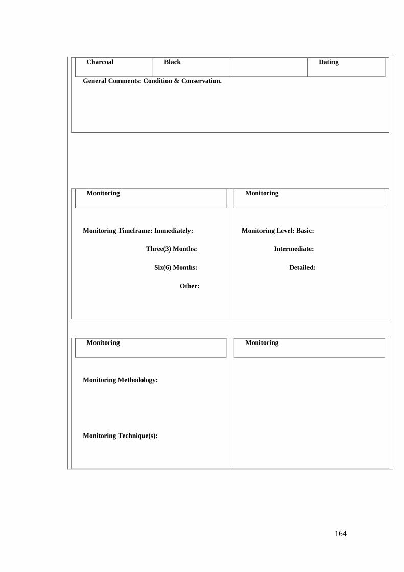
164
Charcoal Black Dating
General Comments: Condition & Conservation.
Monitoring
Monitoring Timeframe: Immediately:
Three(3) Months:
Six(6) Months:
Other:
Monitoring
Monitoring Level: Basic:
Intermediate:
Detailed:
Monitoring
Monitoring Methodology:
Monitoring Technique(s):
Monitoring
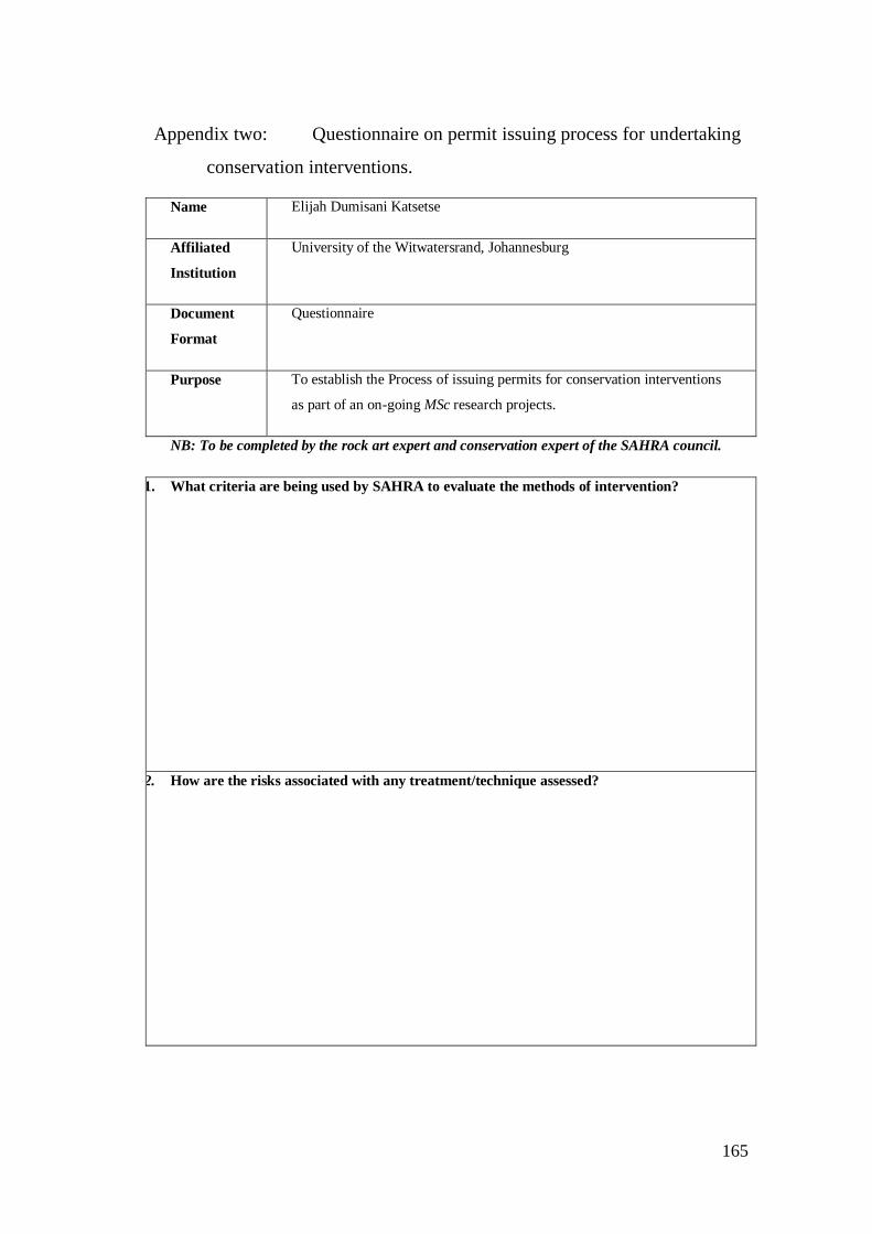
165
Appendix two: Questionnaire on permit issuing process for undertaking
conservation interventions.
Name Elijah Dumisani Katsetse
Affiliated
Institution
University of the Witwatersrand, Johannesburg
Document
Format
Questionnaire
Purpose To establish the Process of issuing permits for conservation interventions
as part of an on-going MSc research projects.
NB: To be completed by the rock art expert and conservation expert of the SAHRA council.
1. What criteria are being used by SAHRA to evaluate the methods of intervention?
2. How are the risks associated with any treatment/technique assessed?
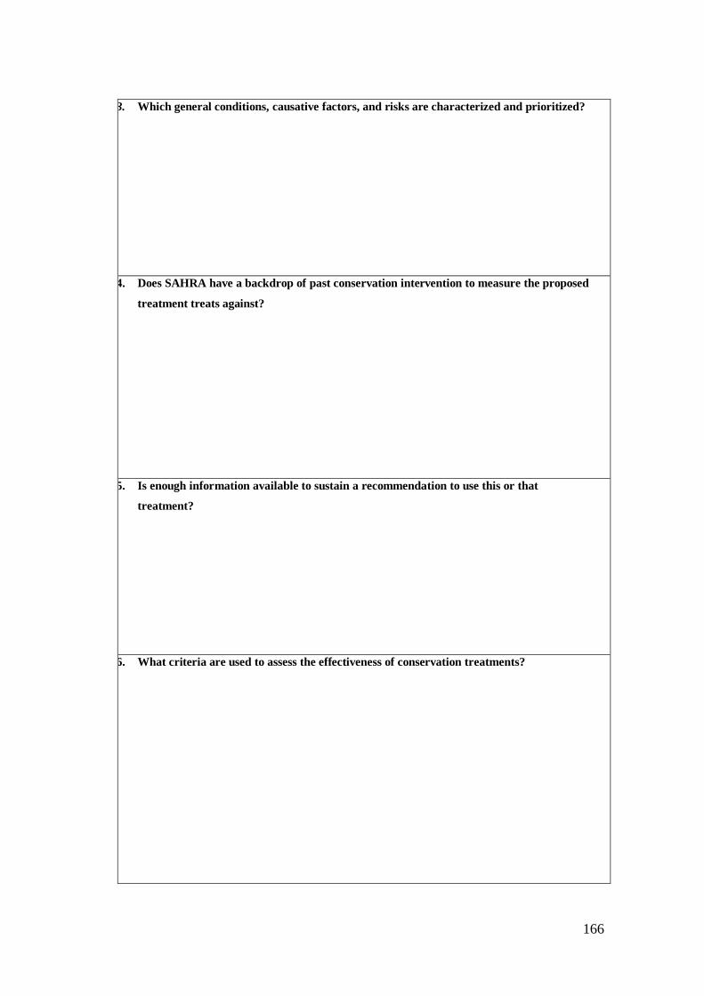
166
3. Which general conditions, causative factors, and risks are characterized and prioritized?
4. Does SAHRA have a backdrop of past conservation intervention to measure the proposed
treatment treats against?
5. Is enough information available to sustain a recommendation to use this or that
treatment?
6. What criteria are used to assess the effectiveness of conservation treatments?
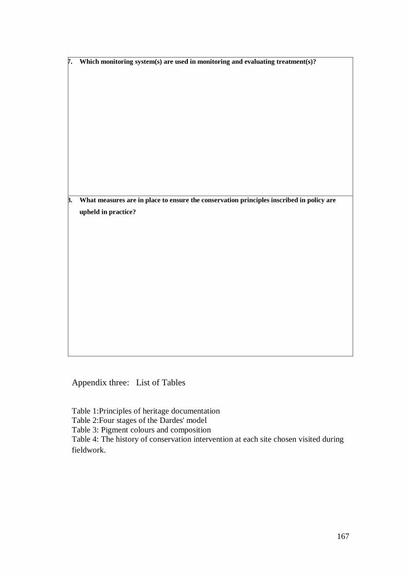
167
7. Which monitoring system(s) are used in monitoring and evaluating treatment(s)?
8. What measures are in place to ensure the conservation principles inscribed in policy are
upheld in practice?
Appendix three: List of Tables
Table 1:Principles of heritage documentation
Table 2:Four stages of the Dardes' model
Table 3: Pigment colours and composition
Table 4: The history of conservation intervention at each site chosen visited during
fieldwork.