a computerized system designed for local …
TRANSCRIPT
A COMPUTERIZED SYSTEM DESIGNED FOR LOCAL AVALANCHE HAZARDFORECASTING IN TIGNES, SAVOIE, FRANCE.
Edouardo Garreaud, Lionel Navillod and Henry Schniewind.
ABSTRACT
The SERVICE DES PISTES DE TIGNES (Tignes Ski Patrol)began developing a computerized system with the help ofEdouardo Garreaud in 1986, to explore new possibilitiesin avalanche forecasting.
Snow-meteorological observations had been recordedsince 1971.
The goal was and is to process snow-meteorologicalobservations in the most efficient way possible in orderto present accurate conclusions for the community ofTignes (1550-3350 H). The ski area includesapproximately 11,000 hectares of skiable terrain and over125 lifts giving access to L'Espace Killy (Tignes and Vald'Isere).
Tignes is situated in the inter-alpine zone, subjectto a wide range of snow-meteorological conditions.
- Snow-meteorological observations are recordedthree times daily at Tignes Le Lac, 2080 H.
- Observations recorded automatically at 2400 H.- Wind speed and direction recorded at 2700 M.- Weekly snowpack profiles at 2400 H.- Complimentary snowpack profiles.- Recording of all avalanche activity.- Observations are then entered into the computer.- Statistical calculations for similar days in the
past.
A practical result of this system is an analysis ofthe snow-meteorological situation for the past week andan evaluation of the local avalanche hazard each day. Abulletin is prepared to inform the general public.
These evaluations are constantly verified in the fieldby the forecaster.
This computerized system is still developing towardsthe ultimate goal of bringing together accurate localforecasting and efficient public communication, throughfor example, the use of local TV and minitel.
I. President of D.I.S.A.H., Chalet Aysen,LongefoY/Aime, 73210 Aime, France.
II. Prevision Locale des Risques d'Avalanches,Service des Pistes, 73320, Tignes, France.
III. Snow Specialist, Snow Fun - Ecole de Ski,73150, Val d'Isere, France.
49
Tignes is located in the Alps. The Alps are a mountain chainthat r~ns 1200 Km in length and 120 to 200 kID in width, from theMediterranean Sea to Vienna Austria. Six countries include theAlps within their borders; Yugoslavia, Austria, Germany,Switzerland, Italy and France. The highest point of the chain isthe Mont Blanc at 4,807m located 50 kID from Tignes. People havebeen living in the Alps since the neolithic period of civilization (10,000 BC) (Hudry 1980). The Alps are the most populatedmountain chain in the world (Encyclopedia Universalis 1990). 29%of the ski areas in the world are situated in France, covering atotal area of 1200 sq kID, the most for one country in the world.French ski resorts have the capacity to lodge 1,120,000 peopleand include 4000 ski lifts (64% are located in the NorthernFrench Alps) that serve sixty one ski areas (Assoc. Ski France1990) .
The French avalanche forecasting system was realized in1970 and 1971 in the wake of "l'annee noire" (the black year).Avalanches during the winter of 1969-1970 claimed over 100 livesin France alone (Rey 1986). Like most of France's federal institutions, the avalanche forecasting network is very organized andhighly centralized. The head office is Le Centre d'Etude de laNeige (Center for the Study of Snow) in Grenoble (C.E.N. isitself part of the French national meteorological company calledMeteo-France). The network has branches, which are themselvesmeteorological centers in each department (a "departement" isthe rough equivalent of a small American state e.g. La savoie,at a total surface area of 6,000 sq kID, is appoximately onesixth the size of Montana. The branches that process snowmeteorological data are spread throughout France in Les Pyrenees,La Corse, Le Massif Central, Jura-Vosges and Les Alpes. Eachbranch is responsible for giving a forecast for its specificregion. The center in Bourg-St-Maurice, in the department of LaSavoie (Alps) is responsible for the massifs of Les Bauges, LeBeaufortain and La Vanoise as well as the valley regions thatsurround the Vanoise i.e. La Tarentaise and La Maurienne (Tignesis located in La Haute (high) Tarentaise limit of La Vanoise). Abulletin is announced everyday of the winter for each massif.
Avalanche forecasting in Savoie is based principally upondata provided by 20 snow-meteorological posts located for themost part at ski patrol centers throughout each massif or valleyregion. According to Mr. Chabert, director of the Bourg SaintMaurice snow-meteorological center, almost 4000 snowmeteorological observations and 400 snow-profiles are processedeach winter. The center is responsible for avalanche hazardforecast bulletins that cover a total area of approximately 5000sq km (1950 sq mi).
Savoie, which is made up of approximately 80% mountainousterrain, is easily recognized by the massif of the Vanoise whichis shaped like a hen-its plume is the border of Italy, its backformed by the Isere River (Tarentaise valley), its undersideformed by the Arc River (Maurienne valley), next to the top ofits head is Albertville (city of the 1992 Winter Olympic Games)
50
and the beak is formed by the Isere and the Arc where they cometogether just before Chambery (capital of the department ofSavoie). The ski area Tignes-Val d'Isere, also known as l'EspaceKilly because Jean-Claude Killy grew up in Val d'Isere, islocated at the end of the Haute Tarentaise Valley. This regionis located in the inter-alpine zone. The climat is therefore"montagnard" or alpine, which gives rise to many different microclimates subject to an extremely variable range of weatherconditions. La Haute Tarentaise is generally influenced by theeastern arm of the atlantic sub-tropical high pressure system(known as the anticyclone des Acores) and by Atlantic maratimepolar and maratime tropical low pressure systems that originateoff the coast of Iceland (known as the depression d'Island).Otherwise, systems moving in from the south, which are lessfrequent, deposit pinkish sands carried in by the Sirocco Windsthat originate in the Sahara Desert. This sand creates a weaklayer within the snowpack. Arctic systems originating in Siberiaare also less frequent but not negligible nor is the "returnfrom the east" of the Atlantic storms. The Foehn wind alsoinfluences the region on occasion. The following averages forthe last 30 years were obtained for the meteorological center inBourg St Maurice located at an altitude of 800 m (the seasonalweather station in Tignes is located at 2080 m - approximately20 km from Bourg St Maurice): The average annual temperature is+8.8'c. The average temperature for January is -0.4'c contrastwith an average temperature of +17.7'c in July. Average annualprecipitation is 952 mm (approximately 1100 mm in Tignes) -withan average of 153 days of precipitation recorded. Also recordedare annual averages of 2019 hours of clear skies, 42 days ofFoehn, and 27 days of thunder stormes. Most of the winter inTignes is experienced above the valley cloud level (StationMeteorologique Departementale de Bourg St Maurice).
The Tarentaise valley includes some of the largest skiareas in the world. In just a few decades, this once quiteagricultural valley has been transformed into a boombing touristcenter which will host almost all of the Winter Olympic eventsin 1992. The ski area Tignes-Val d'Isere is capable of lodging55,000 people. It provides just under 130 ski lifts that giveaccess to approximately 110 sq km (35 sq mi) of skiable terraincovering a relief of 1550 m to 3550 m in altitude. Approximately95% of the area is above tree line and over 80% is "hors-piste"(off-trail) skiing terrain. Hors-piste and out of bounds skiingis not only legal, it is encouraged as a selling point for theski area. Avalanche control is practiced only where trails orimportant structures may be at risk.
Tignes makes up approximately half of the total ski area ofthe Espace Killy. The original Tignes was a small agriculturalcommunity of approximately 400 people in 1945. Tignes as theski resort dates back to the early 1930's. Between 1946 and 1952an enormous dam was built that, at the time, supplied France "with five percent of its total electricity. The remains of theoriginal town are now located at the bottom of the resulting
51
lake, Lac du Chevril. The Church and the Town Hall wererelocated to the edge of the lake, creating the center of a townwhich is now called Tignes les Boisses. Only 20 of the original400 Tignards stayed in the area after the relocation. It wasn'tuntil 1967 that the "purpose built" ski resort of Tignes Ie Lac,located next to a small lake above the Lac du Chevril, began toemmerge as the ski resort giant that we see today. Since 1967Tignes has grown from 1500 'beds' to 30,000 available for theOlympics in 1992. During this period, the Town Hall moved toTignes Ie Lac. To accommodate this growth, enormous trenches,walls and various other structures have been put in place inorder to protect the resort community from the many existingavalanche paths that threaten a relatively large percentage ofthe town and the surrounding villages. Because of the destruction caused by avalanches during the 1969-1970 season, theFrench government asked the Minister of Agriculture to create amap of probable avalanche paths. The result was a combinedeffort between the French Natonal Forest service and theInstitut Geographique National. The Forest Service processedinformation on all avalanche events recorded during the lastcentury as well as surveys from the local population. TheInstitut Geographique National conducted a photo-interpretationstudy. The map that resulted turned out to be extremely usefulas a reference to the Service des Pistes who were able to modifythe original map, according to the avalanche paths thatconcerned them, and create - P.I.D.A (Plan d'Intervention pourIe Declenchement des Avalanches -Avalanche Control Plan). Anavalanche control team of 40 pisteurs is divided into fivegroups and assigned to secure the five different sectors ofTignes. Approximately 80 avalanche paths are controled duringand after each significant snowfall. Between three and sixthousand kg of explosives are used each season for avalanchecontrol alone. According to statistics obtained from A.N.E.N.A.for the last ten years, Tignes experiences an average of 1.4"hors piste" avalanche related deaths per year. The Service desPistes is also responsible for these out of bounds rescues.
Along with the responsibilities of avalanche control, LeService des Pistes de Tignes is in charge of taking care of 65marked pistes (trails) that total 120 km in length. This meanstaking charge of securing the trails from avalanche danger aswell as grooming and all other security mesures. The service despistes is also involved in the security of the entire resort.The coordination of the 80 professional pisteurs is effectuatedfrom the Central Office of the Service des Pistes which is underthe direction of Bernard Foucher. The Service des Pistes itselfis, in fact, under the responsability of the Mayor of Tignes.
La Prevision Locale des Risques d'Avalanches (LocalAvalanche Hazard Forecasting) was made possible by the openessand willingness of the Service des Pistes de La Plagne (LaPlagne Ski Patrol). La Plagne is a ski resort located nearTignes in the Haute Tarentaise. For several years this skipatrol, under the direction of Andre Martzolf, had been tryingto merge snow-meteorological parameters with hazards inherent of
52
avalanches. However, these observations were only emperical.
In 1978, Edouardo Garreaud (glaciologist) was hired by theService des Pistes de La Plagne with the goal in mind to createwhat eventually would become the system for Local AvalancheHazard Forecasting.
In 1980, Ie Service des Pistes de La Plagne signed acontract of cooperation with the Centre d'Etude de la Neige. Thegoal of this contract was research on creeping and gliding ofsnow, seismic detection of avalanches, automatic recording ofmeteorological parameters in altitude, integration of parametersconnected to avalanche hazards such as, albedo ... At the sametime this contract included the goal of developing a statisticalmodel that would permit the discrimination of the day analysedinto A DAY WITH AVALANCHES or A DAY WITHOUT AVALANCHES. Thissame model, also had to be able to analyze the meteorologicalparameters for a certain day through an analogue program inorder to find a similar day in the past with a known behavior ofavalanches. The analysis is achieved by a search through thedata base for the day that most resembles the day in question.This model is being used in Tignes today.
In July 1986, in order to extend the availability of themethod used for Local Avalanche Hazard Forecasting to other skiareas, Mr. Garreaud left La Plagne and created a company fortechnical development and assistance, la D.I.S.A.M, specializedin avalanche security and glaciology. The goal of this companyis to promote avalanche security and awareness as well as thestudy of glaciology in summer ski resorts.
Meanwhile, the Centre d'Etude de la Neige had developed aprogram called A.D.I.P.R.A. (Assistance Departementalisee etInformatisee a la Prevision du Risque d'Avalanches Departmentwide Computer Aided Avalanche Hazard Forecasting)designed to facilitate the departmental network of avalancheforecasting centers already in place. As stated before, thesecenters are responsible for a forecast by "massif" or region.For Example, the program had to be able to process informationcoming in from a potential 42 snow-meteorological observationposts in the region (see COMPUTER HELPED AVALANCHE FORECASTINGIN FRANCE, by Jerome Lafeuille and Eric Brun: proceedings fromthe ISSW, 1988).
The company D.I.S.A.M., concerned about the compatabilitybetween the data files of the Local Avalanche Hazard Forecastingin ski areas and the files of A.D.I.P.R.A. used by thedepartmental avalanche forecasting centers under the Centred'Etude de la Neige, decided to abandon the programs used beforein La Plagne. D.l.S.A.M. asked the Centre d'Etude de la Neige ifit would be possible to adapt certain programs of the systemA.D.l.P.R.A. to the method of Local Avalanche HazardForecasting. The local version of A.D.I.P.R.A. is a systemcalled P.R.E.L.A.(Prevision Local d'Avalanches -Local AvalancheForecasting), D.I.S.A.M. signed a two year contract with C.E.N.
53
in order to commercialize this version.
At the end of these two years, the development of themethod of Local Avalanche Hazard Forecasting demonstrated to Mr.Garreaud that P.R.E.L.A. was insufficient for processing snowmeteorological observations at posts in ski resorts. As aresult, D.I.S.A.M developed its own system for local forecastingcalled A.D.I.C.L.H.I.M.A.(Aide Informatisee a la ClimatologieHivernale de Montagne et aux Risques d'Avalanches dans lesZones Securisees - Computer Aided Climatology for winter AlpineEnvironments and Avalanche Hazard Forecasting in Secured Areas).The programs of P.R.E.L.A. for processing ram sonde observationsand analogous model are still used in this system.
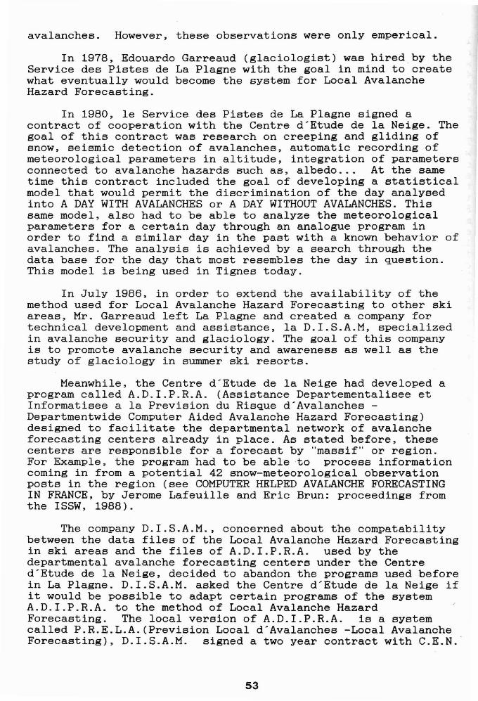
A SYSTEM FOR LOCAL AVALANCHE HAZARD FORECASTING
A.D.I.C.L.H.I.M.A. consists of six functions (Figure 1):
. A.D.I.C.L.H.I.M.A • .Aide Informatis~e l la Climatologie Hivernale de Montagne
et aUK Risques d'Avalanches dans les Zones S~curis~e8
Service des Pistes et de la S~curit~ de T I G N E S
I F 1OBSERVATIONS NIVO-I I F2 SONDAGES BATT AGE II F3 SITES AVALANCHEUX IMETEOROLOGIQUES. PROFILS STRATIG. AVALANCHES OBSERVe
I F4PREVISION LOCALE II F5
BASE DES DONNEES I I F6 CENTRE SERVEUR
ISTATIONS NIVOSE A.D.I.C.L.H,I.M.A. TELEMATIQUE
F9 FIN
Figure 1
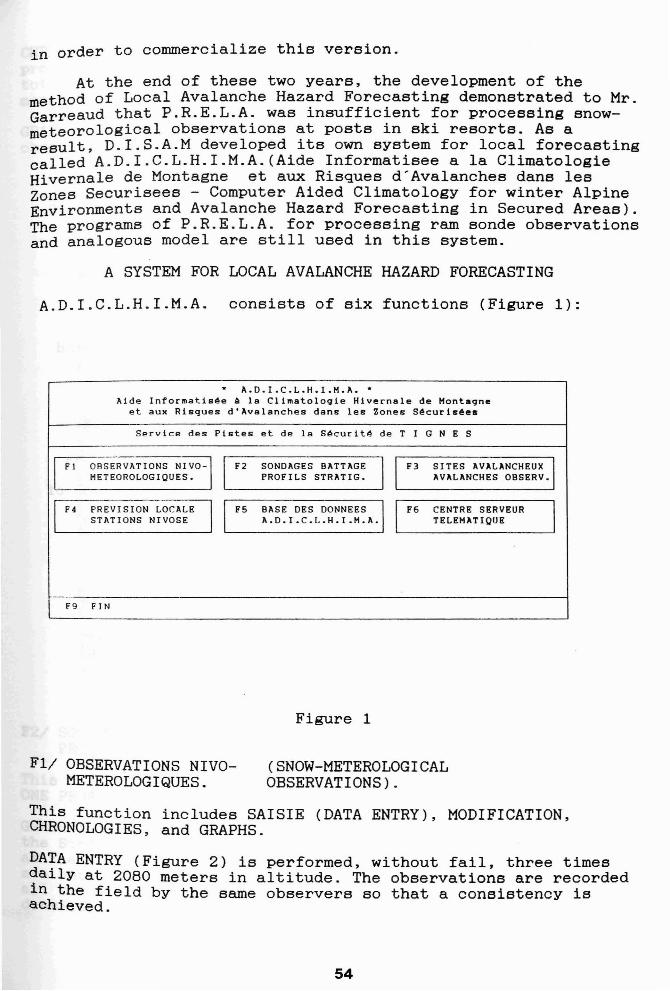
F1/ OBSERVATIONS NIVOMETEROLOGIQUES.
(SNOW-METEROLOGICALOBSERVATIONS) .
This function includes SAISIE (DATA ENTRY), MODIFICATION,CHRONOLOGIES, and GRAPHS.
DATA ENTRY (Figure 2) is performed, without fail, three timesdaily at 2080 meters in altitude. The observations are recordedin the field by the same observers 60 that a consistency isachieved.
54
STATION: T I G N E S Service des Pistes et de la SecuritePrevision Locale du Risque d'Avalanches
* A. D. I. C. L. H. I. M. A. *Pour Arreter Entrez FIN
Poste : Tignes Ie Lac 904Fonction : SAISIE
Observations de la Veillejjmm hr hVV Nddff sTTA RRRR PrPr wwWW NLMH sTTX sTTN SSS ss sTTS EPF'NC LLLL L3004 08 999 01808 +026 0000 jill 0000 0000 +114 -028 118 00 -005 80000 4742 33004 13 999 11805 +045 jill jill 0000 0002 jill jill 117 00 -002 51000 0000 53004 17 599 11802 -070 jill jill 0000 1200 jill jill 116 00 -003 51200 1432 5
Observations du Jourjjmm hr hVV Nddff sTTA RRRR PrPr wwWW NLMH sTTX sTTN SSS ss sTTS EPPNC LLLL L0105 08 999 10000 +032 0000 jill 0000 0002 +095 -013 116 00 -004 80000 1432 30105 13 999 21803 +061 jill jill 0000 0002 jill jill 115 00 -004 50600 0000 50105 17
Figure 2
jjmm hr=day, month, hour ; hVV=height of clouds above theresort, horizontal visibility; Nddff=cloud cover-in octas, winddirection, wind speed at the resort; sTTA=air temperature;RRRR=precipitation; PrPr=atmospheric pressure; wwWW=presentmeteorological conditions, meteo. conditions since the lastobservation; NLMH= low or medium layer cloud cover above theresort-in octas, type of lower height clouds, type of mediumheight clouds, type of the highest clouds; sTTX=maximumtemperature; sTTN=minimum temperature; SSS=total height of thesnowpack; ss=total fresh snow since the last reading;sTTS=temperature of the snow at a depth of 10 em; EPPNC=state ofthe surface of the snowpack, penetration of the first drop ofthe ram sonde in em, cloud cover in the valley, wind blowingsnow in altitude; LLLL L=description of avalanches observed,type of avalanches, altitude of starting zone, orientation,estimation of hazard (1-8).
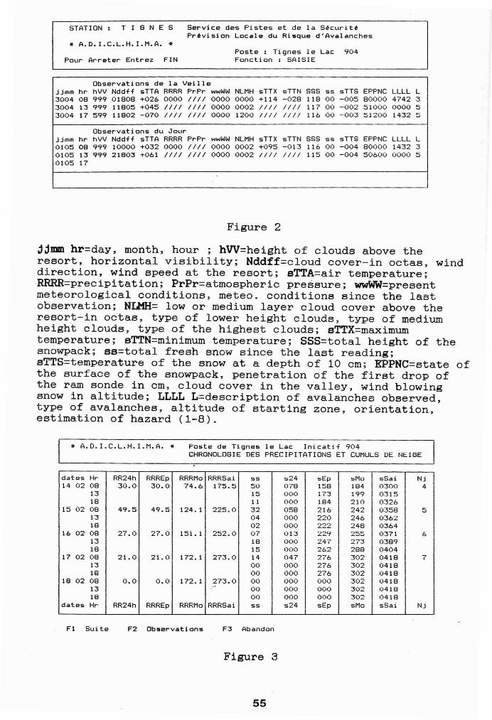
* A. D. I. C. L. H. I. M. A. * Poste de Tignes Ie Lac Inicatif 904CHRONOLOGIE DES PRECIPITATIONS ET CUMULS DE NEIGE
dates Hr RR24h RRREp RRRMo RRRSai ss 524 sEp sMo sSai Nj14 02 08 30.0 30.0 74.6 175.5 50 078 158 184 0300 4
13 15 000 173 199 031518 11 000 184 210 0326
15 02 08 49.5 49.5 124.1 225.0 32 058 216 242 0358 513 04 000 220 246 036218 02 000 222 248 0364
16 02 08 27.0 27.0 151. 1 252.0 07 013 229 255 0371 613 18 000 247 273 038918 15 000 262 288 0404
17 02 08 21. 0 21.0 172.1 273.0 14 047 276 302 0418 713 00 000 276 302 041818 00 000 276 302 0418
18 02 08 0.0 0.0 172.1 273.0 00 000 000 302 041813 .- 00 000 000 302 041818 00 000 000 302 0418
dates Hr RR24h RRREp RRRMo RRRSai 5S s24 sEp sMo sSai Nj
Fl Suite F2 Observations F3 Abandon
Figure 3
55
CHRONOLOGIE (Figure 3): Allows the forecaster to analyze theprevious five days weather events (per screen), as well as,total accumulations for the previous 24 hrs, the episode, themonth and the season. .
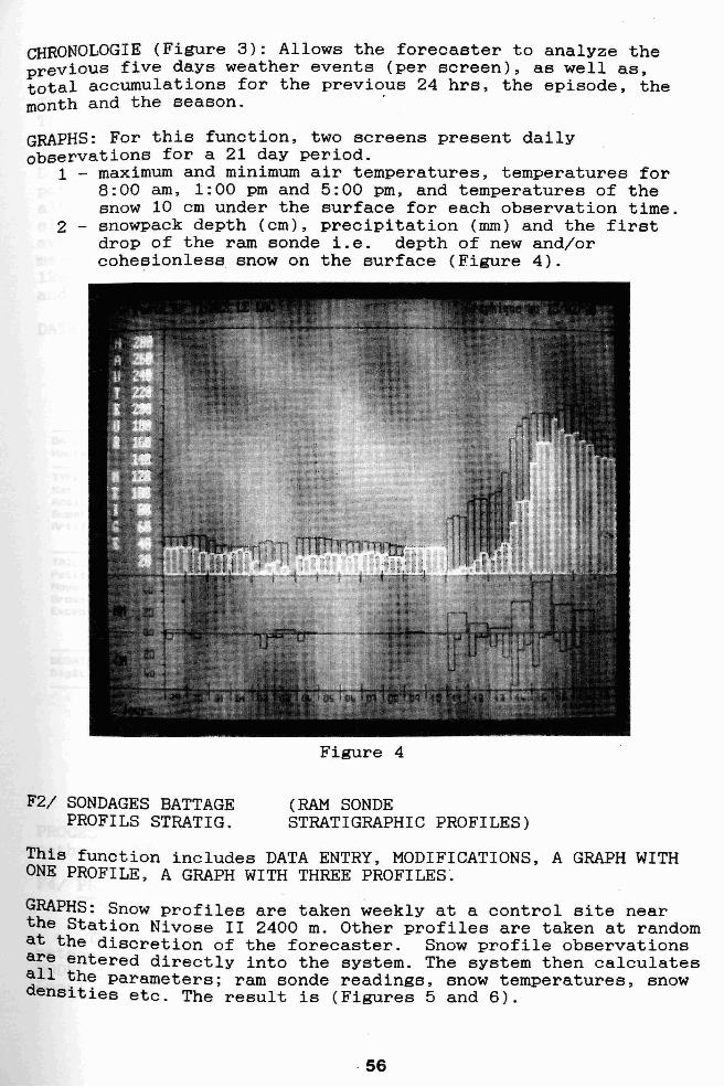
GRAPHS: For this function, two screens present dailyobservations for a 21 day period.
1 - maximum and minimum air temperatures, temperatures for8:00 am, 1:00 pm and 5:00 pm, and temperatures of thesnow 10 cm under the surface for each observation time.
2 - snowpack depth (cm), precipitation (mm) and the firstdrop of the ram sonde i.e. depth of new and/orcohesionless snow on the surface (Figure 4).
Figure 4
F2/ SONDAGES BATTAGEPROFILS STRATIG.
(RAM SONDESTRATIGRAPHIC PROFILES)
This function includes DATA ENTRY, MODIFICATIONS, A GRAPH WITHONE PROFILE, A GRAPH WITH THREE PROFILES.
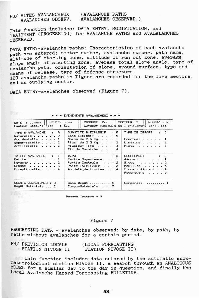
GRAPHS: Snow profiles are taken weekly at a control site nearthe Station Nivose II 2400 m. Other profiles are taken at randomat the discretion of the forecaster. Snow profile observationsare entered directly into the system. The system then calculates~ll the parameters; ram sonde readings, snow temperatures, snowensities etc. The result is (Figures 5 and 6).
56
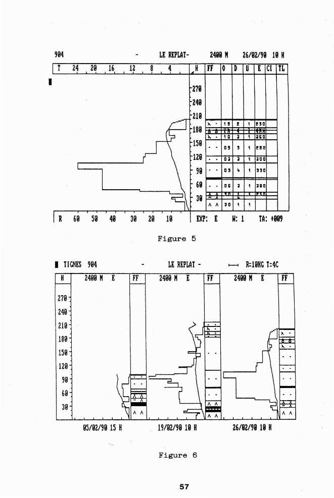
994 LE REPLAT- 2499 " 26/92/99 19 H
I
I T 24 29 16 12 8 4 ",H rr 0 D U [ CI TL
279
249
219- l\ • 1 ! e 1 !!O
189)" . , a iI , illia
159D' ! 1 ellD· ·
129 · ail iI , aDaI
99 · · a, " 1 HD
69 · · Dli a 1 aD
~\ 39 -" " ;0 1 1
I R 69 59 49 39 29 19 00: I N: 1 TA: +889
Figure 5
I TIGHES 994 LE REPLAT - - R:19KG T:4CH 2499 H E FF 2499 H E FF 2499 H [ FF
279
249
219
189
159
129
99
69
39
95/92/99 15 H 19/92/99 19 H 26/92/99 19 H
Figure 6
57
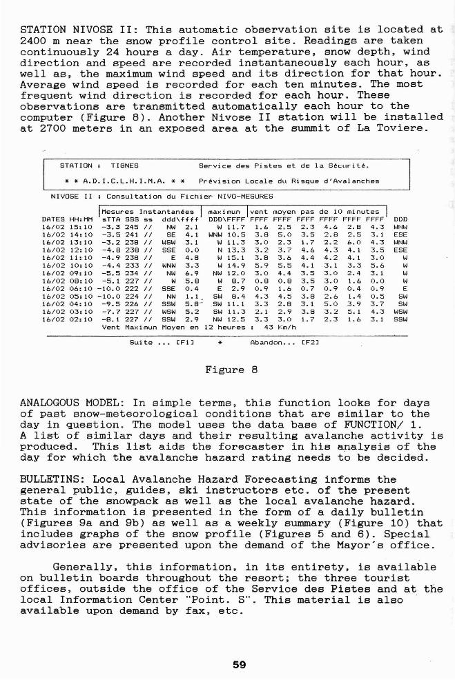
F3/ SITES AVALANCHEUXAVALANCHES OBSERV.
(AVALANCHE PATHSAVALANCHES OBSERVED.)
This function includes: DATA ENTRY, MODIFICATION, andTRAITMENT (PROCESSING) for AVALANCHE PATHS and AVALALANCHESOBSERVED.
DATA ENTRY-avalanche paths: Characteristics of each avalanchepath are entered; sector number, avalanche number, path name,altitude of starting zone, altitude of run out zone, averageslope angle of starting zone, average total slope angle, type ofavalanche path, orientation of slope, ground surface, type andmeans of release, type of defense structure.129 avalanche paths in Tignes are recorded for the five sectors,and an outlying sector.
DATA ENTRY-avalanches observed (Figure 7).
* * * EVENEMENTS AVALANCHEUX * * *DATE : jjmmaa HEURE: hhmmHauteur Cassure em) : Ecc
COMMUNE: Ccc SECTEUR: S NUMERO : NnnLargeur Maxima e de I 'Avalanche 1m): Aaaa
TYPE D'AVALANCHE : A QUANTITE D'EXPLOSIF : Q TYPE DE DEPART : DNaturell e 0 Sans Explosif 0Accidentelle 1 Moins de 2,5 Kg. 1 Ponctuel 1Super' fie i ell e 2 Plus de 2,5 Kg. 2 Lineair'e 2Artificielle :3 Plusieur' Tir's :3 Mi:<te :3
Tir de Corniche 4
TAILLE AVALANCHE : T DEPOT : D ECOULEMENT : EPetite 1 Partie SuperiE!ur'e 1 Aerosol 1Moyenne 2 Par·t i e Centrale 2 Blocs 2Grosse :3 Parte Infer'i E!ure 3 Mouillee 3Exceptionelle 4 Au-dela .;de Limites 4 Blocs + Aerosol 4
Poudr'eus' e 5
DEGATS OCCACIONES : 0 Sans Dega:t .......... 0 Corporels . ........ 1Deg:i:t Materiels ... 2 Corpo+Mat er·i el s . .... 3
Donnee Inconue 9
Figure 7
PROCESSING DATA - avalanches observed: by date, by path, bypaths without avalanches for a certain period.
F4/ PREVISION LOCALESTATION NIVOSE II
(LOCAL FORECASTINGSTATION NIVOSE II)
This function includes data entered by the automatic snowmeteorological station NIVOSE II, a search through an ANALOGOUSMODEL for a similar day to the day in question, and finally theLocal Avalanche Hazard Forecasting BULLETINS.
58 '
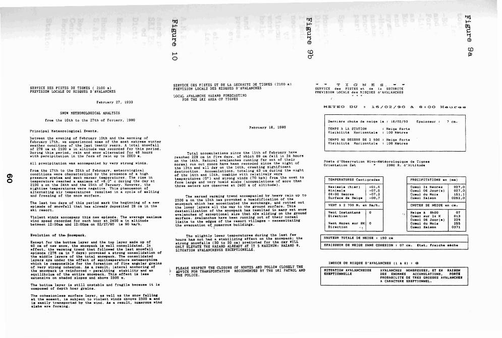
STATION NIVOSE II: This automatic observation site is located at2400 m near the snow profile control site. Readings are takencontinuously 24 hours a day. Air temperature, snow depth, winddirection and speed are recorded instantaneously each hour, aswell as, the maximum wind speed and its direction for that hour.Average wind speed is recorded for each ten minutes. The mostfrequent wind direction is recorded for each hour. Theseobservations are transmitted automatically each hour to thecomputer (Figure B). Another Nivose II station will be installedat 2700 meters in an exposed area at the summit of La Toviere.
STATION: TIGNES Service des Pistes et de la Securite.
* * A.D.I.C.L.H.I.M.A. * * Prevision Locale du Risque d'Avalanches
NIVOSE II : Consultation du Fichier NIVO-MESURES
Mesures Instantanees maximun vent moyen pas de 10 minutesDATES HH:MM sTTA SSS ss ddd\ffff DDD\FFFF FFFF FFFF FFFF FFFF FFFF FFFF DOD16/02 15: 10 -3.3 245 II NW 2.1 W 11. 7 1.6 2.5 2.3 4.6 2.8 4.3 WNW16/02 14: 10 -3.5 241 II SE 4.1 WNW 10.5 3.8 5.0 3.5 2.8 'J ~ 3.1 ESE_ • ..J
16/02 13: 10 -3.2 238 II WSW 3.1 W 11. 3 3.0 2.3 1.7 2.2 6.0 4.3 WNW16/02 12: 10 -4.8 238 II SSE 0.0 N 13.3 3.2 3.7 4.6 4.3 4.1 3.5 ESE16/02 11: 10 -4.9 238 II E 4.8 W 15.1 3.8 3.6 4.4 4.2 4.1 3.0 W16/02 10: 10 -4.4 233 II WNW 3.3 W 14.9 5.9 5.5 4.1 3.1 3.3 5.6 W16/02 09: 10 -5.5 234 II NW 6.9 NW 12.0 3.0 4.4 3.5 3.0 2.4 3.1 W16/02 08: 10 -5.1 227 II W 5.8 W 8.7 0.8 0.8 3.5 3.0 1.6 0.0 W16/02 06: 10 -10.0 222 II SSE 0.4 E 2.9 0.9 1.6 0.7 0.9 0.4 0.9 E16/02 05:10 -10.0 224 II NW 1.1 SW 8.4 4.3 4.5 3.8 2.6 1.4 0.5 SW16/02 04: 10 -9.5 226 II SSW 5.8" SW 11. 1 3.3 2.8 3.1 5.0 3.9 3.7 SW16/02 03: 10 -7.7 227 II WSW 5.2 SW 11.3 2.1 2.9 3.8 3.2 5.1 4.3 WSW16/02 02: 10 -8.1 227 II SSW 2.9 NW 12.5 3.3 3.0 1.7 2.3 1.6 3.1 SSW
Vent Maximun Moyen en 12 heures 43 Km/h
Suite ... (FIJ * Abandon ... (F2J
Figure B
ANALOGOUS MODEL: In simple terms, this function looks for daysof past snow-meteorological conditions that are similar to theday in question. The model uses the data base of FUNCTION/i.A list of similar days and their resulting avalanche activity isproduced. This list aids the forecaster in his analysis of theday for which the avalanche hazard rating needs to be decided.
BULLETINS: Local Avalanche Hazard Forecasting informs thegeneral public, guides, ski instructors etc. of the presentstate of the snowpack as well as the local avalanche hazard.This information is presented in the form of a daily bulletin(Figures 9a and 9b) as well as a weekly summary (Figure 10) thatincludes graphs of the snow profile (Figures 5 and 6). Specialadvisories are presented upon the demand of the Mayor's office.
Generally, this information, in its entirety, is availableon bulletin boards throughout the resort; the three touristoffices, outside the office of the Service des Pistes and at thelocal Information Center "Point. S". This material is alsoavailable upon demand by fax, etc.
59
I'%j I'%j tx:I
1-'" 1-'"1-'"
~ ~ ~'1 '1 '1
(1l (1l(1l
~ CO CO
0 0' III
T I G N E SSERVICE des PISTES et de l~ SECURITEPREVISION L.OCALE des RISQUES d' AVALI\NCHES
SERVICE DES PISTES DE TIGNES ( 2100 .)PREVISION LOCALE OU RISQUES O· AVALANCHES
February 27. 1990
SHOW KETEOROLOGICAL ANALYSIS
SERVICE DES PISTES ET DE LA SECURITE DE TIGNES (2100 .)PREVISIOH LOCALE DES RISQUES O' AVALANCHES
LOCAL AVALANCHE HAZARD FORECASTINGFOR THE SKI AREA OF TIGNES
METEO DO 16/02/90 a 8=00 H_ur __
troll the 10th to the 27th ot Feruary. 1990 Oer-nitr. chut. d. nelqe 1e I 16/02/90 Epalaceur 7 c ••
Pc inc lplll Metoorolo.ical Bvents.February 18. 1990 TEHPS A LA STATION
Vislbll1tt Hor-izontalaN.lq. I!or-t.eiOO M4lit.r-.e
0)o
Between the evening ot February 10th and the 1I0rning orFebruary 17th I IoIe experienced SODe or the Ilost extrelDs winterweather conditons 01' tho last twenty years. A total snowfallof 278 ca at 2100 • in altitude waS recorded tor this period.Our101 thi:s period. 1:'lll0 and snow alternated tor 48 hourswith percipitation in the torlD at rain up to 2000 e.
All precipitation was acooliPanied by very strona: winds.
FrOID the 17th to tho 25th at February, .otooroio.icalconditions wore characterized by the prasenes ot .. hi.hpressure systelD Ilnd Dueh warlDer teDperatures. The rise intellperature reached a aaxiaUD or +8. O· 0 during the day at2100 :D on the 24th and the 25th at Feruary, However. theni,htilD8 tellperatures \fere ne,ative. Thi:l ph"nol1enon atalternatin, air teaperatures resulted in a cycle at a"ltin.and treezina of the snow surfaoe,
The last tva days at thh period .ark the beginnin. ot a nevepisode ot' snowt'all that nas already deposited 29 ca in theski resort.
Violent winds accollpany this nev ItPisode. The avera,e Dll.XiIlUIl
wind speed reoorded tor each hour at.2400 D in altitudebetween 12:00... and 12:00p. on 02/27/90 is 90 ka/h.
Total aooumulations since the 11th ot' February havereached 229 OD in tive days, ot which a9 CD tell in 24 nourson the 14th. Natural avalanches running tar out at theirnorlDal ~un out 2:ones have been ~ecorded since the nijfht atthe 13th and all day on the 14th, creatinjf sijfnitioantdestruction, AccuDulations, totaling 43 ClG during the nightat' the 14tn and 15th, cOllbine wtth relatively warllteaperatures (0·) and strong \finds (70 kph) troa the \.lest totara larae and very hUDid slabs (accuDulations ot Dare thanthree Deters are observed at 2400 ID ot a.ltitude).
The Dar ked warDina trltnd acconpan ied by heavY rain up to2500 D on the 15th nas provoked & nu.iditication ot thesnowpack which has accentuated the surcharlle. lUld rottltd outthe lower layers all the way to the 8'round surf'ace. Thisdestabilization of th_ snovpaclt ha. resulted in .any vet snoeavalancne. ot exceptional size that are slidin8' on the aroundsurface. Avalanches have been runnin. out ot' their noraalUaits to the edles of the resort villa.es - neoessitatinathe evacuation ot. rUDerous buildincs.
TEMPS AU OESSUS DE 2 500 N.lC,. Por-teVlaib.L11tt Hor-lzont~1. I 100 M4litC'e.
Po.t. d'Ob.ervatlon Nlvo-Het.or-oloqlque de T1qn••Or-i.ntation rbt • 2090 H. d',Altltude
TEMPERATURES Centiqr-ad•• PRECIPITATIONS .n (ea)
Maxi.,d. (hiar-) +01,5 Cuaul 24 Haur•• 027 _0M1n!a.le -07,5 Cuaul 06 Jour (.) 027.009 :00 Heur'•• -07,3 Cu.ul du Mo i. 151,1Surface de Na1ge -00,7 Cu.ul S.t.on 0252,0
VENT .to 2 700 H. Ma/h. CHUTRS OK HEIGl
Yant Inetantan. 0 N.,... 9hoo I 07Direction Cuaul .ur 24 H 013
Cu.ul 06 Jour (e) 229Vent. No,en Cu.u1 du Nol. 255Direct.ion " Cu.u1 Salaon 0371
UIDICI 00 R1SQUR O'AVALANCHIS (1 l 8) I a
I HAUTEDR TOTAL&: 01 NKIGIL I 190 ca
rIPAISSEDR Oil HIIGI SANS COHISION I 07 ca. It.at, 'r'atcha .tch.
Ivolutlon ot th., ~nowP.ok.
Exoept for the botto. layer a.nd the top layer lIade up at40 C. ot new snov. the .no~aok 18 well consolidated. Inelleot. th. warainc trend that folloved the last snowfallepisode (278 ca in 7 days) provoked a atrona oonsolidation otthe aiddl. layers ot the total snoupaolt. Th. consolidatedl.,.ers are under the etteot at equitellPerature lI.et..orphisllwhioh is responsible tor the forllation at' tine anlUlar .rainsot ver7 strona ooheslon. A. a re.ult. l.teral &ncnorina ofthe IInoupaok is reintoroed - peraittina stability a.nd anequil1briua ot the entire snovoack. This etrect 18 L•••extensive on shaded slopes and above 2500 D.
The botto. la,.er is still unstabh and t'rq11e because it iscoaposed ot depth hoar .rains.
The aohe.ionle•• surface layer. a. veIl as the snow talllnaat th" aoaent, is subject to violent vinds abvove 2500 a andi. eaaily tranaported by the wind. As • result, nu.erous windslab. are tor.ina.
The sli.htly lover tlt.peratures durinll the last tevhours has not had It. stabilizina etf'ect on th_ snovpack; thestrona snoufaUs (30 to ~O ell) predicted tor the day WILLONLY ELEVATE THE HAlARO ALREADY AT IT S HAXIHUN, HAlARD 8.SITUATION AVALANCHEUSE EXCEPTIONELLE.
PLEASE RESPECT THE CLOSURE OF ROUTES AND FOLLOW CLOSELY THEADVICE FOR TRANSPORTATION RECCOKENOEO BY THE S~I PATROL ANDTHE POLICE.
nTDATION AYALAHCHEUSIIXIPTIONNILLI
AVALAHCHIS HOHBREOSIS, IT IN RAIIONDES INORMIS ACCUMULATIONS, fORTaPROBABILIT. 01 TRIS GROSSIS AViLAMCHaSA CARACTIR. IXIPTtONNIL.
II

The hazard rating and definition are announced every day onthe radio (a complete bulletin is announced on high hazarddays), as well as through an internal telematic system (internalminitel and television).
F5/ BASE DE DONNEESA.D.I.C.L.H.I.M.A.
(DATA BASEA.D.I.C.L.I.H.M.A.)
This function is, in fact, still being structured. Theobjective for this function is to bring together all theobservations recorded since 1970 and organize them in the systemso that they are available quickly and easily to the forecaster,as well as, to other functions in the system i.e. the analogousmodel, statistics ...
F6/ CENTRE SERVEURTELEMATIQUE
(CENTRAL TELEMATICSERVER)
This function is also synonomous of the future goals forLocal Avalanche Hazard Forecasting. The use of minitel (VideoTel)* will allow anyone anywhere in France, and in the futureanywhere in the world, to tap into a reservoir of snow avalancheinformation in Tignes at any time. Bulletins, graphs, lessonson snow and avalanche awareness, the most recent snow stabilityevaluations etc. will all be available, in the comfort of yourown home.
Television and cable T.V. bulletins are in the works aswell.
The easy access to the entire data base combined with moreeffective diffusion of information will allow for in depthsummaries of snow-meteorological data to be available to a widevariety of people. Certain information can be kept confidentialand still be transmitted and then accessed by code. Theseimprovements will be to the benefit of the entire community,especially avalanche control teams and other professionalsinvolved in related occupations in Tignes.
*Minitel (Video Tel) is a sort of computerized phonebook with ascreen. The system is hooked into the phone system. Theinformation that can be accessed is close to infinite and can beinteractive as well.
61
The people responsible for putting this presentationtogether are:
-Edouardo Garreaud, who provides the essentials i.e. the methodand programs that make up the system for Local Avalanche HazardForecasting, A.D.I.C.L.H.I.M.A.-Lionel Navillod, who works at the Service des pistes de Tignesas the snow-meteorological observer and forecaster, trained byEdouardo to take responsibility for all mesurements, data entryand everything that has to do with the daily operations of theSystem in Tignes.-Henry Schniewind, whose undergraduate work in snow, avalanchesand meteorology at Montana State University along with hisknowledge of the French and English languages makes hisparticipation very important to the overall presentation.
Special thanks to:
Monsieur Andre Baudin, Maire de Tignes, Mr. Bernard Foucher,Director of the Service des Pistes de Tignes and Mr. Jean-LouisTuaillon, director of A.N.E.N.A. (Association Nationale pourl'Etude de la Neige et des Avalanches) for providing thenecessary funding that made this project possible.
Vincent Bonnet, Pisteur and snow-meteorological observer, whosework with the Local Avalanche Hazard Forecasting in Tignes hashelped and inspired everyone involved.
and the ISSW '90 Committee for all their help in making ourpresence at the Workshop possible.
References:
A.N.E.N.A., Association Nationale pour l'Etude de la Neige etdes Avalanches.
Association Ski France, stations de ski de montagne hiver-ete;SKI FRANCE EN CHIFFRES, September 1990, Paris.
Dictionnaire Encyclopedique Hachette, 1990.
Encyclopedie Universalis, "Alpes" Vol. 1, Paris.
Hudry, M. 1980, VOYAGE A TRAVERS LA TARENTAISE, EditionsS.A.E.P. Colmar-Ingersheim.
Rey, L. 1985, LA NEIGE. SEE METAMORPHOSES, LEE AVALANCHES. ,CRentre d'Etude de la Neige, Etablissement d'Etude et deecherches Meteorologique, Grenoble.
Station Meteorologique Departementale de Bourg St Maurice.
62