a biannual newsletter of the alabama department of ...€¦ · a biannual newsletter of the alabama...
TRANSCRIPT

Alabama current connection 3
A biannual newsletter of the Alabama Department of Conservation and Natural Resources, State Lands Division, Coastal Section
and the Mobile Bay National Estuary ProgramAlabamacurrent
connectionSPRING 2015 • Vol. IX, Issue 1
Currently Inside
8 Maintaining Quality Coastal Shorelines
11 The Value of Beaches
12 Sharing the Beach with Sea Turtles
13 Tourism Resilience Index
Engaging Businesses to Create a More Resilient Coastal Economy
1 Shoreline Access: A Vital Resource to Gulf Shores
2 Coastal Corner: Barrier Island Restoration Assessment
4 Estuary Reflections: Cooperation, Good Will
and Public Engagement Contribute to Successful Living Shorelines Projects in Coastal Alabama
6 Protecting Our Shorelines: When One Size Does Not Fit All
14 Mobile Bay National Estuary Program Welcomes Deputy Director
15 Current Events
16 You Can Help to Create a Clean Water Future
Shoreline Access: A Vital Resource to Gulf ShoresBy Andy BAuer, director of PlAnning & Zoning, city of gulf ShoreS
The pristine, sugar-white beaches of Gulf Shores, Alabama, were once a sleepy coastal secret, but the secret is out and now millions of visitors lay footprints in the sand there each year. The beachfront is undeniably the community’s most valuable asset, but many of the City’s beach accesses are currently not used to their full potential because of their limiting original design. City leaders recognize the importance of strategically designed beach access points and understand their benefits go far beyond simply increasing public use.
With the help of grants from the Alabama Department of Conservations and Natural Resources (ADCNR), State Lands Division, Coastal Area Program, the City of Gulf Shores has completed, or is in the process of completing, three beach access projects: Gulf Place Master Plan, Little Lagoon Master Plan, and construction improvements to the West 10th Street Public Beach Access. Each of these projects will advance the core values within the City’s Small Town, Big Beach Vision 2025 for Sustainability by helping to preserve and protect coastal dune habitats while also providing sustainability measures such as storm protection.
Continued on page 10

2
Coastal CornerBy eliSkA MorgAn, coAStAl reStorAtion coordinAtor,
AlABAMA dePArtMent of conServAtion And nAturAl reSourceS
Alabama current connection
Barrier Island Restoration AssessmentAs the first in a chain of five
barrier islands in the northern Gulf of Mexico, Dauphin Island is strategically significant as it serves as the only barrier island providing protection to much of Alabama’s coastal natural resources. In addition, it provides valuable habitat for living and coastal marine resources, including many threatened and endangered species, and provides important protection to our estuarine habitats which thrive in Mississippi Sound.
With an astonishing 347 different species reported by the Dauphin Island Bird Sanctuaries, Dauphin Island is one of the top 10 birding spots in the Southeast. Rich in cultural history, the island is a popular tourist destination and a key supporter of recreational and commercial fishing as well as the oil and gas industry. It also serves as the home of historic Fort Gaines, and is the location of the state’s Marine Environmental Sciences Consortium.
Severely impacted over the years by natural events, and most recently by the Deepwater Horizon Oil
Spill, the island has experienced a loss of valuable habitats including wetlands, sea grasses, oyster reefs, and beach and dune habitats. Continual degradation of the island threatens the additional loss of these important habitats as well as the ecological
functioning of Mississippi Sound and the Heron Bay wetlands on the mainland.
Recognizing the importance of its only barrier island, the State of Alabama recently requested funding through
the National Fish and Wildlife Foundation (NFWF) Gulf Environmental Benefit
With an astonishing 347 species reported,
Dauphin Island is one of the top 10 birding spots
in the Southeast.

Alabama current connection 3
Fund (GEBF) to develop a feasibility study based on science and technical expertise. The Alabama Department of Conservation and Natural Resources (ADCNR), in collaboration with the U.S. Army Corps of Engineers and the U.S. Geological Survey, will work with a team of more than 30 scientists and engineers over a 3-year period to assess and evaluate the function of Dauphin Island as a barrier island. Looking to ensure long-term resiliency and sustainability for Dauphin Island, the Alabama Barrier Island Restoration Assessment will identify alternatives to preserve and enhance the ecological functions of the island and associated estuarine resources of which the barrier island protects.
Seeking to provide a means to effectively evaluate the benefits, impacts, and costs of potential restoration activities, the study will produce an assessment tool on which science-based recommendations can be made. In hopes of identifying some limited restoration opportunities early in
the study, an interim report will be prepared at the halfway point, and the final report will include the alternatives and means for assessment. Both reports will be presented to stakeholders at the time of completion, and all data collected as a result of this project will be added to a data catalogue and be available to the public for viewing.
With field work beginning this month, ADCNR looks forward to working with the project’s technical team, as well as stakeholders, to assess beneficial and effective restoration activities for Dauphin Island to ensure long-term sustainability and resiliency of Alabama’s only barrier island, its habitats, the living coastal and marine resources it supports, and the valuable estuarine habitats in Mississippi Sound.

With Dog River Park’s 350-foot shoreline under constant pressure from recreational boat wakes, MBNEP secured $26,000 from NOAA to implement habitat-friendly measures to stabilize the shoreline. Project challenges included: • Lack of experience in “living shorelines” design. • A tight budget of $26K, severely limiting what could be done at the site. • Lack of political consensus from decision-makers on the City’s role in project implementation. • A need to address the cause of the erosion – recreational boat wakes.
Friends helped us overcome those challenges. Dr. Scott Douglass of the University of South Alabama Civil Engineering Department provided a design, pro bono, for installing seven pile-supported timber structures and sand fill to create artificial headlands with alternating vegetated pocket beaches. The Alabama State Port Authority supplied 220 tons of clean sand fill to construct the headlands. MBNEP and the City developed an agreement by which the City donated 240 tons of riprap and supplied the equipment and an operator to complete the earthwork. Volunteers from Dog River Clearwater Revival planted native marsh vegetation. The Alabama Marine Police established a No Wake Zone and installed warning signs on the breakwaters and in the navigation channel. The project continues to perform well five years later.
The City of Satsuma experienced similar problems at the Steele Creek Lodge Marina, with boat wakes undercutting its 150-foot western shoreline and threatening old trees. The City requested $10,000 from the MBNEP to address erosion, but with a vertical scarp and a steeply-dropping bottom, there was no easy or obvious fix. Bret Webb, a USA Engineering colleague of Dr. Douglass, visited the site and provided a series of implementable stabilization strategies, pro bono, for the City to consider. Satsuma’s Public Works Department decided to construct a “perched terrace” and bought rocks, clean sand, and geo-fabric. The City used its own equipment and labor to build a rock sill and create a flat sand terrace. Satsuma High School ROTC students planted the terrace with native marsh species
4 Alabama current connection
Estuary eflectionsRBy toM herder, WAterShed Protection coordinAtor,
MoBile BAy nAtionAl eStuAry ProgrAM
Cooperation, Good Will and Public Engagement Contribute toSuccessful Living Shorelines Projects in Coastal AlabamaTo reverse the trend of installing
habitat-degrading bulkheads along waterfront properties, the Mobile Bay National Estuary Program (MBNEP)implemented three “living shorelines” demonstration projects since 2009: Mobile’s Dog River Park in spring 2010, Satsuma’s Steele Creek Lodge Marina in summer 2012, and Mon Louis Island in winter of 2013-14. Each of these projects faced difficult challenges but contributed to building greater public confidence in this natural technology.
Dog River Park

one might find in undisturbed nearby locations. The project provided a productive wetland area to buffer wave energy, filter stormwater, and provide habitat along the formerly-degraded, 150-foot shoreline, absolutely stretching the $10K award.
The Mon Louis Island design involved placement of rock breakwaters and clean sand fill to create stable headlands that pinned intermittent pocket beaches in place. Two rock islands were constructed offshore to provide habitat for oysters, fish, and other shellfish. In a much more challenging wave climate than the first two projects, this one was significantly bigger and more expensive and required teamwork, tenacity, cooperation, and good will to overcome challenges that included: • Obtaining community “buy-in” and recruiting a group of adjacent property owners willing to participate. • Resolving regulatory obstacles, since restoration involved multiple private property owners and placement of fill on
State water bottoms without reclamation. • Justifying to funders a living shorelines design that did not include marsh plantings. • Implementing an ambitious project that included sophisticated engineering design to restore and stabilize 670 feet of high-energy shoreline on a $120K grant budget (and matching those federal funds with private donations or in-kind services).
Alabama current connection 5
Steele Creek Lodge Marina
To get the community onboard, MBNEP, partners, and residents came together over seven public meetings between April 2009 and December 2012 to learn about wind and wave climate, longshore sand transport, and historical shoreline and marsh profiles necessary to develop design from experts. Drs. Douglass and Webb, attorney Niki Pace from MS-AL Sea Grant Legal Program, and specialists from the Maryland Department of Natural Resources helped us earn credibility in the community. MBNEP produced six Mon Louis Island Reports to keep residents informed. Eventually, six adjoining property owners agreed to participate in designing a project to pin their shorelines in place.
The Alabama Department of Conservation and Natural Resources
allowed us to proceed as a “demonstration project.” Each property owner agreed to execute a deed restriction including: • An agreed-upon boundary between State water bottoms and private up lands, pre-construction mean high tide lines, remained, despite placement of fill to create uplands. • Retaining property owner riparian rights, except for exclusive rights to oysters on installed rock structures. • Agreement to neither destroy nor damage project features into perpetuity and to abstain from construction or installation (but not maintenance) of armoring measures for three years post-construction.
Again, agency partners helped us deliver a strong project on a tight budget. The ASPA donated 1,650 cubic yards of clean sand fill, and the Alabama Department of Transportation provided 350 tons of class #2 riprap to construct the submerged oyster islands. The project continues to perform well and public sentiment on Mon Louis Island has swung in favor of well-engineered living shorelines measures.
Each of these demonstration projects, although small in size, has contributed to a greater community understanding of how nature-based solutions can provide ecosystem benefits and address human needs. Whether restoring wetlands along wake degraded bay shores or abandoning bulkheads for habitat-friendly living shorelines, shoreline enhancement or restoration is vital to protecting the living things that draw us to the coast.
Mon Louis Island
2 Alabama current connection6
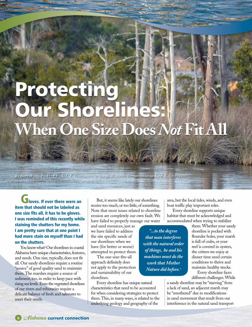
By Bret WeBB, Ph.D., P.e., D.C.e, University of soUth AlABAmA, DePArtment of Civil engineering
Protecting Our Shorelines: When One Size Does Not Fit All
Gloves. If ever there were an item that should not be labeled as one size fits all, it has to be gloves. I was reminded of this recently while staining the shutters for my home. I am pretty sure that at one point I had more stain on myself than I had on the shutters.
You know what? Our shorelines in coastal Alabama have unique characteristics, features, and needs. One size, typically, does not fit all. Our sandy shorelines require a routine “source” of good quality sand to maintain them. The marshes require a source of sediment, too, in order to keep pace with rising sea levels. Even the vegetated shorelines of our rivers and tributaries require a delicate balance of fresh and saltwater to meet their needs.
But, it seems like lately our shorelines receive too much, or too little, of something. Note that most issues related to shoreline erosion are completely our own fault. We have failed to properly manage our water and sand resources, just as we have failed to address the site specific needs of our shorelines when we have (for better or worse) attempted to protect them.
The one-size-fits-all approach definitely does not apply to the protection and sustainability of our shorelines.
Every shoreline has unique natural characteristics that need to be accounted for when considering strategies to protect them. This, in many ways, is related to the underlying geology and geography of the
area, but the local tides, winds, and even boat traffic play important roles.
Every shoreline supports unique habitat that must be acknowledged and accommodated when trying to stabilize
them. Whether your sandy shoreline is pocked with flounder holes, your marsh is full of crabs, or your reef is covered in oysters, the critters we enjoy at dinner time need certain conditions to thrive and maintain healthy stocks.
Every shoreline faces different challenges. While
a sandy shoreline may be “starving” from a lack of sand, an adjacent marsh may be “smothered” due to modifications in sand movement that result from our interference in the natural sand transport
“...to the degree that man interferes
with the natural order of things, he and his machines must do the
work that Mother Nature did before.”

Alabama current connection 37
system. To paraphrase a line from an iconic film, “... to the degree that man interferes with the natural order of things, he and his machines must do the work that Mother Nature did before.”
Truer words were never spoken. In fact, someone ought to cross-stitch that onto a pillowcase.
Following the wisdom of many other coastal states, Alabama now offers a general permit for “living shorelines”. This allows property owners to pursue appropriate nature-based alternatives to traditional shoreline armoring, like the bulkheads, seawalls, and rock revetments that dominate our urban shorelines today.
While they are not new to some practitioners, living shorelines are relatively new to homeowners and marine contractors. But buyer beware: there is no widely accepted guidance on how to select appropriate materials; contacting knowledgeable professionals remains a challenge; and understanding their costs, risks, and rewards is not always easy. However, we do know that they work when experience is brought to bear and when the site-specific needs of each shoreline are addressed and met.
There is no recipe for protecting all shorelines using the same ingredients every time. It just so happens that
as unique as our shorelines are, they require even more unique solutions to sustain them. For this reason alone, it is important to seek guidance from qualified professionals who can help you understand the site specific needs of your shoreline, and what you can hope to achieve with nature-based management.
So the next time you go to the store, why don’t you spend a little bit of extra money and buy a pair of gloves that actually fit? You’ll never regret making a choice that best meets your specific needs instead of those of, well, all.
Photo by Rhoda Vanderhart

8 Alabama current connection
Maintaining Quality Coastal ShorelinesBy Steve JoneS, director coAStAl reSourceS Section, geologicAl Survey of AlABAMA
For hundreds of years, Alabama’s beaches and adjoining areas have been of vital importance from both cultural and natural perspectives. Culturally, this importance is evidenced by existing Native American shell middens, occasionally-uncovered marine vessels, beach-fronting historical structures, current gulf-fronting ports, and recent coastal development. When viewed from a natural perspective, these areas have a range of functions, from storm protection of inland development to wildlife habitat contained within multiple ecosystems.
The Geological Survey of Alabama (GSA) has actively been involved in Alabama’s Gulf of Mexico-fronting beach research for at least four decades. Many of these studies have been made possible through the Coastal Zone Management
Act of 1972 through the National Oceanic and Atmospheric Administration with management and oversight made possible through the Alabama Department of Conservation and Natural Resources, State Lands Division, Coastal Section (ADCNR). The foresight of these agencies reflects their intimate involvement in Alabama’s coastal area and a firm commitment for essential beach quality. As was made evident during the Gulf oil spill crisis of 2010, Alabama’s beaches reflect an essential tourism destination vital to Alabama economics. That said, the interest to document shoreline data and maintain quality coastal shorelines, whether impacted by natural or human-induced causes, has never been greater. Additional studies, both beach and nearshore, have been made possible through the former
Minerals Management Service (now Bureau of Ocean Energy Management), the U.S. Geological Survey, and internal support through GSA. Initial offshore sand resource investigations in Alabama were part of the larger “Gulf Task Force,” formed
in 1986.Currently, land and
offshore-based research on beach topography, shoreline change, and offshore sand deposits is conducted through GSA’s, Geological Investigations Program, Coastal Resources Section. This work includes, but is not limited to, the
assessment of beach topography and shoreline change analysis through Real Time Kinematic Global Positioning System (GPS) surveys, orthophotography, and geospatial technology. It should be noted that, representing approximately 15 miles of Alabama’s eastern-most
“...Alabama’s beaches reflect an essential tourism destination vital
to Alabama economics.”

Alabama current connection 39
GSA aerial photographs reveal a post-Hurricane Ivan breach between the Gulf and Little Lagoon along the western border of the Bon Secour National Wildlife Refuge.
beaches, these engineered beach sections are monitored and maintained by the Engineer-of-Record, Olsen and Associates, retained by the cities of Orange Beach and Gulf Shores and ADCNR. State entities and contractors maintain a positive relationship that involves project planning and data sharing to support a cost-effective approach. GSA actively monitors the primary beaches of Dauphin Island and the Fort Morgan Peninsula and continues to add additional
transects to address data gaps. Data generated from GSA’s monitoring has been used by numerous federal, state, and local government entities as well as academic, private, and non-profit organizations mainly for hazard mitigation, planning, and research.
A web-based application was developed in 2009 to promote offshore sand source discovery, data dissemination, and a means to reduce redundancy and cost. The “Offshore Alabama Sand Information
System” or OASIS was developed to identify potential high-quality sand deposit target areas and serve as a primary guide for future offshore sand investigations through its vast compilation of geophysical and geotechnical data generated through such investigations. To view OASIS and explore Alabama’s beach data visit http://oasis.gsa.alabama.gov/
Little Point Clear and Edith Hammock beach ridge complexes on the Fort Morgan Peninsula showing three unique ridge and swale systems.

10 Alabama current connection
GULF PLACE Gulf Place is undoubtedly Gulf Shores’
most prominent beachfront location. This 36-acre property is located in the heart of Gulf Shores at the terminus of Highway 59 (Gulf Shores Parkway) and Beach Boulevard and offers a variety of activities that range from active to passive beach and water-based recreation. Gulf Place plays host to a variety of annual events, including the Hangout Music Festival, the AVCA Collegiate Sand Volleyball National Championship, and the National Shrimp Festival.
While Gulf Place already sees its fair share of activity, the long range plan is to fully activate its nearly one-half mile of beachfront property to enhance its family-friendly reputation. By creating a destination that can effectively serve a diverse range of activities and interests, Gulf Shores is well on its way to staking its claim as a world-class beach community, and there’s no doubt Gulf Place will serve as a catalyst behind continuing this success.
The Gulf Place Master Plan outlines a variety of access options for pedestrian and bicycle transportation and identifies improved streetscaping which will visually and physically connect the north and south sides of Beach Boulevard. The master plan also details a range of activities and amenities for families and people of all ages, including the ability to host large and small events on the amphitheater lawn, while also allowing
for flexible parking, open air pavilions, seasonal vending stations and play areas for kids. The preservation of existing dune habitats and the existing sea wall are vital pieces of the plan due to the benefits they provide from hurricanes and other storms.
LITTLE LAGOONLittle Lagoon Park is truly a hidden
gem. This 6-acre property is located at Little Lagoon Pass and has become known as a popular “locals” destination. The gentle slope of the beach area and minimal wave action offer a perfect retreat for families with young children or those who enjoy a more laid-back environment. The park winds its way north from the Gulf of Mexico under the Lagoon Pass Bridge and along the southern shore of Little Lagoon. The Lagoon serves as an excellent location for fishing, kayaking, and low intensity water activities; however, facilities and parking are limited.
The vision behind the Little Lagoon Master Plan is to improve the functionality and facilities the park offers, while paying close attention to preserving its unique character and feel. Included in the plan are new bathroom facilities, new shade structures, a kayak launch, and a new boardwalk meandering through the extensive wetlands along Little Lagoon. Improved pedestrian access and safety is also a priority as the plan calls for parking relocation and enhancements
aimed at creating additional water and beach access. Complimentary to the master plan, an upgraded pedestrian path under the bridge is currently being constructed by the Alabama Department of Transportation.
WEST 10th STREETThe public beach access at West 10th
Street is currently unimproved, forcing beachgoers to walk over and through the dunes. However, enhancements are already on their way as Gulf Shores is in the process of constructing an elevated 6 foot wide boardwalk, showers, benches, and ADA-accessible toilets, along with public parking spaces on the north side of West Beach Boulevard. The addition of dune walkovers and public parking at this location will vastly improve access for nearby residents and visitors by providing a designated path for beachgoers, while helping to protect and preserve the existing dune system.
While focusing on the balance between economic development and resource protection, we must continue our efforts to provide and improve access to the natural beauty and pristine shorelines along Alabama’s coast. With a master plan and improved vision, Gulf Shores is working to become a more pedestrian friendly community while providing easy access to attract tourists and locals alike to its white sugar sand beaches.
Shoreline Access: A Vital Resource to Gulf Shores Continued from page 1
GULF PLACE Master Plan
LAGOON PARK Master Plan

Alabama current connection 3Alabama current connection 11
The Value of BeachesBy collette BoehM, director of SPeciAl ProJectS, gulf ShoreS & orAnge BeAch touriSM
In Mobile and Baldwin counties, as in many parts of the country, tourism is big business, with beaches the main draw. Travel and tourism are one of America’s largest industries, and research identifies beaches as one, if not the, leading destination.
In 2013 coastal Alabama’s tourism industry welcomed 8.1 million visitors, accounting for $4.1 billion in spending. That same year Baldwin County, home to 32 miles of beaches and the largest contributor to Alabama’s tourism coffers, welcomed 5.4 million visitors who spent $3.2 billion. Numbers of visitors and their correlating lodging and retail expenditures have climbed to new records in the beach front communities of Gulf Shores and Orange Beach each of the last four years.
As strong as these numbers are, economic impact is not the first thing that comes to mind when considering beaches. Their value as a natural resource is largely considered to be their most important feature. Their ecological value is vast, providing habitat for a variety of animals including nesting shore birds, crabs and beach mice as well as for numerous types of grasses and shrubs. Beaches are nurseries for seven species of endangered sea turtles, three of which are known to nest in Alabama. In 2014, 80 nests were recorded and more than 4,800 hatchings journeyed into Gulf waters.
As the first line of protection against storms, wide beaches and high dunes
provide a buffer for inland buildings and infrastructure. By mitigating winds and storm surge, they prevent or lessen damage, saving property owners and public entities untold dollars.
The societal, health, and recreational benefits of beaches are more difficult to measure, but widely acknowledged, as more and more Americans are moving closer to a shoreline. According to the National Oceanic & Atmospheric Administration (NOAA), a 2010 study reports that while coastal counties account for only 10% of the country’s land, they are home to 39% of its population. The population of these counties increased by almost 40% since 1970 and is projected to increase by an additional 8% by 2020.
Once beachfront areas are inhabited by residents, enjoyed by vacationers and lined by structures, their natural state is often disrupted. Retaining that state and all the benefits it offers, requires management and maintenance.
In 2012-2013 the Bon Secour National Wildlife Refuge, City of Gulf Shores, Gulf State Park, and City of Orange Beach
received a $1.1 million grant for Gulf oil spill restoration to restore 55 acres of primary dune habitat. Instead of installing hard, man-made, habitat-degrading structure, this restoration project involved planting vegetation and installing dune fences to reduce erosion, promote deposition of sand, and protect important habitat naturally.
Also in 2013, a reported $16 million project renourished a 16.2 mile stretch of beachfront in Gulf Shores, Orange Beach and Gulf State Park. Undertaken to repair damage sustained from recent hurricanes, the project was funded jointly by the cities, the state and the Federal Emergency Management Agency (FEMA). The project replaced an estimated 2.2 million cubic yards of sand.
What is the return on investment for such costly efforts? The answers are varied, but they are real. Tourism revenues, wildlife habitat and coastal protection all have value. Perhaps though, the most pervasive is a bit less quantifiable. In the Encyclopedia of Coastal Science, William B. Stronge says this of the value of beaches to America’s societal health:
“There’s an intangible importance of natural shores and beaches to the health and welfare of Americans. America’s coast is as fundamental to our culture as our inalienable right to the pursuit of happiness. To many of us, ‘the beach’ is really part of our lives. Loss of our beaches can be expected to adversely affect our society, and therefore our shores and beaches have great value.”

12 Alabama current connection
Sharing the Beach with
Sea TurtlesFrom May through October
each year, dozens of sea turtles come ashore on Alabama’s beaches. These endangered animals are looking for a safe place to make a nest where their babies can hatch, then find their way safely into the warm Gulf waters.
Thousands of hatchlings take their first steps right here on our shores each year. Many of them need a helping hand to reach the water. The many volunteers of the Share the Beach program give them just that. There are many ways to help the endangered sea turtles, but the best way is to educate yourself about sea turtles and what you can do to help.
Tips for Being Sea Turtle Friendly • Avoid using flashlights or flash photography on the beach at night. • Turn off outside patio lights and shield indoor lights from shining onto the beach at night. • Do not disturb sea turtle nests. • Leave sea turtle tracks undisturbed. • Do not leave trash on the beach. • Volunteer and Adopt-a-Nest.
Turtle Tidbits • Sea Turtle Nesting Season is May 1 - October 31. • Three species of sea turtles nest on Alabama’s Gulf Coast: green, Kemp’s Ridley and loggerhead. • Sea Turtles are protected by the Endangered Species Act. It is against the law to disturb nesting sea turtles, hatchlings, or their nests. • Sea turtles first appeared about 200 million years ago when dinosaurs still roamed the earth. The last of the ancient reptiles, they are like living fossils. • Female sea turtles typically lay more than 100 leathery, ping-pong-size eggs at a time. Only a few young turtles, however, will make it to adulthood.
• Hatchling sea turtles find their way to the Gulf waters by moonlight or starlight. Other lights along the shore may confuse the baby sea turtles, drawing them away from the water.
• Adult loggerhead sea turtles weigh between 175 and
350 pounds. Hatchlings weigh less than
an ounce!
• Sea turtle egg incubation period averages 55 to 60 days. Most
hatchlings emerge together in an
“eruption” of babies from the nest.
“Share the Beach” Volunteer Program
Hundreds of volunteers take time to “Share the Beach” with threatened and endangered sea turtles each year. From searching for nests and assisting hatchlings to educating the public and talking to school groups, these volunteers are making a difference in the future of Alabama’s sea turtles and Alabama’s coastal ecosystem. To find out more about volunteering or the “Adopt-a-Nest” program, visit www.ShareTheBeach.com.
courteSy of ShAre the BeAch

Alabama current connection 13
Tourism Resilience IndexEngaging Businesses to Create a More Resilient Coastal EconomyBy collette BoehM, director of SPeciAl ProJectS, gulf ShoreS & orAnge BeAch touriSM
Tourism-related industries account for millions in state and local revenues, thousands of jobs, and billions of dollars in payrolls. The success of the industry is critical to the northern Gulf Coast economy as well as to its lifestyle. Following the successful deployment of the Community Resilience Index which was developed with the input of communities along the coast following Hurricane Katrina, the Mississippi- Alabama Sea Grant Consortium (MASGC) made a commitment to develop similar tools to assist individual coastal businesses. When surveying the local coastal economy, the tourism industry seemed an appropriate place to start. Thus the development of a Tourism Resilience Index (TRI) began. The goal of the TRI effort is to provide a tool to help ensure the sustainability of this industry (and others with additional indices) and by extension, the overall resilience of coastal communities.
The TRI is a self-assessment tool developed for tourism industry leaders and businesses. It serves as a simple and inexpensive method of predicting if individual tourism businesses and the regional tourism industry are prepared to maintain operations during and after disasters. Completing the TRI will assist
businesses in assessing their level of preparedness for both large and small-scale events and in developing actions for long-term resilience.
Large-scale events range from natural disasters, such as hurricanes, affecting a wide-spread area, to a downturn in the economy resulting in the loss of customers. Small-scale disasters can be thought of as short-term weather events or an event that affects only a particular business, such as a flood that is a result of a pipe break or a fire.
The TRI was developed with broad participation from industry leaders. The TRI Development Team prepared a database of possible indicators of resilience for tourism. To ensure we collected a robust and thorough set of draft indicators, the coordinating team asked for assistance from leaders in the tourism industry to identify measures of resilience. Using those indicators, the TRI was organized into the broad categories of Business and Operations Plans, Disaster Preparedness
Plans, Marketing, Workforce, Government Resources and Resource Sustainability. Each category is expanded with yes or no questions, to be answered using business and local industry conditions. A point system is used for each indicator so an overall score can be calculated. At the completion of the assessment,
a list of resources are provided to assist businesses in improving upon the areas where weaknesses are identified.
Being able to withstand and adapt to change has become a focal point for businesses and industries. Resilient businesses recognize the vital role that
planning, preparation, and collaboration play in developing and executing an ability to respond to challenges, adapt to changes and thrive.
Coastal tourism will benefit from the TRI by identifying strengths and weaknesses in their system. These indicators can provide an important baseline by which to measure progress toward resilience goals. In addition, the TRI assists in assessing the overall resilience of the industry. The process of completing the TRI will help identify the action items the industry should work toward to address system vulnerabilities and maintain long term viability.
The TRI was developed by Mississippi-Alabama Sea Grant Consortium in collaboration with: • Auburn University Marine Extension and Research Center • Alabama Department of Conservation and Natural Resources • Gulf of Mexico Alliance • Gulf Shores & Orange Beach Tourism • Dewberry Consulting • Industry business leaders

2 Alabama current connection14 Alabama current connection
Mobile Bay National Estuary Program Welcomes Deputy Director
The Mobile Bay National Estuary Program (MBNEP) is excited to announce the hiring of Amy Newbold as Deputy Director. Amy comes to the MBNEP from the Southeast Regional Office of the U.S. Environmental Protection Agency (EPA Region 4) located in Atlanta, Georgia. Since 2010, she has served as a Watershed Coordinator in the Water Protection Division of EPA Region 4. As a Watershed Coordinator, her role was to utilize innovative approaches to restore and protect our nation’s waters through implementation of the Clean Water Act. In this role, she led agency-
wide initiatives serving as the program representative on cross-EPA teams or work-groups to develop or carry out joint activities, goals, and work plans.
Amy began her career in 2005 in the Drinking Water Program, where she was responsible for the oversight
and development of national drinking water regulations. In 2009, Amy transi-tioned from the Safe Drinking Water Act to the Clean Water Act as a National Pollutant Discharge Elimination System (NPDES) State Coordinator where she was responsible for reviewing NPDES permits to ensure compliance with the
Clean Water Act and national policies. Amy holds a bachelor’s degree in
Chemical Engineering from the University of Alabama and a master’s degree in Environmental Engineering from Georgia Tech.
Along with her husband, Amy has two young children and two dogs. Amy is originally from Enterprise and is thrilled to be back in her home state of Alabama. She is excited and honored to have the opportunity to work closely with local partners and dedicate her efforts to the protection and restoration of Mobile Bay. Amy enjoys playing the French horn, where she was recently an orchestra member at First Baptist of Woodstock, and kayaking with her husband.
By MoBile BAy nAtionAl eStuAry ProgrAM StAff
Alabama current connection 3Alabama current connection 15
About the Mobile Bay National Estuary Program: The Mobile Bay National Estuary Program’s mission is to lead the wise stewardship of water quality and living resources of the Mobile Bay and Tensaw Delta. The MBNEP serves as a catalyst for activities of estuary stakeholders, helping to build community-based organizational capacity for sound resource management and leveraging commitment and investment to ensure the estuary’s sustainability. For more information, please contact the MBNEP office at 251-431-6409. About ADCNR, State Lands Division, Coastal Section: In an effort to protect and enhance coastal resources and reduce potential conflicts between environmental and economic interests, the Alabama Coastal Area Management Program (ACAMP) was approved by the National Oceanic and Atmospheric Administration (NOAA) in 1979. The ACAMP is administered through the Alabama Department of Conservation and Natural Resources, State Lands Division, Coastal Section. For more information, please contact the Coastal Section office at 251-621-1216. Alabama Current Connection is produced biannually by the Mobile Bay National Estuary Program. Support is provided in part by the Alabama Department of Conservation and Natural Resources (ADCNR), State Lands Division, Coastal Section; the U. S. EPA; NOAA; and the Dauphin Island Sea Lab/Marine Environmental Science Consortium. Alabama Current Connection encourages reprinting of its articles in other publications. If you have recommendations for future articles or would like to subscribe, please contact the editor:
Rick FrederickMobile Bay National Estuary Program118 North Royal Street, Suite 601Mobile, AL 36602Office: 251-431-6409Fax: 251-431-6450E-mail: [email protected]
We reserve the right to edit submissions. Funding for this newsletter provided by Mobile Bay National Estuary Program and the Alabama Department of Conservation and Natural Resources, State Lands Division, Coastal Section, in part, from a grant by the National Oceanic and Atmospheric Administration, Office of Ocean and Coastal Resource Management. Award #NA14NOS4190124.
Alabamacurrent
connectionevents
Current
AugustAugust 1-2 What: 151st Battle of Mobile Bay - Ft. GainesWhere: Dauphin Island, Ala.For information: www.townofdauphinisland.org
SeptemberSeptember 19 What: 28th Annual Alabama Coastal CleanupWhere: Various locations around Mobile Bay For information: www.alcoastalcleanup.com
OctoberOctober 1-3 What: 12th Annual Alabama Bird FestivalWhere: Mobile and Baldwin CountiesFor information: visit www.alabama coastalbirdfest.com
October 8-11 What: 44th Annual National Shrimp FestivalWhere: Gulf Shores, Ala. For information: visit www.myshrimpfest.com
MayMay 1-2 What: Annual Hot Air Balloon FestivalWhere: Foley Sports Complex, Foley, Ala.For information: www.southbaldwin chamber.com
May 2-3, 10 a.m. - 4 p.m. each day What: 66th Annual Blessing of the FleetWhere: St. Margaret Catholic Church, Bayou La Batre, Ala.For information: call (251) 689-7544 or www.fleetblessing.org
May 30, 7 a.m. What: Grandman Triathlon RaceWhere: Fairhope, Ala.For information: www.grandman.com
uneJuly 16 -18What: Gulf of Mexico Alliance (GOMA) 2015 All Hands MeetingWhere: IP Hotel & CasinoBiloxi, Miss.For information: (228) 215-1246 or visit www.gulfofmexicoalliance.org
ulyJuly 17 -19What: 82nd Annual Alabama Deep Sea Fishing RodeoWhere: Dauphin Island, Ala.For information: visit www.adsfr.com

Alabamacurrent
connectionDauphin Island Sea LabMarine Environmental Science Consortium101 Bienville BoulevardDauphin Island, Alabama 36528
Non-Profit Org.U.S. Postage
PAIDPermit No. 435
Mobile, AL 36601
You Can Help to Create a Clean Water FutureCreate a Clean Water Future campaign
was designed to help preserve our state’s unique legacy of seafood rich waterways, beautiful natural habitats and a way of life built on the water. The campaign focuses on the serious issue of polluted stormwater runoff in Alabama’s creeks, streams, rivers and bays and the simple steps businesses and residents of Alabama can take to help solve the problem. The public awareness and action campaign includes public service announcements, user-friendly
online resources and information, and take-action tools.
If you or your organization are interested in joining the Create a Clean Water Future campaign and becoming a partner in creating a bright future for generations to come, please visit our website, www.cleanwaterfuture.com or contact the Mobile Bay National Estuary Program (www.mobilebaynep.com) at (251) 380-7943 for more information.