^5-100^ .60vt fobs- apr 25138q santa cruz, calif. · library, uc santa cruz 1986 a u.s. water...
TRANSCRIPT

^5-100^ .60VT FOBS-
APR 25138Q
UC3C LIBRARY
SANTA CRUZ, CALIF.
THE NATION'S WATER RESOURCES
1975-2000
Volume 4: Arkansas-White-Red Region
Second National
Water Assessment
by the
U.S. Water Resources Council
Genera
ted f
or
mem
ber
(Nort
h C
aro
lina S
tate
Univ
ers
ity)
on 2
01
3-0
3-2
6 1
5:4
7 G
MT /
htt
p:/
/hdl.handle
.net/
20
27
/uc1
.32
10
60
17
08
35
74
Public
Dom
ain
, G
oog
le-d
igit
ized
/
htt
p:/
/ww
w.h
ath
itru
st.o
rg/a
ccess
_use
#pd-g
oogle

library, UC Santa Cruz 1986
A
U.S. WATER RESOURCES COUNCIL
MEMBERS
Secretary of the Interior,
Chairman:
Secretary of Agriculture:
Secretary of the Army:
Secretary of Commerce:
Secretary of Housing and
Urban Development:
Secretary of Energy:
Secretary of Transportation:
Administrator, Environmental
Protection Agency:
Cecil D. Andrus
Bob Bergland
Clifford L. Alexander, Jr.
Juanita M. Kreps
Patricia Roberts Harris
James R. Schlesinger
Brock Adams
Douglas M. Costle
ALTERNATES
Assistant Secretary of the Interior:
Assistant Secretary of Agriculture:
Deputy Under Secretary of the
Army:
Deputy Assistant Secretary of
Commerce:
Deputy Assistant Secretary of
Housing and Urban Development:
Assistant Secretary of Energy:
The Commandant, U.S.
Coast Guard:
Assistant Administrator,
Environmental Protection
Agency:
Guy R. Martin
M. Rupert Cutler
Michael Blumenfeld
James W. Curlin
Yvonne S. Perry
George Mclsaac
Admiral J. B. Hayes
Thomas C. Jorling
DIRECTOR
Director, Water Resources
Council:
Leo M. Eisel
Genera
ted f
or
mem
ber
(Nort
h C
aro
lina S
tate
Univ
ers
ity)
on 2
01
3-0
3-2
6 1
5:4
7 G
MT /
htt
p:/
/hdl.handle
.net/
20
27
/uc1
.32
10
60
17
08
35
74
Public
Dom
ain
, G
oog
le-d
igit
ized
/
htt
p:/
/ww
w.h
ath
itru
st.o
rg/a
ccess
_use
#pd-g
oogle
THE NATION'S WATER RESOURCES
1975-2000
Volume 4: Arkansas-White-Red Region
Second National
Water Assessment
by the
U.S. Water Resources Council
December 1978
Genera
ted f
or
mem
ber
(Nort
h C
aro
lina S
tate
Univ
ers
ity)
on 2
01
3-0
3-2
6 1
5:4
7 G
MT /
htt
p:/
/hdl.handle
.net/
20
27
/uc1
.32
10
60
17
08
35
74
Public
Dom
ain
, G
oog
le-d
igit
ized
/
htt
p:/
/ww
w.h
ath
itru
st.o
rg/a
ccess
_use
#pd-g
oogle

For sale by the Superintendent of Documents, U.8. Government Printing Office
Washington. D.C. 20402
Stock Number 052-045-00069-0
Genera
ted f
or
mem
ber
(Nort
h C
aro
lina S
tate
Univ
ers
ity)
on 2
01
3-0
3-2
6 1
5:4
7 G
MT /
htt
p:/
/hdl.handle
.net/
20
27
/uc1
.32
10
60
17
08
35
74
Public
Dom
ain
, G
oog
le-d
igit
ized
/
htt
p:/
/ww
w.h
ath
itru
st.o
rg/a
ccess
_use
#pd-g
oogle
Foreword
The Water Resources Planning Act of 1965 (Public Law 89-80) directs
the U.S. Water Resources Council to maintain a continuing study of the
Nation's water and related land resources and to prepare periodic assess-
ments to determine the adequacy of these resources to meet present and
future water requirements. In 1968, the Water Resources Council reported
the results of its initial assessment. The Second National Water Assess-
ment, a decade later, provides a comprehensive nationally consistent data
base for the water resources of the United States. The results of the
Second National Water Assessment were obtained by extensive coordination
and collaboration in three phases.
Phase I; Nationwide Analysis
The Council member agencies researched, analyzed, and prepared esti-
mates of current and projected water requirements and problems and the
Implications of the estimates for the future.
Phase II; Specific Problem Analysis
Regional sponsors, one for each of the 21 water resources regions,
surveyed and analyzed State and regional viewpoints about (1) current
and future water problems, (2) conflicts that may arise in meeting State
and regional objectives, and (3) problems and conflicts needing resolution.
Phase III; National Problem Analysis
The Council conducted this final phase in three steps: (1) An evaluation
of phases I and II, (2) an analysis that identified and evaluated the
Nation's most serious water resources problems, and (3) the preparation
of a final report entitled "The Nation's Water Resources—1975-2000."
The final report of the Second National Water Assessment consists of
four separate volumes as described below. These volumes can assist Fed-
eral, State, local, and other program managers, the Administration, and
the Congress in establishing and implementing water resources policies and
programs.
Volume 1, Summary, gives an overview of the Nation's water supply,
water use, and critical water problems for "1975," 1985, and 2000 and sum-
marizes significant concerns.
Volume 2, Water Quantity, Quality, and Related Land Considerations,
consists of one publication with five parts:
Part I, "Introduction," outlines the origin of the Second Nation-
al Water Assessment, states its purpose and scope, explains the
numerous documents that are part of the assessment, and ident-
iii
Genera
ted f
or
mem
ber
(Nort
h C
aro
lina S
tate
Univ
ers
ity)
on 2
01
3-0
3-2
6 1
5:4
7 G
MT /
htt
p:/
/hdl.handle
.net/
20
27
/uc1
.32
10
60
17
08
35
74
Public
Dom
ain
, G
oog
le-d
igit
ized
/
htt
p:/
/ww
w.h
ath
itru
st.o
rg/a
ccess
_use
#pd-g
oogle

ifies the individuals and agencies that contributed to the as-
sessment.
II, "Water-Management Problem Profiles," identifies ten gen-
eral water problem issues and their implications and potential con-
sequences.
Part III, "Water Uses," focuses on the national perspectives re-
garding existing ("1975") and projected (1985 and 2000) require-
ments for water to meet offstream, instream, and flow-management
needs. State-regional and Federal perspectives are compared.
Part IV, "Water Supply and Water Quality Considerations," analyzes
the adequacy of fresh-water supplies (ground and surface) to meet
existing and future requirements. It contains a national water
budget; quantifies surface- and ground-water supplies, reservoir
storage, and transfers of water within and between subregions;
describes regional requirements and compares them to supplies;
evaluates water quality conditions; and discusses the legal and
Institutional aspects of water allocation.
Part V, "Synopses of the Water Resources Regions, " covers existing
conditions and future requirements for each of the 21 water re-
sources regions. Within each regional synopsis is a discussion of
functional and location-specific water-related problems; regional
recommendations regarding planning, research, data, and institu-
tional aspects of solving regional water-related problems; a
problem-issue matrix; and a comparative-analysis table.
Volume 3, Analytical Data, describes the methods and procedures used to
collect, analyze, and describe the data used in the assessment. National sum-
mary data are included with explanatory notes. Volume 3 is supplemented by
five separately published appendixes that contain data for the regions and
subregions:
Appendix I, Social, Economic, and Environmental Data, contains
the socioeconomic baseline ("1975") and growth projections (1985
and 2000) on which the water-supply and water-use projections
are based. This appendix presents two sets of data. One set,
the National Future, represents the Federal viewpoint; the other
set, the State-Regional Future, represents the regional sponsor
and/or State viewpoint.
Appendix II, Annual Water Supply and Use Analysis, contains base-
line water-supply data and baseline and pro jected water withdrawal
and water-consumption data used for the assessment. Also included
are a water adequacy analysis, a natural flow analysis, and a crit-
ical-month analysis.
Appendix III, Monthly Water Supply and Use Analysis, contains
monthly details of the water-supply, water-withdawal, andwater-
iv
Genera
ted f
or
mem
ber
(Nort
h C
aro
lina S
tate
Univ
ers
ity)
on 2
01
3-0
3-2
6 1
5:4
7 G
MT /
htt
p:/
/hdl.handle
.net/
20
27
/uc1
.32
10
60
17
08
35
74
Public
Dom
ain
, G
oog
le-d
igit
ized
/
htt
p:/
/ww
w.h
ath
itru
st.o
rg/a
ccess
_use
#pd-g
oogle

consumption data contained in Appendix II and includes an analy-
sis of monthly water adequacy.
Appendix IV, Dry-Year Conditions Water Supply and Use Analysis,
contains both annual and monthly baseline and projected water-
withdrawal and water-consumption data for dry conditions. Also,
a dry conditions water-adequacy analysis is included.
Appendix V, Streamflow Conditions, contains detailed background
Information on the derivation of the baseline streamflow inform-
ation. A description of streamflow gages used, correction fac-
tors applied, periods of record, and extreme flows of record,
are given for each subregion. Also included is the State-Regional
Future estimate of average streamflow conditions.
Volume 4, Water Resources Regional Reports, consists of separately
published reports for each of the 21 regions. Synopses of these reports
are given in Volume 2, Part V.
For compiling and analyzing water resources data, the Nation has been
divided into 21 major water resources regions and further subdivided into 106
subregions. Eighteen of the regions are within the conterminous United
States; the other three are Alaska, Hawaii, and the Caribbean area.
The 21 water resources regions are hydrologic areas that have either
the drainage area of a major river, such as the Missouri Region, or the
combined drainage areas of a series of rivers, such as the South Atlantic-
Gulf Region, which includes a number of southeastern States that have rivers
draining directly into the Atlantic Ocean and the Gulf of Mexico.
The l06 subregions, which are smaller drainage areas, were used exclu-
sively in the Second National Water Assessment as basic data-collection
units. Subregion data point up problems that are primarily basinwide in
nature. Data aggregated from the subregions portray both regional and
national conditions, and also show the wide contrasts in both regional and
national water sources and uses.
The Second National Water Assessment and its data base constitute a
major step in the identification and definition of water resources problems
by the many State, regional, and Federal institutions involved. However,
much of the information in this assessment is general and broad in scope;
thus, its application should be viewed in that context, particularly in the
area of water quality. Further, the information reflects areas of defici-
encies in availability and reliability of data. For these reasons, State,
regional, and Federal planners should view the information as indicative,
and not the only source to be considered. When policy decisions are to be
made, the effects at State, regional, and local levels should be carefully
considered.
In a national study it is difficult to reflect completely the regional
variations within the national aggregation. For example, several regional
V
Genera
ted f
or
mem
ber
(Nort
h C
aro
lina S
tate
Univ
ers
ity)
on 2
01
3-0
3-2
6 1
5:4
7 G
MT /
htt
p:/
/hdl.handle
.net/
20
27
/uc1
.32
10
60
17
08
35
74
Public
Dom
ain
, G
oog
le-d
igit
ized
/
htt
p:/
/ww
w.h
ath
itru
st.o
rg/a
ccess
_use
#pd-g
oogle
reviewers did not agree with the national projections made for their
regions. These disagreements can be largely attributed either to different
assumptions by the regional reviewers or to lack of representation of
the national data at the regional level. Therefore, any regional or State
resources-management planning effort should consider the State-regional
reports developed during phase II and summarized in Volume 4 as well
as the nationally consistent data base and the other information presented
in this assessment.
Additional years of information and experience show that considerable
change has occurred since the first assessment was prepared in 1968. The
population has not grown at the rate anticipated, and the projections of
future water requirements for this second assessment are considerably lower
than those made for the first assessment. Also, greater awareness of envi-
ronmental values, water quality, ground-water overdraft, limitations of
available water supplies, and energy concerns are having a dramatic effect
on water-resources management. Conservation, reuse, recycling, and weather
modification are considerations toward making better use of, or expanding,
available supplies.
vi
Genera
ted f
or
mem
ber
(Nort
h C
aro
lina S
tate
Univ
ers
ity)
on 2
01
3-0
3-2
6 1
5:4
7 G
MT /
htt
p:/
/hdl.handle
.net/
20
27
/uc1
.32
10
60
17
08
35
74
Public
Dom
ain
, G
oog
le-d
igit
ized
/
htt
p:/
/ww
w.h
ath
itru
st.o
rg/a
ccess
_use
#pd-g
oogle

CONTENTS
Physiography 1
Description 1
Geology 1
Topography 4
Climate 4
People and the Resources 7
Population 7
Economy 7
Natural Resources 8
Agriculture 8
Energy 9
Navigation 9
Environment 9
Water 12
Surface Flows 13
Groundwater 14
Water Withdrawals 16
Water Consumption 16
Instream Uses 16
Water Supply and Demand 18
Comparative Analysis 18
Problems 21
High Plains Ground Water Irrigation 21
Water Quality 21
Erosion and Sedimentation 22
Flooding 22
Water Quantity 23
Water Surface 25
Environmental 25
Indian Rights 25
Individual Problem Areas 27
High Plains Ground-Water Irrigation (5 States) 30
Ozarks Area, Subregion 1101, Arkansas 31
Ozarks Area, Benton and Washington Counties, Arkansas 32
Arkansas, Statewide 33
Arkansas Drainage Area Above Pueblo, Colorado,
Subregion 1102 34
Arkansas Drainage, Pueblo to Kansas-Colorado State Line 37
Red River Area in Louisiana 39
Springfield Area, Missouri 41
Joplin Area, Missouri 43
Subregion 1101, New Mexico 44
Subregion 1103, Oklahoma 46
Subregion 1104, Oklahoma 47
Subregion 1105, Oklahoma 49
Subregion 1106, Oklahoma 61
Subregion 1107, Oklahoma 53
Flooding and Related Problems, Texas 54
Water Supply and Quality Problems, Texas 55
Summary 57
Conclusions and Recommendations 59
Federal Role 59
Planning 60
Data Collection and Research 61
Institutional Arrangements 61
Attainment of Principal Assessment Purpose 62
Specific Conclusions and Recommendations by the States 62
Illustrations
Figure 11 -1. Region Map 2
Figure 11-2. Present Land Use 3
Figure 11 -3. Navigation System 10
Figure 11-4. Environmental Resources 11
Figure 11-5. Streamflow 13
Figure 11-6. Major Aquifers 15
Figure 11-7. Withdrawals and Consumption 17
Figure 11-8a. Problem Map 28
Figure 11 -8b. Problem Matrix 29
Genera
ted f
or
mem
ber
(Nort
h C
aro
lina S
tate
Univ
ers
ity)
on 2
01
3-0
3-2
6 1
5:4
7 G
MT /
htt
p:/
/hdl.handle
.net/
20
27
/uc1
.32
10
60
17
08
35
74
Public
Dom
ain
, G
oog
le-d
igit
ized
/
htt
p:/
/ww
w.h
ath
itru
st.o
rg/a
ccess
_use
#pd-g
oogle

Genera
ted f
or
mem
ber
(Nort
h C
aro
lina S
tate
Univ
ers
ity)
on 2
01
3-0
3-2
6 1
5:4
7 G
MT /
htt
p:/
/hdl.handle
.net/
20
27
/uc1
.32
10
60
17
08
35
74
Public
Dom
ain
, G
oog
le-d
igit
ized
/
htt
p:/
/ww
w.h
ath
itru
st.o
rg/a
ccess
_use
#pd-g
oogle

VOLUME 4 | 1
Physiography
Description
The Arkansas-White-Red Region embraces about 244,000 square miles*
(7 percent of the Nation) in the south-central portion of the United
States between the Continental Divide and the Mississippi River. The
three major rivers, the Arkansas, White, and Red, drain the region
which includes all of Oklahoma and parts of Colorado, New Mexico, Kansas,
Missouri, Arkansas, Texas, and Louisiana (Figure 11-1).
With the exception of the White River, which drains a part of the
Ozark Plateau in the northeast corner of the region, the rivers originate
on the eastern slopes of the southern Rocky Mountains and in the High
Plains that are the western extreme of the region. Elevations range from
a few feet above sea level in Louisiana to over 14,000 feet above sea level
in Colorado. Between the mountains and the rich alluvial farmlands of the
Mississippi Valley, the rivers flow through the High Plains of Colorado,
Kansas, New Mexico, Oklahoma, and Texas, where the land is devoted pri-
marily to livestock and grain production and to the production of oil, gas,
and metallic and nonmetallic minerals (Figure 11-2). Some of the major
cities include Colorado Springs, and Pueblo, Colorado; Wichita, Kansas;
Oklahoma City, and Tulsa, Oklahoma; Amarillo, Texas; Springfield, Mis-
souri; Little Rock, Arkansas; and Shreveport, Louisiana.
In the headwaters of the Arkansas, Red, and Canadian Rivers, water-
flow and quality are satisfactory for most needs except in drought pe-
riods. However, as the rivers enter the plains, their flows decrease and
become highly saline. Low flows in the plains portions of the basins re-
sult from scanty rainfall and withdrawals for agriculture and other needs.
Salinity increases are induced by irrigation return flows, inflows from
natural brine springs and seeps, and the entrance of oil field brines.
In the eastern portion of the region, only the White River has water
quality and flows which have been satisfactory for most needs.
Geology
Surface and subsurface geologic formations vary widely throughout
the region. The oldest rocks of geologic history (Cryptozoic and Precam-
brian Eras) outcrop in the Rocky Mountains of Colorado and New Mexico
and in Oklahoma. Precambrian rocks underlie a series of geologic format-
ions of the region in Colorado, Kansas, Missouri, Arkansas, Oklahoma,
and Texas. Frequently these formations are important sources of metallic
minerals in Colorado, New Mexico, southeastern Kansas, Missouri, Arkansas,
Oklahoma, and Texas. They yield some ground water and provide aggregate
and stone in outcrop areas.
This is the sum of the areas of counties used to approximate the hydro-
logic area of the region. Land use and other socioeconomic data are re-
lated to this area. The drainage area within the hydrologic boundary is
247,540 square miles.
Genera
ted f
or
mem
ber
(Nort
h C
aro
lina S
tate
Univ
ers
ity)
on 2
01
3-0
3-2
6 1
5:4
7 G
MT /
htt
p:/
/hdl.handle
.net/
20
27
/uc1
.32
10
60
17
08
35
74
Public
Dom
ain
, G
oog
le-d
igit
ized
/
htt
p:/
/ww
w.h
ath
itru
st.o
rg/a
ccess
_use
#pd-g
oogle

2 | ARKANSAS-WHITE-RED REGION
Genera
ted f
or
mem
ber
(Nort
h C
aro
lina S
tate
Univ
ers
ity)
on 2
01
3-0
3-2
6 1
5:4
7 G
MT /
htt
p:/
/hdl.handle
.net/
20
27
/uc1
.32
10
60
17
08
35
74
Public
Dom
ain
, G
oog
le-d
igit
ized
/
htt
p:/
/ww
w.h
ath
itru
st.o
rg/a
ccess
_use
#pd-g
oogle

Genera
ted f
or
mem
ber
(Nort
h C
aro
lina S
tate
Univ
ers
ity)
on 2
01
3-0
3-2
6 1
5:4
7 G
MT /
htt
p:/
/hdl.handle
.net/
20
27
/uc1
.32
10
60
17
08
35
74
Public
Dom
ain
, G
oog
le-d
igit
ized
/
htt
p:/
/ww
w.h
ath
itru
st.o
rg/a
ccess
_use
#pd-g
oogle

4 | ARKANSAS-WHITE-RED REGION
Paleozoic Era geologic formations outcrop extensively in the moun-
tains of Colorado and New Mexico, and in eastern Kansas, Missouri, Ar-
kansas, Oklahoma, and Texas. These formations encompass portions of all
eight States of the region. Significant production of oil, natural gas,
coal, and metallic and other nonmetallic materials of the region comes
from these formations. Some of the formations yield relatively small
amounts of water.
Some middle-aged geologic formations (Mesozoic Era) outcrop in all
of the States of the region except Louisiana; two or more formations
in periods of this era underlie all of the States of the region. These
formations, particularly from the Cretaceous Period, produce large quan-
tities of oil, natural gas, coal, and significant amounts of metallic
and nonmetallic materials, including building stone, cement materials,
chalk, and several others. Some ground water is produced in the region
from these formations.
Most significant ground-water supplies come from the youngest geolo-
gic formations (Cenozoic Era) that blanket large portions of the region
in all eight States. Large quantities of ground water are already deve-
loped in Colorado, Kansas, New Mexico, Oklahoma, and Texas from the
formations of the Ogallala Group in the Neocene System of this era.
Significant quantities of ground water have been developed from other
formations in Missouri, Arkansas, and Louisiana, as well as in the
previously mentioned States. In addition, these formations surpass all
others in production of oil and gas. Metallic and nonmetallic materials
are also produced in significant quantities from formations of this era.
Topography
The principal surface features of the region consist of high moun-
tains, some exceeding 14,000 feet in elevation, in Colorado and New Mexico
to the west; a large area of low mountains (the Ozarks) which rise ab-
ruptly as much as 2,500 feet from the coastal and Mississippi alluvial
plains in Arkansas, Missouri, and Oklahoma; and between the two mountain
areas, a broad expanse of interior plains that is part of the southern
portion of the Great Plains. The Great Plains slope downward gradually
from west to east and are broken by river valleys, escarpments, hills,
and a few old but eroded mountains.
Climate
The climate ranges from humid in the east to semiarid in the west
and is characterized by long, hot summers and short, coldwinters. Severe
thunderstorms occur throughout the region, and tornadoes frequent the
central and eastern portions of the region. The western half experiences
temperature extremes and moisture deficiencies associated with its inte-
rior continental location. In winter, there are frequent intrusions of
cold, dry continental air from the north; in summer, hot, dry winds
blow from the interior of Mexico. The climate of the eastern part of
Genera
ted f
or
mem
ber
(Nort
h C
aro
lina S
tate
Univ
ers
ity)
on 2
01
3-0
3-2
6 1
5:4
7 G
MT /
htt
p:/
/hdl.handle
.net/
20
27
/uc1
.32
10
60
17
08
35
74
Public
Dom
ain
, G
oog
le-d
igit
ized
/
htt
p:/
/ww
w.h
ath
itru
st.o
rg/a
ccess
_use
#pd-g
oogle

VOLUME 4 | 5
the region is influenced primarily by warm, moist air from the Gulf of
Mexico.
Annual precipitation averages about 60 inches in eastern Louisiana,
decreases rather uniformly westward to about 12 inches in the western
Great Plains, then increases to 32 inches in the mountains of Colorado and
New Mexico. In the Great Plains, annual rainfall is low and highly vari-
able, and serious deficiencies occur during the growing season. The eas-
tern section is subject to both severe rainstorms of several days dura-
tion and precipitation deficiencies, though the latter are less frequent
than in the Great Plains.
Genera
ted f
or
mem
ber
(Nort
h C
aro
lina S
tate
Univ
ers
ity)
on 2
01
3-0
3-2
6 1
5:4
7 G
MT /
htt
p:/
/hdl.handle
.net/
20
27
/uc1
.32
10
60
17
08
35
74
Public
Dom
ain
, G
oog
le-d
igit
ized
/
htt
p:/
/ww
w.h
ath
itru
st.o
rg/a
ccess
_use
#pd-g
oogle

Genera
ted f
or
mem
ber
(Nort
h C
aro
lina S
tate
Univ
ers
ity)
on 2
01
3-0
3-2
6 1
5:4
7 G
MT /
htt
p:/
/hdl.handle
.net/
20
27
/uc1
.32
10
60
17
08
35
74
Public
Dom
ain
, G
oog
le-d
igit
ized
/
htt
p:/
/ww
w.h
ath
itru
st.o
rg/a
ccess
_use
#pd-g
oogle

VOLUME 4 | 7
People and the Resources
People in both rural and urban areas have problems related to water
and land resources. Current and future activities relating to these
resources are important in identifying those problems. Estimates and pro-
jections of the population, economy, land and water resources, and other
parameters have been made by the Water Resources Council and cooperating
Federal and State agencies. The estimates for the Nation, regions, and
aggregated subregions prepared by the Federal agencies are referred to
as the National Future (NF) data, which are used in this chapter on the
region. Some pertinent differences in the NF data and the State-regional
data (SRF) are mentioned where appropriate.
Population
Historically most of the people of the region have rural backgrounds.
The trend for a few decades has been a gradual movement of people from
the farm to the cities and their suburbs.
Economy
The estimated population in the Arkansas-White-Red Region in 1975
was 6.8 million, or 3.2 percent of the total population of the Nation.
About one-half of these people live in cities, such as Little Rock, Arkan-
sas; Tulsa and Oklahoma City, Oklahoma; Wichita, Kansas; Colorado Springs
and Pueblo, Colorado; and smaller urban areas. Those not residing in
urban areas live in small towns and on scattered large farms and ranches.
By 2000 the population of the region is projected to increase by
about 14 percent to 7.8 million with the growth occurring mainly in urban
areas.
About 2.7 million people were employed in 1975. The 1975 total
personal income, measured in 1975 dollars, was $35.8 billion with a per
capita income of $5,237 per person in the region. Major earnings in the
individual categories were from manufacturing, about 20 percent, and from
agriculture, 7.2 percent. A small part was in mining, but the "other"
shown in Table 11-1 includes more than two-thirds of the total earnings,
which cover wholesale and retail trades, government, services, transpor-
tation, public utilities, etc.
Total per capita income is projected to increase to $10,904 per
annum by 2000, at which time it will still be about 13 percent below
the national average.
Table 11-1.— Arkansas-White-Red Region earnings—1975, 1985, 2000
(million 1975 dollars)
Earnings sector 1975 1985 2000
Manufacturing 5,425 8,057 13,334
Agriculture 1,937 1,868 2,139
Mining 801 828 879
Other 18,802 27,512 46,807
Total 26,965 38,265 63,159
Genera
ted f
or
mem
ber
(Nort
h C
aro
lina S
tate
Univ
ers
ity)
on 2
01
3-0
3-2
6 1
5:4
7 G
MT /
htt
p:/
/hdl.handle
.net/
20
27
/uc1
.32
10
60
17
08
35
74
Public
Dom
ain
, G
oog
le-d
igit
ized
/
htt
p:/
/ww
w.h
ath
itru
st.o
rg/a
ccess
_use
#pd-g
oogle
8 | ARKANSAS-WHITE-RED REGION
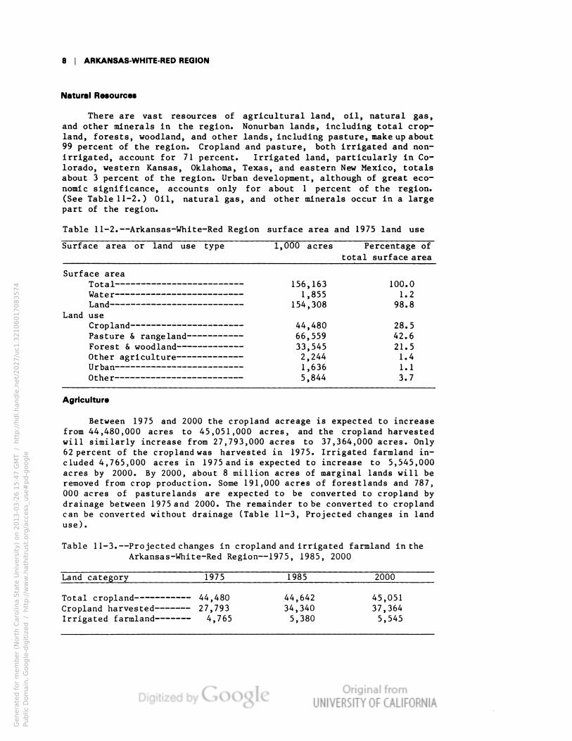
Natural Resources
There are vast resources of agricultural land, oil, natural gas,
and other minerals In the region. Nonurban lands, including total crop-
land, forests, woodland, and other lands, including pasture, make up about
99 percent of the region. Cropland and pasture, both irrigated and non-
irrigated, account for 71 percent. Irrigated land, particularly in Co-
lorado, western Kansas, Oklahoma, Texas, and eastern New Mexico, totals
about 3 percent of the region. Urban development, although of great eco-
nomic significance, accounts only for about 1 percent of the region.
(See Table 11-2.) Oil, natural gas, and other minerals occur in a large
part of the region.
Table 11-2.—Arkansas-White-Red Region surface area and 1975 land use
Surface area or land use type l,000 acres Percentage of
total surface area
Surface area
Total
156,163
100.0
Water
1,855
1.2
Land
154,308
98.8
use
44,480
28.5
Pasture & rangeland
66,559
42.6
33,545
21.5
2,244
1.4
Urban
1,636
1.1
Other
5,844
3.7
Agriculture
Between 1975 and 2000 the cropland acreage is expected to increase
from 44,480,000 acres to 45,051,000 acres, and the cropland harvested
will similarly increase from 27,793,000 acres to 37,364,000 acres. Only
62 percent of the cropland was harvested in 1975. Irrigated farmland in-
cluded 4,765,000 acres in 1975 and is expected to increase to 5,545,000
acres by 2000. By 2000, about 8 million acres of marginal lands will be
removed from crop production. Some 191,000 acres of forestlands and 787,
000 acres of pasturelands are expected to be converted to cropland by
drainage between 1975 and 2000. The remainder to be converted to cropland
can be converted without drainage (Table 11-3, Projected changes in land
use).
Table 11-3.—Projected changes in cropland and irrigated farmland in the
Arkansas-White-Red Region—1975, 1985, 2000
Land category
1975
1985
2000
Total cropland
44,480
44,642
45,051
Cropland harvested
27,793
34,340
37,364
Irrigated farmland
4,765
5,380
5,545
Genera
ted f
or
mem
ber
(Nort
h C
aro
lina S
tate
Univ
ers
ity)
on 2
01
3-0
3-2
6 1
5:4
7 G
MT /
htt
p:/
/hdl.handle
.net/
20
27
/uc1
.32
10
60
17
08
35
74
Public
Dom
ain
, G
oog
le-d
igit
ized
/
htt
p:/
/ww
w.h
ath
itru
st.o
rg/a
ccess
_use
#pd-g
oogle

VOLUME 4 | 9
Energy
In 1975, a total of 72,816 gWh of electric energy was produced, of
which 84 percent was produced by fossil fuel steam electric plants and
the remainder by hydroelectric generating plants and one nuclear plant.
By 2000, eight new nuclear plants are projected to be in operation, plus
46 fossil fuel steam electric plants. With the existing hydroelectric
generating stations, this will bring the combined energy output to 404,432
gWh. The relative energy production from fossil fuels and from nuclear
plants in 1975 and 2000 is shown in Table 11-4. Water consumption in the
steam electric plants, currently 89 mgd, will increase by 513 percent
to 457 mgd. Because of the large amount of water required for cooling,
steam condensers are commonly employed in the evaporative cooling towers
or ponds in the thermal generating stations to allow the cooling water
to be recirculated.
All new steam electric generating stations in the region will utilize
evaporative cooling towers or ponds to cool and recycle their cooling
waters. As a consequence, discharge of heat to surface waters from these
generating stations is only 13 trillion Btu per year and will decrease
to 12 trillion Btu per year by 2000.
The use of cooling towers or ponds by manufacturers is projected to
decrease their thermal discharges to surface waters from the present 21
trillion Btu per year to 2.8 trillion by 2000.
Table 11-4.—Arkansas-White-Red Region electric power generation—1975,
1985, 2000
(gigawat t-hours)
Fuel source
1975
1985
2000
Fossil
60,877
115,400
101,570
Nuclear
4,878
43,810
296,900
Conventional hydropower—
7,061
5,829
5,962
Total generation
72,816
165,039
404,432
Navigation
The McClellan-Kerr Arkansas River program, involving navigation, re-
creation, flood control, power developments, and the construction of 17
dams and locks in Arkansas and Oklahoma was completed in 1971 as far
as Catoosa, Oklahoma, near Tulsa. This program has opened the lower
Arkansas River to commercial navigation as part of the Nation's inland
waterway system in the Mississippi Valley. Other navigation in the region
occurs on the lower White River in Arkansas and on the Red River in
Louisiana, Texas, and Oklahoma. In 1975 waterborne commerce was 5.2
million tons on the Arkansas River, 1.5 million tons on the Red River,
and 0.7 million tons on the White River. The Red River also connects with
the Mississippi River navigation system. Improvement of these systems,
particularly on the lower Red River, is expected to help economic growth
along the waterways (see Figure 11-3).
Environment
This region is an enormous storehouse of historic and archeological
sites. Many facilities are provided for fishing, hunting, and recreation,
Genera
ted f
or
mem
ber
(Nort
h C
aro
lina S
tate
Univ
ers
ity)
on 2
01
3-0
3-2
6 1
5:4
7 G
MT /
htt
p:/
/hdl.handle
.net/
20
27
/uc1
.32
10
60
17
08
35
74
Public
Dom
ain
, G
oog
le-d
igit
ized
/
htt
p:/
/ww
w.h
ath
itru
st.o
rg/a
ccess
_use
#pd-g
oogle

10 I ARKANSAS-WHITE-RED REGION
Genera
ted f
or
mem
ber
(Nort
h C
aro
lina S
tate
Univ
ers
ity)
on 2
01
3-0
3-2
6 1
5:4
7 G
MT /
htt
p:/
/hdl.handle
.net/
20
27
/uc1
.32
10
60
17
08
35
74
Public
Dom
ain
, G
oog
le-d
igit
ized
/
htt
p:/
/ww
w.h
ath
itru
st.o
rg/a
ccess
_use
#pd-g
oogle

VOLUME 4 | 11
Genera
ted f
or
mem
ber
(Nort
h C
aro
lina S
tate
Univ
ers
ity)
on 2
01
3-0
3-2
6 1
5:4
7 G
MT /
htt
p:/
/hdl.handle
.net/
20
27
/uc1
.32
10
60
17
08
35
74
Public
Dom
ain
, G
oog
le-d
igit
ized
/
htt
p:/
/ww
w.h
ath
itru
st.o
rg/a
ccess
_use
#pd-g
oogle
12 | ARKANSAS-WHITE-RED REGION
and growing demand creates a need for more. All of the States have
established parks, properties, and areas for recreation.
Figure 11-4 shows some of the recreation facilities in the State of
Arkansas. A complete list of facilities for the whole region is not
available, but the data for one State, Arkansas, indicate the extent of
local and State concern for the environment. Arkansas constitutes 11
percent of the region in subregions 1101 and 1107.
Arkansas has listed 86 significant properties for the National Register
of Historic Places. The State has numerous prehistoric sites where fossils
are found. There are also many caverns and scenic highways. Twelve State
parks exist in this portion of Arkansas, and more than 67,000 acres of
fishing, hunting, and boating waters. Nine endangered animal species
have been identified.
The NF data show that there are now five designated wilderness areas
compromising 70,000 acres, and another 14 areas have been identified
as potential wilderness areas. Also, the Bureau of Outdoor Recreation
has identified 12 areas of critical environmental concern, and the Nation-
al Park Service has identified 59 such areas. Five endangered species
thus far have been identified as residents of this region, and are
seriously threatened by disturbances to their habitats. Some 440 miles
of nationally significant streams for fish and wildlife have been desig-
nated.
The quality of water in streams, rivers, and their impoundments var-
ies widely. Quality is generally high in the headwaters of the west
and northeast subregions, but deteriorates severely in the middle subre-
gions due to scant streamflows and inflows from naturally saline springs
and seepages, irrigated fields, and urban and industrial centers. Fifty-
five percent of the total stream mileage (about 35,000 miles) has been
estimated as not meeting water quality standards for industry and muni-
cipalities. There is improvement in water quality as the streams enter
and pass through the Ozark Plateau, but in general, the outflows from
the region are of high salinity. An exception to this is subregion 1101,
the White River, where water quality is good to excellent throughout
most of the subregion.
Ground-water quality generally is good throughout most of the region
where the major aquifers are utilized as a source of water. There are
several local quality problems. Excessive pumping from some aquifers is
increasing salinity in some aquifers, a source of concern to many people.
Water
All of the data collected and projected in the region are for the
purpose of assessing the water situation and current and potential problems
related to water and its use. The water withdrawals and consumptive data
are for average-year conditions unless otherwise stated.
Genera
ted f
or
mem
ber
(Nort
h C
aro
lina S
tate
Univ
ers
ity)
on 2
01
3-0
3-2
6 1
5:4
7 G
MT /
htt
p:/
/hdl.handle
.net/
20
27
/uc1
.32
10
60
17
08
35
74
Public
Dom
ain
, G
oog
le-d
igit
ized
/
htt
p:/
/ww
w.h
ath
itru
st.o
rg/a
ccess
_use
#pd-g
oogle
VOLUME 4 | 13
Subregion 1102
Subregion 1103
155 MGD
4,280 MGD
Subregion 1105
3,540 MGD
Subregion 1104
Subregion 1106
2,320 MGD
19,700 MGD
27,000 MGD
Subregion 1107
15,900 MGD Subregion 1101
62.6 BGD
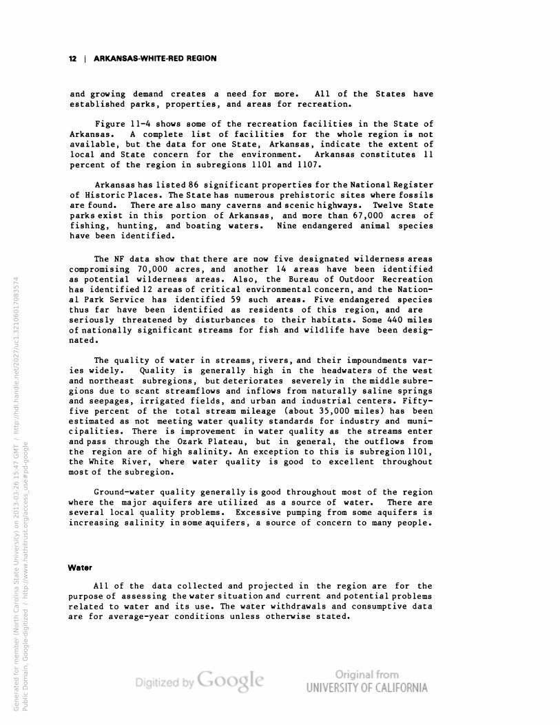
Figure 11-5. Streamflow
Surface Flow
The total surface flow from the region in an average year is 62.6
billion gallons per day (bgd) (70.1 million acre-feet per year). In a
dry year this flow would be reduced to about 37.4 bgd. There are many
years when less than the dry-year estimated flows occurs, particularly
in the western and central portions of the region. Extremely low flows
often occur during the late summer and fall. However, due to thunderstorms
and variations from the normal, floods or droughts may occur at the ex-
tremes of otherwise normal conditions. Planning for water supply should
be on an extremely conservative basis, and planning for floods should
be on an opposite basis, with water supply modified by holdover storage.
Figure 11-5 illustrates 1975 flows in the Arkansas-White-Red Region
based on average conditions of record.
Genera
ted f
or
mem
ber
(Nort
h C
aro
lina S
tate
Univ
ers
ity)
on 2
01
3-0
3-2
6 1
5:4
7 G
MT /
htt
p:/
/hdl.handle
.net/
20
27
/uc1
.32
10
60
17
08
35
74
Public
Dom
ain
, G
oog
le-d
igit
ized
/
htt
p:/
/ww
w.h
ath
itru
st.o
rg/a
ccess
_use
#pd-g
oogle

14 | ARKANSAS-WHITE-RED REGION
While the outflow from the region as displayed in Figure 11-5 pro-
vides an impression of a relatively water-abundant region, the quantity of
surface water available in the west and central portions and the surface
water quality over much of the region are inadequate for satisfying many
requirements. This is particularly true for the Colorado plains and in
the High Plains area from Kansas through Oklahoma, New Mexico, and Texas.
An average 158 mgd are imported to the Arkansas River in Colorado from
the Upper Colorado River. Streamflows are scant in the western parts of
the region due to diversions for irrigation, and quality is impaired
by high salinity introduced by naturally alkaline soils, irrigation re-
turn flows, natural brine inflows, and occasional inflows of oil field
brines.
Water is a major input to most of the manufacturing sector's oper-
ations, and it is estimated that the gross in-plant water use of the
sector in 1975 is equivalent to withdrawals of 4,027 mgd. But manufac-
turers in the region are among the most efficient water users in the Nation.
Through reuse and recycling of water and treated effluents, the region's
manufacturing sector in 1975 managed to meet their water needs by with-
drawing only 713 mgd. This success is due mainly to the extremely effi-
cient use of water by the region's petroleum refiners, who, on the aver-
age, reused or recycled their withdrawals nearly 28 times before dis-
charge .
In the lower Arkansas and Red Rivers, the flows are ample in quan-
tity, but the high salinity of their waters, particularly during periods
of low flows, limits their uses. In those areas, domestic water systems
and industrial users generally obtain water from wells rather than from
the rivers. There are, however, tributary streams of the Arkansas and
Red Rivers that have reliable flows of good quality water, some of which
is withdrawn for local uses. The State of Oklahoma proposes to develop
several of the tributary streams to transfer water to the Oklahoma City
and Tulsa metropolitan areas for domestic and industrial uses.
Ground Water
Ground-water resources in the High Plains area of Colorado, Kansas,
Oklahoma, New Mexico, and Texas are highly developed for irrigation and
municipal uses. Ground water from the alluvial valleys of the Arkansas,
Red, and White Rivers are also fairly well developed, partly for irrigation
and for municipal and industrial purposes. Withdrawals of ground water
from the High Plains, or Ogallala Formation, exceed the recharge from
precipitation in some of the areas, resulting in serious declines in water
levels. This portends very serious problems to the irrigation economy in
portions of the highly-developed areas, with the problems increasing as
pumping continues to exceed recharge (see Figure 11-6).
Genera
ted f
or
mem
ber
(Nort
h C
aro
lina S
tate
Univ
ers
ity)
on 2
01
3-0
3-2
6 1
5:4
7 G
MT /
htt
p:/
/hdl.handle
.net/
20
27
/uc1
.32
10
60
17
08
35
74
Public
Dom
ain
, G
oog
le-d
igit
ized
/
htt
p:/
/ww
w.h
ath
itru
st.o
rg/a
ccess
_use
#pd-g
oogle

VOLUME 4 | 1E
Genera
ted f
or
mem
ber
(Nort
h C
aro
lina S
tate
Univ
ers
ity)
on 2
01
3-0
3-2
6 1
5:4
7 G
MT /
htt
p:/
/hdl.handle
.net/
20
27
/uc1
.32
10
60
17
08
35
74
Public
Dom
ain
, G
oog
le-d
igit
ized
/
htt
p:/
/ww
w.h
ath
itru
st.o
rg/a
ccess
_use
#pd-g
oogle
16 | ARKANSAS-WHITE-RED REGION
Water Withdrawals
Total water withdrawn from streams and ground water in 1975 averaged
about 12.9 bgd distributed as shown in Figure 11-7. Irrigation presently
withdraws about 78 percent of this water, which is used on about 3 percent
of the total land area. Irrigation in 1975 included about 17 percent of
the total harvested cropland acreage. Withdrawals for irrigation are ex-
pected to increase until after 1985 but decrease to less than the present
acreage by 2000.
The percentage of steam electric generation withdrawals is expected
to more than double by 2000, as shown in Figure 11-7. Minerals and domestic
withdrawals by 2000 are estimated to increase by one-fourth. A 33 percent
decline in withdrawals for manufacturing is expected by 2000, while the
actual consumption is forecast to more than double due to increased manu-
facturing activities. Irrigation withdrawals are forecast in the NF data
to decline from 9,980mgdin 1975 to about 9,776mgdin 2000. However, the
States of the region forecast that there will be about a 60 percent increase
in total irrigation withdrawals from 1975 to 2000.
Water Consumption
Total water consumption in 1975 was estimated to be 8,064 mgd dis-
tributed as shown in Figure 11-7. Irrigation accounted for 87 percent of
the total. Domestic and other uses accounted for 8 percent of the total.
Manufacturing and mineral uses each consumed about 2 percent, and steam
electric, 1 percent of the total consumptive use.
By 2000, the total consumption in the region is estimated to increase
about 10 percent, bringing the total to 8,886 mgd distributed as shown on
Figure 11-7. Contributing to this projected increase in consumption are:
manufacturing, which is expected to double; steam electric power genera-
tion, which is forecast to increase more than five times; and small increases
in consumption by domestic, minerals, and other sectors.
Irrigation consumption, on the other hand, is forecast in the NF data
to be about one percent higher in 2000 than in 1975. The States of the
region estimate that irrigation consumptive use will increase about 73
percent from 1975 to 2000. Reservoir and pond evaporation is an addi-
tional depletion not included in the percentages above.
Instream Uses
There are excellent instream recreation and fish and wildlife uses in
the mountains of Colorado and New Mexico and in the central and eastern
areas of the region where natural streamf lows are often adequate. Many of
the streams between the mountains and the central portion of the region
go dry for sustained periods due to lack of rain.
Genera
ted f
or
mem
ber
(Nort
h C
aro
lina S
tate
Univ
ers
ity)
on 2
01
3-0
3-2
6 1
5:4
7 G
MT /
htt
p:/
/hdl.handle
.net/
20
27
/uc1
.32
10
60
17
08
35
74
Public
Dom
ain
, G
oog
le-d
igit
ized
/
htt
p:/
/ww
w.h
ath
itru
st.o
rg/a
ccess
_use
#pd-g
oogle

VOLUME 4 | 17
ANNUAL FRESHWATER WITHDRAWALS
ANNUAL FRESHWATER CONSUMPTION
1975 2000
Total Consumption — 8,064 MGD Total Consumption — 8,887 MGD
Figure 11-7. Withdrawals and Consumption
Genera
ted f
or
mem
ber
(Nort
h C
aro
lina S
tate
Univ
ers
ity)
on 2
01
3-0
3-2
6 1
5:4
7 G
MT /
htt
p:/
/hdl.handle
.net/
20
27
/uc1
.32
10
60
17
08
35
74
Public
Dom
ain
, G
oog
le-d
igit
ized
/
htt
p:/
/ww
w.h
ath
itru
st.o
rg/a
ccess
_use
#pd-g
oogle
18 | ARKANSAS-WHITE-RED REGION
Eastern streams of the region, particularly in the Ozark Plateau
portion of the Arkansas and White Rivers and in the lower Red River,
generally have sustained flows supporting instream recreation and fish
and wildlife uses as well as boating, navigation, hydroelectric power
generation, and waste disposal.
Storage reservoirs created throughout the region primarily for flood
control, irrigation, power, navigation, and other uses provide much needed
recreation areas, and fish and wildlife habitats. They also provide
some streamflow regulation that enhances the instream flow needs of the
region.
Water Supply and Demand
Outflow from the Arkansas, White, and Red Rivers is fairly substan-
tial on the average, giving the impression that the region has an ade-
quate supply of water. This is true in normal water periods in the
eastern parts of Kansas, Oklahoma, and Texas, and in all of Missouri,
Arkansas, and Louisiana. However, even in these areas, general or local
droughts and cyclical changes in streamflow may cause water shortages
that are usually of short duration. The upper Arkansas River in Colorado,
New Mexico, western Kansas, and western Oklahoma usually has water short-
ages every year, as does the upper Red River in eastern New Mexico and
western Texas.
Water supply is adversely affected by the quality of surface water,
particularly in the west and central portions of the region where it
is inadequate for satisfying many requirements. Streamflows are scant
due to diversions for irrigation, and quality is impaired by high salinity
introduced by naturally alkaline soils, irrigation return flow, natural
brine inflows, and occasionally by inflows of oil field brines.
Imports of about 177,000 acre-feet annually ( 158 mgd) into the upper
Arkansas River in Colorado from the Colorado River Region partly allevi-
ate the water supply problem in Colorado.
Groundwater is pumped from the alluvial channels and from the High
Plains of Colorado, Kansas, Oklahoma, New Mexico, and Texas to meet about
one-half of the withdrawal requirements of the region. Since present
withdrawals of ground water exceed the recharge rates in portions of the
High Plains, it is evident that water supply problems in the western por-
tions of the region will become more severe in the near future.
Comparative Analysis (SRF/NF)
Table 11-5 compares the National Future (NF) and State-Regional Fu-
ture (SRF) estimates of streamflows and water needs in the Arkansas-
White-Red Region. SRF data was developed and adopted by consensus of
the membership of the Arkansas-White-Red Interagency Committee.
Genera
ted f
or
mem
ber
(Nort
h C
aro
lina S
tate
Univ
ers
ity)
on 2
01
3-0
3-2
6 1
5:4
7 G
MT /
htt
p:/
/hdl.handle
.net/
20
27
/uc1
.32
10
60
17
08
35
74
Public
Dom
ain
, G
oog
le-d
igit
ized
/
htt
p:/
/ww
w.h
ath
itru
st.o
rg/a
ccess
_use
#pd-g
oogle

VOLUME 4 | 19
Table 11-5—Socioeconomic and volumetric data summary: the Arkansas-White-Red
Reg ion
"1975"
1985
2000
Cateqory
NF
SRF
NF
SRF
NF
SRF
SOCIOECONOMIC DATA (1000)
Total population
6,846
7,350
7,268
8,321
7,815
9,819
Tota1 emp1oyment
2,670
1,565a
2,987
1,966a
3,369
2,530a
VOLUMETRIC DATA (mgd)
-Base conditions-
Tota1 streamf1ow
65,207
NE
65,207
NE
65,207
NE
Streamflow at outflow
point(s)
62,600
62,605
56,192
NE
55,896
NE
Fresh-water withdrawals
12,868
13,551
13,799
16,434
13,337
22,622
Agr icu1ture
10,195
9,827
10,721
1 1,737
10,055
16,056
Steam electric
498
1,297
1,026
2,032
1,012
3,233
Manufacturing
713
956
476
989
480
1,268
Domest i c
735
1,060
807
1,321
894
1,645
Commerc i a 1
210
b
221
b
238
b
Mi neraIs
448
200
469
142
571
206
Public lands
26
30
33
32
39
36
Fish hatcheries
43
NE
46
NE
48
NE
Other
0
180
0
177
0
178
Fresh-water consumption
8,064
9,433
8,769
11,611
8,887
16,405
Agr i cu1ture
7,263
8,379
7,706
10,221
7,404
14,422
Steam electric
89
126
237
285
457
577
Manufactur ing
165
347
232
407
360
562
Domest i c
179
466
305
591
331
Commerc i a 1
69
b
72
b
78
b
MineraIs
173
70
184
67
218
90
Public lands
26
27
33
30
39
34
Fish hatcheries
0
NE
0
NE
0
NE
Other
0
17
0
10
0
10
Ground-Water withdrawals
8,846
6,968
NE
NE
NE
NE
Evaporation
2,615
10,179c
2,910
11,330c
3,111
12,388c
Instream approximation
Fi sh and wi1d1i fe
46,169
NE
46,169
NE
46,169
NE
NE-Not estimated.
a Total includes only subregions 1101,
1102, 1105
, 1106,
and 1107.
Data were
not
available for subregions 1103 and 1104.
SRF domestic water use includes commercial and institutional requirements.
Total does not include subregion 1102 for which data were not available.
Genera
ted f
or
mem
ber
(Nort
h C
aro
lina S
tate
Univ
ers
ity)
on 2
01
3-0
3-2
6 1
5:4
7 G
MT /
htt
p:/
/hdl.handle
.net/
20
27
/uc1
.32
10
60
17
08
35
74
Public
Dom
ain
, G
oog
le-d
igit
ized
/
htt
p:/
/ww
w.h
ath
itru
st.o
rg/a
ccess
_use
#pd-g
oogle

20 | ARKANSAS-WHITE-RED REGION
The SRF data have been developed to reflect records and estimates
of the eight States of the region. The records from Colorado, Kansas,
Oklahoma, New Mexcio, and Texas are pertinent to the administration of
water rights under the Doctrine of Prior Appropriation. Accordingly,
the SRF data on withdrawals and consumptive use in these five States
must be considered. In a number of cases, SRF data on irrigation con-
sumptive use and withdrawals differ substantially from NF data. Although
the region's problems are, for the most part, identified in both data
sources, the severity of some problems appears greater in the SRF esti-
mates.
SRF estimates of manufacturing and steam electric water withdrawals
and consumption are consistently larger than the corresponding NF figures.
The NF data show a greater proportion of water use in the minerals cate-
gory than do those of regional sources.
Genera
ted f
or
mem
ber
(Nort
h C
aro
lina S
tate
Univ
ers
ity)
on 2
01
3-0
3-2
6 1
5:4
7 G
MT /
htt
p:/
/hdl.handle
.net/
20
27
/uc1
.32
10
60
17
08
35
74
Public
Dom
ain
, G
oog
le-d
igit
ized
/
htt
p:/
/ww
w.h
ath
itru
st.o
rg/a
ccess
_use
#pd-g
oogle
VOLUME 4 | 21
Problems
The total water supply versus water use in the region on a whole dur-
ing average years appears to be balanced, but, even under average con-
ditions, this is not the case for portions of the region. Accordingly,
there are water supply and water quality problems in about one-half of
the region in practically every year. These problems affect the economic
well-being of the people and environment of the region. The problems
have been identified by representatives of the eight States and by Federal
participants in this assessment.
High Plains Ground-Water Irrigation
One large and severe problem covering portions of Colorado, Kansas,
Nebraska, New Mexico, Oklahoma, and Texas and the three assessment reg-
ions—Missouri, Arkansas-White-Red, and Texas-Gulf—emerges on the High
Plains. This is known as the High Plains or Ogallala ground-water irri-
gation problem in which private irrigation withdrawals in portions of the
area exceed recharge rates.
The use of large aquifers has created one of the world's large irri-
gated areas during the past few decades. Each year some of the wells
must be deepened and pumps set lower to reach the water. The costs of
pumping rise accordingly. In addition, the cost of energy to operate
the pumps is increasing, which escalates the water costs. Also, the
quality of the ground water declines as the aquifer becomes dewatered,
and, in some portions of the region, the water has become unsuitable
for domestic use. This may eventually have a serious negative impact
on the economy of the area.
Water Quality
Water quality is good in the headwaters of the Arkansas, Canadian,
and Red Rivers and their major tributaries, but the quality deteriorates
rapidly when the streams enter the high western plains of the region.
There the rivers flow through highly erodible and frequently alkaline
soils, and inflows from natural salt springs, irrigation return flows,
runoff from urban areas and farmlands, and from municipal and industrial
discharges degrade the quality of water, making it unsuitable for many
uses. For example, the Arkansas River, fed by melting snows from the
Rocky Mountains, enters the plains of eastern Colorado below Pueblo with
about 400 mg/1 of dissolved solids. By the time it has passed through the
irrigated Colorado farmlands to enter Kansas, the dissolved solids are
frequently as high as 3,500 mg/1, and its use for irrigation is limited
to salt-tolerant crops. Additional inflows from fields irrigated by ground
water used to supplement or replace the waters of the river system enter
the mainstream. Dissolved solids are concentrated by evaporation in
the river and reservoirs, and natural salt springs discharge into the
river and its tributaries. During very low flow periods, concentrations
Genera
ted f
or
mem
ber
(Nort
h C
aro
lina S
tate
Univ
ers
ity)
on 2
01
3-0
3-2
6 1
5:4
7 G
MT /
htt
p:/
/hdl.handle
.net/
20
27
/uc1
.32
10
60
17
08
35
74
Public
Dom
ain
, G
oog
le-d
igit
ized
/
htt
p:/
/ww
w.h
ath
itru
st.o
rg/a
ccess
_use
#pd-g
oogle

22 | ARKANSAS-WHITE-RED REGION
of dissolved solids have been recorded for short times as high as 60,000
mg/l, nearly twice the 35,000mg/lof dissolved solids in sea water.
Water is being completely utilized, and quantity of usable water
is the limiting factor in the central portion of the region. The gen-
erally poor quality of water in these rivers during low flow periods
and the sparsity of streams in the prime agricultural lands in the west
and central portion of the region have resulted in dependence on the
ground-water aquifers from which, in the High Plains (Ogallala Formation),
water is being withdrawn at rates well in excess of natural recharge.
The quality of the mainstream flows in the lower reaches improves
through inflows of good quality water from tributaries. In the lower
reaches, surface water from the tributaries and ground water provide
opportunities for development of good quality water for areas in criti-
cal need.
Erosion and Sedimentation
Erosion and sediment loads are excessive in all of the rivers par-
ticularly during spring snowmelt, after heavy rains, and during the ir-
rigation season. Most of the sediment results from sheet erosion from
grazing lands, farmlands, and urban areas and from the steep slopes of
the Ozark Plateau. Sediment clogs channels and induces flooding, destroys
wildlife habitats, reduces storage capacity of reservoirs, interferes with
navigation and other instream uses, increases costs of treatment for off-
stream uses, and presents problems in disposal once it is diverted from
the stream.
Soil erosion is most severe in subregions 110l, l104, and 1107,
where average erosion rates are 2l, 9, and l2 tons per cropland acre
per year. For the region as a whole, however, erosion rates will average
6 tons per acre per year in 1985, and 2 tons per acre per year in 2000
when subregional average losses will range from a low of l ton to a
high of 5 tons per acre per year. The reductions in soil losses are
projected to result from improved water and land management and from
the removal of nearly 8 million acres of marginal lands from crop produc-
tion.
While present rates of erosion are high in many parts of the region
better management of the lands under cultivation and the water applies
to them can reduce the losses of soils to the rivers. Data in the NF
projections indicate that this will occur, but these projections will
be achieved only with rigorous practice of soil conservation management
techniques.
Flooding
Flood damages occur in the region at a current average annual rate
of about $234 million and are projected to increase about 29 percent by
2000. Damages to agriculture account for $l46 million, distributed re-
Genera
ted f
or
mem
ber
(Nort
h C
aro
lina S
tate
Univ
ers
ity)
on 2
01
3-0
3-2
6 1
5:4
7 G
MT /
htt
p:/
/hdl.handle
.net/
20
27
/uc1
.32
10
60
17
08
35
74
Public
Dom
ain
, G
oog
le-d
igit
ized
/
htt
p:/
/ww
w.h
ath
itru
st.o
rg/a
ccess
_use
#pd-g
oogle
VOLUME 4 | 23
latively evenly throughout the subregions. Urban area flood damages now
average slightly more than $39 million annually, with most occurring in
Colorado, eastern Kansas, eastern Oklahoma, Missouri, and Arkansas. Flood
damages to urban areas are projected to increase 69 percent by 2000 as a
consequence of growth in population and investment values in the flood-
prone zones.
Urban damages occur principally along the mainstreams. The U.S. Army
Corps of Engineers has underway, or proposed, urban area studies of which
flood control is an integral part at Tulsa, Wichita, Pine Bluff, Fort
Smith, and Little Rock. The recommendations that develop from those
studies for reducing losses will undoubtedly emphasize nonstructural
methods, such as flood-plain zoning and management. Structural solutions
in the west-central parts of the region, if reservoirs are included, can
help to reduce losses without aggravating the salinity problems. Under
appropriate design and operating conditions, evaporation in a flood con-
trol reservoir can be insignificant if the retention time of flood flows
is limited. Channelization of the rivers is likely to provoke serious
environmental objections because of destruction of critical water and land
habitats for wildlife.
Water Quantity
The larger cities and metropolitan areas of the region face increas-
ing difficulties and rising costs in obtaining reliable supplies of water
to deliver to their residential, commercial, and industrial service areas.
High salinity in the mainstream flows of the Arkansas, Cimarron, Canadian,
and Red Rivers and many of their tributaries precludes their use as sources
of potable water. Ground-water supplies, although generally suitable as
the source for smaller cities and towns, are difficult and costly to
develop for supplying larger population centers, whose very large require-
ments would necessitate the development and operation of numerous wells
and well fields at scattered locations. Because of the excessive use of
ground water and the threat of depletion of the major aquifers in some
areas of the region, ground water is considered to be unreliable by some
of the larger cities. Subsequent discussion of Problem Area 1 provides
additional insight into ground-water problems.
While mainstream flows of the Arkansas and Red Rivers remain gene-
rally unsuitable for domestic use throughout their lengths, as they ap-
proach their eastern watershed areas a number of tributary streams with
good quality water are encountered. Several of the States and municipali-
ties have developed or proposed for development those streams as water
sources to supply the eastern and central portions of the region. Most
of the State plans are linked with the planning of Federal agencies—
for example, the U.S. Army Corps of Engineers, whose river development
planning and construction programs include reservoirs that intercept and
store large volumes of good quality tributary flows.
Genera
ted f
or
mem
ber
(Nort
h C
aro
lina S
tate
Univ
ers
ity)
on 2
01
3-0
3-2
6 1
5:4
7 G
MT /
htt
p:/
/hdl.handle
.net/
20
27
/uc1
.32
10
60
17
08
35
74
Public
Dom
ain
, G
oog
le-d
igit
ized
/
htt
p:/
/ww
w.h
ath
itru
st.o
rg/a
ccess
_use
#pd-g
oogle
24 | ARKANSAS-WHITE-RED REGION
In the Red River area of eastern Oklahoma, Boggy Creek and Kiamichi
River have good-quality water and excellent reservoir sites, where sev-
eral reservoirs are completed or under construction. Atoka Lake, on Boggy
Creek, is now the major source of supply for Oklahoma City, some 70
miles to the north, and an additional reservoir, McGee, is proposed to
be constructed on the same creek. The Lake Hugo project has been constructed
on the Kiamichi River and is proposed for use to supply additional water
to Oklahoma City; the Clayton Lake project on the same river is under
construction. Two additional reservoir projects, Boswell Lake and Tusk-
ahoma, are proposed for the Kiamichi. Ultimately, the State of Oklahoma
proposes to obtain from those rivers approximately l.5 million acre-feet
of water annually, of which 800,000 acre-feet would be delivered to agri-
cultural areas in western Oklahoma. Six other reservoirs have been proposed
for development on tributaries downstream from Lake Texoma on the Red
River. When developed, those reservoirs would provide additional sources
of good quality water for both Texas and Oklahoma.
Problems of poor-quality water exist in the mainstream flow of the
Arkansas River and its western tributary system east of Colorado, and
few municipal water systems utilize them as sources of water. In western
and central parts of the Arkansas River Basin, the ground-water aquifers
are pumped excessively for irrigation, thus accelerating the decline of
ground-water levels and increasing salinity. There, too, the cities
look eastward for assurance of adequate supplies by development of tribu-
tary streams to the Arkansas River and possibly by transfers of water
from the White River Basin.
A number of reservoir projects have been constructed on tributaries
that drain southeastern Kansas, southwestern Missouri, northwestern Ark-
ansas, and northeast Oklahoma and that enter the Arkansas below Tulsa,
Oklahoma. That city now obtains water from Lake Spavinaw, a smaller tri-
butary, and suggestions have been made that additional water be obtained
from Illinois Creek. These reservoirs are multipurpose in operation,
providing for maintenance of navigation levels in the Arkansas River,
flood control, hydroelectric power, and recreation, in addition to water
supply for municipalities and industry.
The White River Basin is generally free of water quality problems,
and contains a series of large reservoirs for power generation, flood
control, and recreation; however, at present these supply only a minor
amount of water for municipal and industrial (M and I) needs. There is
a surplus of water in this basin when its needs alone are considered.
Therefore, some water could be transferred to areas outside the White River
Basin, where needs cannot otherwise be satisfied.
The three major river systems, the Arkansas, White and Red Rivers,
include portions of seven States and all of Oklahoma in their drainage
basins. Many of the solutions to water supply shortage that involve
alterations in the allocations of their waters will require that agree-
ments, formalized by compacts, be arranged between the States concerned,
with approval of the Congress. A compact covering the lower Red River
is in the formulation stage.
Genera
ted f
or
mem
ber
(Nort
h C
aro
lina S
tate
Univ
ers
ity)
on 2
01
3-0
3-2
6 1
5:4
7 G
MT /
htt
p:/
/hdl.handle
.net/
20
27
/uc1
.32
10
60
17
08
35
74
Public
Dom
ain
, G
oog
le-d
igit
ized
/
htt
p:/
/ww
w.h
ath
itru
st.o
rg/a
ccess
_use
#pd-g
oogle

VOLUME 4 | 25
Water Surface
Water surface for recreation is considered to be in short supply in
Colorado below Pueblo, and in western Kansas, Oklahoma, and Texas. This
is caused mainly by (l) water supply shortages as such and (2) the use of
available water (a good deal of which is consumed and does not return to
the streams) by established water right users in accordance with State
laws.
There is a severe shortage of water areas for water-based hunting,
fishing, and recreation along the Arkansas in Colorado. The present
need is 39,000 acres of water area in subregion 1102; the need is pro-
jected to be 53,000 acres in 2000. The Fryingpan-Arkansas Project and
John Martin Reservoir will provide 9,500 water acres for recreation uses.
Existing privately owned irrigation reservoirs have the capacity to meet
these needs; however, their water levels fluctuate, and they, for the
most part, do not maintain permanent pools. The problem is to develop
permanent pools for public use in these private irrigation reservoirs
through purchase of water and cooperative agreements. Since the direct
beneficiaries of recreation, hunting, and fishing customarily pay little
of the costs for such facilities, the solution to this problem seems
to be for the private water right owners to agree to some plan that
would be financed by the State or Federal Government or both.
Environmental
Many environmental problems in the region threaten to become more
severe with growth in the region and the changes in land use and water
management that appear likely. Among the more severe problems are (1)
the flooding of river bottomland by reservoirs, (2) the added hazards
to some endangered species of conversion of dry lands to irrigated farm-
ing, and (3) the general pressures of growing populations and economic
activities.
Water lost through transpiration by phreatophytic plants is signi-
ficant in subregions ll02, ll03, ll05, and ll06 and some attempts have been
made to control those plants. But removal of phreatophytes, such as
salt cedar, alters the habitat of the white-winged dove and other wild-
life.
Indian Rights
The utilization of the mainstream of the Arkansas River in Oklahoma
may be altered by a court ruling that Indians own the river bed in parts
of the State. Currently, the river is developed and utilized for naviga-
tion of barges between Tulsa and the lower Mississippi River. Extension
of the navigation channel to Wichita, Kansas, has been proposed, but may
not be realized due to uncertainty of maintaining adequate channel depths.
This proposal may also require reconsideration with regard to the vested
interests of the Indians.
Genera
ted f
or
mem
ber
(Nort
h C
aro
lina S
tate
Univ
ers
ity)
on 2
01
3-0
3-2
6 1
5:4
7 G
MT /
htt
p:/
/hdl.handle
.net/
20
27
/uc1
.32
10
60
17
08
35
74
Public
Dom
ain
, G
oog
le-d
igit
ized
/
htt
p:/
/ww
w.h
ath
itru
st.o
rg/a
ccess
_use
#pd-g
oogle

Genera
ted f
or
mem
ber
(Nort
h C
aro
lina S
tate
Univ
ers
ity)
on 2
01
3-0
3-2
6 1
5:4
7 G
MT /
htt
p:/
/hdl.handle
.net/
20
27
/uc1
.32
10
60
17
08
35
74
Public
Dom
ain
, G
oog
le-d
igit
ized
/
htt
p:/
/ww
w.h
ath
itru
st.o
rg/a
ccess
_use
#pd-g
oogle

VOLUME 4 | 27
Individual Problem Areas
The Arkansas-White-Red Basins Interagency Committee has identified
specific areas with urgent problems concerning water and related land re-
sources. For each of these areas, the problems were described and eval-
uated. The problem areas requiring most immediate attention are:
High Plains Ground-water Irrigation (5 States)
Ozarks Area, Subregion 110l, Arkansas
Ozarks Areas, Benton and Washington Counties, Arkansas
Arkansas, Statewide
Arkansas Drainage above Pueblo, Colorado, Subregion 1102
Arkansas Drainage, Pueblo to Kansas-Colorado State Line
Red River Area in Louisiana
Springfield Area, Missouri
Joplin Area, Missouri
Subregion l105, New Mexico
Subregion 1103, Oklahoma
Subregion 1104, Oklahoma
Subregion 1105, Oklahoma
Subregion 1106, Oklahoma
Subregion 1107, Oklahoma
Flooding and Related Problems, Texas
Water Supply & Quality Problems, Texas
Figure ll-8a, shows the location of these areas. A tabulation of
the type of problems found in each problem area is presented in Figure
ll-8b. The figure illustrates the problems identified for each aggregated
subregion by State representatives of the Arkansas-White-Red Basins Inter-
agency Committee and Federal agencies. Summary sheets describing each area,
its problems, and their effects, follow the figure.
Genera
ted f
or
mem
ber
(Nort
h C
aro
lina S
tate
Univ
ers
ity)
on 2
01
3-0
3-2
6 1
5:4
7 G
MT /
htt
p:/
/hdl.handle
.net/
20
27
/uc1
.32
10
60
17
08
35
74
Public
Dom
ain
, G
oog
le-d
igit
ized
/
htt
p:/
/ww
w.h
ath
itru
st.o
rg/a
ccess
_use
#pd-g
oogle

28 | ARKANSAS-WHITE-RED REGION
Genera
ted f
or
mem
ber
(Nort
h C
aro
lina S
tate
Univ
ers
ity)
on 2
01
3-0
3-2
6 1
5:4
7 G
MT /
htt
p:/
/hdl.handle
.net/
20
27
/uc1
.32
10
60
17
08
35
74
Public
Dom
ain
, G
oog
le-d
igit
ized
/
htt
p:/
/ww
w.h
ath
itru
st.o
rg/a
ccess
_use
#pd-g
oogle

VOLUME 4 | 29
ARKANSAS-WHITE-RED REGION (11)
PROBLEM MATRIX
Problem i
Problem issues
0= Identified by Federal Agency
Representatives
X= Identified by
State Regional Representative
No. on map
Name
Water quantity
li
5 8
5 i
5 B
oj £
Subregion 1101
Area
Subregion 1102
Area
Subregion 1103
Area ^
Subregion 1104
Area
Subregion 11Q_5
Area
Subregion 11fl6
Area
Subregion 1107
Area
Upper White
Ozarks Area, Arkansas
Arkansas Statewide
Springfield Area, Missouri
Upper Arkansas
High Plains Ogallala Formation
Arkansas Drainage above Pueblo, Colorado
Arkansas Drainage Pueblo to Kansas Border
Arkansas Cimarron
High Plains Ogallala Formation
Oklahoma
Lower Arkansas
Ozarks Areas, Benton & Washington Counties, Arkansas .
Arkansas Statewide
Joplin Area, Missouri
Oklahoma
Canadian
High Plains Ogallala Formation
New Mexico
Oklahoma
Texas Statewide: Flooding
Small Cities & Rural Communities, Texas
Red Washita
High Plains Ogallala Formation
Oklahoma
Texas Statewide: Flooding
Small Cities and Rural Communities, Texas
Red-Sulphur
Arkansas Statewide
Red River Area. Louisiana
Oklahoma
Texas Statewide: Flooding
Small Cities and Rural Communities, Texas
Figure 11 -8b. Problem Matrix
Genera
ted f
or
mem
ber
(Nort
h C
aro
lina S
tate
Univ
ers
ity)
on 2
01
3-0
3-2
6 1
5:4
7 G
MT /
htt
p:/
/hdl.handle
.net/
20
27
/uc1
.32
10
60
17
08
35
74
Public
Dom
ain
, G
oog
le-d
igit
ized
/
htt
p:/
/ww
w.h
ath
itru
st.o
rg/a
ccess
_use
#pd-g
oogle

30 | ARKANSAS-WHITE-RED REGION
Problem Area : High Plains Ground-Water Irrigation
Description
This problem area covers portions of six States—Colorado, Kansas,
Nebraska, New Mexico, Oklahoma, and Texas—and portions of three assess-
ment regions—Missouri, Arkansas-White-Red, and Texas Gulf. It is located
on the High Plains of southwestern Nebraska, eastern Colorado, western
Kansas, Oklahoma, Texas, and eastern New Mexico. During the past 35
years, private irrigation has developed in the area mainly by pumping
ground water from the Ogallala Formation, where in portions of the area
withdrawals now exceed recharge rates. The whole area includes l3.l
million acres of irrigated land and withdrawals of nearly 20 million
acre-feet of water annually in l975.
In the Arkansas-White-Red Region the total irrigated area in l975
was 4.8 million acres. The withdrawal of water was about ll.2 million
acre-feet annually, of which 6.l million acre-feet was mined ground water.
The economy of the High Plains has grown from this development, and the
lowering of water levels foreshadows difficult times ahead in portions
of the area.
Water Issues
Declining ground-water levels due to irrigation pumping is the main
water issue. Lowering of water levels reduces the yield of wells, and,
in some areas, lowers the quality of water. These effects may jeopardize
the economy of portions of the area in the near future.
Related Issues
Since ground-water irrigation is a significant portion of agriculture
and since agriculture is a significant portion of the whole economy of the
High Plains, the trends in further development of ground water are very
important to everyone concerned. As of l975, the States of Colorado,
Kansas, Oklahoma, New Mexico, and Texas indicate that ground-water develop-
ment in the High Plains will increase by 2000, although portions of the
area are now withdrawing water faster than it is being recharged. The
Ogallala Formation extends over a larger area than is now developed. On
the other hand, the State of Texas indicates that irrigation of the High
Plains may decline by 2000 unless positive action is taken to supplement
water supplies.
In any event, the economies of the entire area relate to the con-
tinued growth or decline of the irrigation development of the High Plains.
Adverse Effects
Each year some of the wells must be deepened and pumps set lower' to
Genera
ted f
or
mem
ber
(Nort
h C
aro
lina S
tate
Univ
ers
ity)
on 2
01
3-0
3-2
6 1
5:4
7 G
MT /
htt
p:/
/hdl.handle
.net/
20
27
/uc1
.32
10
60
17
08
35
74
Public
Dom
ain
, G
oog
le-d
igit
ized
/
htt
p:/
/ww
w.h
ath
itru
st.o
rg/a
ccess
_use
#pd-g
oogle

VOLUME 4 | 31
reach the water; the costs of pumping rise accordingly. In addition,
costs of energy to operate the pumps are increasing, which further esca-
lates water costs. Also, the quality of the ground water declines as
the aquifer becomes dewatered; in some portions of the region, the water
has become unsuitable for domestic use. This will jeopardize the economy
first in those areas where the declining water table makes it unprofitable
for farmers to continue irrigation; thus they will depend on dry farming.
The State of Colorado has estimated that this would reduce the economy
of the area by $58l per acre per year, based on l975 dollars. But the
most severe effect would be the loss of homes and businesses through
bankruptcies and general community decay.
Texas has also estimated the adverse effects through loss of ground-
water irrigation. Texas estimates that a decline in water below the l975
level in the region will total l5. 3 million acre-feet in the next 25 years,
resulting in production losses amounting to $999.l million from l975 to
2000. This is a direct loss in marketing crops. It is estimated to result
in a loss of l59,000 jobs over the State both in agriculture and in other
businesses that directly or indirectly service agriculture. The produc-
tion losses are estimated to reduce statewide personal income by $l.6
billion over the same period.
Problem Area : Ozarks Area, Subregion 1101, Arkansas
Description
This area includes fourteen north Arkansas counties, all of which lie
in the White River Basin. One problem issue extends into Problem Area
3, which includes Benton and Washington Counties. The total area is
7,8ll square miles. Terrain is generally hilly, but with local relief
seldom exceeding 200 feet. However, the southeastern portion of the area
extends into the Boston Mountains, where local reliefs of l,600 feet are
common and extreme stream dissection has resulted in deep valleys and
steepsided mountains.
About l66,000 people were living in the area in l975, and the popu-
lation is growing. Increases in population have resulted in part from
an influx of retired persons into developments near the many excellent
fishing lakes. Tourism also has been a major industry in northern Ar-
kansas.
Water Issues
There is a lack of data on ground water for domestic and municipal
uses. Because of the low population density, individual wells are fre-
quently the only feasible sources for rural domestic and livestock water.
Smaller towns and communities must also depend upon ground-water supplies
because the high cost of reservoir developments cannot be financed by the
small number of users.
Genera
ted f
or
mem
ber
(Nort
h C
aro
lina S
tate
Univ
ers
ity)
on 2
01
3-0
3-2
6 1
5:4
7 G
MT /
htt
p:/
/hdl.handle
.net/
20
27
/uc1
.32
10
60
17
08
35
74
Public
Dom
ain
, G
oog
le-d
igit
ized
/
htt
p:/
/ww
w.h
ath
itru
st.o
rg/a
ccess
_use
#pd-g
oogle

32 | ARKANSAS-WHITE-RED REGION
Lack of detailed ground-water inventories makes the search for water
a hit or miss proposition. Efforts of planners who attempt to develop
regional and local water supplies are crippled by this lack of knowledge.
The fact that adequate funds are not available makes it imperative that
funds be used to develop expensive surface water supplies first in areas
known to have insufficient ground water.
Plans for the Carroll-Boone Water Distribution District are well
underway and being funded. This project involves pumping water from
Beaver Lake across two counties to towns on the very banks of Bull Shoals
Lake. However, authority is lacking for the use of the Bull Shoals project
for water regulation. As a result, a greater financial burden has been
placed on people in the area.
Conflicts have arisen concerning interstate flows on the Black River
due to lack of an interstate compact. As development occurs, more frequent
difficulties are sure to arise.
Adverse Effects
Since no detailed inventory of ground-water resources exists, accurate
predictions of yield and depth of water are impossible for most locations.
Several reports describing ground-water supplies have been generated;
however, they are not comprehensive.
Bull Shoals Lake, which has over 3 million acre-feet of normal storage,
has no legal provision for extraction of municipal water. This growing
area must have water to meet the growing needs of industry and people.
Without reservoir regulations, the cheapest source of water often is
not available. As mitigation for loss of warm-water habitat incurred
when the White River reservoirs were built, trout fisheries were established
in the cold tailwaters below Bull Shoals, Beaver, and Table Rock Lakes.
During periods of low power demand and high ambient temperature, the flow
of cold water from the depths of the lakes is sometimes insufficient to
maintain the low temperatures required by trout.
The lack of an interstate compact adversely effects both Arkansas and
Missouri in the development of tourism as well as industry in the Ozarks
region.
Problem Area : Ozarks Area, Benton and Washington Counties, Arkansas
Description
Washington and Benton Counties constitute this area. Washington
County is primarily drained by tributaries of the Grand Neosho River,
which discharges into the Arkansas River. Most streams in Benton County
drain into the White River. The total area is 1,849 square miles.
Genera
ted f
or
mem
ber
(Nort
h C
aro
lina S
tate
Univ
ers
ity)
on 2
01
3-0
3-2
6 1
5:4
7 G
MT /
htt
p:/
/hdl.handle
.net/
20
27
/uc1
.32
10
60
17
08
35
74
Public
Dom
ain
, G
oog
le-d
igit
ized
/
htt
p:/
/ww
w.h
ath
itru
st.o
rg/a
ccess
_use
#pd-g
oogle

VOLUME 4 | 33
Approximately two-thirds of the area is within the Ozark Plateau
Province. Terrain in this section is hilly, but extensive level areas
occur in both counties. Elevation ranges from 500 to 1,500 feet. Local
relief seldom exceeds 300 feet. In 1975 the population was l46,653
and is expected to double by 2000. In l975 a total of 23.4 mgd (million
gallons per day) of water was used; about one-third of this was from ground
water and two-thirds from surface water. The major economic income was
from agriculture, manufacturing, and tourism in 1975.
Water Issues
There is a lack of data on groundwater. A small research project by
the University of Arkansas revealed that, in the area included in the study,
80 percent of the ground-water sources tested were polluted with coliform.
The study encompassed l00 square miles and results indicate that 90 per-
cent of the area may be affected. If the same proportion of the entire
carbonate area is affected, 1,231 square miles of the fastest growing area
in the State is subject to ground-water pollution.
Each year, backwater flooding occurs along the rivers, causing losses
amounting to millions of dollars per year. Unless flooding is controlled,
these losses will continue and will increase as development and property
values increase. At present, development of land is taking place without
adequate regard to possible damage to or contamination of aquifer recharge
areas.
Adverse Effects
Contamination of aquifer recharge areas occurs partly because of lack
of knowledge of recharge areas and their susceptibility to contamination.
In the worst possible case, almost all users of ground water could even-
tually be affected in some degree by lowered water quality. The number of
users could total 255,660 persons.
Problem Area : Arkansas, Statewide
Description
This area includes the entire State of Arkansas. Major drainage is
by the Arkansas, White, Red, Ouachita, and St. Francis Rivers. The total
land area is 53,l02 square miles. The terrain varies from flat delta to
steep, mountainous areas with local relief exceeding l,600 feet. Elevation
varies from 2,823 feet to less than 200 feet above mean sea level.
Arkansas's climate is generally classified as humid-subtropical, but
considerable variation exists between high elevations in the northern
and the southern extremes of the State. Minimum temperatures occasionally
fall below freezing in the southern portion of the State and frequently
below zero in the northern highlands.
Genera
ted f
or
mem
ber
(Nort
h C
aro
lina S
tate
Univ
ers
ity)
on 2
01
3-0
3-2
6 1
5:4
7 G
MT /
htt
p:/
/hdl.handle
.net/
20
27
/uc1
.32
10
60
17
08
35
74
Public
Dom
ain
, G
oog
le-d
igit
ized
/
htt
p:/
/ww
w.h
ath
itru
st.o
rg/a
ccess
_use
#pd-g
oogle
34 | ARKANSAS-WHITE-RED REGION
The population in l975 was 2 million and is forecast to grow about 30
percent by 2000. Historically, agriculture has been the chief source of
earnings, but projections indicate that manufacturing will move ahead.
Water Issues
Flooding and high flows for Arkansas and a possible regional water
export to Texas because of lack of water in the High Plains are the key
water issues.
Related Land Issues
Land issues are flood control and the impact of land use upon ground-
water quality.
Adverse Effects
The feasibility of flood control by export needs to be explored. A
study funded by the State of Texas is placing major emphasis on developing
a source of water for Texas rather than possible flooding relief for
Arkansas. General design parameters in the present study would make water
export useless as a flood control measure.
At present, little data on ground-water quality is available. At least
as important as quality is susceptibility to contamination; this also
is unknown over most of the State. Knowledge of the relation between
recharge area development and quality is essential to protect the quality
of water for future uses.
Problem Area : Arkansas Drainage Area Above Pueblo, Colorado
Description
The area is the mountainous portion of the southern Rocky Mountain
region drained by the Arkansas River from the Continental Divide to Pueblo,
Colorado, and the Front Range and plains area drained by Fountain Creek.
The total area is 3.6 million acres. Elevations range from over l4,000
feet down to 4,640 feet at Pueblo. There is a wide range in the climate
as illustrated by data at Leadville and at Pueblo. The annual precipitation
at Leadville is l8.5 inches, and the snowfall is l25 inches. The maximum
temperature is 82°F., and the mean annual temperature is 37°F. At Pueblo
the mean annual precipitation is l2.l inches, and the snowfall is 3l
inches. The maximum temperature at Pueblo is l05°F., and the mean annual
temperature is 5l°F.
The mountain slopes are forested from about 7,500 feet to ll,000
Genera
ted f
or
mem
ber
(Nort
h C
aro
lina S
tate
Univ
ers
ity)
on 2
01
3-0
3-2
6 1
5:4
7 G
MT /
htt
p:/
/hdl.handle
.net/
20
27
/uc1
.32
10
60
17
08
35
74
Public
Dom
ain
, G
oog
le-d
igit
ized
/
htt
p:/
/ww
w.h
ath
itru
st.o
rg/a
ccess
_use
#pd-g
oogle
VOLUME 4 | 35
feet of elevation. The valley floors are primarily light brush, open hay,
and meadowlands. There are about 42,000 acres of irrigated hay land and
l5,000 acres of irrigated field crops in the Arkansas River Valley above
Pueblo. There are about l2,000 acres of irrigated hay and field crops in
the Fountain Creek drainage. Approximately 46 percent of the problem
area is in Federal lands administered by the Forest Service, the Bureau
of Land Management, and the military.
In l967, there were lll,600 acres of urban and built-up land; this
land is estimated to have increased to l40,000 acres by l975. The total
population of the area in l975 was 458,670. Of this total, 423,670
people live in the Colorado Springs and Pueblo areas. The principal eco-
nomic activities are agriculture, manufacturing, mining, and tourism.
The melt of snowfall from the mountains provides the major portion
of the water supply, but the area has a history of flood-producing storms
occurring over the Arkansas River watershed below Canon City and over
Fountain Creek watershed. •
Water Issues
During a normal year of streamflow and imports of water, Colorado
Springs and Pueblo have just enough water to satisfy their l975 domestic
requirements of l05.7 mgd (l975 requirements). However, during a series
of drought years and low surface runoff years, there are shortages on the
order of 25.0 mgd.
The domestic requirements for Colorado Springs and Pueblo are ex-
pected to increase by about 52 mgd by 2000. When completed, the Frying-
pan-Arkansas Project will provide 25.l mgd annually of this increase,
leaving about 27 mgd annually in shortage. In drought years this shortage
could double.
During late season and dry periods, the flow in the streams becomes
too low to sustain good fisheries. There is a shortage of water areas in
lakes and reservoirs to meet the water-based recreation, fishing, and
hunting demands.
Related Land Issues
Floods on the Arkansas River, Fountain Creek, and their tributaries
are a serious problem. Urban and built-up areas of Colorado Springs,
Fountain, Security, and Pueblo are subject to damaging floods on Fountain
Creek. Local flooding occurs at the communities of Salida, Cotopaxi,
Canon City, Florence, and Portland from the Arkansas River and tributa-
ries.
Prime irrigated farmlands are being converted to urban uses in
the rapidly developing Colorado Springs and Pueblo areas. Water rights
for agricultural lands are usually converted to rights for domestic
Genera
ted f
or
mem
ber
(Nort
h C
aro
lina S
tate
Univ
ers
ity)
on 2
01
3-0
3-2
6 1
5:4
7 G
MT /
htt
p:/
/hdl.handle
.net/
20
27
/uc1
.32
10
60
17
08
35
74
Public
Dom
ain
, G
oog
le-d
igit
ized
/
htt
p:/
/ww
w.h
ath
itru
st.o
rg/a
ccess
_use
#pd-g
oogle

36 | ARKANSAS-WHITE-RED REGION
uses along with the land. It Is estimated that irrigation water from
l2,000 acres will be used for urban development between l975 and 2000.
Institutional Issues
The issue of Federal claims for water rights on public lands, with
dates of priority as the date of public land withdrawal, should be settled.
These Federal claims should be quantified. The State of Colorado lacks a
strong land-use policy to control the transfer of prime irrigated croplands
and attached water rights to urban uses.
Financial Issues
Federal agencies having land management responsibilities need in-
creased funding for recreational facilities. Additional State funding
is needed to meet the cost-sharing responsibilities for proposed recrea-
tion development of water projects. Dependable and regular Federal and
State funding is needed for agricultural water management, flood control,
and related land-use projects.
Adverse Effects
Failure to increase the projected water supply to Colorado Springs
and Pueblo by 2000 will require frequent restrictions on water uses for a
pro jected population of 567,760. The 57,000 acres of irrigated land along
the Arkansas River and tributaries above Pueblo will continue to have water
shortages during dry periods.
Pollution of water in Calif ornia Gulch and other streams in the upper
Arkansas will damage fishing and other recreation uses on l0 miles of the
Arkansas River and 20 miles of tributary streams. Similarly, pollution in
Four Mile Creek near Cripple Creek is damaging fisheries.
Flood protection and flood-prevention measures are needed in the
Fountain Creek watershed. The intense storms and resulting flood in
Fountain Creek and its tributaries in June 1965 produced a peak flow of
68,000 cfs at Pueblo, where 370 residents and 53 business properties
were inundated. Railroad and highway facilities were destroyed so that
Colorado Springs, Fountain, and Security were virtually isolated. The
estimated damages from the June l965 flood on Fountain Creek amounted
to about $6 million.
Damaging floods at other places are, at times, locally severe and a
hazard to life and health.
Prime irrigated farmlands being c onverted to urban use in the Colo-
rado Springs and Pueblo areas will result in a loss to the agricultural
economy of $1.7 million by 2000. However, financial gains to the local
Genera
ted f
or
mem
ber
(Nort
h C
aro
lina S
tate
Univ
ers
ity)
on 2
01
3-0
3-2
6 1
5:4
7 G
MT /
htt
p:/
/hdl.handle
.net/
20
27
/uc1
.32
10
60
17
08
35
74
Public
Dom
ain
, G
oog
le-d
igit
ized
/
htt
p:/
/ww
w.h
ath
itru
st.o
rg/a
ccess
_use
#pd-g
oogle

VOLUME 4 | 37
economy from urbanization may offset or exceed agricultural losses. This
remains to be determined.
Failure to settle the Federal claims for water rights of an unknown
quantity of water on public lands, with the date of priority as the date
of the public land withdrawal, has a far reaching effect on the future
uses of land and the future availability of water under the existing
water rights.
Problem Area : Arkansas Drainage, Pueblo to Kansas-Colorado State Line
Description
The Arkansas River watershed between Pueblo and the Colorado-Kansas
State line, excluding the High Plains, constitutes this problem area.
The total area is approximately 21.2 million acres. The watershed is
a broad rolling plain through which the Arkansas River has formed a wide
valley of flood plains and river terraces. The perennial tributary streams,
the St. Charles, Huerfano, Aphishapa, and Purgatoire Rivers, originate
along the eastern face of the Rocky Mountains south of Pueblo, and flow
northeasterly to enter the Arkansas River upstream of John Martin Reservoir.
In 1975 the population was about 69,250 and is projected to slightly
exceed 70,000 by 2000. The economy is based upon agriculture. There
are approximately 380,000 acres of irrigated cropland about 500,000 acres
of Federal lands administered by the Forest Service and the Bureau of
Land Management.
The annual discharge of the Arkansas River at Las Animas, for example,
varies widely. Here the maximum flow is about 34 times greater than the
average annual flow and about 77 times greater than the minimum annual
flow. The average flow is about 23 times greater than the minimum annual
flow; this great variation is one of the major problems in water supply.
The problem area has a history of floods causing severe damage to
urban and rural areas.
The quality of water in the Arkansas River deteriorates progres-
sively downstream from Pueblo as a result of the leaching of soils from
use and reuse of irrigation water. The average concentration of dis-
solved solids in the river at Pueblo is about 365 ppm; at the Colorado-
Kansas State line it is about 3,600 ppm. The source of municipal water
for the cities is obtained mostly from ground-water wells in the valley fill.
Water Issues
Water quantity is insufficient to meet the requirements of irriga-
tion and municipal water systems. The low flows in the streams in the
fall and during other dry periods are insufficient to sustain fisheries.
Genera
ted f
or
mem
ber
(Nort
h C
aro
lina S
tate
Univ
ers
ity)
on 2
01
3-0
3-2
6 1
5:4
7 G
MT /
htt
p:/
/hdl.handle
.net/
20
27
/uc1
.32
10
60
17
08
35
74
Public
Dom
ain
, G
oog
le-d
igit
ized
/
htt
p:/
/ww
w.h
ath
itru
st.o
rg/a
ccess
_use
#pd-g
oogle
38 | ARKANSAS-WHITE-RED REGION
There is a severe shortage of water for water-based hunting, fishing,
and recreation.
The high salt content of the river water adversely affects crop pro-
duction. The dissolved solids in the surface and ground water used for
public supplies exceed the recommended standards for domestic consumption.
Related Land Issues
Very intense cloudbursts occur over the Arkansas River watershed
leaving very few communities and agricultural areas free from flood damage
to varying degrees. The Arkansas River and local tributaries have flooded
Lamar, La Junta, and Las Animas.
Streambank erosion and sedimentation on valuable cropland during
high streamflow and floods are a serious problem.
Institutional Issues
The Arkansas River Compact between the State of Colorado, the State
of Kansas, and the United States for operation of John Martin Reservoir
should be revised to permit better utilization of the water in the Ark-
ansas River. The compact stipulates in part that during the summer
storage season (April l to October 3l) water being held in storage may
be released upon demand by both States concurrently or separately in
amounts dependent upon the magnitude of storage. With concurrent demand,
Colorado is entitled to 60 percent of the release and Kansas 40 percent.
The problem is that the need for irrigation water is not necessarily
simultaneous in the two States. Therefore, when one State demands release
of water in storage, the other State also demands release of storage water
in order to be assured of its proportionate share of the water.
Financial Issues
Increased funding for recreational facilities is needed for Federal
agencies having land management responsibilities. Also, additional State
funding is needed to meet cost-sharing responsibilities for recreation
development on water projects. Dependable and regular Federal and State
funding is needed for agricultural water management and related land-use
programs.
Adverse Effects
The average annual withdrawal of irrigation water is 407,500 acre-
feet short of meeting the requirement for a full supply for 380,200 acres
of cropland. The Fryingpan-Arkansas Project, scheduled for completion
by 1985, will alleviate the shortage by 148,000 acre-feet, leaving a
shortage of 259,500 acre-feet. The U.S. Bureau of Reclamation estimated
Genera
ted f
or
mem
ber
(Nort
h C
aro
lina S
tate
Univ
ers
ity)
on 2
01
3-0
3-2
6 1
5:4
7 G
MT /
htt
p:/
/hdl.handle
.net/
20
27
/uc1
.32
10
60
17
08
35
74
Public
Dom
ain
, G
oog
le-d
igit
ized
/
htt
p:/
/ww
w.h
ath
itru
st.o
rg/a
ccess
_use
#pd-g
oogle

VOLUME 4 | 39
that the on-farm value of an acre-foot of supplemental irrigation water
for the Fryingpan-Arkansas Project was $27.80, 1967 prices. Thus, the
loss of on-farm income by virtue of the shortage of irrigation is $1l.3
million annually, and after 1985, it will be reduced to $7.2 million
annually. It was determined in a Nebraska study that the on-farm, direct,
induced, and (stemming from economic) value was 7.58 times that of on-farm
direct. Assuming such an economic gain is applicable here, it would
amount to a total of over $85 million annually until 1985, and over $54
million annually after 1985.
The poor quality of Arkansas River water used for irrigation retards
the growth of plants and limits the crops grown to those tolerant of salts.
If the salts accumulate too much, the soil becomes barren.
The domestic water supply for about 44,000 people living in the
municipalities and villages in the Arkansas River Valley does not meet
approved standards because of the high salt content. Of these people,
approximately l8,000 have insufficient water supplies to meet their require-
ments. About 30 percent, or around 13,000 people, have home water systems
and purifiers, costing about $120 per year per person or a total of
$1.6 million annually. Approximately 26,000 people living outside the
Arkansas River Valley receive a good quality of domestic water but ex-
perience to some degree annual shortages of water. Until 1985, when
the Arkansas River Pipeline is scheduled to be completed, the people in
the area will have to contend with inadequate water supply and poor water
quality.
Floods, erosion, and sedimentation continue to cause damage to agri-
cultural and urban areas.
Continued economic losses will result from the failure of Federal
and State governments to increase and regularly fund ongoing planning
programs and to provide funds to implement the recommended plans.
Problem Area : Red River Area in Louisiana
Description
This area involves all of the parishes in the Louisiana portion of
the study area that lie adjacent to the Red River. All of the problems
are related to the Red River. The areas immediately adjacent to the
Red River, specifically the flood plains, receive the greatest impact
from the problems.
The problem area includes the parishes of Caddo, Bossier, Webster,
Bienville, Red River, and Natchitoches. It is predominately a rural
area with one major urban center, Shreveport-Bossier. The area popula-
tion was 395,lll in l970, with Shreveport accounting for 32l,l82. The
major sources of employment are wholesale and retail trade, manufacturing,
Genera
ted f
or
mem
ber
(Nort
h C
aro
lina S
tate
Univ
ers
ity)
on 2
01
3-0
3-2
6 1
5:4
7 G
MT /
htt
p:/
/hdl.handle
.net/
20
27
/uc1
.32
10
60
17
08
35
74
Public
Dom
ain
, G
oog
le-d
igit
ized
/
htt
p:/
/ww
w.h
ath
itru
st.o
rg/a
ccess
_use
#pd-g
oogle

40 | ARKANSAS-WHITE-RED REGION
government, and services. Caddo and Bossier Parishes account for most
of the employment. Agriculture is still a significant source of employ-
ment in Red River and Natchitoches Parishes. In Bienville, Bossier,
Natchitoches, Red River, and Webster Parishes, lumber industries predomi-
nate. Caddo Parish contains the largest number of manufacturing estab-
lishments, with the publishing, food, lumber, machinery, and fabricated
metals industries being most common.
The topography varies from that of an alluvial valley at or near
flood level of the Red River and its tributaries to upland flat woods of
intermediate elevations. Vegetation is wetland hardwoods giving way to
mixed pine and upland hardwoods.
The climate is classified as moist subhumid to humid. Precipita-
tion generally exceeds evapotranspiration. Rainfall averages 53 inches
annually. Normal monthly temperatures range from a low average of 49°F.
in January to a high average of 82.8°F. in July.
Water Issues
The major water problems are associated with the Red River. First,
the water quality is inadequate for most uses. Second, the depth of the
river is insufficient for navigation; and third, flooding and bank erosion
damage property. Studies have shown that the benefits from rendering the
Red River navigable would exceed costs.
institutional Issues
Institutional problems include the lack of an interstate agreement
apportioning waters of the Red River and the responsibility of local
interests to provide spoil dikes during channel dredging.
Adverse Effects
Because of the high salinity, dissolved solids, sediment, herbicides,
and pesticides, water from the Red River is unsuitable at low flow for
irrigation and public use without very expensive treatment. At present
there are no estimates of the cost to the economy because of the poor
quality of Red River water.
The depth of the Red River is insufficient for commercial navigation,
and in many months is insufficient for recreational activities.
Flooding along the Red River and its tributaries occurs on a regular
basis. Damages primarily involve agricultural production, although roads,
bridges, and other property are also affected. Financial losses due to
flooding and erosion which can be eliminated through structural measures
are estimated to be $9.1 million annually. Erosion causes the loss of
many acres of bottomland, and high turbidity damages fish and wildlife.
Genera
ted f
or
mem
ber
(Nort
h C
aro
lina S
tate
Univ
ers
ity)
on 2
01
3-0
3-2
6 1
5:4
7 G
MT /
htt
p:/
/hdl.handle
.net/
20
27
/uc1
.32
10
60
17
08
35
74
Public
Dom
ain
, G
oog
le-d
igit
ized
/
htt
p:/
/ww
w.h
ath
itru
st.o
rg/a
ccess
_use
#pd-g
oogle

VOLUME 4 | 41
The fact that there is no agreement among the States bordering or
encompassing the Red River leaves future supplies available to Louisiana
in doubt.
The responsibility of providing spoil dikes is an onerous one to
local government since it is a Federal requirement which the States believe
should be a Federal expense. This requirement will be a significant cost
to the State of Louisiana for a project as large as the Red River Waterway.
Problem Area : Springfield Area, Missouri
Description
This problem area is located in the southwest portion of the State
and consists of Greene and Christian Counties. Springfield, the third
largest city in the State, has been classified as an SMSA (Standard
Metropolitan Statistical Area). The two counties have an area of about
l,244 square miles.
Springfield is located on a drainage divide, with the Sac River to
the north and the James River to the south. Topography is varied, ranging
from gently rolling plains in the southwest to highly dissected plateaus
in the northeast. Much of the area is 1,200 to 1,300 feet above sea level.
Mild winters and warm summers are characteristic of the area's humid
continental climate. The average annual temperature is 57°F., and the
annual precipitation averages 41 inches.
Major streams are sustained during low flow periods by inflow from
natural underground reservoirs in the soluble carbonate rocks. Surface
streams and ground-water sources in the study area are interconnected
and can be regarded as parts of a single system, differing mainly in
flow rates.
The population of the area in 1975 was about 200,000, and it is fore-
cast to be about 300,000 by the year 2000.
Water Issues
Initial problems or issues include projected water shortages, in-
creased water pollution due mainly to storm-water runoff, the karst ter-
rain and its vulnerability to contamination of shallow and possibly deep
ground water, increased water usage as the population increases, and
destruction of the environmental quality of streams.
In recent years, the cavernous nature of the bedrock, the many sink-
holes, and the losing streams—combined with a rapidly increasing popula-
tion—have greatly increased the possibility of ground-water contamination.
Auxiliary wells utilized by Springfield are in the deep aquifer. Increased
Genera
ted f
or
mem
ber
(Nort
h C
aro
lina S
tate
Univ
ers
ity)
on 2
01
3-0
3-2
6 1
5:4
7 G
MT /
htt
p:/
/hdl.handle
.net/
20
27
/uc1
.32
10
60
17
08
35
74
Public
Dom
ain
, G
oog
le-d
igit
ized
/
htt
p:/
/ww
w.h
ath
itru
st.o
rg/a
ccess
_use
#pd-g
oogle

42 ! ARKANSAS-WHITE-RED REGION
pumping of wells in the deep aquifer by the city and various industries
is lowering the water level and causing a cone of depression that is
centered in Springfield proper.
Dry Sac Creek and Wilson Creek are currently receiving treated wastes.
Below the southwest sewage treatment plant, Wilson Creek contains high
amounts of organic material due to effluent discharged from the plant.
Related Land Issues
Flooding, drainage, and water use conflicts exist. Increased urban-
ization increases the amount of storm-water runoff. The time lag between
initial precipitation and runoff decreases significantly as the amounts
of storm sewers and area of impervious surfaces increase. Increased runoff
amounts increase the threat of more frequent severe floods and greater
flood damages on urbanized flood plains in the area. Urban areas most
susceptible to flooding are along Jordon, Fassnight, and South Creeks,
which are tributaries of Wilson Creek, and along Pierson and Galloway
Creeks, which are tributaries of the James River.
The initial flush of storm-water runoff is the largest threat to
aquatic life. Water temperatures and toxic chemical concentrations are
high, while oxygen content is extremely low.
Adverse Effects
Pumping costs increase with lowering of the water level. Lowering
of the water level also increases the recharge potential through the
shallow aquifer. Pollution in losing streams can be drawn to active
wells. Contamination of water in the deep aquifer can also occur if
wells are poorly constructed or improperly cased, allowing freer movement
of polluted waters in the shallow aquifer to the deep aquifer.
All previous major fish kills of record occurred during periods of
low flow in the James River, when thunderstorms over Springfield located
in the upper Wilson Creek Basin produced a rise in Wilson Creek not
accompanied by a rise in the James River.
The central sewer system in Springfield is limited. Peripheral areas
rely on septic tanks for waste treatment. Because of the karst environment,
effluent from septic tanks is not effectively filtered and readily enters
the ground water. Adequate treatment facilities need to be provided for
smaller urban centers and rural areas which are undergoing rapid urban
development.
City utilities of Springfield estimated the 1976 daily water usage
at 15 mgd. It has been determined that this amount could be sustained
during severe drought conditions from current sources. By 1985, water
needs are estimated to be at 24.2 mgd, and serious shortages could occur
Genera
ted f
or
mem
ber
(Nort
h C
aro
lina S
tate
Univ
ers
ity)
on 2
01
3-0
3-2
6 1
5:4
7 G
MT /
htt
p:/
/hdl.handle
.net/
20
27
/uc1
.32
10
60
17
08
35
74
Public
Dom
ain
, G
oog
le-d
igit
ized
/
htt
p:/
/ww
w.h
ath
itru
st.o
rg/a
ccess
_use
#pd-g
oogle

VOLUME 4 | 43
during peak demand periods of extended drought unless additional sources
are found.
Problem Area : Joplin Area, Missouri
Description
The Joplin problem area consists of Newton and Jasper Counties in
the southwestern corner of Missouri. It is approximately 3l miles wide
east to west, and 41 miles long north to south, and encloses 1,261 square
miles.
The highest point is near the southeast corner with an elevation
of about 1,360 feet above mean sea level, with the lowest area along
the lower reaches of Shoal Creek in the west with elevations of about
850 feet. The difference is about 5l0 feet.
The entire area drains into the Lake of the Cherokees (Grand Lake).
Principal tributaries leaving the area are Center Creek, Shoal Creek,
and Five-Mile Creek, draining into the Spring River, which drains into
the Neosho (Grand) River; Lost Creek, draining into Sycamore Creek, which
drains into the Neosho River; and Buffalo Creek and Indian Creek, draining
into the Elk (Cowskin) River.
The southern portion of the area has rough country with considerable
woodland of relatively low timber value. The northern portion flattens
in upland farmland. The central portion of the area is strewn with
tailing piles and flooded shafts of abandoned lead and zinc mines. The
economically-accessible ore deposits from the relatively shallow mines
have been exhausted.
The population of Jasper and New Counties in l975 was l20,800 and
is projected to grow to l42,000 by 2000. Agriculture has always been
an important segment of the Newton-Jasper-area economy. Joplin has become
a center for manufacturing, transportation, and services, but mining sup-
ports much of the region's economy.
The average annual temperature is 56°F. , and the average annual preci-
pitation totals 4l inches, which includes water from an average snowfall
of l3 inches. The area has abundant fresh-water resources which will
support projected needs beyond this century if properly developed. Water
is available from both surface and ground supplies.
Water Issues
Problems of pollution of both surface and ground water have persisted
for many decades in the mined areas around Joplin. The study in progress
(Section 208 of Public Law 92-500) finds heavy metal content of mine waters
Genera
ted f
or
mem
ber
(Nort
h C
aro
lina S
tate
Univ
ers
ity)
on 2
01
3-0
3-2
6 1
5:4
7 G
MT /
htt
p:/
/hdl.handle
.net/
20
27
/uc1
.32
10
60
17
08
35
74
Public
Dom
ain
, G
oog
le-d
igit
ized
/
htt
p:/
/ww
w.h
ath
itru
st.o
rg/a
ccess
_use
#pd-g
oogle

44 | ARKANSAS-WHITE-RED REGION
to exceed permissible levels for viable life functions of aquatic organ-
isms. Leachates from tailing piles have much greater heavy metal con-
tent than the mine waters have. Water from both sources discharges to
streams.
Stream bottom sediments are being investigated and high levels of
heavy metals are being found along some stream segments. Improperly
constructed deep wells and wells which have become faulty permit polluted
shallow ground water to enter the deep aquifers. In the l930's a federally
funded project plugged all the abandoned deep wells that could be found,
and this has done much to guard the quality of the deep ground water.
Unfortunately, however, not all the wells were located.
With growing populations, industrial centers, and demand for water,
a number of alternatives exist to increase the water supply for Newton
and Jasper Counties. These alternatives include increasing the supply
of water obtained from ground water, increasing the supply of water by
piping it from existing reservoirs, and, probably the most important,
constructing reservoirs within the area. Already several sites have
been considered on Center Creek and Shoal Creek. Prosperity Reservoir
is considered the first choice, followed by Granby.
With the existing and additional needs for fresh water and the short-
age of impoundments, there will be increased usage of the ground water
which may cause shallow wells to go dry, thereby requiring deeper and
more costly wells.
Adverse Effects
Industry is a major waste-water contributor. Industry in the Joplin-
Carthage area has the most effect on the water quality of the Spring River
Basin. Center Creek receives most of the industrial waste discharged to
the Spring River Basin. Wastes discharged from chemical industries to
Center Creek have been and are creating water quality problems in Center
Creek. The large quantity of ammonia which is discharged has been res-
ponsible for toxic conditions in the creek and is thought to be the
primary cause of oxygen deficits, which are commonly found. The water
quality problem in Center Creek is quite complicated. Generally, though,
only minor water quality control problems occur from municipal and in-
dustrial effluents on interstate and intrastate tributaries to the Neosho
(Grand) River.
Problem Area: Subregion 1106, New Mexico
Description
Subregion ll05 in New Mexico includes the counties of Colfax, Harding,
Mora, Quay, and Union, and the hydrologic boundaries also include portions
of San Miguel and Curry Counties. The five counties have an area of
l4,533 square miles, but the hydrologic area contains l7,722 square miles.
Genera
ted f
or
mem
ber
(Nort
h C
aro
lina S
tate
Univ
ers
ity)
on 2
01
3-0
3-2
6 1
5:4
7 G
MT /
htt
p:/
/hdl.handle
.net/
20
27
/uc1
.32
10
60
17
08
35
74
Public
Dom
ain
, G
oog
le-d
igit
ized
/
htt
p:/
/ww
w.h
ath
itru
st.o
rg/a
ccess
_use
#pd-g
oogle

VOLUME 4 | 45
Most of the streams of this basin are tributaries of the Arkansas
River. Principal tributary streams in New Mexico are the Cimarron, North
Canadian, and Canadian Rivers.
The problem area is bounded on the west by the Sangre de Cristo
Mountains; on the north by a series of plateaus, mesas, and hills (along
the Colorado-New Mexico State line); on the south and southeast by a
series of hills, mesas, etc., that separate the region from the Pecos
River Basin; and by the Texas-Oklahoma-New-Mexico State line on the east.
The eastern part of the basin consists primarily of the northern and
part of the southern High Plains that extend from west Texas into eastern
New Mexico.
Altitudes in the basin range from over l3,000 feet (Sangre de Cristo
Mountains) to about 4,500 feet in the plains area. Mean annual precipita-
tion ranges from about l4 inches to over 23 inches. Mean annual tempera-
ture ranges from about 44°F. to 58°F.
The l975 population was about 36,000, about 50 percent urban and
50 percent rural. The major urban places and their midyear l974 popula-
tions included Raton, 7,400, Tucumcari, 4,550, and Clayton, 3,050. Agri-
culture is the major economic base, accounting for about 22 percent of
the total earnings. Manufacturing, minerals, recreation, and general
services are important to the economy.
Water Issues
Surface-water supplies are limited and inmost of the area these sup-
plies are fully appropriated or committed, mostly for irrigation. Other
uses would require a transfer of use from irrigation.
Throughout much of the area yields from ground-water aquifers are
low to moderate, and the quality of water is generally poor. Where these
conditions exist, the supplies are not adequate to meet projected in-
creased municipal and mineral demands.
Related Land Issues
Surface-tfater runoff results in flood damage in urban and rural com-
munities. Uncontrolled flooding along stream channels results in damage
to diversion structures, bank-cutting, loss of irrigated cropland, and
destruction of roads, bridges, powerlines, and other structures.
Headcutting and sheet erosion destroy range and croplands, add se-
diment to the streams, and affect crop production and livestock grazing
capabilities.
A study by the U.S. Bureau of Outdoor Recreation indicates large de-
ficiencies in surface-water supplies required for projected recreation
demands in the subregion.
Genera
ted f
or
mem
ber
(Nort
h C
aro
lina S
tate
Univ
ers
ity)
on 2
01
3-0
3-2
6 1
5:4
7 G
MT /
htt
p:/
/hdl.handle
.net/
20
27
/uc1
.32
10
60
17
08
35
74
Public
Dom
ain
, G
oog
le-d
igit
ized
/
htt
p:/
/ww
w.h
ath
itru
st.o
rg/a
ccess
_use
#pd-g
oogle

46 | ARKANSAS-WHITE-RED REGION
Adverse Effects
Where ground-water supplies are limited, most uses other than irri-
gation will require a transfer from irrigation use. This would dry up
large irrigated acreages and would adversely affect economic, social,
and environmental conditions in the region.
Quality and quantity of ground-water supplies are marginal in many
areas, and expensive works are required to improve the quality for domes-
tic and industrial uses.
Flood damage occurs in three urban communities and in dozens of small
rural communities. Floods destroy irrigation works, cropland, roads,
bridges, and other structures.
Headcutting and sheet erosion destroy range and cropland and result
in rapid siltation of streambeds and reservoir areas.
Because of limited surface-water supplies, projected recreation and
fish and wildlife demands probably cannot be met unless large acreages
of irrigated lands are retired from production.
Problem Area Subregion 1103, Okiahome
Description
This problem area includes Alfalfa, Harper, Garfield, Grant, Kay,
Kingfisher, Logan, Major, Payne, Noble, and Woods Counties. There are
9,594 square miles in the area. Major cities consist of Enid with a
population of 49,986, Stillwater with 3l,l26, and Ponca City with 25,940.
Elevation ranges from l,l00 feet above mean sea level in Grant County
to 850 feet in Lincoln County. Rainfall fluctuates between 2l and 34
inches annually, with snowfall between 9 and l6 inches. Annual runoff
varies from l to 5 inches, with daily mean temperatures ranging from
47°F. in January to 95°F. in July. The length of the annual growing
season is l98 to 222 days. Total population is 249,400. The total
number of employed persons is 94,800. The total earnings amount to
$l,0l6 million, with a per capita income of $6,068, according to State
reports. •
Major ground-water aquifers consist of the Ogallala, Vamossa, Garber
Standstone, and Wellington formation and alluvium and terrace deposits.
Mined minerals include salt, gypsum,limestone, and dolomite. Industrial
activities include 24 gasoline plants, four refineries, and two petro-
chemical plants. Industrial growth has been limited due to a lack of
high quality water and natural resources. Agricultural earnings in l975
dollars totaled $5.9 million. A total of 6.2 million acres of land was
under cultivation, including 54,000 irrigated acres.
The problem area includes the Salt Fork of the Arkansas River and
Genera
ted f
or
mem
ber
(Nort
h C
aro
lina S
tate
Univ
ers
ity)
on 2
01
3-0
3-2
6 1
5:4
7 G
MT /
htt
p:/
/hdl.handle
.net/
20
27
/uc1
.32
10
60
17
08
35
74
Public
Dom
ain
, G
oog
le-d
igit
ized
/
htt
p:/
/ww
w.h
ath
itru
st.o
rg/a
ccess
_use
#pd-g
oogle

VOLUME 4 | 47
the Cimarron River, both draining into the Arkansas River. Developed
surface-water resources within the problem area include the Great Salt
Plains Reservoir and the recently completed Kaw Reservoir.
Water Issues
There are ground-water shortages for crude oil secondary recovery
and petroleum refining.
Related Land Issues
There are urban areas with high risk flooding, including Aline, Black-
well, Burlington, Cherokee, Coyle, Cresent, Dacoma, Dover, Driftwood,
Drumright, Enid, Guthrie, Jefferson, Jet, Kingfisher, Medford, Nash, New-
kirk, Okeene, Ponca City, Stillwater, Tonkawa, Wakita, and Waynoka.
In high-risk nonurban areas floods damage fences, buildings, and farm-
ing equipment as well as crops and pastures. Drainage problems occur
when floods recede.
The combination of increased pumping depths, declining water table
levels, and high energy costs will force farmers to return irrigated land
to dryland farming in the coming decades. Phreatophytes transpire large
quantities of ground water.
Institutional Issues
Additional water-oriented recreational facilities are needed to serve
the growing population of this area at both Federal and State levels.
Public policy and programs are needed to help move the Arkansas chloride
control projects through planning to construction.
Adverse Effects
Damages from flooding total $7.7 million annually in terms of l967
prices. Chemical pollution, deficiencies in recreation facilities, and
water losses because of phreatophytes will remain unless decisive action
is taken to solve these problems.
Problem Area : Subregion 1104, Oklahoma
Description
This problem area includes Creek, Tulsa, Pawnee, Miskogee, Wagoner,
Sequoyah, Cherokee, Adair, Rogers, Mayes, Delaware, Ottawa, Craig, Nowata,
and Osage Counties in Oklahoma. The drainage area is l4,00l square miles.
Genera
ted f
or
mem
ber
(Nort
h C
aro
lina S
tate
Univ
ers
ity)
on 2
01
3-0
3-2
6 1
5:4
7 G
MT /
htt
p:/
/hdl.handle
.net/
20
27
/uc1
.32
10
60
17
08
35
74
Public
Dom
ain
, G
oog
le-d
igit
ized
/
htt
p:/
/ww
w.h
ath
itru
st.o
rg/a
ccess
_use
#pd-g
oogle

48 | ARKANSAS-WHITE-RED REGION
Major cities are Tulsa, Bartlesville, Sapulpa and Muskogee. Elevations
range from l,750 feet above sea level in the east to 400 feet above
sea level in the west. Rainfall fluctuates between 34 and 56 inches
annually across the area, with snowfall amounting to 5 to 9 inches.
Annual runoff varies from 5 to 20 inches, and mean temperatures range
from 51°F. in January to 74°F. in July. The length of the growing season
is 190 to 210 days. Total population is 897,500, of which 592,100 is
SMSA population. Total number of people employed is 34l,l00, and total
earnings in 1975 dollars amount to $3,649 million with a per capita
income of $5,9l3 per annum.
Major ground-water aquifers consist of the Vamoosa and Roubidoux Form-
ations and alluvium and terrace deposits. Mined minerals include glass,
sand, lead, zinc, limestone, dolomite, germanium, granite, and tripoli.
Fuels include oil, gas, and coal. Industrial activities include over
1,000 establishments. The availability of natural resources and their
resulting industries and the McClellan-Kerr Arkansas River navigation
system have promoted the growth of industry. Agricultural earnings in
1967 dollars totaled $211.7 million. A total of 8.6 million acres of
land were under cultivation, including 32,000 irrigated acres in 1975.
Developed surface water includes the following reservoirs: Fort Gibson,
Oologah, Lake O'Cherokees, Spavinaw, Eucha, Tenkiller, Robert S. Kerr,
Wister, Keystone, Heyburn, Kaw, Hulah, and Webbers Falls. Rivers include
the Arkansas, Grand, Verdigris, Deep Fork, and Caney.
Water Issues
Bartlesville needs an additional water supply. There is the possi-
bility of transfering water from Tenkiller to Tulsa for water supply.
There is a potential pump-back storage power unit at Markham Ferry
and Fort Gibson Lakes.
Maintenance and alterations to the McClellan-Kerr Navigation Project
are needed to optimize and preserve benefits. A national study on power
development in inland waterways is needed.
Cooling water for steam electric power generation is an issue.
Related Land Issues
Flood damage is a risk in the communities of Bixby, Glenpool, Coweta,
Tullahassee, Boynton, Braggs, Haskell, Muskogee, Oktaha, Porum, Taft,
Wain, Wright, Warner, Webber Falls, Sapulpa, Checotah, Okay, Hulbert,
Inola, Catoosa, Claremore, Oologah, Nowata, Chelsa, Vinita, Jay, Grove,
Afton, Wyndotte, Miami, Peoria, Commerce, Picher, West Seneca, Fort Gibson,
Bartlesville, and Poteau.
Flood damage is a risk to farmland and forests, and to land along
Genera
ted f
or
mem
ber
(Nort
h C
aro
lina S
tate
Univ
ers
ity)
on 2
01
3-0
3-2
6 1
5:4
7 G
MT /
htt
p:/
/hdl.handle
.net/
20
27
/uc1
.32
10
60
17
08
35
74
Public
Dom
ain
, G
oog
le-d
igit
ized
/
htt
p:/
/ww
w.h
ath
itru
st.o
rg/a
ccess
_use
#pd-g
oogle

VOLUME 4 | 49
the navigation channel in communities and rural areas of the McClellan-
Kerr Navigation Project. Elimination of bank erosion is needed to control
stability of the navigation channel and to prevent sedimentation and
the resulting need for dredging and filling. Also, a master plan for
land use along the canal should be prepared to prevent conflict in uses
and to insure achievement of benefits.
The Illinois River above Tenkiller is a State scenic river.
Institutional Issues
These issues include problems associated with (l) adoption of fund-
ing for the resolution of urban problems, (2) the need for flood-plain
management programs, and (3) allocation and use of water between Kansas
and Oklahoma and between Oklahoma and Arkansas under compact agreements.
There is a need for Federal, State, and local governments to work to-
gether to determine the best use of the McClellan-Kerr project and to pro-
tect it. Indian tribes claim ownership of the streambed in this reach,
and all benefits from McClellan-Kerr cannot be appropriately distributed
until this issue is satisfactorily settled.
Financing and Repayment Issues
Cost-sharing for river bank stabilization involving many different
levels of government units is an issue. Local interests will be pressed
to pay their share of financing to carry out a recommended solution to
the problem.
Adverse Effects
Flooding, erosion, sedimentation, dredging and filling, and water
use conflicts will remain problems until solutions are found and imple-
mented. The need for additional water supply at Bartlesville should
be met as soon as possible because delays will increase costs.
Problem Area Subregion 1105, Oklahoma
Description
This area includes Canadian, Cleveland, Lincoln, Seminole, Pottawa-
tomie, Oklahoma, Cimarron, Texas, Beaver, Harper, Woodward, Dewey, Blaine,
Roger Mills, McClain, Pittsburg, Hughes, Caddo, Okfuskee, Custer, Grady,
Major, and Haskell Counties. The subregion includes l9,548 square miles.
Elevations range from 4,973 feet in Cimarron County to 500 feet above sea
level in Haskell County. Rainfall fluctuates between l7 and 45 inches
annually, with snowfall ranging from l3.5 to l6 inches. Annual runoff
Genera
ted f
or
mem
ber
(Nort
h C
aro
lina S
tate
Univ
ers
ity)
on 2
01
3-0
3-2
6 1
5:4
7 G
MT /
htt
p:/
/hdl.handle
.net/
20
27
/uc1
.32
10
60
17
08
35
74
Public
Dom
ain
, G
oog
le-d
igit
ized
/
htt
p:/
/ww
w.h
ath
itru
st.o
rg/a
ccess
_use
#pd-g
oogle
SO I ARKANSAS-WHITE-RED REGION
varies from one to l3 inches, and temperatures range from a low of l8°F.
in January to 92°F. in summer months. The length of the annual growing
season is between l70 and 280 days. The total population is about l
million, of which 794,900 are in SMSA's. Total employment is 388,600,
and the per capita income is $5,5l9 per annum.
There are several major ground-water aquifers, including the Ogallala.
Fuels include coal, oil, and gas. Many minerals are mined.
Related Land Issues
Flood damages occur in most major cities and in agricultural areas.
The combination of increased pumping depths, declining water levels,
and increasing energy costs will force many farmers to return irrigated
land to dryland farming in the coming decades.
Erosion, sedimentation, and drainage problems exist throughout the
area.
There is an inadequate supply of natural gas for all uses.
Institutional Issues
Public polilcy and programs are needed to develop additional water
recreation areas. Importation of water to the area from southeastern
Oklahoma is being considered in the Central Oklahoma Project plans, and
this consideration should be continued.
Financing and Repayment Issues
Ground-water conservation districts similar to the one being formed
in Texas County are needed to manage the ground-water supply. In 1975,
11.5 million acres of land were under cultivation, of which 467,000 acres
were irrigated. Since 1963 the number of wells in Texas County, Oklahoma,
increased from 200 to 960, in Cimarron County, from 180 to 765, and in
Beaver County, from 85 to 240. These irrigation wells range in capacity
from a few gallons per minute to 2,000 gallons per minute.
Developed surface-water resources include Canton, Fort Supply, Hefner,
Overholser, Thunderbird, McAlester, Eufala, and Shawnee Lakes.
Water Issues
Rivers and streams are not used for recreation because water quality
in most parts is substandard.
The adequacy of the Garber-Wellington sandstone aquifers needs to be
determined for meeting future municipal and industrial water supply needs.
Genera
ted f
or
mem
ber
(Nort
h C
aro
lina S
tate
Univ
ers
ity)
on 2
01
3-0
3-2
6 1
5:4
7 G
MT /
htt
p:/
/hdl.handle
.net/
20
27
/uc1
.32
10
60
17
08
35
74
Public
Dom
ain
, G
oog
le-d
igit
ized
/
htt
p:/
/ww
w.h
ath
itru
st.o
rg/a
ccess
_use
#pd-g
oogle
VOLUME 4 | 51
Water quality in sections of the northern Rush Springs Sandstone is
poor, thus limiting use for municipal purposes.
Adverse Effects
Flooding, particularly of agricultural cropland, is causing annual
damages of over $153 million based on l975 dollars.
Stream water of ten is low in both quantity and quality due to natural
and manmade pollution. Because of waste discharges in Oklahoma City
and satellite communities surrounding the stream channels, pollution is
excessive. The water of the Canadian and North Canadian Rivers is too
mineralized much of the time for municipal or domestic water supplies.
Ground water varies from good to poor for municipal purposes, but
generally is suitable for irrigation.
Problem Area Subregion 1106, Oklahoma
Description
Counties in the area include Roger Mills, Custer, Beckham, Greer,
Harmon, Jackson, Tillman, Cotton, Washita, Kiowa, Caddo, Grady, Comanche,
Jefferson, Stephens, Garvin, Murray, Carter, Love, Johnston, and Marshall.
Major cities include Elk City, Clinton, Altus, Law ton, Anadarko, Chickasha,
Duncan, Sulphur, Ardmore, Park Valley, and Weatherford. The drainage
area is 16,999 square miles. Elevations range from 2,200 feet above
sea level in Roger Mills County to 650 feet near Lake Texoma. Rainfall fluc-
tuates between 22 and 40 inches annually, with snowfall of 8 to 12 inches.
Annual runoff varies from 1 to 8 inches, and temperatures range from
an average of 28°F. in winter to 114°F. maximum in the summer. The length
of the growing season is 188 to 231 days.
Total population is 461,400, and total employment is 175,700. The
per capita income is $4,788 according to State estimates.
There are several major ground-water aquifers, including the Ogalla-
la. Developed surface-water resources include Altus, Clinton, Ellsworth,
Fort Cobb, Foss, Lawtonka, Mountain Park, Humphreys, Fugua, Duncan, Clear-
creek, Ardmore, Mountain Lake, Arbuckle, Waurika, Texoma, and Murray.
The Red River and its tributary along with the Washita River stretch
through the area.
Water Issues
Surface water has been fully appropriated in the upper Washita River
Basin above Foss Dam, and surface-water use restrictions are necessary
in the remaining Upper Washita River Basin. Also restrictions exist in
the Lower Washita River Basin in parts of Caddo, Grady, Garvin, and Mc-
Clain Counties.
Genera
ted f
or
mem
ber
(Nort
h C
aro
lina S
tate
Univ
ers
ity)
on 2
01
3-0
3-2
6 1
5:4
7 G
MT /
htt
p:/
/hdl.handle
.net/
20
27
/uc1
.32
10
60
17
08
35
74
Public
Dom
ain
, G
oog
le-d
igit
ized
/
htt
p:/
/ww
w.h
ath
itru
st.o
rg/a
ccess
_use
#pd-g
oogle

52 | ARKANSAS-WHITE-RED REGION
Most surface water in the Washita River must be treated for municipal
and industrial use due to natural pollution; the lower Washita River Basin
suffers as well from oil field brine pollution.
There is insufficient water to meet water-oriented recreation needs.
Salt-water intrusion is a problem, most noticeably in southeast Caddo
County. High chlorides are often encountered in wells drilled too deep.
Related Land Issues
Flood damages occur in most of the communities of the area. There
are risks of severe damages in Cheyenne, Clinton, Cordell, Corn, Anadarko,
Binger, Carnegie, Fort Cobb, Gracemont, Lookeba, Alex, Chickasha, Verden,
Marlow, Pauls Valley, Wynnewood, Lindsey, Cherokee, Sulphur, Gene Autry,
Springer, Fox, Graham, Tishomingo, Granite, Mangum, Hollis, Hobart, Lawton,
and Duncan.
The combination of increased pumping depths, declining water levels
and pumping yields, and high energy costs will force more farmers to re-
turn irrigated land to dryland farming or fallow in coming decades.
Institutional Issues
There is a need for public policy and programs to preserve ground
water and to develop outdoor recreation.
Financing and Repayment Issues
Financial assistance is needed to develop municipal and irrigation
water sources and related improvements.
Adverse Effects
Flooding damages to urban and built-up areas, to agricultural cropland,
and to forests in terms of l967 dollars totaled $24.l million. A signifi-
cant portion of these damages can be eliminated by flood control measures.
The full appropriation of surface waters will restrict future develop-
ments, but will protect authorized uses at Foss, Tom Steed, Altus, Fort
Cobb, Lawtonka, Ellsworth, Waurika, and Arbuckles reservoirs, where the
waters are fully appropriated at this time.
Without resolving problems, the needs for recreation facilities
and other appropriate water and related land needs will not be met.
Genera
ted f
or
mem
ber
(Nort
h C
aro
lina S
tate
Univ
ers
ity)
on 2
01
3-0
3-2
6 1
5:4
7 G
MT /
htt
p:/
/hdl.handle
.net/
20
27
/uc1
.32
10
60
17
08
35
74
Public
Dom
ain
, G
oog
le-d
igit
ized
/
htt
p:/
/ww
w.h
ath
itru
st.o
rg/a
ccess
_use
#pd-g
oogle

VOLUME 4 | 53
Problem Area Subregion 1107, Oklahoma
Description
This problem area includes the counties of Otoka, Bryan, McCurtain,
and Pushmataha in Oklahoma. The drainage area has 8,050 square miles.
Principal cities include Ada, Antlers, Atoka, Broken Bow, Coalgate, Durant,
Hugo, and Tishomingo. Elevations range from 300 feet in the southeast
to 2,500 feet in the north. Rainfall fluctuates between 40 and 59 inches
annually, and annual runoff varies from about eight inches to 20 inches.
Temperatures range from a low of -22°F. to a high of ll8°F., with
an average of 65°F. The length of the growing season is eight months.
Total population is l40,400, and the total number employed is 53,352.
Annual per capita income is $3,595.
There are several major ground-water aquifers and developed surface
waters in the area. The developed surface waters include Broken Bow,
Pine Creek, Hugo, Atoka, and Texoma reservoirs. Mountain Fork, Glover,
Upper Blue, and Blue, Red, and Little and Upper Kiamichi Rivers flow through
the area.
Water Issues
Development of additional surface-water storage is needed to supply
local communities and additional basin demands. This is a water rich
area with potential for transfer to other areas of Oklahoma.
Natural chlorides pollute the water and make it unusable and a
detriment to fish and wildlife.
Ground waters are less developed than in other sections of Oklahoma.
Related Land Issues
There is a large risk of flood damages in developed areas of Atoka,
Durant, Antlers, Boswell, Fort Townson, Hugo, Broken Bow, Idabel, and
Wright City. Flood damages occur to rural development and crops, parti-
cularly on Little River above Milwood Reservoir.
Drainage problems occur on croplands after floods.
Forest land-use problems relate to lack of adequate watershed manage-
ment.
Erosion and sedimentation cause muddy waters around recreation facil-
ities and fish and wildlife habitat.
Genera
ted f
or
mem
ber
(Nort
h C
aro
lina S
tate
Univ
ers
ity)
on 2
01
3-0
3-2
6 1
5:4
7 G
MT /
htt
p:/
/hdl.handle
.net/
20
27
/uc1
.32
10
60
17
08
35
74
Public
Dom
ain
, G
oog
le-d
igit
ized
/
htt
p:/
/ww
w.h
ath
itru
st.o
rg/a
ccess
_use
#pd-g
oogle

54 | ARKANSAS-WHITE-RED REGION
Institutional Issues
Arkansas, Louisiana, Oklahoma, and Texas have agreed to underwrite
a compact with respect to the waters of the Red River and its tributaries.
No formal compact has been executed.
Adverse Effects
Ample surface water is available to meet the needs of the area.
Storage is needed to regulate the supplies to meet the needs. In fact,
studies by the State of Oklahoma indicate that this is a water surplus
area which could be regulated by storage to furnish about l.3 million
acre-feet of water for potential interbasin transfers to more arid regions
of the State. Without decisive action such transfers will not be accom-
plished, nor will the adverse effects of floods, erosion, sedimentation,
drainage, and pollution be alleviated.
Problem Area Flooding and Related Problems, Texas
Descripton
This problem area includes those portions of subregions ll05, ll06,
and ll07 in Texas but excludes the High Plains portion summarized in
Problem Area 4. It also includes portions of the North Canadian and
Canadian Rivers, as well as the headwaters of the Red River and the south
side of the Red River through Texas to Louisiana. The principal cities
include Amarillo on the High Plains, Wichita Falls on the Red River near
the center of the area, and Marshall, which is west of Shreveport, Louis-
iana. There are 28.l million acres in the problem area.
Related Land Issues
Floods have resulted in the loss of human life and have caused
serious economic damages to urban areas, agriculture, transportation,
and utilities. Because of the wide variations in climate and physiography
of Texas, the magnitude and character of floods differ widely, both within
and between major river basins.
In western and central Texas, ground and tree cover is sparse. Stream
slopes vary from moderately steep to steep. During intense rainfall,
runoff is more rapid than in the eastern part of the State. High peak
flows, high stream velocities, and short periods of land inundation occur.
In eastern Texas, where rainfall is abundant, streams flow through
broad, flat valleys bordered by timber and dense growths of vegetation.
Stream channels commonly have gentle slopes and small capacities, and fol-
low meandering courses. Runoff is comparatively slow, and stream veloci-
ties are generally low. During intense rainfall, large volumes of water
Genera
ted f
or
mem
ber
(Nort
h C
aro
lina S
tate
Univ
ers
ity)
on 2
01
3-0
3-2
6 1
5:4
7 G
MT /
htt
p:/
/hdl.handle
.net/
20
27
/uc1
.32
10
60
17
08
35
74
Public
Dom
ain
, G
oog
le-d
igit
ized
/
htt
p:/
/ww
w.h
ath
itru
st.o
rg/a
ccess
_use
#pd-g
oogle
VOLUME 4 | 56
accumulate in the valleys of the basins and are released slowly to the
streams. The magnitude of the problem in this area is illustrated by
estimated flood damages for the Red River, Sulphur River, and Cypress
Creek Basins during the years l950 through l976. The dollar value of
damages at the time of the flooding ranged from alow of $l4,000 in l960
to a high of $3.5 million in l97l. The high figure was almost equaled
in l955.
Adverse Effects
Flood damages will continue if flood control measures are not under-
taken.
Problem Area Water Supply and Quality Problems, Texas
Description
This problem area relates to the portions of subregions ll05, ll06,
and ll07 in Texas. The problems, however, also relate to other portions
of Texas in the Texas-Gulf and Rio Grande Regions.
Portions of the North Canadian and Canadian Rivers, the headwaters
of the Red River, and the south side of the Red River through Texas to
Louisiana are in the problem area. The principal cities include Amarillo
on the High Plains, Wichita Falls on the Red River near the center of
the area, and Marshall, which is near Shreveport, Louisiana. The land
area of this problem area is 28.1 million acres.
Water Issues
Water quantity and quality are issues. An assessment was made by
the Texas Water Development Board of all public water systems in the
State which could not comply with the water quality parameters set forth
in the Environmental Protection Agency's Interim Primary Drinking Water
Standards of the Safe Drinking Water Act of l974, (Public Law 93-563).
Water quality information was obtained from the records of the Texas
Department of Health Resources as of May l4, l976.
The Texas assessment found about 600 public water systems in violation
of the standards. The majority will be unable to meet the maximum standards
set for fluoride, and many will be in noncompliance due to excessive
nitrates or both. Compliance with the standards is mandatory, and many
of the water systems will encounter financial difficulties in providing
and operating the necessary treatment facilities or alternative sources
of supply to meet the proposed standards.
An estimated 6 percent of all Texans, some 734,000 persons, reside
in areas where current water supply systems cannot meet the EPA Primary
Genera
ted f
or
mem
ber
(Nort
h C
aro
lina S
tate
Univ
ers
ity)
on 2
01
3-0
3-2
6 1
5:4
7 G
MT /
htt
p:/
/hdl.handle
.net/
20
27
/uc1
.32
10
60
17
08
35
74
Public
Dom
ain
, G
oog
le-d
igit
ized
/
htt
p:/
/ww
w.h
ath
itru
st.o
rg/a
ccess
_use
#pd-g
oogle

66 | ARKANSAS-WHITE-RED REGION
Standards of the 1974 Safe Drinking Water Act. Some of these people
reside in the problem area under discussion.
There are 504 systems, estimated to serve 500,000 persons, for which
improvement to meet requirements of the Interim Primary Standards is not
deemed economically feasible. Almost all systems in need of improvement
do not comply with the fluoride requirements. A large number of systems
suffer from nitrate contamination.
Institutional and Financial Issues
If the contaminants cannot be . removed through the installation of
equipment financed through local taxes or revenue, some form of public
assistance will be required. Many of the systems in need of treatment
facilities are currently receiving loans and grants from the Federal
Government. At present the State cannot directly assist private water
systems that are financed largely through Federal funds because of statutory
constraints.
Adverse Effects
Without a solution, the populations served by the noncomplying systems
are in danger of losing their water supply. The severity of the prob-
lems associated with the Safe Drinking Water Act is also increasing since
many rural areas are gaining from out-migration from urban areas.
Genera
ted f
or
mem
ber
(Nort
h C
aro
lina S
tate
Univ
ers
ity)
on 2
01
3-0
3-2
6 1
5:4
7 G
MT /
htt
p:/
/hdl.handle
.net/
20
27
/uc1
.32
10
60
17
08
35
74
Public
Dom
ain
, G
oog
le-d
igit
ized
/
htt
p:/
/ww
w.h
ath
itru
st.o
rg/a
ccess
_use
#pd-g
oogle

VOLUME 4 | 57
Summary
The Arkansas-White-Red Region includes, among other features, moun-
tains, extensive high plains, the forested Ozark Plateau, and three major
rivers merging into the Lower Mississippi Region. The climate ranges from
alpine-humid to semiarid, subhumid, and humid through the region from
west to east. Rainfall is insufficient to produce abundant crops in the
western and central portions of the region, and certain areas are irri-
gated to supplement lack of rain. Winters are cold, and summers are pleas-
ant to hot. The rich soils of the plains and valleys have produced and
are expected to continue to produce abundant crops.
Major metropolitan centers include Colorado Springs, Pueblo, Wichita,
Springfield, Little Rock, Oklahoma City, Tulsa, Amarillo, and Shreveport.
There are also innumerable small towns and many people living on farms
from the mountains of Colorado to the lowlands of Louisiana. The region
has a thriving and diversified economy based on agriculture, metallic and
nonmetallic minerals (particularly oil and gas), manufacturing, a wide
assortment of fish and wildlife, and abroad range of services. The larg-
est employment is in services and related activities classified as "other"
in the assessment (Figure 1l-7). The population, employment, and the
economy are expected to grow at a faster rate than the Nation as a whole
according to SRF forecasts and at a slower rate than the Nation according
to NF data.
The Arkansas and Red Rivers course through the region from west to
east-southeast, whereas the White River flows from Missouri and Arkansas
from the west to the southeast. All three rivers discharge waters into
the Mississippi River system. These streams drain all of Oklahoma and
parts of Colorado, Kansas, Missouri, Arkansas, New Mexico, Texas, and
Louisiana, which constitutes about 7 percent of the U.S. land area. Many
major dams and reservoirs aid in the regulation of the water supply for
multiple uses, including outdoor activities such as fishing, hunting, and
boating.
Water is diverted from the streams and withdrawn from ground water
for irrigation, municipalities, powerplants, industries, and other uses.
In 1975, 63 percent of this water was consumed. Consumption of water is
expected to increase to 66 percent of withdrawals by 2000, according to
NF estimates.
Withdrawals of water are projected to be 3.6 percent above 1975
levels in 2000.
The difficult water supply problems in the High Plains and central
portion of the region will require cities and industries to change their
pattern of water use to meet restrictions on discharging pollutants as
well as to meet their basic water supply needs at economical costs. The
overall water supply outlook is one of cautious optimism, since much water
resource development will be needed to keep pace with growing needs even
under the rigorous conditions of water supply that prevail and under the
criteria for maintaining acceptable environmental conditions.
Genera
ted f
or
mem
ber
(Nort
h C
aro
lina S
tate
Univ
ers
ity)
on 2
01
3-0
3-2
6 1
5:4
7 G
MT /
htt
p:/
/hdl.handle
.net/
20
27
/uc1
.32
10
60
17
08
35
74
Public
Dom
ain
, G
oog
le-d
igit
ized
/
htt
p:/
/ww
w.h
ath
itru
st.o
rg/a
ccess
_use
#pd-g
oogle

58 | ARKANSAS-WHITE-RED REGION
The Arkansas-White-Red Region is basically rural and agricultural.
The regional viewpoint is influenced by the requirement to meet the needs
of its present and projected population. Use and improvement of the
region's water and land resources for agricultural purposes have provided
the primary base for enhancement of the region's economy. Industrial
production in the region has a strong relationship to the agricultural
sector. The manufacturing and services sectors are largely related to
agriculture. The regional concern therefore leans strongly to maintenance
and enhancement of the agricultural base.
The region has energy resources—coal, oil, and gas—which are viewed
as a potential base for industrial development. The industrial sector
will hopefully provide employment for the increasing migration of workers
to the region.
Part of the rapid rise of immigration to the region is motivated
by the favorable environmental setting for retirement living. This is
particularly true of the Ozark area of Arkansas, Oklahoma, and Missouri.
These States have a strong motivation for protection and enhancement of
the environmental setting.
Genera
ted f
or
mem
ber
(Nort
h C
aro
lina S
tate
Univ
ers
ity)
on 2
01
3-0
3-2
6 1
5:4
7 G
MT /
htt
p:/
/hdl.handle
.net/
20
27
/uc1
.32
10
60
17
08
35
74
Public
Dom
ain
, G
oog
le-d
igit
ized
/
htt
p:/
/ww
w.h
ath
itru
st.o
rg/a
ccess
_use
#pd-g
oogle

VOLUME 4 | 59
Conclusions
Water and related land problems in the region include lack of water
supply, salinity, organic pollution, flooding, erosion, and sedimentation.
These problems need to be solved within the constraints imposed by good,
yet practical, environmental quality objectives and by reasonable economic
goals. The array of rules, regulations, and institutional constraints
that govern formulation of water programs and projects should be admin-
istered to encourage practical solutions to water problems. The climate,
weather, topography, and soils are so varied that successful solutions
to problems must be based on local conditions. There are extreme variations
within the region in water quantity and quality.
Accordingly, the following general conclusions and recommendations
relate to ways and means of resolving the identified problems. These
problems can be resolved through appropriate planning; data collection
and research; changes in laws, institutions, and regulations; and coop-
eration of individuals , local authorities, and State and Federal interests.
Federal Role
Federal assistance in solving problems should be sought only after
individuals, local representatives, and State authorities have deter-
mined that they have no other viable solutions.
The role of the Federal Government, once it becomes involved, should
be one of positive action leading to solutions of problems and execution
of plans or programs in full cooperation with local and State interests,
so that the necessary objectives can be attained efficiently to meet
the needs under relevant laws and regulations.
The confusing and conflicting environmental legislation and regula-
tions that have been and are being thrust upon those qualified and compe-
tent to soundly plan and develop water resources should be revised and
consolidated by the legislative and executive branches of the government
into workable rules.
The role of the Arkansas-White-Red Basins Interagency Committee (AWR-
BIAC) is to bring State and Federal points of view into harmony on water
resources and related land planning. It lacks the authority to execute
decisions, but it can recommend action when there is consensus. This
role should be continued, and AWRBIAC's role should be strengthened so
that it will have authority to motivate State and Federal interests to
act.
Historically the Corps of Engineers, Soil Conservation Service, and
the Bureau of Reclamation have been and are still able to fulfill the
Federal role in water supply, flood control, navigation, hydroelectric
power, irrigation, and related purposes involved in comprehensive basin
planning and development. Their abilities are recognized by the States
of the region. Some of the States have so relied upon such services
Genera
ted f
or
mem
ber
(Nort
h C
aro
lina S
tate
Univ
ers
ity)
on 2
01
3-0
3-2
6 1
5:4
7 G
MT /
htt
p:/
/hdl.handle
.net/
20
27
/uc1
.32
10
60
17
08
35
74
Public
Dom
ain
, G
oog
le-d
igit
ized
/
htt
p:/
/ww
w.h
ath
itru
st.o
rg/a
ccess
_use
#pd-g
oogle

60 | ARKANSAS-WHITE-RED REGION
that they have not staffed or organized sufficiently to undertake the
work, that is needed to make comprehensive water resource plans and to
develop the works. The Federal role should be one of assistance, after
it is found that needed water resource activities are beyond the abilities
of private enterprise and the States.
Planning
The AWRBIAC considered the need for Level B studies throughout the
region. These studies involve comprehensive basinwide planning of the
reconnaissance type on a coordinated multiobjective, multidisciplinary
basis, with the goal of recommending projects and programs that should
be undertaken for resolution and action to meet the needs of governmen-
tal and nongovernmental interests. ^
Planning in one form or another has been going on for many years,
largely under sponsorship of Federal agencies. Many millions of dollars
have been spent, and many files and bookcases have been filled with data
as a result of such studies. Some studies have resulted in action on
projects and programs that have been executed and are delivering their
intended services. Other studies, however, proposed projects and pro-
grams that, although authorized, have not been executed. These projects
and programs often relate to solutions of the serious problems of the
region identified in this assessment. As a result, the AWRBIAC has con-
cluded that Level B Studies in the region will not be recommended at
this time.
Those projects and programs that have been studied, found justified
and feasible, and have been and are supported by local and State interests,
should be given highest priority.
By Public Law 94-587, approved October 22, 1976, the Congress autho-
rized $6 million for the Secretary of Commerce, in cooperation with others,
to develop plans to increase water supplies in the High Plains area
which now utilizes water from the Ogallala aquifer. This has been identified
as Problem Area 1, involving Colorado, Kansas, New Mexico, Oklahoma, and
Texas in this region. The AWRBIAC concurs with the objectives of Public
Law 94-587.
The seventeen individual problem areas identified for this region
are concerned with water supply, water quality, flood control, navigation,
irrigation, recreation, fish and wildlife, erosion, sedimentation, the
environment, and other related matters. These problems involve local,
State and Federal interests. The AWRBIAC recommends that the appropriate
authorities take early action to advance solutions to these serious prob-
lems.
The U.S. Water Resources Council has defined three levels of study
and planning. Levels A and B are generally supported financially by
the Council. Level C involves implementation of planning by recommended
entities, generally by Federal or State agencies.
Genera
ted f
or
mem
ber
(Nort
h C
aro
lina S
tate
Univ
ers
ity)
on 2
01
3-0
3-2
6 1
5:4
7 G
MT /
htt
p:/
/hdl.handle
.net/
20
27
/uc1
.32
10
60
17
08
35
74
Public
Dom
ain
, G
oog
le-d
igit
ized
/
htt
p:/
/ww
w.h
ath
itru
st.o
rg/a
ccess
_use
#pd-g
oogle

VOLUME 4 | 61
Data Collection and Research
Data collection and research are needed to solve some of the identi-
fied problems. Additional data are needed, particularly on ground-water
supplies and quality where it is the primary source of domestic, municipal,
and industrial use. For example, Arkansas and Missouri have identified
the lack of ground-water quantity or quality data as a serious detriment
to the solution of the urgent problems identified in those States.
Data on pollution of ground waters in areas where ground water is
the source, or the logical source of additional supplies, is a most im-
portant need for the entire region.
The AWRBIAC supports the continuation of data collection on surface
and ground waters, with emphasis on identification of pollution of waters
used for domestic, municipal, and industrial purposes.
Institutional Arrangements
Resolution of proposed or pending institutional arrangements is recom-
mended to facilitate solutions to some of the problems.
Proposed agreements on two potential interstate compacts and re-
vision of one existing compact have been identified. Arkansas has iden-
tified the need for a compact between Arkansas and Missouri on the White
River in the Ozarks region, where tourism and industrial activity are
developing rapidly.
Arkansas, Louisiana, Oklahoma, and Texas are making a compact re-
lating to waters of the Red River. The legislature of Louisiana has
approved the compact and the other States expect approval from their
legislatures in the near future.
Colorado has pointed out the need for revisions or modifications
in the operating procedures specified in the Arkansas River Compact be-
tween Colorado and Kansas to permit better and more timely utilization
of the waters of the Arkansas River. The compact contains a stipulation
that during the summer season (April 1 to October 31) water being held
in storage may be released upon demand by both States, concurrently or
separately, in amounts dependent upon the magnitude of storage. When
demand is concurrent, Colorado is entitled to 60 percent of the release
and Kansas to 40 percent. The problem is that the need for irrigation
water is not necessarily the same in the two States at the same time,
but when one State demands release of water in storage, the other State
also demands release to assure that it receives its share.
Colorado also urges settlement of Federal claims for water rights
to an unknown quantity of water on public lands, with the date of pri-
ority proposed as the date of public withdrawal. This has a far-reaching
effect on the future uses of land and the future availability of water
under existing water rights. Presently, waters in the Arkansas River
Genera
ted f
or
mem
ber
(Nort
h C
aro
lina S
tate
Univ
ers
ity)
on 2
01
3-0
3-2
6 1
5:4
7 G
MT /
htt
p:/
/hdl.handle
.net/
20
27
/uc1
.32
10
60
17
08
35
74
Public
Dom
ain
, G
oog
le-d
igit
ized
/
htt
p:/
/ww
w.h
ath
itru
st.o
rg/a
ccess
_use
#pd-g
oogle

62 | ARKANSAS-WHITE-RED REGION
Basin are overappropriated, and each year many junior appropriators do
not receive enough water to produce a full crop.
In Oklahoma, Indian tribes have claimed ownership of the Arkansas
River streambed in subregion 1104. There is need for resolution of this
claim since it directly affects the successful operation of the McClellan-
Kerr Navigation Project from Tulsa to the Mississippi River.
Attainment of Principal Assessment Purpose
Logical conclusions relating to the principal purpose of the assess-
ment, that of determining "the adequacy of supplies of water necessary to
meet the water requirements in each water resource region in the United
States and the national interest therein," can be made without resorting
to hundreds of pages of statistical data, since the States and Federal
agencies have made many estimates from time to time to solve problems
where situations are critical. It is more important for these agencies
to cooperate in bringing these estimates up to date, taking into account
any changes in laws and requirements. An assessment backed by reliable
water supply data and economic data can be attained only by the States
and Federal agencies working together on basic criteria and assumptions
and checking the base year data and agreeing on it.
Specific Conclusions and Recommendations by the States
Arkansas
The Soil Survey Program of the Soil Conservation Service should be
expedited, and the Public Law 566 watershed program should be continued
and expanded.
Federal legislation should be enacted to allow reallocation of storage
water in Corps of Engineers' lakes. This would enable storage water
to be allocated to municipal and industrial uses as well as wildlife
protection.
Flood-plain information studies should be expedited, and the Flood
Insurance Program should be improved.
Funds available to local entities for cost sharing on urban drainage
and flood control should be increased and divided more equitably.
Comprehensive studies should be initiated to determine feasible sources
to provide municipal and industrial water for those locations that are
experiencing shortages or are projected to encounter shortages in the
near future. The studies should project probable costs.
Statewide plans should be developed to correlate all existing or
proposed flood-control projects in relation to the total need for pro-
tection of wetlands.
Genera
ted f
or
mem
ber
(Nort
h C
aro
lina S
tate
Univ
ers
ity)
on 2
01
3-0
3-2
6 1
5:4
7 G
MT /
htt
p:/
/hdl.handle
.net/
20
27
/uc1
.32
10
60
17
08
35
74
Public
Dom
ain
, G
oog
le-d
igit
ized
/
htt
p:/
/ww
w.h
ath
itru
st.o
rg/a
ccess
_use
#pd-g
oogle

VOLUME 4 | 63
State water plans should designate as natural and scenic rivers those
rivers that should be protected from development.
The USGS ground-water program should be expanded to produce a more
usable inventory of water resources, especially for the Ozarks region
which is in particular need of this kind of work.
Those involved in Red River Compact negotiations should resolve their
differences.
State legislation allowing allocation and management of overtaxed
ground-water resources should be enacted.
Existing water quality monitoring programs should be expanded to
monitor sediment and pesticide loads as well as to increase the number
of sampling stations.
Funds available for cost-sharing water supply construction with local
entities should be increased on the Federal and State levels.
Negotiations to create an interstate compact between Missouri and
Arkansas should begin as soon as Missouri gives negotiating authority
to an appropriate agency.
Proposed State legislation to allow interbasin water transfer in
Arkansas should be passed.
A detailed study of water export into arid portions of the country
should begin.
Colorado
The Arkansas River Basin is experiencing all the problems associ-
ated with increased growth occurring in an area of limited water sup-
plies. Basically, the critical issue facing the Arkansas River Basin is
the lack of dependable, high-quality water to meet increasing municipal
and industrial requirements without adversely affecting the agricultural
economy of the region. In addition, the basin has many other significant
water and related land-resources problems, including water quality, flood-
ing, erosion, sedimentation, and the shortage of water-based recreat-
ion in the plains area. Most of the foregoing and other related prob-
lems have been created principally by the growing popularity of the area
for new homes, businesses, and industries. The Colorado River Project
is supplying municipal and industrial water and will help to alleviate
some of these problems.
The Arkansas River Basin in Colorado (subregion 1102) is currently
experiencing severe water and related land-use problems. Because of
continuing growth, these problems will intensify. Although many studies
have been made of the basin problems, the objectives generally have been
Genera
ted f
or
mem
ber
(Nort
h C
aro
lina S
tate
Univ
ers
ity)
on 2
01
3-0
3-2
6 1
5:4
7 G
MT /
htt
p:/
/hdl.handle
.net/
20
27
/uc1
.32
10
60
17
08
35
74
Public
Dom
ain
, G
oog
le-d
igit
ized
/
htt
p:/
/ww
w.h
ath
itru
st.o
rg/a
ccess
_use
#pd-g
oogle
64 | ARKANSAS-WHITE-RED REGION
agency oriented, single purpose, geographically limited, and not suffi-
ciently coordinated with other agency problems. For these reasons, a
USDA Cooperative River Basin Study in the Arkansas River Basin in Colo-
rado should be undertaken and completed as soon as possible. This study
will benefit Colorado by defining the problems and needs in greater de-
tail and by recommending plans for their resolution. Additionally, the
Bureau of Reclamation has proposed a water management study for the Ar-
kansas River Basin in fiscal year 1982.
Kansas
In the development of information and data for the assessment, in
particular for the SRF for the Kansas portion of subregions 1103 and 1104,
many problem areas were identified, all related to a program of develop-
ment. Some of the identified problems were statewide; most had been
scheduled for a planning or implementation activity. Consequently, an
evaluation of these areas indicated they were primarily of the Group B
category.
One major problem was identified and classified as severe and cri-
tical: the High Plains ground water depletion in the Ogallala area.
This problem is of interstate and interbasin concern. In cooperation with
the Economic Development Administration (EDA) of the U.S. Department of
Commerce, the State is currently studying this problem. The Bureau of
Reclamation is currently conducting the Republican and Solomon Rivers
management studies. In addition, USGS is conducting a study in this
area. It should be noted that in the identification of problems, no
attempt was made to cover the basic issue of funding and personnel or the
cooperative State-Federal programs. Nor did Kansas attempt to identify
the basic problems of congressional/administrative/executive actions,
which in many instances served only to add to prevalent confusion.
In the development of basic data and information, the efforts of the
Water Resources Council and the field offices should be better coordinated.
Current differences on historic or base-year data point up this problem;
no attempt was made to obtain base-year data from the field, insofar
as is known.
Presentation of data by subregion has been of no value to the States.
This seems to be an inherent problem that everyone at the Federal level
chooses to ignore and is one of the difficulties which has arisen with
NF/SRF data.
Continued requirements to meet standards resulting from legislation
or interpretation of legislation without full knowledge of facts and data
present additional problems. Funding requirements and available fund-
ing are not always compatible.
Genera
ted f
or
mem
ber
(Nort
h C
aro
lina S
tate
Univ
ers
ity)
on 2
01
3-0
3-2
6 1
5:4
7 G
MT /
htt
p:/
/hdl.handle
.net/
20
27
/uc1
.32
10
60
17
08
35
74
Public
Dom
ain
, G
oog
le-d
igit
ized
/
htt
p:/
/ww
w.h
ath
itru
st.o
rg/a
ccess
_use
#pd-g
oogle

VOLUME 4 | 65
Louisiana
The Red River has been identified as one of the greatest assets of
the Louisiana portion of subregion 1107. It also presents a multitude
of problems. One of the primary problems is periodic flooding as well
as erosion of valuable agricultural lands. The sedimentation not only
harms fish and wildlife but makes the river unattractive for recrea-
tion. Bank stabilization measures associated with the Red River Water-
way Project will help to remedy erosion and sedimentation problems and
to make the Red River navigable. This will benefit the area by provid-
ing an economic stimulus. Implementing the findings of the Red River
Below Denison Dam, Comprehensive Basin Study, would aid the Louisiana
portion of subregion 1107 as well as Texas and Arkansas. The Red River
also has naturally high chloride quantities, which renders the water un-
fit for municipal and agricultural uses unless it is treated extensi-
vely.
High-quality ground water is seldom found in quantities sufficient
for large pumpages. This problem hinders the development of large water-
using industries and in some instances proves troublesome to municipali-
ties. If economic development continues, this area will increase its
dependence on surface water. Water transfers within the region may have
to be studied, as well as the need for industry to increase its reuse of
water.
A key institutional issue in northwestern Louisiana is the failure
of the States contained in the Red River Basin to come to terms on an in-
terstate compact. The absence of an agreement on the apportionment of
the Red River waters leaves doubt regarding available future supplies.
In all the plans envisioned for northwestern Louisiana, the Red River
will play a major role, whether for water supply, navigation, or recre-
ation. Failure to secure an adequate share of this water resource for
Louisiana would have a detrimental impact on the continued economic and
social progress of that state. There is no immediate impact because of
the failure to agree on the Red River Compact; however, all States would
stand to lose if apportionment of the waters developed piecemeal.
Louisiana would like to go on record as opposing the restudy of the
importation of Mississippi River water to the High Plains. The money au-
thorized under Public Law 94-587 should be spent studying other alterna-
tives to solve the water supply problems of the region.
Missouri
Because of the limited State data available, Missouri does not ne-
cessarily agree or disagree with all conclusions. As State water plan-
ning work progresses, refined data and projections will be available and
Missouri can better evaluate the results of the National Water Assess-
ment.
Genera
ted f
or
mem
ber
(Nort
h C
aro
lina S
tate
Univ
ers
ity)
on 2
01
3-0
3-2
6 1
5:4
7 G
MT /
htt
p:/
/hdl.handle
.net/
20
27
/uc1
.32
10
60
17
08
35
74
Public
Dom
ain
, G
oog
le-d
igit
ized
/
htt
p:/
/ww
w.h
ath
itru
st.o
rg/a
ccess
_use
#pd-g
oogle

66 | ARKANSAS-WHITE-RED REGION
The Springfield and Joplin areas are recognized as having ma jor water
resource problems needing further attention.
It is recommended that all future basin planning activities of this
type present data on a State-by-State basis to make the basin projections
and conclusions more usable to individual States.
New Mexico
The NF data provided by the Water Resources Council were compiled
for subregions which inmost cases ignored State boundaries and hydrologic
areas within States. Comparison of SRF and NF data in New Mexico could
not be made, and so differences could not be identified. For the most
part, NF data have no useful application in New Mexico in providing eco-
nomic, water, and related land-resource statistics.
Existing laws, regulations, and compacts that relate to water use
within States or between States appear to be ignored. State laws and
interstate compacts affect present and future use of water supplies,
and both are important in determining availability of these supplieds
for various uses.
The State of New Mexico recommends that future studies include State
data and consideration of legal constraints that effect the use of water
supplies.
In New Mexico, surface-water supplies are limited, and in most of
the areas these supplies are fully appropriated or committed, mostly for
irrigation purposes. Increased demands for uses other than irrigation
could result in drying up large irrigated acreages and would have an
adverse impact upon economic, social, and environmental conditions in
the State.
Problems of ground-water quality and quantity, flooding, erosion,
siltation, and sedimentation are being addressed by several existing stud-
ies and programs at the local, State, and Federal levels. The rate
at which these problems are alleviated appears to depend upon available
funds, and the State recommends that all the resources and conservation
programs be expedited.
The High Plains Study authorized by Public Law 94-587 is designed to
develop plans to increase water supplies and to examine the feasibility
of various alternatives to provide adequate supplies for the High Plains
area. The results of this study will be applicable in the Arkansas-White-
Red and Texas-Gulf Regions of New Mexico, and the State of New Mexico sup-
ports this study.
Genera
ted f
or
mem
ber
(Nort
h C
aro
lina S
tate
Univ
ers
ity)
on 2
01
3-0
3-2
6 1
5:4
7 G
MT /
htt
p:/
/hdl.handle
.net/
20
27
/uc1
.32
10
60
17
08
35
74
Public
Dom
ain
, G
oog
le-d
igit
ized
/
htt
p:/
/ww
w.h
ath
itru
st.o
rg/a
ccess
_use
#pd-g
oogle
VOLUME 4 | 87
Oklahoma
Additional studies are needed to address flooding problems due to
changes in the runoff of the drainage basins caused by urban, rural, and
related development. Additional upstream flood-control structures are
needed to further stabilize downstream flood-control protection and al-
low downstream structures to reallocate initial project purposes to needs
that have emerged.
The development and implementation of public policy and involvement
are essential to stimulate the advancement of the Chloride Control Pro-
jects through the planning stages to the actual construction of the pro-
jects in subregion 1103.
A water transfer system is needed to alleviate existing problems
encountered by numerous communities throughout the State. Such a system
would benefit all citizens of Oklahoma.
Available surface water supplies in subregions 1105 and 1106 have
been fully appropriated, and there is a need to transport water from
areas of surplus to these areas of need.
The State needs to initiate an additional study to encompass those
sectors of the Rush Springs Sandstone that lie in Dewey, Blaine, and
northern Custer counties of subregion 1105 that have not previously been
assessed. Also needed are ground-water hydrologic studies of fresh-water
basins not addressed by prior reports in subregions 1105 and 1106 and
the initiation of a program to study the water quality of ground-water
basins.
Programs are needed to establish research and test plots for the
analyses of alternative methods to control phreatophytes. Cooperative
funding among appropriate agencies is needed to eradicate phreatophytes
in those densely populated areas in subregion 1103 and in the Red River
Basin.
The Oklahoma Water Resources Board should receive additional profes-
sional personnel and augmented appropriations to complete the Oklahoma
Comprehensive Water Plan. The State legislature, in turn, should strive
to adopt the plan and fully implement its recommendations. This water
plan would put excess water of the State to maximum beneficial use.
Oklahoma is very concerned over the poor quality of water that exists
in northwestern and southwestern Oklahoma. Natural salt pollutants have
degraded the waters of the Cimarron and Arkansas Rivers in the north and
the Red River in the south to the point that they are not usable for most
purposes. Oklahoma fully supports the construction of the Chloride Con-
trol Projects on both the Arkansas and Red River Basins. Upon implemen-
tation of these projects, water supply sources in Oklahoma will be great-
ly expanded.
Genera
ted f
or
mem
ber
(Nort
h C
aro
lina S
tate
Univ
ers
ity)
on 2
01
3-0
3-2
6 1
5:4
7 G
MT /
htt
p:/
/hdl.handle
.net/
20
27
/uc1
.32
10
60
17
08
35
74
Public
Dom
ain
, G
oog
le-d
igit
ized
/
htt
p:/
/ww
w.h
ath
itru
st.o
rg/a
ccess
_use
#pd-g
oogle

68 | ARKANSAS-WHITE-RED REGION
Ground-water depletion in the western part of the State, particular-
ly in the Panhandle, is of major concern to water development authorities
in Oklahoma. Ground-water mining has increased significantly in recent
years, and the water table is dropping at an alarming rate. Measures
should be taken to assure western Oklahoma an additional water supply
in view of the diminishing ground-water source.
Another important problem is the inadequacy of the rural water sys-
tems in Oklahoma. Many of the hundreds of thousands of Oklahomans serv-
ed by rural systems are faced with deteriorating distribution facilities,
diminishing water supply, and decreasing water quality.
Statewide there is a need for creation of a water development fund-
ing program to provide financial assistance to cities, small towns, and
rural water districts. The monetary aid offered by the funding program
would be used to repair existing distribution facilities, to help con-
struct water treatment plants, and to construct new delivery lines for
systems in need of expansion. This funding program, to be established
by legislative action, would consist of a revolving fund of not less
than $100 million with reimbursement made by user revenues.
The ultimate solutions to the problems outlined here will take a
lot of time, effort, and money. Augmentation of existing funding pro-
grams or creation of new ones is an absolute necessity if the State is
to alleviate its various water problems.
Texas
A problem of major concern to Texas is ground-water depletion in the
High Plains. The agricultural economy dependent upon that resource is a
significant part of the overall Texas economy. Supported by Federal
studies, Texas knows the depletion rate of the resource, the predictable
loss of the resource, and the economic impact. Further studies of this
type are not needed. What is needed is a realistic resolution of the
problem by importation of a replacement water supply. Arkansas has iden-
tified surplus water of suitable quality that could be conveyed to the
area. This potential and others should be studied jointly by Texas, other
States of the area, and the Federal Government. Texas views the pending
problem with great concern and feels that the impact on the economy and
loss of agricultural production is great enough to be of national concern.
The Texas Department of Natural Resources has surveyed public water
systems throughout the State. Six hundred systems serving 734,000 peo-
ple cannot meet Primary Standards of the 1974 Safe Drinking Water Act.
The relatively small size of many of these systems and the low density
of customers present financial problems in meeting the new standards.
It is estimated that the systems serving populations below 2,500 serve
a total of 500,000 persons. It is recommended that the Federal Govern-
ment implement a program to financially assist the State and local com-
munities to construct facilities necessary to provide an acceptable water
supply within the Safe Drinking Water Standards.
Genera
ted f
or
mem
ber
(Nort
h C
aro
lina S
tate
Univ
ers
ity)
on 2
01
3-0
3-2
6 1
5:4
7 G
MT /
htt
p:/
/hdl.handle
.net/
20
27
/uc1
.32
10
60
17
08
35
74
Public
Dom
ain
, G
oog
le-d
igit
ized
/
htt
p:/
/ww
w.h
ath
itru
st.o
rg/a
ccess
_use
#pd-g
oogle

VOLUME 4 | 89
Surface water supplies within the Canadian River Basin and the Red
River Basin above Denison Dam have excessive salinity. Both the Corps
of Engineers and the Bureau of Reclamation are studying the problem.
Most of the salinity comes from springs and seeps. Those identified
sources can be controlled by various structural measures. Texas recom-
mends that both the Bureau of Reclamation and the Corps of Engineers be
funded to implement a salinity control program. The water supply in both
streams is needed to meet projected demands.
Texas suffers large annual damages from stream flooding. In the
Red, Sulphur, and Cypress Creek Basins the average annual damages ex-
perienced amount to about $860,000. The majority are crop and pasture
damages which cannot be alleviated by flood-plain zoning. It is recom-
mended that structural measures continue to be implemented for flood
control. Such flood-control measures will have a positive impact upon
agricultural productivity and the Texas and national economy.
Texas recognizes the need to achieve a balance between development
and environmental concerns. However, water resource development prompted
by strong economic needs has been unnecessarily delayed or obstructed by
uncertain and vacillating environmental program administration. Texas
recommends a more responsive and expeditious environmental program re-
lated to water resource development.
■it US. GOVERNMENT PRINTING OFFICE I 1979—O-30S-622
Genera
ted f
or
mem
ber
(Nort
h C
aro
lina S
tate
Univ
ers
ity)
on 2
01
3-0
3-2
6 1
5:4
7 G
MT /
htt
p:/
/hdl.handle
.net/
20
27
/uc1
.32
10
60
17
08
35
74
Public
Dom
ain
, G
oog
le-d
igit
ized
/
htt
p:/
/ww
w.h
ath
itru
st.o
rg/a
ccess
_use
#pd-g
oogle

Genera
ted f
or
mem
ber
(Nort
h C
aro
lina S
tate
Univ
ers
ity)
on 2
01
3-0
3-2
6 1
5:4
7 G
MT /
htt
p:/
/hdl.handle
.net/
20
27
/uc1
.32
10
60
17
08
35
74
Public
Dom
ain
, G
oog
le-d
igit
ized
/
htt
p:/
/ww
w.h
ath
itru
st.o
rg/a
ccess
_use
#pd-g
oogle

Genera
ted f
or
mem
ber
(Nort
h C
aro
lina S
tate
Univ
ers
ity)
on 2
01
3-0
3-2
6 1
5:4
7 G
MT /
htt
p:/
/hdl.handle
.net/
20
27
/uc1
.32
10
60
17
08
35
74
Public
Dom
ain
, G
oog
le-d
igit
ized
/
htt
p:/
/ww
w.h
ath
itru
st.o
rg/a
ccess
_use
#pd-g
oogle

J
ACKNOWLEDGMENTS
The Second National Water Assessment
program, including the technical data input
and the final report, was the responsibility
of the U.S. Water Resources Council's
National Programs and Assessment Task
Group. Participants in the Group included
technical representatives from the Federal
member agencies, Regional Sponsors,
Regional Study Directors, numerous State
agencies, Council staff, and others as listed
on the facing cover.
Genera
ted f
or
mem
ber
(Nort
h C
aro
lina S
tate
Univ
ers
ity)
on 2
01
3-0
3-2
6 1
5:4
7 G
MT /
htt
p:/
/hdl.handle
.net/
20
27
/uc1
.32
10
60
17
08
35
74
Public
Dom
ain
, G
oog
le-d
igit
ized
/
htt
p:/
/ww
w.h
ath
itru
st.o
rg/a
ccess
_use
#pd-g
oogle

NATIONAL PROGRAMS AND ASSESSMENT TASK GROUP
Lewis D Walker. Water Resources Council, Chairman of Task Group
Federal Member Agencies') and Council Staff
Department of Agriculture:
Department of Commerce—Con
Department of the Interior—Con
Water Resources Council—Con.
Karl Klingelhofer
Henry L DeGraff
Keith Bayha
Raymond E Barsch (IPA. California)
Arthur Flickinger
Edward A Trott. Jr
Robert Bergman
Edith B Chase (Detail. USGS)
David K Bowen
Lyle Spatz
Jerry Versttaete
Art Garrett (Detail. USGS)
Adrian Haught
David Cartwright
Irene Murphy
Clive Walker (Detail. SCSI
Roger Strohbehn
Department of Energy:
Mortimer Dreamer
Frank Davenport
Martin Hanson
Ernest E. Sligh
Hal Langford
James Evans
Roy M Gray
Robert Restall
Bruce Gilbert
Joel Frisch
Department of the Army
John Mathur
Robert May
Charles Meyers
William T Whitman
Louis A Schuppin
Henry Gerke
Peter Ramalowski
Theodore Hillyer
Department of Housing and
Don Willen
Arden Weiss
George Phippen
Urban Development
Ralph Baumer
William Clark
Walter Schilling
Truman Goins
Brent Paul
Ted Iff t
Jack Lane
Theodore H Levin
Dick Nash
Delia Laura
Department of Commerce
Environmental Protection Agency
Water Resources Council
Ward Hickman
Konstamine Kollar
Robert F Powell
Jack R Pickett
Greg Gaiewski
Robert Brewer
Department of the Interior
W James Berry
Robert Mathisen
Patrick MacAuley
Thomas Bond
Kerie Hitt
Albert Spector
Judith B Smith
Regional Sponsors and Regional Study Directors
Region Sponsor Study Director
New England New England River Basins Commission Jane Carlson. Dave Holmes
Mid-Atlantic U S Army Corps of Engineers Robert Meikleiohn, Kyle Schilling
South Atlantic-Gulf Southeast Basins Inter-Agency Committee Douglas Belcher
Great Lakes Great Lakes Basin Commission Robert Reed. Allen Curtes. Dave Gregorka
Ohio Ohio River Basin Commission Steve Thrasher. Jim Webb
Tennessee Tennessee Valley Authority Jack Davis
Upper Mississippi and Souris-Red-Rainy Upper Mississippi River Basin Commission Jeff Featherstone. Stan Wenu
Lower Mississippi U S Army Corps of Engineers Richard Stuart
Missouri Missouri River Basin Commission Carroll M Hamon, Amos Gnesel
Arkansas-White-Red Arkansas-White-Red Basins Inter-Agency Committee Kenneth Schroeder, Paul Willmore
Texas-Gulf Texas Department of Water Resources Arthur Simkins
Rio Grande U S Bureau of Reclamation Kenneth Schroeder. Paul Willmore
Upper Colorado U S Bureau of Reclamation Ival Goslm
Lower Colorado U S Bureau of Reclamation Dean Johanson
Great Basin , States of Nevada and Utah Vic Hill. Barry Saunders
Pacific Northwest Pacific Northwest River Basins Commission Jack Johnson. William Delay
California California Department of Water Resources Jake Holderman
Alaska Alaska Water Study Committee Jim Cheatham. Larry Parker
Hawaii Hawaii Department of Land and Natural Resources Walter Watson
Caribbean Puerto Rico Department of Natural Resources Greg Morris
State and Other Representatives2
Alabama
Illinois
Nebraska
South Carolina
Walter Stevenson
Greg Parker
Jerry Wallin
Christopher Brooks
Alaska
Indiana
Dale Williamson
Clair P Guess. Jr
Katharine Allred
Richard L Wawrzyniak
Nevada
South Dakota
Arizona
Iowa
Robert Walstrom
Keith Harner
David A Gerke
William Brabham
New Hampshire
Tennessee
Arkansas
Kansas
David Hartman
Frank M Alexander
Jonathan Sweeney
John M Dewey
New Jersey
Texas
California
Kentucky
Robert E Cyphers
Herbert W Grubb
James U McDaniel
Charlie Dixon
New Mexico
Utah
Vernon E Valentine
Louisiana
Carl Slingerland
Lloyd H Austin
Colorado
Sharon Balfour
New York
Vermont
Fred E Daubert
Maine
Randolph M Stelle
Elizabeth Humstone
Connecticut
Burton Anderson
North Carolina
Virginia
Carolyn Grimbrone
Maryland
John Wiay
Oale F Jones
Delaware
David Schultz
North Dakota
Washington
James Pase
Massachusetts
E Eugene Krenj
Fred Hahn
District of Columbia
Julia O'Brien
Ohio
West Virginia
J B Levesque
Michigan
William G Maltox
M S Baloch
Florida
Delbert Johnson
Oklahoma
Wisconsin
Pratt Finlayson
Minnesota
Mike Melton
Rahim Oghalai
Georgia
Joseph C Gibson
Oregon
Wyoming
James R Wilson
Mississippi
James E Sexson
Clem Lord
Hawaii
Jack W Pepper
Chris L Wheeler
Puerto Rico
Nancy Brown
Missouri
Pennsylvania
Guillermo Barreto
Manuel Monzie. Jr
Robert L Dunkeson
William N Frazier
Virgin Islands
Idaho
Montana
Rhode Island
Albert E Pratt
Warren D Reynolds
John E Acord
Frank Gerema
Terr i Vaughan
Principal Advisors and Reviewers
Jack Gladwell. University of Idaho James Wade University of Arizona H James Owen. Consultant Francis M Warmck. Consultant
Ronald M North. University of Georgia Mark Hughes. Consultant Harry A Steele. Consultant Bernard J Witzig. Consultant
Warren Viessmen. Jr , Library of Congress Lance Maiston Consultant Pat Waldo. Consultant Leo R Beard University of Texaa
The Washington staff of the Federal agencies was augmented by held office staff who participated with Washington offices or through the Regional Study Teems
ieveral Slates had representatives on more man one Regional Study Team Contributions of those not named were greatly appreciated
Genera
ted f
or
mem
ber
(Nort
h C
aro
lina S
tate
Univ
ers
ity)
on 2
01
3-0
3-2
6 1
5:4
7 G
MT /
htt
p:/
/hdl.handle
.net/
20
27
/uc1
.32
10
60
17
08
35
74
Public
Dom
ain
, G
oog
le-d
igit
ized
/
htt
p:/
/ww
w.h
ath
itru
st.o
rg/a
ccess
_use
#pd-g
oogle

A
Authorization
The United States Water Resources Council
was established by the
Water Resources Planning Act of 1966
(Public Law 89-80).
The purpose of the Council is to encourage the
conservation, development, and utilization
of water and related land resources
on a comprehensive and coordinated basis
by the Federal government.
States, localities, and private enterprises
with the cooperation of all
affected Federal agencies.
States, local government, individual
corporations, business enterprises,
and others concerned.
Genera
ted f
or
mem
ber
(Nort
h C
aro
lina S
tate
Univ
ers
ity)
on 2
01
3-0
3-2
6 1
5:4
7 G
MT /
htt
p:/
/hdl.handle
.net/
20
27
/uc1
.32
10
60
17
08
35
74
Public
Dom
ain
, G
oog
le-d
igit
ized
/
htt
p:/
/ww
w.h
ath
itru
st.o
rg/a
ccess
_use
#pd-g
oogle

THE UNIVERSITY LIBRARY
UNIVERSITY OF CALIFORNIA, SANTA CRUZ
This book is due on the last DATE stamped below.
To renew by phone, call 429-2756
Books not returned or renewed within 14 days
after due date are subject to billing.
Series 2373
Genera
ted f
or
mem
ber
(Nort
h C
aro
lina S
tate
Univ
ers
ity)
on 2
01
3-0
3-2
6 1
5:4
7 G
MT /
htt
p:/
/hdl.handle
.net/
20
27
/uc1
.32
10
60
17
08
35
74
Public
Dom
ain
, G
oog
le-d
igit
ized
/
htt
p:/
/ww
w.h
ath
itru
st.o
rg/a
ccess
_use
#pd-g
oogle

Genera
ted f
or
mem
ber
(Nort
h C
aro
lina S
tate
Univ
ers
ity)
on 2
01
3-0
3-2
6 1
5:4
7 G
MT /
htt
p:/
/hdl.handle
.net/
20
27
/uc1
.32
10
60
17
08
35
74
Public
Dom
ain
, G
oog
le-d
igit
ized
/
htt
p:/
/ww
w.h
ath
itru
st.o
rg/a
ccess
_use
#pd-g
oogle