4.12 mount hutton area plan - lake macquarie · lmcc dcp no.1 - revision 11 - part 4.12 – mount...
TRANSCRIPT

LMCC DCP No.1 - Revision 11 - Part 4.12 – Mount Hutton Area Plan Page 1 – F2011/00731 Adopted by Council 10 February 2014
4.12 Mount Hutton Area Plan Introduction This Area Plan covers the entire suburb of Mount Hutton as identified on Map 1. The need for the Area Plan has arisen due to the increasing development pressure being experienced in the suburb. It is proposed that the highly desirable amenity of Mount Hutton be maintained while increasing the population base and economic viability of the area. The pressures for development exist for a number of reasons, including: The limited availability of land on the
eastern side of the lake, The availability of large land parcels for
potential subdivision and development, Its desirable location between the coast and
lake, Its high amenity and surrounding natural
environment, The proximity to shopping facilities, such as
Lake Macquarie Fair and supporting local centres, and
Its proximity to major centres, such as Newcastle and Charlestown.
Many of these factors are recognised by the Mount Hutton community as major benefits for the area, especially the suburb’s amenity, locality and character. The Mount Hutton Area Plan identifies specific planning solutions to suit the existing and desired character and address local issues. These solutions are in addition to the general solutions provided in Parts 2 and 3 of DCP No.1 - Principles of Development. Principles of Development contained within this Area Plan include: 4.12.1 Urban Structure 4.12.2 Land Capability 4.12.3 Stormwater Management 4.12.4 Land Use 4.12.5 Residential Built Form and
Landscape 4.12.6 Commercial and Retail
Development 4.12.7 Bushland and Scenic Protection 4.12.8 Streetscape 4.12.9 Public Open Space
Character Statement Mount Hutton is a residential area, supported by a large shopping precinct with two smaller local centres and a range of additional stand alone uses, including nurseries and aged care facilities. Residential development is mostly low-density, although the area also offers opportunities for a variety of housing types and lifestyle choices. Maintaining and enhancing these opportunities to ensure a continued mix of housing is essential to the success of the suburb’s liveability. The suburb of Mount Hutton has been divided into land use Precincts. Each Precinct is described in detail in 4.12.4 – Land Use, which expands on existing, preferred and non-preferred uses. In general, the Precincts may be described as follows: Central Commercial and Retail Precinct The main retail and commercial focus of Mount Hutton is Lake Macquarie Fair and Mount Hutton Plaza, with 2 supermarkets and 35 speciality stores. The centres, built in the early 1980s, are characterised as two centralised freestanding shopping centres surrounded by large car parking areas. These separate shopping centres are located side by side yet separated by a single lane roadway that serves as a loading area for the centres. Linkages between these two centres is presently poor and pedestrian movement is disconnected and dysfunctional. Future development of these centres should incorporate direct, pedestrian scaled connections between the two shopping areas that enhance connectivity, liveability and economic benefits. Pedestrian access within this precinct has been highlighted by the local community as unacceptable in regard to pathway gradients, breaks in continuous path of travel and barriers to those with a disability. New development proposals in the precinct will be supported by a Master Plan, prepared by the proponent, which addresses these issues.

LMCC DCP No.1 - Revision 11 - Part 4.12 – Mount Hutton Area Plan Page 2 – F2011/00731
Adopted by Council 10 February 2014
The centre is supported by the Lake Macquarie Tavern, the only hotel and bistro in the area. Land east of the Tavern is vacant and has some potential for supporting commercial, retail and recreational development. A strip of 3(2) Urban Centre (Support) zone extends west from Lake Macquarie Fair to Warners Bay Road and contains the Ford’s Corner Shops, and east to the proposed Willow Road extension. These areas are intended to support the main shopping area. Scrubby Creek forms the northern border of the Central Commercial Precinct and should be considered in conjunction with any development or redevelopment opportunities. An area of 6(1) Public Open Space is identified for acquisition adjacent to the creek. It is intended that this area, together with existing open space and another acquisition site to the north of the creek, will support a public recreation space centrally located within the suburb, and allow for water quality management needs for Scrubby Creek. Wilsons Road South Precinct This Precinct is characterised by Hillside Nursing Home and residential development leading up to the south western ridgeline. This ridgeline is well vegetated and is a significant backdrop to the suburb. Bushland reserve in the form of 6(1) Public Open Space and 7(2) Conservation (Secondary) will ensure the ridgeline is protected from potentially intrusive development. The lower slopes of the ridgeline are in a number of large land holdings, generally cleared and in some areas disturbed. These sites may provide potential for residential development in close proximity to the shopping centres. Helen Street Precinct This Precinct contains the central and oldest sector of detached housing to the north and west of the main shopping centre. Much of the housing in this sector is more than 30 years old and may be characterised as traditional three bedroom houses of primarily weatherboard and iron construction. The precinct is bisected by the channelled section of Scrubby Creek and there is little connection between the northern and southern parts of the precinct ie: Helen and Alexander Streets. There is little remnant vegetation in the precinct.
There is some opportunity to improve access across the precinct by investigating the potential for pedestrian access across and along Scrubby Creek. Any improved access along Scrubby Creek must address the security concerns of the residents adjoining the creek. Tomaga Parade Precinct The eastern part of this Precinct closest to Wilsons Road is of similar vintage and construction to the Helen Street Precinct. The western part between Gill Street and Lampeter Close was built during the eighties and may be characterised as modern two storey brick and tile dwellings designed to utilise the easterly views. The ridgeline to the south and west of the precinct is well vegetated and offers potential pedestrian opportunities utilising the vegetated ridgelines around Mt Hutton. Cowmeadow Road Precinct The most recently developed residential Precinct in Mount Hutton is centred on Cowmeadow Road. Developed since 1990, the Precinct is characterised as a mixture of contemporary brick and tile dwellings including many dual occupancies and two large recently completed aged housing developments. The Precinct includes a strip shopping centre in Dunkley Parade. The centre has a large hardware store and a number of other retail and commercial businesses. The centre benefits from passing traffic and being adjacent to the local primary school and Mullington Park, the suburb’s main park. The western section of the Precinct forms part of the bushland backdrop to Mount Hutton and includes some bushland residential housing off Warners Bay Road, undeveloped Local Aboriginal Land Council holdings and a disused quarry off Bayview Street. Kestrel Avenue Precinct This Precinct is between Auklet Road and the newly constructed West Charlestown By-pass. Developed primarily during the eighties, the Precinct may be characterised as modern detached brick and tile dwellings distinct from the housing in the older residential areas. With little opportunity for new development the major priority for the precinct is to retain the remnant areas of native vegetation and to improve access with other parts of the suburb; the central shopping precinct in particular.

LMCC DCP No.1 - Revision 11 - Part 4.12 – Mount Hutton Area Plan Page 3 – F2011/00731 Adopted by Council 10 February 2014
Casson Avenue Precinct This area comprises a large area of bushland that forms part of the treed backdrop to the south-west of Mount Hutton. The area may be characterised as bushland and rural housing to the south with undeveloped Local Aboriginal Land Council holdings to the north.
Crawford Lane Precinct Located between Tennent Road to the south west and Auklet Road to the north east, this Precinct is a significant area for potential residential development. The Precinct is in transition from semi-rural to residential uses. It comprises mainly grasslands and a large wholesale nursery business in Auklet Road. The majority of this Precinct is within walking distance of the shopping centres. It is anticipated that the precinct will be developed for residential purposes. A priority of this Area Plan is setting guidelines outlining the most appropriate nature and density of this residential development. A key feature of any residential development within the precinct will be the need to retain the existing treed areas and allow for the eventual re-vegetation of the ridgeline south of Auklet Road.
Rural housing in Casson Avenue Precinct
Map1 – Mount Hutton Area Plan Boundary

LMCC DCP No.1 - Revision 11 - Part 4.12 – Mount Hutton Area Plan Page 4 – F2011/00731
Adopted by Council 10 February 2014
Specific Issues Relating to Mount Hutton There are a number of areas in Mount Hutton with development opportunity. In each case there are a number of land capability or environmental issues that need consideration and investigation. The Crawford Lane Precinct The Precinct is poorly orientated with the majority of the existing lots falling outside the preferred orientation for energy efficient design. Consequently, energy efficient orientation will need to be achieved at the site planning and building design stages. The northern and highest area off Auklet Road is identified as having a T1 geotechnical classification. This land is at the highest risk of landslip. Refer to Map 4 – Geotechnical Zones.
Wilsons Road South Precinct. The area south of Wilsons Road has potential for residential development, being a generally cleared, north facing, sloping site of approximately four hectares within walking distance of the main shopping area. There is also some potential for similar development east of Nursery Grove.
The Precinct consists of a number of larger lots with potential for medium density development. Rising from 30 m Australian Height Datum (AHD) to 60 m AHD any such development would need to be sensitive to the treed open space ridgeline, which adjoins to the south. The site is identified as having a T3 and T4 geotechnical classification, which allows development with conditions. Disused Quarry off Bayview Street This site is currently being remediated before returning to the control of the Department of Lands and may have some development potential. The site will require full investigation of environmental, geotechnical and contamination issues, among other matters, before any development potential is determined. Stormwater Management Soil limitations of the area include high water erosion hazard with the possibility of landslip on steep slopes. The area is subject to seasonal waterlogging, high run-off with
moderate to high shrinkage and strongly acid soils of low fertility. Sustainable and efficient stormwater management is essential to future development in Mount Hutton. Scrubby Creek flows through Mount Hutton from the northwest to the south east before entering the Jewells Wetlands. The majority of the suburb is contained in the Scrubby Creek catchment. The priority stormwater issues include flooding and sediment and erosion control while ensuring the downstream wetlands receive a viable and continuous supply of water. The preparation of a Stormwater Management Strategy is a priority before any further significant development is approved within the catchment. Such a strategy will investigate the potential requirements for detention and nutrient control and the potential for the implementation of water cycle management. A key priority for such a strategy will be to ensure the maintenance and enhancement of Scrubby Creek and the long-term quality of the receiving waters, Jewells Wetlands. The Jewells Wetland Catchment Management Strategy and Plan (JWCMS), adopted by Council, contains important recommendations that should be considered when assessing development proposals for Mount Hutton. (refer to the JWCMS Table 4.2 and Figure 4.2 – Scrubby creek sub-catchment) South Creek runs in a westerly direction from the Casson Avenue precinct and drains to Warners Bay. Parts of the Cowmeadow Road precinct also drain to Warners Bay in Lake Macquarie which has experienced an increase in macroalgae blooms and decreasing water quality. Retention of native vegetation throughout these catchments is important for maintaining lake water quality. The Area Plan incorporates initial, retention, detention, reuse and cleansing measures to address stormwater run-off resulting from development. The controls contained in the Plan are estimates only and will be reinforced following further investigation. Contaminated Land There are a number of potentially contaminated sites in Mount Hutton that are identified on Councils’ contaminated sites register. They are:

LMCC DCP No.1 - Revision 11 - Part 4.12 – Mount Hutton Area Plan Page 5 – F2011/00731 Adopted by Council 10 February 2014
No. 112 Bayview Street – Lot 326 DP 755233 – quarry site, uncontrolled filling
No. 114 Bayview Street – Lot 1 DP 803569 – reservoir site,
No. 118 Bayview Street – Lot 2 DP 104872 – construction works depot, and
No. 11 Cowmeadow Road – Lot 2 DP 715512 – bulk store and silo site.
No. 43 Wilson Road – Part lot 3 DP 551463 – uncontrolled filling
No. 192 Warners Bay Road – lot 1638 DP 755233
Ridgeline Management An important aspect of Mount Hutton’s character is the natural bushland and vegetated ridgelines, which surround and cross the suburb. The vegetated ridgelines are the most dominant physical and scenic feature of the suburb. They frame the western and southern areas and define the valley that spreads out to the east. Protecting and maintaining these ridgelines is a key priority of this Area Plan. To enhance this character, re-vegetation of the ridgeline within the Crawford Lane precinct is a priority. It is proposed that residential development along the ridgeline south of
Auklet Road shall include provision for sufficient landscaping so that the ridgeline will be gradually re-vegetated over time. Retention of the existing treed areas within the precinct is also a priority. Pedestrian and Cycle Paths The community is concerned about the lack of, and condition of, footpaths and cycleways within Mount Hutton. There are only two pedestrian crossings in Mount Hutton and two pedestrian refuges in the form of concrete build-outs or islands. Pedestrian access from the western side of Warners Bay Road is quite difficult. The northern section of the suburb has few formal pedestrian facilities with limited connections to the shopping centres or primary school. Formal cycle paths are lacking in the Mount Hutton area. The area is perceived as being very accessible by bicycle to the lake foreshore area however the infrastructure is not in place to facilitate safe movement between the two areas.
Natural bushland and vegetated ridgelines are an important aspect of Mount Hutton’s character

LMCC DCP No.1 - Revision 11 - Part 4.12 – Mount Hutton Area Plan Page 6 – F2011/00731
Adopted by Council 10 February 2014
Traffic and Transport Ease of travel or ‘getting around’ is a good test of a suburb’s liveability. Mount Hutton’s road movement system is disconnected and often dysfunctional. New residential development in Mount Hutton will place additional pressure on the existing road infrastructure. The priority areas include: 1) Intersection of Dunkley Parade, Tennent
Road and Progress Road.
This is a traffic/pedestrian ‘black spot’ involving high traffic along Warners Bay Road, proximity to the local school and shops and a well used pedestrian crossing. The problem could be resolved by the installation of traffic lights. Budget allocation for this project is a priority and Council is hoping to progress to design phase pending budget allocation.
2) Intersection of Dunkley Parade, Warners
Bay Road and Bayview Street.
Council identified this intersection as a critical ‘black spot’ in 1998, due to the high number of accidents and some mitigation work was carried out in 2000 to alleviate the problem. It has been suggested that in the longer term there is a need to open Warners Bay Road and formalise the intersection with a roundabout or traffic lights. Any future proposal to open Warners Bay Road will require significant investigation and consultation.
3) Willow Road to Wilsons Road
This road connection has been planned for many years with a strip of land identified in the 1984 LEP and 2004 LEP to facilitate this road connection. However the lack of development between Tennent Road and Wilsons Road may presently be hindering the realisation of this connection.
4) Government Road between Auklet and
Warners Bay Road
Government Road has been identified as a possible link between Auklet and Warners Bay Roads. While seemingly the best option for an alternative access it has numerous constraints including the slope of Government Road and poor sight lines along Warners Bay Road.
There may be potential to limit access to left in and left out via feeder lanes on Warners Bay Road. Bushland, Flora & Fauna Corridors and Insect Fossils The bushland to the west of Mount Hutton stretching from Sanctuary Grove through Casson Avenue and Warners Bay Road to Bayview Street supports important native threatened species habitat. A population of squirrel gliders occurs in the area and the masked owl has been recorded throughout. Tetratheca juncea has also been reported on the ridge to the south of Wilsons road in the reserve off McElwee Drive. The bushland to the west of Mount Hutton is part of an important north-south flora and fauna corridor stretching from Green Point/Floraville to Hillsborough Golf Course. This corridor is weak in places and needs protection and rehabilitation. Retention and enhancement of the native vegetation and corridors in the Mount Hutton area is very important for the long term survival of threatened species and other native fauna that inhabit the area. Threatened species, habitat and corridors are particularly relevant issues for the disused quarry south of Bayview Street and the Cowmeadow Road and Casson Avenue Precincts. Refer to DCP No.1 Section 2.1.2 - Ecological Corridors. Insect fossils of international significance occur throughout this area. Known deposits are in the Sanctuary Grove/Casson Avenue area and in the vicinity of Violet Town Road. Other significant geological features may also occur in the area. Refer to DCP No.1 Section 2.4.4 – Natural heritage items.

LMCC DCP No.1 - Revision 11 - Part 4.12 – Mount Hutton Area Plan Page 7 – F2011/00731 Adopted by Council 10 February 2014
Implementation A priority for this Area Plan is the preparation of a Section 94 Contributions Plan to ensure the outcomes anticipated by the Area Plan are achieved. In particular the Section 94 Plan would provide for the funding and construction of the additional infrastructure, such as roads and stormwater basins, required to cater for the additional development that will occur in Mount Hutton. Another significant issue is the construction of single dwellings in the 2(2) residential urban living zone. While single dwellings are permissible in the 2(2) zone Council may not approve single dwellings that result in the sterilisation of adjoining 2(2) land from further development. A new single detached dwelling should be designed and located to allow future development of the adjoining land.
An application for a detached dwelling on land zoned 2(2) must be supported by an appropriate Master Plan for the site demonstrating how the adjoining land could be developed and how the proposal complies with the intentions of the zone. The future roads identified in the Area Plan are essential to ensure orderly development of the precinct. Any Master Plan for a site should allow for these future roads. Links: 2.1.1 – Ecological Values 2.1.2 – Ecological Corridors 2.1.3 – Scenic Values 2.1.4 – Tree Preservation and Management 2.1.5 – Bushfire Risk 2.4.4 – Natural Heritage items 2.6.9 – Access to Bushfire Risk Areas 3.2 – Subdivision 3.4 – Housing – Building, Siting Design
and Form 3.5 – Housing – Specific Housing Types
Map 2 –Mount Hutton Precinct Plan
LMCC DCP No.1 - Revision 11 - Part 4.12 – Mount Hutton Area Plan Page 8 – F2011/00731
Adopted by Council 10 February 2014
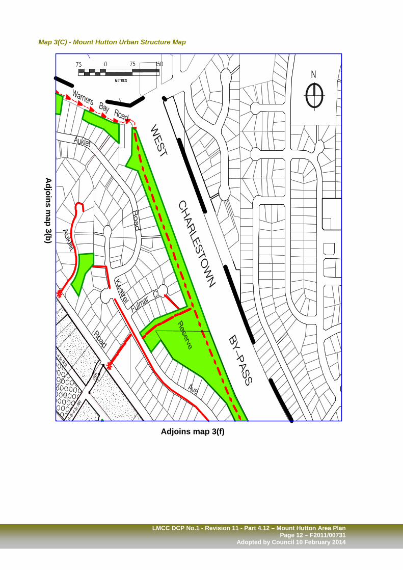
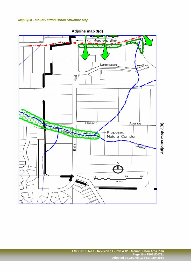
4.12.1 Urban Structure The INTENT of Council’s requirements is to ensure Mount Hutton develops in an integrated manner that reflects community desires and development needs. Urban Structure Plan The preferred development, movement and open space structure for Mount Hutton is set out in Map 3 – Mount Hutton Urban Structure Plan. This Plan is also provided at a 1:4000 scale in Maps 3(A) – 3 (I). The Urban Structure Plan was developed in accordance with Part 3.2 – Subdivision and identifies: Existing development types, Existing and proposed road locations, types
and carriageway widths, Proposed development sites and
subdivision patterns, Proposed development types and densities, Existing and proposed open space areas
and networks, including open space category,
Major stormwater management device
locations, Existing and proposed pedestrian
footpaths, On road and off road cycle paths, and Elements of the natural environment
including bushland, creeks and ridgelines. Key sites in Mount Hutton with potential for residential development have been identified and assessed. A table of these sites together with a description of their development potential will be included in the proposed Section 94 Plan to be prepared for Mount Hutton.
Performance Criteria Acceptable Solutions P1.
The intent may be achieved where: Subdivision and resulting development achieves the outcomes identified in the Urban Structure Plan by: Integrating existing and potential
development, Facilitating the provision of a high level
of internal accessibility and good external connections for vehicles, pedestrians and cyclists,
Facilitating the provision of public open space areas and networks,
Protecting areas of high scenic and/or habitat value throughout Mount Hutton,
Providing a range of housing types to suit current population trends, such as the nuclear family group, aged and sole person households,
Maintaining stormwater run-off to existing conditions, and
Facilitating the improvement of water quality entering Scrubby Creek.
A1.
Subdivision and resulting development is designed in accordance with: The Mount Hutton Urban Structure
Plan, Subdivision proposals are:
Accompanied by a DEVELOPMENT SITE PLAN, and/or
Minimum lot size identified. Further subdivision will be
determined in conjunction with building design plans.
Note – Subdivision of development sites smaller than 1500m2 where identified for Multiple Dwelling Housing, is limited to ensure resulting lots: Are of a size and configuration suitable
to the proposed development type, and Can be adequately accessed within
the proposed Urban Structure Plan.
See Part 5 for Dictionary

LMCC DCP No.1 - Revision 11 - Part 4.12 – Mount Hutton Area Plan Page 9 – F2011/00731 Adopted by Council 10 February 2014
Map 3 – Mount Hutton Urban Structure – Key Map and Legend

LMCC DCP No.1 - Revision 11 - Part 4.12 – Mount Hutton Area Plan Page 10 – F2011/00731
Adopted by Council 10 February 2014
Map 3(A) - Mount Hutton Urban Structure Map
Adj
oins
Map
3(b
)
Adjoins Map 3(d)

LMCC DCP No.1 - Revision 11 - Part 4.12 – Mount Hutton Area Plan Page 11 – F2011/00731 Adopted by Council 10 February 2014
Map 3(B) - Mount Hutton Urban Structure Map
Adj
oins
map
3(c
)
Adjoins map 3(e)
Adj
oins
map
3(a
)
LMCC DCP No.1 - Revision 11 - Part 4.12 – Mount Hutton Area Plan Page 12 – F2011/00731
Adopted by Council 10 February 2014
Map 3(C) - Mount Hutton Urban Structure Map
Adjoins m
ap 3(b)
Adjoins map 3(f)

LMCC DCP No.1 - Revision 11 - Part 4.12 – Mount Hutton Area Plan Page 13 – F2011/00731 Adopted by Council 10 February 2014
Map 3(D) - Mount Hutton Urban Structure Map
Adjoins map 3(a)
Adjoins map 3(g)
Adj
oins
map
3(e
)

LMCC DCP No.1 - Revision 11 - Part 4.12 – Mount Hutton Area Plan Page 14 – F2011/00731
Adopted by Council 10 February 2014
Map 3(E) - Mount Hutton Urban Structure Map
Adjoins map 3(b)
Adj
oins
map
3(f)
Adjoins m
ap 3(d)
Adjoins map 3(h)

LMCC DCP No.1 - Revision 11 - Part 4.12 – Mount Hutton Area Plan Page 15 – F2011/00731 Adopted by Council 10 February 2014
Map 3(F) - Mount Hutton Urban Structure Map
Adjoins map 3(c) A
djoi
ns m
ap 3
(e)
Adjoins map 3(i)
LMCC DCP No.1 - Revision 11 - Part 4.12 – Mount Hutton Area Plan Page 16 – F2011/00731
Adopted by Council 10 February 2014
Map 3(G) - Mount Hutton Urban Structure Map
Adj
oins
map
3(h
)
Adjoins map 3(d)

LMCC DCP No.1 - Revision 11 - Part 4.12 – Mount Hutton Area Plan Page 17 – F2011/00731 Adopted by Council 10 February 2014
Map 3(H) - Mount Hutton Urban Structure Map
Adj
oins
map
2(g
)
Adj
oins
map
2(i)
Adjoins map 3(e)

LMCC DCP No.1 - Revision 11 - Part 4.12 – Mount Hutton Area Plan Page 18 – F2011/00731
Adopted by Council 10 February 2014
Map 3(I) - Mount Hutton Urban Structure Map
Adjoins m
ap 3(h)
Adjoins map 3(f)

LMCC DCP No.1 - Revision 11 - Part 4.12 – Mount Hutton Area Plan Page 19 – F2011/00731 Adopted by Council 10 February 2014
4.12.2 Land Capability The INTENT of Council’s requirements is to facilitate the development of Mount Hutton while: Maintaining its valued environmental
characteristics, Protecting people and property from hazards,
and Maximising the provision of essential
infrastructure available in the suburb.
Links – 2.1.3 – Scenic Values 2.1.5 – Bushfire Risk 2.1.9 – Sloping Land and Soils 2.1.12 – Mine Subsidence 2.5.1 – Essential Infrastructure 2.6.9 – Access to Bushfire Risk Areas 3.2 – Subdivision
Performance Criteria Acceptable Solutions P1.
The intent may be achieved where: Development is designed in accordance with Council’s geotechnical zoning requirements.
A1.
Refer to Section 2.1.9 - Sloping Land and Soils if the site is identified as being T1, T2, or T3 on Geotechnical Zone Maps held at Council’s Offices. Notes – Detailed Geotechnical Zone Maps are held at Council’s Offices in electronic format and hard copies and are applied to land in accordance with Council’s Geotechnical Engineering Policies.
P2. Development is located to minimise the risk of hazards to people and property.
A2.
Refer to Section 2.1.5 – Bushfire Risk and 2.1.12 – Mine Subsidence.
P3. Development maintains the desirable character of Mount Hutton, which is rated as having a Scenic Management Zone B. Zone B is assigned to areas highly valued for the maintenance of scenic quality.
A3. Refer Section 2.1.3 – Scenic Values.
P4. Development maximises the use of service infrastructure available in Mount Hutton.
A4. Comply with the requirements of Section 2.5.1 – Essential Infrastructure. Note – Natural gas is available throughout the suburb and extends along Warners Bay Road, the length of Tennent Road, Helen Street, Wilsons Road, Violet Town Road Judd Street and partially along Auklet and Kestrel Avenue. Most new development within the suburb will fall into the required distances for providing this infrastructure, which will expand the natural gas network throughout the area.
See Part 5 for Dictionary

LMCC DCP No.1 - Revision 11 - Part 4.12 – Mount Hutton Area Plan Page 20 – F2011/00731
Adopted by Council 10 February 2014
4.12.3 Stormwater Management The INTENT of Council’s requirements is to contribute to the enhancement of Scrubby Creek, South Creek and downstream waterways, wetlands and the lake and ocean by managing stormwater run-off from development.
Links – 2.5.3 – Stormwater Management (Drainage System Design) 2.5.4 – On-Site Stormwater Harvesting (Source Controls)
Performance Criteria Acceptable Solutions P1.1 P1.2
The intent may be achieved where: In addition to Sections 2.5.3 and 2.5.4, development in Mount Hutton incorporates on-site detention of stormwater to limit run-off to existing patterns for a range of storm events. Development aims to further reduce stormwater run-off levels to compensate for run-off associated with infrastructure such as roads that are necessary to serve development.
A1.1 A1.2
Appropriate on site detention measures are implemented for new or additional development including: Rainwater tanks Onsite detention Permeable paving Landscaping Infiltration
Scrubby Creek sub-catchment detention basins act primarily as water quality devices, with the majority of stormwater detention controlled on-site. Note – It is estimated that each sub-catchment will require stormwater basins/ponds to further ensure run-off does not exceed current levels and sufficient water quality filtering is undertaken before entry to the Scrubby Creek system. Each of these is identified on Map 4. Auklet Road – Catchment A – 4000m2 Auklet Road – Catchment B – 1 x
3600m2 and 1 x 1000m2 Wilsons Road South – 1800m2
A Stormwater Management Strategy is to be prepared for the Scrubby Creek sub-catchments subject to future development. The Strategy will include specific requirements for on-site and catchment detention/water quality measures. While development surrounding South Creek and its tributaries is expected to be less intensive, all measures should be taken to protect and enhance the creek corridor.
See Part 5 for Dictionary

LMCC DCP No.1 - Revision 11 - Part 4.12 – Mount Hutton Area Plan Page 21 – F2011/00731 Adopted by Council 10 February 2014
Performance Criteria Acceptable Solutions
P2. Stormwater run-off from 100 percent of roof surfaces shall be managed through storage/reuse/landscaping systems within the development.
A2.
50 percent or more of the annual average rainfall falling on the roof area of each individual dwelling is harvested and reused on site.
A minimum 4500 litre storage system
per dwelling, being either a rainwater tank and/or gutter/fence system is provided.
Run-off collected is used for irrigation,
hot water and toilet flushing purposes. Note – Average annual rainfall recorded at Nobbys Signal Station is 1142mm per year. Based on this data and for an estimated roof area of 150m2 per dwelling, 86m3 is capable of being harvested and reused per year. An average household of 2.3 persons uses approximately 353 litres per day (low estimate) and irrigates up to 50m2 of landscaped area. This equates to 130m3 per year. Through the collection and re-use of roof water it is anticipated that 66 percent of water needs can be provided, less periods where system is empty, at which time the mains system will be used. The use of communal tank systems is preferred for Multiple Dwelling Housing. Refer to 2.5.4 – On-site Stormwater Harvesting.

LMCC DCP No.1 - Revision 11 - Part 4.12 – Mount Hutton Area Plan Page 22 – F2011/00731
Adopted by Council 10 February 2014
Map 4 – Drainage Sub-catchments

LMCC DCP No.1 - Revision 11 - Part 4.12 – Mount Hutton Area Plan Page 23 – F2011/00731 Adopted by Council 10 February 2014
4.12.4 Land Use The INTENT of Council’s requirements is to increase the population density within walking distance of the shopping facilities and public transport routes, while respecting the existing natural and built environment. Note – Mount Hutton is described as a series of Precincts, based on their existing and desired character. The Precincts are illustrated in Map 2 – Precinct Plan.
Links – 3.2 – Subdivision 3.3 – Urban Centre Development 3.4 – Housing – Building, Siting Form and
Design 3.5 – Housing – Specific Housing Types 3.7 – Specific Land Uses
Performance Criteria Acceptable Solutions P1.
The intent may be achieved where: Central Commercial Retail Precinct Future expansion, redevelopment or
upgrades, incorporate mixed uses, commercial, retail and recreational uses.
Integration between existing and new
development in the 3(1) – Urban Centre (Core) and 3(2) – Urban Centre (Support) zones are strengthened.
A1.1 A1.2
Comply with the requirements of 3.3 – Urban Centre Development. In cooperation with adjoining land owners and business interests, prepare and lodge, a Master Plan that integrates the Commercial/Retail Precinct into a unified whole to achieve greater economic potential, satisfy community needs and improve safety and aesthetics. Preferred land uses in the Central Retail Precinct 3(1) Urban Centre (Core) zone include: Commercial premises Community facility Entertainment facility Hotel Mixed use building Restaurant Shop
In the 3(2) Urban Centre (Support) zone include: Medical facility Commercial premises Community facility Recreation facility Sporting facility
Non-preferred uses in 3(2) Zone include: Bulky goods showroom
See Part 5 for Dictionary

LMCC DCP No.1 - Revision 11 - Part 4.12 – Mount Hutton Area Plan Page 24 – F2011/00731
Adopted by Council 10 February 2014
Performance Criteria Acceptable Solutions
P2. Crawford Lane Precinct Medium and low density development respects the residential and natural amenity within the suburb.
A2.1 A2.2
Proposed development facilitates the Urban Structure Plan for the Precinct. Preferred land uses in Crawford Lane Precinct include: Areas zoned 2(1) Residential –
Dwelling houses Dual occupancies – attached and
detached Home business Small lot housing
Areas zoned 2(2) – Residential (Urban Living) – Multiple dwelling housing
Non-preferred uses in the 2(2) zone include: Residential flat buildings
P3. Wilsons Road South Precinct
Medium and low density development respects the residential and natural amenity of the suburb.
A3. Preferred land uses in the Wilsons Road South Precinct include: Dwelling houses Dual occupancies Multiple dwelling housing Home business Small lot housing Environmental facility
Non-preferred uses in the 2(2) zone include: Residential flat buildings
P4. Helen Street Precinct
Medium density residential development respects the residential and natural amenity of the suburb.
A4.1
Preferred uses include: Home business Multiple dwelling housing Small lot housing
Non-preferred uses in the 2(2) zone include: Residential flat buildings
P5. Tomaga Parade Precinct
Low density residential development respects the residential and natural amenity of the suburb.
A5.1
Preferred uses include: Dwelling houses Dual occupancies Home businesses Small lot housing

LMCC DCP No.1 - Revision 11 - Part 4.12 – Mount Hutton Area Plan Page 25 – F2011/00731 Adopted by Council 10 February 2014
Performance Criteria Acceptable Solutions
P6. Cowmeadow Road Precinct Urban centre and supporting uses in appropriate locations, with low and medium density residential development that respects the amenity of the surrounding areas.
A6. Incremental redevelopment of the Dunkley Road Local Centre, includes uses that enhance the viability of existing retail uses. Preferred uses include: Shops Restaurants Mixed use building Commercial premises
Preferred uses in the remainder of the
precinct include: Dwelling houses Dual occupancies Multiple dwelling housing (particularly
between Cowmeadow Road and Warners Bay Road)
Home business Small lot housing
P7. Kestrel Avenue Precinct
Low density residential development respects the built and natural amenity of the suburb.
A7. Preferred land uses in the Kestrel Avenue precinct include: Dwelling houses Dual occupancies Home business Small lot housing Environmental facility
P8. Casson Avenue Precinct
Very low density, bushland and rural residential development that respects the rural and natural amenity of the Precinct.
A8. Preferred land uses in the Casson Avenue precinct include: Dwelling houses Home business Home industry Tourist accommodation

LMCC DCP No.1 - Revision 11 - Part 4.12 – Mount Hutton Area Plan Page 26 – F2011/00731
Adopted by Council 10 February 2014
4.12.5 Residential Built Form and
Landscape The INTENT of Council’s requirements is to ensure that residential development in Mount Hutton: meets predicted population needs, achieves a quality living environment, respects the built form character of the
area, is of a density and design that reflects
a predominately detached housing appearance, and
achieves a green and treed environment that enhances the existing and valued bushland and scenic character of the suburb.
Is designed to work with the specific qualities of individuals sites.
Links – 2.1.14 – Energy Efficiency 2.6.6 – Vehicle Parking Provision 2.7.2 – Landscape 2.7.8 – Fencing 2.6.8 – Vehicle Access 3.4.3 – Site Coverage and Unbuilt Upon
Areas 3.4.4 – Solar Access 3.4.5 – Privacy 3.4.6 – Private Outdoor Areas 3.4.8 – Garages, Sheds and Driveway
Access 3.5.1 – Dwelling Houses 3.5.2 – Small Lot Housing 3.5.3 – Dual Occupancy Housing –
Attached or Detached 3.5.4 – Multiple Dwelling Housing
Performance Criteria Acceptable Solutions P1.
The intent may be achieved where: Building Siting – In addition to the matters detailed in Section 3.4.1 – Building Siting, residential development in Mount Hutton: Achieves a single dwelling appearance
to street frontages Maximises opportunities for orientating
dwellings to the north-east Maximises opportunities for private
outdoor areas within the desired solar access orientation.
A1.1
Front setbacks for dwellings adjoining south-east – north-west orientated roads ie: Crawford Lane precinct: Dwellings fronting the north-east side
may have a reduced setback - 3 metres minimum
Dwellings fronting the south-west side will maintain a setback of 5 metres unless it can be demonstrated that a reduced setback will improve solar access to the rear courtyard while providing for future street trees
Corner lots to be determined by their dual aspects.
Note – On corner sites, traffic engineering requirements may require greater setbacks, reduced building heights, landscaping and fencing or modification to the building design to provide adequate sight lines.
See Part 5 for Dictionary

LMCC DCP No.1 - Revision 11 - Part 4.12 – Mount Hutton Area Plan Page 27 – F2011/00731 Adopted by Council 10 February 2014
Performance Criteria Acceptable Solutions
P1. Continued – A1.2 A1.3 A1.4
For Multiple Dwelling Housing, front setbacks allow for landscaping and garden areas that present a traditional dwelling frontage to the street, as typically found within established areas of the suburb. Refer to 3.4.1 – Building Siting for: Side and/or Rear Setbacks, and Building to the Boundary.
Dwellings internal to the development are suitably located in relation to street frontage dwellings and other boundaries to provide sufficient access, private outdoor areas, car parking facilities and manoeuvring areas. Note – Development that results in internal setbacks, which do not achieve a useful purpose, are not encouraged.
P2. Building Heights – Development adopts the predominant
height and scale of buildings existing within the suburb of Mount Hutton.
On hillsides and for dwellings south of
a street frontage, or in the instance of Multiple Dwelling Housing proposals, houses in the north or eastern area of the development are reduced to ensure solar access to adjoining dwellings.
A2.
Residential development in Mount Hutton adopt the following BUILDING HEIGHTS: In the 2(1) Residential and 2(2)
Residential (Urban Living) zones- 8 metres (2 storey), except for
Dwellings:
On land bounded by Auklet Road, Crawford Lane, Warners Bay Road and Bottlebrush Road,
in these locations, a building height of 4.5 metres (single storey) is preferred.
Multiple Dwelling Housing, Dual Occupancy or Small Lot Housing where lot orientation or topography will result in impacts on down slope or adjoining dwellings, in this instance building height of 4.5 metres (single storey) is preferred.
In the above situation, increasing the building height to 8 metres (2 storey) may be appropriate where: the second storey component is
limited to the northern section of the dwelling, for a maximum of 50 per cent of the ground floor area.
In the 1(2) Rural (Living) and 7(5) Environmental (Living) zones – 4.5 metres (single storey).
In the above rural and environmental zones building height greater than 4.5 metres (single storey) may be achieved where the building is designed in context with its environment.

LMCC DCP No.1 - Revision 11 - Part 4.12 – Mount Hutton Area Plan Page 28 – F2011/00731
Adopted by Council 10 February 2014
Performance Criteria Acceptable Solutions P3. Site Coverage and Unbuilt Upon Areas –
In addition to the matters detailed in Section 3.4.3 – Site Coverage and Unbuilt Upon Areas, residential development in Mount Hutton provides greater level of unbuilt upon area, especially for Multiple Dwelling Housing, to ensure: The density of development achieves
required dwelling numbers, while providing the appearance of detached dwellings, especially to street frontages.
The provision of open space areas is suitable to residents’ needs, especially, homes designed for family groups.
Landscaped areas or permeable surfaces are maximised to provide a level of stormwater infiltration that is suitable to the soil characteristics and the density of the development.
A3.1 A3.2
SITE COVERAGE is limited to: 50 percent for Dwelling Houses, 60 percent for Dual Occupancy –
Attached or Detached 60 percent for Small Lot Housing, 70 percent for Multiple Dwelling
Housing. In the instance of Multiple Dwelling Housing the maximum site coverage per dwelling is 210m2. Notes – Site coverage is the area of land covered by buildings and/or structures, including carports, garages, driveways and pathways. An average area of 310m2 has been allowed for each Multiple Dwelling House, which allows for 100m2 to be unbuilt upon. Where permeable surfaces are maximised and/or superior run-off measures are used, the level of unbuilt upon area may be reduced.
P4. Building Design – Development achieves a sense of diversity and interest, typical of individually designed and constructed dwellings, within the suburb.
A4. In the instance of Small Lot Housing, Dual Occupancy and Multiple Dwelling Housing: Development is designed on a theme
and incorporates a variety of elements to provide variety to that common theme, including:
Building material, Colour, Architectural detail, Window, location, size and finish, Roof pitch, gables and material, Fencing finishes, heights and
colour, to eliminate repetition in building finishes and allow a level of individuality to dwellings within a particular development proposal.
LMCC DCP No.1 - Revision 11 - Part 4.12 – Mount Hutton Area Plan Page 29 – F2011/00731 Adopted by Council 10 February 2014
Performance Criteria Acceptable Solutions
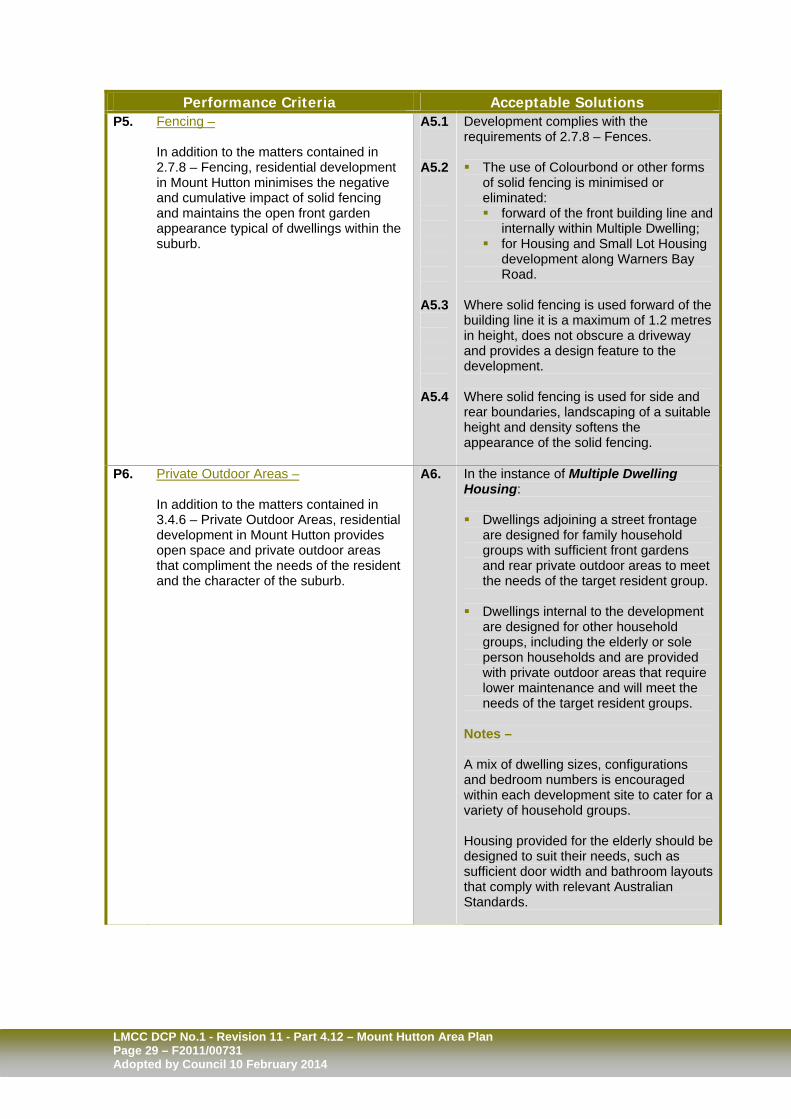
P5. Fencing – In addition to the matters contained in 2.7.8 – Fencing, residential development in Mount Hutton minimises the negative and cumulative impact of solid fencing and maintains the open front garden appearance typical of dwellings within the suburb.
A5.1 A5.2 A5.3 A5.4
Development complies with the requirements of 2.7.8 – Fences. The use of Colourbond or other forms
of solid fencing is minimised or eliminated: forward of the front building line and
internally within Multiple Dwelling; for Housing and Small Lot Housing
development along Warners Bay Road.
Where solid fencing is used forward of the building line it is a maximum of 1.2 metres in height, does not obscure a driveway and provides a design feature to the development. Where solid fencing is used for side and rear boundaries, landscaping of a suitable height and density softens the appearance of the solid fencing.
P6. Private Outdoor Areas –
In addition to the matters contained in 3.4.6 – Private Outdoor Areas, residential development in Mount Hutton provides open space and private outdoor areas that compliment the needs of the resident and the character of the suburb.
A6. In the instance of Multiple Dwelling Housing: Dwellings adjoining a street frontage
are designed for family household groups with sufficient front gardens and rear private outdoor areas to meet the needs of the target resident group.
Dwellings internal to the development
are designed for other household groups, including the elderly or sole person households and are provided with private outdoor areas that require lower maintenance and will meet the needs of the target resident groups.
Notes – A mix of dwelling sizes, configurations and bedroom numbers is encouraged within each development site to cater for a variety of household groups. Housing provided for the elderly should be designed to suit their needs, such as sufficient door width and bathroom layouts that comply with relevant Australian Standards.

LMCC DCP No.1 - Revision 11 - Part 4.12 – Mount Hutton Area Plan Page 30 – F2011/00731
Adopted by Council 10 February 2014
Performance Criteria Acceptable Solutions
P7.1
Residential Landscaping In addition to the matters contained in 2.7.2, 3.4.3 and 3.4.8, landscaping associated with residential development in Mount Hutton achieves: a high level of design, style, finish and
amenity, and utilises predominantly native species.
A7.1
Refer to the relevant Principles of Development in Sections 2.7.2 – Landscape, 3.4.3 – Site Coverage and Unbuilt Areas and 3.4.8 – Garages, Sheds and Driveway Access
P7.2 P7.3
Visible tree coverage within individual development is achieved. Landscaping is complimented by vehicular and pedestrian surfaces that: Minimise the visual impact of hard
surfaces, Maximise permeability, Add interest through colour, texture
and pattern, and Are durable and safe.
A7.2 A7.3
All opportunities are taken to maintain and incorporate into the landscaping trees existing within the site. Landscaping is distributed throughout
the development in areas of a suitable size and location to provide a minimum of 3 trees that achieve a height of 5 metres or greater at maturity for each dwelling within the development.
Shrubs and ground covers, as
appropriate, are provided: as screening devices, to assist in stormwater infiltration.
Note – Refer to Table 2 – Recommended Trees for Retail, Commercial or Residential Development for a list of trees appropriate to the Mount Hutton area. A mixture of concrete, paving and
pebble finishes are used to increase permeability and maximise infiltration of stormwater run-off, in conjunction with suitable retention devices.
A range of methods, including colour,
texture, pattern, and the location of landscape and buildings are used to reduce the visible expanse of driveways and manoeuvring areas required to serve a number of dwellings.

LMCC DCP No.1 - Revision 11 - Part 4.12 – Mount Hutton Area Plan Page 31 – F2011/00731 Adopted by Council 10 February 2014
Performance Criteria Acceptable Solutions
P8.
Access and Car Accommodation – In addition to the matters contained in 3.4.8 – Garages, Sheds and Driveway Access, development in Mount Hutton, continue the existing pattern and distance of driveway entrances within the suburb.
A8.
Section 3.4.8 – Garages, Sheds and Driveway Access prefer a single entry to housing developments. Variation from this requirement, may be appropriate for Multiple Dwelling Housing and Dual Occupancy in the following circumstances: Where accessing individual dwellings the: Lot frontage is of a sufficient width to
accommodate more than one entrance while maintaining the predominant driveway separation distances in the street,
Driveway location, separation and width continues the pattern of established residential development,
Dwellings fronting the street have a detached appearance,
Garages are limited to a single garage
door width (can be double garage in length), and
Location of the driveway is suitable based on traffic conditions and sight lines, among other road design requirements.
Where providing more than one entry/exit or an alternate entry and exit point to a number of dwellings the: Lot frontage is of a sufficient width, Driveway location, separation and
width continues the pattern of establishes residential development,
Location of the driveway is suitable based on traffic conditions and sight lines, among other road design requirements, and
Preferably, the entry and exit are located on separate street frontages.

LMCC DCP No.1 - Revision 11 - Part 4.12 – Mount Hutton Area Plan Page 32 – F2011/00731
Adopted by Council 10 February 2014
Typical building setbacks for Northwest-Southwest roads

LMCC DCP No.1 - Revision 11 - Part 4.12 – Mount Hutton Area Plan Page 33 – F2011/00731 Adopted by Council 10 February 2014
Table 2 – Native Trees for Retail, Commercial and Residential Development. Recommended species include: Botanical Name Common Name Acmena smithii lillypilly Alectyron subcinereus Native Quince Alphitonia excelsa Red ash Angophora hispida dwarf apple Angophora floribunda Rough barked apple Backhousia mytifolia Grey myrtle Backhousia anisata Banksia integrifolia coast Banksia Banksia serrata old man Banksia Banksia aemula wallum Banksia Banksia marginata silver Banksia Brachychiton populneus kurrajong Callicoma serratifolia black wattle Callistemon salignus willow bottlebrush Callistemon citrinus Red bottlebrush Callistemon nearis Narrow leaved bottlebush Callistemon ‘Dawson River’ bottlebrush Callitris collumellaris Cypress pine Ceratopetalum apetalum coachwood Corymbia maculate Spotted gum Cupaniopsis anarcardioides tuckeroo Diospyros australis Ebony myrtle Dysoxylomfraseriano Rosewood Endiandra sieneri Hard corkwood Elaeocarpus obovalus Hard quandong Elaeocarpus reticulatus blueberry ash Eucalyptus gummifera red bloodwood Eucalyptus piperita Sydney peppermint Eucalyptus punctata Grey gum Eucalyptus robusta swamp mahogany Eucalyptus saligia Sydney blue gum Eucalyptus tereticornis Forest red gum Glochidion ferdinandi cheese tree Gmelina leichhardtii White beach Guioa semiglauca Guioa Hakea salicifolia willow leaved Hakea Hymenosporum flavum native frangipani Livistona australis cabbage tree palm Melaleuca linariifolia snow in summer Melaleuca quinquenervia broad leaved paperbark Melaleuca sieberi Sieber’s paperback Melaleuca stypheliodies Prickly leaved paperback Myoporum acuminatum Podocarpus elatus plum pine Rapanea variabilis muttonwood Stenocarpus salignus Scrub beefwood Syntarpin glomulifera Turpentine Synoum glandutosum Scentless rosewood Syzygium australe brush cherry Syzygium paniculatum Magenta lillypilly Tristaniopsis laurina kanooka, water gum

LMCC DCP No.1 - Revision 11 - Part 4.12 – Mount Hutton Area Plan Page 34 – F2011/00731
Adopted by Council 10 February 2014
4.12.6 Commercial and Retail Development The INTENT of Council’s requirements is to ensure that commercial and retail development in Mount Hutton: contribute to the reinforcement of retail
and commercial main streets independent of Lake Macquarie Fair and Mount Hutton Plaza,
contribute to vibrant and attractive streets and public spaces,
improve the viability of existing local shopping centres in Dunkley Parade and along Wilsons Road,
allow for a range of services for the suburb.
Links – 2.6.6 – Vehicle Parking Provision 2.6.8 – Vehicle Access 2.7 – Streetscape and the Public Realm 3.3.1 – Centre – Design of Buildings and
Places 3.3.2 – Centre – Amenity and Performance
Performance Criteria Acceptable Solutions P1.
The intent may be achieved where: In addition to the matters contained in Section 3.3 – Urban Centre Development, redevelopment or development in the 3(1) Urban Centre (Core) and 3(2) Urban Centre (Support) in Mount Hutton: facilitates the upgrading of
streetscapes fronting and surrounding development;
increases connectivity between retail and commercial areas;
is of a nature, scale and height compatible with the local area;
increases safety and security in public areas, especially car parking areas; and
provides for professional, medical, entertainment, recreational and community related services and facilities required by the community.
Note – Further ‘stand alone’ retail activities are not encouraged within the Commercial Centre Precinct, unless they work together with existing centres to achieve a unified retail and commercial area.
A1.1 A1.2 A1.3
Building Heights – Building heights do not exceed: 9 metres (3 storey) in 3(1) zoned
areas, and 6 metres (2 storey) in 3(2) zoned
areas. Setbacks – In the 3(2) Urban Centre (Support)
zone a variety of setbacks are used to:
Add interest to the streetscape, Provide places for on street activity,
by adopting a minimum 3 metres setback on the main street frontage for 75 – 100 percent of the building façade.
Front setbacks do not include car-
parking areas. Streetscapes – Refer to 4.12.8 – Streetscape.
A mixture of awnings and shade trees
is provided along all street frontages, in accordance with the species identified in Table 2.
See Part 5 for Dictionary

LMCC DCP No.1 - Revision 11 - Part 4.12 – Mount Hutton Area Plan Page 35 – F2011/00731 Adopted by Council 10 February 2014
Performance Criteria Acceptable Solutions
A1.4 Vehicle Parking and Access – Car parking is located at the side or
rear of development to optimise active building frontages.
Where possible, communal vehicle access is provided for multiple developments.
Examples of potential development along Wilsons Road

LMCC DCP No.1 - Revision 11 - Part 4.12 – Mount Hutton Area Plan Page 36 – F2011/00731
Adopted by Council 10 February 2014
4.12.7 Bushland and Scenic
Protection The INTENT of Council’s requirements is to ensure that the highly valued bushland setting and ridgelines that surround Mount Hutton are protected and enhanced. Local Vegetation There is considerable remnant vegetation in Mount Hutton, especially along ridgelines. Existing remnant vegetation types found around Mount Hutton are described in the Department of Land and Water Conservation - Soil Landscape Units summarised in Table 3. (Murphy, 1993). Note – Not all of these species lend themselves to street tree planting and development landscaping.
Links – 2.1.1 – Ecological Values 2.1.2 – Ecological Corridors 2.1.3 – Scenic Values 2.1.4 – Tree Preservation and Management 3.2 – Subdivision 3.2.3 – Subdivision in the Conservation,
Environmental and Rural Zones
Performance Criteria Acceptable Solutions
P1.
The intent may be achieved where: Existing vegetation is maintained throughout the suburb, particularly on prominent landscape features, such
as hillsides and ridgelines; along Scrubby Creek and associated
buffers; along major road corridors; and in areas zoned 1(2) Rural (Living), and 2(1) Residential zoned land with
bushland or native tree species.
A1.
Development does not extend in
height, above the GROUND LEVEL (EXISTING) of the ridgeline.
Development in or adjacent to areas of natural vegetation minimises its impact on existing vegetation.
Visual Impact Assessment and Development Site Plans determine the location of buildings, structures, driveways and other development within bushland areas of the suburb.
Rehabilitation of riparian areas with native vegetation
Development complies with the relevant sections of DCP No. 1.
P2.
Development in or adjacent to degraded vegetation assists in the rehabilitation of the suburb with suitable flora species.
A2.
Development incorporates the planting of suitable flora species indigenous to the area and/or in accordance with the Soil Landscape Units typical of the topography, soil types and slope found in Mount Hutton. Note – Refer to Table 3 – Remnant Vegetation – Soil Landscape Units for a list of preferred species.
See Part 5 for Dictionary

LMCC DCP No.1 - Revision 11 - Part 4.12 – Mount Hutton Area Plan Page 37 – F2011/00731 Adopted by Council 10 February 2014
Performance Criteria Acceptable Solutions
P3. P4
Existing vegetation, habitat and corridors are maintained and enhanced throughout the suburb, particularly in areas zoned 7(2) – Conservation Secondary, 7(5) Environmental Living and 6(1) Public Open Space Insect fossil beds are properly investigated and protected prior to the development
A3. A4.
Development avoids the removal of native vegetation and habitat.
Development avoids impacts on
existing vegetation corridors and riparian areas
Development enhances corridors,
threatened species habitat and/or areas of native vegetation
New landscaping to include species
indigenous to the site. Damage to insect fossil beds and other
important geology is avoided Insect fossil bed or other important
geology is not sterilised by development
Where insect fossil beds are exposed
arrangements are made for scientific examination and study

LMCC DCP No.1 - Revision 11 - Part 4.12 – Mount Hutton Area Plan Page 38 – F2011/00731
Adopted by Council 10 February 2014
Table 3 - Remnant Vegetation – Soil Landscape Units Gateshead Soil Landscape Unit – This is the predominant landscape unit in Mount Hutton. Characteristics - Undulating to rolling hills and rises. Local relief is 60-130 metres. Slope gradients are 5-15%. Common species include: Angophora costata smooth barked apple Eucalyptus haemastona scribbly gum Eucalyptus eugenioides thin leaved stringy bark Eucalyptus capitellata brown stringy bark Eucalyptus umbra bastard mahogany Allocasuarina torulosa forest oak Syncarpia glomulifera turpentine Eucalyptus saligna Sydney blue gum
Warners Bay Soil Landscape Unit – This land unit would relate to most of the valley and lower side slopes of Mount Hutton. Characteristics - Undulating to rolling low hills and rises on fine grained sediments of the Newcastle Coal Measures. Local relief 30 – 80 metres; elevation to 80 metres. Slope gradient 3 – 20%. Crests are broad, slopes are large and gentle and drainage lines are broad. Predominantly cleared tall open forest. Common species include: Corymbia maculata spotted gum Eucalyptus punctata grey gum Eucalyptus paniculata grey ironbark Eucalyptus gummifera red bloodwood Poorly drained areas (lower in valley) Melaleuca spp paperbark Eucalyptus robusta swamp mahogany Casuarina glauca swamp oak
Killingworth – Soil Landscape Unit – Characteristics –Rolling to steep hills, slopes are >20%. Vegetation – Open Forest & Woodland. Common species include: Corymbia maculata spotted gum Eucalyptus eugenioides thin leaved stringy bark Eucalyptus umbra bastard mahogany Eucalyptus fibrosa broad leaved ironbark Eucalyptus paniculata grey ironbark Understorey - Themeda australis kangaroo grass Leptospermun spp tee tree Xanthorrhoea spp grass tree On well drained sandstone - Eucalyptus gummifera red bloodwood Angophora costata smooth barked apple Poorly drained areas - Melaleuca styphelioides prickly leaved paperback On sheltered upper slopes - Syncarpia glomulifera turpentine Eucalyptus piperita Sydney peppermint
Awaba – Soil Landscape Unit Characteristics – Rolling low hills with short side slopes and numerous closely spaced drainage lines. Moderately inclined to steep slopes 7-25%. Sandy clay loam soils. Predominantly uncleared coastal heaths and woodlands. Common species include Eucalyptus capitellata brown stringy bark Eucalyptus haemastoma scribbly gum Eucalyptus punctata grey gum In poorly drained areas - Melaleuca nodosa paperbark Melaleuca quinquenervia broad leaved paperbark
Source: Department of Land and Water Conservation – Soil Landscape Units maps (Murphy, 1993).
LMCC DCP No.1 - Revision 11 - Part 4.12 – Mount Hutton Area Plan Page 39 – F2011/00731 Adopted by Council 10 February 2014
4.12.8 Streetscape The INTENT of Council’s requirements is to ensure that the streetscapes of Mount Hutton are attractive, safe and compliment the valued bushland environment of the suburb. Streetscape Elements Streetscape elements can enhance the amenity and attraction of an area. Streetscape elements will also help reinforce the treed character of Mount Hutton. Street furniture, including benches, rubbish bins, drinking fountains, lighting, are not widely used in Mount Hutton. The incorporation of these elements into the public areas of the suburb will enhance the usability and liveability of the area.
Links – 2.7.1 – Streetscape and Local Character 2.7.2 – Landscape 2.7.4 – Pedestrian Networks and Paths
Performance Criteria Acceptable Solutions P1.
The intent may be achieved where: Development provides footpaths and associated street furniture for identified locations throughout Mount Hutton.
A1.1 A1.2 A1.3
Footpaths are provided throughout Mount Hutton in accordance with the Urban Structure Plan. Refer to Section 4.12.1. Footpaths along residential streets
should be concrete with grass verges and street trees.
The incorporation of street furniture,
such as seating and rubbish bins may be required along public transport or high use routes.
Footpaths in commercial and retail areas should incorporate unit paving, rather than concrete, and include suitable street trees and furniture, such as seating, rubbish bin, bollards, signage, among other elements. Notes – The Urban Structure Plan identifies existing and proposed footpaths for the suburb. These footpaths are based on road design, accumulation of development, existing footpaths and major internal and external desire lines such as Lake Macquarie Fair shopping centre or Mount Hutton Public School.
See Part 5 for Dictionary

LMCC DCP No.1 - Revision 11 - Part 4.12 – Mount Hutton Area Plan Page 40 – F2011/00731
Adopted by Council 10 February 2014
Performance Criteria Acceptable Solutions
P1. Continued – Clay or concrete unit paving with consistent colouring and patterns is used in retail and commercial areas.
P2. Development enhances the streetscape through the provision of street tree planting.
A2.1 A2.2 A2.3 A2.4
Cumulative street tree planting results in an avenue effect and is located on the nature reserve of the street. Primarily native species are used and selected from Table 4 – Recommended Street Trees. Comply with the requirements of 2.7.1 – Streetscape and Local Character, when applicable. On new public streets, street tree
planting is coordinated with underground or cable bundling.
On existing streets, where above
ground power lines exist, underground or cable bundling is achieved where practicable.
Table 4 – Recommended Street Tree Species
Proposed Species Where no power lines exist Where power lines exist
Araucaria spp. (Norfolk Island pine etc.) Brachychiton spp (kurrajong) Eucalyptus spp. (gum) Flindersia australis (crows ash) Ficus spp (fig) Harpullia pendula (tupliwood) Lophostemon confertus (brush box) Melaleuca quinquenervia (broad leaved
paperbark) Podocarpus elatus (brown pine) Waterhousea floribunda (weeping lillypilly)
Agonis flexuosa Buckinghamia celsissima (ivory curl) Banksia spp Callistemon salignus (willow bottlebrush) Callistemon ‘Dawson River’ (bottlebrush) Cupaniopsis anarcardioides (tuckeroo) Elaeocarpus reticulatus (blueberry ash) Eucalyptus ficifolia (grafted) (flowering gum) Eucalyptus ‘Summer Red’ (flowering gum) Melaleuca spp. (paperbark) Tristaniopsis laurina (water gum)
LMCC DCP No.1 - Revision 11 - Part 4.12 – Mount Hutton Area Plan Page 41 – F2011/00731 Adopted by Council 10 February 2014
4.12.9 Public Open Space The INTENT of Council’s requirements is to ensure that existing and proposed public open space areas are managed and enhanced to meet community needs.
Links – 2.6.4 – Pedestrian and Cycle Paths 2.7 – Streetscape and The Public Realm 2.7.3 – Public Open Space 2.7.9 – Safety and Security
Performance Criteria Acceptable Solutions P1.
The intent may be achieved where: Open space sites within Mount Hutton provide: for the recreational needs of the local
community, increase the aesthetic amenity of the
suburb, protect environmental values, and assist in stormwater management
needs. Note – Abbreviations such as MH-001 reflect Lake Macquarie City Council Community Planning inventory codes for Council owned land.
A1.1 A1.2
In the instance of new public open space: Refer to 2.7.3 – Public Open Space
and 2.6.4 – Pedestrian and Cycle Paths
Establish a connection between MH-003 and Bayview Street through the disused quarry, and
As development occurs establish a new parkland area on the ridge in the Crawford Lane Precinct.
In the instance of existing reserves the following is a summary of opportunities associated with public open space in and adjoining Mount Hutton: John Peschar Reserve (MH-001) 716 Bayview Street This is the primary active recreation area in Mount Hutton. The current tennis and football facilities should be maintained and improved. There is little scope for expansion of sporting facilities as the site is constrained by Scrubby Creek to the south and significant bushland on the northern slope of the site. There is potential for passive use of the bushland to support existing facilities. This could include picnic facilities, walking trails and nature appreciation. An upgrade of the existing vehicular entrance from Dunkley Parade is desirable to allow a safer entry/exit. Rationalisation of the existing signage into one LMCC sign is desirable. Additional directional signage to the north and south on Dunkley Parade may be useful to direct visitors to the area.
See Part 5 for Dictionary

LMCC DCP No.1 - Revision 11 - Part 4.12 – Mount Hutton Area Plan Page 42 – F2011/00731
Adopted by Council 10 February 2014
Performance Criteria Acceptable Solutions
P1.
Continued –
The provision of a pedestrian linkage across Scrubby Creek will provide alternative safe access to the reserve. This linkage would traverse the public reserve (MH-005 10 Judd Street) which is primarily used as a stormwater management facility. Additional tree planting around this facility and to the Judd Street frontage will enhance the reserve. Rehabilitation of the interface between bushland and sporting facilities is necessary to prevent erosion as a result of past vehicle access. Mullington Park (MH-009) 2a Progress Road This is the primary passive recreation reserve for Mount Hutton. Its location near Dunkley Parade Local Centre and the primary school, as well as frontage to Warners Bay Road, give it the status of a district level park. The current play facilities and shelter will benefit from the provision of public toilets. Additional planting of large shade trees will reinforce this significant location. Pedestrian access to the park across Progress Road requires improvement, possibly through use of kerb extensions into the street. Increased pedestrian links to the bus stop, along the Warners Bay Road frontage and throughout the park are desirable. Landscape treatment of the drainage swale through the reserve will enhance that this is the headwater of Scrubby Creek and provide a feature for the park. Lighting of the primary use areas of the park will improve safety. Cashel Close Reserve (MH-002) 3 Cashel Close This small parcel of sloped grass offers very little potential for recreation but could be a useful pocket for some native tree planting with the co-operation of surrounding landowners.
LMCC DCP No.1 - Revision 11 - Part 4.12 – Mount Hutton Area Plan Page 43 – F2011/00731 Adopted by Council 10 February 2014
Performance Criteria Acceptable Solutions
P1. Continued –
Cowmeadow Road Reserve (MH-003) 17c and 17d Cowmeadow Road This ridgeline parcel of land primarily functions as a bushland reserve for environmental and scenic purposes. The reserve is isolated and does not have a frontage to the formed section of Cowmeadow Road. It does offer potential for a pedestrian linkage along the ridgeline between Thurles Street and Bayview Street. Tango Street and Ford Avenue Reserves (MH-004) 5 Tango Street and 2 Ford Avenue These two small parcels of parkland are located at the rear of the Ford Corner Local Centre and have little recreational potential. Expansion of the centre could benefit from use of this land with resulting funds used to finance other open space projects in the area. Tomaga Parade and Lampeter Close Reserves (MH-005, MH-006 and MH-007) 5 and 12 Lampeter Close and 56 Tomaga Parade These three parcels of land run along the significant south western ridgeline. The remnant vegetation on these parcels is important for the scenic character of Mount Hutton and requires protection. Some rehabilitation work is necessary to reduce erosion, especially where the reserves meet roads. Planting is required in the cleared area to the south of Tomaga Parade, especially the slope down to Violet Town Road, while the flatter area on the ridge lends itself to passive recreation, such as an informal play area. An informal trail runs along the ridgeline and offers potential to link to Warners Bay Road. Stairs are required down to Violet Town Road, which will assist in accessing Lake Macquarie Fair.

LMCC DCP No.1 - Revision 11 - Part 4.12 – Mount Hutton Area Plan Page 44 – F2011/00731
Adopted by Council 10 February 2014
Performance Criteria Acceptable Solutions
P1. Continued –
In conjunction with safe pedestrian facilities across Violet Town Road, there is potential to link these reserves WD-001 detailed below. Violet Town Road Reserve (WD-001) 19a Katie Place Windale; 42 Sturt Street, These large bushland reserves traverse the ridgeline on the southern boundary of Mount Hutton. The larger of the reserves has a long frontage to Violet Town Road, enhancing the natural character of this roadway. The bushland is significant as an environmental and scenic asset and provides opportunities for pedestrian access to South Street. Pedestrian access to the reserve is currently available from a number of residential streets including Sturt Street, Nursery Grove and McElwee Drive. Provision of formalised gravel pathways with low-key trail signage along major desire lines and rehabilitation of disturbed areas should be undertaken. Outlook Close Reserve (MH-008) 4 Outlook Close This reserve is primarily bushland with some significant trees. Its location near one of the highest points in Mount Hutton makes the vegetation scenically significant. Erosion control works and general rehabilitation is required. A pedestrian facility such as low-key steps should be provided down the steep track that links to the walkway to Kestrel Avenue. Weed encroachment around the edges of the reserve needs controlling, possibly with involvement of surrounding residents. Small bushland pockets like this are significant in maintaining Mount Hutton’s relatively natural character.

LMCC DCP No.1 - Revision 11 - Part 4.12 – Mount Hutton Area Plan Page 45 – F2011/00731 Adopted by Council 10 February 2014
Performance Criteria Acceptable Solutions
P1. Continued –
Scrubby Creek Reserves (MH-016) 74a Wilsons Road (MH-010) 83a Tennent Road, (MH-015) 56a Wilsons Road (MH-011) 89 Tennent Road Scrubby Creek is one of the main physical features of Mount Hutton along with the surrounding ridgelines. Due to past subdivision patterns, the upper section of Scrubby Creek, east of Warners Bay Road, is channelled through a narrow corridor. The Lake Fair Shopping Centre has also developed close to the creek resulting in a heavily disturbed and unattractive appearance. Recent residential subdivision has resulted in housing backing onto the creek and ignoring the potential of the creek landscape. Development should aim to optimise views over the creek, thereby increasing safety in vicinity of the creek and its value to the community. Some significant creek line vegetation remains on MH-010 suggesting potential landscape rehabilitation for the rest of the creek. Future acquisition of the adjacent parcel to the east will link this reserve to MH-011 which is at the corner of Tennent Road and Willow Road. Together, these three parcels would form a reserve three times larger than Mullington Park. The extension of Willow Road to South Street will give this combined reserve an additional street frontage. Unified rehabilitation of the creek line can be achieved with the combined ‘Scrubby Creek Reserve’ Some of the reserve is required for stormwater management to ensure run-off entering Scrubby Creek is cleansed. This facility should be designed so it becomes a landscaped feature of the reserve. The overall park theme should be based on informal native landscape. Well lit pedestrian and cycle paths should be provided along Scrubby Creek and at the main park entry on Tennent Road.
LMCC DCP No.1 - Revision 11 - Part 4.12 – Mount Hutton Area Plan Page 46 – F2011/00731
Adopted by Council 10 February 2014
Performance Criteria Acceptable Solutions
P1. Continued –
Other small-scale facilities for informal ball games should be provided along with shelters and seating. Since a playground already exists at the corner of Willow Road and Merrigum Street, playground facilities are not required. In general, enhancement of the narrow reserve areas along Scrubby Creek including planting is required. Security for uses of the creek corridor should be considered at all times. Any pathways should be well-lit and passive surveillance from adjoining areas ensured. Warners Bay Road Reserves (MH-012) 190 Warners Bay Road These two bushland reserves lie on the south side of Warners Bay Road, east of Burton Road. They provide protection for some significant native trees, especially Smooth Barked apple, and reinforce the generally natural character of the roadway surrounds. The reserves provide a natural gateway to Mount Hutton from Warners Bay. (MH-013) 360 Warners Bay Road and (MH-014) 368 Warners Bay Road These narrow bushland reserves separate the residential development along Auklet Road from this busy winding section of Warners Bay Road. Combined with the remnant vegetation on the north side of Warners Bay Road, these reserves reinforce the roads’ natural character and provide a natural gateway to Mount Hutton from Charlestown and the West Charlestown By-pass. Warners Bay Road will likely cater for increased traffic as a result of the West Charlestown By-pass and these bushland roadside reserves require protection to enhance the natural scenic character of Mount Hutton.