3¥4 hawick to selkirk 55 57 - rucksack readers · it was ruled by baron drumlanrig around 1412 and...
TRANSCRIPT

Hawick (formerly Hagawic) refers to a settlement surrounded by hedging and likely dates back some 1500 years. Hawick was not associated with any abbey, however in the 12th century the Lovells, a Norman family associated with David I, were granted the lands.
They built a motte-and-bailey stronghold (Hawick Castle), but all that survives today is the motte (grassy mound). Nearby is Drumlanrig’s Tower (now home to the Borders Textile Towerhouse). It was ruled by Baron Drumlanrig around 1412 and then by the Scott family or Dukes of Buccleuch around 1671.
Whilst Hawick derived income from town markets, the area was plagued by border conflicts. Cattle theft and looting was commonplace throughout the area. In 1514, the town’s youths overpowered an English raiding party from Hexham at Hornshole, and captured their banner. The statue ‘Ken the horse’ depicts this post-Flodden success: see page ??. The victory is celebrated in Hawick every year as part of the Common Riding ceremonies.
In 1771, John Ballie introduced Hawick’s first knitting loom and founded its long association with knitwear and Tweed cloth. The industry evolved to produce stockings and underwear, and then pullovers and cardigans. By the 19th century, the famous Tweed cloth was also being produced and collectively the industries supported the town. Even today, Hawick continues to produce some of these high quality products.
At the west end of the High Street a £10 million ‘Heart of Hawick’ regeneration project has three main elements: Tower Mill, a former spinning mill, has been transformed into a 108-seat cinema and theatre space and displays a 14-foot high Victorian waterwheel. It houses the Heritage Hub (a genealogy resource) and also includes the Borders Textile Towerhouse with VisitScotland iCentre: for more information, see page ?? and www.hawickonline.com.
‘Ken the horse’, Hawick High Street
3•4 Hawick to Selkirk Distance 12.8 miles 20.6 km Terrain mainly farm and forest tracks, with some quiet roads Grade long ascent from Hawick to Drinkstone Hill, then another long climb to Hartwoodmyres (summit of the Way at 338 m/1110 ft) with a total ascent of 430 m/1410 ft Food & drink Hawick (wide choice), Selkirk (wide choice) Summary interesting section starting on minor road, then climbing high with open vistas; some may prefer the longer drove road alternative, which follows a moorland ridge with wide views
3.04.8 SelkirkHawick drove rd junction
4.77.6Hartwoodmyres Wood
5.18.2
5.08.1
5755
53

Leaving Hawick, your choice is either to return to the Borders Abbeys Way or to continue through Hawick and join a drove road. The Way is shorter and better waymarked: see page ??. The historic drove road option, described below, rejoins the Way after 5.0 miles (8.1 km). Popular with equestrians, this route adds 2.0 miles/3.3 km to your overall distance. Be prepared to follow directions closely through Hawick (no waymarkers) and on its offroad sections to find the terrain churned by horses’ hooves. Its attractions are that it takes you through the centre of Hawick, it explores Wilton Lodge Park on the outskirts, and there are fine views from the ridge towards Drinkstone Hill.
Start from where North Bridge Street meets the north-east end of the High Street. The statue known as ‘Ken the horse’ 1 was erected in 1914 to commemorate 400 years since the famouse skirmish: see page ??. It soon became a local landmark, with a nickname from the local dialect: when asked for directions, residents would reply ‘dive ee ken the horse? – gan past it ...’ meaning ‘do you know where the horse (monument) is? – go past it ...’.
Continue south-west along the High Street, passing the handsome town hall 2 with clock tower designed by James Campbell Walker (1821-88). Soon after the town hall, you reach the ‘Heart of Hawick’ 3 : see page 53.
Bear right on the road to cross the Slitrig Water by Drumlanrig Bridge, and reach a roundabout where you bear left along Buccleuch Street. After 150 m, turn right along a lane at a blue ‘Public Park’ sign.
At the end of the lane turn left along the tarmac path past the River Teviot’s weir, and onwards under the trees of Wilton Lodge Park: 4 see panel.
Cross the arched bridge and turn left under the mature tree canopy. Turn left, passing the shelter and arrive beside the fountain and the museum.
Wilton Lodge ParkThe park, once the estate of the Langland family, extends over
107 acres and is home to many mature trees, plant displays, walled gardens, fountains and statues of some of Hawick’s sporting heroes. It also houses the Hawick Museum, with Scott Gallery and a programme of exhibitions. Thanks to a £3.6 million Heritage Lottery Fund, a five-year restoration project began in 2013 and was has recreated the historic bandstand, built a café with link bridge across the Teviot, and enhanced the museum.
1
2
4
High St
reet
North
Brid
ge St
reet
St George’s Lane
Hawick MuseumScott Gallery
A7
A7
A698
Mansfield Rd
Weensland Rd
Princes St Leisure Centre
Dickson St
River Teviot
3
2
Buccleuch Street
Wilton Park Road
Stirches Road
54
45
4
A 7
A 7
A 698
B635
9
Burnfoot
Appletreehall
Clarilaw
Hawick
211
256
224
335
328
299
270
282
Smasha Hill
Drinkstone Hill318
AshkirkLoch
Drumlandrig's Tower
Hawick Motte &Bailey Castle (Remains)
Wilton Lodge Park
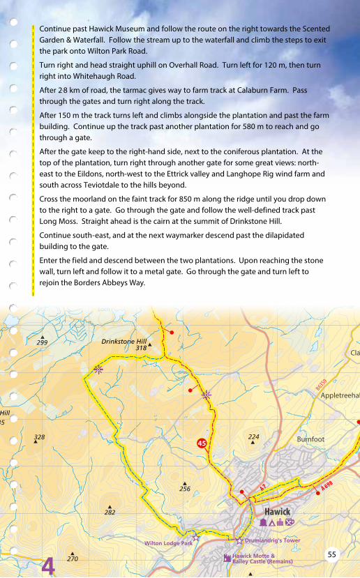
Continue past Hawick Museum and follow the route on the right towards the Scented Garden & Waterfall. Follow the stream up to the waterfall and climb the steps to exit the park onto Wilton Park Road.
Turn right and head straight uphill on Overhall Road. Turn left for 120 m, then turn right into Whitehaugh Road.
After 2.8 km of road, the tarmac gives way to farm track at Calaburn Farm. Pass through the gates and turn right along the track.
After 150 m the track turns left and climbs alongside the plantation and past the farm building. Continue up the track past another plantation for 580 m to reach and go through a gate.
After the gate keep to the right-hand side, next to the coniferous plantation. At the top of the plantation, turn right through another gate for some great views: north-east to the Eildons, north-west to the Ettrick valley and Langhope Rig wind farm and south across Teviotdale to the hills beyond.
Cross the moorland on the faint track for 850 m along the ridge until you drop down to the right to a gate. Go through the gate and follow the well-defined track past Long Moss. Straight ahead is the cairn at the summit of Drinkstone Hill.
Continue south-east, and at the next waymarker descend past the dilapidated building to the gate.
Enter the field and descend between the two plantations. Upon reaching the stone wall, turn left and follow it to a metal gate. Go through the gate and turn left to rejoin the Borders Abbeys Way.
55

• To leave the centre of Hawick on the Borders Abbeys Way, head north up North Bridge Street and cross the pedestrian bridge. Continue on Dovemount Place for 120 m, then turn left up Princes Street. (Here you rejoin the Way which officially makes a loop around the Teviotdale Leisure Centre and crosses the A7).
• Turn right into Dickson Street and follow it uphill past Wilton Church where it becomes Stirches Road, which climbs steadily leaving Hawick behind. Beyond the derestriction sign it has no pavement or verges: be aware of oncoming traffic.
• You may notice the large building of St Andrews Convent on your right, seen through the parkland dotted with mature trees, and after about 900 m, Stirches Road passes its driveway.
• Keep straight on the road as it climbs through fields following the old stone dyke for 1.6 km past Stirches Mains Farm to a crossroads. From here, there are extensive views towards Rubers Law, Minto Hills, Liddesdale and the Cheviots.
• Go straight over the crossroads and keep on the road past Tandlaw farm, over Boonraw Burn and past Drinkstone farm. About 600 m after the crossroads, bear right just after a large shed.
• Continue for 300 m on gravel farm track and bear left at the next fork into the fields, keeping the wire fence on your left. The going underfoot is firm, stony in places.
East towards the Minto hills, with Cheviots distant at left
56

50
557A
A7
A 708
B7014
B700
9
B6400
B7039
WollAshkirk
Philiphaugh
Clerklands
Selkirk
Ale Water
Ettric
k W
ater
Yarrow Water
Ettrick
Wat
er
227
323
265
298
308
296
277
287
314
324
347
353
299
319
Drinkstone Hill318
AshkirkLoch
LochSike
EssensideLoch
HeadshawLoch
HainingLoch
BishopsStone
TheHaining
Bowhill House &
Selkirk's Motte &Bailey Castle (remains)
Halliwells HouseMuseum
Sr WalterScott'sCourtroom
Auld Kirk
Half CrownCorner
57

• Enter the next field at a gate/stile, bearing right on a well-defined track across the pasture and uphill. You are joined by the Cross Borders Drove Road.
• Follow the track through the field and enter a further field. The track meanders in a northerly direction until it reaches a gate in a stone wall.
• Go through the gate and bear left through the forest glade, through another gate and down to cross the burn, the Falla Cleuch. Follow the track through the plantation, with the stone wall on your right, for 400 m to reach and go through a gate.
• Continue on the path through further forestry until you emerge on a well-defined track, and follow it.
• After 1 km on the track, at a junction go ahead on a narrow muddy path between a conifer plantation and a field. Emerge on a farm road and follow the waymarkers as they descend to pass between the house and outbuildings of Salenside Farm.
• Cross the Ale Water to meet the public road, where you turn right for just 50 m. Then turn left over the stile to follow an old right of way known as the Thief Road.
• Follow the field boundary and enter the Woll Golf Course by ladder stile. Cross the golf course following the many waymarkers closely: they lead you for over 1.3 km across the Woll Burn, then beside a fine drystone wall. Please take great care when crossing fairways, be aware of flying golf balls and avoid distracting golfers whenever a ball is in play!
The drove road joins the Way from the left
The Way beside the drystone wall
58
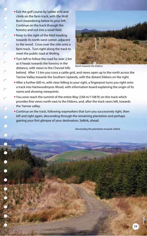
• Exit the golf course by ladder stile and climb on the farm track, with the Woll Burn meandering below to your left. Continue on the track through the forestry and out into a small field.
• Keep to the right of the field heading towards its north-west corner, adjacent to the wood. Cross over the stile onto a farm track. Turn right along the track to meet the public road at Wollrig.
• Turn left to follow the road for over 2 km as it heads towards the forestry in the distance, with views to the Cheviot hills behind. After 1.5 km you cross a cattle grid, and views open up to the north across the Yarrow Valley towards the Southern Uplands, with the distant Eildons on the right.
• After a further 600 m, with clear felling to your right, a fingerpost turns you right onto a track into Hartwoodmyres Wood, with information board explaining the origin of its name and showing viewpoints.
• You soon reach the summit of the entire Way (338 m/1108 ft) on this track which provides fine views north-east to the Eildons, and, after the track veers left, towards the Yarrow valley.
• Continue on the track, following waymarkers that turn you successively right, then left and right again, descending through the remaining plantation and perhaps gaining your first glimpse of your destination, Selkirk, ahead.
North towards the Eildons
Descending the plantation towards Selkirk
59

55
7A
A 708
B7014
B700
9
B6400
B7039
Philiphaugh
Clerklands
Selkirk
Ale Water
Ettric
k W
ater
Yarrow Water
Ettrick
Wat
er
227
323
298
308
324
LochSike
HeadshawLoch
HainingLoch
BishopsStone
TheHaining
Selkirk's Motte &Bailey Castle (remains)
Halliwells HouseMuseum
Sr WalterScott'sCourtroom
Auld Kirk
Old Lindean Church(site of Selkirk Abbey)
Half CrownCorner
• Cross the Middlestead Burn and after 30 m leave the main track to join a grassy path bearing right alongside a wood. To the left there are fine views towards Bowhill Country House and Estate: see panel.
• Continue beside the wood to join a farm track through rough grasslands and descend to meet the Middlestead Burn again. Follow the track through the farmland beside the burn and pass through the steadings of Middlestead Farm in a left-right dogleg.
• At the junction with the public road, turn right and follow the quiet road for 1 km. The quiet road crosses Brownmoor burn and passes between fields.
• The road bends around the large sheds of Brownmoor. At the foot of the hill, turn left over the stile to enter a field. Head to the right edge, and pass around two sides of the field, then exit by a stile.
Bowhill Bowhill is the ancestral home of the Dukes of Buccleuch, the hereditary Chief of the Scott clan. The land was once
part of the vast Ettrick Forest and a royal hunting ground gifted to the clan by Robert the Bruce in 1322. According to legend, the name Buccleuch name comes from a hunting incident where King Kenneth III was saved by John Scott, who wrestled a charging buck (male deer) to the ground in a deep cleuch or gorge. Bowhill House dates from 1708 and is home to a priceless art collection including works by Gainsborough, Reynolds an d Canaletto. For visit information, see www.bowhillhouse.co.uk.
1
1
60
• After crossing another stile and the Hartwood Burn, turn right over a further stile to follow the field edges for 50 m, and meet a grassy farm track.
• Turn left on the track to cross the field uphill and pass through a small wood. Follow the track around to the right, then left, where The Haining will come into view.
• At the foot of the hill, through the trees you may glimpse the Haining Loch. Keep to the track, passing a ruined dovecot near the end of the field and continue straight on through the wood.
• Turn right onto a tree-lined driveway, passing stables, to join the main driveway to The Haining 1 , with the mansion house and loch to your right.
• The country house forms part of an estate originally owned by the Pringle family and dates back to the 1790s. In 2009 the house was bequeathed to the people of Selkirk, and its exhibition highlights the estate’s history. For visit information, see www.thehaining.co.uk.
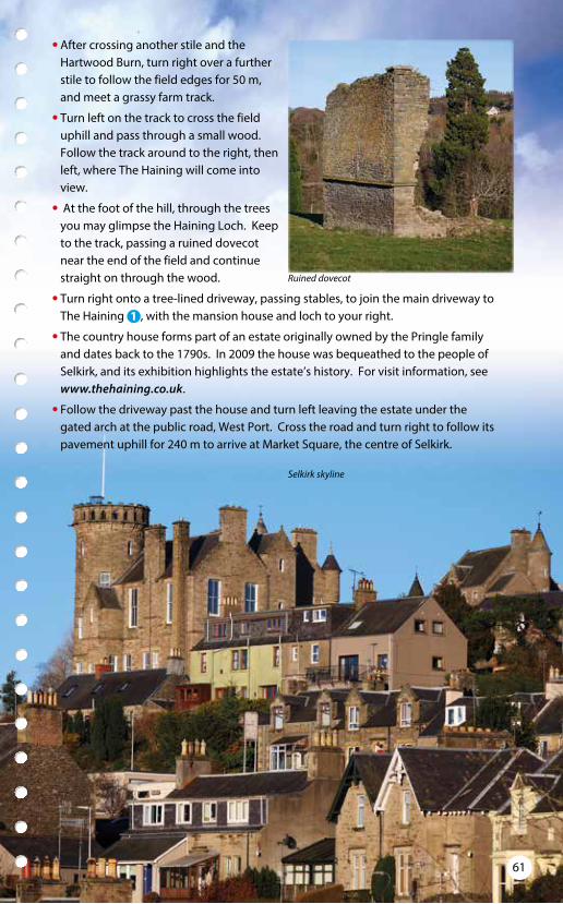
• Follow the driveway past the house and turn left leaving the estate under the gated arch at the public road, West Port. Cross the road and turn right to follow its pavement uphill for 240 m to arrive at Market Square, the centre of Selkirk.
Selkirk skyline
Ruined dovecot
61