#3 what we have heard so far what we have heard so far what do you want this area to look like?...
TRANSCRIPT
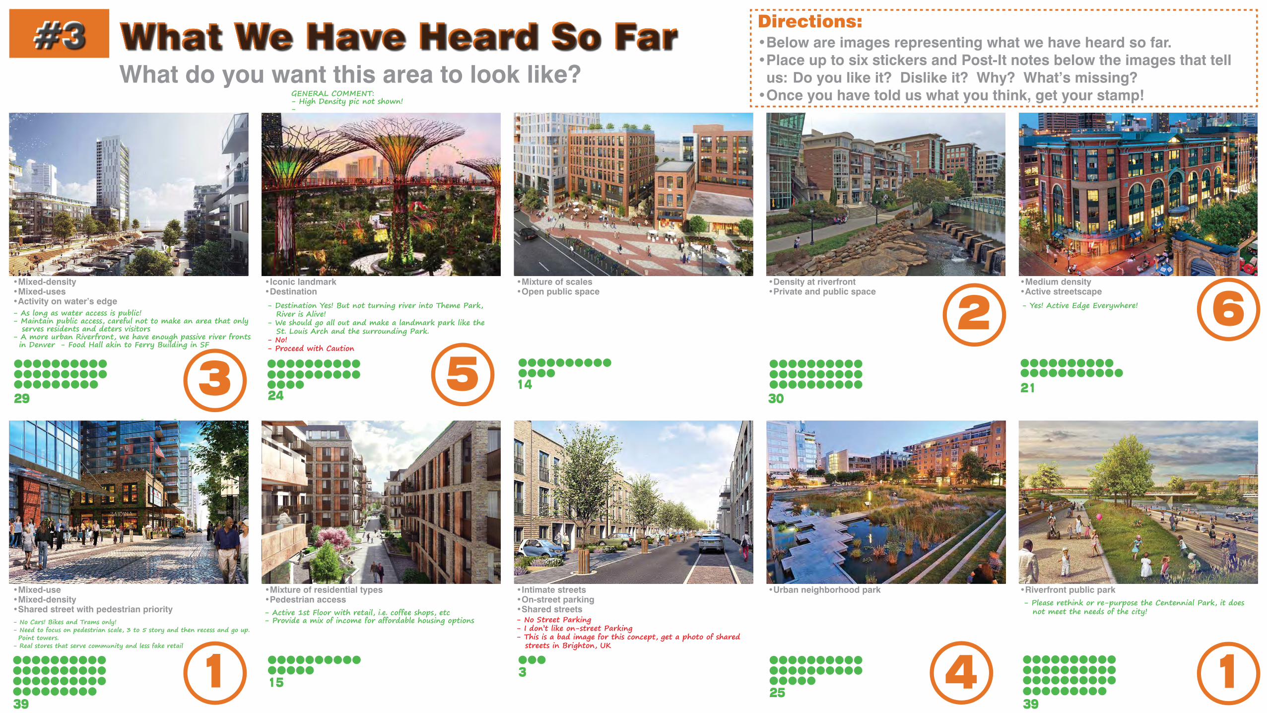
What We Have Heard So Far#3What do you want this area to look like?
•Below are images representing what we have heard so far.•Place up to six stickers and Post-It notes below the images that tell
us: Do you like it? Dislike it? Why? What’s missing?•Once you have told us what you think, get your stamp!
Directions:
GENERAL COMMENT:- High Density pic not shown!-
y g
1
23
4
56
11525
3
39 39
- Please rethink or re-purpose the Centennial Park, it does not meet the needs of the city!
- No Street Parking- I don’t like on-street Parking- This is a bad image for this concept, get a photo of shared streets in Brighton, UK
- Active 1st Floor with retail, i.e. coffee shops, etc- Provide a mix of income for affordable housing options- No Cars! Bikes and Trams only!
- Need to focus on pedestrian scale, 3 to 5 story and then recess and go up. Point towers. - Real stores that serve community and less fake retail
•Mixed-use•Mixed-density •Shared street with pedestrian priority
•Mixture of residential types•Pedestrian access
•Urban neighborhood park•Intimate streets•On-street parking•Shared streets
•Riverfront public park
2130
142429
- Yes! Active Edge Everywhere!- As long as water access is public!- Maintain public access, careful not to make an area that only serves residents and deters visitors- A more urban Riverfront, we have enough passive river fronts in Denver - Food Hall akin to Ferry Building in SF
- Destination Yes! But not turning river into Theme Park, River is Alive! - We should go all out and make a landmark park like the St. Louis Arch and the surrounding Park.- No!- Proceed with Caution
•Mixed-density•Mixed-uses •Activity on water’s edge
•Iconic landmark•Destination
•Density at riverfront•Private and public space
•Mixture of scales •Open public space
•Medium density•Active streetscape

Complete Neighborhood Preference#4What elements of a neighborhood are most important to you?
•Place up to six stickers next to the amenities you think the study area should include.
•Once you’ve placed your stickers, get your stamp!
Directions:
1
2
3
4 6
5
6
28 3243
216
1424 2431 35
- But not too much, we have confluence park, this is an opportunity to be urban! - Parks within high-density! - Parks are great but there should be an opportunity for an urban waterfront.
- Trolleys! - Trolleys that connect to other areas.
- With a balance leaning towards pedestrians, transit, and bikes. - No Cars! - Make area car free, leave your car at home!- NOOOOO!- Please NO!- This is a perfect situation to go car free or car light, on part or whole area.
- Have art that is locally inspired,locally decided, and locally sourced. - Art needs to be interactive and or able to be touched or play on, and interact with. - Public art that can be used for seating and climbing
- High density and good design- Good but make it dense
- I like this idea but not how it is presented in this image.- Critical to build places and promote development that keeps families and children in the city.
- Maybe even bicycle dominant!
Parks
Bicycle-friendly
Public transport Shared streets
Social gathering space Public art
Activated streets with retail Public parking garages
Places and activities for all ages Mixture of housing types

Online SurveyInitial Analysis Summary
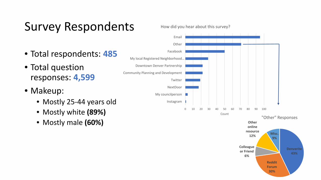
Survey Respondents
• Total respondents: 485• Total question
responses: 4,599• Makeup:
• Mostly 25-44 years old• Mostly white (89%)• Mostly male (60%)
0 10 20 30 40 50 60 70 80 90 100
My councilperson
NextDoor
Community Planning and Development
Downtown Denver Partnership
My local Registered Neighborhood…
Other
Count
How did you hear about this survey?
Denverite43%
Reddit Forum
30%
Colleague or Friend
6%
Other online
resource12% Misc.
9%
"Other" Responses

SWOT Analysis

SWOT: Likes
0 50 100 150 200 250 300 350 400 450
Other
Highly visible from surrounding neighborhoods
Has good views from study area of downtown and the mountains
Easy to get to
Development potential on underutilized vacant lots
Regional draw as cultural and entertainment destination
Existing public transit access
Accessibility to the river and riverfront trails
Close proximity to downtown and surrounding neighborhoods
The river

SWOT: Dislikes
0 50 100 150 200 250 300 350
Other
Unsafe
Noise and/or air pollution
Traffic
No existing strong street grid
Lack of physical connectivity
Man-made and natural barriers
Void of activity
Lack of vegetation
Poor use of land

SWOT: Concerns
0 50 100 150 200 250
Other
Economic downturn
Flood risks and associated mitigation
Too much density
Pollution (noise, air, water, etc.)
Entertainment uses will not be well-balanced with other land uses
Damage to existing river habitat
Failure to meet potential for parkland
Not enough density
Poor quality future development lacking vision or innovation

SWOT: Hopes
0 50 100 150 200 250 300
Other
Leveraging existing amenities
Distinctive street grid
Mobility options
A variety of housing types
Shared structured parking between existing entertainment and new urban uses
A connection to the existing surrounding streets
Development of existing parking lots
A connection to the surrounding neighborhoods and attractions
Community parks
Potential to become the new area or district of downtown
A connection across the river and railway
Incorporating the river in development to engage it as an asset

Neighborhood Elements
0
50
100
150
200
250
300

Vision for the Future
• Thriving, artsy• Entertainment destination with local feel; a place for Denverites to
play• Multi-modal, walkable, connected with pedestrian (and bike) bridges
to surrounding neighborhoods• Activation of and access to the river (Riverfront boardwalk, patios
along river)• Multi-use (housing, restaurants), multi-income• Dense (taller buildings, Vancouver point tower, some specified low-
rise)• High quality design/construction• Green space, open space, trees• Diversity of residents

prepared by
Moore Iacofano Goltsman, Inc.
Progressive Urban Management Associates
In Association with
Fehr and Peers Transportation Consultants
UrbanTrans Consultants, Inc.
Carl Walker, Inc.
DOWNTOWN AREA PLAN
5 VISION ELEMENTS
A. A Prosperous CityB. A Walkable CityC. A Diverse City D. A Distinctive CityE. A Green City

A Prosperous City
Sense of place and identity
High density mix of uses with 24/7 activity
Mixed-income
Flexible retail space
Unlimited building height with human-scale streetscapes
Maintained visibility of South Platte River
•
•
• •
•
•

A Walkable City
Hierarchy of streets, all with good pedestrian facilities and wayfinding
Iconic new pedestrian and bicycle connections over the river, railway, and to Auraria
Small-scale, multi-modal mobility hub Connected to the planned 5280 loop
•
•
•

A Diverse City
Family-friendly downtown living with diverse housing options
Spaces to attract all ages
Physically and programmatically connected to Downtown and other neighborhoods
Culturally diverse businesses
•
•
•
•

A Distinctive City
Design and programs that are forward-thinking and innovative
Variety in architectural styles, rhythm, materials, and finishes
Strong relationship and identity with the river
Open spaces that are well designed with unique character
Public art
•
•
•
•
•

A Green City
Green public realm with a variety of ways to incorporate vegetation
System of distinct, varied public spaces, parks, open space
Urban refuges in areas that are a natural confluence of people
Foster an interactive relationship between the river and parks, public space, and development
Consider registering to become an EcoDistrict
•
•
•
•
•

Summary of the Vision Elements

FUTURE CONCEPTSFOR CPV-AURARIA

T
T
T
T
Existing Road Network
At Grade Crossing
At Grade Crossingon Walnut Street
Existing Pedestrian and Bicyclist Bridges
Existing CML
Existing Light Rail
5th Street
7th Street9th Street
11th Street
12th Street
Chopper Cir
Water StWew
atta St
Wazee S
tWynkoop
St
Blake St
Market S
t
Elitch
CirLitt
le Rave
n
LEGEND
Existing Conditions Map
Platte Valley Trolley
T
23rd Ave
Pepsi Center - Elitch
Gardens Station
Auraria West
Station
Sports Authority Field at Mile High Station
W Byron Pl
26th Ave

T
T
T
T
Street Grid • Maximum multi-modal connectivity within site and to surrounding neighborhoods
Existing Road Network
At Grade Crossing
Existing Pedestrian and Bicyclist Bridges
Proposed Pedestrian and Bicyclist Bridges
Existing CML
Existing Light Rail
5th Street
7th Street9th Street
11th Street
12th Street
Chopper Cir
Water StWew
atta St
Wazee S
t
Blake St
Market S
t
Elitch
CirLitt
le Rave
n
LEGEND
Proposed Street Grid Network
T
Proposed Continuitaion of Existing Road Network
Proposed Additional Street Grids
Proposed Vehicular Bridge
At Grade Crossingon Walnut Street
Platte Valley Trolley
W Byron Pl
26th Ave
23rd Ave Wynkoop
St

T
T
T
T
• Create an extension of the street grids• Vehicular connection along 7th Street• Connect under Speer Blvd. to Little Raven St.• Provide as many access points into the site as possible to relieve pressure from the Speer/Wewatta intersection• Water street can become a main street
Street Grid • Maximum multi-modal connectivity within site and to surrounding neighborhoods
Existing Road Network
At Grade Crossing
Existing Pedestrian and Bicyclist Bridges
Proposed Pedestrian and Bicyclist Bridges
Existing CML
Existing Light Rail
5th Street
7th Street9th Street
11th Street
12th Street
Chopper Cir
Water StWew
atta St
Wazee S
t
Blake St
Market S
t
Elitch
CirLitt
le Rave
n
LEGEND
Proposed Street Grid Network
T
Proposed Continuitaion of Existing Road Network
Proposed Additional Street Grids
Proposed Vehicular Bridge
At Grade Crossingon Walnut Street
Platte Valley Trolley
W Byron Pl
26th Ave
23rd Ave Wynkoop
St

T
T
T
T• Design egress and ingress on to the study area for pedestrians and cyclist only. • Create bridges – make them unique and iconic/landmarks for the area
• Create an extension of the street grids• Vehicular connection along 7th Street• Connect under Speer Blvd. to Little Raven St.• Provide as many access points into the site as possible to relieve pressure from the Speer/Wewatta intersection• Water street can become a main street
Street Grid • Maximum multi-modal connectivity within site and to surrounding neighborhoods
Existing Road Network
At Grade Crossing
Existing Pedestrian and Bicyclist Bridges
Proposed Pedestrian and Bicyclist Bridges
Existing CML
Existing Light Rail
5th Street
7th Street9th Street
11th Street
12th Street
Chopper Cir
Water StWew
atta St
Wazee S
t
Blake St
Market S
t
Elitch
CirLitt
le Rave
n
LEGEND
Proposed Street Grid Network
T
Proposed Continuitaion of Existing Road Network
Proposed Additional Street Grids
Proposed Vehicular Bridge
At Grade Crossingon Walnut Street
Platte Valley Trolley
W Byron Pl
26th Ave
23rd Ave Wynkoop
St

T
T
T
T
Proposed Street Type A
Existing CML
Existing Light Rail
5th Street
7th Street9th Street
11th Street
12th Street
Water St Wewatta
St
Delgany
St
Wazee S
t
Blake St
Market S
t
Elitch
CirLitt
le Rave
n
LEGEND
Proposed Street Grid Network
Proposed Street Type B
Proposed Street Type C
T
At Grade Crossing
Existing Pedestrian and Bicyclist Bridges
Proposed Pedestrian and Bicyclist Bridges
Proposed Vehicular Bridge
Underpass Connection
At Grade Crossingon Walnut Street
Platte Valley Trolley
Wynkoop
St
23rd Ave
W Byron Pl
26th Ave

Street Type B Street Type CStreet Type AConsidered the bones of the street grid and are identified as the main streets to move vehicles, bikes, and pedestrians through the study area and to efficiently connect these transportation modes to surrounding areas.
Considered the foundation of active streets and generally prioritizes bicyclists and pedestrians.
Considered low-traffic streets that provide connections for the neighborhood.

T
T
T
T
Existing CML
Existing Light Rail
5th Street
7th Street9th Street
11th Street
Walnut st
12th Street
Water St Wewatta
St
Delgany
St
Wazee S
t
15th St
Wynkoop
St
Blake St
Market S
t
Elitch
CirLitt
le Rave
n
LEGEND
Proposed Bike Network
T
At Grade Crossing
Existing & ProposedPedestrian and Bicyclist Bridges
Proposed Vehicular Bridge
Underpass Connection
Protected Bike Lane orGrade-separated Bike Lane
Existing Bike Network
Proposed Multi-use Trail
Proposed 5280 Loop
5280 Loop
Shared Roadways
Platte Valley Trolley
W Byron Pl
26th Ave
23rd Ave

Grand Boulevard
T
T
T
T
Existing Green Networks
At Grade Crossing5th Street
7th Street9th Street
11th Street
12th Street
Chopper Cir
Water St
23rd St
Wewatta
St
Wazee S
t
Blake St
Market S
t
Elitch
CirLitt
le Rave
n
LEGEND
Green Networks & Open Space Strategy
Enhanced Green Streets
To La AlmaLincoln Park
Existing Park Network
Enhanced Green Zone
Proposed Park/Open Space
Existing CML
Existing Light RailT
Platte Valley Trolley

T
T
T
T
5th Street
7th Street9th Street
11th Street
12th Street
Chopper Cir
Water St Wewatta
St
Wazee S
t
Blake St
Market S
t
Elitch
Cir
Little R
aven
LEGEND
Future Concept Land Use
Existing CML
Existing Light RailT
Platte Valley Trolley
Downtown/Mixed-Use
Retail Corridor Encouraged
Mitigate External Effects of Noise & Air Pollution
Grand Boulevard
Wynkoop
St
23rd Ave
W Byron Pl
26th Ave

T
T
T
T
5th Street
7th Street9th Street
11th Street
12th Street
Chopper Cir
Water St Wewatta
St
Wazee S
t
Blake St
Market S
t
Elitch
Cir
Little R
aven
LEGEND
Future Concept Land Use
Existing CML
Existing Light RailT
Platte Valley Trolley
Grand Boulevard
Wynkoop
St
23rd Ave
W Byron Pl
26th Ave
Office
Commercial/Retail
Mixed-UseIndustrial/Manufacturing
Civic
Entertaiment - Cultural
Multi-Family Low Rise
Mutli-Family Mid RiseMulti-Family High Rise
Park-Open Space
Parking
Surface Water
T
T
T
T
5th Street
7th Street9th Street
11th Street
12th Street
Chopper Cir
Water St Wewatta
St
Wazee S
t
Blake St
Market S
t
Elitch
Cir
Little R
aven
LEGEND
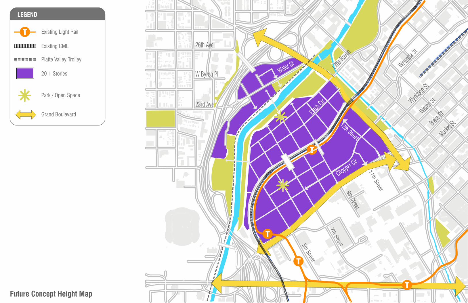
Future Concept Height Map
Existing CML
Existing Light RailT
Platte Valley Trolley
20+ Stories
Grand Boulevard
Park / Open SpaceWynk
oop St
23rd Ave
W Byron Pl
26th Ave

High-density (20+ Stories)
Mid-density (4-19 Stories)
Low-density (1-3 Stories)
T
T
T
T
5th Street
7th Street9th Street
11th Street
12th Street
Chopper Cir
Water St Wewatta
St
Wazee S
t
Blake St
Market S
t
Elitch
Cir
Little R
aven
LEGEND
Potential Height Map
Existing CML
Existing Light RailT
Platte Valley Trolley
Grand Boulevard
Wynkoop
St
23rd Ave
W Byron Pl
26th Ave

T
T
T
T
At Grade Crossing
Priority Pedestrian Connection
Opportunity Site
Existing CML
Existing Light Rail
5th Street
7th Street9th Street
11th Street
12th Street
Chopper Cir
Water St
23rd Ave
W Byron Pl
26th Ave
Wewatta
St
Wazee S
t
Blake St
Market S
t
Elitch
CirLitt
le Rave
n
LEGEND
Development Opportunity Strategy To Lincoln Park
Grand Boulevard
1/4 Mile Radius AroundKey Transit
Platte Valley Trolley
T