3 affected environment - united states fish and wildlife … · 2017-01-24 · the diverse habitats...
TRANSCRIPT

3 Affected Environment
Ear Mountain in Blackleaf Wildlife Management Area.
US
FW
S
This chapter describes the biological, cultural, and socioeconomic resources most likely affected by expanding the Rocky Mountain Front Conservation Area.
BIOLOGICAL ENVIRONMENT The biological environment studied included climate, geological resources, habitat, and wildlife.
CLIMATE
The climate is generally cool and dry, but there is considerable variability corresponding to the east– west elevational gradient that greatly influences vegetation and habitat. The weather station at the Gibson Reservoir near the western boundary has above freezing average maximum temperatures all year, with the coldest minimum temperatures in January (12.4ºF). July and August are the warmest months with an average high around 77ºF and a low near 45ºF. The Augusta climatic station at the eastern boundary of the Front has similar above freezing winter average maximums, but is colder at night with January having average minimums of 10ºF. Average summer temperatures are also warmer in Augusta with July and August having maximums slightly over 80ºF and minimums around 47ºF.
Gibson Dam receives almost 18 inches of precipitation annually; May and June are the
wettest months with about 3 inches per month; all of the winter months receive less than 1 inch of precipitation per month. Augusta has a similar pattern with relatively wet springs and dry winters, although the total precipitation averages only about 14 inches annually. This precipitation gradient (along with soils) is vital for structuring vegetation communities across the Front (Kudray and Cooper 2006).
GEOLOGICAL RESOURCES
The Front lies at the eastern edge of the Rocky Mountains where tectonic plates collided and pushed large slabs of rock upward in a fold-and-thrust belt. The highest elevation landforms are located in the most western section of the Front and are mapped as Paleozoic Era sedimentary rock composed of sandstone, shale, and limestone (including dolomite). The Kootenai Formation from the Mesozoic Era is found adjacent at lower elevations and is also sedimentary rock, but composed of conglomerate, sandstone, shale, and mudstone. The Colorado Shale Formation of shale and siltstone is typically found at the next lowest topographic position. At lower elevations, alluvial deposits are common with layers of gravel, sand, and silt. There are also significant low-elevation glacial deposits from the Pleistocene Age that have variable, mostly coarse textures. The Two Medicine Formation from the Cretaceous Era is one of the most common lower elevation types and

10 EA, Rocky Mountain Front Conservation Area Expansion, MT
is sedimentary with clay, limestone, and sandstone. There is also a prominent area of Cretaceous volcanic rock in the far southern part of the Front (Kudray and Cooper 2006).
HABITAT An ecotone formed by the meeting of two major ecoregions along a mountains–plains gradient, the Front hosts a rich mixture of glaciated wetlands (“prairie potholes”), riparian corridors, mixed grass prairie, and coniferous forests. Alpine meadows lie on the shoulders of the high peaks along the western edge of the Front. Montane forests consisting of limber pine, Douglas-fir, and ponderosa pine transition eastward into aspen parklands and a large expanse of fescue grasslands. The Front’s varied topography and soils give rise to a diverse array of plant communities, including some of considerable scientific importance. The Montana Natural Heritage Program has rated the Rocky Mountain Front as highly significant for biodiversity including 114 species or communities of special concern.
The landscape is extremely variable and extends from higher elevation barren rock or forested stands of Douglas-fir or aspen, to mid-elevation limber pine woodlands down to a complex mosaic of mixed-grass prairie with agricultural grain and hay fields at lower elevations and in floodplains.
Numerous hydrological features bisect the project area. The Dearborn, Sun, and Teton rivers form major riparian corridors running from the mountains eastward into the prairies. Numerous other tributaries provide a diversity of riparian and wetland plant communities. A large number of vascular plants occur within the project boundary, representing a remarkable biological diversity. Approximately 30% of the over 700 species of plants are associated exclusively with wetland or riparian habitats, including some of the largest remaining fens in the Pacific Northwest. The project area contains the largest intact expanse of fescue grasslands left in the Northern Great Plains (Lesica 1994).
Higher elevations also include fescue grasslands and a large acreage recovering from a wildfire that is now a mix of mostly Douglas-fir regeneration, among burned tree trunks over relatively lush fescue grasslands. The fescue is often mixed with shrubs; creeping juniper and kinnikinnick occurring on somewhat drier sites, while shrubby cinquefoil is common in more mesic areas (habitat with a moderate- or well-balanced supply of moisture). Shrubby cinquefoil is particularly common in the northern extreme of the Front, but also follows the greater eastward expansion of the fescue-type habitat in the southern end, where it is more closely associated with stream terraces. The aspen stands are typically small clonal (genetically identical) patches in landforms that receive some additional
moisture or have a more mesic aspect. Limber pine stands are generally in decline, primarily from white pine blister rust disease. Dead and dying trees are typical; some former stands can only be recognized by the dead tree trunks.
The riparian corridors associated with the larger drainage system are especially diverse and rich in habitat value. Natural vegetation communities generally correspond to the height of the floodplain above the water table, although successional influences also affect the distribution of shrubby and forested types—early shrub establishment can give way to later forested stands on suitable sites.
The shrub communities also respond to a moisture gradient; willows and red-osier dogwood dominate the wetter sites while chokecherry, Saskatoon serviceberry, and Woods’ rose occur on drier sites, sometimes with an aspen overstory. Wet meadows dominate riparian areas where water tables are high and there is not sufficient water movement to oxygenate the soil enough for shrubs and trees. Flood-irrigated hay meadows are also common where the floodplain is wider and soils are suitable.
The fescue grasslands at higher elevation (and correspondingly greater precipitation) transition at lower elevations to grasslands dominated by various grass species in response to soil and topography. Western wheatgrass is the dominant species in swales (lower elevation land that remains moist) with heavier soils and often moisture run-in. Needle and thread is the most common species on sandier soils, which tend to occur somewhat higher in the local landscape. Bluebunch wheatgrass is associated with steeper slopes; mixtures of any or all these grasses can occur with the variable conditions found in this diverse landscape. Blue grama can become very common with sustained heavy grazing. The absence of sagebrush is notable and currently unexplained.
A variety of wetland types occurs throughout the upland matrix in pothole depressions, larger shallow basins, or swales with impeded drainage. There is considerable diversity; some basins have dry to bare soil after seasonal flooding while others will have a variety of wetland types in a zoned pattern dependent on seasonal water table depths and salt concentrations. Most of these areas are dominated by graminoids (grasses), but shrubby cinquefoil is common in swales. Willows may be found, but are much more common in riparian wetlands.
Agricultural fields are most common in the central part of the project area. In addition to flood-irrigated hay fields, there are some central pivot-irrigated hay fields and dryland small grain production. Barley and wheat are the typical dryland crops but some fields have been planted to a variety of introduced species and are used for grazing land or hay production. Although a somewhat uncommon practice, fields have also been planted back to cultivars (presumed) of
native species (mostly western wheatgrass) and can be identified by their unusual degree of uniformity, lack of forb (herbaceous flowering plant) diversity and telltale furrowing.
WILDLIFE About 240 species of birds or approximately 65% of all birds found in Montana are known to inhabit this area. At least 134 species of birds are known to breed, an additional fifty-four species are suspected of breeding within the project area, and some 108 species of Neotropical migrants have been observed (see appendix A).
Mammals
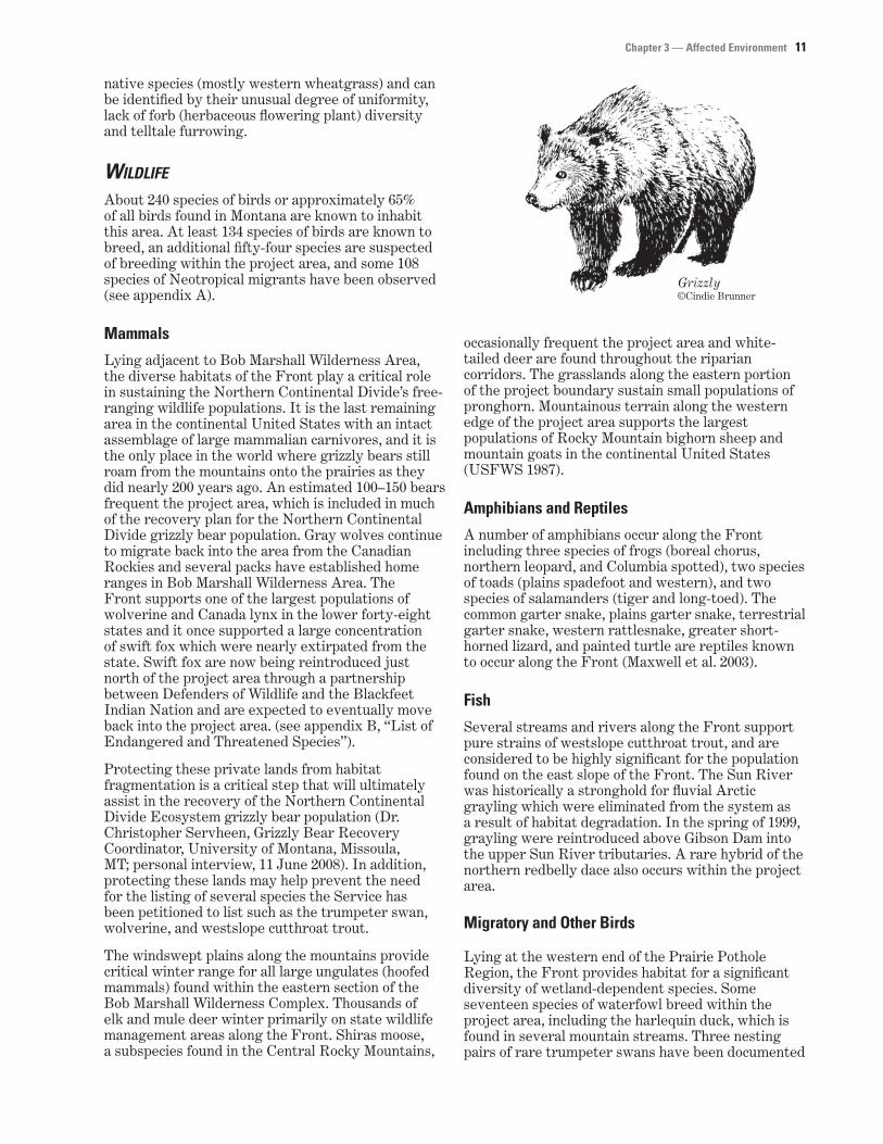
Lying adjacent to Bob Marshall Wilderness Area, the diverse habitats of the Front play a critical role in sustaining the Northern Continental Divide’s free-ranging wildlife populations. It is the last remaining area in the continental United States with an intact assemblage of large mammalian carnivores, and it is the only place in the world where grizzly bears still roam from the mountains onto the prairies as they did nearly 200 years ago. An estimated 100–150 bears frequent the project area, which is included in much of the recovery plan for the Northern Continental Divide grizzly bear population. Gray wolves continue to migrate back into the area from the Canadian Rockies and several packs have established home ranges in Bob Marshall Wilderness Area. The Front supports one of the largest populations of wolverine and Canada lynx in the lower forty-eight states and it once supported a large concentration of swift fox which were nearly extirpated from the state. Swift fox are now being reintroduced just north of the project area through a partnership between Defenders of Wildlife and the Blackfeet Indian Nation and are expected to eventually move back into the project area. (see appendix B, “List of Endangered and Threatened Species”).
Protecting these private lands from habitat fragmentation is a critical step that will ultimately assist in the recovery of the Northern Continental Divide Ecosystem grizzly bear population (Dr. Christopher Servheen, Grizzly Bear Recovery Coordinator, University of Montana, Missoula, MT; personal interview, 11 June 2008). In addition, protecting these lands may help prevent the need for the listing of several species the Service has been petitioned to list such as the trumpeter swan, wolverine, and westslope cutthroat trout.
The windswept plains along the mountains provide critical winter range for all large ungulates (hoofed mammals) found within the eastern section of the Bob Marshall Wilderness Complex. Thousands of elk and mule deer winter primarily on state wildlife management areas along the Front. Shiras moose, a subspecies found in the Central Rocky Mountains,
Chapter 3 — Affected Environment 11
©Cindie Brunner Grizzly
occasionally frequent the project area and white-tailed deer are found throughout the riparian corridors. The grasslands along the eastern portion of the project boundary sustain small populations of pronghorn. Mountainous terrain along the western edge of the project area supports the largest populations of Rocky Mountain bighorn sheep and mountain goats in the continental United States (USFWS 1987).
Amphibians and Reptiles
A number of amphibians occur along the Front including three species of frogs (boreal chorus, northern leopard, and Columbia spotted), two species of toads (plains spadefoot and western), and two species of salamanders (tiger and long-toed). The common garter snake, plains garter snake, terrestrial garter snake, western rattlesnake, greater short-horned lizard, and painted turtle are reptiles known to occur along the Front (Maxwell et al. 2003).
Fish
Several streams and rivers along the Front support pure strains of westslope cutthroat trout, and are considered to be highly significant for the population found on the east slope of the Front. The Sun River was historically a stronghold for fluvial Arctic grayling which were eliminated from the system as a result of habitat degradation. In the spring of 1999, grayling were reintroduced above Gibson Dam into the upper Sun River tributaries. A rare hybrid of the northern redbelly dace also occurs within the project area.
Migratory and Other Birds
Lying at the western end of the Prairie Pothole Region, the Front provides habitat for a significant diversity of wetland-dependent species. Some seventeen species of waterfowl breed within the project area, including the harlequin duck, which is found in several mountain streams. Three nesting pairs of rare trumpeter swans have been documented

12 EA, Rocky Mountain Front Conservation Area Expansion, MT
in the Bean Lake-Nylan Reservoir Complex, one of the few breeding occurrences outside of the Centennial Valley in southwestern Montana. Hundreds of thousands of snow geese migrate along the Front, including 40,000 Wrangel Island snow geese, representing 50% of the entire known population. Peak flights of waterfowl along the Front during spring and fall migration often exceed several million birds. Six species of grebes are known to nest including the red-necked grebe, a species in serious decline in many other areas. Eleven different species of shorebirds breed in the wetlands and adjacent grasslands scattered throughout the area. The westernmost breeding occurrence of inland piping plovers occurs at Alkali Lake near the northeastern boundary of the project area. Several thousand sandhill cranes from the Rocky Mountain population use the river corridors during their spring and fall migration, and a portion of the cranes breed in these areas as well.
Cliff and riparian areas provide the two most important habitats for nesting raptors within the project area. At least twenty-one species of raptors breed along the Front, including nine species of owls. One of the Nation’s densest populations of golden eagles and prairie falcons reside in the rock escarpments along the western edge of the project area. The Front hosts relatively robust populations of bald eagles, peregrine falcons, ferruginous hawks, and goshawks.
The project area includes one of the largest remaining expanses of native prairie left in the Northern Great Plains. This “sea of grass” provides essential habitat for numerous grassland birds, many of which are experiencing significant population declines. These include chestnut-collared longspurs, Le Conte’s sparrows, bobolinks, Sprague’s pipit, burrowing owls, marbled godwits, long-billed curlews, and lark buntings.
Long-billed curlew.
Mik
e P
arke
r/U
SF
WS
CULTURAL RESOURCES The Service has a trust responsibility to American Indian tribes that includes protection of the tribal sovereignty and preservation of tribal culture and other trust resources.
Currently, the Service does not propose any project, activity, or program that would result in changes in the character of, or adversely affect, any historical cultural resource or archaeological site. When such undertakings are considered, the Service takes all necessary steps to comply with Section 106 of the National Historic Preservation Act (NHPA) of 1966, as amended. The Service pursues compliance with Section 110 of the NHPA to survey, inventory, and evaluate cultural resources.
SOCIOECONOMIC ENVIRONMENT The project area includes portions of three counties—Lewis and Clark, Pondera, and Teton. Four communities are within the project area, all located along the eastern boundary on Highway 89/287. The largest community is Choteau with a population of 1,781. Augusta has 284 people, and Dupuyer and Bynum both have less than 200 people (U.S. Census Bureau 2000).
Most of the rural population is involved in ranching and livestock production. Hunting of a wide variety of game species occurs on private lands, with elk hunting bringing the most people to the Front.
A seasonal influx of tourists are attracted to the Front for opportunities to bird watch, mountain bike, horseback ride, backpack, camp, canoe, fish, and view archeological and paleontological resources. Choteau and Augusta are “gateway” communities for recreational activities in the Lewis and Clark National Forest, Bob Marshall, and Scapegoat Wildernesses, and Glacier National Park.
AGRICULTURAL RESOURCES
The economy of the Rocky Mountain Front is primarily agrarian. Large cattle ranches dominate the private lands within the project area.
LANDOWNERSHIP Ownerships are relatively large in size (2,000 to 25,000 acre blocks) which helps maintain this intact landscape. The human population is sparse and towns are widely scattered. Towns tend to be service centers for the agricultural economy, but also support tourism and recreation.
Other significant public lands within the project area include 113,000 acres of state (school trust) lands that are managed to generate revenues for public schools in Montana (see figure 3).
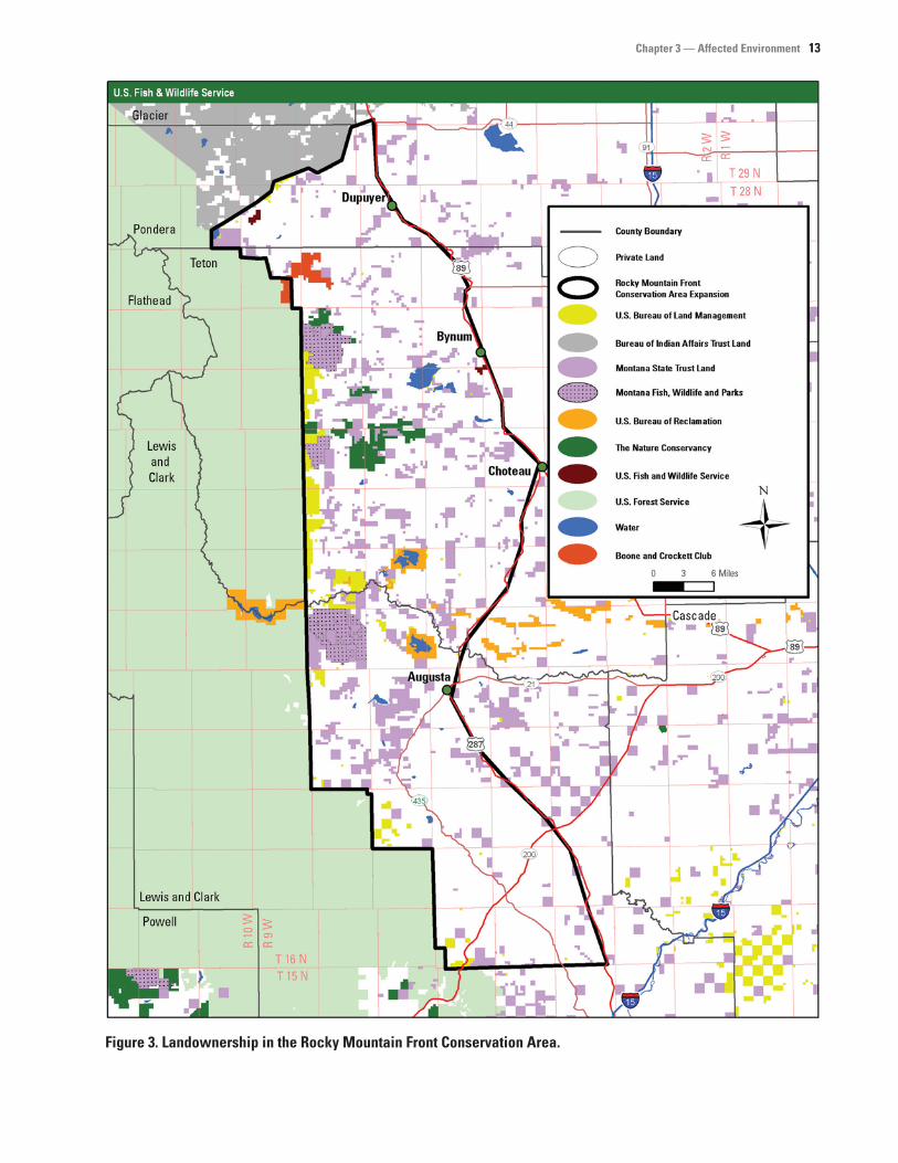
Chapter 3 — Affected Environment 13
Figure 3. Landownership in the Rocky Mountain Front Conservation Area.

14 EA, Rocky Mountain Front Conservation Area Expansion, MT
PROPERTY TAX
Currently, landowners pay property taxes on their private lands to the counties. The land does not change hands and, therefore, the property taxes paid by the landowner to the county are not affected. No changes to the tax base are anticipated.
PUBLIC USE AND WILDLIFE-DEPENDENT RECREATIONAL ACTIVITIES Hunting and fishing are very popular throughout the project area. Hunting for a variety of wildlife includes waterfowl, upland game birds, pronghorn, elk, moose, deer, black bear, bighorn sheep, mountain lion, and furbearers. Private landowners often give permission for hunting and fishing on their land. Under a conservation easement, control of public access to land would remain under the discretion of the landowner.