chapter 4. affected environment 4. affected environment ... glacial lake agassiz basin from the...
TRANSCRIPT
Chapter 4. Affected Environment
4.1 Physical Environment The limited-interest refuges are scattered across North Dakota, primarily east of the Missouri River, from the Canadian border down to South Dakota. Because the refuges cover such a large geographic area, the physical environment and biological resources will be described in terms of the physiographic region or ecoregion in which each refuge or group of refuges is located. Thirteen ecoregions are found in the Program area (figure 5). These ecoregions denote areas of general similarity in ecosystems and the type, quality, and quantity of environmental resources.
The text and graphics in this section are from a project completed in 1998 by the Northern Prairie Wildlife Research Center in Jamestown, North Dakota and titled “Ecoregions of North and South Dakota.”
Ecological regions are distinguished by the patterns of biotic and abiotic phenomena that reflect the differences in ecosystem quality. These phenomena include geology, physiography, vegetation, climate, soils, land use, wildlife, and hydrology. Each ecoregion and its associated refuge(s) are summarized in tables 6 and 7.
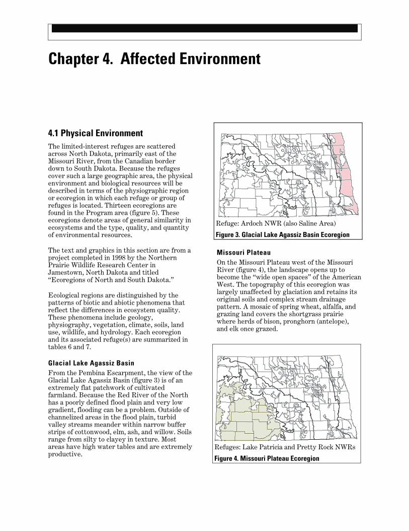
Glacial Lake Agassiz Basin From the Pembina Escarpment, the view of the Glacial Lake Agassiz Basin (figure 3) is of an extremely flat patchwork of cultivated farmland. Because the Red River of the North has a poorly defined flood plain and very low gradient, flooding can be a problem. Outside of channelized areas in the flood plain, turbid valley streams meander within narrow buffer strips of cottonwood, elm, ash, and willow. Soils range from silty to clayey in texture. Most areas have high water tables and are extremely productive.
Refuge: Ardoch NWR (also Saline Area)
Figure 3. Glacial Lake Agassiz Basin Ecoregion
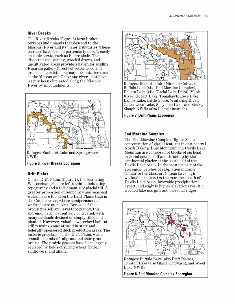
Missouri Plateau On the Missouri Plateau west of the Missouri River (figure 4), the landscape opens up to become the “wide open spaces” of the American West. The topography of this ecoregion was largely unaffected by glaciation and retains its original soils and complex stream drainage pattern. A mosaic of spring wheat, alfalfa, and grazing land covers the shortgrass prairie where herds of bison, pronghorn (antelope), and elk once grazed.
Refuges: Lake Patricia and Pretty Rock NWRs
Figure 4. Missouri Plateau Ecoregion

32 Comprehensive Conservation Plan, North Dakota Limited-interest National Wildlife Refuges
Figure 5. Ecoregion Map
4⎯Affected Environment 33
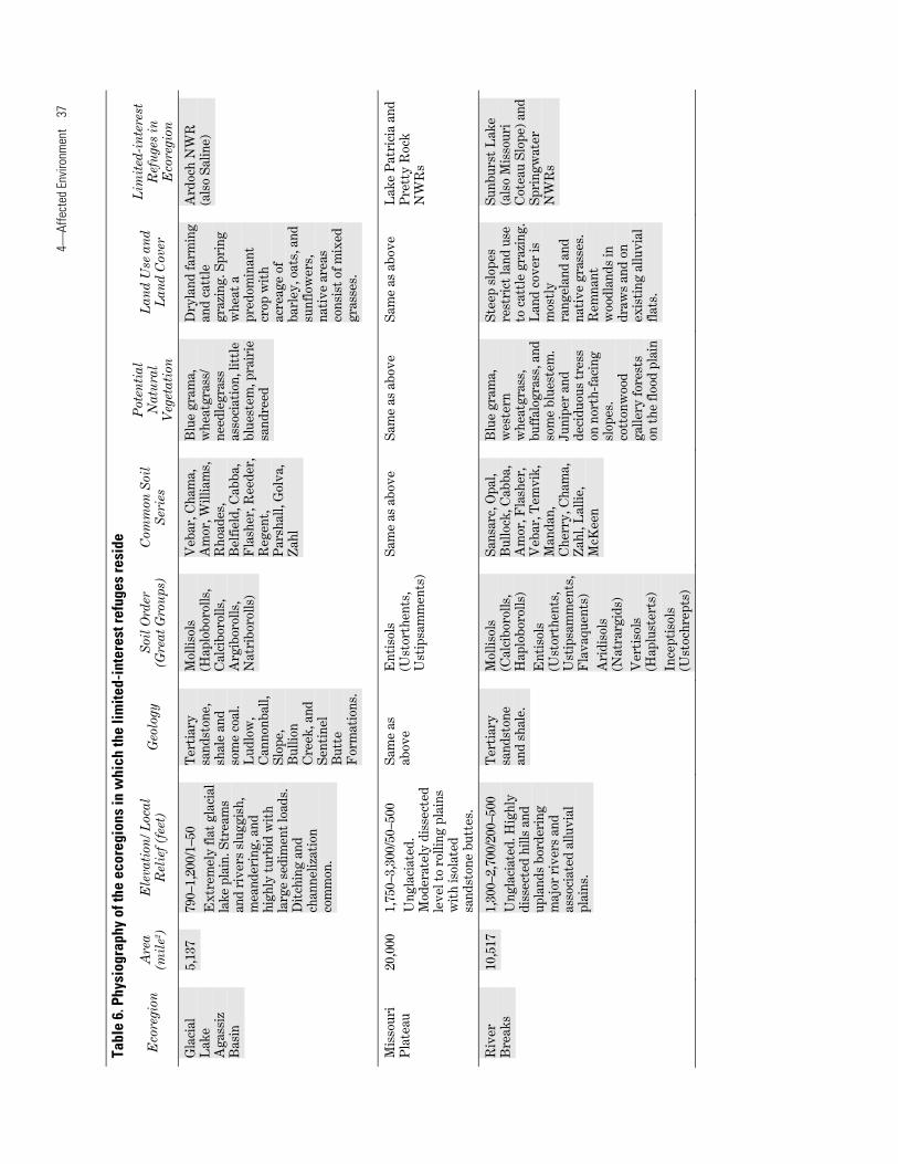
River Breaks The River Breaks (figure 6) form broken terraces and uplands that descend to the Missouri River and its major tributaries. These terraces have formed particularly in soft, easily erodible strata, such as Pierre shale. The dissected topography, wooded draws, and uncultivated areas provide a haven for wildlife. Riparian gallery forests of cottonwood and green ash persist along major tributaries such as the Moreau and Cheyenne rivers, but have largely been eliminated along the Missouri River by impoundments.
Refuges: Sunburst Lake and Springwater NWRs
Figure 6. River Breaks Ecoregion
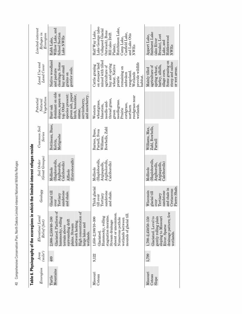
Drift Plains On the Drift Plains (figure 7), the retreating Wisconsinan glaciers left a subtle undulating topography and a thick mantle of glacial till. A greater proportion of temporary and seasonal wetlands are found on the Drift Plains than in the Coteau areas, where semipermanent wetlands are numerous. Because of the productive soil and level topography, this ecoregion is almost entirely cultivated, with many wetlands drained or simply tilled and planted. However, valuable waterfowl habitat still remains, concentrated in state and federally sponsored duck production areas. The historic grassland on the Drift Plains was a transitional mix of tallgrass and shortgrass prairie. The prairie grasses have been largely replaced by fields of spring wheat, barley, sunflowers, and alfalfa.
Refuges: Bone Hill (also Missouri Coteau), Buffalo Lake (also End Moraine Complex), Dakota Lake (also Glacial Lake Delta), Maple River, Hobart Lake, Tomahawk, Rose Lake, Lambs Lake, Little Goose, Wintering River, Cottonwood Lake, Sheyenne Lake, and Stoney Slough NWRs (also Glacial Outwash)
Figure 7. Drift Plains Ecoregion
End Moraine Complex The End Moraine Complex (figure 8) is a concentration of glacial features in east central North Dakota. Blue Mountain and Devils Lake Mountain are composed of blocks of surficial material scraped off and thrust up by the continental glacier at the south end of the Devils Lake basin. In the western part of the ecoregion, patches of stagnation moraine similar to the Missouri Coteau have high wetland densities. On the moraines south of Devils Lake basin, favorable precipitation, aspect, and slightly higher elevations result in wooded lake margins and morainal ridges.
Refuges: Buffalo Lake (also Drift Plains), Johnson Lake (also Glacial Outwash), and Wood Lake NWRs
Figure 8. End Moraine Complex Ecoregion

34 Comprehensive Conservation Plan, North Dakota Limited-interest National Wildlife Refuges
Glacial Lake Basins The Glacial Lake Basins (figure 9) were once occupied by Lake Souris, Devils Lake, and Lake Dakota. These proglacial lakes were formed when major stream or river drainages were blocked by glacial ice during the Pleistocene. The smooth topography of the Glacial Lake Basins, even flatter than the surrounding Drift Plains, resulted from the slow buildup of water-laid sediments. The level, deep soils on the lake plains are intensively cultivated. In the north, the primary crops are spring wheat, other small grains, and sunflowers; in the Lake Dakota basin of South Dakota, corn and soybeans are more prevalent.
Refuges: Pleasant Lake, Dakota Lake (also Drift Plains), Silver Lake, Rock Lake and Brumba (both also in Northern Black Prairie), and Snyder Lake NWRs
Figure 9. Glacial Lake Basins Ecoregion
Glacial Outwash The disjunct areas of Glacial Outwash (figure 10) differ from outwash areas on the Missouri Coteau in that they generally have a smoother topography. The soils are highly permeable with low water holding capacity. Areas of excessive soil permeability have a poor to fair potential for dryland crop production. Some areas are used for irrigated agriculture. The risk for blowing soil in droughty areas is reduced by retaining native range grasses like little bluestem, needle-and-thread grass, and green needlegrass.
Refuges: Sibley Lake, Johnson Lake (also End Moraine Complex), and Stoney Slough NWRs (also Drift Plains)
Figure 10. Glacial Outwash Ecoregion
Northern Black Prairie The Northern Black Prairie (figure 11) represents a broad phenological transition zone marking the introduction from the north of a boreal influence in climate. Aspen and birch appear in wooded areas, willows grow on wetland perimeters, and rough fescue, common to the Rocky Mountain foothills, becomes evident in grassland associations. This ecoregion has the shortest growing season and the lowest January temperatures of any other ecoregion in the Dakotas. Most of the area is used for growing small grains, with durum wheat being a major crop.
Refuges: Rock Lake and Brumba NWRs (both also in Glacial Lake Basins)
Figure 11. Northern Black Prairie Ecoregion

4⎯Affected Environment 35
Turtle Mountains The undulating landscape and abundant wetlands of the Turtle Mountains (figure 12) are similar to the Missouri Coteau. However, the Turtle Mountains contain larger, deeper, and more numerous lakes. Additionally, this ecoregion receives about 10 inches more precipitation than the surrounding Drift Plains; thus, it supports a forest cover of aspen, birch, burr oak, elm, and ash. The forest soils are erodible and poorly suited for cropland, though there is some clearing for pastureland.
Refuges: Rabb Lake, Willow Lake, and School Section Lake NWRs
Figure 12. Turtle Mountains Ecoregion
Missouri Coteau Like closely spaced ocean swells, the rolling hummocks of the Missouri Coteau (figure 13) enclose countless wetland depressions or potholes. During its slow retreat, the Wisconsinan glacier stalled on the Missouri escarpment for thousands of years, melting slowly beneath a mantle of sediment to create the characteristic pothole topography of the Coteau. The wetlands of the Missouri Coteau and the neighboring prairie pothole regions are the major WPAs in North America. Land use on the Coteau is a mix of tilled agriculture in flatter areas and grazing land on steeper slopes.
Refuges: Half Way Lake, Lake George, Hutchinson Lake, Canfield Lake, Camp Lake, Lake Otis, and Bone Hill NWRs (also Drift Plains)
Figure 13. Missouri Coteau Ecoregion
Missouri Coteau Slope The Missouri Coteau Slope ecoregion (figure 14) declines in elevation from the Missouri Coteau to the Missouri River. Unlike the Missouri Coteau where there is a paucity of streams, the Missouri Coteau Slope has a simple drainage pattern and fewer wetland depressions. Due to the level to gently rolling topography, there is more cropland than on the Missouri Coteau. Cattle graze on the steeper land that occurs along drainages.
Refuges: Appert Lake, Lost Lake, and Hiddenwood NWRs
Figure 14. Missouri Coteau Slope Ecoregion

36 Comprehensive Conservation Plan, North Dakota Limited-interest National Wildlife Refuges
Glacial Lake Deltas The Glacial Lake Deltas (figure 15) were deposited by rivers entering glacial lake basins (e.g., Glacial Lake Souris, Devils Lake, and Lake Dakota). The heaviest sediments, mostly sand and fine gravel, formed delta fans at the river inlets. As the lake floors were exposed during withdrawal of the glacial ice, wind reworked the sand in some areas into dunes. In contrast to the highly productive, intensively tilled glacial lake plains, the dunes in the delta areas have a thin vegetative cover and a high risk for wind erosion. These areas are used mainly for grazing or irrigated agriculture.
Refuges: Dakota Lake (also Drift Plains and Glacial Lake Basins), and Lords Lake NWRs
Figure 15. Glacial Lake Deltas Ecoregion
Saline Area In the Saline Area (figure 16) of the Lake Agassiz basin, salty artesian groundwater flows to the surface through glacial till and lacustrine sediments from the underlying beds of Cretaceous sandstone. The regional boundary of the Saline Area delineates an area where salt effects are most evident. Other saline areas occur along the tributaries of the Park, Forest, and Turtle rivers in northeast North Dakota. Salt-affected soils in the saline area reduce crop productivity. Many areas are not suitable for farming, but are used for range or wildlife habitat.
Refuge: Ardoch NWR (also Glacial Lake Agassiz Basin)
Figure 16. Saline Area Ecoregion
Collapsed Glacial Outwash Areas of Collapsed Glacial Outwash (figure 17) formed from gravel and sand deposited by glacial meltwater and precipitation runoff over stagnant ice. Many large, shallow lakes are found in these areas; lakes and wetlands tend to be slightly to very alkaline depending upon the flowpath of groundwater moving through the permeable outwash deposits. They attract birds preferring large areas of open water, such as white pelicans, black terns, and Forster’s terns, as well as those living in brackish water, such as avocets and tundra swans.
Refuge: Lake George NWR (also Missouri Coteau)
Figure 17. Collapsed Glacial Outwash Ecoregion
4⎯Af
fect
ed E
nviro
nmen
t 37
Tabl
e 6.
Phy
siog
raph
y of
the
ecor
egio
ns in
whi
ch th
e lim
ited-
inte
rest
refu
ges
resi
de
Pot
enti
al
Lim
ited
-in
tere
stA
rea
Ele
vati
on/ L
ocal
S
oil O
rder
C
omm
on S
oil
Lan
d U
se a
nd
Eco
regi
on
Geo
logy
N
atu
ral
Ref
uge
s in
(m
ile2 )
R
elie
f (fe
et)
(Gre
at G
rou
ps)
Ser
ies
Lan
d C
over
V
eget
atio
n
Eco
regi
on
Gla
cial
5,
137
790–
1,20
0/1–
50
Lak
e E
xtre
mel
y fl
at g
laci
alA
gass
iz
lake
pla
in. S
trea
ms
Bas
in
and
rive
rs s
lugg
ish,
m
eand
erin
g, a
nd
high
ly t
urbi
d w
ith
larg
e se
dim
ent
load
s.
Dit
chin
g an
d ch
anne
lizat
ion
com
mon
.
Ter
tiar
y M
ollis
ols
Veb
ar, C
ham
a,
Blu
e gr
ama,
D
ryla
nd fa
rmin
g A
rdoc
h N
WR
sa
ndst
one,
(H
aplo
boro
lls,
Am
or, W
illia
ms,
w
heat
gras
s/
and
catt
le
(als
o S
alin
e)
shal
e an
d C
alci
boro
lls,
Rho
ades
, ne
edle
gras
s gr
azin
g. S
prin
g so
me
coal
. A
rgib
orol
ls,
Bel
fiel
d, C
abba
, as
soci
atio
n, li
ttle
w
heat
a
Lud
low
, N
atri
boro
lls)
Fla
sher
, Ree
der,
bl
uest
em, p
rair
ie
pred
omin
ant
Can
nonb
all,
Reg
ent,
sa
ndre
ed
crop
wit
h S
lope
, P
arsh
all,
Gol
va,
acre
age
of
Bul
lion
Zah
l ba
rley
, oat
s, a
nd
Cre
ek, a
nd
sunf
low
ers,
S
enti
nel
nati
ve a
reas
B
utte
co
nsis
t of
mix
ed
For
mat
ions
. gr
asse
s.
Mis
sour
i 20
,000
1,
750–
3,30
0/50
–500
S
ame
as
Ent
isol
s S
ame
as a
bove
S
ame
as a
bove
S
ame
as a
bove
L
ake
Pat
rici
a an
d P
late
au
abov
e (U
stor
then
ts,
Pre
tty
Roc
kU
ngla
ciat
ed.
Ust
ipsa
mm
ents
) N
WR
sM
oder
atel
y di
ssec
ted
le
vel t
o ro
lling
pla
ins
w
ith
isol
ated
sa
ndst
one
butt
es.
Riv
er
10,5
17
1,30
0–2,
700/
200–
500
Ter
tiar
y B
reak
s sa
ndst
one
Ung
laci
ated
. Hig
hly
and
shal
e.di
ssec
ted
hills
and
up
land
s bo
rder
ing
maj
or r
iver
s an
d as
soci
ated
allu
vial
pl
ains
.
Mol
lisol
s (C
alci
boro
lls,
Hap
lobo
rolls
) E
ntis
ols
(Ust
orth
ents
, U
stip
sam
men
ts,
Fla
vaqu
ents
) A
ridi
sols
(N
atra
rgid
s)
Ver
tiso
ls
(Hap
lust
erts
) In
cept
isol
s (U
stoc
hrep
ts)
San
sarc
, Opa
l, B
ullo
ck, C
abba
, A
mor
, Fla
sher
, V
ebar
, Tem
vik,
M
anda
n,
Che
rry,
Cha
ma,
Z
ahl,
Lal
lie,
McK
een
Blu
e gr
ama,
w
este
rn
whe
atgr
ass,
bu
ffal
ogra
ss, a
nd
som
e bl
uest
em.
Juni
per
and
deci
duou
s tr
ess
on n
orth
-fac
ing
slop
es.
cott
onw
ood
galle
ry fo
rest
s on
the
floo
d pl
ain
Ste
ep s
lope
s re
stri
ct la
nd u
se
to c
attl
e gr
azin
g.
Lan
d co
ver
is
mos
tly
rang
elan
d an
d na
tive
gra
sses
. R
emna
nt
woo
dlan
ds in
dr
aws
and
on
exis
ting
allu
vial
fl
ats.
Sun
burs
t L
ake
(als
o M
isso
uri
Cot
eau
Slo
pe) a
nd
Spr
ingw
ater
N
WR
s

38
Com
preh
ensi
ve C
onse
rvat
ion
Plan
, Nor
th D
akot
a Lim
ited-
inte
rest
Nat
iona
l Wild
life
Refu
ges
Tabl
e 6.
Phy
siog
raph
y of
the
ecor
egio
ns in
whi
ch th
e lim
ited-
inte
rest
refu
ges
resi
de
Pot
enti
al
Lim
ited
-in
tere
stA
rea
Ele
vati
on/ L
ocal
S
oil O
rder
C
omm
on S
oil
Lan
d U
se a
nd
Eco
regi
on
Geo
logy
N
atu
ral
Ref
uge
s in
(m
ile2 )
R
elie
f (fe
et)
(Gre
at G
rou
ps)
Ser
ies
L
and
Cov
er
Veg
etat
ion
E
core
gion
Dri
ft P
lain
s 15
,609
1,
080–
2,00
0/0–
200
G
laci
al t
ill
Mol
lisol
s B
arne
s, S
vea,
W
este
rn
Ext
ensi
vely
B
one
Hill
(als
o ov
er
(Hap
lobo
rolls
, B
use,
Ham
erly
, w
heat
gras
s, b
ig
tille
d to
spr
ing
Mis
sour
i Cot
eau)
,G
laci
ated
. Gen
eral
ly
Cre
tace
ous
Cal
ciaq
uolls
, C
resb
ard,
an
d lit
tle
whe
at a
nd o
ther
D
akot
a L
ake
(als
o fl
at, w
ith
occa
sion
al
Pie
rre
Sha
le
Nat
ribo
rolls
, P
arne
ll bl
uest
em,
smal
l gra
ins,
G
laci
al L
ake
“was
hboa
rd”
and
Fox
C
alci
boro
lls,
swit
chgr
ass,
and
su
nflo
wer
s, a
nd
Del
ta a
nd B
asin
s),
undu
lati
ons.
Hig
h H
ills
Arg
iaqu
olls
) in
dian
gras
s al
falf
a H
obar
t L
ake,
co
ncen
trat
ions
of
For
mat
ions
T
omah
awk,
Silv
er
tem
pora
ry a
nd
Lak
e (a
lso
Gla
cial
seas
onal
wet
land
s.
Lak
e B
asin
s),
Sim
ple
drai
nage
R
ose
Lak
e,
patt
ern.
L
ambs
Lak
e,
Lit
tle
Goo
se,
Sto
ney
Slo
ugh
(als
o G
laci
al
Out
was
h),
Cot
tonw
ood
Lak
e, S
heye
nne
Lak
e, M
aple
R
iver
, Buf
falo
L
ake
(als
o E
nd
Mor
aine
C
ompl
ex) a
nd
Win
teri
ng R
iver
N
WR
s
End
1,
518
1,45
0–1,
790/
20–1
70
Wis
cons
in
Mol
lisol
s H
emda
l, M
orai
ne
glac
ial t
ill
(Hap
lobo
rolls
, E
mri
ck,
Gla
ciat
ed. A
div
erse
an
d ou
twas
h A
rgib
orol
ls,
Esm
ond,
C
ompl
ex
area
of h
umm
ocky
C
alci
boro
lls,
Bar
nes,
Bus
e,
stag
nati
on m
orai
ne,
Cal
ciaq
uolls
) B
otti
neau
, pa
ralle
l end
mor
aine
A
asta
d,ri
dges
, and
oth
er
Edg
eley
,gl
acia
l fea
ture
s su
ch
Ham
erly
as e
sker
s, k
ames
and
th
rust
rid
ges.
Tal
lgra
ss/
Mid
gras
s pr
airi
e;
wes
tern
w
heat
gras
s,
gree
n ne
edle
gras
s, b
ig
and
blue
stem
, bl
ue g
ram
a.
For
est
vege
tati
on o
f bu
rr o
ak a
nd
aspe
n as
soci
ated
w
ith
Dev
ils
Lak
e.
Mix
ed r
ange
and
cr
opla
nd
depe
ndin
g up
sl
ope
and
pres
ence
of
rock
s in
soi
l. S
prin
g w
heat
, oa
ts, b
arle
y,
flax
, and
hay
.
Buf
falo
Lak
e N
WR
(a
nd D
rift
Pla
ins)
Jo
hnso
n L
ake
NW
R
(als
o G
laci
al
Out
was
h)
Woo
d L
ake
NW
R

4⎯Af
fect
ed E
nviro
nmen
t 39
Tabl
e 6.
Phy
siog
raph
y of
the
ecor
egio
ns in
whi
ch th
e lim
ited-
inte
rest
refu
ges
resi
de
Pot
enti
al
Lim
ited
-in
tere
stA
rea
Ele
vati
on/ L
ocal
S
oil O
rder
C
omm
on S
oil
Lan
d U
se a
nd
Eco
regi
on
Geo
logy
N
atu
ral
Ref
uge
s in
(m
ile2 )
R
elie
f (fe
et)
(Gre
at G
rou
ps)
Ser
ies
Lan
d C
over
V
eget
atio
n
Eco
regi
on
Gla
cial
3,
584
1,30
0–1,
585/
0–30
G
laci
al la
ke
Mol
lisol
s L
ake
depo
sits
(C
alci
aquo
lls,
Gla
ciat
ed. V
ery
leve
l B
asin
s E
ndoa
quol
ls,
glac
ial l
ake
floo
rs.
Hap
lobo
rolls
,L
ow w
etla
nd d
ensi
ty.
Nat
ribo
rolls
)
Heg
ne, F
argo
, W
este
rn
Ext
ensi
vely
P
leas
ant
Lak
e,
Bea
rden
, w
heat
gras
s,
tille
d fo
r du
rum
D
akot
a L
ake
(als
o O
verl
y,
need
le-a
nd-
and
spri
ng
Dri
ft P
lain
s an
d E
mbd
en,
thre
ad g
rass
, w
heat
, G
laci
al L
ake
Gar
dena
, bl
ue g
ram
a,
sunf
low
ers,
and
D
elta
s), S
ilver
G
lynd
on, G
reat
gr
een
flax
. Cor
n an
d L
ake
(als
o D
rift
B
end,
Abe
rdee
n ne
edle
gras
s.
soyb
eans
sou
th.
Pla
ins)
, Roc
k L
ake
and
Bru
mba
(bot
h al
so in
Nor
ther
n B
lack
Pra
irie
), an
d S
nyde
r L
ake
N
WR
s
Gla
cial
89
0 1,
300–
1,55
0/0–
50
San
d an
d M
ollis
ols
Bra
ntfo
rd,
Lit
tle
blue
stem
, C
attl
e gr
azin
g Jo
hnso
n L
ake
Out
was
h pl
ane-
(Hap
lobo
rolls
, C
lair
e, T
otte
n,
need
le-a
nd-
on d
roug
htie
st
(als
o E
nd M
orai
neG
laci
ated
. Fla
t to
be
dded
N
atra
quol
ls)
Ren
shaw
, th
read
gra
ss,
soils
. Till
able
C
ompl
ex),
Sto
ney
slig
htly
rol
ling.
gr
avel
, A
rvill
a,
blue
gra
ma,
la
nd p
rodu
ces
Slo
ugh
(als
o D
rift
A
ncie
nt c
hann
el
Ent
isol
s se
dim
ents
of
For
dvill
e, S
ioux
pr
airi
e w
heat
, oat
s,
Pla
ins)
and
Sib
ley
depr
essi
ons,
rel
ict
(Udi
psam
men
ts)
glac
ial
june
gras
s. E
lm,
barl
ey, r
ye, a
nd
Lak
e N
WR
sla
kes.
m
eltw
ater
as
h, b
urr
oak
in
alfa
lfa.
ri
vers
ri
ver
bott
oms.
Nor
ther
n 5,
040
1,50
0–1,
970/
5–20
0 B
lack
G
laci
ated
. Gen
eral
ly
Pra
irie
fl
at, w
ith
occa
sion
al
“was
hboa
rd”
undu
lati
ons.
Hig
h co
ncen
trat
ions
of
tem
pora
ry a
nd
seas
onal
wet
land
s.
Sim
ple
drai
nage
pa
tter
n.
Gla
cial
till
M
ollli
sols
B
arne
s, S
vea,
N
orth
ern
over
(H
aplo
boro
lls,
Cre
sbar
d,
prai
rie:
wes
tern
C
reta
ceou
s N
atri
boro
lls,
Ham
erly
, Bus
e,
whe
atgr
ass,
P
ierr
e S
hale
C
alci
aquo
lls,
Par
nell
gree
n an
d T
erti
ary
Cal
cibo
rolls
, ne
edle
gras
s,
Ft.
Uni
on
Arg
iaqu
olls
) lit
tle
blue
stem
, F
orm
atio
n.
blue
gra
ma,
and
ro
ugh
fesc
ue.
Ext
ensi
vely
R
ock
Lak
e an
d ti
lled
to d
urum
B
rum
ba L
ake
and
spri
ng
NW
Rs
(bot
h al
so
whe
at, o
ther
in
Gla
cial
Lak
e sm
all g
rain
s,
Bas
ins)
su
nflo
wer
s an
d al
falf
a.
Wes
tern
w
heat
gras
s,
need
le-a
nd-
thre
ad g
rass
, pr
airi
e ju
negr
ass,
gre
en
need
legr
ass.
40
Com
preh
ensi
ve C
onse
rvat
ion
Plan
, Nor
th D
akot
a Lim
ited-
inte
rest
Nat
iona
l Wild
life
Refu
ges
Tabl
e 6.
Phy
siog
raph
y of
the
ecor
egio
ns in
whi
ch th
e lim
ited-
inte
rest
refu
ges
resi
de
Pot
enti
al
Lim
ited
-in
tere
stA
rea
Ele
vati
on/ L
ocal
S
oil O
rder
C
omm
on S
oil
Lan
d U
se a
nd
Eco
regi
on
Geo
logy
N
atu
ral
Ref
uge
s in
(m
ile2 )
R
elie
f (fe
et)
(Gre
at G
rou
ps)
Ser
ies
Lan
d C
over
V
eget
atio
n
Eco
regi
on
Tur
tle
409
2,00
0–2,
550/
40–1
80
Gla
cial
till
M
ollis
ols
Bot
tine
au, B
use,
B
urr
oak
Nat
ive
woo
dlan
d R
abb
Lak
e,
Mou
ntai
ns
over
(H
aplo
roro
lls,
Kel
vin,
do
min
ant
on s
ide
and
past
ure
Will
ow L
ake,
and
G
laci
ated
. Pla
tfor
m o
f T
erti
ary
Arg
ibor
olls
, M
etig
oshe
sl
opes
, asp
en o
n cl
eari
ngs.
Som
e S
choo
l Sec
tion
hum
moc
ky, r
ollin
g sa
ndst
one
Cal
cibo
rolls
) to
p. O
ther
ha
y an
d sm
all
Lak
e N
WR
ste
rrai
n ab
ove
and
shal
e.
spec
ies
pres
ent:
gr
ains
on
surr
ound
ing
drift
A
lfis
ols
gree
n as
h, p
aper
ge
ntle
r so
ils.
plai
ns. S
trea
m
(Eut
robo
ralf
s)
birc
h, b
oxel
der,
ne
twor
k la
ckin
g.
sum
ac,
Hig
h co
ncen
trat
ion
of
serv
iceb
erry
, la
rge
lake
s an
d an
d sn
owbe
rry.
w
etla
nds.
Mis
sour
i 9,
122
1,65
0–2,
100/
10–3
00
Thi
ck g
laci
al
Mol
lisol
s B
arne
s, B
use,
W
este
rn
Cot
eau
till
over
(H
aplo
boro
lls,
Par
nell,
Sve
a w
heat
gras
s,G
laci
ated
. T
erti
ary
Arg
iaqu
olls
, W
illia
ms,
bl
uest
em,
Hum
moc
ky, r
ollin
g sa
ndst
one
Arg
ibol
orol
ls,
Bow
bells
, Zah
l ne
edle
-and
st
agna
tion
mor
aine
. an
d sh
ale.
C
alci
boro
lls)
thre
ad g
rass
,S
trea
m d
rain
age
gree
nab
sent
or
unco
mm
on.
need
legr
ass.
Num
erou
s po
thol
e P
rair
iew
etla
nds
betw
een
cord
gras
s,
mou
nds
of g
laci
al t
ill.
nort
hern
re
edgr
ass
near
w
etla
nds.
Cat
tle
graz
ing
on s
teep
er la
nd
mix
ed w
ith
tille
d ag
ricu
ltur
e of
ha
y an
d sp
ring
w
heat
. Nat
ive
prai
rie
rem
aini
ng o
n un
brok
en
rang
elan
d.
Wet
land
s pr
ovid
e w
ildlif
e ha
bita
t.
Hal
f Way
Lak
e,
Lak
e G
eorg
e (a
lso
Col
laps
ed G
laci
al
Out
was
h), B
one
Hill
(als
o D
rift
P
lain
s),
Hut
chin
son
Lak
e,
Cam
p L
ake,
C
anfi
eld
Lak
e,
and
Lak
e O
tis
NW
Rs
Mis
sour
i 5,
799
1,70
0–2,
450/
50–1
50
Cot
eau
Gla
ciat
ed. L
evel
to
Slo
pe
gent
ly r
ollin
g pl
ain
slop
ing
to M
isso
uri
Riv
er. S
pars
e dr
aina
ge p
atte
rn; f
ew
wet
land
s.
Wis
cons
in
glac
ial t
ill
over
T
erti
ary
sand
ston
e an
d sh
ale
in
Cre
tace
ous
Pie
rre
Sha
le.
Mol
lisol
s (H
aplo
boro
lls,
Arg
ibor
olls
, A
rgia
quol
ls,
Cal
cibo
rolls
)
Will
iam
s, M
ax,
Zah
l, B
owbe
lls,
Par
nell
Mai
nly
tille
d ag
ricu
ltur
e of
sp
ring
whe
at,
barl
ey, a
lfal
fa,
sila
ge c
orn.
S
ome
graz
ing
on
stee
p an
d sa
line
or w
et a
reas
.
App
ert
Lak
e,
Sun
burs
t L
ake
(als
o R
iver
B
reak
s), L
ost
Lak
e, a
nd
Hid
denw
ood
NW
Rs

4⎯Af
fect
ed E
nviro
nmen
t 41
Tabl
e 6.
Phy
siog
raph
y of
the
ecor
egio
ns in
whi
ch th
e lim
ited-
inte
rest
refu
ges
resi
de
Pot
enti
al
Lim
ited
-in
tere
stA
rea
Ele
vati
on/ L
ocal
S
oil O
rder
C
omm
on S
oil
Lan
d U
se a
nd
Eco
regi
on
Geo
logy
N
atu
ral
Ref
uge
s in
(m
ile2 )
R
elie
f (fe
et)
(Gre
at G
rou
ps)
Ser
ies
L
and
Cov
er
Veg
etat
ion
E
core
gion
Gla
cial
1,
877
1,29
0–1,
595/
6–85
L
ake
Del
ta
Gla
ciat
ed. F
lat
shee
ts
of s
and
and
grav
el o
r ro
lling
san
d du
nes.
P
auci
ty o
f str
eam
ch
anne
ls.
San
d an
d M
ollis
ols
Hec
la, U
len,
P
rair
ie s
andr
eed,
D
roug
hty
soils
D
akot
a L
ake
(als
o gr
avel
(H
aplo
boro
lls,
Arv
illa,
Sio
ux,
littl
e bl
uest
em,
mos
tly
used
for
Gla
cial
Lak
e de
posi
ted
Cal
ciaq
uolls
, S
erde
n,
indi
angr
ass,
na
tive
pas
ture
. B
asin
s an
d D
rift
ov
er g
laci
al
End
oaqu
olls
) R
osew
ood,
sw
itch
gras
s,
Whe
n ti
lled,
P
lain
s) a
nd L
ords
la
ke fl
oor
Loh
nes,
Ban
try,
sa
nd b
lues
tem
us
ed fo
r sm
all
Lak
e N
WR
sE
ntis
ols
Ham
ar
grai
ns, f
lax
and
(Udi
psam
men
ts,
fall
plan
ted
rye
Psa
mm
aque
nts)
(n
orth
) or
smal
l gr
ains
, su
nflo
wer
s, a
nd
corn
(sou
th).
Sal
ine
Are
a 34
8 82
0–87
0/3–
25
Silt
and
cla
y M
ollis
ols
Bea
rden
, Ant
ler,
T
allg
rass
pra
irie
, G
razi
ng la
nd o
n A
rdoc
h N
WR
la
cust
rine
(C
alci
aquo
lls)
Oja
ta
salt
tol
eran
t st
rong
ly s
alin
e (a
lso
Gla
cial
Lak
e G
laci
al L
ake
plai
n de
posi
ts
wes
tern
so
ils. W
here
A
gass
iz B
asin
) w
ith
salin
e gr
ound
w
heat
gras
s,
salin
ity
leve
lsw
ater
wel
ling
to t
he
over
C
reta
ceou
s sa
ltgr
ass
are
mod
erat
e,su
rfac
e.
shal
e an
d su
nflo
wer
s,
sand
ston
e ba
rley
, su
garb
eets
, and
po
tato
es a
re
grow
n. B
rack
ish
wet
land
hab
itat
Col
laps
ed
1,77
1 1,
650–
2,10
0/30
/120
G
laci
al
Gla
ciat
ed. I
rreg
ular
O
utw
ash
plai
ns le
ft b
y gl
acia
l ou
twas
h de
posi
ted
over
sta
gnan
t ic
e.
Bro
ad, s
hallo
w,
brac
kish
wet
land
s an
d la
kes.
Lat
e M
ollis
ols
Rus
o, B
owdl
e,
Nee
dlet
hrea
d,
Sm
all g
rain
s,
Lak
e G
eorg
e W
isco
nsin
(N
atra
quol
ls,
Leh
r, W
abek
, pl
ains
muh
ly,
sunf
low
ers,
N
WR
(als
o gl
acia
l H
aplo
boro
lls,
Tel
fer,
Lih
en,
prai
rie
muh
ly,
alfa
lfa,
and
cor
n M
isso
uri C
otea
u)
outw
ash
Cal
ciaq
uolls
, S
ioux
, Par
shal
l, pr
airi
e on
dee
per
soils
. de
posi
ts
Hap
laqu
olls
, A
rvill
a,
june
gras
s, b
lue
Gra
zing
land
on
over
A
rgia
quol
ls)
Sou
tham
, gr
ama.
Sal
tgra
ss
shal
low
soi
ls
Ter
tiar
y D
ivid
e, H
arri
et
in a
lkal
ine
area
s.
over
gra
vel.
sand
ston
e S
and
and
grav
el
and
shal
e qu
arri
es.
and
Wet
land
s C
reta
ceou
s pr
ovid
e w
ildlif
e P
ierr
e S
hale
. ha
bita
t.
Sou
rce:
Bry
ce e
t al.
1998
.

42
Com
preh
ensi
ve C
onse
rvat
ion
Plan
, Nor
th D
akot
a Lim
ited-
inte
rest
Nat
iona
l Wild
life
Refu
ges
Tabl
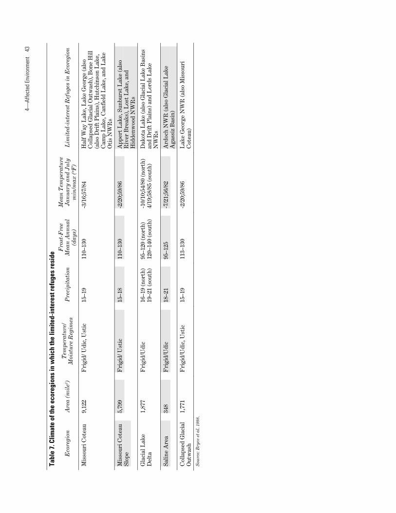
e 7.
Clim
ate
of th
e ec
oreg
ions
in w
hich
the
limite
d-in
tere
st re
fuge
s re
side
Fro
st-F
ree
Mea
n T
empe
ratu
re
Tem
pera
ture
/ E
core
gion
A
rea
(mil
e2 )
Pre
cipi
tati
on
Mea
n A
nn
ual
Ja
nu
ary
and
July
L
imit
ed-i
nte
rest
Ref
uge
s in
Eco
regi
on
Moi
stu
re R
egim
es
(day
s)
min
/max
(ºF
)
Gla
cial
Lak
e 5,
137
Fri
gid/
Ust
ic
15–1
7 95
–130
-3
/21;
55/8
3 A
rdoc
h N
WR
(als
o S
alin
e)
Aga
ssiz
Bas
in
Mis
sour
i Pla
teau
20
,000
F
rigi
d/U
stic
15
–17
95–1
30
-3/2
1;55
/83
Lak
e P
atri
cia
and
Pre
tty
Roc
k N
WR
s
Riv
er B
reak
s 10
,517
F
rigi
d/U
stic
16
–18
80–1
25
-3/2
1;56
/87
Sun
burs
t L
ake
(als
o M
isso
uri C
otea
u S
lope
) and
Spr
ingw
ater
NW
Rs
Dri
ft P
lain
s 15
,609
F
rigi
d/U
dic
17–1
9 95
–125
-5
/16;
56/8
3 B
one
Hill
(als
o M
isso
uri C
otea
u),
Dak
ota
Lak
e (a
lso
Gla
cial
Lak
e D
elta
an
d B
asin
s), H
obar
t L
ake,
Tom
ahaw
k,
Silv
er L
ake
(als
o G
laci
al L
ake
Bas
ins)
, R
ose
Lak
e, L
ambs
Lak
e, L
ittl
e G
oose
, S
tone
y S
loug
h (a
lso
Gla
cial
Out
was
h),
Cot
tonw
ood
Lak
e, S
heye
nne
Lak
e,
Map
le R
iver
, Buf
falo
Lak
e (a
lso
End
M
orai
ne C
ompl
ex) a
nd W
inte
ring
R
iver
NW
Rs
End
Mor
aine
1,
518
Fri
gid/
Udi
c 18
–20
90–1
20
-7/1
3;55
/82
Buf
falo
Lak
e N
WR
(and
Dri
ft P
lain
s)
Com
plex
Jo
hnso
n L
ake
NW
R (a
lso
Gla
cial
O
utw
ash)
Woo
d L
ake
NW
Rs
Gla
cial
Lak
e 3,
584
Fri
gid/
Udi
c 16
–19
95–1
20
-10/
10;5
4/80
P
leas
ant
Lak
e, D
akot
a L
ake
(als
o D
rift
B
asin
s P
lain
s an
d G
laci
al L
ake
Del
tas)
, Silv
er
Lak
e (a
lso
Dri
ft P
lain
s), R
ock
Lak
e an
d B
rum
ba (b
oth
also
in N
orth
ern
Bla
ck P
rair
ie),
and
Sny
der
Lak
e N
WR
s
Gla
cial
Out
was
h 89
0 F
rigi
d/U
dic
16–1
8 11
0–13
0 -6
/14;
55–8
1 Jo
hnso
n L
ake
(als
o E
nd M
orai
ne
Com
plex
), S
tone
y S
loug
h (a
lso
Dri
ft
Pla
ins)
and
Sib
ley
Lak
e N
WR
s
Nor
ther
n B
lack
5,
040
Fri
gid/
Udi
c 16
–20
95–1
20
-10/
10;5
4–80
R
ock
Lak
e an
d B
rum
ba L
ake
NW
Rs
Pra
irie
(b
oth
also
in G
laci
al L
ake
Bas
ins)
Tur
tle
Mou
ntai
ns
409
Fri
dig/
Udi
c 16
–22
95–1
20
-10/
10;5
3/80
R
abb
Lak
e, W
illow
Lak
e, a
nd S
choo
l S
ecti
on L
ake
NW
Rs
4⎯Af
fect
ed E
nviro
nmen
t 43
Tabl
e 7.
Clim
ate
of th
e ec
oreg
ions
in w
hich
the
limite
d-in
tere
st re
fuge
s re
side
Fro
st-F
ree
Mea
n T
empe
ratu
re
Tem
pera
ture
/ E
core
gion
A
rea
(mil
e2 )
Pre
cipi
tati
on
Mea
n A
nn
ual
Ja
nu
ary
and
July
L
imit
ed-i
nte
rest
Ref
uge
s in
Eco
regi
on
Moi
stu
re R
egim
es
(day
s)
min
/max
(ºF
)
Mis
sour
i Cot
eau
9,12
2 F
rigi
d/ U
dic,
Ust
ic
15–1
9 11
0–13
0 -3
/16;
57/8
4 H
alf W
ay L
ake,
Lak
e G
eorg
e (a
lso
Col
laps
ed G
laci
al O
utw
ash)
, Bon
e H
ill
(als
o D
rift
Pla
ins)
, Hut
chin
son
Lak
e,
Cam
p L
ake,
Can
field
Lak
e, a
nd L
ake
Oti
s N
WR
s
Mis
sour
i Cot
eau
5,79
9 F
rigi
d/ U
stic
15
–18
110–
130
-2/2
0;59
/86
App
ert
Lak
e, S
unbu
rst
Lak
e (a
lso
Slo
pe
Riv
er B
reak
s), L
ost
Lak
e, a
nd
Hid
denw
ood
NW
Rs
Gla
cial
Lak
e 1,
877
Fri
gid/
Udi
c 16
–19
(nor
th)
95–1
20 (n
orth
) -1
0/10
;54/
80 (n
orth
) D
akot
a L
ake
(als
o G
laci
al L
ake
Bas
ins
Del
ta
19–2
1 (s
outh
) 12
0–14
0 (s
outh
) 4/
19;5
8/85
(sou
th)
and
Dri
ft P
lain
s) a
nd L
ords
Lak
e N
WR
s
Sal
ine
Are
a 34
8 F
rigi
d/U
dic
18–2
1 95
–125
-7
/21;
56/8
2 A
rdoc
h N
WR
(als
o G
laci
al L
ake
Aga
ssiz
Bas
in)
Col
laps
ed G
laci
al
1,77
1 F
rigi
d/U
dic,
Ust
ic
15–1
9 11
3–13
0 -2
/20;
59/8
6 L
ake
Geo
rge
NW
R (a
lso
Mis
sour
i O
utw
ash
Cot
eau)
S
ourc
e: B
ryce
et a
l. 19
98.
44 Comprehensive Conservation Plan, North Dakota Limited-interest National Wildlife Refuges
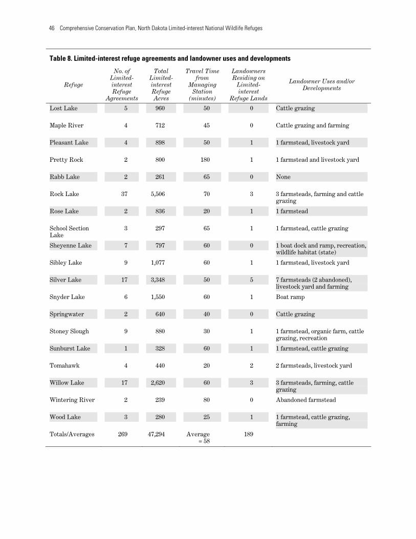
Most of the limited-interest refuges have had some form of development or use varying from livestock yards to dozens of recreational cabins (table 8). Currently, 189 landowners reside on these 39 refuges (149 reside on Camp Lake NWR).
Several of the refuges have become popular recreational areas. Many of the refuges had some residential development at the time the limited-interest refuges were acquired, primarily in the form of farmsteads; however, development now includes commercial operations such as a fertilizer plant, recreational facilities, and an elk farm. The limited-interest refuges are scattered across North Dakota, primarily east of the Missouri River, from the Canadian border down to South Dakota.
Travel from the managing station ranges from 15 minutes to two hours. This travel time is relative to the station’s ability to conduct regular maintenance and management programs.
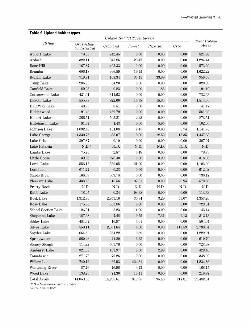
4.2 Biological Resources Most limited-interest refuges are located east of the Missouri River in the area commonly known the “Prairie Pothole Region.” The two major categories of habitat types addressed in this CCP are upland (table 9) and wetland (table 10). The only available data relative to these refuges is from the HAPET office in partnership with Ducks Unlimited and the National Wetlands Inventory. To map upland habitat types, the HAPET office used Landsat Thematic Mapper Satellite Imagery (30 meter resolution) using a combination of unsupervised and supervised classification techniques. Image acquisition dates range from May 1992 to September 1996. Thematic Mapper scenes were processed individually and mosaiced to produce a state-wide coverage. The resulting classes of upland habitat are summarized in table 9.
Five separate upland habitat types were mapped using the image classification process: grass/hay/undisturbed, cropland, forest, riparian, and urban. Most uplands within the refuges are classified as cropland, totaling 14,296 acres. The grass/hay/undisturbed habitat type totals 14,060 acres and is used primarily for haying and grazing operations. These areas have the potential to be preserved as native prairie habitat because there is no indication this ground has ever been plowed or
broken. Forested lands total 814 acres, while riparian areas total 96 acres for all refuges. Some refuges encompass sections of small communities, resulting in an urban classification that totals 218 acres.
Currently, the Service only regulates hunting and trapping uses on the 29,483 acres of uplands (see section 2.3).
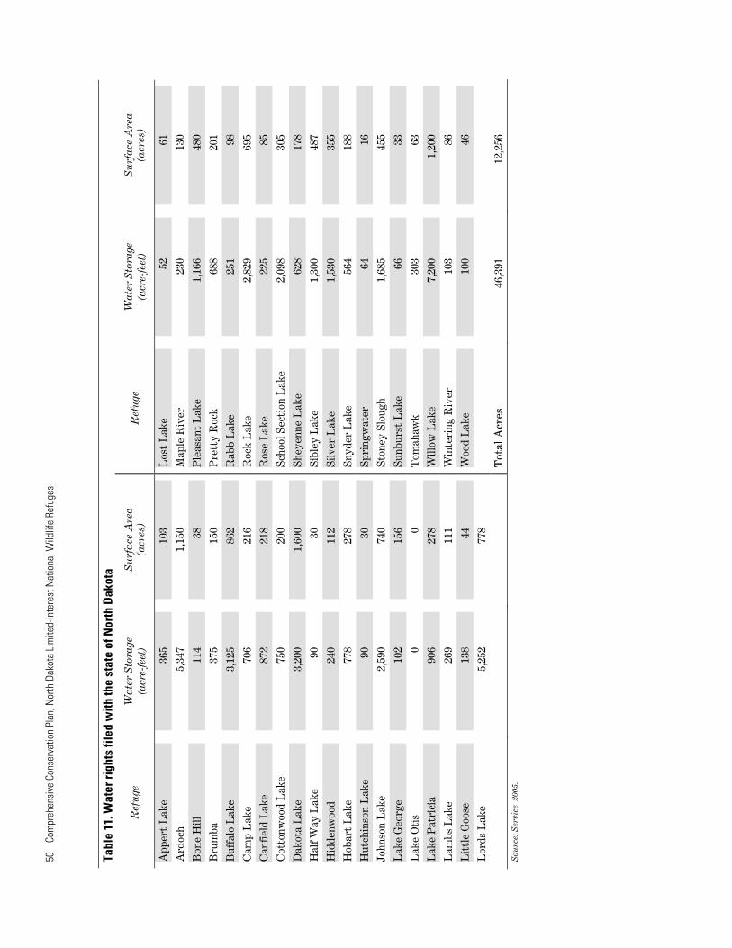
Wetland mapping was acquired from the National Wetlands Inventory database and interpreted by the HAPET office. Wetland habitat types within the limited-interest refuges include: impoundments; seasonal, temporary, and semi-permanent wetlands; riverine; and lakes. The Service has a water right on each refuge except Lake Otis. Table 11 summarizes those water rights filed with the state of North Dakota.
The main body of water within the limited-interest refuges was a major focus of the agreement, both from a wildlife preservation and water conservation perspective. Dozens of structures were built in the 1930s to impound and control water. Existing waterbodies, such as lakes and rivers, also were covered by this flowage limited-interest refuge and water right. The Service will regulate the uses that occur on these waters (see section 2.3).
Most of the wetland habitat types within the limited-interest refuges are classified as lakes, totaling 12,867 acres. Impoundment habitat accounts for 3,850 acres, encompassing many other wetland habitat acres due to the characteristics of the impoundment habitats. Impoundment habitats vary from deepwater lakes to seasonal, temporary wetlands. Riverine habitat is limited, totaling 176 acres. These three habitat types are areas in which the Service has the right to control uses and manage for wildlife. Naturally occurring wetland habitats including semi-permanent, temporary, and seasonal wetlands, total 2,436 acres. Information for wetlands on all refuges is provided in table 10. The Service does not control the uses and alterations of any of these naturally occurring wetlands not encumbered by a Service easement. Regulatory authority rests with the U.S. Army Corps of Engineers and the U.S. Environmental Protection Agency. As described in section 2.3, it appears from historical documentation that there was never any intent to regulate wetland uses even though these areas are critical habitat to wetland-dependent wildlife.

Most of the limited-interest refuges (30 of 39) have some sort of structure intended to either impound water or allow manipulation of that water for wildlife or flood control. Few of these structures have been updated since they were
4⎯Affected Environment 45
originally installed in the 1930s and 1940s. Some are in disrepair, while others are functioning but do not meet the standards for modern water level management practices used to enhance wildlife habitat production.
Table 8. Limited-interest refuge agreements and landowner uses and developments
No. of Total Travel Time Landowners
Refuge Limited-interest Refuge
Limited-interest Refuge
from Managing
Station
Residing on Limited-interest
Landowner Uses and/or Developments
Agreements Acres (minutes) Refuge Lands
Appert Lake 7 908 20 0 Farming
Ardoch 4 2,389 75 1 3 farmsteads (2 abandoned) and outbuildings
Bone Hill 3 640 30 2 2 residences, fertilizer plant, elk farm
Brumba 12 1,978 65 3 3 farmsteads, farming
Buffalo Lake 7 1,540 80 0 1 recreational cabin
Camp Lake 8 585 60 149 238 cabins, boat docks, beach, livestock, and farming
Canfield Lake 4 310 60 0 Cattle grazing
Cottonwood 7 1,014 80 5 2 farmsteads, 3 residences, 1 Lake mobile trailer, 2 boat docks
Dakota Lake 20 2,800 60 1 2 residences, 1 cabin, boat dock and ramp
Half Way Lake 1 160 30 0 Farming and cattle grazing
Hiddenwood 6 568 80 0 Boat dock and ramp, storage, ball diamond, picnic shelter
Hobart Lake 7 1,831 15 3 3 farmsteads, livestock yard
Hutchinson Lake 2 479 60 0 Cattle grazing
Johnson Lake 7 2,003 60 0 Livestock yard and hay land
Lake George 8 3,090 40 1 1 residence, cattle grazing
Lake Otis 1 320 60 0 Livestock
Lake Patricia 5 800 120 0 Farming, recreation, wildlife habitat (state)
Lambs Lake 11 1,207 60 0 2 abandoned residences, livestock yard
Little Goose 3 288 70 0 None
Lords Lake 10 1,915 45 2 2 farmsteads
46 Comprehensive Conservation Plan, North Dakota Limited-interest National Wildlife Refuges
Table 8. Limited-interest refuge agreements and landowner uses and developments
Refuge
Lost Lake
No. of Limited-interest Refuge
Agreements
5
Total Limited-interest Refuge Acres
960
Travel Time from
Managing Station
(minutes)
50
Landowners Residing on
Limited-interest
Refuge Lands
0
Landowner Uses and/or Developments
Cattle grazing
Maple River 4 712 45 0 Cattle grazing and farming
Pleasant Lake 4 898 50 1 1 farmstead, livestock yard
Pretty Rock 2 800 180 1 1 farmstead and livestock yard
Rabb Lake 2 261 65 0 None
Rock Lake
Rose Lake
37
2
5,506
836
70
20
3
1
3 farmsteads, farming and cattle grazing
1 farmstead
School Section Lake
Sheyenne Lake
Sibley Lake
3
7
9
297
797
1,077
65
60
60
1
0
1
1 farmstead, cattle grazing
1 boat dock and ramp, recreation, wildlife habitat (state)
1 farmstead, livestock yard
Silver Lake
Snyder Lake
17
6
3,348
1,550
50
60
5
1
7 farmsteads (2 abandoned), livestock yard and farming
Boat ramp
Springwater 2 640 40 0 Cattle grazing
Stoney Slough
Sunburst Lake
9
1
880
328
30
60
1
1
1 farmstead, organic farm, cattle grazing, recreation
1 farmstead, cattle grazing
Tomahawk 4 440 20 2 2 farmsteads, livestock yard
Willow Lake
Wintering River
17
2
2,620
239
60
80
3
0
3 farmsteads, farming, cattle grazing
Abandoned farmstead
Wood Lake
Totals/Averages
3
269
280
47,294
25
Average = 58
1
189
1 farmstead, cattle grazing, farming
4⎯Affected Environment 47
Table 9. Upland habitat types
Refuge Grass/Hay/ Undisturbed
Upland Habi
Cropland
tat Types (acr
Forest
es)
Riparian Urban Total Upland
Acres
Appert Lake 79.53 742.45 0.00 0.00 0.00 821.98
Ardoch 322.11 945.86 26.47 0.00 0.00 1,294.44
Bone Hill 167.87 405.33 0.00 0.00 0.00 573.20
Brumba 606.18 996.59 19.45 0.00 0.00 1,622.22
Buffalo Lake 719.91 167.34 35.45 33.89 0.00 956.58
Camp Lake 286.62 34.20 0.00 0.00 0.00 320.82
Canfield Lake 89.05 0.23 0.00 1.83 0.00 91.10
Cottonwood Lake 421.01 311.62 0.00 0.00 0.00 732.63
Dakota Lake 555.88 922.60 16.98 18.85 0.00 1,514.30
Half Way Lake 40.96 0.51 0.00 0.00 0.00 41.47
Hiddenwood 91.42 469.79 0.00 0.00 0.00 561.22
Hobart Lake 366.51 505.21 2.22 0.00 0.00 873.51
Hutchinson Lake 91.67 1.43 0.00 8.95 0.00 102.06
Johnson Lake 1,032.49 101.08 2.45 0.00 5.74 1,141.76
Lake George 1,330.75 83.07 0.00 18.52 15.35 1,447.68
Lake Otis 307.87 0.10 0.00 0.00 0.00 307.97
Lake Patricia N.D. † N.D. N.D. N.D. N.D. N.D.
Lambs Lake 75.73 2.87 0.18 0.00 0.00 78.78
Little Goose 39.63 278.40 0.00 0.00 0.00 318.03
Lords Lake 553.15 529.05 21.00 0.00 0.00 1,103.20
Lost Lake 611.77 0.23 0.00 0.00 0.00 612.02
Maple River 166.39 563.78 0.00 0.00 0.00 730.17
Pleasant Lake 433.56 18.56 97.81 0.00 20.94 570.86
Pretty Rock N.D. N.D. N.D. N.D. N.D. N.D.
Rabb Lake 18.05 0.34 93.68 0.00 0.00 113.63
Rock Lake 1,312.80 2,953.16 30.94 3.29 53.07 4,353.26
Rose Lake 175.65 553.86 0.00 0.00 0.00 729.51
School Section Lake 26.91 5.23 11.00 0.00 0.00 43.14
Sheyenne Lake 187.68 7.48 0.55 7.31 9.12 212.13
Sibley Lake 481.67 16.97 6.01 0.00 0.00 504.64
Silver Lake 559.11 2,061.64 4.00 0.00 113.59 2,738.34
Snyder Lake 664.80 564.22 0.89 0.00 0.00 1,229.91
Springwater 569.26 44.20 6.23 0.00 0.00 619.70
Stoney Slough 114.22 609.76 0.00 0.00 0.00 723.98
Sunburst Lake 321.53 103.97 0.00 2.89 0.00 428.40
Tomahawk 271.76 76.26 0.00 0.00 0.00 348.02
Willow Lake 740.12 69.93 424.81 0.00 0.00 1,234.86
Wintering River 87.76 76.96 3.43 0.00 0.00 168.15
Wood Lake 138.26 71.30 10.41 0.00 0.00 219.97
Total Acres 14,059.66 14,295.61 813.95 95.48 217.81 29,482.51 †N.D. = No landcover data available. Source: Service 1998.

48
Com
preh
ensi
ve C
onse
rvat
ion
Plan
, Nor
th D
akot
a Lim
ited-
inte
rest
Nat
iona
l Wild
life
Refu
ges
Tabl
e 10
. Wet
land
hab
itat t
ypes
W
etla
nds
(ac
res)
Im
pou
ndm
ents
R
iver
ine
Lak
e N
WI
Tot
al
Ref
uge
W
ater
Man
agem
ent S
tru
ctu
re(s
) S
emi-
(acr
es)
(a
cres
) (a
cres
) (a
cres
) S
easo
nal
T
empo
rary
pe
rman
ent
App
ert
Lak
e 71
.91
7.43
3.
17
72.2
7 0.
00
0.00
82
.28
E
arth
en le
vee
Ard
och
1,09
1.00
23
.4
12.5
5 0.
79
9.43
1,
143.
16
1,18
9.33
Ste
el s
crew
gat
e, 2
spi
llway
s
Bon
e H
ill
15.0
3 15
.87
0.82
9.
12
0.00
43
.15
68.9
5
Ear
then
dam
Bru
mba
0.
22
57.1
1 17
.02
15.9
4 13
.15
97.7
3 20
0.94
2 sp
illw
ays
(ear
then
and
she
et p
ile)
Buf
falo
Lak
e 53
5.65
16
.40
7.66
16
.60
3.08
53
8.98
58
2.72
E
arth
en d
am, c
ulve
rt, m
ason
ry s
pillw
ay
Cam
p L
ake
157.
36
2.54
0.
52
21.0
4 0.
00
143.
45
167.
55
Ear
th a
nd r
ubbl
e d
ike,
con
cret
e sp
illw
ay,
inop
erab
le W
CS
Can
fiel
d L
ake
0.00
11
.93
0.00
0.
00
0.00
20
4.33
21
6.25
N
one
Cot
tonw
ood
Lak
e 0.
00
35.9
2 7.
68
16.8
7 4.
98
232.
03
297.
48
Dit
ch, c
oncr
ete
culv
ert
Dak
ota
Lak
e 54
9.65
48
.98
80.7
6 64
.55
13.1
6 82
3.15
1,
030.
59
Ear
then
/she
et p
ile d
am w
ith
stop
log
Hal
f Way
Lak
e 0.
00
0.93
0.
00
0.19
0.
00
116.
31
117.
41
N
one
Hid
denw
ood
0.00
1.
50
7.52
0.
00
0.00
12
1.71
13
0.72
C
ulve
rt
Hob
art
Lak
e 63
.88
4.34
10
.14
9.24
0.
00
849.
79
873.
51
N
one
Hut
chin
son
Lak
e 0.
00
1.74
14
.33
36.7
8 0.
00
290.
94
343.
38
Non
e
John
son
Lak
e 0.
00
1.48
0.
67
1.89
0.
00
454.
80
458.
48
Ear
then
dam
and
spi
llway
Lak
e G
eorg
e 0.
00
28.6
8 30
.64
76.5
5 0.
00
1,44
1.51
1,
577.
37
2 E
arth
en d
ikes
, met
al s
pillw
ay
Lak
e O
tis
0.00
12
.20
0.11
0.
00
0.00
6.
29
18.6
0
Non
e
Lak
e P
atri
cia
316.
83
0.00
0.
00
0.00
0.
00
339.
86
339.
83
Ear
then
dik
e, W
CS
, and
spi
llway
Lam
bs L
ake
111.
76
30.8
1 23
.40
97.4
8 0.
00
132.
47
284.
16
Ear
then
dam
and
con
cret
e sp
illw
ay
Lit
tle
Goo
se
31.5
6 0.
39
1.11
0.
00
0.00
38
.80
40.3
0
Ear
then
dam
and
spi
llway
, fie
ld c
ross
ing
Lor
ds L
ake
0.00
32
.35
5.45
82
.04
0.00
66
9.50
78
9.33
2
ditc
hes
and
2 ea
rthe
n da
ms
Los
t L
ake
0.00
10
.49
10.2
6 14
5.73
18
.91
165.
04
350.
42
Dik
e, d
iver
sion
dit
ch, a
nd n
esti
ng is
land
, co
ncre
te s
pillw
ay, W
CS
M
aple
Riv
er
0.00
19
.30
4.01
32
.92
26.0
9 0.
00
82.3
1
Ear
then
dam
and
she
et p
ile w
eir
Ple
asan
t L
ake
0.00
7.
69
0.00
11
.91
0.00
47
1.98
49
1.58
F
ence
and
mas
onry
wat
er c
ontr
ol
stru
ctur
e P
rett
y R
ock
183.
13
30.5
1 0.
00
0.00
0.
00
181.
83
212.
34
Dik
e an
d W
CS

4⎯Af
fect
ed E
nviro
nmen
t 49
Tabl
e 10
. Wet
land
hab
itat t
ypes
W
etla
nds
(ac
res)
Im
pou
ndm
ents
R
iver
ine
Lak
e N
WI
Tot
al
Ref
uge
W
ater
Man
agem
ent S
tru
ctu
re(s
) S
emi-
(acr
es)
(a
cres
) (a
cres
) (a
cres
) S
easo
nal
T
empo
rary
pe
rman
ent
Rab
b L
ake
0.00
5.
53
0.00
2.
52
3.47
10
2.13
11
3.63
N
one
Roc
k L
ake
0.00
11
0.14
78
.15
109.
99
0.00
83
1.17
1,
129.
20
E
arth
en d
ike,
sto
p lo
g, a
nd s
heet
pile
sp
illw
ay
Ros
e L
ake
0.00
28
.45
6.74
38
.19
0.00
0.
00
73.3
6
2 ea
rthe
n di
kes
and
1 ru
bble
spi
llway
Sch
ool S
ecti
on L
ake
0.00
0.
00
0.31
0.
00
0.00
31
2.56
31
2.56
E
arth
en d
ike
and
spill
way
She
yenn
e L
ake
564.
35
5.06
1.
51
0.00
0.
00
564.
30
570.
00
Ear
then
dam
and
con
cret
e sp
illw
ay
Sib
ley
Lak
e 0.
00
0.26
6.
58
85.4
1 0.
00
464.
95
557.
19
N
one
Silv
er L
ake
0.00
33
.26
61.5
4 36
.20
65.1
9 42
8.07
62
4.26
N
one
Sny
der
Lak
e 0.
00
22.1
8 24
.40
27.5
5 0.
00
243.
82
317.
95
Sh
eet
pile
spi
llway
, ear
then
dik
e, s
top
log
Spr
ingw
ater
2.
83
15.2
5 0.
00
9.59
14
.21
0.00
39
.05
E
arth
en d
ike
Sto
ney
Slo
ugh
0.00
57
.79
36.4
0 0.
00
0.00
58
.01
152.
19
3
wat
er
cont
rol s
truc
ture
s
Sun
burs
t L
ake
55.7
8 3.
63
8.40
16
.57
3.25
49
.51
81.3
5
Ear
then
dik
e, m
etal
spi
llway
Tom
ahaw
k 63
.12
0.57
3.
96
14.0
3 0.
00
65.9
4 84
.49
E
arth
en d
ike
and
spill
way
Will
ow L
ake
0.00
81
.67
9.47
70
.09
0.65
1,
164.
78
1,32
6.65
S
top
log
stru
ctur
e
Win
teri
ng R
iver
0.
00
9.20
0.
09
67.3
1 0.
00
0.00
76
.57
4
eart
hen
dike
s an
d sh
eetp
ile s
pillw
ay
Woo
d L
ake
35.5
2 4.
00
6.26
7.
12
0.00
40
.41
57.7
8
Mas
onry
wat
er c
ontr
ol s
truc
ture
, ear
then
di
ke
Tot
al A
cres
3,
849.
57
782.
32
484.
82
1,16
9.25
17
5.57
12
,867
.03
15,4
26.0
6
WC
S =
wat
er c
ontr
ol s
tru
ctu
re
Sou
rce:
Ser
vice
200
4.
50
Com
preh
ensi
ve C
onse
rvat
ion
Plan
, Nor
th D
akot
a Lim
ited-
inte
rest
Nat
iona
l Wild
life
Refu
ges
Tabl
e 11
. Wat
er ri
ghts
file
d w
ith th
e st
ate
of N
orth
Dak
ota
Wat
er S
tora
ge
Su
rfac
e A
rea
Ref
uge
(a
cre-
feet
) (a
cres
)
38
862
218
1,60
0
App
ert
Lak
e 36
5
Ard
och
5,34
7 1,
150
Bon
e H
ill
114
Bru
mba
37
5 15
0
Buf
falo
Lak
e 3,
125
Cam
p L
ake
706
216
Can
fiel
d L
ake
872
Cot
tonw
ood
Lak
e 75
0 20
0
Dak
ota
Lak
e 3,
200
Hal
f Way
Lak
e 90
30
Hid
denw
ood
240
Hob
art
Lak
e 77
8 27
8
Hut
chin
son
Lak
e 90
John
son
Lak
e 2,
590
740
Lak
e G
eorg
e 10
2
Lak
e O
tis
0 0
Lak
e P
atri
cia
906
Lam
bs L
ake
269
111
Lit
tle
Goo
se
138
Lor
ds L
ake
5,25
2 77
8
103
112 30
156
278 44
Sou
rce:
Ser
vice
200
5.
Wat
er S
tora
ge
Su
rfac
e A
rea
Ref
uge
(a
cre-
feet
) (a
cres
)
Los
t L
ake
Map
le R
iver
Ple
asan
t L
ake
Pre
tty
Roc
k
Rab
b L
ake
Roc
k L
ake
Ros
e L
ake
Sch
ool S
ecti
on L
ake
She
yenn
e L
ake
Sib
ley
Lak
e
Silv
er L
ake
Sny
der
Lak
e
Spr
ingw
ater
Sto
ney
Slo
ugh
Sun
burs
t L
ake
Tom
ahaw
k
Will
ow L
ake
Win
teri
ng R
iver
Woo
d L
ake
Tot
al A
cres
52
61
230
130
1,16
6 48
0
688
201
251
98
2,82
9 69
5
225
85
2,09
8 30
5
628
178
1,30
0 48
7
1,53
0 35
5
564
188
64
16
1,68
5 45
5
66
33
303
63
7,20
0 1,
200
103
86
100
46
46,3
91
12,2
56

4.3 Cultural Resources This CCP is not subject to compliance with section 106 of the National Historic Preservation Act. Limited-interest refuges are the rental/lease of non-federally owned land for habitat purposes. The only exception would be if conditions of the agreement specifically identified the protection of cultural resources, which is not the case for the limited-interest refuges.
However, if future federally funded projects on these limited-interest refuges have the potential to affect historic properties, then 106 compliance is necessary.
4.4 Visitor Services To provide visitor services on the limited-interest refuges, access must be provided by the landowner. If any public activity is allowed, it must be open to the general public. There may be limitations as to the number of participants and seasons of use, but the general public must be given the opportunity to participate because national wildlife refuges are managed by the federal government.
To date, most of the limited-interest refuges have remained closed to all public use. In particular, they historically have been closed to hunting. There has been little public interest in these refuges. Most of these refuges are now posted, but few have entrance signs identifying them by name as is typical on most other national wildlife refuges.
Northern Pike Tom Kelley/USFWS
4⎯Affected Environment 51
During scoping, the state, general public, and some landowners requested opening some refuges to hunting. Increased hunting opportunities and overgrazing by deer and geese, resulting in loss of crops, prompted this request. Trapping has been allowed on a permit-only basis and has become a vital management tool to control unnatural populations of predators that have devastated waterfowl and other grassland nesting birds. Fishing occurs on several refuges and the state has stocked fish in some of the more popular impoundments. Only a few of the refuges have been officially open to public fishing. Numerous requests were made to open these refuges for ice fishing, an extremely popular winter activity in North Dakota.
Other activities such as environmental education and interpretation opportunities, wildlife observation, and photography programs, are nonexistent on the limited-interest refuges. Again, these are private lands so access must be granted by the landowner for an activity to occur. Some landowners expressed interest in establishing environmental education and interpretation programs targeting local schools.
4.5 Socioeconomic Environment The limited-interest refuges are scattered across a 23-county area with a landbase of 19,970,400 acres. Except for Morton and Grant counties, most counties are located east of the Missouri River. Areas surrounding the limited-interest refuges are typically characterized as rural with an economy and land use based on agriculture. Currently, over 88 percent of the land in these counties is identified as agricultural (table 12).
The state of North Dakota covers 44,156,200 acres. Of this acreage, the Service currently owns 627,116 acres (1.4 percent of the entire state) and has an easement or lease (wetland, grassland, limited-interest) on an additional 1,100,960 acres (3 percent of the entire state). North Dakota ranks 31 in the nation for overall federal land ownership (National Wilderness Institute 1995). Within the 23-county planning area, the Service currently owns 2 percent of the land in national wildlife refuges, WPAs, and National Fish Hatcheries and has various easements on 3.5 percent of lands in this planning area.

52 Comprehensive Conservation Plan, North Dakota Limited-interest National Wildlife Refuges
Race composition in most of the counties in the Program area is predominantly Caucasian ranging from 50.8 percent (Benson County) to 99.5 percent (Kidder County) (table 13). The next largest group represented is Native American Indian ranging from 0 percent (Emmons) to 48 percent (Benson County). Most of the counties are sparsely populated excluding those with large urban areas such as Grand Forks County and Burleigh County, which encompass the cities of Grand Forks and Bismarck, respectively. Population sizes in 2003 ranged from 2,591 (Kidder County) to 70,937 (Burleigh County). The total population for all counties combined is 296,433, which is 46 percent of North Dakota’s 2004 population of 642,200. Population densities range from 1.7/square mile (Grant County) to 42.5/square mile (Burleigh County). Overall, the population of the counties continued to decline between 2000-2003. Population declines ranged from 0.7 percent in Morton County to a decline of 9.9 percent in Sheridan County. Only two counties increased population during this same period: Burleigh County (an increase of 3.3 percent) and Rolette County (an increase of 0.3 percent). The median age varies from 28.9 in Rolette County, to 48.1 in Sheridan County.
The national unemployment rate is 5.0 percent (U.S. Department of Labor 2005). The state of North Dakota’s unemployment rate is below the national average at 3.2 percent. The largest employer in the state is the health care and social services (human services) industry employing over 14.1 percent of the state. In 2004, this industry had the largest employment growth in the state (North Dakota Job Service 2004), adding over 1,000 jobs (table 14).
The counties surrounding the limited-interest refuges have an average of 3.1 percent unemployment rate, slightly below the state average. Grant County had the lowest unemployment rate at 1.3 percent, while Rolette County was the highest at 8.2 percent (U.S. Bureau of Census 2000). Human services was the leading industry in 16 of the 23 counties, followed by agriculture (six counties). One county had “entertainment” as the primary industry. The median household income varied between $23,165 in Grant County to $41,309 in Burleigh County (U.S. Bureau of Census 2000).

4⎯Af
fect
ed E
nviro
nmen
t 53
Tabl
e 12
. Acr
es o
f agr
icul
tura
l and
Ser
vice
-con
trol
led
land
s by
cou
nty
(% o
f tot
al la
nd fo
r all
liste
d co
untie
s)
Lim
ited
-L
imit
ed-
Agr
icu
ltu
ral
FW
S F
ee-t
itle
(ac
res)
F
mH
A
Wet
lan
d G
rass
lan
d L
and
in
tere
st
inte
rest
Cou
nty
L
ands
L
ands
† E
asem
ents
E
asem
ents
(a
cres
)
Ref
uge
s in
R
efu
ge
(acr
es)
(a
cres
) (a
cres
) (a
cres
) N
WR
W
PA
N
FH
Cou
nty
(a
cres
)
Bar
nes
954,
880
856,
976
246
7,01
7 11
0 0
17,3
42
0
Hob
art
Lak
e,
3,15
1 S
tone
y S
loug
h,
and
Tom
ahaw
k
Ben
son
883,
840
732,
870
1,67
4 7,
216
0 1,
703
35,1
95
2,98
2
Ple
asan
t L
ake,
4,
238
Silv
er L
ake
(als
o R
olet
te),
and
Woo
d L
ake
Bot
tine
au
1,06
8,16
0 94
8,47
5 21
,563
2,
589
0 47
1 29
,183
0
L
ords
Lak
e 1,
462
(als
o R
olet
te
Co.
)
Bur
leig
h 1,
045,
120
865,
524
11,8
01
11,2
56
0 2,
187
26,0
63
12,8
44
C
anfi
eld
Lak
e 31
0
Dic
key
723,
840
599,
450
0 10
,042
0
2,58
4 26
,817
9,
333
D
akot
a L
ake
3,51
2 an
d M
aple
R
iver
Edd
y 40
3,20
0 34
8,78
6 0
4,65
7 0
417
11,8
11
0
John
son
Lak
e 2,
003
Em
mon
s 96
6,40
0 83
8,07
5 0
3,61
5 0
309
11,4
92
0
Spr
ingw
ater
, 1,
876
Sun
burs
t L
ake,
an
d A
pper
t L
ake
Gra
nd
920,
320
755,
592
680
6,39
5 0
0 93
9 0
Lit
tle
Goo
se
288
For
ks
Gra
nt
1,06
1,76
0 1,
056,
729
0 5,
363
0 0
5,82
1 10
,331
P
rett
y R
ock
800
Gri
ggs
453,
120
379,
022
0 3,
228
0 10
1 16
,677
0
S
ible
y L
ake
1,07
7
Kid
der
864,
640
794,
465
6,60
9 7,
404
0 1,
222
63,9
55
9,88
7
Hut
chin
son
3,56
9 L
ake
and
Lak
e G
eorg
e
Lam
oure
73
4,08
0 67
6,96
6 0
5,43
5 0
955
13,1
21
0
Bon
e H
ill
640
McH
enry
1,
199,
360
1,12
5,83
1 37
,122
5,
882
0 2,
213
29,1
31
15,2
72
Cot
tonw
ood
1,25
3 L
ake
and
Win
teri
ng
Riv
er

54
Com
preh
ensi
ve C
onse
rvat
ion
Plan
, Nor
th D
akot
a Lim
ited-
inte
rest
Nat
iona
l Wild
life
Refu
ges
Tabl
e 12
. Acr
es o
f agr
icul
tura
l and
Ser
vice
-con
trol
led
land
s by
cou
nty
(% o
f tot
al la
nd fo
r all
liste
d co
untie
s)
Lim
ited
-L
imit
ed-
Agr
icu
ltu
ral
FW
S F
ee-t
itle
(ac
res)
F
mH
A
Wet
lan
d G
rass
lan
d L
and
in
tere
st
inte
rest
Cou
nty
L
ands
L
ands
† E
asem
ents
E
asem
ents
(a
cres
)
Ref
uge
s in
R
efu
ge
(acr
es)
(a
cres
) (a
cres
) (a
cres
) N
WR
W
PA
N
FH
Cou
nty
(a
cres
)
McL
ean
1,35
0,40
0 1,
094,
748
17,5
04
12,3
43
186
73
22,2
80
7,94
5
Cam
p L
ake,
2,
433
Hid
denw
ood,
L
ake
Oti
s, a
nd
Los
t L
ake
Mor
ton
1,23
2,64
0 1,
276,
269
0 0
0 37
5 0
0
Lak
e P
atri
cia
Nel
son
628,
480
531,
591
32
3,54
4 0
439
37,8
81
0
Lam
bs L
ake,
2,
043
John
son
Lak
e,
and
Ros
e L
ake
Pie
rce
651,
520
530,
623
24
12,7
50
0 3,
906
36,2
46
1,46
9
Buf
falo
Lak
e 1,
540
Ram
sey
758,
400
636,
109
7,71
0 9,
477
0 38
6 28
,730
0
S
ilver
Lak
e 31
3 (a
lso
Ben
son
Co.
)
Rol
ette
57
7,28
0 50
7,65
8 1
5,80
0 0
361
20,1
49
0
Rab
b L
ake,
3,
616
Sch
ool S
ecti
on
Lak
e, L
ords
L
ake
and
Will
ow L
ake
She
rida
n 62
2,08
0 46
8,74
5 29
,737
22
,748
0
726
31,4
27
11,0
46
S
heye
nne
Lak
e 79
7
Stu
tsm
an
1,42
1,44
0 1,
215,
190
17,6
90
28,2
77
0 1,
259
41,9
27
11,8
34
H
alf W
ay
160
Tow
ner
656,
000
548,
774
802
7,24
1 0
865
24,2
13
398
B
rum
ba, R
ock
9,03
4 L
ake,
and
S
nyde
r L
ake
Wal
sh
820,
480
759,
381
308
1,78
6 0
329
8,75
8 0
A
rdoc
h 2,
389
Tot
als
19,9
97,4
40
17,5
47,8
48
153,
503
184,
065
396
20,8
81
539,
158
93,3
41
39 li
mit
ed-
47,3
04
inte
rest
re
fuge
s
Ave
rage
%
88%
2%
0.
1%
2.7%
0.
5%
0.2%
† Far
mer
s H
ome
Adm
inis
trat
ion
Lan
ds.
NW
R=n
atio
nal
wil
dlif
e re
fuge
; WP
A=w
ater
fow
l pro
duct
ion
are
a; N
FH
=nat
ion
al fi
sh h
atch
ery
Sou
rce:
US
DA
200
2; S
ervi
ce 2
005.
800

4⎯Af
fect
ed E
nviro
nmen
t 55
Tabl
e 13
. Dem
ogra
phic
s of
the
23 c
ount
ies
with
in th
e pl
anni
ng a
rea
R
aces
(%
of p
opu
lati
on)
Pop
ula
tion
Pop
ula
tion
P
erso
ns
per
Cou
nty
C
han
ge
Med
ian
Age
A
mer
ican
(2
003)
S
quar
e M
ile
Cau
casi
an
Bla
ck
Asi
an(2
000–
2003
) In
dian
Bar
nes
11,0
93
7.9
-5.9
%
40.6
97
.9
0.5
0.8
0.2
Ben
son
6,87
3 5.
0 -1
.2%
31
.4
50.8
0.
1 48
.0
0
Bot
tine
au
6,89
3 4.
3 -4
.6%
43
.4
97.2
0.
2 1.
5 0.
2
Bur
leig
h 70
,937
42
.5
+3.3
%
35.6
95
.0
0.3
3.3
0.4
Dic
key
5,55
4 5.
1 -4
.6%
40
.7
97.8
0.
1 0.
3 0.
5
Edd
y 2,
627
4.4
-5.8
%
43.8
96
.4
0.1
2.4
0.1
Em
mon
s 4,
087
2.9
-7.5
%
44.5
99
.1
0 0.
1 0.
2
Gra
nd F
orks
64
,929
46
.0
-2.1
%
29.2
93
.0
1.4
2.3
1.0
Gra
nt
2,68
9 1.
7 -6
.2%
46
.5
96.9
0
1.7
0.4
Gri
ggs
2,59
9 3.
9 -6
.4%
45
.8
99.3
0
0.2
0.1
Kid
der
2,59
1 2.
0 -6
.4%
44
.5
99.5
0.
2 0.
1 0.
1
Lam
oure
4,
569
4.1
-4.0
%
43.3
99
.2
0 0.
2 0.
1
McH
enry
5,
739
3.2
-4.4
%
43.0
98
.7
0.1
0.4
0
McL
ean
9,01
4 4.
4 -4
.0%
44
.1
92.5
0
5.9
0.1
Mor
ton
25,1
81
13.1
-0
.7%
37
.4
95.8
0.
2 2.
4 0.
3
Nel
son
3,46
4 3.
8 -7
.0%
47
.2
98.6
0.
1 0.
3 0.
3
Pie
rce
4,52
5 4.
6 -4
.2%
42
.9
98.5
0.
1 0.
7 0.
3
Ram
sey
11,7
46
10.2
-3
.7%
39
.5
92.3
0.
2 5.
4 0.
3
Rol
ette
13
,760
15
.2
+0.4
%
28.9
25
.1
0.1
73.0
0.
1
She
rida
n 1,
572
1.8
-9.9
%
48.1
99
.2
0.1
0.4
0
Stu
tsm
an
21,3
88
9.9
-3.0
%
39.6
97
.5
0.3
0.9
0.4
Tow
ner
2,71
2 2.
8 -7
.3%
44
.0
97.3
0.
1 2.
1 0.
1
Wal
sh
11,8
91
9.7
-5.4
%
40.9
94
.9
0.3
1.0
0.2
Sou
rce:
U.S
. Bu
reau
of C
ensu
s 20
00.
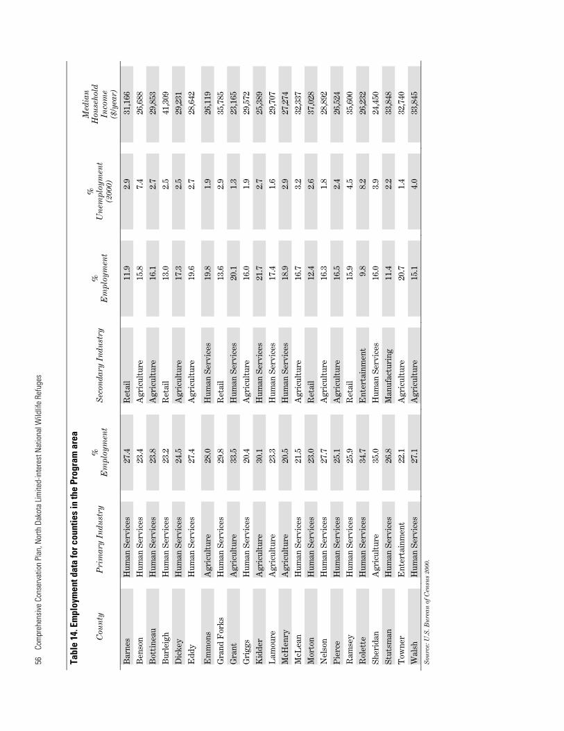
56
Com
preh
ensi
ve C
onse
rvat
ion
Plan
, Nor
th D
akot
a Lim
ited-
inte
rest
Nat
iona
l Wild
life
Refu
ges
Tabl
e 14
. Em
ploy
men
t dat
a fo
r cou
ntie
s in
the
Prog
ram
are
a M
edia
n
%%
%
H
ouse
hold
C
oun
ty
Pri
mar
y In
dust
ry
Sec
onda
ry I
ndu
stry
U
nem
ploy
men
tE
mpl
oym
ent
Em
ploy
men
t In
com
e(2
000)
($
/yea
r)
Bar
nes
Hum
an S
ervi
ces
27.4
R
etai
l 11
.9
2.9
31,1
66
Ben
son
Hum
an S
ervi
ces
23.4
A
gric
ultu
re
15.8
7.
4 26
,688
Bot
tine
au
Hum
an S
ervi
ces
23.8
A
gric
ultu
re
16.1
2.
7 29
,853
Bur
leig
h H
uman
Ser
vice
s 23
.2
Ret
ail
13.0
2.
5 41
,309
Dic
key
Hum
an S
ervi
ces
24.5
A
gric
ultu
re
17.3
2.
5 29
,231
Edd
y H
uman
Ser
vice
s 27
.4
Agr
icul
ture
19
.6
2.7
28,6
42
Em
mon
s A
gric
ultu
re
28.0
H
uman
Ser
vice
s 19
.8
1.9
26,1
19
Gra
nd F
orks
H
uman
Ser
vice
s 29
.8
Ret
ail
13.6
2.
9 35
,785
Gra
nt
Agr
icul
ture
33
.5
Hum
an S
ervi
ces
20.1
1.
3 23
,165
Gri
ggs
Hum
an S
ervi
ces
20.4
A
gric
ultu
re
16.0
1.
9 29
,572
Kid
der
Agr
icul
ture
30
.1
Hum
an S
ervi
ces
21.7
2.
7 25
,389
Lam
oure
A
gric
ultu
re
23.3
H
uman
Ser
vice
s 17
.4
1.6
29,7
07
McH
enry
A
gric
ultu
re
20.5
H
uman
Ser
vice
s 18
.9
2.9
27,2
74
McL
ean
Hum
an S
ervi
ces
21.5
A
gric
ultu
re
16.7
3.
2 32
,337
Mor
ton
Hum
an S
ervi
ces
23.0
R
etai
l 12
.4
2.6
37,0
28
Nel
son
Hum
an S
ervi
ces
27.7
A
gric
ultu
re
16.3
1.
8 28
,892
Pie
rce
Hum
an S
ervi
ces
25.1
A
gric
ultu
re
16.5
2.
4 26
,524
Ram
sey
Hum
an S
ervi
ces
25.9
R
etai
l 15
.9
4.5
35,6
00
Rol
ette
H
uman
Ser
vice
s 34
.7
Ent
erta
inm
ent
9.8
8.2
26,2
32
She
rida
n A
gric
ultu
re
35.0
H
uman
Ser
vice
s 16
.0
3.9
24,4
50
Stu
tsm
an
Hum
an S
ervi
ces
26.8
M
anuf
actu
ring
11
.4
2.2
33,8
48
Tow
ner
Ent
erta
inm
ent
22.1
A
gric
ultu
re
20.7
1.
4 32
,740
Wal
sh
Hum
an S
ervi
ces
27.1
A
gric
ultu
re
15.1
4.
0 33
,845
S
ourc
e: U
.S. B
ure
au o
f Cen
sus
2000
.
