2021 product workbook
TRANSCRIPT

2021 Product WorkbookA Complete Guide to PhotoSat’s Satellite Surveying and Mapping Products

© 2020 PhotoSat 2
About PhotoSatFounded in 1993, PhotoSat has delivered over 1,300 elevation surveys in more than 75 countries since 2005. Our client base is globally diverse, with broad representation across the earthworks construction and resource development industries. Though our clients have a variety of commercial objectives, they all have a persistent need for engineering-quality survey data.
Our MissionAs a company, our mission is to provide better data for better decisions.
From our experience with the resource development industry and infrastructure projects, we have seen how using accurate survey data can prevent environmental damage, improve safety, and shorten project timelines.
Our ValuesAs a company, we have three key values that drive our commercial strategy and company culture.
I. Desire to be the best. We have consciously chosen to offer products and services that are truly unique, high quality, and impactful. Our development Team is continually testing new processes to improve our existing products and to create new ones.
II. Always create value. We believe in creating products that provide high value to our clients. Every project that we complete is carefully assessed to guarantee accuracy and reliability.
III. I’ve got your back. Collaboration and teamwork are fundamental to PhotoSat’s achievements and success. Our teams work closely and cross-functionally, with common goals. We promote a culture of helping out other teams whenever possible.

© 2020 PhotoSat 3
ContentsBase Packages
Engineering Survey Package 5
Recurring Survey Package 6
Tailings History Package 7
Dam Breach Analysis Package 8
Regional Mapping Package 9
ASTER Alteration Mineral Mapping Package 10
WV-3 Alteration Mineral Mapping Package 11
Add-On Products
Water Body Outlines 13
Mine Site Toes and Crests 14
Infrastructure and Feature Outlines 15
Deposition Graph 16
Volume Measurement 17
Additional Product Information
Available Formats 18
Size and Location 18
Pricing 18
Timeline for Delivery 19
Contact Us 19

© 2020 PhotoSat 4
Base Packages We offer a variety of base survey and mapping packages.
Our products fall into three categories:
I. Satellite Surveying
Complex projects require accurate survey data without disrupting ground operations. Project sites are often large or hard to access, making it slow or difficult to survey such sites by conventional means.
Our surveying products are suitable for earthworks construction, operating and developing mines, and tailings management.
II. Satellite Mapping
In early stages of a project, it is often necessary to obtain reliable topographical data over large areas (100s to 1000s of km²) in an efficient and economical manner. In these cases, ground controls frequently do not yet exist.
Our mapping products are suitable for exploration planning, geological targeting, logistical coordination, and more.
III. Alteration Mineral Mapping
Using data processing with spectral analysis, we can produce alteration mineral maps that distinguish between many key minerals.
Our alteration mineral maps are useful tools for exploration geologists.
Base Packages
PhotoSat has completed over 1,300 projects in more than 75 countries.

© 2020 PhotoSat 5
Engineering Survey PackageBoth operating mines and civil engineering earthworks projects need highly accurate survey data. These types of projects are often large or remote, with complex daily activities than cannot be interrupted.
For a range of applications, the Engineering Survey Package is a practical solution for professionals. It provides prompt and reliable survey data, with high accuracy and high survey point density.
Product Accuracy & Specifications Our Engineering Survey Package comes with the following specifications:
Accuracy (vertical) <15 cm RMSEAccuracy (volume) <1-2% errorSurvey point density ~1 point per m²Area UnlimitedIncluded Orthophoto (colour or greyscale)
Elevation grid (1 m, 3 ft, custom)Colour elevation imageContours (50 cm, 1 m, 5 m, 10 m, or 50 m)Accuracy report
Add-ons available Water body outlinesMine site toes and crestsInfrastructure and feature outlinesVolume measurement Deposition graph
Thinned grid option On request
Delivery TimeOver large or remote sites, satellite surveying is normally faster than conventional survey methods as there is no need for permits or for on-site presence.
For more information, see page 19.
Base Packages
For operating mines, there is a constant need for highly accurate survey data.

© 2020 PhotoSat 6
Recurring Survey Package The Recurring Survey Package delivers our engineering-quality surveys of a site automatically throughout the year. For active sites with tailings facilities or complex operations, this package is a practical way to obtain the data you need in a timely and consistent fashion.
Recurring Surveys can be used to establish monthly production quantities, monitor dyke construction, and monitor tailings placement. A database like this can also be used to resolve contract disputes, meet unforeseen survey requirements, or address other unexpected situations. Overall, it forms an updated database of relevant topographic data.
Some sites rely on the satellite archive, however the satellite archive does not guarantee that site-wide photos will exist at dates you may require. The Recurring Survey Package guarantees a site-wide survey record at regular intervals.
Product Accuracy & Specifications Our Recurring Survey Package comes with the following specifications:
Accuracy (vertical) <15 cm RMSEAccuracy (volume) <1-2% errorSurvey point density ~1 point per m²Area UnlimitedIncluded Orthophoto (colour or greyscale)
Elevation grid (1 m, 3 ft, custom)Colour elevation imageContours (50 cm, 1 m, 5 m, 10 m, or 50 m)Accuracy report
Add-ons available Water body outlinesMine site toes and crestsInfrastructure and feature outlinesVolume measurement Deposition graph
Thinned grid option On request
Delivery TimeThe Recurring Survey Package can be delivered bi-weekly, monthly, or quarterly. Custom delivery schedules are also available.
For more information, see page 19.
Base Packages
Operating mines have a constant need for survey data. The data must be highly accurate and delivered without delays.

© 2020 PhotoSat 7
Tailings History Package Many mining companies are responsible for older tailings facilities. Whether active or inactive, these structures require constant monitoring and ongoing maintenance. Reliable survey data is essential for proper management.
Some tailings facilities either have incomplete survey records or lack them altogether. For facilities without reliable records, the Tailings History Package is a practical solution for obtaining missing survey data or verifying existing records.
Product Accuracy & Specifications A Tailings History Package comes with the following specifications:
Accuracy (vertical) <15 cm RMSEAccuracy (volume) <1-2% errorTime period On request Data intervals On requestArea UnlimitedIncluded (per interval) Engineering Survey Package
Volume measurementsWater body outlinesDeposition graphAccuracy report
Thinned grid option On request
Delivery TimeTo complete a Tailings History Package, we search the satellite archive for suitable photos.
The delivery time for this product depends on:
• Time period: The archive goes back as far as the 1960s. Up to the current date, we can complete a tailings history for any period when the data is available.
• Data intervals: We can add data at custom intervals depending on what satellite photos are available.
For more information, see page 19.
Base Packages
This photo shows the Mopani Mine in 1967. This satellite photo is from the Keyhole satellite archive.

© 2020 PhotoSat 8
Dam Breach Analysis PackageMany mining companies will be required to complete thorough dam breach analyses for their tailings facilities.
A credible dam breach analysis requires a number of inputs. PhotoSat can provide:
• Calculations of total tailings volume• Detailed topography of the inundation areaA qualified engineering consulting firm can use these inputs to complete a dam breach analysis for a specific tailings facility.
Product Accuracy & Specifications A Dam Breach Analysis Package comes with the following specifications:
Accuracy (vertical) <15 cm RMSEAccuracy (volume) <1-2% errorTime period On request Data intervals On requestArea UnlimitedIncluded Topography of the inundation area
(Engineering Survey with infrastructure and feature outlines)Total tailings volume (complete Tailings History of deposition and construction)Accuracy report
Thinned grid option On request
Delivery TimeIn a Dam Breach Analysis Package, we provide two separate sets of data:
• Total tailings volume: This comes from a complete Tailings History. The delivery time for this depends on the time period for the Tailings History, and the number of photos available in the archive.
• Inundation area study: This comes from an Engineering Survey of the inundation area, including outlines of all infrastructure in the inundation area.
For more information, see page 19.
Base Packages
Many tailings facilities will require dam breach analyses to determine the potential impact of a tailings dam breach, even if the actual risk of failure is low..

© 2020 PhotoSat 9
Regional Mapping Package Some projects require topographical data over large or remote areas in a tight time frame. When mapping data is reliable, it can be used by multiple departments throughout a project’s life cycle.
This package is economical for exploration, with applications in geological targeting, logistical coordination, and exploration planning. This package is suitable as an NI 43-101 input.
When few or no ground controls exist, the Regional Mapping Package is a practical solution. It provides reliable topographical data over huge or remote areas, without the need for GCPs or onsite personnel.
Product Accuracy & Specifications Our Regional Mapping Package comes with the following specifications:
Accuracy (vertical) ~1-2 m RMSEArea UnlimitedIncluded Orthophoto (colour or greyscale)
Elevation grid (1.5 m or 3 m)Colour elevation imageContours (2 m, 5 m, 10 m, 50 m, or 100 m)Accuracy report
Add-ons available Water body outlinesInfrastructure and feature outlines
Thinned grid option On request
Delivery TimeOver large or remote sites, satellite mapping is faster than conventional surveying.
For more information, see page 19.
Base Packages
Satellite mapping is suitable for exploration, as it is fast, reliable, and economical for large areas of interest. Our standard deliverables include: orthophoto, colour elevation image, slope direction images, and contours.

© 2020 PhotoSat 10
ASTER Alteration Mineral Mapping Package At the regional scale, the ASTER Alteration Mineral Mapping Package is a suitable tool for choosing targets.
Alteration mineral mapping is a powerful resource when looking for certain types of deposits, such as epithermal and porphyry deposits. By examining the distribution of alteration minerals, exploration geologists can select better targets for advanced exploration.
Product Accuracy & Specifications Our ASTER Alteration Mineral Mapping Package comes with the following specifications:
Pixel size 12.5 m
75 m (for silica only)Area UnlimitedMinerals detected Iron oxide gossans
JarositeHematiteGoethiteAluniteKaoliniteSilicaSericiteCalciteBuddingtoniteOpal/chalcedonyChlorite/epidote
Delivery TimeThe ASTER satellite is no longer in operation, however there is a large archive of satellite photos available. For this package, there is no need to collect new satellite photos. Instead, we conduct a search of the satellite archive.
For more information, see page 19.
Base Packages
ASTER photos are suitable for regional exploration.

© 2020 PhotoSat 11
WV-3 Alteration Mineral Mapping Package At property scale, the WV-3 Alteration Mineral Mapping Package is a suitable tool for choosing targets. Photos from WV-3 photos have a high resolution that makes it possible to see extremely small features.
Alteration mineral mapping is a powerful resource when looking for certain types of deposits, such as epithermal and porphyry deposits. By examining the distribution of alteration minerals, exploration geologists can select better targets for advanced exploration.
Product Accuracy & Specifications Our WV-3 Alteration Mineral Mapping Package comes with the following specifications:
Pixel size 2 mArea UnlimitedMinerals detected Iron oxide gossans
JarositeHematiteGoethiteAluniteKaoliniteSericiteCalciteBuddingtoniteMontmorilloniteOpal/chalcedonyChlorite/epidote
Delivery TimeFor this package, we use high resolution satellite photos from WV-3.
For more information, see page 19.
Base Packages
WV-3 photos are suitable for exploration at property scale.

© 2020 PhotoSat 12
Add-On ProductsOnce you have chosen your Base Package, you can select from these additional products.
• Water Body Outlines• Mine Site Toes and Crests• Infrastructure and Feature Outlines• Deposition Graph• Volume Measurements
Add-On Products

© 2020 PhotoSat 13
Water Body OutlinesFor many types of sites, keeping track of surface water is important. As an add-on product, we can provide detailed Water Body Outlines. By analyzing satellite photos with color band filtering, we can produce accurate and detailed boundaries around surface water.
This includes:
• Man-made: tailings facilities, holding ponds, reservoirs, and more• Natural: streams, rivers, ponds, and lakes• Seasonal: accumulation from heavy rainfall, flooding, or snow melt
Product Accuracy & Specifications Water Body Outlines have the following specifications:
Outline 1 pxWater body elevation On requestWater body area On requestAvailable for Engineering Survey Package
Recurring Survey Package Regional Mapping Package
Delivery TimeThe length of time to deliver the outlines depends on:
• Total size of the survey or mapping area• Number and complexity of water bodies in the area • Snow or ice coverAdd-ons are produced concurrently with your base package. For more information, see page 19.
Add-On Products
The bright white line above shows the exact edge of surface water in a tailings facility.
© 2020 PhotoSat 14
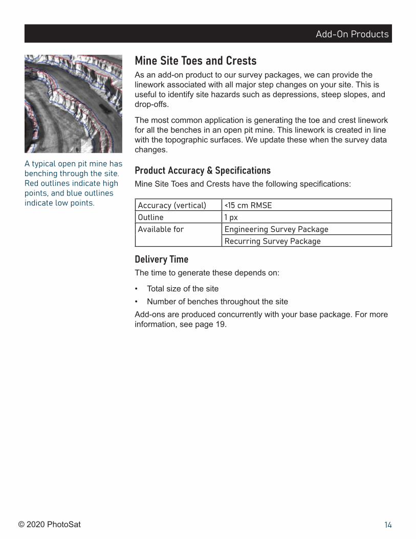
Mine Site Toes and CrestsAs an add-on product to our survey packages, we can provide the linework associated with all major step changes on your site. This is useful to identify site hazards such as depressions, steep slopes, and drop-offs.
The most common application is generating the toe and crest linework for all the benches in an open pit mine. This linework is created in line with the topographic surfaces. We update these when the survey data changes.
Product Accuracy & Specifications Mine Site Toes and Crests have the following specifications:
Accuracy (vertical) <15 cm RMSEOutline 1 pxAvailable for Engineering Survey Package
Recurring Survey Package
Delivery TimeThe time to generate these depends on:
• Total size of the site• Number of benches throughout the siteAdd-ons are produced concurrently with your base package. For more information, see page 19.
Add-On Products
A typical open pit mine has benching through the site. Red outlines indicate high points, and blue outlines indicate low points.

© 2020 PhotoSat 15
Infrastructure and Feature Outlines For some projects, it may be necessary to identify specific features such as roads or buildings. An add-on product to our survey or mapping packages, we can locate and digitize features in a specific area. This includes:
• Roads• Buildings• Rivers and drainages• Other important natural featuresThis is a useful add-on when obtaining topography of an inundation area for a dam breach analysis.
Product Accuracy & Specifications Infrastructure and feature outlines have the following specifications:
Outline 1 pxAvailable for Engineering Survey Package
Recurring Survey Package Regional Mapping Package
Included in Dam Breach Analyses Package
Delivery TimeThe time to generate these depends on:
• Total size of the mapping or survey area• Number of features to digitize• Type and complexity of infrastructureAdd-ons are produced concurrently with your base package. For more information, see page 19.
Add-On Products
Digital outlines of roads or buildings are useful during planning or for impact assessments. These are particularly useful when completing an inundation area study for a dam breach analysis.

© 2020 PhotoSat 16
Deposition Graph When tracking volume changes, it is often useful to present data in a cross-section deposition graph. In this add-on product, we can combine survey data and volume changes into a single useful image.
A deposition graph is useful for:
• Monitoring tailings deposition for ongoing monitoring• Showing a deposition history for a tailings facility
Product Accuracy & Specifications Deposition graphs have the following specifications:
Accuracy (vertical) <15 cm RMSEAccuracy (volume) <1-2% errorAvailable for Engineering Survey Package
Recurring Survey Package Included in Tailings History Package
Delivery TimeAdd-ons are produced concurrently with your base package. For more information, see page 19.
Add-On Products
Produced for a tailings history, this deposition graph shows changes in tailings volumes by survey. At different dates, it shows the deposition elevation, along with dyke and beach profiles.

© 2020 PhotoSat 17
Volume MeasurementTo measure volume changes at a site, we compare two or more PhotoSat surveys from different dates. If there is only one PhotoSat survey available, we can also use good quality drone, LiDAR, or ground surveys.
There are several applications for volume measurements:
• Monitoring tailings deposition• Measuring volume changes for leach pads and ore stockpiles• Volume reconciliation• Cut and fill volumes
Product Accuracy & Specifications Our volume measurements have the following specifications:
Accuracy (vertical) <15 cm RMSEAccuracy (volume) <1-2% errorAvailable for Engineering Survey Package
Recurring Survey Package Included in Tailings History Package
Delivery TimeIf more than one PhotoSat survey exists, volume calculations can be completed immediately after the most recent PhotoSat survey.
Add-ons are produced concurrently with your base package. For more information, see page 19.
Add-On Products
By comparing two surveys taken on different dates, it is possible to calculate changes in volume.

© 2020 PhotoSat 18
Additional Product InformationAvailable FormatsWe offer a number of formats.
Thinned Grid FormatsFor large files, we offer thinned grid formats. This makes it easier to store, share, and work with larger files.
File FormatsWe can provide our deliverables in:
Deliverable(s) Format(s) AvailableOrthophotoColour elevation imageSlope direction image
GeoTIFF
Elevation gridFloating Point GeoTIFFMapInfo GridASCII XYZ
Contours3D ArcGIS Shapefile2D MapInfo3D DWG
Size and LocationPhotoSat can complete surveying and mapping orders almost anywhere in the world. There is no upper size limit.
Data ordering minimums may apply to small orders:
• Satellite surveying with new photos for areas under 25 km²• Satellite surveying with archived photos for areas under 100 km²• Satellite mapping for areas under 100 km²
Pricing Due to the unique nature of every project, all quotes are custom. Contact us for a custom quote or visit our website at photosat.ca.
Additional Product Information

© 2020 PhotoSat 19
Contact UsTo learn more about our products and delivery times:
General [email protected] | 604-681-9770
Alteration Mineral Mapping and ExplorationJayda Akatsuka | [email protected]
Tailings Facilities Sam Rivet (P. Eng.) | [email protected]
Mine Operations and DevelopmentJim Turner (P. Eng.) | [email protected]
Timeline for DeliveryEvery project is unique. There are a number of outside factors that influence the total delivery time of a surveying or mapping order.
Phase 1: Obtaining Satellite PhotosFor new satellite photos, collection can be delayed by persistent cloud cover over the site, satellite production capacity, and a few other factors. Under ideal conditions, it usually takes ~5-7 business days to collect new satellite photos.
For archived satellite photos, it typically takes ~2-3 business days to conduct an archive search for a single survey or map order. If suitable photos exist, we may be able to use them.
Phase 2: Data ProcessingAfter we receive the satellite photos, data processing can begin. The majority of mine site surveys are around 50-70 km² in size. For these types of sites, most data processing times are:
• ~10 business days for a first-time survey• ~5-7 business days for repeat surveys
Other factors may increase data processing time, including:
• Add-on products (e.g. water body outlines)• Certain types or terrain and/or high numbers of ground features• Requests for extra file formats and/or thinned grid formats
Additional Product Information