2014 secondary road review recommendations county road system.pdf · 2014 secondary road review...
TRANSCRIPT


2014 SECONDARY ROAD REVIEW RECOMMENDATIONS
Currently Lawrence County has two road classifications, Primary and Secondary Roads. The Secondary Highway System is comprised of 86 different roads within the County. Those 86 roads
total up to 88.69 miles in total length. Most of those roads would ordinarily be considered Townships Roads in most instances, but beings there is only one organized Township in Lawrence County, the majority of those roads have been listed as County Secondary Roads and have been maintained by the Lawrence County Highway Department for many years. Secondary Roads do receive a lower level of service than the Primary Roads such as magging, blading, graveling, culvert maintenance and mowing. The one exception to the level of service is the snow removal. All Secondary Roads receive the same level of snow plowing as do the Primary Roads in the County. Upon review, the following is a list of recommendations adjusting the Secondary Road System in Lawrence County as prepared by the Highway Superintendent.
1. Remove Skivicalo Road No. 2471 from the secondary system (0.306 mile). 2. Remove Frosty Meadows Road No. 0780 from the secondary system (0.727
mile). 3. Remove Gudat Road No. 0670 from the secondary system (0.831 mile). 4. Remove Rocky Johnson Road No. 0650 from the secondary system (0.901 mile). 5. Remove Hann Place Road No. 4044 from the secondary system (0.344 mile). 6. Remove Tammi Place Road No. 5342 from the secondary system (0.22 mile). 7. Remove Hill Place Road No. 1510 from the secondary system (0.308 mile). 8. Remove Gibson Road No. 0441 from the secondary system (0.750 mile). 9. Remove the segment of Thompson Road No. 5343 starting at the intersection of
Old Ridge Road to the east end from the secondary system (0.463 mile). 10. Remove the segment of Gold Dust Trail Road No. 4043 starting at the intersection
of Legal Tender Trail proceeding to the east end from the secondary system (0.65 mile).
11. Remove the segment of Corral Creek Road No. 4042 from the Forest Service Boundary cattleguard to the south from the secondary system (1.235 miles).
12. Remove McInerney Road No. 0270 from the secondary system (1.20 miles). 13. Remove the east segment of Holso Road No. 0750 starting at the intersection of
Billy Hill driveway proceeding east into the Holso Ranch Yard from the secondary system (0.460 mile).
14. Remove the segment of Beasant Park Road No. 2060 starting at the intersection of Forest Service Road 206-1A west to Buskala Ranch gate from the Secondary system (0.570 mile).
15. Remove the Evenson Branch of the Juso Road No. 0660 from the secondary system (0.498 mile).
16. Remove 100th Place Road from the secondary system (0.402 mile). 17. Remove 108th Ave. from the secondary system (0.323 mile). 18. Remove Dairy Lane Road No. 1051 from the secondary system (0.298 mile). 19. Remove Red Hill Place Road No. 0092 from the secondary system (0.472 mile).
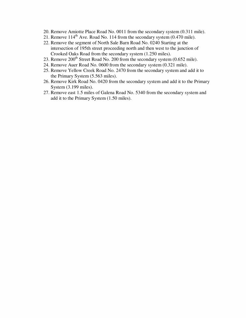
20. Remove Amiotte Place Road No. 0011 from the secondary system (0.311 mile). 21. Remove 114th Ave. Road No. 114 from the secondary system (0.470 mile). 22. Remove the segment of North Sale Barn Road No. 0240 Starting at the
intersection of 195th street proceeding north and then west to the junction of Crooked Oaks Road from the secondary system (1.250 miles).
23. Remove 200th Street Road No. 200 from the secondary system (0.652 mile). 24. Remove Auer Road No. 0600 from the secondary system (0.321 mile). 25. Remove Yellow Creek Road No. 2470 from the secondary system and add it to
the Primary System (5.563 miles). 26. Remove Kirk Road No. 0420 from the secondary system and add it to the Primary
System (3.199 miles). 27. Remove east 1.5 miles of Galena Road No. 5340 from the secondary system and
add it to the Primary System (1.50 miles).

2013 SECONDARY ROAD COSTS
ROAD NO. ROAD NAME LENGTH COST 100 100th Place 0.4 mi. $ 720.32 108 108th Ave. 0.32 mi 377.84 114 114th Place 0.47 mi 3,180.42 117 117th Ave 1.0 mi 5,039.03 194 194th Ave. 1.45 mi 4,008.91 200 200th St. 0.7 mi 5,226.31 0380 76 Ranch Road 0.3 mi 4,229.36 0011 Amiotte Place 0.3 mi 1,019.45 0740 Archery Road 0.9 mi 5,041.13 0600 Auer Road 0.3 mi 394.28 0350 Bauer Ave. 0.59 mi 4,090.55 0610 Baumberger Road 0.7 mi 2,339.05 1980 Benchmark Road 3.9 mi 47,579.58 2060 Beasant Park Road 1.8 mi 10,464.29 1951 Blacktail Bench Road 0.1 mi 1,067.54 0370 Boulder Creek Road 0.3 mi 2,725.14 1400 Boxelder Forks Road 2.3 mi 9,140.59 1860 Carbonate Road 0.8 mi 7,978.33 0252 Cleopatra Place 0.06 mi 1,425.76 4042 Corral Creek Road 1.9 mi 7,581.50 0253 Coyote Lane 0.1 mi 2,504.02 0510 Crow Creek Road 1.3 mi 2,172.77 2160 Custer Peak Road 2.9 mi 19,253.06 0460 Cutting Mine Road 0.4 mi 6,285.29 1051 Dairy Lane 0.3 mi 860.20 2240 Dalton Lake Road 3.8 mi 11,253.57 0104 Datum Creek Place 0.4 mi 978.04 0760 Deer Mountain Road 1.0 mi 1,896.11 0144 Diamond Drive 0.5 mi 3,047.22 0061 Dorsett Road 0.3 mi 6,119.56 0250 Elmore Road 0.2 mi 3,922.01 0430 Englewood Road 3.4 mi 41,286.68 1450 Erskine Gulch Road 1.4 mi 4,685.19 0242 Fogelsong Road 2.5 mi 8,109.75 0780 Frosty Meadows Road 0.7 mi 4,106.36 5340 Galena Road (East End) 1.5 mi 18,241.58 0441 Gibson Road 0.8 mi 2,197.86 0360 Gigear Road 0.25 mi 1,327.21 1700 Gilt Edge Road 0.8 mi 9,162.65 4043 Gold Dust Trail 0.8 mi 2,506.69 0371 Granite Peak Lane 0.03 mi 551.61 0710 Grizzly Gulch Road 0.4 mi 2,195.22

0670 Gudat Road 0.8 mi 6,073.80 4044 Hannn Place 0.3 mi 1,362.22 4041 Heaton Road 0.6 mi 4,238.97 2472 Hideaway Road 1.2 mi 3,101.45 2140 Higgins Gulch Road 1.0 mi 43,315.55 385 Highway 385 (Jones Road) 0.1 mi 695.45 1510 Hill Place 0.3 mi 1,133.42 0750 Holso Road 1.4 mi 65,705.87 2223 Iron Creek Lake 0.7 mi 10,571.35 0660 Jusso Ranch Road 2.0 mi 10,764.26 0420 Kirk Road 3.2 mi 50,561.02 0452 Larson Road 1.9 mi 5,783.23 0790 Legends Lane 0.2 mi 1,995.80 1952 McDermott Road 0.4 mi 3,127.12 0270 McInerney Road 1.2 mi 2,047.04 0340 Merritt Road 0.5 mi 676.70 0091 Mill Creek Road 0.5 mi 1,325.21 0240 North Sale Barn Road 2.2 mi 4,391.48 2480 Old Iron Horse Road 1.1 mi 2,930.34 1511 Old Ridge Road 2.2 mi 15,623.19 0101 Oliver Street (West End) 0.3 mi 799.62 2290 Pahkamaa Road 1.5 mi 4,705.41 1320 Pendo Road 1.6 mi 15,489.02 0800 Radio Tower Road 0.3 mi 5,238.19 0092 Red Hill Place 0.5 mi 1,135.52 0222 Ridley Road 2.3 mi 6,669.29 0251 Rimrock Place 0.04 mi 1,233.09 0650 Rocky Johnson Road 0.9 mi 3,536.01 2550 Roubaix Lake Road 0.3 mi 2,430.16 2221 Roughlock Falls Road 1.1 mi 158,112.87 0560 Salebarn Road 0.7 mi 8,881.33 2471 Skvicalo Road 0.3 mi 2,475.38 0400 Stewart Slope Road 0.5 mi 8,369.09 1103 Superior Place 0.4 mi 2,920.77 5342 Tammi Place 0.22 mi 680.12 5343 Thompson Road 0.8 mi 3,231.95 0390 Two Bit Road 3.5 mi 24,238.59 0070 Upper Redwater Road 0.5 mi 2,267.84 0730 Upper Two Bit Road 0.6 mi 4,122 46 1052 Westview Drive 1.0 mi 5,102.26 1760 Wildberger Road 0.7 mi 2,817.15 0451 Windy Flats Road 0.6 mi 2,508.44 0020 Winterville Drive 0.26 mi 330.34 2470 Yellowcreek Road 5.6 mi 41,461.69 TOTAL 88.69 MI $ 820,472.09

HIGH RESOLUTION MAP
For a higher resolution copy of the map, you can go to the following link: http://www.lawrence.sd.us/downloads/Lawrence_County_Road_System.jpg