2012 municipal ict capacity and its impact on the climate...
TRANSCRIPT

2012
Municipal ICT Capacity and its Impact on the Climate-Change Affected Urban PoorThe Case of Mozambique
A Poverty & Social Impact Analysis (PSIA) Study
Municipal ICT Capacity and its Impact on the Climate-ChangeAffected Urban Poor The Case of Mozambique A Poverty & Social Impact Analysis (PSIA) Study
2012
Africa Urban & Water Unit (AFTUW) The World Bank Group

© 2012 The International Bank for Reconstruction and Development/The World Bank 1818 H Street, NW Washington, DC 20433 Telephone: 202-473-1000 Internet: www.worldbank.org
This volume is a product of the staff of the International Bank for Reconstruction and Development/ The World Bank. The findings, interpretations, and conclusions expressed in this paper do not necessarily reflect the views of the Executive Directors of The World Bank or the governments they represent.
The World Bank does not guarantee the accuracy of the data included in this work. The boundaries, colors, denominations, and other information shown on any map in this work do not imply any judgment on the part of The World Bank concerning the legal status of any territory or the endorsement or acceptance of such boundaries.
The material in this publication is copyrighted. Copying and/or transmitting portions or all of this work without permission may be a violation of applicable law. The International Bank for Reconstruction and Development/ The World Bank encourages dissemination of its work and will normally grant permission to reproduce portions of the work promptly.
All queries on rights and licenses, including subsidiary rights, should be addressed to the Office of the Publisher, The World Bank, 1818 H Street NW, Washington, DC 20433, USA, fax 202-522-2422, e-mail: [email protected]

Table of Contents
SECTION 1: URBANIZATION IN MOZAMBIQUE, CLIMATE CHANGE, AND ITS IMPACT ON THE URBAN POOR …3
1.1. THE URBANIZATION PHENOMENON ........................................................................................................................ 3 1.2. UNDERSTANDING THE NEXUS OF CITIES, CLIMATE CHANGE, AND THE URBAN POOR ................................................... 5 1.3. GROWTH OF THE VULNERABLE URBAN POOR .......................................................................................................... 7 1.4. FLOOD RESPONSE MECHANISM IN MOZAMBIQUE .................................................................................................... 8
SECTION 2: MUNICIPAL ICT PHENOMENA AND POLICY GOALS ..................................................................... 10
2.1. ICT IN AFRICA AND THE SITUATION IN MOZAMBIQUE ............................................................................................. 10 2.2. THE ICT PHENOMENON IN URBAN GOVERNANCE ................................................................................................... 10 2.3. THE ROLE OF ICT IN URBAN CLIMATE RESILIENCE ................................................................................................... 11 2.4. THE DIGITAL DIVIDE RISK .............................................................................................................................. ........ 13 2.5. MOZAMBQIUE’S ICT POLICY GOALS ....................................................................................................................... 13 2.6. STUDY OBJECTIVES .............................................................................................................................. ................ 15
SECTION 3: ICT FOR CLIMATE RESILIENCE – FOUR TOOLS ............................................................................ 16
3.1 ICT IN DISASTER PREVENTION AND RECOVERY .............................................................................................. 16
3.1.1. GEOGRAPHIC INFORMATION SYSTEMS (GIS) .............................................................................................. 16 3.1.2. E-GOVERNANCE ...................................................................................................................................... 17
3.2. ICT IN DISASTER WARNING AND EMERGENCY RESPONSE ............................................................................. 19
3.2.1 WIRELESS: MOBILE TELEPHONY AND RADIO ............................................................................................... 19 3.2.2. EARLY WARNING SYSTEMS (EWS) .............................................................................................................. 20
SECTION 4: ASSESSMENT AND FINDINGS ..................................................................................................... 22
4.1. ICT INFRASTRUCTURE ....................................................................................................... .................................................. 23 4.2. GEOGRAPHIC INFORMATION SYSTEMS (GIS) ..................................................................................... ................................. 25 4.3. E-GOVERNANCE TOOLS ....................................................................................................... ................................................ 29 4.4. WIRELESS COMMUNICATIONS .................................................................................................. .......................................... 32 4.5. EARLY WARNING SYSTEMS .................................................................................................... ............................................. 34 4.6. RESULTS ANALYSIS ......................................................................................................... ..................................................... 38
SECTION 5: POLICY RECOMMENDATIONS .................................................................................................... 42
5.1. THE LIMITATIONS OF SUPPLY-SIDE ICT INTERVENTIONS ......................................................................... ........................... 42 5.2. CAPTURING THE CITIZEN”S VOICE ................................................................................................ ...................................... 43 5.3. LEVERAGING ICT FOR COMMUNITY-GOVERNEMNT COLLABORATION .................................................................... .......... 45 5.4. NEEDED MODIFICATIONS TO ICT-PARPA FRAMEWORK .............................................................................. ....................... 47 5.5. CONCLUSION ............................................................................................................... ........................................................ 49
ANNEX A: MUNICIPAL GIS SCREENSHOTS .................................................................................................... 49
ANNEX B: OVERVIEW OF SIGEM (SCREENSHOTS) ......................................................................................... 58

Abbreviations
ARA Administração Regional de Águas CENOI Centro Nacional Operativo de Emergência DUAT Direito de Uso e Aproveitamento da Terra DSG Demand Side Governance DNTF Directorate of Land & Forests DNA Direcção Nacional de Àguas EWS Early Warning Systems E-SISTAFE Financial Administrative and Management System FEWSNET Famine Early Warning Systems Network GCM General Circulation Models GeoSFM Geospatial Stream Flow Model GHG Global Greenhouse Gas GIS Geographic Information System GIZ Gesellschaft für Internationale Zusammenarbeit GovNet Government Electronic Network GoM Government of Mozambique GPS Global Positioning System ICT Information & Communication Technology ICT4DSG ICT for Demand Side Governance IT Information Technologies INAM Instituto Naciona de Meteorologia INGC Instituto Nacional de Gestão de Calamidades IPCC Intergovernmental Panel on Climate Change ISPs Internet service providers LIMS Computerized Land Management Information System MCA Millennium Challenge Account MDG Millennium Development Goals PARPA Action Plan for the Reduction of Absolute Poverty PSIA Poverty & Social Impact Analysis SCADA Supervisory Control and Data Acquisition SIGEM Sistema de Informação de Gestão Municipal SIP State Personnel Information System SMS Short Messaging System SSG Supply Side Governance TDM Telecomunicações de Moçambique UNPAN United Nations Public Administration Network

Acknowledgements
This study was prepared by Gaurav Relhan, ICT Specialist, World Bank. Overall editing services were
provided by Marc P. DeFrancis (DeFrancis Writing & Editing). Xavier Muianga (Universidade Eduardo
Mondlane) assisted in field-based data gathering activities. The team thanks the various municipalities,
local government agencies, and ministries in Mozambique for their active cooperation in providing data,
and extends its gratitude to the Poverty & Social Impact Analysis (PSIA) Multi-Donor Trust Fund and
Cities Alliance for providing resources which made this study possible.
Quality feedback on report structure and content was received from peer reviewers Paula Lytle, Judy
Baker, Varalakshmi Vemuru, and Louise Croneborg.
The work is a joint effort by the Africa Urban and Water Unit (AFTUW), Fragile States, Conflict &
Social Department (AFTCS), and Transport, Water, ICT (TWICT) department of the World Bank.

Introduction
Driven by rapid rural migrant influx, Mozambique’s unprecedented urbanization is testament to the
symbiotic relationship that exists between cities and the poor –which is, the urban poor invigorate cities
into engines of growth through abundant rendition of their manpower and vitality, and cities in return
render a refuge for shelter, growth, and other socio-economic opportunities. But in Mozambique such
symbiosis is under duress due to vulnerability of the country’s key cities to climatic hazards.
Commonplace challenges faced by the urban poor such as safe housing, sanitation, and drinking water
access are being exacerbated by the impacts of climate change, which include more frequent and intense
flooding, disease, and livelihood loss. In this light, local governments in Mozambique are under
increasing pressure to improve their cities’ livability conditions and are thus seeking solutions to make
their city management more responsive to the needs of citizens.
Significantly, Information & Communication Technology (ICT) has evolved into an effective means for
helping institutions and citizens mitigate, and if possible, prevent severe impacts from shocks and
emergencies that affect physical and economic well-being. To refine ICT’s role in the public sector,
Mozambique has since long embraced policies aimed at leveraging ICT as a poverty alleviation tool
through its rendition of better service delivery capabilities and transparency in public-sector institutions.
Under the lens of such policy framework, in an effort to enhance safety nets for cities and urban denizens,
Mozambique is upgrading its local governments’ capabilities using various ICT tools such as Geographic
Information Systems, E-Governance, Wireless Communications, and Early Warning Systems. But while
the country has made progress towards applying ICT in this direction, the impact on the poor has been
unknown.
Against such backdrop, this Poverty & Social Impact Analysis (PSIA) study performs a spatial analysis of
Mozambique’s ICT policy framework to assess the impact of local government-level ICT on the poor.
Given the socio-economic importance of Mozambique’s coastal cities and their susceptibility to regular
climate hazards, the country’s ICT policy framework is evaluated by analyzing the efficacy of the
aforementioned ICT tools along a dimension that disproportionately affects the poor more, namely
vulnerability to flooding -- a reality worsening each year due to the effects of climate change. The spatial
analysis approach adopted by this study involves comparing key coastal cities with each other to discern
differences in respective ICT capabilities and effectiveness that derive from policy as well as scale.
The objective of conducting this case study on Mozambique is to uncover the pattern of municipal ICT
impact that may exist in other low-capacity countries with analogous political economy structures in
relation to leveraging ICT in public sectors. The study concludes by suggesting measures to link the

2
continent’s ICT boom in citizen-based mobile telephony and internet usage with the rapid rise of public-
sector ICT phenomena as a promising means to plug service delivery gaps. In view of these highlights,
this report stands to serve as a valuable resource guide to a wide audience of practitioners, including
policy wonks, urban specialists, ICT and climate change enthusiasts, as well as social accountability
activists.
This report consists of five sections. Section 1 details the impact of climate change on Mozambique’s
urban poor while also providing an overview of the country’s disaster response system. In view of the
decentralization of much of Mozambique’s ICT and other resources among municipal governments,
Section 2 sheds light on leveraging local government -level ICT towards enhancing urban climate
resilience and disseminates awareness on the ‘ICT-PARPA’ framework. Section 3 describes the four ICT
tools most widely being used towards climate-change adaptation, while Section 4 seeks to quantify the
level to which municipal ICT growth is having an impact on urban climate resilience generally, and seeks
to answer the question of whether it is having an equitable impact on the poor. Upon measuring the extent
to which urban climate resilience is being enhanced and analyzing differential impact on the urban poor,
Section 5 recommends targeted reform in ICT-PARPA framework such that ICT impact is equitable for
all communities, and postulates how such reform can be realized.
Any comments, questions, feedback, and suggestions on the report are welcome and may be sent to
[email protected]. On Facebook, post your suggestions to the World Bank Africa page. On
Twitter, reply to @WorldBankAfrica .

3
Section 1 Urbanization in Mozambique, Climate Change, and its Impact
on the Urban Poor
1.1. The Urbanization Phenomenon
With an annual per capita income of only USD 330 in 2007 and with 54 percent of its population
still below the poverty line, Mozambique is a poor country facing considerable social and economic
challenges. Yet, Mozambique has been a strong economic and social performer in Africa and is regarded
by donors as a growth success story. Since the devastating civil war ended in 1992, the country has
enjoyed a remarkable recovery, achieving an average annual rate of economic growth of 8 percent
between 1996 and 2008. As a result, the country’s poverty headcount index fell by 15 percentage points
between 1997 and 2003, bringing almost 3 million people above the poverty line and out of extreme
poverty (out of a total population of 20 million at 2003 levels). From the human development perspective,
this has meant a significant improvement in various indices and progress toward achieving the
Millennium Development Goals (MDGs). a
This stable political climate followed by increasing privatization and deregulation of markets has
sparked surging capital growth in non-agricultural sectors, as a result of which cities in the country are
particularly in expansion mode. Urbanization in Mozambique is increasing at roughly 4.5 percent
annually, with cities now housing almost 20 percent of the country’s population and contributing almost
75 percent to its GDP. Today, Mozambique joins Botswana, Tanzania, and Swaziland, as a country whose
urban population is growing more than twice as fast as the natural rate of increase of their countries’
overall populations.1 Approximately 3.5 million people live in ten of Mozambique’s coastal cities, and 70
percent of those live in the cities of the Maputo metropolitan area, Beira and Nacala.2 Box 1 describes in
further detail the significance of Mozambique’s coastal cities to the country’s development.
The benefits of urban agglomeration, underscored by rising productivity, fluid labor markets, and
greater market access, have led to the recognition that urbanization can indeed be a vital force for growth
and poverty reduction. 3 But while rapid urbanization is transforming urban centers into drivers of
economic growth, it can also increase poverty if not handled well. In particular, urban mismanagement
and haphazard planning severely affect the wellbeing of residents by exacerbating vulnerability of cities
to natural disasters on account of cities’ often hazard-prone locations along coastal areas or rivers. As
discussed in the following paragraphs, risks are especially high for the urban poor in low- and middle- a Some key indicators: a 35% decrease in infant and under-five mortality, a 65% increase in net primary school enrollment, and relatively low inequality (UN MDG report, 2011).

4
income countries, almost a billion of whom live in disaster-prone settlements in and adjacent to cities.4
Today, these risks are being further aggravated for the poor due to the effects of climate change.
In light of the above facts, it becomes clear that these coastal urban regions constitute
Mozambique’s engines of economic growth and therefore need to be protected from the impacts of
natural disasters and climate change for the country to maintain its growth trajectory. But strong evidence
shows that Mozambique’s development is severely handicapped by natural disasters – a fact amply
Box 1. A Glimpse at Mozambique’s Largest Cities
Matola,
Beira, ,
Pemba
Xai Xai

5
illustrated by its recurring major floods – with susceptibility to such hazards not likely to abate given the
projections of climate scientists, as is discussed below.
1.2. Understanding the Nexus of Cities, Climate Change, and the Urban Poor
Mozambique is already one of the world’s most vulnerable to the impacts of climate variability,
ranking third in the continent among countries most exposed to risks from multiple weather-related
hazards.5 A major disaster has struck Mozambique every five years, translating to an average loss of GDP
growth of 1 percent per year. During the past 50 years, the country has experienced more than 68 natural
disasters, which have caused the death of more than 100,000 people and afflicted either physical or
economic harm to as many as 28 million.6 The General Circulation Models (GCM) approved by the
United Nations’ Intergovernmental Panel on Climate Change (IPCC) suggest a dramatic increase in inter-
annual climate variability for Mozambique -- implying that extreme weather events such as intense floods
and droughts may become more frequent.7 This long-term outlook places further pressure on cash-
strapped local governments, as urban agencies must increasingly adapt to migrations of people displaced
by climate crises taking place elsewhere.
Worldwide, energy use for urban electricity, transport, and industry contributes up to 77 percent
of global greenhouse gas (GHG) emissions, rendering cities as a major contributor to GHG emissions8
with rapidly rising carbon footprints. But while cities are significant contributors to climate change, they
are also disproportionately vulnerable to suffering its catastrophic consequences on account of their
proximity to water bodies, which combined with poor planning and infrastructure in low-income
countries, makes them highly susceptible to flooding and drought.9 Regrettably, cities worst affected by
climate-change induced hazards and least capable of coping with natural disasters are often the
unfortunate victims of major GHG emissions from other parts of the continent or the globe. Climate-
change induced floods have already wrought havoc across Mozambique’s major urban centers, all located
along its Indian Ocean coastline.b
In their vulnerability to climate-related disasters, the urban poor are on the front line. This is
especially true of flood events, since, as in the case of Maputo, Mozambique (shown in Figure 1 below), it
is the poorest who must find or build homes in the least desirable, highest-risk locales, such as those most b To illustrate: Heavy floods devastated capital Maputo in 2000 killing over 700 citizens. In Beira, increasing flooding and coastal erosion already impact most of the area, disrupting the city’s functioning and threatening its strategic regional role and development opportunities. In Nacala, coastal erosion is increasing at an alarming rate, shrinking the city’s useful territory and affecting both public infrastructure investments and the ongoing rapid influx of private investments in the special industrial zone, which the city hosts.

6
prone to flooding along rivers or seacoasts. Further, basic physical infrastructure being weak in informal
settlements, during floods these localities suffer the compounded disadvantage of poor or even absent
storm drainage and sanitation facilities and difficult access to roads and hospitals. As depicted in Figure
2, drainage and sanitation systems are often overwhelmingly concentrated in cities’ formal, well-off areas.
(b)(a)
Figure 1. Geographic Information System (GIS) Maps of Maputo: Flood-Prone ElevationMap (a) depicts regions of the city usually prone to flooding. Map (b) depicts location of formal and informal
settlements. A cross-comparison is made to depict flood-prone zones. Image Courtesy: GIS departments of INGC (Maputo), Maputo Municipal Corporation
IndianOcean
IndianOcean
Figure 2. GIS Maps of Maputo: Location of Drainage and Sanitation NetworksMap (a) depicts regions of the city served by drainage & sanitation infrastructure. Map (b) depicts location of
Formal and Informal settlements Image Courtesy: GIS Department of Maputo Municipal Corporation
IndianOcean
IndianOcean
(a) (b)

7
1.3. Growth of the Vulnerable Urban Poor
In view of the economic activity generated in Mozambique’s cities, they are not only major
markets for goods but also a magnet for a growing number of poor rural migrants. This migration is
driven in large part by the country’s low and continually declining agricultural productivity. To illustrate,
while 80 percent of the population engages in agriculture, this sector accounts for only 25 percent of
national GDP. As shown in Table 1, the overwhelming majority of citizens in Mozambique’s cities today
live in informal settlements. The prevalence and size of these settlements also owes in part to the
country’s long and devastating civil war, when many people fled rural areas to seek refuge in towns.
According to Mozambique’s National Directorate of Land & Forests (DNTF), given the humanitarian
crisis at the time, local governments permitted the refugees to occupy land in restrictive zones, places that
were either disaster-prone or else undesirable due to being too close to infrastructure such as abutting
railway lines. Over time, as these refugees stayed on, the settlements became de facto communities
despite their vulnerable setting, poor infrastructure, and regular flooding.
Table 1. Estimated Populations in Informal Settlements in Eight Coastal Cities, Mozambique, 2010
Map
uto
Mat
ola
Bei
ra
Pem
ba
Xai-X
ai
Chi
buto
Man
iça
Maç
ia
Population 1,430,000 758,000 620,000 156,000 128,000 61,000 56,000 40,000
Percent of population living in informal
settlements 70% 70% 75% 80% 85% 90% 90% 90%
Number of people living in informal
settlements 1,001,000 530,600 465,000 124,800 108,800 54,900 50,400 36,000
Susceptibility to flooding High High High High Moderate Low Low Low
The inadequacy of basic services, such as drainage and sanitation, that these vulnerable poor
communities must make do with only amplifies the effects of climate-related hazards, for example turning
a heavy rain into a disastrous flood that, in turn, damages infrastructure and leads to water scarcity, water
contamination, and epidemic disease. More than 700 people, most of them poor, lost their lives across
cities in Mozambique during the floods in 2000 on account of poor infrastructure.

8
Analyses of both climate-change and urban development models suggest that even if coastal
flooding in Mozambique due to inland rainfall were to remain stable over the coming decades (i.e., not
taking into account any effect of climate change), the expansion and densification of informal settlements
around coastal cities will itself severely escalate the economic and human costs of regular (that is, non-
climate-change-induced) flooding, which will undoubtedly continue to occur.
1.4. Flood Response Mechanism in Mozambique
While heavy rainfall is a significant cause of flooding in Mozambique’s coastal cities, other
factors include poor drainage infrastructure, upstream dam releases on the many rivers that flow through
or near these cities, wind-driven tidal surges, and seawater intrusion. Globally, the response to imminent
or ongoing floods is normally taken up, first and foremost, by local authorities. Cities mobilize their
municipal emergency systems, from police to hospitals to evacuation teams. In Mozambique, flood
response involves an inverted pyramid of increasingly well-resourced public agencies. If a flood is too
large for a municipality to handle, responsibility moves upward to the regional authority, and if that
authority’s resources are inadequate, it rests finally with the national-level authority. Effective response
requires rapid communication among agencies and transparent sharing of accurate data. Box 2 provides a
glimpse of the various agencies involved in organizing relief in the event of disaster.
Box 2. An Overview of Flood Response Agencies in Mozambique
Disaster Response: National Disaster Management Institute (Instituto Nacional de Gestão de Calamidades, or INGC).
Forecasting: National Institute of Meteorology (Instituto Naciona de Meteorologia, or INAM).

9
Planning and Relief: Local Government.
Water Control and Management: The Regional Water Authorities (Administração Regional de Águas, or ARA).
Hydro-Meteorological Management: The National Directorate of Water (Direcção Nacional de Àguas, or DNA).
Response Coordination: National Emergency Operations Center (Centro Nacional Operativo de Emergência, or CENOI).

10
Section 2 Municipal ICT Phenomena and Policy Goals
2.1. ICT in Africa and the Situation in Mozambique
Growth in access to and use of ICT across the developing world has been exponential. This
includes the entire range of telecommunications networks, information technologies (IT), and electronic
services (e-services). The growth of ICT has been particularly strong in Africa. One study found that
between 2002 and 2008, while the French telecom market grew at an annual rate of 7.5 percent and the
Brazilian market at a rate of 28 percent, the African market experienced 49.3 percent annual growth.
During the same period, the African continent’s mobile phone use grew at an annual rate of 65 percent,
which was twice the global average. c Internet penetration, while still low in Africa, registered the world’s
highest growth rate at 9 percent in 2009, with public-sector institutions fast embracing the use of Internet
in their daily operations.
In Mozambique, the telecommunications and ICT sectors are in a strong expansion, mirroring the
overall sectoral progress taking place across the continent. Mobile service penetration in Mozambique has
increased dramatically over the past 10 years, with the number of subscribers growing from 0.1 percent of
the population to 20 percent, reaching a total of 4.2 million subscribers in 2008. This high level of growth
is forecast to continue the next few years, and it may even accelerate with the recent introduction, in
2011, of a third mobile operator. d Mobile coverage is particularly strong in urban areas, including
provincial capitals and cities, and along corridors of development. While Internet access remains limited
with only 2.8 percent user penetration, web usage is in expansion mode. New international connectivity
exists via undersea cables, and more than 20 Internet service providers (ISPs) are providing Internet
access today.10 Recognizing that ICT is a viable tool for strengthening governance mechanisms and
rendering urban management more efficient, a range of actors, both foreign and domestic, are investing
millions of dollars into upgrading local governments’ ICT capacities in Mozambique.
2.2. The ICT Phenomenon in Urban Governance
With the Africa Region adding an estimated 35 million people to its cities each year, its local
governments are facing increasing demands to improve their cities’ livability and competitiveness. To
c These findings are from Ernst & Young's research, conducted in the third quarter of 2008, as cited by the online periodical afrol News, May 5, 2011 (available at http://afrol.com/articles/12176).d Vodafone, mCel, and (now) Viettel offer mobile services in Mozambique

11
cope with this rising urbanization, many African countries have transferred power, resources, and
responsibilities to their subnational urban governments through the process of decentralization. While
such decentralization has transferred greater fiscal autonomy and responsibility to local governments,
giving them a larger say in formulating ordinances, collecting revenue, and allocating budget, these
governments now find themselves often lacking sufficient resources and capacities to fulfill their
mandates. To cope with both their expanded responsibilities in the wake of decentralization and the
increasing importance of their cities as engines of growth, Africa’s local governments are searching for
more effective urban governance solutions, with sustainable development as a key goal. To this end,
municipalities across the region are seeking greater assistance in strengthening their governance
mechanisms, planning their service strategies, and making their city management more responsive in
ensuring the delivery of vital services to urban residents, in particular the poor.
Worldwide, the growing prevalence of Information & Communication Technology (ICT) is being
leveraged by governments to extend the reach, quality, and efficiency of public services delivery.
Successful e-initiatives across regions have demonstrated that ICT tools involving the use of PCs
(including related software applications), the internet, and mobile phones can trigger a range of positive
outcomes when integrated within local governments. These outcomes include streamlined municipal
communication (e.g., via email or SMS correspondence), more secure data storage, and better accounting
(e.g., by using Excel spreadsheets), leading to enhanced institutional management and transparency.
Building a strong foundation for municipal ICT, as demonstrated by well-functioning PCs and laptops,
good Internet facilities, and skilled technicians and IT specialists, is also fundamental for enabling more
advanced municipal ICT capabilities--such as IFMIS (for strengthened financial management),
Geographic Information Systems or GIS (for better urban design and disaster response planning), and
social accountability initiatives, among others. Interestingly, the ICT sector itself can have a significant
economic impact on urban communities. It is estimated that every 10 percent increase in the market
penetration of mobile phones boosts GDP growth by 6 percentage points.11 Another estimate suggests that
for every 10 percent increase in broadband penetration in a particular area, employment increases 2 to 3
percentage points per year.12
2.3. The Role of ICT in Urban Climate Resilience
ICT has evolved into a powerful set of tools that enable governments to be more transparent,
more responsive, and better equipped to handle challenging needs. Its adoption is being applied both to
the normal business of running public services, such as planning land use, as well as for the rapid-
response work vital to handling natural disasters. It is thereby regarded as a great toolset for helping cities

12
and people mitigate and, under the right conditions, even prevent severe impacts on life, safety, and well-
being from environmental shocks and emergencies. In this light, it is no accident that ICT is being
adopted by both central and municipal governments across Africa. Cities have found that properly
installed ICT systems can ultimately save lives as well as minimize the costs of recovery. Table 2 shows
some of the ways ICT can serve as a powerful tool to protect the environment, enhance response to
climate-change- induced disasters, and assist with other environmental issues.
Table 2. ICT for Urban Environment
Objective Salient ICT Applications
Better Urban Planning
Digitized land records and topographical data can control further mushrooming of slums in flood-prone regions by enabling the rapid classification of city zones. Regular surveillance conducted with ICT tools makes it possible to conveniently cross-check and validate new encroachments and unauthorized/illegal constructions, which can block the flow of water systems. ICT tools like GIS make possible well informed planning of drainage systems for the rapid discharge of flood waters.
Reduced Pollution
Large-scale telecommuting enabled by broadband infrastructure can help reduce vehicular emissions. Reductions in paper consumption enabled by ICT, such as through paperless government and paperless office operations, can help prevent deforestation.
More Efficient Natural Resource Utilization
ICT tools such as SCADA/Telemetry, SmartGrid, and Smart Logistics systems can help reduce the consumption of energy, water, and other essential natural resources through real-time monitoring and by improving the efficiency of household and industrial resource uses. Further, by providing and enabling more useful metrics and information, ICT systems can play an important role in the systematic generation and sharing of data for natural resource management.
Better Environmental Disaster Management
Through constant real-time monitoring of water-level rises and flow in rivers and drainage systems (via automated sensors, Telemetry mechanisms) and of natural weather phenomena (via satellite imagery), ICT can be deployed extensively to predict and respond to environmental disasters. ICT tools can help bring to a municipality’s attention the location of leaking pipes, garbage accumulation, and other problems in slum areas. ICT tools such as online mapping and mobile phone-based applications can strengthen the coordination mechanisms of relief agencies during disasters.
Enhanced Environmental Awareness and Capacity
Building
Cities and communities can harness Internet or mobile-phone based “social accountability” platforms to communicate environmental knowledge, facilitate citizen monitoring of environmental issues, and encourage environmental activism.

13
2.4. The Digital Divide Risk
Although ICT tools are increasingly being adopted worldwide for a range of purposes, global
experience suggests that ICT policies sometimes leave out the poorest populations at both the macro and
micro levels. Uninformed or misguided ICT policies can actually lead to “digital divides” such that the
poor, or services oriented towards the poor, may benefit from little if any ICT capacity.
Among developing countries, a digital divide visibly sets apart the technologically more
advanced countries from the less advanced ones. Whereas a few developing countries still have Internet
penetration rates of less than 1 percent, in Brazil almost 41 percent of the population has access to the
Internet.13 Within a given region, too, some countries have a stronger information and communication
infrastructure than others. In Sub-Saharan Africa, the number of Internet hosts (i.e., computers connected
to the internet having an IP address) per 1,000 population ranges from only 0.01 in Burundi to 25 in South
Africa.14 Regional disparities in ICT can exist within countries as well. For instance, the southern Indian
cities of Bangalore and Hyderabad are more advanced in their overall broadband infrastructure and e-
services adoption than Kolkata in the east. Most strikingly, and in the context of this report most
importantly, within both developed and developing countries technological change and its costs often
mean that groups already disadvantaged or excluded—low-income families, rural populations, women,
minorities, and the elderly—fall farther behind. In India, for example, only 1.2 percent of the rural
population has Internet access, compared with 12 percent of the population in India’s urban centers.15
It is clear, therefore, that investments in local government-level ICT capabilities and ICT-based
service delivery mechanisms (such as e-registration) may have little or no impact on the poor and
disadvantaged so long as these populations lack the means to access them. Moreover, failing to take into
account the poor and their conditions in the design and usage of these municipal level ICT systems (for
instance, in depicting poor communities on GIS maps) may also result in widening rather than narrowing
the well-being gap between the poorest and the wealthiest. So, as ICT is steadily being ramped up within
agencies and communities globally and as access is becoming wider and more affordable, this paper
represents an example of gauging whether and which groups of people are being excluded from the
advantages and to ensure that steps are taken to bridge the gaps.
2.5. Mozambique’s ICT Policy Goals
Public sector reform, wherever it occurs, aims to improve the governance capabilities of
government institutions with a view to improving agencies’ efficiency, transparency, and accountability.
The Government of Mozambique is well aware of ICT’s potential in this regard and, indeed, has been
14
investing heavily in upgrading its public-sector ICT capabilities. It is also committed to furthering ICT-
sector reform, especially in the telecom arena. Advancements in ICT have been made at the local
government level to enhance the delivery of urban services, although as this report will discuss, much
ground remains to be covered. The central government is assisting the autonomously governed
municipalities in developing their ICT capabilities under the umbrella of a National ICT Policy, adopted
in 2000, which positioned ICT as a vehicle for national development. Within this policy, improved
governance and service delivery via ICT adoption within public-sector institutions are assigned as
essential priority areas. It is hoped that two other goals of national policy--reduction in absolute poverty
and improved transparency and effectiveness in governance--will be reached in tandem with this
leveraging of ICT towards improved public sector capabilities.
The will to make progress on ICT projects in general, and on e-government projects in particular,
is evident today among high-profile officials and ministries. Reducing dire poverty, the goal of the
country’s Action Plan for the Reduction of Absolute Poverty (PARPA), is the government’s primary
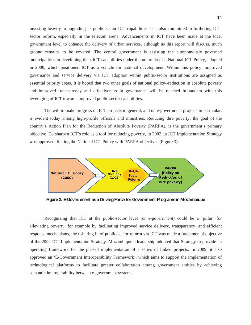
objective. To sharpen ICT’s role as a tool for reducing poverty, in 2002 an ICT Implementation Strategy
was approved, linking the National ICT Policy with PARPA objectives (Figure 3).
Figure 3. E-Government as a Driving Force for Government Programs in Mozambique
Recognizing that ICT at the public-sector level (or e-government) could be a ‘pillar’ for
alleviating poverty, for example by facilitating improved service delivery, transparency, and efficient
response mechanisms, the ushering in of public-sector reform via ICT was made a fundamental objective
of the 2002 ICT Implementation Strategy. Mozambique’s leadership adopted that Strategy to provide an
operating framework for the phased implementation of a series of linked projects. In 2009, it also
approved an ‘E-Government Interoperability Framework’, which aims to support the implementation of
technological platforms to facilitate greater collaboration among government entities by achieving
semantic interoperability between e-government systems.

15
2.6. Study Objectives
Although Mozambique’s population is still largely rural and agricultural, the rapid growth of
informal settlements in cities as well as the special vulnerability and density of urban populations magnify
the need for attention in making cities more livable through better planning, effective flood prevention
responses, and targeted poverty reduction strategies. Under the lens of the ICT-PARPA framework
outlined in the preceding paragraphs, a number of ICT projects for improving governance have been
launched both at the level of central ministries and agencies and at the local government level, often
funded by external donors and institutions. A range of such ICT initiatives now allow local governments
and national agencies to apply advanced solutions for better urban planning and effective response
mechanisms, very critical in the event of disaster.
In this light, the objective of this Poverty & Social Impact Analysis (PSIA) study is to assess the
performance of the ICT-poverty reduction framework since its inception in 2002. Given the importance of
Mozambique’s coastal cities and their susceptibility to regular climate hazards, one way to evaluate this
framework is to analyze the effectiveness of ICT advancements made at the local government level in key
cities along a dimension that disproportionately affects the poor. Flooding is such a dimension -- a reality
that is getting worse each year due, very possibly, to the effects of climate change. Recognizing the social
reality of digital divides (as discussed in Section 1), this study sets out to answer three key questions:
Is municipal ICT growth having an equitable impact on the urban poor?
To what extent is the use of local government -level ICT proving effective in enhancing
urban climate resilience in the country?
What policy reform and measures are needed to bridge any digital divides?

16
Section 3 ICT for Climate Resilience – Four Tools
There are four types of ICT tools, namely, Geographic Information Systems (GIS), E-
Governance, Early Warning Systems (including telemetry), and Wireless communications commonly
adopted by local governments worldwide for helping their cities adapt to the effects of climate change. Of
these, GIS and E-Governance are commonly leveraged for disaster prevention and recovery purposes,
while Wireless communications and Early Warning Systems are adopted to facilitate efficient disaster
warning and emergency response. Recognizing ICT’s potential in rendering urban environmental
management more effective, a range of actors, both foreign and domestic, are investing heavily in
upgrading local governments’ capacities of these four ICT tools in Mozambique. To enable readers gain a
better understanding of these tools’ impact on the urban poor (as analyzed in Section 4), a brief overview
of each ICT tool is being provided in this section.
3.1. ICT in Disaster Prevention and Recovery
1. Geographic Information Systems (GIS)
GIS systems allow the viewing, understanding, interpreting, and visualizing of data in ways that
reveal relationships, patterns, and trends in the form of maps, reports, and charts. In its simplest form, a
GIS system can be thought of as a digital map that contains a database of valuable information embedded
within it. It is by nature interactive, so that location-based data can readily be called up and viewed in a
geographic display. Maps in GIS can be displayed in layers-- as shown in Figure 4, a city map might have
a primary layer showing zone demarcations, another showing median income levels of neighborhoods,
another showing the location and percentage of uncredentialed teachers.
In the context of urban flood-risk reduction, GIS can furnish municipal officials and relief
agencies with in-depth clues on the location of the most at-risk residents based on the low-lying
topography of their settlements, their type of housing structures, their proximity to drainage systems and
canals, and so on. For example, through survey of river flows, storm tides, rainfall, and other
topographical features, the city of Honolulu created a GIS (Figure 5) allowing any resident with Internet
access to find out the flood-vulnerability level of any spot in the city. Also, the digital display of
information related to the proximity of these residents to roads, hospitals, and emergency centers enables
the development of effective evacuation strategies for vulnerable communities in no time.

17
2. E-Governance
E-Governance encompasses both computerization and Internet-based sharing of information by
governments in order to improve efficiency, accuracy, reliability, and transparency in government
services. It can be applied in two distinct ways: to the sharing and updating of information between
government and citizenry/businesses, and to the storage and sharing of information among and within
Figure 4. A GIS Mapping of Urban Zones Showing Concentrations of Uncredentialed Teachers(Image courtesy: Teaching to Change LA (TCLA))
Figure 5. Honolulu’s GIS Mapping of Low-to-High Flood Risk Zone Classifications (Image courtesy: ESRI)

18
government ministries and offices. By eliminating intermediaries and simplifying government-to-
government and government-to- citizen and -business transactions, making them more accessible to a
wider audience, e-governance reduces opportunities for corruption by supporting transparency and
accountability measures. The ability of any citizen to efficiently and securely access municipal services or
information round-the-clock and from any location reduces the potential for bribery, which can especially
harm the poor, and opportunities for discrimination, which can dissuade minorities from using services.
Along with PCs, widely diffused mobile telephones now also allow more citizens to deepen their
interactions with public-sector urban agencies. As a result, mainstreaming e-governance systems into the
functions of sub-national level entities can transform municipalities by supporting officials with better
governance and management capabilities.
In the context of enhancing urban climate resilience, in municipalities worldwide, e-governance
tools such as E-Land Planning and E-Registration are used for various land and building management
purposes, such as issuance of construction licenses, land titling/registration, and land purchases. Often,
these tools automatically perform functions such as validation of plot topography (to check flooding
susceptibility), violation of environmental regulations, and so on, before granting any certification.
Therefore, by curbing unauthorized construction on low-lying plots or the illegal sale of flood-prone
plots, e-governance tools can reduce the vulnerability of cities and communities to flooding. Box 4
discusses one such example.
Box 4. E-Land Planning Portal in Denmark
Figure 6. Zonal developmental plans for the Copenhagen metropolitan region

19
3.2. ICT in Disaster Warning and Emergency Response
1. Wireless: Mobile Telephony and Radio
In the realm of urban climate change adaptation, the scope of wireless technology, including
mobile and radio, is mainly due to the interplay of four elements that can lead to a virtuous circle of
government-citizen engagement: access, affordability, appliance innovation, and application.
Regarding access, already the wireless footprint covers a great majority of the population in
urban areas. Improvement in affordability has been due to the combination of prepaid service plans and
cheaper mobile handsets. Appliance innovation is evident in making these devices more adaptable to a
growing range of needs and services relevant to all citizens. Applications have experienced a vast increase
in a few years in the development and roll-out of mobile applications. These conditions, in concert, enable
stakeholders to instantaneously monitor environment –related issues and communicate these issues with
one another, thereby encouraging environmental activism.
SMS is often used during emergencies by local governments to convey emergency messages to
citizens (as shown in Figure 7), and also in a reverse fashion, enabling widely scattered residents to send
instant messages to emergency centers or local authorities so that they, in turn, can assemble an accurate,
minute-by-minute picture of changing needs. For instance, in the aftermath of the 2010 earthquake in
Haiti, an NGO named Ushahidi launched a mobile-based disaster response system to assist fire, police,
medical personnel coordinate relief efforts. This online tool aggregated information collected from local
witnesses, citizens and on-the-spot relief agencies using SMS messages and pinpointed relevant data on
interactive maps, saving over 100 lives. Also, to stop the spread of cholera in Port-Au-Prince, aid
agencies joined forces with mobile telecom providers to raise awareness on clean water and sanitation by
using SMS to convey relevant information, including precautionary measures, to refugee camp residents.
lokalplan
lokalplan Source

20
2. Early Warning Systems (EWS)
EWS involving the use of technology such as telemetry (also known as Supervisory Control and
Data Acquisition or SCADA), precipitation simulation software, and sensor-induced alarm mechanisms
can help prevent the loss of lives by forecasting in advance upcoming floods, typhoons, landslides,
tsunamis, and other associated disasters. Such systems provide timely estimates of the potential risk faced
by communities, economies and the environment through their monitoring and predicting capabilities.
EWS systems are often applied to make automated measurements of changing data, such as river/drainage
levels and atmospheric conditions, which could lead to prediction of natural disasters with a high degree
of accuracy. These updated conditions can be rapidly communicated to disaster management agencies,
preparing them in time for adequate response. For instance, in Westminster, U.K., sensors were installed
to monitor drainage and sewage flows, with corresponding data relayed to GIS mapping tools in real time.
The pin-pointing of accurate bottleneck locations using this technique vastly improved the city’s ability to
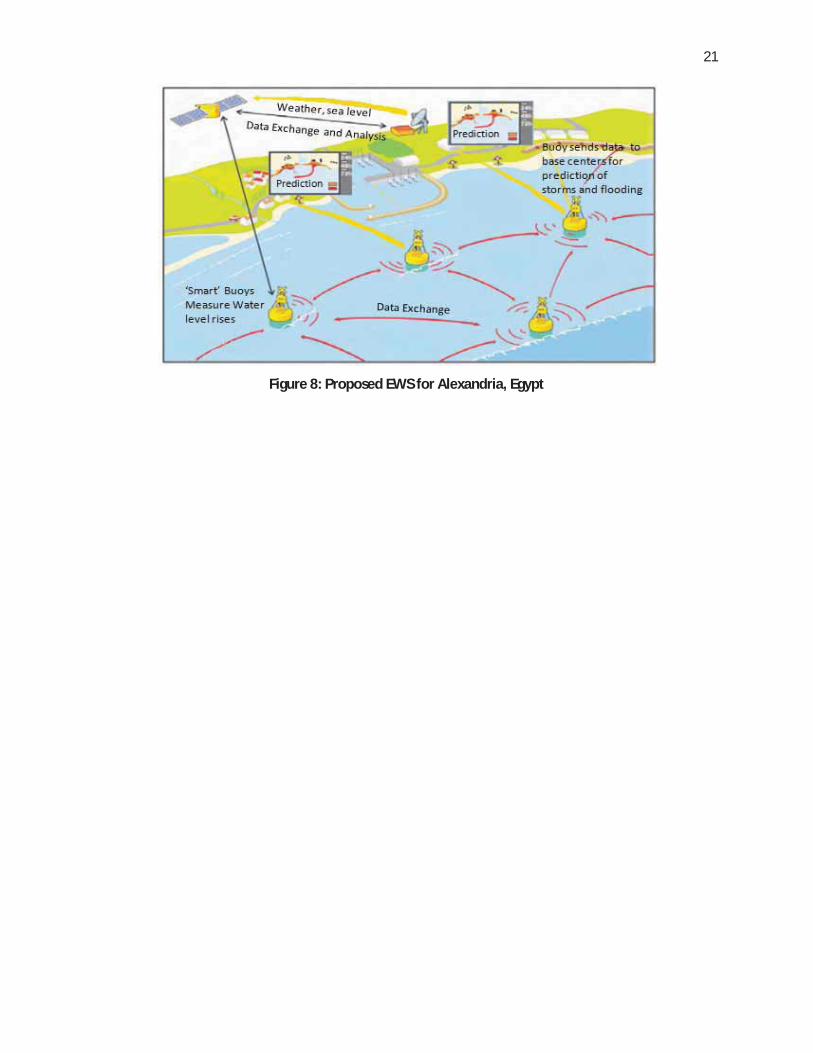
deal with escalating overflow problems in densely populated sectors. Figure 8 illustrates another example,
a proposed EWS system for Alexandria, Egypt, employing “smart buoys” linked to satellites, intended to
enable that coastal city lower any potential damage from sea surges, storms and tsunamis.
But while EWS technology can play a key role in early prediction of hydro-meteorological
hazards, it is important to remember that institutional coordination and appropriate action plans are
equally essential for an early warning system to succeed.
Figure 7. Disseminating Disaster Warning Messages using SMS Technology
21
Figure 8: Proposed EWS for Alexandria, Egypt

22
Section 4 Assessment and Findings
In light of ICT’s potential for enhancing urban service delivery and disaster response
mechanisms, significant resources have been invested in raising the ICT capabilities of Mozambique’s
sub-national agencies since the country’s national ICT policy was introduced in 2000. But the impact of
such sub-national-level ICT investments on the poor in Mozambique and elsewhere remains largely
unknown. Given Mozambique’s vulnerability to climate variability and its standing as a country
undergoing rapid urbanization and ICT growth, this section of the report attempts to analyze the impact of
local-government-level ICT deployments on the poor by evaluating their efficacy over a dimension that
disproportionately affects underprivileged communities most, namely their susceptibility to flooding – a
situation worsening each year due to possible climate change-related effects.
To assess the current status of ICT adoption towards enhancing urban climate resilience, existing ICT
capabilities in this direction associated with overall local government-level IT infrastructure, GIS, e-
governance, wireless communications, and early warning systems have been surveyed in eight coastal
cities of Mozambique: Maputo, Matola, Beira, Pemba, Xai-Xai, Chibuto, Maçia, and Manhiça (Figure 9).
A spatial analysis approach is applied to assess impacts on the poor and the creation of digital divides, if
any. The assessment methodology and findings are elaborated in the ensuing sections.
Figure 9: Location of the Eight Cities Surveyed

23
4.1. ICT Infrastructure
Generally, a strong municipal ICT core is demonstrated by the availability of well-functioning
PCs/laptops, good internet connections, and skilled technicians and IT specialists. All of this is
fundamental to ensuring that advanced ICT applications including GIS, e-governance tools, Early
Warning Systems, etc. can be effectively implemented and harnessed within municipalities. Having this
infrastructure in place also makes it possible to integrate other valuable advantages offered by IT, such as
streamlined municipal communication via email correspondence, secure and reliable data storage, and
improved accuracy of accounting (e.g., using Excel spreadsheets).
Methodology
The quality of IT infrastructure was measured by assessing parameters related to the number of
functional computer systems installed in municipalities; the speed of internet connections; the general IT
skill level of municipal officials; the technical support available from the local community (needed to
ensure that the infrastructure can be sustainably used and maintained); and so forth. Table 3 provides a
complete baseline pertaining to fundamental IT infrastructure existing in the eight surveyed cities.
Assessment Findings
Computers: Desktop computers existed in all the municipal governments, although laptops were rare.
Only the economically very prominent cities of Maputo and Matola had an ample number of
computers relative to the size of their municipal staffs, with roughly 75 percent of staff having direct
access to a computer. In other cities, less than 10 percent had access. Examined by rank of employee,
computers were available to both senior officials and mid-level employees, such as urban planners, in
every city. In most smaller cities, lower-level employees, such as secretaries, did not have computers.
Internet use: Every city except Pemba had Internet access but most were limited to a slow connection
speed of 128 kbps. Internet speeds in the large Maputo and Matola municipalities were the fastest, at
8 mbps and 2 mbps respectively. In Maputo and Matola, moreover, every municipal computer was
linked to the Internet, but in most of the other cities only one or two computers were linked. In Beira,
however, the problem is solved with staff utilizing their personally-owned USB modem sticks.
Email: Every city except Pemba incorporated email for internal communications, but only Beira
required staff to use email for this purpose.

24
Table 3. Baseline Study Data on Municipal IT Infrastructure* As of Aug 2011, only 5 PCs were available in Manhiça. An additional 10 expected by Dec. 2011
*
25
Municipal web page: As of 2011, only the big cities of Maputo, Matola, and Beira had municipal
government web pages. Beira is notable for having a function allowing citizen feedback on its page.
Local support: Needed hardware was available from the local market in every city. The situation
regarding skilled technicians, however, was mixed: Most cities could find such skilled help when
needed but Xai-Xai, Manhiça, and Chibuto lacked it.
Staff skill level: General IT training was carried out for staff in half the cities. The overall IT fluency
level among employees was nevertheless moderate-to-high only for the three largest cities (Maputo,
Matola, Beira) and substantially lower in the smaller cities.
Strategy and policy awareness: Only in the capital city Maputo was there awareness of the central
government’s e-government policies, and only in that city had a municipal strategy/roadmap for ICT
implementation been devised.
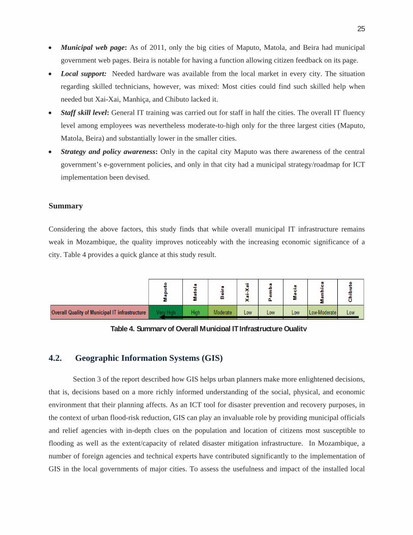
Summary
Considering the above factors, this study finds that while overall municipal IT infrastructure remains
weak in Mozambique, the quality improves noticeably with the increasing economic significance of a
city. Table 4 provides a quick glance at this study result.
4.2. Geographic Information Systems (GIS)
Section 3 of the report described how GIS helps urban planners make more enlightened decisions,
that is, decisions based on a more richly informed understanding of the social, physical, and economic
environment that their planning affects. As an ICT tool for disaster prevention and recovery purposes, in
the context of urban flood-risk reduction, GIS can play an invaluable role by providing municipal officials
and relief agencies with in-depth clues on the population and location of citizens most susceptible to
flooding as well as the extent/capacity of related disaster mitigation infrastructure. In Mozambique, a
number of foreign agencies and technical experts have contributed significantly to the implementation of
GIS in the local governments of major cities. To assess the usefulness and impact of the installed local
Table 4. Summary of Overall Municipal IT Infrastructure Quality

26
government GIS capability on the urban poor in the event of flooding, the approach adopted by this study
is described below.
Methodology
Local governments worldwide often employ GIS to gain information related to topography of localities
(to assess risk of flooding); socio-demographics of neighborhoods (to assess vulnerable population
groups, who in most cases are slum/informal settlement dwellers); proximity to hydrological systems
such as drainage, canals, and rivers (to assess means of water overflow/discharge); and proximity to road
networks and emergency/medical centers (to assess ease of speedy evacuation and relief). The
information so obtained is then used to devise effective evacuation strategies, demarcate needed new
infrastructure, or better plan cities in a manner that makes neighborhoods and communities less
susceptible to climate-related risks.
Step 1: In view of how local governments apply GIS for urban flood risk management, identification of
the following features in GIS of municipality and INGCe of each city was performed:
Depiction of vulnerable communitiesf
Topography
Drainage systems
Road networks, and
Hospitals/emergency centers.
Step 2: The level/quality of feature portrayal on the layers of GIS digital maps (for the overall city) was
assigned a score from 0 to 10 (10 = highest) based on a cross-comparison of the depicted data for a
sample of neighborhoods and regions, using available open-source maps
e Given the fact that in Mozambique a committee of representatives from the municipality and from the National Disaster Management Agency (INGC) coordinates response strategies in the event of imminent flooding, the GIS capacity of both these entities was evaluated to assess the coverage/quality of a GIS-enabled disaster response. (Note: an INGC field office is present in every city). f To assess which communities are at most risk to flooding, cognizant of the fact that the urban poor living in slums/informal settlements bear the brunt of flooding disasters, any information from the GIS related to settlement type (formal/informal) was used as a proxy to identify where the poor are located. The corresponding information was overlaid on cities’ topography maps to demarcate locations of the most vulnerable population groups.
27
Step 3: The level/quality of feature portrayal (relevant only to informal settlement areas) on the GIS
digital maps was assigned a score from 0 to 10 (10 = highest) based on a cross-comparison of the depicted
data for a sample of informal neighborhoods and regions, using available open-source maps.
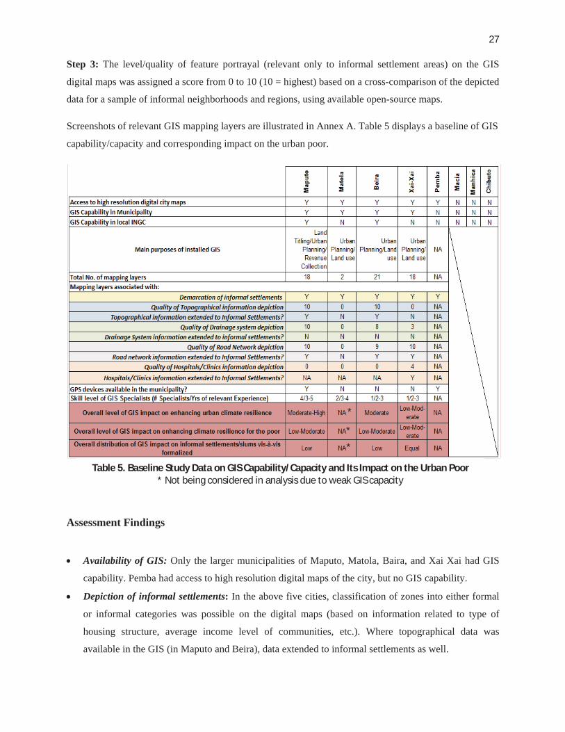
Screenshots of relevant GIS mapping layers are illustrated in Annex A. Table 5 displays a baseline of GIS
capability/capacity and corresponding impact on the urban poor.
Assessment Findings
Availability of GIS: Only the larger municipalities of Maputo, Matola, Baira, and Xai Xai had GIS
capability. Pemba had access to high resolution digital maps of the city, but no GIS capability.
Depiction of informal settlements: In the above five cities, classification of zones into either formal
or informal categories was possible on the digital maps (based on information related to type of
housing structure, average income level of communities, etc.). Where topographical data was
available in the GIS (in Maputo and Beira), data extended to informal settlements as well.
Table 5. Baseline Study Data on GIS Capability/Capacity and Its Impact on the Urban Poor * Not being considered in analysis due to weak GIS capacity
*
*
*

28
Depiction of (overall) city infrastructure: The quality of the depiction of drainage and road networks
was found to be excellent in Maputo and very good in Beira. Beira scored lower than Maputo since
base maps have not been updated since 1998. Note that although Beira’s existing drainage and road
networks have undergone renovation and upgradation since that time, no major expansion of this
infrastructure has taken place. In smaller Xai Xai, the depiction of road networks was extensive but
drainage depiction was weak (owing largely to the fact that not much drainage infrastructure exists);
also, the city’s GIS depicted hospitals or clinics to some extent. In Matola, depiction of city
infrastructure was non-existent.
Comparison of GIS coverage for informal settlements vis-à-vis formal settlements: While GIS
depiction of drainage and sanitation networks is good in both Maputo and Beira, the non-existence of
the infrastructure itself in informal settlements implies that GIS may be applied less effectively for
planning disaster management strategies for these areas, compared to formalized settlements. In Xai
Xai, the drainage infrastructure is weak in both the formal and the informal areas of the city; since
road networks and hospitals/clinics are depicted for both types of settlements, overall coverage is
regarded as equal.
Overall impact on enhancing urban climate resilience: Given the above findings, the study
concludes that the overall utility of GIS towards helping cities tackle flooding disasters may be
regarded as moderate-to-high in Maputo, moderate in Beira, moderate-to-low in Xai-Xai, and
irrelevant in Matola.
Overall utility for strengthening climate resilience of the urban poor: In light of the GIS data
coverage extended to informal settlements as described above, the study finds that the utility of local
government GIS capacity towards enhancing the flood resiliency of the poor is low-to-moderate for
Maputo, Beira, and Xai-Xai.
Summary
This research concludes that while municipal GIS capacity increased with level of city’s economic
prominence, the overall distribution of GIS impact (where available) on the poor vs. the well-off tended to
increase in the reverse direction. Table 6 provides a quick glance on this result.
Table 6. Summary of Overall Impact of GIS Capacity

29
4.3. E-Governance Tools
Section 3 of this report described how mainstreaming e-governance systems into municipal
government can provide officials with better management capabilities enabling them to deliver
customized socio-economic services to their citizens. In the realm of land management, municipalities
worldwide often apply e-governance solutions to ensure that construction licenses and land registration
are not issued for plots deemed susceptible to flooding or violating coastal regulations. This practice can
reduce the vulnerability of whole communities to flood damage. In Mozambique, a range of e-governance
projects, both completed and ongoing, have been initiated at both the national and local levels. These
include the Government Electronic Network (GovNet), the State Personnel Information System (SIP
2000), the Financial Administrative and Management System (e-SISTAFE), the Computerized Land
Management Information System (LMIS), and the Civil Identification System, among others. For this
study, each municipality was surveyed to assess the respective capabilities of its installed e-governance
systems and to analyze whether any of them helped enhance urban climate resilience. A discussion of any
thematically relevant installed systems is provided.
Assessment Findings
Use of e-governance: Overall, cities in Mozambique have been slow to adopt e-governance systems
into their functions, with inadequate technical and human capacities posing key hurdles. Only Maputo
was found to be relatively advanced in its adoption of e-governance, while in a few other
municipalities only ad-hoc instances exist. E-governance was used for the vehicle tax system in three
of the cities and for land titling/management in two.
Impact on climate resilience: While the cities of Maputo and Pemba are notable for extending e-
governance capability to the domain of land management, the overall impact of these initiatives on
enhancing climate resilience could only be considered moderate at best.
Distribution of impact on the poor: Among all cities, Pemba has applied e-governance specifically to
land-titling in informal settlements and, therefore, its e-governance has a higher impact on the poor.
The city-by-city results are displayed in Table 7. A brief overview of relevant e-government systems
implemented in Maputo and Pemba follows.

30
Overview of SIGEM and LIMS
In the realm of enhancing urban climate resilience, Maputo’s Sistema de Informação de Gestão
Municipal (SIGEM) g and Pemba’s Land Information Management System (LIMS) both have some
relevance.
SIGEM: Maputo has implemented a GIS-based e-governance municipal management system that
involves geo-referenced digital maps and a networked software platform capable of producing a
variety of analyses and images. Data in the system has been populated by integrating and updating the
existing datasets at different institutions. SIGEM currently pertains to the management of formalized
areas only. For these neighborhoods, the system supports land use planning, land titling through
issuance of the state-granted land right (known as Direito de Uso e Aproveitamento da Terra
(DUAT)), and real property tax administration. It also improves the administration of a variety of
municipal licensing systems, including construction, parking, and various business permits. Yet the
system lacks any capability for measuring the susceptibility of land plots to natural disaster while
reviewing and issuing land titles or construction licenses. In view of these factors, its potential impact
g Note that this tool is distinct from the regular GIS in place.
Table 7. Baseline Data on Municipal E-governance Tools and their Impact on the Urban poor

31
on enhancing city-wide climate resilience is regarded by this study as moderate at best but having low
utility for the urban poor. (Refer Annex B for illustrations of SIGEM’s capabilities)
Land Management Information System (LIMS): LIMS is a type of cadastre system that
commonly tracks land ownership, boundaries, and adjacent landmarks and often includes land-use
information. This information can be crucial as a fundamental source of data on land disputes and
lawsuits over land ownership. Other benefits of LIMS include: (i) improved quality of rural/urban
planning, (ii) establishment of a transparent backlog of land management decisions, and (iii)
improved revenue collection at provincial, district, and municipal levels. The city of Pemba, through
support from the Millennium Challenge Account (MCA),h has implemented a LIMS by which, as
depicted in Figure 10, each plot parcel in informal settlements is digitally mapped using GPS devices.
Based on the geo-coordinates, corresponding land titles are issued to residents. Such provision of
legal recognition to poor households helps protect them against land-sharking while enhancing the
municipality’s revenue stream, since property taxes may now be levied on newly formalized areas.
While the system has the potential to provide the poor with greater social protection, its impact on
enhancing climate resilience is regarded by this study as low in the short term and moderate in the
longer term (by way of potentially impeding large-scale land grabbing of fragile coastal zones).
h Millennium Challenge Account (MCA) is implementing similar LIMS in 4 Northern provinces: Zambezia, Nampula, Cabo Delgado and Niassa
Figure 10: Pemba’s LIMS – A screenshot depicting land parcels mapped for issuing land titles

32
Summary
While currently installed E-Governance tools in Mozambique do not contribute in any large extent
towards enhancing urban climate resilience, overall distribution of the installed capacity’s impact for
poorer communities tends to be (slightly) inversely proportional with economic prominence of city.
4.4. Wireless Communications
Worldwide, both mobile telephony and radio communication systems have been harnessed to
help cities tackle the effects of climate change. Local governments use these systems to broadcast
warning messages on upcoming weather conditions and to disseminate information on evacuation routes
and available relief services in the event of disaster. Using SMS--that is, text-messaging to thousands of
subscribers at once--they can broadcast the same emergency messages traditionally received over the
radio but with the added advantage that (for example) the listener/subscriber does not need to be “tuned
in” the moment a message is sent.
As of 2011, at least 85 percent of all urban denizens in Mozambique had access to a mobile
telephone, with mobile coverage extending to most urban regions and surrounding areas. 16 Mobile
services are being provided by three operators--mCel, Vodacom, and Viettel—which provide service to
the roughly 30 percent of the country’s population that has mobile phones. Mozambique also has a
number of radio stations, which together cover approximately 60 to 70 percent of the population, with
Rádio Moçambique (RM) being by far the most advanced station and the one with the largest geographic
coverage. Almost all cities host local community radio. In view of the scope to apply mobile solutions to
flood-risk mitigation in Mozambique’s cities, assessments were carried by this study to survey the extent
to which these tools were so harnessed.
Table 8. Summary of Overall Impact of E-Governance Capacity

33
Methodology
Departments of public relations and communication in each city were assessed to identify any
collaborative arrangements they had with mobile phone operators and radio channels and to assess the
medium they used to collaborate with disaster-response agencies. Adoption of any relevant mobile-phone
–based solution was also surveyed in municipalities.
Assessment Findings
Coordination with climate disaster services: Personnel in all eight cities only used officially-
provided landline phones to coordinate with remote agencies and services, such as the INGC, the
national weather stations, and relief agencies. In emergency situations, personal mobile phones were
sometimes used to deliver critical messages.
Municipal arrangements with broadcast media: All eight cities had cooperative arrangements with
the local radio and television broadcasters in order to relay emergency and other public information.
Local media channels themselves get information from a range of sources, among which INGC is a
major one as well as the ARAs and DNA. But according to the National Institute of Meteorology
(INAM), accomplishing in-time dissemination of warnings using broadcast media is often
challenging, since bad weather often arrives in the night – when most citizens and authorities are
inaccessible.
Municipal arrangements with mobile phone operators: None of the cities had cooperative
arrangements with mobile phone operators for any form of emergency or other special
communications.
Availability of mobile applications for citizen engagement: In only one city is an application being
tested. This application, being piloted by INAM in the Muinava informal settlement area in Beira,
aims to give residents 48 hours’ advance notice of floods. The system is still under development.
Impact on climate resilience and the poor: Since the wireless medium is not being harnessed in an
effective way for flood-risk mitigation, its overall impact on enhancing urban climate resilience is
deemed by this study as too weak to be considered in the study’s concluding analysis.
Table 9 provides detailed city-by-city results.

34
4.5. Early Warning Systems
Early Warning Systems (EWS), as discussed in Section 3, are surveillance systems that provide
timely information to enable early detection, forecasting, and warning about natural disasters such as
floods and wildfires. Various forms of EWS--including telemetry systems and precipitation/weather
simulation software--are applied to predict looming disasters, simulate a situation is likely to unfold, and
furnish authorities with the information they need to respond effectively.
The monitoring and forecasting of hydrological and meteorological hazards in Mozambique is the
within the mandate of the National Directorate for Water (DNA) in collaboration with the five Regional
Water Authorities (ARAs), and the National Institute of Meteorology (INAM). Using a combination of
ICT (such as various modeling capacities and softwares) and non-ICT tools, these agencies generate
datasets to forecast upcoming conditions. The country’s National Institute of Disaster Management
(INGC) is the agency tasked with primary responsibility for carrying out relief measures in the event of
disasters. In disaster contexts, meteorological information from INAM combined with hydrological
information from DNA and the ARAs is relayed to the INGC’s district centers.
Methodology
In view of the institutional coordination mechanisms just described, this study assessed any
available ICT-based EWS capacity that INAM might have as well as the capacity wielded by the three
regional ARA centers (ARA-Suli, ARA-Centroj, and ARA-Nortek) under whose purview the surveyed
i Covers the cities of Maputo, Matola, Xai-Xai, Maçia, Manhiça, and Chibuto.
Table 9. Baseline Data on Municipal Wireless Telecom Capability/Capacity

35
cities fell. In addition, the study surveyed each city’s capabilities in the form of sensors or telemetry
systems installed in or along its associated hydrological bodies, such as coastlines, rivers, and drainage.
Assessment Findings: INAM
INAM gathers its input data (including rainfall, air temperature, air humidity, wind speed and
direction, and air pressure) for predicting weather conditions from a network of its own stations and from
external sources, which include both global centers and regional centers such as South Africa Weather
Service. While INAM’s own network includes both manned and automated weather stations, most of its
automated stations were found to be not functioning or to be delivering insufficient levels of information.
Two doppler radars were installed in the mid-2000s, but neither is fully operational. As a result, many
important types of observation--such as upper air, marine, and lightning detection--are not effectively
performed. In sum, the agency lacked any meaningful ICT-based EWS capability related to the prediction
of floods and tropical cyclones and their impact.
Assessment Findings: ARA
ARA-Sul: Hydrological data pertaining to rainfall, river level, and river discharge are obtained from
three sources: ARA-Sul’s own rainfall and discharge monitoring stations; the water management
agencies of upstream countries; and a GIS-based Famine Early Warning Systems Network or
‘FEWSNET’ (implemented in ARA-SUL) for simulating upcoming rainfall conditions. The agency
also has the capacity to leverage a MIKE-11 software tool to simulate the flow and water levels in the
Mbeluzi river basin, although this system is not fully operational due to dysfunctional telemetry
equipment. See the next section for further discussion of FEWNSET and MIKE 11.
ARA-Centro: ARA-Centro has little to no ICT-based EWS capability. However, the city of Beira, in
cooperation with Gesellschaft für Internationale Zusammenarbeit (GIZ), is piloting a system of
mechanical sensors in drainage canals that can warn residents of rising water levels (Figure 11). Since
this mechanical system is not an ICT -based system, its impact is not analyzed in this study.
ARA-Zambeze: ARA-Zambeze operates a MIKE 11 rainfall-runoff and routing model from the
Cahora Bassa dam outflow to the mouth of the Zambezi River for flood forecasting and water
infrastructure operations. Hydraulic routing is only performed on the main stem of the Zambezi, with
tributaries modelled as hydrologic inflows. Flood forecasting performance is hampered by lack of
real-time rainfall and runoff observations (telemetric networks) and precipitation forecasts. Despite
j Covers the city of Beira. k Covers the city of Pemba.

36
operating MIKE 11, the agency is unable to produce flood inundation maps owing to the fact that it
does not possess a digital elevation model (DEM) of the Zambezi Basin.
ARA-Norte and ARA-Centro Norte: These agencies have little to no ICT-based EWS capability.
Overall EWS-ICT impact on enhancing urban climate resilience: This study finds that in view of
ARA-Sul’s ICT simulation software, the agency’s ability to predict heavy rainfall for its
respective region is strong and can greatly enhance the climate resilience of its six southern
cities. The other two regions (Norte and Centro), however, lack this predictive capacity.
Distribution of EWS-ICT impact on the poor: ARA-Sul’s simulation tools produce precipitation
forecasts region wide, covering both the formal and informal areas of cities, so their positive impact
on the vulnerable urban poor is distributed equally with their impact on the more well-off.
Table 10 provides detailed city-by-city results.
Table 10. Baseline Data on EWS Capability/Capacity
Figure 11: GIZ’s Mechanical Sensor

37
Overview of FEWSNET and MIKE11
The FEWSNET and MIKE 11 software tools enhance resilience to natural disasters by virtue of their
precipitation and flood prediction capabilities. These are briefly described below.
FEWSNET (GeoSFM): A Geospatial Stream Flow Model (GeoSFM) that covers all of Mozambique
has been made available by the U.S. Geological Survey and is provided free-of-charge to ARA-Sul
through the FEWSNET software. GeoSFM utilises daily satellite-derived rainfall estimates produced
by the U.S. National Oceanic and Atmospheric Administration along with daily potential
evapotranspiration data. Together, these estimates produce precipitation forecasts with a high degree
of accuracy, and when combined with GIS they allow for easy analyses and depiction of upcoming
conditions (Fig. 12a).
MIKE11: MIKE 11 is a software tool that simulates flow and water level, water quality, and
sediment transport in rivers, flood plains, and other water bodies. Used in conjunction with GIS, it
allows the depiction and analysis of flood depths and water levels as viewable layers of data (Fig.
12b), so it can serve as an effective tool for spatially based river and floodplain management.
Telemetry systems installed on the embankments of water bodies can transmit their automated
measurements of water flows and levels to MIKE 11 for real-time analyses. However, at present these
telemetry systems are largely inoperative in Mozambique due to lack of resources for maintenance
and upgrade.
Figure 12 (b): MIKE 11 An illustration of MIKE11 GIS simulating
potential flooding
Figure 12 (a): FEWSNET An illustration of FEWSNET showing rainfall
levels using GIS

38
Summary
By allowing forecasting of rainfall conditions, ARA-Sul’s EWS-ICT capability enables the
agency to significantly enhance the climate resilience of the country’s southern cities, with an equal
distribution of impact on formal and informal settlements. But while this can lead to more informed
decision-making, the quality of inter-agency coordination is the factor that, eventually, most determines
how great an impact the EWS-ICT capability can have.
4.6. Results Analysis
At this point, we can pull together the summary findings on each of the four major ICT tools for
which the study surveys found at least some impact on climate resilience, and examine their overall
effectiveness city by city for the five largest cities under consideration. Looking at the general impact of
these four ICT tools side by side reveals a general picture of the level of impact ICT currently has on
disaster resilience in Maputo, Matola, Beira, Pemba, and Xai-Xai. Combining the summaries from Tables
5, 7, 9, and 11, the evaluations are presented in Table 12.
In order to synthesize the overall level of ICT impact on urban climate resilience for each city,
this study quantifies the broad ratings of “low,” “moderate,” and “high” impact so that a mean rating can
be calculated. This is also necessary to calculate an overall rating for impact on the urban poor. The
method chosen was to assign a numerical scale running from 0 to 10 for climate resilience and from -2 to
4 for impact on the poor, as shown in Table 13. Table 14 depicts the overall scorecard for the cities.
Table 11. Summary of Overall Impact of EWS ICT Capacity .

39
Table 12. Complete Summary Table
(a) (b)
Table 13. Point Systems for Quantifying the Impact of Municipal ICT on the Poor Table (a): Point system for calculating overall level of ICT impact on enhancing urban climate resilience
Table (b): Point system for calculating distribution of ICT impact on the vulnerable urban poor

40
The numerical summary ratings for each city immediately make clear that Maputo enjoys a far
higher level of effectiveness in its ICT impact on climate resilience than any other city, and seven times
higher than the effectiveness currently experienced in Pemba, which ranks at the bottom (21 versus 3) in
this cluster of cities. Matola and Xai-Xai rank in the middle in this evaluation. This demonstrates that the
local governments of the more economically advanced cities possess higher potential to harness ICT
toward purposes of better urban development and planning.
The above result may not be completely unexpected, given that bigger municipalities have greater
resources at hand to upgrade their capabilities. But what is surprising is that lower set of scores in Table
14 show an opposite city pattern with regard to relative impact on the poor. The distribution of ICT
impact tends to be more equal or even higher for the poor in the smaller and less prosperous cities, such
as Pemba and Xai-Xai, than in the economically most significant ones.
In essence, these results indicate that the introduction of ICT at the local government level in
Mozambique is creating a regional-level digital divide, one in which the southern region is more
advanced than the central and northern regions in terms of ICT capability. Factors involving political
Table 14. City Scorecard: Municipal ICT and Its Impact on the Poor

41
economies may be at play, compelling institutions to leverage ICT to target different population segments
based on a region’s socio-economic condition. But significantly, the introduction of ICT is also creating a
community-level digital divide, one in which the poor in smaller, less advanced cities tend to be more
favorably impacted by the harnessing of any ICT at the local-government level, compared to for the poor
in richer cities.
This second pattern might be attributable to the fact that smaller cities simply host a greater
proportion of underprivileged communities, or perhaps to the fact that the economic gap between the
relatively better-off and the poor is not as pronounced in these smaller cities vis-à-vis bigger metropolitan
areas--implying that any ICT intervention will impact the poor more. Although determining which
explanation is more accurate will require additional analysis and lies beyond the scope of this report, it is
worth considering that similar patterns of ICT harnessing and impact might be found in other countries as
well, especially in those with analogously low capacities and weak regulatory oversight.
In light of the observations in Mozambique, the existing situation necessitates suitable
amendments to the country’s ICT-PARPA framework such that ICT may more effectively be applied as
an instrument that mitigates risks for all poor communities. To this end, Section 5 discusses needed policy
reform measures along technical, institutional and social dimensions for bridging digital divides and
enhancing institutional capabilities.

42
Section 5 Policy Recommendations
It is hoped that this report has raised awareness concerning the potential of municipal-level ICT
to enhance transparency and productivity, transform services delivery, and reduce poverty in cities. In
Mozambique, the harnessing of this potential began in the early 2000s with the government’s introduction
of its National ICT Policy and E-Government strategy. The ICT-PARPA framework, which links the
country’s ICT strategy with the objectives of poverty reduction, gave fresh impetus to the adoption of ICT
in the public sector.
Against this backdrop and as observed in this report, over the last 10 years, a range of local
government agencies in Mozambique have begun to adopt ICT systems for purposes of better urban
planning, management and risk mitigation, and are today looking at further enhancing their capacities. In
fact, indicators show that the readiness for eGovernment in Mozambique has been improving consistently
over the last few years (rising in the United Nations’ E-readiness Index from 0.173 in 2003 to 0.256 in
2008 l). The extensive prevalence of mobile telephony and the proliferation of mobile operators also stand
as testimony to achievements in telecom-sector reform.
At the same time, however, this study’s analysis of ICT’s impact on climate resilience for the
urban poor makes it clear that significant ground remains to be covered. That unfinished work will require
not only enhancing municipal ICT capabilities but also ensuring that disparities in ICT-enabled service
delivery are bridged so that all communities can enjoy an equal and favorable impact. It must also be
mentioned that in order to effectively engage ICT as a risk mitigation tool for the poor, an overhaul of
processes and culture is needed such that institutional ICT systems, at the very outset, function as planned
and are indeed regarded as an integral ‘go to’ mechanism by intended population segments.
5.1. The Limitations of Supply-side ICT Interventions
The objective of the ICT-PARPA Framework adopted by the Government of Mozambique was to
contour the application of ICT toward reducing dire poverty. Within this framework, in an effort to l The United Nations Public Administration Network’s (UNPAN’s) E-readiness index shows the degree of a country's readiness for the knowledge economy. The E-readiness index is an aggregate index comprising an infrastructure index, a web measure index, a human capital index, and an e-participation index. For more information, go to http://www2.unpan.org/egovkb/profilecountry.aspx?ID=116.

43
enhance transparency and extend the reach and quality of public services, municipalities in Mozambique
have indeed focused on adopting ICT for basic services to citizens, such as enabling online platforms for
vehicular tax payment or for registration of public-sector staff and applying Geographic Information
Systems tools to city planning.
However, this PSIA observes that local government agencies are leveraging ICT solutions largely
to support “supply-side governance” (SSG), that is, the unidirectional government-to-citizen dimension of
government activities. This approach alone might not be sufficient to achieve the objectives of poverty
reduction and enhancement of institutional capabilities, for the following reasons:
1] Given the limited resources associated with public sector agencies in low-capacity regions,
completely automating and sustaining the gamut of SSG activities across all regions may be
unachievable in the short term.
2] Designing ICT-based SSG solutions tailored specifically for the poor will be a challenging
endeavor, given the diverse needs and socioeconomic complexities associated with disadvantaged
communities.
3] There is a risk of overcapitalizing low capacity organizations with costly and complex information
technology systems. That is, investments in sophisticated and potentially efficient software and
systems may prove wasteful as the necessary core skills and staffing are often missing.
5.2. Capturing the Citizens’ Voice
Policy-level amendments such as Mozambique’s ‘E-Government Interoperability Framework’ of
2009 (which, in a nutshell, recommends standards for data interchange between disparate ICT systems)
are steps in the right direction towards implementing a technological framework allowing for better
collaboration between government entities and improving government-citizen communication. 17 Yet
based on this study’s assessment of the extent to which the urban poor are being affected by the adoption
of ICT, it appears that interventions on the supply side alone have led to a skewed impact in the context of
cities and disadvantaged communities. To counter the effects of digital disparities induced by the
generally top-down nature of SSG ICT interventions, mechanisms are needed for citizens themselves to
connect with their public-sector institutions to co-design and co-participate in the functioning of
government. Thanks to an increasing integration of ICT within public life in Africa, creation of new
political economies in the region is being observed stemming from the emergence of ICT for “demand
side governance” systems, termed as ‘ICT4DSG’.

44
As demonstrated by the wide range of ICT4DSG initiatives, ranging from the Facebook and
Twitter-fuelled Jasmine Revolution in North Africa to Kenya’s community GIS-based Map Kibera
project, this bottom-up approach comprises a powerful medium to facilitate large-scale citizen review,
feedback, and dialogue on public-sector policies/services via up-to-the-second news, meeting notes,
postings, data, images, and so forth. Such crowdsourcing m and geo-mapping ingenuities enable
collaboration in real time and on a massive scale, rendering to citizens and businesses the ability to place
adequate pressure points on governments for demanding reform, transparency, or action. An example of
such citizen participation in urban design that was harnessed with an ICT4DSG methodology is discussed
in Box 5.
Note that cities, long at the crux of the ICT era in Africa by virtue of their superior infrastructure
and large concentrations of ICT users and innovators, can readily harvest ICT4DSG methodologies in
presence of an enabling policy framework -discussed in the following pages. In collaboration with social
intermediaries (such as NGOs, unions, social/traditional media, and activists) ICT4DSG can then be
leveraged to compel public agencies plug service delivery gaps for the poor.
m “Crowdsourcing”, a term that combines the concepts of “crowd” and “outsourcing,” can be defined as “the act of taking tasks traditionally performed by an employee or contractor, and outsourcing them to a group of people or community, through an ‘open call‘ to a large group of people (a crowd) asking for contributions.” It is thus a means for leveraging mass collaboration on a project – for instance, by inviting feedback via mobile phones.
Box 5. Use of ICT4DSG in Dar es Salaam, Tanzania to Inform the Design, and Monitor Implementation of an Urban Development Project

45
5.3. Leveraging ICT for Community-Government Collaboration
To achieve the objective of reducing dire poverty through ICT as envisioned by the Government
of Mozambique, this study recommends that the dimensions of the ICT-PARPA Framework be suitably
enhanced to enable two-way government-citizen engagement involving both DSG and SSG
methodologies. Through ICT4DSG, efforts can be placed on harnessing civil-society- and private-sector-
led ICT solutions that would help communities monitor development results and facilitate citizen
feedback on service delivery to government and service providers.
In the context of enhancing climate resilience for the urban poor, as an example, simple
crowdsource-based geo-mapping mechanisms (such as the Map Tandale example described in Box 5)
could assist in bringing infrastructure issues much more quickly to the attention of local governments and
enable authorities to better devise zoning and planning regulations, while social accountability platforms
(such as blogs) could be leveraged to gather information on the impact of extreme weather events and
make improvements in disaster preparedness. As civil society –led DSG solutions can be flexibly
designed, Table 15 shows that the intensity of these solutions can be suitably modulated to complement
and compensate for the gaps created by current SSG interventions in Mozambique’s cities, thereby
Figure 13: ICT4DSG in the Map Tandale Project
Source: Joshua Goldstein, ‘Community Mapping & Open Development in Dar Es Salaam’ (2011) Available online at http://blogs.worldbank.org

46
helping bridge digital disparities. Box 6 provides a flowchart to illustrate the general flow of ICT4DSG
mechanism.
Table 15. ICT4DSG as a DSG Mechanism for Bridging Digital Divides: Color Variation Reflects Intensity of ICT4DSG solution
Box 6. An Overview of ICT-based Social Accountability Mechanisms

47
5.4. Needed Modifications to ICT-PARPA Framework
For public-sector institutions to effectively reduce poverty through ICT, policy frameworks must
be sufficiently broadened so as to spur an enabling environment which could facilitate the rapid
deployment of ‘targeted’ ICT interventions, that is, those that directly address poverty issues via tightly
funneled ICT-PARPA initiatives. This can be achieved using a three-stage process which
involves, firstly, ability of all stakeholders to partake in ICT interventions within the governance
realm, ensuring that uptake of ICT interventions drives informed decision-making processes
within government entities, and thirdly, ascertaining that ICT systems are compatible with local
capabilities and work effectively to achieve intended objectives. In Mozambique, the most critical
challenges to realizing the potential of ICT for this purpose are contextual: both technical and
institutional. These challenges include:
infrastructural and skilled manpower constraints
weak enabling policies
limited capacity of social intermediaries to scale up and secure sustainability
weak partnerships among local stakeholders, and
turf barriers among specialists concerned with ICT, governance, and social development.
To tackle these issues towards creation of an enabling environment, enhancements to the country’s ICT-
PARPA framework are needed. These can be grouped under three headings, and are discussed in the
ensuing sub-sections.
1. Addressing Technical Constraints
Promote Institutional Harnessing of the Mobile Platform: In view of the already extensive
prevalence of mobile devices in cities, local governments in Mozambique are suitably placed to
leverage ICT4DSG for e-government and social inclusion. Further, innovations in mobile appliances
and solutions (for example, the SMS-based Ushahidi platform for geo-tagging or smartphone-based
‘See-Click-Fix’ application) are richly enhancing the scope of two-way government-citizen
engagement. But as shown in Section 4 of this report, the mobile platform is currently not being
harnessed in any major capacity in Mozambique for municipal services delivery. So to enhance
citizen’s participation in co-governance, leveraging the mobile telephony platform by local

48
governments can pave the way for greater government-citizen exchanges through ICT4DSG
applications and also provide a means for remotely located communities to engage with government.
Reduce Internet Access Tariffs for the Poor: Internet penetration is low in Mozambique at 2.8
percent, with most users concentrated in elite urban centers. Costly internet services due to high
prices of national fixed fiber backbone connectivity (operated by state-owned Telecomunicações de
Moçambique (TDM)) poses a major barrier towards greater ICT uptake amongst citizens, especially
the poor. n While the arrival of two submarine cables at the coast of Mozambique in 2010 has lowered
international connectivity prices by a factor of 10 o, the challenge remains to match those reductions
with lowering the price of national backbone access for the poor to further enable these users to
participate in ICT4DSG through the internet medium. Competition in the national fixed fiber sector
and upgrading this network for greater bandwidth are needed interventions.
2. Cultivating Institutional Commitment and Culture for Harnessing ICT
Ensure that public-sector institutions find value in ICT. For ICT systems to be effectively applied to
the purposes of reducing poverty, local governments and other public sector institutions must be
committed to embracing these systems and acting upon the information yielded through their use. In
the arena of ICT4DSG, governments need to adapt and amend their own processes to become more
responsive to these channels of citizen demand. To this end, it is necessary to ensure that local
governments find adequate value--social, political, or financial--in using ICT systems. Research from
various pilot programs worldwide has shown that initiatives such as media monitoring/reporting of
ICT-based local government response to urban problems, or linking fiscal incentives to local
governments based on their use of ICT systems, have proven successful in helping local governments
find value in adopting ICT.
Eliminate digital silos. One of the primary weaknesses of E-Government initiatives worldwide has
been their silo-based approach, whereby each institution develops its own ICT capabilities without
incorporating flexibility for integration with other systems. For instance, municipalities in
Mozambique are currently unable to leverage electronic data-sharing with other agencies (such as
INGC or ARA) in a coordination methodology that could address the issue of flooding, because each
n Note that despite high prices, availability of infrastructure has however improved considerably over the last few years and backbone services today reach all provinces in Mozambique. o To illustrate: in 2008, a 2 Mbps dedicated line for 500 km was priced at US $ 7000 in Mozambique, nearly 40 – 60 times higher than United States or Europe.

49
institution has adopted a different data standard. To prevent the creation of digital silos, personnel
from different agencies must closely collaborate when ICT projects are conceptualized and apply
consistent standards or formats for data exchange to design inter-operable systems.
3. Empowering Social Intermediaries
Equip intermediaries with needed tools, skills, and capacity. Inadequacy of resources, such as time,
expertise, and information, often hinder individual citizens from exercising their client power over
local governments to demand adherence to the ‘social compact’. But social intermediaries, who often
play the roles of organizers and citizen advocates, can help close the accountability loop on behalf of
citizens. Recent advances in ICT (such as geo-mapping and crowd-sourcing applications, mobile
apps, portals, and analytics) can vastly augment the role of social intermediary institutions. These
institutions can use ICT4DSG tools on behalf of communities to amplify and aggregate citizens’
voices, reduce access costs to information and media, help analyze information and detect patterns of
poor service or corruption, and facilitate mobilization and collaboration with local governments.
Render an enabling environment for intermediaries. Social intermediaries are essential actors in
promoting good governance by demanding consultation, representation, transparency and
accountability from authorities. But remaining largely dependent on international donors, association
and involvement of intermediaries with Mozambican public sector institutions is limited and distant. p
Yet, the success of applying ICT to social accountability depends on the extent to which civil society
can enable communities to hold authorities and their representatives accountable. An enabling
environment for intermediaries is therefore essential, and this in turn depends on favorable structural
conditions. Factors typically favorable to an enabling environment include a legal and regulatory
framework, political will, accessible government, freedom of information laws, open government,
strong and independent media, independent judiciary, and independent accountability institutions.
5.5. Conclusion
The adoption of complex new products and services in public sector institutions of countries
where subsistence lifestyles and widespread poverty are still common raises the question, whether rapid
ICT adoption might be causing as much harm as good if it leaves the bulk of citizens untouched or
isolated by a digital divide. Findings from this study suggest that within the framework of leveraging ICT
p Based on interviews with the NGO community in Mozambique.

50
for public-sector reform in Mozambique, differences in municipal resources and governance structures
have led to a situation where ICT capabilities have been better developed in the cities that are of greatest
economic significance, and least developed in cities where economic output is smallest. But significantly,
the digital divide in ICT’s impact appears to be widest in the better equipped, wealthiest cities, and
narrowest in the lower capacity smaller ones.
So in view of the distance that Supply-Side ICT has yet to traverse in Mozambique, it is
recommended that dimensions of ICT-PARPA framework be sufficiently broadened to increase citizen
participation and social accountability. To this end, the report remains optimistic on three fronts regarding
the possibility and potential of harnessing Demand-Side ICT for overcoming the digital divide in
Mozambique and other low capacity countries. First, mobile-phone availability and Internet access are
steadily improving in the country, rendering greater digital access to citizens. Second, innovations in ICT
are themselves allowing for the rapid creation of ICT4DSG platforms and methodologies. And third,
examples of ICT4DSG in regions worldwide illustrate the readiness of citizens and social intermediaries
to engage with their governments through this platform, given the appropriate enabling environment. To
better deliver on the social compact, especially towards the poor, local governments are thereby
encouraged to participate in the uptake of cost-effective crowdsourcing methodologies, which can even
render low human and economic resources a non-problem in certain areas of work, such as community
mapping of drainage overflow points.
In other words, E-Government must be expanded to allow a flow of information and critique
“upwards” from grassroots activists and residents as much as it allows the traditional flow “downwards.”
However, the flourishing of such a two-way government-citizen engagement model will necessitate
facilitation of a suitable enabling environment which can be nurtured through calibrations along technical
and socio-institutional dimensions. These changes will spearhead greater digital inclusion in governance
of disadvantaged communities and their social representatives, while also bolstering absorption of
ICT4DSG systems within institutions.
Achieving these measures will require a determined resolve amongst authorities towards reform.
But policymakers and practitioners would be wise to discern the urgency factor concerning the growing
tribulations afflicting the poor, such as climate change and its accompanying perils.

51
ANNEX A:
MUNICIPAL GIS SCREENSHOTS


52
Maputo Municipal GIS
Figure A1. Depiction of Formal/Informal Settlements
Figure A2. Depiction of Topography

53
Figure A4. Depiction of natural watercourses
Figure A3. Depiction of Drainage network

54
Figure A6. Depiction of road network in Maputo INGC GIS
Figure A5. Depiction of Flood-prone localities in Maputo INGC GIS

55
Beira Municipal GIS
Figure A8. Depiction of Drainage+Canal system overlaid with Road network layer (in Red)
Figure A7. Depiction of Topography
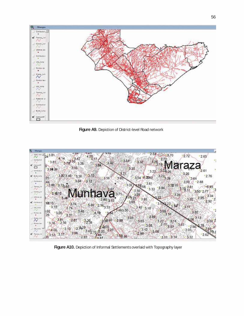
56
Figure A10. Depiction of Informal Settlements overlaid with Topography layer
Figure A9. Depiction of District-level Road network

57
Figure A12. Depiction of Informal settlements overlaid with Road network layer
Figure A11. Depiction of Topography layer overlaid with Settlement areas

58
Xai-Xai Municipal GIS
Figure A13. Depiction of Formal/Informal demarcations overlaid with Road network and Structure-type layers
Figure A14. Depiction of Plots overlaid with Structure-type layer (Note: Hospitals/clinics depicted under Social Category)

59
Matola Municipal GIS
Figure A15. Depiction of Formal Settlements

60
ANNEX B:
OVERVIEW OF SIGEM
(SCREENSHOTS)


61
Figure B1. The Capability of SIGEM to display cadastral information related to plots
Figure B2. Capability of SIGEM to identify and display plots

62
Figure B4. Capability of SIGEM to identify and display roads
Figure B3. Using SIGEM to identify and display information on residents of buildings along with job occupations

63
Figure B5. Using SIGEM for issuance of land titles
Figure B6. Using SIGEM for issuance of construction licenses

64
ENDNOTES
1 UNEP and AMCEN, Africa Environment Outlook.2 The Maputo metropolitan area includes Matola, Beira, Nacala, Xai-Xai, Inhambane, Maxixe, Quelimane, Angoche, Ilha de Moçambique, Pemba. This list does not include coastal cities with less than 30,000 inhabitants. 3 World Bank, Urban and Local Government Strategy Report (2009). 4 World Bank, Climate Change, Disaster Risk, and the Urban Poor: Cities Building Resilience for a Changing World (Summary) (Washington, DC: 2011); available at http://wbi.worldbank.org/wbi/Data/wbi/wbicms/files/drupal-acquia/wbi/disaster_risk_urban_poor_final.pdf 5 UNISDR, 2009 Global Assessment Report on Disaster Risk Reduction (New York: 2009). 6 World Bank, Mozambique Country Water Resources Assistance Strategy: Making Water Work for Sustainable Growth and Poverty Reduction (Washington, DC: 2007). 7 IPCC, Climate Change 2007: Impacts, Adaptation and Vulnerability: Contribution of Working Group II to the Fourth Assessment Report of the IPCC (Cambridge: Cambridge University Press, 2007). 8 World Resource Institute, World Greenhouse Gas Emissions Flow Chart, available at http://www.wri.org/chart/world-greenhouse-gas-emissions-flow-chart; David Satterthwaite, “Cities' Contribution to Global Warming: Notes on the Allocation of Greenhouse Gas Emissions,” Environment and Urbanization, Vol. 20 (2008): 539-49. 9 Nicholls, R.J., Hanson, S., Herweijer, C., Patmore, N., Hallegatte, S., Jan Corfee-Morlot Jean Chateau, and Muir-Wood, R., “Ranking of the World's Cities Most Exposed to Coastal Flooding Today and In the Future,” OECD Environment Working Paper No. 1 (Paris: OECD, 2007). 10 Based on author discussions with officials from the Ministry of Science and Technology. 11 A. Bhavnani, R. Won-Wai Chiu, S. Janakiram, and P. Silarszky, The Role of Mobile Phones in Sustainable Rural Poverty Reduction, (Washington: World Bank, 2008). 12 R. Crandall, W. Lehr, and R. Litan, “The Effects of Broadband Deployment on Output and Employment: A Cross-Sectional Analysis of U.S. Data”, Issues in Economic Policy (Brookings Institution, July 2007).13 International Telecommunications Union (ITU) data, 2010. Available online at http://en.wikipedia.org/wiki/List_of_countries_by_number_of_Internet_users 14 World Sites Atlas data, 2008. Available online at http://www.sitesatlas.com/Thematic-Maps/Internet-hosts-per-capita.html 15 S. Dhar “Massive Digital Divide in the Land of IT”, IPS News Report, Nov 2011. Available online at: http://ipsnews.net/news.asp?idnews=105725 16 Source: http://www.vir.com.vn/news/business/corporate/viettel-launches-mobile-services-in-
mozambique.html.17 E-Government Interoperability Framework https://www.portaldogoverno.gov.mz/docs_gov/outros/eGIF4M_v1_1web.pdf
With over 35 million new urban residents each year, sub-Saharan Africa is
undergoing the world’s fastest urbanization—placing immense pressure on
the region’s resource-constrained local governments towards maintaining
and improving livability standards of their cities. Simultaneously, the explo-
sive growth of Information and Communications Technologies (ICT) across
urban Africa, as evidenced by rapidly rising mobile and internet penetration
transparency, and responsiveness of local governments, which are increas-
ingly integrating ICT within their urban agenda.
By conducting a reconnaissance of the thematic interplays between ICT, Ur-
banization, and Climate Change, Municipal ICT Capacity and its Impact on the
Climate-Change Affected Urban Poor investigates the impact of local govern-
ment-level ICT adoption in Mozambique, a rapidly urbanizing country whose
government is committed to leveraging ICT in an anti-poverty direction. Given
the socio-economic importance of Mozambique’s coastal cities and their sus-
ceptibility to regular climate hazards, this report evaluates Mozambique’s ICT
-
mension that disproportionately affects the poor more, namely vulnerability to
Against such backdrop, this case study on Mozambique stands to serve as a
valuable resource guide to a wide range of practitioners, including policymak-
ers, urban specialists, ICT and climate change enthusiasts, as well as social
accountability activists.
THE WORLD BANK1818 H Street, NWWashington, DC 20433