1b.1 evolution of the 30 june 2014 double derecho … · 1b.1 evolution of the 30 june 2014 double...
TRANSCRIPT

1B.1 Evolution of the 30 June 2014 Double Derecho Event in Northern Illinois & Northwest Indiana
Matthew T. Friedlein*, Richard Castro, and Eric Lenning
NOAA/NWS Chicago, IL
Anthony W. Lyza and Kevin R. Knupp
Severe Weather Institute and Radar & Lightning Laboratories (SWIRLL)
University of Alabama in Huntsville
1. INTRODUCTION
In a seven hour period on the evening of 30 June
2014, two separate quasi-linear convective systems
(QLCSs) exhibited derecho characteristics as they
tracked across northern Illinois. As the first derecho
gradually waned and moved northeast, the second
derecho intensified behind it and progressed
southeast. Both lines of storms resulted in widespread
wind damage, gusts of 26-35 m s-1
(58-80 mph) or
higher, sporadic reports of large hail, and areas of
flooding. The second derecho also was responsible for
29 documented tornadoes across northern Illinois and
northern Indiana. While the late spring and early
summer period is favored for QLCS events in the Corn
Belt states, the rapid succession of these two organized
convective features with the latter being more
pronounced made this event especially noteworthy.
This presentation explores the synoptic and
mesoscale processes that contributed to this unusual
event. It also describes how the atmospheric evolution
after the first derecho enabled the second one to be
such a prolific tornado producer. Key factors include a
limited cold pool imprint from the first derecho,
strengthening of a surface theta-e boundary, more
pronounced deep layer shear, and enhanced storm
relative helicity in advance of the second storm
complex. These stronger dynamics in the presence of
only slightly elevated instability favored storm-scale
structures and interactions in the second QLCS that
were more conducive for tornado development. Paper
1B.2 (Lenning et al. 2015) further examines the
mesoscale and storm-scale evolution of this event, and
specifically the role of a bore in driving the behavior of
the second QLCS.
2. EVENT OVERVIEW
The National Weather Service (NWS) logged over
600 severe weather reports on the evening of 30 June
into 1 July 2014. The greatest concentration of reports
was associated with two QLCSs across the Corn Belt
and Lower Great Lakes (Figure 1). Both QLCSs
satisfied the definition of a derecho established by Fujita
and Wakimoto (1981) and amended by Johns and Hirt
(1987). Both also persisted five to six hours, and
together generated over 230 reports of severe wind
speeds of 26 m s-1
or higher, or wind damage attributed
to such speeds.
Figure 1. Severe weather reports and the outline of the
two derecho swaths from 30 June 2014.
Table 1 shows that the second derecho brought far
more tornadoes than the first, all occurring across
northeast Illinois and northern Indiana (Figure 2).
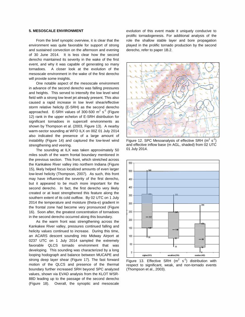
Figure 3 and Figure 4 show some of the damage that
occurred from the second derecho, while Figure 5
provides evidence of a tornado path near Earlville, IL,
the first tornado in the second derecho. The most
notable aspect of this event, beyond the large number of
tornadoes in such a concentrated area, was that the
tornadoes in the second QLCS developed within the
remnant cold pool of the first QLCS. Quite often a cold
pool will have the opposite effect and inhibit additional
severe weather after the initial storms have passed.
First Derecho Second Derecho
Time 1845-0030 0100-0700
Severe Wind 112 119
Tornadoes 2 29
Hail 28 3
Table 1. Derecho times (UTC) and report counts from 30 June – 01 July 2014.
* Corresponding author address: Matt Friedlein,
NOAA/NWS Chicago; 333 W. University Dr., Romeoville, IL 60446; e-mail: [email protected]
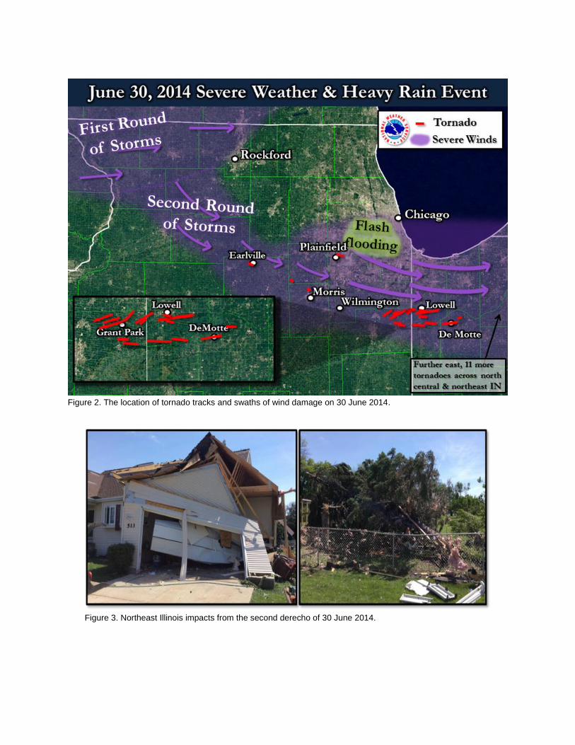
Figure 2. The location of tornado tracks and swaths of wind damage on 30 June 2014.
Figure 3. Northeast Illinois impacts from the second derecho of 30 June 2014.

Figure 4. Northwest Indiana impacts from the second derecho of 30 June 2014.
Figure 5. Evident tornado path within fields near Earlville, IL as taken and shared by media entity ABC7 Chicago.
3. DERECHO CLIMATOLOGY
As already mentioned, the region hardest hit by the
prolific tornado producing derecho of 30 June 2014 was
northern Illinois and northwest Indiana. Multiple
climatological studies from the 1980s to as recently as
2015 have noted the high frequency of warm season
derecho events in this area. A pair of spatial data plots
from these studies (Figure 6) shows this region lies near
the center of highest derecho frequency across the
Midwest and lower Great Lakes.
While the derecho frequency in this area is well-
documented, this region of the country is not considered
to be part of the traditional “Tornado Alley” or “Dixie
Alley” where tornadoes occur with the greatest
frequency (Gagan et al., 2010). There is, however,
some evidence this region sees a greater share of
QLCS tornadoes. The climatology has not been studied
extensively, though Smith et al. (2012) investigated the
convective mode of tornadoes per season. Their results
suggest that some areas of the country do see a greater
frequency of QLCS tornadoes during the summer
relative to tornadoes associated with other modes of
convection ( Figure 7). One such area includes
northeast Illinois and northwest Indiana.
Even though the climatology of derechos and
QLCS tornadoes suggests this was not a rare event
from those perspectives, the rapid succession of
derechos over partially overlapping areas is far less
common. From a dataset containing 256 progressive
derechos from 1996 to 2013, Guastini (2015) noted
there were not two in such quick succession, let alone
over the same area. It is therefore worth seeking to
understand the synoptic and mesoscale environment
that led to this unusual event.
4. SYNOPTIC ENVIRONMENT
Multiple aspects of the evolving synoptic
environment on 30 June 2014 contributed to the
initiation and maintenance of both derechos that
evening. This is examined from the hourly archive of
mesoscale analysis imagery from the NWS Storm
Prediction Center (SPC), a dataset widely used in real-
time by operational forecasters. This mesoanalysis is
created by merging recent surface observations with
fields from the 40km RAP model (Hart et al. 2015).
The factors that proved to be important on this
evening are typical of many derecho synoptic
environments. This was especially true at 500mb
(Figure 8), where high speed mid-level flow with a
shortwave trough and its associated forcing for ascent
were approaching the area of interest during the early
afternoon of 30 June 2014. This served as an impetus
for the first derecho, and a second short wave trough
analyzed from western Minnesota through the High
Plains became one of the triggering mechanisms for the
second derecho.

Figure 6. Number of derecho occurrences in the time spans identified as defined by Coniglio & Strensrud (2004, top) and Guastini (2015, bottom).
Figure 7. Relative frequency of summer QLCS
tornadoes to all summer (Jun-Aug) tornadoes from
2003-2009 by Smith et al. (2012).
In addition to these upper level features, the
thermodynamic environment on this afternoon and
evening also was very supportive of strong vertical
ascent. Southerly flow into the area was producing
surface temperatures in the low 80s and dewpoints in
the middle to upper 70s. As lapse rates steepened
aloft, values of CAPE for parcels rooted in this very
warm and moist surface layer exceeded 4000 J kg-1
(Figure 9). Generally a value exceeding 1000 J kg-1
is
considered sufficient for support of deep moist
convection (Evan and Doswell, 2002).
Favorable deep layer shear also has been shown to
support thunderstorm strength and longevity (Evans,
2002). The earlier noted mid-level winds of 37 m s-1
contributed to deep layer shear values in excess of 30
m s-1
across the Corn Belt by early afternoon (~1900
UTC). This area of higher shear gradually expanded
east in conjunction with the second derecho. However,
the first derecho, which formed in the early afternoon,
had tracked ahead of this maximum by late afternoon
(Figure 10). This would likely be a factor in the first
derecho gradually weakening by the time it reached
Lake Michigan and adjacent parts of Illinois, Michigan,
and Wisconsin.

Figure 8. SPC Mesoanalysis of 500mb height (m), temperature (C), and wind (kts) from 1900 UTC on 30 June 2014.
Figure 9. Surface-based CAPE (contours, J kg
-1) and
CIN (shaded, J kg-1
) at 1900 UTC 30 June 2014.
At the surface, low pressure centered near the
Iowa/Missouri border gradually evolved eastward in
tandem with the upper level support (Figure 11). This is
in the latter part of the first derecho’s lifecycle as well as
the beginning phase of storms in eastern to central Iowa
that would become the second derecho. Figure 11 also
shows isallobaric pressure rises and falls. The area of
pressure falls of 1-2 mb per 3 hr (shaded in red as of 23
UTC) is in the immediate wake of the first derecho.
Typically an immediate post-derecho air mass is one
characterized by a rain-driven cold pool and one of
rising surface pressures. These falls indicate a limited
cold pool footprint from the first derecho and show the
influence of the surface low moving from Missouri into
northern Illinois.
An additional feature within the low-level cyclonic
flow ahead of the advancing low pressure center and
second derecho was a warm front. Conceptual models
for both progressive and serial derechos address the
importance of nearby stationary or warm fronts (Johns
and Hirt, 1987). The first derecho tracked just north of
the area where this front became established. In fact, it
is likely that the passage of the first derecho significantly
influenced the strength of this front, as described in the
next section.
Figure 10. SPC Mesoanalysis of 0-6km shear (kts) from 22 UTC and concurrent radar mosaic on 30 June 2014.
Figure 11. SPC Mesoanalysis of mean sea level pressure (mb), wind barbs, and 2hr pressure falls from 23 UTC and concurrent radar mosaic on 30 June 2014.
5. MESOSCALE ENVIRONMENT
From the brief synoptic overview, it is clear that the
environment was quite favorable for support of strong
and sustained convection on the afternoon and evening
of 30 June 2014. It is less clear how the second
derecho maintained its severity in the wake of the first
event, and why it was capable of generating so many
tornadoes. A closer look at the evolution of the
mesoscale environment in the wake of the first derecho
will provide some insights.
One notable aspect of the mesoscale environment
in advance of the second derecho was falling pressures
and heights. This served to intensify the low level wind
field with a strong low level jet already present. This also
caused a rapid increase in low level shear/effective
storm relative helicity (E-SRH) as the second derecho
approached. E-SRH values of 300-500 m2 s
-2 (Figure
12) rank in the upper echelon of E-SRH distribution for
significant tornadoes in supercell environments as
shown by Thompson et al. (2003, Figure 13). A nearby
warm-sector sounding at WFO ILX on 00Z 01 July 2014
also indicated the presence of a large amount of
instability (Figure 14) and captured the low-level wind
strengthening and veering.
The sounding at ILX was taken approximately 50
miles south of the warm frontal boundary mentioned in
the previous section. This front, which stretched across
the Kankakee River valley into northern Indiana (Figure
15), likely helped focus localized amounts of even larger
low-level helicity (Thompson, 2007). As such, this front
may have influenced the severity of the first derecho,
but it appeared to be much more important for the
second derecho. In fact, the first derecho very likely
created or at least strengthened this feature along the
southern extent of its cold outflow. By 02 UTC on 1 July
2014 the temperature and moisture (theta-e) gradient in
the frontal zone had become very pronounced (Figure
16). Soon after, the greatest concentration of tornadoes
in the second derecho occurred along this boundary.
As the warm front was strengthening across the
Kankakee River valley, pressures continued falling and
helicity values continued to increase. During this time,
an ACARS descent sounding into Midway Airport at
0237 UTC on 1 July 2014 sampled the extremely
favorable QLCS tornado environment that was
developing. This sounding was characterized by a long
looping hodograph and balance between MUCAPE and
strong deep layer shear (Figure 17). The fast forward
motion of the QLCS and presence of the thermal
boundary further increased SRH beyond SPC analyzed
values, shown via EVAD analysis from the KLOT WSR-
88D leading up to the passage of the second derecho
(Figure 18). Overall, the synoptic and mesoscale
evolution of this event made it uniquely conducive to
prolific tornadogenesis. For additional analysis of the
role the shallow stable layer and bore propagation
played in the prolific tornado production by the second
derecho, refer to paper 1B.2.
Figure 12. SPC Mesoanalysis of effective SRH (m
2 s
-2)
and effective inflow base (m AGL, shaded) from 02 UTC 01 July 2014.
Figure 13. Effective SRH (m
2 s
-2) distribution with
respect to significant, weak, and non-tornado events (Thompson et al., 2003).

Figure 14. ILX (Central Illinois) sounding plot from 0000 UTC on 1 July 2014.
Figure 15. SPC Mesoanalysis of mean sea level pressure and wind in knots, with a zoomed-in inset along the warm front, from 02Z on 01 July 2014.
6. CONCLUSION
The successive derechos across the Corn Belt and
southern Great Lakes on 30 June 2014 generated over
230 severe wind reports and at least 29 tornadoes. This
area of the U.S. that was hit hardest by the two
derechos has been highlighted by climatological studies
of derechos and QLCS tornadoes. However, the rapid
succession of these two events was something much
more rare.
The synoptic environment supported organized and longer-lived, progressive storms. The nature of the two derechos was different however, in that the second became much more of a tornado producer.
Figure 16. Surface observations and RAP surface analysis of surface theta-e (K) from 0200 UTC 1 July 2014.
This different evolution was likely contributed to by
an effective warm frontal boundary that was enhanced
by the outflow of the first derecho. While rain-cooled
outflow could be considered a deterrent to immediate
robust surface-based convection, the outflow from the
first derecho was characterized by limited pressure rises
over northern Illinois and northwest Indiana and a sign
that the footprint was quite minimal. A strengthening
low-level jet and veering with height as shown by
soundings and profilers illustrated the tornado threat.
Within two to three hours of the first derecho passage, a
severe QLCS produced at least 29 tornadoes across
northern Illinois and northern Indiana.

Figure 17. ACARS sounding data from descent into Chicago Midway International Airport at 0237 UTC 01 July 2014.
Figure 18. KLOT EVAD analysis prior to the arrival of the second derecho at the radar site.

7. REFERENCES
Coniglio, M.C., and D. J. Stensrud, 2004: Interpreting
the Climatology of Derechos. Wea. Forecasting, 19,
595-605.
Evans, J.S., and C.A. Doswell III, 2002: Investigating
Derecho and Supercell Proximity Soundings. Preprints,
21st Conf. Severe Local Storms, San Antonio.
Gagan, J. P., A. Gerard, and J. Gordon, 2010: A
historical and statistical comparison of "Tornado Alley"
to "Dixie Alley". Natl. Wea. Dig., 34, 145-155.
Guastini, C., and L. Bosart, 2014: Corey T. Guastini
Research. [Available online at
http://www.atmos.albany.edu/student/cguastin/research.
html and via direct communication].
Johns, R. H., and W. D. Hirt, 1987: Derechos:
Widespread Convectively Induced Windstorms. Wea.
Forecasting, 2, 32–49.
Lenning, E., M. T. Friedlein, R. Castro, A. W. Lyza, and
K. R. Knupp, 2015: Storm Scale Meteorological
Processes in the 30 June 2015 Double Derecho Event.
27st Conf. on Weather Analysis and Forecasting,
Chicago, IL, Amer. Meteor. Soc., 1B.2. [Available online:
https://ams.confex.com/ams/27WAF23NWP/webprogra
m/Paper273807.html]
Schaumann, J.S., R.W. Przybylinski: Operational
Application of 0-3 km Bulk Shear Vectors in Assessing
QLCS Mesovortex and Tornado Potential. Preprints,
27th Conf. Severe Local Storms, Madison WI, P9.10.
Smith, B.T., R. L. Thompson, J. S. Grams, C. Broyles,
and H. E. Brooks, (2012): Convective Modes for
Significant Severe Thunderstorms in the Contiguous
United States Part I: Storm Classification and
Climatology. Wea. Forecasting, 27, 1114 – 1135.
Thompson, R. L., R. Edwards, J. A. Hart, K. L. Elmore,
and P. Markowski, 2003: Close proximity soundings
within supercell environments obtained from the Rapid
Update Cycle. Wea. Forecasting, 18, 1253.
Thompson, R. L., C. M. Mead, and R. Edwards, 2007:
Effective Storm-Relative Helicity and Bulk Shear in
Supercell Thunderstorm Environments. Wea.
Forecasting, 22, 102–115.
Trapp, R.J., S. A. Tessendorf, E.S. Godfrey, and H.E.
Brooks, 2005: Tornadoes from Squall Lines and Bow
Echoes. Part I: Climatological Distributions. Wea.
Forecasting, 131, 2779-2803.
Wakimoto, R. M. 2001: Convectively driven high wind
events. Severe Convective Storms, Meteor. Monogr.,
No. 50, Amer. Meteor. Soc., 257-258.