19.01 - scope and interpretation33d7f… · web viewzoning. ordinance city of grand marais zoning...
TRANSCRIPT
GRAND MARAIS
ZONING
ORDINANCE
1

CITY OF GRAND MARAIS ZONING ORDINANCE
Table of Contents
Section Page
19.01 Scope and Interpretation 119.02 Definitions 119.03 Zoning Districts 619.04 R-1 Permanent Residence District 619.05 R-2 Multiple Family Residential District 819.06 Downtown Districts 919.07 C/I Service Commercial-Industrial District 1319.07A Communications District 1819.08 PR Protected Resources 1819.09 PARK Public Parkland 1919.10 RC Recreational/Commercial 2019.11 SC Community Services 2019.12 BDA Business Development Area 2119.13 RCN Resort/Commercial Neighborhood 2319.13A Tabulation of District Provisions & Dimensional Requirements 2719.14 General Regulations 29-59
Scope of Regulations 29Erection of more than one Principal structure on a Lot 29Accessory Buildings 29Height Regulations 30Yard Regulations 30Vision Clearance 31Street closures 32Areas under Water 32Essential Services 32Structures to have Access 32Sign Regulations 32-42Off-Street Parking and Loading and Unloading Requirements 43Minimum Mobile Home Requirements 46Foundation Requirements 48Automobile Service Stations in the H61 District 48Manufactured housing Regulations 49Junked Vehicles 50Landscape Preservation Standards 50Runoff and Erosion Control Standards 51North Shore Management Plan 52General Requirements for Motels and Hotels 57
19.15 Planned Unit Development 5919.16 Non-Conforming Uses 6219.17 Conditional Use Permits 6319.18 The Administrative Official 6419.19 Building and Use Permits 6519.20 Adjustments and Variances 6619.21 Amendments to the Zoning Ordinance 6819.22 Violations and Penalties 6919.23 Effective Date 70
2

19.01 - SCOPE AND INTERPRETATION
Subdivision 1. Scope
From and after August 5, 1971, the effective date of this chapter and any subsequent amendments, the use of all land and every building and the erection or structural alteration of any building or portion of a building in the City shall be in conformity with the provisions of this chapter. Any structure or use lawfully existing at the passage of this chapter but not in conformity with the regulations of the appropriate zoning district may be continued subject to the regulations of Section 19.16.
Subdivision 2. Interpretation
The provisions of this chapter shall be interpreted as the minimum requirements for the promotion of the public health, safety, morals, convenience and general welfare. Where the provisions of this chapter impose greater restrictions than those of any statute, or City Code provision, or regulation, this chapter shall apply. Where the provisions of any statute, City Code provision, or regulation impose greater restrictions than this chapter, such restrictions shall apply.
19.02 - DEFINITIONS
Subdivision 1. Rules
For the purpose of this chapter, words used in the present tense shall include the future; words in the singular shall include the plural, and the plural the singular; the word “building” shall include the word “structure”; the word “lot” shall include the word “plot”; and the word “shall” is mandatory and not discretionary.
Subdivision 2. Definitions
For the purpose of this chapter, certain words are defined as follows:
Alley -- A public or private right-of-way less than thirty (30) feet in width which affords secondary means of access to abutting property.
Apartment -- A room or suite of rooms designed for, intended for, or used as a residence for one family or individual and equipped with cooking facilities.
Apartment Building -- Three or more dwelling units grouped in one building.
Arts and Cultural Uses – Establishments where the intellectual and artistic manifestations of society are documented, created, or displayed, such as museums, art galleries and studios, gardens, or any other historic or educational purpose.
Auto Oriented Services – Any commercial entity designed to serve primarily automobile traffic, such as gas stations, auto repair, carwash, businesses with drive thru windows.
Block -- A tract of land bounded by streets or a combination of streets and public parks, cemeteries, railroad rights of way, shorelines, unsubdivided acreage or boundary line of the corporate limits of the City.
Boarding House -- Any dwelling other than a hotel or motel where meals or lodging and meals for compensation are provided for five (5) or more persons pursuant to previous arrangements.
1

Building -- Any structure for the shelter, support or enclosure of persons, animals, chattel, or property of any kind; and when separated by bearing walls without openings, each portion of such building so separated shall be deemed a separate building.
Building, Accessory -- A subordinate building, the use of which is incidental to that of the principle building on the same lot.
Building Height -- The vertical distance from the average of the lowest and the highest point of that portion of the lot covered by the building to the highest point of the roof, to the deck line of mansard roofs, and to the mean height between eaves and ridge for gable, hip and gambrel roofs.
Deck -- A horizontal platform, any part of which is more than 18” off the ground, except railings or seats, attached or adjacent and functionally related to a building. Any deck-like structure 18” and under does not require a land use permit.
Dwelling, Single Family -- A detached residential dwelling unit other than a mobile/manufactured home, designed for and occupied by one family only. (Derivation: Council action July 28, 1982)
Dwelling, Mobile/Manufactured Home -- A detached residential dwelling unit designed for transportation after fabrication on streets or highways on its own wheels or on flatbed or other trailers, and arriving at the site where it is to be occupied as a dwelling complete and ready for occupancy except for minor and incidental unpacking and assembly operations, located on permanent foundations, connected to utilities, and the like, and in conformance with Minnesota Statutes Chapter 327.31, Subdivision 6 or amendments thereto. A travel trailer is not to be considered as a mobile home. (Derivation: Council action July 28, 1982)
Dwelling, Two Family -- A detached residential building containing two dwelling units, designed for occupancy by not more than two families.
Dwelling, Multiple Family -- A residential building designed for or occupied by three or more families, with the number of families in residence not exceeding the number of dwelling units provided.
Dwelling Unit -- One room, or rooms connected together, constituting a separate, independent housekeeping establishment for owner occupancy, or rental or lease on a weekly, monthly, or longer basis, and physically separated from any other rooms or dwelling units which may be in the same structure, and containing independent cooking and sleeping facilities.
Family -- Any number of individuals living together on the premises as a single non-profit housekeeping unit (except for necessary servants) as distinguished from a group occupying a boarding house, lodging house, hotel, club, fraternity or sorority house.
Floor Area -- The sum of the gross horizontal areas of the several floors of a building, measured from the exterior walls, including basements and attached accessory buildings.
Garage, Private -- An accessory building for storage of self-propelled vehicles and tools and equipment maintained as incidental to the principal use of the premises.
Garage, Public -- Any premises except those defined as a private garage used for the storage or care of self-propelled vehicles and/or where any such vehicles are equipped for operation, repair, or are kept for remuneration, hire, or sale.
Home Occupation --Any use customarily conducted entirely within a dwelling or accessory building and carried on by members of a family residing therein, which use is clearly incidental and secondary to the use of the dwelling for dwelling purposes and does not change the character thereof. Clinics, hospitals, lodging, mortuaries, motor vehicle repairing for hire, welding, animal hospitals and the maintenance of
2

animals, except as provided in Section 19.04., Subdivision 2-6, shall not be deemed to be home occupations. (Ord. 2007-02)
Hotel -- Lodging facilities consisting of more than 10 lodging units. (Ord 2016-02 3/30/2016)
Junk Yard -- Land or buildings where waste, discarded, or salvaged materials are bought, sold, exchanged, stored, cleaned, packed, disassembled or handled, including but not limited to scrap metal, rags, paper, rubber products, glass products, lumber products and products resulting from the wrecking of automobiles or other machinery.
Loading Area -- Any area where trucks are parked, maneuvered, or loaded or unloaded of materials or equipment.
Lodging – A building, structure, enclosure, or any part thereof used as, maintained as, advertised as, or held out to be rented, leased, or sold to the public for sleeping accommodations for periods of less than 30 continuous days.
Lot -- One unit of a recorded plot or subdivision, which unit has frontage on a public street and is occupied, or to be occupied, by a building and its accessory buildings, and including as a minimum, such open spaces as are required under this chapter.
Lot Area -- The land area within the lot lines.
Lot, Corner -- A lot situated at the intersection of two or more streets.
Lot Coverage -- The total allowable amount of lot area, expressed as a percentage, which may be covered by a principal structure and its accessory structures.
Lot Depth -- The average distance between the front and rear lot line (the greater frontage of a corner lot shall be deemed its depth and the lesser frontage its width).
Lot, Double Frontage -- An interior lot having frontage on two streets.
Lot, Interior -- A lot other than a corner lot.
Lot Width -- The horizontal straight line distance between the side lot lines at the setback line.
Marina -- A facility for water based activities related to the storing, servicing, fueling, berthing, and securing of pleasure boats.
Non-Conforming Use -- A use lawfully in existence on August 5, 1971, the effective date of this chapter or upon any subsequent amendment, and not conforming to the regulations for the district in which it is situated, except that such a use is not non-conforming if it would be authorized under a conditional use permit where located.
Persons -- Any individual, firm, partnership, corporation, company, association, joint stock association or body politic; includes any trustee, receiver, assignee, or similar representative thereof.
Premises -- A lot or plot with the required front, side and rear yards for a dwelling or other use as allowed under this chapter.
Retail -- Establishments primarily engaged in selling goods or merchandise to the general public for personal or household consumption and rendering services incidental to the sale of such goods. Retail may also include manufacturing of goods to be sold on or off site so long as retail sales remain the primary component of the commercial activity.
3

Services – Establishments primarily engaged in providing assistance, as opposed to products, to individuals, business, industry, government, and other enterprises, personal, business, repair, and amusement services; health, legal, engineering and other professional services; educational services, membership organizations, and other miscellaneous services.
Setback -- The shortest horizontal distance between the lot line and the foundation wall of a building or the allowable building line as defined by the yard regulations of this chapter.
Sign -- A name, identification, display, illustration, or device which is affixed to or represented directly or indirectly upon a building, structure, or land in view of the general public and which directs attention to a product, place, activity, purpose, institution or business.
Sign, Advertising -- A sign which directs attention to a business, commodity, service, activity or entertainment not necessarily conducted, sold or offered upon the premises where such a sign is located.
Sign, Business -- A sign which directs attention to a business or profession or a commodity, service, or entertainment sold or offered upon the premises where such a sign is located.
Sign, Flashing -- Any illuminated sign on which such illumination is not kept stationary or constant in intensity and color at all times when such sign is in use.
Sign, Illuminated -- Any sign which has characters, letters, figures, designs, or outlines illuminated by electric lights or luminous tubes as a part of the sign.
Sign, Nameplate -- Any sign which states the name or address or both of the business or occupancy of the lot where the sign is placed.
Sign, Rotating -- A sign which revolves or rotates on its axis by mechanical means.
Sign, Surface Area of -- The entire area within a single continuous perimeter enclosing the extreme limits of the actual sign surface, not including any structural elements outside the limits of such sign and not forming an integral part of the display. Only one side of a double-face of V-type sign structure shall be used in computing total surface area.
Story -- That portion of the building included between the surface of any floor and the surface of the next floor above it, or, if there is no floor above it, the space between the floor and the ceiling next above it.
Story, Half -- A story with at least two, opposite exterior sides meeting a sloping roof not more than two feet above the floor of such story.
Street Line -- The right-of-way line of a street.
Structure -- Anything constructed or erected, the use of which requires location on the ground or attachment to something having a location on the ground.
Structural Alteration -- Any change or addition to the supporting members of a building such as bearing walls, columns, beams or girders.
Subdivision -- A described tract of land which is to be or has been divided into two (2) or more lots or parcels, any of which resultant parcels is less than two and one-half (2 1/2) acres in area and one hundred fifty (150) feet in width, for the purpose of transfer of ownership or building development, or if a new street is involved, any division of a parcel of land. The term includes resubdivision, and, where it is appropriate to the context, relates either to the process of subdivision or to the land subdivided.
Use -- The purpose for which land or premises or a building thereon is designated, arranged or intended, or for which it is or may be occupied or maintained.
4

Use, Accessory -- A use clearly incidental or accessory to the principal use of a lot or building located on the same lot as the accessory use, but not including commercial uses in the R-1 or R-2 zones.
Variance -- A modification or variation of the provisions of this chapter, as applied to a specific piece of property, except that modification in the allowable uses within a district shall not be considered a variance.
Yard -- A space on the same lot with a building open and unobstructed from the ground to the sky, except for fences five (5) feet or less in height, and trees and shrubs.
Yard, Front -- A yard extending across the front of the lot between the side yard lines and lying between the center line of the road or highway and the nearest line of the building.
Yard, Rear -- An open space unoccupied except for accessory buildings on the same lot with a building between the rear lines of the building and the rear line of the lot, for the full width of the lot. In the case of a corner lot, there is no rear yard.
Yard, Side -- An open, unoccupied space on the lot with a building between the building and the side line of the lot.
5

19.03 ZONING DISTRICTS
Subdivision 1. Establishment of Districts
For the purpose of this chapter, the City is divided into the following districts:
R-1 Permanent Residence DistrictR-2 Multiple Family Residential DistrictDowntown Districts
DW Core Downtown Waterfront DistrictH61Highway 61 Corridor DistrictMU Commercial-Residential Mixed Use District
C/I Service Commercial - Industrial DistrictCOM Communications DistrictPR Protected ResourcesPARK Public ParklandRC Recreation/CommercialSC Community ServicesBDA Business Development AreaRCN Resort/Commercial Neighborhood
Subdivision 2. Zoning Map
The boundaries of the districts established by this chapter are delineated on the Zoning Map; said Map and all notations, references, and data shown thereon are hereby adopted and made part of this chapter and will be on permanent file, and for public inspection, at the City Hall. It shall be the responsibility of the Zoning Administrator and staff to maintain said Map, and amendments thereto shall be recorded thereon within thirty (30) days after official publication of amendments.
Subdivision 3. District Boundaries
The boundaries between districts are, unless otherwise indicated, either the center line of streets, or alleys, or such lines extended or lines parallel or perpendicular thereto. Where figures are shown on the Zoning Map between a street and a district boundary line they indicate the district boundary line runs parallel to the street at a distance there from equivalent to the number of feet stated unless otherwise indicated.
19.04 R-1 PERMANENT RESIDENCE DISTRICT
Subdivision 1. Purpose
The R-1 Permanent Residence District is intended to provide a healthy, safe and attractive residential environment, protect property values and the environment and provide a mix of residential options, both seasonal and year around.
Subdivision 2. Permitted Principal Uses
Within an R-1 District, unless otherwise provided by this chapter, no uses are permitted except the following:
1. One and two family attached dwellings, including mobile/manufactured homes (Derivation: Council Action July 28, 1982)
6

2. Parks and recreational areas owned or operated by governmental agencies.
3. Public elementary or high schools, or private schools with an equivalent curriculum.
4. Churches, parish homes, convents, children’s nurseries and schools, provided that no building shall be located within fifty (50) feet of any abutting lot in any residential district.
5. Accessory uses.
Subdivision 3. Uses by Conditional Use Permit
Buildings or land may be used for the following if granted a Conditional Use Permit as provided in Section 19.17:
1. Rental of rooms for three to eight unrelated persons on a premises on a monthly or longer basis.
2. Mobile home park developments, subject to the regulations as established in Section 19.14, Subdivision 13, General Regulations: Mobile Home Park Requirements.
3. Home occupations as defined in Section 19.02, Subdivision 2. (Derivation: Council Action, April 16, 1979).
4. Apartment buildings and multiple dwelling units, townhouse developments and row houses.
5. Planned Unit Developments.
Subdivision 4. Height, Yard Setbacks, Lot Area and Coverage Requirements
Height, yard setbacks, lot area and coverage requirements shall be as stated in Section 19.13, District Provisions and Dimensional Requirements.
Subdivision 5. General Requirements
Additional regulations applicable in the R-1 District are set forth in Section 19.14, General Regulations.
7

19.05 R-2 MULTIPLE FAMILY RESIDENTIAL DISTRICT
Subdivision 1. Purpose
The R-2 Multiple Family Residential District is intended to provide areas suitable for the location of apartment buildings, row housing, and the like, which maintain density and space standards that will ensure a wholesome living environment and which effectively relate to the comprehensive plan for community development.
Subdivision 2. Permitted Principal Uses
Within an R-2 District, unless otherwise provided by this chapter, no uses are permitted except the following:
1. One and two family attached dwellings, including mobile/manufactured homes.
2. Parks and recreational areas owned by governmental agencies.
3. Public elementary or high schools, or private schools with an equivalent curriculum.
4. Churches, parish homes, convents, children’s nurseries and schools, provided that no building shall be located within fifty (50) feet of any abutting lot in any residential district.
5. Accessory uses.
Subdivision 3. Uses by Conditional Use Permit
Buildings or land may be used for the following if granted a Conditional Use Permit as provided in Section 19.17:
1. Apartment Buildings and multiple dwelling units, townhouse developments and row houses.
2. Planned Unit Developments.
3. Home occupations as defined in 19.02, Subdivision 2.
Subdivision 4. Height, Yard Setbacks and Lot Area and Coverage Requirements
Height, yard setbacks and lot area and coverage requirements shall be as stated in Section 19.13, District Provisions and Dimensional Requirements.
Subdivision 5. General Requirements
Additional regulations applicable in the R-2 District are set forth in Section 19.14, General Regulations.
8

19.06 DOWNTOWN DISTRICTS
19.06.10 DW CORE DOWNTOWN WATERFRONT DISTRICT
Subdivision 1. Purpose
The Core Downtown Waterfront district is intended to promote a mix of shops, restaurants and professional services that serve both the year round and seasonal or visitor populations. The emphasis in this district is on commercial services as a primary function, where residential uses can fit as a secondary function and can add to the liveliness and viability of the downtown. There is an emphasis on creating an attractive pedestrian environment that makes the Core Downtown and Waterfront of the City a destination in and of itself. New uses in this district should not detract from other existing uses.
Subdivision 2. Permitted Principal Uses
Within the DW District, unless otherwise provided by this chapter, no uses are permitted except the following:
Permitted uses:1. Commercial: retail, restaurant, bar, services, excluding auto oriented services.2. Lodging (Including 1st floor)3. Government and civic uses4. Parks and recreational uses5. Arts and cultural uses6. Accessory uses customary to permitted uses
Subdivision 3. Uses by Conditional Use Permit
Buildings and land may be used for the following if granted a Conditional Use Permit as provided in Section 19.17:
Conditional Uses:1. Residential above the first floor2. Three-story buildings3. Structures over 10,000 square feet4. Improvements to and restoration of existing single and multiple family dwellings as regulated in
Section 19.04, R-1 Residence District (Ord. 2003-03)5. Any water dependent industrial or water dependent transportation use; provided that the
Planning Commission finds that the proposed use is advantageously served in this location through the direct access to water transportation for receipt or shipment of supplies, goods, or commodities.
6. Docks, wharfs, and other facilities used in connection with water transportation, navigation, or industrial uses.
8
Subdivision 4. Heights, Yard Setbacks and Lot Coverage Requirements
The height, yard setbacks and lot coverage requirements shall be those stated in Section 19.13, District Provisions and Dimensional Requirements.
Subdivision 5. Additional Regulations
1. Lighting (glare) shall be directed away from public rights-of-way and residential districts.
9

2. An awning, canopy, or marquee suspended from a building may extend over the public right-of-way ten (10) feet, but not within two (2) feet of the curb line. Such structures shall be of a height not less than eight (8) feet from the sidewalk or ground grade line, and the owner of such structure shall be responsible for its structural safety.
3. All uses within the DW District shall be subject to the Performance Standards as stated in Section 19.07, Subdivision 5, Performance Standards in the C/I District and Section 19.07, Subdivision 6. Regulations on Screening, Landscaping, Lighting, and Storage and Outdoor Display.
4. All residential uses in the DW zone must provide 1 off-street parking space per unit located within 150’ of the property.
Subdivision 6. General Regulations
Additional regulations applicable to the DW District are set forth in Section 19.14, General Regulations.
Subdivision 7. Design Guidelines
The objective of the design guidelines is to convey desirable elements the community would like to see reinforced in building design. They are not intended to be prescriptive or limit the creativity of the developer but to maintain the current scale and character of the downtown while allowing the downtown to evolve with its eclectic mix of buildings. The guidelines are further intended to enhance the pedestrian experience with a continuous active streetscape and to provide for public views of the harbor and waterfront.
The following design guidelines are required for all properties on the following streets: Wisconsin St, 1st Ave south of Highway 61 and Broadway between 1st St and Artist Point. The guidelines will apply as a standard for the Design Overlay District and for development requiring a conditional use permit and will be reviewed by the Planning Commission. The guidelines are advisory for the remainder of the Core Downtown Waterfront district.
Buildings must have a clearly defined base, middle and top. Building façades should be organized vertically. A building more than 50 feet in width should be divided into increments of no more than 48 feet
through articulation of the façade. This could be achieved through the combinations of the following techniques:
o Divisions or breaks in materialso Window bayso Separate entrances and entry treatmentso Use of architectural details such as parapets
A minimum of 30% of the ground level façade up to 9’ above grade shall be transparent (windows and doors). Reflective or glass tinted more than 40% is not allowed. This standard should be applied to newly constructed buildings or where there is a substantial modification* and encouraged for all other buildings. This standard applies only to the primary frontage for corner lots. The second frontage for corner lots may substitute other tools to indicate pedestrian-orientation.
The color of buildings should complement the adjacent buildings’ colors and include a complementary mix of colors.
Roof lines for new buildings should complement neighboring properties. Buildings should have front setbacks of 0 ft.
* A Substantial Modification would be an alteration to a building that is valued at more than 50% of the replacement cost of the entire building, if new.
10
19.06.20 H61 HIGHWAY 61 CORRIDOR DISTRICT
Subdivision 1. Purpose
The Highway 61 Corridor District is intended to promote a mix of retail, restaurants and services that serve both the year round and seasonal or visitor populations. Automobile oriented services can be located in this district. Commercial, restaurant and lodging services are the district’s primary function. Residential uses can fit as a secondary function where it does not conflict with the primary use. The district is intended to be an aesthetically-pleasing entryway into the City and as pedestrian-friendly and safe as possible. It is intended that the barrier that Highway 61 forms to other parts of the City be minimized as much as possible.
Subdivision 2. Permitted Principal Uses
Within the H61 District, unless otherwise provided by this chapter, no uses are permitted except the following:Permitted uses:
1. Commercial: retail, auto oriented services (e.g. gas stations, auto repair, carwash, businesses with drive thru windows) restaurant, bar, services.
2. Lodging3. Residential use above the first floor4. Arts and cultural uses5. Government and civic uses6. Park and recreational uses
Subdivision 3. Uses by Conditional Use Permit
Buildings and land may be used for the following if granted a Conditional Use Permit as provided in Section 19.17:
1. Three story buildings2. Building height of 35 feet when no significant additional impact to views and improved design.3. Structures with no commercial use on the first floor (including single family residential).
Subdivision 4. Heights, Yard Setbacks and Lot Coverage Requirements
The height, yard setbacks and lot coverage requirements shall be those stated in Section 19.13, District Provisions and Dimensional Requirements.
Subdivision 5. Additional Regulations
1. Lighting (glare) shall be directed away from public rights-of-way and residential districts.
2. An awning, canopy, or marquee suspended from a building may extend over the public right-of-way ten (10) feet, but not within two (2) feet of the curb line. Such structures shall be of a height not less than eight (8) feet from the sidewalk or ground grade line, and the owner of such structure shall be responsible for its structural safety.
3. All uses within the H61 District shall be subject to the Performance Standards as stated in Section 19.07, Subdivision 5, Performance Standards in the C/I District and Section
11

19.07, Subdivision 6. Regulations on Screening, Landscaping, Lighting, and Storage and Outdoor Display.
4. All residential uses in the H61 zone must provide 1 off-street parking space per unit located within 150’ of the property.
Subdivision 6. General Regulations
Additional regulations applicable to the H-61 District are set forth in Section 19.14, General Regulations.
19.06.30 MU COMMERCIAL-RESIDENTIAL MIXED USE DISTRICT
Subdivision 1. Purpose
The Commercial-Residential Mixed Use district can be characterized as a transition zone from the downtown and Highway 61 commercial areas to the residential parts of Grand Marais, and an expansion area for the downtown commercial uses. The MU district is intended to Promote the current character of a neighborhood that includes a mix of residential, lodging, professional and small scale retail uses that are compatible with this character. Site design standards for new development, re-development and expansion should reflect the mixed use character and reflect the current lot coverage and setback characteristics found within the concept area.
Subdivision 2. Permitted Principal Uses
Within the MU District, unless otherwise provided by this chapter, no uses are permitted except the following:Permitted uses:
1. Single family residence2. Multi family residence (2-4 units)3. Services, excluding auto oriented services4. Arts and cultural uses5. Retail6. Bed and breakfasts (subject to regulations in 19.13 subd. 6, 2.)
Subdivision 3. Uses by Conditional Use Permit
Buildings and land may be used for the following if granted a Conditional Use Permit as provided in Section 19.17:
1. Small scale lodging (10 units or less)2. Multi-family residence (5-10 units)3. Building height of 35 feet when no significant impact to views and improved design.4. Deviation from rear and side-yard setbacks may be allowed after evaluating impacts on public
safety, neighboring properties, parking and a storm water management plan is put in place.
Subdivision 4. Heights, Yard Setbacks and Lot Coverage Requirements
The height, yard setbacks and lot coverage requirements shall be those stated in Section 19.13, District Provisions and Dimensional Requirements.
12
Subdivision 5. Additional Regulations
1. Lighting (glare) shall be directed away from public rights-of-way and residential districts.
2. An awning, canopy, or marquee suspended from a building may extend over the public right-of-way ten (10) feet, but not within two (2) feet of the curb line. Such structures shall be of a height not less than eight (8) feet from the sidewalk or ground grade line, and the owner of such structure shall be responsible for its structural safety.
3. All uses within the MU District shall be subject to the Performance Standards as stated in Section 19.07, Subdivision 5, Performance Standards in the C/I District and Section 19.07, Subdivision 6. Regulations on Screening, Landscaping, Lighting, and Storage and Outdoor Display.
4. All residential uses in the MU zone must provide 1 off-street parking space per unit located within 150’ of the property.
Subdivision 6. General Regulations
Additional regulations applicable to the MU District are set forth in Section 19.14, General Regulations.
19.07 C/I SERVICE COMMERCIAL-INDUSTRIAL DISTRICT
Subdivision 1. Purpose
The C/I Service Commercial-Industrial District is intended to provide areas suitable for the location of commercial enterprises and light manufacturing and warehousing activities which require special traffic access considerations due to the nature of use. It is the intent of this district to guide the development of these uses in a manner which will be beneficial to the residents, the land use growth pattern of the City, and the natural environmental.
Subdivision 2. Permitted Principal Uses
Within a C/I District, unless otherwise provided by this chapter, no uses are permitted except for the following:
1. Automobile dealers, new or used car lots, boat, trailer and mobile home display lots and structures.
2. Lodging and automobile trailer camps.
3. Commercial retail and service establishments and clinics.
4. Professional Offices
5. Service stations and repair garages for motor vehicles.
6. Taverns and restaurants, to include drive-in type facilities.
7. Truck and machinery sales and service.
8. Laundry and dry cleaning processing centers.
13

9. Accessory uses.
10. Enclosed storage structures.
11. Radio and television stations, not including transmission towers and transmission antennae.
Subdivision 3. Uses by Conditional Use Permit
Buildings or land may be used for the following if granted a Conditional Use Permit as provided in Section 19.17:
1. Improvements to existing single and multiple family dwellings as regulated in Section 19.04, R-1 Residence District.
2. Light manufacturing and processing operations, excluding sawmill operations.
3. Single family dwellings.
4. Enclosed warehousing structures.
Subdivision 4. Heights, Yard Setbacks and Lot Coverage Requirements
The height, yard setbacks and lot coverage requirements shall be those stated in Section 19.13, District Provisions and Dimensional Requirements.
Subdivision 5. Performance Standards
In order to insure compliance with the performance standards set forth below, the Council may require the owner or operator of any permitted use to have made such investigations or tests as may be required to show adherence to the performance standards. Such investigation or tests as are required shall be carried out by an independent testing organization selected by the City. Such investigations or testing shall be ordered by the owner or operator. The cost of same shall be shared equally by the owner or operator and the City, unless the investigation or tests disclose non-compliance with the performance standards, in which situation the entire cost shall be paid by the owner or operator.
1. Noise:
At any property line the sound pressure level of noise radiated from an industrial operation shall not exceed the values given in Table 1 below. The sound pressure level shall be measured with a Sound Level Meter and an associated Octave Band Analyzer, both of which are manufactured to specifications published by the American Standard Specifications for an Octave Band Filter Set for the Analysis of Noise and Other Sounds, 224. 10-1953, American Standards Association Inc., New York, New York. Measurements shall be made using the flat network of the sound level meter.
TABLE 1Frequency Band Cycles Per Second Maximum Permitted Sound Level (Decibels)
20 - 75 7275 - 150 67
150 - 300 59300 - 600 52
600 - 1,200 46
14
1,200 - 2,400 402,400 - 4,800 344,800 - Over 32
2. Odors:
No odors shall be detectable beyond the limits of the property.
3. Exterior Lighting:
Any lights used for exterior illumination shall direct light away from adjoining property. Glare, whether direct or reflected, such as from floodlights, spotlights, or high-temperature processing, and as differentiated from general illumination, shall not be visible beyond the limits of the property.
4. Vibration:
No vibration shall be discernible at any property line to the human sense of feeling for an accumulated total of three (3) or more minutes during any hour.
5. Smoke:
The Ringelman Smoke Chart, published by the United States Bureau of Mines, shall be used for measuring smoke at the point of emission. Smoke not darker or more opaque than No. 4 on said chart may be emitted, except that smoke darker or more opaque than No. 2 on said chart may not be emitted for periods longer than four (4) minutes in any thirty (30) minutes. These provisions, applicable to visible gray smoke, shall also apply to visible smoke of a different color but an equivalent apparent opacity.
6. Dust:
Solid or liquid particles shall not be emitted at any point in concentrations exceeding 0.3 grains per cubic foot of the conveying gas or air. For measurements of the amount of particles in gases resulting from combustion, standard corrections shall be applied to a stack temperature of five hundred (500) degrees Fahrenheit and fifty (50) percent excess air.
7. Fumes or Gases:
Fumes or gases shall not be emitted at any point in concentrations or amounts that are noxious, toxic, or corrosive. The values given in Table 1 (Industrial Hygiene Standards - Maximum Allowable Concentration for eight hour day, five days per week), Table I11 (Odor Thresholds), Table IV (Exposure to Substances Causing Pain in the Eyes), and Table 1 (Exposure to Substances Causing Injury to Vegetation) in the latest revision of Chapter 5, “Physiological Effects”, that contain such tables, in the “Air Pollution, Inc., Washington, DC, are hereby established as guides for the determination of permissible concentration or amounts. Detailed plans for the elimination of fumes or gases may be required before the issuance of a building permit.
8. Sewer and Water:
The design and construction of water supply facilities and treatment of all industrial sewage and waste shall comply with City and State health standards and requirements.
15

Subdivision 6. Regulations on Screening, Landscaping, Lighting, Storage and Outdoor Displays
1. Screening:
All principal and accessory uses, except business signs, which are situated within fifty (50) feet of a residential district, shall be screened from such district by a wall or fence of not less than ninety (90) percent opacity and not less than five (5) nor more than seven (7) feet in height above the level of the residential district property at the district boundary. Walls or fences of lesser heights or planting screens may be permitted by the Council if there is a finding that the nature or extent of the use being screened is such that a lesser degree of screening will as adequately promote and protect the use and enjoyment of the properties within the adjacent residential district, or if there is a finding that a screening of the type required by this chapter would interfere with the provisions of adequate amounts of light and air to same said properties. Loading docks in the Commercial-Industrial District shall be screened so as not to be visible from any public street right-of-way within a residential district. All required screening devices shall be designed so that they are architecturally harmonious with the principal structures on the site and they shall be properly maintained so as not to become unsightly, hazardous, or less opaque than when originally constructed.
2. Landscaping:
All exposed ground areas surrounding or within a principal or accessory use, including street boulevards, which are not devoted to drives, sidewalks, patios, or other such uses shall be landscaped with grass, shrubs, trees, or other ornamental landscaped materials. All landscaped areas shall be kept neat, clean and uncluttered. No landscaped area shall be used for the parking of vehicles or the storage or display of materials, supplies or merchandise.
3. Lighting:
All sources of artificial light situated in a Commercial-Industrial District site shall be so fixed, directed, designed or sized that the sum total of their illumination will not increase the level of illumination on any nearby residential property by more than 0.1 foot candle in or within twenty-five (25) feet of a dwelling nor more than 0.5 foot candle on any other part of the property. “Glare”, whether direct or reflected, as differentiated from general illumination, shall not be visible from beyond the limits of the immediate site from which is originates.
4. Storage - Displays:
All materials, supplies, merchandise or other similar matter not on display for a direct sale, rental or lease to the ultimate consumer or user shall be stored within a completely enclosed building within the Commercial-Industrial District, or within the confines of a one hundred (100) percent opaque wall or fence not less than five (5) feet high. Merchandise which is offered for sale as described above may be displayed beyond the confines of a building in the Commercial-Industrial District, but the area occupied by such outdoor display shall not constitute a greater number of square feet than ten (10) percent of the ground floor area of the building housing the principal use, unless such merchandise is of a type customarily displayed outdoors, such as garden supplies. No storage or any type shall be permitted within the one-half of the required front or side street setback nearest the street.
Subdivision 7. Requirement for Vehicular and Pedestrian Circulation
1. Traffic and Circulation:
16

All commercial buildings or structures and their accessory uses shall be accessible to and from nearby public streets and sidewalks by driveways and walkways surfaced with a hard, all-weather, durable, dust-free material and property drained. Vehicular traffic generated by a commercial use shall be channeled and controlled in a manner that will avoid congestion on the public streets, traffic hazards, and excessive traffic through residential areas, particularly truck traffic. The adequacy of any proposed traffic circulation system to accomplish these objectives shall be determined by the City Engineer who may require such additional measures for traffic control as he may deem necessary, including but not limited to the following: directional signalization, channelization, standby turn lanes, illumination, and storage area and distribution facilities within the commercial site to prevent back-up of vehicles on public streets.
2. No area used by motor vehicles other than driveways serving as ingress and egress to the commercial site shall be located within the public street right-of-way.
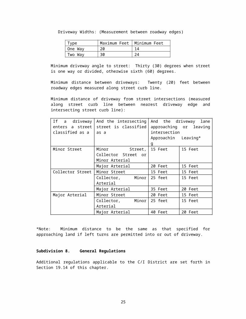
3. All driveways to or from public streets shall be subject to the following restrictions:
Driveway Widths: (Measurement between roadway edges)
Type Maximum Feet Minimum FeetOne Way 20 14Two Way 30 24
Minimum driveway angle to street: Thirty (30) degrees when street is one way or divided, otherwise sixth (60) degrees.
Minimum distance between driveways: Twenty (20) feet between roadway edges measured along street curb line.
Minimum distance of driveway from street intersections (measured along street curb line between nearest driveway edge and intersecting street curb line):
If a driveway enters a street classified as a
And the intersecting street is classified as a
And the driveway lane approaching or leaving intersection Approaching Leaving*
Minor Street Minor Street, Collector Street or Minor Arterial
15 Feet 15 Feet
Major Arterial 20 Feet 15 FeetCollector Street Minor Street 15 Feet 15 Feet
Collector, Minor Arterial 25 feet 15 FeetMajor Arterial 35 Feet 20 Feet
Major Arterial Minor Street 20 Feet 15 FeetCollector, Minor Arterial 25 feet 15 FeetMajor Arterial 40 Feet 20 Feet
*Note: Minimum distance to be the same as that specified for approaching land if left turns are permitted into or out of driveway.
Subdivision 8. General Regulations
Additional regulations applicable to the C/I District are set forth in Section 19.14 of this chapter.
17

19.07A COM COMMUNICATIONS DISTRICT (Added by Amendment August 28, 1996)
Subdivision 1. Purpose
The COM Communications District is designed to provide a compact area suitable for electronic communications transmitters, receivers and antennas and associated structures and equipment. The communications district shall be limited to:
The North 900 feet of the SW1/4 of NE1/4, Section 17, Township 61North, Range 1 East;
And
The East 330 feet of the SW1/4 of NE1/4, Section 17, Township 61 North, Range 1 East., WHICH LIES West of Cook County Road No. 64.
Subdivision 2. Permitted Principal Uses
i. Electronic and telecommunication towers, radio, television and other telecommunications towers and associated structural devices.
ii. Satellite, microwave , and other receivers and transmitters and systems.
iii. Accessory uses, included:a. Structures for storage, maintenance and repair of the permitted uses.b. Fences and other security and safety structures and equipment.
Subdivision 3. Height, Yard Setbacks and Lot Coverage Requirements
Height and yard setbacks and lot coverage requirements shall be set by the city council on a case-by-case basis. Factors to be considered by the council shall include, but not be limited to:
i. Public safety.ii. Aestheticsiii. The public need for the communications systems and the availability of alternative sites.iv. The reasonable needs of the applicant.
Subdivision 4. Personal Telecommunications Equipment
Nothing in this amendment shall be deemed to limit the right of homeowners or businesses from installing or maintaining television, radio, or telephone equipment which is otherwise permissible under other provisions of the Grand Marais Zoning Ordinance.
19.08 PR PROTECTED RESOURCES
Subdivision 1. Purpose
Protected Resource Districts are to include: outstanding or unique natural or scenic areas, both public and private that exist relatively free from human influence; significant archeological or historic areas and state parks and other public lands managed for resource conservation or recreation purposes.
Subdivision 2. Permitted Principal Uses
18
Within a PR District, unless otherwise provided by this chapter, no uses are permitted except for the following:
1. Public parks and picnic areas, owned or operated by government agencies.
Subdivision 3. Uses by Conditional Use Permit
Buildings or land may be used for the following if granted a Conditional Use Permit as provided in Section 19.17:
1. Private parks, recreation areas.2. Interpretive centers.3. Public accesses and boat launches.4. Replacement, repair, or remodeling of designated historical buildings.5. Any water dependent industrial or water dependent transportation use: provided that the
Planning Commission finds that the proposed use is advantageously served in this location through the direct access to water transportation for receipt or shipment of supplies, goods, or commodities.
6. Docks, wharfs, and other facilities used in connection with water transportation, navigation or industrial uses.
Subdivision 4. Height, Yard Setbacks and Lot Coverage
The height, yard setbacks, and lot coverage requirement for the PR District shall be those stated in Section 19.13 District Provisions and Dimensional Requirements.
Subdivision 5. General Regulations
Additional regulations applicable in the PR District are set forth in Section 19.14, General Regulations.
19.09 PARK PUBLIC PARKLAND
Subdivision 1. Purpose
A park oriented district allowing recreational activities that are compatible with the natural environment and designed to strengthen the recreational characteristics of these areas.
Subdivision 2. Permitted uses
1. Public parks, playgrounds and recreation areas.
Subdivision 3. Uses by Conditional Use Permit
Buildings or land may be used for the following if granted a conditional use permit as provided in Section 19.17:
1. Camping areas, tent or vehicle, subject to all applicable state standards.2. Clubhouses.3. Recreational uses requiring specialized equipment, buildings or facilities.4. General stores, gasoline sales, bait sales, marina sales and service.5. Marinas.6. Boat launches and docks.7. Any water dependent industrial or water dependent transportation use; provided that the
Planning Commission finds that the proposed use is advantageously served in this location
19

through the direct access to water transportation for receipt or shipment of supplies, goods, or commodities.
8. Docks, wharfs, and other facilities used in connection with water transportation, navigation, or industrial uses.
Subdivision 4. Height, Yard Setbacks and Lot Coverage Requirement
The height, yard setbacks, and lot coverage requirement for the PARK District shall be those stated in Section 19.13 District Provisions and Dimensional Requirements.
Subdivision 5. General Regulations
Additional regulations applicable in the PARK District are set forth in Section 19.14, General Regulations.
19.10 RC RECREATIONAL/COMMERCIAL
Subdivision 1. Purpose
A recreational oriented district allowing both public and private recreational activities that are compatible with the natural environment and designed to strengthen the recreational characteristic of these areas.
Subdivision 2. Permitted Uses
1. Public and private parks, playgrounds, and recreation areas.
Subdivision 3. Uses by Conditional Use Permit
Buildings or land may be used for the following if granted a Conditional Use Permit as provided in Section 19.17:
1. Golf Courses and clubhouses.2. Riding stables.3. Ski areas.4. Private commercial recreational uses requiring specialized equipment, buildings or other
facilities.5. Lodging facilities.6. Grocery, restaurants, laundromats, general stores, gasoline sales, gift shops, bait sales; when
part of a resort or lodging facility.7. Planned Unit Development.
Subdivision 4. Height, Yard Setbacks and Lot Coverage Requirements
The height, yard setbacks, and lot coverage requirement for the RC District shall be those stated in Section 19.13 District Provisions and Dimensional Requirements.
Subdivision 5. General Regulations
Additional regulations applicable in the RC District are set forth in Section 19.14, General Regulations.
19.11 SC COMMUNITY/SERVICES
Subdivision 1. Purpose
20

The SC Community/Services District is designed to provide an efficient location for public and community service uses.
Subdivision 2. Permitted Principal Uses
1. Government buildings.2. Schools.3. Community center.4. Recreation center.
Subdivision 3. Uses by Conditional Use Permit
Buildings or land may be used for the following if granted a Conditional Use Permit as provided in Section 19.17:
1. Single and Multiple Family Housing.2. Congregate housing.3. Fairgrounds.4. Clubs, lodges, or organization center, non-profit only.5. Planned Unit Developments.6. Home Occupations/SC Zoned Property (Added by Amendment Ord.2000-14)
Subdivision 4. Height, Yard Setbacks and Lot Coverage Requirements
The height, yard setbacks, and lot coverage requirement for the SC District shall be those stated in Section 19.13 District Provisions and Dimensional Requirements.
Subdivision 5. General Regulations
Additional regulations applicable in the SC District are set forth in Section 19.14, General Regulations.
19.12 BDA BUSINESS DEVELOPMENT AREA
Subdivision 1. Purpose
It is the purpose of the Business Development Area District to create areas suitable for development of manufacturing, warehousing, and other similar industrial uses which are either: a) uses whose operations are relatively free from objectionable influences; or b) uses whose objectionable features will be minimized or eliminated by design and/or appropriate devises. These uses should be compatible with each other and surrounding land uses.
Subdivision 2. Permitted Principal Uses
Within a BDA District, unless otherwise provided by this chapter, no uses are permitted except for the following:
1. Light manufacturing including, but not limited to wood products, electric and electronic devices, clothing, hardware, metal stamping, printing, tools, instruments and controls.
2. Repair, service or storage of heavy vehicles or equipment.3. Sawmills, debarking, chipping, wood products storage and other timber processing
operations.4. Warehousing and wholesale business.5. Offices.
21

6. Retail sales.7. Public utilities.8. Research or Testing facilities.9. Accessory uses.
Subdivision 3. Uses by Conditional Use Permit
Buildings or land may be used for the following if granted a Conditional Use Permit as provided in Section 19.17:
1. Bulk oil or chemical storage tanks.
Subdivision 4. Requirements
1. Minimum lot area: No minimum if on public sewer/water. One acre if on individual sewage treatment system.
2. Minimum lot width: None.
3. Lot line setbacks: Business Development Area perimeter boundaries.
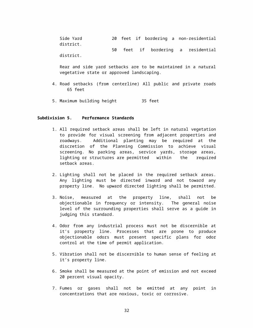
Rear Yard 20 feet if bordering a non-residential district.50 feet if bordering a residential district.
Side Yard 20 feet if bordering a non-residential district. 50 feet if bordering a residential district.
Rear and side yard setbacks are to be maintained in a natural vegetative state or approved landscaping.
4. Road setbacks (from centerline) All public and private roads 65 feet
5. Maximum building height 35 feet
Subdivision 5. Performance Standards
1. All required setback areas shall be left in natural vegetation to provide for visual screening from adjacent properties and roadways. Additional planting may be required at the discretion of the Planning Commission to achieve visual screening. No parking areas, service yards, storage areas, lighting or structures are permitted within the required setback areas.
2. Lighting shall not be placed in the required setback areas. Any lighting must be directed inward and not toward any property line. No upward directed lighting shall be permitted.
3. Noise, measured at the property line, shall not be objectionable in frequency or intensity. The general noise level of the surrounding properties shall serve as a guide in judging this standard.
4. Odor from any industrial process must not be discernible at it’s property line. Processes that are prone to produce objectionable odors must present specific plans for odor control at the time of permit application.
22

5. Vibration shall not be discernible to human sense of feeling at it’s property line.
6. Smoke shall be measured at the point of emission and not exceed 20 percent visual opacity.
7. Fumes or gases shall not be emitted at any point in concentrations that are noxious, toxic or corrosive.
8. Every operation shall be carried on with reasonable precautions against fire and explosive hazards.
Subdivision 6. Accessory Residential Use
For Lots 3-8, Block 5, owner occupied residences are permitted as accessory uses subject to the following standards:
1. An owner occupied residence can be located on a second story or attached to the side of building containing a permitted principal commercial or light industrial use.
2. Separate ingress/egress shall be provided for the residence and other emergency entrances shall be provided as required by applicable codes.
3. One parking space shall be provided for the residence in addition to any other spaces as required in this chapter.
4. Land use permit applications including residences shall explicitly state the proposed light industrial and commercial uses in the building. Land use permit approval shall be limited to the disclosed and approved uses, unless and until the City approves a change of use.
19.13 RCN RESORT/COMMERCIAL NEIGHBORHOOD
Subdivision 1. Purpose
The RCN District is intended to provide for a mix of residential, low intensity commercial, and governmental uses. It is further specifically intended that the internal development be of a residential scale and appearance comparable with the surrounding residential area. The purpose and intent of the resort/commercial neighborhood district is to permit the designation of suitable locations for small scale low intensity resort/commercial facilities within or adjacent to areas or neighborhoods which are essentially residential in nature.
Subdivision 2. Permitted Principal Uses
Within an RCN District, unless otherwise provided by this chapter, no uses are permitted except the following:
1. One and two family attached dwellings, including mobile/manufactured homes.2. Parks and recreational areas owned or operated by governmental agencies.3. Accessory uses.
Subdivision 3. Uses by Conditional Use Permit
23
Buildings or land may be used for the following if granted a Conditional Use Permit as provided in Section 19.17:
1. Lodging.2. Bed and Breakfast homes.3. Government building, provided that no building shall be located within fifty (50) feet of
any abutting lot in any residential district.4. Home occupations as defined in Section 19.02m Subdivision 2.5. Self-service laundromats and car washes.6. Apartment buildings and multiple dwelling units.7. Planned unit developments.8. Churches, parish homes, convents, children’s nurseries and schools, provided that no
building shall be located within fifty (50) feet of any abutting lot in any residential district.
Subdivision 4. Height, Yard Setbacks and Lot Area and Coverage Requirements
Height, yard setbacks and lot area and coverage requirements shall be as stated in Section 19.13, District provisions and Dimensional Requirements. NOTE: PROPOSED REQUIREMENTS ARE SAME AS FOR R-1 ZONE DISTRICT, EXCEPT MAXIMUM HEIGHT SHALL BE 30 FEET.
Subdivision 5. General Regulation
Additional regulations applicable in the RCN District are set forth in Section 19.14, General Regulations.
Subdivision 6. Performance Standards
The following controls shall be satisfied when new construction, change of use or other activity requiring a land use permit takes place in the Resort/Commercial Neighborhood (RCN).
1. Hotels
A. Required Setback Areas A detailed landscaping plan shall be submitted for all the required setback areas to achieve visual screening. No parking areas, service yards, storage areas, lighting or structures are permitted within the required setback areas.
B. LightingLighting shall not be placed in required setback areas and must be directed inward and not toward any property line. No upward directed lighting shall be permitted. All lighting on premises must be directed inward and not create glare on adjacent properties.
C. NoiseNoise, measured at the property line, shall not be objectionable in frequency or intensity. The general noise level of surrounding properties shall serve as a guide in judging this standard. This ordinance shall adopt by reference, Minnesota Pollution Control Agency Rules, Chapter 7010, Noise Pollution Control Rules.
D. Minimum Lot Area: 12,000 square feet.
E. Open Space Requirement At least 30% of the lot area must be preserved as open space. Open space does not include parking areas.
24
F. Density The total square footage of the rental units shall not exceed 30% of the total lot area.
G. ParkingOne off-street parking space is required for each rental or living unit. One additional off-street parking space is required for each non-resident employee.
H. Signs 1. One sign not to exceed 32 square feet shall be allowed.2. No internally illuminated signs shall be allowed.3. Free-standing signs shall not exceed 10 feet in height.4. Signs shall be setback at least 5 feet from the street right-of-way.5. No roof signs shall be allowed.
2. Bed and Breakfast Homes
A. A maximum of five (5) bedrooms may be rented with a maximum occupancy of ten (10) persons at one time.
B. Off-street parking shall be provided with a minimum of one space per guest room and one space for the operator.
C. Bed and breakfast facilities shall meet lot size and all setback requirements for the zone district in which they are located.
D. Signs shall be limited to a maximum size of six (6) square feet.
E. The owner or manager shall be in residence when rooms are being rented by paying guests.
F. The facility shall not be used for commercial, receptions, parties, etc. for other than overnight guests.
G. A license is required from the State of Minnesota.
H. If ownership is transferred, an amended conditional use permit must be applied for by the new owner within 60 days of the change of ownership. The conditional use permit will terminate if the amended permit is not requested within 60 days.
I. Lighting shall not be placed in required setback areas and must be directed inward and not toward any property line. No upward directed lighting shall be permitted. All lighting on premises must be directed inward and not create glare on adjacent properties.
3. Government Buildings
A. Setback from residential property: 50 feet.
B. Signs:
1. One sign not to exceed 24 square feet shall be allowed.2. No internally illuminated signs shall be allowed.3. Free standing signs shall not exceed ten feet in height.4. Signs shall be setback at least five feet from the street right-of-way.5. No roof signs shall be allowed.
25
4. Self-service laundromats and car washes
A. Lighting:
Lighting shall not be placed in required setback areas and must be directed inward and not toward any property line. No upward directed lighting shall be permitted. All lighting on premises must be directed inward and not create glare on adjacent properties.
B. Signs:
1. One sign not to exceed 32 square feet shall be allowed.2. No internally illuminated signs shall be allowed.3. Free standing signs shall not exceed ten feet in height.4. Signs shall be setback at least five feet from the street right-of-way.5. No roof signs shall be allowed.
5. Churches
A. Lighting:
Lighting shall not be placed in required setback areas and must be directed inward and toward any property line. No upward directed lighting shall be permitted. All lighting on premises must be directed inward and not create glare on adjacent properties.
B. Signs:
1. One sign not to exceed 32 square feet shall be allowed.2. No internally illuminated signs shall be allowed.3. Free standing signs shall not exceed ten feet in height.4. Signs shall be setback at least five feet from the street right-of-way.5. No roof signs shall be allowed.
26
19.13A TABULATION OF DISTRICT PROVISIONS AND DIMENSIONAL REQUIREMENTS
R-1 R-2 DW H61 MU C/I PR RCN PARK RC SC BDA1. Height 35 ft 35 ft 30 ft 30/35 ft† 30/35 ft‡ 35 ft 15ft 30 ft 30 ft 35 ft 35 ft 35 ft2. Yard Setback (structure only)
a) Front: Bldg line to right-of-way line
25 ft 40 ft Not required
Not required
Not required
10 ft 25 ft 25 ft 25 ft 25 ft 25 ft 65 ft
b) Side (each side) 10 ft 25 ft Not required
Not required
Not required
15 ft 15 ft 10 ft 25 ft 20 ft**
50 ftError:Referencesource notfound
20 ftError:Referencesource notfound50 ftError:Referencesource notfound
20 ftReferencesource notfound50 ftReferencesource notfound
c) Rear 25 ft 40 ft Not required
Not required
Not required
20 ft 25 ft 25 ft 25 ft 20 ftError:Referencesource notfound50 ft††
20 ftError:Referencesource notfound50 ftError:Referencesource notfound
20 ftReferencesource notfound50 ftReferencesource notfound
d) Corner (2 street exposure)
25 ft‡‡ 40 ftError:Referencesource notfound
Not required
Not required
Not required
10 ftError:Referencesource notfound
25 ftError:Referencesource notfound
25 ftError:Referencesource notfound
25 ftError:Referencesource notfound
25 ftError:Referencesource notfound
25 ftError:Referencesource notfound
65 ftReferencesource notfound
3. Total Required Lot Area
a) connected to city sewer
10,000 sq ft
10,000 sq ft
As needed As needed As needed 10,000 sq ft
10,000 sq ft
10,000 sq ft
10,000 sq ft
10,000 sq ft
10,000 sq ft
10,000 sq ft
† Building height is 30 feet. However, 35 feet may be allowed as a conditional use. The impact on views as a result of the additional 5 feet will be an important consideration.‡ Building height is limited to 30 feet, but 35 feet can be allowed as a conditional use if the additional height does not significantly impact views.§ From street centerline** If non-residential†† If residential‡‡ From each street right-of-way line
27
b) not connected to city sewer
1.61 ac. 1.61 ac. As needed As needed As needed 1.61 ac. 1.61 ac. 1.61 ac. 1 ac 1 ac 1 ac 1 ac
4. Widtha) connected to city
sewer75 ft 75 ft As needed As needed As needed As needed As needed 75 ft 75 ft 75 ft As needed As needed
As needed As needed As neededb) not connected to city
sewer200 ft 200 ft As needed As needed As needed 200 ft 200 ft 200 ft 200 ft 200 ft 200 ft 200 ft
5. Depth As needed As needed As neededa) connected to city
sewer120 ft 120 ft As needed As needed As needed As needed As needed 120 ft 120 ft 120 ft As needed As needed
b) not connected to city sewer
350 ft 350 ft As needed As needed As needed N/A N/A 350 ft 350 ft 350 ft 350 ft 350 ft
R-1 R-2 DW H61 MU C/I PR RCN PARK RC SC BDA6. Allowable % lot coverage
30% 25% N/A N/A N/A 50% 10% 30% 10% 25% 25% N/A
7. Lot area per dwelling §§ Error:Referencesource notfound
N/A N/A N/A N/A N/A Error:Referencesource notfound
N/A Error:Referencesource notfound
Error:Referencesource notfound
N/A
8. Boundary line setback for structures from “R” districts
N/A N/A 50 ft 50 ft 50 ft 50 ft 50 ft N/A 50 ft 50 ft 50 ft 50 ft
9. Performance standards
N/A N/A Yes*** YesError:Referencesource notfound
YesError:Referencesource notfound
YesError:Referencesource notfound
N/A N/A N/A N/A N/A Yes†††
10. Screening and landscaping
‡‡‡ Error:Referencesource notfound
Error:Referencesource notfound§§§
Error:Referencesource notfoundError:Referencesource not
Error:Referencesource notfound
Error:Referencesource notfound
Error:Referencesource notfound
Error:Referencesource notfound
Error:Referencesource notfound
Error:Referencesource notfound
Error:Referencesource notfound
Error:Referencesource notfound
§§ 2,000 additional square feet for each dwelling unit over two in number.*** Section 19.07, Subdivision 5††† Section 19.12, Subdivision 5‡‡‡ Section 19.14, Subdivision 17§§§ Section 19.07, Subdivision 6
28
11. General Regulations
Section 19.14
Section 19.14
Section 19.14
Section 19.14
Section 19.14
Section 19.14
Section 19.14
Section 19.14
Section 19.14
Section 19.14
Section 19.14
Section 19.14
12. Special district **** Error:Referencesource notfound
†††† Error:Referencesource notfound
Error:Referencesource notfound
‡‡‡‡ ---- Error:Referencesource notfound
none none none none
13. Minimum building width
17 ft 17 ft N/A N/A N/A N/A N/A 17 ft N/A N/A N/A N/A
**** All non-residential uses shall be a minimum of 50 feet from any abutting residential lot.†††† Lighting and glare; sign overhang - Section 19.06, Subdivision 5.‡‡‡‡ Traffic circulation, Section 19.07, Subdivision 7.
29

19.14 GENERAL REGULATIONS
Subdivision 1. Scope of Regulations
1. Except as may otherwise be provided in Section 19.16, Non-conforming Structures and Uses, all buildings erected hereafter, all uses of land or buildings established hereafter, all structural alterations or relocation of existing buildings occurring hereafter, and all enlargements of additions to existing uses occurring hereafter shall be subject to all regulations of this chapter which are applicable to the zoning districts in which such buildings, uses or land shall be located.
2. No application for a building permit or other permit or license, or for a certificate of zoning compliance shall be approved by the Zoning Enforcement Officer and no permit or license shall be issued by any other City department which would authorize the use or change in use of any land or building contrary to the provisions of this chapter, or the erection, moving alteration, enlargement, or occupancy of any building designed or intended to be used for a purpose or in a manner contrary to the provisions of this chapter.
3. Area Regulations: No lot area shall be so reduced or diminished that the yards or other open spaces shall be smaller than prescribed by this chapter, nor shall the density of population be increased in any manner except in conformity with the area regulations as hereinafter provided, nor shall the area of any lot be reduced below the minimum requirement herein established.
Subdivision 2. Erection of more than one principal structure on a lot
In any district, more than one structure housing a permitted or permissible principal use may be erected on a single lot, provided that yard and other requirements of this chapter shall be met for each structure as though it were on an individual lot.
Subdivision 3. Accessory Buildings
1. In case an accessory building is attached to the main building, it shall be made structurally a part of the main building and shall comply in all respects with the requirements of this chapter applicable to the main building. An accessory building, unless attached to and made a part of the main building, shall not be closer than five (5) feet to the main building.
2. A detached accessory building shall not be located in any required front yard, except where such front yard lies between the building line an the shoreline, in which case such arrangement may be permitted.
3. A detached accessory building not over (1) story and not exceeding twelve (12) feet in height shall occupy not more than thirty (30) percent of the area of any side or rear yard, providing further that no detached accessory building shall be placed nearer than two and one-half (2-1/2) feet from any side or rear lot line, except that a two-stall garage may be used jointly and solely by the families living on two (2) adjacent lots and may be built so as to place one (1) stall on each side or rear lot line, provided that the two (2) stalls are separated by a fire wall.
4. Decks located in the side or rear yard of a lot and under 4’ in height are accessory structures and may be located up to 2 ½’ from the side or rear lot line.
30

Subdivision 4. Height Regulations
1. Where the average slope of a lot is greater than one (1) foot rise or fall in seven (7) feet of horizontal distance from the established street elevation at the property line, one story in addition to the number permitted in the district in which the lot is situated shall be permitted on the downhill side of any building.
2. In districts where the following structures are permitted, heights of the following structures may exceed limits set forth elsewhere in this ordinance.
a. Monumentsb. Flag Polesc. Chimneys or Smoke Stacksd. Lookout Towerse. Windmill and Wind Generatorsf. Water Towersg. Church Spires, Belfries, or Domesh. Radio and Television Antennae and Transmitting Towers
Subdivision 5. Yard Regulations
The following requirements qualify or supplement, as the case may be, the district regulations appearing elsewhere in this chapter. Measurements shall be taken from the nearest point of the wall of a building to the lot line in question, subject to the following qualifications:
1. Every part of a required yard or court shall be open from its lowest point to the sky, unobstructed except for the ordinary projections of window wells above the bottom of such yard or court and except for the projections of sills, belt courses, cornices and ornamental features not to exceed eighteen (18) inches.
2. Open or lattice enclosed fire escapes, fireproof outside stairways and balconies opening upon fire towers projecting into a yard not more than two (2) feet or into a court not more than three and one-half (3-1/2) feet shall be permitted, where the same are to be so placed as not to obstruct light and ventilation.
3. A yard, court, or other open space provided about any building for the purpose of complying with the provisions of this chapter shall not again be used as a yard, court, or other open space for another building.
4. The setback requirements shall be observed on each street side of a corner lot-provided, however, that the buildable width of a lot shall not be reduced to less than thirty (30) feet.
5. A total setback requirement of three hundred (300) feet shall be mandatory for all land uses handling highly explosive or inflammable materials in quantity, such as gas service stations, bulk fuel or oil dealers and similar operations, from all schools, churches, hospitals, or any public meeting place having a seating capacity of fifty (50) or more persons.
6. Yards for Open Land Uses:
Where a lot is to be occupied for permitted uses without buildings or structures thereon, the side yards and front yards required herein for the zone within which such lot is located, shall be provided and maintained between such use and the respective lot
31
lines--provided that side and rear yards shall not be required on lots without buildings or structures, used for garden purposes or public playgrounds.
7. Permitted Obstructions in Required Yards:
The following shall not be considered to be obstructions when located in the required yards specified:
a. In Front Yards:
One story bay windows projecting three (3) feet or less into the yard; and overhanging eaves and gutters projecting two and one-half (2-1/2) feet or less into the yard.
1. A landing place or uncovered porch may extend into the required front yard to a distance not exceeding six (6) feet, if the eland place or porch has its floor no higher than the entrance floor of the building. An open railing no higher than (3) feet may be placed around such place.
2. The required front yard of a corner lot shall not contain any wall, fence, or other structure, tree, shrub, or other growth which may cause danger to traffic on a street or public road by obscuring the view.
3. On double frontage lots, the required front yard shall be provided on both streets.
4. Air conditioning units, including window units, shall be located a minimum of twenty (20) feet from all lot lines, but not within the front yard.
b. In Side Yards:
Overhanging eaves and gutters projecting into the yard for a distance of two (2) inches per foot of required side yard.
c. In Rear Yards:
Enclosed, attached, or detached off-street parking spaces; open off-street parking spaces; accessory structures, tool rooms, and similar buildings or structures for domestic storage; balconies; breezeways and open porches; one story bay windows projecting two and one-half (2-1/2) feet or less into the yard; and overhanging eaves and gutters projecting two and one-half (2-1/2) feet or less into the yard.
1. In determining the depth of rear yard for any building where the rear yard opens into an alley, one-half (1/2) the width of the alley, but not exceeding ten (10) feet, may be considered as a portion of the rear yard.
Subdivision 6. Vision Clearance
1. Fences, Walls in Front Yard:
In any residence zone on any corner lot, no fence or accessory structure or planting shall rise over two and one-half (2-1/2) feet in height above the level of the public sidewalk within twenty (20) feet of any corner, so as to interfere with traffic visibility across the corner. No fence or wall or shrub planting of more than two and one-half (2-1/2) feet in height above the level of the public sidewalk shall be erected on any interior
32
lot within ten (10) feet of the front property line where it will interfere with traffic visibility from a driveway.
2. Fences in Side Yard:
No fence or wall, other than a retaining wall, along a side line of a lot in a residence zone, shall be higher than four (4) feet unless any part above such a height has at least fifty (50) percent of the surface uniformly open and unobstructed, unless the adjoining lot is not in a residential zone.
3. Fences in Rear Yard:
Fences having a height of six (6) feet or less may be used to locate property lines within the required rear yards in the residence district.
Subdivision 7. Street Closures
Whenever any street, alley, or other public way is vacated by official action of the City, the zoning district adjoining each side of such street, alley or public way shall be automatically extended to the center of such vacation, and all area included in the vacation shall then and henceforth, be subject to all appropriate regulations of the extended districts.
Subdivision 8. Areas Under Water
All areas within the City which are under water and not shown as included within any zone shall be subject to all of the regulations of the zone which immediately adjoins the water area. If the water area adjoins two or more zones, the boundaries of each zone shall be construed to extend into the water area in a straight line until they meet the other district at a half-way point.
Subdivision 9. Essential Services
Essential services shall be permitted as authorized and regulated by law and the City Code in any district, it being the intention hereof to exempt such erection, construction, alteration, and maintenance from the application of this chapter.
Subdivision 10. Structures to have Access
Every building hereafter erected or moved shall be on a lot adjacent to a public street, or with access to an approved private street, and all structures shall be so located on lots as to provide safe and convenient access to servicing, fire protection, and required off-street parking.
Subdivision 11. Sign Regulations
1. PURPOSE AND INTENT
The purpose of these regulations are to protect and promote the general welfare, health, safety, and order in the City of Grand Marais through establishment of a comprehensive series of standards, regulations, and procedures governing the erections, use, display, and maintenance of devices, signs, or symbols serving as channels of communication (hereinafter “Signs”) to the public which resides, works and visits in the City other than signs required by law and whose placements, size, color and other features are otherwise governed by law.
33

The provisions of these regulations are intended to encourage creativity, a reasonable degree of freedom of choice, an opportunity for effective communication, and a sense of concern for visual amenities by those who design, display or otherwise utilize signs of the types regulated by this ordinance; while at the same time assuring that the public is not endangered, annoyed or unduly distracted by the unsafe, unsightly, disorderly, indiscriminate or unnecessary use of such signs and sign facilities.
Further objectives of these regulations are to assure compatibility of signs with surrounding land uses, to protect property values in all districts, to protect the public investment in streets and highways, to promote the safety and recreational value of public travel, to strengthen the economy and to improve the appearance of the City.
2. APPLICATION FOR A SIGN PERMIT
a. Application for a sign permit shall be made to the Zoning Administrator on forms provided for that purpose. Each application shall be filled out completely.
b. The application shall include a complete description of the sign and a sketch showing size, location, manner of construction, dimensions and such other information as the Zoning Administrator shall deem necessary to inform him of the kind, size, material, construction and location of the sign.
c. The applicant shall submit at the time of application any fee or fees required by the ordinances of the City.
d. All applicants will be issued or denied by the Zoning Administrator within 30 days of the receipt of the application in the office of the Zoning Administrator.
e. If a sign authorized by permit has not been installed and completed within 3 months after the date of issuance of the permit, the permit shall be canceled.
3. GENERAL REGULATIONS APPLICABLE TO ALL SIGNS
a. Permits are required for all new, relocated, modified or redesigned signs except those specifically exempted in Sec. D.
b. No sign shall contain any indecent or offensive picture or written matter.
c. No sign which purports to be or resembles an official traffic control device, sign or signal; or which hides from view or interferes with the ability of drivers or pedestrians to see any traffic control device, sign or signal, or which obstructs or interferes with a driver’s view of approaching, merging or intersection traffic for a distance not to exceed 200 feet; or which resembles an official sign erected by a governmental agency; or which bears the word “Stop” , “Caution”, “Danger”, “Warning”, or similar words, shall be erected.
d. No sign other than governmental signs shall be erected or temporarily placed within any street right-of-way or upon any public easement, except as specifically permitted herein.
e. For the purposes of this ordinance, any change in advertising area which exceeds the advertising area for which a permit has been issued shall require a new permit.
f. Every sign, including, but not limited to, those signs for which no permits or permit fees are required, shall be maintained in a safe, presentable and good structural material condition at all times, including the replacement of defective parts, painting, repainting,
34

cleaning and maintaining the immediate surrounding premises in a clean, sanitary and inoffensive condition free of obnoxious substances, rubbish and weeds. Signs in good repair are not corroded, do not have deteriorated paint on finished surfaces and do not have loose members, broken parts or similar deterioration.
4. NO SIGN PERMIT REQUIRED
Sign permits are not required for the following:
a. Campaign signs posted by a bona fide candidate for political office or by a political issue or a political candidate may be placed on private property in any district with the permission of the tenant or owner. No campaign sign shall be posted on public property. Only one campaign sign per street frontage per candidate is allowed. The maximum area for such a sign is 8 square feet. Any one dimension of the sign cannot exceed 4 feet. Such signs may be posted for a period of not more than 30 days before an election and must be removed not more than 10 days after an election. The tenant and the owner of the private property on which the sign is displayed are both responsible for the removal of all such signs.
For the purposes of this provision, a primary election and the following general election held in the same year for the same office shall be considered one election.
b. Lettering or symbols which are an integral part of the design of a gasoline or other pump utilized in the operation of a service station shall be permitted. The dimensions of such lettering or symbols are to be included in total surface area allowed for the business operated on the premises.
c. A window sign affixed to or within 12 inches of the interior of a window and not exceeding 20% of the window area.
d. Signs erected by a government unit.
e. Memorial signs or tablets containing the name of the building, its use and date of erection when cut or built into the walls of the building and constructed of bronze, brass, stone or marble, or similar substance, in harmony with the exterior appearance of the building.
f. The flag of any state or nation respectfully displayed.
g. Advertising signs located on the vehicles of common carriers or motor vehicles bearing current license plates. Such vehicles must either be traveling or be lawfully parked upon the public right-of-way.
h. Banners, pennants and temporary signs upon private property used for grand openings, special events and holidays, but each such sign must be given approval for a temporary sign permit by the Zoning Administrator and such approval is to be for a period of 30 days or less at the discretion of the Zoning Administrator.
i. Free standing or portable signs for garage sales or similar events occurring within the corporate limits of the City, not exceeding 4 square feet in sign surface area, erected on private property with permission of the landowner and displayed for not more than 3 days. At least one dimension of the sign must be a minimum of 1 foot. The occupant of the private property on which the sign is displayed is responsible for the removal of such sign.
35
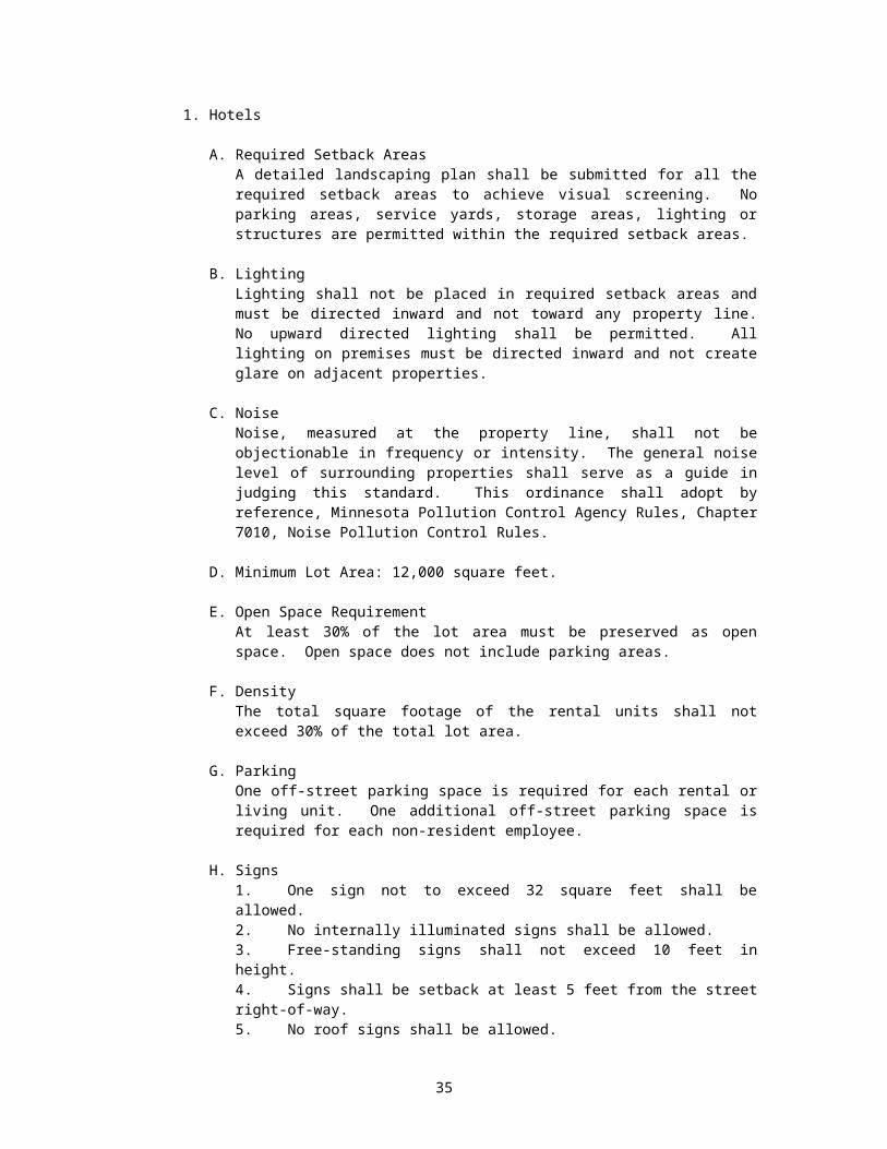
j. Signs denoting the architect, engineer or contractor when placed upon work under construction, provided the total sign area of all such signs does not exceed 12 square feet and provided that the sign is removed upon completion of construction or prior to a date 6 months after the sign is first placed on the property, whichever is earlier.
k. Signs for the purpose of selling or leasing individual lots or buildings, provided:
1) Such sign shall not exceed 12 square feet in area;
2) Only one such sign is permitted per street frontage upon which the property abuts; and,
3) Such signs shall be removed within 7 days following the lease or sale.
l. One identification sign identifying an owner or occupant of a building, not exceeding 2 square feet, and the sign shall not contain any advertising information except identifying the occupation of the occupant.
i. Directional signs, not illuminated and not exceeding 2 square feet, displaying directional information only for community organizations, such as churches, schools, hospitals, nursing homes, clubs, libraries or similar uses, and excluding office or commercial establishments. Only one such sign for each avenue or street directly leading to the establishment shall be allowed.
ii. Government funding signs that do not exceed 32 square feet in size.
5. SIGNS PROHIBITED IN ALL ZONING DISTRICTS
The following signs will not be erected or maintained:
a. Any sign that does or would obstruct a window (except as specifically provided herein), door, fire escape, stairway, or opening intended to provide light, air or access to any building or structure upon which the sign may be attached or otherwise appurtenant thereto, or any adjoining building or structure.
b. Any illuminated sign which moves, revolves or changes in either color or in intensity of light, except one giving time, date, temperature, weather or similar public service information.
c. Any inflatable or flying device designed and utilized primarily to draw attention to an object, product, place, activity, institution or business.
d. Any sign painted, attached to or in any manner affixed to trees, rocks, fences, poles or other structures not originally intended to be sign structures.
e. Any internally illuminated sign except when given a conditional use permit.
f. Any sign which no longer advertises a bona fide business conducted or product sold or any sign structure or frame no longer containing a sign.
g. Any sign that is erected or maintained in such a manner so as to obscure an official traffic control device or sign.
6. SIGNS PERMITTED BY ZONING DISTRICTS
36

a. Permitted signs in any permanent residence district (R-1) or medium density multiple dwelling residence district (R-2) may be erected subject to the following provisions:
1) An identification sign identifying the owner or occupant of a building or dwelling unit as provided in subsection D.
2) A sign with a maximum surface of 4 square feet may be allowed for home occupation or business in lieu of any other identification sign. Such sign may be illuminated in accordance with this Ordinance.
3) One on-site identification sign (per street front) not to exceed 24 square feet in surface area, displaying information for churches, schools, hospitals, nursing homes, clubs, libraries, or similar use. Such sign may be illuminated in accordance with this Ordinance.
b. Permitted signs in the Downtown Districts (DW, H61, MU), the service commercial industrial district (C/I), and the business development area district (BDA) may be erected subject to the following provisions:
1) Sign Area:
a) The total surface area of all business signs for a particular business property shall not exceed 1.5 square feet per lineal foot of lot frontage area, or 50 square feet in area, whichever is greater. Such signs may be illuminated in accordance with this Ordinance.
b) For Corner lots, the frontage used to determine allowable sign area shall be the least dimension along a street, but an equivalent sign area shall be allowed facing the intersecting street.
2) Wall Signs:
a) No wall sign, including cutout letters, shall project more than 6 inches from the building wall.
b) The top edge of a wall sign shall not extend beyond the mid-point of the roof as measured from peak to the eaves on a peaked roof building or to the top of the facade on a flat roof building.
c) No wall sign shall extend beyond the end of the wall to which it is attached.
d) Wall signs painted on a building shall be governed by the square footage limitations specified in Section F.2.a. (1) of this Ordinance.
3) Projecting Signs:
a) The top edge of a projecting sign shall not be higher than the eave line of a one-story building and the top edge of the sign may not be higher than the bottom of the sills of the first level of windows above the first story in a multiple story building. Such sign shall be a minimum of 8 feet above grade when located adjacent to or projecting over a pedestrian way.
37

b) A projecting sign shall not exceed 30 square feet in surface area. Said signs hall be limited to one sign per principal occupant of a building frontage.
c) Projecting sign shall not be more than 15 feet above grade.
d) A projecting sign shall not project more than 5 feet from the wall of the building to which it is attached.
4) Freestanding Signs:
a) Shall not exceed a height of 30 feet above grade.
b) The base of the advertising area shall be a minimum of 8 feet above grade when located within 5 feet of a pedestrian way unless the base and pedestal is designed so as to not interfere with pedestrians.
c) Shall not exceed 100 square feet of surface area.
d) Limited to 1 sign per 100 feet of street frontage or less and to only one sign for any additional street frontage beyond 100 feet. Only one street shall be used in computing this dimension.
5) Portable Signs:
a) There shall be no more than one portable sign per business.
b) All portable signs shall be 24 inches wide and 48 inches high. The size of a portable sign shall not be included in the total square footage allowed on other permitted signs.
c) Portable signs shall be displayed only during the hours the business is open.
d) An annual permit is required for all portable signs. Permits for portable signs shall expire on the last day of each year.
6) Window Signs:
a) No Window sign shall occupy more than 20% of the total area of the window in which the sign is located.
b) The surface area of such sign is not to be included in the overall computation of the square footage allowed on other permitted signs.
7) Awnings and Canopies:
a) May be no less than 7.5 feet above grade when overhanging the right-of-way and shall not project beyond two feet inside the curb line.
b) Letter or symbols must be painted on or attached flat against the surface of, but not extending beyond or attached to the underside of the canopy or awing.
c) Letters or symbols painted on or attached to the canopy or awning shall not exceed 10 inches in height.
38
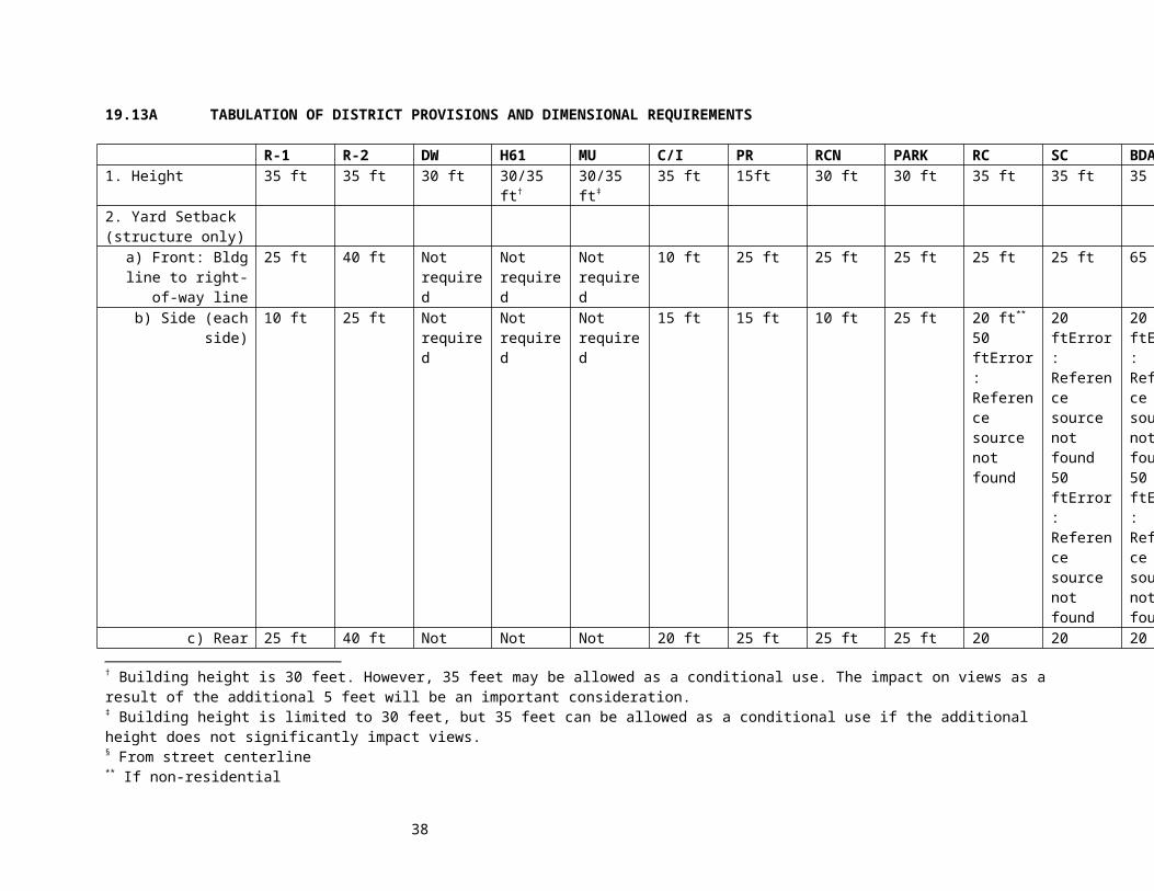
d) The only sign allowed on awnings or canopies shall be the name of the store, logo, date the business was founded, and the street number. The combined area of such sign shall be counted as part of the total square footage allowed on the permitted signs.
8) Roof Signs:
a) Allowed by conditional use permit only.
b) Such signs shall not project higher than 5 feet above the height of the building to which it is attached. For a building less than 50’ in width the sign shall not extend more than 10% of the building width above the roof.
c) Height of roof signs shall not exceed 30’ above grade.
d) The bottom of roof signs shall be no higher than the height of the roof where attached
9) Graphic Signs:
a) Allowed by conditional use permit only.
c. Permitted signs in the Service-Commercial Industrial Zone District (C/I) may be erected subject to the following provisions:
1) Billboards
a) Billboards shall be limited to one for a lot of 100 foot frontage or less and to only one additional sign for additional lot frontage beyond 100 feet.
b) Billboards shall not be larger than 100 square feet per face.
c) Billboards shall be spaced at least 350 lineal feet from another billboard.
d) Billboards shall not be permitted to be erected within 100 feet of an adjoining residential district boundary line or any public park, school, library, church or government building.
e) The maximum height of all billboards shall not exceed 20 feet above ground.
f) Billboards erected side by side, back to back, or in a V-type construction by one owner shall be deemed to be one sign structure and will be required to have only one permit. Each side of a sign of a sign structure so designed shall be directed toward a different direction of travel, making it impractical to simultaneously view both sides of the structure from any one traffic lane.
g) An annual permit is required for all billboards.
39
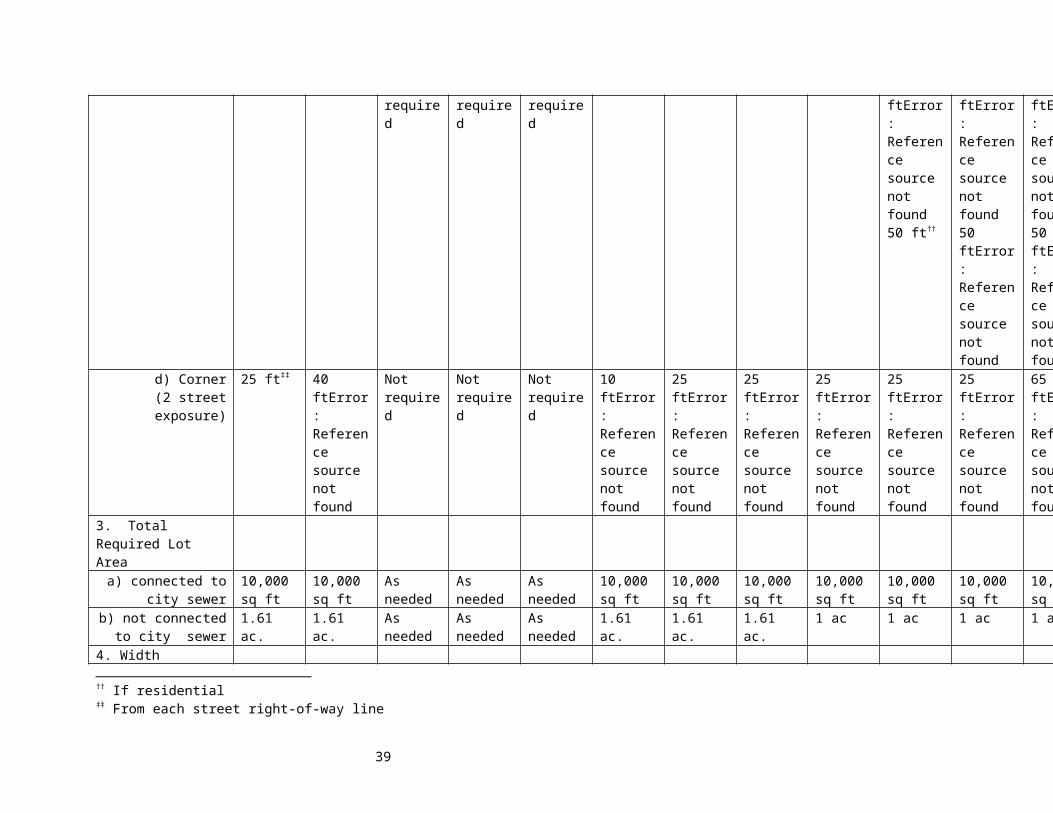
1) An applicant shall submit at the time of application any fee or fees required by ordinances of the City.
2) All applicants will be issued or denied by the Zoning Administrator within 30 days after receipt of the application in the Zoning Office.
3) Request for permit renewals will not be accepted more than 60 calendar days prior to the expiration date of the permit.
4) Permits for billboards shall expire on the last day of each year.
5) When a permit is granted for a billboard, the permit holder will be furnished a permit identification number. This number must be affixed by the permit holder to the supporting structure nearest the roadway and in such manner and height so as to be identified from the nearest traffic lane.
6) When a permit is revoked or has expired, applications for a permit for that site will be accepted from new applicants only after the billboard of the former permit holder has been completely removed.
7) For the purpose of this ordinance, a billboard for which a permit can be issued shall, when erected, be a complete billboard, advertising a product or legend. A billboard painted out, or painted over, or is advertising space for lease and has so existed for one permit period shall not be considered for a permit or renewal. Where there are only posts, a partial structure, company name markers, or no structure at all, a renewal will not be issued.
7. REVOCATIONS
Permits issued under the provisions of this Ordinance may be revoked by the Council of the City of Grand Marais after notice and hearing for any of the following causes:
a. Fraud, misrepresentation or incorrect statement contained in the application for permit;
b. Any violation of this Ordinance.
c. Notice of a hearing for revocation of a permit shall be given by the Zoning Administrator in writing, setting forth specifically the grounds for revocation and the time and place of hearing. Such notice shall be mailed, postage prepaid, to the permit holder at his or her last known address at least (5) days prior to the date set for hearing, or shall be delivered by a Police Officer in the same manner as a summons at least (3) days prior to the date set for hearing.
8. AMORTIZATION
Every sign or other advertising structure in existence on the adoption of this Ordinance which violates or does not conform to the provisions hereof, shall be removed, altered or replaced so as
40

to conform to provisions of the Ordinance within 10 years of the effective date of this Ordinance.
9. APPEAL
Any person aggrieved by the action of the Zoning Administrator in the denial or revocation of a permit under this Ordinance may appeal to the City Council. Such appeal shall be taken by filing with the Council, within 14 days after notice of action complained of, a written statement setting forth fully the grounds of the appeal together with a fee as established by City Code Chapter 25.07. The Council shall thereafter set a time and place for a hearing of the appeal.
10. VIOLATION A NUISANCE.
a. If any permit holder fails to remove or bring into compliance a sign permitted or licensed under this regulation within 30 days after notice that the permitted sign is in violation of this regulation, then the sign shall be deemed a nuisance and may be removed or altered to comply with this regulation by the Zoning Administrator. The removal or alteration shall be at the expense of the owner of the property upon which the sign is located.
b. If a sign is found by the City Council to be an immediate danger to the public because of its unsafe condition, it may be removed without notice, and written notice of removal and the reasons for such shall be given to the owner of the property on which such sign is located as soon as possible.
c. If payment is not made within 30 days after a statement for the costs of removal or alteration of a sign is sent to the owner of the property on which the sign is located, the costs may be assessed against the property on which the sign is located by certifying the costs to the County Treasurer for collection in the same manner as real estate taxes.
11. PENALTY
a. Violation of this subdivision is a petty misdemeanor. Each period of 10 days that the violation exists is a separate offense.
b. A second or subsequent conviction of a violation of the same subsection of this subdivision within one 12 month period shall be a misdemeanor.
12. EFFECTIVE DATE
a. January 28, 1991
13. DEFINITIONS
a. “Awning” means a temporary roof-like cover which projects from and is wholly or partially supported by the exterior wall of a building for the purpose of shielding a doorway or window from the elements.
b. “Banner or Pennant” means attention-getting devices which resemble flags and are of paper, cloth, plastic or similar substances.
c. “Billboard” means a sign erected and used for the purpose of advertising a product, event, place, person, or subject not related to the premises on which the sign is located.
41

d. “Canopy or Marquee” means a roof-like structure projecting over the entrance of a theater, store, etc., and that projects from the wall of a building for the purpose of shielding a doorway or window from the elements.
e. “Church Directional Sign” means a sign which bears the address and/or name of a church and directional arrows pointing to a church location.
f. “Freestanding Sign” means any self-supporting sign not attached to any other structure.
g. “Graphic Sign” means any mural or pictorial scene painted on the side of a wall or building or painted on a sign board and affixed to a wall, and which mural or scene has as its purpose artistic effect.
h. “Illuminated Sign” means a sign lighted by or exposed to artificial lighting, either by lights on or in the sign or directed towards the sign. Further definitions are:
1) “Illuminated Sign - External” means a sign which is affected by an artificial source of light which is not contained within the sign itself.
2) “Illuminated Sign - Internal “ means a sign which is illuminated by a source of light contained within the sign itself.
3) “illuminated Sign - Flashing” means any externally or internally illuminated sign which exhibits changing natural or artificial light or color effects by any means whatsoever.
i) “Moving Signs” means any sign which revolves, rotates, has any moving parts, or in which an illuminated component alternates with another to create the illusion of movement.
j) “Owner” means one who possesses the title to the property, even though subject to a leasehold interest. For the purposes of this ordinance, the term “Owner, shall include the owner of a leasehold interest and thus there can be more than one owner of a property.
k) “Portable Sign” means a sign so designed as to be movable from one location to another which is not permanently attached to the ground or any structure. See Figure 1.
l) “Projecting Sign” means any sign wholly or partially dependent upon a building or wall for support and projecting more than 12 inches therefrom. See Figure 1.
m) “Remove” means that “Remove”, “Removed”, and “Removal” shall mean the complete disassembly of a sign including all component parts, except such parts the removal of which would result in substantial structural damage to the building. All electrical services shall be disconnected, if any, and there shall be complete removal of wires, conduits, and supporting structures. All ground excavations or holes shall be filled. All disassembled elements of the sign and its supporting structure shall be removed from the property or stored inside a building.
n) “Roof Sign” means a sign that is mounted on the roof of a building or which is wholly dependent upon a building for support and which projects above the point of the building with a flat roof, the eave line of a building with a gambrel, gable, or hip roof, or the deck line of a building with a mansard roof. See Figure 1.
42

o) “Sign” means any letter, word, or symbol, device, poster, picture, statuary, reading matter or representation in the nature of an advertisement, announcement, message, or visual communication whether painted, posted, printed, affixed or constructed, which is displayed for informational or communicative purposes.
p) “Temporary Sign” means a sign or advertising display constructed of cloth, canvas, fabric, plywood, or other such light material and designed or intended to be displayed for a short period of time. See Figure 1.
q) “Wall Sign” means a sign fastened to or painted on a wall of a building or structure in such a manner that the wall becomes the supporting structure for, or forms the background surface of the sign and which does not project more than 12 inches from such building or structure. See Figure 1.
r) For the definition of words or phrases used in this ordinance, other than herein stated, reference is made to Moskowitz and Lindbloom; “The Illustration book of Development Definitions.” (1981).
43

Subdivision 12. Off-Street Parking and Loading-Unloading Space Requirements
1. Parking Space Requirements:
The required parking and loading spaces shall be provided on the premises of each use, except for non-residential uses within the Downtown Districts (DW, H61, MU). Residential uses in the Downtown Districts (DW, H61, MU) must comply with the parking requirements in section 19.02. Each parking space shall contain a minimum area of not less than three hundred (300) square feet, including access drives, and a width of not less than nine (9) feet, and a depth not less than twenty (20) feet. The minimum number of required off-street parking spaces for various uses shall be as follows:
a. One and two family dwelling - One (1) parking space per unit. No garage shall be converted into living space unless other acceptable on-site parking space is provided.
b. Apartments - One and one-half (1-1/2) parking spaces for each apartment, except housing for the elderly projects, which shall provide three-tenths (.3) parking space for each dwelling unit.
c. Mobile Home Park - One and one-fourth (1-1/4) parking spaces per mobile home berth.
d. Lodging - One (1) parking space for each rental room or suite.
e. Churches - One (1) parking space for each four (4) seats, based on the design capacity of the main seating area.
f. Elementary School or Junior High School - Two (2) parking spaces for each classroom.
g. Senior High School - One (1) parking space for each classroom plus one (1) parking space for each ten (10) students, based on design capacity.
h. Public Administration Buildings, Community Center, Public Library, Museum, Art Galleries, Post Office, and other public service buildings - One (1) parking space for each five hundred (500) square feet of floor area in the principal structure.
i. Assembly or Exhibition Hall, Armory, Auditorium, Theater or Sports Arena - One (1) parking space for each four (4) seats, based upon design capacity.
j. Golf Course, Golf Clubhouse, Country Club, Swimming Club, Tennis Club, Public Swimming Pool - Thirty-six (36) spaces, plus one (1) space for each five hundred (500) square feet of floor area in the principal structure.
k. Hospitals - One (1) parking space for each three (3) beds; convalescent or nursing homes - one (1) parking space for each four (4) beds.
l. Automobile Service Station - Four (4) parking spaces plus two (2) parking spaces for each service stall. Such parking spaces shall be in addition to gas pump service area.
m. Drive-in Restaurant - Twenty (20) parking spaces or one (1) space for each twenty (20) square feet of floor area, whichever is greater.
44
n. Restaurant, Cafe, Night Club, Tavern or Bar - One (1) parking space for each one hundred (100) square feet of floor area.
o. Bowling Alley - Ten (10) parking spaces for each bowling lane.
p. Miniature Golf Course, Archery Range or Golf Driving Range - Ten (10) parking spaces.
q. Professional Offices, Medical and Dental Clinics and Animal Hospital – Three (3) parking spaces for each five hundred (500) square feet of floor area.
r. Office Building - Three (3) parking spaces for each five hundred (500) square feet of floor area.
s. Retail Stores and Service Establishments - One (1) parking space for each two hundred (200) square feet of floor area.
t. Research, Experimental or Testing Stations - One (1) parking space for each employee on the major shift or one (1) off-street parking space for each five hundred (500) square feet of gross floor area within the building, whichever is the greater.
u. Auto Sales, Trailer Sales, Marine and Boat Sales, Implement Sales, Garden Supply Store, Building Materials Sales, Auto Repair - One (1) parking space for each five hundred (500) square feet of floor area.
v. Shopping Center - Where several business uses are grouped together according to a general development plan, on-site automobile parking shall be provided in a ratio of not less than three (3) square feet of gross parking area for each one (1) square foot of gross floor area; separate on-site space shall be provided for loading and unloading.
w. Storage, Wholesale or Warehouse Establishments - One (1) parking space for each two (2) employees on the major shift or one (1) space for each two thousand (2,000) square feet of floor area, whichever is greater, plus one (1) space for each company motor vehicle when customarily kept on the premises.
x. Manufacturing or Processing Plant - One (1) off-street parking space for each two (2) employees on the major shift or one (1) off-street parking space for each one thousand (1,000) square feet of gross floor area within the building, whichever is greater, plus one (1) space for all company motor vehicles when customarily kept on the premises.
2. Off-Street Loading Design and Maintenance:
a. Location - All required loading or unloading into or out of trucks in excess of 3/4 ton capacity, or railroad cars, shall be conducted at facilities specifically designed or designated for that purpose. These facilities shall be located upon the zoning lot of the principal use requiring them. All berths beyond one shall be separate from areas used for off-street parking.
b. Access - Each required off-street loading berth shall be so designed as to avoid undue interference with other vehicular or rail access or use of public streets, alleys, or other public transport system.
45
c. Surfacing - All off-street loading facilities, including loading berths and maneuvering areas, shall be surfaced with a hard, all weather, dust-free, durable surfacing material and shall be well drained and landscaped and shall be maintained in a sightly and well-kept condition.
d. Landscaping and Screening - All berths shall be screened from view from the property street frontage and/or from the zoning district boundary when the adjacent property or property across the street frontage or side street frontage is zoned or used for residential purposes - said screening shall be accomplished by a solid wall not less than eight (8) feet in height and shall be so designed as to be architecturally harmonious with the principal structure. Screen planting may be substituted for the prescribed wall; however, such plantings must not be less than two and one-half (2-1/2) inches in diameter and of such type as to permit a minimum of ninety (90) percent opacity during all months of the year.
e. Design - Fifty (50) percent of the required number of truck berths shall be fifty (50) feet in length, twelve (12) feet in width and fifteen (15) feet in height – all loading areas shall consist of a maneuvering area in addition to the berth and shall not use any of that portion of the site containing parking stalls - maneuvering areas shall be of such size as to permit the backing of truck tractors and coupled trailers into a berth, without blocking the use of other berths or drive or maneuvering areas.
f. Required Loading Areas:
1. Space for loading and unloading of goods, supplies and services shall be provided in addition to required off-street parking spaces and shall be sufficient to meet the requirements of each use.
2. The following uses shall observe required loading and unloading spaces as indicated:
Use Required SpacesMotels, hotels, lodging and room houses One for each structure over 20,000 square feet of
gross floor areaLight and heavy commercial uses except where otherwise specified
One space for the first 10,000 square feet of gross floor area and one space for each additional 50,000 square feet of gross floor area
Auditorium, stadium, gymnasium, community centers and religious institutions and schools centers and religious institutions and schools (private and public)
One for each structure over 100,000 square feet of gross floor area
Office building and professional offices (other than doctor and dentist); banks
One space for buildings between 30,000 and 100,000 square feet of gross floor area and one space for each additional 100,000 square feet of gross floor area
Restaurants and other food dispensing establishments, except drive-in restaurants
One for each structure with over 10,000 square feet of gross floor area
Furniture, automobile and boat sales and appliance sales
One space plus one additional space for each 25,000 square feet of gross floor area
Hospitals, rest homes One space plus one nursing homes, etc. additional space for each 25,000 square feet of gross floor area
Bowling alleys One space for each structure over 20,000 square feet of gross floor area
46
Use Required SpacesManufacturing and research, experimental or testing stations
One space for each 50,000 square feet of gross floor area
Subdivision 13. Minimum Mobile Home Park Requirements
1. Minimum Density and Area Requirements: Lot areas and density as hereby established shall be considered the minimum requirements within a mobile home park.
a. Minimum area requirements for a mobile home park shall be five (5) acres and shall not be less than one hundred fifty (150) feet in width.
b. A minimum of five hundred (500) square feet per mobile home shall be provided for definable play areas an open space within the mobile home park. Such areas of open space and/or play areas shall not be areas included within any setback nor shall they include any areas of less than twenty (20) feet in length or width.
c. Minimum lot area per unit shall be five thousand (5,000) square feet, excluding private drives, parking spaces and street rights-of-way.
2. Lot Coverage and Setback Requirements:
a. Maximum lot coverage for mobile home parks shall be twenty-five (25) percent.
b. Minimum distance between units shall be not less than twenty (20) feet, or the sum of the heights of the two units, whichever is greater; the point of measurement being a straight line between the closest point of the units being measured.
c. When a mobile home park abuts a single family residential use area, there shall be a minimum setback on that side f fifty (50) feet between the street right-of- way line and any mobile home park use; which setback area shall act as buffer zone and shall be landscaped according to a landscape plan, to be submitted at the time of application - such plan shall show the type of planting material, size, and planting schedule.
d. Street access shall not be permitted into or upon minor single family residential area streets.
3. General Internal Park Development Requirements:
a. There shall be a minimum front yard setback from the mobile home unit to the street line of fifteen (15) feet.
b. The mobile home stand shall be at such elevation, distance and angle relative to the street and driveway that placement and removal of the mobile home with a car, tow truck, or other customary moving equipment is practical. The mobile home stand shall have a longitudinal grade of less than four (4) percent and transverse crown or grade to provide adequate surface drainage. The stand shall be compacted and surfaced with a material which will prevent the growth of vegetation while supporting the maximum anticipated loads during all seasons.
47
c. The entire mobile home park shall be landscaped (excluding hard surfaced areas) and there shall be planted, or otherwise located, one shade tree with a minimum diameter of two (2) inches placed and maintained near each unit pad.
d. All utilities supplied by the mobile home park shall be underground - this shall include sanitary sewer, municipal water and electricity - when piped fuel and/or gas is provided by the mobile home park to each mobile home stand, such service shall also be located underground.
4. Parking and Street Requirements:
a. Parking:
1. Off-street parking areas shall be surfaced in accordance with the street surface standards below.
2. All required off-street parking space shall be located not further than two (200) feet from the unit or units for which they are designed.
3. A minimum of one and one-fourth (1-1/4) spaces of parking must be provided for each mobile home unit space provided within the park. The one unit space for occupant use must be within the distance from the unit established above. The remaining spaces equivalent to one-fourth (1/4) spaces must be in group compounds at an appropriate location within the park.
b. Streets:
1. Streets shall be of sufficient width so as to permit ease of access to the mobile home parking stands and the placement and removal of mobile homes without causing damage to or otherwise jeopardizing the safety of any occupants or mobile homes in the park.
2. Streets shall have a minimum width so as to permit two (2) moving lanes of traffic. Minimum land width shall be ten (10) feet.
3. Public access to a mobile home park shall be so designed as to permit a minimum number of ingress and egress points to control traffic movement, and to keep undesirable traffic out of the park.
4. Streets shall be graded to their full width to provide proper grades for pavements and sidewalks to have adequate surface drainage to the storm sewer system. The improvements shall extend continuously from existing improved streets to provide access to each lot and to provide connections to existing or future streets at the boundaries of the mobile home park.
5. Streets and parking areas shall be surfaced for all weather travel with not less than, four (4) inches of crushed stone, gravel, or other suitable base material topped with not less than one and one-half (1-1/2) inches of bituminous concrete, or four (4) inches of Portland cement concrete. The surface shall be limited at the edge by a Portland cement curb not less than four (4) inches high.
5. Storage:
48
Enclosed storage lockers when provided shall be located either adjacent to the mobile home in a mobile home park or at such other place in the park as to be convenient to the unit for which it is provided. Storage of large items such as boats, boat trailers, etc., shall not be accomplished at the site of the mobile home unit, but rather shall be provided in a separate screened area of the park.
6. Registration:
a. It shall be the duty of the operator of the mobile home park to keep a register containing a record of all mobile home owners and occupants located within the park. The register shall contain the following information:
1. The name and address of each mobile home occupant.2. The name and address of the owner of each mobile home.3. The make, model, year and license number of each mobile home.4. The state, territory or county issuing such a license.5. The date of the arrival and departure of each mobile home.6. The number and type of motor vehicles of residents in the park.
b. The park shall keep the register available for inspection at all times by the City and County law enforcement officers, public health officials, and other public officers whose duty necessitates acquisition of the information contained in the register. The register record for each occupant and/or mobile home registered shall not be destroyed until after a period of three (3) years following the date of departure of the registrant from the park.
7. Maintenance:
The operator of any mobile home park, or a duly authorized attendant or caretaker, shall be in charge at all times to keep the mobile home park, its facilities and equipment, in a clean, orderly and sanitary condition. The attendant or caretaker shall be answerable, with said operator for the violation of any provisions of these regulations to which said operator is subject.
Subdivision 14. Foundation Requirements
All residential structures shall be constructed or placed on either a concrete block or treated wood foundation with concrete footings. (Derivation: Council Action July 28, 1982).
Subdivision 15. Automobile Service Stations in the H61 Highway 61 Corridor District
1. Purpose. It is the purpose of this regulation to permit the development of automobile service stations without any repair service in the H61 zone district in a manner that will promote and improve the general health, safety, convenience and welfare of the citizens. The service station parcel must abut Minnesota Trunk Highway 61.
2. General Requirements:
a. Minimum required frontage on Highway 61: 100 feet.
b. Minimum required setback for gas pumps from any public right-of-way: 25 feet.
c. Applicant shall submit a site plan of the proposed development which shall include the following information:
49

1. Survey of parcel showing perimeter dimensions of development area.2. Location and size of any proposed building(s).3. Number and location of gas pumps.4. Location of driveway entrances and indication of all paved areas.
Curb and gutter shall be provided on all street rights-of-way, except for driveway entrances.
5. Location, material and size of all buried fuel tanks.6. Highway and street rights-of-way.
d. Any building shall be designed to be compatible with surrounding land uses. All exterior wall surfaces or buildings shall be of the same or equivalent facing material used on the front of the building. Such surfaces shall be of wood siding, face brick, stone, curtain wall or of a compatible equivalent material. Final building design shall be approved by the City Council prior to the issuance of any building permit, and shall meet the Fire Zone Regulations of Chapter 21.
e. No automobile repairs shall be made or offered to customers, including, but not limited to, lubrication, oil change, tire repair, battery charge, and replacement of fan belts, hoses and wiper blades. (Derivation: Council Action: May 28, 1986 and June 11, 1986).
Subdivision 16. Manufactured Housing Regulations
1. Manufactured Homes: Manufactured homes, built in conformity with Minnesota Statutes 327.31 to 327.34, shall be authorized in the R-1 and R-2 Residential Districts if such dwellings comply with the following conditions:
a. Zoning. Such houses shall comply with all zoning regulations for the zoning district in which they are located.
b. Permits. A building permit and any other required permits shall be obtained for such manufactured housing.
c. Foundations. All such homes shall be constructed or placed upon either concrete block or treated wood foundation with concrete footings.
d. Minimum Width. The minimum width of the main portion of the structure shall not be less than seventeen (17) feet, as measured across the narrowest portion.
e. Roofs. The pitch of the main roof shall not be less than three (3) feet of rise for each twelve (12) feet of horizontal run; flat or shed roofs are not permitted. The roof shall be covered with shingles or tiles customarily used for conventional dwellings and have eaves of not less than six (6) inches.
f. Siding Materials. The home shall have exterior siding of a conventional dwelling-type material. Any metal siding must have horizontal edges and overlap in sections no wider than twelve (12) inches. Sheet metal siding is not permitted. The exterior siding shall extend to the ground., except that when a concrete foundation is used the siding need not extend below the top of the foundation.
50
g. Variance. Manufactured homes which vary from these requirements may be permitted in residential zoning districts when authorized by a conditional use permit, granted by the City Council. Before any such permit is granted the City Council shall find as a fact that the value of the adjacent properties will not be diminished by the placement of the manufactured home. The conditional use permit shall state any conditions which may be set by the City Council.
h. Violation. Violation of this ordinance will be a misdemeanor.
i. Non-Conforming Uses. The present owner of a non-conforming manufactured home may continue to own it and may maintain his/her manufactured home upon the property owned by him/her for as long as the dwelling is habitable and able to be maintained in a state of reasonable repair. This shall be determined by the City Council. In the event the present owner shall sell the property, the non-conforming home must be brought into compliance with this ordinance or else the home shall not be permitted on the premises. (Derivation: Council Action - December 14, 1988)
Subdivision 17. Junked Vehicles
1. Definition. A junk vehicle shall include any motor vehicle or trailer which is not in anoperable conditions suitable for travel on public thoroughfares as defined by Minnesota Statutes, Chapter 169; is partially dismantled; is used as a source of repair and replacement parts for other vehicles; which is kept for scrapping, dismantling or salvage, or which is not properly licensed by the State of Minnesota. The following motor vehicles shall not be considered junk vehicles:
a. A motor vehicle for sale in an automobile sales lot;
b. A collector, pioneer or classic motor vehicle licensed in accordance with Minnesota Statute, Chapter 168.
2. Residential Property. The parking, storage, repairing, dismantling, demolition or abandonment of junk vehicles is prohibited in zoning districts R-1 and R-2, except a resident may repair one vehicle registered in the name of the resident upon the property occupied by the resident if the period of repair does not exceed 60 consecutive days.
3. All Other Zoning Districts. In other zoning districts, the parking, storage or maintenance of junk vehicles is allowed only if incidental to a permitted use. Such vehicles shall be stored within an enclosed building or be so screened that they are not visible from public streets or adjoining properties. Two junk vehicles may be repaired on the property without screening if such repair does not take over 60 days.
4. Violation. Any person violating any provision of this subdivision is guilty of a petty misdemeanor.
5. This subdivision is effective June 15, 1989.
Subdivision 18. Landscape Preservation Standards
1. Definition:
51
Landscape plant materials, topography and other physical elements combined in relation to one another and to man-made structures. Landscape elements include all forms of planting vegetation, ground forms, rock groupings, water patterns and all visible construction except buildings and utilitarian structures.
2. Purpose:
Design and construction standards will be required in order to preserve the natural landscape and to lessen physical and visual damage to the natural terrain streams, vegetation and other natural characteristics and features of the landscape that may be caused by development.
3. Requirements:
a. Plant materials (trees, shrubs, grasses, etc.) shall be removed from only areas necessary to the day-to-day operations of the business (buildings, parking areas, loading areas, storage areas).
b. The rear and side yard setback areas shall be maintained in a natural vegetative state or approved landscaping consistent with the natural surroundings.
c. Revegetation and reforestation of materials removed during construction shall include utilization of native or similar horticultural material and shall be complete during the first planting season after construction.
d. Topsoil shall be removed prior to any grading or excavation and shall be saved for replacement for revegetation.
e. Building site placement shall result in least damage possible to vegetation and the natural terrain.
f. Installation methods and location of utilities shall result in the least damage to the natural environment.
g. New landscaping shall incorporate the natural topography and vegetation of the surrounding area.
h. Protective measures (such as fencing) shall be implemented during construction.
i. Screening of service yards and other places that tend to be unsightly shall be accomplished by use of walls, fences, planting, or a combination of these. Planting shall be limited to species natural to the area and the use of walls and fences shall not detract from the natural aesthetics of the area.
Subdivision 19. Runoff and Erosion Control Standards
1. Purpose:
Protection measures shall be undertaken in order to minimize the problems of runoff and erosion.
2. Requirements:
a. A site development plan shall be required and shall include the following:
52

1. Surface runoff including roof drains.2. Subsurface runoff.3. Vegetation removal including proposed landscaping.4. Proposed sewage treatment systems if not connected to public system.5. Topography of site.6. Structure and driveway location.7. Slope alterations.8. Other pertinent information as requested.
b. Storm water runoff plans for both construction and operation shall be required.
c. Erosion control plans for sites for both construction and operation shall be required.
Subdivision 20. North Shore Management Plan
1. Regulations (for the purpose of this ordinance, all lands within the city limits will be classified as part of the North Shore Management Area).
a. North Shore Management Planning Area: All lands between Lake Superior and a line formed by the 40 acre subdivision lines of the rectangular coordinate system established in the U.S. Public Land survey nearest to the landward side of a line 1,000 feet from the shoreline of Lake Superior or 300 feet landward from the centerline of U.S. Highway 61, whichever is greater.
b. North Shore Management Areas:
1. Protected Resources District.2. Residential District.3. Commercial District.4. Resort Commercial District.5. Industrial District.
c. North Shore Management Areas. Definition, Permitted and Conditional Use.
1. Protected Resources District.See Section 19.08 PR, Protected ResourcesSee Section 19.09 PARK Public Parkland
2. Residential District.See Section 19.04 R-1 Permanent ResidentialSee Section 19.05 R-2 Multiple Family ResidentialSee Section 19.11 SC Community/Services
3. Commercial DistrictSee Section 19.06 Downtown DistrictsSee Section 19.07 C/I Service Commercial Industrial District
4. Resort Commercial DistrictSee Section 19.10 RC Recreation/Commercial
5. Industrial DistrictSee Section 19.12 Business Development Area.
53
d. Lot Area, Width and Placement and Height of Structures
1. Minimum Standards: The following lot area and width dimensional standards apply to lots created after the effective date of this ordinance.
2. Lot Size: Refer to Section 19.13 for specific zone district requirements.
3. Structure Setback from the Ordinary High Water Mark of Rivers and Streams: The structure setback from the ordinary high water mark shall be 75 feet.
4. Structure Setback from the Vegetation Line: The structure setback from the vegetation line on Lake Superior shall be 40 feet, except in erosion hazard areas where the setback shall be 125 feet from the top edge of the eroding bluff or a distance equal to the annual erosion rate times 50 plus 25 feet from the top edge of the eroding bluff, whichever is greater.
5. Structure Setback from Public Right-of-way Line: The structure setback from a public road right-of-way line is 25 feet. Exceptions are as follows:
DW, H61, MU: Not RequiredC/I: 10 feetBDA: 65 feet
6. Lot Width: Refer to Section 19.13 for specific zone district requirements.
7. Building Height: The maximum building height is 35 feet, unless specified otherwise in Section 19.13.
8. Floor Elevation above Water Level: The lowest floor elevation for new structures shall be three (3) feet above the highest known water level or one (1) foot above the one hundred (100) year storm wave run-off elevation on Lake Superior as determined by a licensed engineer.
9. Lot Coverage by Impervious Surfaces: In all areas, lot coverage by impervious surfaces shall not exceed 30% unless a surface water runoff plan certified by a registered professional engineer is submitted and approved by the zoning officer. The surface water runoff plan shall contain, at a minimum, provisions for sediment entrapment and erosion control on order to minimize impacts on the receiving waters.
e. Subdivision/Platting Provisions:
1. Land Suitability: Each lot created through subdivision, including planned unit developments authorized under this ordinance must be suitable in its natural state for the proposed use with minimal alteration. Suitability analysis by the local unit of government shall consider susceptibility to flooding, existence of wetlands, soil and rock formations with severe limitations for development, severe erosion potential, steep topography, inadequate water supply or
54

sewage treatment capabilities, important fish and wildlife habitat, presence of significant historic sites, or any other feature of the natural land likely to be harmful to the health, safety, or welfare of future residents of the proposed subdivision or of the community.
2. Consistency with Other Controls: Subdivisions must conform to all official controls of this community. A subdivision will not be approved where a later variance from one or more standards in official controls would be needed to use the lots for their intended purpose. In areas not served by publicly owned sewer and water systems, a subdivision will not be approved unless domestic water supply is available and a sewage treatment system consistent with this ordinance can be provided for every lot. Each lot shall meet the minimum lot size and dimensional requirements of this ordinance.
3. Information Requirements: Sufficient information must be submitted by the applicant for the community to make a determination of land suitability. The information shall include at least the following:
a. Topographic contours at ten-foot intervals or less from United States Geological Survey maps or more accurate sources, showing limiting site characteristics;
b. The surface water features required in Minnesota Statutes, Section 505.02, Subdivision 1, to be shown on plats, obtained from United State Geological Survey quadrangle topographic maps or more accurate sources;
c. Adequate soils information to determine suitability for building and on-site sewage treatment capabilities for every lot from the most current existing sources or from field investigations such as soil borings, percolation tests, or other methods;
d. Information regarding adequacy of domestic water supply; extent of anticipated vegetation and topographic alterations; and proposed methods for controlling storm water runoff and erosion, both during and after construction activities.
e. Location of 100-year floor plain areas and floodway districts from existing adopted maps or data; and,
f. A line or contour representing the ordinary high water level, or vegetation line in the case of frontage on Lake Superior.
4. Dedications. When a land or easement dedication is a condition of subdivision approval, the approval must provide easements over natural drainage ponding areas for management of storm water and significant wetlands.
5. Platting. All subdivisions that create five or more lots or parcels that are 2-1/2 acres or less in site shall be processed as a plat in accordance with Minnesota Statutes, Chapter 505. No permit for construction of buildings or sewage treatment systems shall be issued for lots created after these official controls were enacted unless the lot was approved as part of a formal subdivision.
55
f. Sanitary Provisions
1. The sanitary provision of the Minnesota Pollution Control Agency’s (MPCA) standards for individual sewage treatment systems, Chapter 7080, apply to all areas within the jurisdiction of this ordinance, except areas served by a sewer system approved by the MPCA in which instance such sewer shall be the preferred method of disposal. Where public sewers are not utilized, the sewage disposal system must comply with Chapter 7080 or other applicable state standards. Chapter 7080 is hereby adopted by reference.
2. Individual on-site sewage disposal systems must be setback at least 100 feet from the vegetation line.
3. In erosion hazard areas, sewage treatment systems shall not be located between the dwelling unit and the shoreline.
g. Shoreland Alterations
1. Vegetation Management.
a. A vegetation management plan will be required for total vegetation removal of over 10,000 square feet or 25% of the lot area, whichever is greater.
b. Removal of woody vegetation shall be restricted on bluffs, steep slopes and within the structure setback area to maintain stable soil conditions.
c. Removal of woody vegetation shall be limited to screen structures, clear cuts, parked vehicles or other facilities from public roads and Lake Superior. Selective removal of woody vegetation shall be allowed to provide a reasonable view of the lake from individual residences.
d. Clear cutting shall not be permitted unless part of an approved site development plan with the exception of an authorized public service such as public roads and utilities.
e. Removal of woody vegetation shall be restricted as much as possible along DNR designated trout streams to provide for shade coverage to help keep stream temperatures as proper levels.
f. Cutting, pruning and trimming of trees shall be based on sound forest management practices for each individual tree species.
g. Private driveways shall blend in to the existing terrain as much as possible and public utility lines to private landowners shall be buried if at all possible.
2. Wetlands
56

a. Alterations to wetlands shall not be permitted unless part of an approved site development plan. Any alterations shall be first permitted by the DNR and U.S. Army Corps of Engineers as required.
b. Alterations to wetlands, if permitted, shall require suitable mitigation.
c. Wetlands shall be identified on site development plans.
3. Grading and Filling, Erosion Control
a. An erosion and sediment control plan shall be required for excavations exceeding 1,000 square feet or 100 cubic yards, or fill exceeding 1,000 cubic yards or 50 cubic yards within the structure setback area. Shoreland alterations done in connection with work authorized by a building or sewage disposal permit shall be exempt from the erosion control plan requirement.
b. Erosion an sediment control plans shall be reviewed by the local Soil and Water Conservation District and approved by the local zoning office prior to the start of the land alteration work.
c. Alterations must be designed and conducted in a manner which insures only the smallest amount of bare ground is exposed for the shortest time possible.
d. Mulches or similar materials must be used, where necessary, for temporary bare soil coverage and a permanent vegetative cover must be established as soon as possible.
e. Methods to minimize soil erosion and to trap sediment before they reach any surface water feature must be used. Such methods shall be in place before development occurs.
f. Altered areas must be stabilized to acceptable erosion control standards consistent with the Field Office Technical Guides of the local Soil and Water Conservation Districts and the U.S. Soil Conservation Service.
g. Fill or excavated material must be stabilized to prevent erosion and slope failure.
h. Fill or excavated material must not be placed on steep slopes, except as designated by qualified professionals.
i. Approved permanent erosion control practices should be maintained.
j. Alterations below the Ordinary High Water Level of Lakes and Streams shall follow accepted practices. Any alterations shall be first permitted by the DNR and U.S. Army Corps of Engineers, as required.
57

h. Erosion Hazard Areas
“Erosion Hazard Area” means those areas of Lake Superior’s North Shore where the long-term average annual rate of recession is one foot or greater per year as mapped in the December 1988 version of the North Shore Management Plan.
1. The burden of proof concerning the suitability of land in designated erosion hazard areas is the responsibility of the project proponent.
2. Site development plans shall be required and approved by the zoning office for all new construction in erosion hazard areas as shown on the official controls map for Grand Marais.
3. The required site development plan shall include a description of;
a. Surface runoff including roof drains.b. Subsurface runoff.c. Vegetation removal including proposed landscaping.d. Proposed sewage treatment systems.e. Topography of site.f. Structure and driveway location.g. Potential bluff toe protection.h. Slope alterations.I. Other pertinent information as requested.
4. The site development plan shall include setback and shoreline erosion control recommendations and shall comply with the shoreland alteration provisions of this ordinance.
5. Structure setbacks in Erosion Hazard Areas
a. Structures and soil absorption areas shall be setback the annual erosion rate times 50 plus 25 feet (to allow for structure relocation) from the top edge of the eroding bluff. Where slumping is evident, the setback shall be measured from the uppermost shear zone (point at which the soil separates and slumping begins). In the absence of an established long term erosion rate, the setback shall be 125 feet.
b. The structure setback and the location of the soil absorption areas can be modified by variance if the landowner provides technical data proving a different recession rate or that the erosion hazard although correctly estimated, can be mitigated by structural protection.
Subdivision 21. General Requirements for Motels and Hotels
A. Goal
To establish standards for the development of motels and hotels as permitted uses for commercially zoned property.
58

B. Definitions
For these purposes, “motels and hotels” will be defined as any lodging facility consisting of more than 10 lodging units. (Rev. Ord. 2016-02 3/30/2016)
C. Requirements
1. Minimum lot size: Minimum lot area for any hotel or motel development shall be 12,000 square feet.
2. Density: The total square footage of the inside living space shall not exceed 35% of the total lot area. In determining the amount of inside living space, the space occupied by decks, patios, stoops and steps will not be considered.
3. Minimum setbacks:
Side yard if on shoreline: 35 feet.Side yard if bordering residential zone district: 25 feet.Rear yard if bordering residential zone district: 25 feet.Lake Superior: 40 feet from vegetation line.
4. Minimum lot width: 100 feet.
5. Maximum building height: 30 feet.
6. Open space requirement: At least 30% of the project area must be preserved as open space. In shoreland areas a minimum of 25% of lot frontage, as measured at the building setback line, must be preserved as open space.
7. Any public or private supply of water for domestic purposes must meet or exceed standards for water quality of the Minnesota Department of Health and the Minnesota Pollution Control Agency.
8. The project must be connected to the public sewer system. All new units must utilize water conserving plumbing fixtures and have water meters installed and accessible which serve all sewage generating appliances.
9. Parking and loading requirements: One (1) off-street parking space for each room or unit shall be required. One (1) off-street parking space shall be required for each non-resident employee. For motels or hotels with restaurants and/or bars, one off-street parking space shall be required for each five (5) seats, based on maximum seating capacity. One (1) loading space shall be required for each structure over 20,000 square feet of gross floor area.
10. Application criteria: The application shall provide a detail development plan which shall include the following:
a. The property under consideration, including property boundaries, contours, on-site features, roads, lakes, rivers, and other relevant features.
b. Building elevations, location on site, proposed uses, number of units and commercial operations, including a floor plan for all structures.
c. A concept statement describing the project.
59

d. Parking areas and driveways for both residences and commercial activities, vehicle loading/unloading areas, proposed road entrances, and projected traffic generation of the proposed development.
e. Proposed phasing of the final development.
f. Description of how the project will operate after completion.
g. Nature of proposed ownership after completion.
h. Proposed fire protection.
i. Proposed homeowners association agreement, where applicable.
j. Detailed landscape plan which shows existing vegetation and proposed alterations and new plantings and landscaping.
k. Open space location and use.
l. Water sources and water supply system plans.
m. Proposed sewage treatment system plans.
n. Storm water runoff plans (construction and operation).
o. Erosion control plan for shoreline, where applicable.
p. Erosion control plan for site (construction and operation).
q. Evidence of application for appropriate permits, state and federal.
r. Evidence of availability of necessary public utilities.
19.15 PLANNED UNIT DEVELOPMENT
1. Goal
It is the goal of these standards and criteria to provide uniform standards for the optimization of development opportunities and maximum environmental protection on any given planned unit development site.
2. Definition
For the purpose of these guidelines, a planned unit development will be defined as: multiple residential or commercial dwelling units including but not limited to townhomes, condominiums, and related commercial activities, consisting of five or more units with a maximum density of four units per acre.
3. Design Criteria
a. Structures, parking areas, and other facilities must be designed and placed to reduce visibility as viewed from Lake Superior , roads and adjacent shorelands by vegetation, topography, increased setbacks, color, or other means acceptable to the local unit of government, assuming summer, leaf-on conditions.
60

b. Units, recreation facilities, and commercial uses must be clustered into one or more groups and located on suitable areas of the development site.
c. At least 50% of the development area must be provided for open space for the users and residents of the development. Road right-of-ways, land covered by road surfaces, parking areas, units, structures, except water-oriented accessory structures or facilities are considered developed areas and should not be included in the computation of minimum open space. This 50% open space dedication must be filed as a restriction against the property. At least 25% of the lot width at the structure setback line should be left as open space.
d. The appearance of open space areas, including topography, vegetation and allowable uses must be preserved by the use of restrictive deed covenants, permanent easements, public dedication and acceptance, or other equally effective and permanent means.
e. Areas with physical characteristics unsuitable for development in their natural state, such as wetlands or areas containing significant historical sites shall be considered open space.
f. Each development shall be no less than five units and a lot area of three acres.
g. The development shall have no more than four units per acre.
h. The development shall provide at least one and one-half parking spaces per unit and one parking space for each non-resident employee, and for each five seats of seating capacity for restaurants and bars. Space for loading and unloading vehicles shall be provided for buildings used for commercial purposes.
i. The development must also provide access to developed public roads.
4. Sewage Disposal Standards
a. On-site water supply and sewage treatment systems must be centralized and designed, installed and operated to meet or exceed applicable standards or regulations of the Minnesota Pollution Control Agency (MPCA) and the local unit of government.
b. On-site sewage treatment systems must be located on the most suitable areas of the development.
c. Public water and sewage service must be used where available.
d. Developments which produce 5,000 gallons of sewage per day or contain more than 15 units require a MPCA State Disposal System Permit. This would result in an average flow rate of 333 gallons per unit per day.
e. The potential person capacity of a dwelling shall be used to determine the potential gallons generated which in turn shall dictate the appropriate system(s) that should be utilized by the proposed development. Local and state standards and regulations apply and should be consulted.
f. All new units must utilize water conserving plumbing fixtures and have water meters installed and accessible which serve all sewage generating appliances.
g. No occupancy of any unit or use of any commercial structure of any planned unit development shall be allowed until the appropriate sewage disposal system is in place and fully operational.
61

5. Plan approval at the time of application, planning and scheduled development, the proposed facility shall be under unified control or ownership. The applicant will provide a detailed development plan which shall include a description of:
a. The property under consideration, including property boundaries, contours, on-site features, roads, lakes, rivers and other relevant features.
b. Building elevations, location on site, proposed uses, number of units and commercial operations.
c. A concept statement describing the project.
d. Parking areas and driveways for both residences and commercial activities, vehicles loading/unloading areas, proposed public road entrances, and projected traffic generation of the proposed development.
e. Proposed phasing of the final development.
f. Description of how the project will operate after completion.
g. Nature of proposed ownership after completion.
h. Proposed fire protection.
i. Proposed homeowners association agreement, where applicable.
j. Detailed landscape plan which shows existing vegetation and proposed alterations and new plantings and landscaping.
k. Recreational space location and use.
l. Water sources and water supply system plans.
m. Proposed sewage treatment system plans.
n. Storm water runoff plans (construction and operation).
o. Erosion control plan for shoreline, where applicable.
p. Erosion control plan for site (construction and operation).
q. Evidence of application for appropriate permits, state and federal.
r. Evidence of availability of necessary public utilities.
s. Proposed development plan will demonstrate that the development will conform with adjacent development and be screened from the lake, adjacent roads, and adjacent properties. Any other information deemed to be necessary by the Planning Commission or Zoning Office will be provided by the applicant. Plan modifications or special conditions or performance standards may be required.
6. Campgrounds
All campgrounds approved after the effective date of this ordinance shall comply in all respects to applicable state regulations and laws and furthermore shall comply with the sanitary,
62
shoreland alteration, erosion hazard area and planned unit development standards of this ordinance, except are exempt from the density standards of the planned unit development standards of this ordinance.
19.16 NONCONFORMITIES
Subdivision 1 Purpose and Intent.
It is the purpose and intent of this section to:(1) allow nonconforming structures, uses, site characteristics and lots to continue to exist and
be put to reasonable and productive use;(2) encourage such nonconformities to be brought into compliance when reasonable to do so;(3) establish the requirements under which nonconformities may be operated and maintained;(4) diminish the impacts of nonconformities on adjacent properties by limiting the expansion
of nonconformities; and(5) comply with Minnesota Statutes Section 462.357, Subd. 1e, as amended from time to
time.
Subdivision 2 Definitions
The following terms and accompanying definitions are used in the context of nonconformities. Where the terms are used elsewhere in the code outside of the context of nonconformities, their meaning may have an alternate definition as otherwise defined in their respective section of the code.
(1) Discontinued. For the purposes of nonconformities, the cessation of a use, or removal of a structure or site characteristic for a continuous period of more than one year.
(2) Expansion. For the purposes of nonconformities, expansion includes, but is not limited to, intensification of the use, expansion of the use to a portion of the property not previously used, or increased structure dimension(s).
(3) Improvement. Where a nonconformity is made more compatible with the use of adjacent properties, efficient, and/or more aesthetically pleasing. For the purposes of nonconformities, an improvement does not include an expansion.
(4) Maintenance. Normal repair, restoration, and improvement including cosmetic changes. For the purposes of nonconformities, maintenance does not include new construction or expansion of a use or structure.
(5) Nonconforming Lot. A lot lawfully established prior to the effective date of the city code, or subsequent amendments to it, which fails to meet requirements for lot area, and/or width, depth, lot frontage or other requirement of the existing city code.
(6) Nonconforming Site. A site lawfully established prior to the effective date of the city code, or subsequent amendments to it, which fails to meet requirements of the existing city code.
(7) Nonconforming Site Characteristics. A site characteristic lawfully established prior to the effective date of the code, or subsequent amendments to it, which fails to meet requirements of the existing city code. For the purposes of nonconformities, Site Characteristics are physical improvements to the site beyond structures, and may include, but are not limited to: impervious surface coverage, storm water facilities, parking and parking lots, driveway surfaces, screening, fences, landscaping, sidewalks, patios, human-made water features such as ponds or swimming pools and similar features.
63

(8) Nonconforming Structure. A structure that was legally conforming at the time it was constructed but which does not comply with the current city code.
(9) Nonconforming Use. A use that was legally conforming at the time it was established but which does not comply with the current city code.
(10) Nonconformity. Any use, structure, site characteristic or parcel of land which existed lawfully at the effective date of a zoning ordinance or subdivision ordinance, has been continued since that time but which would not have been permitted to become established under the terms of the city code as now written.
(11) Nonconformity Agreement. A recordable agreement between the City and the property owner of a nonconformity, which imposes reasonable regulations or conditions upon nonconformities to prevent and abate nuisances and to protect the public health, safety, or welfare. Such agreement may only be approved by the City Council following review thereof by the planning commission.
(12) Nonconformity, Legal. A nonconformity that was legally conforming at the time it was established and received all required approvals.
(13) Nonconformity, Illegal. A nonconformity that was not legal at the time it was established or did not receive all required approvals.
(14) Repair. For the purposes of nonconformities, repair means to restore to good condition by replacing or reassembling broken, worn out or malfunctioning components. Repair does not include expansion.
(15) Replacement. Construction that provides a substitute substantially equivalent to the preexisting conditions that preceded damage or destruction.
(16) Restoration. For the purposes of nonconformities, restoration means to restore or repair to good condition by replacing or reassembling broken, worn out or malfunctioning components. Restoration does not include expansion.
Subdivision 3 Continuation Rights.
Pursuant to Minnesota Statutes Section 462.357, Subd. 1e, any legal nonconformity, including, the lawful use or occupation of land or premises existing at the time a City Zoning Ordinance amendment created the nonconformity may be continued with any necessary approvals, including through repair, replacement, restoration, maintenance, and improvement, but not including expansion, unless authorized by this Section.
Subdivision 4 Termination of Rights.
A legal nonconformity must not resume where:(1) The nonconformity or occupancy is discontinued for a period of more than one year
unless the owner shows intent to continue the use or occupancy through an overt act expressing that intent.
(2) A structural alteration increases usable floor area.(3) Any nonconforming use is destroyed by fire or other peril to the extent of greater than
50 percent of its market value, and no building permit has been applied for within 180 days of when the property is damaged. The assessed market value (including buildings and land) must be determined by the most recent valuation of the County Assessor.
64
Subdivision 5 Expansion.
Nonconformities may not be expanded, unless expressly permitted as discussed below. For purposes of this section, expansion of a nonconformity shall include:
(1) An increase in: structure dimension(s), size, area, height, width, usable floor area, and/or the land area of use;
(2) Addition of a structure or part thereof;(3) Addition of equipment. This shall not apply to new equipment which constitutes merely
an improvement over the previous method and does not constitute a change in the nature and purpose of the original use of a property.
(4) Relocation of the nonconforming use to a new location on the property not previously used unless the relocation reduces or eliminates the nonconformity;
Nonconformities may be expanded as follows:(1) Nonconformities may expand upon issuance of a conditional use permit only when
listed as a conditional use within the applicable zoning district.(2) Nonconformities not listed as a conditional use may only expand if changed to a
conforming use.
Subdivision 6 Substitution.
Nonconforming uses may be substituted for another similar nonconforming use when both uses fall under the same category of use as defined in the current City Zoning Ordinance.
For structures containing a mix of conforming and non conforming uses at the time the nonconformity is established, substitution of conforming uses for nonconforming uses shall not constitute an expansion where the resulting use:
a) does not create any new adverse impacts on adjacent property; and,b) is substantially equivalent to the conditions that existed before the
substitution, including structural dimensions such as height, width, and useable floor area.
Nonconforming uses may be substituted for another similar nonconforming use if granted a conditional use permit. The city may grant a conditional use permit if the substitution does not:
a) increase the overall, site-wide degree of nonconformity,b) impede implementation of goals and policies of the Comprehensive Plan; c) have undue adverse impacts on neighboring residential properties;d) have undue adverse impacts on the public health, safety or welfare.
Subdivision 7 Reasonable Regulations or Conditions.
Pursuant to Minnesota Statutes, Section462.357, Subd. 1e, the City may impose upon any nonconformity reasonable regulations or conditions to prevent and abate nuisances and to protect the public health, safety or welfare. Reasonable regulations or conditions may be imposed by the City on a nonconformity through a recordable instrument approved by the City Council, including a nonconformity agreement, or otherwise by permit or order of the City Council.
19.17 CONDITIONAL USE PERMITS
Subdivision 1. Conditional Use Permits
65
Conditional Use Permits may be issued for any of the following:
1. Any of the uses or purposes for which such permits are required or permitted by the provisions of this chapter.
2. Public utility or public service uses or public building in any district when found to be necessary for the public health, safety, convenience or welfare.
3. To classify as a conforming use, any institutional use existing in any district at the time of the establishment of such district.
4. To permit the location of any of the following uses in a district from which they are excluded by the provisions of this chapter: library, community center, church, hospital, fair grounds, any institution of any educational, philanthropic, or charitable nature, cemetery, mausoleum or any other place for the disposal of the human dead
Subdivision 2. Application
Application for the issuance of a Conditional Use Permit shall be made to the Planning Commission. Any proceedings to classify certain uses as conforming uses as provided in this section may be initiated either by application or by the Council or by the Planning Commission. The Planning Commission may hold such hearings on the proposal to issue a Conditional Use Permit as it may consider necessary; but at least one public hearing shall be held on any application for a use permit for the establishment of any use listed in Subdivision 1, paragraph 4, of this section. The Planning Commission shall give notice of the time an place of the public hearing - notice shall be given not more than thirty (30) days nor less than ten (10) days in advance of the hearings, by publishing a notice thereof at least once in a newspaper published in the City, by notifying the owner or owners of the property under consideration, and by notifying my mail at least ten (10) days prior to the meeting the property owners within three hundred (300) feet of the subject property. The current City Assessor’s tax records shall be deemed sufficient for the location of said properties. The Planning Commission shall make a report to the Council whatever action it deems advisable.
A Conditional Use Permit may be granted only upon finding all of the following:
1. The use conforms to the land use or comprehensive plan of the City.
2. The use is compatible with the existing neighborhood.
3. The use will not impede the normal and orderly development and improvement in the surrounding area of uses permitted by right in the zone district.
4. The location and character of the proposed use is considered to be consistent with a desirable pattern of development for the area.
It may designate conditions and require guarantees in the granting of use permits in the manner provided in Section 19.20 for the granting of adjustments. Upon receipt of the report of the Planning Commission, the Council may hold whatever public hearing it deems advisable and shall make a decision upon the proposal to grant a use permit. If the Council finds that the conditions exist which are necessary under this section before the Planning Commission may recommend the granting of a use permit, the Council may grant the use permit and it may attach to the permit such conditions and guarantees as are provided for in Section 19.20 for the granting of adjustments.
Subdivision 3. Conformance
66
Any use permitted under the terms of any Conditional Use Permit shall be established and conducted in conformity to the terms of such permit and of any conditions designated in connection therewith.
19.18. THE ADMINISTRATIVE OFFICIAL
The Mayor is hereby authorized and directed to enforce all the provisions of this chapter. He may delegate the enforcement of this chapter to any administrative official of the City, and supporting staff if deemed necessary, who shall be directly under the control of the Mayor and shall be known as the Zoning Administrator or Zoning Enforcement Officer. The Zoning Administrator shall perform the following duties.
1. Examine all applications pertaining to use of land, buildings, or structures and approve same when the application conforms with the provisions of this chapter.
2. Keep a record of all non-conforming uses.
3. Periodically inspect buildings, structures, an and uses of land to determine compliance with the terms of this chapter. In regards to performance standards, the zoning administrator may require the services of a testing laboratory to determine compliance. The cost of employing said laboratory shall be paid for by the owner if a violation of this chapter is established, otherwise by the City.
4. Notify, in writing, any person responsible for violating a provision of this chapter, indicating the nature of the violation and ordering the action necessary to correct it.
5. Order discontinuance of illegal use of land, buildings or structures; order removal of illegal buildings, structures, additions, alterations; order discontinuance of illegal work being done; or take any action authorized by this chapter to insure compliance with or to prevent violation of its provisions.
6. Maintain permanent and current records of the Zoning Ordinance as provided in Section 19.03, Subdivision 2, including all maps, amendments, conditional use and variations.
7. Maintain a current file of all permits, all certificates, and all copies of notices of violation, discontinuance, or removal for such time as necessary to insure a continuous compliance with the provisions of this chapter and, on request, provide information to any person having a proprietary or tenancy interest in any specific property.
8. Provide technical assistance to the City Council and the Planning Commission.
19.19 BUILDING AND USE PERMITS
Subdivision 1. General
Except as hereinafter provided, no person shall construct, erect, alter, wreck or move any building or structure or parts thereof within the City without first securing a Building Permit from the City. It shall not be necessary to secure a Building Permit in order to alter, repair or otherwise change the interior of any residential building, provided the proposed alteration, repair or change will not affect the exterior dimension of such building or change the existing use and occupancy thereof.
Subdivision 2. Application
67

Application for a building permit shall be made to the Zoning Administrator on blank forms to be furnished by the City. Each application for a permit to construct or alter a building shall be accompanied by a plan drawn to scale showing the dimensions of the lot to be built upon and the size and location of the building and accessory buildings to be erected. Applications shall contain such other information as may be deemed necessary for the proper enforcement of this chapter or any other City Code provision.
Subdivision 3. Fees
The Council may, from time to time, set the fee for a building permit. The amount shall be specified in the “FEES” chapter of this code.
Subdivision 4. Issuance
The Zoning Administrator shall issue or may direct the Clerk to issue the building permit only after determining that the building plans together with the application comply with the terms of this chapter.
Subdivision 5. Certificate of Zoning Compliance
1. A certificate of Zoning Compliance shall be obtained before any building hereafter erected or structurally altered is occupied or the use of any such building is altered.
2. Application for a certificate of Zoning Compliance for a new building or for existing building which has been altered shall be made to the Zoning Administrator as part of the application for a building permit as required in Subdivision 2 of this section.
3. Every certificate of Zoning Compliance shall state that the building or proposed use of a building or land complies with all provisions of law and this chapter. A record of all certificates of Zoning Compliance shall kept on file in the office of the Zoning Administrator and copies shall be furnished on request to any person having a proprietary or tenancy interest in the building or land affected.
Subdivision 6A. Utility Certificate
No building permit shall be issued until the Grand Marais Public Utility Commission has certified that necessary utility services are available at the site (or that the site complies with individual water and sewage system standards as set forth in the City Code) and that all the necessary hook-up facility fees, as set by the Public Utilities Commission from time to time, have been paid, or adequate provisions for payment of the fees has been made. (Derivation: Council Action , September 26, 1984)
Subdivision 6B. Exception
Provided, however, that if the Manager of the Public Utilities Commission determines that the building or construction contemplated is of such a nature that it does not impose any load on the utility systems, or an insignificant additional load on the utility systems, the Manager may so certify and the Public Utilities Commission shall not be required to make the certification otherwise required in Subdivision 6A. (Derivation: Council Action , September 26, 1984)
Subdivision 7A. Expiration Dates
All building and use permits issued in compliance with this Ordinance shall expire after one year from the date of issuance unless prior to the expiration date the permit holder:
1. Has made substantial progress towards completion of the improvement for which the permit has been issued, or
68
2. Makes a written application for an extension not to exceed one additional year to be approved by the Zoning Administrator. Extensions must meet all then current building and zoning ordinances.
All existing permits issued within the 12 months prior to the publication of this ordinance shall expire one year from date of publication of this ordinance.
All existing permits issued prior to 12 months before the date of publication of this ordinance shall expire six months from date of publication of this ordinance.
19.20 ADJUSTMENTS AND VARIANCES
Subdivision 1. Purpose
The Council, in each case as hereinafter provided, shall have the power to grant adjustments in an deceptions to any of the provisions of this chapter to the extent of the following and no further.
1. To vary or modify the strict application of any of the regulations or provisions contained in this chapter in cases in which there are practical difficulties or unnecessary hardships in the way of such strict application.
2. To permit the extension of a district where the boundary line thereof divides a lot in one ownership at the time of the passage of this chapter, August 5, 1971, or any amendment.
Subdivision 2. Application
Application for any adjustment permissible under the provisions of this section shall be made to the Zoning Administrator in the form of a written application for a permit to use the property or premises as set forth in the application. An application for an adjustment shall be accompanied by payment of a fee in such amount as may be set by the Council from time to time in addition to the regular building fee, if any. The amount shall be specified in the “FEES” chapter of this Code. Upon receipt of any application such officer shall set a time and place for a public hearing before the Planning Commission on such application. The Planning Commission shall give notice of the time and place of the public hearing - notice shall be given not more than thirty (30) days nor less than ten (10) days in advance of the hearings, by publishing a notice thereof at least once in a newspaper published in the City, by notifying the owner or owners of the property under consideration, and by notifying by mail at least ten (10) days prior to the meeting the property owners within three hundred (300) feet of the subject property. The current City Assessor’s tax records shall be deemed sufficient for the location of said properties.
Subdivision 3. Review and Decision
The Commission shall thereupon make its decision upon the application and report its recommendation to the Council within ten (10) days after such hearing. In recommending granting any adjustment or variance under the provision of this section, the Planning Commission shall designate such conditions in connection therewith as will, in its opinion, secure substantially the objectives of the regulation involved; and in recommending denial the Commission shall specify the reasons why the variance cannot be adjusted to meet the purposes of this chapter as to light, air, public health, safety, comfort, convenience, or general welfare.
69

Subdivision 4. Issuance
No permit shall be issued under the provisions of this section unless and until it is ordered by the Council. In reporting its decision to the Council, the Planning Commission shall report its finding with respect thereto and all facts in connection therewith and shall specifically and fully set forth the conditions upon which variance is recommended. Upon receipt of such report, the Council shall by resolution either accept or reject the same and shall either grant or deny the application for permit according to its own determination of the question involved. In all cases in which adjustments or variances are granted under the provision of this section, the Council shall require such evidence and guarantees as it deems necessary to insure compliance with the conditions designated in connection therewith.
Subdivision 5. Conditions for Issuance
For Variances: A variance may be granted only upon finding all of the following:
1. The proposed use is reasonable.2. It would be unreasonable to require conforming to the ordinance.3. The difficulty of conforming to the ordinance is due to circumstances unique to the
property.4. The problem must be one not created by the landowner.5. The variance, if granted, will not alter the essential character of the locality.
At the hearing, the applicant shall present a statement and evidence in such form as the Planning Commission may require to show the facts.
Subdivision 6. Form of Action taken and Record Thereof
The Planning Commission and the Council shall provide for a record of their proceedings, which shall include the minutes of their meetings, their findings, and the action taken on each matter heard by them, including final recommendation, decision and order.
Subdivision 7. Appeals from the Decision of the Council
Any person or persons, or any board, taxpayer, department, or bureau of the city aggrieved by any decision of the Council may seek review by a court of record of such decision, in the manner provided by the laws of the State and particularly by Chapter 462.361, Minnesota State Statutes.
19.21 AMENDMENTS TO THE ZONING ORDINANCE
Subdivision 1. Purpose
The Council may on its own motion, or on request of the Planning Commission, or on petition or appeal of the affected property owners:
1. Transfer land, or a portion thereof, from the district in which it is situated into another district, by amendment to this chapter.
2. Change any of the regulations of this chapter as to the use or platting of land in any district, or as to the restrictions upon buildings or structures herein, by amendment to this chapter.
70

Subdivision 2. Procedure
1. An application for amendment shall be filed with the Clerk in duplicate, accompanied by a feet as determined by the Council, from time to time. Such amount shall be specified in the “FEES” chapter of this Code. The Clerk shall forward one (1) copy to the Planning Commission.
2. The Planning Commission may transmit its recommendations on the application to the Council within thirty (30) days.
3. The Planning Commission shall give notice of the time and place of the public hearing - notice shall be given not more than thirty (30) days nor less than ten (10) days in advance of the hearings, by publishing a notice thereof at least once in a newspaper published a notice thereof at least once in a newspaper published in the City, by notifying the owner or owners of the property under consideration, and by notifying by mail at least ten (10) days prior to the meeting the property owners within three hundred (300) feet of the subject property. The current City Assessor’s tax records shall be deemed sufficient for the location or certification of township of said properties.
4. The Council, upon receiving reports of the Planning Commission, and without further public hearing, may vote upon the adoption of any proposed amendment or it may refer it back to the Planning Commission and/or Board for further consideration. If not recommendation is transmitted by the Planning Commission within thirty (30) days after the hearing, the Council may take action without awaiting such modification. In considering such recommendations, due allowance shall be made for existing conditions, for the conservation of property values, for the direction of building development to the best advantage of the entire City, and for the uses to which the property affected is being devoted at the time; and no change shall be recommended unless it is required for the public good. The amendment shall be effective only if three-fourths (3/4) of all members of the council concur in its passage.
Subdivision 3. Criteria for Zone District Map Amendment
For Rezoning (zone district map amendment)
Amendments to the zone district map should be recommended for approval only upon the finding by the Planning Commission that all of the following conditions exist.
a. The proposed zoning shall be consistent with the comprehensive land use plan adopted by the city if existing.
b. A mistake has been made in the original zoning which was inconsistent with the comprehensive or land use plan which should now be corrected along with the zoning; or substantial changes have occurred in the community since the adoption of the comprehensive or land use plan, which should result in the plan(s) and the zoning being amended.
c. There shall exist a clear public need for a benefit from additional zoning of the type proposed which shall be above and beyond any benefit or convenience to the land owners.
71

d. Beyond a public need being evident, there shall be a showing that the public interest would be best served by rezoning the property in question rather than other property in the community.
e. In the case of down zoning, which is the changing of a zone district from a higher or more intensive use to a lower or less intensive use, the proposed zoning shall allow the property owner a reasonable use of his property under the terms of this ordinance, as well as serve the public interest.
Subdivision 4. Petition
1. Give the name or names of the petitioner or petitioners, and the petition shall be signed by each of them. The address of each petitioner shall be given.
2. Specifically describe the area proposed to be rezoned, and give the names and addresses of all owners of property owned by each.
3. State the present zone classification of the area and the proposed zone classification.
4. State the present use of each separately owned tract within the area, and the intended use of any tract of land therein, if the petitioners, or any of them, have particular use presently in mind.
5. Show how the rezoning will fit in with the general zoning pattern of the neighborhood, and the zoning plan of the entire City.
6. Be accompanied by three (3) copies of a map showing the property to be rezoned, and the present zoning of the surrounding area for at least a distance of five hundred (500) feet, including the street pattern of such area. The map scale shall be one hundred (100) feet to the inch.
19.22 VIOLATIONS AND PENALTIES
Subdivision 1. Violations and Penalties
Any person who shall violate any of the provisions hereof or who shall fail to comply with any of the provisions hereof or who shall make any false statement in any document required to be submitted under the provisions hereof shall be guilty of a misdemeanor.
Subdivision 2. Enforcement
In case any building or structure is erected, constructed, reconstructed, altered, repaired, converted, or maintained, or any building, structure, or land is used in violation of this chapter, the Zoning Administrator, in addition to other remedies, may institute any property action or proceedings in the name of the City. He shall hereby have the powers of a police officer to prevent such unlawful erection, construction, reconstruction, alteration, repair, conversion, maintenance, or use, to restrain, correct, or abate such violations to prevent the occupancy of said building, structure or land, or to prevent any illegal act, conduct, business or use in or about said premises.
19.23 EFFECTIVE DATE
72

This chapter shall be effective on and from August 5, 1971.
73