12.1 affected nvironment - guambuildupeis.us
TRANSCRIPT
Guam and CNMI Military Relocation Draft EIS/OEIS (November 2009)
VOLUME 2: MARINE CORPS – GUAM 12-1 Cultural Resources
CHAPTER 12.
CULTURAL RESOURCES
12.1 AFFECTED ENVIRONMENT
12.1.1 Definition of Resource
Cultural resources are defined as any district, site, building, structure, or object considered to be important
to a culture, subculture, or community for scientific, traditional, religious, or any other reason. Cultural
resources include pre-Contact (before European contact) and post-Contact archaeological resources,
architectural resources, and traditional cultural properties. The cultural resources discussed in this chapter
only include those that meet the specific criteria of the National Historic Preservation Act (NHPA) and its
associated regulations.
Pre-Contact and post-Contact archaeological resources are areas or locations (sites) where human activity
measurably altered the earth or left deposits of physical remains. Archaeological resources can be
identified and evaluated for significance according to each site‘s cultural importance, integrity, and ability
to yield important information. Architectural resources are standing buildings, dams, canals, bridges, and
other structures of historic or aesthetic significance. Traditional cultural properties are resources
associated with cultural practices and beliefs of a living community that are rooted in its history and are
important in maintaining the continuing cultural identity of the community; such properties may not
always be represented by archaeological or architectural resources. In general, specific locations of
archaeological sites and traditional cultural properties are not revealed to the public because of the
concern of vandalism or cultural sensitivity. Therefore, figures with specific locations of archaeological
sites would not be presented in this chapter. However, figures with commonly known sites are presented
in Volume 2, Chapter 9, Recreational Resources of this Environmental Impact Statement/Overseas
Environmental Impact Statement (EIS/OEIS).
12.1.1.1 Regulatory Review
Archaeological and architectural resources determined to be significant under cultural resource legislation
such as the NHPA and the Archaeological Resources Protection Act (ARPA) are subject to protection or
consideration by a federal agency. Significant cultural resources are those that are eligible for or listed on
the National Register of Historic Places (NRHP). The criteria for significance are contained in Federal
Regulation 36 Code of Federal Regulations (CFR) 60.4 and include criterion A) association with
significant historic events, criterion B) association with significant people, criterion C) embodiment of
distinctive characteristics, and criterion D) ability to yield information important in prehistory or history.
Sites and structures that are eligible for or are listed on the NRHP on Guam include Latte Stone Park,
Asan Invasion Beach, Agat Bridge, and Orote Field. Other sites or structures are important because they
may yield important information about prehistory or history through the study of artifacts, such as pottery
sherds, stone tools or their remains termed lithics, bottles, and food remains. The determination of
significance is made in consultation with the Guam Historic Preservation Officer (HPO). Section 106 of
the NHPA requires federal agencies to consider the effects of their actions on NRHP-eligible or listed
cultural properties. The implementing regulations for Section 106 (36 CFR 800) specify a consultation
process to assist in satisfying this requirement. This approach is in accordance with the Secretary of the
Navy‘s Instruction 4000.35A, Department of Navy Cultural Resources Program.
Guam and CNMI Military Relocation Draft EIS/OEIS (November 2009)
VOLUME 2: MARINE CORPS – GUAM 12-2 Cultural Resources
National Historic Landmarks (NHL) are cultural resources of national historic importance and are
automatically listed on the NRHP. Under the implementing regulations for Section 106 (36 CFR 800.10),
special consideration to minimize harm to an NHL is required, and both the Advisory Council for Historic
Preservation (ACHP) and the Secretary of the Interior are consulted if any adverse effects are likely to
occur to such resources.
NRHP-eligible or listed post-Contact resources usually must be at least 50 years old; however, certain
structures at technical or scientific facilities associated with important periods such as the Cold War, the
Space Age, or the Nuclear Age, may be considered to be eligible for listing on the NRHP. Guidelines for
determining the significance of traditional cultural properties are contained in Bulletin 38: Guidelines for
Evaluating and Documenting Traditional Cultural Properties (National Park Service [NPS] 1998);
however, in order to be considered a historic property under the NHPA, they must meet the criteria in 36
CFR 60.4.
Section 4(f) of the Department of Transportation Act of 1966 (49 United States (U.S.) Code [USC] 303)
also offers protection to historic properties, which are resources that are eligible for or listed on the
NRHP. The Transportation Administration (Federal Highway Administration or Federal Transit
Administration) may not permit the use of historic properties unless it has been determined through
evaluation that no prudent and feasible alternative to the use exists or unless it has been determined that
the impact is considered de minimis, meaning trivial. The Transportation Administration may consider
use of a historic Section 4(f) property de minimis if Section 106 consultation with the HPO results in a
finding of No Adverse Effect or No Historic Properties Affected.
The laws and regulations related to the management and preservation of cultural resources on Guam
consist of Title 21 Guam Code Annotated (GCA), Chapter 76, Historical Objects and Sites, codified as
Public Law 12-126, which establishes public policy to implement a comprehensive program of historic
preservation; Public Law 20-151, which establishes authority for preservation review of all government
permits or licenses and provides authority to stop projects in violation of preservation requirements;
Executive Order 89-9, which requires consideration of historic preservation for any action needing an
approval of the Territorial Land Use Commission (now known as the Guam Land Use Commission); and
Executive Order 89-24, which establishes policies for the disposition of archaeologically recovered
human remains. The Comprehensive Historic Preservation Plan for Guam (Belt Collins 2007) and
Guidelines for Archaeological Burials (Parks and Recreation n.d.) further define specific procedures and
consultation requirements. Federal agencies are required to comply with federal laws, which supersede
local laws; however, such compliance would meet local historic preservation goals.
12.1.1.2 Research Methodology
The region of influence (ROI) for cultural resources includes areas subject to construction, training
maneuvers, firing and nonfiring ranges, road improvements, and landing zones (LZs), among other
activities. The ROI for cultural resources is synonymous with the Area of Potential Effect (APE) under
NHPA.
The methodology for determining the presence of NRHP-eligible or listed cultural resources within the
ROI was based on a combination of existing data and special studies. The Navy assessed the adequacy of
existing data (Tomonari-Tuggle et al. 2007) and conducted extensive archaeological and architectural
surveys in Guam (Athens et al. 2008, Welch et al. 2008). These studies included:
Complete surveys and assessment of resources in Naval Computer and Telecommunications
Site (NCTS) Finegayan, South Finegayan, former Federal Aviation Administration (FAA)
Guam and CNMI Military Relocation Draft EIS/OEIS (November 2009)
VOLUME 2: MARINE CORPS – GUAM 12-3 Cultural Resources
parcel, Guam Land Use Plan (GLUP) 77 parcel, Naval Munitions Site (NMS), portions of
Andersen Air Force Base (AFB), Andersen South, Navy Barrigada, Air Force Barrigada, and
southeast of Route 15.
Subsurface testing at Naval Base Guam and Dadi and Tipalao Beaches.
Underwater surveys at Dadi and Tipalao Beaches.
World War II (WWII) oral histories and archival studies.
Traditional cultural property studies.
Three types of data on traditional cultural properties on Guam have been collected to identify traditional
cultural properties in the study areas:
Legendary association – myths, legends, or stories from the written record.
Archaeological association – sites or other resources documented by archaeological
investigations such as surveys, testing or excavations, or mitigation.
Ethnographic association – information from the oral histories, as well as contemporary
accounts from readily accessible sources, and current inventories of resources (marine or
terrestrial) deemed important to traditional practices (Griffin et al. 2009a, b, c).
Additional information was provided by the Regional Integrated Cultural Resources Management
Plan (ICRMP) for Commander Navy Region (COMNAV) Marianas Lands (Tomonari-Tuggle et al.
2005), the Andersen AFB ICRMP (Tomonari-Tuggle and Tuggle 2003), numerous survey reports, and
traditional cultural property studies from Andersen AFB (Welch and Prasad 2006).
12.1.1.3 Historical Overview
Guam‘s oldest archaeological sites are from the Pre-Latte and Latte Periods of Chamorro occupation,
prior to western contact in 1521. Other archaeological and architectural resources show evidence of
Guam‘s status as a former possession of Spainand as an American territory, while numerous structures
and relics attest to the island‘s occupation by Japan and subsequent reoccupation by the U.S. during
WWII. Other areas on Guam are important to the Chamorro people because of their historical and
traditional use. The following discussions first present a brief overview of regional prehistory and history,
followed by a presentation of the type of investigations conducted in each area, the type and number of
resources eligible or listed on the NRHP, and the potential for finding NRHP-eligible or listed cultural
resources in the impact areas. Locations of archaeological sites on U.S. title fee land are protected under
ARPA to prevent vandalism to sites not revealed to the general public; therefore, as previously noted,
figures with site locations are not included in this section. However, sites commonly known to the public
are presented in Volume 2, Chapter 9, Recreational Resources.
Pre-Contact in the Mariana Archipelago
At the time of Western contact, the Mariana Islands were inhabited by a group of people that came to be
known to the rest of the world as the Chamorro. The first European contact in this archipelago is
considered to have taken place in 1521, the year that Ferdinand Magellan and his crew landed on Guam
after a 99-day voyage across the Pacific from South America. The inhabitants of all of the Mariana
Islands were found to share similar customs, technology, and artifact styles. They spoke a non-Oceanic
Austronesian language with dialect differences between islands (Levesque 1995).
Chamorro is one of only two non-Oceanic languages within the Austronesian family in remote Oceania,
the other is Palauan. Examination of Chamorro syntax, phonology, and lexicon, when compared with
other Austronesian languages and discounting post-European contact influences, indicates divergence
from a distant Austronesian ancestry prior to the development of more than 450 related Oceanic
Guam and CNMI Military Relocation Draft EIS/OEIS (November 2009)
VOLUME 2: MARINE CORPS – GUAM 12-4 Cultural Resources
Austronesian languages in Melanesia, Micronesia, and Polynesia (Carson and Tuggle 2007). Linguistic
evidence favors the central or northern Philippines as the most likely origin of populations initially
settling the Mariana Islands.
Initial Settlement
The main Mariana Islands were settled by at least 1500 years Before Christ (B.C.) according to
archaeological data. However, some paleoenvironmental evidence suggests initial settlement of Guam by
as much as 300 to 900 years earlier, as yet uncorrobrated by archaeological data. Far from the Marianas
being an accidental discovery, it appears much of island SE Asia was being populated at roughly the same
time in what has been termed a ―swarm‖ of maritime exploration (Peterson 2009), perhaps coinciding
with a global high sea stand between 5,000 and 3,500 years Before Present (B.P.).
Early Settlement: Pre-Latte Period
This period dates from the time of initial settlement circa 1500 B.C. to Anno Domini (A.D.) 1000. Moore
(2002 in Tomonari-Tuggle et al. 2007) subdivides the Pre-Latte Period into four phases based on pottery
styles: Early Unai, Middle Unai, Late Unai, and Huyong. Archaeological sites dating to the early Pre-
Latte Period are limited, but are usually found in coastal calcareous sand deposits and typically contain
small numbers of redware pottery sherds (some with lime-filled stamping or incising) associated with
marine midden or food remains, consisting mainly of bivalve shells. Site integrity is frequently
compromised as a result of both natural shoreline processes reworking of the deposits and later human
activities (Carson 2008).
Due to poor site integrity, evidence of residency and community composition is difficult to identify.
However, the basic settlement pattern appears to have been one of small population groups living along
the back of sandy embayments, especially near coastal lagoons with easy access to marine resources
(Graves and Moore 1985). Caves and rock overhangs near shore were used for shelter, presumably during
inclement weather. Considering the increasing quantity of shellfish and reef fish remains found in middle
to late Pre-Latte coastal sites, it appears that subsistence practices still focused primarily on ocean
resources, with an emphasis on exploitation of the shallow water, fringing reef, and lagoon areas
(Reinman 1977, Kurashina and
Clayshulte 1983, Hunter-Anderson
1989, Burtchard 1991). Activities that
took place in the interior of the island
are evident archaeologically, including
burial of the dead and foraging for
resources not available on the coast
after typhoons or during prolonged
doubts such as birds, fruit bats, and
forest fruits and nuts.
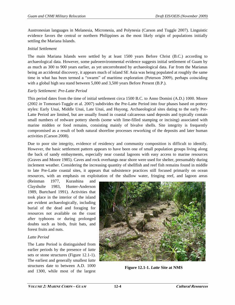
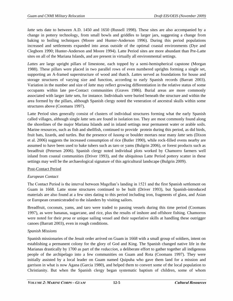
Latte Period
The Latte Period is distinguished from
earlier periods by the presence of latte
sets or stone structures (Figure 12.1-1).
The earliest and generally smallest latte
structures date to between A.D. 1000
and 1300, while most of the largest Figure 12.1-1. Latte Site at NMS
Guam and CNMI Military Relocation Draft EIS/OEIS (November 2009)
VOLUME 2: MARINE CORPS – GUAM 12-5 Cultural Resources
latte sets date to between A.D. 1450 and 1650 (Russell 1998). These sites are also accompanied by a
change in pottery technology, from small bowls and griddles to larger jars, suggesting a change from
baking to boiling techniques (Moore and Hunter-Anderson 1996). During this period populations
increased and settlements expanded into areas outside of the optimal coastal environments (Dye and
Cleghorn 1990; Hunter-Anderson and Moore 1994). Latte Period sites are more abundant than Pre-Latte
sites on all of the Mariana Islands, and are present in virtually all environmental settings.
Lattes are large upright pillars of limestone, each topped by a semi-hemispherical capstone (Morgan
1988). These pillars were placed in two parallel rows of even numbered uprights forming a single set,
supporting an A-framed superstructure of wood and thatch. Lattes served as foundations for house and
storage structures of varying size and function, according to early Spanish records (Barratt 2003).
Variation in the number and size of latte may reflect growing differentiation in the relative status of some
occupants within late pre-Contact communities (Graves 1986). Burial areas are more commonly
associated with larger latte sets, for instance. Individuals were buried beneath the structure and within the
area formed by the pillars, although Spanish clergy noted the veneration of ancestral skulls within some
structures above (Coomans 1997).
Latte Period sites generally consist of clusters of individual structures forming what the early Spanish
called villages, although single latte sets are found in isolation too. They are most commonly found along
the shorelines of the major Mariana Islands and in inland settings near permanent water or arable soils.
Marine resources, such as fish and shellfish, continued to provide protein during this period, as did birds,
fruit bats, lizards, and turtles. But the presence of lusong or boulder mortars near many latte sets (Dixon
et al. 2006) suggests the increased consumption of rice (Butler 1990), while rock-filled ovens nearby are
assumed to have been used to bake tubers such as taro or yams (Bulgrin 2006), or forest products such as
breadfruit (Petersen 2006). Spanish clergy noted individual plots worked by Chamorro farmers well
inland from coastal communities (Driver 1993), and the ubiquitous Latte Period pottery scatter in these
settings may well be the archaeological signature of this agricultural landscape (Bulgrin 2009).
Post-Contact Period
European Contact
The Contact Period is the interval between Magellan‘s landing in 1521 and the first Spanish settlement on
Guam in 1668. Latte stone structures continued to be built (Driver 1993), but Spanish-introduced
materials are also found at a few sites dating to this period including iron, fragments of glass, and Asian
or European ceramicstraded to the islanders by visiting sailors.
Breadfruit, coconuts, yams, and taro were traded to passing vessels during this time period (Coomans
1997), as were bananas, sugarcane, and rice, plus the results of inshore and offshore fishing. Chamorros
were noted for their proa or unique sailing vessel and their superlative skills at handling these outrigger
canoes (Barratt 2003), even in rough conditions.
Spanish Missions
Spanish missionaries of the Jesuit order arrived on Guam in 1668 with a small group of soldiers, intent on
establishing a permanent colony for the glory of God and King. The Spanish changed native life in the
Marianas drastically by 1700 as part of the reduccion, a deliberate effort to gather together all indigenous
people of the archipelago into a few communities on Guam and Rota (Coomans 1997). They were
initially assisted by a local leader on Guam named Quipuha who gave them land for a mission and
garrison in what is now Agana (Garcia 1980), and helped them to convert some of the local population to
Christianity. But when the Spanish clergy began systematic baptism of children, some of whom
Guam and CNMI Military Relocation Draft EIS/OEIS (November 2009)
VOLUME 2: MARINE CORPS – GUAM 12-6 Cultural Resources
succumbed to recently introduced diseases, several influential missionaries were killed and many
Chamorro moved to the northern part of the island or fled to other islands.
New diseases and ensuing war with the Spanish decimated the local population of Guam, from an
estimated pre-Contact level of between 20,000 and 40,000 in 1668, to a total of 1,800 in 1690 (Abella
1962 as cited in Tomonari-Tuggle et al. 2007) and only 1,600 by 1693 (Russell and Fleming 1990 as cited
in Tomonari-Tuggle et al. 2007). Maize was introduced during this period after inland settlements were
discouraged and it soon became a staple food crop, being processed into tortillas or atol using a metate.
Rice also increased in importanceafter the introduction of the water buffalo as draft animal, and pigs,
goats, and deer were added to the diet.
The Marianas in the 19th Century
The Philippines assumed administrative control over the Marianas in 1817, relinquishing direct control
from Spain and New Spain (Mexico after 1821). Sometime between 1815 and 1820, after severe storms
devastated the Caroline Islands, Carolinian refugees began arriving in the Marianas (Driver and Brunal-
Perry 1996), as they may have done periodically in prehistory. During this period they established trading
networks with the Spanish on Guam. By the 1880s, more Carolinians immigrated to the Marianas and
were resettled to the northern islands of Saipan and Tinian where they assisted in rounding up and salting
feral cattle for sale to Guam, and provided inter-island transportation for the government..
While the Carolinians were an asset to the Marianas economy, a serious drain on local self-sufficiency
was incurred by the deportation of hundreds of Spanish and Philippino political prisoners to Guam from
1870 to 1877 (Madrid 2006), during which time often unsavory individuals were housed and fed by the
residents of Agana and surrounding villages. In response to local privations, some prisoners were then
sent to Saipan and Tinian where they often led a life of destitution. Such deportations eventually ceased
and most of the remaining prisoners were repatriated, after which a period of relative political calm
prevailed in Spain and its colonies.
Guam in the 20th Century
Guam was ceded by Spain to the U.S. government in 1898, but did not become a U.S. territory until 1950.
Between 1898 and 1941 Guam served as a coaling and fueling station for Naval ships, as the site of the
trans-Pacific cable station, the base of a strategic naval radio station, and a landing place for the Pan-
American trans-Pacific air clippers flying between San Francisco and Hong Kong. Despite being
surrounded by Japanese controlled islands, the U.S. did little in terms of military defense development
(Peattie 1988) under terms of their agreement with other colonial powers in the Pacific after World War I.
A few hours after the attack on Pearl Harbor in December of 1941, Japanese planes from Saipan attacked
Guam. Japanese planes first bombed the Pan American building and the Standard Oil fuel tank in Sumay.
Then the Japanese turned to bombing military targets at the Piti navy yard, the Libugon radio towers, and
the few vessels in and around Apra Harbor (Rogers 1995).
Two days later Japanese forces landed on Guam where the met with limited resistance. For the next 2
years the Japanese Navy controlled the island and its economy (Higuchi 2008). All of the Americans who
were on the island were shipped to Japan as prisoners of war in January of 1942. In 1944 Japanese
reinforcements came to Guam from Manchuria and began fortifying the beaches that the Americans might
use for invasion landings and strategic overlooks (Denfield 1997). The local population was forced into
labor to build these defenses and feed the soldiers, and eventually into internment camps when combat
began (Sanchez 1979 in Tomonari-Tuggle et al. 2007).

Guam and CNMI Military Relocation Draft EIS/OEIS (November 2009)
VOLUME 2: MARINE CORPS – GUAM 12-7 Cultural Resources
In 1944 the U.S. began air raids over Japan-occupied Saipan, Tinian, Rota, and Guam. As a response, the
Japanese ordered the Chamorro to construct air-raid shelters and to stock them with food. Most of these
air-raid shelters were dugouts topped with coconut logs as well as tunnels dug into cliffs and hillsides
(Rogers 1995).
The U.S. commenced an intensive bombardment of Guam that started on July 8, 1944 and lasted for 13
days. The 3rd Marine Division and the 1st Provisional Brigade landed on Asan Beach on July 21. The
Army 77th Infantry Division followed on July 22. By July 27, American sovereignty over Guam was
proclaimed andby August 10 all organized resistance ceased (Lodge 1954 as cited in Tomonari-Tuggle et
al. 2007), although small groups of stragglers remained hidden for months and even years on Guam and
other Mariana islands (Fukimi and Cross
1969, Jones 1986, Kahn 1962). Many
Chamorro were killed during the American
recapture of Guam, both by Japanese
defenders in blatant acts of atrocity (Blas
2008, Palomo 1984), and inadvertently
during U.S. bombing and urban combat.
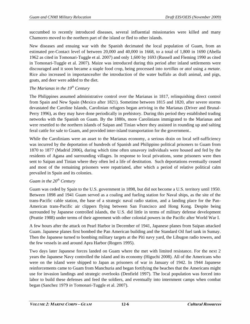
After recapturing the island, there was a
massive build-up of American forces and
new facilities in support of air attacks on
Japan and in preparation for an invasion of
Japan. The new facilities included a major
port and ship repair facility at Apra Harbor
and five airfields, Northwest Field (Figure
12.1-2), North Field, Harmon, Agana, and
Orote.
The Mariana Islands also became the platform for the strategic bombing campaign against Japan that was
to employ the new VHB/VLR B-29 Superfortress. Five B-29 airfields were built in the Mariana Islands;
Northwest Field and North Field were constructed on Guam, in the area that is now Andersen AFB. After
WWII, Northwest Field was decommissioned, but North Field continued to be used and additional
facilities were added in response to military needs arising from the Cold War, Korean War, and Vietnam
War (Rogers 1995).
In 1946, a civilian government under U.S. Navy administration was established on Guam, and in 1950 the
Guam Organic Act passed by the U.S. Congress made the island an unincorporated U.S. territory and
gave Guamanians American citizenship, with significant amendments implemented in 1970. Since the
late 1960s, tourism particularly from Japan and other Asian countries has become the mainstay of the
Guam economy, alongside local government employment (see Volume 2, Chapter 16, Socioeconomics
and General Services). Resorts have been developed in the Tumon and Agana Bay areas on the west
coast, with a few inland golf courses. The American military presence on the island has also remained
significant in the economy, through federal subsidies, civilian employment, and military personnel
expenditures.
Figure 12.1-2. Northwest Field 1945
Guam and CNMI Military Relocation Draft EIS/OEIS (November 2009)
VOLUME 2: MARINE CORPS – GUAM 12-8 Cultural Resources
12.1.2 North
12.1.2.1 Andersen AFB
Andersen AFB is one of the largest airfields in Air Force jurisdiction. It covers 15,500 acres (ac) (6,273
hectares [ha]) and occupies a mostly flat, uplifted limestone plateau in the northern portion of the island.
To the north, west, and east of the plateau, steep cliffs drop 500 to 600 feet (ft) (152 to 183 meters [m]) to
a coastal terrace that extends 300 to 900 ft (91 to 274 m) to a rocky shoreline. The Tarague Embayment is
a coastal flat along the north shore that offers the only direct access to the ocean from the base.
The eastern third of the base includes the main active airfield and an array of operations, maintenance,
and community support facilities, most of which are located along the South Ramp. The North Ramp area
includes operations of the Navy‘s HSC-25, munitions storage in the former Strategic Command storage
area, and a parking apron space for contingency operations (U.S. Pacific Command [PACOM] 2006:2-6).
The central third of the base is a Munitions Storage Area (MSA). The western third is Northwest Field
(NWF), which is currently used for helicopter training, various field exercises, and bivouac.
This summary of surveys and resources on Andersen AFB is derived primarily from Tomonari-Tuggle
and Tuggle (2003) and Tomonari-Tuggle et al. (2007). There have been 41 cultural resources surveys on
Andersen AFB beginning in the 1920s. Two major cultural resource projects in the 1990s were the
preparation of a Cultural Resources Management Plan (Schilz et al. 1996) and a study of the Tarague
Embayment (Camacho et al. 1996 as cited in Tomonari-Tuggle et al. 2007, Liston 1996, Randall and
Siegrist 1996 as cited in Tomonari-Tuggle et al. 2007, Tomonari-Tuggle and Olmo 1996 in Tomonari-
Tuggle et al. 2007). The Cultural Resources Management Plan was updated in 2003 (Tomonari-Tuggle
and Tuggle 2003). Other work included an overview survey of archaeological and architectural resources
on Andersen AFB (Yoklavich et al. 1996 as cited in Tomonari-Tuggle et al. 2007), an assessment of
proposed military training activities on Guam (McNeill and Welch 1998), identification of cultural
resource improvement projects that could be implemented over the period Fiscal Year 2002 through 2007
(Tomonari-Tuggle and Welch 2001 in Tomonari-Tuggle et al. 2009), additional post-Contact sites
documentation (Yoklavich 2003 in Tomonari-Tuggle and Welch 2007), and a surface survey along Route
9 (Yee et al. 2004).
Cultural resources on Andersen AFB include pre-Contact and post-Contact sites, post-Contact structures,
and pictographs. The Pati Point Complex and the Tarague Beach Historic District are listed on the Guam
Register (Guam Register of Historic Places 2008). NRHP-eligible or listed resources include the Tarague
Beach Historic District, the Pati Point Complex, a Spanish oven and well, a stone pier, NWF, a
farmhouse, water catchment features, a Japanese bunker, and reservoirs. There are a number of
architectural resources on Andersen AFB that are eligible for or listed on the NRHP.
In 2004 a study was conducted to retrieve additional information about the lands on which Andersen AFB
is located and identify the presence of any traditional cultural properties that may exist on Andersen AFB
(Welch and Prasad 2006). No traditional cultural properties were identified on Andersen AFB during the
course of the research. While the study succeeded in identifying and interviewing Chamorro and part-
Chamorro informants with close ties to the lands within and around Andersen AFB, these informants
were unable to identify places of traditional importance at the base; this inability to identify places of
traditional importance is a likely result of alienation of the native peoples from the lands dating back to
the arrival of Spanish missionaries and soldiers in the late 1600s. The Spanish forced all the occupants to
leave their villages in the north of Guam and resettle in the south, and only gradually in the nineteenth
century were the northern lands reoccupied. These new settlers frequently worked and lived on their
―ranchos‖ while retaining permanent residence in a southern town; they were also Christianized and
Guam and CNMI Military Relocation Draft EIS/OEIS (November 2009)
VOLUME 2: MARINE CORPS – GUAM 12-9 Cultural Resources
gradually lost much of their spiritual knowledge connecting them to the land (Welch and Prasad 2006).
However, later studies have identified two traditional cultural properties in the Andersen AFB region. The
Tarague Historic District is a traditional property with archaeological, legendary and ethnographic
associations. The Jinapsan Complex is a traditional cultural property with archaeological and
ethnographic associations (Griffin et al. 2009). All of these resources are eligible for listing on the NRHP.
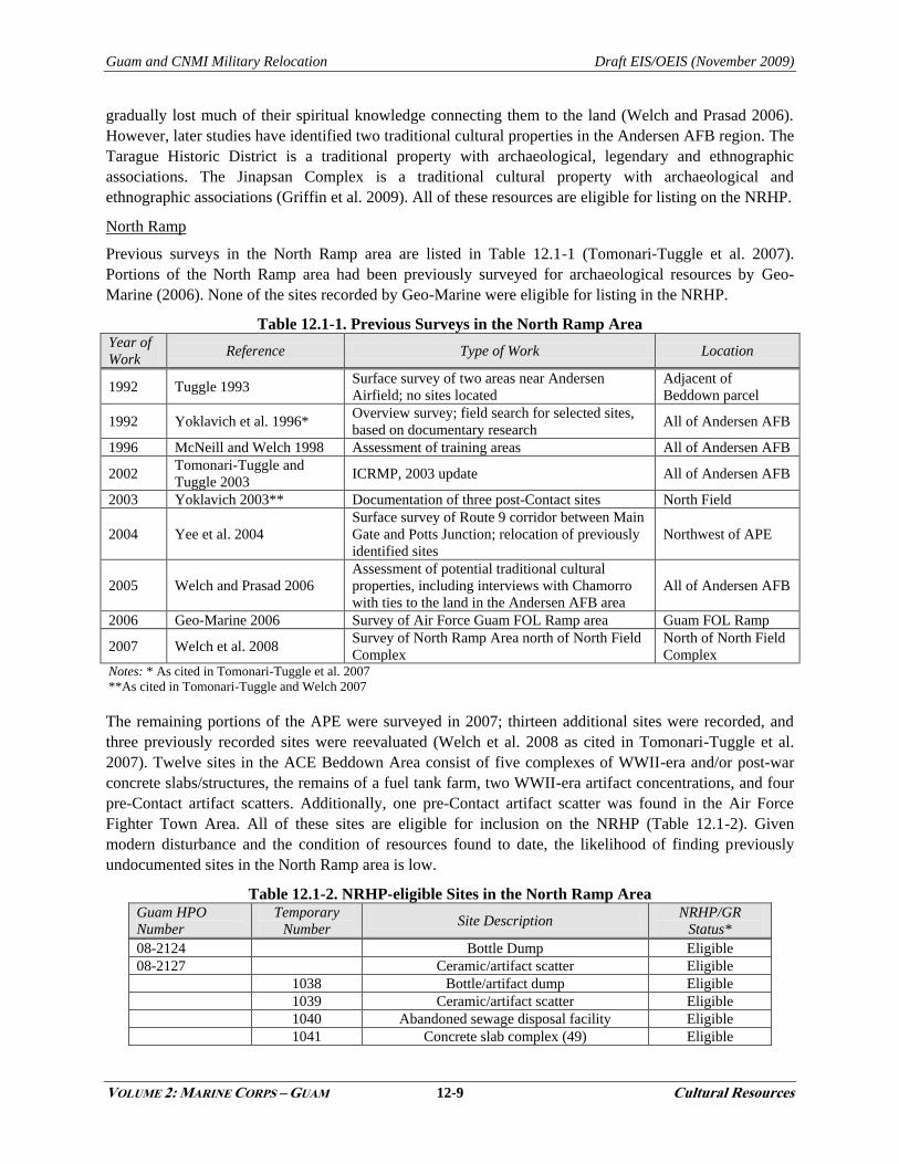
North Ramp
Previous surveys in the North Ramp area are listed in Table 12.1-1 (Tomonari-Tuggle et al. 2007).
Portions of the North Ramp area had been previously surveyed for archaeological resources by Geo-
Marine (2006). None of the sites recorded by Geo-Marine were eligible for listing in the NRHP.
Table 12.1-1. Previous Surveys in the North Ramp Area Year of
Work Reference Type of Work Location
1992 Tuggle 1993 Surface survey of two areas near Andersen
Airfield; no sites located
Adjacent of
Beddown parcel
1992 Yoklavich et al. 1996* Overview survey; field search for selected sites,
based on documentary research All of Andersen AFB
1996 McNeill and Welch 1998 Assessment of training areas All of Andersen AFB
2002 Tomonari-Tuggle and
Tuggle 2003 ICRMP, 2003 update All of Andersen AFB
2003 Yoklavich 2003** Documentation of three post-Contact sites North Field
2004 Yee et al. 2004
Surface survey of Route 9 corridor between Main
Gate and Potts Junction; relocation of previously
identified sites
Northwest of APE
2005 Welch and Prasad 2006
Assessment of potential traditional cultural
properties, including interviews with Chamorro
with ties to the land in the Andersen AFB area
All of Andersen AFB
2006 Geo-Marine 2006 Survey of Air Force Guam FOL Ramp area Guam FOL Ramp
2007 Welch et al. 2008 Survey of North Ramp Area north of North Field
Complex
North of North Field
Complex Notes: * As cited in Tomonari-Tuggle et al. 2007
**As cited in Tomonari-Tuggle and Welch 2007
The remaining portions of the APE were surveyed in 2007; thirteen additional sites were recorded, and
three previously recorded sites were reevaluated (Welch et al. 2008 as cited in Tomonari-Tuggle et al.
2007). Twelve sites in the ACE Beddown Area consist of five complexes of WWII-era and/or post-war
concrete slabs/structures, the remains of a fuel tank farm, two WWII-era artifact concentrations, and four
pre-Contact artifact scatters. Additionally, one pre-Contact artifact scatter was found in the Air Force
Fighter Town Area. All of these sites are eligible for inclusion on the NRHP (Table 12.1-2). Given
modern disturbance and the condition of resources found to date, the likelihood of finding previously
undocumented sites in the North Ramp area is low.
Table 12.1-2. NRHP-eligible Sites in the North Ramp Area Guam HPO
Number
Temporary
Number Site Description
NRHP/GR
Status*
08-2124 Bottle Dump Eligible
08-2127 Ceramic/artifact scatter Eligible
1038 Bottle/artifact dump Eligible
1039 Ceramic/artifact scatter Eligible
1040 Abandoned sewage disposal facility Eligible
1041 Concrete slab complex (49) Eligible
Guam and CNMI Military Relocation Draft EIS/OEIS (November 2009)
VOLUME 2: MARINE CORPS – GUAM 12-10 Cultural Resources
Guam HPO
Number
Temporary
Number Site Description
NRHP/GR
Status*
1042 Concrete slab complex (13) Eligible
1043
Earthen berm rectangular structures (3),
former tank farm Eligible
1044 Ceramic/artifact scatter Eligible
1045 Ceramic/artifact scatter Eligible
1046 Ceramic/artifact scatter Eligible
1049 Ceramic/artifact scatter Eligible
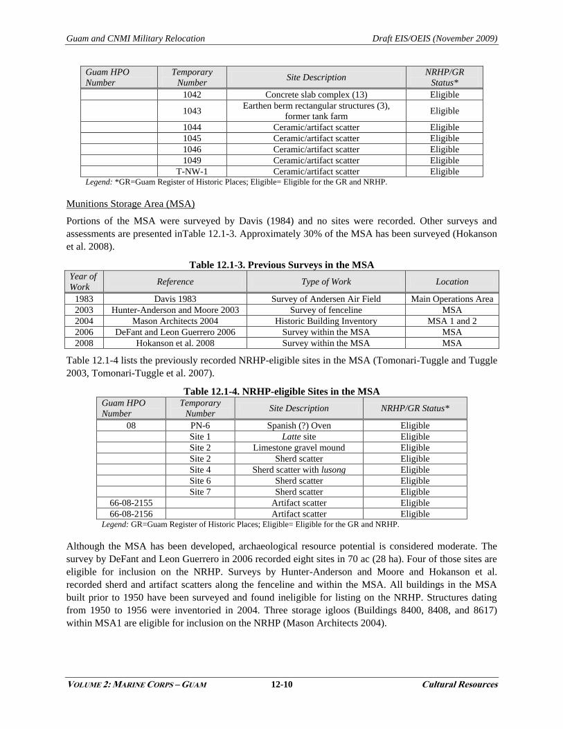
T-NW-1 Ceramic/artifact scatter Eligible Legend: *GR=Guam Register of Historic Places; Eligible= Eligible for the GR and NRHP.
Munitions Storage Area (MSA)
Portions of the MSA were surveyed by Davis (1984) and no sites were recorded. Other surveys and
assessments are presented inTable 12.1-3. Approximately 30% of the MSA has been surveyed (Hokanson
et al. 2008).
Table 12.1-3. Previous Surveys in the MSA Year of
Work Reference Type of Work Location
1983 Davis 1983 Survey of Andersen Air Field Main Operations Area
2003 Hunter-Anderson and Moore 2003 Survey of fenceline MSA
2004 Mason Architects 2004 Historic Building Inventory MSA 1 and 2
2006 DeFant and Leon Guerrero 2006 Survey within the MSA MSA
2008 Hokanson et al. 2008 Survey within the MSA MSA
Table 12.1-4 lists the previously recorded NRHP-eligible sites in the MSA (Tomonari-Tuggle and Tuggle
2003, Tomonari-Tuggle et al. 2007).
Table 12.1-4. NRHP-eligible Sites in the MSA Guam HPO
Number
Temporary
Number Site Description NRHP/GR Status*
08 PN-6 Spanish (?) Oven Eligible
Site 1 Latte site Eligible
Site 2 Limestone gravel mound Eligible
Site 2 Sherd scatter Eligible
Site 4 Sherd scatter with lusong Eligible
Site 6 Sherd scatter Eligible
Site 7 Sherd scatter Eligible
66-08-2155 Artifact scatter Eligible
66-08-2156 Artifact scatter Eligible Legend: GR=Guam Register of Historic Places; Eligible= Eligible for the GR and NRHP.
Although the MSA has been developed, archaeological resource potential is considered moderate. The
survey by DeFant and Leon Guerrero in 2006 recorded eight sites in 70 ac (28 ha). Four of those sites are
eligible for inclusion on the NRHP. Surveys by Hunter-Anderson and Moore and Hokanson et al.
recorded sherd and artifact scatters along the fenceline and within the MSA. All buildings in the MSA
built prior to 1950 have been surveyed and found ineligible for listing on the NRHP. Structures dating
from 1950 to 1956 were inventoried in 2004. Three storage igloos (Buildings 8400, 8408, and 8617)
within MSA1 are eligible for inclusion on the NRHP (Mason Architects 2004).
Guam and CNMI Military Relocation Draft EIS/OEIS (November 2009)
VOLUME 2: MARINE CORPS – GUAM 12-11 Cultural Resources
Surveys conducted for the current project within the MSA include one by Dixon and Walker (2009).
They surveyed eight isolated parcels throughout the munitions storage area that would be impacted by the
proposed action. Dixon and Walker located four sites within the MSA during their surveys that are
eligible to the NRHP and were given the following temporary site numbers: T-9-1 (prehistoric artifact
scatter), T-9-2 (prehistoric and WWII artifact scatter), T-15-1 (prehistoric artifact scatter with lusong),
and T-3-1 (prehistoric artifact scatter).
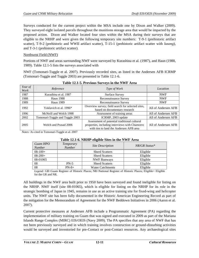
Northwest Field (NWF)
Portions of NWF and areas surrounding NWF were surveyed by Kurashina et al. (1987), and Haun (1988,
1989). Table 12.1-5 lists the surveys associated with
NWF (Tomonari-Tuggle et al. 2007). Previously recorded sites, as listed in the Andersen AFB ICRMP
(Tomonari-Tuggle and Tuggle 2003) are presented in Table 12.1-6.
Table 12.1-5. Previous Surveys in the NWF Area Year of
Work Reference Type of Work Location
1987 Kurashina et al. 1987 Surface Survey NWF
1988 Haun 1988 Reconnaissance Survey NWF
1989 Haun 1989 Reconnaissance Survey NWF
1992 Yoklavich et al. 1996* Overview survey; field search for selected sites,
based on documentary research All of Andersen AFB
1996 McNeill and Welch 1998 Assessment of training areas All of Andersen AFB
2002 Tomonari-Tuggle and Tuggle 2003 ICRMP, 2003 update All of Andersen AFB
2005 Welch and Prasad 2006
Assessment of potential traditional cultural
properties, including interviews with Chamorro
with ties to land the Andersen AFB area
All of Andersen AFB
Notes: As cited in Tomonari-Tuggle et al. 2007
Table 12.1-6. NRHP-eligible Sites in the NWF Area Guam HPO
Number
Temporary
Number Site Description NR/GR Status*
08-100+ Sherd Scatters Eligible
08-200+ Sherd Scatters Eligible
08-01065 NWF Runways Eligible
08 PN-5 Sherd Scatters Eligible
08 PN-8+ Water Catchments Eligible Legend: GR=Guam Register of Historic Places; NR=National Register of Historic Places; Eligible= Eligible
for the GR and NR.
All buildings in the NWF area built prior to 1950 have been surveyed and found ineligible for listing on
the NRHP. NWF itself (site 08-01065), which is eligible for listing on the NRHP for its role in the
strategic bombing of Japan in 1945, remains in use as an active training site for fixed-wing and helicopter
units. The NWF site has been fully documented in the Historic American Engineering Record as part of
the mitigation for the Memorandum of Agreement for the NWF Beddown Initiatives in 2006 (Aaron et al.
2007).
Current protective measures at Andersen AFB include a Programmatic Agreement (PA) regarding the
implementation of military training on Guam that was signed and executed in 2009 as part of the Mariana
Islands Range Complex (MIRC) EIS/OEIS (Navy 2009). The PA specifies that any area of NWF that has
not been previously surveyed and in which training involves construction or ground-disturbing activities
would be surveyed and inventoried for pre-Contact or post-Contact resources. Any archaeological sites
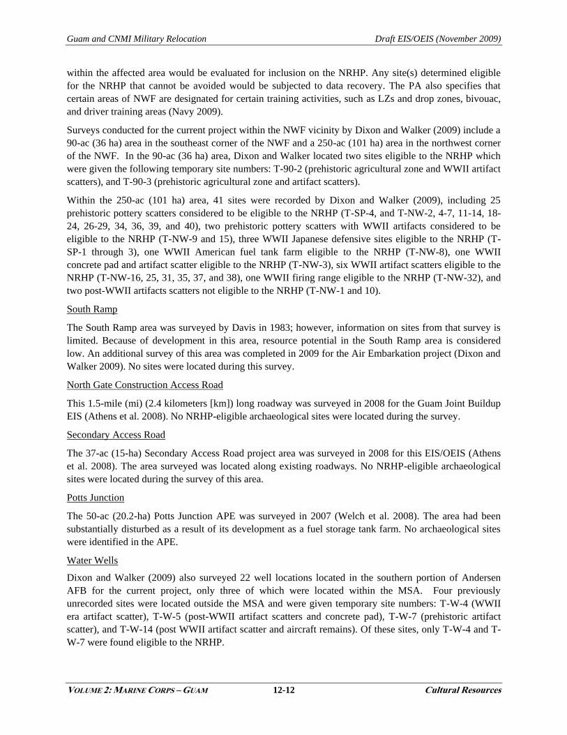
Guam and CNMI Military Relocation Draft EIS/OEIS (November 2009)
VOLUME 2: MARINE CORPS – GUAM 12-12 Cultural Resources
within the affected area would be evaluated for inclusion on the NRHP. Any site(s) determined eligible
for the NRHP that cannot be avoided would be subjected to data recovery. The PA also specifies that
certain areas of NWF are designated for certain training activities, such as LZs and drop zones, bivouac,
and driver training areas (Navy 2009).
Surveys conducted for the current project within the NWF vicinity by Dixon and Walker (2009) include a
90-ac (36 ha) area in the southeast corner of the NWF and a 250-ac (101 ha) area in the northwest corner
of the NWF. In the 90-ac (36 ha) area, Dixon and Walker located two sites eligible to the NRHP which
were given the following temporary site numbers: T-90-2 (prehistoric agricultural zone and WWII artifact
scatters), and T-90-3 (prehistoric agricultural zone and artifact scatters).
Within the 250-ac (101 ha) area, 41 sites were recorded by Dixon and Walker (2009), including 25
prehistoric pottery scatters considered to be eligible to the NRHP (T-SP-4, and T-NW-2, 4-7, 11-14, 18-
24, 26-29, 34, 36, 39, and 40), two prehistoric pottery scatters with WWII artifacts considered to be
eligible to the NRHP (T-NW-9 and 15), three WWII Japanese defensive sites eligible to the NRHP (T-
SP-1 through 3), one WWII American fuel tank farm eligible to the NRHP (T-NW-8), one WWII
concrete pad and artifact scatter eligible to the NRHP (T-NW-3), six WWII artifact scatters eligible to the
NRHP (T-NW-16, 25, 31, 35, 37, and 38), one WWII firing range eligible to the NRHP (T-NW-32), and
two post-WWII artifacts scatters not eligible to the NRHP (T-NW-1 and 10).
South Ramp
The South Ramp area was surveyed by Davis in 1983; however, information on sites from that survey is
limited. Because of development in this area, resource potential in the South Ramp area is considered
low. An additional survey of this area was completed in 2009 for the Air Embarkation project (Dixon and
Walker 2009). No sites were located during this survey.
North Gate Construction Access Road
This 1.5-mile (mi) (2.4 kilometers [km]) long roadway was surveyed in 2008 for the Guam Joint Buildup
EIS (Athens et al. 2008). No NRHP-eligible archaeological sites were located during the survey.
Secondary Access Road
The 37-ac (15-ha) Secondary Access Road project area was surveyed in 2008 for this EIS/OEIS (Athens
et al. 2008). The area surveyed was located along existing roadways. No NRHP-eligible archaeological
sites were located during the survey of this area.
Potts Junction
The 50-ac (20.2-ha) Potts Junction APE was surveyed in 2007 (Welch et al. 2008). The area had been
substantially disturbed as a result of its development as a fuel storage tank farm. No archaeological sites
were identified in the APE.
Water Wells
Dixon and Walker (2009) also surveyed 22 well locations located in the southern portion of Andersen
AFB for the current project, only three of which were located within the MSA. Four previously
unrecorded sites were located outside the MSA and were given temporary site numbers: T-W-4 (WWII
era artifact scatter), T-W-5 (post-WWII artifact scatters and concrete pad), T-W-7 (prehistoric artifact
scatter), and T-W-14 (post WWII artifact scatter and aircraft remains). Of these sites, only T-W-4 and T-
W-7 were found eligible to the NRHP.

Guam and CNMI Military Relocation Draft EIS/OEIS (November 2009)
VOLUME 2: MARINE CORPS – GUAM 12-13 Cultural Resources
12.1.2.2 Finegayan
Comprising about 2,952 ac (1,195 ha), NCTS Finegayan and South Finegayan are located in northwestern
Guam, west of Route 3 and south of NWF at Andersen AFB. The limestone plateau area of NCTS
Finegayan supports headquarters activities, communications center activities, and provides
communications receiving operations for the Navy. South Finegayan contains family housing.
Table 12.1-7 provides a summary of the surveys that have taken place at NCTS Finegayan (Tomonari-
Tuggle et al. 2007). Three traditional cultural properties have been recorded in Finegayan (two in NCTS
Finegayan and one in South Finegayan). Haputo Beach and Pugua Point (NCTS Finegayan) are
traditional properties with both archaeological and ethnographic associations (Griffin et al. 2009). Latte
Stone Park (South Finegayan) has archaeological associations.
NCTS Finegayan
Four surveys in NCTS Finegayan on the limestone plateau were conducted in the late 1980s (Kurashina et
al. 1987; Haun 1988, 1989; Highness and Haun 1990 as cited in Tomonari-Tuggle et al. 2007). Ceramic
scatters were identified by Kurashina et al. (1987) and Haun (1988). These surveys overlapped Andersen
AFB property. More recent surveys had difficulty re-identifying these scatters, primarily due to the nature
of the sites and the dense ground cover in the area.
A Phase II archaeological survey including archival research, field survey, and subsurface testing was
conducted by Olmo et al. (2000 in Tomonari-Tuggle et al. 2007) in portions of NCTS Finegayan and
South Finegayan. This study included a complete survey of the coastal shelf and a partial survey of the
limestone plateau. The study identified over 20 sites of significance.
Previous surveys at NCTS Finegayan have recorded 28 sites that are considered to be eligible or need
further evaluation (Tomonari-Tuggle et al. 2005).
Table 12.1-7. Summary of the Surveys that have Taken Place at NCTS Finegayan Year of
Work Reference Type of Work Location
1921-4 Hornbostel n.d*,
Thompson 1932 Survey Coast
1952 Reed 1952* Survey Coast
1965-6 Reinman 1967* Survey Coast
1986 Kurashina et al. 1987
Survey boundary with Andersen
AFB; 17 sherd scatters recorded;
Post-Contact sites not recorded
NCTS Finegayan
1988 Haun 1988
Survey boundary with Andersen
AFB; sherd scatters found, only some
recorded
NCTS Finegayan
(northern area)
1988 Haun 1989 Reconnaissance survey near
boundary with FAA parcel
NCTS Finegayan
(southern area)
1990 Highness and Haun 1990* Inventory survey of facility in
northern area of NCTS Finegayan
NCTS Finegayan
(northern area)
1992 Craib and Yoklavich 1996c* Overview survey All of NCTS Finegayan
1993 Lauter-Reiman 1997 Management plan for WWII
resources All of NCTS Finegayan
1996 McNeill and Welch 1998 Assessment of training area All of NCTS Finegayan
1998 Tuggle and Welch 2000 Archival research, reconnaissance
survey, assessment FAA Parcel
Guam and CNMI Military Relocation Draft EIS/OEIS (November 2009)
VOLUME 2: MARINE CORPS – GUAM 12-14 Cultural Resources
Year of
Work Reference Type of Work Location
1998 Olmo et al. 2000*
Phase II survey and detailed
recording; complete survey of coastal
shelf, reconnaissance survey of
limestone plateau
NCTS Finegayan
2000 Hunter-Anderson et al. 2001 Survey, limited archaeological
testing FAA parcel
2001-5 Welch et al. 2005* Synthesis of Guam prehistory and
history All of Guam
2001-5 Tomonari-Tuggle et al. 2005 Regional ICRMP for Navy lands All NCTS Finegayan
2007 Welch et al. 2008 Survey, limited testing NCTS Finegayan, GLUP 77
2008 Athens et al. 2008 Survey South Finegayan,
Former FAA Parcel Notes: *As cited in Tomonari-Tuggle et al. 2007
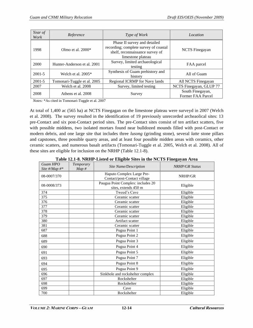
At total of 1,400 ac (565 ha) at NCTS Finegagan on the limestone plateau were surveyd in 2007 (Welch
et al. 2008). The survey resulted in the identification of 19 previously unrecorded archeaolical sites: 13
pre-Contact and six post-Contact period sites. The pre-Contact sites consist of ten artifact scatters, five
with possible middens, two isolated mortars found near bulldozed mounds filled with post-Contact or
modern debris, and one large site that includes three lusong (grinding stone), several latte stone pillars
and capstones, three possible quarry areas, and at least four possible midden areas with ceramics, other
ceramic scatters, and numerous basalt artifacts (Tomonari-Tuggle et al. 2005, Welch et al. 2008). All of
these sites are eligible for inclusion on the NRHP (Table 12.1-8).
Table 12.1-8. NRHP-Listed or Eligible Sites in the NCTS Finegayan Area Guam HPO
Site #/Map #*
Temporary
Map # Site Name/Description NRHP/GR Status
08-0007/370 Haputo Complex Large Pre-
Contact/post-Contact village NRHP/GR
08-0008/373 Paugua Point Complex: includes 20
sites, extends 450 m Eligible
374 Tweed‘s Cave Eligible
375 Ceramic scatter Eligible
376 Ceramic scatter Eligible
377 Ceramic scatter Eligible
378 Ceramic scatter Eligible
379 Ceramic scatter Eligible
380 Artifact scatter Eligible
381 Ceramic scatter Eligible
687 Pugua Point 1 Eligible
688 Pugua Point 2 Eligible
689 Pugua Point 3 Eligible
690 Pugua Point 4 Eligible
691 Pugua Point 5 Eligible
693 Pugua Point 7 Eligible
694 Pugua Point 8 Eligible
695 Pugua Point 9 Eligible
696 Sinkhole and rockshelter complex Eligible
697 Rockshelter Eligible
698 Rockshelter Eligible
699 Cave Eligible
700 Rockshelter Eligible

Guam and CNMI Military Relocation Draft EIS/OEIS (November 2009)
VOLUME 2: MARINE CORPS – GUAM 12-15 Cultural Resources
Guam HPO
Site #/Map #*
Temporary
Map # Site Name/Description NRHP/GR Status
701 Rockshelter Eligible
702 Rockshelter Eligible
703 Artifact Scatter Eligible
704 Artifact Scatter Eligible
705 Rockshelter complex, pictographs Eligible
1031 Artifact scatter Eligible
1024 Mortar/lusong Eligible
1026 Habitation site/artifact scatter Eligible
1032 Mortar/lusong Eligible
1027 Encampment Eligible
1028 Encampment Eligible
1029 Water catchment structure Eligible
1030 Artifact scatter Eligible
1033 Artifact scatter Eligible
1034 Artifact scatter Eligible
1035 Artifact scatter Eligible
1012 Artifact scatter Eligible
1018 Concrete trough structure Eligible
1019 Artifact scatter Eligible
1020 Artifact scatter Eligible
1021 Artifact scatter/Concrete pad Eligible
1022 Artifact scatter Eligible
1023 4 defense structures Eligible
Legend: **GR=Guam Register of Historic Places; Eligible= Eligible for the GR and NR.
Notes: *See Welch et al. 2005 (as cited in Tomonari-Tuggle et al. 2007): Appendix A (Guam Sites in the Navy
Retained Lands Presented in Geographic Information System Assigned Map Number Order).
Three post-WWII encampments were also identified during the survey in 2007. Two camps were
identified by the presence of curbed concrete foundations and the third by the presence of numerous
artifacts. A crudely built, long narrow curbed concrete trough structure may date from the 1950s and be
associated with nearby barrow pits. There are no NRHP-eligible or listed architectural resources in NCTS
Finegayan APE (Welch et. al. 2008 as cited in Tomonari-Tuggle et al. 2007).
An additional 150 ac (61 ha) was surveyed at NCTS Finegayan in 2008 near the northern boundary of
NCTS Finegayan (Athens et al. 2008). Two post-Contact and four pre-Contact sites were recorded;
however, because of poor condition, none are eligible for inclusion on the NRHP. The pre-Contact sites
were pottery scatters and the post-Contact sites were concrete pads.
South Finegayan
A Phase II archaeological survey including archival research, field survey, and subsurface testing was
conducted by Olmo et al. (2000 as cited in Tomonari-Tuggle et al. 2007) in portions of NCTS Finegayan
and South Finegayan. This study included a complete survey of the coastal shelf and a partial survey of
the limestone plateau. One site was listed on the NRHP (Table 12.1-9) (Tomonari-Tuggle et al. 2007).
Table 12.1-9. NRHP-listed Sites in the South Finegayan Area Guam HPO Site #/Map #* Site Name/Description NRHP/GR Status*
08-0141/811 Latte Stone Park; latte set, cultural deposit NRHP, GR
Legend: *GR=Guam Register of Historic Places.
Archaeological surveys completed in 2008 of South Finegayan encountered no intact archaeological
resources (Athens et al. 2008). This area has been highly disturbed by bulldozing and clearing activities.
Guam and CNMI Military Relocation Draft EIS/OEIS (November 2009)
VOLUME 2: MARINE CORPS – GUAM 12-16 Cultural Resources
In addition, there are no NRHP-eligible or listed architectural resources in South Finegayan project area
(Welch et al. 2008).
12.1.2.3 Non-DoD Land
Former FAA Parcel
The former FAA parcel was subject to a reconnaissance survey by Tuggle and Welch in 1998. They
conducted ground surveys along the coastal cliffs and in selected areas of the limestone plateau. At Ague
Cove they documented three rock shelters, a cave with rock art, and a midden scatter. The previously
recorded Hilan‘an Rock Shelter was also relocated during this survey. The WWII-era Navy
Communications Camp was recorded on the limestone plateau. As a follow-up to this survey Hunter-
Anderson et al. (2001) conducted a survey and did limited archaeological excavations. They identified
four pre-Contact sites and a post WWII site.
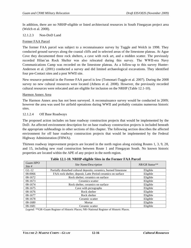
New resource potential in the Former FAA parcel is low (Tomonari-Tuggle et al. 2007). During the 2008
survey no new cultural resources were located (Athens et al. 2008). However, the previously recorded
cultural resources were relocated and are eligible for inclusion on the NRHP (Table 12.1-10).
Harmon Annex Area
The Harmon Annex area has not been surveyed. A reconnaissance survey would be conducted in 2009;
however the area was used for airfield operations during WWII and probably contains numerous historic
sites.
12.1.2.4 Off Base Roadways
The proposed action includes on base roadway construction projects that would be implemented by the
DoD. An affected environment description for on base roadway construction projects is included beneath
the appropriate subheadings in other sections of this chapter. The following section describes the affected
environment for off base roadway construction projects that would be implemented by the Federal
Highway Administration (FHWA).
Thirteen roadway improvement projects are located in the north region along existing Routes 1, 3, 9, 28,
and 15, including new road construction between Route 1 and Finegayan South. No known historic
properties are located within the APE of any project in the north region.
Table 12.1-10. NRHP-eligible Sites in the Former FAA Parcel Guam HPO
Site # Site Name/Description NR/GR Status**
GL-12 Partially disturbed cultural deposits; ceramics, burned limestone Eligible
08-0066 FAA rock shelter, deposit, Latte Period ceramics on surface Eligible
08-1672 Rock shelter; ceramics on surface Eligible
08-1673 Ceramics scatter Eligible
08-1674 Rock shelter, ceramics on surface Eligible
08-1675 Cave with pictographs Eligible
08-1676 Rock shelter Eligible
08-1677 Rock shelter Eligible
08-1678 Ceramic scatter Eligible
08-1680 Mortar Eligible
08-1681 Ceramic scatter Eligible
Legend: **GR=Guam Register of Historic Places; NR=National Register of Historic Places.
Guam and CNMI Military Relocation Draft EIS/OEIS (November 2009)
VOLUME 2: MARINE CORPS – GUAM 12-17 Cultural Resources
12.1.3 Central
12.1.3.1 Andersen South
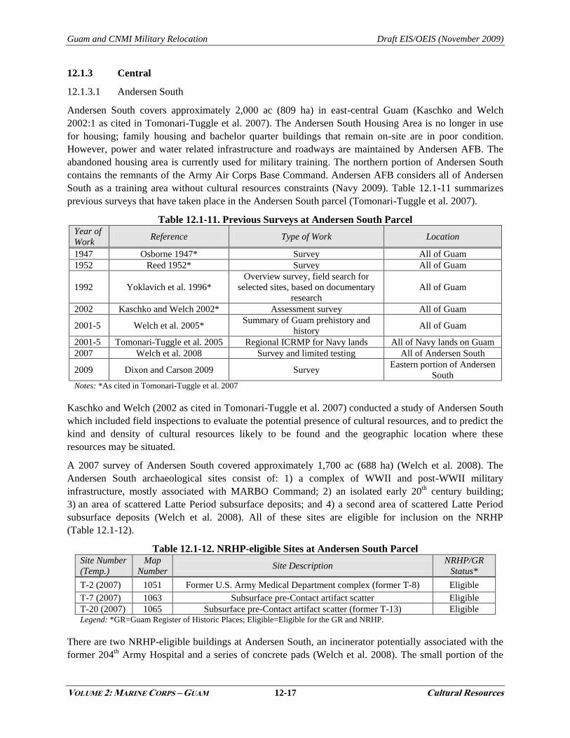
Andersen South covers approximately 2,000 ac (809 ha) in east-central Guam (Kaschko and Welch
2002:1 as cited in Tomonari-Tuggle et al. 2007). The Andersen South Housing Area is no longer in use
for housing; family housing and bachelor quarter buildings that remain on-site are in poor condition.
However, power and water related infrastructure and roadways are maintained by Andersen AFB. The
abandoned housing area is currently used for military training. The northern portion of Andersen South
contains the remnants of the Army Air Corps Base Command. Andersen AFB considers all of Andersen
South as a training area without cultural resources constraints (Navy 2009). Table 12.1-11 summarizes
previous surveys that have taken place in the Andersen South parcel (Tomonari-Tuggle et al. 2007).
Table 12.1-11. Previous Surveys at Andersen South Parcel Year of
Work Reference Type of Work Location
1947 Osborne 1947* Survey All of Guam
1952 Reed 1952* Survey All of Guam
1992 Yoklavich et al. 1996*
Overview survey, field search for
selected sites, based on documentary
research
All of Guam
2002 Kaschko and Welch 2002* Assessment survey All of Guam
2001-5 Welch et al. 2005* Summary of Guam prehistory and
history All of Guam
2001-5 Tomonari-Tuggle et al. 2005 Regional ICRMP for Navy lands All of Navy lands on Guam
2007 Welch et al. 2008 Survey and limited testing All of Andersen South
2009 Dixon and Carson 2009 Survey Eastern portion of Andersen
South Notes: *As cited in Tomonari-Tuggle et al. 2007
Kaschko and Welch (2002 as cited in Tomonari-Tuggle et al. 2007) conducted a study of Andersen South
which included field inspections to evaluate the potential presence of cultural resources, and to predict the
kind and density of cultural resources likely to be found and the geographic location where these
resources may be situated.
A 2007 survey of Andersen South covered approximately 1,700 ac (688 ha) (Welch et al. 2008). The
Andersen South archaeological sites consist of: 1) a complex of WWII and post-WWII military
infrastructure, mostly associated with MARBO Command; 2) an isolated early 20th century building;
3) an area of scattered Latte Period subsurface deposits; and 4) a second area of scattered Latte Period
subsurface deposits (Welch et al. 2008). All of these sites are eligible for inclusion on the NRHP
(Table 12.1-12).
Table 12.1-12. NRHP-eligible Sites at Andersen South Parcel Site Number
(Temp.)
Map
Number Site Description
NRHP/GR
Status*
T-2 (2007) 1051 Former U.S. Army Medical Department complex (former T-8) Eligible
T-7 (2007) 1063 Subsurface pre-Contact artifact scatter Eligible
T-20 (2007) 1065 Subsurface pre-Contact artifact scatter (former T-13) Eligible Legend: *GR=Guam Register of Historic Places; Eligible=Eligible for the GR and NRHP.
There are two NRHP-eligible buildings at Andersen South, an incinerator potentially associated with the
former 204th Army Hospital and a series of concrete pads (Welch et al. 2008). The small portion of the
Guam and CNMI Military Relocation Draft EIS/OEIS (November 2009)
VOLUME 2: MARINE CORPS – GUAM 12-18 Cultural Resources
Andersen South area that was not surveyed in 2007 was surveyed in 2008 (Dixon and Carson 2009). An
additional eight prehistoric sites were recorded during this survey. They include artifact scatters and a
bulldozed displaced latte set. All of the eight sites are eligible for inclusion on the NRHP.
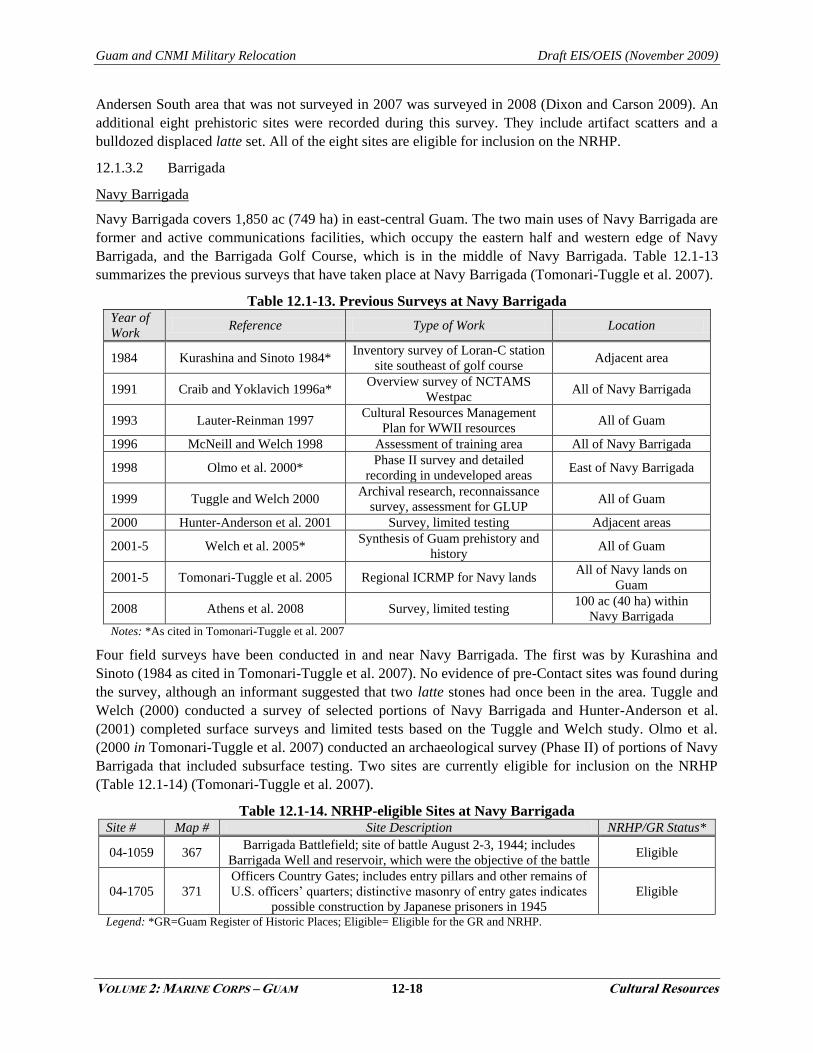
12.1.3.2 Barrigada
Navy Barrigada
Navy Barrigada covers 1,850 ac (749 ha) in east-central Guam. The two main uses of Navy Barrigada are
former and active communications facilities, which occupy the eastern half and western edge of Navy
Barrigada, and the Barrigada Golf Course, which is in the middle of Navy Barrigada. Table 12.1-13
summarizes the previous surveys that have taken place at Navy Barrigada (Tomonari-Tuggle et al. 2007).
Table 12.1-13. Previous Surveys at Navy Barrigada Year of
Work Reference Type of Work Location
1984 Kurashina and Sinoto 1984* Inventory survey of Loran-C station
site southeast of golf course Adjacent area
1991 Craib and Yoklavich 1996a* Overview survey of NCTAMS
Westpac All of Navy Barrigada
1993 Lauter-Reinman 1997 Cultural Resources Management
Plan for WWII resources All of Guam
1996 McNeill and Welch 1998 Assessment of training area All of Navy Barrigada
1998 Olmo et al. 2000* Phase II survey and detailed
recording in undeveloped areas East of Navy Barrigada
1999 Tuggle and Welch 2000 Archival research, reconnaissance
survey, assessment for GLUP All of Guam
2000 Hunter-Anderson et al. 2001 Survey, limited testing Adjacent areas
2001-5 Welch et al. 2005* Synthesis of Guam prehistory and
history All of Guam
2001-5 Tomonari-Tuggle et al. 2005 Regional ICRMP for Navy lands All of Navy lands on
Guam
2008 Athens et al. 2008 Survey, limited testing 100 ac (40 ha) within
Navy Barrigada Notes: *As cited in Tomonari-Tuggle et al. 2007
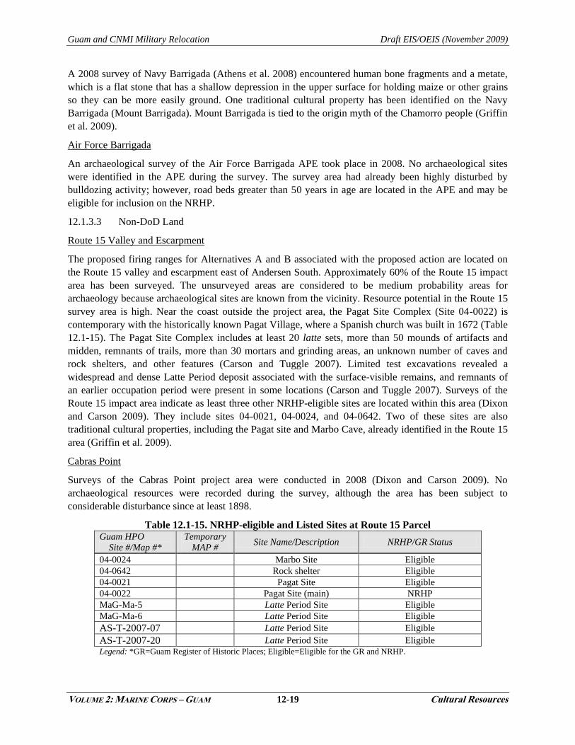
Four field surveys have been conducted in and near Navy Barrigada. The first was by Kurashina and
Sinoto (1984 as cited in Tomonari-Tuggle et al. 2007). No evidence of pre-Contact sites was found during
the survey, although an informant suggested that two latte stones had once been in the area. Tuggle and
Welch (2000) conducted a survey of selected portions of Navy Barrigada and Hunter-Anderson et al.
(2001) completed surface surveys and limited tests based on the Tuggle and Welch study. Olmo et al.
(2000 in Tomonari-Tuggle et al. 2007) conducted an archaeological survey (Phase II) of portions of Navy
Barrigada that included subsurface testing. Two sites are currently eligible for inclusion on the NRHP
(Table 12.1-14) (Tomonari-Tuggle et al. 2007).
Table 12.1-14. NRHP-eligible Sites at Navy Barrigada Site # Map # Site Description NRHP/GR Status*
04-1059 367 Barrigada Battlefield; site of battle August 2-3, 1944; includes
Barrigada Well and reservoir, which were the objective of the battle Eligible
04-1705 371
Officers Country Gates; includes entry pillars and other remains of
U.S. officers‘ quarters; distinctive masonry of entry gates indicates
possible construction by Japanese prisoners in 1945
Eligible
Legend: *GR=Guam Register of Historic Places; Eligible= Eligible for the GR and NRHP.
Guam and CNMI Military Relocation Draft EIS/OEIS (November 2009)
VOLUME 2: MARINE CORPS – GUAM 12-19 Cultural Resources
A 2008 survey of Navy Barrigada (Athens et al. 2008) encountered human bone fragments and a metate,
which is a flat stone that has a shallow depression in the upper surface for holding maize or other grains
so they can be more easily ground. One traditional cultural property has been identified on the Navy
Barrigada (Mount Barrigada). Mount Barrigada is tied to the origin myth of the Chamorro people (Griffin
et al. 2009).
Air Force Barrigada
An archaeological survey of the Air Force Barrigada APE took place in 2008. No archaeological sites
were identified in the APE during the survey. The survey area had already been highly disturbed by
bulldozing activity; however, road beds greater than 50 years in age are located in the APE and may be
eligible for inclusion on the NRHP.
12.1.3.3 Non-DoD Land
Route 15 Valley and Escarpment
The proposed firing ranges for Alternatives A and B associated with the proposed action are located on
the Route 15 valley and escarpment east of Andersen South. Approximately 60% of the Route 15 impact
area has been surveyed. The unsurveyed areas are considered to be medium probability areas for
archaeology because archaeological sites are known from the vicinity. Resource potential in the Route 15
survey area is high. Near the coast outside the project area, the Pagat Site Complex (Site 04-0022) is
contemporary with the historically known Pagat Village, where a Spanish church was built in 1672 (Table
12.1-15). The Pagat Site Complex includes at least 20 latte sets, more than 50 mounds of artifacts and
midden, remnants of trails, more than 30 mortars and grinding areas, an unknown number of caves and
rock shelters, and other features (Carson and Tuggle 2007). Limited test excavations revealed a
widespread and dense Latte Period deposit associated with the surface-visible remains, and remnants of
an earlier occupation period were present in some locations (Carson and Tuggle 2007). Surveys of the
Route 15 impact area indicate as least three other NRHP-eligible sites are located within this area (Dixon
and Carson 2009). They include sites 04-0021, 04-0024, and 04-0642. Two of these sites are also
traditional cultural properties, including the Pagat site and Marbo Cave, already identified in the Route 15
area (Griffin et al. 2009).
Cabras Point
Surveys of the Cabras Point project area were conducted in 2008 (Dixon and Carson 2009). No
archaeological resources were recorded during the survey, although the area has been subject to
considerable disturbance since at least 1898.
Table 12.1-15. NRHP-eligible and Listed Sites at Route 15 Parcel Guam HPO
Site #/Map #*
Temporary
MAP # Site Name/Description NRHP/GR Status
04-0024 Marbo Site Eligible
04-0642 Rock shelter Eligible
04-0021 Pagat Site Eligible
04-0022 Pagat Site (main) NRHP
MaG-Ma-5 Latte Period Site Eligible
MaG-Ma-6 Latte Period Site Eligible
AS-T-2007-07 Latte Period Site Eligible
AS-T-2007-20 Latte Period Site Eligible
Legend: *GR=Guam Register of Historic Places; Eligible=Eligible for the GR and NRHP.
Guam and CNMI Military Relocation Draft EIS/OEIS (November 2009)
VOLUME 2: MARINE CORPS – GUAM 12-20 Cultural Resources
12.1.3.4 Off Base Roadways
The proposed action includes on base roadway construction projects that would be implemented by the
DoD. An affected environment description for on base roadway construction projects is included beneath
the appropriate subheadings in other sections of this chapter. The following section describes the affected
environment for off base roadway construction projects that would be implemented by the FHWA.
Thirty-three (33) roadway improvement projects are located in the central region along existing Routes 1,
8, 8A 10, 15, 16, 25, 26, and 27, Alageta-Lily, and Chalan Lujuna Road. Several known historic
properties are within the APE for these projects. Historic properties are listed inTable 12.1-16 and
Figure 12.1-3 illustrates the location of well known historic properties in the APE. Archaeological sites
are not depicted on Figure 12.1-3.
Table 12.1-16. Historic Properties within the APE of Central Region Projects
Historic Property Description GRN #
Cormoran Monument
The Cormoran Monument is a monument to the sailors lost aboard the
Cormoran. It is located within the U.S. Naval Cemetery. It was listed
on the GRHP July 24, 1974.
1
U.S. Naval Cemetery The U.S. Naval Cemetery in Agana is listed on the NRHP and GRHP. 1
Asan Invasion Beach
Asan Invasion Beach is listed as on the NRHP and GRHP. It is the site
of the U.S. invasion, July 21, 1944. Part of this property is included
within the War in the Pacific National Historic Park (NHP).
13
Memorial Beach Park
Memorial Beach Park is listed on the NRHP and GRHP. It is the site of
the U.S. invasion, July 21, 1944. It is included within the War in the
Pacific NHP.
13
War in the Pacific National
Historic Park
This park was listed on the NRHP and GRHP in 1978. This unique
National Park is the only site in the National Park System that honors
the bravery and sacrifices of all those who participated in the Pacific
Theater of World War II.
13
Aspaalas #675 Archaeological site. 13
Adelup RT Burial #300 Archaeological site. 14
Asan Patriots of World War II
Memorial
Asan Patriots of World War II Memorial is listed on the GRHP, and it
is eligible for listing on the NRHP. 14
Asan archaeological site Archaeological site. 14
Guam Heroes Memorial /
Skinner Plaza Eligible for the NRHP/GRHP. 15
Taitano House Eligible for the NRHP/GRHP. 15
Garrido House Listed on the GRHP in 1984. 15
Toves House Listed on the NRHP and GRHP. 15
Agana Spanish Bridge Listed on the NRHP and GRHP. Stone arch bridge ca. 1800. 15
Agana-Hagatna Pillbox Listed on the NRHP and GRHP. Japanese coastal defense fortifications. 15
Unnamed Archaeological Site Archaeological site. 36 Legend: GRHP= Guam Register of Historic Places; GRN= Guam Road Network.
GRN #1 passes by the U.S. Naval Cemetery and Fortification along Route 1. Cormoran Monument is also
located within the cemetery boundary. GRN #13 passes by the Asan Invasion Beach and Memorial Beach
Park, which are adjacent to the north side to Route 1, along the Philippine Sea. Both of these properties
are included within the War in the Pacific NHP. The NHP has a much larger boundary and straddles
Route 1 at Asan Point. GRN #13 also passes by one archaeological site. GRN #14 is adjacent to the Asan
Patriots of World War II Memorial and two archaeological sites. GRN #15 is adjacent to parcels holding
the San Nicholas Bridge, the Guam Heroes Memorial, historic Skinner Plaza, Taitano House, Garrido
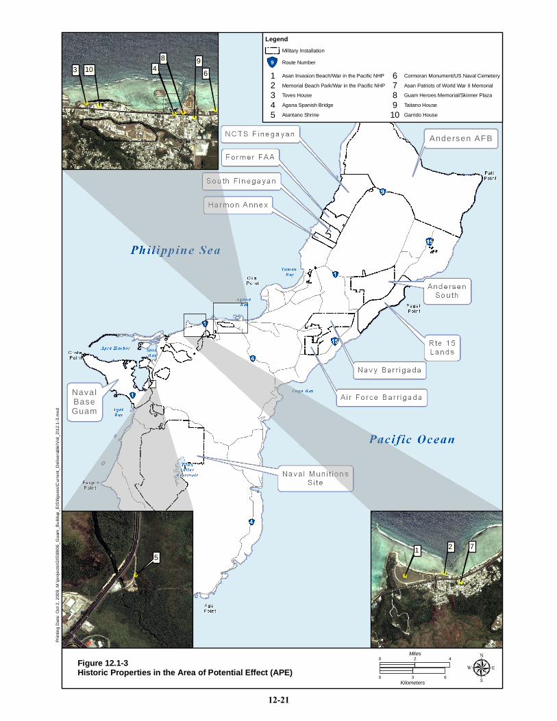
NavalNavalBaseBaseGuamGuam
Andersen AFBAndersen AFB
Prin
ting
Dat
e: O
ct 2
, 200
9, M
:\pro
ject
s\G
IS\8
806_
Gua
m_B
uild
up_E
IS\fi
gure
s\C
urre
nt_D
eliv
erab
le\V
ol_2
\12.
1-3.
mxd
Figure 12.1-3Historic Properties in the Area of Potential Effect (APE)
0 42Miles
0 3 6Kilometers
4466
88 9933 1010
5511 7722
Legend
Military Installation
9 Route Number
Garrido House10Taitano House9Guam Heroes Memorial/Skinner Plaza8
Cormoran Monument/US Naval Cemetery6Asan Patriots of World War II Memorial7
Atantano Shrine5Agana Spanish Bridge4Toves House3Memorial Beach Park/War in the Pacific NHP2Asan Invasion Beach/War in the Pacific NHP1
12-21
Guam and CNMI Military Relocation Draft EIS/OEIS (November 2009)
VOLUME 2: MARINE CORPS – GUAM 12-22 Cultural Resources
House, Toves House, and the Agana Spanish Bridge. An unnamed archaeological site is located within
the APE of GRN #36 (Route 15 relocation).
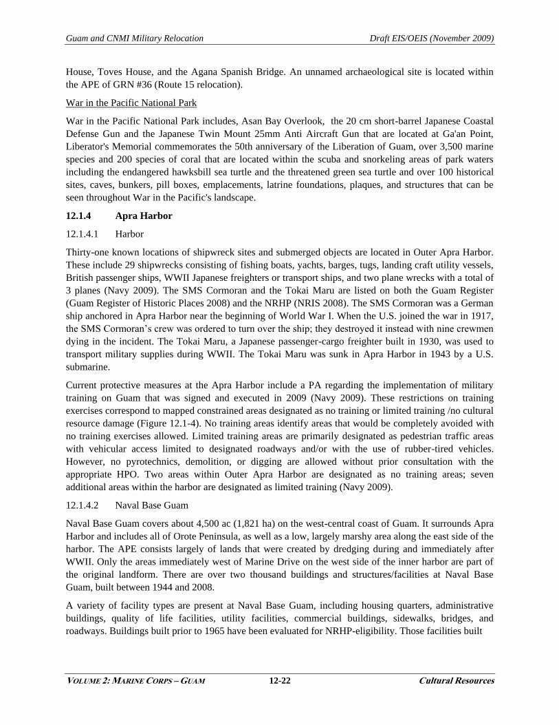
War in the Pacific National Park
War in the Pacific National Park includes, Asan Bay Overlook, the 20 cm short-barrel Japanese Coastal
Defense Gun and the Japanese Twin Mount 25mm Anti Aircraft Gun that are located at Ga'an Point,
Liberator's Memorial commemorates the 50th anniversary of the Liberation of Guam, over 3,500 marine
species and 200 species of coral that are located within the scuba and snorkeling areas of park waters
including the endangered hawksbill sea turtle and the threatened green sea turtle and over 100 historical
sites, caves, bunkers, pill boxes, emplacements, latrine foundations, plaques, and structures that can be
seen throughout War in the Pacific's landscape.
12.1.4 Apra Harbor
12.1.4.1 Harbor
Thirty-one known locations of shipwreck sites and submerged objects are located in Outer Apra Harbor.
These include 29 shipwrecks consisting of fishing boats, yachts, barges, tugs, landing craft utility vessels,
British passenger ships, WWII Japanese freighters or transport ships, and two plane wrecks with a total of
3 planes (Navy 2009). The SMS Cormoran and the Tokai Maru are listed on both the Guam Register
(Guam Register of Historic Places 2008) and the NRHP (NRIS 2008). The SMS Cormoran was a German
ship anchored in Apra Harbor near the beginning of World War I. When the U.S. joined the war in 1917,
the SMS Cormoran‘s crew was ordered to turn over the ship; they destroyed it instead with nine crewmen
dying in the incident. The Tokai Maru, a Japanese passenger-cargo freighter built in 1930, was used to
transport military supplies during WWII. The Tokai Maru was sunk in Apra Harbor in 1943 by a U.S.
submarine.
Current protective measures at the Apra Harbor include a PA regarding the implementation of military
training on Guam that was signed and executed in 2009 (Navy 2009). These restrictions on training
exercises correspond to mapped constrained areas designated as no training or limited training /no cultural
resource damage (Figure 12.1-4). No training areas identify areas that would be completely avoided with
no training exercises allowed. Limited training areas are primarily designated as pedestrian traffic areas
with vehicular access limited to designated roadways and/or with the use of rubber-tired vehicles.
However, no pyrotechnics, demolition, or digging are allowed without prior consultation with the
appropriate HPO. Two areas within Outer Apra Harbor are designated as no training areas; seven
additional areas within the harbor are designated as limited training (Navy 2009).
12.1.4.2 Naval Base Guam
Naval Base Guam covers about 4,500 ac (1,821 ha) on the west-central coast of Guam. It surrounds Apra
Harbor and includes all of Orote Peninsula, as well as a low, largely marshy area along the east side of the
harbor. The APE consists largely of lands that were created by dredging during and immediately after
WWII. Only the areas immediately west of Marine Drive on the west side of the inner harbor are part of
the original landform. There are over two thousand buildings and structures/facilities at Naval Base
Guam, built between 1944 and 2008.
A variety of facility types are present at Naval Base Guam, including housing quarters, administrative
buildings, quality of life facilities, utility facilities, commercial buildings, sidewalks, bridges, and
roadways. Buildings built prior to 1965 have been evaluated for NRHP-eligibility. Those facilities built
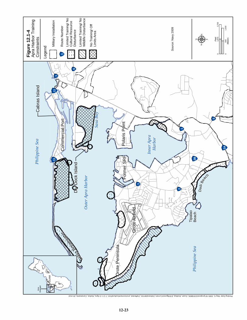
Printing Date: May 6, 2009; M:\projects\GIS\8806_Guam_Buildup_EIS\figures\Current_Deliverable\Vol_2\affected_environment\cultural\Vol. 2 12.1-3 Apra_Harbor_Constraints_kh.mxd
Pol
aris
Poi
ntP
olar
is P
oint
Form
er S
RF
Form
er S
RF
Oro
te P
enin
sula
Oro
te P
enin
sula
Oro
te A
irfie
ldO
rote
Airf
ield
DDaa dd
ii BBee aa cc hh
Tipa
lao
Tipa
lao
Beac
hBe
ach
Glass B
reak
water
Glass B
reak
water
Com
mer
cial
Por
tC
omm
erci
al P
ort
Cab
ras
Isla
ndC
abra
s Is
land
Dry
Doc
k Is
land
Dry
Doc
k Is
land
1
1
1
2
2A
5
2B
6
1111
Phili
ppin
e Se
aPh
ilipp
ine
Sea
Phili
ppin
e Se
aPh
ilipp
ine
Sea
Out
er A
pra
Har
bor
Out
er A
pra
Har
bor
Inne
r Apr
a In
ner A
pra
Har
bor
Har
bor
Sasa
Bay
Sasa
Bay
GU
AM
GU
AM
Area
Enla
rged
Sour
ce: N
avy
2009
Apra
Har
bor T
rain
ing
Con
stra
ints
Figu
re 1
2.1-
4
Lege
nd
1R
oute
Num
ber
050
01,
000
Met
ers
03,
750
1,87
5Fe
et
No
Trai
ning
/ Off
Lim
its A
rea
Lim
ited
Trai
ning
/ No
Wild
life
Dis
turb
ance
Lim
ited
Trai
ning
/ No
Cul
tura
l Res
ourc
eD
istu
rban
ce
Mili
tary
Inst
alla
tion
12-23
Guam and CNMI Military Relocation Draft EIS/OEIS (November 2009)
VOLUME 2: MARINE CORPS – GUAM 12-24 Cultural Resources
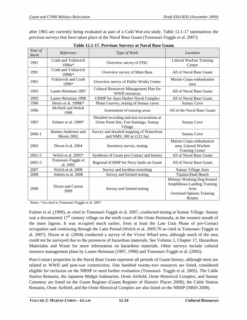
after 1965 are currently being evaluated as part of a Cold War-era study. Table 12.1-17 summarizes the
previous surveys that have taken place at the Naval Base Guam (Tomonari-Tuggle et al. 2007).
Table 12.1-17. Previous Surveys at Naval Base Guam Year of
Work Reference Type of Work Location
1991 Craib and Yoklavich
1996a* Overview survey of FISC
Littoral Warfare Training
Center
1991 Craib and Yoklavich
1996b* Overview survey of Main Base All of Naval Base Guam
1991 Yoklavich and Craib
1996* Overview survey of Public Works Center
Marine Corps embarkation
area
1993 Lauter-Reinman 1997 Cultural Resources Management Plan for
WWII resources All of Naval Base Guam
1993 Lauter-Reinman 1998 CRMP for Apra Harbor Naval Complex All of Naval Base Guam
1996 Henry et al. 1998b* Phase I survey, testing of Sumay caves Sumay Cove
1996 McNeill and Welch
1998 Assessment of training areas All of the Naval Base Guam
1997 Fulmer et al. 1999*
Detailed recording and test excavations at
Orote Point Site, Fort Santiago, Sumay
Village
Sumay Cove
2000-1 Hunter-Andersen and
Moore 2002
Survey and detailed mapping of Waterfront
and NMS; 300 ac (121 ha) Sumay Cove
2002 Dixon et al. 2004 Inventory survey, testing
Marine Corps embarkation
area, Littoral Warfare
Training Center
2001-5 Welch et al. 2005* Synthesis of Guam pre-Contact and history All of Naval Base Guam
2001-5 Tomonari-Tuggle et
al. 2005 Regional ICRMP for Navy lands on Guam All of Naval Base Guam
2007 Welch et al. 2008 Survey and backhoe trenching Sumay Village Area
2008 Athens et al. 2008 Survey and limited testing Tipalao/Dadi Beach
2008 Dixon and Carson
2009 Survey and limited testing
Military Working Dog Kennel
Amphibious Landing Training
Area
Overland Options Training
Routes Notes: *As cited in Tomonari-Tuggle et al. 2007
Fulmer et al. (1999), as cited in Tomonari-Tuggle et al. 2007, conducted testing at Sumay Village. Sumay
was a documented 17th century village on the north coast of the Orote Peninsula, at the western mouth of
the inner lagoon. It was occupied much earlier, from at least the Late Unai Phase of pre-Contact
occupation and continuing through the Latte Period (Welch et al. 2005:70 as cited in Tomonari-Tuggle et
al. 2007). Dixon et al. (2004) conducted a survey of the Victor Wharf area, although much of the area
could not be surveyed due to the presences of hazardous materials. See Volume 2, Chapter 17, Hazardous
Materialns and Waste for more information on hazardous materials. Other surveys include cultural
resource management plans by Lauter-Reinman (1997, 1998) and Tomonari-Tuggle et al. (2005).
Post-Contact properties in the Naval Base Guam represent all periods of Guam history, although most are
related to WWII and post-war construction. One hundred twenty-two resources are listed, considered
eligible for inclusion on the NRHP or need further evaluation (Tomonari- Tuggle et al. 2005). The Cable
Station Remains, the Japanese Midget Submarine, Orote Airfield, Orote Historical Complex, and Sumay
Cemetery are listed on the Guam Register (Guam Register of Historic Places 2008); the Cable Station
Remains, Orote Airfield, and the Orote Historical Complex are also listed on the NRHP (NRIS 2008).
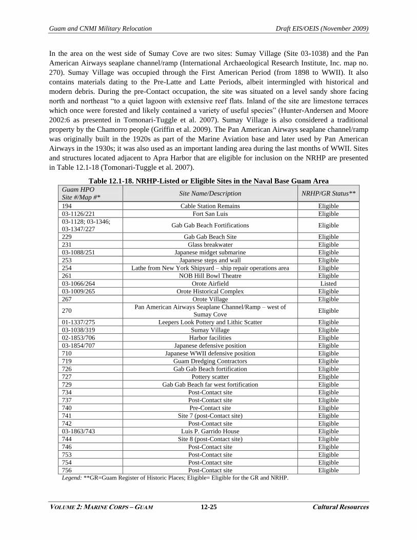
Guam and CNMI Military Relocation Draft EIS/OEIS (November 2009)
VOLUME 2: MARINE CORPS – GUAM 12-25 Cultural Resources
In the area on the west side of Sumay Cove are two sites: Sumay Village (Site 03-1038) and the Pan
American Airways seaplane channel/ramp (International Archaeological Research Institute, Inc. map no.
270). Sumay Village was occupied through the First American Period (from 1898 to WWII). It also
contains materials dating to the Pre-Latte and Latte Periods, albeit intermingled with historical and
modern debris. During the pre-Contact occupation, the site was situated on a level sandy shore facing
north and northeast ―to a quiet lagoon with extensive reef flats. Inland of the site are limestone terraces
which once were forested and likely contained a variety of useful species‖ (Hunter-Andersen and Moore
2002:6 as presented in Tomonari-Tuggle et al. 2007). Sumay Village is also considered a traditional
property by the Chamorro people (Griffin et al. 2009). The Pan American Airways seaplane channel/ramp
was originally built in the 1920s as part of the Marine Aviation base and later used by Pan American
Airways in the 1930s; it was also used as an important landing area during the last months of WWII. Sites
and structures located adjacent to Apra Harbor that are eligible for inclusion on the NRHP are presented
in Table 12.1-18 (Tomonari-Tuggle et al. 2007).
Table 12.1-18. NRHP-Listed or Eligible Sites in the Naval Base Guam Area Guam HPO
Site #/Map #* Site Name/Description NRHP/GR Status**
194 Cable Station Remains Eligible
03-1126/221 Fort San Luis Eligible
03-1128; 03-1346;
03-1347/227 Gab Gab Beach Fortifications Eligible
229 Gab Gab Beach Site Eligible
231 Glass breakwater Eligible
03-1088/251 Japanese midget submarine Eligible
253 Japanese steps and wall Eligible
254 Lathe from New York Shipyard – ship repair operations area Eligible
261 NOB Hill Bowl Theatre Eligible
03-1066/264 Orote Airfield Listed
03-1009/265 Orote Historical Complex Eligible
267 Orote Village Eligible
270 Pan American Airways Seaplane Channel/Ramp – west of
Sumay Cove Eligible
01-1337/275 Leepers Look Pottery and Lithic Scatter Eligible
03-1038/319 Sumay Village Eligible
02-1853/706 Harbor facilities Eligible
03-1854/707 Japanese defensive position Eligible
710 Japanese WWII defensive position Eligible
719 Guam Dredging Contractors Eligible
726 Gab Gab Beach fortification Eligible
727 Pottery scatter Eligible
729 Gab Gab Beach far west fortification Eligible
734 Post-Contact site Eligible
737 Post-Contact site Eligible
740 Pre-Contact site Eligible
741 Site 7 (post-Contact site) Eligible
742 Post-Contact site Eligible
03-1863/743 Luis P. Garrido House Eligible
744 Site 8 (post-Contact site) Eligible
746 Post-Contact site Eligible
753 Post-Contact site Eligible
754 Post-Contact site Eligible
756 Post-Contact site Eligible
Legend: **GR=Guam Register of Historic Places; Eligible= Eligible for the GR and NRHP.
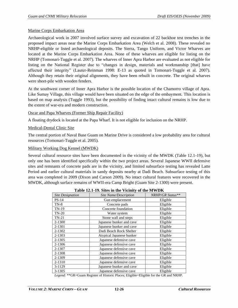
Guam and CNMI Military Relocation Draft EIS/OEIS (November 2009)
VOLUME 2: MARINE CORPS – GUAM 12-26 Cultural Resources
Marine Corps Embarkation Area
Archaeological work in 2007 involved surface survey and excavation of 22 backhoe test trenches in the
proposed impact areas near the Marine Corps Embarkation Area (Welch et al. 2008). These revealed no
NRHP-eligible or listed archaeological deposits. The Sierra, Tango Uniform, and Victor Wharves are
located at the Marine Corps Embarkation Area. None of these wharves are eligible for listing on the
NRHP (Tomonari-Tuggle et al. 2007). The wharves of Inner Apra Harbor are evaluated as not eligible for
listing on the National Register due to ―changes in design, materials and workmanship [that] have
affected their integrity‖ (Lauter-Reinman 1998: E-13 as quoted in Tomonari-Tuggle et al. 2007).
Although they retain their original alignments, they have been rebuilt in concrete. The original wharves
were sheet-pile with wooden fenders.
At the southwest corner of Inner Apra Harbor is the possible location of the Chamorro village of Apra.
Like Sumay Village, this village would have been situated on the edge of the embayment. This location is
based on map analysis (Tuggle 1993), but the possibility of finding intact cultural remains is low due to
the extent of war-era and modern construction.
Oscar and Papa Wharves (Former Ship Repair Facility)
A floating drydock is located at the Papa Wharf. It is not eligible for inclusion on the NRHP.
Medical-Dental Clinic Site
The central portion of Naval Base Guam on Marine Drive is considered a low probability area for cultural
resources (Tomonari-Tuggle et al. 2005).
Military Working Dog Kennel (MWDK)
Several cultural resource sites have been documented in the vicinity of the MWDK (Table 12.1-19), but
only one has been identified specifically within the two project areas. Several Japanese WWII defensive
sites and remnants of concrete pads are in the vicinity, and limited subsurface testing has revealed Latte
Period and earlier cultural materials in sandy deposits nearby at Dadi Beach. Subsurface testing of this
area was completed in 2009 (Dixon and Carson 2009). No intact cultural features were recovered in the
MWDK, although surface remains of WWII-era Camp Bright (Guam Site 2-1300) were present.
Table 12.1-19. Sites in the Vicinity of the MWDK Site Designation Site Name/Description NRHP/GR Status**
PS-14 Gun emplacement Eligible
TN-8 Concrete pads Eligible
TN-19 Concrete foundation Eligible
TN-20 Water system Eligible
TN-21 Stone wall and steps Eligible
2-1300 Japanese bunker and cave Eligible
2-1301 Japanese bunker and cave Eligible
2-1302 Dadi Beach Rock Shelter Eligible
2-1303 Atypical Japanese bunker Eligible
2-1305 Japanese defensive cave Eligible
2-1306 Japanese defensive cave Eligible
2-1307 Japanese defensive cave Eligible
2-1308 Japanese defensive cave Eligible
2-1309 Japanese defensive cave Eligible
2-1310 Japanese defensive cave Eligible
3-1129 Japanese bunker and cave Eligible
3-1305 Japanese defensive cave Eligible
Legend: **GR=Guam Register of Historic Places; Eligible=Eligible for the GR and NRHP.
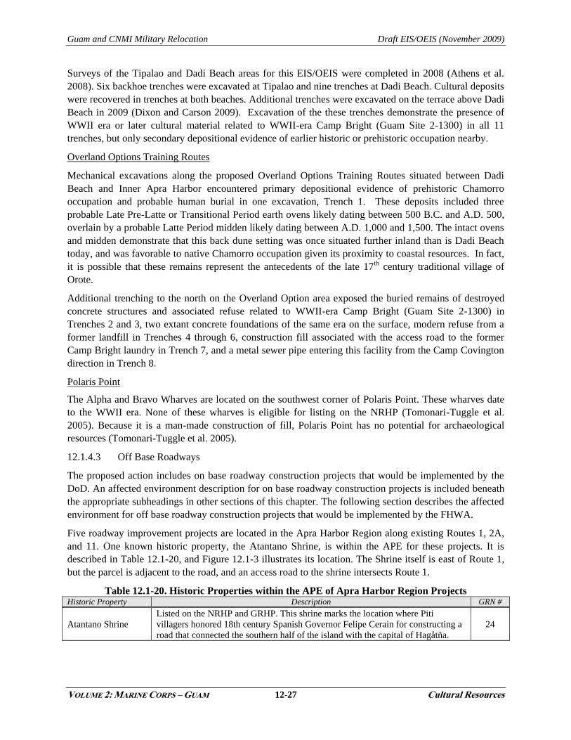
Guam and CNMI Military Relocation Draft EIS/OEIS (November 2009)
VOLUME 2: MARINE CORPS – GUAM 12-27 Cultural Resources
Surveys of the Tipalao and Dadi Beach areas for this EIS/OEIS were completed in 2008 (Athens et al.
2008). Six backhoe trenches were excavated at Tipalao and nine trenches at Dadi Beach. Cultural deposits
were recovered in trenches at both beaches. Additional trenches were excavated on the terrace above Dadi
Beach in 2009 (Dixon and Carson 2009). Excavation of the these trenches demonstrate the presence of
WWII era or later cultural material related to WWII-era Camp Bright (Guam Site 2-1300) in all 11
trenches, but only secondary depositional evidence of earlier historic or prehistoric occupation nearby.
Overland Options Training Routes
Mechanical excavations along the proposed Overland Options Training Routes situated between Dadi
Beach and Inner Apra Harbor encountered primary depositional evidence of prehistoric Chamorro
occupation and probable human burial in one excavation, Trench 1. These deposits included three
probable Late Pre-Latte or Transitional Period earth ovens likely dating between 500 B.C. and A.D. 500,
overlain by a probable Latte Period midden likely dating between A.D. 1,000 and 1,500. The intact ovens
and midden demonstrate that this back dune setting was once situated further inland than is Dadi Beach
today, and was favorable to native Chamorro occupation given its proximity to coastal resources. In fact,
it is possible that these remains represent the antecedents of the late 17th century traditional village of
Orote.
Additional trenching to the north on the Overland Option area exposed the buried remains of destroyed
concrete structures and associated refuse related to WWII-era Camp Bright (Guam Site 2-1300) in
Trenches 2 and 3, two extant concrete foundations of the same era on the surface, modern refuse from a
former landfill in Trenches 4 through 6, construction fill associated with the access road to the former
Camp Bright laundry in Trench 7, and a metal sewer pipe entering this facility from the Camp Covington
direction in Trench 8.
Polaris Point
The Alpha and Bravo Wharves are located on the southwest corner of Polaris Point. These wharves date
to the WWII era. None of these wharves is eligible for listing on the NRHP (Tomonari-Tuggle et al.
2005). Because it is a man-made construction of fill, Polaris Point has no potential for archaeological
resources (Tomonari-Tuggle et al. 2005).
12.1.4.3 Off Base Roadways
The proposed action includes on base roadway construction projects that would be implemented by the
DoD. An affected environment description for on base roadway construction projects is included beneath
the appropriate subheadings in other sections of this chapter. The following section describes the affected
environment for off base roadway construction projects that would be implemented by the FHWA.
Five roadway improvement projects are located in the Apra Harbor Region along existing Routes 1, 2A,
and 11. One known historic property, the Atantano Shrine, is within the APE for these projects. It is
described in Table 12.1-20, and Figure 12.1-3 illustrates its location. The Shrine itself is east of Route 1,
but the parcel is adjacent to the road, and an access road to the shrine intersects Route 1.
Table 12.1-20. Historic Properties within the APE of Apra Harbor Region Projects Historic Property Description GRN #
Atantano Shrine
Listed on the NRHP and GRHP. This shrine marks the location where Piti
villagers honored 18th century Spanish Governor Felipe Cerain for constructing a
road that connected the southern half of the island with the capital of Hagåtña.
24
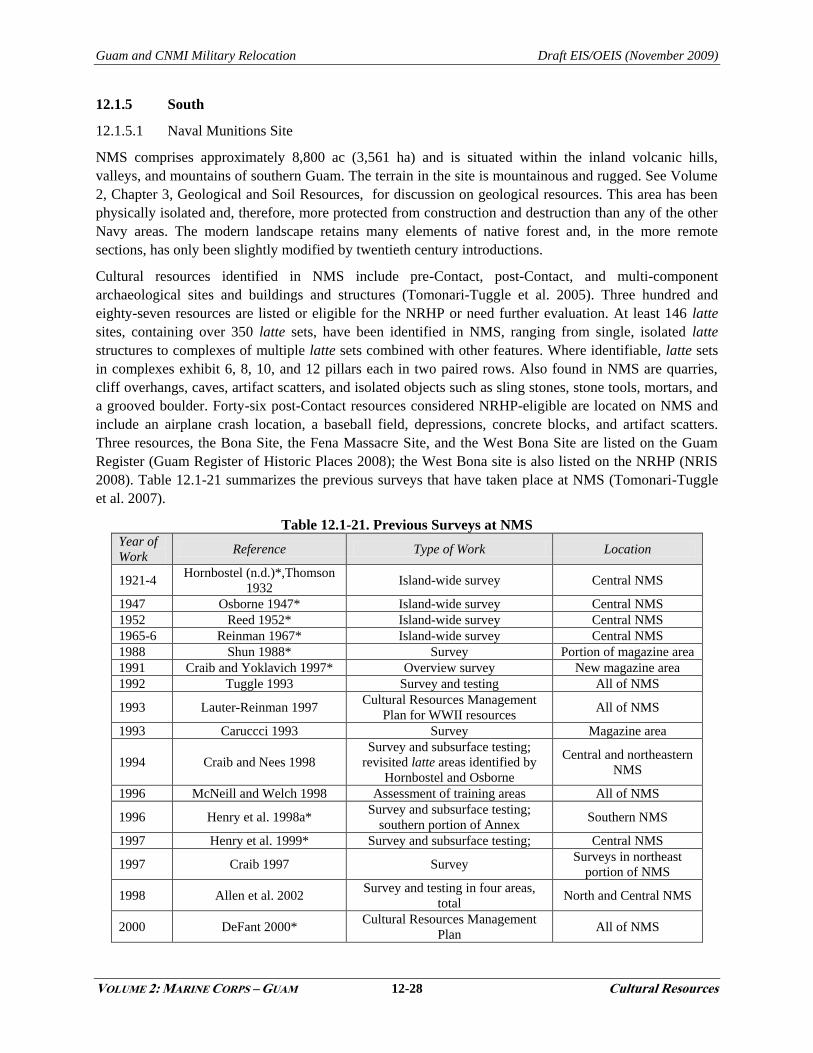
Guam and CNMI Military Relocation Draft EIS/OEIS (November 2009)
VOLUME 2: MARINE CORPS – GUAM 12-28 Cultural Resources
12.1.5 South
12.1.5.1 Naval Munitions Site
NMS comprises approximately 8,800 ac (3,561 ha) and is situated within the inland volcanic hills,
valleys, and mountains of southern Guam. The terrain in the site is mountainous and rugged. See Volume
2, Chapter 3, Geological and Soil Resources, for discussion on geological resources. This area has been
physically isolated and, therefore, more protected from construction and destruction than any of the other
Navy areas. The modern landscape retains many elements of native forest and, in the more remote
sections, has only been slightly modified by twentieth century introductions.
Cultural resources identified in NMS include pre-Contact, post-Contact, and multi-component
archaeological sites and buildings and structures (Tomonari-Tuggle et al. 2005). Three hundred and
eighty-seven resources are listed or eligible for the NRHP or need further evaluation. At least 146 latte
sites, containing over 350 latte sets, have been identified in NMS, ranging from single, isolated latte
structures to complexes of multiple latte sets combined with other features. Where identifiable, latte sets
in complexes exhibit 6, 8, 10, and 12 pillars each in two paired rows. Also found in NMS are quarries,
cliff overhangs, caves, artifact scatters, and isolated objects such as sling stones, stone tools, mortars, and
a grooved boulder. Forty-six post-Contact resources considered NRHP-eligible are located on NMS and
include an airplane crash location, a baseball field, depressions, concrete blocks, and artifact scatters.
Three resources, the Bona Site, the Fena Massacre Site, and the West Bona Site are listed on the Guam
Register (Guam Register of Historic Places 2008); the West Bona site is also listed on the NRHP (NRIS
2008). Table 12.1-21 summarizes the previous surveys that have taken place at NMS (Tomonari-Tuggle
et al. 2007).
Table 12.1-21. Previous Surveys at NMS Year of
Work Reference Type of Work Location
1921-4 Hornbostel (n.d.)*,Thomson
1932 Island-wide survey Central NMS
1947 Osborne 1947* Island-wide survey Central NMS
1952 Reed 1952* Island-wide survey Central NMS
1965-6 Reinman 1967* Island-wide survey Central NMS
1988 Shun 1988* Survey Portion of magazine area
1991 Craib and Yoklavich 1997* Overview survey New magazine area
1992 Tuggle 1993 Survey and testing All of NMS
1993 Lauter-Reinman 1997 Cultural Resources Management
Plan for WWII resources All of NMS
1993 Caruccci 1993 Survey Magazine area
1994 Craib and Nees 1998
Survey and subsurface testing;
revisited latte areas identified by
Hornbostel and Osborne
Central and northeastern
NMS
1996 McNeill and Welch 1998 Assessment of training areas All of NMS
1996 Henry et al. 1998a* Survey and subsurface testing;
southern portion of Annex Southern NMS
1997 Henry et al. 1999* Survey and subsurface testing; Central NMS
1997 Craib 1997 Survey Surveys in northeast
portion of NMS
1998 Allen et al. 2002 Survey and testing in four areas,
total North and Central NMS
2000 DeFant 2000* Cultural Resources Management
Plan All of NMS

Guam and CNMI Military Relocation Draft EIS/OEIS (November 2009)
VOLUME 2: MARINE CORPS – GUAM 12-29 Cultural Resources
Year of
Work Reference Type of Work Location
2001-5 Welch et al. 2005* Summary of Guam pre-Contact and
history All of NMS
2001-5 Tomonari-Tuggle et al. 2005 Regional ICRMP for Navy Lands All of NMS
2002 Hunter-Anderson and Moore
2002* Survey
Southwest portion of
NMS
2007 Welch et al. 2008 Survey and limited testing Southwest portion of
NMS
2002 Dixon et al 2004 Survey and limited testing Northeast NMS
Lost River Notes: *As cited in Tomonari-Tuggle et al. 2007
Survey and auger testing was conducted by Tuggle (1993) just north of Dealey Road. No pre-Contact
sites were found in this parcel. The central portion of NMS was surveyed by Craib and Nees (1998). They
note that use of this area began as early as Anno Domini 400, with Latte Period construction and
habitation.
Approximately 2,850 ac (1,153 ha) in the southern portion of NMS was surveyed by Henry et al. (1998a
as cited in Tomonari-Tuggle et al. 2007). Henry et al. (1999, as cited in Tomonari-Tugglet et al. 2007)
suggest that specific activities that took place in NMS including resource procurement, cooking, storage,
ceramic manufacturing, shelter, stone tool manufacturing, latte construction, plant processing,
woodworking/fiber craft, hearth construction, oven construction, marine exploitation, hunting, warfare,
food production, and mortuary activities. This variety indicates that inland sites were not just for
occasional use or collection of resources, but were used for long-term habitation and activities.
Allen et al. (2002) conducted a survey of approximately 365 ac (148 ha) in four parcels in the northern
and central portions of NMS. They located artifact scatters, latte sets, military sites, overhangs and cave
shelters, and early 20th century habitations. Welch et al. (2007) surveyed the southwestern portion of
NMS.
A traditional cultural properties study of Guam was completed in 2009 (Griffin et al. 2009). Two
traditional cultural properties were identified in NMS. The Fena Massacre Site has archaeological and
ethnographic associations. The Fena Watershed contains numerous archaeological sites and has
legendary, archaeological, and ethnographic associations. Concerns over the possible disturbance and
disposition of pre-Contact human remains are likely and the presence of petroglyphs and pictographs may
indicate past or present ceremonial or religious activities. Pre-Contact human remains have been
recovered from caves and rockshelters as well as near latte sites.
Specific areas known to have traditional importance to the Chamorro include Almagosa Springs area of
Fena on NMS. The Fena Massacre Caves on NMS are the location of annual commemoration ceremonies
by the Chamorro.
Munitions Storage
In the northeastern portion of NMS, a surface survey in 2007 identified several abandoned magazines, a
recently renovated bridge, one latte site, an isolated stone artifact fragment, and the displaced remnants of
a damaged Armco structure. One latte site is eligible for listing on the NRHP. Of the architectural sites
present in the area, the abandoned Armco Magazines are eligible for listing on the NRHP (Welch et al.
2008). Bridge 705 was not eligible for listing on the NRHP (Welch et al. 2008).
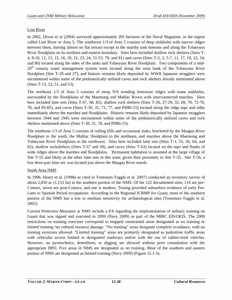
Guam and CNMI Military Relocation Draft EIS/OEIS (November 2009)
VOLUME 2: MARINE CORPS – GUAM 12-30 Cultural Resources
Lost River
In 2002, Dixon et al (2004) surveyed approximately 205 hectares of the Naval Magazine, in the region
called Lost River or Area 5. The southwest 1/3 of Area 5 consists of deep sinkholes with narrow ridges
between them, leaving almost no flat terrain except in the marshy sink bottoms and along the Tolaeyuus
River floodplain on its northern and eastern boundary. Sites here included shallow rock shelters (Sites T-
4, 8-10, 12, 13, 15, 16, 20, 21, 23, 24, 51-53, 79, and 81) and caves (Sites T-2, 3, 5-7, 11, 17, 19, 22, 54,
and 80) located along the sides of the sinks and Tolaeyuus River floodplain. Two components of a mid-
20th century water management system were located along the west bank of the Tolaeyuus River
floodplain (Site T-18 and 27), and historic remains likely deposited by WWII Japanese stragglers were
encountered within some of the prehistorically utilized caves and rock shelters already mentioned above
(Sites T-13, 22, 51, and 53).
The northeast 1/3 of Area 5 consists of steep N/S trending limestone ridges with some sinkholes,
surrounded by the floodplains of the Maemong and Mahlac Rivers with interconnected marshes. Sites
here included latte sets (Sites T-67, 68, 82), shallow rock shelters (Sites T-26, 27-29, 32, 69, 70, 72-76,
78, and 83-85), and caves (Sites T-30, 31, 71, 77, and PHRI-15) located along the ridge tops and sides
immediately above the marshes and floodplains. Historic remains likely deposited by Japanese stragglers
between 1944 and 1945 were encountered within some of the prehistorically utilized caves and rock
shelters mentioned above (Sites T-30, 31, 78, and PHRI-15).
The southeast 1/3 of Area 5 consists of rolling hills and occasional sinks, bracketed by the Maagas River
floodplain to the south, the Mahlac floodplain to the northeast, and marshes above the Maemong and
Tolaeyuus River floodplains to the northwest. Sites here included latte sets (Sites T-1, 55, 56, 64, and
65), shallow rockshelters (Sites T-57 and 58), and caves (Sites T-63) located on the tops and flanks of
wide ridges above the marshes and floodplains. Permanent habitation is assumed at the large village of
Site T-55 and likely at the other latte sets in this zone, given their proximity to Site T-55. Site T-56, a
low three-pair latte set, was located just above the Maagas River marsh.
South Area NMS
In 1996, Henry et al. (1998a as cited in Tomonari-Tuggle et al. 2007) conducted an inventory survey of
about 2,850 ac (1,153 ha) in the southern portion of the NMS. Of the 122 documented sites, 114 are pre-
Contact, seven are post-Contact, and one is modern. Testing provided subsurface evidence of early Pre-
Latte to Spanish Period occupations. According to the Regional ICRMP for Guam, most of the southern
portion of the NMS has a low to medium sensitivity for archaeological sites (Tomonari-Tuggle et al.
2005).
Current Protective Measures at NMS include a PA regarding the implementation of military training on
Guam that was signed and executed in 2009 (Navy 2009) as part of the MIRC EIS/OEIS. The 2009
restrictions on training exercises correspond to mapped constrained areas designated as no training or
limited training /no cultural resource damage. ―No training‖ areas designate complete avoidance, with no
training exercises allowed. ―Limited training‖ areas are primarily designated as pedestrian traffic areas
with vehicular access limited to designated roadways and/or with the use of rubber-tired vehicles.
However, no pyrotechnics, demolition, or digging are allowed without prior consultation with the
appropriate HPO. Five areas in NMS are designated as no training. Most of the southern and eastern
portion of NMS are designated as limited training (Navy 2009) (Figure 12.1-5).
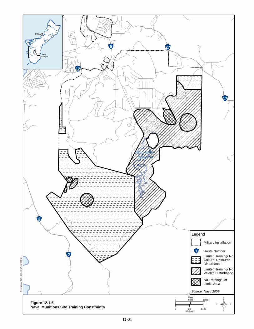
2A
5 27
12
2
2
17
Fena Valley Fena Valley ReservoirReservoir
GUAMGUAM
AreaEnlarged
Legend
1 Route Number
No Training/ OffLimits Area
Limited Training/ NoWildlife Disturbance
Limited Training/ NoCultural ResourceDisturbance
Military Installation
Source: Navy 2009Prin
ting
Dat
e: M
TH D
AY
, YE
AR
, LO
CA
TIO
N
0 4,0002,000Feet
0 570 1,140Meters
Figure 12.1-5Naval Munitions Site Training Constraints
12-31
Guam and CNMI Military Relocation Draft EIS/OEIS (November 2009)
VOLUME 2: MARINE CORPS – GUAM 12-32 Cultural Resources
12.1.5.2 Non-DoD Lands
Access Road
Access road Alternative A was surveyed in 2008 (Dixon and Carson 2009). No archaeological sites were
recorded along this existing foot path.
12.1.5.3 Off Base Roadways
The proposed action includes on base roadway construction projects that would be implemented by the
DoD. An affected environment description for on base roadway construction projects is included beneath
the appropriate subheadings in other sections of this chapter. The following section describes the affected
environment for off base roadway construction projects that would be implemented by the FHWA.
Four roadway improvement projects are proposed within the south region – two pavement strengthening
projects, one intersection improvement project, and one military access point (MAP). No known historic
properties are located within the APE of any project in the south region.
12.2 ENVIRONMENTAL CONSEQUENCES
This description of environmental consequences addresses all components of the proposed action for the
Marine Corps on Guam. The components addressed include: Main Cantonment, Training, Airfield, and
Waterfront. There are multiple alternatives for the Main Cantonment, Training-Firing Range, Training-
Ammunition Storage, and Training-NMS Access Road. Airfield and Waterfront do not have alternatives.
Although organized by the Main Cantonment alternatives, a full analysis of each alternative, Airfield, and
Waterfront is presented beneath the respective headings. A summary of impacts specific to each
alternative, Airfield, and Waterfront is presented at the end of this chapter. An analysis of the impacts
associated with the off base roadways is discussed in Volume 6.
12.2.1 Approach to Analysis
12.2.1.1 Methodology
The methodology for identifying, evaluating, and mitigating impacts to cultural resources has been
established through federal laws and regulations including the NHPA and the ARPA.
A significant resource is a cultural resource eligible or listed on the NRHP. A project affects a NRHP-
eligible or listed resource when it alters the resource‘s characteristics, including relevant features of its
environment or features that qualify it for inclusion on the NRHP. Adverse effects may include the
following: physical destruction, damage, or alteration of all or part of the resources; alteration of the
character of the surrounding environment that contributes to the resource‘s qualifications for the NRHP;
introduction of visual, audible, or atmospheric elements that are out of character with the resource;
neglect of the resource resulting in its deterioration or destruction; and transfer, lease, or sale of the
property (36 CFR 800.5(a)(2)) without adequate and legally enforceable restrictions or conditions to
ensure long-term preservation of the property‘s historic significance.
Analysis of potential impacts to cultural resources considers both direct and indirect impacts. Direct
impacts are those that may occur during either the construction or operations phase of the project. They
may be the result of increased noise during operations or ground disturbing activities involving
construction, modification, or the use and maintenance of facilities. Indirect impacts are those that may
occur as a result of the completed project such as increased vehicular or pedestrian traffic in the vicinity
of the resource that may lead to vandalism or increased erosion from ground disturbing activities.

Guam and CNMI Military Relocation Draft EIS/OEIS (November 2009)
VOLUME 2: MARINE CORPS – GUAM 12-33 Cultural Resources
Vandalism is considered to be a significant impact because it damages the integrity of the site, which is
the major determinant of NRHP-eligibility. Physical evidence left in archaeological sites is finite and
cannot renew itself once it has been disturbed. For this reason, federal activities that open areas up to the
public or that involve personnel traveling through an area may have an adverse impact, especially if
vandalism to NRHP-eligible or listed resources in the vicinity occurs. If a site is eligible to the NRHP
primarily for its setting or location, changes to the visual setting are considered a significant impact.
Cumulative impacts, the impact on cultural resources which result from the incremental impact of the
action when added to other past, present, and future actions, must also be taken into account.
12.2.1.2 Determination of Significance
A historic property is a property that is eligible for or listed on the NRHP. For cultural resources found
eligible to the NRHP, a significant adverse impact is one that disturbs the integrity of a historic property.
If a project disturbs intrinsic characteristics that make the property eligible for or listed on the NRHP
(other than its integrity), then it is also considered to have a significant adverse impact.
The Regional ICRMP for Navy property in Guam has established Standard Operating Procedures for
protecting known NRHP-eligible or listed cultural resources; procedures for managing the inadvertent
discovery of archaeological resources, inadvertent discovery of human remains, inadvertent disturbance
to historic properties; and distributing permits for archaeological investigations (Tomonari-Tuggle et al.
2005). In addition, agreements on limitations in training have been made as part of the MIRC EIS PA
(Navy 2009). Areas with limited or no training stipulations at Apra Harbor are presented in Figure 12.1-3
and at NMS in Figure 12.1-5.
As part of the Section 106 consultation process for the proposed action, a PA for all proposed military
training activities, construction, and operations, which includes additional mitigation measures and
procedures, is being prepared. Current signatories to this PA are: the Department of Defense (Joint
Region Marianas); DoD Representative Guam, CNMI, Federated States of Micronesia, and Republic of
Palau; Marines; Navy; Army; Air Force), other federal agencies (U.S. Environmental Protection Agency,
ACHP, and the NPS), and local government agencies (Guam HPO, CNMI HPO). Tthe signed PA would
be incorporated into the Final EIS. Stipulations in the PA include the following:
DoD would ensure the identification and evaluation of historic properties within the APE
before the project is completed or prior to the initiation of any part of the project with the
potential to impact historic properties.
For areas or properties that have not been previously inventoried for historic properties, DoD
would record surface sites and, when possible, areas would also be archaeologically sampled
for subsurface sites, when data is easily obtainable without having to demolish existing
facilities or infrastructure.
Archaeological probability maps have been generated for all DoD lands on Guam. For all
other areas and islands impacted by the project, archaeological probability maps would be
generated that predict the probability of encountering subsurface cultural resources in three
categories (no/low, medium, and high). These maps would be compiled using previous
archaeological investigations, maps, interviews, and ethnohistoric accounts and in
consultation with the HPOs and the NPS.
o No to Low Probability Areas: These areas contain no surface sites and include
reclaimed fill lands or heavily disturbed areas. No to low probability areas are also areas
that have been previously surveyed and tested and were found not to contain subsurface
Guam and CNMI Military Relocation Draft EIS/OEIS (November 2009)
VOLUME 2: MARINE CORPS – GUAM 12-34 Cultural Resources
resources, orareas not likely to contain subsurface materials based on known social
practices or history of the area.
o Medium Probability Areas: These areas have not been surveyed but may have the
potential to contain sites (surface and/or subsurface), or are areas that contain no known
surface sites but have the potential to encounter subsurface archaeological resources
based on known social practices or history of the area.
o High Probability Areas: These areas contain known surface and/or subsurface sites or
are areas where historic maps, documents, or legends indicate former villages,
habitations, shrines, cemeteries, or other types of cultural activity areas are present or
have been in the past.
Any properties not evaluated shall be assessed for NRHP eligibility. These historic properties
would be incorporated into existing ICRMPs as they are revised or updated or if a new
ICRMP is developed in consultation with the appropriate HPOs.
Any updates to the existing Geographical Information System cultural resource layers, such as shape files
showing the locations of known archaeological sites and buildings and structures, would be shared with
the appropriate HPO or NPS (if a property is associated with a NHL in accordance with 36 CFR
800.11(c)). The HPOs and the NPS recognize that these layers may contain sensitive information and
would not disseminate or make them available to the public without obtaining permission of the
appropriate responsible person whose jurisdiction that historic property is under. Maps of all areas with
archaeological potential and sensitivity for the presence of NRHP-eligible or listed resources would be
appended to the PA. No further review under Section 106 is required for areas designated as No to Low
probability areas. Mitigation measures for Medium and High probability areas are stipulated as follows:
High Probability Areas would be avoided if possible. If sites are impacted, a mitigation plan
would be developed and reviewed by the appropriate HPO and then data recovery
excavations would take place.
Medium Probability Areas would be subject to monitoring or testing. Prior to any disturbance
or excavation, work plans would be developed and reviewed by the appropriate HPO.
In recognition of the significance that traditional cultural properties within the APE of the proposed action
have to various cultural groups, DoD would allow access to individuals and organizations that attach
significance to these historic properties, where security requirements are not prohibitive. The PA also
provides stipulations for treatment in case of emergency discoveries, the review process, and report
requirements. The Standard Operating Procedures in the current Regional ICRMP would be updated,
revised, and attached to the PA. Although probability maps would be generated based on the likelihood of
archaeological resources, treatment of known architectural resources and traditional cultural properties as
a result of the proposed action would also be stipulated in the PA.
12.2.1.3 Issues Identified during Public Scoping Process
The following analysis focuses on possible impacts to cultural resources—archaeological, architectural,
and traditional cultural properties—that could be impacted or affected by the proposal. As part of the
analysis, concerns relating to cultural resources that were mentioned by the public, including regulatory
stakeholders, during scoping meetings were addressed. These include:
Access to cultural sites
Construction impacts to cultural resources
Thorough and adequate data collection
Guam and CNMI Military Relocation Draft EIS/OEIS (November 2009)
VOLUME 2: MARINE CORPS – GUAM 12-35 Cultural Resources
Public participation in the planning process relating to cultural resources
12.2.2 Alternative 1
Alternative 1 contains actions relating to construction of a main cantonment at Finegayan and adjacent
non-DoD lands (the Former FAA parcel and the Harmon Annex); construction and operation of
waterfront improvements at Apra Harbor; aviation training at Andersen AFB, Orote Field, and Andersen
South; firing training south of Route. 15; and non-firing training at Andersen South and NMS.
12.2.2.1 North
Andersen AFB
Construction
The Air Combat Element Beddown project construction would take place in an area of low and high
archaeological probability near North Field (Figure 12.2-1). Given the level of development in the area, it
is assumed that 100% of the area would be disturbed. Ground excavation and soil removal associated with
buildings and utilities construction would adversely impact NRHP-eligible archaeological resources
known in the project area, including site 1044 (artifact scatter) and 1046 (artifact scatter).
The Air Embarkation project construction would take place primarily in a developed, paved area.
However, approximately 20 ac (8 ha) of undeveloped land were surveyed in 2009 (Dixon and Walker
2009). No sites were discovered, therefore this area is considered to have a low probability for
archaeological remains (see Figure 12.2-1) The project would require the demolition of one building,
Building 19028, the Air Mobility Command Headquarters Building. This building is not eligible for
listing on the NRHP.
The North Gate and Access Road construction would take place in an area of low archaeological
probability. This area was surveyed in 2008 and no NRHP-eligible sites occur in this area. No
construction impacts are anticipated.
The Secondary Access Road construction would also take place in an area of low archaeological
probability. NRHP eligible sites do not occur in this area and no construction impacts are anticipated.
LZs would be established at NWF under Alternative 1. These LZs would occur in an area currently used
for training (and approved for training under the MIRC PA [Navy 2009]) and would not adversely affect
the site (NWF).
Construction of 12 standard earth covered magazines (ECMs) and associated support facilities (two
concrete pads and a concrete support building) at MSA 1 would occur in a low and high probability area.
Ground excavation and soil removal associated with buildings and utilities construction would adversely
impact NRHP-eligible archaeological resources recorded by Dixon and Walker (2009) at prehistoric sites
T-9-1 and T-9-2,. NRHP eligible prehistoric site T-1-15 is located near the project APE, but would not be
affected by the proposed action.
Operation
Operating activities (training and non-training related) include increased personnel in the area as a result
of the proposed action. This increase in personnel in the area could increase site vandalism. Additional
traffic on NWF due to increased aviation activities could adversely impact the runway surface.
Disturbance to NRHP-eligible resources indirectly through increasing access to the sites is considered to
be a significant adverse impact.
Sour
ces:
Nav
y 20
09b
Printing Date: May 8, 2009; M:\projects\GIS\8806_Guam_Buildup_EIS\figures\Current_Deliverable\Vol_2\impacts\cultural\Figure 12.2-1_aafb.mxd
9
3
3A
1
15
Ande
rsen
AFB
Ande
rsen
AFB
Nor
thw
est F
ield
Nor
thw
est F
ield
NC
TS F
ineg
ayan
NC
TS F
ineg
ayan
Riti
dian
Poi
ntR
itidi
an P
oint
Pati
Poi
ntPa
ti P
oint
Potts
Jun
ctio
nPo
tts J
unct
ion
Paci
fic O
cean
Nor
th R
amp
Nor
th R
amp
Prop
osed
AC
EPr
opos
ed A
CE
Prop
osed
Prop
osed
Air E
mba
rkat
ion
Air E
mba
rkat
ion
Prop
osed
Prop
osed
Acce
ss R
oad
Acce
ss R
oad
Prop
osed
Prop
osed
Mun
ition
s S
tora
geM
uniti
ons
Sto
rage
Prop
osed
Prop
osed
Land
ing
Zone
sLa
ndin
g Zo
nes
Figu
re 1
2.2-
1
GU
AM
GU
AM
Area
Enla
rged
077
51,
550
Met
ers
05,
800
2,90
0Fe
et
Impa
cts
on o
rin
the
Vic
inity
of
Ande
rsen
AFB
and
Arch
aeol
ogic
alPr
obab
ility
Are
as
Lege
nd
1R
oute
Num
ber
Mili
tary
Inst
alla
tion
Hig
h
Med
ium
Low
Arch
aeol
ogic
alPr
obab
ility
Area
s
Pro
pose
d P
roje
ctFo
otpr
int
Avia
tion
Trai
ning
Area
Buf
fer
12-36
Guam and CNMI Military Relocation Draft EIS/OEIS (November 2009)
VOLUME 2: MARINE CORPS – GUAM 12-37 Cultural Resources
Finegayan
Construction
Construction of the main cantonment, family housing, and community support would take place at
Finegayan under Alternative 1 (Figure 12.2-2). A variety of land uses/functions would be sited at NCTS
Finegayan and South Finegayan including: housing, quality of life facilities, administration, training, and
education. A total of 1,090 ac (441 ha) within NCTS Finegayan and 290 ac (117 ha) within South
Finegayan could be affected by construction and development. The initial planning process considered the
locations of NRHP-eligible resources and avoided impacting the majority of the historic properties in the
area. Additional efforts would be made during the final planning stage to avoid all historic properties, if
possible.
Construction of the Bachelor Enlisted Quarters (BEQ) would impact areas with low, medium, and high
archaeological probability. This setting would require a substantial amount of vegetation/ground
excavation and soil removal, and has the potential to adversely affect archaeological resources and disturb
an area with high probability for archaeological resources, which includes site 1021 (artifact scatter).
Construction of Headquarters (HQ) facilities would impact areas with a medium archaeological
probability. This setting would disturb an area with medium probability for archaeological resources.
Construction of the BASE, DIVA and MEFA facilities would impact areas with low, medium, and high
archaeological probability. This setting has the potential to adversely affect archaeological resources in an
area with medium/high probability. Sites in this area include 1022 (artifact scatter) 1023 (four WWII
defensive structures) and 1026 (habitation site and artifact scatter). Construction of the Marine Logistic
Group (MLG) facilities would impact areas with low, medium, and high archaeological probability. This
setting would adversely affect archaeological resources in areas with medium/high archaeological
probability. These resources include sites 381 (ceramic scatter), 1012 (artifact scatter) and 1020 (artifact
scatter). Construction of the LTC facilities would impact an area with low archaeological probability.
NRHP-eligible or listed sites do not occur in this area and construction impacts are not expected.
Construction of housing and education facilities would impact areas on South Finegayan. However, site
811 (Latte Stone Park) would be avoided.
Construction at Finegayan has the potential to require the removal of dukduk trees, a traditional resource
used by canoe builders.
Operation
Operation of the main cantonment and family housing and community support would take place at
Finegayan under Alternative 1 and would bring additional personnel into the area. This increase in
personnel could increase site vandalism, especially to sites such as Haputo on the coast and Latte Stone
Park. Disturbance to NRHP-eligible or listed resources, either directly through construction or indirectly
through increasing access to the sites, is considered to be a significant adverse impact.
Non-DoD Land
Non-DoD land impacted by Alternative 1 includes the FAA parcel and the Harmon Annex. Under
Alternative 1, a real estate interest would be obtained for these parcels.
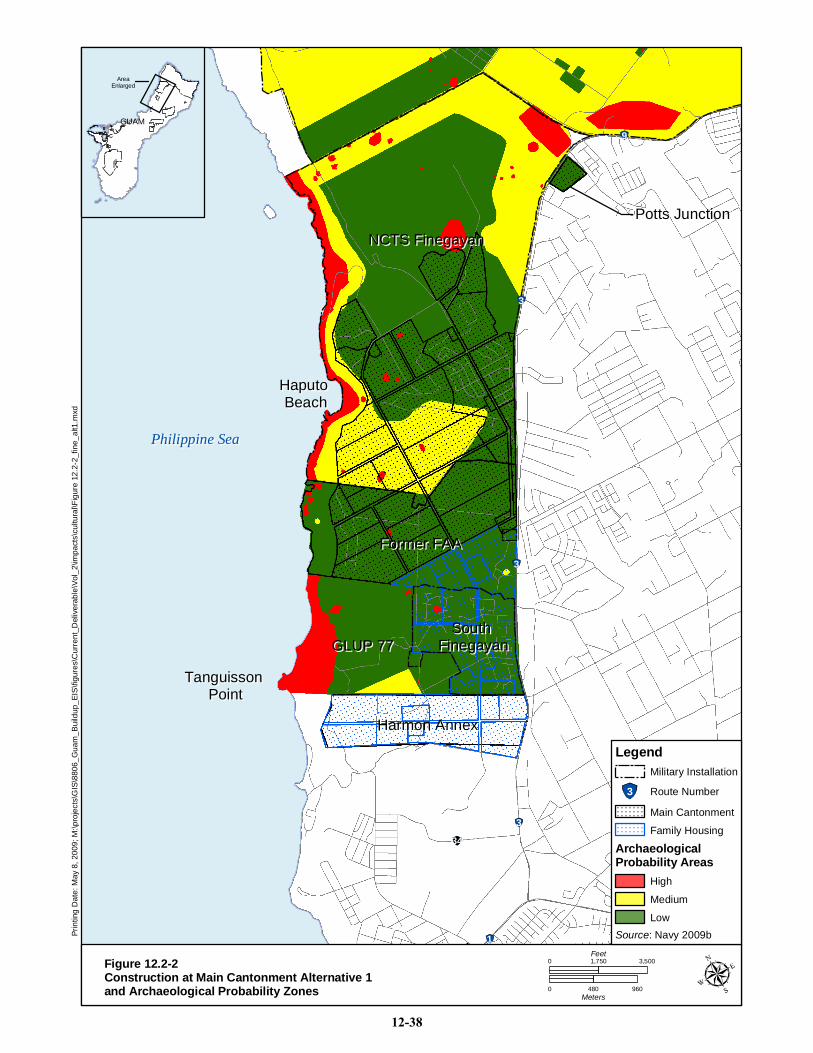
28
9
3
3
3
34
1
Philippine SeaPhilippine Sea
NCTS FinegayanNCTS FinegayanPotts JunctionPotts Junction
Former FAAFormer FAA
GLUP 77GLUP 77South South
FinegayanFinegayan
Harmon AnnexHarmon Annex
Tanguisson Tanguisson PointPoint
Haputo Haputo BeachBeach
GUAMGUAM
AreaEnlarged
Prin
ting
Dat
e: M
ay 8
, 200
9; M
:\pro
ject
s\G
IS\8
806_
Gua
m_B
uild
up_E
IS\fi
gure
s\C
urre
nt_D
eliv
erab
le\V
ol_2
\impa
cts\
cultu
ral\F
igur
e 12
.2-2
_fin
e_al
t1.m
xd
Figure 12.2-2Construction at Main Cantonment Alternative 1and Archaeological Probability Zones 0 480 960
Meters
0 3,5001,750Feet
Source: Navy 2009b
Legend
3 Route Number
Low
Medium
High
ArchaeologicalProbability Areas
Family Housing
Main Cantonment
Military Installation
12-38
Guam and CNMI Military Relocation Draft EIS/OEIS (November 2009)
VOLUME 2: MARINE CORPS – GUAM 12-39 Cultural Resources
Construction
Construction of Quality of Life (QOL), HSG, Bachelor Officer Quarters (BOQ) and education facilities
would impact 680 ac (275 ha) in areas with low and high archaeological probability at the FAA parcel.
This setting would impact sites 1678 (ceramic scatter) and 1681 (ceramic scatter).
Construction of the Personnel Management Office (PMO) facilities would impact areas with medium and
low archaeological probability at the FAA parcel. Construction of the TRN facilities would impact areas
with low archaeological probability at the FAA Parcel. NRHP eligible or listed sites do not occur in this
area and construction and operational impacts are not expected.
Construction of HSG and education facilities at the Harmon Annex would impact 326 ac (132 ha) in areas
of medium archaeological probability.
Operation
Operation of these facilities would bring additional personnel into the area. This increase in personnel
could increase site vandalism. Disturbance to NRHP-eligible or listed resources indirectly through
increasing access to the sites is considered to be a significant adverse impact. Sites that could be impacted
indirectly include sites 1678 and 1681, if they are not directly disturbed by construction.
12.2.2.2 Central
Andersen South
Construction
Training at Andersen South would involve reuse of the existing barracks and demolition of the family
housing located in this area. None of the buildings to be reused or demolished are eligible or listed on the
NRHP. It would also involve construction of a Driver‘s Course and a Convoy Course for a total of 35 ac
(14 ha), clearing for two LZs, and other training facilities (Figure 12.2-3). Two NRHP-eligible
archaeological sites are located in the vicinity of the planned training areas: 1063 (subsurface pre-Contact
artifact scatter) and 1065 (subsurface pre-Contact artifact scatter). Clearing of the training areas and
construction of the Driver‘s Course and convoy course would result in adverse impacts to these
archaeological sites. Clearing for the LZs would involve an area of 100 ft (30 m) square. As the LZs
would be used by MV-22 aircraft, the buffer area around the LZ for analysis purposes was 300 ft (100 m)
in keeping with impact areas defined in the MV-22 Draft EIS (Navy 2009) . Both of the LZs in Andersen
South are in low probability areas and would not impact any NRHP-eligible or listed archaeological sites,
architectural resources, or traditional cultural properties.
A perimeter fence would be constructed around Andersen South. Most of the area in which the fence
would be constructed is an area of low archaeological probability. Portions of Andersen South border
areas with medium archaeological probability along Route 15, although surface recording and subsurface
testing of prehistoric sites AS-T-2008-1 through -8 conducted during survey (Dixon and Carson 2009) is
considered adequate mitigation of these adverse effects.
At Andersen South there are two proposed Hand Grenade Range and Grenade House options associated
with the Training Range Complex Alternatives A and B. Option 1 would affect medium and low
probability areas. Option 2 would affect low probability areas.
Construction at Andersen South has the potential to require the removal of dukduk trees, a traditional
resource used by canoe builders.

Printing Date: Oct 23, 2009, M:\projects\GIS\8806_Guam_Buildup_EIS\figures\Current_Deliverable\Vol_2\12.2-3.mxd
28
1
26 15
15
Paga
t Poi
ntPa
gat P
oint
Ande
rsen
Sou
thAn
ders
en S
outh
Sasa
jyan
Sasa
jyan
Paci
fic O
cean
Paci
fic O
cean
Prop
osed
Prop
osed
AMV
OC
AMV
OC Prop
osed
MO
UT
Prop
osed
MO
UT
Log/
Adm
inLo
g/A
dmin
Prop
osed
Prop
osed
Mod
ular
Mod
ular
MO
UT
MO
UT
Prop
osed
Prop
osed
Rec
onst
ruct
edR
econ
stru
cted
MO
UT
MO
UT
Prop
osed
Prop
osed
Seco
ndar
ySe
cond
ary
Gat
eG
ate
Prop
osed
Mai
n G
ate
Prop
osed
Mai
n G
ate
Con
voy
Cou
rse
Con
voy
Cou
rse
UD
Ran
geU
D R
ange
Mac
hine
Gun
Ran
geM
achi
ne G
un R
ange
KD R
ange
KD R
ange
Pist
ol R
ange
Pist
ol R
ange
Squa
re B
ay R
ange
Squa
re B
ay R
ange
Gre
nade
Hou
seG
rena
de H
ouse
Prop
osed
Prop
osed
Pion
eer R
oad
Pion
eer R
oad
GU
AM
GU
AM
Area
Enla
rged
Alte
rnat
ive
A Im
pact
son
or i
n V
icin
ity o
fAn
ders
en S
outh
and
Rte
15
Par
cels
and
Arc
haeo
logi
cal
Prob
abili
ty A
reas
Figu
re 1
2.2-
3
040
080
0M
eter
s
02,
900
1,45
0Fe
et
Hig
h
Med
ium
Low
Arch
aeol
ogic
alPr
obab
ility
Area
s
Lege
nd
1R
oute
Num
ber
Mili
tary
Inst
alla
tion
Prop
osed
Fea
ture
s
Ran
ge R
oad
Fenc
e Li
ne
Ran
ge T
ower
Ran
ge G
ate
Brid
ge
Pro
pose
d P
roje
ctFo
otpr
int
12-40
Guam and CNMI Military Relocation Draft EIS/OEIS (November 2009)
VOLUME 2: MARINE CORPS – GUAM 12-41 Cultural Resources
Operation
In addition, a 2,000 ac (809 ha) area would be used for maneuver training by 300 personnel for over 45
weeks per year. Operation of the training facilities would bring additional personnel into the area. This
increase in personnel could increase site vandalism Disturbance to NRHP-eligible or listed resources
indirectly through increasing access to the sites, is considered to be a significant adverse impact.
Non-DoD Land
Non-DoD land in the central project sites includes the proposed firing ranges near Route 15. There are
two possible locations for the training ranges, Alternative A and Alternative B.
Construction
Alternative A includes a pistol range, a known distance (KD) range, a machine gun range, an unknown
distance (UD) range, and a square bay range (see Figure 12.2-3). Alternative A would also include the
realignment of a portion of Route 15 to go through Andersen South with a fence constructed on either
side of the road. Construction of Alternative A has the potential to disturb previously unrecorded
archaeological sites within medium probability areas. Construction of the pistol range and KD range
would affect medium probability areas. Construction of the machine gun range and the UD range would
affect both medium and low probability areas. The square bay range is located within a low probability
area. The road realignment would be located in low and high probability areas. Construction of the
realigned road would have adverse impacts to site 1063 (artifact scatter). Construction of the range roads
and fencelines would impact medium and low probability areas. Construction of the range towers would
impact medium probability areas. Construction of the range support areas would impact both medium
and low probability areas. Total area of medium probability of Alternative A would be 61 ac (25 ha).
Alternative B contains similar firming ranges as Alternative A, but would not require the realignment of
Route 15 (Figure 12.2-4). Construction of Alternative B has the potential to disturb previously unrecorded
archaeological sites within medium probability areas. Construction of the pistol range, KD range, and
square bay range would affect medium probability areas. Construction of the machine gun range and the
UD range would affect both medium and low probability areas. The fenceline would impact both
medium and low probability areas. The range towers would impact areas with medium probability. The
range roads would impact medium and low probability areas. Construction of the range support areas
would impact both medium and low probability areas. Total area of medium probability area under
Alternative B is 50 ac (20 ha).
Construction of Alternatives A and B have the potential to require the removal of dukduk trees, a
traditional resource used by canoe builders, and ifit trees, which are used for timber, fuel wood and craft
wood.
Operation
Part of the construction would include fencing the firing range and restricting access to the public. As a
result, operation of the training facilities at Alternative A would restrict public access to the Pagat site
(04-0022, an NRHP-listed archaeological site and a traditional cultural property). Restricted access would
have a beneficial impact to the site. Reduction in public access would reduce the incidence of vandalism.
Also, these sites would not be affected by cleanup activities associated with the operations at the range
because the sites are located outside of any potential impact areas. However, use of the firing range could
create an audible change in the setting of the Pagat site. In addition, losing access to the site could be
perceived by the public as an adverse impact.

Printing Date: Oct 23, 2009, M:\projects\GIS\8806_Guam_Buildup_EIS\figures\Current_Deliverable\Vol_2\12.2-4.mxd
28
1
26 15
15
Paga
t Poi
ntPa
gat P
oint
Ande
rsen
Sou
thAn
ders
en S
outh
Sasa
jyan
Sasa
jyan
Paci
fic O
cean
Paci
fic O
cean
Prop
osed
Prop
osed
AMV
OC
AMV
OC Prop
osed
MO
UT
Prop
osed
MO
UT
Log/
Adm
inLo
g/A
dmin
Prop
osed
Prop
osed
Mod
ular
Mod
ular
MO
UT
MO
UT
Prop
osed
Prop
osed
Rec
onst
ruct
edR
econ
stru
cted
MO
UT
MO
UT
Prop
osed
Prop
osed
Seco
ndar
ySe
cond
ary
Gat
eG
ate
Prop
osed
Mai
n G
ate
Prop
osed
Mai
n G
ate
Con
voy
Cou
rse
Con
voy
Cou
rse
UD
Ran
geU
D R
ange
Mac
hine
Gun
Ran
geM
achi
ne G
un R
ange
KD R
ange
KD R
ange
Pist
ol R
ange
Pist
ol R
ange
Squa
re B
ay R
ange
Squa
re B
ay R
ange
Gre
nade
Hou
seG
rena
de H
ouse
Prop
osed
Prop
osed
Pion
eer R
oad
Pion
eer R
oad
GU
AM
GU
AM
Area
Enla
rged
Alte
rnat
ive
B Im
pact
son
or i
n V
icin
ity o
fAn
ders
en S
outh
and
Rte
15
Par
cels
and
Arc
haeo
logi
cal
Prob
abili
ty A
reas
Figu
re 1
2.2-
4
040
080
0M
eter
s
02,
900
1,45
0Fe
et
Hig
h
Med
ium
Low
Arch
aeol
ogic
alPr
obab
ility
Area
s
Lege
nd
1R
oute
Num
ber
Mili
tary
Inst
alla
tion
Prop
osed
Fea
ture
s
Ran
ge R
oad
Fenc
e Li
ne
Ran
ge T
ower
Ran
ge G
ate
Brid
ge
Pro
pose
d P
roje
ctFo
otpr
int
12-42
Guam and CNMI Military Relocation Draft EIS/OEIS (November 2009)
VOLUME 2: MARINE CORPS – GUAM 12-43 Cultural Resources
Operation of the training facilities at Alternative B would also limit public access to two traditional
cultural properties--the Pagat site (04-0022 and 04-0020) and Marbo Cave (04-0642 and 04-0024). This
would have a beneficial impact to the sites. These sites would not be affected by cleanup activities
associated with the operations at the range because the sites are located outside of the any potential
impact areas. As discussed under Alternative A, loss of access to these sites could be perceived as an
adverse impact by the public due to their traditional importance.
Barrigada
No new Marine Corps-related construction or training activities are planned at Navy or Air Force
Barrigada under Alternative 1. Therefore, Alternative 1 Marine Corps related-projects would have no
impact on NRHP-eligible cultural resources on Navy or Air Force Barrigada.
12.2.2.3 Apra Harbor
Harbor
Activities in Apra Harbor under Alternative 1 include dredging near Sierra Wharf and increased ship
traffic in inner Apra Harbor.
Construction
Dredging would take place in inner Apra Harbor in the vicinity of Sierra and Tango Wharves. No cultural
resources are known in the dredging area and no cultural resources impacts would occur.
Operation
Operations within Apra Harbor would not adversely impact any NRHP-eligible or listed cultural
resources, since none of these resources occur within the APE.
Naval Base Guam
Construction
Several projects would be implemented at Naval Base Guam associated with Alternative 1: ship berthing
and embarkation/staging area at Victor Wharf; amphibious craft laydown area at Victor Wharf; relocation
of the USCG berthing and crew support buildings to Oscar/Papa Wharves; relocation of the MWDK; and
construction of the Apra Medical/Dental clinic. In addition, several wharves would be repaired and
improved—Victor, Uniform, Sierra, and Tango.
The ship berthing and embarkation staging area construction would take place in a low archaeological
probability area at the wharves on the western portion of inner Apra Harbor (Figure 12.2-5). No
demolition of existing buildings would be required. None of the wharves located at the ship berthing and
embarkation area (Victor, Uniform, Sierra, and Tango) are eligible for inclusion on the NRHP.
The amphibious craft laydown area construction would take place in a low archaeological probability area
near Alpha and Bravo wharves at Polaris Point. Since Polaris Point is constructed entirely of manmade
fill, there is no potential for archaeological sites. Ground disturbance as a result of this construction would
be 468,000 square ft (ft2) (43,479 square m [m2]). No demolition of existing buildings is required as this
parcel is undeveloped.
The construction of the relocated U.S. Coast Guard (USCG) berthing and crew support buildings would
take place in a low archaeological probability area at Oscar and Papa wharves. Several buildings would
be demolished for the construction of the USCG berthing and crew support buildings (Buildings 24, 27,

Printing Date: Oct 23, 2009; M:\projects\GIS\8806_Guam_Buildup_EIS\figures\Current_Deliverable\Vol_2\12.2-5.mxd
Cam
pC
amp
Cov
ingt
onC
ovin
gton
Sum
ay P
ond
Sum
ay P
ond
Sum
ay P
ond
Nava
l Sta
tion
Wet
land
s
Atan
tano
Wet
land
s
P
Inne
r Apr
aH
abor
Dad
i Bea
chD
adi B
each
5
1
Victor
X-ray
Uniform
Tang
o
Sierra
Alph
a
Bravo
Papa
Oscar
Impa
cts
on o
rin
the
Vic
inity
of
Nav
al B
ase
Gua
man
d A
rcha
eolo
gica
lPr
obab
ility
Are
as
Figu
re 1
2.2-
5
Nav
y M
ain
Nav
y M
ain
Bas
eB
ase
Oro
te A
irfie
ldO
rote
Airf
ield
Pro
po
se
d L
ZP
rop
os
ed
LZ
Sour
ce: N
avy
2009
b
02,
100
1,05
0Fe
et
029
058
0M
eter
s
US
CG
US
CG
Med
ical
& D
enta
lM
edic
al &
Den
tal
Mili
tary
Wor
king
Dog
Ken
nel
Mili
tary
Wor
king
Dog
Ken
nel
Emba
rkat
ion
Emba
rkat
ion
LCAC
& A
AV R
amp
LCAC
& A
AV R
amp
Lege
nd
Mili
tary
Inst
alla
tion
15R
oute
Num
ber
Arch
aeol
ogic
alPr
obab
ility
Area
s
Low
Med
ium
Hig
h
Pro
pose
d P
roje
ctFo
otpr
int
Pro
pose
d U
plan
dPl
acem
ent S
ite
12-44

Guam and CNMI Military Relocation Draft EIS/OEIS (November 2009)
VOLUME 2: MARINE CORPS – GUAM 12-45 Cultural Resources
29, 40, 42, 43, and 2078) and a floating drydock. None of these buildings is eligible for or listed on the
NRHP.
The construction of the MWDK would take place near a high archaeological probability area associated
with Dadi Beach and WWII-era Camp Bright (Guam site 02-1300). However, surveys of the relocated
area for the MWDK site in 2009 included backhoe testing that did not find any NRHP-eligible
archaeological resources (Dixon and Carson 2009). Therefore, no impacts would occur due to
construction of the MWDK.
Construction of the Apra Medical/Dental clinic would take place in an area with low archaeological
probability. Ground disturbance as a result of this construction would be 334,000 ft2 (31,030 m2). Sites
are not located in this low probability area and no impacts would occur.
Operation
Use of the MWDK, the USCG berthing, the amphibious laydown area, and the Apra Medical/Dental
clinic, would not impact NRHP-eligible or listed resources. Five potential upland placement sites would
be located at Naval Base Guam. Dredged material would be temporarily stored in these areas. No
construction is associated with creating the upland placement sites. Three of these sites, Fields 3, 5 and
Polaris Point, have been analyzed in a previous NEPA document. The other two sites, Field 4 and PWC
Compound, analyzed in this document are located in low probability areas.
War in the Pacific National Park
None of the projects associated with the proposed action would have an inpact on the War in the Pacific
National Park. The closest projects associated with the proposed action to the War in the Pacific National
Park would be at Apra Harbor approximately 0.75 miles away from the Piti Guns Unit portion of the
park.
12.2.2.4 South
Naval Munitions Site
Activities at NMS would include munitions storage, aviation training, and non-firing maneuver training.
Construction
The NMS munitions area would be expanded by constructing 11 ECMs under Alternative 1. There are
two alternatives for locating these storage areas. In Alternative A, 10 ECMs would be located on Parson‘s
Road. Under Alternative B, 10 ECMs would be located at the High Road area. Under either alternative,
one ECM would be placed within the High 12 Group. Alternative A would not impact any NRHP-eligible
or listed archaeological, architectural, or traditional cultural property. Alternative B would adversely
impact six WWII-era open munitions pads (Buildings 618, 619, 620, 623, 626, and 628. Five LZs would
be placed within the southern portion of the NMS. Three LZs are within medium probability areas and
two, NMS 4 and NMS 1, would adversely impact NRHP-eligible archaeological sites. Clearing associated
with the preparation of the LZs could have an adverse impact on these NRHP-eligible sites.
Construction at NMS has the potential to require the removal of da‘ok trees, a traditional resource used by
canoe builders.

Guam and CNMI Military Relocation Draft EIS/OEIS (November 2009)
VOLUME 2: MARINE CORPS – GUAM 12-46 Cultural Resources
Operation
Non-firing maneuver training is planned for NMS in areas with low, medium, and high archaeological
probability (Figure 12.2-6. Archaeological Probability Area Impacts on or in the vicinity of Naval
Munitions Site ). A 3,000 ac (1,214 ha) area would host 120 personnel 12 times a year. All of

2A
5 27
12
2
2
17
Fena Valley Fena Valley ReservoirReservoir
Munitions StorageMunitions Storage
NMS3
NMS4
NMS5
NMS2
NMS1
AccessAccessAlternative A, BAlternative A, B
GUAMGUAM
AreaEnlarged
FenaValley
ReservoirM u n i t i o n s S t o r a g eM u n i t i o n s S t o r a g e
2 Route Number
Source: Navy 2009b
Legend
LowMediumHigh
ArchaeologicalProbability Areas
Military Installation
Proposed ProjectFootprint
Option 1
Option 2
Prin
ting
Dat
e: O
ct 2
3, 2
009;
M:\p
roje
cts\
GIS
\880
6_G
uam
_Bui
ldup
_EIS
\figu
res\
Cur
rent
_Del
iver
able
\Vol
_2\1
2.2-
6.m
xd
Figure 12.2-6Archaeological Probability Area Impacts on or in the Vicinityof Naval Munitions Site 0 530 1,060
Meters
0 4,0002,000Feet
12-47
Guam and CNMI Military Relocation Draft EIS/OEIS (November 2009)
VOLUME 2: MARINE CORPS – GUAM 12-48 Cultural Resources
these training areas are protected by the PA associated with the MIRC EIS/OEIS signed in 2009 (Navy
2009g) as light training/ no cultural resource damage areas. The proposed maneuver training would be in
accordance with the PA and would not adversely impact NRHP-eligible or listed archaeological sites.
Non-DoD Lands
Construction
An access road would be constructed to provide a transportation route to the southern portion of NMS.
Access Alternative A and B (0.4 mi [0.6 km]) has been surveyed and no NRHP-eligible resources would
be impacted from construction of this road.
Operation
Access roads into the southern portion of NMS could lead to increased vandalism in an area with a high
density of archaeological sites and traditional cultural properties. This would be an adverse impact to
these resources.
12.2.2.4 Summary of Impacts
Therefore, implementation of Alternative 1 would result in significant adverse impacts to
18 NRHP-eligible archaeological sites (9 in the Main Cantonment, 1 in Range Complex Alternative A,
and 8 in airfield training areas), six NRHP-eligible architectural resources (at the Ammunition Storage
Alternative B), and four traditional cultural properties (two associated with the Main Cantonment and two
with Range Complex Alternative B). No adverse impacts would occur to NRHP-eligible or listed cultural
resources at Apra Harbor or Barrigada.
12.2.2.5 Potential Mitigation Measures
Alternative 1 would have significant adverse impacts to cultural resources. However, with
implementation of the proposed mitigation measures listed below and in accordance with the PA for this
EIS/OEIS, these impacts would be resolved through consultation to less than significant levels.
Direct impacts to two archaeological sites in and around North Field at Anderson AFB (sites 1044 and
1046) would be avoided, or if avoidance is not possible then data recovery would take place at sites 1044
and 1046. Operational impacts would be mitigated through training of personnel working in the area to
avoid impacts to archaeological sites.
Ground excavation and soil removal associated with MSA buildings and utilities construction would
adversely impact 2 NRHP-eligible archaeological resources recorded by Dixon and Walker (2009) at
prehistoric sites T-9-1 and T-9-2, but surface recording and subsurface testing conducted during survey is
considered adequate mitigation of these adverse effects. NRHP eligible prehistoric site T-1-15 is located
near the project APE, but would not be affected by the proposed action if avoided.
Direct impacts to 9 NRHP-eligible sites (381, 1012, 1020, 1021, 1022, 1023, 1026, 1678, and 1681) in the
Main Cantonment and Housing areas would be avoided, or if avoidance is not possible, data recovery
would take place. Indirect impacts to the Haputo site (08-007) and the Latte Stone Park (site 811) from
possible vandalism would be mitigated through interpretive signs and documentation. The sign at the
Latte Stone Park would be replaced. The Haputo site would be documented and brochures and signs
created for public educational purposes.
The HQ area at the Main Cantonment and other medium probability areas in Finegayan and NMS would
be subject to archaeological monitoring during construction.

Guam and CNMI Military Relocation Draft EIS/OEIS (November 2009)
VOLUME 2: MARINE CORPS – GUAM 12-49 Cultural Resources
Impacts to traditional resources such as the nunu tree, dukduk tree, ifit tree, and da‘ok tree, would be
avoided if possible. For post review discoveries, an assessment would be made for NRHP eligibility in
consultation with the Historic Preservation Office.
Direct impacts to 2 NRHP-eligible sites 1063 and 1065 at Andersen South, 1 site (1063) at Training
Range Complex Alternative A, and 2 NRHP-eligible archaeological sites at NMS would be avoided or, if
avoidance is not possible, then data recovery would take place. Potential indirect impacts to NRHP-
eligible sites 04-0022 and 04-0021 (Pagat site) in the proposed firing area at Route 15 Alternatives A and
B and to 04-0025 and 04-0642 (Marbo Cave and Marbo site) with Alternative B would be mitigated
through implementation of a management plan. The Pagat Preservation Plan (sites 04-0021 and 04-0022)
would be updated and executed. In recognition of the significance that Pagat cave has to various ethnic
and historic groups, cultural access would be granted to the Pagat site when Navy procedures are
followed. As stipulated in the PA, access to the Pagat site would be considered in light of military
operational requirements and anti-terrorism/force protection security conditions and other pertinent
circumstances as determined by the DoD at the time. Operational impacts would be mitigated through
training of personnel working in the area to avoid impacts. Provisions for periodic access to Marbo Cave
would be instituted if possible.
12.2.3 Alternative 2 (Preferred Alternative)
Alternative 2 differs from Alternatives 1, 3, and 8 by the location of the main cantonment. Under
Alternative 2, the main cantonment would be constructed at Finegayan and the Former FAA land.
Elements of Alternative 2 that are the same as the other alternatives include the aviation training at
Andersen AFB, Andersen South, NMS, and Naval Base Guam; the two alternatives for the firing range
south of Route 15; and non-firing ranges at Andersen South and NMS.
12.2.3.1 North
Andersen AFB
Construction
Impacts would be the same as those discussed under Alternative 1.
Operation
Impacts would be the same as those discussed under Alternative 1.
Finegayan
Construction
Construction of the main cantonment and family housing and community support would take place at
Finegayan under Alternative 2. A variety of land uses/functions would be sited at NCTS Finegayan and
South Finegayan including: housing, training, quality of life facilities, administrative, and educational
facilities. A total of 1,610 ac (652 ha) at NCTS Finegayan and 290 ac (117 ha) at South Finegayan could
be affected by construction. For the purposes of this analysis, all of this area would be considered
disturbed, although some landscaping and open spaces may occur among the buildings. Initial planning
considered the locations of NRHP-eligible resources and avoided impacting the majority of the historic
properties in the area. Additional efforts would be made during the final planning stage to avoid all
historic properties if possible.
Guam and CNMI Military Relocation Draft EIS/OEIS (November 2009)
VOLUME 2: MARINE CORPS – GUAM 12-50 Cultural Resources
Construction of the MLG facilities would impact areas with low and high archaeological probability
(Figure 12.2-7). This setting would adversely impact sites 1024 (mortar and lusong) and 1026 (habitation
site and artifact scatter). Construction of the QOL facilities would impact in areas with low and high
archaeological probability. This setting would impact site 1012 (artifact scatter). Construction of the HQ,
DIVA and MEFA facilities would impact areas with low, medium and high archaeological probability.
This setting would impact sites 381 (ceramic scatter), 1020 (artifact scatter), 1022 (artifact scatter), 1032
(mortar/lusong), 1033 (artifact scatter), and 1034 (artifact scatter). Construction of the BEQ, BOQ,
Military Aircraft Wing (MAW), and recreation facilities would impact in areas with low and high
archaeological probability. This setting would impact sites 1021 (artifact scatter) and 1023 (four defensive
structures).
Construction of education facilities would impact 290 ac (117 ha) in South Finegayan. However, site 811
(Latte Stone Park) would be avoided by construction and there would be no direct impacts to this site.
Construction at Finegayan has the potential to require the removal of dukduk trees, a traditional resource
used by canoe builders.
Operation
Operation of these facilities would bring additional personnel into the area. This increase in personnel
could increase site vandalism, especially to sites such as Haputo on the coast and Latte Stone Park.
Non-DoD Land
Non-DoD land under Alternative 2 includes the lands in the Former FAA parcel.
Construction
Under Alternative 2, impacts to cultural resources within the FAA parcel would be similar to those
discussed for Alternative 1. Most of the construction that would take place at the FAA Parcel under
Alternative 2 would be housing, education, and QOL. Construction would take place in areas with
primarily low archaeological probability, but small amounts of medium archaeological probability would
be impacted. Direct impacts from construction would occur to sites 1678 (ceramic scatter) and 1681
(ceramic scatter). The total impact area subject to ground disturbance would be 680 ac (275 ha).
Operation
Operation of these facilities would bring additional personnel into the area. This increase in personnel
could increase site vandalism.
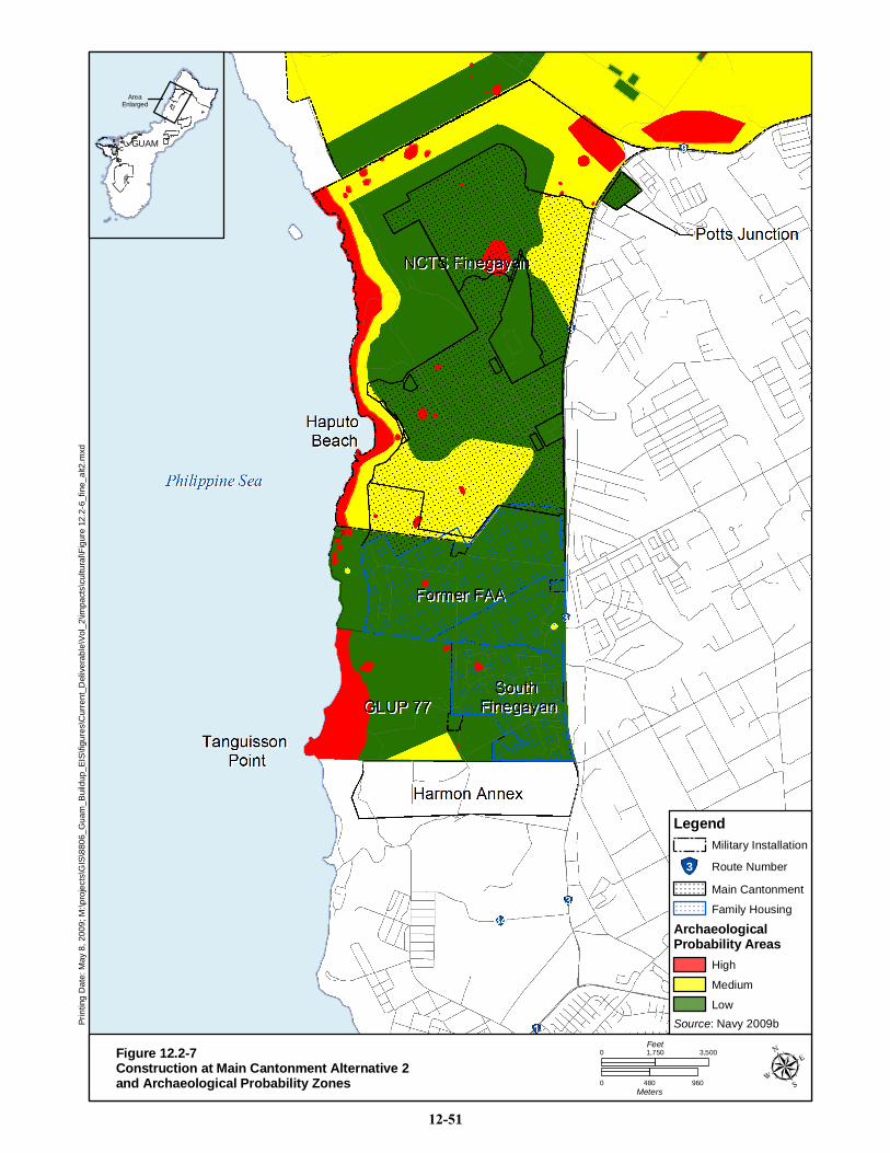
Prin
ting
Dat
e: M
ay 8
, 200
9; M
:\pro
ject
s\G
IS\8
806_
Gua
m_B
uild
up_E
IS\fi
gure
s\C
urre
nt_D
eliv
erab
le\V
ol_2
\impa
cts\
cultu
ral\F
igur
e 12
.2-6
_fin
e_al
t2.m
xd
GUAMGUAM
AreaEnlarged
Figure 12.2-7Construction at Main Cantonment Alternative 2and Archaeological Probability Zones 0 480 960
Meters
0 3,5001,750Feet
Source: Navy 2009b
Legend
3 Route Number
Low
Medium
High
ArchaeologicalProbability Areas
Family Housing
Main Cantonment
Military Installation
12-51
Guam and CNMI Military Relocation Draft EIS/OEIS (November 2009)
VOLUME 2: MARINE CORPS – GUAM 12-52 Cultural Resources
12.2.3.2 Central
Andersen South
Construction
Impacts would be the same as those discussed under Alternative 1.
Operation
Impacts would be the same as those discussed under Alternative 1.
Barrigada
Construction
Impacts would be the same as those discussed under Alternative 1.
Operation
Impacts would be the same as those discussed under Alternative 1.
Non-DoD Land
Construction
Impacts would be the same as those discussed under Alternative 1.
Operation
Impacts would be the same as those discussed under Alternative 1.
12.2.3.3 Apra Harbor
Harbor
Construction
Impacts would be the same as those discussed under Alternative 1.
Operation
Impacts would be the same as those discussed under Alternative 1.
Naval Base Guam
Construction
Impacts would be the same as those discussed under Alternative 1.
Operation
Impacts would be the same as those discussed under Alternative 1.
12.2.3.2 South
Naval Munitions Site
Construction
Impacts would be the same as those discussed under Alternative 1.
Guam and CNMI Military Relocation Draft EIS/OEIS (November 2009)
VOLUME 2: MARINE CORPS – GUAM 12-53 Cultural Resources
Operation
Impacts would be the same as those discussed under Alternative 1.
Non-DoD Land
Construction
Impacts would be the same as those discussed under Alternative 1.
Operation
Impacts would be the same as those discussed under Alternative 1.
12.2.3.3 Summary of Impacts
Therefore, implementation of Alternative 2 would result in significant impacts to 22 NRHP-eligible
archaeological sites, including 13 sites associated with the Main Cantonment, six NRHP-eligible
architectural resources, and four traditional cultural properties. No adverse impacts would occur to
NRHP-eligible or listed cultural resources at Apra Harbor or Barrigada.
12.2.3.4 Potential Mitigation Measures
Alternative 2 would have significant adverse impacts to cultural resources. However, with
implementation of the proposed mitigation measures listed below and in accordance with the PA for this
EIS/OEIS, these impacts would be resolved through consultation to less than significant levels.
Impacts and mitigations to cultural resources at Andersen AFB, Andersen South, Route 15, NMS, and
Apra Harbor would be the same as for Alternative 1.
Impacts to traditional resources such as the nunu tree, dukduk tree, ifit tree, and da‘ok tree, would be
avoided if possible.
Direct impacts to NRHP-eligible sites (381, 1012, 1020, 1021, 1022, 1023, 1026, 1033, 1034, 1678, and
1681) in the Main Cantonment and Housing areas would be avoided or if avoidance is not possible, then
data recovery would take place at these sites. Operations impacts would be mitigated through training of
personnel working and living in the area to avoid impacts to archaeological sites. The lusong at sites 1024
and 1032 would be curated or relocated. Indirect impacts to the Haputo site (08-007) and the Latte Stone
Park (site 811) from possible vandalism would be mitigated through signage and documentation. The sign
at the Latte Stone Park would be replaced. The Haputo site would be documented and brochures and signs
created for public educational purposes.
The HQ, MEFA, and MAW area at the Main Cantonment would be subject to archaeological monitoring
during construction because they are within medium archaeological probability areas.
12.2.4 Alternative 3
Alternative 3 differs from Alternatives 1, 2, and 8 by the location of the main cantonment. Under
Alternative 3 the main cantonment would be constructed at Finegayan, Air Force Barrigada, and Navy
Barrigada. Elements of Alternative 3 that are the same as the other alternatives include the aviation
training at Andersen AFB, Andersen South, NMS, and Naval Base Guam; the two alternatives for the
firing range south of Route 15; and non-firing ranges at Andersen South and NMS.
Guam and CNMI Military Relocation Draft EIS/OEIS (November 2009)
VOLUME 2: MARINE CORPS – GUAM 12-54 Cultural Resources
12.2.4.1 North
Andersen AFB
Construction
Impacts would be the same as those discussed under Alternative 1.
Operation
Impacts would be the same as those discussed under Alternative 1.
Finegayan
Construction
Construction and operation for the main cantonment and family housing and community support would
take place at Finegayan under Alternative 3. A variety of land uses/functions would be sited at NCTS
Finegayan and South Finegayan including; housing, training, administration, quality of life facilities, and
educational facilities. A total of 1,610 ac (652 ha) at NCTS Finegayan and 290 ac (117 ha) at South
Finegayan could be affected by construction. For the purposes of this analysis, all of this area would be
considered disturbed, although some landscaping and open spaces may occur among the buildings. Initial
planning considered the locations of NRHP-eligible resources and avoided impacting the majority of the
historic properties in the area. Additional efforts would be made during the final planning stage to avoid
all historic properties if possible.
Construction of the MLG facilities would impact areas with low, medium, and high archaeological
probability (Figure 12.2-8). This setting would impact sites 1024 (mortar and lusong) and 1026
(habitation site and artifact scatter).
Construction of the QOL facilities would impact areas with low and high archaeological probability. This
setting would impact site 1012 (artifact scatter). Construction of the HQ , DIVA and MEFA facilities
would impact areas with low, medium and high archaeological probability. This setting would impact
sites 381 (ceramic scatter) and 1020 (artifact scatter),. Construction of the MLG facilities would impact
areas with medium and high archaeological probability including sites 1032 (mortar/lusong), 1033(artifact
scatter), and 1034 (artifact scatter). Construction of the BEQ and BOQ facilities would impact areas with
low, medium and high archaeological probability. This setting would adversely affect sites 1021 (artifact
scatter) and 1023 (four defensive structures).
Construction of HSG and education facilities would impact areas with low and high archaeological
probability at South Finegayan. However, site 811 would be avoided by construction and there would be
no direct impacts to this site.
Construction at Finegayan has the potential to require the removal of dukduk trees, a traditional resource
used by canoe builders.
Operation
Operation of these facilities would bring additional personnel into the area. This increase in personnel
could increase site vandalism, especially to sites such as Haputo on the coast and Latte Stone Park.
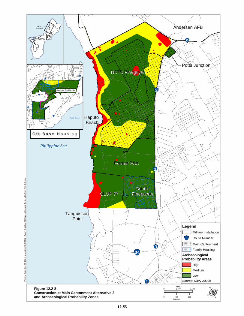
28
9
3
3
334
1
Philippine SeaPhilippine Sea
NCTS FinegayanNCTS FinegayanPotts JunctionPotts Junction
Former FAAFormer FAA
GLUP 77GLUP 77South South
FinegayanFinegayan
Tanguisson Tanguisson PointPoint
Haputo Haputo BeachBeach
Andersen AFBAndersen AFBPr
intin
g D
ate:
Oct
23,
200
9, M
:\pro
ject
s\G
IS\8
806_
Gua
m_B
uild
up_E
IS\fi
gure
s\C
urre
nt_D
eliv
erab
le\V
ol_2
\12.
2-8.
mxd
GUAMGUAM
AreaEnlarged
0 480 960Meters
0 3,5001,750Feet
26
1516
8
10
15
Air ForceAir ForceBarrigadaBarrigada
Navy BarrigadaNavy Barrigada
Admiral Nimitz
Admiral Nimitz
Golf Course
Golf Course
Pacific OceanPacific Ocean
Connector Road NeededConnector Road Needed
RECREC
O f f - B a s e H o u s i n gO f f - B a s e H o u s i n g
Source: Navy 2009b
Legend
3 Route Number
Low
Medium
High
ArchaeologicalProbability Areas
Family Housing
Main Cantonment
Military Installation
Figure 12.2-8Construction at Main Cantonment Alternative 3and Archaeological Probability Zones
12-55

Guam and CNMI Military Relocation Draft EIS/OEIS (November 2009)
VOLUME 2: MARINE CORPS – GUAM 12-56 Cultural Resources
Central
Andersen South
Construction
Impacts would be the same as those discussed under Alternative 1.
Operation
Impacts would be the same as those discussed under Alternative 1.
Non-DoD Land
Construction
Impacts would be the same as those discussed under Alternative 1.
Operation
Impacts would be the same as those discussed under Alternative 1.
Barrigada
Construction
Under Alternative 3, HSG and education facilities would be constructed at Navy and Air Force Barrigada.
Air Force Barrigada has a low potential for archaeological sites. NRHP-eligible sites do not occur in this
area and construction and operational impacts are not expected.
The majority of the construction would occur in a low archaeological probability area. Construction at the
northern boundary of Navy Barrigada would occur at an area considered to be a medium probability area
for archaeology (see Figure 12.2-8). This area is also the southwestern corner of Mount Barrigada or
Mount Tuyan, a traditional cultural property. The proposed construction would place the Base Gate,
BEQ/BOQ, QOL and all housing facilities atop the steep slope on the southwestern side of Mount
Barrigada. This setting would require a substantial amount of vegetation/ground excavation, and soil
removal and has the potential to adversely affect a traditional cultural property by the removal of the foot
of the mountain and disturb an area with medium probability for archaeological resources.
Operation
Operations at the Navy Barrigada would include the use of administrative, maintenance, and housing by
Marine Corps personnel. The occupation of housing in the area would increase the population living in
the area. This increase in personnel in the area could increase site vandalism and have a visual and
audible impact on the surrounding area. However, most of the area is situated in a low archaeological
probability area and NRHP-eligible resources do not occur in this area. Increased population in this area
would not adversely impact Mount Barrigada since the operations would not restrict access to the
property, or adversely impact its association with Chamorro legends.
12.2.4.2 Apra Harbor
Harbor
Construction
Impacts would be the same as those discussed under Alternative 1.
Guam and CNMI Military Relocation Draft EIS/OEIS (November 2009)
VOLUME 2: MARINE CORPS – GUAM 12-57 Cultural Resources
Operation
Impacts would be the same as those discussed under Alternative 1.
12.2.4.3 South
Naval Munitions Site
Construction
Impacts would be the same as those discussed under Alternative 1.
Operation
Impacts would be the same as those discussed under Alternative 1.
Non-DoD Land
Construction
Impacts would be the same as those discussed under Alternative 1.
Operation
Impacts would be the same as those discussed under Alternative 1.
12.2.4.4 Summary of Impacts
Therefore, implementation of Alternative 3 would result in significant impacts to 19 NRHP-eligible
archaeological sites (including 10 sites in the Main Cantonment alternative), six NRHP-eligible
architectural resources, and five traditional cultural properties. No adverse impacts would occur to
NRHP-eligible or listed cultural resources at Apra Harbor.
12.2.4.5 Potential Mitigation Measures
Alternative 3 would have significant adverse impacts to cultural resources. However, with
implementation of the proposed mitigation measures listed below and in accordance with the PA for this
EIS/OEIS, these impacts would be resolved through consultation to less than significant levels.
Impacts and mitigations to cultural resources at Andersen AFB, Andersen South, Route 15, NMS, and
Apra Harbor would be the same as for Alternative 1.
Impacts to traditional resources such as the nunu tree, dukduk tree, ifit tree, and da‘ok tree, would be
avoided if possible.Direct impacts to NRHP-eligible sites (381, 1012, 1020, 1021, 1022, 1023, 1026,
1033, and 1034) in the Main Cantonment and Housing areas would be avoided or, if avoidance is not
possible, then data recovery would occur. The lusong at sites 1024 and 1032 would be curated or
relocated. Operational impacts would be mitigated through training of personnel working and living in the
area to avoid impacts to archaeological sites. Indirect impacts to the Haputo site (08-007) and the Latte
Stone Park (site 811) from possible vandalism would be mitigated through the signage and
documentation. The sign at the Latte Stone Park would be replaced. The Haputo site would be
documented and brochures and signs created for public educational purposes.
The HQ, MEFA, and MAW area at the Main Cantonment would be subject to archaeological monitoring
during construction because it is within a medium archaeological probability area. Construction of
facilities in the north of Navy Barrigada that would require leveling a portion of Mount Barrigada would
be redesigned to avoid disturbing this area, if possible. Otherwise, appropriate documentation or
interpretation would take place.
Guam and CNMI Military Relocation Draft EIS/OEIS (November 2009)
VOLUME 2: MARINE CORPS – GUAM 12-58 Cultural Resources
12.2.5 Alternative 8
Alternative 8 differs from Alternatives 1, 2, and 3 by the location of the main cantonment. Under
Alternative 8, the main cantonment would be constructed at Finegayan and the Former FAA land and at
Air Force Barrigada. Elements of Alternative 8 that are the same as the other alternatives include the
aviation training at Andersen AFB, Andersen South, NMS, and Naval Base Guam; the two alternatives
for the firing range south of Route 15; and non-firing ranges at Andersen South and NMS.
12.2.5.1 North
Andersen AFB
Construction
Impacts would be the same as those discussed under Alternative 1.
Operation
Impacts would be the same as those discussed under Alternative 1.
Finegayan
Construction
Construction of the main cantonment and family housing and community support would take place at
Finegayan, the Former FAA property, and Air Force Barrigada under Alternative 8. A variety of land
uses/functions would be sited at Finegayan and South Finegayan including housing, training, quality of
life facilities, administration, and educational facilities. A total of 1,090 ac (441 ha) at NCTS Finegayan
and 290 ac (117 ha) at South Finegayan could be affected by construction. For the purposes of this
analysis, all of this area would be considered disturbed, although some landscaping and open spaces may
occur among the buildings. Initial planning considered the locations of NRHP-eligible resources and
avoided impacting the majority of the historic properties in the area. Additional efforts would be made
during the final planning stage to avoid all historic properties if possible.
Construction of the BEQ would impact areas with low, medium, and high archaeological probability
(Figure 12.2-9). This setting would impact site 1021 (artifact scatter).
Construction of HQ facilities would impact areas with a medium archaeological probability. Construction
of the BASE, DIVA and MEFA facilities would impact areas with low, medium, and high archaeological
probability. This setting would impact sites 1022 (artifact scatter) 1023 (four defensive structures) and
1026 (habitation site and artifact scatter).
Construction of the MLG facilities would impact areas with low, medium, and high archaeological
probability. This setting would impact sites 381 (ceramic scatter), 1012 (artifact scatter) and 1020 (artifact
scatter). Construction of the LTC facilities would impact an area with low archaeological probability.
NRHP-eligible sites do not occur in this area and no impacts are expected.
Construction of education facilities would impact areas with low archaeological probability at South
Finegayan. Site 811 (Latte Stone Park) would be avoided.
Construction at Finegayan has the potential to require the removal of dukduk trees, a traditional resource
used by canoe builders.
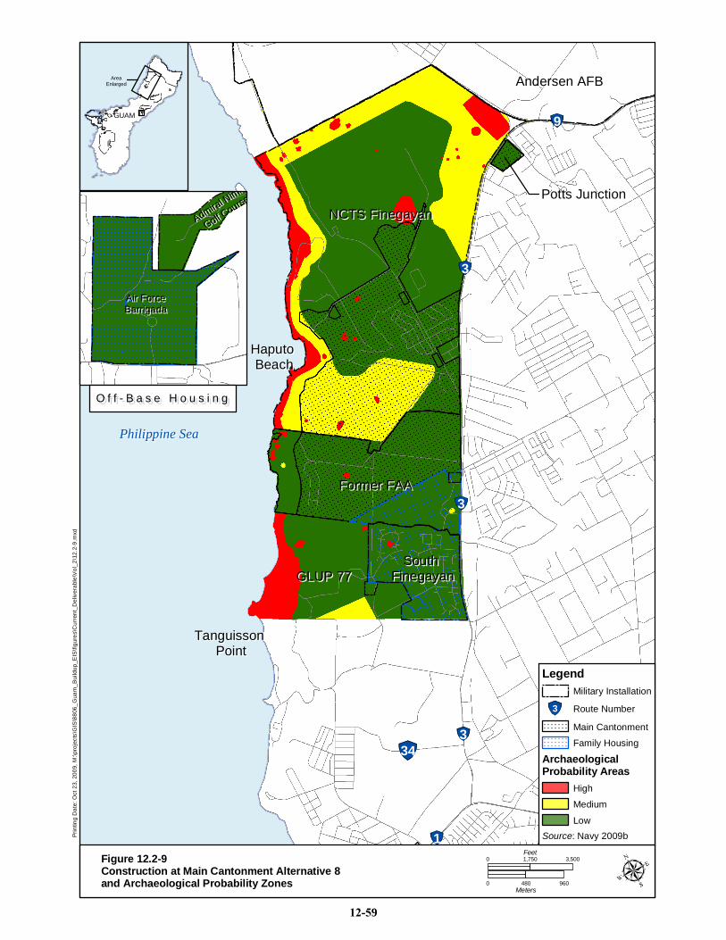
28
9
3
3
334
1
Philippine SeaPhilippine Sea
NCTS FinegayanNCTS FinegayanPotts JunctionPotts Junction
Former FAAFormer FAA
GLUP 77GLUP 77South South
FinegayanFinegayan
Tanguisson Tanguisson PointPoint
Haputo Haputo BeachBeach
Andersen AFBAndersen AFBPr
intin
g D
ate:
Oct
23,
200
9, M
:\pro
ject
s\G
IS\8
806_
Gua
m_B
uild
up_E
IS\fi
gure
s\C
urre
nt_D
eliv
erab
le\V
ol_2
\12.
2-9.
mxd
GUAMGUAM
AreaEnlarged
0 480 960Meters
0 3,5001,750Feet
Air ForceAir ForceBarrigadaBarrigada
Admiral Nimit
Admiral Nimit
Golf Course
Golf Course
O f f - B a s e H o u s i n gO f f - B a s e H o u s i n g
Source: Navy 2009b
Legend
3 Route Number
Low
Medium
High
ArchaeologicalProbability Areas
Family Housing
Main Cantonment
Military Installation
Figure 12.2-9Construction at Main Cantonment Alternative 8and Archaeological Probability Zones
12-59
Guam and CNMI Military Relocation Draft EIS/OEIS (November 2009)
VOLUME 2: MARINE CORPS – GUAM 12-60 Cultural Resources
Operation
Operation of the HQ facilities, education facilities, BASE facilities, and BEQ would bring additional
personnel into the area. This increase in personnel could increase site vandalism, especially to sites such
as Haputo on the coast and Latte Stone Park.
Non-DoD Land
Construction
Under Alternative 8, impacts to the FAA Parcel would be similar to those discussed for Alternative 1.
Most of the construction that would take place at the FAA Parcel under Alternative 8 would be HSG,
education, BOQ, PMO, TRN, and QOL . Construction would take place in areas with low, medium, and
high archaeological probability including sites 1678 (ceramic scatter) and 1681 (ceramic scatter). Total
impacted acres would be 680 (275 ha).
Operation
Operation of these facilities would bring additional personnel into the area. This increase in personnel
could increase site vandalism.
12.2.5.2 Central
Andersen South
Construction
Impacts would be the same as those discussed under Alternative 1.
Operation
Impacts would be the same as those discussed under Alternative 1.
Barrigada
Construction
Under Alternative 8, HSG, BASE, QOL and education facilities would be constructed at Air Force
Barrigada. Air Force Barrigada has a low potential for archaeological sites. NRHP-eligible sites do not
occur in this area and no impacts to NRHP-eligible cultural resources would occur.
Operation
Under Alternative 8, HSG, BASE, QOL and education facilities would be constructed at Air Force
Barrigada. Air Force Barrigada has a low potential for archaeological sites. NRHP-eligible sites do not
occur in this area and no impacts to NRHP-eligible cultural resources would occur.
Non-DoD Land
Construction
Impacts would be the same as those discussed under Alternative 1.
Operation
Impacts would be the same as those discussed under Alternative 1.
Guam and CNMI Military Relocation Draft EIS/OEIS (November 2009)
VOLUME 2: MARINE CORPS – GUAM 12-61 Cultural Resources
12.2.5.2 Apra Harbor
Harbor
Construction
Impacts would be the same as those discussed under Alternative 1.
Operation
Impacts would be the same as those discussed under Alternative 1.
Naval Base Guam
Construction
Impacts would be the same as those discussed under Alternative 1.
Operation
Impacts would be the same as those discussed under Alternative 1.
12.2.5.3 South
Naval Munitions Site
Construction
Impacts would be the same as those discussed under Alternative 1.
Operation
Impacts would be the same as those discussed under Alternative 1.
Non-DoD Land
Construction
Impacts would be the same as those discussed under Alternative 1.
Operation
Impacts would be the same as those discussed under Alternative 1.
12.2.5.4 Summary of Impacts
Therefore, implementation of Alternative 8 would result in significant impacts to 18 NRHP-eligible
archaeological sites (including 9 sites associated with the Main Cantonment alternative), six NRHP-
eligible architectural resources, and five traditional cultural properties. No adverse impacts would occur
to NRHP-eligible or listed cultural resources at Apra Harbor
12.2.5.5 Potential Mitigation Measures
Alternative 8 would have significant adverse impacts to cultural resources. However, with
implementation of the proposed mitigation measures listed below and in accordance with the PA for this
EIS/OEIS, these impacts would be resolved through consultation.
Impacts and mitigations to cultural resources at Andersen AFB, Andersen South, Route 15, NMS, and
Apra Harbor would be the same as for Alternative 1.
Impacts to traditional resources such as the nunu tree, dukduk tree, ifit tree, and da‘ok tree, would be
avoided if possible. Direct impacts to NRHP eligible sites (381, 1012, 1020, 1021, 1022, 1023, 1026,
Guam and CNMI Military Relocation Draft EIS/OEIS (November 2009)
VOLUME 2: MARINE CORPS – GUAM 12-62 Cultural Resources
1678, and 1681) in the Main Cantonment and Housing areas would be avoided or if avoidance is not
possible, then data recovery would take place. Operational impacts would be mitigated through training of
personnel working and living in the area to avoid impacts to archaeological sites. Indirect impacts to the
Haputo site (08-007) and the Latte Stone Park (site 811) from possible vandalism would be mitigated
through the signage and documentation. The sign at the Latte Stone Park would be replaced. The Haputo
site would be documented and brochures and signs created for public educational purposes.
The HQ area at the Main Cantonment would be monitored during construction because it is within a
medium archaeological probability area.
12.2.6 No-Action Alternative
Under the no-action alternative, Marine Corps units would remain in Japan and would not relocate to
Guam. No construction, dredging, training, or operations associated with the military relocation would
occur and the Marine Corps would not meet readiness, mission and international treaty obligations.
Existing operations on Guam would continue. DoD management of cultural resources on non-DoD lands
at the Harmon Annex or Route 15 would not occur and these sites could be vandalized or allowed to
deteriorate. Implementation of the no-action alternative would maintain existing conditions, although
there could be a significant adverse impact to NRHP-eligible or listed sites on non-DoD lands. In
addition, implementation of the no-action alternative would not meet the mission, readiness, national
security and international treaty obligations of the Marine Corps.
12.2.7 Summary of Impacts
Extensive data collection and surveys associated with this EIS/OEIS have examined more than 5,000
acres in Guam and recorded more than 100 NRHP-eligible archaeological sites and architectural
resources. Recent studies have also identified traditional cultural properties, and conducted interviews
with individuals knowledgeable about the history of WW II and of traditional practices.
The impact analysis has identified significant adverse impacts from the proposed action to between 20
and 35 NRHP-eligible archaeological and architectural resources and traditional cultural properties. Most
of the impacts would occur on DoD lands. This EIS/OEIS has proposed potential mitigation measures to
reduce those impacts to less than significant levels through data recovery, implementation of a
preservation plan, public education, signs, brochures, and documentation.
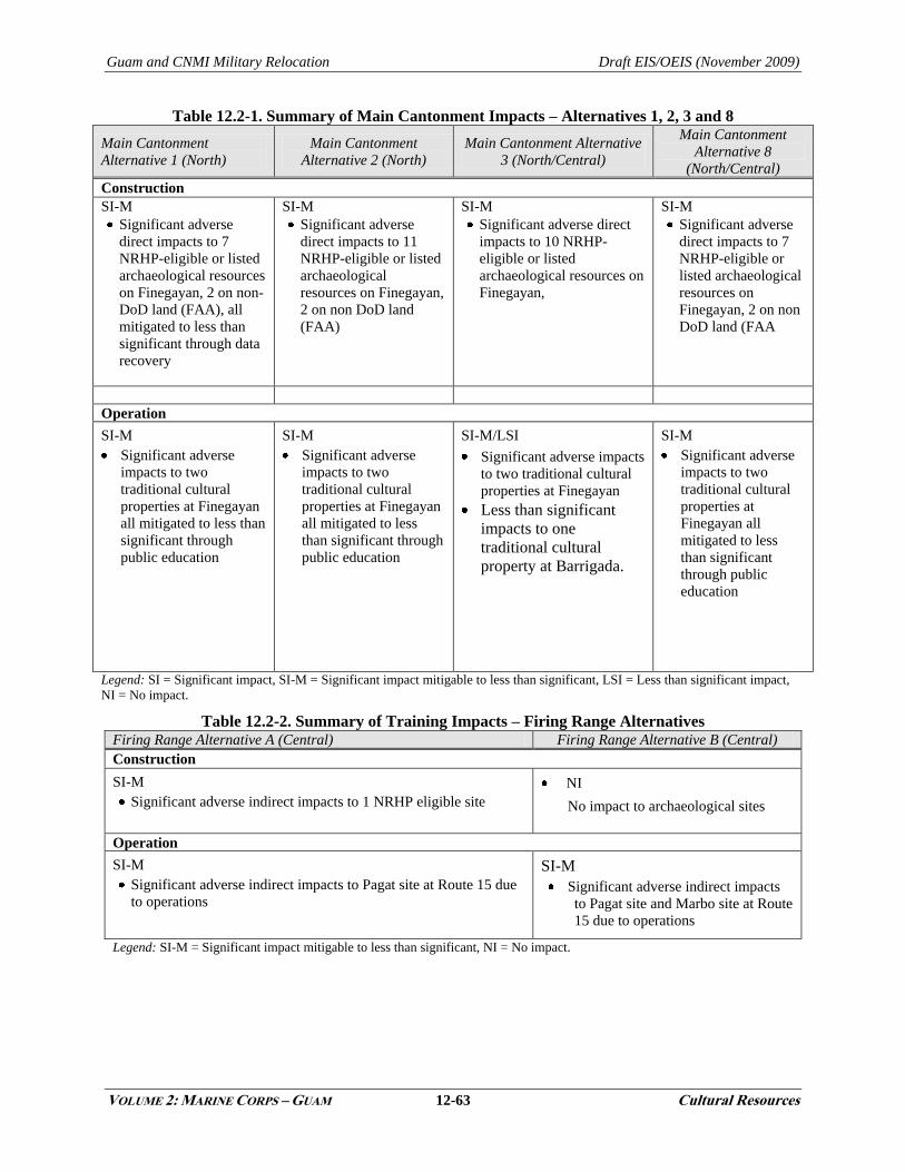
Guam and CNMI Military Relocation Draft EIS/OEIS (November 2009)
VOLUME 2: MARINE CORPS – GUAM 12-63 Cultural Resources
Table 12.2-1. Summary of Main Cantonment Impacts – Alternatives 1, 2, 3 and 8
Main Cantonment
Alternative 1 (North)
Main Cantonment
Alternative 2 (North)
Main Cantonment Alternative
3 (North/Central)
Main Cantonment
Alternative 8
(North/Central)
Construction
SI-M
Significant adverse
direct impacts to 7
NRHP-eligible or listed
archaeological resources
on Finegayan, 2 on non-
DoD land (FAA), all
mitigated to less than
significant through data
recovery
SI-M
Significant adverse
direct impacts to 11
NRHP-eligible or listed
archaeological
resources on Finegayan,
2 on non DoD land
(FAA)
SI-M
Significant adverse direct
impacts to 10 NRHP-
eligible or listed
archaeological resources on
Finegayan,
SI-M
Significant adverse
direct impacts to 7
NRHP-eligible or
listed archaeological
resources on
Finegayan, 2 on non
DoD land (FAA
Operation
SI-M
Significant adverse
impacts to two
traditional cultural
properties at Finegayan
all mitigated to less than
significant through
public education
SI-M
Significant adverse
impacts to two
traditional cultural
properties at Finegayan
all mitigated to less
than significant through
public education
SI-M/LSI
Significant adverse impacts
to two traditional cultural
properties at Finegayan
Less than significant
impacts to one
traditional cultural
property at Barrigada.
SI-M
Significant adverse
impacts to two
traditional cultural
properties at
Finegayan all
mitigated to less
than significant
through public
education
Legend: SI = Significant impact, SI-M = Significant impact mitigable to less than significant, LSI = Less than significant impact,
NI = No impact.
Table 12.2-2. Summary of Training Impacts – Firing Range Alternatives Firing Range Alternative A (Central) Firing Range Alternative B (Central)
Construction
SI-M
Significant adverse indirect impacts to 1 NRHP eligible site
NI
No impact to archaeological sites
Operation
SI-M
Significant adverse indirect impacts to Pagat site at Route 15 due
to operations
SI-M
Significant adverse indirect impacts
to Pagat site and Marbo site at Route
15 due to operations
Legend: SI-M = Significant impact mitigable to less than significant, NI = No impact.
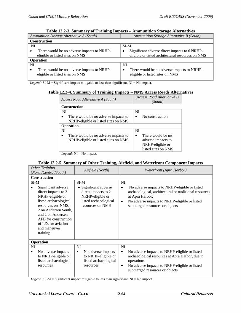
Guam and CNMI Military Relocation Draft EIS/OEIS (November 2009)
VOLUME 2: MARINE CORPS – GUAM 12-64 Cultural Resources
Table 12.2-3. Summary of Training Impacts – Ammunition Storage Alternatives Ammunition Storage Alternative A (South) Ammunition Storage Alternative B (South)
Construction
NI
There would be no adverse impacts to NRHP-
eligible or listed sites on NMS
SI-M
Significant adverse direct impacts to 6 NRHP-
eligible or listed architectural resources on NMS
Operation
NI
There would be no adverse impacts to NRHP-
eligible or listed sites on NMS
NI
There would be no adverse impacts to NRHP-
eligible or listed sites on NMS
Legend: SI-M = Significant impact mitigable to less than significant, NI = No impact.
Table 12.2-4. Summary of Training Impacts – NMS Access Roads Alternatives
Access Road Alternative A (South) Access Road Alternative B
(South)
Construction
NI
There would be no adverse impacts to
NRHP-eligible or listed sites on NMS
NI
No construction
Operation
NI
There would be no adverse impacts to
NRHP-eligible or listed sites on NMS
NI
There would be no
adverse impacts to
NRHP-eligible or
listed sites on NMS Legend: NI = No impact.
Table 12.2-5. Summary of Other Training, Airfield, and Waterfront Component Impacts Other Training
(North/Central/South) Airfield (North) Waterfront (Apra Harbor)
Construction
SI-M
Significant adverse
direct impacts to 2
NRHP-eligible or
listed archaeological
resources on NMS;
2 on Andersen South,
and 2 on Andersen
AFB for construction
of LZs for aviation
and maneuver
training
SI-M
Significant adverse
direct impacts to 2
NRHP-eligible or
listed archaeological
resources on NMS
NI
No adverse impacts to NRHP-eligible or listed
archaeological, architectural or traditional resources
at Apra Harbor,
No adverse impacts to NRHP-eligible or listed
submerged resources or objects
Operation
NI
No adverse impacts
to NRHP-eligible or
listed archaeological
resources
NI
No adverse impacts
to NRHP-eligible or
listed archaeological
resources
NI
No adverse impacts to NRHP-eligible or listed
archaeological resources at Apra Harbor, due to
operations
No adverse impacts to NRHP-eligible or listed
submerged resources or objects
Legend: SI-M = Significant impact mitigable to less than significant, NI = No impact.
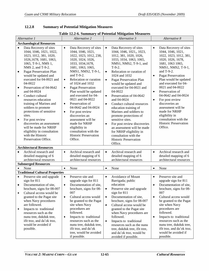
Guam and CNMI Military Relocation Draft EIS/OEIS (November 2009)
VOLUME 2: MARINE CORPS – GUAM 12-65 Cultural Resources
12.2.8 Summary of Potential Mitigation Measures
Table 12.2-6. Summary of Potential Mitigation Measures
Alternative 1 Alternative 2 Alternative 3 Alternative 8
Archaeological Resources
Data Recovery of sites
1044, 1046, 1021, 1022,
1023, 1012, 381, 1020,
1026,1678, 1681, 1063,
1065, T-9-1, NMS 1,
NMS 2, and T-9-2.
Pagat Preservation Plan
would be updated and
executed for 04-0021 and
04-0022
Preservation of 04-0642
and 04-0024
Conduct cultural
resources education
training of Marines and
soldiers to promote
protections of sensitive
sites.
For post review
discoveries an assessment
will be made for NRHP
eligibility in consultation
with the Historic
Preservation Office.
Data Recovery of sites
1044, 1046, 1021,
1022, 1023, 1012, 238,
1020, 1024, 1026,
1033, 1034,1678,
1681, 1063, 1065,
NMS1, NMS2, T-9-1,
and T-9-2.
Relocation or curation
of 1024 and 1032
Pagat Preservation
Plan would be updated
and executed for 04-
0021 and 04-0022
Preservation of
04-0642 and 04-0024
For post review
discoveries an
assessment will be
made for NRHP
eligibility in
consultation with the
Historic Preservation
Office.
Data Recovery of sites
1044, 1046, 1021,, 1023,
1012, 381, 1020, 1026,
1033, 1034, 1063, 1065,
NMS1, NMS2, T-9-1, and
T-9-2.
Relocation or curation of
1024 and 1032
Pagat Preservation Plan
would be updated and
executed for 04-0021 and
04-0022
Preservation of 04-0642
and 04-0024
Conduct cultural resources
education training of
Marines and soldiers to
promote protections of
sensitive sites.
For post review discoveries
an assessment will be made
for NRHP eligibility in
consultation with the
Historic Preservation
Office.
Data Recovery of sites
1044, 1046, 1021,
1022, 1023, 1012, 381,
1020, 1026, 1678,
1681, 1063 1065,
NMS1, NMS2, T-9-1,
and T-9-2.
Pagat Preservation
Plan would be updated
and executed for 04-
0021 and 04-0022
Preservation of
04-0642 and 04-0024
For post review
discoveries an
assessment will be
made for NRHP
eligibility in
consultation with the
Historic Preservation
Office.
Architectural Resources
Archival research and
detailed mapping of 6
architectural resources
Archival research and
detailed mapping of 6
architectural resources
Archival research and
detailed mapping of 6
architectural resources
Archival research and
detailed mapping of 6
architectural resources
Submerged Resources
None None None None
Traditional Cultural Properties
Preserve site and upgrade
sign for 811
Documentation of site,
brochure, signs for 08-007
Cultural access would be
granted to the Pagat site
when Navy procedures
are followed.
Impacts to traditional
resources such as the
nunu tree, dukduk tree,
ifit tree, and da‘ok tree,
would be avoided if
possible.
Preserve site and
upgrade sign for 811
Documentation of site,
brochure, signs for 08-
007
Cultural access would
be granted to the Pagat
site when Navy
procedures are
followed.
Impacts to traditional
resources such as the
nunu tree, dukduk tree,
ifit tree, and da‘ok
tree, would be avoided
if possible.
Avoidance of Mount
Barrigada; public
education
Preserve site and upgrade
sign for 811
Documentation of site,
brochure, signs for 08-007
Cultural access would be
granted to the Pagat site
when Navy procedures are
followed.
Impacts to traditional
resources such as the nunu
tree, dukduk tree, ifit tree,
and da‘ok tree, would be
avoided if possible.
Preserve site and
upgrade sign for 811
Documentation of site,
brochure, signs for 08-
007
Cultural access would
be granted to the Pagat
site when Navy
procedures are
followed.
Impacts to traditional
resources such as the
nunu tree, dukduk tree,
ifit tree, and da‘ok tree,
would be avoided if
possible.
Guam and CNMI Military Relocation Draft EIS/OEIS (November 2009)
VOLUME 2: MARINE CORPS – GUAM 12-66 Cultural Resources
This Page Intentionally Left Blank.