10.app-electrofacies and sedimentary structure analysis...
TRANSCRIPT
Impact Factor(JCC): 3.6754 - This article can be downloaded from www.impactjournals.us
IMPACT: International Journal of Research in Applie d, Natural and Social Sciences (IMPACT: IJRANSS) ISSN(P): 2347-4580; ISSN(E): 2321-8851 Vol. 5, Issue 5, May 2017, 91-102 © Impact Journals
ELECTROFACIES AND SEDIMENTARY STRUCTURE ANALYSIS FO R THE
DETERMINATING COAL DEPOSITIONAL IN PIT J, SANGATTA COALFIELD USING
GEOPHYSICAL WELL LOGS
IRFAN MARWANZA & CHAIRUL NAS
Mining Department, University of Trisakti, Jakarta, Indonesia
ABSTRACT
The identification of various deposition environments is indicated by all components of the deposition system and
the location of the coal seams in the deposition environment based on the study of sedimentary environments, among
others, supported by data from outcrop profiles (sedimentary structures), drilling, and geophysical logs.
The research location in Upper Kutai Basin, which occupies the location of coal mining concession of PT Kaltim
Prima Coal, precisely PIT J, with Balikpapan formation as a coal bearing formation. Some of coal observed are SE seam,
NM seam and Sangatta seam.
Electrolysis analysis results, this logging result is dominated by funneling and bell shape. This form is interpreted
as a precipitation environment in the form of delta plain. The results of the lithological analysis (sedimentary structure)
consisting of sandstone and rock / limestone constellations are characteristic of fluvial environmental up to upper delta
plain.
Based on research results, it can be interpreted depositional environment of coal in the area of research is
the fluvio deltaic.
KEYWORDS: Coal, Pit J, Electrofacies, Geophysical Logs, Fluvio Deltaic
INTRODUCTION
The sedimentary environment is the settling of sediment materials along with the physical, chemical, and
biological conditions that characterize the occurrence of certain precipitation mechanisms (Gould, 1972).
The interpretation of the sedimentary environment can be determined from the analysis of electrofacies and the analysis of
sedimentary structures formed.
The research was conducted at the location of coal mining concession of PT Kaltim Prima Coal. The research area
is located at PIT J. PT Kaltim Prima Coal is located in Sangatta sub-district, East Kutai Regency, East Kalimantan
Province.
Research is done in the Kutai basin, the rock formations found in the study area are Pulaubalag Formation and
Balikpapan Formation, but the research is only focused on Balikpapan Formation. The coal deposits found in Balikpapan
Formation (Middle to the late Miocene). Coal Seam in Balikpapan Formation are BE Seam, NM Seam and Sangatta Seam.

92 Irfan Marwanza & Chairul Nas
NAAS Rating: 3.00- Articles can be sent to [email protected]
The objective of this study was to determine the deposition environment for the Balikpapan Formation in the
study are based on the analysis of drill logs (electrofacies) and sedimentary structures.
Tectonic Setting of the Kutai Basin
The tectonic setting has been reviewed in the geological literature by authors such as van de Weerd and Amin,
1992, Hall, 1996, Cloke at al, 1999, and McClay et al, 2000, and is described briefly here. There were several major
tectonic phases, which resulted from interaction between the three plates, Eurasian, Pacific and Indian-Australian.
The Kutai Basin, which is the largest and the deepest basin in Indonesia, was initiated during the middle Eocene
as a result of the extension, linked to the opening of the Makassar Strait between Kalimantan and Sulawesi. The initial
extension in the middle Eocene was accommodated on N-S, NNE-SSW and NE-SW trending faults. Miocene collisions
resulted in an inversion of the Kutai Basin.
Basement of the Kutai Basin is probably an Upper Cretaceous assemblage of microcontinental fragments,
ophiolites and accretionary prism sediments intruded by Cretaceous plutons (Moss et al, 1997).
Figure 1: Simplified Regional Geology, Eastern Kalimantan (Modified from Moss and Chambers, 1999)
The Kutai Basin is divided into the Upper Kutai Basin, of Paleogene sediments and Cenozoic volcanics, with a
strong NW-SE structural grain, and the lowe Kutai Basin, of Neogene sediments, with a NNE-SSW trending structures.
The Meratus Mountains to the southwest and the Central Kalimantan Mountains in the north of the Kutai Basin have an
ophiolite basement, with Paleogene strata, which have a mainly NNE trending strike direction. Research area located in the
Upper Kutai Basin.
Electrofacies and Sedimentary Structure Analysis for the Determinating 93
Coal Depositional in PIT J, Sangatta Coalfield Using Geophysical Well Logs
Impact Factor(JCC): 3.6754 - This article can be downloaded from www.impactjournals.us
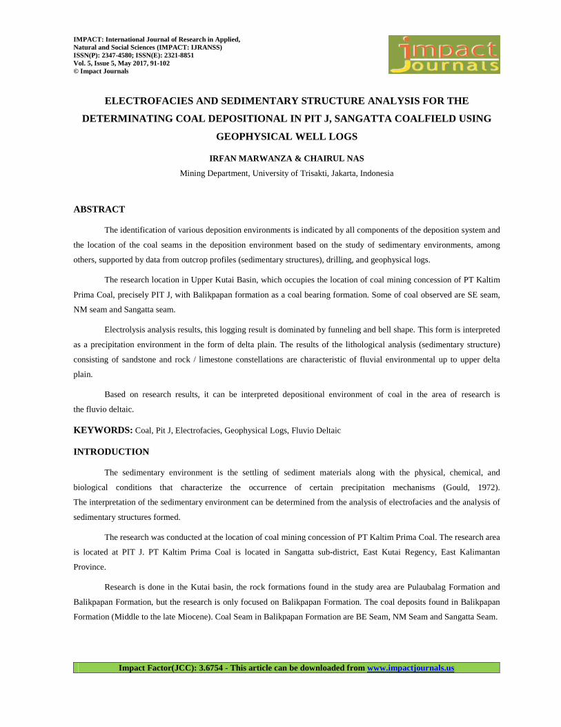
Figure 2: Surface Geology, StudyArea (from Sukardi and Sikumbang, 1995)
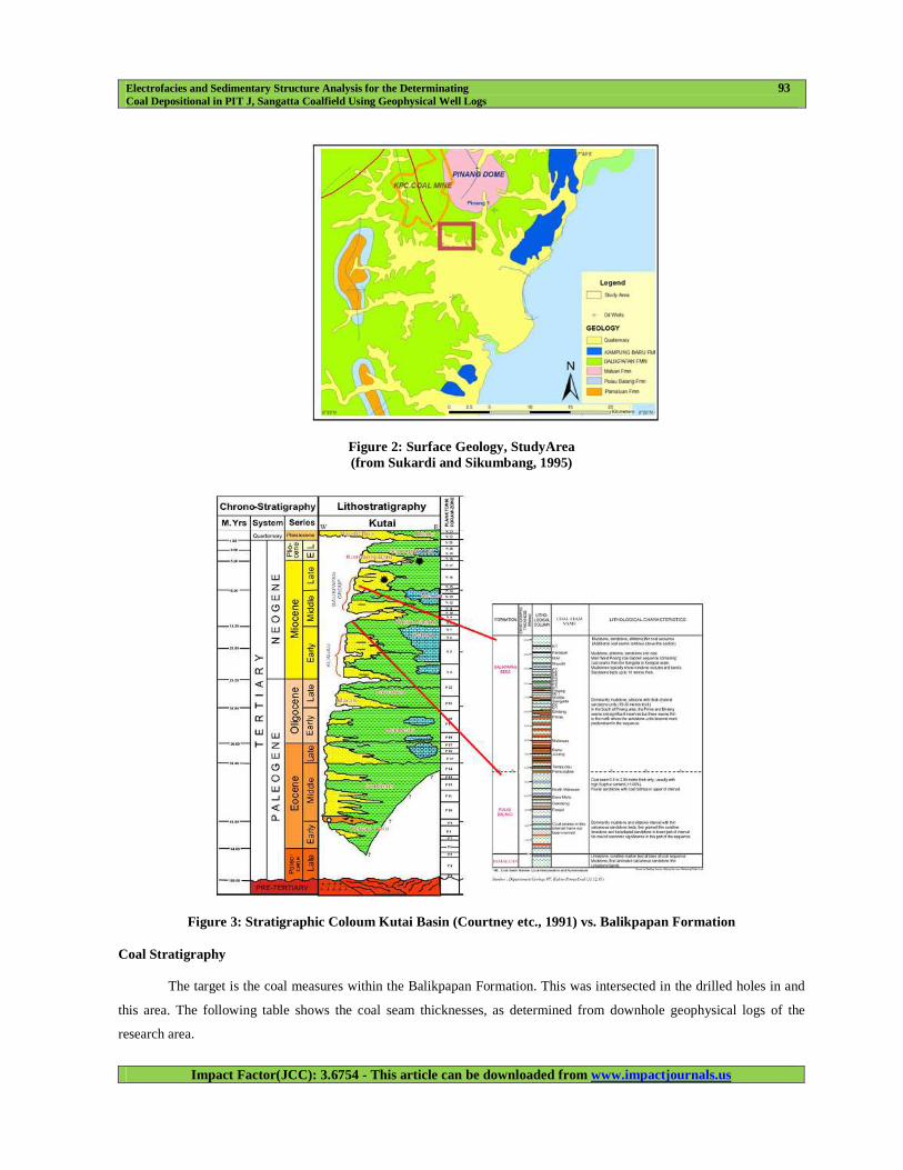
Figure 3: Stratigraphic Coloum Kutai Basin (Courtney etc., 1991) vs. Balikpapan Formation
Coal Stratigraphy
The target is the coal measures within the Balikpapan Formation. This was intersected in the drilled holes in and
this area. The following table shows the coal seam thicknesses, as determined from downhole geophysical logs of the
research area.
94 Irfan Marwanza & Chairul Nas
NAAS Rating: 3.00- Articles can be sent to [email protected]
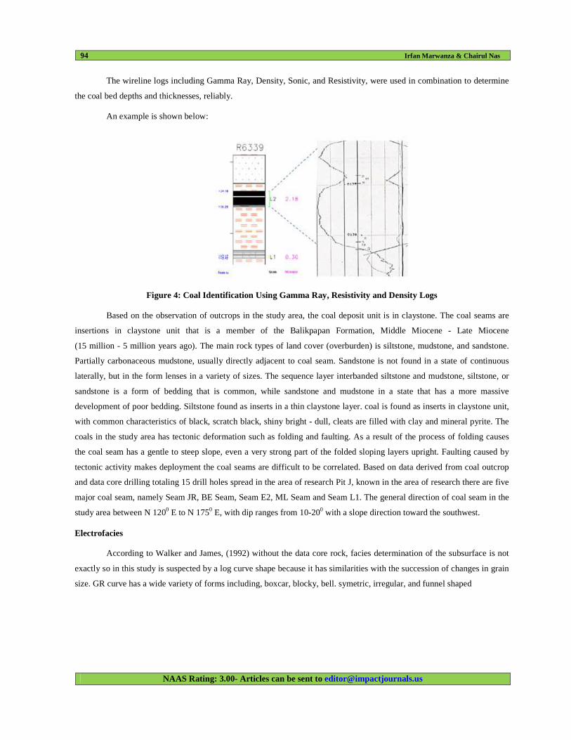
The wireline logs including Gamma Ray, Density, Sonic, and Resistivity, were used in combination to determine
the coal bed depths and thicknesses, reliably.
An example is shown below:
Figure 4: Coal Identification Using Gamma Ray, Resistivity and Density Logs
Based on the observation of outcrops in the study area, the coal deposit unit is in claystone. The coal seams are
insertions in claystone unit that is a member of the Balikpapan Formation, Middle Miocene - Late Miocene
(15 million - 5 million years ago). The main rock types of land cover (overburden) is siltstone, mudstone, and sandstone.
Partially carbonaceous mudstone, usually directly adjacent to coal seam. Sandstone is not found in a state of continuous
laterally, but in the form lenses in a variety of sizes. The sequence layer interbanded siltstone and mudstone, siltstone, or
sandstone is a form of bedding that is common, while sandstone and mudstone in a state that has a more massive
development of poor bedding. Siltstone found as inserts in a thin claystone layer. coal is found as inserts in claystone unit,
with common characteristics of black, scratch black, shiny bright - dull, cleats are filled with clay and mineral pyrite. The
coals in the study area has tectonic deformation such as folding and faulting. As a result of the process of folding causes
the coal seam has a gentle to steep slope, even a very strong part of the folded sloping layers upright. Faulting caused by
tectonic activity makes deployment the coal seams are difficult to be correlated. Based on data derived from coal outcrop
and data core drilling totaling 15 drill holes spread in the area of research Pit J, known in the area of research there are five
major coal seam, namely Seam JR, BE Seam, Seam E2, ML Seam and Seam L1. The general direction of coal seam in the
study area between N 1200 E to N 1750 E, with dip ranges from 10-200 with a slope direction toward the southwest.
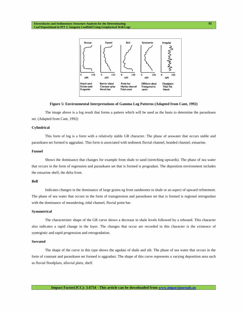
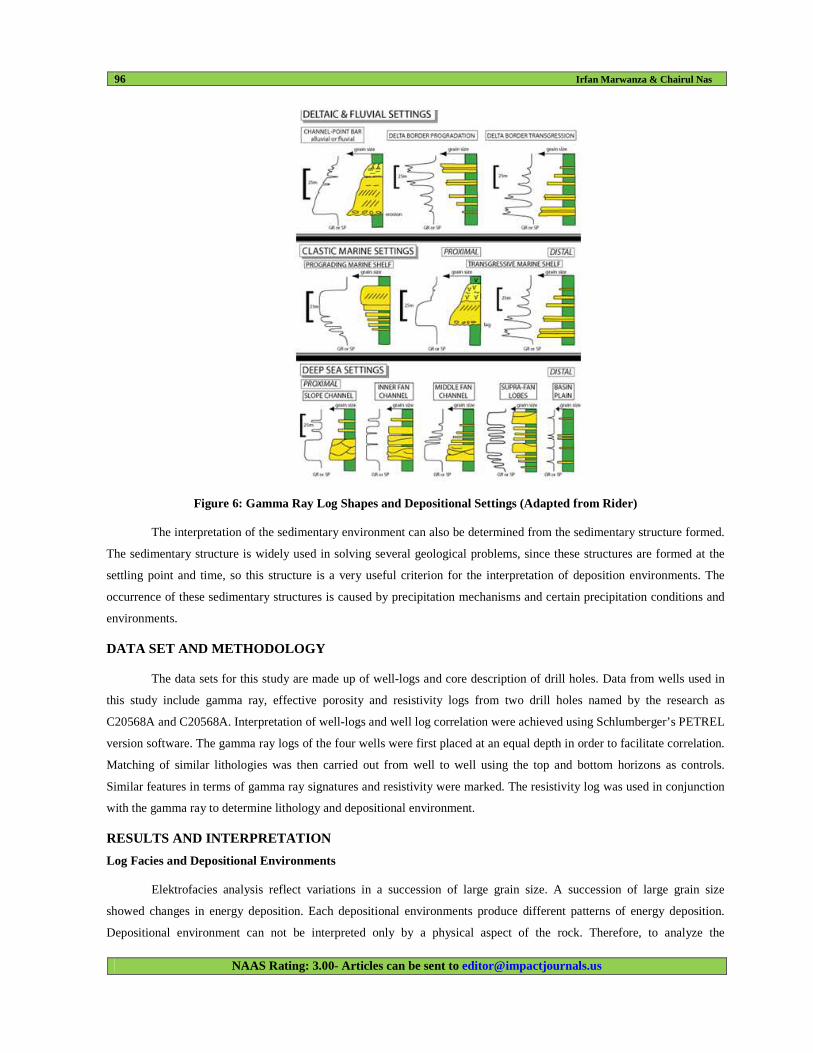
Electrofacies
According to Walker and James, (1992) without the data core rock, facies determination of the subsurface is not
exactly so in this study is suspected by a log curve shape because it has similarities with the succession of changes in grain
size. GR curve has a wide variety of forms including, boxcar, blocky, bell. symetric, irregular, and funnel shaped
Electrofacies and Sedimentary Structure Analysis for the Determinating 95
Coal Depositional in PIT J, Sangatta Coalfield Using Geophysical Well Logs
Impact Factor(JCC): 3.6754 - This article can be downloaded from www.impactjournals.us
Figure 5: Environmental Interpretations of Gamma Log Patterns (Adapted from Cant, 1992)
The image above is a log result that forms a pattern which will be used as the basis to determine the parasikuen
set. (Adapted from Cant, 1992)
Cylindrical
This form of log is a form with a relatively stable GR character. The phase of seawater that occurs stable and
parasikuen set formed is aggradasi. This form is associated with sediment fluvial channel, braided channel, estuarine.
Funnel
Shows the dominance that changes for example from shale to sand (stretching upwards). The phase of sea water
that occurs in the form of regression and parasikuen set that is formed is progradasi. The deposition environment includes
the estuarine shelf, the delta front.
Bell
Indicates changes in the dominance of large grains eg from sandstones to shale or an aspect of upward refinement.
The phase of sea water that occurs in the form of transgression and parasikuen set that is formed is regional retrogradasi
with the dominance of meandering, tidal channel, fluvial point bar.
Symmetrical
The characteristic shape of the GR curve shows a decrease in shale levels followed by a rebound. This character
also indicates a rapid change in the layer. The changes that occur are recorded in this character is the existence of
synergistic and rapid progression and retrogradation.
Serrated
The shape of the curve in this type shows the agadasi of shale and silt. The phase of sea water that occurs in the
form of constant and parasikuen set formed is aggradasi. The shape of this curve represents a varying deposition area such
as fluvial floodplain, alluvial plain, shelf.
96 Irfan Marwanza & Chairul Nas
NAAS Rating: 3.00- Articles can be sent to [email protected]
Figure 6: Gamma Ray Log Shapes and Depositional Settings (Adapted from Rider)
The interpretation of the sedimentary environment can also be determined from the sedimentary structure formed.
The sedimentary structure is widely used in solving several geological problems, since these structures are formed at the
settling point and time, so this structure is a very useful criterion for the interpretation of deposition environments. The
occurrence of these sedimentary structures is caused by precipitation mechanisms and certain precipitation conditions and
environments.
DATA SET AND METHODOLOGY
The data sets for this study are made up of well-logs and core description of drill holes. Data from wells used in
this study include gamma ray, effective porosity and resistivity logs from two drill holes named by the research as
C20568A and C20568A. Interpretation of well-logs and well log correlation were achieved using Schlumberger’s PETREL
version software. The gamma ray logs of the four wells were first placed at an equal depth in order to facilitate correlation.
Matching of similar lithologies was then carried out from well to well using the top and bottom horizons as controls.
Similar features in terms of gamma ray signatures and resistivity were marked. The resistivity log was used in conjunction
with the gamma ray to determine lithology and depositional environment.
RESULTS AND INTERPRETATION
Log Facies and Depositional Environments
Elektrofacies analysis reflect variations in a succession of large grain size. A succession of large grain size
showed changes in energy deposition. Each depositional environments produce different patterns of energy deposition.
Depositional environment can not be interpreted only by a physical aspect of the rock. Therefore, to analyze the
Electrofacies and Sedimentary Structure Analysis for the Determinating 97
Coal Depositional in PIT J, Sangatta Coalfield Using Geophysical Well Logs
Impact Factor(JCC): 3.6754 - This article can be downloaded from www.impactjournals.us
depositional environment should be reviewed regarding sedimentary structures, grain size (grain size), the content of
fossils, minerals, runs, vertical and lateral relations, the geometry and distribution of the rock.
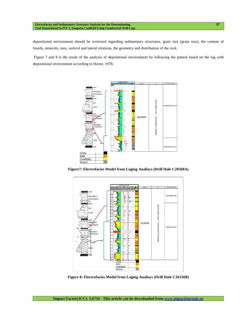
Figure 7 and 8 is the result of the analysis of depositional environment by following the pattern based on the log with
depositional environment according to Horne, 1978.
Figure7: Electrofacies Model from Loging Analisys (Drill Hole C20568A)
Figure 8: Electrofacies Model from Loging Analisys (Drill Hole C26156B)
98 Irfan Marwanza & Chairul Nas
NAAS Rating: 3.00- Articles can be sent to [email protected]
Based on the elektrofacies analysis, the results of this logging is dominated by the shape of the funnel and the bell
shape is interpreted as depositional environment in the form of lower – upper delta plain.
• Funnel-Shaped Successions
The gamma ray log trend of drill hole C20568A and C20568A (Fig.7 and Fig.8), which occur between depths of
196 - 360 m, is serrated and funnel-shaped. According to Selley (1998), the environments of shallowing-upward and
coarsening successions is divided into three categories namely; Regressive barrier bars, prograding marine shelf fans and
prograding delta or crevasse splays. The first two environments are commonly deposited with glauconite, shell debris,
carbonaceous detritus and mica (Selley, 1998).
• Bell-Shaped Successions
The bell-shaped gamma ray logs in the drill hole C20568A (Fig.8), where found, have thicknesses less than 70 m.
They occur in the lower portion of sands of The bell-shaped successions are usually indicative of a transgressive sand, tidal
channel or deep tidal channel and fluvial or deltaic channel. Tidal channels commonly contain glauconite and shell debris
(Nelson and James, 2000).
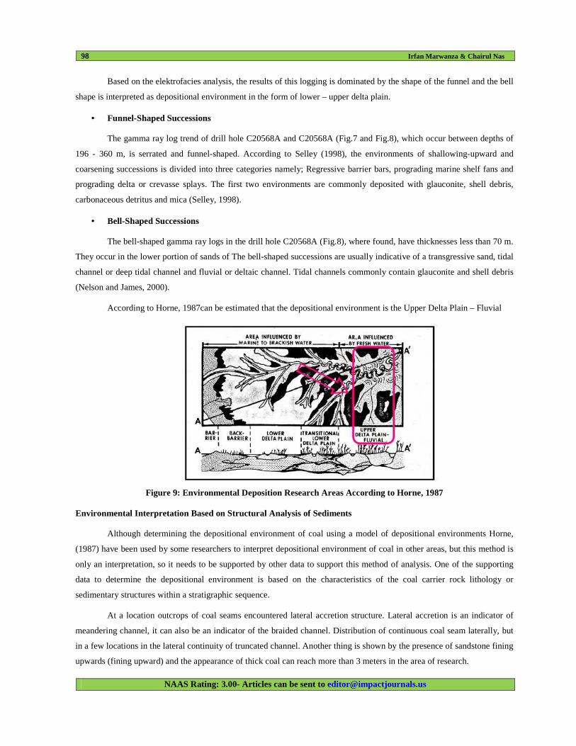
According to Horne, 1987can be estimated that the depositional environment is the Upper Delta Plain – Fluvial
Figure 9: Environmental Deposition Research Areas According to Horne, 1987
Environmental Interpretation Based on Structural Analysis of Sediments
Although determining the depositional environment of coal using a model of depositional environments Horne,
(1987) have been used by some researchers to interpret depositional environment of coal in other areas, but this method is
only an interpretation, so it needs to be supported by other data to support this method of analysis. One of the supporting
data to determine the depositional environment is based on the characteristics of the coal carrier rock lithology or
sedimentary structures within a stratigraphic sequence.
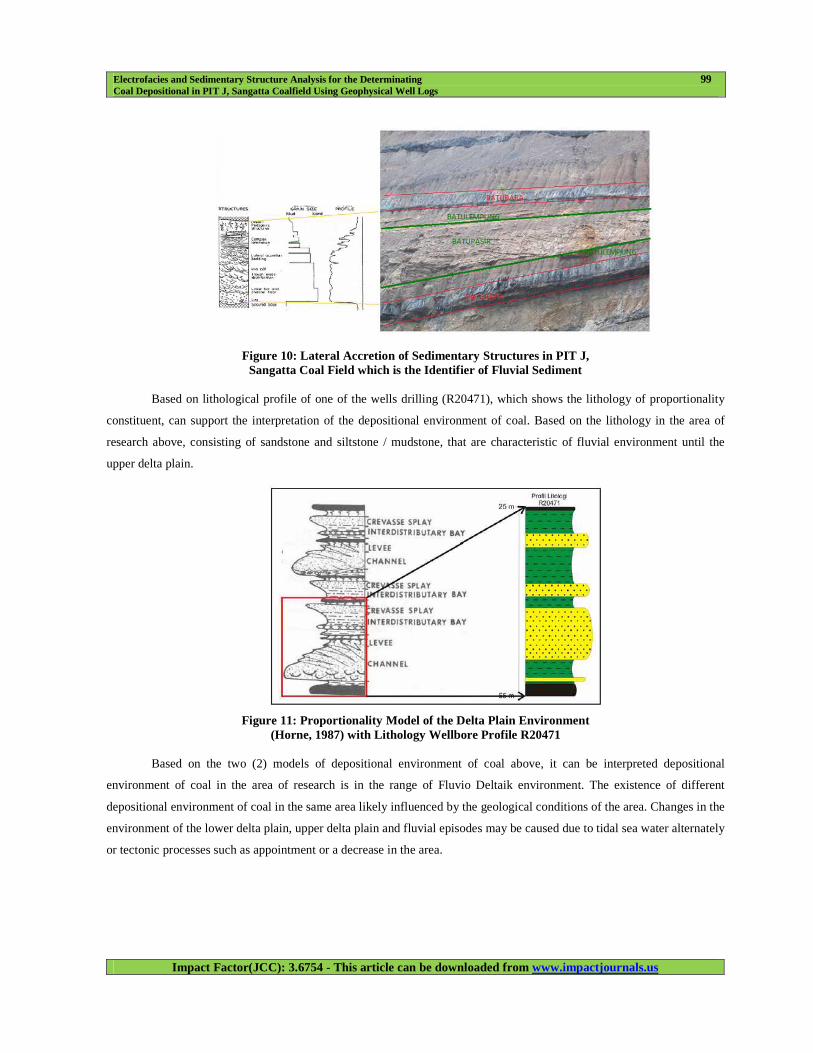
At a location outcrops of coal seams encountered lateral accretion structure. Lateral accretion is an indicator of
meandering channel, it can also be an indicator of the braided channel. Distribution of continuous coal seam laterally, but
in a few locations in the lateral continuity of truncated channel. Another thing is shown by the presence of sandstone fining
upwards (fining upward) and the appearance of thick coal can reach more than 3 meters in the area of research.
Electrofacies and Sedimentary Structure Analysis for the Determinating 99
Coal Depositional in PIT J, Sangatta Coalfield Using Geophysical Well Logs
Impact Factor(JCC): 3.6754 - This article can be downloaded from www.impactjournals.us
Figure 10: Lateral Accretion of Sedimentary Structures in PIT J, Sangatta Coal Field which is the Identifier of Fluvial Sediment
Based on lithological profile of one of the wells drilling (R20471), which shows the lithology of proportionality
constituent, can support the interpretation of the depositional environment of coal. Based on the lithology in the area of
research above, consisting of sandstone and siltstone / mudstone, that are characteristic of fluvial environment until the
upper delta plain.
Figure 11: Proportionality Model of the Delta Plain Environment (Horne, 1987) with Lithology Wellbore Profile R20471
Based on the two (2) models of depositional environment of coal above, it can be interpreted depositional
environment of coal in the area of research is in the range of Fluvio Deltaik environment. The existence of different
depositional environment of coal in the same area likely influenced by the geological conditions of the area. Changes in the
environment of the lower delta plain, upper delta plain and fluvial episodes may be caused due to tidal sea water alternately
or tectonic processes such as appointment or a decrease in the area.
100 Irfan Marwanza & Chairul Nas
NAAS Rating: 3.00- Articles can be sent to [email protected]
CONCLUSIONS
The PIT J Sangatta coal field is a located in the northern part of the Kutai Basin. The combination of core
description data from the cored well and gamma ray log responses were useful in generating a series of log faces. The log
faces were used to describe the reservoir section in the uncored, but logged wells in the field.
Two log faces were recognized in the study area. The facies represents palaeo depositional environments of
interdistributary bay, levee, crevasse splay, and channel. The crevasse splays belong to parts of a ditch system which is
characteristic of the Balikpapan Formation. Lateral accretion is an indicator of meandering channel, it can also be an
indicator of the braided channel.
Based on this research, some conclusions:
• The results of the data analysis of well logs and sedimentary structures, lithology authors showed PIT J Coal
Fields Sangatta, Balikpapan Formation consists of shale, sandstone, siltstone (siltstone) and coal.
• The results of the data analysis of well logs and sedimentary structures, coal depositional
environment - Balikpapan Formation is fluvio deltaic.
REFERENCES
1. Burke, K.C. (1972). Longshore drift submarine canyons and submarine fans in the development of the Niger
Delta. AAPG Bulletin 56, pp. 1975-1983.
2. Chow, J. J., Ming.-Ching Li. and Fuh, S. (2005). Geophysical well logs study on the paleoenvironment of
the hydrocarbon producing zones in the Erchungchi Formation, Hsinyin, SW Taiwan. TAO, Vol.16, No.3, pp.
531-543.
3. Coleman, J. M. and Prior, D.B. (1980). Deltaic sand bodies; A 1980 education short course. AAPG Note Series
No.14.
4. Cant, D.J. 1992. Subsurface facies analysis. In Facies Models: Response to Sea level Change (Walker, R.G.;
James, N.P.; editors). Geological Association of Canada, p. 195-218.
5. Emery, D & Myers, KJ, (eds) 1996. sequence stratigraphy. Blackwell Science Limited, 297pp.
6. Emery, D. and Myers, K.J. (1996). Sequence Stratigraphy. Blackwell Science Ltd.
7. Gould, H.R. 1972. Environmental indicators-A key to the stratigraphic record, in J.K. Rigby & W.K. Hamblin
(Eds.). Recognition of ancient sedimentary environments: Soc. Econ. Paleontologists and Mineralogist Spec. Pub.
16, p. 1-3.
8. Gluyas, J. and Swarbick, R. (2004). Petroleum geoscience. Oxford: Blackwell Publishing Co. p. 40-252
9. Horne, J. C., Ferm, J. C., Caruccio, F. T., and Baganz, B. P., 1978. Depositional models in coal exploration and
mine planning in Appalachian region. American Association of Petroleum Geologists Bulletin, v. 62,
p. 2379-2411.HWU. (2005). Petroleum Geoscience. Heriot Watt Institute of Petroleum Engineering.
10. Jesús A. Sánchez, 2003. Mesozoic sedimentation on an isolated platform at the eastern entrance to the Strait of
Electrofacies and Sedimentary Structure Analysis for the Determinating 101
Coal Depositional in PIT J, Sangatta Coalfield Using Geophysical Well Logs
Impact Factor(JCC): 3.6754 - This article can be downloaded from www.impactjournals.us
Magellan, Tierra del Fuego, Departamento de Geología, Facultad de Ciencias Físicas Matemáticas Universidad de
Chile, Casilla 13518, Correo 21, Santiago, Chile.
11. Krassay, A.A., 1998. Outcrop and drill core gamma ray logging integrated with sequence stratigraphy: examples
from Proterozoic sedimentary successions of northern Australia. AGSO Journal of Australian Geology and
Geophysics 17(4), 285-299.
12. Rider, M. 1986. The geological interpretation of well logs. Blackie, Halsted Press, New York, 175 pp.
13. Morris, R.L. and Biggs, W.P. (1990). Using log derived values of water saturation and porosity. SPWLA 8th
Annual Logging Symposium, 1-26.
14. Nelson, C. S. and James, N.P. (2000). Marine Cements in Mid-Tertiary cool-water shelf limestones of New
Zealand and Southern Australia. Sediment 47, 609-629.
15. Porrenga, D. H. (1967). Glauconite and chamosite as depth indicators in the marine environment. Marine Geology
5, 495-501.
16. Reijers, T. J., Petters, S.W. and Nwajide, C.S. (1997). The Niger Delta. In R. e. Selley, African
Basins-Sedimentary Basin of the World 3. Amsterdam: Elsevier Science. pp. 151-172.
17. Selley, R.C. (1998). Elements of Petroleum Geology. Department of Geology, Imperial College, London. pp.
37-145.
18. Shell. (1982). Well log interpretation: Chapters 11,12 and 13. Shell Houston.
19. Vail, P.R. and Wornardt, W. (1991). An integrated approach to exploration and development in the 90s. Well log
seismic sequence stratigraphy analysis. Gulf Coast Association of Geologists XL1, 630-650.
