1067 & 1096 donnybrook / woodstock - amazon web services · pdf filepsp 1067 & 1096...
TRANSCRIPT

Donnybrook / WoodstockPSP 1067 & 1096
Precinct Structure Plan
May 2016
Part B Submission - GC28 Amendment to the Whittlesea and Mitchell Planning Scheme
Panel Hearing Commencing 16 May 2016
Heard at Melbourne

GC28 | MPA submission to Planning Panels Victoria | 16 May 2016
PART B| Response to Submissions 1
1. INTRODUCTION ...................................................................................................... 3
2. RESPONSE TO OUTSTANDING SUBMISSIONS .......................................................... 4
2.1. GC28 Submissions which relate to the Donnybrook/Woodstock Precinct Structure Plan ..... 4
Conservation Areas ........................................................................................................................... 5
Infrastructure Contributions Plan ................................................................................................... 11
APA GasNet ..................................................................................................................................... 16
Requested Ordinance Changes ....................................................................................................... 20
Town Centres .................................................................................................................................. 26
Native Vegetation ........................................................................................................................... 32
Melbourne Water ........................................................................................................................... 34
Other ............................................................................................................................................... 50
3. SUMMARY ........................................................................................................... 63

GC28 | MPA submission to Planning Panels Victoria | 16 May 2016
PART B| Response to Submissions 2
Submissions
Submission 2 - M & J Harte
Submission 3 - Lou Dibella
Submission 4 - Glenn Halliday
Submission 6 - Angela and Sam Galileos
Submission 7 - Dennis Family Corporation
Submission 8 - Mitchell Shire Council
Submission 10 - Catholic Education Office
Submission 12 - Boral
Submission 14 - Mason Family
Submission 17 - City of Hume
Submission 18 - Friends of Donnybrook Train Station
Submission 19 - Melbourne Water
Submission 22 - Mirvac
Submission 23 - Merri Creek Management Committee
Submission 24 - Somerton Road Garden Supplies
Submission 25 - Greg Heffernan
Submission 26 - Anthony Monteleone
Submission 27 - Monteleone Family
Submission 31 - APA GasNet
Submission 34 - Friends of the Merri Creek
Appendices
Appendix 1 - Updated Unresolved Issues Table – Donnybrook/Woodstock PSP
Appendix 2 - Updated List of changes - Donnybrook/Woodstock PSP
Appendix 3 - Updated Urban Growth Zone – Track Changes
Appendix 4 - Revised Cross Sections

GC28 | MPA submission to Planning Panels Victoria | 16 May 2016
PART B| Response to Submissions 3
1. Introduction
These submissions are made on behalf of the Metropolitan Planning Authority (MPA), and as
Planning Authority for Amendment GC28 (the Amendment) to the Mitchell and Whittlesea Planning
Schemes (the Schemes).
The Amendment applies to the land known as the Donnybrook and Woodstock Precincts, to the
south of the Outer Metropolitan Ring Road Corridor and north of Donnybrook Road.
In summary, the Amendment proposes to implement:
(a) The Urban Growth Zone –schedule 6 to the Whittlesea Planning Scheme (“UGZ6”) and
schedule 4 to the Mitchell Planning Scheme (“UGZ4”).
(b) The Donnybrook and Woodstock Precinct Structure Plan (“PSP”).
The general background and strategic basis of the Amendment are set out in the MPA’s Part A
submissions and also the powerpoint presentation of Mr Stephen Davis – Structure Planning
Manager (MPA).

GC28 | MPA submission to Planning Panels Victoria | 16 May 2016
PART B| Response to Submissions 4
2. Response to outstanding submissions
The Metropolitan Planning Authority (MPA) has worked with the City of Whittlesea, Mitchell Shire
Council, Department of Environment, Land, Water and Planning (DELWP), key agencies and
landowners to resolve submissions during and after the public exhibition of the Amendment.
Appendix 1 to the Part A Submission comprises a table that sets out MPA’s position with respect to
submissions as at 29 April 2016. Since circulation of the Part A Submission the MPA has continued to
work with the various submitters whose matters were unresolved.
As a result, a significant number of issues have been resolved. The MPA has prepared:
(i) A list of outstanding issues that remain unresolved (Appendix 1)
(ii) A changes table, outlining the changes agreed to be made to the PSP (Appendix 2) and;
(iii) UGZ Schedule’s in order to resolve, or partially resolve, submitter objections (Appendix 3).
It is not proposed to address the Panel on the matters that have been resolved. These, and the MPA
response are set out in the documents referred to above. If any submitters believe that these matters
have not been resolved, or alternatively that other amendments should be made to the
documentation, then the most efficient course of action is for the submitters to raise these issues in
their submissions, and the MPA to respond to them in its right of reply.
Accordingly, the balance of this submission addresses the outstanding issues between the parties.
2.1. GC28 Submissions which relate to the Donnybrook/Woodstock Precinct
Structure Plan
The MPA has summarised the outstanding submissions and identified the following issues:
2.1.1. – Conservation Areas
2.1.2. – Infrastructure Contributions Plan
2.1.3. – APA GasNet
2.1.4. – Ordinance
2.1.5. – Town Centres
2.1.6. – Native Vegetation
2.1.7. – Melbourne Water
2.1.8. – Other

GC28 | MPA submission to Planning Panels Victoria | 16 May 2016
PART B| Response to Submissions 5
Conservation Areas
The Biodiversity Conservation Strategy for Melbourne’s Growth Corridors, June 2013 (BCS), describes
the overarching strategy for the protection of biodiversity within Melbourne’s growth corridors and
identifies areas to be conserved to protect nationally significant biodiversity values.
Issue 1. Review of Conservation Area Boundaries
The Donnybrook Woodstock Precinct contains conservation areas CA22, CA25 and CA34 identified in
the BCS. These are shown on plan 3. Three of these areas are subject to a review process and may
ultimately change if the Commonwealth agrees. The only area not subject to a request to change the
boundary is the small conservation area (CA25) located on the Mirvac (submitter 22) property.
Submission 12 – Boral
Boral wish to review the boundary for the conservation area on their property in light of the
additional work undertaken and identify land in the PSP which is deemed to be appropriate for
development.

GC28 | MPA submission to Planning Panels Victoria | 16 May 2016
PART B| Response to Submissions 6
Boral commissioned Ecology and Heritage Partners to survey the Open Space Conservation area and
the results have been submitted to DELWP for consideration.
Submission 14 – Mason Family
The Mason family submitted an application to DELWP on 1 June 2015, to amend the conservation
area boundary, based on a biodiversity assessment by Brett Lane & Associates (BL&A).
DELWP has since requested two more detailed surveys to be completed so that it could make a final
decision on the boundary amendment.
On the basis of its investigations, BL&A has recommended a nature conservation reserve boundary
encompassing the southern 22.6 hectares of the property that supports the listed threatened
community. The balance of the property it concludes, should be available for urban development as
it supports limited areas of remnant native vegetation, no vegetation that qualifies as an EPBC Act
listed community and no threatened species.
In summary, the Mason Family consider the extent of the designated conversation area
unnecessarily limits the developable area of the subject land. The Mason family are also calling
evidence from Mr Galbraith.
Submission 7 – Dennis Family Corporation
DFC request a note on plan /text to add.:
‘The Conservation Area boundary may change with the appropriate approvals from DELWP
/Commonwealth as required under the Melbourne Strategic Assessment.’
MPA Response:
Three of the Conservation Areas are being reviewed by DELWP. This work is not yet complete and
therefore cannot be incorporated into the document until it is completed and approved.
The Conservation Area Concept Plans (CACPS) will be updated when the revised boundaries are
identified. It should also be noted that any increase in developable area associated with a
reduction in Conservation Area will be subject to the payment of native vegetation offsets and the
City of Whittlesea’s tree retention policy.
Until such time this review is completed and approved, the MPA can only show the current
designated BCS boundary.
As highlighted in the Wollert Panel Report (p.g. 31)
“It is not the Panel’s role to determine the boundaries of the Conservation Areas that are subject
to Commonwealth approval; it is the Panel’s role to be satisfied that:

GC28 | MPA submission to Planning Panels Victoria | 16 May 2016
PART B| Response to Submissions 7
the land identified for development is capable of being developed
the consequent changes to the PSP would not adversely affect a party who has not
had the opportunity to make submissions about the change.
The Panel agrees that it is preferable for the conservation areas to be settled
before the Amendment is approved. If a Commonwealth decision on the shape of
CA31 and CA32 is not made before the approval of the PSP then a notation on
Plans 1, 2, 3, 5, 6 and 7 to indicate that an application for review is under
consideration would need to be included. The plans should explicitly identify the
areas that might be subject to change.”
This is the approach that is proposed in relation to any changes to the Donnybrook Woodstock PSP
conservation areas.
Issue 2 – Heffernan Property, time stamping of vegetation
Submission 25 – Greg Heffernan
Mr Heffernan is concerned that the native vegetation values placed on his land were greatly
exaggerated when time stamped.
MPA and DELWP response:
The time‐stamping project brings together native vegetation assessments of the growth corridors
conducted since 2008 by the former Growth Areas Authority, Department of Transport, and DEPI in
consultation with the former Department of Planning and Community Development. Many
properties in the growth corridors were surveyed by consultants under contract to the Growth
Areas Authority (for precinct structure planning) or Department of Transport (for the Regional Rail
Link project). The time‐stamping project completed the mapping across the growth corridors by
consulting directly with landowners of properties that had not been surveyed through these
projects.

GC28 | MPA submission to Planning Panels Victoria | 16 May 2016
PART B| Response to Submissions 8
All native vegetation field assessments used for the time‐stamping dataset have been done
according to published native vegetation assessment methodology and the former DEPI conducted
quality assurance on the data collected.
In cases where field assessments have not been done, the former DEPI has consulted directly with
landowners, who were given an opportunity to review and revise the department's understanding
of the native vegetation on their properties.
The data from this consultation has been combined with all available field data to complete the
final 'time‐stamped' native vegetation dataset.
In the time‐stamped dataset, areas with at least 25 per cent native cover at the time they were
mapped are considered native vegetation, irrespective of how the land has been managed in the
past. This could include areas that have been ploughed or cropped, but have since regenerated as
native vegetation. This approach has been applied consistently for all mapping used in the
timestamped dataset.
Under the time-stamping approach, if land in the growth corridors is to be subdivided and
developed, habitat compensation for the removal of native vegetation and habitat will be
calculated using the 2012 "time-stamped" maps regardless of the extent and condition of the
vegetation on the land at the time it is developed.
Time stamping is part of the BCS for Melbourne and cannot be changed through this process.
Issue 3 – Width of GGF corridor
Submission 25 – Greg Heffernan
Mr Heffernan questions why there is a difference in the dimensions of growling grass frog corridors.
MPA and DELWP response:
The Growling Grass Frog (GGF) Conservation Areas respond to the requirements of the Growling
Grass Frog Sub‐regional Species Strategy for the Growling Grass Frog DEPI, 2013. The strategy
identified suitable habitat for GGF and was informed by technical work done by consultants,
including literature reviews, targeted surveys, and development of a habitat connectivity model,
stream by stream site analysis and technical workshops.
The part of the Growling Grass Frog Conservation Area 34 (part b) occurring on Mr Heffernan’s
property has been assigned the management category of Nature conservation, contiguous with
Nature conservation, Conservation Area 22.
The Growling Grass Frog corridors were identified through the BCS and cannot be assisted through
the Panel process.
GC28 | MPA submission to Planning Panels Victoria | 16 May 2016
PART B| Response to Submissions 9
Issue 4 Vegetation outside Conservation Areas
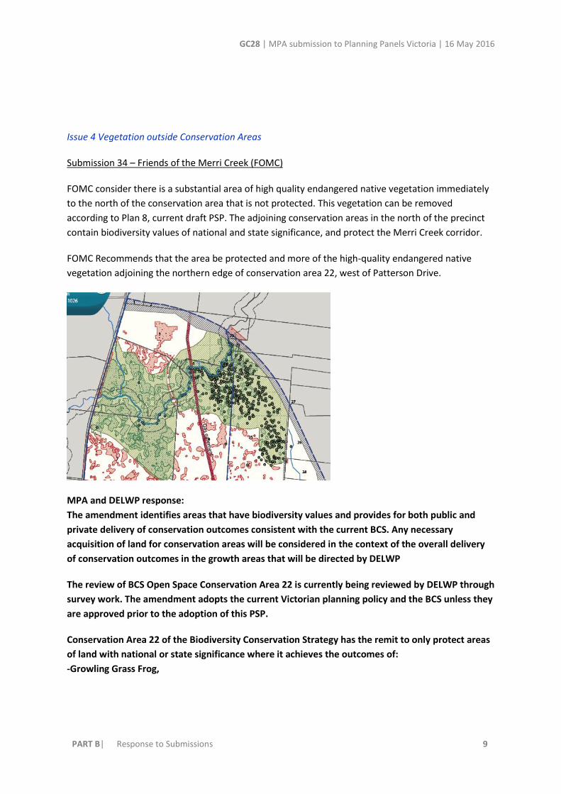
Submission 34 – Friends of the Merri Creek (FOMC)
FOMC consider there is a substantial area of high quality endangered native vegetation immediately
to the north of the conservation area that is not protected. This vegetation can be removed
according to Plan 8, current draft PSP. The adjoining conservation areas in the north of the precinct
contain biodiversity values of national and state significance, and protect the Merri Creek corridor.
FOMC Recommends that the area be protected and more of the high-quality endangered native
vegetation adjoining the northern edge of conservation area 22, west of Patterson Drive.
MPA and DELWP response:
The amendment identifies areas that have biodiversity values and provides for both public and
private delivery of conservation outcomes consistent with the current BCS. Any necessary
acquisition of land for conservation areas will be considered in the context of the overall delivery
of conservation outcomes in the growth areas that will be directed by DELWP
The review of BCS Open Space Conservation Area 22 is currently being reviewed by DELWP through
survey work. The amendment adopts the current Victorian planning policy and the BCS unless they
are approved prior to the adoption of this PSP.
Conservation Area 22 of the Biodiversity Conservation Strategy has the remit to only protect areas
of land with national or state significance where it achieves the outcomes of:
-Growling Grass Frog,

GC28 | MPA submission to Planning Panels Victoria | 16 May 2016
PART B| Response to Submissions 10
- contributes to the 80% grassy eucalypt woodland retention,
- contributes to ensuring no substantial change to curly sedge grass populations.
Landscape, and cultural values are not protected through the BCS, but are protected through other
means in the PSP planning process. Again, this is a matter for DELWP and the Commonwealth
regarding the BCS.
Issue 5 – Conservation Areas on Merri creek should be acquired
Submission 34 – Friends of the Merri Creek (FOMC)
Friends of the Merri Creek submit that Conservation areas along the Merri Creek corridor should be
acquired by the State, and reserved and actively managed for conservation as part of a Greater
Wallan-Merri State Park
MPA and DELWP response:
Provision for conservation areas along Melbourne's Growth corridor creeks and rivers has been the
subject of significant investigation, review, contest and regulation over the past 5 years. The
submitter was part of this process. The process resulted in statutory decisions by the
Commonwealth, supported by both current and former governments under the Environment
Protection and Biodiversity Conservation Act 1999 (Cth). These decisions are designed to provide
the long-term conservation through a range of measures including the protection of land and the
creation of habitat. This regulatory regime is a first in Australia to fulfil national conservation
outcomes alongside urban development. The program is being implemented through the PSP
program through protecting the entire length of the creek with land either side in all growth areas.
It is a matter for the State and Commonwealth under the BCS as to the acquisition of land for
conservation purposes.

GC28 | MPA submission to Planning Panels Victoria | 16 May 2016
PART B| Response to Submissions 11
Infrastructure Contributions Plan
Issue 1. Exhibition of PSP without an ICP or DCP
A number of submitters raised issues with the fact that the PSP has been exhibited without an
accompanying Development Contributions Plan, prior to the Infrastructure Contributions Plan (ICP)
system.
Submission 8 – Mitchell Shire Council
Submission 12 – Boral
Submission 14 – Mason Family
Submission 22 – Mirvac
Submission 27 – Monteleone Family
MPA Response:
Infrastructure contributions reform
Planning and Environment Amendment (Infrastructure Contributions) Act 2015 (NO. 35 OF 2015) -
SECT 4.
The Act introduces a new simple, standardised infrastructure contributions system for levying
development contributions towards the provision of infrastructure in growth and strategic
development areas across Victoria.
The Act is based on the recommendations of the Standard Development Contributions Advisory
Committee that was established in 2012 to provide advice on a new standard levy system for
development contributions.
The new system is based on standard levies that are pre-set for different development settings and
land uses. The standard levies are designed to provide for a financial contribution to the delivery of
essential local infrastructure required to support new or growing communities.
The DELWP has worked, and is still working with an Implementation Reference Group representing
peak industry groups and Councils to finalise the details of the new system, such as the levy rates,
indexation mechanisms and application criteria, before it commences.
The new system is to be introduced in mid-2016 and in the first instance will be applied in
greenfield growth areas and strategic development areas.
The MPA has committed to preparing an ICP prior to Gazettal of the Donnybrook Woodstock PSP.

GC28 | MPA submission to Planning Panels Victoria | 16 May 2016
PART B| Response to Submissions 12
Issue 2 – Inclusion of the funding for the east portion of Gunns Gully Road and culvert in the ICP
Submission 14 – Mason Family
The Mason Family submit that the east portion of the Gunns Gully Road 6 lane arterial is to be
funded as part of the OMR project, however it is not clear how the proposed interim treatment
connecting to Merriang Road will be funded.
The Mason Family submit that due to the major role in providing an east-west access in the wider
region it is essential that this interim treatment be allocated contributions funding.
The exclusion of the culvert from development contributions funding ignores the immediate
requirement of access to the Mason family land and others who own a property in the northern part
of the DWPSP area, as outlined above.
Furthermore, the funding of all other culverts along arterial roads are expected to be funded as
detailed in the Draft Precinct Infrastructure Plan Projects.
MPA Response:
The MPA does not anticipate that the eastern link of Gunns Gully Road (i.e. east of the culvert
crossing) will be required in the short term and will most likely only be constructed by VicRoads
should they see a need to connect to Grants Road. This is unlikely to occur before the construction
of the OMR.
As such the funded construction of the temporary access street cannot be justified as an ICP item.
The MPA and the City of Whittlesea are of the view that neighbouring properties to the north of
1235 Merriang Road are already accessible and can apply as part of a future planning permit
application to upgrade access. It is expected that as the area develops local street connections will

GC28 | MPA submission to Planning Panels Victoria | 16 May 2016
PART B| Response to Submissions 13
provide opportunities to cross the constructed waterways and connect to the arterial road
network.
A culvert is proposed within the subject land on Gunns Gully Road where it passes over the east
waterway corridor.
The culvert issue in this instance is considered in the same context as the temporary access road
associated with the submission regarding Gunns Gully Road. Melbourne Water have indicated that
until the area fully develops the passage of water can be managed with the installation of pipes
under the local street with the specifications able to be determined at the planning permit for
subdivision stage.
Issue 3 – Funding of Monteleone Way and culvert in DCP
Submission 27 – Monteleone Family
The Monteleone Family have requested funding in the ICP for the construction of Monteleone Way
and proposed culvert located on their site. The submitter contends that Monteleone Way serves an
arterial function, and also serves a considerable public purpose as a reservation for the large amount
of infrastructure to be accommodated within road reserve.
MPA response:
The MPA does not support this position.
The MPA position is that connector streets are subdivision works as required by the PSP pursuant
to R98. R98 specifies as follows.
R98: “Subdivision of land within the Precinct must provide and meet the total cost of delivering the
following infrastructure:
• Connector roads and local streets.

GC28 | MPA submission to Planning Panels Victoria | 16 May 2016
PART B| Response to Submissions 14
• Local bus stop infrastructure (where locations have been agreed in writing by Public Transport
Victoria).
• Landscaping of all existing and future roads and local streets.
• Intersection works and traffic management measures along arterial roads, connector streets, and
local streets (except those included in the Donnybrook-Woodstock Infrastructure Contributions Plan
(ICP).
• Council approved fencing and landscaping (where required) along arterial roads.
• Local shared, pedestrian and bicycle paths along local arterial roads, connector roads, utilities
easements, local streets, waterways and within local parks including bridges, intersections, and
barrier crossing points (except those included in the ICP).
• Bicycle parking.
• Appropriately scaled lighting along all roads, major shared and pedestrian paths, and traversing
public open space.
• Basic improvements to local parks and open space (refer open space delivery below).
• Local drainage system.
• Local street or pedestrian path crossings of waterways unless included in the ICP or outlined as the
responsibility of another agency in the Precinct Infrastructure Plan.
• Infrastructure as required by utility service providers including water, sewerage, drainage (except
where the item is funded through a Development Services Scheme), electricity, gas, and
telecommunications.
• Construction of shared paths along waterways and public paths.
• Remediation and / or reconstruction of dry stone walls where required.”
The MPA does not accept that there is sufficient justification to include the connector street in the
ICP.
New arterial roads are funded through infrastructure levies because of the strategic need to
deliver land for future road widening and their role in providing broader strategic connections
throughout the precinct and into neighbouring precincts. It should also be noted that arterial
roads are designed to limit direct access points to VicRoads standards. Therefore the principle of
an infrastructure contribution towards arterial roads is predicated on the principle of the broader
precinct contributing to the cost of a road that travels through a development but has design
constraints associated with the need for traffic movement priority on arterial roads.
With a connector street, while it may provide connections to and from and between various land
uses, its cross section is ultimately single carriageway and does not have a need to duplicate in the
future. The MPA notes that all of the connector streets set out in the PSP, including those planned
as boulevard connector streets are developed as a development cost and do not receive ICP
funding. In addition we note that the land uses they claim justify the funding of the road such as
schools, community buildings, sports reserves and local centres are typically only ever located on
connector streets and local access streets.

GC28 | MPA submission to Planning Panels Victoria | 16 May 2016
PART B| Response to Submissions 15
For the same reasons. The MPA does not support the inclusion of the connector street culvert in
the ICP. The MPA does not accept that this culvert is required because of the GGF habitat area
located west of the connector street. Melbourne Water have clearly stated that the purpose of the
constructed waterway is to convey developed flows west to the retarding basin/wetland. It is
simply part of a local connector street construction and would be required irrespective of the GGF
habitat.
These views are supported by the evidence of Mr Hunt who agrees on the classification of
Monteleone Way as a normal connector street.

GC28 | MPA submission to Planning Panels Victoria | 16 May 2016
PART B| Response to Submissions 16
APA GasNet
Issue 1 – Referral/Notice Requirements to APA
Submission 31 – APA GasNet
Submission 7 – Dennis Family Corporation
APA recommends that a pipeline specific provision be placed within the GC28 Whittlesea Planning
Scheme amendment for the requirement of a planning permit for certain land uses to be referred to
them.
APA recommended the following provision be included in the amendment
A permit is required to use land that is located within:
o 341 metres of the Keon Park to Wodonga (T74.2-300mm) pipeline with Pipeline Licence
PL101 and 590 metres of the Wollert to Broadford (T119- 400mm) pipeline with Pipeline
Licence PL101, as shown on Plan 2 in the incorporated Donnybrook/Woodstock Precinct
Structure Plan for the following land uses:
o Accommodation (other than a single dwelling on a lot or a Dependent person’s unit), a Child
care centre, an Education centre, a Place of Assembly, Retail premises, a Cinema based
entertainment facility, or a Hospital. Where an application is made for a permit, the
application must be referred to the operator of the gas transmission pipeline. The purpose
of this provision is to ensure that, prior to the commencement of any of the said uses;
consideration is given to the safety of locating the use nearby to the gas transmission
pipeline.
MPA Response:
Within the PSP area there are two gas transmission pipelines:
Keon Park to Wodonga
Wollert to Broadford
The pipelines are owned and operated by a number of private companies collectively known as
APA.
The MPA considers that the easement has been appropriately identified through the PSP and
through the easements which are shown on the relevant property titles. The proposed UGZ also
includes provisions to manage land uses on and around the easements.
The MPA does not support the recommendations suggested in point 2 of the APA submission.

GC28 | MPA submission to Planning Panels Victoria | 16 May 2016
PART B| Response to Submissions 17
The MPA proposes that where notice is required, notice of any sensitive land use or development
requiring a planning permit be given to the gas pipeline Licensee under Clause 66 and the provision
be written into the UGZ schedule.
The MPA does not agree that APA should be a referral authority in the Planning Scheme as it is
private entity and has no statutory authority.
The Wording for the UGZ schedule is consistent with the position put forward for the Wollert PSP
Panel Hearing. It is considered that the findings in Wollert Panel have put this issue to bed, and
the parties should not have to revisit the notice issue here.
The approved wording at Wollert was as follows:
Notice to gas transmission pipeline owner and operator
Notice must be given to the person or body listed in the Schedule to Clause 66.06 of an application on
land shown within:
708 metres of the Pakenham to Wollert (T61‐750mm) pipeline with Pipeline Licence PL141 (i.e. the east‐west pipeline); or
377 metres of the Wollert to Keon Park (T74‐600mm) pipeline with Pipeline Licence PL101 (i.e. the north‐south pipeline), and shown as gas transmission pipeline on Plan 11 – Utilities in the incorporated Wollert Precinct Structure Plan for Accommodation (other than a dwelling on a lot or a Dependent person’s unit), Dwelling where density will equal or exceed 30 dwellings per net developable hectare, a Child care centre, an Education centre, a Place of Assembly, Retail premises, a Cinema based entertainment facility, Hospital or Aged Care Facility
Proposed wording in the current Donnybrook/Woodstock PSP is as follows:
Notice to gas transmission pipeline owner and operator
Notice must be given to the person or body listed in the Schedule to Clause 66.06 of an application on
land shown within:
341 metres of the Keon Park to Wodonga (T74.2-300mm) pipeline with Pipeline Licence PL101; or
590 metres of the Wollert to Broadford (T119- 400mm) pipeline with Pipeline Licence PL101
and shown as gas transmission pipeline on Plan 15 - Utilities in the incorporated
Donnybrook/Woodstock Precinct Structure Plan for Accommodation (other than a dwelling on a lot or
a Dependent person’s unit), Dwelling where density will equal or exceed 30 dwellings per net
developable hectare, a Child care centre, an Education centre, a Place of Assembly, Retail premises, a
Cinema based entertainment facility, Hospital or Aged Care Facility.

GC28 | MPA submission to Planning Panels Victoria | 16 May 2016
PART B| Response to Submissions 18
Issue 2 – Minimising Crossings and crossings to be at 90 degrees to the gas line
Include additional Requirement stating: Subdivision design adjacent to the high pressure gas pipeline
corridor must actively respond to the safety, maintenance and management of the asset throughout
the precinct by minimising crossings of the asset, crossing the pipeline at 90 degrees, and
appropriate landscaping treatments to the satisfaction of the Responsible Authority in consultation
of the pipeline licensee.
MPA response:
The MPA does not support the requirement with regard to minimising crossings. It is considered
that a requirement worded in this way, to minimise the number of crossings would result in a poor
urban design outcome and reduced connectivity. The MPA considers that the cost associated with
achieving a local street crossing of the pipeline easement will be sufficient to ensure that minimal
crossings are proposed through the subdivision process.
The MPA supports an additional Guideline which states: “Subdivision design adjacent to the high
pressure gas pipeline corridor should ensure road crossings are at 90 degrees to the pipeline”.
Landscaping treatment would be triggered by the subdivision process to the satisfaction of the
responsible authority where a construction management plan is required.
Issue 3 – Additional requirement for no sensitive uses within 590 metres of the pipeline
APA requested an additional Requirement that reads: No sensitive land uses as defined under AS
2885- Gas and Liquid Petroleum are to be located within 590 metres of the existing high pressure gas
pipelines unless otherwise approved by the pipeline licensee.
MPA response:
The MPA does not support this request.
The SMS workshop conducted at the MPA on 11 March 2016 concluded that the risks associated
with land uses within the 590m Measurement Length is ALARP.
APA is obliged under the Pipelines Act 2005 (Vic) to, among other things, manage its pipeline
operations to minimise, as far as is reasonably practicable, hazards and risks to the safety of the
public and the environment arising from the pipeline operation
The PSP has been prepared so as to exclude certain land uses from areas that fall within the
‘measurement lengths’ around the pipelines.
As found in the Wollert Panel:

GC28 | MPA submission to Planning Panels Victoria | 16 May 2016
PART B| Response to Submissions 19
AS2885 does not require increased risk arising from changes in land use around a pipeline to be
mitigated at the cost of everyone else other than the relevant pipeline operator.
On the contrary, clause 4.7.4 of the AS2885.1 directs that, where there are changes to land use
planning or land use along the route of existing pipelines to permit Residential, High Density,
Industrial or Sensitive development in areas where those uses were currently prohibited, then the
pipeline Licensee must:
Undertake an SMS designed to assess any risk of the proposed changes; and
Consider a number of alternative solutions to appropriately address that risk.
The notion that controls should further restrict development in the measurement length of the
pipeline on the basis of an unquantifiable risk is not prudent.
The Panel concluded that safety issues associated with the gas pipeline have been properly dealt
with in the urban structure.
The MPA also notes that since the SMS has been prepared, requirement 94 is to be deleted. R94
reads as follows:
R94: An application for a ‘sensitive’ land use (as determined in Section 4.3.5 of the AS2885 Australian
Standard Pipelines – Gas and Liquid Petroleum) within the measurement length area of the APA gas
pipelines as shown on Plan 12 must be accompanied by a Safety Management Study (SMS) as
required by AS2885.

GC28 | MPA submission to Planning Panels Victoria | 16 May 2016
PART B| Response to Submissions 20
Requested Ordinance Changes
Issue 1. RESIDENTIAL GROWTH ZONE or GENERAL RESIDENTIAL ZONE
Submission 33 – City of Whittlesea
Submission 8 – Mitchell Shire Council
The MPA proposes to apply the Residential Growth Zone (RGZ) to the residential areas of the
Donnybrook Woodstock Precinct. This is the area noted as ‘all other land’ in the Urban Growth Zone
schedules.
It is understood that Whittlesea and Mitchell Councils would prefer the General Residential Zone (GRZ)
or that the RGZ should only be applied to those areas identified as a higher density residential
opportunity in Plan 5 of the PSP (Character & Housing) and by Requirements R20 and R21, with the
balance placed in the General Residential Zone.
It is common ground that the areas identified for higher density residential opportunities in Plan
5 appropriately accommodate increased residential densities.
The issue is therefore limited to the appropriate mechanism by which to implement the Donnybrook
Woodstock PSP.
It is submitted that, on a proper analysis of the provisions of the Urban Growth Zone, concern regarding
the implementation of the RGZ is misconceived:
The purposes of the Urban Growth Zone include:
“To manage the transition of non-urban land into urban land in accordance with a precinct
structure plan. “
“To provide for a range of uses and the development of land generally in accordance with
a precinct structure plan.”
If a structure plan is in force, then Part B of the UGZ applies (that is - Clauses 37.07-9 – 37.07-16).
These provisions include:
A requirement that any permit that is granted be generally in accordance with the precinct
structure plan applying to the land.
If the schedule to the zone specifies that the provisions of a zone apply to the
development of land, then those provisions apply in the circumstances specified in the
schedule.
In short:
The provisions of the PSP guide the exercise of the discretion whether or not to grant a
permit.

GC28 | MPA submission to Planning Panels Victoria | 16 May 2016
PART B| Response to Submissions 21
Whether or not the applied zone is the Residential Growth Zone or General Residential
Zone makes little difference in assessing a permit application. The terms of the PSP and
the general requirement that any development must be generally in accordance with the
PSP guide the exercise of the discretion. The anticipated development details are
contained within the PSP document in relation to the form of proposed development, the
anticipated yield and the areas where different types of development are detailed. The
intensity of the proposed development is settled within the PSP, not with the applied
zone. These matters are provided with much greater detail in the PSP, particularity than
would be the case in an amendment which simply rezoned land from one zoning control
to the next.
Plan Melbourne recognises the need for growth areas to depart from the traditional application of the
General Residential Zone to explore the application of alternate zones.
o Amend the Precinct Structure Planning Guidelines to ensure that housing diversity will
be achieved by providing a variety of lot sizes and housing types across a precinct,
including lower-density, standard lots and higher-density housing in areas of higher
amenity. Precinct structure planning should apply the suite of reformed residential
zones and Mixed Use Zone to encourage the delivery of a diversity of lot sizes and
housing types in the short and long terms.
Metropolitan Planning Authority
o Encourage use of the Residential Growth Zone in Melbourne’s greenfield locations in
growth areas to allow for residential change and redevelopment in appropriate
locations over time.
The starting proposition must accordingly be that the RGZ has a role to play in the delivery of
Melbourne’s newest suburbs. What this policy calls for is application of the reformed zones in growths
areas, but more particularly the RGZ in certain ‘appropriate locations’.
It is the MPA’s practice going forward to apply the RGZ to the residential component of greenfield
sites.
In applying the RGZ, MPA notes that the delivery of growth areas operates in an alternate statutory
context where the UGZ applies zones, which then provide the machinery provisions by which statutory
planning applications can be processed.
MPA considers that the hierarchy of documents in the statutory planning process where the UGZ is
applied is materially different to the context of ordinary permit applications, in particular because the
UGZ and its purposes, and the PSP itself, provide the guiding principles for development.
It is also necessary to examine the machinery clauses within the RGZ and GRZ to examine whether
there are any material differences between the zones. Of course both zones permit residential uses

GC28 | MPA submission to Planning Panels Victoria | 16 May 2016
PART B| Response to Submissions 22
with a maximum discretionary height of 13.5 (UGZ) or 9 metres (GRZ). Where development is guided
by the PSP and subject to a requirement of ‘generally in accordance with’ this is not material.
In terms of alternate uses allowable under the RGZ, the only potentially material as-of-right uses would
be food and drink premises and shop (up to 100 sqm), but only where the site abuts a road zone and
is within 100 metres of a commercial or Mixed Use Zone (applied). The MPA considers that these
additional small scale, as-of-right uses provide some additional flexibility for the location of non-
residential uses within the precinct, and in the circumstances of the Amendment these additional non-
residential uses, if developed, would not result in a material change to the structure of the precinct.
Finally, and although not determinative, this is not the first time that a RGZ has been applied to a
precinct. Other precincts where a RGZ has been applied to the whole precinct include:
o Casey Planning Scheme:
UGZ6 – Thompsons Road.
UGZ7 – Clyde Creek.
UGZ8 – Casey Fields South.
UGZ9 – Berwick Waterways.
o Wyndham Planning Scheme:
UGZ8 – Ballan Road.
UGZ9 – Westbrook.
UGZ10 – Truganina.
UGZ11 – Riverdale.
UGZ13 – Tarneit North.
o Whittlesea:
English Street.
It is also proposed by the MPA to include the RGZ in the Rockbank and Brompton Lodge PSP, a matter where the issue was contested, however the Panel Reports have not been delivered to date
Issue 2 – Heritage Overlay
Submission 3 – Lou Dibella
Mr Dibella submits that justification has not been provided for the application of the Heritage
Overlay to 975 Donnybrook Road, Donnybrook and the loss of 1.25ha of what is currently
developable land. This directly conflicts with previous work undertaken by Council and the Context
report which has been prepared to inform the PSP.

GC28 | MPA submission to Planning Panels Victoria | 16 May 2016
PART B| Response to Submissions 23
MPA Response:
The MPA has been working closely with the City of Whittlesea to ensure that the application of
heritage protection to the site is appropriate and accurate having regard to the heritage values of
the site. It is the MPA and City of Whittlesea’s view that the exhibited Heritage Overlay affecting
this site remains suitable, as it ensures a planning permit is triggered if buildings and works or
demolition works on the land are proposed. However, this does not necessarily require the existing
buildings on the land to be retained, rather they will be subject to assessment via the planning
permit process.
The panel inspected the site, viewing the drystone walls and old brick buildings. The Heritage
Overlay extends to the old dwellings on the site as well. It was noted that it was in a state of
disrepair, however that alone is not a reason to remove the Heritage Overlay from the site.
Issue 3 – Changes to the requirements for Environmental Assessment
Submission 3 – Lou Dibella
Mr Dibella submits that the requirement of a certificate or statement of audit in Section 3.3 of the
UGZ should be replaced with the need to prepare a Phase 2 Environmental Assessment and the
wording be based upon the wording of recent schedules approved in the City of Casey such as:
An application to subdivide land, use or develop land for a sensitive use (residential use, child
care centre, pre-school centre or primary school) must be accompanied by an environmental
site assessment of the land by a suitably qualified environmental professional to the
satisfaction of the responsible authority which takes account of ‘[name of report]’ and
provides information including:
- Further detailed assessment of potential contaminants on the relevant land;
- Clear advice on whether the environmental condition of the land is suitable for the
proposed use/s and whether an environmental audit of all, or part, of the land is
recommended having regard to the Potentially Contaminated Land General Practice Note
June 2005, DSE;
- Further detailed assessment of surface and subsurface water conditions and geotechnical
characteristics on the relevant land and the potential impacts on the proposed development

GC28 | MPA submission to Planning Panels Victoria | 16 May 2016
PART B| Response to Submissions 24
including any measures required to mitigate the impacts of
- groundwater conditions and geology on the development and the impact of the
development on surface and subsurface water; and
- Recommended remediation actions for any potentially contaminated land.
MPA Response:
The MPA has sought input from both the City of Whittlesea and Mitchell Shire Council in relation
to this matter. Both Councils have indicated that they oppose the alternate approach sought to the
Environmental Site Assessment requirements in the UGZ schedules. Whittlesea in particular has
advised that they support the exhibited UGZ schedules nominating sites with a high potential for
contamination as suitable to require a certificate of environmental audit or statement by an
environmental auditor, and sites with medium contamination potential to require a Phase Two
assessment. Mitchell supports this approach.
The MPA is of the view that where the background report has identified sites with high potential
for contamination, it is appropriate that these sites require a greater extent of examination via a
certificate of environmental audit or statement by an environmental auditor.
Issue 4 – Request to retain Special Use Zone for Quarry
Submission 25 – Greg Heffernan
Mr Heffernan’s property has a zoning of Special Use for the extractive industry. The reason for this is
the quarry which was started in 1981. Mr Heffernan requests the that the Special Use Zoning should
remain as to protect an important resource.

GC28 | MPA submission to Planning Panels Victoria | 16 May 2016
PART B| Response to Submissions 25
MPA Response:
This matter was referred to Mitchell Shire who do not support the development of extractive
industries on the Heffernan land. It should be noted that the planning and policy frameworks that
influence how the property can be used or developed has changed substantially since the land was
zoned SUZ. The policy framework associated with this change is the North Growth Corridor Plan
directs that the land should be developed for urban purposes and as such extractive industry is
considered incompatible.

GC28 | MPA submission to Planning Panels Victoria | 16 May 2016
PART B| Response to Submissions 26
Town Centres
Issue 1 – Location and role of the Local Town Centre 1.
Submission 13 – Stockland
Submission 17 – City of Hume
The draft PSP proposes a large Local Town Centre (LTC 1), performing a sub-regional role, two LTCs
performing conventional neighbourhood roles (LTC 2 and LTC 3), a small LTC (LTC 4) and six local
convenience centres (LCCs 1-6).
This centre hierarchy is based on advice prepared by Essential Economics in June 2014, and
supplementary Essential Economics advice in June 2015 that identified the potential for Koukoura
Local Town Centre (LTC 1) to include a DDS and second supermarket. This additional potential is
based on the study region capturing 41% of the total retail spending in the study region and
supporting 45,000m2 retail floorspace (Scenario 2, Potential for Expanded Retail Facilities Scenario),
as compared to a 31% capture of the total retail spending in the study region, supporting only
33,000m2 retail floorspace (Scenario 1, LTC Only Scenario).
The 2014 Essential Economics report did not further define the retail floorspace demand analysis and
recommended a total provision of between 33,000m2 - 45,000m2. However, it did recommend a
centre hierarchy based on the lower retail spending capture and total provision of 33,000m2 retail
floorspace. The Essential Economics 2015 update provided additional advice to the MPA to further
consider, amongst other things, the potential for a larger LTC on Koukoura Drive to be the larger
centre serving the region. This advice was not clearly based on any additional analysis but rather
responded to ongoing MPA work on the Future Urban Structure (FUS) for the PSP areas ‘taking into
account consultation with land owners and research/advice on the many aspects that are involved in
planning for future urban growth areas (including community planning, economics, environmental,
traffic, etc). The 2015 advice does not explicitly make recommendations that a larger LTC should be
provided, but rather reiterates that there is potential and outlines spatial considerations for an
enlarged LTC at Koukoura Drive.
We do not therefore find that the Essential Economics work conclusively justifies why the larger
floorspace provision of 45,000m2 is the favoured option for the Donnybrook-Woodstock PSP.
A comparison of the recommendations in the 2014 Essential Economics with both scenarios
described above and the 2015 PSP retail centre caps is provided within the content of this
submission.
Stockland are of the view that the increase in LTC 1 to 21,500m2 will foreseeably have a negative
impact on the development of retail uses in Lockerbie PTC, particularly if LTC 2 develops prior to
Lockerbie PTC.

GC28 | MPA submission to Planning Panels Victoria | 16 May 2016
PART B| Response to Submissions 27
Stockland seek for the retail floorspace cap for LTC 1 to be retained at the 7,000m2 cap as identified
in the 2014 Essential Economics assessment. At the very least, this item should be supported by
further economic analysis on the centre’s impact on Lockerbie PTC, and that analysis made available
for public scrutiny.
Stockland would also object strongly to any additional increase in the retail floorspace caps
associated with LTC 1 or LTC 2 arising from the consideration of Amendment GC28, or the addition of
land designated ‘retail’ associated with either of those centres.
MPA Response:
The MPA supports the strategic role and function of the Lockerbie Principal Town Centre. The MPA
is satisfied that the size and distribution of retail floor space is appropriate for the precinct and
does not support reducing the retail floor space of LTC-1 to 7,000m2 as requested for the following
reasons:
Essential Economics provided the background research which informed the total amount of retail floorspace that would be required to serve the future population. The Essential Economics work assumed that between 31% and 41% of the retail spend generated by households in the precinct would occur within the precinct and that this equated to a total floor space requirement of approximately 33,000m2-45,000m2.
The MPA in consultation with the City of Whittlesea established a local retail hierarchy having regard to a range of considerations. This included among other things appropriate separation of centres, collocation of a hierarchy of community assets, the future road network and restrictions associated with the presence of the APA Gas Pipeline easement. As the PSP is a strategic document designed to guide the development of a future urban area it was deemed appropriate to plan for the upper end of the retail floor space scenario so as not to preclude the opportunities for the precinct.
The increase in floors space allocation for LTC-1 allows for the centre to accommodate 2 full line supermarkets, a discount department store and a range of specialty retail floor space. We note that while this increase has occurred it has remained close to the upper limit of the estimated demand projected by Essential Economics for the precinct.

GC28 | MPA submission to Planning Panels Victoria | 16 May 2016
PART B| Response to Submissions 28
Having regard to the potential impacts on the future Lockerbie Principal Town Centre, the MPA
considers the following:
LTC 1 would be located approximately 4 – 5 kilometres by road from the Lockerbie PTC when either Cameron Street or Gunns Gully Road crossings are constructed. In terms of the two centres competing in the early stages of development it is considered unlikely that residents in the east (i.e. Donnybrook and Woodstock) would travel to the west to Lockerbie for supermarket shopping, which we note will have its own growing catchment to support it.
In the later stages of development Lockerbie PTC is planned to accommodate the higher order retail and education needs for the entire North Growth Corridor (up to 80,000m2) providing the regional level shopping and commercial centre. The MPA is satisfied that at approximately 21,500m2, LTC-1 is sustainable having regard to the identified regional role of the Lockerbie PTC.
Submission 17 – City of Hume
Council notes that the Koukoura Drive Local Town Centre has plans for retail and commercial floors
pace of some 27, 700sqm, which would elevate the retail role of this centre to a sub-regional
shopping centre. Council requests the right to make a late submission on this issue following
consideration of Stockland's submission (Stockland are the landowners and anticipated developers of
the Lockerbie PTC).
MPA Response:
MPA does not agree that the Koukoura Drive Town Centre will become a sub-regional shopping
centre. The town centre has been designed to service the need of the PSP and is considered to be
the most appropriate centre within the PSP for its larger town
Issue 2- Request for additional retail floor space at the Monteleone Property
Submission 27 – Monteleone Family
In their submission, the Monteleone family have sought:
o the relocation of LCC-1 to the southern portion of their land, fronting Donnybrook Road; o an increase in its floor area to a soft cap of 2,500 sqm; o the relocation of LTC-3 adjacent to Cameron Street; and o a reduction in its floor area.
The Monteleone Family cited four reasons for their submission on this point:
o LCC-1 would not be viable in its proposed location and at its proposed scale. Its viability would be improved by greater size and frontage to Donnybrook Road;
o relocation of LCC-1 to front Doonybrook Road would better serve the Donnybrook Road Employment Precinct and the English Street PSP area;
o relocation of LCC-1 would better integrate the proposed retail commercial area with the existing farmhouse cheese factory; and

GC28 | MPA submission to Planning Panels Victoria | 16 May 2016
PART B| Response to Submissions 29
o LTC-3 would not be viable in its proposed location and at its proposed scale because of the influence of the Lockerbie Major Town Centre. Absence of justification for retail hierarchy and reasons as to why additional retail floorspace on Monteleone property is problematic.
MPA Response:
The MPA does not support Monteleone Family’s submission. The MPA is satisfied that the size and
location of LCC-1 and LTC-3 are appropriate given the size, location and layout of the proposed PSP
area.
Essential Economics provided the background research which informed the total amount of retail
floorspace that would be required to serve the future population. The Essential Economics work
assumed that between 31% and 41% of the retail spend generated by households in the precinct
would occur within the precinct and that this equated to a total floor space requirement of
approximately 33,000m2-45,000m2.
The PSP Guidelines concerning Town Centre Design set a standard that 80-90% of households should be within 1km of an activity centre of sufficient size to allow for provision of a supermarket. In response, the PSP nominates 400 m and 1 km catchments for retail areas.

GC28 | MPA submission to Planning Panels Victoria | 16 May 2016
PART B| Response to Submissions 30
The distribution of town and convenience centres has been carefully considered to ensure that approximately 80-90% of households are within at least 1 km of an activity centre. Relocating LCC-1 and, especially, LTC-3, would disrupt this. Further, relocating LCC-1 to Donnybrook Road (given its status as a VicRoads future 6-lane primary arterial road and freight route) would be unlikely to improve the amenity of that centre and would be unlikely to improve its integration with the existing farmhouse cheese factory. As the Essential Economics work demonstrates, the size of the proposed local town centres and local convenience centres – and, in particular, their capacity to support a supermarket – has been sensibly chosen in light of the potential impact of the future Lockerbie Town Centre on retail spend in the PSP area and the likely demand for retail spending within the PSP area. LTC-3 is well located to serve a larger function that LCC-1 by providing an important role in the central and western part of the PSP area. LCC-1 is an appropriate size given its proximity to LCC-2 – a convenience centre served by a railway station – and its location at the southern end of the PSP area. Indeed, if an increase in retail floor space at either LCC-1 or LCC-2 were to be contemplated then such increase would be better accommodated at LCC-2 given its location adjacent to the railway station. The MPA will rely upon the evidence of Mr Nick Hooper and Mr Nick Brisbane on this topic.
Issue 3 – Medium and higher density housing around LTCs and LCCs
Submission 27 – Monteleone Family
Monteleones seek to ensure that medium and higher density housing is encouraged around all local
centre inclusive of LTCs and LCCs).
MPA Response:
The MPA agrees with the intent but considers the proposed change to the objective to be
unnecessary. The Schedule to the Urban Growth Zone will apply the Residential Growth Zone to
all residential areas throughout the precinct. This provides support for medium density housing.
In addition the MPA considers that the current wording is sufficient having regard to its reference
to “local centres”. Given that the centres are generally located on proposed roads capable of
accommodating a future public transport route, medium density housing is likely to occur in the
appropriate locations. The MPA would like to consider this as resolved by general consensus.
Issue 4 – Donnybrook Train Station LCC
Submission 18 – Friends of Donnybrook Train Station (FDTS)
The FDTS object to the LCC-‐2 in the Donnybrook Train Station Precinct because it is unviable. The
LCC-‐2 that is proposed is deemed to be too small and inappropriately located to be a viable centre.
FDTS request it be changed to accommodate only retail and convenience stores of less than 1000m2.

GC28 | MPA submission to Planning Panels Victoria | 16 May 2016
PART B| Response to Submissions 31
The FDTS has concerns about the capacity of the Supermarket to meet the needs of a growing
community.
The FDTS recommend a full and complete economic assessment of the viability of the Donnybrook
Train Station commercial precinct
MPA Response:
The MPA does not support this recommendation. The distribution of LTC's and LCCs has been
assisted by the application of sound planning principles throughout the precinct. The owner of the
site has indicated that they support the scale of the LCC and intend to develop generally in
accordance with the vision of the PSP. Furthermore, it is considered appropriate to plan the centre
to achieve its highest and best land use outcome (i.e. a mix of high density/mixed use
development). This will ensure that activity can be maximised in this strategically important site.
The retail has been located in this location to capitalise on the station activity, traffic movement
and land-use outcomes.
A full and complete economic assessment was prepared by Essential economics in 2014 and was
updated in 2015 in order to confirm that changes to the FUS were appropriate and supportable.
The FDTS object to the uncertainty in relation to the delivery of the proposed Supermarket. The
FDTS note that a Supermarket in unlikely to be delivered until the medium-‐high density residential
housing is built and occupied.
The proposed medium-‐high density residential complexes in unlikely to be delivered until much
later in the development sequence.
The FDTS recommend a down grade of the supermarket are as it is unlikely to be delivered early or at
all as it is dependent on the delivery of the medium-‐high density residential complexes.
The MPA does not support this recommendation. The MPA has worked closely with PTV, the City
of Whittlesea and landowners to ensure that the precinct can develop as intended. Masterplans
for the station were also prepared in January 2015 by PTV.

GC28 | MPA submission to Planning Panels Victoria | 16 May 2016
PART B| Response to Submissions 32
Native Vegetation
Issue 1. Tree data
Submission 4 – Glenn Halliday
Scattered trees identified on the property within the PSP however no reference to these trees within
the Biosis Scattered Tree Assessment dated 28 July 2014 or Treetec Arboricultural Report dated 14
June 2013. There are no GPS coordinates to identify the dots on the maps.
Clarify if these trees are to be retained or a mapping error.
MPA Response:
We acknowledge that not all trees have been assessed and there are gaps in the data. The MPA
consider that we should not refer to the Biosis Assessment or Treetec Arboricultural Report in Plan
8, as these reports have not surveyed all trees across the precinct. These reports were prepared to
inform the MPA in the development of the Future Urban Structure, and where to avoid locating
key infrastructure.
The purpose of Plan 8 is to identify which trees are marked for retention or to be offset by the
DELWP as set out in their guidance note: Implementing the Biodiversity Conservation Strategy for
Melbourne’s Growth Corridors.
In addition, the planning permit applications for subdivision and development will be subject to
the Schedule to the Urban Growth Zone which contains an Application Requirement requiring the
assessment of tree values on site and compliance with the City of Whittlesea’ street retention
policy which seeks to ensure that no less than 80% indigenous trees are retained on site.
There are still many other trees across the precinct that are not shown on the plan that require
retention, in line with Council’s requirement to retain 80% of river red gum trees to be
retained. As each planning application would require a survey of trees prior to approval of a
subdivision, this process will identify which additional trees further to those identified by the
DELWP that will require retention. This will also clarify where offset would be payable in line with
DELWP’s Guidance Note. In line with the recent Wollert Panel recommendations, a number of
requirements and guidelines will be provided to clarify these tree requirements:
Requirements:
o Except with the written consent of Council, a minimum of 80 per cent of river red gums classified as Medium, Large, or Very Large (per DSE publication ‘Guide for Assessment of Referred Planning Permit Applications’) must be retained on each parcel for their landscape and amenity value. The retention of trees on Plan 5 will contribute to the attainment of this requirement. Where multiple contiguous parcels are owned or controlled by a single entity

GC28 | MPA submission to Planning Panels Victoria | 16 May 2016
PART B| Response to Submissions 33
and planned to be developed in an integrated manner, this Requirement may be applied and met across those contiguous parcels.
o Retained River Red Gums, wind rows and significant trees must be located within the public domain, including parks and street reserves, unless otherwise agreed by the Responsible Authority.
o Where trees are retained, applications for subdivision and/or development must apply Tree Protection Zones as identified within Appendix 4.6 of the Precinct Structure Plan.
With supporting Guidelines:
o Small River Red Gum and other indigenous trees should be retained where located with other trees identified for retention.
o Large areas of closely scattered River Red Gums should be prioritised for retention to enhance local identity and visually reference the historic rural landscape.

GC28 | MPA submission to Planning Panels Victoria | 16 May 2016
PART B| Response to Submissions 34
Melbourne Water
The following submission by the MPA on behalf of Melbourne Water, details the unresolved drainage
issues with the Monteleone Family. The following is an extract with amendments from the
“Melbourne Water Drainage Report/Water Supply” (3 May 2016).
Monteleone Family property
The Lockerbie East DSS consists of the following major drainage assets within the Monteleone
property:
• Two retarding basins and two wetlands (RBWL1 and RBWL2)
• East-west constructed waterway connecting (CH1)
• East-west constructed waterway north of proposed Cameron Street (CH2) DSS outfall at
railway Culvert #1
Current Lockerbie East DSS (April 2016)
GC28 | MPA submission to Planning Panels Victoria | 16 May 2016
PART B| Response to Submissions 35
Flood extent and DSS design
The image below shows the existing floodplain extent for a tributary of the Merri Creek within the
Lockerbie East DSS in rural conditions. The existing flood extent covers an area of approximately 40ha
across multiple properties for 2.7km. The largest width of the floodplain is approximately 470m
between the Monteleone and Dibella properties. The Lockerbie East DSS incorporated a waterway and
retarding basins design that will free up land for future development. The discharge from the retarding
basin RBWL1 immediately east of the railway line controls the 1 in 100 stormwater runoff to the
capacity of the existing culverts across the railway.
Existing floodplain for a tributary of Merri Creek
Floodplain at the largest point

GC28 | MPA submission to Planning Panels Victoria | 16 May 2016
PART B| Response to Submissions 36
Drainage design
Railway culverts & capacity
The Lockerbie East DSS has three outfalls through culverts across the railway. These are:
1. Culvert 1 adjacent to the Monteleone property (outlet for RBWL1)
Size: 1600x1800 mm box culverts (east-side of the railway); 2000mm arched brick culvert
(west-side of the railway)
Capacity: 12.5 m3/s
2. Culvert 2 adjacent to Stanton Grant Legal property (GGF bulge culverts) (outlet for WL1)
Size: 1050 mm (east); 900mm (west)
Capacity: 2.52 m3/s
3. Culvert 3 adjacent to Stanton Grant Legal property (southern-most) (outlet for RBWL3)
Size: 750mm (east)
Capacity: 1.3 m3/s
The Monteleone culverts have the largest capacity to convey flows (12.5 cumecs), compared to the
other two culverts.
As part of Melbourne Water approach, the railway culverts will not be upgraded due to the costs of
railway upgrade construction and the impact on major rail services. Even if the Monteleone Culvert 1
was upgraded to allow for more capacity to convey flows, the size of RBWL1 would not be reduced as
the size of this asset is being dictated by the wetland, not the retarding basin. That is, the requirements
for treating the developed stormwater to meet best practice standards has dictated the size of RBWL1,
not the requirement for retardation to pre-developed flows.
RBWL1
RBWL 1 has a total catchment area of about 332ha.The proposed retarding basin will control peak
flows to existing 1600x1800mm box culvert capacity at Culvert 1 . The 100 year ARI peak storage
capacity of this retarding basin is about 87,000m3.
A wetland is proposed within this retarding basin to treat flows from developable areas of the
catchment. It has been sized to ensure that Best Practice Stormwater Quality Objectives are met. The
wetland consists of two sediment basins to reduce sediment loads within the catchment. The total
footprint area of the wetland including the 2 sediment basins is about 6ha. The total land take for
RBWL1 is about 7ha.

GC28 | MPA submission to Planning Panels Victoria | 16 May 2016
PART B| Response to Submissions 37
RBWL2/RBWL3
RBWL2/RBWL Di Bella has a total catchment of about 109ha. The retarding basin will retard the fully
developed flows from the catchment to predeveloped flows. The 100 year ARI storm event peak
storage capacity of this retarding basin is about 37,000 m3. RBWL2/RBWL3 are to be located within the
Monteleones and Di Bella’s properties.
A wetland is proposed within the retarding basin to treat flows from the developed catchment. Two
sediment basins are also proposed to reduce sediment loads within the catchment but are located
immediately to the east of the Monteleone’s property and are within the Mirvac’s property.
The wetland system has been sized to ensure that Best Practice Stormwater Quality Objectives are met.
The wetland footprint area is about 2ha and 0.4ha and the total land take (including retarding
basin) is about 2.9ha and 0.5ha within the Monteleones and Di Bella’s properties respectively.
Changes made to RBWL2 and why RBWL2 cannot be located within Mirvac property at this location
RBWL2 was located completely within the Monteleone property in the original Lockerbie East DSS
because there is an existing depression and drainage line within this property. Following consultation
with the Monteleones who were keen for Melbourne Water to explore alternative design options, and
discussions with Mirvac, Mirvac indicated that they would consider distributing RBWL2 across into their
property subject to engineering feasibility. As a result, Melbourne Water re-designed the Lockerbie East
DSS for RBWL2 to straddle both Monteleone and Mirvac property. This design ultimately informed the
Donnybrook PSP Public Exhibition November 2015.
An engineering feasibility was undertaken by Mirvac on the design of RBWL2 across two properties. By
locating RBWL2 within the Mirvac property at this location, further excavation would be required
resulting in additional construction costs that would be added to the Development Services Scheme
contribution rates. This is because:
The land rises within the Mirvac property (see cross section below). The existing surface on the Mirvac side has a grade of about 1 in 60 (steep). In contrast, the land on the Monteleone side is “essentially flat”. Putting RBWL2 within the Mirvac site at this location would result in an excavation depth of up to 5.5 – 6 metres, therefore extremely costly and not optimal.
RBWL2 as proposed by Engeny would only be justified in benefiting the Monteleone, at the expense of the rest of the developers/landowners in the Lockerbie East DSS that would be charged a higher DSS contribution rate.

GC28 | MPA submission to Planning Panels Victoria | 16 May 2016
PART B| Response to Submissions 38
Cross section RBWL2 (property boundary in pink)
Additional cost to DSS at the expense of other developers/landowners
By locating RBWL2 within the Mirvac property at this location, further excavation would be required
resulting in additional significant construction costs that would be added to the Development Services
Scheme contribution rates. The location of this retarding basin would not be optimal, and would only
be justified in benefiting the Monteleone, at the expense of the rest of the developers/landowners in
the Lockerbie East DSS who would be charged a higher DSS contribution rate.
Alternative design
An alternative design option was then explored to have an additional retarding basin/wetland
(referenced as RBWL4 in the Lockerbie East DSS above) within the Mirvac property, just south of the
future Gunns Gully Road. As a result, RBWL2 within the Monteleone property has been reduced to 2.9
ha, from the original 7.2 ha (Table 1 – further in this report). This design has been adopted by
Melbourne Water and approved by Mirvac, and is shown in the current Lockerbie East DSS (April 2016).
Growling Grass Frog bulge
Minimal drainage works have been located within this conservation area following consultation with
DELWP. The conservation area is part of DELWP’s Biodiversity Conservation Strategy to protect
Growling Grass Frog within the Merri Creek catchment. Based on discussions with DELWP, the majority
of this area is to be protected and not impacted by drainage works as the conservation area will be
utilised for the creation and enhancement for GGF habitat and terrestrial foraging habitat. The use of
this area for a retarding basin and stormwater wetland would result in excavation of a large portion of
the area, impacting on any future GGF habitat creation.
GC28 | MPA submission to Planning Panels Victoria | 16 May 2016
PART B| Response to Submissions 39
CH1 Design & Compensation
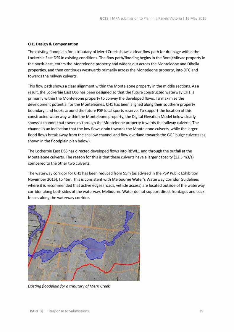
The existing floodplain for a tributary of Merri Creek shows a clear flow path for drainage within the
Lockerbie East DSS in existing conditions. The flow path/flooding begins in the Boral/Mirvac property in
the north-east, enters the Monteleone property and widens out across the Monteleone and Dibella
properties, and then continues westwards primarily across the Monteleone property, into DFC and
towards the railway culverts.
This flow path shows a clear alignment within the Monteleone property in the middle sections. As a
result, the Lockerbie East DSS has been designed so that the future constructed waterway CH1 is
primarily within the Monteleone property to convey the developed flows. To maximise the
development potential for the Monteleones, CH1 has been aligned along their southern property
boundary, and hooks around the future PSP local sports reserve. To support the location of this
constructed waterway within the Monteleone property, the Digital Elevation Model below clearly
shows a channel that traverses through the Monteleone property towards the railway culverts. The
channel is an indication that the low flows drain towards the Monteleone culverts, while the larger
flood flows break away from the shallow channel and flow overland towards the GGF bulge culverts (as
shown in the floodplain plan below).
The Lockerbie East DSS has directed developed flows into RBWL1 and through the outfall at the
Monteleone culverts. The reason for this is that these culverts have a larger capacity (12.5 m3/s)
compared to the other two culverts.
The waterway corridor for CH1 has been reduced from 55m (as advised in the PSP Public Exhibition
November 2015), to 45m. This is consistent with Melbourne Water’s Waterway Corridor Guidelines
where it is recommended that active edges (roads, vehicle access) are located outside of the waterway
corridor along both sides of the waterway. Melbourne Water do not support direct frontages and back
fences along the waterway corridor.
Existing floodplain for a tributary of Merri Creek

GC28 | MPA submission to Planning Panels Victoria | 16 May 2016
PART B| Response to Submissions 40
Lockerbie East DSS DEM
Channel vs Pipe
Melbourne Water do not support the piping of 1.2km of a waterway/floodplain of the Merri Creek. As
shown in the existing floodplain for a tributary of Merri Creek, the piping of this existing floodplain
would not be consistent with Melbourne Water objectives to retain significant waterways in urban
areas as open systems. The long term benefits of an open waterway would be sacrificed at the expense
of maximising developable land for one landowner, these benefits that would be lost forever are
(Melbourne Water 2016):
Benefits to the environment: contribute to the biological diversity of the area and provide future habitat for plants and animals. Assist in the processing of nutrients and regulating the flow of water downstream.
Benefits to the community: people benefit from the environmental services provided by headwater streams (reduction in urban heat island effect, improved air quality, and nutrient cycling). Provide people with opportunities to interact with the natural environment.
Benefits to land managers: land managers can benefit from well-planned and designed constructed waterways, with positive influences on community well-being and amenity of an area.

GC28 | MPA submission to Planning Panels Victoria | 16 May 2016
PART B| Response to Submissions 41
Benefits to developers: Well planned and designed constructed waterways provide positive branding opportunities and offer the potential to increase the value of housing stock through proximity to substantial public open space.
The image below shows an example of a constructed waterway integrated with community playground
areas and shared paths, a place for people to appreciate and interact with the natural environment in
an urban area. This will have long term benefits to the community as opposed to a piped solution.
A constructed waterway integrated with community playground areas and shared paths.
Compensation
Melbourne Water has determined that the constructed waterway at points A-B (plan below) has
diverted flood flows onto the Monteleone property where naturally they would have traversed the
property to the south.
As a result Melbourne Water intend to purchase the waterway (including the waterway corridor) from
points A-B in the image below. These negotiations will take place in conjunction with the acquisition of
RBWL1.

GC28 | MPA submission to Planning Panels Victoria | 16 May 2016
PART B| Response to Submissions 42
CH1 constructed waterway alignment through Monteleone property. CH2 Design
CH2 constructed waterway along Cameron Street will be required for drainage and river health
functions. A waterway corridor is required so that a peak flow of approximately 34m3/s is conveyed
throught this channel from an upstream catchment of 173ha.
Melbourne Water will not support the piping of this waterway as the long term benefits of an open
waterway would be sacrificed at the expense of maximising developable land for one landowner, these
benefits that would be lost forever are:
Benefits to the environment: contribute to the biological diversity of the area and provide future habitat for plants and animals. Assist in the processing of nutrients and regulating the flow of water downstream.
Benefits to the community: people benefit from the environmental services provided by headwater streams (reduction in urban heat island effect, improved air quality, and nutrient cycling). Provide people with opportunities to interact with the natural environment.
Benefits to land managers: land managers can benefit from well-planned and designed constructed waterways, with positive influences on community well-being and amenity of an area.
Benefits to developers: Well planned and designed constructed waterways provide positive branding opportunities and offer the potential to increase the value of housing stock through proximity to substantial public open space.
An example of a constructed waterway is shown below.

GC28 | MPA submission to Planning Panels Victoria | 16 May 2016
PART B| Response to Submissions 43
Consultation
Melbourne Water has met with the Monteleone landowners on numerous occasions. As shown by the
evolution of the Lockerbie East DSS design into its current design, significant changes have been made
to accommodate drainage for future development within the Monteleone property.
The floodplain as indicated in the plans above have been allowed by Melbourne Water to be reduced
for urban developed.
Table 1 below highlights the changes that have been made to the Lockerbie East DSS within the
Monteleone property based on consultation with the landowners and other agencies, and a further
review of the design strategy. The changes made between the current DSS and the May 2014 DSS have
resulted in 12.1 ha of extra developable land for the Monteleones as part of the DSS/PSP consultation
process.

GC28 | MPA submission to Planning Panels Victoria | 16 May 2016
PART B| Response to Submissions 44
Table 1 Monteleone property: Design changes between the Preliminary Lockerbie East DSS (May 2014),
PSP Public Exhibition (November 2015), and current Lockerbie East DSS (April 2016); and resulting
developable land.
DSS May 2014 draft PSP Public Exhibition
November 2015
DSS April 2016 Developable land (ha)
difference between
2014 and 2016 DSS
versions
Railway retarding
basin/wetland
#RBWL1 (Figure 4)
11.2 ha 7ha 7ha +4.2 ha
Extra developable land
Eastern retarding
basin/wetland
#RBWL2
7.2 ha
(excludes waterway)
2.4ha
(excludes the
waterway)
2.9ha +4.3 ha
Extra developable land
East-west
constructed
waterway
connecting RBWL2
to RBWL1.
#CH1
6.3 ha
(55m waterway width)
8.2 ha
Based on feedback
from landowner, the
waterway was
realigned to the
southern boundary.
Based on feedback
from the MPA, the
waterway was aligned
around the proposed
local sports reserve.
(55m waterway width)
6ha
The waterway has
been realigned to
the southern
boundary of the
property to
minimise the
impact on the
future
development.
The waterway has
been reduced in
extent as the
RBWL2 is
elongated.
The waterway
corridor has been
reduced to 45m
(using Table 3
instead of Table 4
of Waterway
Corridor
Guidelines).
+0.3 ha
Extra developable land
NOTE: +2.2 ha extra
developable land
compared to PSP
Public Exhibition.

GC28 | MPA submission to Planning Panels Victoria | 16 May 2016
PART B| Response to Submissions 45
East-west
constructed
waterway north of
proposed Cameron
Street (50m
waterway width)
#CH2
2.9 ha 2.9 ha 2.9 ha No difference
East-west linear
wetland and
waterway
connecting towards
GGF bulge area
#RBWL X
1.9 ha Removed.
Consolidated into CH1.
Removed. +1.9 ha
Extra developable land
Sediment basin
asset at East-west
constructed
waterway north of
proposed Cameron
Street
#SB1
None 0.40 ha
Included in the PSP
IWM Plan.
Sediment basin will
not be required in
the revised DSS.
No difference
NOTE: +0.4 ha extra
developable land
compared to PSP
Public Exhibition.
Diagonal tributary
north of proposed
Cameron Street
(40m waterway
width)
#CH3
To be protected and
retained as natural
1.4 ha
To be protected and
retained as natural
1.4 ha
Removed. + 1.4 ha
Extra developable land
Total 30.9 ha 22.3 ha 18.8 ha +12.1 ha
Extra developable
land
GC28 | MPA submission to Planning Panels Victoria | 16 May 2016
PART B| Response to Submissions 46
Melbourne Water Response to Engeny's alternative Lockerbie East DSS on behalf of Monteleone’s
Melbourne Water has reviewed the alternative drainage proposal for Lockerbie East DSS. The
following response is provided:
Engeny claim that there is 130ha of catchment missing from the MUSIC model
o Melbourne Water has reviewed this claim by Engeny. Melbourne Water’s MUSIC model is treating the catchments from areas of future developable land that will be contributing flow to the treatment systems. The MUSIC model has excluded all areas that are not proposed to be developable (conservation areas, local sports reserves and local parks) which total an area of approximately 130 ha. The reason for excluding these areas is that it is anticipated that the runoff from these areas do not need to be treated as they are not impervious surfaces, and so pollutants and nutrients are not expected to runoff from these areas.
o Melbourne Water has acknowledges that there are different approaches to MUSIC modelling design.
Engeny claim that MW’s MUSIC model does not achieve Best Practice
o Melbourne Water acknowledges that our MUSIC model does not meet best practice for total suspended solids. An update of the MUSIC model can be undertaken at the detail design stage, resulting in an increase in size for a couple of the sediment basins.
Engeny proposed change 1 (relocate RBWL2 (which they refer to as WL1A/RB1A) into Mirvac
property)
As explained above, by locating WL1RB1 within the Mirvac property at this location, further excavation
would be required resulting in additional significant construction costs that would be added to the
Development Services Scheme contribution rates. This is because:
The land rises within the Mirvac property (see cross section below). The existing surface on the Mirvac side has a grade of about 1 in 60 (steep). In contrast, the land on the Monteleone side is “essentially flat”. Putting RBWL2 within the Mirvac site at this location would result in an excavation depth of up to 5.5 – 6 metres, therefore extremely costly and not optimal.
RBWL2 as proposed by Engeny would only be justified in benefiting the Monteleone, at the expense of the rest of the developers/landowners in the Lockerbie East DSS that would be charged a higher DSS contribution rate.
Engeny proposed change 2 (piping of waterway from WL1RB1)
As explained above, Melbourne Water do not support the piping of 1.2km of a waterway/floodplain of
the Merri Creek. As shown in the existing floodplain for a tributary of Merri Creek, the piping of this
existing floodplain would not be consistent with Melbourne Water objectives to retain significant
waterways in urban areas as open systems. The long term benefits of an open waterway would be
sacrificed at the expense of maximising developable land for one landowner, these benefits that would
be lost forever are (Melbourne Water 2016):

GC28 | MPA submission to Planning Panels Victoria | 16 May 2016
PART B| Response to Submissions 47
Benefits to the environment: contribute to the biological diversity of the area and provide future habitat for plants and animals. Assist in the processing of nutrients and regulating the flow of water downstream.
Benefits to the community: people benefit from the environmental services provided by open waterways (reduction in urban heat island effect, improved air quality, and nutrient cycling). Provide people with opportunities to interact with the natural environment.
Benefits to land managers: land managers can benefit from well-planned and designed constructed waterways, with positive influences on community well-being and amenity of an area.
Benefits to developers: Well planned and designed constructed waterways provide positive branding opportunities and offer the potential to increase the value of housing stock through proximity to substantial public open space.
The image below shows an example of a waterway integrated with adjacent urban development. It is a
place for people to appreciate and interact with the natural environment in an urban area. This will
have long term benefits to the community as opposed to a piped solution.
Claim by Engeny that there is no defined existing waterway
The Digital Elevation Model plan shows a channel that traverses through the Monteleone property
towards the railway culverts. This channel may not easily be observable in the field, and may no longer
exist due to changes in land use. The channel is an indication that the low flows drain towards the
Monteleone culverts, while the larger flood flows break away from the shallow channel and flow
overland towards the GGF bulge culverts. The channel and flood flow path are considered by
Melbourne Water as waterways.

GC28 | MPA submission to Planning Panels Victoria | 16 May 2016
PART B| Response to Submissions 48
Engeny proposed change 3 (WL3 and GGF bulge)
Redirecting the stormwater flows to the south of the Monteleone property and into the GGF
conservation area is contrary to the advice we have received from DELWP. The DELWP advice states
that the area proposed by Engeny within the GGF bulge is required by DELWP for “either the creation
and enhancement of dedicated GGF wetlands or for terrestrial foraging habitat for the species”.
Engeny are directing drainage flows towards specific railway culverts that have lesser capacity
(1050mm), as opposed to Melbourne Water’s design to direct flows to the culverts (1600x1800 mm
box) adjacent to the Monteleone land that have greater capacity.
Engeny proposed change 4 (piping of waterway north of Cameron St)
Melbourne Water requires a constructed waterway for drainage and river health functions. A waterway
corridor is required so that a peak flow of approximately 34 cumecs is conveyed through this channel
from an upstream catchment of 173ha.
Melbourne Water will not support the piping of this waterway as the long term benefits of an open
waterway would be sacrificed at the expense of maximising developable land for one landowner, these
benefits that would be lost forever are:
o Benefits to the environment: contribute to the biological diversity of the area and provide future habitat for plants and animals. Assist in the processing of nutrients and regulating the flow of water downstream.
o Benefits to the community: people benefit from the environmental services provided by open waterways (reduction in urban heat island effect, improved air quality, and nutrient cycling). Provide people with opportunities to interact with the natural environment.
o Benefits to land managers: land managers can benefit from well-planned and designed constructed waterways, with positive influences on community well-being and amenity of an area.
o Benefits to developers: Well planned and designed constructed waterways provide positive branding opportunities and offer the potential to increase the value of housing stock through proximity to substantial public open space.
Engeny claim that the DSS principles requires protection of only existing environmental values
This claim by Engeny is incorrect. The DSS principle number 4 states “The design should propose works
that are optimal in terms of cost and performance, while protecting environmental and other
waterway values.” This principle neither states existing or new values, but Melbourne Water’s
interpretation that the creation of new values should also need to be considered in drainage design as
we are ultimately the responsible authority of these waterways in perpetuity.
Engeny cost comparisons
Engeny’s cost reduction in the removal of the two waterways is incorrect. Melbourne Water DSSs do not purchase waterway and waterway corridors but only land required for retarding

GC28 | MPA submission to Planning Panels Victoria | 16 May 2016
PART B| Response to Submissions 49
basins and wetlands. The exception is when a channel is diverted from its natural flow path, Melbourne Water will purchase the land required for this diversion.
o Engeny’s costings have therefore incorrectly included land acquisition for waterways of approximately $3million. Melbourne Water, as communicated to the Monteleones previously, will only compensate for the waterway section A-B (plan below) as this is considered a diversion.
Engeny’s cost of relocating RBWL2 into steeper slopes within Mirvac property of $2,716,000 will need to be reviewed by Melbourne Water in further detail, along with the rest of their costings. The proposal by Engeny for RBWL2 would require additional land on the Mirvac property because the retarding basin would be cut into the hill thereby requiring substantial battering back.
Engeny’s cost saving of $4.5m is not as significant when land acquisition cost of waterways is removed.
Engeny’s cost comparisons does not factor in the long term benefits of an open waterway to the environment, the community and to the development.
DELWP Response to Engeny's alternative Lockerbie East DSS on behalf of Monteleone’s
Proposed changes 1 and 4: pipe vs constructed waterway:
This is not a matter that requires DELWP agreement under the Melbourne Strategic Assessment
program approvals. While GGF may use Melbourne Water's proposed constructed waterway for
foraging, they are outside the conservation area.
Proposed change 2: piping stormwater from Engeny's G1 & SB1a directly into the GGF conservation
area - i.e. the CA becomes a retarding basin (RB3):
DELWP does not support the proposal to construct a bypass channel through the existing large dam.
GGF has been recorded at this waterbody in the recent past and existing large dams (even if currently
dry) will be a priority for GGF habitat enhancement.
Proposed change 3: locating stormwater treatment wetland WL3 within the GGF conservation area:
DELWP would not support a break in connectivity between WL2 and the GGF conservation area.
Locating WL3 adjacent to the northwestern corner of the conservation area enables better
connectivity with Merri Creek populations via the larger culverts under the railway line. Engeny's
proposal to locate WL3 within the GGF conservation area would result in a gap between WL2 and the
GGF conservation area.
DELWP supports Melbourne Water's Drainage Services Scheme on the basis that we have had
significant engagement in the development of drainage plans through the precinct structure planning
process to date. DELWP has previously determined that the northwest corner of this portion of the
"bulge" is the most suitable location for wetland 3 and that the remainder would be required for GGF
wetlands and terrestrial foraging habitat. (see attached email from DELWP to MPA).
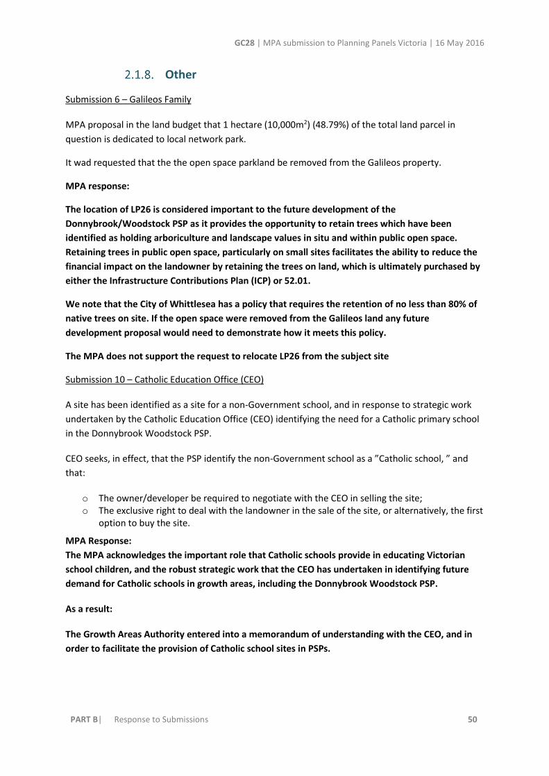
GC28 | MPA submission to Planning Panels Victoria | 16 May 2016
PART B| Response to Submissions 50
Other
Submission 6 – Galileos Family
MPA proposal in the land budget that 1 hectare (10,000m2) (48.79%) of the total land parcel in
question is dedicated to local network park.
It wad requested that the the open space parkland be removed from the Galileos property.
MPA response:
The location of LP26 is considered important to the future development of the
Donnybrook/Woodstock PSP as it provides the opportunity to retain trees which have been
identified as holding arboriculture and landscape values in situ and within public open space.
Retaining trees in public open space, particularly on small sites facilitates the ability to reduce the
financial impact on the landowner by retaining the trees on land, which is ultimately purchased by
either the Infrastructure Contributions Plan (ICP) or 52.01.
We note that the City of Whittlesea has a policy that requires the retention of no less than 80% of
native trees on site. If the open space were removed from the Galileos land any future
development proposal would need to demonstrate how it meets this policy.
The MPA does not support the request to relocate LP26 from the subject site
Submission 10 – Catholic Education Office (CEO)
A site has been identified as a site for a non-Government school, and in response to strategic work
undertaken by the Catholic Education Office (CEO) identifying the need for a Catholic primary school
in the Donnybrook Woodstock PSP.
CEO seeks, in effect, that the PSP identify the non-Government school as a ”Catholic school, ” and
that:
o The owner/developer be required to negotiate with the CEO in selling the site; o The exclusive right to deal with the landowner in the sale of the site, or alternatively, the first
option to buy the site.
MPA Response:
The MPA acknowledges the important role that Catholic schools provide in educating Victorian
school children, and the robust strategic work that the CEO has undertaken in identifying future
demand for Catholic schools in growth areas, including the Donnybrook Woodstock PSP.
As a result:
The Growth Areas Authority entered into a memorandum of understanding with the CEO, and in
order to facilitate the provision of Catholic school sites in PSPs.

GC28 | MPA submission to Planning Panels Victoria | 16 May 2016
PART B| Response to Submissions 51
The MPA has written to the CEO, and outlining its proposed approach to non-Government schools
in PSPs. The MPA, in consultation with the CEO, and on being satisfied that there was a demand for
a Catholic school in the Donnybrook Woodstock PSP:
The PSP references the development of a non-Government school in the following ways:
o Lists the following as an objective of the PSP: “Provide for government and non-government schools sites to meet a strategically justified need for State and Catholic education in the area.”
o Shows land set aside as a potential non-government school.1 o In the PSP, specifically refers to the CEO: Lists the CEO as the “Lead Agency” in providing a
Catholic primary School. o Does not include this land as subject to a Development Contributions Levy.
This achieves the appropriate balance of direction and flexibility in achieving PSP outcomes. It
identifies that the CEO provided the strategic justification for the non-government school. It
provides the opportunity and encouragement for a catholic primary school to establish on the site.
That said, it cannot “lock in” this outcome. The CEO, and other non-government schools, do not
have the power to compulsorily acquire the land. The land is privately owned. As a result, any use
of the land as a school is dependent on the landowner selling the land to the CEO or other non-
government education provider. There is therefore no certainty that the land will be owned by the
CEO, or other non-Government school.
There is nothing to prevent the CEO from purchasing an alternative site. This could occur if:
o The existing landowner cannot reach terms with the CEO. o The CEO is able to purchase an alternative site, for a cheaper price, and from another
landowner.2
Finally, it is unfair to impose a defacto compulsory acquisition control on the current
landowner/developer in circumstances where the CEO may not end up purchasing the land. It
blights otherwise developable land.
It is not appropriate to mandate that a particular use be undertaken by a particular operator. The
MPA do not mark any particular operators to any particular use. It would be like marking
supermarket sites as Woolworths or Coles, which is inappropriate in planning terms.
Instead, and consistent with the operation of the planning system in Victoria, the PSP seeks to
facilitate, and not force, the establishment of certain uses in certain locations, let alone certain
uses undertaken by specified operators.
1 Refer for example to Plans 3 and Plan 4.
2 Refer also to the Panel report for the Hume Planning Scheme – Amendment C120, Craigieburn R2 PSP at pp 76 – 78; Panel report for the Hume Planning Scheme – Amendment C154, at pp 52 – 53.

GC28 | MPA submission to Planning Panels Victoria | 16 May 2016
PART B| Response to Submissions 52
Submission 2 – M & J Harte
The Harte family submit that the designation of open space is not appropriate on the site as it is
located on the intersection of two major roads of the South and Eastern Boundary of the PSP.
MPA Response:
The location of LP25 is considered important to the future development of the
Donnybrook/Woodstock PSP as it provides the opportunity to retain trees which have been
identified as holding arboriculture and landscape values in situ and within public open space.
Retaining trees in public open space, particularly on small sites facilitates the ability to reduce the
financial impact on the landowner by retaining the trees on land, which is ultimately purchased by
either the Infrastructure Contributions Plan (ICP) or via the provisions of Clause 52.01 of the
Whittlesea Planning Scheme.
We note that the City of Whittlesea has a policy that requires the retention of no less than 80% of
native trees on site. If the open space were removed from the Harte property, any future
development proposal would need to demonstrate how it meets this policy
The Donnybrook/Woodstock PSP has applied the “Public Land Equalisation Methodology”(PLEM)
to land required for the development of community and development infrastructure. The PLEM
provides a site-specific valuation to all land, which provides over the average amount of
contribution towards public land. In essence this means that because the subject site is providing
greater than the per site average across the PSP, a higher value is placed on the portion of land
over the average.
Council and the MPA support the retention of the park in order to protect the trees at this site.
Submission 18 – Friends of Donnybrook Train Station
The FDTS recommend the redevelopment of Donnybrook Railway Station does not proceed until
such time as a full and detailed traffic engineering study is complete and includes current and
anticipated traffic flow modelling.
MPA Response:
The MPA does not support this recommendation. The Traffic modelling has used an appropriate

GC28 | MPA submission to Planning Panels Victoria | 16 May 2016
PART B| Response to Submissions 53
methodology to estimate the need for roads in the area this includes an analysis of daily volumes
as well as peak flow on a range of scenarios. In addition the UGZ schedule requires applications to
be accompanied by a Traffic Impact Assessment Report (TIAR) to ensure that development is
appropriately considering vehicle movements. The future development of the Donnybrook train
station is subject to State funding and PTV planning.
The FDTS notes that the traffic overpass over the Sydney-‐Melbourne Railway Line is proposed to
extend 820 metres due to increased height of the bridge as a result of an allowance for double-‐
stacked rail container carriages.
The FDTS recommends an update of the traffic management report be undertaken to determine the
optimal location for intersection and road networks north and south of the Sydney-‐Melbourne
Railway Overpass.
MPA Response:
The rail overpass project is not part of PSP area and will be planned and developed by VicRoads in
the future. The future urban structure has considered the relevant information. The MPA notes
that VicRoads support the exhibited Future Urban Structure.
The FDTS object to the proposed intersection IN01 located at the foot of the proposed Sydney-‐
Melbourne Railway Overpass on Donnybrook Road due to traffic blockage of easterly-‐travelling
traffic on the said overpass wishing to turn left turn into the train station precinct.
The FDTS recommend a complete review of the intersection at IN01 in terms of its location and
integration with the Donnybrook Train Station Urban Structure Precinct.
MPA Response:
Donnybrook Road is a declared State road and VicRoads are the Responsible Authority for the
future duplication and upgrade. Through the PSP process VicRoads provided a draft concept design
for the future overpass of the rail line and realignment of Langley Park Drive. The result of
constructing the overpass is that it will impact on the Langley Park Drive intersection with
Donnybrook Road, hence its realignment to the east. It is at this point where IN-01 will connect
and provide signalised access to the residential communities immediately to the north of
Donnybrook Road.
The FDTS object to the design and layout of the car park as detailed in the OPUS Study (Donnybrook
Station Development Concepts p.g.40), which allows for approximately 2,200 car parking spaces at
the station. The FDTS believe this will create an asphalt sea of car parks spread across the centre of
the precinct.
MPA Response:
This has been a point of discussion between PTV, MPA and Council Officers through the
preparation of the PSP. It is envisaged that car parking for the station can be delivered in stages
that minimise the uptake of strategically important land adjacent to the train station for at-grade
car parking in the medium term and that the State Government funds can be directed towards the

GC28 | MPA submission to Planning Panels Victoria | 16 May 2016
PART B| Response to Submissions 54
early provision of efficient, regular and direct bus services, bike lanes and walking tracks to
encourage less driving to the train.
The FDTS recommend a CAC of sufficient size (approx. 1Ha) that allows for a 2 room maternal
healthcare centre, dual room kindergarten facility for 99 licensed spaces, program room and
dedicated community meeting space with amenities and an administration area, and a community
garden.
MPA Response:
The MPA does not support this recommendation. The CAC facility is provided as a co located
facility at LCC1 where it is more centrally accessible to the future residents and accessible to the
future Government P-12 campus. The Donnybrook station precinct (LCC-2) provides an opportunity
for private providers and NGOs to provide additional services. It is noted that Council community
services at the nearby LCC-1 has been sized to accommodate the medium/high density population
proposed at the station.
The background study by CAPIRE Report October 2014 and addendum August 2015 does not provide
a Community Benefit Analysis for the precinct.
The FDTS recommends an independent review of the community and infrastructure needs of this
precinct. The CAPIRE Report October 2014 did not analyse the impact of medium-‐high residential
zones in this precinct and to date there has been no analysis whatsoever on the livability and impact
of the proposed Donnybrook Train Station precinct.
MPA Response:
The Capire report was commissioned to assess the needs of the future community having regard to
Council input and factoring into its assumptions a range of residential densities. The MPA and the
City of Whittlesea are satisfied that the PSP provides an appropriate level of community
infrastructure.
submission 23 – Merri Creek Management Committee
MCMC submit that although the Terra Culture report identifies two land forms with 'high sensitivity'
waterways and stony rises, it is not possible to tell from the PSP document which of the stony rises,
might be protected in the open space network and thus to what extent the approach outlined in the
Heritage Guideline Note has been followed.
MCMC recommends that the stony rises identified by Terra Culture as "high sensitivity" for aboriginal
cultural heritage be shown on Plan 2 - Precinct Features/ or some other appropriate plan. The extent
to which these stony rises are integrated and protected in the open space network be made explicit.
High priority should be given to providing more extensive protection to stony rises through the PSP
area.
MPA Response:
The MPA generally supports the inclusion of the stony rises that are considered to have ‘high

GC28 | MPA submission to Planning Panels Victoria | 16 May 2016
PART B| Response to Submissions 55
sensitivity’ for integration with the existing features plan. The PSP includes a number of provisions
that seek to ensure subdivision actively responds to landscape features such as stony rises.
In addition to the explicit reference to Stony Rises in the Vision:
“Objective 29 states …Plan sensitive urban interfaces to historic and Aboriginal cultural heritage
and natural assets such as retained stony rises, dry stone walls and heritage buildings, local
conservation reserves, the Grassy Eucalypt Woodland”
and…
“Requirement 35 states …Subdivision design must actively respond to the landscape character
throughout the precinct by aligning streets, lots, open space and public spaces to retain visual
character elements such as River Red Gums, stony rises, dry stone walls, heritage places and
waterways, to the satisfaction of the Responsible Authority.”
It is considered that because subdivision and development must be generally in accordance with
the PSP, these provisions provide the appropriate level of consideration for the protection of stony
rises.
MCMC submit that the Visual Character Assessment report (CoW 2015) identifies a number of
viewlines (p.41). It would be useful if these viewlines were shown in the PSP, for example on Plan 2-
Precinct Features, and if the location of these view lines could be shown in relation to the open space
network.
MPA Response:
The Landscape and Visual Character Assessment was prepared to provide a preliminary assessment
of the landscape features of the PSP area. Many of the recommendations from the assessment
have been included within the PSP including the protection of heritage elements and the provision
for an extensive shared path network that accesses key significant landscape features across the
PSP area. The MPA hold the view that the PSP appropriately requires development to address and
respond to the landscape and visual character of the area.
MCMC submits that the PSP documentation makes no reference to groundwater and groundwater
dependent ecosystems. Further, the Biodiversity Conservation Strategy specifies that pre-
development hydrology of should be retained for designated Conservation Areas and that this should
be made explicit in the PSP. This should be made explicit in the PSP.
MPA Response:
The MPA has sought advice from Melbourne Water and DELWP in relation to this concern. Given
the complex nature of the BCS issues and the need to ensure that drainage assets discharge
stormwater runoff from urban development treated to an appropriate level, it has been agreed
between Melbourne Water, DELWP and the MPA that the following amendment to G48 be made
in order to address the issue of ground water quality.
G48: Where practical, integrated water management systems should be designed to:

GC28 | MPA submission to Planning Panels Victoria | 16 May 2016
PART B| Response to Submissions 56
o Maximise habitat values for local flora and fauna species. o Enable future harvesting and/or treatment and re-use of stormwater. o Protect and manage for MNES values, particularly within conservation areas, in relation to
water quality and suitable hydrological regimes (both surface and groundwater).
MCMC recommends that all culvert bridge crossings of Darebin Creek include reference to 'frog
friendly.'
MPA Response:
The two crossings referred to in the PSP as being “frog friendly” are located within the GGF Habitat
areas of Darebin Creek. The design of theses culverts need to be designed to meet the DELWP
standards for GGF habitat crossings, hence the reference to “frog friendly”. The MPA notes that
other culvert crossings along Darebin Creek are not identified as being in the GGF habitat and
therefore are not expected to be developed in such a way that supports the development of GGF
wetlands.
MCMC recommends designating local parks as local conservation parks where the primary purpose is
the protection of conservation values.
MPA Response:
The MPA does not support this recommendation as the primary purpose of the local parks are to
serve a localised passive recreation and amenity purpose. The retention of existing trees within
parks conserves the tree for its landscape value and any conservation value (while technically it
remains) is considered subordinate for these purposes.
MCMC recommends that the northern most portion of the PSP area (north of CA22, and below the
OMR) be included in the open space network rather than developed for residential purposes.
MPA Response:
The MPA does not support this recommendation. The BCS has been finalised and DELWP do not
intend to revisit its boundaries for the purpose of expanding the BCS Conservation Area.
Submission 25 – Greg Heffernan
Mr Heffernan submits that the positioning of Melbourne Water's Water management area is placed
in an area of solid rock, which also has a water spring in the middle of the proposed area.. A better
position for a water management area is closer to the Merri creek and on the unnamed creek
MPA Response:
DELWP continues to work with Melbourne Water to inform the location of suitable areas for water
management assets. Conservation Areas established under the Biodiversity Conservation Strategy
(BCS) for the Melbourne Strategic Assessment (MSA) Program, categorised for Nature
conservation, are not considered suitable areas for the location of infrastructure
The MPA supports the position of DELWP and has continued to encourage Melbourne Water to
find an appropriate location for the retarding basin that minimises the impacts on your land.
GC28 | MPA submission to Planning Panels Victoria | 16 May 2016
PART B| Response to Submissions 57
Melbourne Water response:
Based on feedback from the landowner, a water spring and solid rock was identified in this current
location. The water spring will not prevent the construction and performance of the retarding
basin and wetland. The solid rock will be taken into account as part of the construction, but
nevertheless it would still be possible to construct at this location, albeit more costly. The cost of
construction is factored in determining the costs of the Beveridge East DSS.
As a result of Melbourne Water's discussions with Mr Heffernan, Melbourne Water will further
review the retarding basin and wetland design. Melbourne Water will continue to consult with Mr
Heffernan and other affected landowners on any further changes.
Mr Heffernan queried the fire management risks in the conservation area.
MPA and DELWP response:
The land remains in private ownership and therefore current fire management responsibilities for
the land remain.
Once DELWP acquire the Conservation Area it will typically be reserved under the Crown Land
(Reserves) Act 1978 and will be managed by an appropriate public land manager. A fire
management plan will be developed as part of the overall Conservation Area management plan
developed for the Conservation Area.
Mr Heffernan queried who will be responsible for the 400ha conservation area, how they will
maintain it and more importantly how it will be funded?
MPA and DELWP response:
Designation of Conservation Areas has no effect on landowners’ abilities to continue to use their
land as they have historically done. Only when landowners seek to develop their property for
urban purposes will they be required to secure and protect the Conservation Area.
The means by which the Crown can receive this land under the Melbourne Strategic Assessment
program are:
Voluntary negotiated sale, or;
Voluntary land transfer for a habitat compensation obligation reduction
Land may also be permanently protected, while remaining in private ownership through an
agreement registered on the title of the land. These agreements will be made under section 69 of
the Conservation Forests & Land Act and signed between the landowner and the Secretary to the
Department of Environment Land Water and Planning.
The process for land acquisition is outlined in the document Land Protection under the Biodiversity
Conservation Strategy, DEPI 2014.
Acquisition and management of the Conservation Areas by DELWP will be funded using a cost
recovery model. The cost recovery model establishes the fees that are collected from developers

GC28 | MPA submission to Planning Panels Victoria | 16 May 2016
PART B| Response to Submissions 58
and is used to mitigate the impacts of urban development on native vegetation and threatened
species habitat in the area covered by the Biodiversity Conservation Strategy.
The cost recovery model has been developed in accordance with the State Government’s Cost
Recovery Guidelines and rules regarding competition policy.
The cost recovery model and fee structure are described in the document Habitat Compensation
under the Biodiversity Conservation Strategy, DEPI 2013 which can be located online:
http://www.depi.vic.gov.au/environment‐and‐wildlife/biodiversity/melbourne‐
strategicassessment/melbourne‐strategic‐assessment‐publications.
Mr Heffernan submits that the Patterson Drive bridge on the Merri creek is in the wrong place. He
requests that Patterson drive should be on the same alignment as the existing bridge over the Merri
creek and associated road.
MPA and DELWP response:
DELWP is continuing to work with the Metropolitan Planning Authority, Melbourne Water and
affected land owners to identify the most appropriate location for a creek crossing, while avoiding
areas of high conservation value within the Conservation Area.
The approximate location of the proposed bridge is considered appropriate as it avoids areas of
high environmental and cultural significance. The position of the bridge is to some extent
determined by the preferred location and alignment of the proposed Patterson Drive through the
BCS and the need to minimise the amount of impact associated the development of the future
arterial road. The exact location and alignment of the bridge and the road will be determined
during the detailed design process associated with its construction. Given the location of the
northern parcels of the precinct, development pressure in this part of the precinct is unlikely to
occur in the short term.
The Panel inspected the old creek crossing and road location constructed for a previous quarry
access. The new location of the bridge and road have been located in consultation with Vicroads,
the Wurrungari and DELWP to service future needs. The exhibited alignment minimises the road
length required to cross the Conservation area. It also meets the design standards for an 80km per
hour arterial road. The image below shows the approximate location of the existing creek crossing
in the context of the fixed points associated with the future Patterson Drive. It shows that the
alignment of Patterson Drive were it to connect to the existing crossing would substantially
increase the length of road running through the conservation area and cause the alignment to
bend unnecessarily. While the MPA acknowledges that existing infrastructure should be utilised
where possible, in this instance it is not practicle.
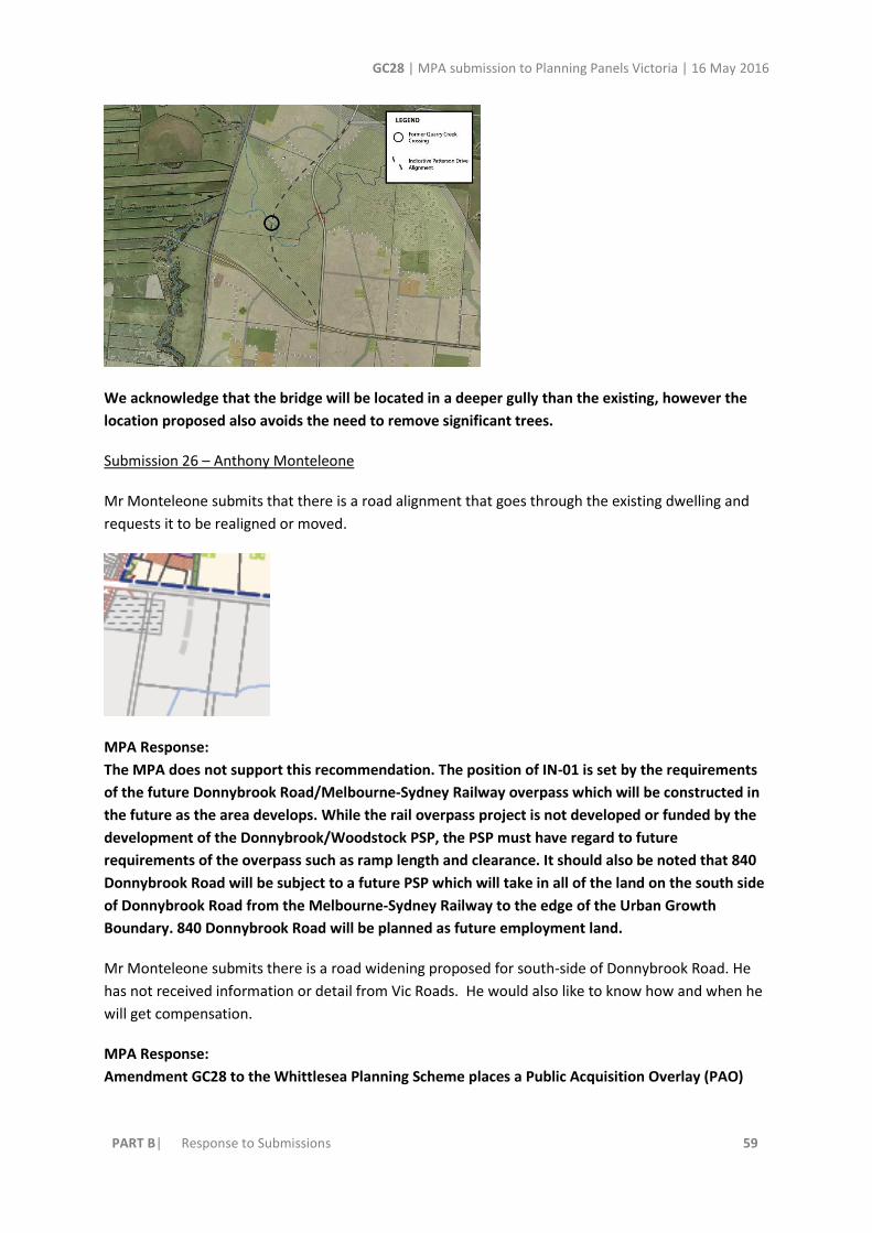
GC28 | MPA submission to Planning Panels Victoria | 16 May 2016
PART B| Response to Submissions 59
We acknowledge that the bridge will be located in a deeper gully than the existing, however the
location proposed also avoids the need to remove significant trees.
Submission 26 – Anthony Monteleone
Mr Monteleone submits that there is a road alignment that goes through the existing dwelling and
requests it to be realigned or moved.
MPA Response:
The MPA does not support this recommendation. The position of IN-01 is set by the requirements
of the future Donnybrook Road/Melbourne-Sydney Railway overpass which will be constructed in
the future as the area develops. While the rail overpass project is not developed or funded by the
development of the Donnybrook/Woodstock PSP, the PSP must have regard to future
requirements of the overpass such as ramp length and clearance. It should also be noted that 840
Donnybrook Road will be subject to a future PSP which will take in all of the land on the south side
of Donnybrook Road from the Melbourne-Sydney Railway to the edge of the Urban Growth
Boundary. 840 Donnybrook Road will be planned as future employment land.
Mr Monteleone submits there is a road widening proposed for south-side of Donnybrook Road. He
has not received information or detail from Vic Roads. He would also like to know how and when he
will get compensation.
MPA Response:
Amendment GC28 to the Whittlesea Planning Scheme places a Public Acquisition Overlay (PAO)

GC28 | MPA submission to Planning Panels Victoria | 16 May 2016
PART B| Response to Submissions 60
along the south side of the entire length of Donnybrook Road from the Melbourne-Sydney Rail to
the intersection with Epping Road/Merriang Road.
The PAO is in favour of VicRoads. Payment for acquisition of the land is not triggered until
VicRoads require the land for the construction of the road widening or when an application for a
planning permit is refused by VicRoads in its capacity as a referral authority because approval of
the planning permit would prejudice the future construction of the road widening.
Part 5. Section 106 of the Planning and Environment Act 1987 (the Act) makes provision for “Loss
on Sale”. This section of the Act allows the owner of land may claim compensation under Section
98 of the Act after the sale of the land if the owner of the land sold it at a lower price than the
owner might reasonably have expected to get if the land or part of the land had not been reserved
or proposed to be reserved.
Submission 34 – Friends of the Merri Creek
FOMC submit that the PSP should better reflect and implement the proposed habitat network
(MCMC 2009), thereby protecting endangered grassland vegetation and providing continuous
movement corridors for fauna across the precinct.
MPA Response:
The PSP has been developed in close consultation with DELWP regarding flora and fauna issues.
MPA do not agree that the PSP should go any further by implementing the MCMC habitat network,
particularly as there is an opportunity for three key conservation corridors throughout the PSP that
would allow for fauna habitat links in both an east- west and a north- south direction. These are
the gas easement, the Merri Creek and along the Darebin Creek.
FOMC Protect the full extent of endangered Grassy Eucalypt Woodland near the central southern
boundary of the precinct.

GC28 | MPA submission to Planning Panels Victoria | 16 May 2016
PART B| Response to Submissions 61
The woodland and stony knoll has been retained as an open space in the PSP and therefore the
grassy eucalypt woodland will be retained as far as practicable. Since the City of Whittlesea have
an 80% tree retention policy, most of the trees will look to be retained.
Requirement R99 Open space delivery refers to the “finishing” of public open space prior to transfer.
The requirement for “Clearing of rubbish and weeds, levelled, topsoiled and grassed with warm
climate grass” is inappropriate and potentially damaging if there is indigenous vegetation in the park
or reserve, or if natural rock formations are present.
A number of other provisions are problematic. Instead, Friends of the Merri Creek propose the
following wording:
● Levelling must not impinge on natural rock formations (e.g. stony knolls) or native vegetation
● Weed control in open space with native vegetation should avoid soil disturbance (i.e. not use
mechanical or physical ‘clearing’)
● Levelling must not impact on natural drainage patterns
● Warm climate grasses must not include Couch, Brown-top Bent or Kikuyu where the reserve has
native vegetation, as these are highly invasive species
● Planting of trees and shrubs: indigenous species are preferred in a local park with native
vegetation. Exotic deciduous trees can cause die-off through shading and the impact of smothering
and disturbed nutrient cycling. These have downstream impacts as well on creeks when this material
enters stormwater drainage.
All parkland or open space containing indigenous vegetation and/or natural features such as rocky
areas should be managed to enhance these natural values and the above listed guidelines be
implemented.
MPA Response:
Where appropriate local parks have been strategically located to ensure that stony knolls have an
appropriate level of protection in the PSP.
R47 could also be reworded to specifically reference stony knolls: 'If parks interface or are located
on a drainage corridor, heritage site, stony knoll or encompass remnant native vegetation, the
design of that open space must demonstrate that it has integrated the relevant environmental and
heritage constraints and features into the design of the park.”
The MPA does not however, agree with all the other points, as each open space will have its own
character and purpose, some which will be more formal than others, and some used for recreation
purposes, where these may not be practicable.
The agreed wording for the requirement for R99 for handing over of active open space between
Whittlesea Council and MPA is:
"All public open space must be finished to a standard that satisfies the requirements of the
Responsible Authority prior to the transfer of the public open space, including:
GC28 | MPA submission to Planning Panels Victoria | 16 May 2016
PART B| Response to Submissions 62
• Removal of all existing and disused structures, foundations, pipelines, and stockpiles.
• Basic levelling, including the supply and spread of minimum 75mm topsoil and sub soil if
required on the proposed areas of open space to provide a stable, free draining surface.
• Clearing of rubbish and weeds, topsoiled and grassed with warm climate grass (unless
conservation reserve requirements dictate otherwise).
• Provision of water tapping, potable and recycled water connection points. Sewer and gas
connection points must also be provided to land identified as an active reserve.
• Planting of trees and shrubs.
• Provision of vehicular exclusion devices (fence, bollards, or other suitable method).
• Maintenance access points.
• Installation of park furniture including barbeques, shelters, furniture, rubbish bins, local scale
playground equipment, local scale play areas, and appropriate paving to support these facilities,
consistent with the type of public open space listed in the open space delivery guide (Table 6)."

GC28 | MPA submission to Planning Panels Victoria | 16 May 2016
PART B| Response to Submissions 63
3. Summary
Review of the submissions made to the Donnybrook/Woodstock PSP shows support across State
Government and all associated key agencies. The fact that none of these agencies have chosen to
appear before the Panel, is indicative of the fact that this Amendment represents a “whole of
government” response.
The MPA is appreciative of the high level of cooperation it has received from landowners and
stakeholders.
The MPA commends the Amendment to the Panel.
Submissions in Reply will be made to the Panel in due course.
Adele Patterson
Isaacs Chambers
Ian Munt
Castan Chambers
For and on behalf of the Metropolitan Planning Authority

Donnybrook/Woodstock Precinct Structure Plan - Amendment to the Whittlesea & Mitchell Planning Scheme May 2016