1. marine operations - alaska ocean observing...
TRANSCRIPT
PRELIMINARY BUILD-OUT PLAN FOR
ALASKA OCEAN OBSERVING SYSTEM
SEPTEMBER 2011
THEMATIC ISSUES AND PRODUCTS
Alaska Ocean Observing System Version 1.5 1
Introduction
Document organization: Guidance and directions for developing this build out plan were provided by the national Integrated Ocean Observing System (IOOS) and the National Federation of Regional Associations for Coastal and Ocean Observing (NFRA). Accordingly, each Regional Association develops a build out plan centered on four theme areas. The theme areas are: Marine Operations; Climate Variability and Change; Ecosystem, Fisheries and Water Quality; and Coastal Hazards. A fifth theme, Integrated Products, was added for issues that cross two or more of the original four themes. For each theme, the build out document identifies the important AOOS issue, priority products and services identified by stakeholders, and information requirements for each product. The build out document is organized so that products within each major category can be compared among other Regional Associations. The AOOS plan describes only those major products that can be delivered by the end of the 10- year planning horizon (2021) and represents a “bare-bones” system rather than an “optimal” system.
Supplementary Material: Please refer to the following material for additional guidance:
RA Build Out Guidance Document Terms and Definitions: Please refer to the Terms and Definitions Appendix in the
Guidance Document
Geographic Regions, Subregions, Areas, and Sites: For the purposes of this build out plan, AOOS will adopt a geographically nested apprroach where Regions represent each of Alaska’s three Large Marine Ecosystems, and each Region is subdivided into two or more Subregions. Each Subregion has several Areas (Fig. 1). Areas are sized (i.e. ~100 km x 100 km), based on lessons learned from the Prince William Sound demonstration, to be tractable for logistical resources and the deployment of atmospheric and oceanic instrumentation packages, and for the development of higher resolution model domains. Each Area will have observation platforms at one or many Sites. For example, in this document the Chukchi and Beaufort Seas are Subregions within the Arctic Ocean Region, and Kotzebue Sound is an Area within the Chukchi Sea Subregion, and the town of Kotzebue is a Site within the Kotzebue Sound Area. The AOOS build out plan will address three primary scales of effort, where relatively few observations and coarse spatial resolutions of modeling will occur at Region and Subregion scales, and more intensive observations and higher resolution modeling will occur within Areas. Thus, observations and products intended to address issues at the Regional scale are coarser than those developed to address issues at the Area scale. Fine scale observations (e.g. Sites) will generally inform larger scale issues (e.g. Areas). In some cases, thematic issues may be adequately addressed, in the context of available funding and resources, at the scale of a Region or Subregion (e.g. ocean acidification, sea level rise, etc.). In other cases, the issue
Alaska Ocean Observing System Version 1.5 2
may only be relevant at the scale of Areas (e.g. coastal inundation, wave height, marine weather, etc.), or only at the Site scale such as a harbor weather station.
The National Weather Service already provides general weather and wave nowcasts and forecasts for all of Alaska. Similarly there are existing ocean circulation models for the North Pacific, Gulf of Alaska, Bering Sea, and Arctic Ocean. However, while a few of these models are quasi-operational, most are research-oriented. There are several observational platforms that serve the needs of Regional scale thematic issues such as the time series at GAK1 in the Gulf of Alaska and M2 in the Bering Sea for climate variability. However, stakeholder workshops in 2010 identified a need for more intensive observations and forecasts of higher spatial resolution at the scale of Areas. Areas identified for more intensive observing and modeling efforts represent (1) relatively populated embayments and coastlines, (2) places of concern due to industrial activities, or (3) the need for more ecological understanding. Over a 10-year AOOS build out to address the IOOS thematic issues and products, the nested design will provide coarser scale observations and forecasts for the Regions and Subregions and more intensive observations and finer scale forecasts at the scale of Areas.
Alaska Ocean Observing System Version 1.5 3
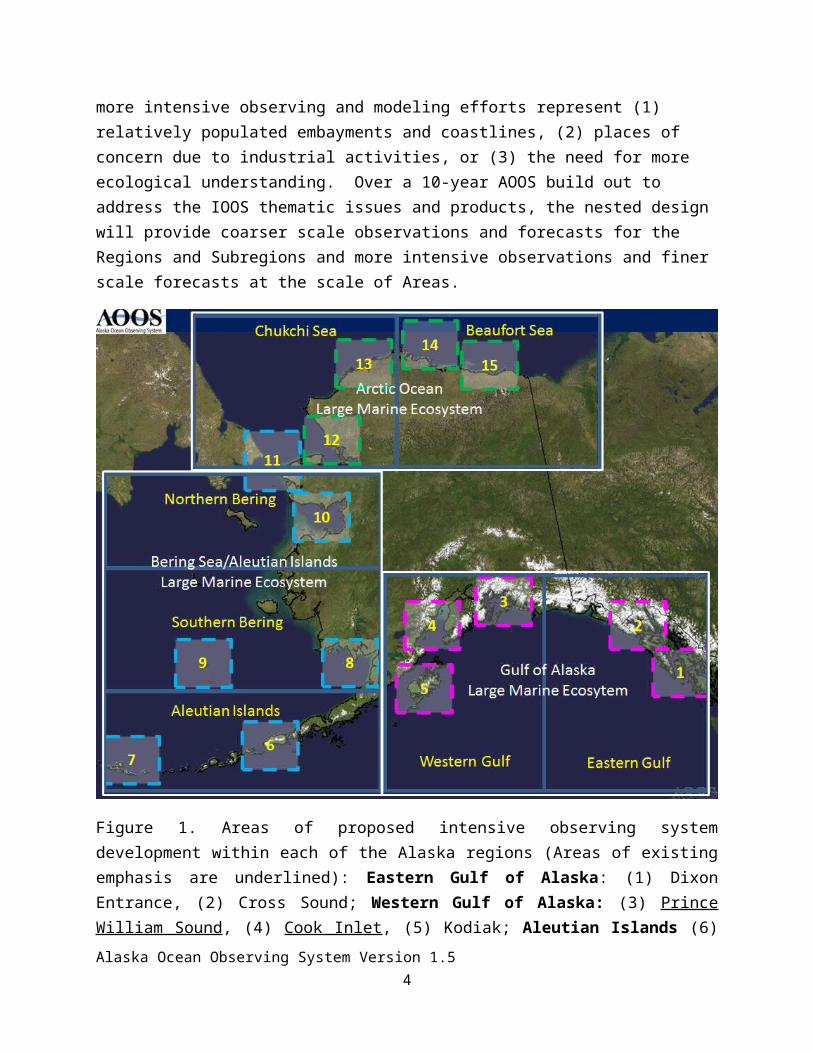
Figure 1. Areas of proposed intensive observing system development within each of the Alaska regions (Areas of existing emphasis are underlined): Eastern Gulf of Alaska: (1) Dixon Entrance, (2) Cross Sound; Western Gulf of Alaska: (3) Prince William Sound, (4) Cook Inlet, (5) Kodiak; Aleutian Islands (6) Unimak Pass, (7) Adak; Southern Bering Sea: (8) Bristol Bay, (9) Pribilof Islands; Northern Bering Sea (10) Norton Sound, (11) Bering Strait; Chukchi Sea (12) Kotzebue Sound, (13) Wainwright; and the Beaufort Sea (14) Prudhoe Bay, and (15) Kaktovik.
The AOOS build out will proceed with a prioritization of thematic issues at the appropriate spatial scale. In some cases a thematic issue may already be adequately addressed at the Region or Subregional scale through products developed at the Data Management and Communications level with little or no additional infrastructure investment (e.g. climate variability and change, sustainable fisheries, ecosystem health, etc.). In other cases some limited infrastructure development at the Subregional scale may be needed to augment an existing effort (e.g. ocean acidification, harmful algal blooms, water quality, etc.). Several issues may only be addressed with considerable investment at the most intensive scale of observation and model resolution (e.g. Area scale real-time surface currents, forecasting storm surges, etc.).
In general, thematic issues at coarser Regional or Subregional scales will be less costly to address and more tractable than those at finer Area scales. But several issues may only be addressed at the Area scale and the development steps will proceed from (1) identification (see Fig. 1) of an Area of focus (within one or more of the Regions), (2) identify site(s) within an area for additional observations or weather (met stations, buoys, etc.), waves (e.g. wave buoys), and ocean conditions (e.g. buoys, moorings, routine glider deployments), (3) develop numerical simulations of actual conditions (nowcasts) and provide area specific forecasts using data assimilation techniques where practicable. Information products provided by these efforts will lead to developing additional decision support tools for coastal hazards (e.g. tsunami warning, coastal erosion, inundation, etc.), climate change and variability, and ecosystem assessments and management.
Alaska Ocean Observing System Version 1.5 4

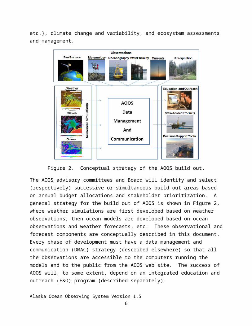
Figure 2. Conceptual strategy of the AOOS build out.
The AOOS advisory committees and Board will identify and select (respectively) successive or simultaneous build out areas based on annual budget allocations and stakeholder prioritization. A general strategy for the build out of AOOS is shown in Figure 2, where weather simulations are first developed based on weather observations, then ocean models are developed based on ocean observations and weather forecasts, etc. These observational and forecast components are conceptually described in this document. Every phase of development must have a data management and communication (DMAC) strategy (described elsewhere) so that all the observations are accessible to the computers running the models and to the public from the AOOS web site. The success of AOOS will, to some extent, depend on an integrated education and outreach (E&O) program (described separately).
Alaska Ocean Observing System Version 1.5 5
1. MARINE OPERATIONSIssue 1.1 Safe and efficient commercial shipping and recreational boating.
Description of the issue: Many areas frequented by vessels in Alaska have no fine scale observations or forecasts of atmospheric or oceanic conditions, or cost effective communications for mariners to receive recent weather or wave and currents information.
Importance to the region: Alaska’s maritime operations are diverse, spanning many government, industrial, and recreational user communities. The state is home to a $6 billion commercial fishing industry, offshore oil exploration in the Arctic as well as development and production in Cook Inlet, a Marine Highway System (ferries) serving otherwise isolated coastal communities in the Gulf of Alaska, cruise ships carrying a million passengers per year, and active charter and recreation fleets. AOOS hosted a workshop in May 2010 to discuss the important marine operations issues for Alaska. A summary and report of this workshop can be found at www.aoos.org/workshops-and-reports/.
Who are the impacted and targeted users: Stakeholders and interested organizations are represented by the University of Alaska Fairbanks, U.S. Coast Guard (Search and Rescue), Marine Exchange of Alaska (Vessel Tracking System), the Alaska Energy Authority (Tidal Energy), the U.S. BOEM (Offshore Oil Development), the Prince William Sound and Cook Inlet Citizens Advisory Councils (Oil Spill Response), the National Weather Service (Weather and Sea State), Alaska Association of Harbormasters and Port Administrators (Tsunami Warning), the Oil Spill Recovery Institute (Oil Spill Research), offshore oil and gas companies such as Shell and ConocoPhillips (Offshore Oil Production), the Southwest Pilot’s Association (Risk Assessment), and commercial shipping interests (Insurance Risk).
1.1.1 PRODUCTS AND SERVICES: Weather and sea state conditions for mariners
Site-specific weather conditions (see Table 1) will be collected using a low cost meteorological sensor array measuring key IOOS atmospheric variables. This array may be similar to the standardized weather stations used by the NOAA NERRS in the System Wide Monitoring program or the experimental array at Cape St. Elias (http://denali.micro-specialties.com/CapeStElias/CSE%20Metadata.htm), although, depending on funds available, these could also be standard NWS weather stations or the SnoTel stations now used in Prince William Sound and Cook Inlet. The design will include, at a minimum, wind speed and direction, air temperature, and barometric pressure. Precipitation will also be an important variable in many areas. Some installations with immediate access to sufficient power supplies and internet bandwidth may be augmented with webcams for qualitative sea state and ice observations.
Alaska Ocean Observing System Version 1.5 6

Once weather stations are deployed and observations are available, numerical models can be developed or expanded to simulate area-wide synoptic weather conditions. Observational data will be critical for evaluating model performance. AOOS has taken a lead role in developing collaborations with the University of Alaska Anchorage and Fairbanks campuses to develop Weather Research Forecasting (WRF) atmospheric circulation models that now provide statewide, Regional and Subregional (e.g. GOA, Bering), and Area scale (e.g. Prince William Sound and Cook Inlet) nowcasts/forecasts. There is an on-going effort to integrate the nowcasts/forecasts with the National Weather Service regional forecasts. The WRF nowcasts and forecasts are disseminated through the AOOS Model Explorer (www.aoos.org). The wind nowcasts/forecasts are used directly and also as input to Area-scale synoptic wave and ocean circulation models. The performance of wind nowcasts/forecasts are evaluated by Site-scale weather observations, and subsequently inform wave and ocean circulation models.
Site-specific sea state conditions are observed with wave buoys. AOOS collaborated with the NDBC, Scripps, and the US Army Corp of Engineers (USACE) in 2011 to deploy the first CDIP wave buoy in Alaska as part of an expanding effort to provide observations of sea state to mariners. This buoy is providing measurements of wave height, period, and direction to aid in validating a synoptic wave model for Cook Inlet. This wave buoy is intended as a demonstration of the technology in Alaska, and if successful will be used in other areas around the state.
Synoptic sea state conditions are obtained using wave models linked to the AOOS wind nowcast/forecast models and wave buoy observations. In the near term, AOOS will continue collaborating with Texas A&M University on developing Simulating Waves in the Nearshore (SWAN) wave model domains for Prince William Sound and Cook Inlet. In the longer term, to economize the modeling effort, AOOS may seek a contract for a coupled approach with the wave modeling conducted in tandem with the atmospheric modeling from one location.
TABLE 1.1.1 INFORMATION REQUIREMENTS (FOR WEATHER AND SEA STATE):
Alaska Ocean Observing System Version 1.5 7

Geographic Focus Observations and modelsRegions Subregion Areas ** Platform Parameters Time step Resolution Spatial
Gulf of Alaska Eastern Dixon Entrance 1 Land Wind speed 15 min Point Site*Cross Sound/Icy Strait 2 Land Wind direction 15 min Point Site*
Western Prince William Sound 3 Land Temperature air 15 min Point Site*Cook Inlet 4 Land Pressure air 15 min Point Site*Kodiak 5 Buoy Wave height 1 hr Point Site
Bering Sea Aleutians Alaska Peninsula 6 Buoy Wave period 1 hr Point SiteAdak 7 Buoy Wave direction 1 hr Point Site
Southern Bristol Bay 8 Buoy Water temperature 1 hr Point SitePribilof Islands 9
Northern Norton Sound 10Bering Strait 11
Arctic Ocean Chukchi Kotzebue Sound 12Wainwright 13
Beaufort Prudhoe Bay 14Kaktovik 15
**Areas in bold have some existing AOOS infrastructure* minimum or 3 sites (TBD)/area
1.1.2 PRODUCTS AND SERVICES: Improved wind and ocean current nowcasts/forecasts
AOOS will continue funding the development of a Data Assimilating Regional Ocean Modeling System (ROMS) forecasting model for Prince William Sound, the north Gulf of Alaska (GOA), and the northeastern Pacific Ocean. The NOAA CO-OPS is developing a ROMS domain for Cook Inlet. WRF and ROMS nowcasts and forecasts are produced daily, and images, analysis, and model output are disseminated by NASA’s Jet Propulsion Lab (JPL) and are also available on the AOOS Model Explorer (www.aoos.org).
Experiments in Prince William Sound have shown that ROMS performance is improved through data assimilation of fresh water discharge and ocean conditions. Fresh water discharge relies on improving hydrological forecasts. Observations of ocean conditions are provided by a suite of fixed and mobile instruments such as moorings, gliders, and HF radar arrays (see 1.3.1).
TABLE 1.1.2 INFORMATION REQUIREMENTS (FOR WIND AND OCEAN CURRENTS NOWCASTS/FORECASTS):
Alaska Ocean Observing System Version 1.5 8

Geographic Focus Observations and modelsRegions Subregion Areas ** Platform Parameters Time step Resolution Spatial
Gulf of Alaska Eastern Dixon Entrance 1 Land Wind speed 15 min Point Site*Cross Sound/Icy Strait 2 Land Wind direction 15 min Point Site*
Western Prince William Sound 3 Land Temperature air 15 min Point Site*Cook Inlet 4 Land Pressure air 15 min Point Site*Kodiak 5 Model Weather Nowcast/Forecast 6hr/48hr 3 km Area
Bering Sea Aleutians Alaska Peninsula 6 Buoy Wave height 1 hr Point SiteAdak 7 Buoy Wave period 1 hr Point Site
Southern Bristol Bay 8 Buoy Wave direction 1 hr Point SitePribilof Islands 9 Buoy Water temperature 1 hr Point Site
Northern Norton Sound 10 Model Wave Nowcast/Forecast 6hr/48hr 1 km AreaBering Strait 11 Station Stream discharge 15 min Point Site
Arctic Ocean Chukchi Kotzebue Sound 12 Model Glacier discharge 24 hr 1 km AreaWainwright 13 Model Hydrology Forecast 6hr/48hr 3 km Area
Beaufort Prudhoe Bay 14 Buoy Salinity water 1 hr Point SiteKaktovik 15 Buoy Temperature water 1 hr Point Site
Buoy Currents 1 hr Point SiteMooring Salinity water 1 hr Point SiteMooring Temperature water 1 hr Point SiteMooring Pressure 1 hr Point SiteMooring Currents 1 hr Point SiteRadar Currents 1 hr 1 km AreaGlider Salinity water Continuous Point SiteGlider Temperature water Continuous Point SiteModel Ocean Nowcast/Forecast 6hr/48hr 3 km Area
** Areas in bold have some existing AOOS infrastructure*minimum of 3 sites (TBD)/area
1.1.3 PRODUCTS AND SERVICES: Improved sea ice extent and trajectory nowcasts/forecasts
As Arctic sea ice retreats, and northern oceanic passages stay open for longer periods, more vessels are passing through Alaska waters. These vessels take shipments to international destinations, as well as supporting increased economic development in western and northern Alaska, and touring the Arctic for recreation. In 2011, an ice free passage along the north coast of Russia is expected for up to three months allowing cargo and cruise ships direct access between Russian and US west coast ports (www.arcus.org/search/seaiceoutlook/2011/august). For example, the Russian gas producer Novatek plans to send the 120,000-ton tanker Vladimir Tikhonov along Russia’s Arctic Coast to the Bering Strait in August — the largest ship of its kind to ever traverse the Northern Sea Route.
The NWS and ARCUS now provide sea ice maps that depict the location of fast ice and the ice shelf based on satellite image analysis. But highly mobile broken ice continues to be problematic especially for vessels in transit. AOOS will explore using ice radars, bottom mounted ice thickness sonars and numerical modeling to develop a sea ice trajectory nowcast/forecast as an aid to vessels working in the Arctic (see: www.crrel.usace.army.mil/sid/hopkins_files/Seaice/Cook_inlet.htm ).
Alaska Ocean Observing System Version 1.5 9
TABLE 1.1.3 INFORMATION REQUIREMENTS (FOR SEA ICE EXTENT AND TRAJECTORY NOWCASTS/FORECASTS):
Geographic Focus Observations and modelsRegions Subregion Areas ** Platform Parameters Time step Resolution Spatial
Gulf of Alaska Western Cook Inlet 4 Land Wind speed 15 min Point Site*Bering Sea Southern Bristol Bay 8 Land Wind direction 15 min Point Site*
Pribilof Islands 9 Land Temperature air 15 min Point Site*Northern Norton Sound 10 Land Pressure air 15 min Point Site*
Bering Strait 11 Model Weather Nowcast/Forecast 6hr/48hr 3 km AreaArctic Ocean Chukchi Kotzebue Sound 12 Mooring Ice thickness 24 hr Point Site
Wainwright 13 Radar Ice density and trajectory 15 min 1 km SiteBeaufort Prudhoe Bay 14 Webcams Ice floe density 15 min Point Site
Kaktovik 15 Model Ice trajectory 6hr/48hr 1 km AreaModel Sea Ice Nowcast/Forecast 6hr/48hr 3 km Area
** Areas in bold have some existing AOOS infrastructure*minimum of 3 sites (TBD)/area
Issue 1.2: Search and Rescue
Description of the issue: The United States Coast Guard (USCG) must often conduct time-consuming searches for lost, missing, or distressed vessels and persons in Alaska’s coastal oceans. Search and rescue (SAR) and minimizing the loss of life, injury and property damage by rendering aid to the distressed in the maritime environment have always been a Coast Guard priority. Coast Guard SAR response involves costly multi-mission stations, cutters, aircraft and boats linked by communications networks.
A SAR responder is faced with many challenges, including acquiring atmospheric winds, oceanic currents, sea surface temperature, craft/personal conditions, and other information that may not be precisely known. The USCG adopted a new Decision Support Tool (DST) in early 2007 known as the Search and Rescue Optimal Planning System (SAROPS) for planning search and rescue operations. SAROPS uses a sophisticated, cutting-edge animated grid model to project how/where floating persons or objects might move. It allows searchers to define the situation, access environmental data such as wind and water current patterns, compute drift models, simulate environmental hazards, and develop a comprehensive search plan with available resources. The two most important input parameters for SAROPS are: (1) atmospheric surface (10-meter) wind (both speed and direction); and (2) ocean surface current (both speed and direction). Currently, SAROPS accesses these data sets through the Applied Science Associates’ Environmental Data Server (EDS), that manages a number of global and regional wind and current data sets. These include both observations and computer forecast models. For the northeastern Pacific area, the EDS is presently accessing NOAA NCEP’s Global Forecast System (GFS) and North America Mesoscale (NAM)
Alaska Ocean Observing System Version 1.5 10
10-meter surface winds fields. Providing higher resolution forecasts would improve the SAROPS model for use in Alaska.
Importance to the region: See 1.1.
Who are the impacted and targeted users: See 1.1
1.2.1 PRODUCTS AND SERVICES: Real time surface currents sent to the USCG EDS for use in SAR operations
The success of SAR operations critically depends upon the quality of the surface wind and current data sets accessible through EDS. Of particular interest is the measurement of surface currents from HF radars. The accuracy of surface current measurements with HF radars has been reported to be between 4 to 20 cm s-1 making this an ideal tool both for direct observation as well as data assimilation by numerical models.
Observational data need to be assimilated into models for more precise predictions. Furthermore, a single model realization without measures of uncertainties will be of very limited use. Finally, the data have to be readily available for both nowcast and forecast fields, in a timely manner, using a standard format.
The challenge in Alaska is to maintain continuous real-time operation of these systems at remote sites. To address the technical challenge, HR radars have now been designed with more reliable power supplies and telecommunications.
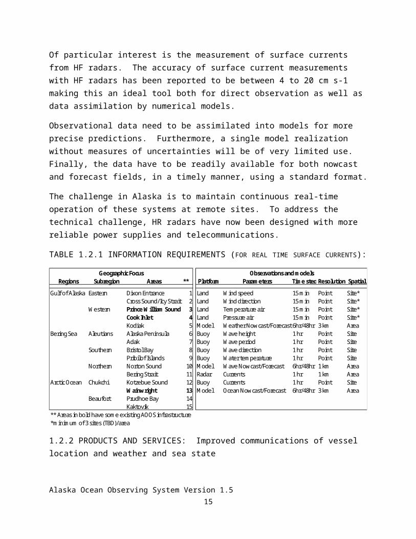
TABLE 1.2.1 INFORMATION REQUIREMENTS (FOR REAL TIME SURFACE CURRENTS):
Geographic Focus Observations and modelsRegions Subregion Areas ** Platform Parameters Time step Resolution Spatial
Gulf of Alaska Eastern Dixon Entrance 1 Land Wind speed 15 min Point Site*Cross Sound/Icy Strait 2 Land Wind direction 15 min Point Site*
Western Prince William Sound 3 Land Temperature air 15 min Point Site*Cook Inlet 4 Land Pressure air 15 min Point Site*Kodiak 5 Model Weather Nowcast/Forecast 6hr/48hr 3 km Area
Bering Sea Aleutians Alaska Peninsula 6 Buoy Wave height 1 hr Point SiteAdak 7 Buoy Wave period 1 hr Point Site
Southern Bristol Bay 8 Buoy Wave direction 1 hr Point SitePribilof Islands 9 Buoy Water temperature 1 hr Point Site
Northern Norton Sound 10 Model Wave Nowcast/Forecast 6hr/48hr 1 km AreaBering Strait 11 Radar Currents 1 hr 1 km Area
Arctic Ocean Chukchi Kotzebue Sound 12 Buoy Currents 1 hr Point SiteWainwright 13 Model Ocean Nowcast/Forecast 6hr/48hr 3 km Area
Beaufort Prudhoe Bay 14Kaktovik 15
** Areas in bold have some existing AOOS infrastructure*minimum of 3 sites (TBD)/area
Alaska Ocean Observing System Version 1.5 11
1.2.2 PRODUCTS AND SERVICES: Improved communications of vessel location and weather and sea state
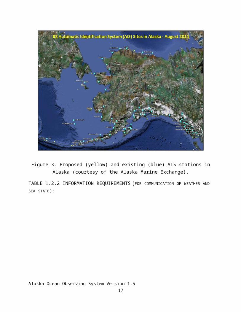
Most vessel traffic (per capita) in Alaska now has access to emergency VHF radio broadcasts and much of it is within cell phone coverage areas; however, the area represented is less than 15% of Alaska’s waters. The lower 48 states now have 99% VHF coverage out to 20 miles. The USCG does not intend to fully implement Rescue 21, the new national VHF distress communication system, in Alaska and most commercial vessels will continue relying on HF radio and satellite telephone (or internet). The USCG will not be fully implementing the vessel Automated Information System (AIS) in Alaska either, and will rely on industry to provide additional communication infrastructure. The Alaska Marine Exchange is implementing the regional AIS infrastructure and in the future may be adding Rescue 21 Digital Selective Calling to selected new and existing AIS relay stations (Fig. 3). A significant contribution by AOOS to maritime safety in Alaska would be to facilitate the expansion of AIS relay stations in the three ocean basins, and to augment existing weather stations with AIS transmitters to communicate weather conditions directly to mariners at sea.
Figure 3. Proposed (yellow) and existing (blue) AIS stations in Alaska (courtesy of the Alaska Marine Exchange).
Alaska Ocean Observing System Version 1.5 12
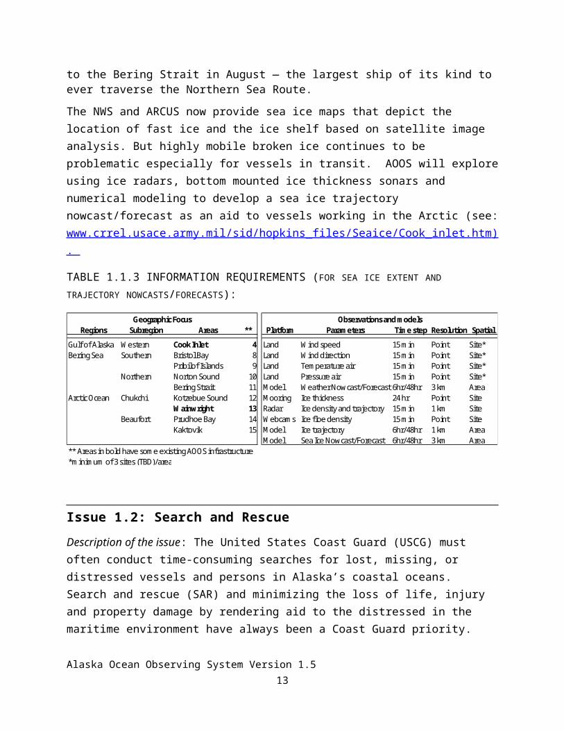
TABLE 1.2.2 INFORMATION REQUIREMENTS (FOR COMMUNICATION OF WEATHER AND SEA STATE):
Geographic Focus Observations and modelsRegions Subregion Areas Platform Parameters Time step Resolution Spatial
Gulf of Alaska Eastern Dixon Entrance 1 Land AIS Transmitter Continuous Point Site*Cross Sound/Icy Strait 2
Western Prince William Sound 3Cook Inlet 4Kodiak 5
Bering Sea Aleutians Alaska Peninsula 6Adak 7
Southern Bristol Bay 8Pribilof Islands 9
Northern Norton Sound 10Bering Strait 11
Arctic Ocean Chukchi Kotzebue Sound 12Wainwright 13
Beaufort Prudhoe Bay 14Kaktovik 15
*minimum of 3 sites (TBD)/area
Issue 1.3: Spill response
Description of the issue: Under the National Contingency Plan the USCG serves as the Federal On Scene Coordinator for oil spill response and NOAA is designated to provide the Scientific Support Coordinator (SSC). NOAA's Office of Response and Restoration staffs the SSCs with oceanographers, modelers, chemists, and biologists available 24 hours a day. During a real oil spill, the primary Decision Support Tool for evaluating potential trajectories is the General NOAA Oil Modeling Environment (GNOME). GNOME forecasts spill trajectories based upon the best wind and ocean circulation forecasts available at the time of the response. Twice daily overflights of the spill are made to validate the real oil spill trajectory.
Importance to the region: NOAA does not officially respond to oil spills until formally requested by the U.S. Coast Guard. Therefore, the GNOME model as implemented by NOAA is generally not used in small oil spills, oil spill drills, or in pre-staging equipment in advance of an oil spill. This was demonstrated recently in Cook Inlet during the Mt. Redoubt volcanic eruption of 2009. The oil terminal at Drift River was in imminent danger of being overwhelmed by the ash flow, but the U.S. Coast Guard had not issued a request for spill trajectory scenarios from NOAA. Spill response organizations such as Alyeska Pipeline Service Company (Alyeska) in Prince William Sound and Alaska Clean Seas in the Beaufort Sea need oil spill trajectory forecasts for better planning scenarios, and to anticipate the placement of protection and response equipment.
Who are the impacted and targeted users: See 1.1
Alaska Ocean Observing System Version 1.5 13
Geographic site selection: See 1.1: Areas Prince William Sound (2), Cook Inlet (3), Chukchi Sea (11), and Beaufort Sea (12).
1.3.1 PRODUCTS AND SERVICES: Real time surface currents used by NOAA HAZMAT, Coast Guard and others to track and forecast oil & chemical trajectories
See 1.2.1
TABLE 1.3.1 INFORMATION REQUIREMENTS (FOR REAL TIME SURFACE CURRENTS):
Geographic Focus Observations and modelsRegions Subregion Areas ** Platform Parameters Time step Resolution Spatial
Gulf of Alaska Western Prince William Sound 3 Radar Currents 1 hr 1 km AreaCook Inlet 4
Arctic Ocean Chukchi Wainwright 13Beaufort Prudhoe Bay 14
** Areas in bold have some existing AOOS infrastructure
1.3.2 PRODUCTS AND SERVICES: Ocean circulation models & forecasts
See 1.1.2
INFORMATION REQUIREMENTS (FOR OCEAN CIRCULATION MODELS & FORECASTS):
See TABLE 1.1.2
Issue 1.4: Offshore Energy (includes oil and gas, wind, tidal, waves,
etc.)
Description of the issue: Exploration for potential offshore energy has accelerated in Alaska in the last five years, and may be a primary source of energy for Alaska and the nation for many decades. Offshore energy is used here to describe all forms of energy derived from the sea including oil and gas (see 1.4.1), as well as marine renewable energy sources such waves, tides, currents, and winds (see 1.4.2). A tidal energy project is being planned for Upper Cook Inlet, with NOAA taking the lead in developing an ocean circulation model as an aid in siting this and other area projects. There are several sites in Southeast Alaska that also have potential for ocean current development. Oil and gas development is on-going in Cook Inlet and exploration is progressing in the Chukchi and Beaufort Seas.
Importance to the region: In Alaska, the Bureau of Ocean Energy Management (BOEM) is the primary federal agency administrating ocean energy development in offshore waters. The environmental issues of greatest concern to BOEM include monitoring the marine environment for changes attributable to offshore energy development, conducting research
Alaska Ocean Observing System Version 1.5 14
on oil spill fate and effects especially in ice environments, and minimizing impacts of seismic and acoustic operations. Issues relevant to AOOS and IOOS include quantifying change in the marine and coastal environment due to offshore activity, determining the role of currents in the distribution of anthropogenic pollutants, and the fate of pollutants, particularly in broken ice.
Who are the impacted and targeted users: See 1.1. In addition, users include statewide Alaska Native Villages that are aggressively pursuing wind energy sources to offset the high cost of petroleum energy products.
Geographic site selection: See 1.1: All Areas
1.4.1 PRODUCTS AND SERVICES: Atmospheric and oceanographic information to assist with offshore oil and gas operations
See 1.1.2
INFORMATION REQUIREMENTS (FOR WEATHER, WAVE, OCEAN CIRCULATION OBSERVATIONS AND NOWCASTS/FORECASTS):
See TABLE 1.1.2
1.4.2 PRODUCTS AND SERVICES: Atmospheric and oceanographic information to assist with alternative energy development such as wind, waves, and currents.
See 1.1.2
INFORMATION REQUIREMENTS (FOR ENVIRONMENTAL INFORMATION):
See TABLE 1.1.2
Alaska Ocean Observing System Version 1.5 15
2. CLIMATE VARIABILITY AND CHANGEIssue 2.1: Changes in ocean conditions over time
Description of the issue: The ocean is a fundamental part of the climate system. Short-term fluctuations (years to a few decades) such as the El Niño-Southern Oscillation, the Pacific decadal oscillation, the North Atlantic oscillation, and the Arctic oscillation, represent climate variability rather than climate change. On longer time scales, alterations to ocean processes such as thermohaline circulation, play a key role in redistributing heat by carrying out a very slow and extremely deep movement of water. These processes drive the long-term redistribution of heat in the world's oceans.
Importance to the region: The goal of this section is to provide data characterizing the response of Alaska’s oceans to oscillations in climate. Quantitative information acquired includes mixed layer depth, vertical stratification, timing of the spring phytoplankton bloom, zooplankton species abundance, and summer mixing that results in production. AOOS hosted a workshop in May 2010 to discuss the important climate variability and change issues for Alaska. A summary and report of this workshop can be found at www.aoos.org/workshops-and-reports/.
Who are the impacted and targeted users: Resource managers, policy makers, commercial and recreational fishing, coastal communities, and subsistence users.
Geographic site selection: Gulf of Alaska, Bering Sea, Arctic Ocean (Chukchi Sea)
2.1.1 PRODUCTS AND SERVICES: Coastal climate records on key parameters over time. Regional contributions to climate indices and national climate assessments.
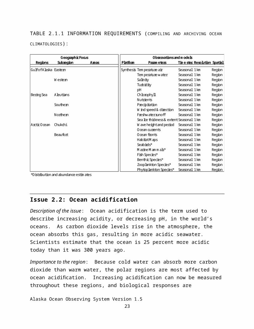
TABLE 2.1.1 INFORMATION REQUIREMENTS (COMPILING AND ARCHIVING OCEAN
CLIMATOLOGIES):
Alaska Ocean Observing System Version 1.5 16
Geographic Focus Observations and modelsRegions Subregion Areas Platform Parameters Time step Resolution Spatial
Gulf of Alaska Eastern Synthesis Temperature air Seasonal 1 km RegionTemperature water Seasonal 1 km Region
Western Salinity Seasonal 1 km RegionTurbidity Seasonal 1 km RegionpH Seasonal 1 km Region
Bering Sea Aleutians Chlorophyll Seasonal 1 km RegionNutrients Seasonal 1 km Region
Southern Precipitation Seasonal 1 km RegionWind speed & direction Seasonal 1 km Region
Northern Freshwater runoff Seasonal 1 km RegionSea Ice thickness & extent Seasonal 1 km Region
Arctic Ocean Chukchi Wave height and period Seasonal 1 km RegionOcean currents Seasonal 1 km Region
Beaufort Ocean fronts Seasonal 1 km RegionHabitat Maps Seasonal 1 km RegionSeabirds* Seasonal 1 km RegionMarine Mammals* Seasonal 1 km RegionFish Species* Seasonal 1 km RegionBenthic Species* Seasonal 1 km RegionZooplankton Species* Seasonal 1 km RegionPhytoplankton Species* Seasonal 1 km Region
*Distribution and abundance estimates
Issue 2.2: Ocean acidification
Description of the issue: Ocean acidification is the term used to describe increasing acidity, or decreasing pH, in the world’s oceans. As carbon dioxide levels rise in the atmosphere, the ocean absorbs this gas, resulting in more acidic seawater. Scientists estimate that the ocean is 25 percent more acidic today than it was 300 years ago.
Importance to the region: Because cold water can absorb more carbon dioxide than warm water, the polar regions are most affected by ocean acidification. Increasing acidification can now be measured throughout these regions, and biological responses are detectable. The coastal seas around Alaska are more susceptible to ocean acidification because of unique circulation patterns and colder temperatures. These factors increase the transport of carbon dioxide from the atmosphere into surface waters. As the pH in the ocean decreases, it reduces the availability of carbonate ions, which play an important role in shell formation for a number of marine organisms such as corals, marine plankton, and shellfish. Some of the smaller calcifying organisms, such as Pteropods and other planktonic calcifiers, may be particularly susceptible to increases in acidity with potentially negative cascading effects on predator organisms such as salmon. Commercially important shellfish like crabs and oysters, and coraline marine habitats may all decline as a result of increased ocean acidification.
Alaska Ocean Observing System Version 1.5 17
Who are the impacted and targeted users: Resource managers, policy makers, commercial and recreational fishing, shellfish growers, coastal communities
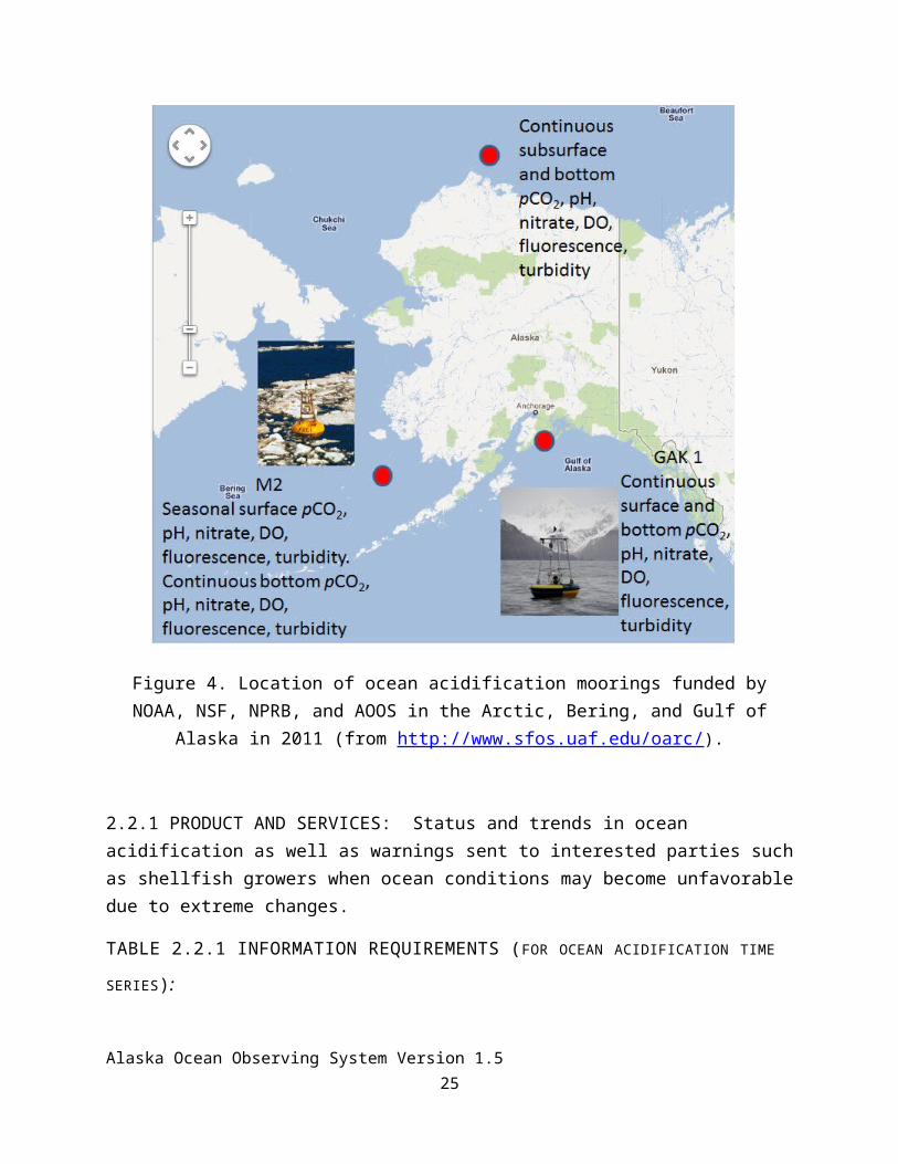
Geographic site selection: (Fig 4) Gulf of Alaska, Bering Sea, and Arctic Ocean
Figure 4. Location of ocean acidification moorings funded by NOAA, NSF, NPRB, and AOOS in the Arctic, Bering, and Gulf of Alaska in 2011 (from http://www.sfos.uaf.edu/oarc/).
2.2.1 PRODUCT AND SERVICES: Status and trends in ocean acidification as well as warnings sent to interested parties such as shellfish growers when ocean conditions may become unfavorable due to extreme changes.
TABLE 2.2.1 INFORMATION REQUIREMENTS (FOR OCEAN ACIDIFICATION TIME SERIES):
Alaska Ocean Observing System Version 1.5 18

Geographic Focus Observations and modelsRegions Subregion Areas ** Platform Parameters Time step Resolution Spatial
Gulf of Alaska Eastern Buoy pH 1 hr Point SiteBuoy Temperature water 1 hr Point Site
Western Buoy pCO2 1 hr Point SiteBuoy Salinity 1 hr Point SiteBuoy Dissolved oxyegn 1 hr Point Site
Bering Sea Aleutians Buoy Turbidity 1 hr Point SiteBuoy Fluorescence 1 hr Point Site
Southern Mooring pH 1 hr Point SiteMooring Temperature water 1 hr Point Site
Northern Mooring pCO2 1 hr Point SiteMooring Salinity 1 hr Point Site
Arctic Ocean Chukchi Mooring Dissolved oxyegn 1 hr Point SiteMooring Turbidity 1 hr Point Site
Beaufort Mooring Fluorescence 1 hr Point SiteShip pH 2/year 10 km RegionShip Temperature water 2/year 10 km RegionShip pCO2 2/year 10 km RegionShip Salinity 2/year 10 km RegionShip Dissolved oxyegn 2/year 10 km RegionShip Turbidity 2/year 10 km RegionShip Fluorescence 2/year 10 km Region
** Subregions in bold have some existing AOOS infrastructure
Issue 2.3: Sea Level Change
Description of the issue: There is a widespread consensus that substantial long-term sea level rise across the globe will continue for centuries to come. For this century, one meter of sea level rise is well within the range of recent projections, although for Alaska this will be confounded somewhat by subsidence or uplift events. There are two main factors that have contributed to observed sea level rise. The first is thermal expansion: as ocean water warms, it expands in volume. The second is from the contribution of land-based ice due to increased melting. The major store of water on land is found in glaciers and ice sheets that are now rapidly decreasing in size.
Importance to the region: On the timescale of centuries to millennia, the melting of ice sheets could result in even higher sea level rise. Partial deglaciation of the Greenland and West Antarctic Ice Sheets could result in sea level rise of 4–6 meters or more. Such an increase in sea level would imply major changes in coastlines and ecosystems, and inundation of low-lying areas, with greatest effects in estuaries.
Who are the impacted and targeted users: Resource managers, policy makers, and coastal communities. Current sea level rise potentially impacts all human populations living in coastal regions and on islands.
Alaska Ocean Observing System Version 1.5 19

Geographic site selection: Statewide
2.3.1 PRODUCT AND SERVICES: Improved forecasts for communities in areas affected by sea level rise, land subsidence, and coastal inundation.
TABLE 2.3.1 INFORMATION REQUIREMENTS (FOR SEA LEVEL CHANGE AND INUNDATION FORECASTS):
Geographic Focus Observations and modelsRegions Subregion Areas Platform Parameters Time step Resolution Spatial
Gulf of Alaska Eastern Dixon Entrance 1 Model Digital elevation NA 1 m AreaCross Sound/Icy Strait 2 Model Digital shoreline NA 1 m Area
Western Prince William Sound 3 Model Bathymetry NA 1 m AreaCook Inlet 4 Model Flooding/Inundation NA 1 m AreaKodiak 5 Model Uplift/Subsidence NA 1 m Area
Bering Sea Aleutians Alaska Peninsula 6Adak 7
Southern Bristol Bay 8Pribilof Islands 9
Northern Norton Sound 10Bering Strait 11
Arctic Ocean Chukchi Kotzebue Sound 12Wainwright 13
Beaufort Prudhoe Bay 14Kaktovik 15
Alaska Ocean Observing System Version 1.5 20

3. ECOSYSTEMS, FISHERIES AND WATER QUALITYIssue 3.1 Healthy and Productive Ecosystems
Description of the issue: Alaska’s coastal waters support a rich and diverse ecosystem, and are home to the nation’s largest fisheries, as well as abundant populations of seabirds and marine mammals. Many economically important fisheries are now declining and conflicts exist between threatened and endangered species and development industries over critical marine habitats. The health of ecosystems in Alaska has direct social and economic implications that are likely to be more profound as the effects of climate change are manifested by large-scale ecosystem adjustments. In addition, as human activities increase in Alaska waters, management challenges increase and will require new sources of information and decision support tools. The relationship between changing ocean conditions and fish and shellfish populations is now better understood but decision support tools will require better data integration
Importance to the region: The Alaska region continues to demonstrate susceptibility to climate variability and change. Additional threats include oil spills, mineral extraction industries, overfishing, noise and pollution. The loss of sea ice is affecting marine mammal migrations, and potentially expanding the northern range of fishes and invertebrate species through the Bering Strait. Socioeconomic changes are likely to follow as in the mid-1970s when the relative dominance of the commercially important fish species changed. These ecosystem adjustments were linked to decadal-scale changes in the atmosphere and ocean of the North Pacific. As a consequence, the commercial fishing industry had to invest heavily in new infrastructure to remain economically viable. AOOS hosted a workshop in May 2010 to discuss the important ecosystem health and fisheries issues for Alaska. A summary and report of this workshop can be found at www.aoos.org.
Who are the impacted and targeted users: Representative stakeholders include resource managers, policy makers, the fishing industry, subsistence-based communities, academic and agency researchers, and everyone who depends on healthy and productive marine ecosystems.
Geographic site selection: Statewide
3.1.1 PRODUCTS AND SERVICES: Integrated datasets and displays linking habitats with physical oceanographic properties (Habitat GIS/seabird data portals).
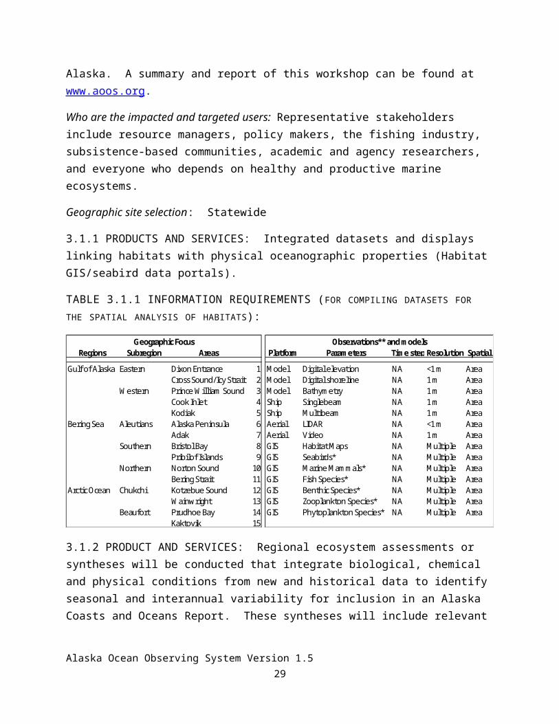
TABLE 3.1.1 INFORMATION REQUIREMENTS (FOR COMPILING DATASETS FOR THE SPATIAL ANALYSIS OF HABITATS):
Alaska Ocean Observing System Version 1.5 21

Geographic Focus Observations** and modelsRegions Subregion Areas Platform Parameters Time step Resolution Spatial
Gulf of Alaska Eastern Dixon Entrance 1 Model Digital elevation NA <1 m AreaCross Sound/Icy Strait 2 Model Digital shoreline NA 1 m Area
Western Prince William Sound 3 Model Bathymetry NA 1 m AreaCook Inlet 4 Ship Singlebeam NA 1 m AreaKodiak 5 Ship Multibeam NA 1 m Area
Bering Sea Aleutians Alaska Peninsula 6 Aerial LIDAR NA <1 m AreaAdak 7 Aerial Video NA 1 m Area
Southern Bristol Bay 8 GIS Habitat Maps NA Multiple AreaPribilof Islands 9 GIS Seabirds* NA Multiple Area
Northern Norton Sound 10 GIS Marine Mammals* NA Multiple AreaBering Strait 11 GIS Fish Species* NA Multiple Area
Arctic Ocean Chukchi Kotzebue Sound 12 GIS Benthic Species* NA Multiple AreaWainwright 13 GIS Zooplankton Species* NA Multiple Area
Beaufort Prudhoe Bay 14 GIS Phytoplankton Species* NA Multiple AreaKaktovik 15
3.1.2 PRODUCT AND SERVICES: Regional ecosystem assessments or syntheses will be conducted that integrate biological, chemical and physical conditions from new and historical data to identify seasonal and interannual variability for inclusion in an Alaska Coasts and Oceans Report. These syntheses will include relevant data and analyses from federal and state fisheries surveys in the respective ocean basins.
TABLE 3.1.2 INFORMATION REQUIREMENTS (FOR PRODUCING AN ANNUAL OCEANS SYNTHESIS PUBLICATION):
Alaska Ocean Observing System Version 1.5 22
Geographic Focus Observations and modelsRegions Subregion Areas Platform Parameters Time step Resolution Spatial
Gulf of Alaska Eastern Dixon Entrance 1 Synthesis Temperature air Seasonal 1 km RegionCross Sound/Icy Strait 2 Temperature water Seasonal 1 km Region
Western Prince William Sound 3 Salinity Seasonal 1 km RegionCook Inlet 4 Turbidity Seasonal 1 km RegionKodiak 5 pH Seasonal 1 km Region
Bering Sea Aleutians Alaska Peninsula 6 Chlorophyll Seasonal 1 km RegionAdak 7 Nutrients Seasonal 1 km Region
Southern Bristol Bay 8 Precipitation Seasonal 1 km RegionPribilof Islands 9 Wind speed & direction Seasonal 1 km Region
Northern Norton Sound 10 Freshwater runoff Seasonal 1 km RegionBering Strait 11 Sea Ice thickness & extent Seasonal 1 km Region
Arctic Ocean Chukchi Kotzebue Sound 12 Wave height and period Seasonal 1 km RegionWainwright 13 Ocean currents Seasonal 1 km Region
Beaufort Prudhoe Bay 14 Ocean fronts Seasonal 1 km RegionKaktovik 15 Habitat Maps Seasonal 1 km Region
Seabirds* Seasonal 1 km RegionMarine Mammals* Seasonal 1 km RegionFish Species* Seasonal 1 km RegionBenthic Species* Seasonal 1 km RegionZooplankton Species* Seasonal 1 km RegionPhytoplankton Species* Seasonal 1 km Region
*Distribution and abundance estimates
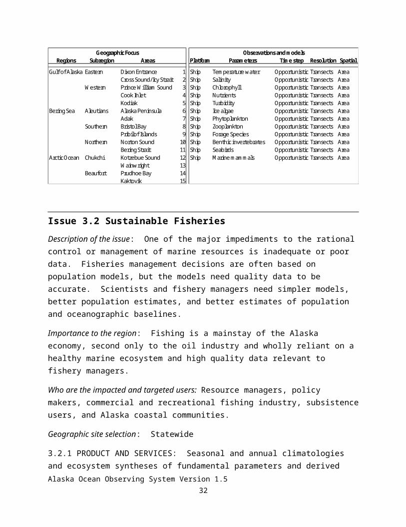
3.1.4 PRODUCTS AND SERVICES: Distributed Biological Observations (DBO) using vessels of opportunity. A marine Distributed Biological Observatory (DBO) in the U.S. Arctic is envisioned for consistent monitoring of biophysical responses in four pivotal oceanographic areas along a north-south latitudinal gradient. Each area exhibits high biological productivity, biodiversity, and gradients in ecosystem properties and direct linkages to subsistence-based coastal communities. All areas are projected to experience increased commercial use with the loss of sea ice. The Bering Strait region represents potential conflicts between commercial shipping and resource exploration, subsistence hunting, and management of biological resources. As sea ice retreats, the DBO will track the rate of ecosystem change and sample currently unknown impacts. The DBO integrates biological and physical sampling, including both mooring and dedicated repeat ship occupations using a collaborative international network of logistical support.
Alaska Ocean Observing System Version 1.5 23
Figure 5. Four possible regional locations of Distributed Biological Observatory transect lines and stations for standard hydrological and biological measurements in the Pacific Arctic sector, including acoustics for marine mammal detection. These stations would include Canadian, Chinese, Japanese, Korean, Russian, and U.S. research vessels, coordinated through the international Pacific Arctic Group, and land-based research from coastal communities using helicopters, small ships, and long-term moorings.
TABLE 3.1.4 INFORMATION REQUIREMENTS (FOR A DBO USING VESSELS OF OPPORTUNITY):
Geographic Focus Observations and modelsRegions Subregion Areas Platform Parameters Time step Resolution Spatial
Gulf of Alaska Eastern Dixon Entrance 1 Ship Temperature water Opportunistic Transects AreaCross Sound/Icy Strait 2 Ship Salinity Opportunistic Transects Area
Western Prince William Sound 3 Ship Chlorophyll Opportunistic Transects AreaCook Inlet 4 Ship Nutrients Opportunistic Transects AreaKodiak 5 Ship Turbidity Opportunistic Transects Area
Bering Sea Aleutians Alaska Peninsula 6 Ship Ice algae Opportunistic Transects AreaAdak 7 Ship Phytoplankton Opportunistic Transects Area
Southern Bristol Bay 8 Ship Zooplankton Opportunistic Transects AreaPribilof Islands 9 Ship Forage Species Opportunistic Transects Area
Northern Norton Sound 10 Ship Benthic invertebrates Opportunistic Transects AreaBering Strait 11 Ship Seabirds Opportunistic Transects Area
Arctic Ocean Chukchi Kotzebue Sound 12 Ship Marine mammals Opportunistic Transects AreaWainwright 13
Beaufort Prudhoe Bay 14Kaktovik 15
Issue 3.2 Sustainable Fisheries
Alaska Ocean Observing System Version 1.5 24
Description of the issue: One of the major impediments to the rational control or management of marine resources is inadequate or poor data. Fisheries management decisions are often based on population models, but the models need quality data to be accurate. Scientists and fishery managers need simpler models, better population estimates, and better estimates of population and oceanographic baselines.
Importance to the region: Fishing is a mainstay of the Alaska economy, second only to the oil industry and wholly reliant on a healthy marine ecosystem and high quality data relevant to fishery managers.
Who are the impacted and targeted users: Resource managers, policy makers, commercial and recreational fishing industry, subsistence users, and Alaska coastal communities.
Geographic site selection: Statewide
3.2.1 PRODUCT AND SERVICES: Seasonal and annual climatologies and ecosystem syntheses of fundamental parameters and derived information products important for fisheries and ecosystem-based management.
INFORMATION REQUIREMENTS (FOR PRODUCING DERIVED SEASONAL AND ANNUAL OCEAN CLIMATOLOGIES AND ECOSYSTEM SYNTHESIS PUBLICATIONS):
See 3.1.2
3.2.2 PRODUCTS AND SERVICES: Surface current mapping for larval fish transport
INFORMATION REQUIREMENTS (FOR SURFACE CURRENT MAPPING):
See 1.2.1
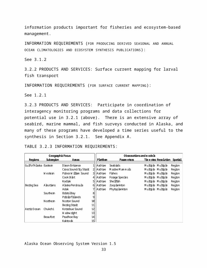
3.2.3 PRODUCTS AND SERVICES: Participate in coordination of interagency monitoring programs and data collections for potential use in 3.2.1 (above). There is an extensive array of seabird, marine mammal, and fish surveys conducted in Alaska, and many of these programs have developed a time series useful to the synthesis in Section 3.2.1. See Appendix A.
TABLE 3.2.3 INFORMATION REQUIREMENTS:
Alaska Ocean Observing System Version 1.5 25
Geographic Focus Observations and modelsRegions Subregion Areas Platform Parameters Time step Resolution Spatial
Gulf of Alaska Eastern Dixon Entrance 1 Archive Seabirds Multiple Multiple RegionCross Sound/Icy Strait 2 Archive Marine Mammals Multiple Multiple Region
Western Prince William Sound 3 Archive Fishes Multiple Multiple RegionCook Inlet 4 Archive Forage Species Multiple Multiple RegionKodiak 5 Archive Shellfish Multiple Multiple Region
Bering Sea Aleutians Alaska Peninsula 6 Archive Zooplankton Multiple Multiple RegionAdak 7 Archive Phytoplankton Multiple Multiple Region
Southern Bristol Bay 8Pribilof Islands 9
Northern Norton Sound 10Bering Strait 11
Arctic Ocean Chukchi Kotzebue Sound 12Wainwright 13
Beaufort Prudhoe Bay 14Kaktovik 15
Issue 3.3 Harmful algal blooms
Description of the issue: Toxic or Harmful Algal Blooms (HABs) are becoming an increasing public health concern on a global scale. HAB events are generally attributed to anthropogenic nutrient enrichment of coastal waters. In Alaska, of most concern is Paralytic Shellfish Poisoning (PSP), caused by several species of dinoflagellates in the genus Alexandrium. Shellfish become toxic when environmental conditions such as changes in salinity and temperature enable toxic dinoflagellate cells to rapidly reproduce causing a toxic bloom. PSP episodes in Alaska tend to be seasonal, occurring most often during late spring and summer. Off-season occurrences of PSP are most likely caused by tissue retention of toxins from summer bioaccumulation.
Another HAB of concern in Alaska is caused by the marine bacteria Vibrio parahaemolyticus. This is the leading cause of seafood-associated gastroenteritis in the United States, and typically is associated with the consumption of raw oysters gathered from warm-water estuaries. Oysters associated with a 2004 outbreak on a cruise ship in Alaska were harvested from an oyster farm when mean daily water temperatures exceeded 15.0 degrees C. In this case, rising temperatures of ocean water seem to have contributed to one of the largest known outbreaks of V. parahaemolyticus in the United States.
Importance to the region: The economic consequences of the HABs has drastically impacted the commercial oyster farms and clam fisheries in Alaska., as well as recreational and subsistence users.
Who are the impacted and targeted users: Resource managers, policy makers, coastal communities, Alaska Natives, commercial farms, consumers
Alaska Ocean Observing System Version 1.5 26
Geographic site selection: Gulf of Alaska and Western Aleutians
3.3.1 PRODUCTS AND SERVICES: Early information to coastal managers for when conditions are conducive for harmful algal blooms (includes alerts for shellfish consumers, growers and others)
TABLE 3.3.1 INFORMATION REQUIREMENTS (FOR HABS DETECTION AND MONITORING):
Geographic Focus Observations and modelsRegions Subregion Areas ** Platform Parameters Time step Resolution Spatial
Gulf of Alaska Eastern Dixon Entrance 1 Mooring Temperature water 1 hr Point SiteCross Sound/Icy Strait 2 Mooring Salinity 1 hr Point Site
Western Prince William Sound 3 Mooring Chlorophyll Fluorescence 1 hr Point SiteCook Inlet 4 Mooring Nutrients 1 hr Point SiteKodiak 5 Mooring Turbidity 1 hr Point Site
Bering Sea Aleutians Adak 7** Areas in bold have some existing AOOS infrastructure
Issue 3.4 Hypoxia
Description of the issue: Ocean hypoxia (low-oxygen) areas or “dead zones” in the world's oceans have been increasing in number and size since oceanographers began noting them in the 1970s. These are generally attributed to regional eutrophication (such as the Gulf of Mexico) or areas of anthropogenic nutrient enrichment. There are no known areas of ocean hypoxia or ocean deoxygenation in Alaska and the nearest occurrence is off the Oregon coast.
Importance to the region: Not a critical concern at this time in Alaska.
Who are the impacted and targeted users: Resource managers, policy makers
Geographic site selection: None in Alaska at this time.
3.4.1 PRODUCTS AND SERVICES: Ocean monitoring of temperature, nutrients and phytoplankton blooms, and dissolved oxygen
INFORMATION REQUIREMENTS (FOR EARLY DETECTION OF DEOXYGENATION):
Alaska Ocean Observing System Version 1.5 27
Geographic Focus Observations** and modelsRegions Subregion Areas ** Platform Parameters Time step Resolution Spatial
Gulf of Alaska Eastern Dixon Entrance 1 Mooring Temperature water 1 hr Point SiteCross Sound/Icy Strait 2 Mooring Salinity 1 hr Point Site
Western Prince William Sound 3 Mooring Nutrients 1 hr Point SiteCook Inlet 4 Mooring Chlorophyll Fluorescence 1 hr Point SiteKodiak 5 Mooring Turbidity 1 hr Point Site
Bering Sea Aleutians Alaska Peninsula 6 Mooring Dissolved oxygen 1 hr Point SiteAdak 7
Southern Bristol Bay 8Pribilof Islands 9
Northern Norton Sound 10Bering Strait 11
Arctic Ocean Chukchi Kotzebue Sound 12Wainwright 13
Beaufort Prudhoe Bay 14Kaktovik 15
** Areas in bold have some existing AOOS infrastructure
Issue 3.5 Minimizing the Impact from Polluted Waters
Description of the issue: Alaska has a reputation of being a pristine wilderness despite well publicized pollution events such as the Exxon Valdez oil spill and the Selendang Ayu shipwreck in the Aleutian Islands. Less well publicized are smaller scale events such as cruise ship polluters, oil and other industry discharges, and sewage discharges from coastal communities.
Importance to the region: Economic mainstays of Alaska are the fishing and commercial cruise ship industries and both are based on a healthy marine environment. Many of Alaska’s coastal communities and Alaska native villages depend on the ocean for food. Even minor pollution events could easily disrupt this fragile economy and subsistence lifestyle.
Who are the impacted and targeted users: Resource managers, commercial fisheries, cruise ships, coastal communities, Alaska Natives
Geographic site selection: Statewide
3.5.1 PRODUCTS AND SERVICES: Early warnings for when large spatial scale pollution events may be present or forecasted.
TABLE 3.5.1 INFORMATION REQUIREMENTS (FOR INFORMING THE PUBLIC ON PRESENT OR IMMINENT EVENTS):
Alaska Ocean Observing System Version 1.5 28
Geographic Focus Observations and modelsRegions Subregion Areas Platform Parameters* Time step Resolution Spatial
Gulf of Alaska Eastern Dixon Entrance 1 Model Weather Nowcast/Forecast 6hr/48hr 3 km AreaCross Sound/Icy Strait 2 Model Ocean Nowcast/Forecast 6hr/48hr 3 km Area
Western Prince William Sound 3Cook Inlet 4Kodiak 5
Bering Sea Aleutians Alaska Peninsula 6Adak 7
Southern Bristol Bay 8Pribilof Islands 9
Northern Norton Sound 10Bering Strait 11
Arctic Ocean Chukchi Kotzebue Sound 12Wainwright 13
Beaufort Prudhoe Bay 14Kaktovik 15
* See also Section 1.2.1
3.5.2 PRODUCTS AND SERVICES: Assist public health officials and resource managers with ready access to multiple sources of information on regional water quality
INFORMATION REQUIREMENTS (FOR PUBLIC DISSEMINATION OF EVENT SPECIFIC POLLUTION RELATED DATA AND INFORMATION):
See 3.5.1
Alaska Ocean Observing System Version 1.5 29

4. COASTAL HAZARDSIssue 4.1 Providing hazard and disaster information when and where it is needed
Description of the issue: The goal of the AOOS coastal hazards program is to improve forecasts of extreme weather events and sea ice conditions and the likely effects on coastal communities. The effects of climate change in Alaska are dramatically manifested by the loss of sea ice. As a direct result, the Bering Sea and Arctic Ocean coasts are experiencing significantly increased wave heights, coastal erosion, storm surge and subsequent coastal inundation, and thawing coastal permafrost. AOOS will focus on water level and coastal inundation, wave observations and coastal erosion, and sea ice trends and drift trajectory data products.
Importance to the region: With the rapid loss of sea ice, Arctic weather and ocean conditions are increasingly endangering Alaska Native coastal communities. In a statewide assessment, flooding and erosion affects 184 out of 213 Native villages (GAO 2003). While some villages may need to be permanently moved, relocation is prohibitively expensive. Meanwhile, better forecasting and communication of storm surge events and coastal inundation is needed to help communities prepare for threatening storm events. AOOS hosted a workshop in May 2010 to discuss the important coastal hazards issues for Alaska. A summary and report of this workshop can be found at www.aoos.org.
Who are the impacted and targeted users: See Section 1.1: Alaska coastal communities.
Geographic site selection: Arctic Ocean and Bering Sea areas (see Fig. 1)
4.1.1 PRODUCTS AND SERVICES: Improved forecasts for coastal communities of extreme weather events, storm surges, and erosion events
See 1.1.1
TABLE 4.1.1 INFORMATION REQUIREMENTS (FOR IMPROVED FORECASTS FOR COASTAL
COMMUNITIES):
Alaska Ocean Observing System Version 1.5 30

Geographic Focus Observations and modelsRegions Subregion Areas Platform Parameters Time step Resolution Spatial
Gulf of Alaska Eastern Dixon Entrance 1 Land Wind speed 15 min Point Site*Cross Sound/Icy Strait 2 Land Wind direction 15 min Point Site*
Western Prince William Sound 3 Land Temperature air 15 min Point Site*Cook Inlet 4 Land Pressure air 15 min Point Site*Kodiak 5 Model Weather Nowcast/Forecast 6hr/48hr 3 km Area
Bering Sea Aleutians Alaska Peninsula 6 Satellite Various 24 hr Various RegionAdak 7
Southern Bristol Bay 8Pribilof Islands 9
Northern Norton Sound 10Bering Strait 11
Arctic Ocean Chukchi Kotzebue Sound 12Wainwright 13
Beaufort Prudhoe Bay 14Kaktovik 15
* minimum or 3 sites (TBD)/area
4.1.2 PRODUCTS AND SERVICES: Increase water level observations and coastal inundation forecasts (See also Sea Level Change Section 2.3.1)
There are presently only three permanent water level gauges north of the Aleutians at Nome, Red Dog, and Prudhoe Bay. This area covers about half of Alaska’s considerable coastline and dozens of Alaska Native villages. AOOS will facilitate the deployment of water level sensors at new village sites, likely using a bottom mount and a shore-based bubbler system at each site. Data from the bottom mount will be retrieved bi-annually while the bubbler will stream real-time data seasonally during ice-free seasons. These data will be used by the NWS for forecasting, and by the USACE for wave and inundation models to help inform safe development and community relocation plans.
TABLE 4.1.2 INFORMATION REQUIREMENTS (FOR WATER LEVEL OBSERVATIONS AND COASTAL INUNDATION MODELING):
Geographic Focus Observations and modelsRegions Subregion Areas Platform Parameters Time step Resolution Spatial
Bering Sea Southern Bristol Bay 8 Land Water level 15 min Point SiteNorthern Norton Sound 10 Model Coastal inundation 0.5 hr 0.5 km Area
Bering Strait 11Arctic Ocean Chukchi Kotzebue Sound 12
Wainwright 13Beaufort Prudhoe Bay 14
Kaktovik 15
4.1.3 PRODUCTS AND SERVICES: Increased wave observations and forecasts
AOOS will facilitate the deployment of additional wave buoys and develop wave forecast models for areas with coastal communities in need of additional wave information. These area locations cover missing gaps for NWS forecasters as well as USACE modelers, and will
Alaska Ocean Observing System Version 1.5 31
help implement the IOOS National Operational Waves Observation Plan in Alaska. The buoys will measure wave height, period, and direction. Real-time data from the buoys will be communicated and made available through the AOOS web portal, as well as pushed to the NWS for ocean forecasting center.
TABLE 4.1.3 INFORMATION REQUIREMENTS (FOR WAVE OBSERVATIONS AND FORECASTS):
Geographic Focus Observations and modelsRegions Subregion Areas Platform Parameters Time step Resolution Spatial
Gulf of Alaska Eastern Dixon Entrance 1 Buoy Wave height 1 hr Point AreaCross Sound/Icy Strait 2 Buoy Wave period 1 hr Point Area
Western Prince William Sound 3 Buoy Wave direction 1 hr Point AreaCook Inlet 4 Buoy Water temperature 1 hr Point AreaKodiak 5 Model Wave Nowcast/Forecast 6hr/48hr 1 km Area
Bering Sea Aleutians Alaska Peninsula 6Adak 7
Southern Bristol Bay 8Pribilof Islands 9
Northern Norton Sound 10Bering Strait 11
Arctic Ocean Chukchi Kotzebue Sound 12Wainwright 13
Beaufort Prudhoe Bay 14Kaktovik 15
4.1.3 PRODUCTS AND SERVICES: Improved Sea Ice thickness, extent and trajectory nowcast/forecasts
See 1.1.3
INFORMATION REQUIREMENTS (FOR IMPROVED SEA ICE EXTENT AND TRAJECTORY NOWCAST/FORECASTS):
See TABLE 1.1.3
5. INTEGRATED PRODUCTS
This section is for products that apply to many users and don’t fall into one of the above categories.
Issue 5.1Description: The National Ocean Policy Task Force defines coastal and marine spatial planning as a comprehensive, adaptive, integrated, ecosystem-based, and transparent spatial planning process, based on sound science, for analyzing current and anticipated uses of ocean, coastal, and Great Lakes areas. Coastal and marine spatial planning
Alaska Ocean Observing System Version 1.5 32
identifies areas most suitable for various types or classes of activities in order to reduce conflicts among uses, reduce environmental impacts, facilitate compatible uses, and preserve critical ecosystem services to meet economic, environmental, security, and social objectives.
5.1.1 PRODUCTS AND SERVICES: Integrated regional maps in support of coastal and marine spatial planning.
INFORMATION REQUIREMENTS (FOR DEVELOPING DATA VISUALIZATION TOOLS TO AID IN CMSP):
See 3.1.1 and 3.1.2
5.1.2 OTHER PRODUCT AND SERVICES: Visualizations of observing information that serve multiple purposes, including coastal and marine spatial planning. AOOS will focus on developing data visualization tools for the spatial analysis of coastal ecosystems in response to the new National Ocean Policy recommendation for Coastal and Marine Spatial Planning (CMSP).
INFORMATION REQUIREMENTS (FOR DEVELOPING DATA VISUALIZATION TOOLS TO AID IN CMSP):
See 3.1.1 and 3.1.2
Alaska Ocean Observing System Version 1.5 33