1 introduction eklutna glacier – arra lidar … · this report contains a summary of the lidar...
TRANSCRIPT

USGS – Eklutna Glacier – ARRA LiDAR TASK ORDER October 2010
Processing Report 1
1 INTRODUCTION
This report contains a summary of the LiDAR data acquisition and processing for the EKLUTNA GLACIER – ARRA LiDAR TASK ORDER.
1.1 Contact Info
Questions regarding the technical aspects of this report should be addressed to: AERO-METRIC, Inc. 2014 Merrill Field Dr. Anchorage, AK 99501 Attention: Jason Mann (Geomatics Manager)
Telephone: 907-272-4495 FAX: 907-274-3265 Email: [email protected]
1.2 Purpose AERO-METRIC, INC. acquired highly accurate Light Detection and Ranging (LiDAR) data for an area that comprises of approximately 160 square miles for the United State Geological Survey. AERO-METRIC’s Optech Gemini LiDAR system was used in the collection of data for this project.
1.3 Project Location
The project area is located over Eklutna Glacier in the Chugach Mountains. This area is about 30 miles East of Anchorage, Alaska. The project area of interest was defined and supplied by USGS in June of 2010.
1.4 Project Spatial Reference System
All products for this project are delivered in: UTM, NAD 83, Meters; NAVD88, Meters All data and products reference GEOID09 (Alaska), which is the most recent geoid model approved by the NGS. Due to the remoteness of the project, no direct ties to published monuments were completed for this project.
1.5 Time Period
LiDAR data acquisition, control and QC surveys were completed between September 16th, 2010 and October 24th, 2010. A total of 6 flight missions were flown over the project areas with the first 3 flights being rejected due to data

USGS – Eklutna Glacier – ARRA LiDAR TASK ORDER October 2010
Processing Report 2
quality concerns. See Section 3 for a sketch of the acquisition missions and Section 7 of the report for each flight log. QC surveys were completed between October 22nd and 23rd, 2010.
1.6 Project Scope
This project involves new LiDAR data acquisition at a nominal pulse spacing of 1.9 meters. As documented in our proposal dated March 26, 2010 we were to achieve a TIN accuracy of 15cm. The accuracy as tested and published in this report has met vertical accuracy requirements specified by the client.
1.7 Conditions Affecting Progress
• Overcast conditions throughout the summer provided relatively few windows of opportunity for flight until September.

USGS – Eklutna Glacier – ARRA LiDAR TASK ORDER October 2010
Processing Report 3
2 GEODETIC CONTROL 2.1 Control Scope
Geodetic control for this project was based on the position of AERO-METRIC’s privately operated continuously operating reference station (AM03) on Merrill Field, in Anchorage, Alaska. The location of this station allowed for average GPS baselines of approximately 32 miles, with no baseline exceeding 38 miles. This GPS station collects 2 Hz data, and is situated on the rooftop of a hangar, with virtually no obstructions in any direction. The NAD83 (CORS96) position of AM03’s Antenna Reference Point (ARP) is as follows:
� Latitude: 61° 12’ 53.49604” N � Longitude: 149° 50’ 36.33693” W � Ellipsoid Height: 56.421 meters

USGS – Eklutna Glacier – ARRA LiDAR TASK ORDER October 2010
Processing Report 4
3 LiDAR ACQUISITION & PROCEDURES 3.1 Acquisition Time Period
Initial LiDAR data acquisition and Airborne GPS control surveys were completed on September 16th, 2010, with two gap areas being re-flown on October 9th, 2010. Data analysis led to the discovery of irreconcilable sensor errors that caused several point density issues throughout the project area, and so a complete re-acquisition was undertaken on October 23rd, 2010. This re-acquisition required 3 missions in all, two to cover the project area, and the third to fill in gaps.
3.2 LiDAR Planning
The LiDAR data for this project was collected with Aero-Metric’s Optech Gemini Airborne LiDAR system (Serial Number 03SEN145). All flight planning and acquisition was completed using Optech’s ALTM-Nav, version 2.1.25b (flight planning and LiDAR control software).
The following are the acquisition settings for the first two missions:
• Flying Height (Above Ground): 3000 meters
• Laser Pulse Rate: 33 kHz
• Mirror Scan Frequency: 20 Hz
• Scan Angle (+/-): 15°
• Side Lap: 60 %
• Ground Speed: 150 kts
• Nominal Point Spacing: 1.939 meters
The following are the acquisition settings for the third (gap) mission:
• Flying Height (Above Ground): 2000 meters
• Laser Pulse Rate: 33 kHz
• Mirror Scan Frequency: 24 Hz
• Scan Angle (+/-): 16°
• Side Lap: 60 %
• Ground Speed: 150 kts
• Nominal Point Spacing: 1.638 meters

USGS – Eklutna Glacier – ARRA LiDAR TASK ORDER October 2010
Processing Report 5
3.3 LiDAR Acquisition
A total of 3 flight missions were required to cover the project area. The missions were flown using the above planned values. See below for a sketch of the acquisition missions and Appendix A of the report for each flight log. Airborne GPS and IMU trajectories for the LiDAR sensor where also acquired during the time of flight. The first mission was approximately 4 hours long; the second about 2.5. Before take-off, the LiDAR system and the Airborne GPS and IMU system were initiated for a period of five minutes and then again after landing for another five minutes. The missions acquired data according to the planned flight lines and included cross flights. The cross flights were flown perpendicular to the planned flight lines and their data used in the in-situ calibration of the sensor.
3.3 LiDAR Trajectory Processing
The airborne positioning of all missions was based on control station AM03. The red polygon indicates the extents of the project boundary.

USGS – Eklutna Glacier – ARRA LiDAR TASK ORDER October 2010
Processing Report 6
4 QC SURVEYS
AERO-METRIC performed a QC survey on October 8th over open, identifiable surfaces to determine the presence of any vertical bias within the LiDAR data set. Real Time Kinematic GPS methods were utilized to perform this survey. The results of the analysis that followed led to a vertical bias adjustment of -0.265 meters being applied to the LiDAR data. Global Positioning Services, Inc performed an independent QC survey on October 22nd and 23rd across the project area in open terrain to as independent QC of the LiDAR surface. A combination of Fast Static, Rapid Static, and Real Time Kinematic GPS methods were utilized to perform this survey. These points were collected to assess Fundamental Vertical Accuracy. Additional information regarding the QC control survey can be found in the control survey report.

USGS – Eklutna Glacier – ARRA LiDAR TASK ORDER October 2010
Processing Report 7
5 FINAL LiDAR PROCESSING 5.1 ABGPS and IMU Processing The Applanix POSPac software, version 4.4, was used to determine both the ABGPS trajectory and the blending of inertial data. Airborne GPS
Applanix - POSGPS Utilizing carrier phase ambiguity resolution on the fly (i.e., without initialization). The solution to sub-decimeter kinematic positioning without the operational constraint of static initialization as used in semi-kinematic or stop-and-go positioning was utilized for the airborne GPS post-processing. The processing technique used by Applanix, Inc. for achieving the desired accuracy is Kinematic Ambiguity Resolution (KAR). KAR searches for ambiguities and uses a special method to evaluate the relative quality of each intersection (RMS). The quality indicator is used to evaluate the accuracy of the solution for each processing computation. In addition to the quality indicator, the software will compute separation plots between any two solutions, which will ultimately determine the acceptance of the airborne GPS post processing.
Inertial Data Applanix - POSProc
The post-processing of inertial and aiding sensor data (i.e. airborne GPS post processed data) is to compute an optimally blended navigation solution. The Kalman filter-based aided inertial navigation algorithm generates an accurate (in the sense of least-square error) navigation solution that will retain the best characteristics of the processed input data. An example of inertial/GPS sensor blending is the following: inertial data is smooth in the short term. However, a free-inertial navigation solution has errors that grow without bound with time. A GPS navigation solution exhibits short-term noise but has errors that are bounded. This optimally blended navigation solution will retain the best features of both, i.e. the blended navigation solution has errors that are smooth and bounded. The resultant processing generates the following data:
• Position: Latitude, Longitude, Altitude
• Velocity: North, East, and Down components
• 3-axis attitude: roll, pitch, true heading
• Acceleration: x, y, z components
• Angular rates: x, y, z components

USGS – Eklutna Glacier – ARRA LiDAR TASK ORDER October 2010
Processing Report 8
The airborne GPS and blending of inertial and GPS post-processing were completed in multiple steps.
1. The collected data was transferred the field data collectors to the main computer. Data was saved under the project number and separated between LiDAR missions.
2. The aircraft raw data (IMU and GPS data combined) was run through Applanix
POSPac’s extractor program. This separated the IMU and GPS data. In addition to the extracting of data, it provided the analyst the first statistics on the overall flight.
3. Executing POSGPS program to derive accurate GPS positions for all flights:
Applanix POSGPS The software utilized for the data collected was PosGPS, a kinematic on-the-fly (OTF) processing software package. Post processing of the data is computed from each base station (Note: only base stations within the flying area were used) in both a forward and backward direction. This provides the analyst the ability to Quality Check (QC) the post processing, since different ambiguities are determined from different base stations and also with the same data from different directions. The trajectory separation program is designed to display the time of week that the airborne or roving antenna traveled, and compute the differences found between processing runs. Processed data can be compared between a forward/reverse solution from one base station, a reverse solution from one base station and a forward solution from the second base station, etc. For the Applanix POSGPS processing, this is considered the final QC check for the given mission. If wrong ambiguities were found with one or both runs, the analyst would see disagreements from the trajectory plot, and re-processing would continue until an agreement was determined. Once the analyst accepts a forward and reverse processing solution, the trajectory plot is analyzed and the combined solution is stored in a file format acceptable for the IMU post processor.
4. When the processed trajectory (either through POSGPS) data was accepted after quality control analysis, the combined solution is stored in a file format acceptable for the IMU post processor (i.e. POSProc).
5. Execute POSProc.
POSProc comprises a set of individual processing interface tools that execute and provide the following functions:

USGS – Eklutna Glacier – ARRA LiDAR TASK ORDER October 2010
Processing Report 9
Diagram 3 shows the organization of these tools, and is a function of the
POSProc processing components.
• Integrated Inertial Navigation (iin) Module. The name iin is a contraction of Integrated Inertial Navigation. iin reads inertial data and aiding data from data files specified in a processing environment file and computes the aided inertial navigation solution. The inertial data comes from a strapdown IMU. iin outputs the navigation data between start and end times at a data rate as specified in the environment file. iin also outputs Kalman filter data for analysis of estimation error statistics and smoother data that the smoothing program smth uses to improve the navigation solution accuracy.3 iin implements a full strapdown inertial navigator that solves Newton’s equation of motion on the earth using inertial data from a strapdown IMU. The inertial navigator implements coning and sculling compensation to handle potential problems caused by vibration of the IMU. 3
• Smoother Module (smth). smth is a companion processing module to iin. smth is comprised of two individual functions that run in sequence. smth first runs the smoother function and then runs the navigation correction function. 3 The smth smoother function performs backwards-in-time processing of the forwards-in-time blended navigation solution and Kalman filter data generated by iin to compute smoothed error estimates. smth implements a modified Bryson-Frazier smoothing algorithm
Diagram 3

USGS – Eklutna Glacier – ARRA LiDAR TASK ORDER October 2010
Processing Report 10
specifically designed for use with the iin Kalman filter. The resulting smoothed strapdown navigator error estimates at a given time point are the optimal estimates based on all input data before and after the given time point. In this sense, smth makes use of all available information in the input data. smth writes the smoothed error estimates and their RMS estimation errors to output data files. 3 The smth navigation correction function implements a feedforward error correction mechanism similar to that in the iin strapdown navigation solution using the smoothed strapdown navigation errors. smth reads in the smoothed error estimates and with these, corrects the strapdown navigation data. The resulting navigation solution is called a Best Estimate of Trajectory (BET), and is the best obtainable estimate of vehicle trajectory with the available inertial and aiding sensor data. 3
The above mentioned modules provide the analyst the following statistics to ensure that the most optimal solution was achieved: a log of the iin processing, the Kalman filter Measurement Residuals, Smoothed RMS Estimation Errors, and Smoothed Sensor Errors and RMS.
5.2 LiDAR “Point Cloud” Processing
The ABGPS/IMU post processed data along with the LiDAR raw measurements were processed using Optech Incorporated’s LiDAR Mapping Suite software (LMS). This software was used to match the raw LiDAR measurements with the computed ABGPS/IMU positions and attitudes of the LiDAR sensor. The result was a “point cloud” of LiDAR measured points referenced to the ground control system.

USGS – Eklutna Glacier – ARRA LiDAR TASK ORDER October 2010
Processing Report 11
5.3 LIDAR CALIBRATION Introduction
The purpose of the LiDAR system calibration is to refine the system parameters in order for the post-processing software to produce a “point cloud” that best fits the actual ground. The following report outlines the calibration techniques employed for this project.
Calibration Procedures AERO-METRIC routinely performs two types of calibrations on its Optech Gemini LiDAR system. The first calibration, system calibration, is performed whenever the LiDAR system is installed in the aircraft. This calibration is performed to define the system parameters affected by the physical misalignment of the system versus aircraft. The second calibration, in-situ calibration, is performed for each mission using that missions data. This calibration is performed to refine the system parameters that are affected by the on site conditions as needed.
System Calibration and Correction Software
Optech has developed a proprietary calibration software in December of 2009 that performs system calibration. The results from this new software achieved excellent results and an accuracy that meets the project requirements.
This new calibration tool incorporates Optech’s proprietary optical sensor models to compute laser point positions and provide laser point calibration improvements on a per flightline basis for the entire project area. It furthermore calculates planar surfaces at different angles from each flight line and then uses a robust least squares solution to compute the orientation parameters at the optical level instead of the traditional methods relating to the ground points. Determining and correcting at the optical level is critical when correcting the data especially when working in terrain and aggressive design parameters as found in this project. Each flight line was computed individually and output in LAS 1.2 format.
In-situ Calibration
The in-situ calibration is performed as needed using the mission’s data. This calibration is performed to refine the system parameters that are affected by the on site conditions. For each mission, LiDAR data for at least one cross flight is acquired over the mission’s acquisition site. The processed data of the cross flight is compared to the perpendicular flight lines using either the Optech proprietary software or TerraSolid's TerraMatch software (or a combination of both) to determine if any systematic errors are present. In this calibration, the data of individual flight lines are compared against each other and their systematic errors are corrected in the final processed data.

USGS – Eklutna Glacier – ARRA LiDAR TASK ORDER October 2010
Processing Report 12
5.4 LiDAR Processing
LAS files were imported, verified, and parsed into manageable, tiled grids using GeoCue version 7.0.34.0. GeoCue allows for ease of data management and process tracking. The first step after the data has been processed and calibrated is to perform a relative accuracy assessment of the flightlines in relation to each other. To perform this assessment, Aero-Metric uses GeoCue to create Orthophotos colored by elevation differences. These images provide a visual interpretation of how well flightlines match, and are a useful tool and determining either the success or need to re-evaluate the in-situ calibration procedure. In addition to the relative accuracy assessment, Aero-Metric utilizes proprietary, in-house software to confirm that the data density requirements have been met. Initially a grid was placed according the version 12 specification that is based on the nominal post spacing. The results indicated that the density of the sampled tiles achieved only 88.8% of the specified data density criteria. However, using the latest USGS specification, version 13, which modifies the requirements to allow 2 times the nominal post spacing our data easily meets the desired density requirements. Below are the statistics resulting from this procedure: Version 12 – 2 meter grid Total number of cells: 95681412 Total number of cells with no points: 10680256 Percentage of cells with 1 point or more: 88.8% Version 13 – 4 meter grid Total number of cells: 23920362 Total number of cells with no points: 24594 Percentage of cells with 1 point or more: 99.9% Once both the accuracy between swaths and data density is accepted, an automated classification algorithm is performed using TerraSolid’s TerraScan, version 10.011. This will produce the majority of the bare-earth datasets. The remainder of the data was classified using manual classification techniques. The majority of the manual edit removed points misclassified as ground (class 2) to unclassified (class 1). Erroneous low points and high point are classified to class 7.

USGS – Eklutna Glacier – ARRA LiDAR TASK ORDER October 2010
Processing Report 13
5.4 Check Point Validation
The data was verified using the twenty-four (445) ground control check points collected by Aero-Metric, Inc. TerraScan then computes the vertical differences between the surveyed elevation and the LiDAR derived elevation for each point. The RMSE (95th Confidence Interval as defined by the NSSDA) of the lidar dataset is 0.214 meters. A report listing the differences and common statistics was created and can be found in Appendix B of this report.
5.5 Hydro-Flattening
In accordance with this task order’s specifications, breaklines were collected along water bodies within the project area using QCoherent’s LP360. These breaklines were assigned elevations within the deliverable datum, based upon the elevations of the surrounding LiDAR data. Once all necessary breaklines were collected and assigned appropriate elevations, they were used as hydro-enforcement in the following manner: 1) All points within the breaklines were classified as class 9, water.
2) All ground points within 1 meter of the exterior of the breaklines were classified as class 10, withheld ground
3) All DEM files generated containing relevant bodies of water held the elevations assigned to the breaklines within the extents of said lines

USGS – Eklutna Glacier – ARRA LiDAR TASK ORDER October 2010
Processing Report 14
5.6 LiDAR Data Delivery
Raw Point Cloud Data:
• LAS, version 1.2
• GPS times recorded as Adjusted GPS Time
• Full swaths delivered as 1 file per swath which did not exceed 2GB
Classified Point Cloud Data:
• 3000m x 3000m tiles
• 200 * NPS (400m) buffered extents
• LAS, version 1.2
• GPS times recorded as Adjusted GPS Time
• Classification schemed: � Code 1 – Processed, but unclassified � Code 2 – Bare-Earth Ground � Code 7 – Noise � Code 9 – Water � Code 10 – Ignored Ground (Breakline proxmimty)
3 Meter Bare-Earth DEMs:
• 3000m x 3000m tiles
• 200 * NPS (400m) buffered extents
• ERDAS .IMG Format The 3 meter bare-earth DEMs were created in the following manner. First, 32-bit binary float raster files were exported from QCoherent’s LP360 from classified bare-earth data using collected 3D breaklines for hydro flattening. The raster files were then imported into Global Mapper v11.02 and converted to ERDAS .IMG format. Breaklines used in hydro-flattening will be delivered in ESRI Shapefile format.
6 CONCLUSION Because of the rigorous procedures and use of new technology, this project will serve the USGS and all users requiring the provided LiDAR derivative products for the Eklutna Glaciers project area well into the future. Although this project tested the limits of both the equipment and personnel, the results are extremely accurate and reliable.
USGS – Eklutna Glacier – ARRA LiDAR TASK ORDER October 2010
Processing Report 15
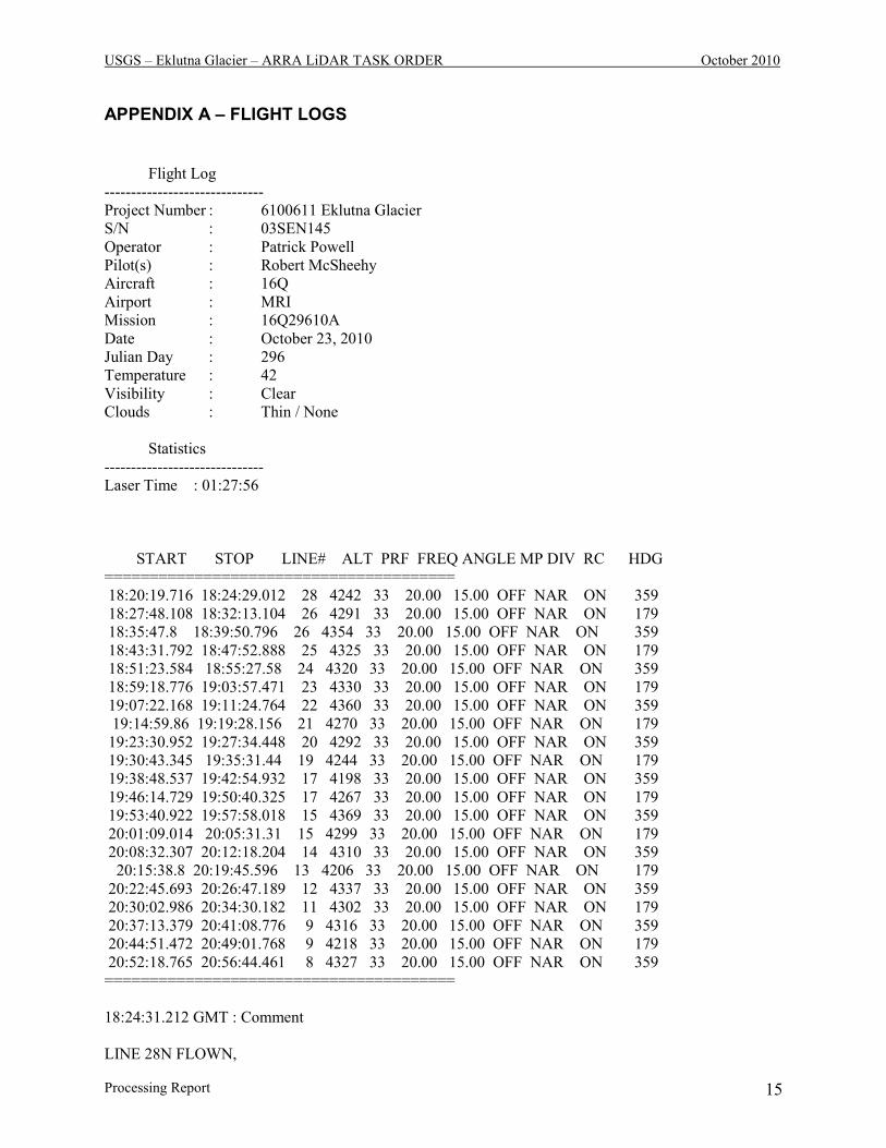
APPENDIX A – FLIGHT LOGS
Flight Log
------------------------------
Project Number : 6100611 Eklutna Glacier
S/N : 03SEN145
Operator : Patrick Powell
Pilot(s) : Robert McSheehy
Aircraft : 16Q
Airport : MRI
Mission : 16Q29610A
Date : October 23, 2010
Julian Day : 296
Temperature : 42
Visibility : Clear
Clouds : Thin / None
Statistics
------------------------------
Laser Time : 01:27:56
START STOP LINE# ALT PRF FREQ ANGLE MP DIV RC HDG
=======================================
18:20:19.716 18:24:29.012 28 4242 33 20.00 15.00 OFF NAR ON 359
18:27:48.108 18:32:13.104 26 4291 33 20.00 15.00 OFF NAR ON 179
18:35:47.8 18:39:50.796 26 4354 33 20.00 15.00 OFF NAR ON 359
18:43:31.792 18:47:52.888 25 4325 33 20.00 15.00 OFF NAR ON 179
18:51:23.584 18:55:27.58 24 4320 33 20.00 15.00 OFF NAR ON 359
18:59:18.776 19:03:57.471 23 4330 33 20.00 15.00 OFF NAR ON 179
19:07:22.168 19:11:24.764 22 4360 33 20.00 15.00 OFF NAR ON 359
19:14:59.86 19:19:28.156 21 4270 33 20.00 15.00 OFF NAR ON 179
19:23:30.952 19:27:34.448 20 4292 33 20.00 15.00 OFF NAR ON 359
19:30:43.345 19:35:31.44 19 4244 33 20.00 15.00 OFF NAR ON 179
19:38:48.537 19:42:54.932 17 4198 33 20.00 15.00 OFF NAR ON 359
19:46:14.729 19:50:40.325 17 4267 33 20.00 15.00 OFF NAR ON 179
19:53:40.922 19:57:58.018 15 4369 33 20.00 15.00 OFF NAR ON 359
20:01:09.014 20:05:31.31 15 4299 33 20.00 15.00 OFF NAR ON 179
20:08:32.307 20:12:18.204 14 4310 33 20.00 15.00 OFF NAR ON 359
20:15:38.8 20:19:45.596 13 4206 33 20.00 15.00 OFF NAR ON 179
20:22:45.693 20:26:47.189 12 4337 33 20.00 15.00 OFF NAR ON 359
20:30:02.986 20:34:30.182 11 4302 33 20.00 15.00 OFF NAR ON 179
20:37:13.379 20:41:08.776 9 4316 33 20.00 15.00 OFF NAR ON 359
20:44:51.472 20:49:01.768 9 4218 33 20.00 15.00 OFF NAR ON 179
20:52:18.765 20:56:44.461 8 4327 33 20.00 15.00 OFF NAR ON 359
=======================================
18:24:31.212 GMT : Comment
LINE 28N FLOWN,
USGS – Eklutna Glacier – ARRA LiDAR TASK ORDER October 2010
Processing Report 16
18:32:20.304 GMT : Comment
LINE 27S FLOWN,
18:39:54.796 GMT : Comment
LINE 26N FLOWN,
18:47:52.588 GMT : Comment
LINE 25S FLOWN, SOME BAD RETURNS
18:55:36.78 GMT : Comment
LINE 24N FLOWN,
19:03:56.271 GMT : Comment
LINE 23S FLOWN,
19:11:24.264 GMT : Comment
LINE 22N FLOWN,
19:19:31.456 GMT : Comment
LINE 21S FLOWN,
19:27:38.048 GMT : Comment
LINE 20N FLOWN,
19:35:39.64 GMT : Comment
LINE 19S FLOWN,
19:43:01.032 GMT : Comment
LINE 18N FLOWN,
19:50:44.325 GMT : Comment
LINE 17S FLOWN,
19:58:22.317 GMT : Comment
LINE 16N FLOWN,
20:05:34.81 GMT : Comment
LINE 15S FLOWN,

USGS – Eklutna Glacier – ARRA LiDAR TASK ORDER October 2010
Processing Report 17
20:12:19.003 GMT : Comment
LINE 14N FLOWN,
20:19:47.596 GMT : Comment
LINE 13S FLOWN,
20:26:48.389 GMT : Comment
LINE 12N FLOWN,
20:35:49.081 GMT : Comment
LINE 11S FLOWN,
20:49:01.568 GMT : Comment
LINE 9S FLOWN,
20:56:55.06 GMT : Comment
LINE 8N FLOWN,
21:07:29.35 GMT : Comment
LINE 7S FLOWN

USGS – Eklutna Glacier – ARRA LiDAR TASK ORDER October 2010
Processing Report 18
Flight Log
------------------------------
Project Number : 6100611 Eklutna Glacier
S/N : 03SEN145
Operator : Patrick Powell
Pilot(s) : Robert McSheehy
Aircraft : 16Q
Airport : MRI
Mission : 16Q29610B
Date : October 23, 2010
Julian Day : 296
Temperature : 42
Visibility : Clear
Clouds : None
Statistics
------------------------------
Laser Time : 00:45:21
START STOP LINE# ALT PRF FREQ ANGLE MP DIV RC HDG
=======================================
22:22:16.436 22:22:37.336 33 3362 33 20.00 15.00 OFF NAR ON 88.77
22:29:48.229 22:33:08.925 33 4404 33 20.00 15.00 OFF NAR ON 88.77
22:38:25.02 22:42:52.315 1 4333 33 20.00 15.00 OFF NAR ON 179
22:45:49.112 22:49:43.408 2 4343 33 20.00 15.00 OFF NAR ON 359
22:52:37.805 22:57:03.301 3 4353 33 20.00 15.00 OFF NAR ON 179
23:00:04.298 23:03:59.394 4 4347 33 20.00 15.00 OFF NAR ON 359
23:07:16.291 23:11:46.886 6 4342 33 20.00 15.00 OFF NAR ON 179
23:15:03.483 23:19:03.879 6 4317 33 20.00 15.00 OFF NAR ON 359
23:22:28.976 23:26:51.472 7 4334 33 20.00 15.00 OFF NAR ON 179
23:32:14.166 23:35:17.863 32 3681 33 20.00 15.00 OFF NAR ON 315
23:38:29.86 23:41:44.057 31 3552 33 20.00 15.00 OFF NAR ON 135
23:44:46.054 23:48:02.151 30 3541 33 20.00 15.00 OFF NAR ON 315
23:51:26.148 23:54:47.644 29 3702 33 20.00 15.00 OFF NAR ON 135
23:58:51.54 00:00:20.939 29 3690 33 20.00 15.00 OFF NAR ON 135
=======================================
22:22:48.136 GMT : Comment
TEST STRIP
22:33:09.325 GMT : Comment
CROSSFLIGHT 33E FLOWN,
22:42:57.415 GMT : Comment
LINE 1S FLOWN,
22:49:47.108 GMT : Comment

USGS – Eklutna Glacier – ARRA LiDAR TASK ORDER October 2010
Processing Report 19
LINE 2N FLOWN,
22:57:01.401 GMT : Comment
LINE 3S FLOWN,
23:03:59.494 GMT : Comment
LINE 4N FLOWN,
23:11:44.287 GMT : Comment
LINE 5S FLOWN,
23:19:04.479 GMT : Comment
LINE 6N FLOWN,
23:26:50.372 GMT : Comment
LINE 7S FLOWN,
23:35:16.463 GMT : Comment
LINE 32N FLOWN,
23:41:44.657 GMT : Comment
LINE 31S FLOWN,
23:48:00.551 GMT : Comment
LINE 30N FLOWN,
23:55:00.644 GMT : Comment
LINE 29S FLOWN,
00:00:21.039 GMT : Comment
CROSSFLIGHT W 29-32

USGS – Eklutna Glacier – ARRA LiDAR TASK ORDER October 2010
Processing Report 20
Flight Log
------------------------------
Project Number : 6100611 Eklutna Glacier
S/N : 03SEN145
Operator : Patrick Powell
Pilot(s) : Robert McSheehy
Aircraft : 16Q
Airport : MRI
Mission : 16Q29610B
Date : October 23, 2010
Julian Day : 296
Temperature : 42
Visibility : Clear
Clouds : None
Statistics
------------------------------
Laser Time : 00:09:55
START STOP LINE# ALT PRF FREQ ANGLE MP DIV RC HDG
=======================================
02:33:14.91 02:33:38.31 4 1973 33 24.00 16.00 OFF NAR ON 118
02:34:49.409 02:35:12.508 4 2559 33 24.00 16.00 OFF NAR ON 118
02:35:49.108 02:36:09.907 4 2848 33 24.00 16.00 OFF NAR ON 118
02:38:50.504 02:39:58.903 4 2907 33 24.00 16.00 OFF NAR ON 118
02:43:16.7 02:44:16.999 5 3110 33 24.00 16.00 OFF NAR ON 298
02:47:27.296 02:48:12.095 6 2749 33 24.00 16.00 OFF NAR ON 30.04
02:50:35.292 02:51:19.392 1 2982 33 24.00 16.00 OFF NAR ON 345
02:54:37.288 02:55:23.087 2 2994 33 24.00 16.00 OFF NAR ON 165
02:57:57.885 02:58:47.384 3 3137 33 24.00 16.00 OFF NAR ON 76.12
03:00:49.482 03:01:47.181 10 2868 33 24.00 16.00 OFF NAR ON 179.44
03:05:33.277 03:06:36.776 7 2718 33 24.00 16.00 OFF NAR ON 270
03:09:29.973 03:10:44.472 8 2720 33 24.00 16.00 OFF NAR ON 90
03:13:28.869 03:14:37.168 9 2919 33 24.00 16.00 OFF NAR ON 270
=======================================
02:34:03.609 GMT : Comment
TEST STRIP
02:36:22.307 GMT : Comment
TEST STRIP WITH SHUTTERS IN OPEN POSITION

USGS – Eklutna Glacier – ARRA LiDAR TASK ORDER October 2010
Processing Report 21
02:39:58.603 GMT : Comment
LINE 4E FLOWN,
02:44:15.599 GMT : Comment
LINE 5W FLOWN,
02:48:10.795 GMT : Comment
LINE 6N FLOWN,
02:51:19.592 GMT : Comment
LINE 1N FLOWN,
02:55:22.688 GMT : Comment
LINE 2S FLOWN,
02:58:44.484 GMT : Comment
LINE 3E FLOWN,
03:01:47.181 GMT : Comment
LINE 10S FLOWN,
03:06:36.776 GMT : Comment
LINE 7W FLOWN,
03:10:42.972 GMT : Comment
LINE 8E FLOWN,
03:14:36.068 GMT : Comment
LINE 9W FLOWN,
USGS – Eklutna Glacier – ARRA LiDAR TASK ORDER October 2010
Processing Report 22
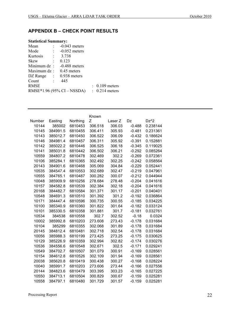
APPENDIX B – CHECK POINT RESULTS
Statistical Summary:
Mean : -0.043 meters
Mode : -0.052 meters
Kurtosis : 3.738
Skew : 0.123
Minimum dz : -0.488 meters
Maximum dz : 0.45 meters
DZ Range : 0.938 meters
Count : 445
RMSE : 0.109 meters
RMSE*1.96 (95% CI – NSSDA) : 0.214 meters
Number Easting Northing Known Z Laser Z Dz Dz^2
10144 385002 6810453 306.518 306.03 -0.488 0.238144
10145 384991.5 6810455 306.411 305.93 -0.481 0.231361
10143 385012.7 6810450 306.522 306.09 -0.432 0.186624
10146 384981.4 6810457 306.311 305.92 -0.391 0.152881
10142 385022.2 6810446 306.525 306.18 -0.345 0.119025
10141 385031.8 6810442 306.502 306.21 -0.292 0.085264
10559 384807.2 6810478 302.469 302.2 -0.269 0.072361
10106 385284.1 6810365 302.492 302.25 -0.242 0.058564
20143 384901.6 6810468 305.069 304.84 -0.229 0.052441
10535 384547.4 6810553 302.689 302.47 -0.219 0.047961
10555 384765.1 6810487 300.282 300.07 -0.212 0.044944
10048 385909.9 6810256 278.684 278.48 -0.204 0.041616
10157 384582.8 6810539 302.384 302.18 -0.204 0.041616
20168 384482.7 6810584 301.371 301.17 -0.201 0.040401
10548 384691.3 6810510 301.392 301.2 -0.192 0.036864
10171 384447.4 6810596 300.735 300.55 -0.185 0.034225
10100 385340.9 6810360 301.822 301.64 -0.182 0.033124
10101 385330.5 6810358 301.881 301.7 -0.181 0.032761
10534 384538 6810558 302.7 302.52 -0.18 0.0324
10002 385992.8 6810203 273.608 273.43 -0.178 0.031684
10104 385299 6810355 302.068 301.89 -0.178 0.031684
20145 384812.4 6810481 302.718 302.54 -0.178 0.031684
10056 385988.3 6810199 273.425 273.25 -0.175 0.030625
10129 385226.9 6810359 302.994 302.82 -0.174 0.030276
10536 384556.6 6810548 302.671 302.5 -0.171 0.029241
10549 384702.7 6810507 301.079 300.91 -0.169 0.028561
10154 384612.8 6810526 302.109 301.94 -0.169 0.028561
20038 385620.8 6810419 300.438 300.27 -0.168 0.028224
10040 385991.7 6810203 273.606 273.44 -0.166 0.027556
20144 384823.6 6810479 303.395 303.23 -0.165 0.027225
10550 384713.1 6810504 300.829 300.67 -0.159 0.025281
10558 384797.1 6810480 301.729 301.57 -0.159 0.025281

USGS – Eklutna Glacier – ARRA LiDAR TASK ORDER October 2010
Processing Report 23
10139 385125.9 6810395 304.709 304.55 -0.159 0.025281
10027 385895.9 6810280 280.647 280.49 -0.157 0.024649
10147 384694.9 6810513 301.297 301.14 -0.157 0.024649
20010 385324.6 6810354 301.994 301.84 -0.154 0.023716
10159 384564.1 6810548 302.643 302.49 -0.153 0.023409
10153 384623.2 6810524 302.142 301.99 -0.152 0.023104
10541 384606.1 6810525 302.222 302.07 -0.152 0.023104
10537 384566.2 6810542 302.562 302.41 -0.152 0.023104
10136 385154.8 6810382 304.122 303.97 -0.152 0.023104
10160 384554.3 6810553 302.739 302.59 -0.149 0.022201
20115 385361.5 6810365 301.786 301.64 -0.146 0.021316
10161 384545.3 6810559 302.774 302.63 -0.144 0.020736
20142 384912.5 6810466 305.113 304.97 -0.143 0.020449
20584 384783 6810483 300.819 300.68 -0.139 0.019321
10546 384663.1 6810514 302.169 302.03 -0.139 0.019321
10543 384631.6 6810518 302.259 302.12 -0.139 0.019321
20562 384529.7 6810563 302.649 302.51 -0.139 0.019321
20121 385296.8 6810354 302.058 301.92 -0.138 0.019044
10098 385361.8 6810365 301.757 301.62 -0.137 0.018769
10545 384652.9 6810515 302.267 302.13 -0.137 0.018769
20131 385190.3 6810368 303.606 303.47 -0.136 0.018496
20587 384814.4 6810477 302.915 302.78 -0.135 0.018225
10169 384467.3 6810590 300.864 300.73 -0.134 0.017956
10045 385884.7 6810283 281.363 281.23 -0.133 0.017689
10560 384823.8 6810475 303.493 303.36 -0.133 0.017689
10552 384733.9 6810495 300.34 300.21 -0.13 0.0169
10108 385285.6 6810385 303.33 303.2 -0.13 0.0169
10155 384603 6810530 302.169 302.04 -0.129 0.016641
10126 385258.9 6810355 302.458 302.33 -0.128 0.016384
10132 385195.3 6810366 303.568 303.44 -0.128 0.016384
10544 384642.7 6810517 302.257 302.13 -0.127 0.016129
10133 385185.1 6810369 303.717 303.59 -0.127 0.016129
10162 384536.1 6810564 302.756 302.63 -0.126 0.015876
10047 385900.1 6810269 279.835 279.71 -0.125 0.015625
10167 384487.2 6810583 301.565 301.44 -0.125 0.015625
10163 384526 6810569 302.694 302.57 -0.124 0.015376
10150 384655.2 6810519 302.143 302.02 -0.123 0.015129
10005 385951.7 6810289 279.312 279.19 -0.122 0.014884
10051 385923.7 6810228 276.461 276.34 -0.121 0.014641
10539 384585.9 6810533 302.321 302.2 -0.121 0.014641
10557 384786.7 6810482 301.07 300.95 -0.12 0.0144
20007 385293.5 6810351 302.17 302.05 -0.12 0.0144
10107 385284.3 6810375 302.89 302.77 -0.12 0.0144
20111 385403.8 6810378 301.699 301.58 -0.119 0.014161
20589 384836.6 6810473 304.149 304.03 -0.119 0.014161
10553 384743.8 6810492 300.167 300.05 -0.117 0.013689
20585 384793.8 6810481 301.475 301.36 -0.115 0.013225
20140 384940 6810462 305.485 305.37 -0.115 0.013225
10074 385610.1 6810422 301.124 301.01 -0.114 0.012996
10083 385515.5 6810411 303.164 303.05 -0.114 0.012996
10174 384417.3 6810606 301.613 301.5 -0.113 0.012769

USGS – Eklutna Glacier – ARRA LiDAR TASK ORDER October 2010
Processing Report 24
10542 384615.8 6810522 302.193 302.08 -0.113 0.012769
20586 384804.3 6810479 302.193 302.08 -0.113 0.012769
10004 385958.3 6810281 278.662 278.55 -0.112 0.012544
20163 384531.2 6810566 302.681 302.57 -0.111 0.012321
20148 384778.4 6810487 300.59 300.48 -0.11 0.0121
20158 384580.8 6810539 302.35 302.24 -0.11 0.0121
10001 385985.6 6810196 273.299 273.19 -0.109 0.011881
10551 384723.4 6810499 300.639 300.53 -0.109 0.011881
10556 384776 6810484 300.548 300.44 -0.108 0.011664
20094 385580.3 6810422 302.258 302.15 -0.108 0.011664
20126 385242.3 6810357 302.688 302.58 -0.108 0.011664
20132 385180.4 6810371 303.708 303.6 -0.108 0.011664
20160 384561.6 6810550 302.617 302.51 -0.107 0.011449
20117 385340.2 6810360 301.766 301.66 -0.106 0.011236
10033 385940.6 6810206 274.404 274.3 -0.104 0.010816
20017 385398.5 6810373 301.704 301.6 -0.104 0.010816
20599 385083.2 6810413 305.664 305.56 -0.104 0.010816
10049 385912.8 6810246 277.893 277.79 -0.103 0.010609
20556 384455.6 6810590 300.693 300.59 -0.103 0.010609
20154 384622.1 6810524 302.101 302 -0.101 0.010201
10538 384575.7 6810537 302.421 302.32 -0.101 0.010201
10109 385292.9 6810392 303.531 303.43 -0.101 0.010201
10028 385901.2 6810271 279.89 279.79 -0.1 0.01
10170 384457.3 6810593 300.67 300.57 -0.1 0.01
20006 385280.5 6810372 302.819 302.72 -0.099 0.009801
20081 385717 6810403 294.548 294.45 -0.098 0.009604
20146 384801.5 6810483 301.867 301.77 -0.097 0.009409
20103 385487.6 6810403 302.757 302.66 -0.097 0.009409
10105 385288.8 6810355 302.146 302.05 -0.096 0.009216
10085 385495 6810405 302.916 302.82 -0.096 0.009216
10052 385931.8 6810220 275.655 275.56 -0.095 0.009025
10168 384477.3 6810587 301.155 301.06 -0.095 0.009025
10151 384644.6 6810520 302.145 302.05 -0.095 0.009025
20129 385210.7 6810362 303.294 303.2 -0.094 0.008836
20110 385414.3 6810381 301.753 301.66 -0.093 0.008649
10127 385248.5 6810356 302.553 302.46 -0.093 0.008649
10177 384387.1 6810615 302.933 302.84 -0.093 0.008649
10173 384428 6810602 301.132 301.04 -0.092 0.008464
20175 384400.6 6810611 302.372 302.28 -0.092 0.008464
10072 385631.5 6810421 299.951 299.86 -0.091 0.008281
10102 385320.3 6810356 301.911 301.82 -0.091 0.008281
10540 384596.6 6810528 302.231 302.14 -0.091 0.008281
20025 385484.1 6810399 302.661 302.57 -0.091 0.008281
10097 385372.4 6810369 301.73 301.64 -0.09 0.0081
10175 384407.1 6810609 302.11 302.02 -0.09 0.0081
10137 385145.3 6810386 304.26 304.17 -0.09 0.0081
10003 385965.1 6810274 277.999 277.91 -0.089 0.007921
20581 384749.1 6810490 300.049 299.96 -0.089 0.007921
20588 384825.2 6810475 303.529 303.44 -0.089 0.007921
10131 385205.2 6810363 303.408 303.32 -0.088 0.007744
10043 385881.3 6810302 282.527 282.44 -0.087 0.007569

USGS – Eklutna Glacier – ARRA LiDAR TASK ORDER October 2010
Processing Report 25
10176 384397.1 6810612 302.567 302.48 -0.087 0.007569
20151 384747 6810495 300.106 300.02 -0.086 0.007396
20553 384415.4 6810602 301.646 301.56 -0.086 0.007396
10099 385352.1 6810363 301.786 301.7 -0.086 0.007396
20118 385329.4 6810357 301.856 301.77 -0.086 0.007396
20011 385335.4 6810355 301.886 301.8 -0.086 0.007396
20559 384494.3 6810577 301.926 301.84 -0.086 0.007396
20155 384611.4 6810527 302.046 301.96 -0.086 0.007396
20128 385221.1 6810360 303.106 303.02 -0.086 0.007396
20172 384440.9 6810598 300.765 300.68 -0.085 0.007225
10554 384754 6810489 300.094 300.01 -0.084 0.007056
20557 384468.8 6810585 300.914 300.83 -0.084 0.007056
20093 385590.5 6810423 301.934 301.85 -0.084 0.007056
20552 384402 6810607 302.344 302.26 -0.084 0.007056
20161 384551.5 6810555 302.694 302.61 -0.084 0.007056
10135 385164.9 6810377 303.934 303.85 -0.084 0.007056
20033 385566.6 6810418 302.553 302.47 -0.083 0.006889
20133 385170.8 6810375 303.863 303.78 -0.083 0.006889
20135 385149.8 6810384 304.163 304.08 -0.083 0.006889
20583 384772 6810485 300.362 300.28 -0.082 0.006724
20558 384481.8 6810581 301.382 301.3 -0.082 0.006724
10148 384676.4 6810516 301.862 301.78 -0.082 0.006724
10032 385934.4 6810215 275.281 275.2 -0.081 0.006561
10007 385939.1 6810305 280.441 280.36 -0.081 0.006561
10094 385403.2 6810378 301.701 301.62 -0.081 0.006561
20109 385424.7 6810384 301.821 301.74 -0.081 0.006561
10158 384573.4 6810543 302.521 302.44 -0.081 0.006561
10134 385174.8 6810373 303.821 303.74 -0.081 0.006561
10039 385983.8 6810195 273.3 273.22 -0.08 0.0064
20045 385813.7 6810372 289.529 289.45 -0.079 0.006241
20165 384512.2 6810574 302.438 302.36 -0.078 0.006084
10180 384356.9 6810625 303.808 303.73 -0.078 0.006084
10090 385445.8 6810390 302.107 302.03 -0.077 0.005929
20602 385279.6 6810402 303.797 303.72 -0.077 0.005929
20580 384737.8 6810494 300.206 300.13 -0.076 0.005776
20137 385130.7 6810393 304.546 304.47 -0.076 0.005776
20139 385110.2 6810403 305.026 304.95 -0.076 0.005776
20086 385666 6810416 297.845 297.77 -0.075 0.005625
20555 384442.2 6810594 300.725 300.65 -0.075 0.005625
20174 384410.9 6810608 301.875 301.8 -0.075 0.005625
10179 384367.1 6810622 303.555 303.48 -0.075 0.005625
10115 385312.2 6810413 303.905 303.83 -0.075 0.005625
20565 384563.7 6810544 302.534 302.46 -0.074 0.005476
10084 385505.2 6810408 303.054 302.98 -0.074 0.005476
20549 384361.5 6810620 303.634 303.56 -0.074 0.005476
20593 384880.7 6810468 304.624 304.55 -0.074 0.005476
10130 385216.2 6810361 303.203 303.13 -0.073 0.005329
20002 385247.9 6810395 304.143 304.07 -0.073 0.005329
20173 384430.6 6810601 301.012 300.94 -0.072 0.005184
10547 384673.2 6810513 301.962 301.89 -0.072 0.005184
10124 385278.9 6810358 302.192 302.12 -0.072 0.005184

USGS – Eklutna Glacier – ARRA LiDAR TASK ORDER October 2010
Processing Report 26
10138 385135.6 6810391 304.402 304.33 -0.072 0.005184
20061 385951.9 6810288 279.201 279.13 -0.071 0.005041
20596 385049 6810429 306.171 306.1 -0.071 0.005041
10066 385696.6 6810408 295.81 295.74 -0.07 0.0049
20564 384551.7 6810551 302.639 302.57 -0.069 0.004761
20551 384388.6 6810611 302.859 302.79 -0.069 0.004761
10077 385578.7 6810422 302.288 302.22 -0.068 0.004624
10178 384377.1 6810619 303.268 303.2 -0.068 0.004624
20152 384643.5 6810520 302.137 302.07 -0.067 0.004489
20579 384726.7 6810498 300.486 300.42 -0.066 0.004356
20171 384451.4 6810595 300.626 300.56 -0.066 0.004356
10076 385589.4 6810422 301.946 301.88 -0.066 0.004356
20167 384492.7 6810581 301.805 301.74 -0.065 0.004225
20164 384521.5 6810571 302.575 302.51 -0.065 0.004225
20138 385120.2 6810398 304.805 304.74 -0.065 0.004225
10172 384437.5 6810599 300.854 300.79 -0.064 0.004096
20008 385304.5 6810352 302.134 302.07 -0.064 0.004096
20566 384575.1 6810538 302.394 302.33 -0.064 0.004096
20136 385140 6810388 304.334 304.27 -0.064 0.004096
20162 384541.4 6810560 302.733 302.67 -0.063 0.003969
20550 384375 6810615 303.293 303.23 -0.063 0.003969
20159 384571.6 6810544 302.482 302.42 -0.062 0.003844
10166 384496.7 6810580 302.001 301.94 -0.061 0.003721
10164 384516.2 6810573 302.541 302.48 -0.061 0.003721
20548 384348.1 6810625 303.971 303.91 -0.061 0.003721
20141 384922.7 6810464 305.211 305.15 -0.061 0.003721
20597 385063.8 6810422 305.97 305.91 -0.06 0.0036
20036 385599.3 6810420 301.469 301.41 -0.059 0.003481
20130 385200.4 6810364 303.459 303.4 -0.059 0.003481
10152 384633.4 6810522 302.147 302.09 -0.057 0.003249
20000 385252.5 6810412 304.417 304.36 -0.057 0.003249
10035 385957.8 6810194 273.275 273.22 -0.055 0.003025
10096 385382.3 6810371 301.715 301.66 -0.055 0.003025
20157 384590.2 6810535 302.195 302.14 -0.055 0.003025
20034 385577.7 6810419 302.233 302.18 -0.053 0.002809
10165 384506.2 6810577 302.303 302.25 -0.053 0.002809
20170 384462 6810591 300.712 300.66 -0.052 0.002704
20567 384586.8 6810532 302.232 302.18 -0.052 0.002704
20088 385644 6810420 299.181 299.13 -0.051 0.002601
10533 384388.4 6810611 302.841 302.79 -0.051 0.002601
10081 385536 6810416 303.101 303.05 -0.051 0.002601
20116 385350.8 6810362 301.76 301.71 -0.05 0.0025
20120 385307.7 6810355 301.98 301.93 -0.05 0.0025
10156 384593.2 6810534 302.21 302.16 -0.05 0.0025
20001 385245.4 6810405 304.31 304.26 -0.05 0.0025
20592 384870.5 6810469 304.57 304.52 -0.05 0.0025
10031 385929 6810224 275.959 275.91 -0.049 0.002401
10025 385886 6810298 282.039 281.99 -0.049 0.002401
20069 385933.5 6810301 280.398 280.35 -0.048 0.002304
10149 384666.4 6810518 302.068 302.02 -0.048 0.002304
20123 385274.9 6810355 302.278 302.23 -0.048 0.002304

USGS – Eklutna Glacier – ARRA LiDAR TASK ORDER October 2010
Processing Report 27
20582 384760.6 6810488 300.106 300.06 -0.046 0.002116
20037 385609.9 6810419 300.955 300.91 -0.045 0.002025
20598 385073.3 6810417 305.825 305.78 -0.045 0.002025
10065 385707.4 6810405 295.104 295.06 -0.044 0.001936
10103 385310.1 6810355 302.043 302 -0.043 0.001849
20177 384378.8 6810618 303.183 303.14 -0.043 0.001849
20067 385920.6 6810317 281.502 281.46 -0.042 0.001764
10010 385921.4 6810330 282.292 282.25 -0.042 0.001764
20085 385676.5 6810414 297.142 297.1 -0.042 0.001764
20091 385611.6 6810422 301.002 300.96 -0.042 0.001764
20560 384506.5 6810573 302.321 302.28 -0.041 0.001681
20156 384600.8 6810531 302.07 302.03 -0.04 0.0016
20178 384368.1 6810622 303.49 303.45 -0.04 0.0016
10093 385413.4 6810381 301.739 301.7 -0.039 0.001521
20569 384610.5 6810523 302.109 302.07 -0.039 0.001521
20125 385253.2 6810356 302.509 302.47 -0.039 0.001521
20600 385285.2 6810377 302.869 302.83 -0.039 0.001521
10050 385916.8 6810235 277.198 277.16 -0.038 0.001444
10022 385873.4 6810327 284.247 284.21 -0.037 0.001369
20568 384598.6 6810527 302.137 302.1 -0.037 0.001369
10023 385876.8 6810317 283.536 283.5 -0.036 0.001296
10059 385783.7 6810381 290.626 290.59 -0.036 0.001296
10068 385675.3 6810414 297.266 297.23 -0.036 0.001296
20114 385372 6810368 301.686 301.65 -0.036 0.001296
20591 384859.2 6810471 304.546 304.51 -0.036 0.001296
20166 384502.5 6810578 302.184 302.15 -0.034 0.001156
20590 384847.9 6810472 304.414 304.38 -0.034 0.001156
10036 385987.2 6810199 273.432 273.4 -0.032 0.001024
20068 385925.5 6810308 280.912 280.88 -0.032 0.001024
10092 385423.6 6810384 301.812 301.78 -0.032 0.001024
20571 384634.5 6810518 302.152 302.12 -0.032 0.001024
20563 384540.7 6810557 302.642 302.61 -0.032 0.001024
10095 385392.3 6810374 301.69 301.66 -0.03 0.0009
20561 384518.3 6810568 302.55 302.52 -0.03 0.0009
20601 385284.2 6810392 303.42 303.39 -0.03 0.0009
20179 384357.5 6810625 303.759 303.73 -0.029 0.000841
20072 385931.5 6810322 281.468 281.44 -0.028 0.000784
20578 384715.7 6810503 300.698 300.67 -0.028 0.000784
20009 385314.6 6810352 302.008 301.98 -0.028 0.000784
10118 385272.6 6810410 303.988 303.96 -0.028 0.000784
20603 385271.6 6810409 303.988 303.96 -0.028 0.000784
20019 385418.3 6810378 301.707 301.68 -0.027 0.000729
20095 385569.7 6810422 302.557 302.53 -0.027 0.000729
10038 385974.2 6810191 273.176 273.15 -0.026 0.000676
20570 384622.5 6810520 302.096 302.07 -0.026 0.000676
10082 385525.7 6810413 303.216 303.19 -0.026 0.000676
10046 385891.7 6810275 280.565 280.54 -0.025 0.000625
20575 384681.2 6810511 301.605 301.58 -0.025 0.000625
20169 384472.4 6810588 300.944 300.92 -0.024 0.000576
10091 385434.6 6810387 301.933 301.91 -0.023 0.000529
20574 384669.7 6810513 301.963 301.94 -0.023 0.000529

USGS – Eklutna Glacier – ARRA LiDAR TASK ORDER October 2010
Processing Report 28
20176 384389.6 6810615 302.803 302.78 -0.023 0.000529
20058 385971.3 6810265 277.232 277.21 -0.022 0.000484
20554 384428.8 6810598 301.082 301.06 -0.022 0.000484
20112 385393.2 6810375 301.662 301.64 -0.022 0.000484
20113 385382.6 6810372 301.672 301.65 -0.022 0.000484
10053 385937.7 6810212 274.911 274.89 -0.021 0.000441
10116 385302.2 6810412 303.881 303.86 -0.021 0.000441
10006 385945.2 6810297 279.85 279.83 -0.02 0.0004
10026 385891 6810289 281.34 281.32 -0.02 0.0004
20153 384632.9 6810522 302.1 302.08 -0.02 0.0004
20079 385738 6810396 293.159 293.14 -0.019 0.000361
20107 385445.2 6810390 302.047 302.03 -0.017 0.000289
20104 385476.4 6810400 302.597 302.58 -0.017 0.000289
20013 385355.3 6810360 301.776 301.76 -0.016 0.000256
10064 385718.1 6810402 294.455 294.44 -0.015 0.000225
20149 384768.5 6810490 300.145 300.13 -0.015 0.000225
20577 384704.4 6810507 300.875 300.86 -0.015 0.000225
10079 385556.2 6810420 302.855 302.84 -0.015 0.000225
20087 385655.1 6810418 298.493 298.48 -0.013 0.000169
20015 385376.4 6810366 301.773 301.76 -0.013 0.000169
10120 385261.4 6810390 303.913 303.9 -0.013 0.000169
20059 385964.7 6810273 277.912 277.9 -0.012 0.000144
20573 384658.1 6810515 302.131 302.12 -0.011 0.000121
20083 385696.6 6810409 295.75 295.74 -0.01 0.0001
10067 385685.9 6810411 296.588 296.58 -0.008 0.000064
20005 385273.9 6810380 303.398 303.39 -0.008 0.000064
20082 385706.3 6810406 295.177 295.17 -0.007 0.000049
20108 385435 6810387 301.927 301.92 -0.007 0.000049
10080 385546.2 6810418 303.037 303.03 -0.007 0.000049
20595 385019 6810442 306.157 306.15 -0.007 0.000049
20018 385408.3 6810376 301.646 301.64 -0.006 0.000036
20119 385318.6 6810356 301.886 301.88 -0.006 0.000036
10089 385455.4 6810393 302.216 302.21 -0.006 0.000036
10112 385323.9 6810395 303.675 303.67 -0.005 0.000025
20594 384890.7 6810466 304.625 304.62 -0.005 0.000025
10019 385866 6810357 286.343 286.34 -0.003 0.000009
20026 385493.8 6810402 302.803 302.8 -0.003 0.000009
10060 385771.3 6810385 291.212 291.21 -0.002 0.000004
20106 385455.1 6810393 302.22 302.22 0 0
20060 385958.3 6810280 278.539 278.54 0.001 0.000001
10071 385642.7 6810420 299.299 299.3 0.001 0.000001
10563 385271.5 6810412 304.097 304.1 0.003 0.000009
10073 385620.1 6810422 300.564 300.57 0.006 0.000036
20099 385528.2 6810414 303.134 303.14 0.006 0.000036
20012 385345.2 6810358 301.802 301.81 0.008 0.000064
10110 385303.5 6810393 303.56 303.57 0.01 0.0001
20062 385947.6 6810298 279.818 279.83 0.012 0.000144
20150 384758.6 6810492 300.008 300.02 0.012 0.000144
20576 384692.8 6810509 301.198 301.21 0.012 0.000144
20105 385464.9 6810396 302.358 302.37 0.012 0.000144
10125 385269.1 6810355 302.337 302.35 0.013 0.000169

USGS – Eklutna Glacier – ARRA LiDAR TASK ORDER October 2010
Processing Report 29
10000 385976.7 6810191 273.226 273.24 0.014 0.000196
20089 385632.6 6810421 299.823 299.84 0.017 0.000289
20035 385588.3 6810420 301.893 301.91 0.017 0.000289
10057 385997.3 6810216 274.122 274.14 0.018 0.000324
10122 385277.9 6810379 303.132 303.15 0.018 0.000324
10117 385282.6 6810409 303.932 303.95 0.018 0.000324
20572 384646.3 6810516 302.171 302.19 0.019 0.000361
10054 385943.4 6810204 274.049 274.07 0.021 0.000441
20053 385937.2 6810210 274.819 274.84 0.021 0.000441
20039 385632.1 6810418 299.768 299.79 0.022 0.000484
20147 384790.2 6810485 301.078 301.1 0.022 0.000484
20016 385387.3 6810370 301.658 301.68 0.022 0.000484
10111 385313.7 6810393 303.638 303.66 0.022 0.000484
20065 385934.9 6810325 281.496 281.52 0.024 0.000576
10030 385924 6810233 276.655 276.68 0.025 0.000625
20014 385365.6 6810363 301.745 301.77 0.025 0.000625
20022 385448 6810388 302.075 302.1 0.025 0.000625
20122 385285.8 6810354 302.164 302.19 0.026 0.000676
10088 385465.1 6810396 302.363 302.39 0.027 0.000729
10123 385280.9 6810368 302.502 302.53 0.028 0.000784
10121 385271 6810387 303.551 303.58 0.029 0.000841
20052 385932.7 6810219 275.51 275.54 0.03 0.0009
20127 385231.6 6810358 302.899 302.93 0.031 0.000961
20027 385503.5 6810405 302.949 302.98 0.031 0.000961
20030 385534.2 6810413 303.028 303.06 0.032 0.001024
20029 385523.1 6810410 303.068 303.1 0.032 0.001024
10034 385948 6810199 273.686 273.72 0.034 0.001156
20073 385923.3 6810329 282.104 282.14 0.036 0.001296
10024 385881.2 6810308 282.804 282.84 0.036 0.001296
10087 385474.9 6810399 302.574 302.61 0.036 0.001296
20057 385995.1 6810209 273.833 273.87 0.037 0.001369
10015 385891.8 6810379 285.652 285.69 0.038 0.001444
20023 385457.9 6810391 302.222 302.26 0.038 0.001444
20048 385892.3 6810288 281.077 281.12 0.043 0.001849
10069 385664.5 6810416 297.946 297.99 0.044 0.001936
20020 385428.2 6810381 301.781 301.83 0.049 0.002401
10029 385918.5 6810242 277.449 277.5 0.051 0.002601
20066 385924.5 6810326 281.899 281.95 0.051 0.002601
20084 385686.7 6810411 296.489 296.54 0.051 0.002601
20092 385601.1 6810423 301.469 301.52 0.051 0.002601
20050 385901.9 6810270 279.758 279.81 0.052 0.002704
20098 385538.1 6810416 303.067 303.12 0.053 0.002809
20041 385773.8 6810381 291.005 291.06 0.055 0.003025
20096 385558.9 6810420 302.825 302.88 0.055 0.003025
20071 385939.5 6810316 280.873 280.93 0.057 0.003249
10114 385322.4 6810410 303.973 304.03 0.057 0.003249
20004 385264.8 6810384 303.88 303.94 0.06 0.0036
20024 385467.8 6810394 302.349 302.41 0.061 0.003721
20003 385255.6 6810389 304.097 304.16 0.063 0.003969
10070 385653.7 6810418 298.645 298.71 0.065 0.004225
10009 385926.7 6810321 281.654 281.72 0.066 0.004356

USGS – Eklutna Glacier – ARRA LiDAR TASK ORDER October 2010
Processing Report 30
20101 385507.5 6810409 303.053 303.12 0.067 0.004489
20031 385545 6810415 302.941 303.01 0.069 0.004761
10562 385037.5 6810434 306.05 306.12 0.07 0.0049
20124 385264 6810355 302.419 302.49 0.071 0.005041
10119 385262.5 6810412 304.119 304.19 0.071 0.005041
20032 385555.8 6810417 302.775 302.85 0.075 0.005625
10017 385872 6810375 286.604 286.68 0.076 0.005776
20100 385518 6810411 303.163 303.24 0.077 0.005929
10113 385329.9 6810403 303.973 304.05 0.077 0.005929
20043 385793.5 6810376 290.152 290.23 0.078 0.006084
10075 385599.8 6810422 301.532 301.61 0.078 0.006084
20051 385930.1 6810229 276.17 276.25 0.08 0.0064
20064 385941.1 6810317 280.89 280.97 0.08 0.0064
10561 384883.9 6810467 304.498 304.58 0.082 0.006724
10062 385744.9 6810394 292.727 292.81 0.083 0.006889
10018 385865.7 6810367 286.845 286.93 0.085 0.007225
10037 385994.3 6810207 273.644 273.73 0.086 0.007396
20047 385887 6810296 281.854 281.94 0.086 0.007396
20080 385727.5 6810399 293.884 293.97 0.086 0.007396
10044 385878.9 6810292 282.128 282.22 0.092 0.008464
20046 385873.7 6810325 284.097 284.19 0.093 0.008649
20097 385548.6 6810419 302.956 303.05 0.094 0.008836
10042 385891.5 6810301 281.885 281.98 0.095 0.009025
20049 385896.9 6810278 280.382 280.48 0.098 0.009604
10016 385881.7 6810378 286.131 286.23 0.099 0.009801
10078 385567.7 6810421 302.61 302.71 0.1 0.01
10008 385932.8 6810313 281.018 281.12 0.102 0.010404
10055 385969.6 6810192 273.185 273.29 0.105 0.011025
20075 385913.4 6810347 283.353 283.46 0.107 0.011449
10086 385484.9 6810402 302.729 302.84 0.111 0.012321
20021 385438.2 6810385 301.938 302.05 0.112 0.012544
20102 385497.6 6810406 302.915 303.03 0.115 0.013225
20090 385622.1 6810422 300.414 300.53 0.116 0.013456
10128 385237.3 6810358 302.754 302.87 0.116 0.013456
20040 385763.9 6810384 291.569 291.69 0.121 0.014641
10061 385760.8 6810388 291.839 291.96 0.121 0.014641
20042 385783.7 6810378 290.512 290.64 0.128 0.016384
20063 385945.1 6810308 280.341 280.47 0.129 0.016641
20078 385748.1 6810393 292.558 292.69 0.132 0.017424
20074 385917.7 6810337 282.68 282.82 0.14 0.0196
20028 385513.3 6810408 303.027 303.17 0.143 0.020449
10058 385803.8 6810377 289.704 289.85 0.146 0.021316
10063 385734.2 6810397 293.391 293.55 0.159 0.025281
20070 385942.6 6810306 280.336 280.5 0.164 0.026896
20077 385767.9 6810386 291.401 291.57 0.169 0.028561
20054 385944.4 6810202 273.77 273.94 0.17 0.0289
10021 385870.8 6810337 284.76 284.93 0.17 0.0289
10012 385909.4 6810356 283.846 284.02 0.174 0.030276
20076 385909.4 6810357 283.95 284.13 0.18 0.0324
20056 385963.2 6810195 273.095 273.29 0.195 0.038025
20044 385803.5 6810373 289.689 289.9 0.211 0.044521

USGS – Eklutna Glacier – ARRA LiDAR TASK ORDER October 2010
Processing Report 31
10013 385905.4 6810366 284.475 284.7 0.225 0.050625
10020 385868.2 6810347 285.484 285.73 0.246 0.060516
10041 385996.3 6810212 273.746 274.04 0.294 0.086436
10011 385916.4 6810339 282.613 282.94 0.327 0.106929
20055 385952.9 6810197 273.04 273.49 0.45 0.2025