01160021 sec05-02 hydrology and water quality · • water supply assessment and compliance letter...
TRANSCRIPT

Rich Haven Specific Plan - Draft EIR Hydrology and Water Quality
Michael Brandman Associates 5.2-1 H:\Client (PN-JN)\0116\01160021\DEIR\01160021_Sec05-02_Hydrology and Water Quality.doc
5.2 - HYDROLOGY AND WATER QUALITY
5.2.1 - Introduction
This section of the Draft EIR evaluates the potentially significant impacts to hydrology and water quality and includes information contained in the New Model Colony (NMC) Final EIR. Additional information specific to the project site that may not have been included in the broad, program-level evaluation in the NMC Final EIR is also included.
Information in this section is based upon the following documents and correspondence received on the Notice of Preparation:
• Preliminary Geotechnical Investigation for the Rich Haven Specific Plan, Petra Geotechnical Inc., September 27, 2005. The complete report is contained in Appendix C of the Technical Appendices.
• NMC Final EIR, City of Ontario, 1997.
• Water and Recycled Water Master Plan, Final Report, MWH Americas, Inc May, 2006.
• Master Plan of Drainage for the NMC, City of Ontario, October 2000.
• Water Supply Assessment and Compliance Letter for the Rich Haven Specific Plan, Albert A. Webb Associates, June 22, 2007.
• Initial Study/Mitigated Negative Declaration, NMC Infrastructure Master Plans, City of Ontario, August 2002.
• General Stormwater permits issued for the NMC General Plan Area. The NMC Final EIR evaluated potential impacts to water resources, which included hydrology and water quality. The NMC Final EIR stated that the existing stormwater infrastructure is inadequate for the planned development of the NMC. The NMC Final EIR also identified that the ultimate transition from the predominantly agricultural uses to the planned urban uses would eliminate the impacts to groundwater from nitrates and total dissolved solids. However, the planned uses would potentially contribute to contaminants related to urban development, related to both the short-term construction-related activities and the long-term operational impacts.
The NMC Final EIR stated that the planned development would require a stormwater collection system that would be capable of handling the increased stormwater flows from the additional impervious surfaces associated with urban type land uses. This system would most likely be a network of storm drains and detention basins. Individual development within the NMC would be
Hydrology and Water Quality Rich Haven Specific Plan - Draft EIR
5.2-2 Michael Brandman Associates H:\Client (PN-JN)\0116\01160021\DEIR\01160021_Sec05-02_Hydrology and Water Quality.doc
required to contribute a Fair Share contribution to the development of this infrastructure. The NMC Final EIR stated that any projects that are proposed prior to the completion of the NMC-programmed stormwater system would be required to accommodate excess flows beyond existing offsite flows through using onsite stormwater detention basins. With the implementation of these interim control measures, no excess stormwater flows would be conveyed offsite from a proposed development project and would not contribute to offsite flooding.
The NMC Final EIR also stated that individual development projects would be required to conform to various stormwater control measures, such as the preparation of s Stormwater Pollution Prevention Program (SWPPP) and a Water Quality Management Plan (WQMP).
Subsequent to the preparation of the NMC Final EIR, the City prepared the Master Plan of Drainage (MPD) to provide a guide to developing storm drain systems intended to serve the entire NMC, which included two alternatives for regional and secondary drainage facilities. Alternative 1 is a traditional storm drain system, which intercepts runoff throughout the NMC and conveys the runoff to the Prado Flood Control Basin. Alternative 2 provides for permanent detention basins at strategic locations throughout the NMC to reduce the size and cost of downstream drainage systems. The MPD recommended adopting Alternative 1 and using this system as a guide for future development of the drainage system facilities for the entire NMC. However, the MPD stated that as the NMC develops, it would be likely that alternate routing of stormwater drainage facilities would be proposed.
Development phasing throughout the entire NMC is dependent upon many market factors and could happen in a variety of ways. Therefore, the phasing of the MPD will depend on the pattern of development within the NMC. The MPD anticipated that many development projects will be constructed in the NMC prior to completion of downstream MPD facilities. However, the MPD anticipated that CEQA review will be completed at the time of Specific Plan approval and infrastructure development. These projects will be required to construct temporary or interim detention facilities to attenuate flows to equal or less than the magnitude of flows experienced before the project area was developed. In addition, the MPD recommends that the County Line Stormwater Channel be recognized as the drainage system with top priority for construction because it is the mainline system for all areas east of the Cucamonga Creek Channel, which includes the project site, and provides necessary protection for Riverside County properties to the south. Separate CEQA review will be conducted when County Line Stormwater Channel is considered for approval.
To evaluate the potential impacts of implementing the MPD, the City prepared an Initial Study/Mitigated Negative Declaration for water, wastewater, and drainage infrastructure plans (Infrastructure Plans IS/MND). The Infrastructure Plans IS/MND stated that with the implementation

Rich Haven Specific Plan - Draft EIR Hydrology and Water Quality
Michael Brandman Associates 5.2-3 H:\Client (PN-JN)\0116\01160021\DEIR\01160021_Sec05-02_Hydrology and Water Quality.doc
of mitigation measures identified in the NMC Final EIR, and the implementation of the MPD, flooding impacts within the NMC would be below the level of significance. The Infrastructure Plans IS/MND further stated that separate environmental review would be conducted for individual development projects within the NMC, and the Infrastructure Plans IS/MND reflected the statements in the NMC Final EIR that development projects would be required to install interim stormwater retention basins in advance of the completed NMC-programmed stormwater system.
The Infrastructure Plans IS/MND also recommended a mitigation measure to ensure coordination between the City and adjacent jurisdictions for regional infrastructure improvements, such as the County Line Stormwater Channel. Implementation of this mitigation measure would eliminate potentially significant impacts related to infrastructure.
The City is currently evaluating the construction of a regional stormwater runoff treatment facility for the sub-watershed area that the project site is located within. At this time, the size and location of the regional treatment facility are unknown. The City is presuming that the facility will be located in close proximity to Mill Creek Channel out-fall area. This facility would serve the eastern portion of the NMC. Other treatment facilities could be developed in the western portion of the NMC. These facilities would be designed for expansion as development occurs. Additionally, onsite treatment control measures will be required by each development to supplement the proposed regional treatment facility to the satisfaction of the City Engineer.
5.2.2 - Existing Conditions
The existing conditions will be described in terms of the project site’s setting in a regional context and the actual conditions on the project site.
Regional Conditions The project site is located in the central portion of the Chino Groundwater Basin and within the Santa Ana River Watershed. Alluvium depth in the region varies from 400 to 1,500 feet below ground surface (BGS). Bedrock consists of Tertiary sedimentary and igneous rock. Extensive dairy operations in the region have resulted in the degradation of surface and groundwater quality. This historic agricultural development pattern does not result in high-levels of stormwater runoff that are typically associated with urban types of land uses, due to the extensive amounts of pervious surfaces.
Hydrology and Water Quality Rich Haven Specific Plan - Draft EIR
5.2-4 Michael Brandman Associates H:\Client (PN-JN)\0116\01160021\DEIR\01160021_Sec05-02_Hydrology and Water Quality.doc
Groundwater Quality With some minor exceptions, all of the constituents required for monitoring are below the Maximum Contaminant Levels established by the California Department of Health Services in its Primary Drinking Water Standards, according to the City’s 2003 Water Quality Report.
Quality of water related to total dissolved solids and nitrates in the Chino Basin transitions from generally excellent in the northern portion of the City to generally poor in the southern portion. In addition, variations occur in water quality underlying the City regarding these two constituents. Pockets of poor water quality have been observed within areas of otherwise excellent water quality. However, the quality of the groundwater below the project area is unknown.
According to Figure 3-A of the Water Master Plan, there are several groundwater contamination plumes resulting from industrial activity located in the Chino Basin. These are the Airport Plume located approximately 2.5 miles northwest of the project site, the GE Plume located approximately 5 miles northwest of the project site, and the Kaiser Plume located approximately 4 miles northeast of the project site.
Surface Water Quality Stormwater runoff from the agricultural and dairy lands, due to extensive pervious surfaces, is not as extensive as from urban type uses. The NMC Final EIR stated that following periods of high precipitation, runoff from agricultural lands accumulates along roadways and surface depressions within the NMC where it percolates through the soil, transporting excess salts and nutrients into the groundwater, enters Cucamonga Creek and then discharges into the Prado Basin thereby transporting dissolved salts and suspended solids and nutrients. Figure WR-3 of the NMC Final EIR identified the area of the NMC that is subject to flooding. The closest boundary of this area is approximately 0.9 miles southwest of the project site.
Quality of Domestic Water Supplies The City domestic water supply production facilities are currently in compliance with applicable standards and regulations. According to the City’s 2003 Water Quality Report, the latest report filed with the California Department of Health Services indicates that domestic water delivered to City customers is in compliance with, or within established maximum contaminant levels, for all major constituents required for monitoring.
Groundwater Recharge Facilities According to Figure 5-1 of the NMC Water Supply Assessment, the closest groundwater recharge facilities to the project site are the Riverside Groundwater Recharge Basin located in Riverside
Rich Haven Specific Plan - Draft EIR Hydrology and Water Quality
Michael Brandman Associates 5.2-5 H:\Client (PN-JN)\0116\01160021\DEIR\01160021_Sec05-02_Hydrology and Water Quality.doc
County approximately 3 miles northeast of the project site and the Ely Groundwater Recharge Basin located in the City approximately 5 miles northwest of the project site. The surface water on the site may contribute to ground water recharge through the large area of permeable surfaces existing on the site.
Drainage Facilities The existing storm drain system surrounding the project site is generally unimproved and consists primarily of open earthen swales along area roadways or curbed roadway surfaces. Surface stormwater drains on the project site from the north to the south. The adjacent Colony High School site drains to a retention basin located in the southerly end of the school site. This retention basin does not provide drainage capacity to the project site. An existing drainage channel located north of Riverside Drive collects runoff from the Creekside development and drains to Deer Creek Channel. This facility prevents offsite flows from draining across the project site.
Flooding According to Figure 4-3 of the NMC General Plan, the project site is not located in an area that is subject to flooding.
The Riverside County Flood Control District (District) is currently in the process of preparing a Master Drainage Plan for the entire area located within District boundaries east of the project site in Riverside County (i.e., Eastvale). Although flooding does occur within the District, the proposed project site (in San Bernardino County) is not known to contribute to any significant flooding conditions in Riverside County.
Groundwater Elevation According to Figure WR-2 of the NMC Final EIR, groundwater depth in 1991 in the NMC was as low as 550 feet BGS. This represents a historic drop from approximately 150 feet BGS in 1986 and 100 feet BGS in 1960. Current groundwater depths throughout the NMC are not known. Groundwater subsidence ranges from 0.8 to 2.5 feet due to historic groundwater extraction. According to the Preliminary Geotechnical Report, depth to groundwater on the project site was estimated to be between 140 to 195 feet BGS.
Water Bodies The following water bodies are located in the vicinity of the project site: Swan Lake in the Swan Lake Mobile Home Park 2.2 miles southeast; Chris Flood Control Basin 1.25 miles southwest; Ely Flood Control Basins 2.2 miles northwest; Creekside Lake 1.1 miles northwest; and Riverside Flood Control Basin 1.8 miles northeast.
Hydrology and Water Quality Rich Haven Specific Plan - Draft EIR
5.2-6 Michael Brandman Associates H:\Client (PN-JN)\0116\01160021\DEIR\01160021_Sec05-02_Hydrology and Water Quality.doc
Existing Regulations and Standard Conditions Hydrology and Water Quality Programs Two water programs related to hydrology and water quality exist within the region of the project site. Following is a brief overview of these programs.
Recycled Water Program. The Inland Empire Utilities Agency currently produces about 67,000 acre-feet (60 million gallons per day [MGD]) of excellent quality tertiary treated recycled water. Available recycled water supplies are projected to exceed 100,000 acre-feet per year by 2020. In conformance with the 1969 Orange County Judgment, 17,000 acre-feet per year of water will be discharged to the Santa Ana River. This means that more than 75,000 acre-feet of water will be available for beneficial use within the service area within twenty years. Currently, there are thirty-seven users connected to and taking delivery from the recycled water distribution system. The following locations within the City currently use recycled water: Westwind Park, Whispering Lakes Golf Course, and landscaping on the Pomona Freeway right-of-way.
Optimum Basin Management Program. The Chino Groundwater Basin is an adjudicated basin whereby water rights are administered by the Chino Basin Watermaster (CBW). The CBW, created in 1978 by a San Bernardino County Superior Court judgment (County Case No. RCV 51010), began preparation of the Optimum Basin Management Program (OBMP) in 1998 as required by the judgment. The OBMP is intended to formulate and implement a groundwater management program that will preserve and enhance the safe yield and the water quality of the basin.
The OBMP for the Chino Basin is comprised of nine Program Elements that collectively will enhance basin water supplies, protect and enhance water quality, and enhance management of the basin. The OBMP components that are related to water quality are briefly referenced below:
Program Element No. 1 - Develop and Implement Comprehensive Monitoring Program. This program includes a groundwater quality-monitoring program, a surface water discharge and quality-monitoring program, and a program related to domestic water well construction, abandonment, and destruction monitoring.
Program Element No. 6 - Develop and Implement Cooperative Programs. This program element relates to development of cooperative programs with the Santa Ana Regional Water Quality Control Board and other agencies. This program element relates to verification that the OBMP will improve groundwater quality.
Rich Haven Specific Plan - Draft EIR Hydrology and Water Quality
Michael Brandman Associates 5.2-7 H:\Client (PN-JN)\0116\01160021\DEIR\01160021_Sec05-02_Hydrology and Water Quality.doc
Program Element No. 7 - Develop and Implement Salt Management Program. This program relates to minimizing total dissolved solids (TDS) and nitrogen, and desalting of the groundwater.
Stormwater Permits The project site is located within the jurisdiction of the Santa Ana Regional Water Quality Control Board. The 1972 Clean Water Act established the National Pollution Discharge Elimination System (NPDES) in order to regulate the discharge of pollutants from point sources into receiving Waters of the U.S. Two NPDES permits exist within the region of the project site. Following is a brief reference to these permits.
Waters of the U.S. includes the following:
• All waters which are currently used, or were used in the past, or may be susceptible to use in interstate or foreign commerce, including all waters, which are subject to the ebb and flow of the tide.
• All interstate waters including interstate wetlands.
• All other waters such as intrastate lakes, rivers, streams (including intermittent streams), mudflats, sandflats, wetlands, sloughs, prairie potholes, wet meadows, playa lakes, or natural ponds, the use, degradation or destruction of which could affect interstate or foreign commerce that would include any such waters which are or could be used by interstate or foreign travelers for recreational or other purposes, from which fish or shellfish are or could be taken and sold in interstate or foreign commerce, or which are used or could be used for industrial purpose by industries in interstate commerce.
• All impoundments of waters otherwise defined as waters of the United States under the definition.
• Tributaries of waters.
• The territorial seas.
• Wetlands adjacent to waters. Area-Wide Urban Storm Water Runoff Permit. In April 2002, the Santa Ana Regional Water Quality Control Board issued NPDES Permit No. CAS618036 (Waste Discharge Requirement Order No. R8-2002-0012) for San Bernardino County and its incorporated cities. The San Bernardino County Flood Control District is the principal permittee and the City is a co-permittee under this permit.
Hydrology and Water Quality Rich Haven Specific Plan - Draft EIR
5.2-8 Michael Brandman Associates H:\Client (PN-JN)\0116\01160021\DEIR\01160021_Sec05-02_Hydrology and Water Quality.doc
State-Wide Construction Storm Water Runoff Permit. In August 1999, the State Water Resources Control Board issued NPDES Permit No. CAS000002 (Waste Discharge Requirement Order No. 99-08-DWQ). This permit was issued statewide and covers construction activities on development projects.
City of Ontario Stormwater Ordinance. Chapter 6 of the City of Ontario Municipal Code entitled Storm Water Drainage System includes a variety of standards, conditions, and Best Management Practices for the development and operation of buildings and facilities to limit the effects of stormwater pollution, erosion and flooding. These are enforced through the City’s building and construction permitting and inspection activities.
Confined Animal Feeding Operation Permit. In August 1999, the Santa Ana Regional Water Quality Control Board issued NPDES Permit No. CAGO18001 (Waste Discharge Requirement Order No. 99-11) for dairy operations within the jurisdiction of the Santa Ana Regional Water Quality Control Board. The purpose of this permit is to regulate dairy wash water, offsite stormwater runoff, and application rates of land application of manure for the purpose of controlling wastes generated at these facilities such as bacteria, ammonia, nitrates, phosphorous, and salts.
Project Site Conditions The project site is generally level with a very slight slope (1 to 2 percent) trending toward the south, and has been primarily disturbed from dairy, hog, and agricultural activities. Secondary site disturbances have resulted from the construction and maintenance of the Southern California Edison high-voltage transmission line corridor. No jurisdictional waters, streams, or bodies of water are located on the project site (RBF Consulting 2006). The project site is not one of the previously identified groundwater recharge facilities.
Groundwater Perched groundwater does not occur in the vicinity of the project site, according to Section 5.5.1 of the NMC Final EIR. Groundwater quality in the vicinity of the project site is expected to exhibit the same characteristics as the regional groundwater characteristics, which include high concentrations of nitrates and TDS’s. The Preliminary Geotechnical Investigation reported that no groundwater was encountered at 51.5 feet BGS, which was the maximum depth of the exploratory boring.
Surface Water Quality Stormwater generated on the project site, similar to other dairy operations in the region, would be contaminated with manure, urine and other organic materials. Manure contains a very high organic content, generally greater than 10 percent by weight and includes pure manure or soil mixed with
Rich Haven Specific Plan - Draft EIR Hydrology and Water Quality
Michael Brandman Associates 5.2-9 H:\Client (PN-JN)\0116\01160021\DEIR\01160021_Sec05-02_Hydrology and Water Quality.doc
substantial amounts of manure. Manure stockpiling resulting from on-going dairy operations occurs on various locations of the project site. Concentrations 6 to 12 inches deep are located within the cattle pens, according to the Preliminary Geotechnical Investigation. Concentrations up to several feet were observed in the dairies and pig farm according to the Preliminary Geotechnical Investigation.
Drainage Facilities Because the project is not developed with urban type uses that have extensive impervious surfaces, stormwater generated on the project site is able to percolate and does not result in high volumes of surface runoff. During periods of heavy rainfall, when ground surfaces become saturated, surface runoff is collected in the existing drainage ditches and retention basin located on the project site.
5.2.3 - Thresholds of Significance
According to Appendix G of the CEQA Guidelines, a project would normally have a significant effect on the environment if it would:
• Violate any water quality standards or waste discharge requirements
• Substantially deplete groundwater supplies or interfere substantially with groundwater recharge such that there would be a net deficit in aquifer volume or a lowering of the local groundwater table level (e.g., the production rate of pre-existing nearby wells would drop to a level which would not support existing land uses or planned uses for which permits have been granted).
• Substantially alter the existing drainage pattern of the site or area, including through the alteration of the course of a stream or river, in a manner which would result in substantial erosion or siltation on- or offsite.
• Substantially alter the existing drainage pattern of the site or area, including through the alteration of the course of a stream or river, or substantially increase the rate or amount of surface runoff in a manner, which would result in flooding on- or offsite.
• Create or contribute runoff water, which would exceed the capacity of existing or planned stormwater drainage systems or provide substantial additional sources of polluted runoff;
• Otherwise substantially degrade water quality.
• Place housing within a 100-year flood hazard area as mapped on a federal Flood Hazard Boundary or Flood Insurance Rate Map or other flood hazard delineation map.
• Place within a 100-year flood hazard area structures, which would impede or redirect flood flows.

Hydrology and Water Quality Rich Haven Specific Plan - Draft EIR
5.2-10 Michael Brandman Associates H:\Client (PN-JN)\0116\01160021\DEIR\01160021_Sec05-02_Hydrology and Water Quality.doc
• Expose people or structures to a significant risk of loss, injury or death involving flooding, including flooding as a result of the failure of a levee or dam,
• Inundate the project site by seiche, tsunami, or mudflow. 5.2.4 - Project Impacts
Following is a discussion of the project impacts that correspond to the thresholds of significance previously identified in Section 5.2.3.
The proposed project would develop the project site with urban type uses that could potentially affect surface and groundwater quality, and expose people and structures to flooding.
The following Project Design Feature included in the project description is applicable to the protection of water quality:
PDF-5 Landscape strips and landscaped setback areas will include swales and be depressed to retain and infiltrate irrigation water and runoff from small storm events.
Impacts Related to the Violation of Water Quality Standards or Waste Discharge Requirements The Rich Haven Project would receive domestic water from the City and would not rely on the existing groundwater extraction well located onsite. Because the proposed project would be connected to the existing water supply system, which includes NMC-programmed domestic water supply infrastructure, water customers on the project site would receive domestic water with the same quality standards as existing customers in the City. Therefore, less than significant impacts relating to violation of drinking and domestic water quality standards would result from project implementation.
As previously discussed in this section, the City’s Water Master Plan references groundwater contamination plumes within the City. The closest of these is 2.5 miles from the project site. According to the NMC Final EIR, the groundwater contamination plumes would take approximately 100 years to migrate to the City limits and the NMC. Moreover, the City would close and decommission any wells that would have the potential to become contaminated from these plumes. Therefore, less than significant impacts resulting from groundwater contamination from the groundwater contamination plumes would result.
The Rich Haven Project would be consistent with the previously described Recycled Water Program because the project includes the use of recycled water.
Rich Haven Specific Plan - Draft EIR Hydrology and Water Quality
Michael Brandman Associates 5.2-11 H:\Client (PN-JN)\0116\01160021\DEIR\01160021_Sec05-02_Hydrology and Water Quality.doc
Program Element No. 1, related to the development and implementation of water quality monitoring programs, specifically relates to the project site because any existing onsite domestic water supply wells would be abandoned as part of the proposed project. Abandonment of any existing wells will proceed in accordance with applicable City, San Bernardino County, and/or State of California standards and regulations. Therefore, no impacts related to the abandonment of the existing well or construction of the new City wells would result from project implementation.
The Rich Haven Project would not conflict with OBMP Program Element No. 1 - Develop and Implement Comprehensive Monitoring Program, OBMP Program Element No. 6 - Develop and Implement Cooperative Programs, or OBMP Program Element No. 7 - Develop and Implement Salt Management Program previously described because the City is one of the entities participating in the implementation of the OBMP programs. In addition, all of the OBMP Program Elements, including the three that relate to water quality, have been included in the Water Supply Assessment and Written Verification of Sufficient Water Supply for the NMC evaluation of the City’s legal right to extract groundwater. See Section 5.10, Utilities, for a discussion of water supply and the Water Supply Assessment. Therefore, no conflicts with the other water program elements would result from project implementation.
As previously identified, the existing dairy operations on the project site are covered under NPDES Permit No. CAGO18001 (Waste Discharge Requirement Order No. 99-11) issued by the Santa Ana Regional Quality Control Board. Dairy operations are planned to cease prior to the commencement of construction activities related to the residential component of the proposed project. The cessation of dairy operations would render this permit no longer applicable to the project site. In addition, there are no closure requirements associated with this permit. Also, developers of the residential component will need to apply for coverage under the state permit once the dairy operations cease, as the current permit allowing discharge would no longer be valid. Therefore, potentially significant water quality impacts associated with continued dairy operations on the project site would no longer occur with the implementation of the proposed project.
Short-Term Construction Impacts Implementation of the proposed project would result in construction activities that would have the potential to release pollutants and siltation offsite and into receiving Waters of the U.S. that could potentially affect water quality. Pollutant means any liquid, solid, or semi-solid substances that causes a nuisance or contributes to contamination or pollution of the City’s stormwater runoff, stormwater drainage system, or the impairment or degradation of waters. Generally, construction site pollutants could include the following:

Hydrology and Water Quality Rich Haven Specific Plan - Draft EIR
5.2-12 Michael Brandman Associates H:\Client (PN-JN)\0116\01160021\DEIR\01160021_Sec05-02_Hydrology and Water Quality.doc
• Sealants and glues. • Paint fragments and stucco flakes. • Wood preservatives; oils and lubricants. • Vehicle maintenance. • Construction equipment washing. • Concrete pouring and clean-up. • Steam cleaning and sand blasting. • Chemical degreasing.
In addition to the introduction of these agents into offsite receiving waters, construction activities associated with the proposed project would also include land disturbing activities such as clearing and grading, which have the potential to increase the turbidity and sedimentation of offsite receiving waters, which include silt. Silt is sedimentary materials consisting of very fine particles intermediate in size between sand and clay. Offsite transport of silt has the potential to affect water quality through increased turbidity and stream hydrology. Introduction of these pollutant materials and sediments into offsite receiving waters have the potential to degrade water quality.
Prior to the issuance of a grading or construction permit, the City requires the preparation of a Stormwater Pollution Prevention Plan (SWPPP) that conforms to the State Water Resources Control Board NPDES Permit No. CAS000002 (Waste Discharge Requirement Order No. 99-08-DWQ). Generally, the SWPPP specifies Best Management Practices (BMPs) that will prevent all construction-related pollutants from contacting stormwater and all products of erosion from moving offsite into receiving waters. The General Permit requires that pollutant dischargers “utilize the best available technology economically achievable (BAT) and best conventional pollutant control technology (BCT) to reduce pollutants and any more stringent controls necessary to meet water quality standards.” (General Permit Fact Sheet, at p. 4) thus, the General Permit establishes a performance standard that all BMPs must satisfy. Additionally, as provided in title 6, Chapter 6, Article 6 of the City’s Municipal Code, the City is empowered to enforce potential violations of water quality standards, including violations of SWPPPS and WQMPs. Therefore the requirements established by the NPDES permits are fully enforceable.
The NPDES program is administered by the State Water Resources Control Board (SWRCB) through the individual California Regional Water Quality Control Boards (RWQCB). General Construction Activity Storm Water NPDES permits for storm water discharges are administered by the RWQCB. Construction activities subject to this General Permit include clearing, grading, and disturbances to the ground such as stockpiling, or excavation that results in soil disturbances. SWPPPs are required for operation under a construction NPDES permit; these plans typically include both structural and
Rich Haven Specific Plan - Draft EIR Hydrology and Water Quality
Michael Brandman Associates 5.2-13 H:\Client (PN-JN)\0116\01160021\DEIR\01160021_Sec05-02_Hydrology and Water Quality.doc
non-structural BMPs to reduce water quality impacts. Prior to operation under a grading permit, individual projects will be required to demonstrate compliance with NPDES construction activity stormwater permit requirements.
A number of BMPs are available for application by the City to subsequent development projects within the specific plan area in order to reduce water pollution sources on developed sites to the maximum extent feasible. The incorporation of these BMPs is intended to reduce the level of contaminants present at the drainage system discharge points to acceptable levels. Source reduction techniques have proven to be the most cost-effective ways of avoiding or reducing water pollution from urban runoff. Among the source-reduction BMPs that may be applied by the City to individual development projects within the plan area are the following:
• Animal Waste Collection. Collection of animal wastes to reduce the levels of bacteria and organic matter released to surface waters.
• Exposure Reduction. Partial or total physical enclosure of stockpiled or stored material, loading and unloading areas, and processing operations and the capture of and filtration of drainage from these areas to remove metals, soils and grease, and other chemicals.
• Recycling/Waste Disposal. Community hazardous waste and waste oil recycling centers to encourage careful and correct disposal of potentially hazardous chemicals and materials.
• Parking Lot and Street Cleaning. Regular parking lot and street cleaning will be conducted by either property owners or the City as appropriate and will help reduce accumulation of pollutants deposited on paved surfaces.
• Infiltration (Exfiltration) Devices. This includes devices such as infiltration trenches, dry wells, and catch basins that can remove pollutants through adsorption onto soil particles, and biological and chemical conversion in the soil.
• Oil and Grease Traps. This includes devices such as oil-water separators, oil and grease trap catch basins, simple skimmers, and control structures to separate oils and grease and other sediments from storm water.
• Sand Filters. Sand filters achieve reduction of urban pollutants by passing storm water through beds of sand, allowing particles to settle out in the pre-treatment devices and by straining out particles in the filter.
• Filter Strips. This involves placement of close-growing vegetation (e.g., turfgrass) to trap sediments between pollutant source areas and the receiving water.
• Grass Swales. Grass-lined drainage swales remove pollutants from surface flow by the filtering action of the grass, sediment deposition, and through infiltration into the soil.
Hydrology and Water Quality Rich Haven Specific Plan - Draft EIR
5.2-14 Michael Brandman Associates H:\Client (PN-JN)\0116\01160021\DEIR\01160021_Sec05-02_Hydrology and Water Quality.doc
• Regular/Routine Maintenance. Regular maintenance and cleaning of all pollution control devices within the public right-of-way to ensure that those devices are kept clean and unobstructed and are functioning correctly.
The storm drain system and the BMPs applied by the City to individual development projects must conform to non-point stormwater pollution control standards related to the County’s Municipal Stormwater Permit, under the NPDES program (Water Quality Order Number 90-136, NPDES CAS000200), as amended by the SWRCB’s Statewide General Permit (WQ Order No. 92-08 DWQ) and General Construction Activities Storm Water Permit (WQ Order No. 99-08-DWQ).
In addition to the preparation of a SWPPP for construction-related activities, a Stormwater Quality Management Plan (SWQMP) is required for the proposed project that would include Best Management Practices (BMPs) for the short-term construction activities and the long-term operations associated with the various land uses that are proposed. Both the SWPPP and the WQMP would include site design BMPs, source-control BMPs, and treatment control BMPs. BMPs will be selected from the California Stormwater Quality Association’s Construction Handbook (CSQA Construction Handbook), which provides guidance on the selection and implementation of BMPs. Use of BMPs from the handbook is consistent with City’s Municipal Code (§6-6.505). The purpose of the CSQA Construction Handbook is to provide guidance suitable for use by a wide range of individuals involved in construction site water pollution control, which include the following: developers, engineers, contractors, tradesmen, subcontractors, and municipal agencies. Each user of the handbook is responsible for working within their capabilities obtained through training and experience, and for seeking the advice and consultation of appropriate experts at all times. The CSQA Construction Handbook identifies the following six BMP categories:
• Erosion Control (EC) - EC-1 Scheduling - EC-2 Preservation of Existing Vegetation - EC-3 Hydraulic Mulch - EC-4 Hydroseeding - EC-5 Soil Binders - EC-6 Straw Mulch - EC-7 Geotextiles and Mats - EC-8 Wood Mulching - EC-9 Earth Dikes and Drainage Swales - EC-10 Velocity Dissipation Devices - EC-11 Slope Drains - EC-12 Streambank Stabilization
Rich Haven Specific Plan - Draft EIR Hydrology and Water Quality
Michael Brandman Associates 5.2-15 H:\Client (PN-JN)\0116\01160021\DEIR\01160021_Sec05-02_Hydrology and Water Quality.doc
- EC-13 Polyacrylamide • Sediment Control (SE)
- SE-1 Silt Fence - SE-2 Sediment Basin - SE-3 Sediment Trap - SE-4 Check Dam - SE-5 Fiber Rolls - SE-6 Gravel Bag Berm - SE-7 Street Sweeping and Vacuuming - SE-8 Sandbag Barrier - SE-9 Straw Bale Barrier - SE-10 Storm Drain Inlet Protection - SE-11 Chemical Treatment
• Wind Erosion Control (WE) - WE-1 Wind Erosion Control
• Tracking Control (TR) - TR-1 Stabilized Construction Entrance/Exit - TR-2 Stabilized Construction Roadway - TR-3 Entrance/Outlet Tire Wash
• Non-Stormwater Management (NS) • Waste Management and Materials Pollution Control (WM)
BMPs for erosion and sediment control are selected to meet the BMP objectives based on specific site conditions, construction activities, and cost. Various BMPs may be required at different times during the short-term construction period because activities are constantly changing the site conditions. Selection of erosion control BMPs should be based on minimizing disturbed areas, stabilizing disturbed areas, and protecting slopes and channels. Selection of sediment control BMPs should be based on retaining sediment onsite and controlling the site perimeter. Erosion and sediment control BMPs are listed in the Erosion Control (EC), Sediment Control (SE), Wind Erosion Control (WE), and Tracking Control (TR) categories.
BMPs for contractor activities may cause pollution if not properly managed. BMPs should be selected based on the contractor activities information collected in a SWPPP. The materials and BMP objectives for contractor activities are practicing good housekeeping and containing materials and waste. BMPs for contractor activities are selected from the TR, NS, and WM categories. Several considerations for selecting a BMP for contractor activities include the following:
Hydrology and Water Quality Rich Haven Specific Plan - Draft EIR
5.2-16 Michael Brandman Associates H:\Client (PN-JN)\0116\01160021\DEIR\01160021_Sec05-02_Hydrology and Water Quality.doc
• Is it expected to rain? Selection of a BMP is different for the rainy season versus the dry season. What activities can be postponed or re-scheduled until after the rains or performed during the dry season?
• How much water is being used? The more water used and wastewater generated, the more likely that pollutants transported by this water will reach the drainage system or be transported offsite.
• What are the site conditions? BMPs may differ depending on whether the activity is conducted on a slope or flat ground near a drainage structure or watercourse. Conducting activities away from certain sensitive areas will reduce the cost and inconvenience of implementing BMPs.
• What about accidents? Controls for common activities should be established, and preparations should be made to allow for quick response to accidents or spills. In the event of a spill or exposure of construction compounds, what are the contingency plans for sampling the contaminated stormwater? Can the analysis be done in the field or should laboratory analysis be required? Are sample bottles available onsite, appropriate test strips, etc.?
EC BMPs temporarily prevent erosion by concentrated flows. These BMPs, used alone or in combination, prevent erosion by intercepting, diverting, conveying, and discharging concentrated flows in a manner that prevents soil detachment and transport. Temporary concentrated flow conveyance controls may be required to direct run-off around or through the project site in a non-erodible fashion. SE BMPs are most effective when used in conjunction with erosion control BMPs. The combination of erosion control and sediment control prevent sediment from leaving the project site and potentially entering storm drains or receiving waters. WE BMPs prevent or alleviate dust nuisance. TR BMPs prevent soil from being tracked offsite.
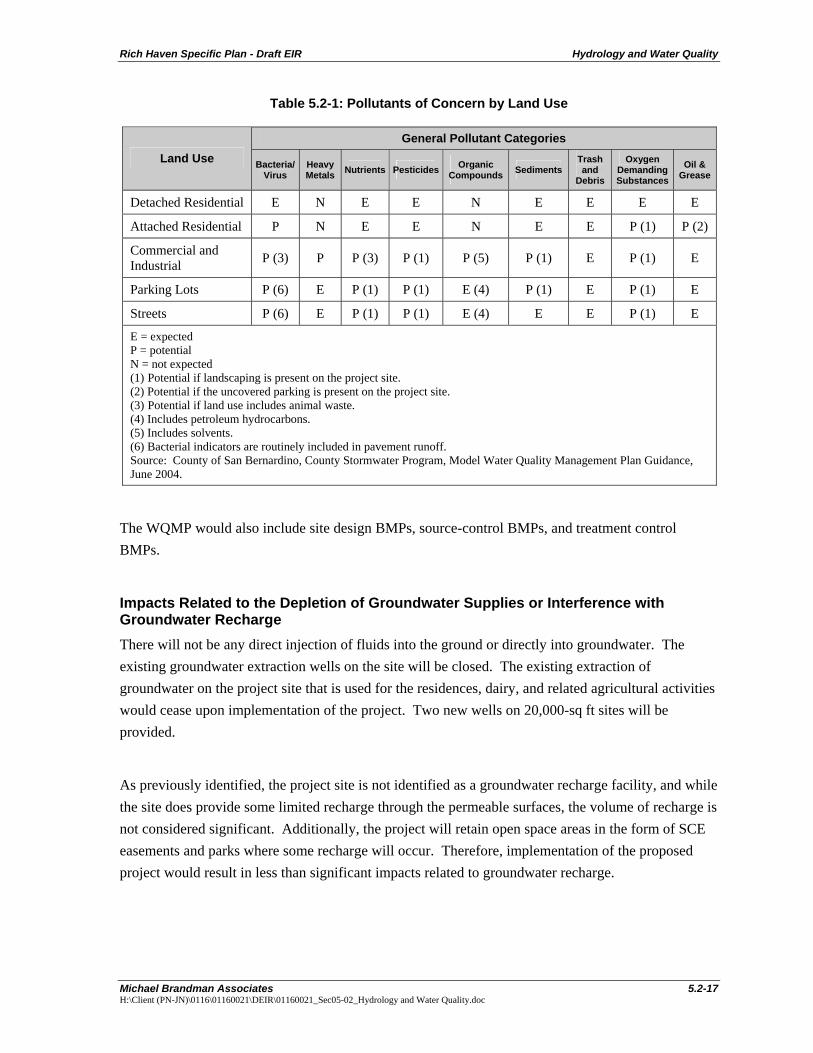
Long-Term Operational Impacts Similar to short-term construction activities, long-term operations of the proposed project have the potential to release pollutants offsite and into receiving Waters of the U.S. that could potentially affect water quality. Table 5.2-1 identifies pollutants of concern by type of land use that have the potential to be generated on the project site.
Rich Haven Specific Plan - Draft EIR Hydrology and Water Quality
Michael Brandman Associates 5.2-17 H:\Client (PN-JN)\0116\01160021\DEIR\01160021_Sec05-02_Hydrology and Water Quality.doc
Table 5.2-1: Pollutants of Concern by Land Use
General Pollutant Categories Land Use Bacteria/
Virus Heavy Metals Nutrients Pesticides Organic
Compounds Sediments Trash and
Debris
Oxygen Demanding Substances
Oil & Grease
Detached Residential E N E E N E E E E
Attached Residential P N E E N E E P (1) P (2)
Commercial and Industrial P (3) P P (3) P (1) P (5) P (1) E P (1) E
Parking Lots P (6) E P (1) P (1) E (4) P (1) E P (1) E
Streets P (6) E P (1) P (1) E (4) E E P (1) E
E = expected P = potential N = not expected (1) Potential if landscaping is present on the project site. (2) Potential if the uncovered parking is present on the project site. (3) Potential if land use includes animal waste. (4) Includes petroleum hydrocarbons. (5) Includes solvents. (6) Bacterial indicators are routinely included in pavement runoff. Source: County of San Bernardino, County Stormwater Program, Model Water Quality Management Plan Guidance, June 2004.
The WQMP would also include site design BMPs, source-control BMPs, and treatment control BMPs.
Impacts Related to the Depletion of Groundwater Supplies or Interference with Groundwater Recharge There will not be any direct injection of fluids into the ground or directly into groundwater. The existing groundwater extraction wells on the site will be closed. The existing extraction of groundwater on the project site that is used for the residences, dairy, and related agricultural activities would cease upon implementation of the project. Two new wells on 20,000-sq ft sites will be provided.
As previously identified, the project site is not identified as a groundwater recharge facility, and while the site does provide some limited recharge through the permeable surfaces, the volume of recharge is not considered significant. Additionally, the project will retain open space areas in the form of SCE easements and parks where some recharge will occur. Therefore, implementation of the proposed project would result in less than significant impacts related to groundwater recharge.

Hydrology and Water Quality Rich Haven Specific Plan - Draft EIR
5.2-18 Michael Brandman Associates H:\Client (PN-JN)\0116\01160021\DEIR\01160021_Sec05-02_Hydrology and Water Quality.doc
Impacts Related to Erosion and Siltation As previously described, the project site is not subject to high levels of erosion and siltation. The development of the proposed project would result in development of urban uses as described in Section 3 of this document. As a result, the amount of impervious surface would increase due to site coverage from buildings, roadways, and other related improvements. This conversion to urban uses would further reduce the existing less than significant impacts related to erosion and siltation with the incorporation of stormwater conveyance facilities incorporated into the proposed project. Therefore, implementation of the proposed project would result in less than significant impacts related to erosion and siltation. Refer to Section 5.8, Air Quality, of this document for a discussion on short-term, construction-related impacts related to erosion.
Impacts Related to Onsite or Offsite Flooding and Stormwater Runoff As subsequently identified, the project site is not subject to onsite flooding.
Onsite storm drains will be constructed to drain stormwater generated on the project site to the south and westerly portions of the project site. Three potential sites for detention basins have been identified along Haven Avenue and one site has been identified at the south end of Mill Creek Avenue. As previously stated in Section 5.2.1, Introduction, the MPD stated that regardless of whether Alternative 1 or Alternative 2 is chosen, developments may be completed prior to the completion of regional NMC-programmed facilities. If the permanent NMC-programmed master plan storm drain improvements have not been completed prior to the commencement of construction activities of the residential component, a temporary or interim onsite retention basin would be required. The exact size and location of this temporary basin will be determined at the time of tentative tract map submittal. According to the MPD, these basins would be required to accept 100 percent of excess flow from a project site, which is determined as that quantity of additional runoff in a 100-year storm event caused by the increased impervious surface on the project site over and above the existing conditions. The MPD also stated that interim basins should be designed using the criteria for sizing increased runoff detention facilities developed by the San Bernardino County Flood Control District. This criteria identifies the following:
• The entire area of proposed development will be routed through a detention facility to mitigate increased runoff.
• Storms to be studied will include the 1-hour, 3-hour, 6-hour and 24-hour duration events for the 2-year, 5-year, and 10-year return frequencies. Detention basin and outlet sizing will ensure that none of these storm events have a higher peak discharge in the “after” condition than in the “before” condition.

Rich Haven Specific Plan - Draft EIR Hydrology and Water Quality
Michael Brandman Associates 5.2-19 H:\Client (PN-JN)\0116\01160021\DEIR\01160021_Sec05-02_Hydrology and Water Quality.doc
• Low Loss rates will be determined using the following: - Undeveloped Condition: Low Loss = 90 percent - Developed Condition: Low Loss = 0.9-(0.8x percent impervious) - Basin Site: Low Loss = 10 percent
• Where possible and feasible, the onsite flows should be mitigated before combining with offsite flows to minimize the detention facility required.
• No outlet pipes will be less than 18 inches in diameter. Where necessary, an orifice plate may be used to restrict outflow rates. Appropriate trash racks shall be provided for all outlets less than 48 inches in diameter.
• The basins and outlet structure must be capable of passing the 100-year storm without damage to the facility.
• Mitigation basins should be designed for joint use and be incorporated into open space or park areas. Side slopes should be no steeper than 4:1 and depths should be minimized where public access in uncontrolled.
• Maintenance of detention facilities should be provided. The Rich Haven project proposes to tie-in to the County Line Stormwater Channel. This facility is a regional facility that would serve the NMC and portions of Riverside County east of the project site. The facility has a drainage area of approximately 3,000 acres with a peak 100-year frequency storm flow rate of 3,400 cubic feet-per-second. This drain is an outlet and will carry storm flows for all major north-south systems east of the Cucamonga Creek Channel.
Impacts Related to the Substantial Degradation of Water Quality As explained above, compliance with the SWPPP and WQMP, as required by General Construction Stormwater Permit and the Municipal Stormwater Permit, will prevent any substantial degradation of water quality resulting from implementation of the Project. As explained below, however, cumulative impacts to water that are already impacted may continue to be significant.
Impacts Related to the Placement of Housing or Structures in a 100-Year Flood Hazard Area According to Flood Insurance Rate Maps published by the Federal Emergency Management Agency, the project site is not located within a 100-year flood zone (Community Number 060270, Panel Numbers 8639 and 8645). Therefore, implementation of the proposed project would result in less than significant impacts related to placement of structures within an identified flood hazard zone.

Hydrology and Water Quality Rich Haven Specific Plan - Draft EIR
5.2-20 Michael Brandman Associates H:\Client (PN-JN)\0116\01160021\DEIR\01160021_Sec05-02_Hydrology and Water Quality.doc
Impacts Related to Flooding from the Failure of a Dam or Levee The project site is not located in close proximity to a dam or levee that would flood the project site if structural failure occurred, according to the Geotechnical Review Report. Therefore, implementation of the proposed project would result in less than significant impacts related to flooding from the failure of a dam or levee.
Impacts Related to Inundation by Seiche, Tsunami, or Mudflow As previously described, the project site is generally level and surrounded by land that is also generally level and therefore not subject to mudflows. In addition, the project design does not propose significant changes in site elevation that would result in conditions that could result in mudflows. Therefore, implementation of the proposed project would result in less than significant impacts related to mudflows.
The project site is not located near the coastline of the Pacific Ocean, or near any large confined bodies of water. Therefore, implementation of the proposed project would result in no impacts related to a tsunami or seiche.
Refer to Section 5.4, Geology and Soils, of this document for a discussion on the potential for landslides on the project site.
5.2.5 - Cumulative Impacts
Development of the related projects would cumulatively affect the hydrology and water quality due to the conversion of rural agricultural lands to urban-type land uses, resulting in greater impervious surfaces and increased stormwater runoff. In particular, as much of the NMC and surrounding areas are currently undeveloped or in agricultural use, flows of floodwaters in the area would increase with urban development. Increased stormwater flows to the Prado Basin from the NMC would result in significant cumulative impacts when considered along with flows of floodwaters from surrounding past, present, and future area projects due to flooding. If 100 percent of the excess flows from the NMC can be detained within the NMC, then released at a rate that does not exceed existing storm flows, cumulative impacts related to flood would be reduced to below a level of significance. The proposed MPD would aid in achieving this standard.
Future land development projects within the NMC would cumulatively impact water quality in the region due to increased urban runoff. The nature of the pollutants found in runoff is expected to change from pollutants associated with agricultural land uses, such as bacteria, ammonia, nitrates, phosphorous, and salts, to urban uses, which produce contaminants such as oil and grease, trash and

Rich Haven Specific Plan - Draft EIR Hydrology and Water Quality
Michael Brandman Associates 5.2-21 H:\Client (PN-JN)\0116\01160021\DEIR\01160021_Sec05-02_Hydrology and Water Quality.doc
debris, and pesticides (refer to Table 5.2-1). Currently, dairies within the NMC operate under the authority of NPDES Permit No. CAGO18001 (Waste Discharge Requirement Order No. 99-11). However, because this permit is concerned with dairy operations, existing non-dairy properties would not be covered along with portions of dairy properties not developed with dairies. Future development of subareas would be required to obtain SWPPPs and WQMPs for all proposed development affording a more extensive amount of stormwater quality protection. However, stormwater permits do not prohibit all discharges of stormwater that may contain pollutants. Reach 1 of the Cucamonga Creek channel, Mill Creek (Prado Area), and Reach 3 of the Santa Ana River are currently in violation of the respective water quality standards. Therefore, development of the project area with the implementation of water quality BMPs has the potential to produce cumulative impacts on the quality of downstream surface waters and groundwater within the Chino Basin.
5.2.6 - Mitigation Measures
The Water Resources Section of the NMC Final EIR identifies eight mitigation measures (mitigation measures WQ-1 through WQ-8). Mitigation measures WQ-1 through WQ-4 are related to flooding. Mitigation measures WQ-5 through WQ-8 are related to water quality. These mitigation measures include consideration of the following: drainage plans; coordination with the San Bernardino County Flood Control District; payment of drainage fees; elevated pads in 100-year flood zones; NPDES permits; preparation of a Storm Water Pollution Prevention Plan; and handling of herbicides and pesticides. In addition, the Utilities Section of the NMC Final EIR identifies a flooding mitigation measure that states implementation of the flood control policies contained in the NMC General Plan would eliminate the need for additional mitigation measures.
With the incorporation of the water quality Project Design Feature No. 5 and implementation of the following recommended mitigation measures in addition to the NMC Final EIR mitigation measures, potentially significant impacts would be reduced to a less than significant level.
HWQ-1 All development shall comply with the National Pollutant Discharge Elimination System (NPDES) regulations. Prior to the issuance of a grading permit, applicants shall demonstrate compliance with NPDES Stormwater Permit requirements to the satisfaction of the City of Ontario. Applicable BMP provisions shall be incorporated in the approved WQMP(s) for the Specific Plan.
HWQ-2 Individual projects within the specific plan area shall be reviewed by the City of Ontario for the inclusion of appropriate structural and non-structural Best Management Practices (BMPs) to control stormwater discharges to ensure compliance with the State and federal water quality requirements. Structural controls may include, but are not limited to filtration, common area efficient irrigation, common area runoff-minimizing landscape design, velocity dissipation devices, oil/grease separators, inlet trash racks, and catch
Hydrology and Water Quality Rich Haven Specific Plan - Draft EIR
5.2-22 Michael Brandman Associates H:\Client (PN-JN)\0116\01160021\DEIR\01160021_Sec05-02_Hydrology and Water Quality.doc
basin stenciling. Non-structural BMPs can include, but not be limited to, education for property owners, tenants and occupants, activity restrictions, common area landscape management, litter control, and catch basin inspection, BMP maintenance; and street sweeping.
The following are examples of BMPs that may be included within NPDES permit requirements for individual projects:
• Use of sand bags and temporary desilting basins during project grading and construction during the rainy season (October through April) to prevent discharge of sediment-laden runoff into stormwater facilities.
• Installation of landscaping as soon as practicable after completion of grading to reduce sediment transport during storms.
• Hydroseeding soil binders or other measures to retain soil on graded building pads if they are not built upon before the onset of the rainy season.
• Incorporation of structural BMPs (e.g., grease traps, debris screens, continuous deflection separators, oil/water separators, drain inlet inserts) into the project design to provide detention and filtering of contaminants in urban runoff from the developed site prior to discharge to stormwater facilities.
• Stenciling of catch basins and other publicly visible flood control facilities with the phrase “No Dumping-Drains to the Ocean.”
HWQ-3 Prior to the issuance of a grading permit or construction permit for the residential
component, whichever would occur first, the City Engineer shall review the developers plans to determine whether a temporary water quality/stormwater detention basin or other treatment BMP shall be required onsite. Plans shall be submitted to the City Engineer identifying the location and size of the temporary water quality/stormwater detention basin or other treatment BMP. The City Engineer shall also approve the location and size of an onsite, temporary water quality/stormwater detention basin on the eastern portion of the project site serving the commercial component. These basins will be required to be sized to accept 100 percent of excess stormwater flows from the western and eastern portions of the project site, respectively. Excess stormwater flows during construction can include the quantity of additional run-off from a 100-year storm event caused on the impervious surface on the project site over and above existing conditions. These basins shall be designed in accordance with the applicable standards of the State Water Resources Control Board Construction Storm Water Permit, the Regional Water Quality Control Board, Santa Ana Region, Area-Wide Urban Storm Water Runoff Permit, the San Bernardino County Flood Control District, and the City of Ontario.
HWQ-4 The City of Ontario shall review subsequent development projects within the specific plan area for the application of Best Management Practices (BMPs) to reduce water
Rich Haven Specific Plan - Draft EIR Hydrology and Water Quality
Michael Brandman Associates 5.2-23 H:\Client (PN-JN)\0116\01160021\DEIR\01160021_Sec05-02_Hydrology and Water Quality.doc
pollution from urban runoff in accordance with regulatory requirements. Among the source-reduction BMPs that may be required by the City of Ontario for application to such projects are the following:
• Animal waste reduction. • Exposure reduction. • Recycling/waste disposal. • Parking lot and street cleaning. • Infiltration (exfiltration) devices. • Oil and grease traps. • Sand traps. • Filter strips. • Regular/routine maintenance. • Maintenance of detention facilities should be provided by the homeowners’
association.
The specific measures to be applied shall be determined in conjunction with review of required project hydrology and hydraulic studies, and shall conform to City standards and the standards of the County’s Municipal Stormwater Permit, under the NPDES program.
5.2.7 - Level of Significance After Mitigation
All of the mitigation measures require implementation prior to permit issuance. This eliminates the potential for construction-related activities to commence without the benefit of the recommended mitigation measures.
Mitigation measures HWQ-1 and HWQ-2 would require compliance with the NPDES and include Best Management Practices (BMPs) for the short-term construction activities and the long-term operations associated with the various land uses that are proposed. BMPs will be selected from the California Stormwater Quality Association’s Construction Handbook and would include site design BMPs, source-control BMPs, and treatment control BMPs within the following six categories: erosion control; sediment control; wind erosion; offsite tracking control; non-stormwater management; and waste management and materials pollution control. Mitigation measure HWQ-3 would retain all excess stormwater on the project site, which would prevent excess stormwater flows from being discharged offsite through the construction of engineered retention basins. Mitigation measure HWQ-4 would require the review of subsequent development projects for the application of BMPs to reduce water pollution from urban runoff. With incorporation of the project design feature, project-level hydrology studies, NPDES permit program requirements, Best Management Practices (BMPs) for point and non-point source pollution control, and other mitigation measures identified
Hydrology and Water Quality Rich Haven Specific Plan - Draft EIR
5.2-24 Michael Brandman Associates H:\Client (PN-JN)\0116\01160021\DEIR\01160021_Sec05-02_Hydrology and Water Quality.doc
above, the flooding, hydrology and water quality impacts of the proposed project would be in compliance with all regulatory requirements and therefore would be reduced to a level that is considered less than significant.
Mitigation described in the EIR will substantially lessen impacts to downstream water bodies, but because the extent of mitigation cannot be quantified, this EIR considers the impact on downstream impacted water bodies to be significant and unavoidable.