oilgas.ogm.utah.gov · o o b 300 e. mineral ave., suite 10 littleton, co 80122-2631 env i ronment a...
TRANSCRIPT
O OB 300 E. Mineral Ave., Suite 10
Littleton, CO 80122-2631
Env i ronment a 1 Consult a nts 303/781-8211 303/781-1167 Fax
October 30, 2006
Fluid Minerals GroupBureau of Land ManagementVernal Field Office170 South 500 EastVernal, Utah 84078
RE: Application for Permit to Drill-Dominion Exploration & Production, Inc.LCU6-10H;
Surface Location: 2,200' FNL&2,250' FWL, SE/4 NWl4,Target Location: 1,900' FNL& 1,950' FWL, SE/4 NWl4,
Section 10, T11S, R20E, SLB&M, Uintah County, Utah
Dear Fluid Minerals Group:
On behalf of DominionExploration&Production, Inc. (Dominion), Buys &Associates, Inc. respectfullysubmits the enclosedoriginaland three copies of the Application for Permit to Drill(APD) for the abovereferenced BLMadministered directional well. The location of the surfaceand target location as well as allpoints alongthe intended wellbore path are within Cause No. 259-01 and are not within460 feet oftheunit boundary or any uncommitted tracts. Included with the APD is the following supplemental information:
Exhibit "A" - Survey plats, layouts and photos ofthe proposed wellsite;
Exhibit "B" - Proposed location maps withaccess and utilitycorridors;
Exhibit "C" - Production site layout;
Exhibit "D" - Drilling Plan with Directional DrillingSurvey;
Exhibit "E" - Surface Use Plan;
Exhibit "F" - Typical BOP and Choke Manifold diagram.
Please accept this letter as Dominion's, written request for confidentialtreatmentof all informationcontained in and pertaining to thisapplication.
Thank you very much for your timelyconsideration of thisapplication.Please feel free to contact myselfor Carla Christian of Dominion at 405-749-5263 if you have any questions or need additional info(Ñiillo'.nE!VEDSincerely NOV0 1 2006
Don HamiltonAgent for Dominion
cc: Diana Whitney, Division of Oil,Gas and MiningCarla Christian, DominionKen Secrest, Dominion

9Fon3160-3 FORMAPPROVED
(Febnmy2005) OMBNo.10M·0137Expim Mad: 31,2001
UNITED STATESDEPARTMENTOF THE INTERIOR 5. Leasew Na
BUREAUOF LAND MANAGEMENTUTU-44eB9
APPLICATIONFOR PERMIT TO DRILLOR REEISERa If Indian,Alloteeor TribcNane
N/A
O 2 IfUnitor CAAgreemcut,NameandNola Typeofwerk: DRILL REENTER
Litue Canyon Unit8 laase NameandWellNo
ib TypeofWen: Wd1 GasWell Odu Sm¢c Zo- OMuge Zoc LCU 6-10H
1 Nane af Operator 9 APIWellDominion Exploration & Panduedom, Inc. S Û
3a Address 14000 Quas Springs Paricway, Suite 600 3h I%oneNa (urink œes me) 10 FieldandPool,orExploratory '2Oklahoma City, OK 73134 405-749-5263 m-isillill!!P"
4 Locationof Well(Apwt inen. desty mutin andme um my sur mimumn•) 11.Sec.,T.R.M. or BlkandSurveyor Area
Atsurface 2,200' FNL & 2,250' FWL, SE/4 NWl4,
At proposedprod.zone 1,950' FNL & 1,950' FWL, SE/4 NWl4,Seedos 10, T115, R20E, SLB&M
14 Distacc inmiles anddirectionikomneacst towntr put air.r.• 12 Comtyor Parish 13.State14.69 miles samth of Ouray, Utah Ulstah UT
15 Distancefrom¡xopoucd* 16 No.of acresinlease 17 SpacingUnitdedicatedmthiswelllocationa nearest
orleaseline,ftsotonearestdrig.unitlim,if any) 2,2ee' M - 40 acres
la Distmuccfrom localion* 19.ProposedDepih 20 BLM/BIABondNa onfiletousarest completed,appliedfor,onthis ft 1,590' 9,2ee' TVD (9,240' MD) WY 3322
21 Elevations(ShowwhetherDF,KDB, RT,GL,etc.) 22 ApproxanatedatewalkwiHstart* 21 Esdmatedduralion5,149' GR 07/16/20&T 14 days
24. AttachmentsThefollowing,completedinaccordancewiththerequirementsof OnshoreOilandGasOrderNo.1,must beattachedtothisform:
1. Wellplatcertiñedbya regigeredsurveyar. 4 Bondin coverthe operationsunlesscoveredby anexistingbandon file (see1 ADnllingPlan. IteinM m)3. A SurfaccUse lim (if thelocationis on NationalForestSystemLands,the 5. Opcratorocrtification
SUPOaust beHiedwithdieappropnateForestServiceOffice). 6. Suchodiersitespecificinfonnationand/orplansasmayberequiredbytheBLK
25. Signature Name(Printeda)ped) DateDon Hamilton 10/30/2006
TitleAgent for Dominion
Apptuvedby (Sigmuure) Name(Pmrted/Fyped Date
Tide Ollice
Applicationapprovaldoesnotwarrantor certifythattheapplicantholdslegalorequitabletitlelo thoserightsinthesubjectleasewhichwouldentitletheapplicanttoconductoperationsthereon.Conditionsof approval,if any,areattached.
Title18U.S.C.Section1001amiTide43 USC. Secdon1212,make ita crime forany personknowmglyandwillfullytomaketoanydepartmentor agency ofthe UnitedStatesanyfalse,fictitiousor fraudulentstatementsorrepresentationsastoanymatterwithinitsjurisaiction.
*(Instructions o
00, Gas and Mining

. i w rys ce see. > ce Tru. Pa."" DOMINION EXPLR. & PROD., INC..
> Pile of Stones Set Mœked Stme, pes. er s'6"" à à Well location, LCU g6-10H, locoted as shown inthe SE 1/4 NW 1/4 of Section 10, T11S, R20E,
3 secuancorn., T11S, R20 E, S. L.B. &M. S.L.B.&M. Uintoh County, Utah.Re-Established UsingDoub/e Proportion Method(Not Set th Ground)
SB8 00'08"W - 2640 7J' (Meas.) SO9 50'06"W - 2655.93' (Meas.) Sg '·
s e
S39°47'187- 797174' (Meas.) Pse at stones
seeBASIS OF ELEVATIONMarked Stone
SPOT ELEVATIONLOCATED AT THE SOUTHWEST CORNER OFSECT10N 20, T10S, R20E, S.L.B.&M. TAKEN FROM THE BIGPACK MTN. NW, QUADRANGLE,UTAH, UINTAH COUNTY 7.5MINUTEQUAD. (TOPOGRAPHIC MAP) PUBLISHED BY THEUNITED STATES DEPARTMENT OF THE INTERIOR, GEOLOGlCSURVEY. SAID ELEVATIONIS MARKEDAS BEING 5251 FEET.
Bottorn Hole
LCU /6-10H | N2250' Bev. Ungraded Ground = 5/49'Set SfmeSet Marked Stone 4
I o o
LINECRAOBLE
ŒNGTHL1 NOO50'19"E 2636.19' SC A LEL2 S8747'48"E 2635.87' CERTIFICATEL2 N45 56'25"W 416.48'
THIS JS TO CERTIFY THAT THE ABO AT 11A$ PREP FROMFIELDNOTES OF ACTUAL SURVE BY ME OR UNDElbpYSUPERVISIONAND THAT THE S UE AND CORREÇT10 THEBEST OF MY KNOWLEDGEAND
.
BASIS OF BEARINGSGISTEREDLAND SURVEYORBAsis OF BEARlNGS IS A G.P.S. OBSERVATIJN. RG§ISTRAllON NO. 161319
STA3( OF UTAH
UINTAH SGINEERING & LAÑD"ËURTÉYING86 SOUTH 200 EAST - VERNAL, UTAH 84078set stone 58920'27"W - 520084' (Meas.) Ps, or sim"
(435) 789-1017LEGEND: (NAD 83) SCALE DATE SURVEYED: DATE DRAWN:LATITUDE= 39 52'34.07" (39.876131) 1" = 1000' 03-11-06 03-20-06=90° SYMBOL
LONGITUDE= 109'40'01.31" (109.667031) PARTY REFERENCES= PROPOSED WELL HEAD (NAD 27) B.H. M.C. C.G. G.L.O. PLATA = SECTION CORNERSLOCATED. LATITUDE= 39 52'34.20" (39.876167) WEATHER FILEA = SECTION CORNERSLOCATED.(Not Set On Ground) LONGITUDE= 109'39'58.82" (109.666339) COOL DOMINIONEXPLR.& PROD.,
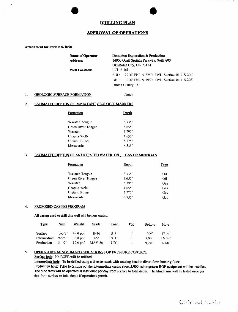
O ODRILLING PLAN
APPROVAL OF OPERATIONS
Attachment for Permit to Drill
Name of Operator: Dominion Exploration & ProductionAddress: 14000 QuailSprings Parkway, Suite 600
Oklahoma City, OK 73134We11 Location: LCC 6-10H
SHL: 2200' FNL & 2250' FWI Section 10-1IS-20E
BIIL: 1900' FNL & 1950' Fwl Section 10-1\ S-20E
Uintah County, UT
1. GEOLOGIC SURFACE FORMATION Uintah
2. ESTIMATED DEPTHS OF IMPORTANT GEOLOGICMARKERS
Formation Depth
Wasatch Tongue 3,335'Green River Tongue 3,655'Wasatch 3,795'Chapita Wells 4,655'Uteland Buttes 5,775'Mesaverde 6,535'
3. ESTIMATED DEPTHS OF ANTICIPATED WATEIL OIL, GAS OR MINERALS
Formation Depth
Wasatch Tongue 3,335' OilGreen River Tongue 3,655' OilWasatch 3,795' GasChapita Wells 4,655' GasUteland Buttes 5,775' GasMesaverde 6,535' Gas
4. PROPOSED CASING PROGRAM
All casing used to drill this well will be new casing.
Tige S.ize Weight Grade & Tog Bottom Hole
Surface I3-3/8" 48.0 ppf H-40 STC 0' 500' l7-½"Intermediate 9-5/8" 36.0 ppf J-55 STC 0' 3,040' 12-1/4"Production 5-1/2" 17.0 ppf MAV-80 LTC D' 9,240' 7-7/8"
5. OPERATOR'S MINIMUM SPECIFICATIONS FOR PRESSURE CONTROLSurface hole: No BOPE will be utilized.Intermediate hole: To be drilled using a diverter stack with rotating head to divert flow from rig floor.Production hole: Prior to drilling out the intermediate casing shoe, 3,000 psi or greater BOP equipment will be installed.The pipe rams will be operated at least once per day from surface to total depth. The blind rams will be tested once perday from surface to total depth if operations
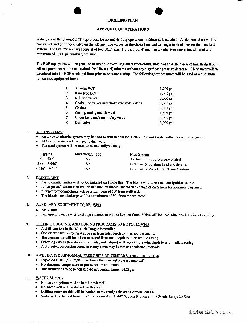
O ODRILLING PLAN
APPROVAL OF OPERATIONS
A diagram of the planned BOP equipment for normal drilling operations in this area is attached. As denoted there will betwo valves and one check valve on the kill line, two valves on the choke line, and two adjustable chokes on the manifoldsystem. The BOP "stack" will consist of two BOP rams (1 pipe, 1 blind) and one annular type preventer, all rated to aminimum of 3,000 psi working pressure.
The BOP equipment will be pressure tested prior to drilling out surface casing shoe and anytime a new casing string is set..All test pressums will be maintained for fifteen (15) minutes without any significant pressure decrease. Clear water will becirculated into the BOP stack and lines prior to pressure testing. The following test possures will be used as a minimumfor various equipment items.
1. Annular BOP 1,500 psi2. Ram type BOP 3,000 psi3. Kill line valves 3,000 psi4. Choke line valves and choke manifold valves 3,000 psi5. Chokes 3,000 psi6. Casing, casinghead & weld 1,500 psi7. Upper kelly cock and safety valve 3,000 psi8. Dart valve 3,000 psi
6. MUD SYSTEMS• An air or an air/mist system may be used to drill to drill the surface hole until water influx becomes too great.• KCL mud system will be used to drill well.• The mud system will be monitored manually/visually.
Deaths Mud Weight (ppa) Mud SystemO' - 500' 8.4 Air foam mist, no pressure control
500' - 3,()40' 8.6 Fresh water, rotating head and diverter3,040' -9,240' 8.6 Fresh water/2% KCI /KCf. mud system
7. BLOOIE LINE• An automatic igniter will not be installed on blooie line. The blooie will have a contant ignition source.• A "target tec" connection will be installed on blooie line for 90° change of directions for abrasion resistance.• "Target tee" connections will be a minimum of 50' from wellhead.• The blooie line discharge will be a minimum of 80' from the wellhead.
8. AUXILIARY EQUIPMENT TO BE USEDa. Kelly cock.b. Full opening valve with drill pipe connection will be kept on floor. Valve will be used when the kelly is not in string.
9. TESTING. LOGGING, AND ÇORING PROGRAMS TO BE FOLLOWED• A drillstem test in the Wasatch Tongue is possible.• One electric line wire-log will be run from total depth to intermediate casing.• The gamma ray will be left on to record from total depth to intermediate casing.• Other log curves (resistivities, porosity, and caliper) will record from total depth to intermediate casing.• A dipmeter, percussion cores, or rotary cores may be run over selected intervals.
10. ANTICIPATED ABNORMAL PRESSURES OR TEMPERATURES EXPECTED• Expected BHP 1,500-2,000 psi (lower than normal pressure gradient).• No abnormal temperature or pressures are anticipated.• The formations to be penetrated do not contain known H2S gas.
11. WATER SUPPLY• No water pipelines will be laid for this well.• No water well will be drilled for this well.• Drilling water for this will be hauled on the road(s) shown in Attachment No. 3.• Water will be hauled from: Water Permit # 43-10447 Section 9, Township 8 South, Range 20

O ODRILLING PLAN
APPROVAL OF OPERATIONS
12. CEMENT SYSTEMSa. Surface Cement:
• Drill 17-½" hole to 500' and cement 13-3/8" to surface with 450 sks class "C" cement with 2% CaCl2and1/4#/sk. Polyflake (volume includes 70% excess). Top out as necessary. Casing to be centralized with a total of5 centralizers.
b. Intermediate Casing Cement:• Drill 12-1/4" hole to 3,040'±, run and cement 9-5/8" to surface.• Pump 20 bb1slightly weighted water spacer followed by 5 bbls fresh water. Displace with any available water.• Casing to be run with: a) guide shoeb) insert float c) three (3) centralizers, one on each of first 3 jointsd) stop ring
for plug one joint off bottom e) bottom three joints thread locked f) pump job with bottom plug only. Casing to becentralized with a total of 15 centralizers.
• Cement to surface not required due to surfdce casing set deeper than normal.
Hole CementTyge _Sac_b Interval Density Yjel_d Volume VolumeLead 352 O'-2,540' 10.5 ppg 4.14 CFS 833 CF I,458 CFTail 254 2,540'-3,040' 15.6 ppg 1.2 CFS 174 CF 304 CF
Intermediate design volumes based on 75% excess of gauge hole.
Lead Mix: Halliburton Prem Plus V blend. Blend includes Class "C" cement, gel, salt, gilsonite, EX-1 and HR-7.Slurry yield: 4.14 ef/sack Slurry weight: 10.5 #/gal.Water requirement: 26.07 gal/sackCompressives @110°F: 72 psi after 24 hours
Tail Mix: Class "G" Cement, 1/4 lb/sk Cellophane Flakes + 2% bwoc Calcium Chloride + 46.5% fresh water.Slurry yield: 1.20 efsack Slurry weight: 15.6 #/gal.Pump Time: 1 hr. 5 min. @ l 10 F.Compressives @110 °F: 2,500 psi after 24 hours
c. Production Casing Cement:• Drill 7-7/8"hole to 9,240'±, run and cement 5 1/2".• Pump 20 bbl Mud Clean II unweighted spacer, followed by 20 Bbls fresh H20 spacer.• Displace with 2% KCL,• Production casing to be centralized with 30 centralizers.
H_ok CementÎyge Sac_lís Interval Density Yield Volume VolumeLead 90 2,995'-3,795' l1.5 ppg 3.12 CFS I39 CF 277 CFTail 1080 3,795'-9,240' 13.0 ppg l.75 CFS 943 CF 1887 CF
Production design volumes based on 35% excess of gauge hole. Actual volumes will be calculated from caliper log to bring leadcement to 800' above top of Wasatch + 15% excess, and tail cement to top of Wasatch +15%.
Lead Mix: Halliburton Pom Plus V blend. Blend includes Class "C" cement, gel, salt, gilsonite, EX-1 and HR-7.Slurry yield: 3.12 cf/sack Slurry weight: 11.60#/gal.Water requirement: 17.71 gal/sackCompressives @130°F: 157 psi after 24 hours
Tail Mix: Halliburton HLC blend (Prem Plus VIJB flyash). Blend includes Class "G" cement, KCl, EX-l, Halad 322,& HR-5.Slurry yield: 1.75 ef/sack Slurry weight: 13.00 #/gal.Water requirement: 9.09 gal/sackCompressives @165°F: 905 psi after 24 hours
13. ANTICIPATED STAllTING DATE AND DURATION OF THE OPERATIONSStarting Date: July 15, 2007Duration: 14
I Hole of0
FIELD DETAILS- 0° 530 MD Start Build 3.00Uintah County, UtahUtah -Natural Buttes4L 12' 925 MD Start Hold USA
1000Geodetic Spism: US Slale Plane Coordinate System 1983
Emesold: GRS 1980zone: Utah, Centml2one
Magnelic Model: igrf2005
Syslam Datum: Mean See LevelLocal North: Tme Norih
00SITEDETAILS
366 12· 2516 MDStart Drop -2.50
LCU6-10HSection 10, T118, R20E, S.LB. & M.
Vertical Point Uintah County, Utah0 2990 MDStart Hold Site Centm Latitude: 39'52'34.070N 300 +
ntermediate Longitude: 109°40'01.310W XGround Level: 5148.00 PBHL 200
Positional Uncertainty: 0.00Wasatch Tongue Convergence: 1.17
Green River TonOue4000-
- wasatchi . . I -100
WELLPATHDETAILS -600-500-400-300-200-100 0 100Chapita WellsOriginal Hole West(-)/East(+)[400R/in]
Ref. SITE 5165.00
314.06' 0.00 0.00 9200.00Uteland Buttes
I-6000- WELL DETAILS
Mesaverde Narne +N/-S +El-W Northing Easting Latitude Longitude SlotWbli #6-10H 0.00 0.00 7128889.63 2154790.00 39'52 34.070N 10e*40 01.310W N/A
7000-
TARGET DETAILS FORMATION TOP DETAILS
No. TVDPuth MOPath FormationNarne TVD +N/-S +El-W Shape
Vertical Point 2950.00 289.62 -299.29 Point 2336 W m
PBHL 9200.00 289.62 -299.29 Point 3 3755 00 3795.13 Wasatch A8 4 4615 00 4855.13 Chaplia Wells §
5 5735.00 5775.13 Uteland Buttes (6 6495.00 6535.13 Mesaverde
SECTION DETAILS9000-* 416 See MD Inc Azi TVD +NI-S +El-W DLeg TFace VSec Target
'y 1 0.00 0.00 314.06 0.00 0.00 0.00 0.00 0.00 0.00
2 530.00 0.00 314.06 530.00 0,00 0.00 0.00 0.00 0.003 925.22 11,86 314.06 922.40 28.34 -29.20 3.00 314.06 40.754 2516.06 11.88 314,06 2479.30 255.63 -264.17 0.00 0.00 367.605 2990.13 0.00 314.06 2950 00 269.62 -299.29 2.50 180.00 416.48 Vertioni Point y6 9240.13 0.00 314.06 9200.00 289.62 -299.29 0,00 314 06 416.46 PBHL
0 1000 2000VerticalSectionat 314.06° [12000/in]
Houston. TX T1073 % a a omPh: 281-443-1414
Appress omFx: 281-443-1676
DomiaRyan Ener Tednologi gygg
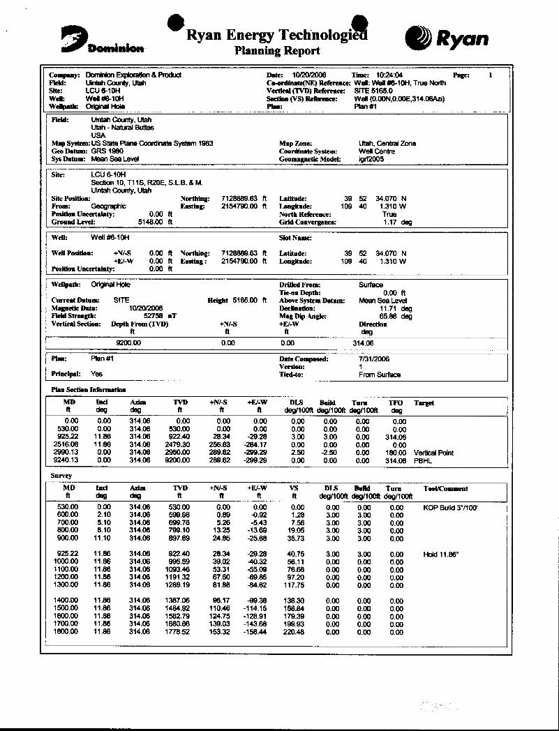
Company: DominkmExplorsion &Product Date: 10/20/2006 Time: 10 24:04 Page 1Fiehl: UinlahCounty,Utah Co.enlinate(NE) Referrace: Well: Well#6-10H, True NorthSite: LCU 6-10H Verdeal(TVD) Reference: SITE 5165.0Wen: Well#6-10H seedon(VS)Reference: Well (0.00N,0.00E,314.06Azi)Welipath: OriginalHole Pina: Plan #1
Field: UIntahCounty, UtahUlah - Natural ButtesUSA
Map System:US Stale Plane Coonfinale System 1983 Map Zone: Utah, Cenbal ZoneGeo Datum: GRS 1980 Coordinate System: Well CentreSysDatum: Mean Sea Level Geomagnetic Model: igrf2005
Site: LCU6-10HSecdon 10, T11S, R20E, S.L.B. &M.UintahCounty, Utah
Site Position: Northing: 7128889.63 ft Latitude: 39 52 34.070 NFrom: Geographic Easting: 2154790.00 ft Longitude: 109 40 1.310 WPosiden Uncertainty: 0.00 ft North Reference: TrueGromad Level: 5148.00 ft Grid Convergence: 1.17 deg
Wen: Well #6-10H Slot Name:
WenPosidam: +N/-S 0.00 ft Northing: 7128889.63 ft Latitude: 39 52 34.070 N+El-W 0.00 ft Easting: 2154790.00 ft Longitude: 109 40 1.310 W
Position Uncertainty: 0.00 ft
WeUpath: OriginalHole Drilled Fmm: SurfaceTieen Depth: 0.00 ft
Current Datum: SITE Height 5165.00 ft Above SystemDatum: Mean Sea LevelMagnede Data: 10/20/2006 Declination: 11.71 degField Strength: 52758 nT Mag Dip Angle: 65.86 degVertical Section: Depth Fmm (TVD) +N/-S +El-W Direction
ft ft ft deg9200.00 0.00 0.00 314.06
Plan: Plan #1 Date Composed: 7/31/2006Venion: 1
Principal: Yes Tied-to: From Surface
Plan Section InformationMD Inci Azim TVD +N/-8 +E/.W DLS Build Tarm TFO Targetft deg deg ft ft ft deg/100ft deg/100ft deg/100R deg0.00 0.00 314.06 0.00 0.00 0.00 0.00 0.00 0.00 0.00
530.00 0,00 314.06 530.00 0.00 0.00 0.00 0.00 0.00 0.00925.22 11.86 314.06 922.40 28.34 -29.28 3.00 3.00 0.00 314.06
2516.06 11.86 314.06 2479.30 255.63 -264.17 0.00 0.00 0.00 0.002990.13 0.00 314.06 2950.00 289.62 -299.29 2.50 -2.50 0.00 180.00 VerticalPoint9240.13 0.00 314.06 9200.00 289.62 -299.29 0.00 0.00 0.00 314.06 PBHL
Survey
MD Inci Azim TVD +N/-S +E/-W VS DLS BuBd Turn Tool/Commentft deg deg ft ft ft ft deg/100ft deg/100R deg/100R
530.00 0.00 314.06 530.00 0.00 0.00 0.00 0.00 0.00 0.00 KOP Build3°/100'600.00 2.10 314.06 599.98 0.89 4.92 1.28 3.00 3.00 0.00700.00 5.10 314.06 699.78 5.26 -5.43 7.56 3.00 3.00 0.00800.00 8.10 314.06 799.10 13.25 -13.69 19.05 3.00 3.00 0.00900.00 11.10 314.06 897.69 24.85 -25,68 35.73 3.00 3.00 0.00
925.22 11.86 314.06 922,40 28.34 -29.28 40.75 3.00 3.00 0.00 Hold 11.86°1000.00 11.86 314.06 995.59 39.02 40.32 56.11 0.00 0.00 0.001100.00 11.86 314.06 1093.46 53.31 -55.09 76.66 0.00 0.00 0.001200.00 11.88 314.06 1191.32 67.60 49.85 97.20 0.00 0.00 0.001300.00 11.86 314.06 1289.19 81.88 -84.62 117.75 0.00 0.00 0.00
1400.00 11.86 314.06 1387.06 96.17 -99.38 138.30 0.00 0.00 0.001500.00 11.86 314.06 1484.92 110.46 -114.15 158.84 0.00 0.00 0.001600.00 11.86 314.06 1582,79 124.75 -128.91 179.39 0.00 0.00 0.001700.00 11.86 314.06 1680.66 139.03 -143.68 199.93 0.00 0.00 0.001800.00 11.86 314.06 1778.52 153.32 -158.44 220.48 0.00 0.00
DomiaRyan Ener Tednologi gygg
Company: DominkmExplorsion &Product Date: 10/20/2006 Time: 10 24:04 Page 1Fiehl: UinlahCounty,Utah Co.enlinate(NE) Referrace: Well: Well#6-10H, True NorthSite: LCU 6-10H Verdeal(TVD) Reference: SITE 5165.0Wen: Well#6-10H seedon(VS)Reference: Well (0.00N,0.00E,314.06Azi)Welipath: OriginalHole Pina: Plan #1
Field: UIntahCounty, UtahUlah - Natural ButtesUSA
Map System:US Stale Plane Coonfinale System 1983 Map Zone: Utah, Cenbal ZoneGeo Datum: GRS 1980 Coordinate System: Well CentreSysDatum: Mean Sea Level Geomagnetic Model: igrf2005
Site: LCU6-10HSecdon 10, T11S, R20E, S.L.B. &M.UintahCounty, Utah
Site Position: Northing: 7128889.63 ft Latitude: 39 52 34.070 NFrom: Geographic Easting: 2154790.00 ft Longitude: 109 40 1.310 WPosiden Uncertainty: 0.00 ft North Reference: TrueGromad Level: 5148.00 ft Grid Convergence: 1.17 deg
Wen: Well #6-10H Slot Name:
WenPosidam: +N/-S 0.00 ft Northing: 7128889.63 ft Latitude: 39 52 34.070 N+El-W 0.00 ft Easting: 2154790.00 ft Longitude: 109 40 1.310 W
Position Uncertainty: 0.00 ft
WeUpath: OriginalHole Drilled Fmm: SurfaceTieen Depth: 0.00 ft
Current Datum: SITE Height 5165.00 ft Above SystemDatum: Mean Sea LevelMagnede Data: 10/20/2006 Declination: 11.71 degField Strength: 52758 nT Mag Dip Angle: 65.86 degVertical Section: Depth Fmm (TVD) +N/-S +El-W Direction
ft ft ft deg9200.00 0.00 0.00 314.06
Plan: Plan #1 Date Composed: 7/31/2006Venion: 1
Principal: Yes Tied-to: From Surface
Plan Section Information
MD Inci Azim TVD +N/-8 +E/.W DLS Build Tarm TFO Targetft deg deg ft ft ft deg/100ft deg/100ft deg/100R deg0.00 0.00 314.06 0.00 0.00 0.00 0.00 0.00 0.00 0.00
530.00 0,00 314.06 530.00 0.00 0.00 0.00 0.00 0.00 0.00925.22 11.86 314.06 922.40 28.34 -29.28 3.00 3.00 0.00 314.06
2516.06 11.86 314.06 2479.30 255.63 -264.17 0.00 0.00 0.00 0.002990.13 0.00 314.06 2950.00 289.62 -299.29 2.50 -2.50 0.00 180.00 VerticalPoint9240.13 0.00 314.06 9200.00 289.62 -299.29 0.00 0.00 0.00 314.06 PBHL
Survey
MD Inci Azim TVD +N/-S +E/-W VS DLS BuBd Turn Tool/Commentft deg deg ft ft ft ft deg/100ft deg/100R deg/100R
530.00 0.00 314.06 530.00 0.00 0.00 0.00 0.00 0.00 0.00 KOP Build3°/100'600.00 2.10 314.06 599.98 0.89 4.92 1.28 3.00 3.00 0.00700.00 5.10 314.06 699.78 5.26 -5.43 7.56 3.00 3.00 0.00800.00 8.10 314.06 799.10 13.25 -13.69 19.05 3.00 3.00 0.00900.00 11.10 314.06 897.69 24.85 -25,68 35.73 3.00 3.00 0.00
925.22 11.86 314.06 922,40 28.34 -29.28 40.75 3.00 3.00 0.00 Hold 11.86°1000.00 11.86 314.06 995.59 39.02 40.32 56.11 0.00 0.00 0.001100.00 11.86 314.06 1093.46 53.31 -55.09 76.66 0.00 0.00 0.001200.00 11.88 314.06 1191.32 67.60 49.85 97.20 0.00 0.00 0.001300.00 11.86 314.06 1289.19 81.88 -84.62 117.75 0.00 0.00 0.00
1400.00 11.86 314.06 1387.06 96.17 -99.38 138.30 0.00 0.00 0.001500.00 11.86 314.06 1484.92 110.46 -114.15 158.84 0.00 0.00 0.001600.00 11.86 314.06 1582,79 124.75 -128.91 179.39 0.00 0.00 0.001700.00 11.86 314.06 1680.66 139.03 -143.68 199.93 0.00 0.00 0.001800.00 11.86 314.06 1778.52 153.32 -158.44 220.48 0.00 0.00

Ryan Enear Tohnologi RyanCompany: DominionExploration&Product Date: 10/20/2006 Time: 10:24:04 Page: 2Field: Uinlah County, Ulah Co·•rdinate(NE) Reference: Wel: Wel #6-10H. Tme NorthSbe: LCU6-10H Verdeal (TVD)Reference: SITE 5165.0WeR: Wei #6-10H Seeden (VS)Reference: Wei (0.00N,0.00E,314.06ArJ)Welipath: OriginalHole Pimm: Plan #1
SurveyMD faci Azim TVD +N/-S +El-W V5 DIE BuBd Tura Tool/Commentft deg deg n R ft ft deg/100lt deg/100R deg/100R
1900.00 11.86 314.06 1876.39 167.61 -173.21 241.03 0.00 0.00 0.002000.00 11.86 314.06 1974.26 181.90 -187.97 261.57 0.00 0.00 0.002100.00 11.86 314.06 2072.12 196.19 -202.74 282.12 0.00 0.00 0.002200.00 11.86 314.06 2169.99 210.47 -217.50 302.66 0.00 0.00 0.002300.00 11.86 314.06 2267.85 224.76 -232.27 323.21 0.00 0.00 0.00
2400.00 11.86 314.06 2365.72 239.05 -247.03 343.76 0.00 0.00 0.002500.00 11.86 314.06 2463.59 253.34 -261.80 364.30 0.00 0.00 0.002516.06 11.86 314.06 2479.30 255.63 -264.17 367.60 0.00 0.00 0.00 Drop 2.5°/100'2600.00 9.76 314.06 2561.75 266.58 -275.48 383.34 2.50 -2.50 0.002700.00 7.26 314.06 2660.64 276.86 -286.11 398.13 2.50 -2.50 0.00
2800.00 4.76 314.06 2760.09 284.14 -293.62 408.59 2.50 -2.50 0.002900.00 2.25 314.06 2859.89 288.39 -298.02 414.71 2.50 -2.50 0.002990.00 0.00 314.06 2949.87 289.62 -299.29 416.48 2.50 -2.50 0.00 Hold0°2990.13 0.00 314.06 2950.00 289.62 -299.29 416.48 2.50 -2.50 0.00 VerticalPoint3000.00 0.00 314 06 2959.87 289.62 -299.29 416.48 0.00 0.00 0.00
3040.13 0.00 314.06 3000.00 289.62 -299.29 416.48 0.00 0.00 0.00 Intermediate3100.00 0.00 314.06 3059.87 289.62 -299.29 416,48 0.00 0.00 0.003200.00 0.00 314.06 3159.87 289.62 -299.29 416.48 0.00 0.00 0.003300.00 0.00 314.06 3259.87 289.62 -299.29 416.48 0.00 0.00 0.003335.13 0.00 314.06 3295.00 289.62 -299.29 416.48 0.00 0.00 0.00 Wasatch Tongue
3400.00 0.00 314.06 3359.87 289.62 -299.29 416.48 0.00 0.00 0.003500.00 0.00 314.06 3459.87 289.62 -299.29 416.48 0.00 0.00 0.003600.00 0.00 314.06 3559.87 289.62 -299.29 416.48 0.00 0.00 0.003655.13 0.00 314 06 3615.00 289.62 -299.29 416.48 0.00 0.00 0.00 Green RiverTongue3700.00 0.00 314 06 3659.87 289.62 -299.29 416.48 0.00 0.00 0.00
3795.13 0.00 314.06 3755.00 289.62 -299.29 416 48 0.00 0.00 0.00 Wasalch3800.00 0.00 314 06 3759.87 289.62 -299.29 416.48 0.00 0.00 0.003900.00 0.00 314 06 3859.87 289.62 -299.29 416 48 0,00 0.00 0.004000.00 0.00 314.06 3959.87 289.62 -299.29 416 48 0.00 0.00 0.004100.00 0.00 314.06 4059.87 289.62 -299.29 416 48 0.00 0.00 0.00
4200.00 0 00 314.06 4159.87 289.62 -299.29 416 48 0.00 0.00 0.004300.00 0.00 314.06 4250.87 289.62 -299.29 416 48 0.00 0.00 0.004400.00 0.00 314.06 4359.87 289.62 -299.29 416 48 0.00 0.00 0.004500.00 0.00 314.06 4459.87 289.62 -299.29 416 48 0.00 0.00 0.004600.00 0.00 314.06 4559.87 289.62 -299.29 416 48 0.00 0.00 0.00
4655.13 0.00 314.06 4615.00 289.62 -299.29 416 48 0.00 0.00 0.00 Chapita Wells4700.00 0.00 314.06 4659.87 289.62 -299.29 416 48 0.00 0.00 0.004800.00 0.00 314.06 4759.87 289.62 -299.29 416 48 0.00 0.00 0.004900.00 0.00 314.06 4859.87 289.62 -299.29 416 48 0.00 0.00 0.005000.00 0.00 314.06 4959.87 289.62 -299.29 416 48 0.00 0.00 0.00
5100.00 0.00 314.06 5059.87 289.62 -299.29 416 48 0.00 0.00 0.005200.00 0.00 314.06 5159.87 289.62 -299.29 416 48 0.00 0.00 0.005300.00 0.00 314.06 5259.87 289.62 -299.29 416 48 0.00 0.00 0.005400.00 0.00 314.06 5359.87 289.62 -299.29 416 48 0.00 0.00 0.005500.00 0.00 314.06 5459.87 289.62 -299.29 416 48 0.00 0.00 0.00
5600.00 0.00 314.06 5559.87 289.62 -299.29 416 48 0.00 0.00 0.005700.00 0.00 314.06 5659.87 289.62 -299.29 416 48 0.00 0.00 0.005775.13 0.00 314.06 5735.00 289.62 -299.29 416 48 0.00 0.00 0.00 Uteland Buttes5800.00 0.00 314.06 5759.87 289.62 -299.29 416 48 0.00 0.00 0.005900.00 0.00 314.06 5859.87 289.62 299.29 416 48 0.00 0.00 0.00
6000.00 0.00 314.06 5959.87 289.62 -299.29 416.48 0.00 0.00 0.006100.00 0.00 314.06 6059.87 289.62 -299.29 416.48 0.00 0.00 0.006200.00 0.00 314.06 6159.87 289.62 -299.29 416.48 0.00 0.00 0.006300.00 0.00 314.06 6259.87 289.62 -299.29 416.48 0.00 0.00
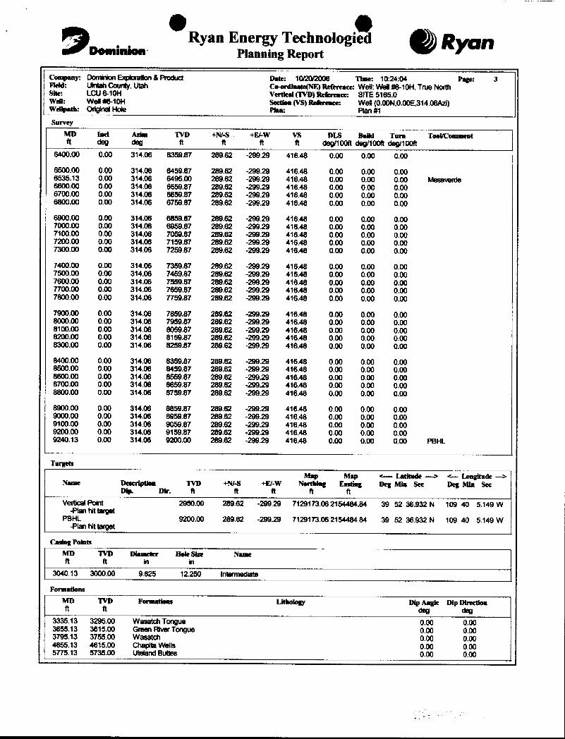
Ryan EnerLTohnologi gyggCompany: DominionExpkwaion &Poduct Date: 10/20/2006 Time: 10:24:04 Page: 3Fleid: UinlahCounty, Utah Coenlimate(NE) Refemace: Wei: Well#6-10H, True NorthSite: LCU6-10H Vertical (WD) Refenwace: SITE 5165.0Weil: Well #6-10H Seedom(VS)Reserence: Wel (0.00N,0.00E,314.06Azi)Weilpath: OriginalHole Plan: Plan #1Survey
MD Inci Asim WD +NI-5 +E/-W V5 DLS Build Tura Tool/Commentft dog deg it ft ft ft deg/100ft deg/100R deg/100R
6400.00 0.00 314.06 6359.87 289.62 -299.29 418.48 0.00 0.00 0.00
6500.00 0.00 314.06 6459.87 289.62 -299.29 416 48 0.00 0.00 0.006535.13 0.00 314.06 6495.00 289.62 -299.29 416 48 0.00 0.00 0.00 Mesaverde6600.00 0.00 314.06 6559.87 289.62 -299.29 416 48 0.00 0.00 0.006700.00 0.00 314.06 6659.87 289.62 -299.29 416 48 0.00 0.00 0.006800.00 0.00 314.06 6759.87 289.62 -299.29 416 48 0.00 0.00 0.00
6900.00 0.00 314.06 6859.67 289.62 -299.29 416 48 0.00 0.00 0.007000.00 0.00 314.06 6959.87 289.62 -299.29 416 48 0.00 0.00 0.007100.00 0.00 314.06 7059.87 289.62 -299.29 416 48 0.00 0.00 0.007200.00 0.00 314.06 7159.87 289.62 -299.29 416 48 0.00 0.00 0.007300.00 0.00 314.06 7259.87 289.62 -299.29 416 48 0.00 0.00 0.00
7400.00 0.00 314.06 7359.87 289.62 -299.29 416 48 0.00 0.00 0.007500.00 0.00 314.06 7459.87 289.62 -299.29 416 48 0.00 0.00 0.007600.00 0.00 314.06 7559.87 289.62 -299.29 416 48 0.00 0.00 0.007700.00 0,00 314.06 7659.87 289.62 -299.29 416 48 0.00 0.00 0.007800.00 0.00 314.06 7759.87 289.62 -299.29 416 48 0.00 0.00 0.00
7900.00 0.00 314.06 7859.87 289.62 -299.29 416 48 0.00 0.00 0.008000.00 0.00 314.06 7959.87 289.62 -299.29 416 48 0.00 0.00 0.008100.00 0.00 314.06 8059.87 289.62 -299.29 416 48 0.00 0.00 0.008200.00 0.00 314.06 8159.87 289.62 -299.29 416 48 0.00 0.00 0.008300.00 0.00 314.06 8259.87 289.62 -299.29 416 48 0.00 0.00 0.00
8400.00 0.00 314.06 8359.87 289.62 -299.29 416 48 0.00 0.00 0.008500.00 0.00 314.06 8459.87 289.62 299.29 416 48 0.00 0.00 0.008600.00 0.00 314.06 8559.87 289.62 -299.29 416 48 0.00 0.00 0.008700.00 0.00 314.06 8659.87 289.62 -299.29 416 48 0.00 0.00 0.008800.00 0.00 314.06 8759.87 289.62 -299.29 416 48 0.00 0.00 0.00
8900.00 0.00 314.06 8859.87 289.62 -299.29 416 48 0.00 0.00 0.009000.00 0.00 314.06 8959.87 289.62 -299.29 416 48 0.00 0.00 0.009100.00 0.00 314.06 9059.87 289.62 -299.29 416 48 0.00 0.00 0.009200.00 0.00 314.06 9159.87 289.62 -299.29 416 48 0.00 0.00 0.009240.13 0.00 314.06 9200.00 289.62 -299.29 416 48 0.00 0,00 0.00 PBHL
Targets
Map Map <-- Latitude -> a Longitude -->
Name Descripden TVD +N/-S +E/-W NortWeg Easdag Dag Min See Deg Min SeeDip. Dir. ft ft it ft ft
Vertical Point 2950.00 289.62 -299 29 7129173.06 2154484.84 39 52 36.932 N 109 40 5.149 W-Plan hit target
PBHL 9200.00 289.62 -299.29 7129173.08 2154484.84 39 52 36.932 N 109 40 5.149 W-Plan hit target
Casing Points
MD WD Dia-stEr 801e Size Na-eft it in in
3040.13 3000.00 9.625 12.250 Intermediale
FormationsMD WD Formations Lithology Dip Angle Dip DIractionft ft dog deg
3335.13 3295.00 Wasatch Tongue 0.00 0.003655.13 3615.00 Green River Tongue 0.00 0.003795.13 3755.00 Wasatch 0.00 0.004655.13 4615.00 Chapita Wells 0.00 0.005775.13 5735.00 Uteland Buties 0.00

Ryan Energy Technologi gyggDensinion Planning Report
Company: DominionExploraion &Product Date: 10/20/2006 Time: 10:24:04 Page: 4FieM: Uinlah County, Utah Co.ordinate(NE) Reference: Wel: Wel #8-10H, True NorthSile: LCU6-10H Vertical(TVD) Refemace: SITE 5165.0Wen: Wei #8-10H secties(VS)Reference: Wei (0.00N,0.00E,314.06Azi)Weupath: OriginalHole Plan: Plan #1Fortsations
MD TVD Formations Litheingy DipAngle Dip Directionft ft deg deg
6535.13 6495.00 Mesamrde 0.00 0.00
Annotation
MD TVDft ft
530.00 530.00 KOP Build3°/100'925.22 922.41 Hold 11,86"
2516.06 2479.30 Drop 2.5°/100'2990.00 2949.87 Hold
O OSURFACE USE PLAN
CONDITIONS OF APPROVAL
AttachmentforPermit to Drill
Name of Operator: Dominion Exploration & ProductionAddress: 14000 QuailSprings Parkway, Suite 600
OklahomaCity,OK 73134Well Location: I U 6-1011
SIll : 2200' FNL & 2250' FWL Section 10-1lS-20E
BHL: 1900' FNL & 1950' FWL Section 10-1IS-20E
LJintah County, UT
The dirt contractor will be provided with an approved copy of the surface use plan of operationsbefore initiating construction.
The BLM onsite inspection for the referenced well was conducted on Thursday, May 4, 2006 at approximately11:20 am. In attendance at theonsite inspection were the following individuals:
Karl Wright Nat. Res. Prot. Spec. Bureau of Land Management - VernalBrandon McDonald Wildlife Biologist Bureau of Land Management - VernalKen Secrest Field Foreman Dominion E & P, Inc.Brandon Bowthorpe Surveyor Uintah Engineering & Land SurveyingBilly McClure Foreman LaRose ConstructionRandy Jackson Foreman Jackson ConstructionDon Hamilton Agent Buys & Associates, Inc.
1. Existing Roads:
a. The proposed well site is located approximately 14.69 miles south of Ouray, UT.
b. Directions to the proposed well site have been attached at the end of Exhibit B.
c. The use of roads under State and County Road Department maintenance are necessary toaccess the Little Canyon Unit. However, an encroachment permit isnot anticipated since noupgrades to the State or County Road system are proposed at this time.
d. All existing roads will be maintained and kept in good repair during all phases of operation.
e. Vehicle operators will obey posted speed restrictions and observe safespeedscommensuratewith road and weather conditions.
f. Since no improvements are anticipated to any State, County,Tribal or BLM access roads notopsoil striping will occur.
g. An off-lease federal right-of-way is not anticipated for the access road or utility corridorsince both are located within the existing Little Canyon Unit

O O
2. Planned Access Roads:
a. From the existing LCU 2-10H access road, an access isproposedtrendingeast approximately0.25 miles to the proposed well site. The access consists of entirely new disturbance andcrosses no significant drainages.
b. A road design plan is not anticipated at this time.
c. The proposed access road will consist of a 24' travelsurfàce within a 30' disturbed areaacross BLM lands.
d. BLM approval to construct and utilize the proposed access road is requested with thisapplication.
e. A maximum grade of 10%will be maintained throughout the project.
f. No turnouts are proposed,
g. No low water crossings and no culverts are anticipated. Adequate drainage structures will beincorporated into the road.
h. No surfacingmaterial will comefrom federal or Indian lands.
i. No gates or cattle guards are anticipated at thistime.
j. Surface disturbance and vehicular travel will be limited to the approved locationaccess road.
k. All access roads and surface disturbing activities will conformto the standardsoutlinedin theBureau of Land Management and Forest Service publication: Surface Operating Standardsfor Oil and GasExploration and Development, (1989).
1. The operator will be responsible for all maintenance of the access road including drainagestructures.
3. Location of Existing Wells:
a. Exhibit B has a map reflecting thesewells within a one mile radius of the proposed well.
4. Location of Production Facilities:
a. All permanent structures will be painted a flat, non-reflective Desert Brown or CarlsbadCanyon to match the standard environmental colors. All facilities will be painted within sixmonths of installation. Facilities required to comply withthe OccupationalSafetyand HealthAct (OSHA) may be excluded.
b. Site security guidelines identified in 43 CFR 3163.7-5 and Onshore Oil andGas OrderNo. 3will be adhered to.
c. A gas meter run will be constructed and located on lease within 500 feet of the wellhead.Meter runs will be housed and/or fenced. All gas production and measurementshallcomplywith the provisions of 43 CFR 3162. 7-3, Onshore Oil and Gas Order No. 5, and AmericanGas Association (AGA) Report No. 3.
d. A tank battery will be constructed on this lease, it will be surrounded by a dike of

O Ocapacity to contain the storage capacity of the largest tank. All loading lines and valves willbe placed inside the berm surroundingthe tank battery. All liquid hydrocarbons productionand measurement shall conform to theprovisions of 43 CFR 3162.7-3 and Onshore Oil andGas Order No. 4 and Onshore Oil and Gas Order No. 5 for natural gas production andmeasurement.
e. Any necessary pits will be properly fenced to prevent any wildlife and livestock entry.
f. All access roads will be maintained as necessary to prevent erosion and accommodateyear-round traffic. The road will be maintained in a safe useable condition.
g. The site will require periodic maintenance toensure thatdrainages are kept open and free ofdebris, ice, and snow, and that surfaces are properly treated to reduce erosion, fugitive dust,and impacts to adjacentareas.
h. A gas pipeline is associated with this application and is being applied for at this time. Theproposed gas pipeline corridor will leave the north sideof the well siteand traverse 524' eastto the existing LCU 2-10 H pipeline corridors.
i. The new gas pipeline will be a 10"or less steel surface line within a 20' wide utility corridor.The use of the proposed well site and access roads will facilitate the staging of thepipelineconstruction. A new pipeline length of approximately 524' is associated with this well.
j. With this application Dominion requests permission to upgrade theexisting 6" pipeline to a10" or less pipeline from thetie-inpoint referenced in the plats to the existing LCU pipelinecorridor that trends east and west across the LCU project area.
k. Dominion intends on installing the pipeline on the surface by welding manyjointsinto longlengths, dragging the long lengths into position and then completing a final welding pass tojointhe long lengths together. Dominion intends on connecting thepipelinetogetherutilizingconventional welding technology.
5. Location and Type of Water Supplv:
a. The location and typeof water supply has been addressed as number I 1 within thepreviousdrilling plan information.
6. Source of Construction Material:
a. The use of materials will conform to 43 CFR 3610.2-3.
b. No construction materials will be removed from Ute Tribal or BLM lands.
c. If any gravel is used, it will be obtained from a state approved gravel pit.
7. Methods of Handling Waste Disposal:
a. All wastes associated with this application will be contained and disposed of utilizingapproved facilities.
b. Drill cuttings will be contained and buried on site.
c. The reserve pit will be located outboard of the location and along the west side of the
O O
capacity to contain the storage capacity of the largest tank. All loading lines and valves willbe placed inside the berm surroundingthe tank battery. All liquid hydrocarbons productionand measurement shall conform to theprovisions of 43 CFR 3162.7-3 and Onshore Oil andGas Order No. 4 and Onshore Oil and Gas Order No. 5 for natural gas production andmeasurement.
e. Any necessary pits will be properly fenced to prevent any wildlife and livestock entry.
f. All access roads will be maintained as necessary to prevent erosion and accommodateyear-round traffic. The road will be maintained in a safe useable condition.
g. The site will require periodic maintenance toensure thatdrainages are kept open and free ofdebris, ice, and snow, and that surfaces are properly treated to reduce erosion, fugitive dust,and impacts to adjacentareas.
h. A gas pipeline is associated with this application and is being applied for at this time. Theproposed gas pipeline corridor will leave the north sideof the well siteand traverse 524' eastto the existing LCU 2-10 H pipeline corridors.
i. The new gas pipeline will be a 10"or less steel surface line within a 20' wide utility corridor.The use of the proposed well site and access roads will facilitate the staging of thepipelineconstruction. A new pipeline length of approximately 524' is associated with this well.
j. With this application Dominion requests permission to upgrade theexisting 6" pipeline to a10" or less pipeline from thetie-inpoint referenced in the plats to the existing LCU pipelinecorridor that trends east and west across the LCU project area.
k. Dominion intends on installing the pipeline on the surface by welding manyjointsinto longlengths, dragging the long lengths into position and then completing a final welding pass tojointhe long lengths together. Dominion intends on connecting thepipelinetogetherutilizingconventional welding technology.
5. Location and Type of Water Supplv:
a. The location and typeof water supply has been addressed as number I 1 within thepreviousdrilling plan information.
6. Source of Construction Material:
a. The use of materials will conform to 43 CFR 3610.2-3.
b. No construction materials will be removed from Ute Tribal or BLM lands.
c. If any gravel is used, it will be obtained from a state approved gravel pit.
7. Methods of Handling Waste Disposal:
a. All wastes associated with this application will be contained and disposed of utilizingapproved facilities.
b. Drill cuttings will be contained and buried on site.
c. The reserve pit will be located outboard of the location and along the west side of the

0 0
d. The reserve pit will be constructed so as not to leak, break, or allow any discharge.
e. The reserve pit will be lined with 16 mil minimum thickness plastic nylon reinforced linermaterial. The liner will overlay a felt liner pad only if rock is encounteredduringexcavation.The pit liner will overlap the pit walls and be covered with dirt and/or rocks to hold it inplace. No trash,scrap pipe, etc., that couldpuncture the liner will be disposed of in thepit.Pit walls will be sloped no greater than2:1. A minimum2-foot freeboard will be maintainedin the pit at all times during the drilling and completion operation.
f The reserve pit has been located in cut material. Three sides of the reserve pit will be fencedbefore drilling starts. The fourth side will be fenced as soon as drilling is completed, andshall remain until the pit is dry. After the reserve pit has dried, all areas not needed forproduction will be rehabilitated.
g. No chemicals subject to reporting under SARA Title III (hazardous materials) in an amountgreater than 10,000 pounds will be used, produced, stored, transported,or disposed ofannually in association with the drilling, testing, or completion of the well. Furthermore, noextremely hazardous substances,as defined in 40 CFR 355, in thresholdplanning quantities,will be used, produced, stored, transported, or disposed of in association with the drilling,testing, or completion of the well.
h. Trash will be contained in a trashcage and hauled away to an approved disposal site asnecessary but no later than at the completion of drilling operations. The contents of thetrashcontainer will be hauled off periodically to the approved UintahCountyLandfillnear Vernal,Utah.
i. Produced fluids from the well other than water will be produced into a test tank until suchtime as construction of production facilities is completed. Any spills of oil, gas, salt water orother produced fluids will be cleaned up and removed.
j. After initial clean-up, a 400 bbl tank will be installed to contain produced waste water. Thiswater will be transported from thetank to an approvedDominion disposal well for disposal.
k. Produced water from the production well will be disposed of at theRBU l 3-11F or RBU 16-19F disposal wells in accordance with Onshore Order #7.
1. Any salts and/or chemicals, which are an integral part of the drilling system, will be disposedof in the same manner as the drilling fluid.
m. Sanitary facilities will be on site at all timesduring operations. Sewage will be placed in aportable chemical toiletand the toilet replaced periodically utilizing a licensed contractor totransport by truck the portable chemical toilet so that its contents can be delivered to theVernal Wastewater Treatment Facility in accordance with state and county regulations.
8. Ancillary Facilities:
a. Garbage Containers and Portable Toilets are the only ancillary facilities proposed in this
O O
9. Well Site Layout: (See Exhibit B)
a. The well will be properly identified in accordance with 43 CFR 3162.6.
b. Access to the well pad will be from the northeast.
c. The pad and road designs are consistent with BLM specification
d. A pre-construction meeting with responsible company representative, contractors and theBLM will be conducted at the project site prior to commencement of surface-disturbingactivities. The pad and road will be construction-staked prior to thismeeting.
e. The pad has been staked at its maximum size; however it will be constructed smaller ifpossible, dependingupon rig availability. Should the layout change, thisapplication will beamended and approved utilizing a sundry notice.
f. All surface disturbing activities, will be supervised by a qualified, responsible companyrepresentative who is aware of the terms and conditions of the APD and specifications in theapproved plans,
g. All cut and fill slopes will be such that stability can be maintained for the life of theactivity.
h. Diversion ditches will be constructed as shown around the well site toprevent surfacewatersform entering the well site area.
i. The site surface will be graded to drain away from the pit to avoid pit spillage during largestorm events.
j. The stockpiled topsoil (first 6 inches or maximum available) will be stored in a windrow onthe uphill side of the location to prevent any possible contamination. All topsoil will bestockpiled for reclamation in such a way as to prevent soil loss and contamination.
k. Pits will remain fenced until site cleanup.
1. The blooie line will be located at least 100 feet from the well head.
m. Water injection may be implemented if necessary to minimize the amount of fugitive dust.
10. Plans for Restoration of the Surface (Interim Reclamation and Final Reclamation):
a. Site reclamation for a producing well will be accomplished for portions of the site notrequired for the continued operation of thewell.
b. Upon well completion, any hydrocarbons in the pit shall be removed in accordance with 43CFR 3162.7-l.Once the reserve pit is dry, theplastic nylon reinforced liner shall be torn andperforated before backfillingof the reserve pit. The reserve pit and that portion of thelocation not needed for production facilities/operations will be re-contoured to theapproximate natural contours.
c. Following BLM published Best Management Practices the interim reclamation will becompleted within 90 days of completion of the well to reestablishvegetation,reducedustanderosion and compliment the visual resources of the area.a. All equipment and debris will be removed from the area proposed for
O O
reclamation and the pit area will be backfilled and re-contoured.b. The area outside of the rig anchors and other disturbed areas not needed for the
operation of the well will be re<ontoured to blend with the surrounding area andreseeded at 12 lbs /acre with the following native grass seeds:
1. Crested Wheat Grass (4 lbs / acre)2. Needle and Thread Grass (4 lbs / acre)3. Rice Grass (4 lbs / acre)
c. Reclaimed areas receiving incidental disturbance during the life of the producing wellwill be re-contoured and reseeded as soon as practical.
d. The Operatorwill control noxious weeds along access road use authorizations, pipelinerouteauthorizations, well sites, or other applicable facilitiesby sprayingor mechanicalremoval. Alist of noxious weeds may be obtained from the BLM or the appropriate County ExtensionOffice. On BLM administered land, it is required that a Pesticide Use Proposal be submittedand approved prior to the application of herbicides, pesticides or possibly hazardouschemicals.
e. Prior to final abandonment of the site, all disturbed areas, including theaccess road, will bescarified and left with a rough surface. The site will then be seeded and/or planted asprescribed by the BLM. The BLM recommended seed mix will be detailed within theirapproval documents.
11. Surface and Mineral Ownership:
a. Surface Ownership - Federal under the management of theBureau of Land Management - VemalField Office, 170 South 500 East, Vernal, Utah 84078; 435-781-4400.
b. Mineral Ownership - Federal under themanagement of theBureauofLand Management - VemalField Office, 170 South 500 East, Vernal, Utah 84078; 435-781-4400.
12. Other Information:
a. AIA Archaeological has conducted a Class Ill archeological survey. A copy of the report hasbeen submitted under separate cover to the appropriate agencies by AIA Archaeological,
b. Alden Hamblin has conducted a paleontological survey. A copy of the report has beensubmitted under separate cover to the appropriate agencies by Alden Hamblin.
c. Our understanding of the results of the onsite inspection are:
a. No Threatened and Endangered flora and fauna species were found during the onsiteinspection.
b. No drainage crossings that require additional State or Federal approval are beingcrossed.
c. A pipeline upgrade of an existing pipeline is proposed with this application.
d. The pit will be double-felted to minimize the probability or rock puncture to the

. O O
13. Operator's Representative and Certification
Title Name Office PhoneCompany Representative (Roosevelt) Ken Secrest 1435-7224521Company Representative (Oklahoma) Carla Christian 1405-749-5263Agent for Dominion Don Hamilton 1435-6374075
Certification:
I hereby certify that I, or persons under my direct supervision, have inspected theproposeddrill site and access route; that I am familiar with the conditions which currently exists; thatthe statements made in this APD package are, to the best of my knowledge, true and correct;and that the work associated with the operations proposed herein will be performed byDominion Exploration & Production, Inc. and its contractors and subcontractors inconformity with this APD package and the terms and conditions under which it is approved. Ialso certify responsibility for the operations conducted on that portion of the leased landsassociated with this application, with bond coverage being provided under Dominion's BLMbond. This statement is subject to theprovisions of 18 U.S.C. 1001 for the filing of a falsestatement.
Signature: &A Date: /Û•

3000 psi. ROTATINGB0P Equipment HEAD
3000psi WP
PUN
TR
CHOKEMNIFOLD2° MIN. ADJUSTABLE 3000 psi) CHOKE BUNDRAMS
TOMUD/G4SSEPARATORORPIT 3000 psio o PIPERAMS
O3" MIN MNUAL MNUAL
RATEDTO VALVE VALVE
0MNU4L REMOTEAV E VALVE
2" UNEp FROM
J" WIN PUMPS
BLEED
a o a O
IJNEPlf 3" UNETO
O
C4SINGHEADWITHTHD'O
QUTLETSAWDVALVES
2" MIN REMOTEOPERATED
CHOKE
TOMUD/G4SSEPARATOROR

O O
DOMINION EXPLR. & PROD., INC.LCU #6-10H
SECTION 10, TllS, R20E, S.L.B.&M.
PROCEED IN A WESTERLY DIRECTION FROM VERNAL, UTAH ALONG U.S.HIGHWAY 40 APPROXIMATELY 14.0 MILES TO THE JUNCTION OF STATEHIGHWAY 88; EXIT LEFT AND PROCEED IN A SOUTHERLY DIRECTIONAPPROXIMATELY 17.0 MILES TO OURAY, UTAH; PROCEED IN ASOUTHERLY, THEN SOUTHEASTERLY DIRECTION APPROXIMATELY 9.1MILES ON THE SEEP RIDGE ROAD TO THE JUNCTION OF THIS ROAD AND ANEXISTING ROAD TO THE SOUTH; TURN RIGHT AND PROCEED IN ASOUTHERLY DIRECTION APPROXIMATELY 6.6 MILES TO THE JUNCTION OFTHIS ROAD AND AN EXISTING ROAD TO THE SOUTHWEST; TURN LEFT ANDPROCEED IN A SOUTHWESTERLY DIRECTION APPROXIMATELY 2.0 MILESTO THE #11-10H AND AN EXISTING TWO-TRACK ROAD TO THE NORTH;PROCEED IN A NORTHERLY DIRECTION APPROXIMATELY 0.25 MILES TOTHE BEGINNING OF THE PROPOSED ACCESS TO THE SOUTHWEST; FOLLOWROAD FLAGS IN A SOUTHWESTERLY DIRECTION APPROXIMATELY 0.1MILES TO THE PROPOSED LOCATION.
TOTAL DISTANCE FROM VERNAL, UTAH TO THE PROPOSED WELLLOCATION IS APPROXIMATELY 49.05
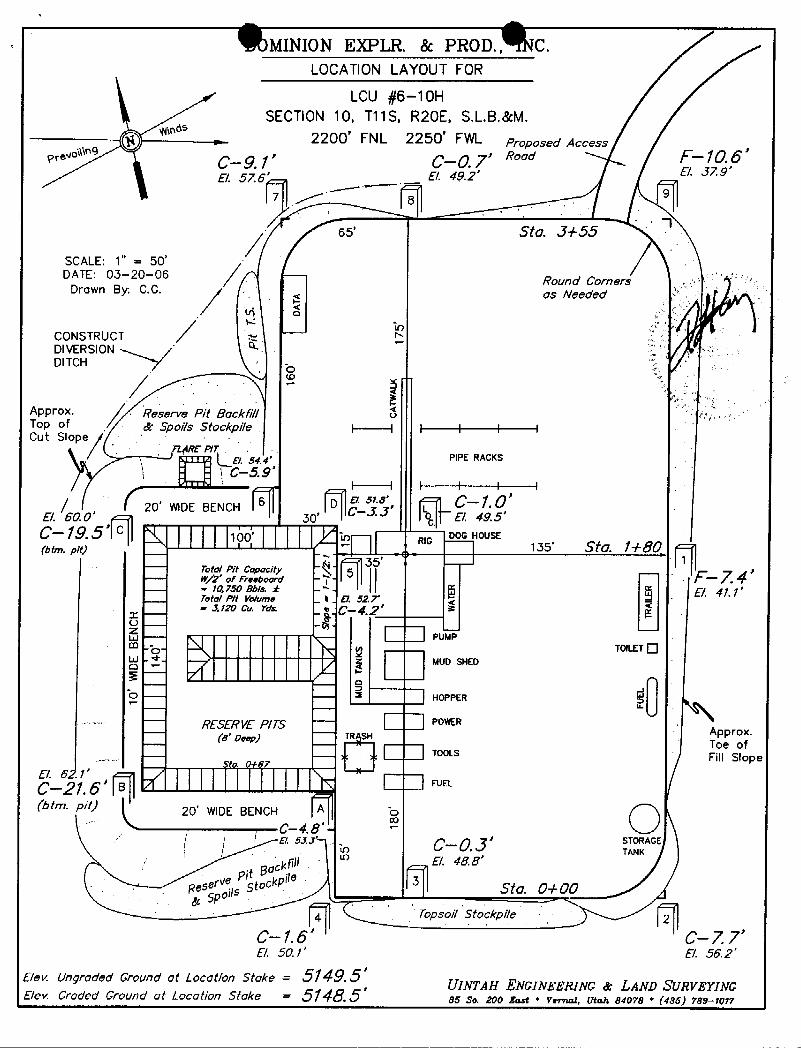
MINION EXPLR. & PROD., C.LOCATION LAYOUT FOR
LCU #6--10HSECTION 10, T11S, R20E, S.L.B.&M.
2200' FNL 2250° FWL Proposed Accessprovo 9 g_g yr Ç_Q 7' Road -10.6
E/. 57.6' E/. 49.29
65' Sto. J+55
SCALE: 1" = 50'DATE: 03-20-06
-
Round CornersDrawn By C.G. as Needed
CONSTRUCTDIVERSIONDITCH -
Appro×. Reserve Pit Backfi//Top of / & Spoi/s Stockpile i I I I I ICut Slope
AgE P/ TE/. 54.4. PIPE RACK5
\ C--5.9'
20 WIDEBENCH30' E 4 .5C--19 S' o ¯¯¯¯
HOUSE
35 -
Told Pit ¢opacity ¯
- 7 *- W/2' of Presboard - - / •
- - 10.750 Bb/s. ± -*- E/. 41.1'Totd P/t Volume
_t
.E/. 527'
= 1120 Ot. Yok e_Ç-4,j'
PUco TOILET
-- - - - MUD SHED
o -- -- 2 HOPPER
¯¯ RESERVE P/75 ¯¯
Approx.¯¯¯
(s' oo. )_¯¯
IN SHTOS Of
-- TOOLs Fill Slope
FUEL
(btm. pit) 20' WIDE BENCHC-4.8 -
O 31 J' C - 0.J' "s^
E/. 48.8'
Resek
Sto. 0+00
Topsoi/ Stockpile
C-1.6' C-7.7'8. 50.1' E 56.2'
Bev. Ungraded Ground at Location Stoke = 5149.5'UINTAH ENGINEERING & LAND St/RVEY1NG
Elev Graded Ground of Location Stake - 5148.5 86 So, 200 East * Verruzi, Utah 84078 * (435)
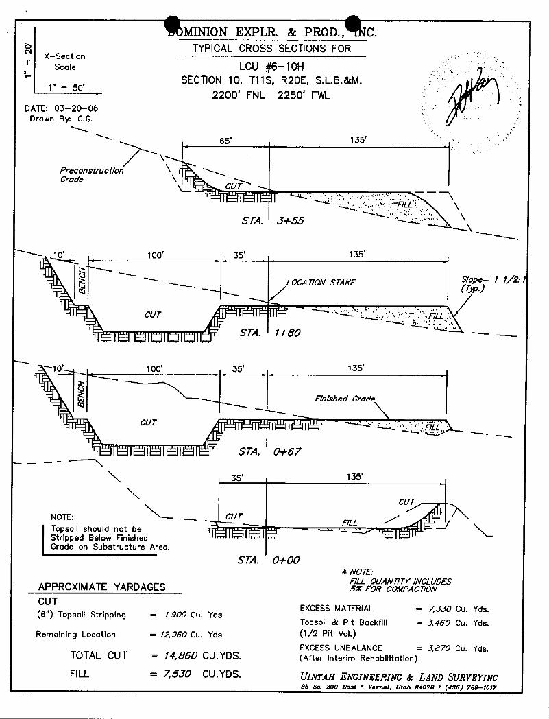
MINION EXPLR. & PROD., C.'O x-section TYPICALCROSS SECTIONSFOR
scale LCU #6-10HSECTION 10, T11S, R20E, S.L.B.&M.
1" = 50'2200' FNL 2250' FWL
DATE: 03-20-06Drawn By C.G.
65' 135'
Preconstruction X iGrade \ NCUT ,
STA. J+55 ' \
100' 35' 135
LOCATION STAKE S/ope= 1 1/'2: 1
10 . 100' 35' 135
inished Grade
CUT
STA. 0+67
35· 135'
p il sho dn bhe -
Grade on substructureAreg.STA. 0+00
* NO7E:F/LL QUAN717Y/NCLUDESAPPROXIMATEYARDAGES SX FOR COMPAC710N
CUT EXCESSMATERIAL = 7,JJO Cu. Yds.(6") Topsoil Stripping = 1,900 Cu. Yds.
Topsoil & Pit Backfill = 3,460 Cu. Yds.Remaining Location = 12,960 Cu. Yds. (1/2 Pit Vol.)
EXCESS UNBALANCE = J,870 Cu. Yds.TOTALCUT = 14,860 CU.YDS. (After Interim Rehabilitation)
FILL = 75JO CU.YDS. UINTAH ENGINEERING & LAND SÏTRVEYING86 So. ß00 East * Vemal, Utah 84078 * (486)
MINION EXPLR. & PROD., C.'O x-section TYPICALCROSS SECTIONSFOR
scale LCU #6-10HSECTION 10, T11S, R20E, S.L.B.&M.
1" = 50'2200' FNL 2250' FWL
DATE: 03-20-06Drawn By C.G.
65' 135'
Preconstruction X iGrade \ NCUT ,
STA. J+55 ' \
100' 35' 135
LOCATION STAKE S/ope= 1 1/'2: 1
10 . 100' 35' 135
inished Grade
CUT
STA. 0+67
35· 135'
p il sho dn bhe -
Grade on substructureAreg.
STA. 0+00* NO7E:
F/LL QUAN717Y/NCLUDESAPPROXIMATEYARDAGES SX FOR COMPAC710NCUT EXCESSMATERIAL = 7,JJO Cu. Yds.(6") Topsoil Stripping = 1,900 Cu. Yds.
Topsoil & Pit Backfill = 3,460 Cu. Yds.Remaining Location = 12,960 Cu. Yds. (1/2 Pit Vol.)
EXCESS UNBALANCE = J,870 Cu. Yds.TOTALCUT = 14,860 CU.YDS. (After Interim Rehabilitation)
FILL = 75JO CU.YDS. UINTAH ENGINEERING & LAND SÏTRVEYING86 So. ß00 East * Vemal, Utah 84078 * (486)
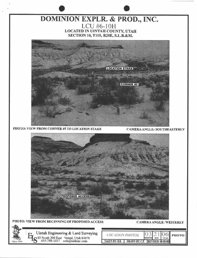
O ODOMINION EXPLR. & PROD., INC.
LCU #6-10HLOCATED IN UINTAH COUNTY, UTAH
SECTION 10, T11S, R20E, S.L.B.&M.
PHOTO: VIEW FROM CORNER #5 TO LOCATION STAKE CAMERA ANGLE: SOUTHEASTERLY
PHOTO: VIEW FROM BEGINNING OF PROPOSED ACCESS CAMERA ANGLE: WESTERLY
LOCATIONPHOTos 03 2 l 06 moro85 South 200 East Vemal, Utah 84078 DAY YEAR
- Since 1964 - 435-789-1017 [email protected] TAKENBY:B.B. DRAWNBY:C.R VISED:00-00·
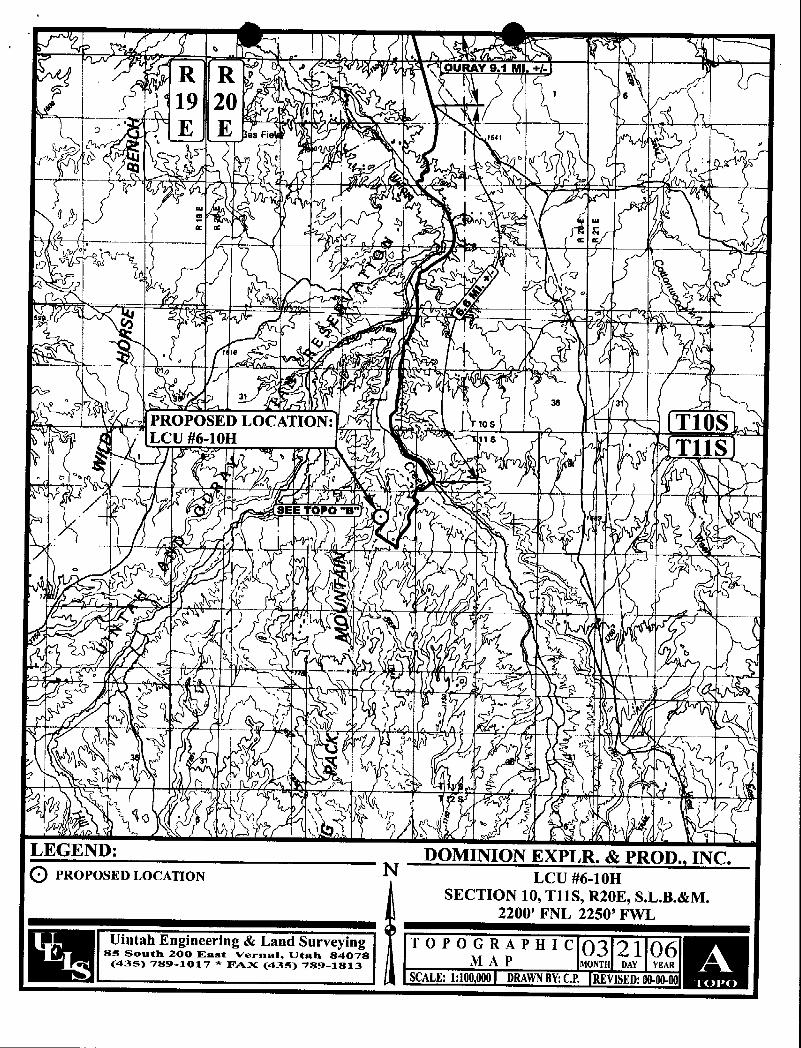
Fie
OU Y 9 1 M
I OPOS D OCATI SLCU #6-10
LEGEND: DOMINION EXPLR. & PROD., INC.O PROPOSED LOCATION N LCU #6-10H
SECTION 10, T11S, R20E, S.L.B.&M.2200' FNL 2250' FWL
Uintah Engineering & Land Surveying TOP ORÃ PH I c 03 21 0685 South 200 East VernnI, Utah 84078 M A P MONT DAY YEAR(435) 789-1017 * FAX (435) 789-1813SCALE:1:100,000 DRAWNBY:C.P. REVISED:
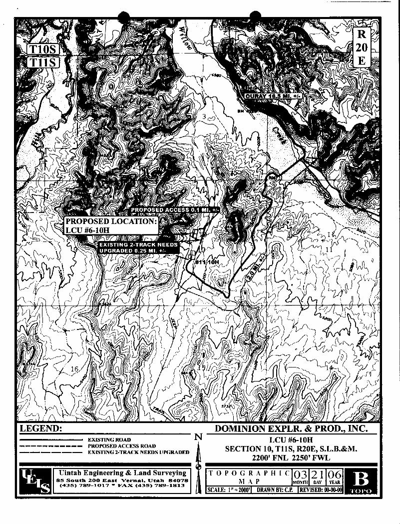
RT10S 20T11S E
OURAY 16.5 MI. +I·
/ 3
PROPOSED LOCATION: ·;
LC
LEGEND: DOMINION EXPLR. & PROD., INC.EXISTING ROAD N LCU #6-10H
----------- PROPOSED ACCESS ROAD SECTION 10 T11S R20E S.L.B.&M.-------- EXISTING 2-TRACK NEEDS UPGRADED * * *
Im2200' FNL 2250' FWL
Uintah Engineering & Land Surveying TOPOGR A PH I e 03 2 1 ÖÏ85 South 200 East Vernal. Utals 84078 Î A ONT DAY YEAR
(435) 789-1017 * FAX (435) 789-1813SCALE:1" -2000' DRAWNBY:C.P.

T10S RT11S 20
E
\ BM
PROPOSED LOCATION:
LEGEND: DOMINION EXPLR. & PROD., INC.pf DISPOSAL WELLS WATER WELLS N LCU #6-10He PRODUCING WELLS ABANDONED WELLs SECTION 10, T11S, R20E, S.L.B.&M.g SHUT IN WELLS - - TEMPORARILY ABANDONED 2200' FNL 2250' FWL
- Uintah Engineering & Land Surveying TOPOGR A PH I e 03 2 1 06as son 2ooMm:7ast ver I, 11t7an a a
SCALE:1" = ' DRAWNBY:C.RMO H DY
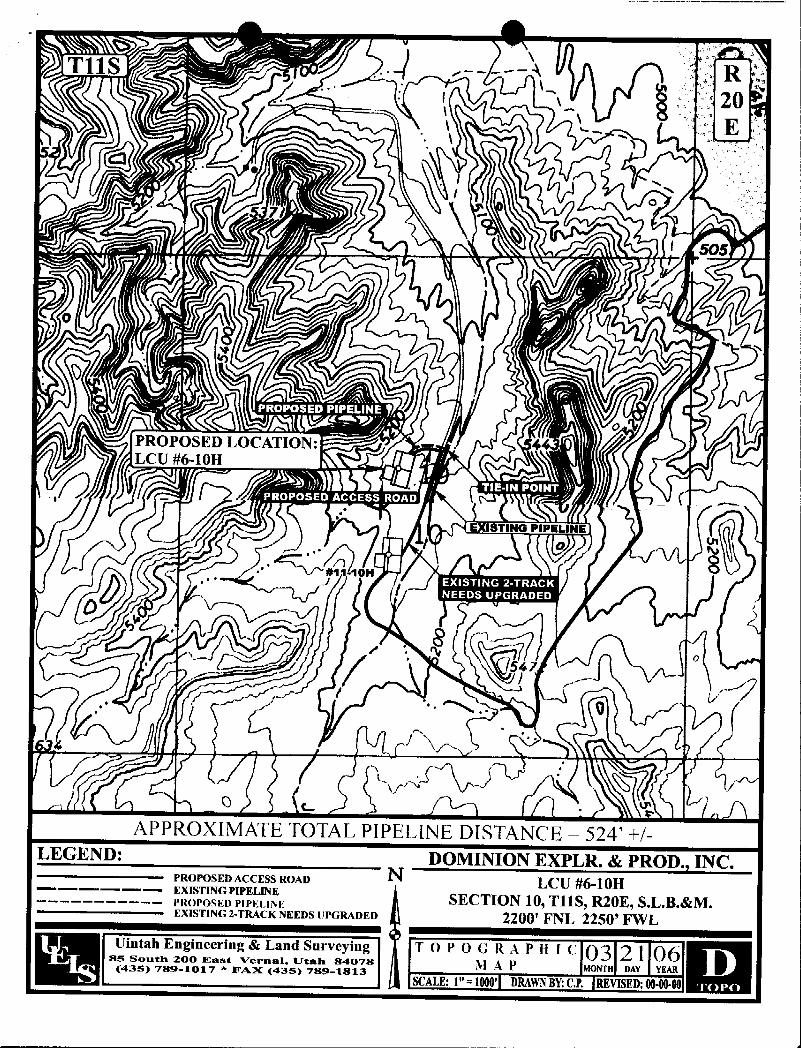
T11S ... -- -- R20E
505
PROPOSED LOCATION: . 4LCU #6-10H
EXISTING PINLINE
"10H
APPROXIMATE TOTAL PIPELlNE DISTANCE = 524'+/-LEGEND: DOMINION EXPLR. & PROD., INC.
PROPOSED ACCESS ROAD N LCU #6-10H------ EXISTINGPIPELINE
SECTION 10, T11S, R20E, S.L.B.&M.------------ PROPOSED PIPEl INEEXISTING 2-TRACK NEEDS UPGRADED 2200' FNL 2250' FWL
ÜÏntahE¯igine¯¯Ïiig& Land¯S¾yÏng
TO ÜOGR A PH i c 03 2 1 0685 South 200 East Verunl, IJtah 84078 N A Ÿ NT DAY YEAR(435) 789-1017 * FAX (435) 789-1813SCALE:1" - 1000' DRAWNBY:C.P. REVISED:

0 0LEGEND
G = Oil Line ·
Vote LineR = RelieF Line (Pressure)C = Condensole LaneV = Vent LineD = Droin LineM = Gas Meter °
P = PumpBP = Bock Pressure volveSVS = Seoteci Yhen ShippingSUS = Seoled Unless ShippingT = Heot Troced LineVELLHEAD (typ> e H = HeoterBL = Buried Line
><'j = Volve= Check Volve
SC = Seateci Closed volveNC = Nornotty Closed
/ BD = Blowdown LineBD. BL
OO' el
30'
SEPW. BL 300 bbt Tonk
BL. C(condensate)
SC SUSCLYCOL &REBOILER - The site security plan is on file
to in DEPI s dîstrict office located at
CONTACT1400-N. State St., Roosevelt, UTah.
TOWER n It can be inspected during officendrs, from 30aAN thna 3:30 PH,
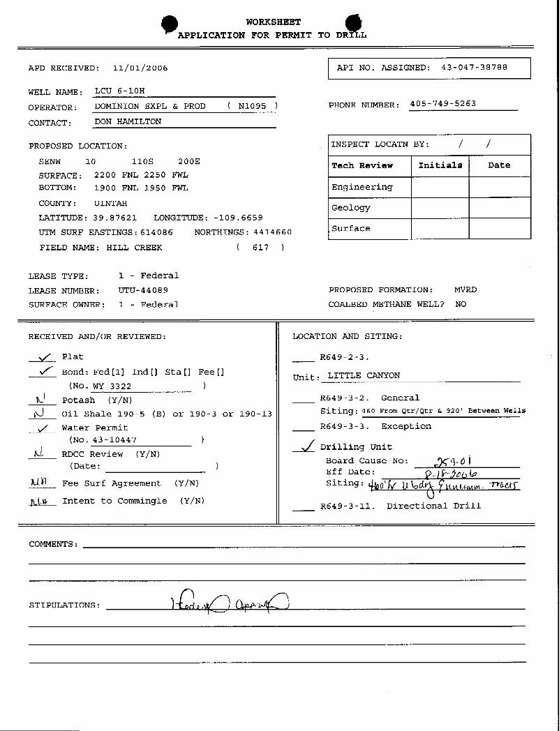
WORKSHEET
APPLICATION FOR PERMIT TO DR L
APD RECEIVED: 11/01/2006 API NO. ASSIGNED: 43-047-38788
WELL NAME: LCU 6-10H
OPERATOR: DOMINION EXPL & PROD ( N1095 ) PHONE NUMBER: 405-749-5263
CONTACT: DON RAMILTON
PROPOSED LOCATION: INSPECT LOCATN BY: / /SENW 10 110S 200E Tech Review Initials DateSURFACE: 2200 FNL 2250 FWL
BOTTOM: 1900 FNL 1950 FWL Engineering
COUNTY: UINTAE GeologyLATITUDE: 39.87621 LONGITUDE: -109.6659
UTM SURF EASTINGS:614086 NORTHINGS: 4414660 Surface
FIELD NAME: HILL CREEK ( 617 )
LEASE TYPE: 1 - Federal
LEASE NUMBER: UTU-44089 PROPOSED FORMATION: MVRD
SURFACE OWNER: 1 - Federal COALBED METHANE WELL? NO
RECEIVED AND/OR REVIEWED: LOCATION AND SITING:
y/ Plat R649-2-3.
v/' Bond: Fed[1] Ind[] Sta[] Fee[]Unit: LITTLE CANYON
(No.WY 3322 )A Potash (Y/N) R649-3-2. General
6 Oil Shale 190-5 (B) or 190-3 or 190-13 Siting:460 From Qtr/Qtr & 920' Between Wells
Water Permit R649-3-3. Exception(No.43-10447 ) /
Drilling UnitA RDCC Review (Y/N)
Board Cause No: pÇ9-ÒÌ(Date:
Eff Date: Fjpglo)LLA Fee Surf Agreement (Y/N) Siting: ¢g ygg ggggt . WMT
in Intent to Commingle (Y/N) R649-3-11. Directional Drill
COMMENTS:
STIPULATIONS:

H-35F M 13-34F I i IICLi lfr3H 100 S-35F LCU I 151 LCU l3 56FBHL I CU 13 35FikWF NATLIRAL BLITTES FIELTilS R2OE ici H
,un 2n LCU 2H
Lou s-liiLOU2-III
LCU H
I LILUGO3II CUh2H
ICU61H LCUTIH100 7 311 I.CU F 2H
[ItI 611I HH H
Lkiillii 1 icus2II 1ICUlf3113ICUFilãII
ILU91II LOLIILU 2]I
122H BIIL itu ullin ŒUIO-IHH2H RIll 2H _Itllifill
UistAks ' 16111 LCUES•!H
00014 III(DIi LCUIfr3H ICU13ZHICUI4-3H BHL LLLIMI
I L M IN b5 IH
LITTLE CANYON UNITHL Mm LCU3 12H
LCU 2-ION I CU 2 12HLCM liH
LL U I-IIH 11HHILL CREEK FIELD
II ŒU6-IIH 1011812H
tcu LCU 5-IIH $ Bill i 12H 8111 1211
LCU n)IlBHL MIH lfU fillll ILLivilH I.Cil9QJI
i Ut] d un I.CU 16 nHLCUI312H
4-Ui I(Ri LCU 13 IIH
Kul LCU H-HHLCU W-HH
EIL PACU 21 15
BIt,94ckLI 12 15
Rit. PACK U
1510.PACE U
OPERATOR: DOMINION EXPL & PROD (N1095)
SEC: 10,12 T.11S R. 20E
FIELD: HILL CREEK (617)
COUNTY: UIN TAH
CAUSE: 25M1/8-18-2006 WdGION Utah OllGas and Mining
× LOCATION ABANDONEDe NEW LOCATION
Field Status Unit Status 4 PLUGGED & ABANDONEDABANDONED EXPLORATORY FRODUCINGGASACTIVE GASSTORAGE e PRODUCINGOILCOMBINED
CONDARY LS W E
INACTTVE I ING)s( TEMF. ABANDONED
M
EADTED
THERMLAS NLßcTION
SPP OIL WATER SUPFLY PREPARED BY: DIANA MASONSECONDARY WATER DISPOSAL DATE 6-NOVEMBER-2006TERMINATED
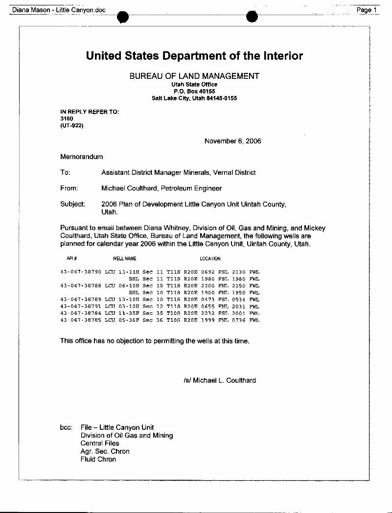
a Mason - Little Canyon.doc __ _ Page 1
United States Department of the InteriorBUREAUOF LANDMANAGEMENT
Utah State OfficeP.O. Box 45155
Salt Lake City, Utah 84145-0155
IN REPLY REFER TO:3160(UT-922)
November 6, 2006
Memorandum
To: Assistant District Manager Minerals, Vernal District
From: Michael Coulthard, Petroleum Engineer
Subject: 2006 Plan of Development Little Canyon Unit Uintah County,Utah.
Pursuant to email between Diana Whitney, Division of Oil, Gas and Mining, and MickeyCoulthard, Utah State Office, Bureau of Land Management, the followingwells areplanned for calendar year 2006 within the Little Canyon Unit, Uintah County, Utah.
API# WELLNAME LOCATION
43-047-38790 LCU 11-11H Sec 11 T11S R20E 0692 FSL 2130 FWLBHL Sec 11 T11S R20E 1980 FSL 1980 FWL
43-047-38788 LCU 06-10H Sec 10 T11S R20E 2200 FNL 2250 FWLBHL Sec 10 T11S R20E 1900 FNL 1950 FWL
43-047-38789 LCU 13-10H Sec 10 T11S R20E 0473 FSL 0534 FWL43-047-38791 LCU 03-12H Sec 12 T11S R20E 0655 FNL 2031 FWL43-047-38784 LCU 11-35F Sec 35 T10S R20E 2232 FSL 2001 FWL43-047-38785 LCU 05-36F Sec 36 T10S R20E 1999 FNL 0736 FWL
This office has no objection to permitting the wells at this time.
/s/ Michael L. Coulthard
bcc: File -- LittleCanyon UnitDivision of Oil Gas and MiningCentral FilesAgr. Sec. ChronFluid
a Mason - Little Canyon.doc __ _ Page 1
United States Department of the Interior
BUREAUOF LANDMANAGEMENTUtah State OfficeP.O. Box 45155
Salt Lake City, Utah 84145-0155
IN REPLY REFER TO:3160(UT-922)
November 6, 2006
Memorandum
To: Assistant District Manager Minerals, Vernal District
From: Michael Coulthard, Petroleum Engineer
Subject: 2006 Plan of Development Little Canyon Unit Uintah County,Utah.
Pursuant to email between Diana Whitney, Division of Oil, Gas and Mining, and MickeyCoulthard, Utah State Office, Bureau of Land Management, the followingwells areplanned for calendar year 2006 within the Little Canyon Unit, Uintah County, Utah.
API# WELLNAME LOCATION
43-047-38790 LCU 11-11H Sec 11 T11S R20E 0692 FSL 2130 FWLBHL Sec 11 T11S R20E 1980 FSL 1980 FWL
43-047-38788 LCU 06-10H Sec 10 T11S R20E 2200 FNL 2250 FWLBHL Sec 10 T11S R20E 1900 FNL 1950 FWL
43-047-38789 LCU 13-10H Sec 10 T11S R20E 0473 FSL 0534 FWL43-047-38791 LCU 03-12H Sec 12 T11S R20E 0655 FNL 2031 FWL43-047-38784 LCU 11-35F Sec 35 T10S R20E 2232 FSL 2001 FWL43-047-38785 LCU 05-36F Sec 36 T10S R20E 1999 FNL 0736 FWL
This office has no objection to permitting the wells at this time.
/s/ Michael L. Coulthard
bcc: File -- LittleCanyon UnitDivision of Oil Gas and MiningCentral FilesAgr. Sec. ChronFluid

'O OJON M. HUNTSMAN, JR.
Governor
GARY R. HERBERTLieutenant Governor
State of Utah November 7, 2006
Department ofNatural Resources
MICHAEL R. STYLERExecutive Director Dominion Exploration & Production, Inc.
14000 QuailSprings Parkway, Ste. 600Division of Oklahoma City, OK 73134
Oil, Gas & Mining
JOHN R. BAZADivision oirector Re: Little Canyon Unit 6-10H Well, Surface Location 2200' FNL, 2250' FWL,
SE NW, Sec. 10, T. 11 South, R. 20 East, Bottom Location 1900' FNL,1950' FWL, SE NW, Sec. 10, T. 11 South, R. 20 East, Uintah County, Utah
Gentlemen:
Pursuant to the provisions and requirements of Utah Code Ann.§ 40-6-1 etseq., Utah Administrative Code R649-3-1 et seq., and the attached Conditions ofApproval, approval to drill the referenced well is granted.
This approval shall expire one year from the above date unless substantial andcontinuous operation is underway, or a request for extension is made prior to theexpiration date. The API identification number assigned to this well is 43-047-38788.
Sincerely,
Gil HuntAssociate Director
pabEnclosures
cc: Uintah County Assessor (via e-mail)Bureau of Land Management, Vernal District Office
1594 West North Temple, Suite 1210, PO Box 14580LSalt Lake City, UT 84114-5801telephone(801) 538-5340• facsimile (801) 359-3940•TTY (801)538-7458•
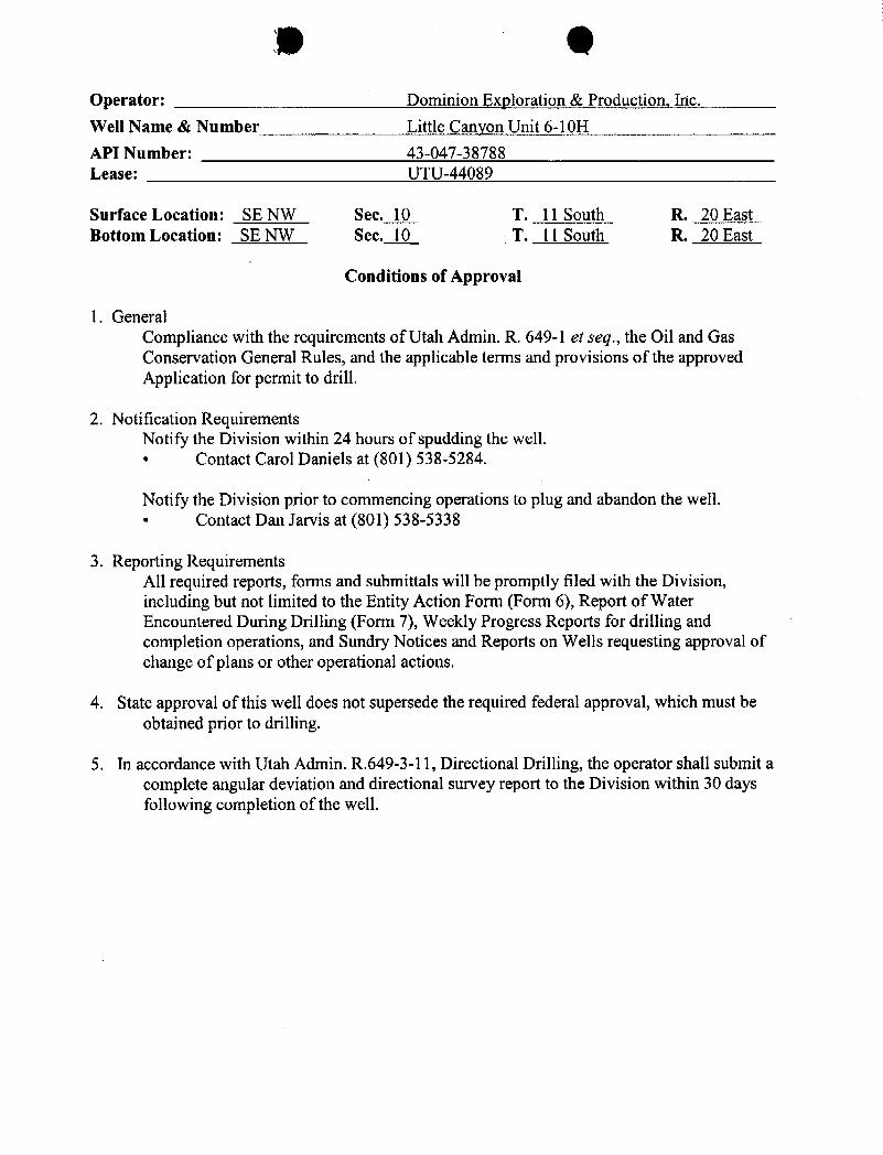
9 OOperator: Dominion Exploration & Production, Inc.
Well Name & Number Little Canyon Unit 6-10H
API Number: 43-047-38788Lease: UTU-44089
Surface Location: SE NW Sec. 10 T. 11 South R. 20 EastBottom Location: SE NW Sec. 10 T. 11 South R. 20 East
Conditions of Approval
1. GeneralCompliance with the requirements of Utah Admin. R. 649-1 et seq., the Oil and GasConservation General Rules, and the applicable terms and provisions of the approvedApplication for permit to drill.
2. Notification RequirementsNotify the Division within 24 hours of spudding the well.• Contact Carol Daniels at (801) 538-5284.
Notify the Division prior to commencing operations to plug and abandon the well.• Contact Dan Jarvis at (801) 538-5338
3. Reporting RequirementsAll required reports, forms and submittals will be promptly filed with the Division,including but not limited to the Entity Action Form (Form 6), Report of WaterEncountered During Drilling (Form 7), Weekly Progress Reports for drilling andcompletion operations, and Sundry Notices and Reports on Wells requesting approval ofchange of plans or other operational actions.
4. State approval of this well does not supersede the required federal approval, which must beobtained prior to drilling.
5. In accordance with Utah Admin. R.649-3-11, DirectionalDrilling, the operator shall submit acomplete angular deviation and directional survey report to the Division within 30 daysfollowing completion of the

Division of Oil, Gas and Mining ROUTINGOPERATOR CHANGE WORKSHEET 1. DJJ
X - Change of Operator (Well Sold) Operator Name Change/MergerThe operator of the well(s) listed below has changed, effective: 7/1/2007
FROM: (Old Operator): TO: ( New Operator):N1095-Dominion Exploration & Production, Inc N2615-XTO Energy Inc
14000 QuailSprings Parkway, Suite 600 810 Houston StOklahoma City, OK 73134 Fort Worth, TX 76102
Phone: 1 (405) 749-1300 Phone: 1 (817) 870-2800
CA No. Unit: LITTLE CANYON
WELL NAME SEC TWN RNG API NO ENTITY LEASE TYPE WELL WELLNO TYPE STATUS
SEE ATTACHED LIST
OPERATOR CHANGES DOCUMENTATIONEnter date after each listed item is completed1. (R649-8-10) Sundry or legal documentation was received from the FORMER operator on: 8/6/20072. (R649-8-10) Sundry or legal documentation was received from the NEW operator on: 8/6/2007
3. The new company was checked on the Department of Commerce, Division of Corporations Database on: 8/6/20074a. Is the new operator registered in the State of Utah: Business Number: 5655506-0143
4b. If NO, the operator was contacted contacted on:5a. (R649-9-2)Waste Management Plan has been received on: IN PLACE5b. Inspections of LA PA state/fee well sites complete on: n/a5c. Reports current for Production/Disposition & Sundries on: ok
6. Federal and Indian Lease Wells: The BLM and or the BIA has approved the merger, name change,or operator change for all wells listed on Federal or Indian leases on: BLM BIA
7. Federal and Indian Units:The BLM or BIA has approved the successor of unit operator for wells listed on:
8. Federal and Indian Communization Agreements ("CA"):The BLM or BIA has approved the operator for all wells listed within a CA on:
9. Underground Injection Control ("UIC") The Division has approved UIC Form 5, Transfer of Authority toInject, for the enhanced/secondary recovery unit/project for the water disposal well(s) listed on:
DATA ENTRY:1. Changes entered in the Oil and Gas Database on: 9/27/20072. Changes have been entered on the Monthly Operator Change Spread Sheet on: 9/27/20073. Bond information entered in RBDMS on: 9/27/20074. Fee/State wells attached to bond in RBDMS on: 9/27/20075. Injection Projects to new operator in RBDMS on: 9/27/20076. Receipt of Acceptance of Drilling Procedures for APD/New on: 9/27/2007BOND VERIFICATION:1. Federal well(s) covered by Bond Number: UTB0001382. Indian well(s) covered by Bond Number: n/a3a. (R649-3-1) The NEW operator of any state/fee well(s) listed covered by Bond Number 1043127623b. The FORMER operator has requested a release of liability from their bond on: 1/23/2008
The Division sent response by letter on:
LEASE INTEREST OWNER NOTIFICATION:4. (R649-2-10) The NEW operator of the fee wells has been contacted and informed by a letter from the Division
of their responsibility to notify all interest owners of this change on:COMMENTS:
XTO - LITTLE CANYON (DOMINION) FORM A.xls
Division of Oil, Gas and Mining ROUTINGOPERATOR CHANGE WORKSHEET 1. DJJ
X - Change of Operator (Well Sold) Operator Name Change/MergerThe operator of the well(s) listed below has changed, effective: 7/1/2007
FROM: (Old Operator): TO: ( New Operator):N1095-Dominion Exploration & Production, Inc N2615-XTO Energy Inc
14000 QuailSprings Parkway, Suite 600 810 Houston StOklahoma City, OK 73134 Fort Worth, TX 76102
Phone: 1 (405) 749-1300 Phone: 1 (817) 870-2800
CA No. Unit: LITTLE CANYON
WELL NAME SEC TWN RNG API NO ENTITY LEASE TYPE WELL WELLNO TYPE STATUS
SEE ATTACHED LIST
OPERATOR CHANGES DOCUMENTATIONEnter date after each listed item is completed1. (R649-8-10) Sundry or legal documentation was received from the FORMER operator on: 8/6/20072. (R649-8-10) Sundry or legal documentation was received from the NEW operator on: 8/6/2007
3. The new company was checked on the Department of Commerce, Division of Corporations Database on: 8/6/20074a. Is the new operator registered in the State of Utah: Business Number: 5655506-0143
4b. If NO, the operator was contacted contacted on:5a. (R649-9-2)Waste Management Plan has been received on: IN PLACE
5b. Inspections of LA PA state/fee well sites complete on: n/a
5c. Reports current for Production/Disposition & Sundries on: ok
6. Federal and Indian Lease Wells: The BLM and or the BIA has approved the merger, name change,or operator change for all wells listed on Federal or Indian leases on: BLM BIA
7. Federal and Indian Units:The BLM or BIA has approved the successor of unit operator for wells listed on:
8. Federal and Indian Communization Agreements ("CA"):The BLM or BIA has approved the operator for all wells listed within a CA on:
9. Underground Injection Control ("UIC") The Division has approved UIC Form 5, Transfer of Authority toInject, for the enhanced/secondary recovery unit/project for the water disposal well(s) listed on:
DATA ENTRY:1. Changes entered in the Oil and Gas Database on: 9/27/20072. Changes have been entered on the Monthly Operator Change Spread Sheet on: 9/27/20073. Bond information entered in RBDMS on: 9/27/20074. Fee/State wells attached to bond in RBDMS on: 9/27/20075. Injection Projects to new operator in RBDMS on: 9/27/20076. Receipt of Acceptance of Drilling Procedures for APD/New on: 9/27/2007BOND VERIFICATION:1. Federal well(s) covered by Bond Number: UTB0001382. Indian well(s) covered by Bond Number: n/a3a. (R649-3-1) The NEW operator of any state/fee well(s) listed covered by Bond Number 1043127623b. The FORMER operator has requested a release of liability from their bond on: 1/23/2008
The Division sent response by letter on:
LEASE INTEREST OWNER NOTIFICATION:4. (R649-2-10) The NEW operator of the fee wells has been contacted and informed by a letter from the Division
of their responsibility to notify all interest owners of this change on:COMMENTS:
XTO - LITTLE CANYON (DOMINION) FORM A.xls

STATE OF UTAH FORM 9DEPARTMENTOF NATURALRESOURCES
DIVISIONOF OIL,GAS AND MINING 5. LEASEDESIGNATIONANDSERIALNUMBER:
6. IF INDIAN,ALLOTTEEOR TRIBE NAMESUNDRY NOTICES AND REPORTS ON WELLS7. UNITor CAAGREEMENTNAME:
Do notuse thisform for proposals to drillnew wells, significantlydeepen existing wells below current bottom-hole depth, reenter plugged wells, or todrillhorizontal laterals. Use APPLICATIONFOR PERMITTO DRILLform for suchproposals.
1. TYPE OF WELL 8. WELLNAMEand NUMBER:OILWELL Ü GAS WELL 2 OTHERSEE ATTACHED
2. NAMEOFEnPERATOR: 9. A UETACHED
3. ADDRESS OF OPERATOR: 810 Houston Street PHONE NUMBER: 10. FIELDANDPOOL, OR WILDCAT:
crry Fort i/Vorth sixre TX zie76102 | (817) 870-2800 Natural Buttes4. LOCATIONOF WELL
FOOTAGESATSURFACE: SEE ATTACHED COUNTY: Uintah
QTR/QTR, SECTION, TOWNSHIP, RANGE, MERIDIAN: STATE:UTAH
n. CHECK APPROPRIATE BOXES TO INDICATENATUREOF NOTICE, REPORT, OR OTHER DATATYPE OF SUBMISSION TYPE OF ACTION
O ACIDIZE DEEPEN REPERFORATE CURRENT FORMATIONNOTICE OF INTENT
(Submit in Duplicate) ALTERCASING FRACTURETREAT SIDETRACKTO REPAIR WELL
Approximate date work willstart: CASING REPAIR NEWCONSTRUCTION TEMPORARILYABANDON
CHANGETO PREVIOUS PLANS OPERATOR CHANGE TUBINGREPAIR
O CHANGETUBING PLUGANDABANDON VENTOR FLARE
SUBSEQUENT REPORT Q CHANGEWELLNAME PLUG BACK WATERDISPOSAL(Submit Original Form Only)
O CHANGEWELLSTATUS PRODUCTION(START/RESUME) WATERSHUT-OFFDate of work completion:
O COMMINGLEPRODUCING FORMATIONS RECLAMATIONOF WELLSITE OTHER:
CONVERTWELLTYPE RECOMPLETE - DIFFERENTFORMATION
12. DESCRIBE PROPOSED OR COMPLETEDOPERATIONS. Clearly show all pertinent details including dates, depths, volumes, etc.
Effective July 1, 2007, XTO Energy Inc. has purchased the wells listed on the attachment from:
Dominion Exploration & Production, Inc.14000 Quail Springs Parkway, Suite 600Oklahoma City, OK 73134
James D. AbercrombieSr. Vice President, General Manager - Western Business Unit
Please be advised that XTO Energy Inc. is considered to be the operator on the attached list and is responsibleunder the terms and conditions of the lease for the operations conducted upon the lease lands. Bond coverageis provided by Nationwide BLM Bond #104312750 and Deþartment of Natural Resources Bond #104312762.
NAME(PLEASEPRINT) Win S. Ryan, sir TITLE Sr. Vice President - Land Administratior)
SIGNATURE 4 DATE 7/31/2007
(Thisspacefor RECEIVED
(5/2000)ÛÎVÎSlon ofOil,Gu andMining (See Instructionson ReverseSide) DN,OFOIL,GAS&MINING
EadeneRussell, Engineering
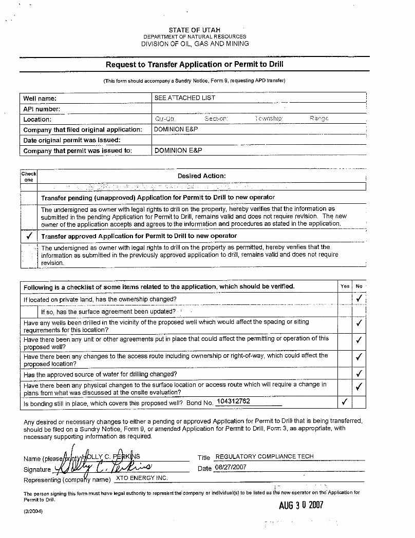
STATE OF UTAHDEPARTMENTOF NATURALRESOURCES
DIVISIONOF OIL,GAS AND MINING
Request to Transfer Application or Permit to Drill
(This form should accompany a Sundry Notice, Form9, requesting APD transfer)
Well name: SEE ATTACHED LIST
API number:Location: Qtr-Qtt: Section Township Rang;e
Company that filed original application: DOMINIONE&P
Date original permit was issued:
Company that permit was issued to: DOMINIONE&P
Check Desired Action:one
Transfer pending (unapproved) Application for Permit to Drill to new operator
The undersigned as owner with legal rights to drillon the property, hereby verifies thatthe information assubmitted in the pending Application for Permit to Drill, remains valid and does not require revision. The newowner of the application accepts and agrees to the information and procedures as stated in the application.
/ Transfer approved Application for Permit to Drill to new operator
The undersigned as owner with legal rights to drill on the property as permitted, hereby verifies that theinformation as submitted in the previously approved application to drill, remains valid and does not requirerevision.
Following is a checklist of some items related to the application, which should be verified. Yes No
If located on private land, has the ownership changed?
Ifso, has the surface agreement been updated?
Have any wells been drilled in the vicinity of the proposed well which would affect the spacing or sitingrequirements for this location?Have there been any unit or other agreements put in place that could affect the permittingor operation of thisproposed well?Have there been any changes to the access route including ownership or right-of-way,which could affect theproposed location?
Has the approved source of water for drillingchanged?
Have there been any physical changes to the surface location or access route which willrequire a change inplans from what was discussed at the onsite evaluation?
bonding still in place, which covers this proposed well? Bond No. 104312762 /
Any desired or necessary changes to either a pending or approved Application for Permit to Drill that is being transferred,should be filed on a Sundry Notice, Form 9, or amended Application for Permit to Drill, Form 3, as appropriate, withnecessary supporting information as required.
Name (pleas LL C. P K S Title REGULATORYCOMPLIANCE TECH
Signature i Date 08/27/2007
Representing (compa y name) XTO ENERGY INC.
The person signing this form must have legal authority to represent the company or individual(s) to be listed as tÑenew operator on the Application forPermit to Drill.

N1095 DOMINIONE and P, INC. to N2615 XTO ENERGY, INC.
api well name qtr qtr sec twp rng lease_num entity Lease well stat4304736892 LCU 5-9H SWNW 09 110S 200E UTU-34350 Federal GW APD4304736893 LCU 5-17H SWNW 17 110S 200E UTU-76265 Federal GW APD4304736896 LCU ll-9H NESW 09 110S 200E UTU-76265 Federal GW APD4304737059 LCU 2-17H NWNE 17 110S 200E UTU-76265 Federal GW APD4304737285 LCU 11-17H NESW 17 110S 200E UTU-76265 Federal OW APD4304737286 LCU 7-17H SWNE 17 110S 200E UTU-76265 Federal OW APD4304737448 LCU 9-8H NESE 08 110S 200E UTU-76265 Federal OW APD4304737653 LCU 14-9H SESW 09 110S 200E UTU-76265 Federal GW APD4304737997 LCU 9-10H NESE 10 110S 200E UTU-44089 Federal GW APD4304738069 LCU 8-35F SENE 35 100S 200E U-01470D Federal GW APD4304738070 LCU 12-35F NWSW 35 100S 200E U-01470D Federal GW APD4304738071 LCU 15-35F SWSE 35 100S 200E U-01470D Federal GW APD4304738072 LCU 16-35F SESE 35 100S 200E U-01470D Federal GW APD4304738073 LCU 1-1H NENE 01 110S 200E UTU-76264 Federal GW APD4304738074 LCU 9-9H NWSE 09 110S 200E UTU-76265 Federal GW APD4304738093 LCU 9-1H NESE 01 110S 200E UTU-73436 Federal GW APD4304738094 LCU 6-1H SENW 01 110S 200E UTU-76264 Federal GW APD4304738095 LCU 4-lH NWNW 01 110S 200E UTU-76264 Federal GW APD4304738096 LCU 3-1H NENW 01 110S 200E UTU-76264 Federal GW APD4304738097 LCU 15-lH SWSE 01 110S 200E UTU-73436 Federal GW APD4304738098 LCU 10-1H NWSE 01 110S 200E UTU-73436 Federal GW APD4304738183 LCU 6-35F SENW 35 100S 200E U-01470C Federal GW APD4304738184 LCU 8-9H NWSE 09 110S 200E UTU-34350 Federal GW APD4304738185 LCU 8-1H SENE 01 110S 200E UTU-76264 Federal GW APD4304738296 LCU 3-17H NENW 17 110S 200E UTU-76265 Federal GW APD4304738297 LCU 12-17H NWSW 17 110S 200E UTU-76265 Federal GW APD4304738298 LCU 13-17H SWSW 17 110S 200E UTU-76265 Federal GW APD4304738379 LCU 2-3H NWNE 03 110S 200E UTU-44090-A Federal GW NEW4304738419 LCU 16-10H SESE 10 110S 200E UTU-44089 Federal GW APD4304738420 LCU 5-11H SWNW 11 110S 200E UTU-73436 Federal GW APD4304738421 LCU 10-11H NWSE 11 110S 200E UTU-73436 Federal GW APD4304738422 LCU 13-11H SWSW 11 110S 200E UTU-73436 Federal GW APD4304738423 LCU 15-11H SWSE 11 110S 200E UTU-73436 Federal GW APD4304738424 LCU 16-11H SESE 11 110S 200E UTU-73436 Federal GW APD4304738503 LCU 4-12H NENW 12 110S 200E UTU-73436 Federal GW APD4304738504 LCU 5-12H NENW 12 110S 200E UTU-73436 Federal GW APD4304738505 LCU 6-12H NENW 12 110S 200E UTU-73436 Federal GW APD4304738676 LCU 12-9H NWSW 09 110S 200E UTU-76265 Federal GW APD4304738677 LCU 6-9H SENW 09 110S 200E UTU-34350 Federal GW APD4304738678 LCU 4-1lH NWNW 11 110S 200E UTU-73436 Federal GW APD4304738679 LCU 9-12H NESE 12 110S 200E UTU-73436 Federal GW APD4304738682 LCU 14-6G SESW 06 110S 210E UTU-81728 Federal GW APD4304738683 LCU 13-6G SWSW 06 110S 210E UTU-81728 Federal GW APD4304738684 LCU 10-6G NWSE 06 110S 210E UTU-81728 Federal GW APD4304738685 LCU 5-6G SWNW 06 110S 210E iUTU-75700 Federal GW APD4304738686 LCU 4-6G NWNW 06 110S 210E UTU-75700 Federal GW APD4304738687 LCU 7-6G SWNE 06 110S 210E UTU-075700 Federal GW APD4304738688 LCU 3-6G NENW 06 110S 210E UTU-075700 Federal GW APD
1
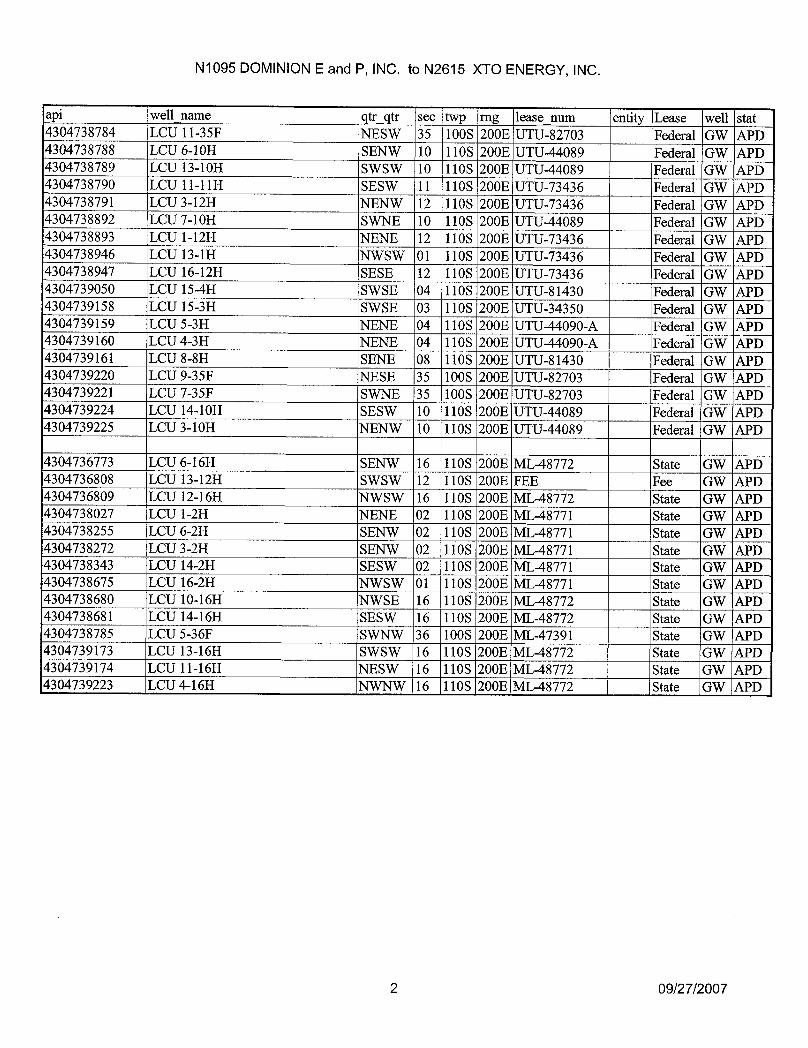
N1095 DOMINIONE and P, INC. to N2615 XTO ENERGY, INC.
api well name qtr qtr see twp rng lease_num entity Lease well stat4304738784 LCU l1-35F NESW 35 100S 200E UTU-82703 Federal GW APD4304738788 LCU 6-10H SENW 10 110S 200E UTU-44089 Federal GW APD4304738789 LCU 13-10H SWSW 10 110S 200E UTU-44089 Federal GW APD4304738790 LCU 11-11H SESW 11 110S 200E UTU-73436 Federal GW APD4304738791 LCU 3-12H NENW 12 110S 200E UTU-73436 Federal GW APD4304738892 LCU 7-10H SWNE 10 110S 200E UTU-44089 Federal GW APD4304738893 LCU 1-12H NENE 12 110S 200E UTU-73436 Federal GW APD4304738946 LCU 13-lH NWSW 01 110S 200E UTU-73436 Federal GW APD4304738947 LCU 16-12H SESE 12 110S 200E UTU-73436 Federal GW APD4304739050 LCU 15-4H SWSE 04 110S 200E UTU-81430 Federal GW APD4304739158 LCU 15-3H SWSE 03 110S 200E UTU-34350 Federal GW APD4304739159 LCU 5-3H NENE 04 110S 200E UTU-44090-A Federal GW APD4304739160 LCU 4-3H NENE 04 110S 200E UTU-44090-A Federal GW APD4304739161 LCU 8-8H SENE 08 110S 200E UTU-81430 Federal GW APD4304739220 LCU 9-35F INESE 35 100S 200E UTU-82703 Federal GW APD4304739221 LCU 7-35F 'SWNE 35 100S 200E UTU-82703 Federal GW APD4304739224 LCU 14-10H SESW 10 110S 200E UTU-44089 Federal GW APD4304739225 LCU 3-10H NENW 10 110S 200E UTU-44089 Federal GW APD
4304736773 LCU 6-16H SENW 16 110S 200E ML-48772 State GW APD4304736808 LCIJ13-12H STVSTV 12 110S 200E FEE Fee GNV APD4304736809 LCU 12-16H NWSW 16 110S 200E ML-48772 State GW APD4304738027 LCU 1-2H NENE 02 110S 200E ML-48771 State GW APD4304738255 LCU 6-2H SENW 02 110S 200E ML-48771 State GW APD4304738272 LCU 3-2H SENW 02 110S 200E ML-48771 State GW APD4304738343 LCU 14-2H SESW 02 il10S 200E ML-48771 State GW APD4304738675 LCU 16-2H NWSW 01 110S 200E ML-48771 State GW APD4304738680 LCU 10-16H NWSE 16 110S 200E ML-48772 State GW APD4304738681 LCU 14-16H SESW 16 110S 200E ML-48772 State GW APD4304738785 LCU 5-36F SWNW 36 100S 200E ML-47391 State GW APD4304739173 LCU 13-16H SWSW 16 110S 200E ML-48772 State GW APD4304739174 LCU 11-16H NESW 16 110S 200E ML-48772 State GW APD4304739223 LCU 4-16H NWNW 16 110S 200E ML-48772 State GW APD
2

United StatesDepartment of the InteriorBUREAU OF LAND MANAGEMENT
a Utah State Office TAKK PFNDEP.O. Box45155 Wy ERICA
Salt Lake City,UT 84145-0155
IN REPLY REFER TO3180UT-922
Dominion Exploration & Production, Inc.Attn: James D. Abercrombie14000 QuailSprings Parkway, #600Oklahoma City,OK 73134-2600
August 10, 2007
Re: Little Canyon UnitUintah County, Utah
Gentlemen:
On August 8, 2007, we received an indenture dated June 30, 2007, whereby Dominion Exploration& Production, Inc. resigned as Unit Operator and XTO Energy Inc. was designated as SuccessorUnit Operator for the Little Canyon Unit, Uintah County, Utah.
This indenture was executed by all required parties and the signatory parties have complied withSections 5 and 6 of the unit agreement. The instrument is hereby approved effective August 15,2007. In approving this designation, the Authorized Officer neither warrants nor certifies that thedesignated party has obtained all required approval that would entitle ittoconduct operations underthe Little Canyon Unit Agreement.
Your statewide oil and gas bond No. UTBOOO138will be used to cover all operations within theRiver Bend Unit.
It is requested that you notify all interested parties of the change in unit operator. Copies of theapproved instruments are being distributed tothe appropriatefederal offices, with one copy returnedherewith.
Sincerely,
/s/ Greg J. Noble
Greg J. NobleActing Chief, Branch of Fluid Minerals
EnclosureRECEIVEDAU6162007
DN.0F0tL,GAS&
United StatesDepartment of the InteriorBUREAU OF LAND MANAGEMENT
a Utah State Office TAKK PFNDEP.O. Box45155 Wy ERICA
Salt Lake City,UT 84145-0155
IN REPLY REFER TO3180UT-922
Dominion Exploration & Production, Inc.Attn: James D. Abercrombie14000 QuailSprings Parkway, #600Oklahoma City,OK 73134-2600
August 10, 2007
Re: Little Canyon UnitUintah County, Utah
Gentlemen:
On August 8, 2007, we received an indenture dated June 30, 2007, whereby Dominion Exploration& Production, Inc. resigned as Unit Operator and XTO Energy Inc. was designated as SuccessorUnit Operator for the Little Canyon Unit, Uintah County, Utah.
This indenture was executed by all required parties and the signatory parties have complied withSections 5 and 6 of the unit agreement. The instrument is hereby approved effective August 15,2007. In approving this designation, the Authorized Officer neither warrants nor certifies that thedesignated party has obtained all required approval that would entitle ittoconduct operations underthe Little Canyon Unit Agreement.
Your statewide oil and gas bond No. UTBOOO138will be used to cover all operations within theRiver Bend Unit.
It is requested that you notify all interested parties of the change in unit operator. Copies of theapproved instruments are being distributed tothe appropriatefederal offices, with one copy returnedherewith.
Sincerely,
/s/ Greg J. Noble
Greg J. NobleActing Chief, Branch of Fluid Minerals
EnclosureRECEIVED
AU6162007
DN.0F0tL,GAS&
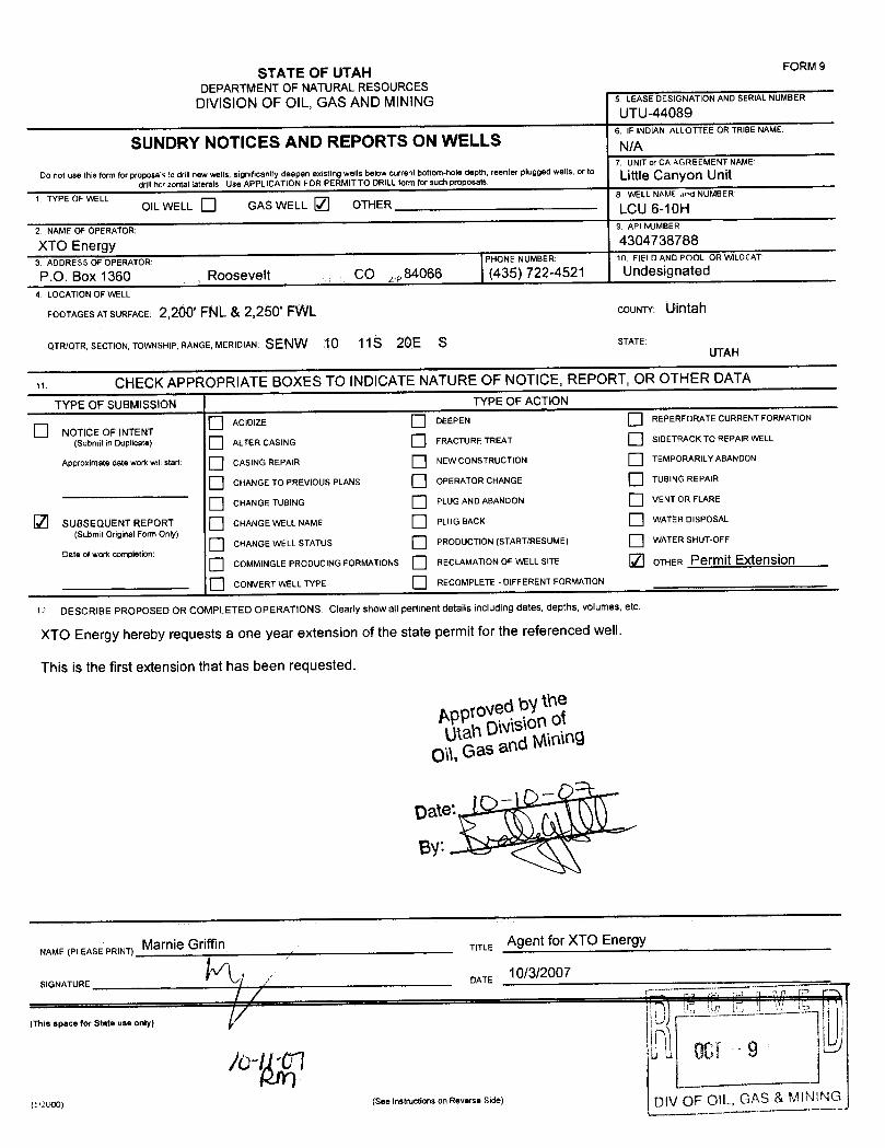
STATE OF UTAH FORM 9
DEPARTMENT OF NATURALRESOURCESDIVISIONOF OIL, GAS AND MINING 5 LEASE DESIGNATION AND SERIALNUMBER
UTU-44089
SUNDRY NOTICES AND REPORTS ON WELLS6 NDlAN ALLOTTEEORTRIBENAME:
7. UNITor CA AGREEMENT NAMEDo not use this form for proposa s to drillnew wells, significantly deepen existing wells below current bottom-hole depth, reenter plugged wells. or to Little Can on Unit
drillhcozental laterals. Use APPLICATION FOR PERMIT TO DRILLform for such proposals.
L TYPE OF WELL 8. WELL NAME and NUMBEROILWELL GAS WELL / OTHER LCU 6-10H
2 NAME OF OPERATOR: 9. API NUMBER
XTO Energy 43047387883 ADDRESS OF OPERATOR: PHONE NUMBER: 10. FIELD AND POOL OR WILDCAT:
P.O. Box 1360 ,Roosevelt . . ,. CO ZiP 84066 (435) 722-4521 Undesignated
4 LOCATION OF WELL
FOOTAGESATSURFACE: 2,200' FNL & 2,250' FVVL COUNTY: Uintah
QTR/QTR, SECTION, TOWNSHIP, RANGE, MERIDIAN: SENW 10 11S 20E S STATE:UTAH
CHECK APPROPRIATE BOXES TO INDICATENATURE OF NOTICE, REPORT, OR OTHER DATA
TYPE OF SUBMISSION TYPE OF ACTION
O ACIDIZE DEEPEN REPERFORATE CURRENT FORMATION
NOTICE OF INTENT(Submit in Duplicate) ALTER CASING FRACTURE TREAT SIDETRACK TO REPAIR WELL
Approximate date work willstart CASING REPAIR NEW CONSTRUCTION TEMPORARlLY ABANDON
O CHANGE TO PREVIOUS PLANS OPERATOR CHANGE TUBING REPA1R
O CHANGE TUBING PLUG AND ABANDON VENT OR FLARE
SUBSEQUENT REPORT CHANGE WELL NAME PLUG BACK WATER DISPOSAL
(Submit Original Form Only)CHANGE WELL STATUS PRODUCTION (START/RESUME) WATER SHUT-OFF
Date of work completion:
O COMMINGLE PRODUCING FORMATIONS RECLAMATIONOF WELL SITE OTHER Permit Extension
CONVERT WELL TYPE RECOMPLETE - DIFFERENT FORMATION
DESCRIBE PROPOSED OR COMPLETED OPERATIONS. Clearly showall pedinentdetails including dates, depths, volurnes, etc
XTO Energy hereby requests a one year extension of the state permit for the referenced well.
This is the first extensionthat has been requested.
Approvedby theUtah Divisionof
Oil,Gas and Mining
NAME (PLEASE PRINT) Marnie Griffin TITLE Agent for XTO Energy
10/3/2007SIGNATURE DATE
7.2000) (s..instructionsonneverseside) DIV OF OL GAS & MIN
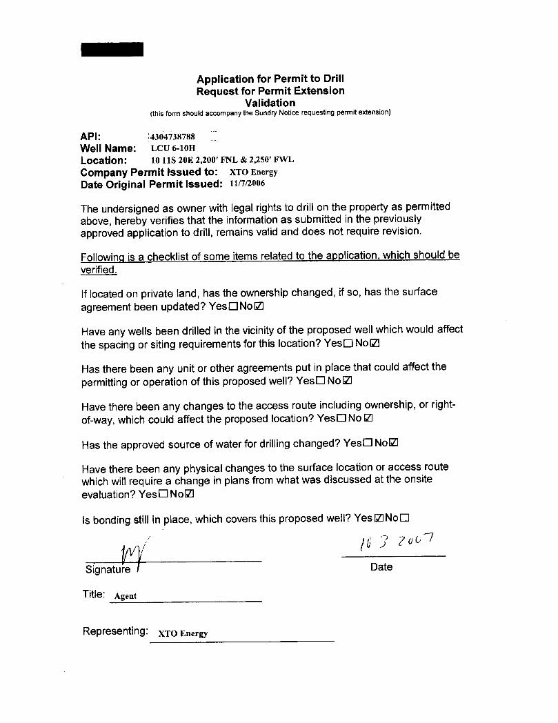
Application for Permit to DrillRequest for Permit Extension
Validation(thisform should accompany the Sundry Notice requesting permit extension)
API: 4304738788
Well Name: LCU 6-10H
Location: 10 11S 20E 2,200' FNL & 2,250' FWL
Company Permit Issued to: XTO EnergyDate Original Permit Issued: 11n/2006
The undersigned as owner with legal rights to drill on the property as permittedabove, hereby verifies that the information as submitted in the previouslyapproved application to drill, remains valid and does not require revision.
Following is a checklist of some items related to the application,which should beverified.
If located on private land, has the ownership changed, if so, has the surfaceagreement been updated? YesONoO
Have any wells been drilled in the vicinityof the proposed well whichwould affectthe spacing or siting requirements for this location? YesO NoO
Has there been any unit or other agreements put in place that could affect thepermitting or operation of thisproposed well? YesO NoO
Have there been any changes to the access route including ownership, or right-of-way, which could affect the proposed location? YesO No IZl
Has the approved source of water for drillingchanged? YesO NoO
Have there been any physical changes to the surface location or access routewhich willrequire a change in plans from what was discussed at the onsiteevaluation? YesO NoO
Is bonding still in place, which covers thisproposed well? YesŒNoO
Signatu Date
Title: Agent
Representing: XTO
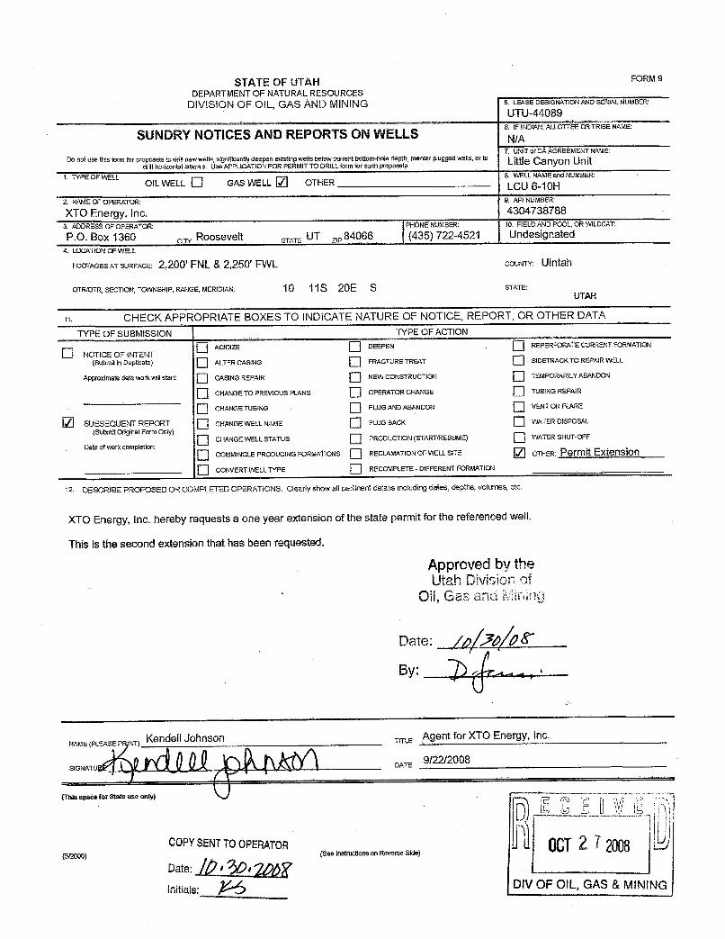
STATEOFUTAH FORMS
DEPARTMENT OF NATURAL RESOURCESDIVISION OF OlL, GAS AND MINING S. LEASEDESIGNATIONANDSERIALNUMBER:
UTU-44089
SUNDRYNOTICES AND REPORTS ON WELLS6. 1 NDIAN,ALLOTTËËÒRTÀlŠÈÑÄMË
7. UNITor CA AGREEMENT NAME:Do not use this form for proposals to drillnew wells, significantly deepen existingwells below current bottom-note depth. isenter plugged wells, of t° Little Can n Unit
drill horizontal laterals. Use APPLICATION FOR PERMlTTO DRILL form for such proposats.L TYPE OF WELL 8. WELLNAMEand NUMBER:
OIL WELL O GAS WELL OTHER LCU 6-10H2. NAME OF 0PERATOR: 9. API NUMBER:
XTO Energy, Inc. 43047387883. ADDRESSðF OPERATOR: PHONENUMBER: 10. FIELDANDPOOL,OR WILDCAT:
P.O. Box 1360 otrv Roosevelt STATE. UT 84066 (435) 722-4521 Undesignated4. LOCATION OF WELL
FOOTAGESATSURFACE: 2,200' FNL & 2,250' FWL coUNTY: Uintah
QTR/QTR, SECTION, TOWNSHIP, RANGE,MERIDIAN: 10 11S 20E S STATE:UTAH
CHECK APPROPRIATE BOXES TO INDICATE NATURE OF NOTICE, REPORT, OR OTHER DATA
TYPE OF SUBMISSION TYPE OF ACTION
O ACIDIZE 0ÉEPEN .REPERFORATECURRENTFORMATION
O NOTICE OF INTENT(Submitin Duplicate) ALTER CASING FRACTURE TREAT SIDETRACK TO REPAIR WELL
Approximate date work willstart: CASING REPAtR NEW CONSTRUCTION TEMPORARILY ABANDON
CHANGETO PREVIOUS PLANS OPERATORCHANGË TUBING REPAlR
O CHANGE TUSING PLUG AND ABANDON VENTOR FLARE
SUBSEQUENT REPORT CHANGEWELL NAME PLUG BACK WATER DISPOSAL(Submit Original Form Only)
O CHANGEWELL STATUS PRODUCTION (START/RESUME) WATER SHUT-OFF
Date of work completionO COMMINGLE PRODUC1NG FORMATIONS RECLAMATIONOF WELL SITE ÒTHER: Permit Extension
O CONVERT WELL TYPF RECOMPLETE - DIFFERENT FORMATION
12 DESCRIBE PROPOSED OR COMPLETED OPERATIONS. Clearly show all pertinent details includingdates, depths, volumes, etc.
XTO Energy, Inc. hereby requests a one year extension of the state permit for the referenced well.
This is the second extension that has been requested.
Approved by theUtah DMsion of
Oil, Gas and Mining
Date: /p 7 P&~
By:
NAME(PLEASEP NT)KendellJohnson TITLE
AgentforXTOEnergy,Inc.
SIGNATU DATE9/22/2008
(This space for State use only)
COPYSENTTOOPERATOR{5/20 (See Instnictionson Revelse Side)
Date:
Initiale DIV OF OIL, GAS &

Application for Permit to DrillRequest for Permit Extension
Validation(this form should accompany the Sundry Notice requesting permit extension)
API: [ãšiiäišfššWell Name: LCU 6-10H
Location: 2,200' FNL & 2,250' FWL Sec. 10, 11S-20ECompany Permit issued to: XTO Energy, Inc.Date Original Permit Issued: 11/1/2006
The undersigned as owner with legal rightsto drillon the propertyas permittedabove, hereby verifies that the information as submitted in the previouslyapproved applicationto drill, remains validand does not require revision.
Following is a checklist of some items related to the application, which should beverified.
If located on private land, has the ownershipchanged, if so, has the surfaceagreement been updated? Yes O NoO
Have any wells been drilled in the vicinityof the proposed wellwhich would affectthe spacing or siting requirements for thislocation? YesO NolZI
Has there been any unit or other agreements put in place that could affect thepermitting or operation of thisproposed well?YesONolZI
Have there been any changes to the access route including ownership, or right-of-way, which could affect the proposed location? YesONo121
Has the approved source of water for drillingchanged? YesO No21
Have there been any physical changes to the surface location or access routewhich will require a change in plans from what was discussed at the onsiteevaluation? YesO NoO
Is bonding stillin place, which covers this proposed well? YeslZINoO
9/22/2008
ture Date
Title: Kendell Johnson
Representing: XTO Energy,
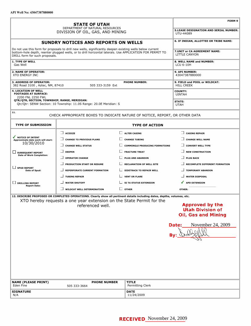
API Well No: 43047387880000
STATE OF UTAHDEPARTMENT OF NATURAL RESOURCES
DIVISION OF OIL, GAS, AND MINING
FORM 9
5.LEASE DESIGNATION AND SERIAL NUMBER: UTU-44089
SUNDRY NOTICES AND REPORTS ON WELLSDo not use this form for proposals to drill new wells, significantly deepen existing wells below currentbottom-hole depth, reenter plugged wells, or to drill horizontal laterals. Use APPLICATION FOR PERMIT TODRILL form for such proposals.
6. IF INDIAN, ALLOTTEE OR TRIBE NAME:
7.UNIT or CA AGREEMENT NAME: LITTLE CANYON
1. TYPE OF WELL Gas Well
8. WELL NAME and NUMBER: LCU 6-10H
2. NAME OF OPERATOR: XTO ENERGY INC
9. API NUMBER: 43047387880000
3. ADDRESS OF OPERATOR: 382 Road 3100 , Aztec, NM, 87410
9. FIELD and POOL or WILDCAT: HILL CREEK
4. LOCATION OF WELL FOOTAGES AT SURFACE: 2200 FNL 2250 FWL QTR/QTR, SECTION, TOWNSHIP, RANGE, MERIDIAN: Qtr/Qtr: SENW Section: 10 Township: 11.0S Range: 20.0E Meridian: S
COUNTY: UINTAH
STATE: UTAH
11.
CHECK APPROPRIATE BOXES TO INDICATE NATURE OF NOTICE, REPORT, OR OTHER DATA
TYPE OF SUBMISSION TYPE OF ACTION
NOTICE OF INTENTApproximate date work will start:
10/30/2010
SUBSEQUENT REPORTDate of Work Completion:
SPUD REPORTDate of Spud:
DRILLING REPORTReport Date:
ACIDIZE ALTER CASING CASING REPAIR
CHANGE TO PREVIOUS PLANS CHANGE TUBING CHANGE WELL NAME
CHANGE WELL STATUS COMMINGLE PRODUCING FORMATIONS CONVERT WELL TYPE
DEEPEN FRACTURE TREAT NEW CONSTRUCTION
OPERATOR CHANGE PLUG AND ABANDON PLUG BACK
PRODUCTION START OR RESUME RECLAMATION OF WELL SITE RECOMPLETE DIFFERENT FORMATION
REPERFORATE CURRENT FORMATION SIDETRACK TO REPAIR WELL TEMPORARY ABANDON
TUBING REPAIR VENT OR FLARE WATER DISPOSAL
WATER SHUTOFF SI TA STATUS EXTENSION APD EXTENSION
WILDCAT WELL DETERMINATION OTHER OTHER:
12. DESCRIBE PROPOSED OR COMPLETED OPERATIONS. Clearly show all pertinent details including dates, depths, volumes, etc.
XTO hereby requests a one year extension on the State Permit for thereferenced well.
NAME (PLEASE PRINT) Eden Fine
TITLE Permitting Clerk
SIGNATURE N/A
DATE 11/24/2009
PHONE NUMBER:505 333-3159 Ext
PHONE NUMBER505 333-3664
November 24, 2009
November 24, 2009
iPI Well No: 43047387880000
FORM 9
STATE OF UTAHDEPARTMENT OF NATURAL RESOURCES
DIVISION OF OIL, GAS, AND MINING LEAS4E40DE9SIGNATION AND SERIAL NUMBER:
SUNDRY NOTICES AND REPORTS ON WELLS 6. IF INDIAN, ALLOTTEE OR TRIBE NAME:
Do not use this form for proposals to drill new wells, significantly deepen existing wells below currentbottom-hole depth, reenter plugged wells, or to drill horizontal laterals. Use APPLICATION FOR PERMIT TO 7.UNIT or CA AGREEMENT NAME:
DRILL form for such proposals. LITTLE CANYON
1. TYPE OF WELL 8. WELL NAME and NUMBER:Gas Well LCU 6-10H
2. NAME OF OPERATOR: 9. API NUMBER:XTO ENERGY INC 43047387880000
3. ADDRESS OF OPERATOR: PHONE NUMBER: 9. FIELD and POOL or WILDCAT:382 Road 3100 , Aztec, NM, 87410 505 333-3159 Ext HILL CREEK
4.LOCATIONOFWELL COUNTY:FOOTAGES AT SURFACE: UINTAH
2200 FNL 2250 FWLQTR/QTR, SECTION, TOWNSHIP, RANGE, MERIDIAN: STATE:
Qtr/Qtr: SENW Section: 10 Township: 11.05 Range: 20.0E Meridian: S UTAH
11.CHECK APPROPRIATE BOXES TO INDICATE NATURE OF NOTICE, REPORT, OR OTHER DATA
TYPE OF SUBMISSION TYPE OF ACTION
ACIDIZE ALTER CASING CASING REPAIR
/ NOTICE OF INTENTApproximate date work will start: CHANGE TO PREVIOUS PLANS CHANGE TUBING CHANGE WELL NAME
10/30/2010CHANGE WELL STATUS COMMINGLE PRODUCING FORMATIONS CONVERT WELL TYPE
SUBSEQUENT REPORT DEEPEN FRACTURE TREAT NEW CONSTRUCTIONDate of Work Completion:
OPERATOR CHANGE PLUG AND ABANDON PLUG BACK
PRODUCTION START OR RESUME RECLAMATION OF WELL SITE RECOMPLETE DIFFERENT FORMATION
SPUD REPORTDate of Spud: REPERFORATE CURRENT FORMATION SIDETRACK TO REPAIR WELL TEMPORARY ABANDON
TUBING REPAIR VENT OR FLARE WATER DISPOSAL
DRILLING REPORT WATER SHUTOFF SI TA STATUS EXTENSION APD EXTENSIONReport Date:
WILDCAT WELL DETERMINATION OTHER OTHER:
12. DESCRIBE PROPOSED OR CC MPLETED OPERATIONS. Clearly show all pertinent details including dates, depths, volumes, etc.
XTO hereby requests a one year extension on the State Permit for thereferenced well. Approved by the
Utah Division ofOil, Gas and Mining
Date: November 24, 2009
By:
NAME (PLEASE PRINT) PHONE NUMBER TITLEEden Fine 505 333-3664 Permitting Clerk
SIGNATURE DATEN/A 11/24/2009
RECEIVED November 24,

The Utah Division of Oil, Gas, and Mining
- State of Utah- Department of Natural Resources
Electronic Permitting System - Sundry Notices
Request for Permit Extension Validation Well Number 43047387880000
API: 43047387880000Well Name: LCU 6-10H
Location: 2200 FNL 2250 FWL QTR SENW SEC 10 TWNP 110S RNG 200E MER SCompany Permit Issued to: XTO ENERGY INC
Date Original Permit Issued: 11/7/2006
The undersigned as owner with legal rights to drill on the property as permitted above, hereby verifies thatthe information as submitted in the previously approved application to drill, remains valid and does notrequire revision. Following is a checklist of some items related to the application, which should be verified.
If located on private land, has the ownership changed, if so, has the surface agreement beenupdated? Yes No
Have any wells been drilled in the vicinity of the proposed well which would affect the spacing orsiting requirements for this location? Yes No
Has there been any unit or other agreements put in place that could affect the permitting or operationof this proposed well? Yes No
Have there been any changes to the access route including ownership, or rightof- way, which couldaffect the proposed location? Yes No
Has the approved source of water for drilling changed? Yes No
Have there been any physical changes to the surface location or access route which will require achange in plans from what was discussed at the onsite evaluation? Yes No
Is bonding still in place, which covers this proposed well? Yes No
Signature: Eden Fine Date: 11/24/2009
Title: Permitting Clerk Representing: XTO ENERGY INC
November 24, 2009
November 24, 2009
UTAH
DNR The Utah Division of Oil, Gas, and Mining'
- State of Utah- Department of Natural ResourcesElectronic Permitting System - Sundry Notices
OTI GAS MlNTNG
Request for Permit Extension Validation Well Number 43047387880000
API: 43047387880000Well Name: LCU 6-10H
Location: 2200 FNL 2250 FWL QTR SENW SEC 10 TWNP 1105 RNG 200E MER SCompany Permit Issued to: XTO ENERGY INC
Date Original Permit Issued: 11/7/2006
The undersigned as owner with legal rights to drill on the property as permitted above, hereby verifies thatthe information as submitted in the previously approved application to drill, remains valid and does notrequire revision. Following is a checklist of some items related to the application, which should be verified.
•If located on private_land, has the ownership changed, if so, has the surface agreement beenupdated? I___|I Yes I_Ð_I No
• Have any wells been drilled in the vicinity of the_proposed well which would affect the spacing orsiting requirements for this location? I:___) Yes _®_) No
• Has there been any unit or other agreements put in place that could affect the permitting or operationof this proposed well? I i Yes i i No
• Have there been any changes to the access route including ownership, or rightof- way, which couldaffect the proposed location? I___) Yes I _I No
• Has the approved source of water for drilling changed? I __I Yes i i No
• Have there been any physical changes to the surface location or access route which will require achange in plans from what was discussed at the onsite evaluation? I___I Yes I®I No
Approved by the•Is bonding still in place, which covers this proposed well? I§|I Yes i i No Utah Division of
Oil, Gas and MiningSignature: Eden Fine Date: 11/24/2009
Title: Permitting Clerk Representing: XTO ENERGY INC Date: November 24, 2009
By:
RECEIVED November 24,
UTAH
DNR The Utah Division of Oil, Gas, and Mining'
- State of Utah- Department of Natural Resources
Electronic Permitting System - Sundry NoticesOTI GAS MlNTNG
Request for Permit Extension Validation Well Number 43047387880000
API: 43047387880000Well Name: LCU 6-10H
Location: 2200 FNL 2250 FWL QTR SENW SEC 10 TWNP 1105 RNG 200E MER SCompany Permit Issued to: XTO ENERGY INC
Date Original Permit Issued: 11/7/2006
The undersigned as owner with legal rights to drill on the property as permitted above, hereby verifies thatthe information as submitted in the previously approved application to drill, remains valid and does notrequire revision. Following is a checklist of some items related to the application, which should be verified.
•If located on private_land, has the ownership changed, if so, has the surface agreement beenupdated? I___|I Yes I_Ð_I No
• Have any wells been drilled in the vicinity of the_proposed well which would affect the spacing orsiting requirements for this location? I:___) Yes _®_) No
• Has there been any unit or other agreements put in place that could affect the permitting or operationof this proposed well? I i Yes i i No
• Have there been any changes to the access route including ownership, or rightof- way, which couldaffect the proposed location? I___) Yes I _I No
• Has the approved source of water for drilling changed? I __I Yes i i No
• Have there been any physical changes to the surface location or access route which will require achange in plans from what was discussed at the onsite evaluation? I___I Yes I®I No
Approved by the•Is bonding still in place, which covers this proposed well? I§|I Yes i i No Utah Division of
Oil, Gas and MiningSignature: Eden Fine Date: 11/24/2009
Title: Permitting Clerk Representing: XTO ENERGY INC Date: November 24, 2009
By:
RECEIVED November 24,

API Well No: 43047387880000
STATE OF UTAHDEPARTMENT OF NATURAL RESOURCES
DIVISION OF OIL, GAS, AND MINING
FORM 9
5.LEASE DESIGNATION AND SERIAL NUMBER: UTU-44089
SUNDRY NOTICES AND REPORTS ON WELLSDo not use this form for proposals to drill new wells, significantly deepen existing wells below currentbottom-hole depth, reenter plugged wells, or to drill horizontal laterals. Use APPLICATION FOR PERMIT TODRILL form for such proposals.
6. IF INDIAN, ALLOTTEE OR TRIBE NAME:
7.UNIT or CA AGREEMENT NAME: LITTLE CANYON
1. TYPE OF WELL Gas Well
8. WELL NAME and NUMBER: LCU 6-10H
2. NAME OF OPERATOR: XTO ENERGY INC
9. API NUMBER: 43047387880000
3. ADDRESS OF OPERATOR: PHONE NUMBER: 382 Road 3100 , Aztec, NM, 87410 505 333-3159 Ext
9. FIELD and POOL or WILDCAT: HILL CREEK
4. LOCATION OF WELL FOOTAGES AT SURFACE: 2200 FNL 2250 FWL QTR/QTR, SECTION, TOWNSHIP, RANGE, MERIDIAN: Qtr/Qtr: SENW Section: 10 Township: 11.0S Range: 20.0E Meridian: S
COUNTY: UINTAH
STATE: UTAH
11.
CHECK APPROPRIATE BOXES TO INDICATE NATURE OF NOTICE, REPORT, OR OTHER DATA
TYPE OF SUBMISSION TYPE OF ACTION
NOTICE OF INTENTApproximate date work will start:
11/8/2011
SUBSEQUENT REPORTDate of Work Completion:
SPUD REPORTDate of Spud:
DRILLING REPORTReport Date:
ACIDIZE ALTER CASING CASING REPAIR
CHANGE TO PREVIOUS PLANS CHANGE TUBING CHANGE WELL NAME
CHANGE WELL STATUS COMMINGLE PRODUCING FORMATIONS CONVERT WELL TYPE
DEEPEN FRACTURE TREAT NEW CONSTRUCTION
OPERATOR CHANGE PLUG AND ABANDON PLUG BACK
PRODUCTION START OR RESUME RECLAMATION OF WELL SITE RECOMPLETE DIFFERENT FORMATION
REPERFORATE CURRENT FORMATION SIDETRACK TO REPAIR WELL TEMPORARY ABANDON
TUBING REPAIR VENT OR FLARE WATER DISPOSAL
WATER SHUTOFF SI TA STATUS EXTENSION APD EXTENSION
WILDCAT WELL DETERMINATION OTHER OTHER:
12. DESCRIBE PROPOSED OR COMPLETED OPERATIONS. Clearly show all pertinent details including dates, depths, volumes, etc.
XTO Energy hereby requests a one (1) year extension of the State APD for thereferenced well.
NAME (PLEASE PRINT) PHONE NUMBER Krista Wilson 505 333-3647
TITLE Permitting Tech
SIGNATURE N/A
DATE 11/8/2010
November 08, 2010
November 08, 2010
iPI Well No: 43047387880000
FORM 9
STATE OF UTAHDEPARTMENT OF NATURAL RESOURCES
DIVISION OF OIL, GAS, AND MINING EAS4E40DE9SIGNATION AND SERIAL NUMBER:
SUNDRY NOTICES AND REPORTS ON WELLS 6. IF INDIAN, ALLOTTEE OR TRIBE NAME:
Do not use this form for proposals to drill new wells, significantly deepen e×isting wells below currentbottom-hole depth, reenter plugged wells, or to drill horizontal laterals. Use APPLICATION FOR PERMIT TO 7.UNIT or CA AGREEMENT NAME:
DRILL form for such proposals. LITTLE CANYON
1. TYPE OF WELL 8. WELL NAME and NUMBER:Gas Well LCU 6-10H
2. NAME OF OPERATOR: 9. API NUMBER:XTO ENERGY INC 43047387880000
3. ADDRESS OF OPERATOR: PHONE NUMBER: 9. FIELD and POOL or WILDCAT:382 Road 3100 , Aztec, NM, 87410 505 333-3159 Ext HILL CREEK
4.LOCATIONOFWELL COUNTY:FOOTAGES AT SURFACE: UINTAH
2200 FNL 2250 FWLQTR/QTR, SECTION, TOWNSHIP, RANGE, MERIDIAN: STATE:
Qtr/Qtr: SENW Section: 10 Township: 11.05 Range: 20.0E Meridian: S UTAH
11.CHECK APPROPRIATE BOXES TO INDICATE NATURE OF NOTICE, REPORT, OR OTHER DATA
TYPE OF SUBMISSION TYPE OF ACTION
ACIDIZE ALTER CASING CASING REPAIR
NOTICE OF INTENTApproximate date work will start: CHANGE TO PREVIOUS PLANS CHANGE TUBING CHANGE WELL NAME
11/8/2011CHANGE WELL STATUS COMMINGLE PRODUCING FORMATIONS CONVERT WELL TYPE
SUBSEQUENT REPORT DEEPEN FRACTURE TREAT NEW CONSTRUCTIONDate of Work Completion:
OPERATOR CHANGE PLUG AND ABANDON PLUG BACK
PRODUCTION START OR RESUME RECLAMATION OF WELL SITE RECOMPLETE DIFFERENT FORMATION
O SPUD REPORTDate of Spud: REPERFORATE CURRENT FORMATION SIDETRACK TO REPAIR WELL TEMPORARY ABANDON
TUBING REPAIR VENT OR FLARE WATER DISPOSAL
DRILLING REPORT WATER SHUTOFF SI TA STATUS EXTENSION APD EXTENSIONReport Date:
WILDCAT WELL DETERMINATION OTHER OTHER:
12. DESCRIBE PROPOSED OR CC MPLETED OPERATIONS. Clearly show all pertinent details including dates, depths, volumes, etc.
XTO Energy hereby requests a one (1) year extension of the State APD for thereferenced well. Approved by the
Utah Division ofOil, Gas and Mining
Date: November 08, 2010
By:
NAME (PLEASE PRINT) PHONE NUMBER TITLEKrista Wilson 505 333-3647 Permitting Tech
SIGNATURE DATEN/A 11/8/2010
RECEIVED November 08,

The Utah Division of Oil, Gas, and Mining
- State of Utah- Department of Natural Resources
Electronic Permitting System - Sundry Notices
Request for Permit Extension Validation Well Number 43047387880000
API: 43047387880000Well Name: LCU 6-10H
Location: 2200 FNL 2250 FWL QTR SENW SEC 10 TWNP 110S RNG 200E MER SCompany Permit Issued to: XTO ENERGY INC
Date Original Permit Issued: 11/7/2006
The undersigned as owner with legal rights to drill on the property as permitted above, hereby verifies thatthe information as submitted in the previously approved application to drill, remains valid and does notrequire revision. Following is a checklist of some items related to the application, which should be verified.
If located on private land, has the ownership changed, if so, has the surface agreement beenupdated? Yes No
Have any wells been drilled in the vicinity of the proposed well which would affect the spacing orsiting requirements for this location? Yes No
Has there been any unit or other agreements put in place that could affect the permitting or operationof this proposed well? Yes No
Have there been any changes to the access route including ownership, or rightof- way, which couldaffect the proposed location? Yes No
Has the approved source of water for drilling changed? Yes No
Have there been any physical changes to the surface location or access route which will require achange in plans from what was discussed at the onsite evaluation? Yes No
Is bonding still in place, which covers this proposed well? Yes No
Signature: Krista Wilson Date: 11/8/2010
Title: Permitting Tech Representing: XTO ENERGY INC
November 08, 2010November 08, 2010
November 08, 2010
UTAH
DNR The Utah Division of Oil, Gas, and Mining'
- State of Utah- Department of Natural ResourcesElectronic Permitting System - Sundry Notices
OTI GAS MlNTNG
Request for Permit Extension Validation Well Number 43047387880000
API: 43047387880000Well Name: LCU 6-10H
Location: 2200 FNL 2250 FWL QTR SENW SEC 10 TWNP 1105 RNG 200E MER SCompany Permit Issued to: XTO ENERGY INC
Date Original Permit Issued: 11/7/2006
The undersigned as owner with legal rights to drill on the property as permitted above, hereby verifies thatthe information as submitted in the previously approved application to drill, remains valid and does notrequire revision. Following is a checklist of some items related to the application, which should be verified.
•If located o_nprivate_land, has the ownership changed, if so, has the surface agreement beenupdated? I
_
i Yes igi No
• Have any wells been drilled in the vicinity of the_proposed well which would affect the spacing orsiting requirements for this location? :__I Yes g:I No
• Has there been any unit or other agreements put in place that could affect the permitting or operationof this proposed well? I:_:I Yes IÏiÏ:I No
• Have there been any changes to the access route including ownership, or rightof- way, which couldaffect the proposed location? I___I Yes igi No
• Has the approved source of water for drilling changed? I_
I Yes IÎiÏI No
• Have there been any physical changes to the surface location or access route which will require achange in plans from what was discussed at the onsite evaluation? __:I Yes ig:I No
Approved by the•Is bonding still in place, which covers this proposed well? liiil Yes i i No Utah Division of
Oil, Gas and MiningSignature: Krista Wilson Date: 11/8/2010
Title: Permitting Tech Representing: XTO ENERGY INC Date: November 08, 2010
By:
RECEIVED November 08,
UTAH
DNR The Utah Division of Oil, Gas, and Mining'
- State of Utah- Department of Natural Resources
Electronic Permitting System - Sundry NoticesOTI GAS MlNTNG
Request for Permit Extension Validation Well Number 43047387880000
API: 43047387880000Well Name: LCU 6-10H
Location: 2200 FNL 2250 FWL QTR SENW SEC 10 TWNP 1105 RNG 200E MER SCompany Permit Issued to: XTO ENERGY INC
Date Original Permit Issued: 11/7/2006
The undersigned as owner with legal rights to drill on the property as permitted above, hereby verifies thatthe information as submitted in the previously approved application to drill, remains valid and does notrequire revision. Following is a checklist of some items related to the application, which should be verified.
•If located o_nprivate_land, has the ownership changed, if so, has the surface agreement beenupdated? I
_
i Yes igi No
• Have any wells been drilled in the vicinity of the_proposed well which would affect the spacing orsiting requirements for this location? :__I Yes g:I No
• Has there been any unit or other agreements put in place that could affect the permitting or operationof this proposed well? I:_:I Yes IÏiÏ:I No
• Have there been any changes to the access route including ownership, or rightof- way, which couldaffect the proposed location? I___I Yes igi No
• Has the approved source of water for drilling changed? I_
I Yes IÎiÏI No
• Have there been any physical changes to the surface location or access route which will require achange in plans from what was discussed at the onsite evaluation? __:I Yes ig:I No
Approved by the•Is bonding still in place, which covers this proposed well? liiil Yes i i No Utah Division of
Oil, Gas and MiningSignature: Krista Wilson Date: 11/8/2010
Title: Permitting Tech Representing: XTO ENERGY INC Date: November 08, 2010
By:
RECEIVED November 08,

STATE OF UTAHDEPARTMENT OF NATURAL RESOURCES
DIVISION OF OIL, GAS, AND MINING
FORM 9
5.LEASE DESIGNATION AND SERIAL NUMBER: UTU-44089
SUNDRY NOTICES AND REPORTS ON WELLSDo not use this form for proposals to drill new wells, significantly deepen existing wells below currentbottom-hole depth, reenter plugged wells, or to drill horizontal laterals. Use APPLICATION FOR PERMIT TODRILL form for such proposals.
6. IF INDIAN, ALLOTTEE OR TRIBE NAME:
7.UNIT or CA AGREEMENT NAME: LITTLE CANYON
1. TYPE OF WELL Gas Well
8. WELL NAME and NUMBER: LCU 6-10H
2. NAME OF OPERATOR: XTO ENERGY INC
9. API NUMBER: 43047387880000
3. ADDRESS OF OPERATOR: PHONE NUMBER: 382 Road 3100 , Aztec, NM, 87410 505 333-3159 Ext
9. FIELD and POOL or WILDCAT: HILL CREEK
4. LOCATION OF WELL FOOTAGES AT SURFACE: 2200 FNL 2250 FWL QTR/QTR, SECTION, TOWNSHIP, RANGE, MERIDIAN: Qtr/Qtr: SENW Section: 10 Township: 11.0S Range: 20.0E Meridian: S
COUNTY: UINTAH
STATE: UTAH
11.
CHECK APPROPRIATE BOXES TO INDICATE NATURE OF NOTICE, REPORT, OR OTHER DATA
TYPE OF SUBMISSION TYPE OF ACTION
NOTICE OF INTENTApproximate date work will start:
11/15/2012
SUBSEQUENT REPORTDate of Work Completion:
SPUD REPORTDate of Spud:
DRILLING REPORTReport Date:
ACIDIZE ALTER CASING CASING REPAIR
CHANGE TO PREVIOUS PLANS CHANGE TUBING CHANGE WELL NAME
CHANGE WELL STATUS COMMINGLE PRODUCING FORMATIONS CONVERT WELL TYPE
DEEPEN FRACTURE TREAT NEW CONSTRUCTION
OPERATOR CHANGE PLUG AND ABANDON PLUG BACK
PRODUCTION START OR RESUME RECLAMATION OF WELL SITE RECOMPLETE DIFFERENT FORMATION
REPERFORATE CURRENT FORMATION SIDETRACK TO REPAIR WELL TEMPORARY ABANDON
TUBING REPAIR VENT OR FLARE WATER DISPOSAL
WATER SHUTOFF SI TA STATUS EXTENSION APD EXTENSION
WILDCAT WELL DETERMINATION OTHER OTHER:
12. DESCRIBE PROPOSED OR COMPLETED OPERATIONS. Clearly show all pertinent details including dates, depths, volumes, etc.
XTO Energy hereby requests a one (1) year extension of the State APD for thereferenced well.
NAME (PLEASE PRINT) PHONE NUMBER Krista Wilson 505 333-3647
TITLE Permitting Tech
SIGNATURE N/A
DATE 11/15/2011
11/23/2011
Nov. 15, 2011
Sundry Number: 20407 API Well Number: 43047387880000
FORM 9STATE OF UTAH
DEPARTMENT OF NATURAL RESOURCESDIVISION OF OIL, GAS, AND MINING 5.LEAS4E DE95IGNATION AND SERIAL NUMBER:
SUNDRY NOTICES AND REPORTS ON WELLS 6. IF INDIAN, ALLOTTEE OR TRIBE NAME:
Do not use this form for proposals to drill new wells, significantly deepen existing wells below currentbottom-hole depth, reenter plugged wells, or to drill horizontal laterals. Use APPLICATION FOR PERMIT TO 7.UNIT or CA AGREEMENT NAME:
DRILL form for such proposals. LITTLE CANYON
1. TYPE OF WELL 8. WELL NAME and NUMBER:Gas Well LCU 6-10H
2. NAME OF OPERATOR: 9. API NUMBER:XTO ENERGYINC 43047387880000
3. ADDRESS OF OPERATOR: PHONE NUMBER: 9. FIELD and POOL or WILDCAT:382 Road 3100 , Aztec, NM, 87410 505 333-3159 E×t HILL CREEK
4.LOCATIONOFVVELL COUNTY:FOOTAGES AT SURFACE: UINTAH
2200 FNL 2250 FWLQTR/QTR, SECTION, TOWNSHIP, RANGE, MERIDIAN: STATE:
Qtr/Qtr: SENW Section: 10 Township: 11.05 Range: 20.0E Meridian: S UTAH
11.CHECK APPROPRIATE BOXES TO INDICATE NATURE OF NOTICE, REPORT, OR OTHER DATA
TYPE OF SUBMISSION TYPE OF ACTION
ACIDIZE ALTER CASING CASING REPAIR
/ NOTICE OF INTENTApproximate date work will start: CHANGE TO PREVIOUS PLANS CHANGE TUBING CHANGE WELL NAME
11/15/2012CHANGE WELL STATUS COMMINGLE PRODUCING FORMATIONS CONVERT WELL TYPE
SUBSEQUENT REPORT DEEPEN FRACTURE TREAT NEW CONSTRUCTIONDate of Work Completion:
OPERATOR CHANGE PLUG AND ABANDON PLUG BACK
PRODUCTION START OR RESUME RECLAMATION OF WELL SITE RECOMPLETE DIFFERENT FORMATION
SPUD REPORTDate of Spud: REPERFORATE CURRENT FORMATION SIDETRACK TO REPAIR WELL TEMPORARY ABANDON
TUBING REPAIR VENT OR FLARE WATER DISPOSAL
DRILLING REPORT WATER SHUTOFF SI TA STATUS EXTENSION APD EXTENSIONReport Date:
WILDCAT WELL DETERMINATION OTHER OTHER:
12. DESCRIBE PROPOSED OR C( MPLETED OPERATIONS. Clearly show all pertinent details including dates, depths, volumes, etc.
XTO Energy hereby requests a one (1) year extension of the State APD for thereferenced well.
Approved by theUtah Division of
Oil, Gas and Mining
Date: 11/23/2011
By:
NAME (PLEASE PRINT) PHONE NUMBER TITLEKrista Wilson 505 333-3647 Permitting Tech
SIGNATURE DATEN/A
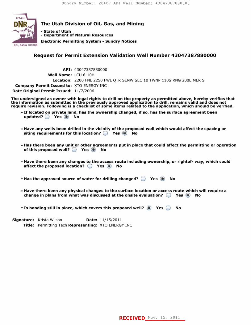
The Utah Division of Oil, Gas, and Mining
- State of Utah- Department of Natural Resources
Electronic Permitting System - Sundry Notices
Request for Permit Extension Validation Well Number 43047387880000
API: 43047387880000Well Name: LCU 6-10H
Location: 2200 FNL 2250 FWL QTR SENW SEC 10 TWNP 110S RNG 200E MER SCompany Permit Issued to: XTO ENERGY INC
Date Original Permit Issued: 11/7/2006
The undersigned as owner with legal rights to drill on the property as permitted above, hereby verifies thatthe information as submitted in the previously approved application to drill, remains valid and does notrequire revision. Following is a checklist of some items related to the application, which should be verified.
If located on private land, has the ownership changed, if so, has the surface agreement beenupdated? Yes No
Have any wells been drilled in the vicinity of the proposed well which would affect the spacing orsiting requirements for this location? Yes No
Has there been any unit or other agreements put in place that could affect the permitting or operationof this proposed well? Yes No
Have there been any changes to the access route including ownership, or rightof- way, which couldaffect the proposed location? Yes No
Has the approved source of water for drilling changed? Yes No
Have there been any physical changes to the surface location or access route which will require achange in plans from what was discussed at the onsite evaluation? Yes No
Is bonding still in place, which covers this proposed well? Yes No
Signature: Krista Wilson Date: 11/15/2011
Title: Permitting Tech Representing: XTO ENERGY INC
Nov. 15, 2011
Sundry Number: 20407 API Well Number: 43047387880000
UTAH
DNR The Utah Division of Oil, Gas, and Mining- State of Utah- Department of Natural ResourcesElectronic Permitting System - Sundry Notices
TI, BAS Pr N1NTMG
Request for Permit Extension Validation Well Number 43047387880000
API: 43047387880000Well Name: LCU 6-10H
Location: 2200 FNL 2250 FWL QTR SENW SEC 10 TWNP 110S RNG 200E MER SCompany Permit Issued to: XTO ENERGY INC
Date Original Permit Issued: 11/7/2006
The undersigned as owner with legal rights to drill on the property as permitted above, hereby verifies thatthe information as submitted in the previously approved application to drill, remains valid and does notrequire revision. Following is a checklist of some items related to the application, which should be verified.
•If located on private_land, has the ownership changed, if so, has the surface agreement beenupdated? O Yes No
• Have any wells been drilled in the vicinity of the roposed well which would affect the spacing orsiting requirements for this location? O Yes No
• Has there been any unit or other agreements put in place that could affect the permitting or operationof this proposed well? O Yes @ No
• Have there been any changes to the access route including ownership, or rightof- way, which couldaffect the proposed location? O Yes @ No
• Has the approved source of water for drilling changed? O Yes @ No
• Have there been any physical changes to the surface location or access route which will require achange in plans from what was discussed at the onsite evaluation? O Yes @ No
• Is bonding still in place, which covers this proposed well? @ Yes O No
Signature: Krista Wilson Date: 11/15/2011Title: Permitting Tech Representing: XTO ENERGY
UTAH
DNR The Utah Division of Oil, Gas, and Mining- State of Utah- Department of Natural Resources
Electronic Permitting System - Sundry NoticesTI, BAS Pr N1NTMG
Request for Permit Extension Validation Well Number 43047387880000
API: 43047387880000Well Name: LCU 6-10H
Location: 2200 FNL 2250 FWL QTR SENW SEC 10 TWNP 110S RNG 200E MER SCompany Permit Issued to: XTO ENERGY INC
Date Original Permit Issued: 11/7/2006
The undersigned as owner with legal rights to drill on the property as permitted above, hereby verifies thatthe information as submitted in the previously approved application to drill, remains valid and does notrequire revision. Following is a checklist of some items related to the application, which should be verified.
•If located on private_land, has the ownership changed, if so, has the surface agreement beenupdated? O Yes No
• Have any wells been drilled in the vicinity of the roposed well which would affect the spacing orsiting requirements for this location? O Yes No
• Has there been any unit or other agreements put in place that could affect the permitting or operationof this proposed well? O Yes @ No
• Have there been any changes to the access route including ownership, or rightof- way, which couldaffect the proposed location? O Yes @ No
• Has the approved source of water for drilling changed? O Yes @ No
• Have there been any physical changes to the surface location or access route which will require achange in plans from what was discussed at the onsite evaluation? O Yes @ No
• Is bonding still in place, which covers this proposed well? @ Yes O No
Signature: Krista Wilson Date: 11/15/2011Title: Permitting Tech Representing: XTO ENERGY

RECEIVED: Nov. 05, 2012
STATE OF UTAHDEPARTMENT OF NATURAL RESOURCES
DIVISION OF OIL, GAS, AND MINING
FORM 9
5.LEASE DESIGNATION AND SERIAL NUMBER: UTU-44089
SUNDRY NOTICES AND REPORTS ON WELLS
Do not use this form for proposals to drill new wells, significantly deepen existing wells belowcurrent bottom-hole depth, reenter plugged wells, or to drill horizontal laterals. Use APPLICATIONFOR PERMIT TO DRILL form for such proposals.
6. IF INDIAN, ALLOTTEE OR TRIBE NAME:
7.UNIT or CA AGREEMENT NAME: LITTLE CANYON
1. TYPE OF WELL Gas Well
8. WELL NAME and NUMBER: LCU 6-10H
2. NAME OF OPERATOR: XTO ENERGY INC
9. API NUMBER: 43047387880000
3. ADDRESS OF OPERATOR: PHONE NUMBER: PO Box 6501 , Englewood, CO, 80155 303 397-3727 Ext
9. FIELD and POOL or WILDCAT: HILL CREEK
4. LOCATION OF WELL FOOTAGES AT SURFACE: 2200 FNL 2250 FWL QTR/QTR, SECTION, TOWNSHIP, RANGE, MERIDIAN: Qtr/Qtr: SENW Section: 10 Township: 11.0S Range: 20.0E Meridian: S
COUNTY: UINTAH
STATE: UTAH
11.
CHECK APPROPRIATE BOXES TO INDICATE NATURE OF NOTICE, REPORT, OR OTHER DATA
TYPE OF SUBMISSION TYPE OF ACTION
NOTICE OF INTENTApproximate date work will start:
9 /30 /2013
SUBSEQUENT REPORTDate of Work Completion:
SPUD REPORTDate of Spud:
DRILLING REPORTReport Date:
ACIDIZE ALTER CASING CASING REPAIR
CHANGE TO PREVIOUS PLANS CHANGE TUBING CHANGE WELL NAME
CHANGE WELL STATUS COMMINGLE PRODUCING FORMATIONS CONVERT WELL TYPE
DEEPEN FRACTURE TREAT NEW CONSTRUCTION
OPERATOR CHANGE PLUG AND ABANDON PLUG BACK
PRODUCTION START OR RESUME RECLAMATION OF WELL SITE RECOMPLETE DIFFERENT FORMATION
REPERFORATE CURRENT FORMATION SIDETRACK TO REPAIR WELL TEMPORARY ABANDON
TUBING REPAIR VENT OR FLARE WATER DISPOSAL
WATER SHUTOFF SI TA STATUS EXTENSION APD EXTENSION
WILDCAT WELL DETERMINATION OTHER OTHER:
12. DESCRIBE PROPOSED OR COMPLETED OPERATIONS. Clearly show all pertinent details including dates, depths, volumes, etc.
XTO Energy requests a one (1) year extension of the State APD for thereferenced well.
NAME (PLEASE PRINT) PHONE NUMBER Richard L. Redus 303 397-3712
TITLE Regulatory
SIGNATURE N/A
DATE 11 /5 /2012
November 13, 2012
Sundry Number: 31560 API Well Number: 43047387880000Sundry Number: 31560 API Well Number: 43047387880000
FORM 9STATE OF UTAH
DEPARTMENTOF NATURALRESOURCES5.LEASE DESIGNATION AND SERIAL NUMBER:DIVISION OF OIL, GAS, AND MINING UTU-44089
SUNDRY NOTICES AND REPORTS ON WELLS 6. IF INDIAN, ALLOTTEE OR TRIBE NAME:
Do not use this form for proposals to drill new wells, significantly deepen existing wells belowcurrent bottom-hole depth, reenter plugged wells, or to drill horizontal laterals. Use APPLICATION 7.UNITor CA AGREEMENT NAME:
FOR PERMIT TO DRILL form for such proposals. LITTLECANYON
1. TYPE OF WELL 8. WELL NAME and NUMBER:Gas Well LCU 6-10H
2. NAME OF OPERATOR: 9. API NUMBER:XTOENERGYlNC 43047387880000
3. ADDRESS OF OPERATOR: PHONE NUMBER: 9. FIELD and POOL or WILDCAT:PO Box 6501 , Englewood, CO, 80155 303 397-3727 Ext HILLCREEK
4. LOCATION OF WELL COUNTY:FOOTAGESAT SURFACE: UINTAH
2200 FNL 2250 FWLQTRIQTR, SECTION, TOWNSHIP, RANGE, MERIDIAN: STATE:
QtrlQtr: SENW Section: 10 Township: 11.0S Range: 20.0E Meridian: S UTAH
CHECK APPROPRIATE BOXES TO INDICATENATURE OF NOTICE, REPORT, OR OTHER DATA
TYPE OF SUBMISSION TYPE OF ACTION
ACI DIZE ALTER CASING CASING REPAIRNOTICE OF INTENT
Approximate date work will start: CHANGE TO PREVIOUS PLANS CHANGE TUBING CHANGE WELL NAME
9/30/2013CHANGE WELL STATUS COMMINGLE PRODUCING FORMATIONS CONVERT WELL TYPE
SUBSEQUENTREPORT DEEPEN FRACTURETREAT NEWCONSTRUCTIONDate of Work Completion:
OPERATOR CHANGE PLUG AND ABANDON PLUG BACK
PRODUCTION START OR RESUME RECLAMATION OF WELL SITE RECOMPLETE DIFFERENT FORMATIONSPUD REPORT
Date of Spud: REPERFORATE CURRENT FORMATION SIDETRACK TO REPAIR WELL TEMPORARY ABANDON
TUBING REPAIR VENT OR FLARE WATER DISPOSAL
DRILLING REPORT WATER SHUTOFF SI TA STATUS EXTENSION APD EXTENSIONReport Date:
WILDCAT WELL DETERMINATION OTHER OTHER:
12. DESCRIBE PROPOSED OR COMPLETED OPERATIONS. Clearly show all pertinent details including dates, depths, volumes, etc.
XTO Energy requests a one (1) year extension of the State APD for the Approved by thereferenced well. Utah Division of
OFI, Gas and Mining
Date: November 13, 2012
By:
NAME (PLEASE PRINT) PHONE NUMBER TITLERichard L. Redus 303 397-3712 Regulatory
SIGNATURE DATEN/A 11/5/2012
RECEIVED: Nov. 05,
Sundry Number: 31560 API Well Number: 43047387880000
FORM 9STATE OF UTAH
DEPARTMENTOF NATURALRESOURCES5.LEASE DESIGNATION AND SERIAL NUMBER:DIVISION OF OIL, GAS, AND MINING UTU-44089
SUNDRY NOTICES AND REPORTS ON WELLS 6. IF INDIAN, ALLOTTEE OR TRIBE NAME:
Do not use this form for proposals to drill new wells, significantly deepen existing wells belowcurrent bottom-hole depth, reenter plugged wells, or to drill horizontal laterals. Use APPLICATION 7.UNITor CA AGREEMENT NAME:
FOR PERMIT TO DRILL form for such proposals. LITTLECANYON
1. TYPE OF WELL 8. WELL NAME and NUMBER:Gas Well LCU 6-10H
2. NAME OF OPERATOR: 9. API NUMBER:XTOENERGYlNC 43047387880000
3. ADDRESS OF OPERATOR: PHONE NUMBER: 9. FIELD and POOL or WILDCAT:PO Box 6501 , Englewood, CO, 80155 303 397-3727 Ext HILLCREEK
4. LOCATION OF WELL COUNTY:FOOTAGESAT SURFACE: UINTAH
2200 FNL 2250 FWLQTRIQTR, SECTION, TOWNSHIP, RANGE, MERIDIAN: STATE:
QtrlQtr: SENW Section: 10 Township: 11.0S Range: 20.0E Meridian: S UTAH
CHECK APPROPRIATE BOXES TO INDICATENATURE OF NOTICE, REPORT, OR OTHER DATA
TYPE OF SUBMISSION TYPE OF ACTION
ACI DIZE ALTER CASING CASING REPAIRNOTICE OF INTENT
Approximate date work will start: CHANGE TO PREVIOUS PLANS CHANGE TUBING CHANGE WELL NAME
9/30/2013CHANGE WELL STATUS COMMINGLE PRODUCING FORMATIONS CONVERT WELL TYPE
SUBSEQUENTREPORT DEEPEN FRACTURETREAT NEWCONSTRUCTIONDate of Work Completion:
OPERATOR CHANGE PLUG AND ABANDON PLUG BACK
PRODUCTION START OR RESUME RECLAMATION OF WELL SITE RECOMPLETE DIFFERENT FORMATIONSPUD REPORT
Date of Spud: REPERFORATE CURRENT FORMATION SIDETRACK TO REPAIR WELL TEMPORARY ABANDON
TUBING REPAIR VENT OR FLARE WATER DISPOSAL
DRILLING REPORT WATER SHUTOFF SI TA STATUS EXTENSION APD EXTENSIONReport Date:
WILDCAT WELL DETERMINATION OTHER OTHER:
12. DESCRIBE PROPOSED OR COMPLETED OPERATIONS. Clearly show all pertinent details including dates, depths, volumes, etc.
XTO Energy requests a one (1) year extension of the State APD for the Approved by thereferenced well. Utah Division of
OFI, Gas and Mining
Date: November 13, 2012
By:
NAME (PLEASE PRINT) PHONE NUMBER TITLERichard L. Redus 303 397-3712 Regulatory
SIGNATURE DATEN/A 11/5/2012
RECEIVED: Nov. 05,
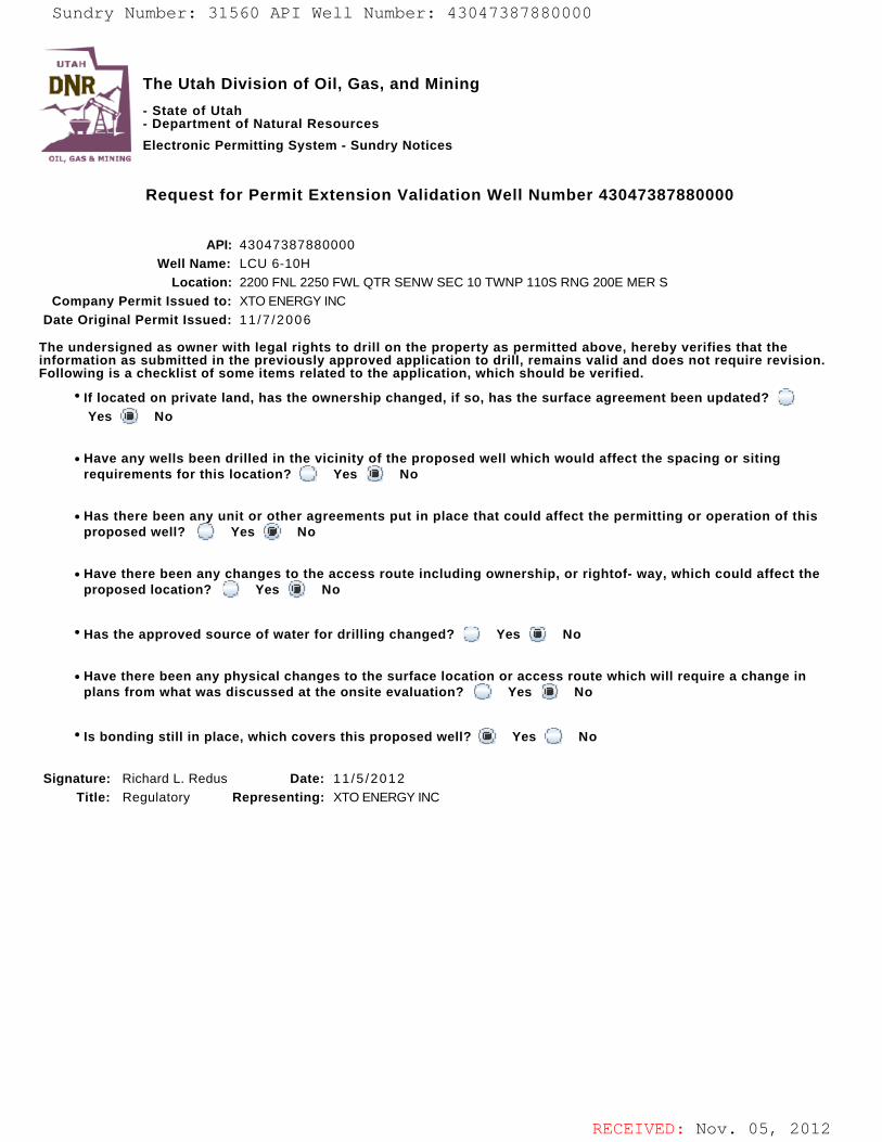
RECEIVED: Nov. 05, 2012
The Utah Division of Oil, Gas, and Mining
- State of Utah- Department of Natural Resources
Electronic Permitting System - Sundry Notices
Request for Permit Extension Validation Well Number 43047387880000
API: 43047387880000Well Name: LCU 6-10H
Location: 2200 FNL 2250 FWL QTR SENW SEC 10 TWNP 110S RNG 200E MER SCompany Permit Issued to: XTO ENERGY INC
Date Original Permit Issued: 11 /7 /2006
The undersigned as owner with legal rights to drill on the property as permitted above, hereby verifies that theinformation as submitted in the previously approved application to drill, remains valid and does not require revision.Following is a checklist of some items related to the application, which should be verified.
If located on private land, has the ownership changed, if so, has the surface agreement been updated? Yes No
Have any wells been drilled in the vicinity of the proposed well which would affect the spacing or sitingrequirements for this location? Yes No
Has there been any unit or other agreements put in place that could affect the permitting or operation of thisproposed well? Yes No
Have there been any changes to the access route including ownership, or rightof- way, which could affect theproposed location? Yes No
Has the approved source of water for drilling changed? Yes No
Have there been any physical changes to the surface location or access route which will require a change inplans from what was discussed at the onsite evaluation? Yes No
Is bonding still in place, which covers this proposed well? Yes No
Signature: Richard L. Redus Date: 11 /5 /2012
Title: Regulatory Representing: XTO ENERGY INC
Sundry Number: 31560 API Well Number: 43047387880000Sundry Number: 31560 API Well Number: 43047387880000
UTAH
DNR The Utah Division of Oil, Gas, and Mining'
- State of Utah- Department of Natural ResourcesElectronic Permitting System - Sundry Notices
OTI. EMI Pr N1NTrie
Request for Permit Extension Validation Well Number 43047387880000
API: 43047387880000Well Name: LCU 6-10H
Location: 2200 FNL 2250 FWL QTR SENW SEC 10 TWNP 110S RNG 200E MER SCompany Permit Issued to: XTO ENERGY INC
Date Original Permit Issued: 11/7/2006
The undersigned as owner with legal rights to drill on the property as permitted above, hereby verifies that theinformation as submitted in the previously approved application to drill, remains valid and does not require revision.Following is a checklist of some items related to the application, which should be verified.
* If located on private land, has the ownership changed, if so, has the surface agreement been updated? OYes No
• Have any wells been drilled in the vicinity of the proposed well which would affect the spacing or sitingrequirements for this location? O Yes No
• Has there been any unit or other agreements put in place that could affect the permitting or operation of thisproposed well? (_) Yes No
• Have there been any changes to the access route including ownership, or rightof- way, which could affect theproposed location? O Yes i No
· Has the approved source of water for drilling changed? O Yes No
• Have there been any physical changes to the surface location or access route which will require a change inplans from what was discussed at the onsite evaluation? Yes No
' Is bonding still in place, which covers this proposed well? Yes No
Signature: Richard L. Redus Date: 11/5/2012Title: Regulatory Representing: XTO ENERGY INC
RECEIVED: Nov. 05,
Sundry Number: 31560 API Well Number: 43047387880000
UTAH
DNR The Utah Division of Oil, Gas, and Mining'
- State of Utah- Department of Natural Resources
Electronic Permitting System - Sundry NoticesOTI. EMI Pr N1NTrie
Request for Permit Extension Validation Well Number 43047387880000
API: 43047387880000Well Name: LCU 6-10H
Location: 2200 FNL 2250 FWL QTR SENW SEC 10 TWNP 110S RNG 200E MER SCompany Permit Issued to: XTO ENERGY INC
Date Original Permit Issued: 11/7/2006
The undersigned as owner with legal rights to drill on the property as permitted above, hereby verifies that theinformation as submitted in the previously approved application to drill, remains valid and does not require revision.Following is a checklist of some items related to the application, which should be verified.
* If located on private land, has the ownership changed, if so, has the surface agreement been updated? OYes No
• Have any wells been drilled in the vicinity of the proposed well which would affect the spacing or sitingrequirements for this location? O Yes No
• Has there been any unit or other agreements put in place that could affect the permitting or operation of thisproposed well? (_) Yes No
• Have there been any changes to the access route including ownership, or rightof- way, which could affect theproposed location? O Yes i No
· Has the approved source of water for drilling changed? O Yes No
• Have there been any physical changes to the surface location or access route which will require a change inplans from what was discussed at the onsite evaluation? Yes No
' Is bonding still in place, which covers this proposed well? Yes No
Signature: Richard L. Redus Date: 11/5/2012Title: Regulatory Representing: XTO ENERGY INC
RECEIVED: Nov. 05,
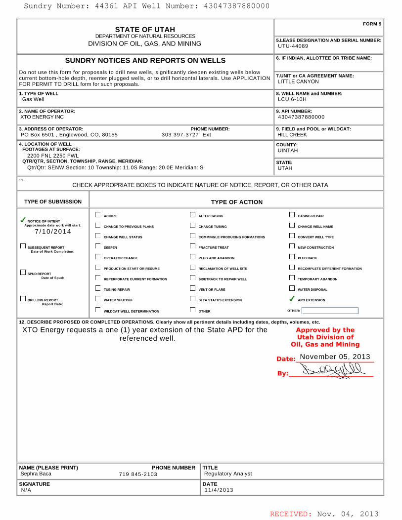
RECEIVED: Nov. 04, 2013
STATE OF UTAHDEPARTMENT OF NATURAL RESOURCES
DIVISION OF OIL, GAS, AND MINING
FORM 9
5.LEASE DESIGNATION AND SERIAL NUMBER: UTU-44089
SUNDRY NOTICES AND REPORTS ON WELLS
Do not use this form for proposals to drill new wells, significantly deepen existing wells belowcurrent bottom-hole depth, reenter plugged wells, or to drill horizontal laterals. Use APPLICATIONFOR PERMIT TO DRILL form for such proposals.
6. IF INDIAN, ALLOTTEE OR TRIBE NAME:
7.UNIT or CA AGREEMENT NAME: LITTLE CANYON
1. TYPE OF WELL Gas Well
8. WELL NAME and NUMBER: LCU 6-10H
2. NAME OF OPERATOR: XTO ENERGY INC
9. API NUMBER: 43047387880000
3. ADDRESS OF OPERATOR: PHONE NUMBER: PO Box 6501 , Englewood, CO, 80155 303 397-3727 Ext
9. FIELD and POOL or WILDCAT: HILL CREEK
4. LOCATION OF WELL FOOTAGES AT SURFACE: 2200 FNL 2250 FWL QTR/QTR, SECTION, TOWNSHIP, RANGE, MERIDIAN: Qtr/Qtr: SENW Section: 10 Township: 11.0S Range: 20.0E Meridian: S
COUNTY: UINTAH
STATE: UTAH
11.
CHECK APPROPRIATE BOXES TO INDICATE NATURE OF NOTICE, REPORT, OR OTHER DATA
TYPE OF SUBMISSION TYPE OF ACTION
NOTICE OF INTENTApproximate date work will start:
7 /10 /2014
SUBSEQUENT REPORTDate of Work Completion:
SPUD REPORTDate of Spud:
DRILLING REPORTReport Date:
ACIDIZE ALTER CASING CASING REPAIR
CHANGE TO PREVIOUS PLANS CHANGE TUBING CHANGE WELL NAME
CHANGE WELL STATUS COMMINGLE PRODUCING FORMATIONS CONVERT WELL TYPE
DEEPEN FRACTURE TREAT NEW CONSTRUCTION
OPERATOR CHANGE PLUG AND ABANDON PLUG BACK
PRODUCTION START OR RESUME RECLAMATION OF WELL SITE RECOMPLETE DIFFERENT FORMATION
REPERFORATE CURRENT FORMATION SIDETRACK TO REPAIR WELL TEMPORARY ABANDON
TUBING REPAIR VENT OR FLARE WATER DISPOSAL
WATER SHUTOFF SI TA STATUS EXTENSION APD EXTENSION
WILDCAT WELL DETERMINATION OTHER OTHER:
12. DESCRIBE PROPOSED OR COMPLETED OPERATIONS. Clearly show all pertinent details including dates, depths, volumes, etc.
XTO Energy requests a one (1) year extension of the State APD for thereferenced well.
NAME (PLEASE PRINT) PHONE NUMBER Sephra Baca 719 845-2103
TITLE Regulatory Analyst
SIGNATURE N/A
DATE 11 /4 /2013
November 05, 2013
Sundry Number: 44361 API Well Number: 43047387880000Sundry Number: 44361 API Well Number: 43047387880000
FORM 9STATE OF UTAH
DEPARTMENTOF NATURALRESOURCES5.LEASE DESIGNATION AND SERIAL NUMBER:DIVISION OF OIL, GAS, AND MINING UTU-44089
SUNDRY NOTICES AND REPORTS ON WELLS 6. IF INDIAN, ALLOTTEE OR TRIBE NAME:
Do not use this form for proposals to drill new wells, significantly deepen existing wells belowcurrent bottom-hole depth, reenter plugged wells, or to drill horizontal laterals. Use APPLICATION 7.UNITor CA AGREEMENT NAME:
FOR PERMIT TO DRILL form for such proposals. LITTLECANYON
1. TYPE OF WELL 8. WELL NAME and NUMBER:Gas Well LCU 6-10H
2. NAME OF OPERATOR: 9. API NUMBER:XTOENERGYlNC 43047387880000
3. ADDRESS OF OPERATOR: PHONE NUMBER: 9. FIELD and POOL or WILDCAT:PO Box 6501 , Englewood, CO, 80155 303 397-3727 Ext HILLCREEK
4. LOCATION OF WELL COUNTY:FOOTAGESAT SURFACE: UINTAH
2200 FNL 2250 FWLQTRIQTR, SECTION, TOWNSHIP, RANGE, MERIDIAN: STATE:
QtrlQtr: SENW Section: 10 Township: 11.0S Range: 20.0E Meridian: S UTAH
CHECK APPROPRIATE BOXES TO INDICATENATURE OF NOTICE, REPORT, OR OTHER DATA
TYPE OF SUBMISSION TYPE OF ACTION
ACI DIZE ALTER CASING CASING REPAIRNOTICE OF INTENT
Approximate date work will start: CHANGE TO PREVIOUS PLANS CHANGE TUBING CHANGE WELL NAME
7/10/2014CHANGE WELL STATUS COMMINGLE PRODUCING FORMATIONS CONVERT WELL TYPE
SUBSEQUENTREPORT DEEPEN FRACTURETREAT NEWCONSTRUCTIONDate of Work Completion:
OPERATOR CHANGE PLUG AND ABANDON PLUG BACK
PRODUCTION START OR RESUME RECLAMATION OF WELL SITE RECOMPLETE DIFFERENT FORMATIONSPUD REPORT
Date of Spud: REPERFORATE CURRENT FORMATION SIDETRACK TO REPAIR WELL TEMPORARY ABANDON
TUBING REPAIR VENT OR FLARE WATER DISPOSAL
DRILLING REPORT WATER SHUTOFF SI TA STATUS EXTENSION APD EXTENSIONReport Date:
WILDCAT WELL DETERMINATION OTHER OTHER:
12. DESCRIBE PROPOSED OR COMPLETED OPERATIONS. Clearly show all pertinent details including dates, depths, volumes, etc.
XTO Energy requests a one (1) year extension of the State APD for the Approved by thereferenced well. Utah Division of
OFI, Gas and Mining
Date: November 05, 2013
By:
NAME (PLEASE PRINT) PHONE NUMBER TITLESephra Baca 719 845-2103 Regulatory Analyst
SIGNATURE DATEN/A 11/4/2013
RECEIVED: Nov. 04,
Sundry Number: 44361 API Well Number: 43047387880000
FORM 9STATE OF UTAH
DEPARTMENTOF NATURALRESOURCES5.LEASE DESIGNATION AND SERIAL NUMBER:DIVISION OF OIL, GAS, AND MINING UTU-44089
SUNDRY NOTICES AND REPORTS ON WELLS 6. IF INDIAN, ALLOTTEE OR TRIBE NAME:
Do not use this form for proposals to drill new wells, significantly deepen existing wells belowcurrent bottom-hole depth, reenter plugged wells, or to drill horizontal laterals. Use APPLICATION 7.UNITor CA AGREEMENT NAME:
FOR PERMIT TO DRILL form for such proposals. LITTLECANYON
1. TYPE OF WELL 8. WELL NAME and NUMBER:Gas Well LCU 6-10H
2. NAME OF OPERATOR: 9. API NUMBER:XTOENERGYlNC 43047387880000
3. ADDRESS OF OPERATOR: PHONE NUMBER: 9. FIELD and POOL or WILDCAT:PO Box 6501 , Englewood, CO, 80155 303 397-3727 Ext HILLCREEK
4. LOCATION OF WELL COUNTY:FOOTAGESAT SURFACE: UINTAH
2200 FNL 2250 FWLQTRIQTR, SECTION, TOWNSHIP, RANGE, MERIDIAN: STATE:
QtrlQtr: SENW Section: 10 Township: 11.0S Range: 20.0E Meridian: S UTAH
CHECK APPROPRIATE BOXES TO INDICATENATURE OF NOTICE, REPORT, OR OTHER DATA
TYPE OF SUBMISSION TYPE OF ACTION
ACI DIZE ALTER CASING CASING REPAIRNOTICE OF INTENT
Approximate date work will start: CHANGE TO PREVIOUS PLANS CHANGE TUBING CHANGE WELL NAME
7/10/2014CHANGE WELL STATUS COMMINGLE PRODUCING FORMATIONS CONVERT WELL TYPE
SUBSEQUENTREPORT DEEPEN FRACTURETREAT NEWCONSTRUCTIONDate of Work Completion:
OPERATOR CHANGE PLUG AND ABANDON PLUG BACK
PRODUCTION START OR RESUME RECLAMATION OF WELL SITE RECOMPLETE DIFFERENT FORMATIONSPUD REPORT
Date of Spud: REPERFORATE CURRENT FORMATION SIDETRACK TO REPAIR WELL TEMPORARY ABANDON
TUBING REPAIR VENT OR FLARE WATER DISPOSAL
DRILLING REPORT WATER SHUTOFF SI TA STATUS EXTENSION APD EXTENSIONReport Date:
WILDCAT WELL DETERMINATION OTHER OTHER:
12. DESCRIBE PROPOSED OR COMPLETED OPERATIONS. Clearly show all pertinent details including dates, depths, volumes, etc.
XTO Energy requests a one (1) year extension of the State APD for the Approved by thereferenced well. Utah Division of
OFI, Gas and Mining
Date: November 05, 2013
By:
NAME (PLEASE PRINT) PHONE NUMBER TITLESephra Baca 719 845-2103 Regulatory Analyst
SIGNATURE DATEN/A 11/4/2013
RECEIVED: Nov. 04,

RECEIVED: Nov. 04, 2013
The Utah Division of Oil, Gas, and Mining
- State of Utah- Department of Natural Resources
Electronic Permitting System - Sundry Notices
Request for Permit Extension Validation Well Number 43047387880000
API: 43047387880000Well Name: LCU 6-10H
Location: 2200 FNL 2250 FWL QTR SENW SEC 10 TWNP 110S RNG 200E MER SCompany Permit Issued to: XTO ENERGY INC
Date Original Permit Issued: 11 /7 /2006
The undersigned as owner with legal rights to drill on the property as permitted above, hereby verifies that theinformation as submitted in the previously approved application to drill, remains valid and does not require revision.Following is a checklist of some items related to the application, which should be verified.
If located on private land, has the ownership changed, if so, has the surface agreement been updated? Yes No
Have any wells been drilled in the vicinity of the proposed well which would affect the spacing or sitingrequirements for this location? Yes No
Has there been any unit or other agreements put in place that could affect the permitting or operation of thisproposed well? Yes No
Have there been any changes to the access route including ownership, or rightof- way, which could affect theproposed location? Yes No
Has the approved source of water for drilling changed? Yes No
Have there been any physical changes to the surface location or access route which will require a change inplans from what was discussed at the onsite evaluation? Yes No
Is bonding still in place, which covers this proposed well? Yes No
Signature: Sephra Baca Date: 11 /4 /2013
Title: Regulatory Analyst Representing: XTO ENERGY INC
Sundry Number: 44361 API Well Number: 43047387880000Sundry Number: 44361 API Well Number: 43047387880000
UTAH
DNR The Utah Division of Oil, Gas, and Mining'
- State of Utah- Department of Natural ResourcesElectronic Permitting System - Sundry Notices
OTI. EMI Pr N1NTrie
Request for Permit Extension Validation Well Number 43047387880000
API: 43047387880000Well Name: LCU 6-10H
Location: 2200 FNL 2250 FWL QTR SENW SEC 10 TWNP 110S RNG 200E MER SCompany Permit Issued to: XTO ENERGY INC
Date Original Permit Issued: 11/7/2006
The undersigned as owner with legal rights to drill on the property as permitted above, hereby verifies that theinformation as submitted in the previously approved application to drill, remains valid and does not require revision.Following is a checklist of some items related to the application, which should be verified.
* If located on private land, has the ownership changed, if so, has the surface agreement been updated? OYes No
• Have any wells been drilled in the vicinity of the proposed well which would affect the spacing or sitingrequirements for this location? O Yes No
• Has there been any unit or other agreements put in place that could affect the permitting or operation of thisproposed well? (_) Yes No
• Have there been any changes to the access route including ownership, or rightof- way, which could affect theproposed location? O Yes i No
· Has the approved source of water for drilling changed? O Yes No
• Have there been any physical changes to the surface location or access route which will require a change inplans from what was discussed at the onsite evaluation? Yes No
' Is bonding still in place, which covers this proposed well? Yes No
Signature: Sephra Baca Date: 11/4/2013Title: Regulatory Analyst Representing: XTO ENERGY INC
RECEIVED: Nov. 04,
Sundry Number: 44361 API Well Number: 43047387880000
UTAH
DNR The Utah Division of Oil, Gas, and Mining'
- State of Utah- Department of Natural Resources
Electronic Permitting System - Sundry NoticesOTI. EMI Pr N1NTrie
Request for Permit Extension Validation Well Number 43047387880000
API: 43047387880000Well Name: LCU 6-10H
Location: 2200 FNL 2250 FWL QTR SENW SEC 10 TWNP 110S RNG 200E MER SCompany Permit Issued to: XTO ENERGY INC
Date Original Permit Issued: 11/7/2006
The undersigned as owner with legal rights to drill on the property as permitted above, hereby verifies that theinformation as submitted in the previously approved application to drill, remains valid and does not require revision.Following is a checklist of some items related to the application, which should be verified.
* If located on private land, has the ownership changed, if so, has the surface agreement been updated? OYes No
• Have any wells been drilled in the vicinity of the proposed well which would affect the spacing or sitingrequirements for this location? O Yes No
• Has there been any unit or other agreements put in place that could affect the permitting or operation of thisproposed well? (_) Yes No
• Have there been any changes to the access route including ownership, or rightof- way, which could affect theproposed location? O Yes i No
· Has the approved source of water for drilling changed? O Yes No
• Have there been any physical changes to the surface location or access route which will require a change inplans from what was discussed at the onsite evaluation? Yes No
' Is bonding still in place, which covers this proposed well? Yes No
Signature: Sephra Baca Date: 11/4/2013Title: Regulatory Analyst Representing: XTO ENERGY INC
RECEIVED: Nov. 04,

RECEIVED: Oct. 20, 2014
STATE OF UTAHDEPARTMENT OF NATURAL RESOURCES
DIVISION OF OIL, GAS, AND MINING
FORM 9
5.LEASE DESIGNATION AND SERIAL NUMBER: UTU-44089
SUNDRY NOTICES AND REPORTS ON WELLS
Do not use this form for proposals to drill new wells, significantly deepen existing wells belowcurrent bottom-hole depth, reenter plugged wells, or to drill horizontal laterals. Use APPLICATIONFOR PERMIT TO DRILL form for such proposals.
6. IF INDIAN, ALLOTTEE OR TRIBE NAME:
7.UNIT or CA AGREEMENT NAME: LITTLE CANYON
1. TYPE OF WELL Gas Well
8. WELL NAME and NUMBER: LCU 6-10H
2. NAME OF OPERATOR: XTO ENERGY INC
9. API NUMBER: 43047387880000
3. ADDRESS OF OPERATOR: PHONE NUMBER: PO Box 6501 , Englewood, CO, 80155 303 397-3727 Ext
9. FIELD and POOL or WILDCAT: HILL CREEK
4. LOCATION OF WELL FOOTAGES AT SURFACE: 2200 FNL 2250 FWL QTR/QTR, SECTION, TOWNSHIP, RANGE, MERIDIAN: Qtr/Qtr: SENW Section: 10 Township: 11.0S Range: 20.0E Meridian: S
COUNTY: UINTAH
STATE: UTAH
11.
CHECK APPROPRIATE BOXES TO INDICATE NATURE OF NOTICE, REPORT, OR OTHER DATA
TYPE OF SUBMISSION TYPE OF ACTION
NOTICE OF INTENTApproximate date work will start:
10/31 /2015
SUBSEQUENT REPORTDate of Work Completion:
SPUD REPORTDate of Spud:
DRILLING REPORTReport Date:
ACIDIZE ALTER CASING CASING REPAIR
CHANGE TO PREVIOUS PLANS CHANGE TUBING CHANGE WELL NAME
CHANGE WELL STATUS COMMINGLE PRODUCING FORMATIONS CONVERT WELL TYPE
DEEPEN FRACTURE TREAT NEW CONSTRUCTION
OPERATOR CHANGE PLUG AND ABANDON PLUG BACK
PRODUCTION START OR RESUME RECLAMATION OF WELL SITE RECOMPLETE DIFFERENT FORMATION
REPERFORATE CURRENT FORMATION SIDETRACK TO REPAIR WELL TEMPORARY ABANDON
TUBING REPAIR VENT OR FLARE WATER DISPOSAL
WATER SHUTOFF SI TA STATUS EXTENSION APD EXTENSION
WILDCAT WELL DETERMINATION OTHER OTHER:
12. DESCRIBE PROPOSED OR COMPLETED OPERATIONS. Clearly show all pertinent details including dates, depths, volumes, etc.
XTO Energy requests a one (1) year extension of the State APD for thereferenced well.
NAME (PLEASE PRINT) PHONE NUMBER Malia Villers 303 397-3670
TITLE Lead Permitting Analyst
SIGNATURE N/A
DATE 10/20/2014
October 27, 2014
Sundry Number: 56862 API Well Number: 43047387880000Sundry Number: 56862 API Well Number: 43047387880000
FORM 9STATE OF UTAH
DEPARTMENTOF NATURALRESOURCES5.LEASE DESIGNATION AND SERIAL NUMBER:DIVISION OF OIL, GAS, AND MINING UTU-44089
SUNDRY NOTICES AND REPORTS ON WELLS 6. IF INDIAN, ALLOTTEE OR TRIBE NAME:
Do not use this form for proposals to drill new wells, significantly deepen existing wells belowcurrent bottom-hole depth, reenter plugged wells, or to drill horizontal laterals. Use APPLICATION 7.UNITor CA AGREEMENT NAME:
FOR PERMIT TO DRILL form for such proposals. LITTLECANYON
1. TYPE OF WELL 8. WELL NAME and NUMBER:Gas Well LCU 6-10H
2. NAME OF OPERATOR: 9. API NUMBER:XTOENERGYlNC 43047387880000
3. ADDRESS OF OPERATOR: PHONE NUMBER: 9. FIELD and POOL or WILDCAT:PO Box 6501 , Englewood, CO, 80155 303 397-3727 Ext HILLCREEK
4. LOCATION OF WELL COUNTY:FOOTAGESAT SURFACE: UINTAH
2200 FNL 2250 FWLQTRIQTR, SECTION, TOWNSHIP, RANGE, MERIDIAN: STATE:
QtrlQtr: SENW Section: 10 Township: 11.0S Range: 20.0E Meridian: S UTAH
CHECK APPROPRIATE BOXES TO INDICATENATURE OF NOTICE, REPORT, OR OTHER DATA
TYPE OF SUBMISSION TYPE OF ACTION
ACI DIZE ALTER CASING CASING REPAIRNOTICE OF INTENT
Approximate date work will start: CHANGE TO PREVIOUS PLANS CHANGE TUBING CHANGE WELL NAME
10/31/2015CHANGE WELL STATUS COMMINGLE PRODUCING FORMATIONS CONVERT WELL TYPE
SUBSEQUENTREPORT DEEPEN FRACTURETREAT NEWCONSTRUCTIONDate of Work Completion:
OPERATOR CHANGE PLUG AND ABANDON PLUG BACK
PRODUCTION START OR RESUME RECLAMATION OF WELL SITE RECOMPLETE DIFFERENT FORMATIONSPUD REPORT
Date of Spud: REPERFORATE CURRENT FORMATION SIDETRACK TO REPAIR WELL TEMPORARY ABANDON
TUBING REPAIR VENT OR FLARE WATER DISPOSAL
DRILLING REPORT WATER SHUTOFF SI TA STATUS EXTENSION APD EXTENSIONReport Date:
WILDCAT WELL DETERMINATION OTHER OTHER:
12. DESCRIBE PROPOSED OR COMPLETED OPERATIONS. Clearly show all pertinent details including dates, depths, volumes, etc.
XTO Energy requests a one (1) year extension of the State APD for the Approved by thereferenced well. UbatobadBp2014
OFI, Gas and Mining
Date:
NAME (PLEASE PRINT) PHONE NUMBER TITLEMalia Villers 303 397-3670 Lead Permitting Analyst
SIGNATURE DATEN/A 10/20/2014
RECEIVED: Oct. 20,
Sundry Number: 56862 API Well Number: 43047387880000
FORM 9STATE OF UTAH
DEPARTMENTOF NATURALRESOURCES5.LEASE DESIGNATION AND SERIAL NUMBER:DIVISION OF OIL, GAS, AND MINING UTU-44089
SUNDRY NOTICES AND REPORTS ON WELLS 6. IF INDIAN, ALLOTTEE OR TRIBE NAME:
Do not use this form for proposals to drill new wells, significantly deepen existing wells belowcurrent bottom-hole depth, reenter plugged wells, or to drill horizontal laterals. Use APPLICATION 7.UNITor CA AGREEMENT NAME:
FOR PERMIT TO DRILL form for such proposals. LITTLECANYON
1. TYPE OF WELL 8. WELL NAME and NUMBER:Gas Well LCU 6-10H
2. NAME OF OPERATOR: 9. API NUMBER:XTOENERGYlNC 43047387880000
3. ADDRESS OF OPERATOR: PHONE NUMBER: 9. FIELD and POOL or WILDCAT:PO Box 6501 , Englewood, CO, 80155 303 397-3727 Ext HILLCREEK
4. LOCATION OF WELL COUNTY:FOOTAGESAT SURFACE: UINTAH
2200 FNL 2250 FWLQTRIQTR, SECTION, TOWNSHIP, RANGE, MERIDIAN: STATE:
QtrlQtr: SENW Section: 10 Township: 11.0S Range: 20.0E Meridian: S UTAH
CHECK APPROPRIATE BOXES TO INDICATENATURE OF NOTICE, REPORT, OR OTHER DATA
TYPE OF SUBMISSION TYPE OF ACTION
ACI DIZE ALTER CASING CASING REPAIRNOTICE OF INTENT
Approximate date work will start: CHANGE TO PREVIOUS PLANS CHANGE TUBING CHANGE WELL NAME
10/31/2015CHANGE WELL STATUS COMMINGLE PRODUCING FORMATIONS CONVERT WELL TYPE
SUBSEQUENTREPORT DEEPEN FRACTURETREAT NEWCONSTRUCTIONDate of Work Completion:
OPERATOR CHANGE PLUG AND ABANDON PLUG BACK
PRODUCTION START OR RESUME RECLAMATION OF WELL SITE RECOMPLETE DIFFERENT FORMATIONSPUD REPORT
Date of Spud: REPERFORATE CURRENT FORMATION SIDETRACK TO REPAIR WELL TEMPORARY ABANDON
TUBING REPAIR VENT OR FLARE WATER DISPOSAL
DRILLING REPORT WATER SHUTOFF SI TA STATUS EXTENSION APD EXTENSIONReport Date:
WILDCAT WELL DETERMINATION OTHER OTHER:
12. DESCRIBE PROPOSED OR COMPLETED OPERATIONS. Clearly show all pertinent details including dates, depths, volumes, etc.
XTO Energy requests a one (1) year extension of the State APD for the Approved by thereferenced well. UbatobadBp2014
OFI, Gas and Mining
Date:
NAME (PLEASE PRINT) PHONE NUMBER TITLEMalia Villers 303 397-3670 Lead Permitting Analyst
SIGNATURE DATEN/A 10/20/2014
RECEIVED: Oct. 20,
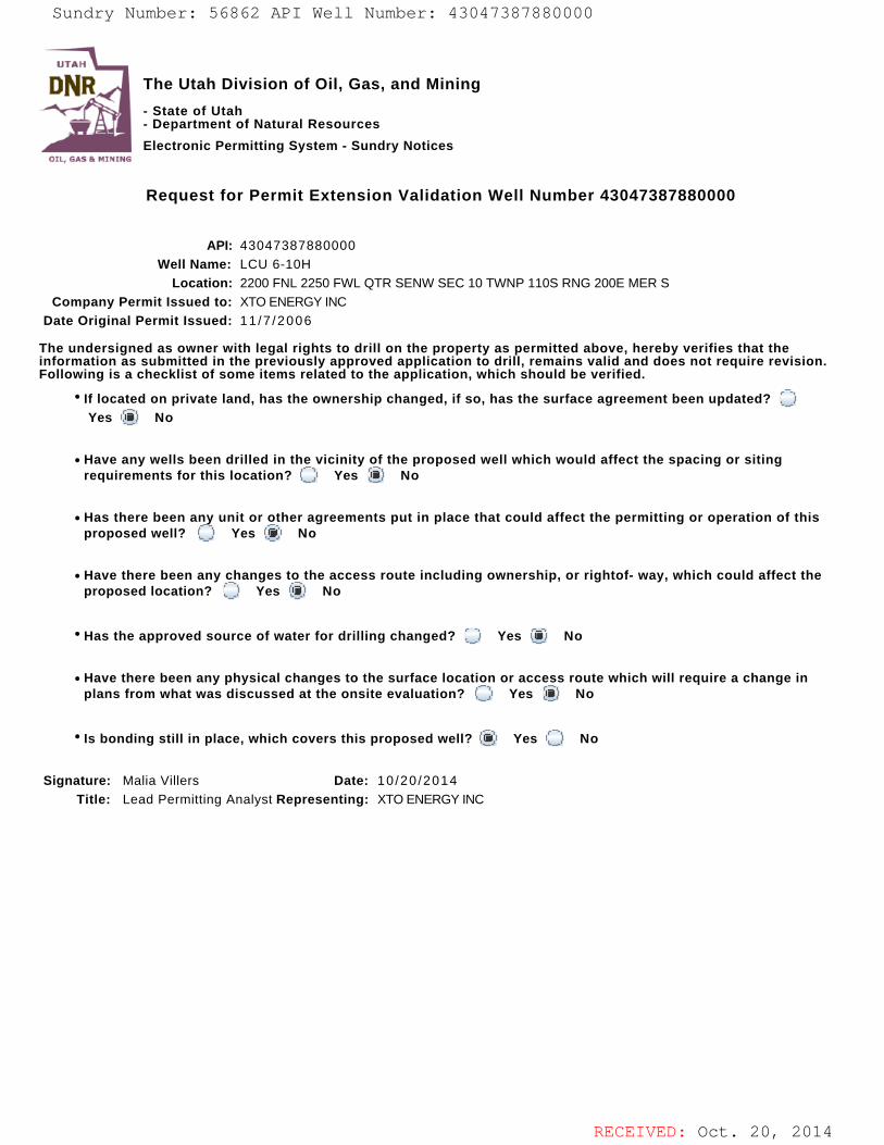
RECEIVED: Oct. 20, 2014
The Utah Division of Oil, Gas, and Mining
- State of Utah- Department of Natural Resources
Electronic Permitting System - Sundry Notices
Request for Permit Extension Validation Well Number 43047387880000
API: 43047387880000Well Name: LCU 6-10H
Location: 2200 FNL 2250 FWL QTR SENW SEC 10 TWNP 110S RNG 200E MER SCompany Permit Issued to: XTO ENERGY INC
Date Original Permit Issued: 11 /7 /2006
The undersigned as owner with legal rights to drill on the property as permitted above, hereby verifies that theinformation as submitted in the previously approved application to drill, remains valid and does not require revision.Following is a checklist of some items related to the application, which should be verified.
If located on private land, has the ownership changed, if so, has the surface agreement been updated? Yes No
Have any wells been drilled in the vicinity of the proposed well which would affect the spacing or sitingrequirements for this location? Yes No
Has there been any unit or other agreements put in place that could affect the permitting or operation of thisproposed well? Yes No
Have there been any changes to the access route including ownership, or rightof- way, which could affect theproposed location? Yes No
Has the approved source of water for drilling changed? Yes No
Have there been any physical changes to the surface location or access route which will require a change inplans from what was discussed at the onsite evaluation? Yes No
Is bonding still in place, which covers this proposed well? Yes No
Signature: Malia Villers Date: 10/20 /2014
Title: Lead Permitting Analyst Representing: XTO ENERGY INC
Sundry Number: 56862 API Well Number: 43047387880000Sundry Number: 56862 API Well Number: 43047387880000
UTAH
DNR The Utah Division of Oil, Gas, and Mining'
- State of Utah- Department of Natural Resources
Electronic Permitting System - Sundry NoticesOTI. EMI Pr N1NTrie
Request for Permit Extension Validation Well Number 43047387880000
API: 43047387880000Well Name: LCU 6-10H
Location: 2200 FNL 2250 FWL QTR SENW SEC 10 TWNP 110S RNG 200E MER SCompany Permit Issued to: XTO ENERGY INC
Date Original Permit Issued: 11/7/2006
The undersigned as owner with legal rights to drill on the property as permitted above, hereby verifies that theinformation as submitted in the previously approved application to drill, remains valid and does not require revision.Following is a checklist of some items related to the application, which should be verified.
* If located on private land, has the ownership changed, if so, has the surface agreement been updated? OYes No
• Have any wells been drilled in the vicinity of the proposed well which would affect the spacing or sitingrequirements for this location? O Yes No
• Has there been any unit or other agreements put in place that could affect the permitting or operation of thisproposed well? (_) Yes No
• Have there been any changes to the access route including ownership, or rightof- way, which could affect theproposed location? O Yes i No
· Has the approved source of water for drilling changed? O Yes No
• Have there been any physical changes to the surface location or access route which will require a change inplans from what was discussed at the onsite evaluation? Yes No
' Is bonding still in place, which covers this proposed well? Yes No
Signature: Malia Villers Date: 10/20/2014Title: Lead Permitting Analyst Representing: XTO ENERGY INC
RECEIVED: Oct. 20,
Sundry Number: 56862 API Well Number: 43047387880000
UTAH
DNR The Utah Division of Oil, Gas, and Mining'
- State of Utah- Department of Natural Resources
Electronic Permitting System - Sundry NoticesOTI. EMI Pr N1NTrie
Request for Permit Extension Validation Well Number 43047387880000
API: 43047387880000Well Name: LCU 6-10H
Location: 2200 FNL 2250 FWL QTR SENW SEC 10 TWNP 110S RNG 200E MER SCompany Permit Issued to: XTO ENERGY INC
Date Original Permit Issued: 11/7/2006
The undersigned as owner with legal rights to drill on the property as permitted above, hereby verifies that theinformation as submitted in the previously approved application to drill, remains valid and does not require revision.Following is a checklist of some items related to the application, which should be verified.
* If located on private land, has the ownership changed, if so, has the surface agreement been updated? OYes No
• Have any wells been drilled in the vicinity of the proposed well which would affect the spacing or sitingrequirements for this location? O Yes No
• Has there been any unit or other agreements put in place that could affect the permitting or operation of thisproposed well? (_) Yes No
• Have there been any changes to the access route including ownership, or rightof- way, which could affect theproposed location? O Yes i No
· Has the approved source of water for drilling changed? O Yes No
• Have there been any physical changes to the surface location or access route which will require a change inplans from what was discussed at the onsite evaluation? Yes No
' Is bonding still in place, which covers this proposed well? Yes No
Signature: Malia Villers Date: 10/20/2014Title: Lead Permitting Analyst Representing: XTO ENERGY INC
RECEIVED: Oct. 20,

State of Utah DEPARTMENT OF NATURAL RESOURCES
GARY R. HERBERT Governor
SPENCER J. COX Lieutenant Governor
MICHAEL R. STYLER Executive Director
Division of Oil, Gas and Mining JOHNR.BAZA Division Director
Malia Villers XTO Energy Inc. P.O. BOX 6501 Englewood, CO 80155
November 12,2015
1~ -rstf7- 3 ~ ~ i Re: APDs Rescinded for XTO Energy Inc., Uintah County
Dear Ms. Villers:
Enclosed find the list of APDs that you asked to be rescinded. No drilling activity at these locations has been reported to the division. Therefore, approval to drill these wells is hereby rescinded effective November 11,2015.
A new APD must be filed with this office for approval prior to the commencement of any future work on the subject location.
If any previously unreported operations have been performed on this well location, it is imperative that you notify the Division immediately.
s~. ly,
"ru~l;lQJl!YL D Mason EnVironmental Scientist
cc: Well File Bureau of Land Management, Verna1
1594 West North Temple, Suite 1210, PO Box 145801, Salt Lake City, UT 84114-5801 telephone (801) 538-5340. facsimile (801) 359-3940. TTY (801) 538-7458. www.ogm.utah.gov
OIL, GAS a. MINING
, State of UtahDEPARTMENT OF NATURAL RESOURCES
MICHAEL R. STYLER
GARY R.HERBERT Executive Director
Governor Division of Oil, Gas and MiningSPENCER J. COX JOHN R. BAZALieutenant Governor DivisionDirector
November 12, 2015
Malia VillersXTO Energy Inc.P.O. BOX 6501Englewood, CO 80155
Re: APDs Rescinded for XTO Energy Inc., Uintah County
Dear Ms. Villers:
Enclosed find the list of APDs that you asked to be rescinded. No drilling activityat these locations has been reported to the division. Therefore, approval to drillthese wells is hereby rescinded effective November 11, 2015.
A new APD must be filed with this office for approval prior to thecommencement of any future work on the subject location.
If any previously unreported operations have been performed on this welllocation, it is imperative that you notify the Division immediately.
Sin ly,
D ana MasonEnŸironmentalScientist
ec: Well FileBureau of Land Management, Vernal
UTAH
DNR
1594 West North Temple, Suite 1210, PO Box 145801, Salt Lake City, UT 84114-5801telephone (801) 538-5340 • facsimile (801) 359-3940 • TTY (801) 538-7458 • www.ogm.utah.gov
OIL, GAS &

Well Name API Wodt DateNumbert WeH