® making location count edxl-sitrep and ows context - opportunity for collaboration 75th ogc...
TRANSCRIPT
®
Making Location Count
EDXL-SitRep and OWS Context - Opportunity for Collaboration
75th OGC Technical Committee
Sydney, Australia
Lew Leinenweber, Evolution Technologies, Inc
December 1, 2010
Copyright © 2010 Open Geospatial Consortium
Sponsored by
Hosted at The University of Sydney
OGC®
Agenda
• EDXL Overview and Background• EDXL Standards Development Process• NIEM – What it is, where it fits, how it’s used• EDXL Family of Standards• EDXL Situation Report (SitRep)• EDXL Distribution Element (DE)• OWS Context• Exchanging Info about COP
Copyright © 2010 Open Geospatial Consortium 2

OGC®
Emergency Data eXchange Language (EDXL) Standards Background
• EDXL standards program was initiated as one of the President’s e-Gov initiatives in 2001.
• Mission: – serve as the standards program within the Federal Government to facilitate local,
tribal, state, and federal public safety and emergency response agencies to improve emergency / disaster response through effective and efficient interoperable data sharing (“Outside of Hospital Walls”)
• Standardization of specific messages (XML messaging interfaces) – coordination and emergency communication between disparate software applications
and systems especially where more than one profession or jurisdiction is involved
• Open, public practitioner-driven process driven by:– Practitioner Steering Group (PSG)– Standards Working Group (SWG)
• Public-private partnership – EIC (Emergency Interoperability Consortium)– Vendor communities– OASIS
Copyright © 2010 Open Geospatial Consortium 3
OGC®
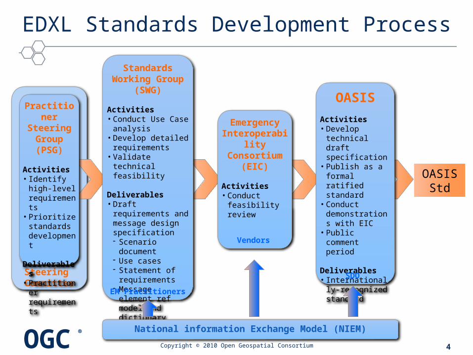
Steering Committee
EDXL Standards Development Process
Copyright © 2010 Open Geospatial Consortium
Practitioner Steering Group (PSG)
Activities• Identify high-
level requirements
• Prioritize standards development
Deliverables• Practitioner
requirements
Standards Working Group
(SWG)
Activities• Conduct Use Case
analysis• Develop detailed
requirements• Validate technical
feasibility
Deliverables• Draft requirements
and message design specification Scenario document Use cases Statement of
requirements Message element
ref model and dictionary
Emergency Interoperability
Consortium (EIC)
Activities• Conduct
feasibility review
OASIS
Activities• Develop technical
draft specification• Publish as a
formal ratified standard
• Conduct demonstrations with EIC
• Public comment period
Deliverables• Internationally-
recognized standard
OASISStd
National information Exchange Model (NIEM)
4
EM Practitioners
Vendors
SDO

OGC®
EDXL Family of OASIS Emergency Messaging Standards
Copyright © 2010 Open Geospatial Consortium
• Common Alerting Protocol (CAP 1.2)– Original “model” for this standards process prior to “EDXL” nomenclature. – XML message for exchange of emergency alerts, notifications, and public warnings
• Distribution Element (DE 1.0)– Easy wrap and route any EDXL or other emergency information (XML and non-XML). – Flexible ways to support intelligent routing by roles, geographic area, or keywords– Revisions in process for v2.0
• Resource Messaging (RM 1.0)– OASIS standard in November 2008. – Suite of 16 standard XML formats for exchange of emergency resource information (equipment,
supplies, people, and teams). – Expedite all activities associated with resources needed to respond and adapt to emergency
incidents.
• Hospital AVailability Exchange (HAVE 1.0)– OASIS standard in November 2008. – XML message for exchange of hospital status, services and resources. – Assists hospital coordination and routing of patients to facilities for care during emergencies– Revisions in process for v2.0
5
OGC®
EDXL Family of OASIS Emergency Messaging Standards (cont)
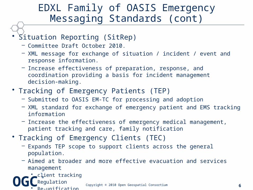
• Situation Reporting (SitRep)– Committee Draft October 2010. – XML message for exchange of situation / incident / event and response information. – Increase effectiveness of preparation, response, and coordination providing a basis
for incident management decision-making.
• Tracking of Emergency Patients (TEP)– Submitted to OASIS EM-TC for processing and adoption– XML standard for exchange of emergency patient and EMS tracking information– Increase the effectiveness of emergency medical management, patient tracking and
care, family notification
• Tracking of Emergency Clients (TEC)– Expands TEP scope to support clients across the general population. – Aimed at broader and more effective evacuation and services management
• client tracking• Regulation• Re-unification• Use of assets for all Emergency clients
– EDXL Project Steering Committee Kickoff planned for 16 Dec 2010
Copyright © 2010 Open Geospatial Consortium 6
OGC®
What is NIEM?
7
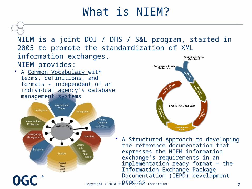
NIEM is a joint DOJ / DHS / S&L program, started in 2005 to promote the standardization of XML information exchanges. NIEM provides:
• A Common Vocabulary with terms, definitions, and formats - independent of an individual agency’s database management systems
• A Structured Approach to developing the reference documentation that expresses the NIEM information exchange’s requirements in an implementation ready format – the Information Exchange Package Documentation (IEPD) development process
Copyright © 2010 Open Geospatial Consortium
OGC®
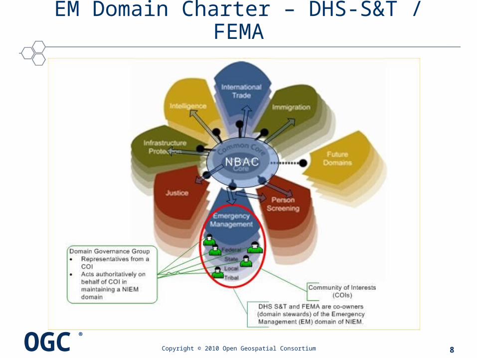
EM Domain Charter – DHS-S&T / FEMA
8Copyright © 2010 Open Geospatial Consortium

OGC®
NIEM Adapters
Copyright © 2010 Open Geospatial Consortium
Issue: commonly used standards’ schemas are generally not NIEM-conformant
Goal: preserve as a single unit a set of data that embodies a single concept from an external standard.
Solution: Create NIEM-Conformant component (Adapter type)• Adapter type must import the external schema (and reference namespace)• Appinfo:
• ConformantIndicator, value: false• ExternalAdapterTypeIndicator, value: true
• MUST be a documented component (carries its own xsd:documentation, reqd by NIEM)
• Adapter composed only of elements and attributes from the external standards• May reference content from more than one external namespace• Adapter type MUST NOT be extended or restricted
A schema is NIEM-conformant if and only if it is a reference schema, a subset schema, an extension schema, an exchange schema, or a constraint schema within NIEM
9
OGC®
EDXL Distribution Element (EDXL-DE)
• Purpose– Wrap separate but related emergency information into a single
easy-to-distribute XML "package"– "address“ package in flexible ways to support intelligent routing
• specifying recipients by role, by geographic area, or by keywords– use standardized lists of roles or keywords, or create your own lists
for additional flexibility and tailoring
• Current approved DE v1.0– Revisions in process at OASIS for DE v2.0
Copyright © 2010 Open Geospatial Consortium 10

OGC®
EDXL-DE Schema Structure+
Copyright © 2010 Open Geospatial Consortium
+ based on EDXL-DE v1.0* Indicates multiple instances allowedBold indicates required element
11
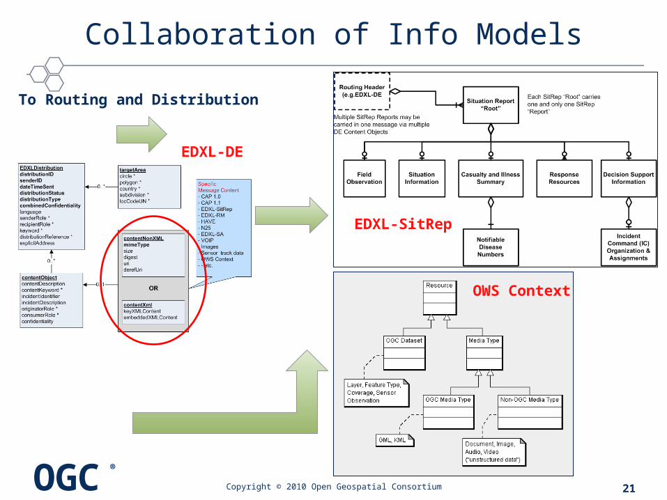
EDXLDistributiondistributionIDsenderIDdateTimeSentdistributionStatusdistributionTypecombinedConfidentialitylanguagesenderRole *recipientRole *keyword *distributionReference *explicitAddress
targetAreacircle *polygon *country *subdivision *locCodeUN *
contentObject contentDescriptioncontentKeyword *incidentIdentifierincidentDescriptionoriginatorRole *consumerRole *confidentiality
0..*
0..*
0..1
SpecificMessage Content- CAP 1.0- CAP 1.1- EDXL-SitRep- EDXL-RM- HAVE- N25- EDXL-SA- VOIP- Images- Sensor track data- OWS Context- - etc.
contentNonXMLmimeTypesizedigesturiderefUri
contentXmlkeyXMLContentembeddedXMLContent
OR
OGC®
EDXL-DE Example Message
Copyright © 2010 Open Geospatial Consortium
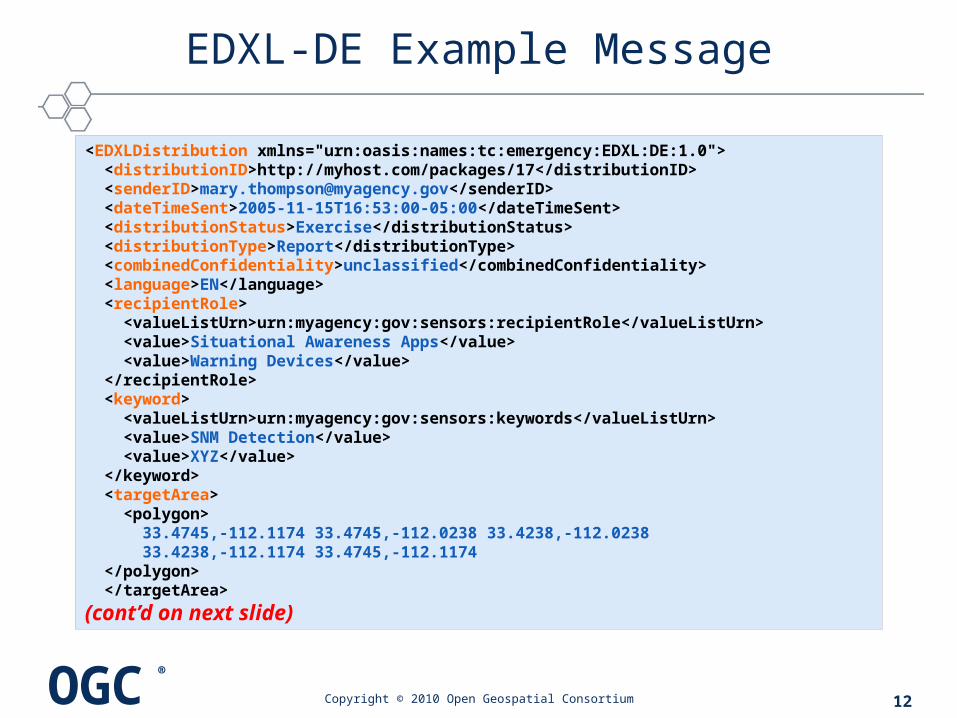
<EDXLDistribution xmlns="urn:oasis:names:tc:emergency:EDXL:DE:1.0"> <distributionID>http://myhost.com/packages/17</distributionID> <senderID>[email protected]</senderID> <dateTimeSent>2005-11-15T16:53:00-05:00</dateTimeSent> <distributionStatus>Exercise</distributionStatus> <distributionType>Report</distributionType> <combinedConfidentiality>unclassified</combinedConfidentiality> <language>EN</language> <recipientRole> <valueListUrn>urn:myagency:gov:sensors:recipientRole</valueListUrn> <value>Situational Awareness Apps</value> <value>Warning Devices</value> </recipientRole> <keyword> <valueListUrn>urn:myagency:gov:sensors:keywords</valueListUrn> <value>SNM Detection</value> <value>XYZ</value> </keyword> <targetArea> <polygon> 33.4745,-112.1174 33.4745,-112.0238 33.4238,-112.0238 33.4238,-112.1174 33.4745,-112.1174 </polygon> </targetArea>
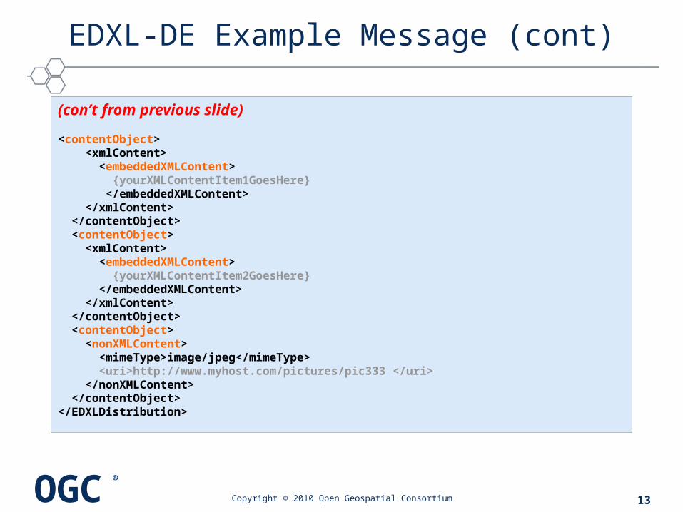
(cont’d on next slide)
12
OGC®
EDXL-DE Example Message (cont)
Copyright © 2010 Open Geospatial Consortium
(con’t from previous slide)
<contentObject> <xmlContent> <embeddedXMLContent> {yourXMLContentItem1GoesHere} </embeddedXMLContent> </xmlContent> </contentObject> <contentObject> <xmlContent> <embeddedXMLContent> {yourXMLContentItem2GoesHere} </embeddedXMLContent> </xmlContent> </contentObject> <contentObject> <nonXMLContent> <mimeType>image/jpeg</mimeType> <uri>http://www.myhost.com/pictures/pic333 </uri> </nonXMLContent> </contentObject></EDXLDistribution>
13

OGC®
EDXL Situation Report (EDXL-SitRep)
SITUATION or INCIDENT“occurrences of various scales - a collection of happenings, observations and actions that have been correlated on some basis that may require resources to perform Public Safety/Emergency/Disaster mitigation, planning and preparation, response or recovery”
SITUATION REPORTING• Support all hazards - any scale (local, day-to-day and Disaster)• Basis for incident management decision making• Standardized information sets across disparate systems • Information sharing between local, regional, state and national
organizations, up and down the chain and laterally• Information about the current situation (“Common Operating
Picture”) and current response and resources• Standard information for initial and evolving command structures (ICS
forms and related info)
Copyright © 2010 Open Geospatial Consortium 14
OGC®
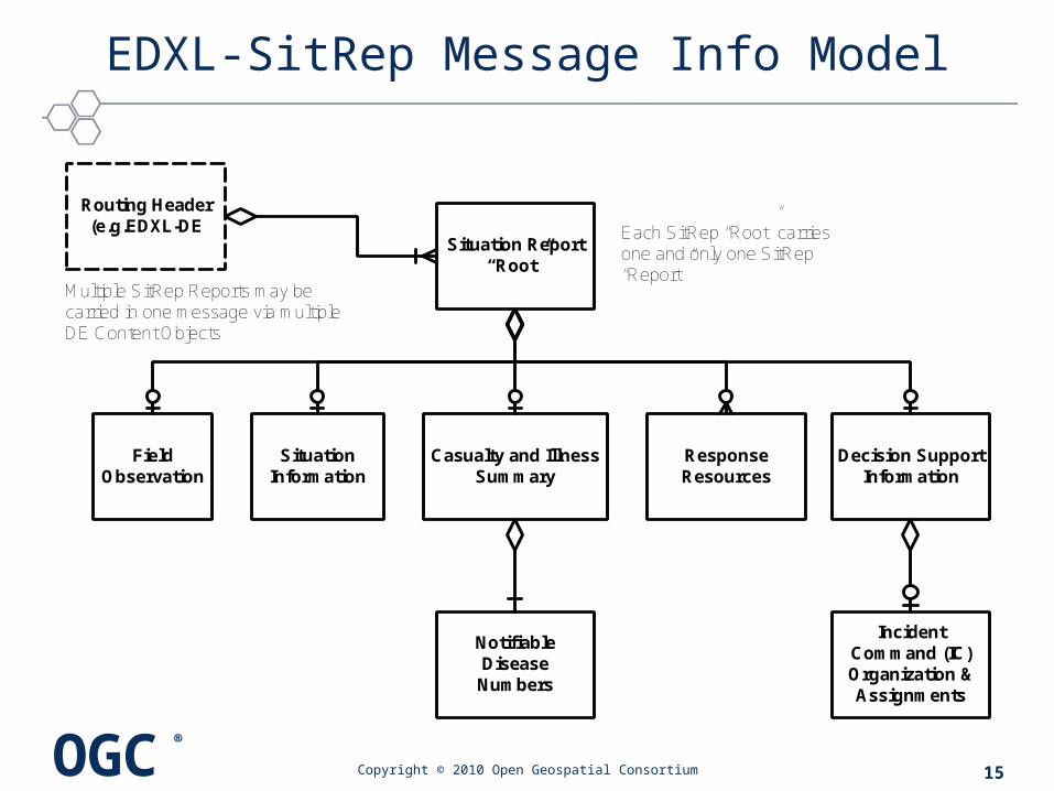
EDXL-SitRep Message Info Model
Copyright © 2010 Open Geospatial Consortium
Routing Header (e.g.EDXL-DE
Situation Report“Root”
Field Observation
Situation Information
Casualty and Illness Summary
Response Resources
Decision Support Information
Notifiable Disease Numbers
Incident Command (IC) Organization & Assignments
Multiple SitRep Reports may be carried in one message via multiple DE Content Objects
Each SitRep “Root” carries one and only one SitRep “Report”
15

OGC®
OWS Context
• Background– Location Organizer Folder (LOF) (OGC 01-137)– Web Map Context Document (OGC 05-005 and 08-050 Corrigendum)
• XML structure for describing “…information about the server(s) providing layer(s) in the overall map, the bounding box and map projection shared by all the maps…”
– OGC 05-062, OGC Web Services Context Interoperability Experiment Final Report
– OGC 10-35r2, “OWS-7 Information Sharing ER” to be used as the starting point for development of OWS Context standard
• Atom proposed as the encoding to represent OWS Content container
• Principle Use Case: define the application state of an Integrated Client
Copyright © 2010 Open Geospatial Consortium 16
OGC®
OWS Context*
• Information sharing is supported through the implementation of a Common Operational Picture (COP)
• COP – Sharing a single identical display of relevant information
• Typical OGC datasets and media types • Non-OGC media types such as documents, motion imagery,
sound/audio etc.– Defined as a single identical display of relevant (operational)
information shared by more than one individual– Facilitates collaborative planning and assists all echelons to achieve
situational awareness– Standardized flexible, interoperable, mass market focused solution– Collaborate to evaluate a situation and determine a coordinated
course of action
Copyright © 2010 Open Geospatial Consortium 17
* Excerpts taken from OWS Context SWG Charter
OGC®
OWS Context Information Model Overview*
• OWS Context document - container that holds a collection of resources
• Resource can be characterized as follows:– Is representative of a particular data entity that contains geographic
information or is associated with a geographic location– Belongs to one or more categories– May includes information on how it should be portrayed– May have a relationship to other resources. For example:
• child’s reference to a parent• reference to an alternative file format or representation• reference to a more authoritative version• reference to an annotation.
Copyright © 2010 Open Geospatial Consortium 18
*Reference: OGC 10-35r2 OWS-7 Information Sharing ER

OGC®
OWS Context Resource Model
Copyright © 2010 Open Geospatial Consortium 19
Ref: OGC 10-35r2, OWS-7 Information Sharing ER

OGC®
Emergency Operations Center - Integrated Client
EDXL SitRep and OWS ContextExchanging Info about COP
Use Case Concept: Information sharing via EDXL message exchange
Copyright © 2010 Open Geospatial Consortium 20
SitRep Report
Supporing content
SitRep Report
OWS Context Document
On-Scene Incident
Commander
SitRep Message and Content in DE message
container
OGC®
Collaboration of Info Models
Copyright © 2010 Open Geospatial Consortium 21
OWS Context
EDXL-DE
EDXL-SitRep
To Routing and Distribution
OGC®
COMMENTS?
QUESTIONS?
THANKS!
Copyright © 2010 Open Geospatial Consortium 22