zonal development plan - stonewellrealtors.com...i zonal development plan zone “a” walled city...
TRANSCRIPT
i
ZONAL DEVELOPMENT PLAN
ZONE “A” Walled City (Part Zone A and C)
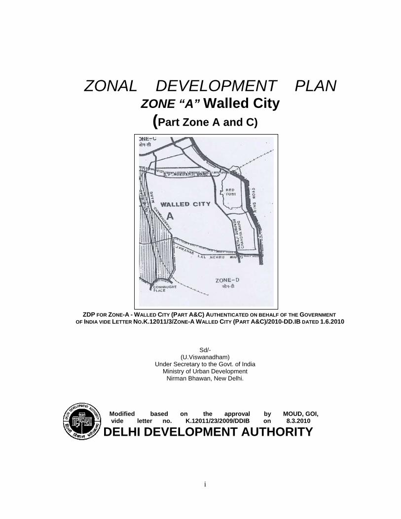
ZDP FOR ZONE-A - WALLED CITY (PART A&C) AUTHENTICATED ON BEHALF OF THE GOVERNMENT OF INDIA VIDE LETTER NO.K.12011/3/ZONE-A WALLED CITY (PART A&C)/2010-DD.IB DATED 1.6.2010
Sd/- (U.Viswanadham)
Under Secretary to the Govt. of India Ministry of Urban Development
Nirman Bhawan, New Delhi.
Modified based on the approval by MOUD, GOI, vide letter no. K.12011/23/2009/DDIB on 8.3.2010
DELHI DEVELOPMENT AUTHORITY

ii
PREAMBLE
The Zonal Development Plan for Zone ‘A’ Walled City (Part Zone A and
C) has been approved by Ministry of Urban Development, vide letter no.K-
12011/23/2009-DDIB dated the 8th March, 2010 under Section 11A of DD Act, 1957
and notified under Section 11 by DDA on 18.06.2010.
The regularization of Cultural, Religious (including spiritual), Educational
and Healthcare institutions will be subject to fulfillment of the conditions as given in the
chapter 14.6 of the ZDP / Govt. directions issued from time to time.
Indication of Influence Zone along MRTS / Major Transport Corridor as
well as indication of uses other than residential and facility corridor shall be undertaken
at the stage of layout plans / local area plans, as per provisions of MPD-2021 and the
guidelines and conditions, as notified by DDA with the approval of Government of India from
time to time.

iii
CONTENTS
Sl.No. CHAPTER PAGE No. 1.0 Introduction 1
2.0 Statutory Provisions Background, 1
2.1 Zonal Development Plan 1
2.2 Provisions in the Master Plan for Delhi-2021 2
3.0 Sub- Zones 2
4.0 Location, Boundaries , Areas 2
5.0 Population 2
6.0 Important Redevelopment Policies 3
6.1 Redevelopment of Existing Urban Area 3
6.1.1 Planned Areas 3
6.1.2 Special Areas 3-4
6.1.3 Shahjahanabad(Walled City) 4-5
6.1.4 Special Area Regulations 5-6
7.0 Use Zone Areas 6
7.1 Residential 6
7.2 Commercial 6
7.2.1 Metropolitan City Centre 6-7
7.2.2 Community Centers (cc) Local shopping centre (LSC)/ Convenience Shopping Centre (CSC)
7
7.2.3 Informal Sector 7
7.2.4 Whole Sale Trade 7
7.2.5 Existing Markets in Special Area 7-8
7.3 Industrial 8
7.4 Government office 8
7.5 Recreational (Parking & Open Spaces) 8
7.6 Traffic and Transportation 9
7.6.1 Circulation Network 9
7.6.2 Proposed Multilevel Parking Sites 9
7.6.3 The Bus Terminals 9-10
7.6.4 Second entry to Delhi railway Junction 10
7.6.5 M.R.T.S. Corridors 10-11
7.6.6 Bicycle/ Cycle-Rickshaw 11

iv
8.0 Delimitation of Non- Residential activity 11-12
8.1 Control for Building/Buildings within the use premises 12
9.0 Urban Design & Development of open Spaces 12
9.1 Walled City and Extensions 12-13
10.0 Redevelopment of Katras and Evacuee properties 13-14
11.0 Areas of conservation 14-15
12.0 Heritage Zones 15
13.0 Zonal Level Community Facilities 16
13.1 Education 16
14.0 Other Facilities 17
14.1 Health Facilities 17
14.2 Police Station 17
14.3 Fire Station 17-18
14.4 Telephone Exchange 18
14.5 Fuel Stations (Petrol pumps/CNG Station) 18
14.6 Regularization of existing Health Care, Educational, Cultural & Religious(including Spiritual) institutes existing Prior to 01.01.2006
18-19
14.7 New Areas for Public & Semi-Public Facilities 19-20
15.0 Mixed Use 20-21
15.1 Mixed Use Regulations 22
Annexures Annexure-I: Manufacturing units (types) to be closed immediately in walled city
22
Annexure-II: List of Polluting Industries 23-24
Annexure-III: List of Protected Monuments 25
Annexure-IV: List of Mixed use streets as per ZDP-2001 26
Annexure-V: List of commercial streets (Notified under MPD-2021)
27-28
Annexure-VI: List of Mixed use streets as per ZDP-2021 29
Annexure-VII: List of Pedestrian shopping streets (Notified under MPD-2021)
30-34
Annexure-VIII: List of Mixed use streets (notified earlier) and now declared as Commercial streets (under MPD-2021)
35-36
Maps Map 1 : National Capital Territory 37
Map 2 : Walled City 38
Map 3 : M.R.T.S Route 39
Map 4 : Monuments 40
Map 5 : Land Use Plan 41

1
ZONAL DEVELOPMENT PLAN FOR ZONE 'A’ Walled City (Part Zone A and C)
1.0 INTRODUCTION
As per the MPD-2021, notified on 07.02.07 the National Capital Territory of Delhi has been divided into 15 zones from A to H and J to P, of which 8 Zones are in the urban area, one in Riverbed and remaining 6 in the rural area. The zones K &Pare subdivided into two part zones. The designated Special Area in MPD-2021 comprises of Zone-A (Walled city), Zone A (Other than Walled City) and Zone B.
i) WALLED CITY: (Sub-Zones A-13 to A-26, A-28 (i.e. part of Railway Station and Railway Yard) and C-1 (Map-1).
Walled City, an old built up and historic area, has a special character and
therefore, zonal Plan for the same has been prepared separately. ii) OTHER THAN WALLED CITY (Sub-Zone A-1 to A-12).
Other than Walled City area also has a special character and therefore a
separate zonal has been prepared. The present Zonal Plan is for the Walled City consisting of 15 sub-zones of
Zone-A and one subzone of Zone-C. Total area of the Walled City is 569 ha.
2.0 STATUTORY PROVISIONS 2.1 ZONAL DEVELOPMENT PLAN
The Delhi Development Act, 1957 under section 8 provides for preparation of Zonal Development Plans simultaneously with the master Plan or as soon as thereafter. Under the Act Zonal Plan may show land use, Public and Semi-Public facilities, utilities and services, roads, housing, recreational, industries, business, markets, schools, hospitals, open spaces, standards of population/density and various other components of development. The Zonal Plans are processed under section 10 of the Act. A Zonal Development Plan means a plan for each Zone (Division) containing information regarding provision of social infrastructure, parks and open spaces, circulation system etc. The Zonal Development Plan indicates the actual as well as proposed use zones designated in the 9 ‘land use’ categories stated in the Master Plan according to which the area in the Zone is to be finally developed. User indicated in the Zonal Development Plan will not give automatic right to the owners to use their property/land for the designated use. Based on the availability of infrastructure services by the respective departments, the urbanisable areas will be opened up for development in a phased manner to meet with the needs of urbanization envisaged in the Master Plan-2021.The hierarchy of urban Development indicated in the Zonal Development Plan is to be in conformity with table 3.3 of Master Plan-2021.
2
2.2 PROVISIONS IN THE MASTER PLAN FOR DELHI-2021
As per the MPD-2021, a Zonal Development Plan means a plan for one of the Zones (Divisions) of the National Capital Territory of Delhi containing detailed information regarding provision of social infrastructure, parks and open spaces and circulation system.
3.0 SUB-ZONES
The walled City comprises of 16 sub-zones. Fifteen sub-zones are part of Zone-A and one subzone is part of Zone-C. The area of the Sub-Zone varies from 14.4 ha. to 76.6 ha.(Map-2).
TABLE 1: SUB-ZONES AS PER MPD-1962
Sub-zone Area (Ha) Locality A-13 27.1 Kucha Pati Ram A-14 23.9 Chitli Qabar A-15 37.9 Matia Mahal & Pataudi House A-16 27.8 Churi Walan, Sita Ram Bazar A-17 28.3 Farash Khana, Lal Kuan A-18 14.4 Naya Bans, Fatehpuri A-19 23.6 Tilak Bazar, Bara Dari, Peeli Kothi A-20 52.5 Daryaganj, Ansari Road A-21 22.1 Jama Masjid, NetaJi subhash Park A-22 35.4 Balli Maran, Charkhey Walan A-23 35.9 Malliwada, Kinari Bazar A-24 33.6 Katra Neel, Town Hall Gandhi Ground A-25 21.1 Lajpat Rai Market Bhagirath Palace A-26 76.7 Red Fort, Salim Garh Fort A-28 46.4 Railway Station RailWay YardC-1 62.3 Ram Bazar, Kashmere Gate G.P.O.
4.0 LOCATION, BOUNDARIES, AREA:
Zone-A (Walled City) is part of the Old City and located in Central Delhi and encircled by the boundaries of Zone-A (other than Walled City) in the West, Part of Zone-C in the North, River Yamuna & Zone O on the East and Zone-D in the South. The total area of the zone works out to 569.0 ha. and is designated as Special Area as per MPD-2021. 5.0 POPULATION
As per MPD-2001, the holding capacity for Zone A is 4.2 Lac and the existing population in 2001 is 5.7 Lac. The stipulated holding capacity for 2021 for Zone A is 5.7Lac (which includes other than walled city Area).The MPD-2021 has recommended no addition in the existing population as on 2001.
3
6.0 IMPORTANT REDEVELOPMENT POLICIES:
The MPD-2021 has identified redevelopment policies for certain areas such as Existing Urban Areas (Planned Area, Special Area and Unplanned Areas), Industrial areas, etc. The relevant policies are detailed out in this plan. 6.1 REDEVELOPMENT OF EXISTING URBAN AREA
Redevelopment, through a process of re-organization and utilization of the land already developed will be a major element of the overall city development plan as per MPD-2021, considering the limitations of the land availability in future. A redevelopment strategy for accommodating more population in a planned manner is to be taken up on priority for efficient and optimum utilization of the existing urban lands, both in planned and unplanned areas. This would have to be based on provision of infrastructure viz. water supply, sewerage, road network, open spaces and the essential social infrastructure. REDEVELOPMENT STRATEGY: The target areas for redevelopment will have to be identified on the basis of their need for up-gradation and potential for development. Redevelopment Schemes will be prepared by the respective local body/land owners/residents. The concerned local body should promote private land owners to take up assembly and redevelopment of a minimum area of 4 hectares. Some of the areas identified are: 6.1.1 PLANNED AREAS: INFLUENCE ZONE As per Master Plan 2021 Para 3.3.2, Influence Zone along MRTS Corridors and the Sub-Zones for redevelopment and renewal should be identified on the basis of physical features, such as, metro, roads, drains, high tension lines and control zones of monuments/heritage areas, etc. This identification is to be done in consultation with GNCTD. In Zonal Development Plan the number of colony roads, local drains, high tension wires, heritage areas etc. are not indicated. Therefore, boundary of Influence Zone has not been indicated in the Zonal Development Plan. It will be shown only in the local area plans, which are more site specific. However, if there is any proposal received within 500 mt. of the centre line of the MRTS/major transport corridor, it will be examined as per the guidelines given for redevelopment as per directions of the government. 6.1.2 SPECIAL AREA
These are characterized by a mix of different land uses and have similarities
in compact built form, narrow circulation space and low-rise high-density developments, mainly accommodating residential, commercial-both retail or wholesale and industrial uses. Therefore, it is important that the areas, which are already established with identified uses, continue to play an active economic role. The Authority may further designate certain other areas as 'Special Area.
Required parking and open spaces will have to be provided as per the norms, while reduced space norms for other facilities may be accepted. The redevelopment

4
areas should ensure modern services and amenities, thereby eliminating risk generating structures and activities.
The regulations for Special Area shall be different from other areas. All these
areas are to be brought within the planning purview. For this, the owners can jointly redevelop on the basis of the norms and regulations to be prescribed.
The Old City areas, Shahjehanabad (Walled City) are fast changing their
residential character to non-residential use, but still have a residential component. The non-residential uses of varying degrees have developed with time depending on their location, related with accessibility and the established trade.
In the case of traditional inner city areas, it is essential first to distinguish
between the heritage segment of the area and the non-heritage segment of the area. Well-designed Special Area Redevelopment Schemes must be prepared for traditional areas giving the development control parameters for the heritage areas keeping in view archaeological norms/architectural character and general parameters for the non-heritage segment of the traditional area. Each Special Area Redevelopment Scheme should entail an enumeration of the monuments and old buildings within the heritage areas, which must be conserved. The MCD is the nodal agency who should prepare Special Area Redevelopment Schemes for all traditional areas within a time frame.
The basic objective of Special Area Redevelopment Scheme in traditional
areas is to bring about in situ improvements, which help in improving architectural character of the area, i.e., design, and layout, as well as revitalizing trade and commerce in the area.
6.1.3. Shahjahanabad (Walled City)
The most important part of the Special Area is the traditional City of
Shahjahanabad, part of which is a core of the business district. The area is prone to commercialization, particularly with improved accessibility due to the MRTS. The Plan proposes to regulate and shift noxious and hazardous wholesale trades and industrial activity from this area.
Traditional areas in Walled City need special treatment to conserve its
heritage value while retaining the residential character. Redevelopment of government owned katras is to be taken on priority. However, redevelopment would also be promoted in privately owned katras simultaneously. Permission of activities in use premises and building control regulations shall be as follows:
(i) The area surrendered for public facilities or for heritage value to be used as
tradable FAR. (ii) Street pattern: The street pattern in residential area is proposed to be
restructured with linkages from the metro stations. The minimum road width and prioritizing of road widening are dictated by fire and other disaster management criteria. The streets, having 30m to 50m lengths, shall have a minimum of 3m width and streets having more than 50m length shall have a minimum of 4.5m width. Common facilities shall be located with linkages to pedestrian roads and metro stations.
(iii) Subject to preparation and approval of an Integrated Redevelopment
Scheme, higher FAR and other development controls can be considered. This

5
provision is also subject to requirement of heritage controls, parking, accessibility of emergency vehicles and basic services. 6.1.4. SPECIAL AREA REGULATIONS
In MPD-2021, the Walled City and the continues area in between has been designated as Special Area for the purpose of development since this area cannot be developed on the basis of normal regulations given in the development code. The Redevelopment Scheme for this Special Area should be prepared and notified by the MCD within three years. Special Area Building regulations shall be prepared by the Authority in consultation with the local body within a period of three years and notified with the approval of the Central Government.
The Authority may declare other historical/pre-1962 developed areas as
Special Area. The development within these areas shall be governed as per the following
norms and regulations as prescribed in MPD-2021 in respective chapters. Permission of use / use activities in use premises:
1. The noxious industries and hazardous trades shall be shifted from the Special Area within a maximum period of five years, and shall be replaced by other compatible uses.
2. The Public and Semi-public uses and services like Hospitals, Dispensaries,
Colleges, Schools, Police Stations, Fire Stations, Post Offices, Local Government Offices, Parking etc. shall be retained in their present locations and additional sites could be indicated in the Redevelopment Schemes / Zonal Plans. Any change or additions thereof shall be in accordance with the overall policy frame prescribed in the plan.
3. Special Area building Regulations shall be framed for special area,
unauthorised regularized colonies and village abadis. Owners in special area, unauthorised regularized colonies and village abadi shall register themselves with the local body within a period of four months indicating the existing extent of construction. Thereafter a certificate of structural safety by qualified engineers shall be submitted within the next 6 months. Subject to height restriction of 15 meters, all buildings covered by such registration shall be exempted from punitive action till Special Area Building Regulations for these areas are notified or maximum three years, whichever is earlier.
4. Regulations for special specific areas shall be as under:
(i) Lajpat Rai Market: The single storeyed market on either side of Chandni Chowk shall be retained.
(ii) The isolated use premises like School adjoining Jama Masjid, Presentation Convent School and the Church at Kashmere Gate, Municipal Offices at Old Hindu College Building Complex shall be retained with existing building volume. Any additions or alterations shall be within the overall policy frame of conservation.
(iii) The redevelopment schemes for different use zones generally shall adopt regulations prescribed in the Development Code. However, the

6
Authority may adopt suitable regulations in case where either it is not feasible or not advisable to adopt the general regulations prescribed.
5. Re-development Plan and Schemes for the Special Area should be
prepared by the local body within three years of approval of the MPD-2021. In this Plan, the Metropolitan City Centres as referred in 5.3, Chapter 5.0 Trade and Commerce, shall be delineated based on survey. Till such time, status quo shall be maintained. 7.0 USE ZONE AREAS: A. The development/re-development in areas marked, as specific use zone shall be governed by respective Use Zone regulations in the manner as prescribed in the relevant sections in the Development Code of MPD-2021. B. In the zone approval/sanction could be on the basis of the approved lay-out
plans taking into consideration the provisions of Master Plan-2021 and the Zonal Plan.
C. The areas declared, as slum under Section 3 of the Slum Act 1956, shall be
dealt under the Slum Act 1956. 7.1 RESIDENTIAL
The proposed housing strategy incorporates specific approaches for development of new housing areas, up-gradation and re-densification through redevelopment of existing housing areas including unauthorized colonies, housing in villages and Special Area. Looking at the possible distribution of housing types, the future requirement of shelter provision will be dominated by small dwelling units.
Shahjehanabad (Walled City), and its Extensions having predominant
residential component should be redeveloped ensuring modern services and amenities for a safe residential environment and in the process, eliminating risk prone structures and activities. The owners can jointly redevelop the areas based on the prescribed guidelines. 7.2 COMMERCIAL
7.2.1. METROPOLITAN CITY CENTRE The MPD-2021 envisages that in Special Area, the existing Central Business
District (CBD) i.e. the Commercial areas in Walled City and its Extension and Karol Bagh have all the necessary ingredients to emerge as Metropolitan City Centres. The commercial areas are to be identified and Metropolitan City Centre to be delineated accordingly while preparing the redevelopment scheme.
The commercial areas in Shahjahanabad (Walled City) and Extension need to
be treated carefully and sensitively in view of their high density and multiple uses. The aim is to revitalize the glory of Walled city and its economic & tourism potential.
Wherever redevelopment of existing commercial areas stipulate preparation
of a comprehensive scheme, the same can be initiated jointly by the lessees/owners themselves and submit to land owning agency/planning authority for approval. Wherever any enhancement in FAR is approved, the same will be subject to charging

7
appropriate levies from the beneficiaries. For Metropolitan City Centre, in Special Area, development controls shall be as per approved scheme. 7.2.2. COMMUNITY CENTRES (CC) LOCAL SHOPPING CENTRE (LSC)/ CONVENIENCE SHOPPING CENTRE (CSC) The Community Centres should be conceived as shopping and business centers catering to the needs of the population at community level. These centers may have Retail Shopping, Commercial and Government Offices, Local Body/Public Sector Undertaking offices, Cinema / Cineplexes, Hotels, Restaurants, Banquet halls, Guest House, Nursing Home, Dispensary, Clinical Laboratory, Clinic & Poly Clinic facilities together with other community facilities as per MPD-2021. As the entire Walled city is designated as Redevelopment area in MPD-2021, the provisions of Commercial area as per the above hierarchy to be considered while preparation of redevelopment scheme. 7.2.3. INFORMAL SECTOR
As pre MPD-2021 the informal sector units locate themselves strategically near work centers, commercial areas, outside the boundaries of schools colleges, hospitals and transport nodes and near large housing clusters. A very high percentage of this activity has been observed in the Walled city, Trans Yamuna area and old commercial areas. A large number of units are mobile in nature.
The provisions of MPD-2021 pertaining to organized informal sector places (Haat), Informal Bazar and weekly markets are retained in this plan and the specific locations are to be identified by the concerned Local Body / Implementing Agencies. The planning norms for informal bazaar are as provided in MPD-2021.
7.2.4. WHOLE SALE TRADE
Delhi is the biggest consumption centre in North India. It has also attained the
status of a major distribution centre by virtue of its geographical location and other historical factors.
Around 20% of the total wholesale trade enterprises of urban Delhi are located in the Walled City, accounting for around 12% of the employment. The average enterprise in the Walled City has less employment but high turnover in comparison to units in other areas. In order to decentralize wholesale trade, the planned markets were developed at Azadpur, Naraina, Okhla, Narela, Keshopur, etc. 7.2.5. EXISTING MARKETS IN SPECIAL AREA
In case of existing developed areas, all wholesale markets dealing with hazardous materials should be developed in decentralized manner and shifted to the areas assigned for these. All unauthorized encroachments/projections on roads/government land should be removed to facilitate easy movement of traffic. Further extension of the wholesale activity in the Walled City and its Extension shall be totally stopped by giving incentives and disincentives as under:
(i) Incentives: (a) The liasioning offices of the traders/agents to continue in the present location;

8
(b) Development of New counter markets for wholesale trade and warehousing; (c) The new counter markets should have access from National Highway, arterial networks and connectivity with MRTS; and (d) Incentives such as Transferable Development Rights (TDR) and reduced taxes to enable start up/expanding of activity in the new markets. (ii) Disincentives: (a) Restriction on the entry of heavy goods vehicles in the Special area; (b) Storage of hazardous/inflammable commodities like paper, plastic/PVC, chemicals, petroleum and its products; should be discouraged. (c) Restriction on storage/warehousing of bulky commodities like food grains, fruits and vegetables, dairy, poultry/fish products, iron and steel, and building materials; and (d) Non-renewal of trade licenses for Wholesale Trade in non-conforming areas. Since the shifting of wholesale trade is a long term process and adequate
infrastructure to be provided in alternative places before shifting planning for this may be undertaken by the concern agencies along with redevelopment schemes. 7.3 INDUSTRIAL:
The listed noxious and hazardous trades/industries including pollutant industries has identified by Delhi Administration Deptt. of Industries GNCTD should close their present activities & restrict to house hold industries only.
The MPD-2021 also states that the approved Work-cum-Industrial Centres, Service Centres etc., where development has been undertaken in accordance with the land use/earlier Master Plans, shall continue to be industrial subject to conformity with provisions stipulated.
However prohibited / negative list of industries identified in MPD-2021 shall
be prohibited within the NCT of Delhi. GNCTD shall take necessary action under Pollution Control Act on considering the latest position of polluting industries, Supreme Court order etc.
7.4 GOVERNMENT OFFICE:
As per NCR Plan, no new Central Government and Public Sector Undertaking offices should be located in NCTD. However, the issue of shifting existing Government / PSU offices from Delhi as well as restricting the setting up of new offices would only be possible after a time bound action plan is prepared together with suitable incentives and disincentives. 7.5 RECREATIONAL (PARKS & OPEN SPACES)
Presently three big parks/open spaces exist in Walled City i.e. Netaji Subhash park, Gandhi Ground and open area around Red Fort. Besides these three major open spaces, only about 11.5 ha. is available within the congested residential area which works out 0.33 sqm. per person which is much below 5 sqm. per person recommended in the Master Plan at this level. There is no possibility to increase this except by removing some of the evacuee properties. The additional provisions to be identified while preparation of redevelopment scheme.
9
7.6 TRAFFIC AND TRANSPORTATION:
The traffic volume is very high (beyond the carrying capacity of the roads) in Walled City. A large number of modes operate here including the slow and fast vehicles, which add to the traffic problems in the area. The area under traffic & transportation and utilities as per existing land use is approx. 23.1 % (131.5 ha.) of Walled City. This also includes the area of Zone A-29 which is fully under Railway line/yard. If this area is exclude, the area under this use remains 85.5 ha. (15%) remains under this category.
The comprehensive system of traffic and transportation was worked out for Walled City in ZDP-2001. The pedestrian routes and Rickshaw movement corridors were identified to facilitate the traffic movement without conflict.Similarly light vehicles and bus routes were identified. In the preparation of redevelopment schemes efforts may be made to ensure proper pedesteranise movement system.
Emergency movement corridors were also identified to facilitate the
movement of fire tender and ambulance in case of emergency. Second entry to Delhi Railway Station has also been proposed giving access to the Railway Station from both the side. The traffic pattern evolved is based on Ring Road and radial roads pattern by constructing a new bridge joining Gokhle Marg and a new road proposed behind Naya Bazar.
Facilities of parking have also been proposed at 6 suitable locations to meet the demands. The parking space has been proposed in Parda Bagh by way of road widening.
The BRT proposed for this zone has been indicated in the Landuse Plan and the same to be developed by the concerned agencies. The concept of Mono Rail and LRT may be explored at the time of preparation of redevelopment scheme. 7.6.1 CIRCULATION NETWORK The Zonal Plan indicates circulation network, which is based on secondary source data. The actual detailed alignment will be with reference to the actual detailed project report/site survey and thus may undergo minor modifications at the time of finalizing the road alignment which will be incorporated in the sector plans/layout plans. A realistic strategy of compensation and rehabilitation of project affected persons is recommended under these plans/areas. 7.6.2 PROPOSED MULTILEVEL PARKING SITES
The MCD has identified multilevel parking sites at Hamilton Road and Ramlila
Ground in the vicinity of this zone. These sites and additional sites finalized from time to time to be developed so that the parking problem could be systematically resolved. 7.6.3 THE BUS TERMINALS Buses operate from four places in Walled City, they are:
(i) Area west of Subhash Marg. (ii) Area East of Subhash Marg. (iii) Area in front of Railway Station. (iv) Bhai Mati Das Chowk area in front of fountain.

10
In the Zonal Plan 2001, additional area for bus terminals indicated is to be retained;
(i) Front of Railway Station on S. P. Mukherjee Marg. (ii) In the Engineering College complex with the entry from Ring Road while
implementing the project of second entry to Railway Station.
7.6.4 SECOND ENTRY TO DELHI RAILWAY JUNCTION
Delhi main junction which was located during British Rule in the Garden Area (Begum Ka Bagh), at present has entry, exit of passengers on one side. The traffic of commuters/passengers is increasing continuously; the existing parking space in front of the station has become insufficient.
Further it has been observed that there should be integration of Inter State Bus Terminus & Railway Station, so that commuters/passengers may use both the facilities if required.
The integration of both Railway Junction & ISBT is possible by providing entry to Railway Station from Zorawar Singh Road side. While designing the integrated passenger terminal the land of present Delhi Engineering College would have to be utilized. The second entry would reduce the traffic volume on present entry, as North & North West Delhi bound traffic from Delhi Station could be served by second entry.
The Central Road Research Institute (CRRI) has conducted the detailed study of traffic around Delhi Railway Station bounded by Rani Jhansi Road, Boulevard Road, Ring Road & S. P. Mukherjee Marg. The project of second entry to Delhi Station in consultation with Railway, DUAC & related agencies needs to be started immediately.
7.6.5 M.R.T.S. CORRIDORS:
The MRTS corridors have been suitably incorporated in the Zonal Plan (Map-3). The MPD-2021 proposal of delineation of influence zone along MRTS and major transport corridors to be taken up at the time of preparation of redevelopment schemes as the entire Walled City has been designated as redevelopment area and the redevelopment scheme for this to be prepared and notified by MCD within three years as per MPD-2021 proposals.
Due to development of economic activities along the Metro Corridors and optimization of connectivity provided by it, the rider ship on the Metro is expected to grow substantially over time. Correspondingly, it is expected that vehicular trips may also progressively shift from road-based transport to MRTS, particularly, with reference to the longer trip lengths (greater than 10 Kms) within the city.
To achieve the above potential impact of the Metro Rail System a number of measures will be necessary. These will include the following:
(i) Preparation of detailed plans to facilitate and encourage direct
pedestrian access to the Metro Rail System/Station.

11
(ii) Preparation of detailed multi-modal transport plans with reference to each major Metro Station, with particular reference to bus transport routes, which could provide inter-linkages and feeder arrangements.
(iii) Parking arrangements at Metro Stations, both for short and medium period viz. for those who would travel for local level requirements such as shopping, etc. and those who would need parking by way of a Park and Ride facility.
(iv) Provision of Park and Ride facilities at identified points from where feeder bus services would be available, or convenient direct pedestrian access would be feasible.
7.6.6 BICYCLE/ CYCLE-RICKSHAW
Bicycle/ Cycle-Rickshaw could be an important mode of travel, particularly
with reference to short and medium trip lengths. To the extent that it meets individual or public transport requirements, it is a non-energy consuming and non-polluting mode of transport.
In so far as rickshaws are concerned, apart from issues pertaining to the
aspect of mixed traffic, this mode also provided employment to a very large number of unskilled workers residing in the city.
In view of the above, the following actions should be considered/taken: -
(i) On all arterial roads fully segregated cycle tracks should be provided with provision for safe parking in park and ride lots.
(ii) In specific areas of the Walled City and Chandni Chowk the use of
cycles/rickshaw as a non-motorized mode of transport is proposed as suggested in the MPD 2021 and it should be cautiously along with the pedestrianisation at the time of preparation of redevelopment scheme. 8.0 DELIMITATION OF NON-RESIDENTIAL ACTIVITY
The following measures identified by the ZDP-2001 are retained and proposed as part of policy frame of the ZDP-2021 for Walled City, and the concerned departments of GNCTD and MCD to take suitable actions.
(i) The industrial units of acids, chemicals and inflammable material and trades like plastic raxine etc., which are noxious and hazardous to be closed down.
(ii) The warehouses/godowns and dairies in the Walled City should be discontinued.
(iii) The area known as Phool Mandi is to be developed as a park.
(iv) The office of the Municipal Corporation of Delhi be shifted to Civic Centre at Jawaharlal Nehru Marg and the present building be converted into Museum, Library etc. Existing structure in the vicinity of the Town Hall including office of Assessor and Collector opposite Railway Station is to be developed as integral part of the total recreational/green area scheme.
(v) To check the increasing commercialization and to preserve the areas of important urban heritage the commercial and the industrial activity should be as far as possible be limited to the present.
12
(vi) The existing non-noxious and non-hazardous commercial establishment
may be considered for continuance as per the mixed use policy of MPD-2021.
(vii) For Buildings of Historical/architectural importance, listed by Archaeological Survey of India/Archaeological Department of Delhi Administration and declared from time to time by the Competent Authority, conservation be provided for by Archaeological Department of Delhi Administration. Such plan for conservation should be carefully observed by the MCD and other authorities while sanctioning building plans.
8.1 CONTROL FOR BUILDING / BUILDINGS WITHIN THE USE PREMISES
(i) Maximum ground coverage and FAR may be same as for residential plot in plotted development unless specified in special area regulations.
(ii) The building shall be permitted to be constructed practically in same form and style as existing as far as possible unless specified in special area regulations.
(iii) In areas where the approved layout plans are available the buildings shall be constructed on the basis of the same in conformity with the zonal Development Plan/Master Plan unless specified in special area regulations.
9.0 URBAN DESIGN & DEVELOPMENT OF OPEN SPACES:
Delhi had a traditional Urban Design, which is reflected in the glory of 17th century Shahajahanabad and New Delhi. In the course of time Delhi has been becoming amorphous aggregate of masses and voids.
The Walled City of Shahjahanabad has certain urban form characteristics.
The Jama Masjid is a dominating feature located on hilltop and is different, both in form and scale from the other developments of the city. The boulevard of Chandni Chowk was its commercial centerpiece, with certain visual character terminating at two landmarks viz. Red Fort and Fatehpuri Mosque at its ends.
The Jama Masjid was visually linked with Parliament House and Connaught
Place. 9.1 Walled City and Extensions: The various proposals for revitalizing the glory of Walled City are:
(i) Conservation approach to retain the overall traditional character of the Walled City.
(ii) Visual integration of major landmarks to revitalize the past glory. (iii) Many areas in Shahjahanabad should be pedestrianised and made
completely free of vehicular traffic so as to restore the human scale and convenient living.
(iv) Judicious use of existing spaces for development of recreational uses. (v) MRTS station areas should be dealt as per specific Urban Design
schemes and be declared as pedestrian zones. (vi) Introduction of activities such as traditional/craft bazaar/heritage
walk/rides to attract tourists. Generation of urban culture at neighbourhood level such as festivals/fairs, kite flying etc.

13
(vii) Environmental up-gradation to reduce degenerative effects of traffic congestion.
(viii) Rejuvenation and conservation through management options, financing incentives, innovative development controls.
The physical environment in the Walled City could be enhanced by proper urban design and street scape on the important junctions and chowks, land marks and nodal points. Urban design schemes are recommended to be prepared for the following chowks / areas of urban design interest.
Dariba Chowk Kashmere Gate Chowk Fountain Chowk Sunehri Masjid Ghanta Ghar Chowk (in front of Town Hall) Fatehpuri MosqueChowk Daryaganj Chowk Lahori Gate Chowk Delhi Gate Chowk Barsa Bulla Chowk Turkman Gate Chowk Ajmeri Gate Chowk Hauz Quazi Chowk Kali Masjid Chitli Kabar
There are important roads where still the building in the traditional character exists. Keeping in view the character of the streets, the property depth on either side of the road/street given below are recommended to be covered Under controls zone for the purpose of sanction of the building plans & preparation of urban design schemes. The streets are Chandni Chowk, Chawari Bazar, Ajmeri Gate Bazar, Urdu Bazar, Daryaganj, Asaf Ali Road, Shardha Nand Marg, Sita Ram Bazar, Dariba Kalan, Nai sarak & Kinari Bazar, Maliwara, Masjid Khajur, Gali Gulian, Part of Dharampura, Part of Chatta Pratap Singh and Gali Anar. While preparing the redevelopment renewal plans if any building/area which is considered of architectural importance would further be added in the control zone and the reconstruction on such premises should be allowed after detailed examination of the merits of the buildings and the adjoining buildings. MCD should obtain clearance of DUAC before sanction renovation/development of listed building. 10.0 REDEVELOPMENT OF KATRAS AND EVACUEE PROPERTIES
There are about 3,500 evacuee properties/Katras, which are being managed/controlled by the Slum Department under section III of Slum Area (Improvement Clearance Act of 1956). The Evacuee properties/Katras were transferred by the Ministry of Rehabilitation for utilisation for Slum clearance programme. In the action plan the rebuilding in conservation manner i.e. property by property has been suggested. This approach seems coherent to social fabric, avoiding undue shifting of the vulnerable sections of the society.The redevelopment of the properties/Katras, which have been categorised in three groups following, has been suggested:
(i) Government owned dangerous katras / evacuee properties:
The Katras which are unfit for human habitation needs to be taken up in schemes in the Urban Area and the land thus vacated lands are to be utilised as per redevelopment scheme.
(ii) Government owned other than dangerous Katras / Properties:
It has been suggested that by formation of the co-operative societies on the lines of the Bombay experience to consider providing the leasehold right for
14
the Katras / properties. The cooperative could be linked with the HUDCO loan/assistance, for construction of residential units.
(iii) Privately owned Katras / Properties:
Besides the Evacuee properties under the control of Slum Department, there are numbers of privately owned Katras or such properties/premises, for which it has been suggested to prepare a scheme to confer ownership rights to the dwellers through formation of cooperative societies, after acquiring the property. Necessary legal processing should also be brought in.
11.0 AREAS OF CONSERVATION
The agencies concerned with the protection of Delhi's Built Heritage are ASI, GNCTD, State Archaeology Department, NDMC, MCD, Cantonment Board and DDA.
Built heritage of Wall City needs to be protected, nourished and nurtured by all citizens and passed on to the coming generations. It is suggested that with the aim of framing policies and strategies for conservation, appropriate action plans may be prepared by all the agencies. These should include promotion of conservation of the civic and urban heritage, architecturally significant historical landmarks, living monuments, memorials and historical gardens, riverfront, city wall, gates, bridges, vistas, public places, edicts and the ridge.
It is recommended that these should be suitably incorporated while preparing layout plans / schemes. In case of major monuments it is necessary that the surrounding area should be identified in the layout / detail plan, and should have building controls in relation to height, material and spread of the monuments.
The City is rich in urban heritage, historical buildings & monuments. As per the. survey conducted by Archaeological Survey of India in 1913 about 411 historical monuments/sites/buildings have been identified. Out of these only 41 comes under the category of protected.
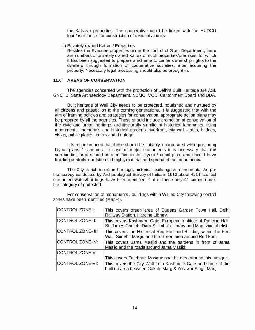
For conservation of monuments / buildings within Walled City following control
zones have been identified (Map-4).
CONTROL ZONE-I: This covers green area of Queens Garden Town Hall, Delhi Railway Station, Harding Library.
CONTROL ZONE-II: This covers Kashmere Gate, European Institute of Dancing Hall, St. James Church, Dara Shikoha's Library and Magazine obelist.
CONTROL ZONE-III: This covers the Historical Red Fort and Building within the Fort Wall, Sunehri Masjid and the Green area around Red Fort.
CONTROL ZONE-IV: This covers Jama Masjid and the gardens in front of Jama Masjid and the roads around Jama Masjid.
CONTROL ZONE-V: This covers Fatehpuri Mosque and the area around this mosque.
CONTROL ZONE-VI: This covers the City Wall from Kashmere Gate and some of the built up area between Gokhle Marg & Zorawar Singh Marg.

15
Around historical premises within the control zone,following measures to be adopted.
(i) Control over the volume & facade treatment in the adjoining building. (ii) Landscaping & street-scaping. (iii) Provision of properly designed approach/access. (iv) Use of building materials in harmony within the originally used in
repair/upkeep of monuments. Other important places such as Gauri Shanker Temple, Gurudawara Shish
Ganj, Lal Mandir, Kotwali (Now in possession of Gurudwara Management), Church, Town Hall, Fatehpuri Mosque and a few commercial buildings constructed in old style with column structure require to be conserved.
For protected monuments; the Archaeological Survey of India, Govt. of India has issued a notification No. F8/2/90-M dt. 16.6.1992. According to which area upto 100m, from protected limits of a monuments is declared as prohibited area for any constructional activity, beyond it upto 200m near or adjoining protected monuments as regulated area in which construction can be allowed only after getting permission from the Director (General) Archaeological Survey of India.
The unprotected monuments shall be cared by the respective property owners and to be conserved. Department of Archaeology, Delhi Administration to be the nodal agency.
It will also be necessary to maintain close interaction and coordination between all these agencies keeping in view the following objectives and requirements.
(i) Maintain and update a database. (ii) Develop organizational capacity for heritage management. (iii) Define all the applicable terms. (iv) Listing of Heritage Buildings based on the following criteria:
(a) The age of the building; (b) Its special value for architectural or cultural reasons or historical periods; (c) Its relevance to history; (d) Its association with a well-known character or event; (e) Its value as part of a group of buildings; (f) The uniqueness of the building or any object or structures fixed to the building or forming part of the land and comprised within the cartilage of the building.
(v) Prepare guidelines for development, redevelopment, additions alterations, repairs, renovations and reuse of the heritage buildings.
(vi) Implementing programmes for education and awareness.
12.0 HERITAGE ZONES
Heritage Zone is an area, which has significant concentration, linkage or continuity of buildings, structures, groups or complexes united historically or aesthetically by plan or physical development. The following areas have been identified as Heritage Zones as indicated in the Zonal Plan:
i. Specific heritage complex within Walled City of Delhi, Shahjahanabad However more areas can be added to this list based on studies by concerned
agencies.
16
13.0 ZONAL LEVEL COMMUNITY FACILITIES 13.1. EDUCATION
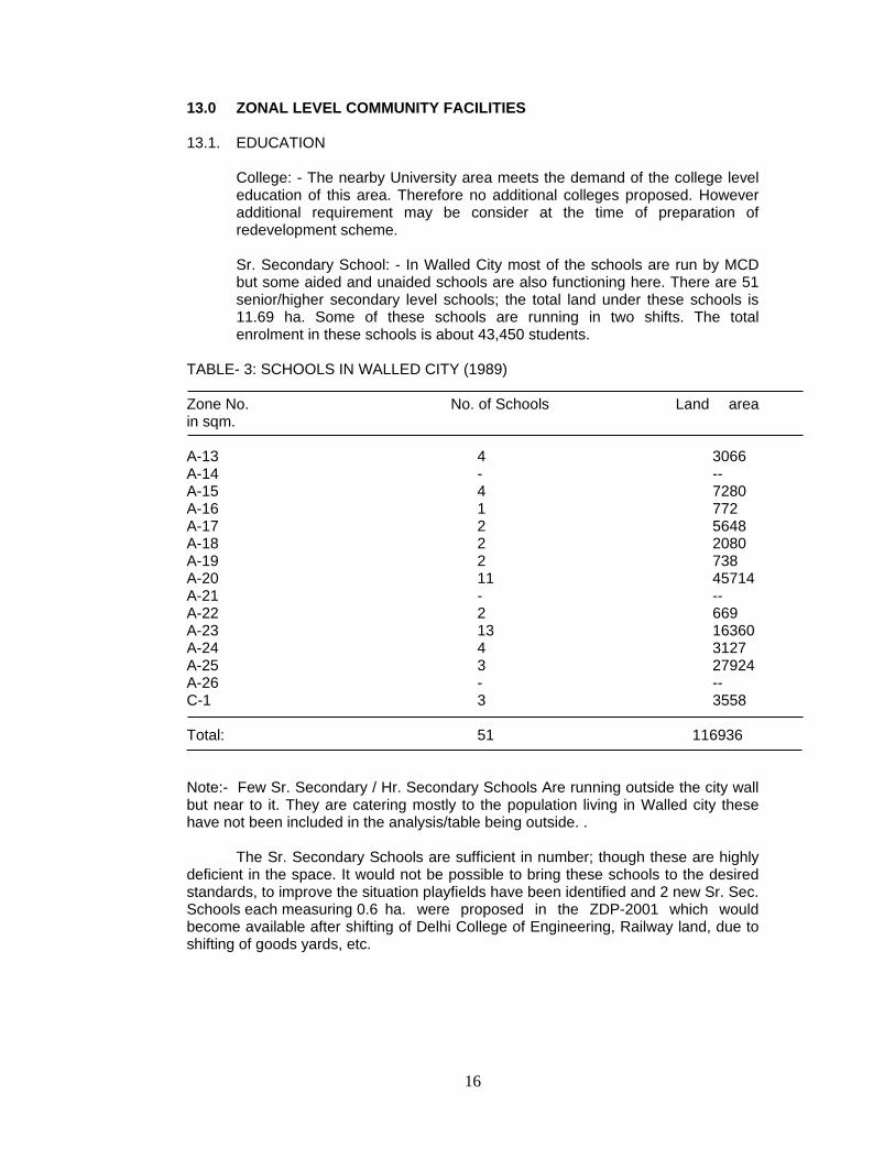
College: - The nearby University area meets the demand of the college level education of this area. Therefore no additional colleges proposed. However additional requirement may be consider at the time of preparation of redevelopment scheme. Sr. Secondary School: - In Walled City most of the schools are run by MCD but some aided and unaided schools are also functioning here. There are 51 senior/higher secondary level schools; the total land under these schools is 11.69 ha. Some of these schools are running in two shifts. The total enrolment in these schools is about 43,450 students.
TABLE- 3: SCHOOLS IN WALLED CITY (1989) Zone No. No. of Schools Land area in sqm. A-13 4 3066 A-14 - -- A-15 4 7280 A-16 1 772 A-17 2 5648 A-18 2 2080 A-19 2 738 A-20 11 45714 A-21 - -- A-22 2 669 A-23 13 16360 A-24 4 3127 A-25 3 27924 A-26 - -- C-1 3 3558 Total: 51 116936 Note:- Few Sr. Secondary / Hr. Secondary Schools Are running outside the city wall but near to it. They are catering mostly to the population living in Walled city these have not been included in the analysis/table being outside. .
The Sr. Secondary Schools are sufficient in number; though these are highly deficient in the space. It would not be possible to bring these schools to the desired standards, to improve the situation playfields have been identified and 2 new Sr. Sec. Schools each measuring 0.6 ha. were proposed in the ZDP-2001 which would become available after shifting of Delhi College of Engineering, Railway land, due to shifting of goods yards, etc.
17
14.0 OTHER FACILITIES 14.1 HEALTH FACILITIES
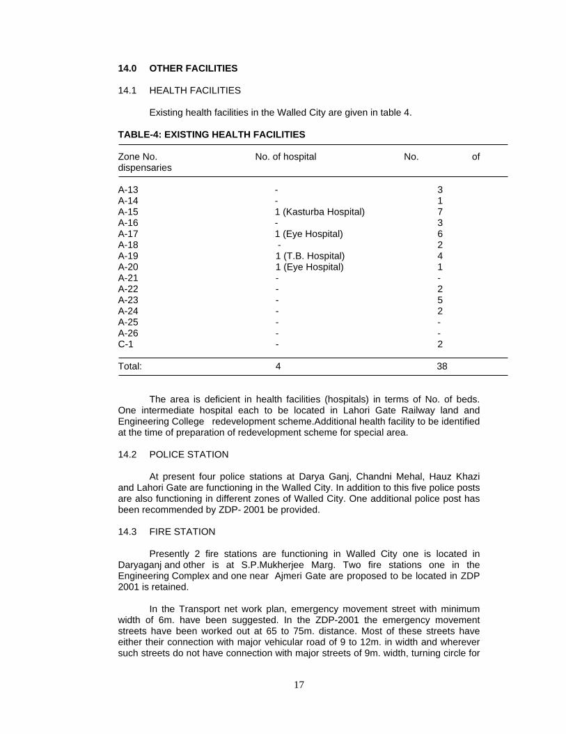
Existing health facilities in the Walled City are given in table 4.
TABLE-4: EXISTING HEALTH FACILITIES Zone No. No. of hospital No. of dispensaries A-13 - 3 A-14 - 1 A-15 1 (Kasturba Hospital) 7 A-16 - 3 A-17 1 (Eye Hospital) 6 A-18 - 2 A-19 1 (T.B. Hospital) 4 A-20 1 (Eye Hospital) 1 A-21 - - A-22 - 2 A-23 - 5 A-24 - 2 A-25 - - A-26 - - C-1 - 2 Total: 4 38
The area is deficient in health facilities (hospitals) in terms of No. of beds.
One intermediate hospital each to be located in Lahori Gate Railway land and Engineering College redevelopment scheme.Additional health facility to be identified at the time of preparation of redevelopment scheme for special area. 14.2 POLICE STATION
At present four police stations at Darya Ganj, Chandni Mehal, Hauz Khazi and Lahori Gate are functioning in the Walled City. In addition to this five police posts are also functioning in different zones of Walled City. One additional police post has been recommended by ZDP- 2001 be provided. 14.3 FIRE STATION
Presently 2 fire stations are functioning in Walled City one is located in Daryaganj and other is at S.P.Mukherjee Marg. Two fire stations one in the Engineering Complex and one near Ajmeri Gate are proposed to be located in ZDP 2001 is retained.
In the Transport net work plan, emergency movement street with minimum
width of 6m. have been suggested. In the ZDP-2001 the emergency movement streets have been worked out at 65 to 75m. distance. Most of these streets have either their connection with major vehicular road of 9 to 12m. in width and wherever such streets do not have connection with major streets of 9m. width, turning circle for

18
movement of fire tender would be designed while preparing the redevelopment scheme of the zone. The following suggestions of Delhi fire department as given in ZDP-2001 are to be considered while preparing the redevelopment scheme.
a) There shall be no building above 15m. in height. However the matter of flexibility in height may be considered on the merit of specific case.
b) All the overhead electric wires as far as possible should be changed to underground cables because in narrow streets and by lanes electric wires create hindrance in fire fighting.
c) Delhi fire service has worked out the requirement of 14 additional static water tanks each of 1.0 Lac Ltr. capacity besides the 32 existing static water tanks.
14.4 TELEPHONE EXCHANGE
At present two telephone exchanges are functioning in / around the Walled City One additional telephone exchange proposed in ZDP-2001 to be provided on the land to be vacated by railway Yard near Ajmeri Gate/Mori Gate or in a suitable location in the redevelopment scheme.
14.5 FUEL STATIONS (PETROL PUMPS / CNG STATION)
At present two petrol pumps, one at Subhash Marg and the other one near Minerwa Cinema in Kashmere Gate area are functioning. Three additional sites of Petrol Pumps proposed in ZDP-2001 to be located: one in the Engineering College complex, one on the proposed Ring Road between Naya Bazar and one near Parda Bagh Bus Terminal.
Additional petrol pumps required to be considered in the redevelopment
scheme as per MPD-2021 norms / standards. 14.6 REGULARIZATION OF EXISTING HEALTH CARE, EDUCATIONAL, CULTURAL & RELIGIOUS (INCLUDINGSPIRITUAL) INSTITUTES EXISTING PRIOR TO 01.01.2006 ON SELF OWNED LAND NOT INCLUDING GRAM SABHA OR RIDGE LAND. 14.6.1. In pursuance of the public notice issued in this regard, the Authority resolved
incorporation & regularization of the above uses/activities in the Public & Semi Public land use category of the Master Plan. The applications of the existing institutions as listed in the annexure –III shall be examined as per the Authority resolution and as per directions of the Central Government issued from time to time. However, the regularization of existing institutions located in the immediate vicinity of notified Ridge/Reserved Forest/Regional Park shall be subject to finalization &demarcation of the boundaries of the aforesaid respective use Zones/areas.
14.6.2. In case of cultural, health care and educational institutions, the structures of
such institutes as existed as on 1.1.2006, but not beyond the prevailing relevant provisions of MPD-2021, shall be considered for regularisation. However, in this case of the existing religious (including spiritual) institutions and vis a vis the land presently owned by them, regularization shall be subject to the conditions that (a) the built up area in these cases shall not exceed FAR of 15 with maximum 15% ground coverage; (b) shall be confined to the

19
buildings, which are directly related to the use activities - religious (including Spiritual); (c) the structures as existed on 1.1.2006 shall only be considered; and (d) the remaining area shall be kept as ‘green area’ with no construction to be permitted in future.
The regularization of all the above institutions shall be confined to those listed
(if any) with this Plan or those cases recommended by DDA to the Government on or before 8th March, 2010, and shall be undertaken only after ensuring that the change of land use u/s 11A of DD Act, 1957 is notified in conformity with the provisions of MPD-2021 as and where required. This is further subject to the condition that such individual cases shall not be considered for regularisation, if the site in question is located.
a. On public/Govt. land; or on land acquired by DDA; b. On encroached land; or on illegal occupied land; c. In notified or reserved forest area; d. In area of right of way infrastructure such as of existing / proposed railway lines/master plan roads, major trunk water supply and sewerage lines etc.; e. Or if it violates the provisions of the Ancient Monuments and Archaeological Remains Act, 1958, amended from time to time; f. Or in cases where there is a Court Order restraining change of land use or for eviction/vacation of premises. There are, as such, no applications on above regularisation received by this deptt. as on date w.r.t Zone ’A’ Walled City(Part Zone A and C). 14.6.3. Further, regularization orders of these categories of institutions shall not be
considered as approved, unless the requisite payment of penalty / levy / additional FAR charges etc. are deposited by the applicant institutes; all the conditions prescribed by the Govt. are fulfilled and formal ‘regularization orders‘ are issued by the DDA. None of the above institutes shall, however, be entitled to put the land to any other land use at any time and doing so shall invite takeover of land by the DDA for alternative uses, on payment of reasonable compensation.
14.7 NEW AREAS FOR PUBLIC AND SEMI PUBLIC FACILITIES To meet the deficiency of public/semi-public uses, it is considered that wherever concentrations of evacuee properties exist, they could be utilized by amalgamation of evacuee properties with private properties together for public/semi-public uses. Nine such pockets have been identified for that purpose. The detailed survey of each pocket in respect of land use, floor use, and number of families had been conducted for ZDP-2001, earlier. Planning of facilities in these pockets could be taken up as priority projects. The facilities, which could be planned in the proposed facility area, have been given in table below.

20
TABLE 5- PROPOSED FACILITY AREAS .S.No Zone
No. Area in Sq. mts.
No. of slum properties
No. of private
properties
Suggested facility
1. A-13 11675 152 13 Sub Fire Station, Police Post, Sr. Sec. School
2. A-15 (1) 2088 64 5 Cultural Hall, Community Hall
3 A-15 (2) 6192 - -
4 A-15 (3) 5076 28 10 Sr. Sec. School, Library, Dispensary
5 A-17 5005 47 15 Community Hall, Library,
Dispensary
6 A-22 (1) 3384 34 6 Library, Community HaII / Vocational School, Dispensary,
Sub Fire Station
7 A-22 (11)
5815 48 17 -
8 A-24 1116 - 1 Library, Community Hall, Dispensary, Night shelter
9 A-25 12710 - 1 Community Hall, Dispensary
Some of the area vacated by Railway goods yard & Delhi College of Engineering and adjoining G.P.O. area could also be used for public and semi-public facilities by preparing comprehensive integrated schemes for these areas. UPGRADATION OF PHYSICAL INFRASTRUCTURE
i) It would be desirable to make water supply and sewerage connection compulsory in the Walled City as per MPD-2021 norms.
ii) Subsidy schemes of sanitation i.e. conversion of dry latrine into water borne are to be enforced vigorously by MCD as per MPD-2021 norms.
iii) In part of the Walled City sewer lines may require augmentation. 15.0 MIXED USE
There are a number of streets which were earlier recommended for commercial use in the \Walled City (as per MPD-2001) in which commercial activity was permitted on ground floor upto one property depth. The Zones in which such mixed use were permitted as per ZDP-2001 are listed at Annexure–IV. However, as per MPD-2021, additional Commercial Streets, mixed-use Streets and Pedestrian Shopping Streets have also been notified by the GNCTD as
21
per recommendation of the local body from time to time, which are also listed at Annexure –V, VI and VII respectively. Besides, certain streets which were earlier notified as mixed use streets ( as per ZDP-2001) have also been declared (under MPD 2021) as Commercial Streets, which are listed at Annexure –VIII. 15.1 MIXED USE REGULATIONS
The MPD-2021 acknowledges the need for permitting use of land for
purposes other than that for which it was originally envisaged and lays down the conditions under which this may be applied in different situations. The general procedure to be followed for implementation of the said policy, and mitigating measures to be taken to counter the effect of such non-intended use in such area also described.

22
Annexure-I
MANUFACTURING UNITS (TYPES) TO BE CLOSED IMMEDIATELY IN WALLED CITY
1) Electric cable and wire.
2) Plastic P. V. C. and rubber goods
3) Electroplating including different types of metal polishing.
4) Paint.
5) Dye.
6) Acid and chemicals.
7) Spice grinding.
8) Grease.
9) Card box (large size).
10) Battery box.
11) Tobbaco processing.
12) Metal box (large size)
13) Any other noxious / hazardous and nuisance manufacturing and processing
units.
The following trades shall be shifted to the areas specifically marked for respective trades:
1) PVC wholesale market (may be shifted to Paharganj subject to a detailed study).
2) Trade dealing with hazardous chemicals.
3) Dairies.
4) Large godowns warehouses (to be shifted in a phased manner).
5) Fruit and vegetable market (Phool Mandi).
6) Poultry and Fish Market.
Source: As per ZDP-2001
23
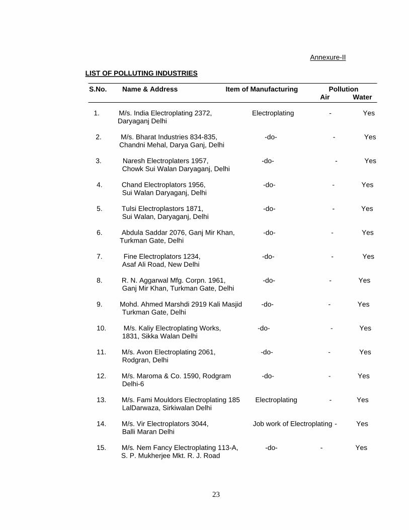
Annexure-II
LIST OF POLLUTING INDUSTRIES S.No. Name & Address Item of Manufacturing Pollution Air Water
1. M/s. India Electroplating 2372, Electroplating - Yes Daryaganj Delhi
2. M/s. Bharat Industries 834-835, -do- - Yes Chandni Mehal, Darya Ganj, Delhi
3. Naresh Electroplaters 1957, -do- - Yes Chowk Sui Walan Daryaganj, Delhi
4. Chand Electroplators 1956, -do- - Yes
Sui Walan Daryaganj, Delhi
5. Tulsi Electroplastors 1871, -do- - Yes Sui Walan, Daryaganj, Delhi
6. Abdula Saddar 2076, Ganj Mir Khan, -do- - Yes Turkman Gate, Delhi
7. Fine Electroplators 1234, -do- - Yes
Asaf Ali Road, New Delhi
8. R. N. Aggarwal Mfg. Corpn. 1961, -do- - Yes Ganj Mir Khan, Turkman Gate, Delhi
9. Mohd. Ahmed Marshdi 2919 Kali Masjid -do- - Yes Turkman Gate, Delhi
10. M/s. Kaliy Electroplating Works, -do- - Yes 1831, Sikka Walan Delhi
11. M/s. Avon Electroplating 2061, -do- - Yes Rodgran, Delhi
12. M/s. Maroma & Co. 1590, Rodgram -do- - Yes
Delhi-6
13. M/s. Fami Mouldors Electroplating 185 Electroplating - Yes LalDarwaza, Sirkiwalan Delhi
14. M/s. Vir Electroplators 3044, Job work of Electroplating - Yes Balli Maran Delhi
15. M/s. Nem Fancy Electroplating 113-A, -do- - Yes S. P. Mukherjee Mkt. R. J. Road

24
16. M/s. Sharma Electroplating 130-A, -do- - Yes S. P. Mukherjee Mkt. 17. M/s. Janta Electroplating A-32 , -do- - Yes S. P. Mukherjee Mkt. R. J. Road 18. M/s. Laxmi Electroplating A-95, -do- - Yes S. P. Mukherjee Mkt. R. J. Road 19. M/s. Mohd. Sajeed, Baraderi Ballimarn , Delhi Job work of nickle polish - Yes 20. M/s. Shiva Iron & Brass works, 3995 -do- - Yes Gali Lohewali. Chawari Bazar, Delhi. 21. M/s. National Electroplating 5957, Ballimaran, Delhi Job work of electroplating - Yes 22. M/s. Ishap Electroplating 26/6, -do - Yes Bara Darwaza, Delhi 23. M/s. Shree Vishnu Metal Foundry 4792, Foundry casing -do- - Yes Phatak Nawab, Hauz Qazi, Delhi 24. M/s. Juneja Electroplating 7192, Bariwala Bagh, Delhi Job work of electroplating - Yes 25. M/s. Banarsi Das Sat Parkash 758, -do- - Yes Haweli Azam Khan, Delhi 26. M/s. Mohd. Umer & Sons 2570, Gali Hauz Qazi Ballimaran, Delhi. . - do- - Yes Source: As per ZDP-2001
25
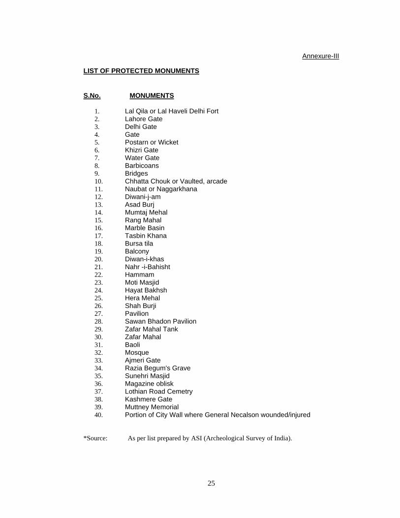
Annexure-III
LIST OF PROTECTED MONUMENTS S.No. MONUMENTS
1. Lal Qila or Lal Haveli Delhi Fort 2. Lahore Gate 3. Delhi Gate 4. Gate 5. Postarn or Wicket 6. Khizri Gate 7. Water Gate 8. Barbicoans 9. Bridges 10. Chhatta Chouk or Vaulted, arcade 11. Naubat or Naggarkhana 12. Diwani-j-am 13. Asad Burj 14. Mumtaj Mehal 15. Rang Mahal 16. Marble Basin 17. Tasbin Khana 18. Bursa tila 19. Balcony 20. Diwan-i-khas 21. Nahr -i-Bahisht 22. Hammam 23. Moti Masjid 24. Hayat Bakhsh 25. Hera Mehal 26. Shah Burji 27. Pavilion 28. Sawan Bhadon Pavilion 29. Zafar Mahal Tank 30. Zafar Mahal 31. Baoli 32. Mosque 33. Ajmeri Gate 34. Razia Begum's Grave 35. Sunehri Masjid 36. Magazine oblisk 37. Lothian Road Cemetry 38. Kashmere Gate 39. Muttney Memorial 40. Portion of City Wall where General Necalson wounded/injured
*Source: As per list prepared by ASI (Archeological Survey of India).

26
Annexure- IV
LIST OF MIXED USE STREETS AS PER ZDP-2001. S.NO. Zone Street 1. A-13 Ajmeri Gate Road Bazar Sita Ram, Gali Kucha Pati Ram, Gali
Arya Samaj, Gali Kali Masjid, Gali Katra Anikhan. 2. A-14 Bazar Dilli Darwaza. 3. A-15 Netaji Subhash Marg, Sir Syed Ahmad Marg, Gali Kuncha
Chalan, Gali Pataudi House, Gali Kala Mehal. 4. A-16 Gali Churiwalan Chawri, Bazar, Bazar Matia Mahal, Sita Ram
Bazar, Gali PanditPrem Narain. 5. A-17 Ajmeri Gate Road, Fasil Road, Gali Shah Tara, Gali Kucha
Pandit, Gali Shahaganj Farashkhana road, Lal Kuan Bazar. 6. A-18 Farash Khana Road, Samosa Wali Gali, Fasil Road, Naya
Bans Road, Bazar Khari Baoli, Katra Dariyan Road, Gali Batashawali, Gali Kucha Nawab.
7. A-20 Netaji Subhash Marg, Dayanand Road, Ansari Road 8. A-22 Katra Bariyan Road, Lal Kuan Road, Gali Ballimaran, Gali
Kashim Jaan, Chawri Bazar, Nai Sarak, Chandni Chowk. 9. A-23 Nai Sarak, Chandni Chowk Esplanade Road, Dariba Kalan
Bazar Gulian,.Chawri Bazar, Chatta Shahji, Gali Khajoor, Gali Katra Kushal Rai, Gali Anar Wali, Kinari Bazar, Maliwara Road.
10. A-24 Chandni Chowk, Katra Neel, Church Mission Road, Katra Natwar Area. 11. A-25 H. C. Sen Road, Chandni Chowk. 12. C-1 Bara Bazar Road.

27
Annexure- V
LIST OF COMMERCIAL STREETS (Notified under MPD-2021).
S.NO. Name of Road/Street Stretch of road ROW (mtrs.)
1 New Darya Gunj Road Subhash Marg to Ring Rd 24.0 to 30.0 2 Rakab Ganj Road
Chowk Rakab Ganj to Delite Cinema
6.0
3 Gali Kotana
Chowk Suiwallan to Bazar Chitli Qabae
6.0
4 Chandni Mahal Dispensary Road
Chandni Mahal Chowk to P.S.Chandni Mahal
6.0
5 Chhatta Lal Mian
Faseel Road to Delhi Gate Bazar
7.0
6 Chitli Qabar Road
Turkman Gate to Chitli Qabar Dargah
8.0
7 Sheesh Mahal Suiwallan to Faseel Road 9.0 to 12.0 8 Motor Market Road
Motor Market to Chooriwallan Chowk 14.83
9 Urdu Bazar Road
Neta ji Subhash Marg to Jama Masjid
15.0
10 Chitli Qabar Bazar Road
Durjana House to Tiraha Baram Khan
8.0
11 Hanuman Road Angoori Bagh
Shop No 7 to 74 7.0
12 Sadar Nala Road
Ghante wali masjid to Sadar thana road crossing
6.5
13 Sher ka Pinjra H.No.T-252 to T-257 6.5 14 Road from Panchaki Chowk to
Gahnte wali Masjid
Panchaki Chowk to Ghante Wali Masjid
6.5
15 Gali Masjid Takia Tawakulshh H.No.3590 to H.No.3560 7.6 16 Choti Masjid Road H.No.1556 to H.No.1594 6.1 17 Narayan Market Shop No.925 to Shop No.912 7.2 18 Gali chuleh Wali H.No1414 to H.No.1439 11.5 19 Mian Lallu Mishra H.No.1355 to H.No.1364 9.5 20 Sadar Nala Road
to Sadar Thana Road Crossing
10.0
21 Hoshiyar singh Marg
Nawab Road to Sadar Thana Road 12.2
22 Ugrsain Marg
Rani Jhansi Road to Chamalian Road 12.2
23 Chowk Singarah Road Idgah Road to Quatub Road 13.5 24 Subzi Chowk Road S.P.M.Marg to Nai Basti 7.0 25 Bhagirath Palace
Chandni Chowk to Shop No.1747 6.0
26 Dewan hall road More Sarai Road to Chandni Chowk 9.0 27 More Sarai Road
H.C.Sen Road to Lajpat Rai Market
7

28
28 Nichalson Road Mori Gate Road to Fire Stone 10.70 to 13.60
29 Quatab Road Lahori Gate to Qutub Road 13.80 to 23.60
30 Mori Gate Main Road Novelty Chowk to Tanga Stand 16.00 to 21.00
31 Zorawar Singh Marg
Mori Gate Road to Ganda Nallah Bazar
18.00 to 19.00
32 G.T.Road Mori Gate Road to Dhalao 13.00 to 20.00
33 Bharat Ram Road Subhash Marg to Ansari Road 9.0 to 12.0
34 M.A. Road Subhash Marg to Ansari Road 9.0 to 12.0
35 Shyam Lal Road Daya Nand Road to Ansari Road 9.0 to 12.0
36 Brij Mohan Marg Ansari Road to Bhrat Ram Road 9.0 to 12.0
37 Daya Nand Road Subhash Marg to Ansari Road 13.5 to 18.0
Source: GNCTD Source: GNCTD Notification No.F.13/46/2006-UD/16071 dated 07.09.2007 as well as Notification No.F.13/46/2006-UD/16085 dated 07.09.2007
Note: In case there is difference between ROW mentioned in the list given by GNCTD and the Zonal Plan, the ROW given in the Zonal Plan / approved Layout plan shall prevail. In case of any clarification, GNCTD Notification may be referred.
29
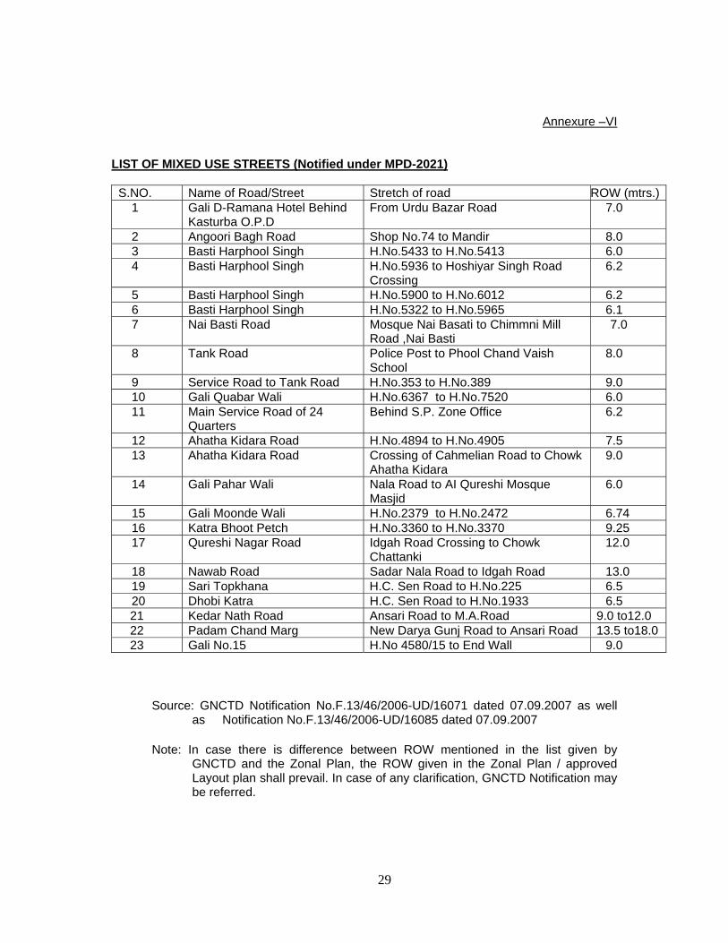
Annexure –VI
LIST OF MIXED USE STREETS (Notified under MPD-2021)
S.NO. Name of Road/Street Stretch of road ROW (mtrs.)1 Gali D-Ramana Hotel Behind
Kasturba O.P.D From Urdu Bazar Road 7.0
2 Angoori Bagh Road Shop No.74 to Mandir 8.0 3 Basti Harphool Singh H.No.5433 to H.No.5413 6.0 4 Basti Harphool Singh H.No.5936 to Hoshiyar Singh Road
Crossing 6.2
5 Basti Harphool Singh H.No.5900 to H.No.6012 6.2 6 Basti Harphool Singh H.No.5322 to H.No.5965 6.17 Nai Basti Road Mosque Nai Basati to Chimmni Mill
Road ,Nai Basti 7.0
8 Tank Road Police Post to Phool Chand Vaish School
8.0
9 Service Road to Tank Road H.No.353 to H.No.389 9.010 Gali Quabar Wali H.No.6367 to H.No.7520 6.0 11 Main Service Road of 24
Quarters Behind S.P. Zone Office 6.2
12 Ahatha Kidara Road H.No.4894 to H.No.4905 7.5 13 Ahatha Kidara Road Crossing of Cahmelian Road to Chowk
Ahatha Kidara 9.0
14 Gali Pahar Wali Nala Road to AI Qureshi Mosque Masjid
6.0
15 Gali Moonde Wali H.No.2379 to H.No.2472 6.74 16 Katra Bhoot Petch H.No.3360 to H.No.3370 9.25 17 Qureshi Nagar Road Idgah Road Crossing to Chowk
Chattanki 12.0
18 Nawab Road Sadar Nala Road to Idgah Road 13.0 19 Sari Topkhana H.C. Sen Road to H.No.225 6.5 20 Dhobi Katra H.C. Sen Road to H.No.1933 6.5
21 Kedar Nath Road Ansari Road to M.A.Road 9.0 to12.0 22 Padam Chand Marg New Darya Gunj Road to Ansari Road 13.5 to18.0 23 Gali No.15 H.No 4580/15 to End Wall 9.0
Source: GNCTD Notification No.F.13/46/2006-UD/16071 dated 07.09.2007 as well as Notification No.F.13/46/2006-UD/16085 dated 07.09.2007
Note: In case there is difference between ROW mentioned in the list given by GNCTD and the Zonal Plan, the ROW given in the Zonal Plan / approved Layout plan shall prevail. In case of any clarification, GNCTD Notification may be referred.

30
Annexure –VII
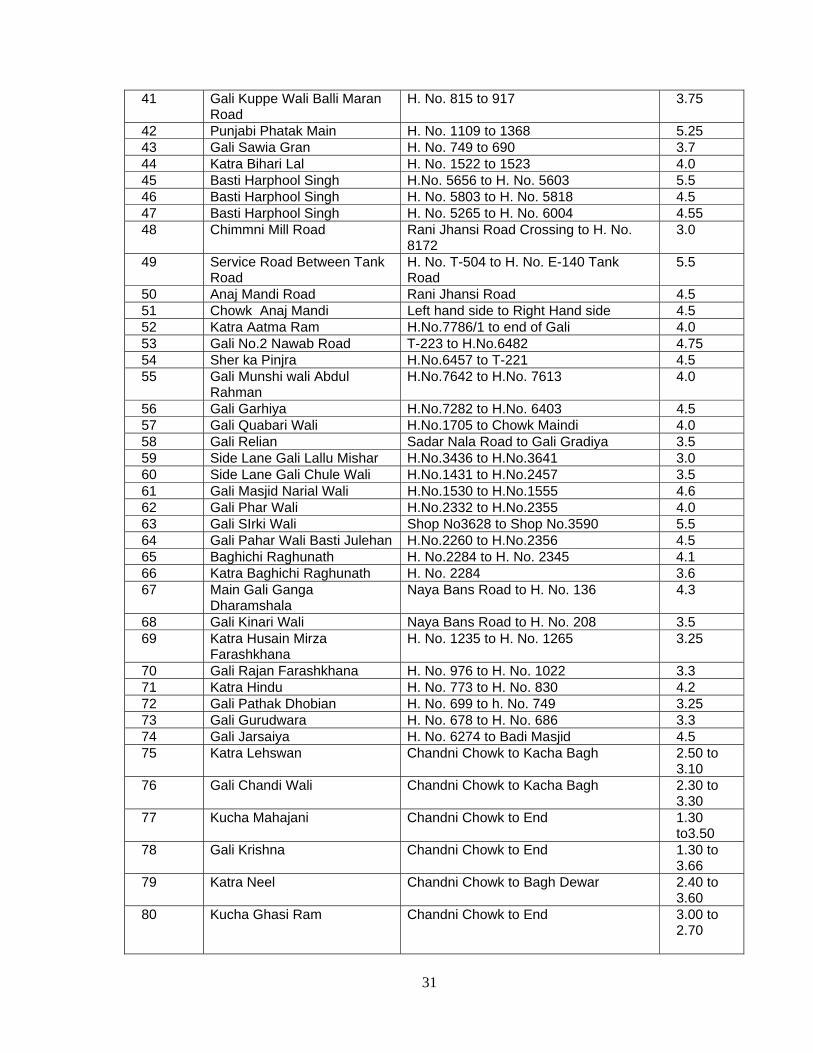
LIST OF PEDESTRIAN SHOPPING STREETS (Notified under MPD-2021) S.NO. Name of Road/Street Stretch of road ROW
(mtrs.) 1 Gali Jalal Bukhari Turkman Gate to Ahata Bukhari 3.0 2 Gali Kucha Mir Ashinm Chawari Bazar to End of Gali 3.25 3 Ganj Mir Khan Ganj Mir Khan Chowk to Bazar Chitli
Qabar 5.15
4 Kuncha Dakini Raj Subhash Marg to Kala Mahal 4.6 5 Gali Garhiya Matia Mahal From Matia Mahal Road 3.5 6 Haveli Azam Khan Road Chitli Qabar Bazar to End of the lane 3.5 7 Gali Bara Dari Road Kucha Challan to Mosque 3.5 8 Gali Qazi Wala Road Subhash Marg to S.S. Road 4.15 9 Gali Jagat Wali Jagat Cinema to Ghante Wali Gali 3.15 10 Gali Fatak Ram Kishan Devi Chitli Bazar to End of Gali 3.2 11 Gali Bhistavan Kucha Challan to End 5.25 12 Gali Tehsil Dar Wali Kucha Challan to Kucha Dakhni Rai 3.3 13 Gali David Street Footover Bridge to Dakhni Rai 5.0 14 Angoori Bagh Road Shop No. 43 to 76 4.0 15 Gali Kabadian Matia Mahal to End of Gali 3.0 16 Kucha Neel Kanth S.S. Road to Qazi Vera 3.1 17 Gali Khan Khana Urdu Bazar to End of Gali 3.1 18 M.P. Street Kucha Dakhini Rai to Kucha Mehar
Khan 3.2
19 Road Gram Road H. No. 2010 to 1745 4.1 20 Gali Imali Wali H. No. 1650 to 1665 3.35 21 Katra Qazi H. No. 1885 to 1893 3.0 22 Lal Darwaza H. No. 1834 to 2905 3.5 23 Gali Madarsa Mir Jumia H. No. 1688 to 1718 4.2 24 Katra Gulam Mohammed H. No. 19 to 1712 3.1 25 Gali Gondnewali H. No. 79 to 6177 4.7 26 Gali Roshan Pura H. No. 1713 to 2695 3.7 27 Gali Daiwada H. No. 3687 to 3670 4.75 28 Gali Haji Ali Jaan H. No. 5642 to 5647 3.6 29 Gali Chitta Gosai H. No. 4183 to 4366 4.1 30 Gali Bhairon Wali & its linc H. No. 4291 to 4367 3.25 31 Phatak Rashid Khan H. No. 574 to 5921 4.9 32 Jogiwara H. No. 5777 to 5846 4.0 33 Gali Kucha Rehman H. No.5458 to 4956 3.0 34 Mohallah Dussan H. No.3071 to 2835 4.2 35 Gali Peepal Makader Chatta to Mukh Mandir Chowk 3.9 36 Gali Rajawali H. No. 3401 to 3734 3.6 37 Gali Madhav Pandit H. No. 3098 to 3106 3.2538 Chotti Bharadari H. No. 2657 to 2965 5.539 Bari Baradari H. No. 2509 to 2634 4.2 40 Katra Alam Beg Balli Maran
Road
H. No. 2331 to 2313 3.15
31
41 Gali Kuppe Wali Balli Maran Road
H. No. 815 to 917 3.75
42 Punjabi Phatak Main H. No. 1109 to 1368 5.25 43 Gali Sawia Gran H. No. 749 to 690 3.7 44 Katra Bihari Lal H. No. 1522 to 1523 4.0 45 Basti Harphool Singh H.No. 5656 to H. No. 5603 5.5 46 Basti Harphool Singh H. No. 5803 to H. No. 5818 4.5 47 Basti Harphool Singh H. No. 5265 to H. No. 6004 4.55 48 Chimmni Mill Road Rani Jhansi Road Crossing to H. No.
8172 3.0
49 Service Road Between Tank Road
H. No. T-504 to H. No. E-140 Tank Road
5.5
50 Anaj Mandi Road Rani Jhansi Road 4.5 51 Chowk Anaj Mandi Left hand side to Right Hand side 4.5 52 Katra Aatma Ram H.No.7786/1 to end of Gali 4.0 53 Gali No.2 Nawab Road T-223 to H.No.6482 4.75 54 Sher ka Pinjra H.No.6457 to T-221 4.5 55 Gali Munshi wali Abdul
Rahman H.No.7642 to H.No. 7613 4.0
56 Gali Garhiya H.No.7282 to H.No. 6403 4.5 57 Gali Quabari Wali H.No.1705 to Chowk Maindi 4.0 58 Gali Relian Sadar Nala Road to Gali Gradiya 3.5 59 Side Lane Gali Lallu Mishar H.No.3436 to H.No.3641 3.0 60 Side Lane Gali Chule Wali H.No.1431 to H.No.2457 3.5 61 Gali Masjid Narial Wali H.No.1530 to H.No.1555 4.6 62 Gali Phar Wali H.No.2332 to H.No.2355 4.0 63 Gali SIrki Wali Shop No3628 to Shop No.3590 5.5 64 Gali Pahar Wali Basti Julehan H.No.2260 to H.No.2356 4.5 65 Baghichi Raghunath H. No.2284 to H. No. 2345 4.1 66 Katra Baghichi Raghunath H. No. 2284 3.6 67 Main Gali Ganga
Dharamshala Naya Bans Road to H. No. 136 4.3
68 Gali Kinari Wali Naya Bans Road to H. No. 208 3.5 69 Katra Husain Mirza
Farashkhana H. No. 1235 to H. No. 1265 3.25
70 Gali Rajan Farashkhana H. No. 976 to H. No. 1022 3.371 Katra Hindu H. No. 773 to H. No. 830 4.2 72 Gali Pathak Dhobian H. No. 699 to h. No. 749 3.25 73 Gali Gurudwara H. No. 678 to H. No. 686 3.3 74 Gali Jarsaiya H. No. 6274 to Badi Masjid 4.5 75 Katra Lehswan Chandni Chowk to Kacha Bagh 2.50 to
3.10 76 Gali Chandi Wali Chandni Chowk to Kacha Bagh 2.30 to
3.30 77 Kucha Mahajani Chandni Chowk to End 1.30
to3.50 78 Gali Krishna Chandni Chowk to End 1.30 to
3.66 79 Katra Neel Chandni Chowk to Bagh Dewar 2.40 to
3.60 80 Kucha Ghasi Ram Chandni Chowk to End 3.00 to
2.70

32
81 Chhatta Bhawani Shankar Church Mission Road to Kucha Ghasiram
2.80 to 3.80
82 Bagh Dewar Church Mission Road to Town Hall Road
3.20 to 6.60
83 Gali Doman Bagh Dewar to End 5.00 to 8.90
84 Gali Jhot Wali Bagh Dewar to End 3.20 to 1.00
85 Gali Ghanteshwar Katra Neel to End 0.80 to 3.60
86 Katra Ishwar Bhawan Khari Bawli to End 1.75 to 4.10
87 Katra Hussen Bax Khari Bawli to End 1.00 to 3.10
88 Tilak Bazar Khari Bawli to End 5.00 to 7.00
89 Katra Tambaco Khari Bawli to End 1.10 to 3.40
90 Katra Chelan Khari Bawli to End 1.00 to 3.80
91 Katra Bansi Dhar Khari Bawli to End 1.55 to 9.00
92 Gali Patti Wali Sushila Mohan Marg to End 1.00 to4.10
93 Gali Raghunandan Sushila Mohan Marg to End 2.40 to 3.60
94 Gali Laltain Sushila Mohan Marg to End 1.60 to 3.20
95 Katra Shiv Ashram Queens Road to End 1.10 to 8.75
96 Gali Rang Mahal Road S.P.M. Marg to Rang Mahal 1.40 to 6.00
97 Gali Teliyan Tilak Chowk to Thakur Dwara 3.50 to 4.50
98 Katra Ghee Tyre Market to Gali Teliyan 1.95 to 3.60
99 Lumbi Gali Rang Mahal to Chaman Wara 2.10 to 4.60
100 Rang Mahal (Bara) Chaman Wara to End 1.40 to 6.35
101 Katra Padam Tilak Bazar to End 1.00 to 4.10
102 Gali Hinga Bagh Tilak Bazar to End 1.10 to8.30
103 Gandhi Gali Church Mission Road to Tilak Chowk 0.80 to 5.00
104 Chhtta Ja Nissar Church Mission Road to End 1.30 to 4.20
105 Tyre Market S.P.M.Marg to Tilak Chowk 4.80 to 8.20
106 Ram Bazar Mori Gate Road to Ganda Nallah Bazar 5.00 to 8.00

33
107 Chowk Ramya Ram Bazar to Ganda Nallah Bazar 3.60 to 7.50
108 Ashok Gali Ram Bazar to End 0.90 to 6.10
109 Chhutani Manzil Nichalson Road to Ram Bazar 4.20 to 6.20
110 Gali Door Wali Nichalson Road to Ram Bazar 1.50 to 6.00
111 Gali Mil Wali Kucha Mohtar Khan to End 1.25 to 3.70
112 Phool Mandi Kucha Gahsi Ram to Chatta Bhawani Shankar
1.25 to 8.20
113 Gandhi Cloth Market Church Mission Road to Tyre Market 3.00 to 6.00
114 Gali Gurudwara Wali Nichalson Road to Gali Door Wali 2.60 to 6.00
115 Hari Ram Building Nichalson Road to End 1.30 to 9.00
116 Gali Anar Kinari Bazar to H,No.2652 3.10
117 Masjit Khazoor Khushal Rai to Dharampura 4.3
118 Kucha Jatmal Dariba to H.No.1195 3.1
119 Mali Wara Road Nai Sarak to Kinari Bazar 5.0
120 Gali Kishan Dutt Mliwala to Shop No.1420 3.5
121 Bhoj Pura Maliwala to H.No.974 3.5
122 Gali Heer Nand Maliwala to H.No.1043 3.4
123 Moti Bazar Chandi Chowk to Maliwar 3.3
124 Vedwara Maliwala to H.No.1324 3.45
125 Cheera Khana Moti Bazar to Roshanpura 4.8
126 Chatta Madan Gopal Maliwar to Gali Matawali 3.65
127 Gali Mata wali Katra Khushal Rai to H.No.1930,1931 4.2
128 Gali Barafwali Kinari Bazar H.No.2030 3.5
129 Kucha seth Dariba to Dharampura 3.4
130 Kucha Bulaki Begum Dariba to Cycle Market 5.95
131 Gali Janiyan Esplanded Road to Shop No.421 5.3
132 Gali Gulyan Paiwalan Road to Dharampura 4.3
133 Chah Rahat Gali Gulyan to H.No.1204 5.2
134 Wakilpura Chah Rahat to H.N.1303 5.20/3.80
135 Chhota Chipiwara Chawri Bazar to H.No.2437 3.85
136 Katra Mangalsen Chawri Bazar to H.No.998 3.15
137 Katra Hardayal Chandi Chowk to Nai Sarak 3.0
138 Gali Gante Wali Chandi Chowk to Shop No.1875 3.15

34
139 Chah Indara H.C.Sen Road to H.No.2176 4.15
140 Gali Baraf Khana H.C.Sen Road to H.No.2287 5.6
141 Ardghara H.C.Sen Road to H.No.1931 4.0
142 Chatta Hathi Khana Paiwalan Road to H.No.523 4.0
143 Kucha Chaudhary Chandni Chowk to H.No.20 5.0
144 Old Marwari Katra Nai Sarak to Cheera Khana 3.5
145 Tanga Stand Road Mori Gate Road to G.T.Road 2.90 to 9.65
146 Gandha Nala Bazar Nichalson Road to Jorawar Singh Marg 3.30 to 10.00
147 Queens Road (Back lane of SPM Marg)
T.B.Clinic to Tyre Market 4.60 to 11.15
148 Church Mission Road Fatehpuri to SPM Marg 1.50 to 25.75
149 Gali No. 1, Ist Lane Ansari Road to City Wall 6.0 150 Gali No. 1, IInd Lane H.No 4236/1to 4239/1 8.5 151 Gali No.2 Ansari Road to City Wall 6.0 152 Gali No. 2 IInd Lane Ansari Road to City Wall 6.0153 Gali No.2 IIIrd Lane Ansari Road to City Wall 6.0 154 Gali No 3 Ist Lane Ansari Road to City Wall 6.0 155 Gali No 4 Ist Lane Ansari Road to City Wall 6.0 156 Gali No 4 B Wall Ansari Road to City 4.5 157 Gali No 5A Ansari Road to City Wall 7.5 158 Gali No.11 Ansari Roadto City W all 5.5 159 Gali No 11 H.No 4596/11to City Wall 6.5 160 Gail No 18 Ansari Road to City Wall 4.5 161 Gali No 20 Ansari Road to City Wall 4.5 162 Gali No 21 Ansari Road to City Wall 6.5 163 Gali No 23 Bharat Ram Rd to City Wall 6.0 164 Gali No 24 Ansari Rd to H.No 4837/24 6.0 165 Mahila Ashram Rd to Taxi
Stand Mahila Ashram Park to Taxi Stand
Malnts Park to Taxi Stand Nizamuddin 7.5
166 Mukesh Road Police Station to Mehboob Hotel 7.5
Source: GNCTD Notification No.F.13/46/2006-UD/16071 dated 07.09.2007 as well as GNCTD Notification No.F.13/46/2006-UD/16085 dated 07.09.2007.
Note: In case there is difference between ROW mentioned in the list given by GNCTD and the Zonal Plan, the ROW given in the Zonal Plan / approved Layout plan shall prevail. In case of any clarification, GNCTD Notification may be referred.
35
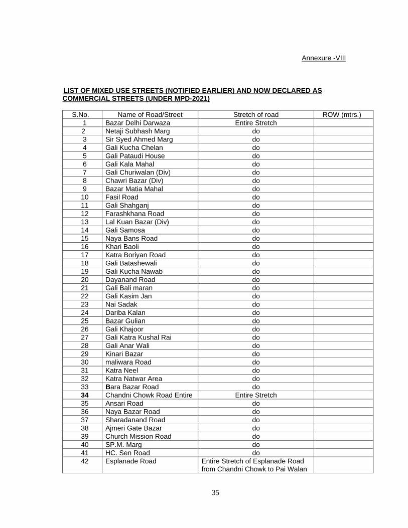
Annexure -VIII
LIST OF MIXED USE STREETS (NOTIFIED EARLIER) AND NOW DECLARED AS COMMERCIAL STREETS (UNDER MPD-2021)
S.No. Name of Road/Street Stretch of road ROW (mtrs.)
1 Bazar Delhi Darwaza Entire Stretch 2 Netaji Subhash Marg do
3 Sir Syed Ahmed Marg do 4 Gali Kucha Chelan do 5 Gali Pataudi House do 6 Gali Kala Mahal do 7 Gali Churiwalan (Div) do 8 Chawri Bazar (Div) do 9 Bazar Matia Mahal do
10 Fasil Road do 11 Gali Shahganj do 12 Farashkhana Road do 13 Lal Kuan Bazar (Div) do 14 Gali Samosa do 15 Naya Bans Road do 16 Khari Baoli do 17 Katra Boriyan Road do 18 Gali Batashewali do 19 Gali Kucha Nawab do 20 Dayanand Road do 21 Gali Bali maran do 22 Gali Kasim Jan do 23 Nai Sadak do 24 Dariba Kalan do 25 Bazar Gulian do 26 Gali Khajoor do 27 Gali Katra Kushal Rai do 28 Gali Anar Wali do 29 Kinari Bazar do 30 maliwara Road do 31 Katra Neel do 32 Katra Natwar Area do 33 Bara Bazar Road do 34 Chandni Chowk Road Entire Entire Stretch 35 Ansari Road do 36 Naya Bazar Road do 37 Sharadanand Road do 38 Ajmeri Gate Bazar do 39 Church Mission Road do 40 SP.M. Marg do 41 HC. Sen Road do 42 Esplanade Road
Entire Stretch of Esplanade Road from Chandni Chowk to Pai Walan

36
Source: GNCTD Notification No.F.13/46/2006-UD/16071 dated 07.09.2007
Note: In case there is difference between ROW mentioned in the list given by GNCTD and the Zonal Plan, the ROW given in the Zonal Plan / approved Layout plan shall prevail. In case of any clarification, GNCTD Notification may be referred.

37
MAP 1

38
MAP 2

39
MAP 3
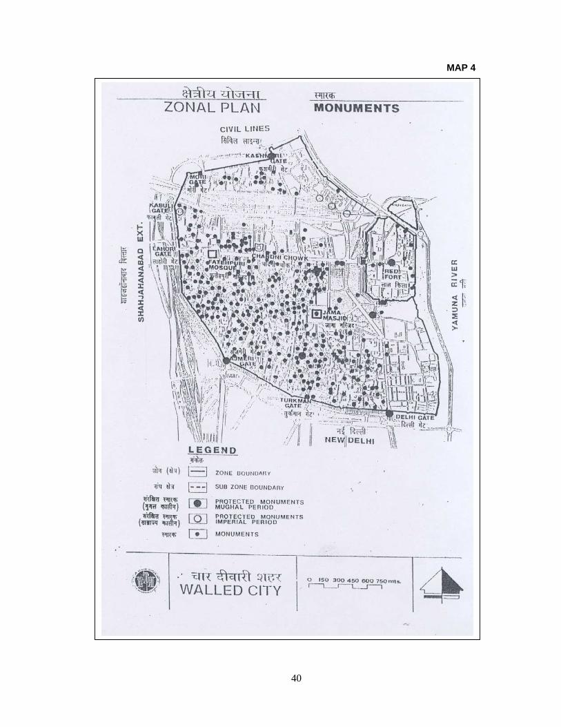
40
MAP 4

41
MAP 5