?z - sandiegocounty.gov · locator map t lakeside mobility element network san diego county general...
TRANSCRIPT

?z
?z
?z
?j
!"_$
?h
!(
!(
!(
!(
!(
!(
!(
!(!(
!(!(
!(!(!(
!(
!(!(
!(
!(
!( !(
!(
!(
!(
!(
!(!(
!(
!(
!(!(
!(
!(
!(!(!(
!(
!(
!(
!(
!(!(
!(
!(
!(
Central Mountain
Barona
Alpine
Crest - Dehesa
Ramona
35
Lakeside
POWAY
EL CAJON
LA MESA
SAN DIEGO
SANDIEGO
SANTEE
1
2
3
4
5
6
7
89
910
1211 13
15
1617
1819
20 21
22
23
24
25
2728
29
30
3132
33
34
3638
39
37
40
4142
43
14
26
28
##
##
##
##
##
##
##
# # # # # # # # #
##
##
##
##
##
##
###
##
###
##
##
##
##
# # # # # # #
!(!(
!(
!(
!(
!(
!(
!(
!(43
42
41
40
37
39
38
35 36
EL CAJON
SANTEESR-67 NB
SR-67
RA
REX L
N
SR-67
SB
GRAVES AV
CLOV
E STVU
LCAN
ST
HART DR
POIN
CIAN
A DR
N MA
GNOL
IA AV
GRETA ST
SUMNER AV
BATE
S LN
GREENFIELD DR
ROXA
NNE D
R
TOPPER LN
DENNY WY SOMER
MONT D
RN
01ST
ST
PEPPE
R VILL
A DR
N ANZ
A STPIE
RRE
WY
SHEIL
A ST
SHIR
-MAR
PL
TETO
N DR
N 01
ST STLocator Map
LAKESIDE MOBILITY ELEMENT NETWORKSan Diego County General Plan Figure M-A-10
0 1 2Miles I
Map Date: March 2018 Source: County of San Diego1
Road NetworkExpressway / FreewayPrime ArterialMajor Roads SeriesBoulevard SeriesCommunity Collector SeriesLight Collector SeriesMinor Collector SeriesLocal Public Roads
Bicycles and Pedestrians! ! ! Bike Path - Class I# # Bike Lane - Class II
Bike Route - Class IIIOther%, Public Airport") Military Airport
Rail/Transit CorridorRegional Trail
##
###
###
#
#
# #
##
##
####
##
#
!!
!! ! ! ! !
!! ! !
!!
!
!!
!!
!!
!
!!
!!! !
!! ! ! ! ! ! ! ! ! ! ! ! ! !
!!
!!
!!
!!
!!
! ! ! ! ! ! !!!!!
!!
!!
!
! ! ! ! !
##
##
##
##
#######
##
##
######
###
##
####
###
##
#
###
###
##
###
######
#####
##
##
##
#
###
##
#
#########
##
#### # # #
#
#
# ##
# ##
# # ##
##
##
# ####
###
##
##
##
##
###
####
# # # # # #
##
##
##
##
###
###
##
##
##
#
# # # # # # # # # # # #
##
#
!(
!(
!(!(
!(
!(!(
!(
!(
!(
!(
!(
!(!(
!(
4
14
3231
24
23
17
15
1311
12
10
SR-67
JULIAN AV
WILLOW RD
SR-67 SB
PINO DR
LAKESHORE DR
WOODSIDE AV
ASHWOOD ST
MAPLEVIEW ST
LAKEVIEW RD
VALLE VISTA RD
PETITE LN
LEMON CREST DR
VINE
ST
RIVERVIEW AV
LAKE
SIDE A
V
EL M
ONTE
RD
LINDO LN
COPING PL
LAUREL ST
MORENO AV
INDUSTRY RD
ROCKCREST RD
A AV
AUDU
BON
RD
VALLE VISTA BY
CUNNING LN
CASA GRANDE AV
SHAYANN LN
ASHWOOD ST
MAPLEVIEW ST
LEGEND

M O B I L I T Y E L E M E N T N E T W O R K A P P E N D I X
C O U N T Y O F S A N D I E G O G E N E R A L P L A N
M-A-33
Mobility Element Network—Lakeside Community Planning Area Matrix
IDa Road Segment
Designation/Improvement
#.#X = [# of lanes].[roadway classification][improvement] Special Circumstances
Scripps Poway Parkway (SA 780)
Segment: Poway city limits to SR-67
6.2 Prime Arterial None
State Route 67
Segment: Poway city limits to Santee city limits
4.1B Major Road
Intermittent Turn Lanes—Poway city limits to Scripps Poway Parkway
4.1A Major Road
Raised Median—Scripps Poway Parkway to Mapleview Street
6.1 Expressway
Mapleview Street to Santee city limits
Accepted at LOS E/F
Segments: Poway city limits to Sycamore Park Drive and Johnson Lake Road to Posthill Road
Additional Improvements
Full interchange at Winter Gardens Boulevard
Overpass at Mapleview Street
Realign Willow Road with Lakeside Avenue and provide a SR-67 overpass
Posthill Road (SC 1790)
Segment: SR-67 to Valle Vista Road
2.2E Light Collector None
Valle Vista Road (SC 1791)
Segment: Posthill Road to Riverside Drive
2.2E Light Collector None
Manzanita Road/ Pinehurst Drive (SC 1780)
Segment: Post Hill Road to Oak Creek Drive
2.2E Light Collector None
Oak Creek Drive/Palm Row Drive (SA 1800)
Segment: Manzanita Road to Riverside Drive
2.2E Light Collector None
El Nopal (SC 1775)
Segment: Santee city limits to Riverside Drive
2.2E Light Collector None
Riverford Road (SC 1800)
Segment: Riverside Drive to Woodside Avenue
6.2 Prime Arterial
Riverside Drive to westbound SR-67 ramp
4.1B Major Road
Intermittent Turn Lanes—Westbound SR-67 ramp to Woodside Avenue
None
Mast Boulevard/Riverside Drive (SA 880.2)
Segment: Santee city limits to Channel Road
4.1B Major Road
Intermittent Turn Lanes
None
11
22
33
44
55
66
77
99
88

M O B I L I T Y E L E M E N T N E T W O R K A P P E N D I X
C O U N T Y O F S A N D I E G O G E N E R A L P L A N
M-A-34
Mobility Element Network—Lakeside Community Planning Area Matrix
IDa Road Segment
Designation/Improvement
#.#X = [# of lanes].[roadway classification][improvement] Special Circumstances
Lakeside Avenue (SA 880)
Segment: Valle Vista Road to SR-67
4.1B Major Road
Intermittent Turn Lanes—Valle Vista Road to Channel Road
2.2E Light Collector
Channel Road to SR-67
None
Channel Road (SC 1910)
Segment: Lakeside Avenue to Julian Avenue
4.1B Major Road
Intermittent Turn Lanes—Lakeside Avenue to Mapleview Street
2.2B Light Collector
Continuous Turn Lane—Mapleview Street to Woodside Avenue
2.2C Light Collector
Intermittent Turn Lanes—Woodside Avenue to Julian Avenue
None
Woodside Avenue (SF 731)
Segment: Santee city limits to Vine Street
4.2A Boulevard
Raised Median
Accepted at LOS F
Segment: State Route 67 northbound ramp to Riverford Road
Maine Avenue (SF 1400)
Segment: Mapleview Street to Los Coches Road
2.2E Light Collector
Mapleview Street to Woodside Avenue
2.1D Community Collector
Improvement Options—Woodside Avenue to Los Coches Road
Accepted at LOS E/F
Segment: Mapleview Street to Woodside Avenue
Shoulder as Parking Lane
Separate Bike Lane required—Mapleview Street to Los Coches Road
Vine Street (SA 841)
Segment: Mapleview Street to Woodside Avenue
2.2E Light Collector Shoulder as Parking Lane
Separate Bike Lane required—Mapleview Street to Woodside Avenue
Julian Avenue (SC 1910)
Segment: Channel Road to Lake Jennings Park Road
2.2C Light Collector
Intermittent Turn Lanes
Right-of-Way Limitations Potential due to existing development
1010
1111
1212
1313
1414
1515

M O B I L I T Y E L E M E N T N E T W O R K A P P E N D I X
C O U N T Y O F S A N D I E G O G E N E R A L P L A N
M-A-35
Mobility Element Network—Lakeside Community Planning Area Matrix
IDa Road Segment
Designation/Improvement
#.#X = [# of lanes].[roadway classification][improvement] Special Circumstances
El Monte Road (SC 1920)
Segment: Lake Jennings Park Road to Alpine community boundary
2.3C Minor Collector None
Willow Road (SA 820)
Segment: SR-67 to Wildcat Canyon Road
2.2E Light Collector Recommended Improvement
Align Willow Road with Lakeside Avenue and provide underpass at SR- 67
Moreno Avenue (SC 1772)
Segment: Vigilante Road to Willow Road
2.2E Light Collector None
San Vicente Avenue (SC 1790)
Segment: SR-67 to Moreno Avenue
2.2E Light Collector None
Vigilante Road (SC 1772)
Segment: SR-67 to Moreno Avenue
2.2B Light Collector
Continuous Turn Lane
Recommended Improvement
Align Slaughterhouse Canyon Road with Vigilante Road to form a four-way signalized intersection at SR- 67
(Unnamed) Muth Valley Connection
Segment: Moreno Avenue to Wildcat Canyon Road
Local Public Road Public Road on Mobility Element
Provide emergency access and connectivity for future development
Wildcat Canyon Road (SA 340.2)
Segment: Willow Road to Ramona CPA boundary
2.1D Community Collector
Improvement Options [Passing Lanes]
Accepted at LOS F
Segment: Willow Road to Ramona CPA boundary
Ashwood Street (SA 340)
Segment: Willow Road to Mapleview Street
4.1A Major Road
Raised Median
None
Mapleview Street (SC 1805)
Segment: Winter Gardens Boulevard to Lake Jennings Park Road
4.1A Major Road
Raised Median
Accepted at LOS F
Maine Avenue to Ashwood Street
Recommended Improvement
Underpass at SR-67
Lake Jennings Park Road (SA 810)
Segment: Mapleview Street to Old Highway 80
4.1B Major Road
Intermittent Turn Lanes
Accepted at LOS F
Segment: I-8 Business Route to I-8 westbound ramp
1616
1717
1818
1919
2020
2121
2222
2323
2424
2525

M O B I L I T Y E L E M E N T N E T W O R K A P P E N D I X
C O U N T Y O F S A N D I E G O G E N E R A L P L A N
M-A-36
Mobility Element Network—Lakeside Community Planning Area Matrix
IDa Road Segment
Designation/Improvement
#.#X = [# of lanes].[roadway classification][improvement] Special Circumstances
Broad Oaks Road (SC 1930)
Segment: Hawley Road to Alpine CPA boundary
2.3C Minor Collector None
Blossom Valley Road (SA 830.1)
Segment: Lake Jennings Park Road to Quail Canyon Road
2.2D Light Collector
Improvement Options—Lake Jennings Park Road to Quail Canyon Road
2.2E Light Collector
Intermittent Turn Lanes—Quail Canyon Road to Quail Canyon Road
None
Quail Canyon Road
Segment: Blossom Valley Road to Hawley Road
2.2E Light Collector None
Hawley Road (SC 1940)
Segment: Old Highway 80 to Broad Oaks Road
2.3C Minor Collector None
Old Highway 80 (SA 895)
Segment: Pepper Drive to Alpine CPA boundary
4.2B Boulevard with Intermittent Turn Lanes
Intermittent Turn Lanes—Pepper Drive to Lake Jennings Park Road
4.1B Major Road
Intermittent Turn Lanes—Lake Jennings Park Road to Marina Springs Lane
2.2B Light Collector
Continuous Turn Lane—Marina Springs Lane to Alpine CPA boundary
None
Lakeview Road (SC 1890)
Segment: Los Coches Road to Julian Avenue
2.2E Light Collector None
Los Coches Road (SF 1400)
Segment: Julian Avenue to Interstate 8
2.1D Community Collector
Improvement Options—Julian Avenue to Old Highway 80
4.1B Major Road
Continuous Turn Lane—Old Highway 80 to Interstate 8
Accepted at LOS E/F
Segment: Woodside Avenue to I-8 Business Route
Shoulder as Parking Lane
Separate Bike Lane required—Mapleview Street to Woodside Avenue
2727
2929
3030
3131
3232
2626
2828

M O B I L I T Y E L E M E N T N E T W O R K A P P E N D I X
C O U N T Y O F S A N D I E G O G E N E R A L P L A N
M-A-37
Mobility Element Network—Lakeside Community Planning Area Matrix
IDa Road Segment
Designation/Improvement
#.#X = [# of lanes].[roadway classification][improvement] Special Circumstances
Melrose Extension
Segment: Winter Gardens Boulevard to Los Coches Road
Local Public Road None
Winter Gardens Boulevard (SF 1399)
Segment: SR-67 to El Cajon city limits
4.1A Major Road
Raised Median—SR-67 to Woodside Avenue
4.2A Boulevard
Raised Median—Woodside Avenue to Lemon Crest Drive
4.1A Major Road
Raised Median—Lemon Crest Drive to El Cajon city limits
Recommended Improvement
Full interchange for SR-67
Magnolia Avenue (SC 850)
Segment: Santee city limits to El Cajon city limits
4.1B Major Road
Intermittent Turn Lanes
None
Graves Avenue (SC 1880)
Segment: Pepper Drive to Bradley Avenue
4.1B Major Road
Intermittent Turn Lanes—Pepper Drive to Bradley Avenue
2.2C Light Collector
Intermittent Turn Lanes—Bradley Avenue to El Cajon city limits
None
Pepper Drive (SC 1870)
Segment: Graves Avenue to El Cajon city limits
2.2C Light Collector
Intermittent Turn Lanes—Graves Avenue to Bradley Avenue
4.1B Major Road
Intermittent Turn Lanes—Bradley Avenue to Winter Gardens Boulevard
2.2C Light Collector
Intermittent Turn Lanes—Winter Gardens Boulevard to El Cajon city limits
None
Bradley Avenue (SA 890)
Segments: El Cajon city limits to El Cajon city limits (near Mollison Avenue) and El Cajon city limits to Pepper Drive
4.1B Major Road
Intermittent Turn Lanes
None
3333
3434
3535
3636
3737
3838
M O B I L I T Y E L E M E N T N E T W O R K A P P E N D I X
C O U N T Y O F S A N D I E G O G E N E R A L P L A N
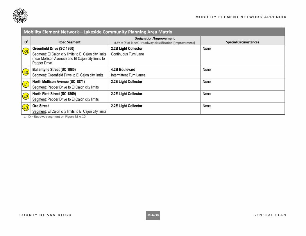
M-A-38
Mobility Element Network—Lakeside Community Planning Area Matrix
IDa Road Segment
Designation/Improvement
#.#X = [# of lanes].[roadway classification][improvement] Special Circumstances
Greenfield Drive (SC 1860)
Segment: El Cajon city limits to El Cajon city limits (near Mollison Avenue) and El Cajon city limits to Pepper Drive
2.2B Light Collector
Continuous Turn Lane
None
Ballantyne Street (SC 1880)
Segment: Greenfield Drive to El Cajon city limits
4.2B Boulevard
Intermittent Turn Lanes
None
North Mollison Avenue (SC 1871)
Segment: Pepper Drive to El Cajon city limits
2.2E Light Collector None
North First Street (SC 1869)
Segment: Pepper Drive to El Cajon city limits
2.2E Light Collector None
Oro Street
Segment: El Cajon city limits to El Cajon city limits
2.2E Light Collector None
a. ID = Roadway segment on Figure M-A-10
3939
4040
4141
4242
4343