your guide to making a planning application (householder ... · planning application ... dormer...
TRANSCRIPT

Your guide to making a planning application (Householder and Relevant Demolition in a Conservation Area)
Introduction This guide is to help you make your application. We can’t cover everything, planning can be complex, so
please contact us if you need more information or advice.
When to make a householder and relevant demolition application This application type should be used for household developments such as: Extensions; Conservatories;
Porches; Dormer windows; Alterations (new windows/doors, cladding, solar panels, microwave aerials,
wind turbines); Fences or walls where, in addition, the works involve the demolition of an unlisted
building in a Conservation Area. It should not be used for non-household developments such as: New
house in the garden; Use of part or whole of property for business use; Conversion to 2 or more
dwellings.
You will need a different form for other types of joint planning application, or for singular applications for
planning permission or relevant demolition in a conservation area. If you are not sure which form to use
for your application, please contact us – we are happy to help.
Before you make your application Pre-application advice can often help to resolve issues and save you time and expense. We offer a pre-
application advice service to provide advice on policy and design issues. For pre-application advice it is
expected that you will submit your proposals in writing, describing your proposals and the site with
sketch plans and relevant photographs.
A Duty Planner is available to discuss very minor proposals, between 9.00am and 5.00pm, Monday to
Thursday and between 9.00am and 4.00pm on Fridays. This service is provided on a first come-first
served basis. Appointments with a Duty Planning Officer are not available. Appointments to deal with
current applications need to be made directly with the case officer.
When planning permission is granted, it is on the basis of the detailed plans submitted. It is therefore imperative that you make sure that the details you submit are those that you want to undertake, as even
minor changes from the approved plans can require a fresh planning application, which will be subject to
exactly the same process as before.
Making your application There are two ways to make an application:
• online via the Planning Portal at www.planningportal.co.uk/apply
• printable application forms at www.planningportal.co.uk/info/200126/applications/61/paper_forms
For hard copy submissions, it is important we receive one original and one duplicate copy of the form, plans and documents. In addition, if available, it would be helpful to receive an electronic copy
of documents and plans.

All information submitted as part of an application is available for public inspection. If you intend to provide information that could be sensitive or breach your data protection rights, please contact us for further advice before proceeding. Prior to submitting your application please read our privacy statement for details of how your data is used. This can be found at www.kettering.gov.uk/privacy Completing the application form The application form is designed to provide a base level of information about you and your proposal.
Please ensure that you complete all of the questions.
Ownership Certificate and Agricultural Land Declaration Every application for Planning Permission must be accompanied by a two part signed statement
confirming that notice of the making of the application has been given to any other owners and / or
tenants of agricultural holdings on the site. There is a range of four certificates to choose from, known as A, B, C and D. The guidance below will
help you to choose the right one. Contact the Planning Department if you are unsure - this may save
you time later. An "owner" means a person or body having a freehold interest, or a leasehold interest with more than
seven years unexpired. There is no need to serve notice on other tenants (except tenants of agricultural
holdings), or on mortgage lenders. "Agricultural holding" and "Agricultural tenant" have the meanings given by reference to the definition of
"agricultural tenant" in Section 65(8) of the Town and Country Planning Act 1990. The land will not meet
this definition unless it is (a) agricultural land, and (b) occupied by others under some form of agricultural
tenancy
• If the applicant is the sole owner of the land to which the application relates and "None of the land
to which the application relates is, or is part of, an agricultural holding" Certificate A should be
completed. This Certificate is not appropriate unless you are the sole freehold owner of all of the
land within the application site.
• If the applicant is not the sole owner of the land or if any part of the application site goes outside
land in their ownership (even if only foundations), and/or there is an agricultural tenant on any
part of the land, notice needs to be served in one of the following forms:
o Where notice has been served on all other owners and agricultural tenants (if any),
Certificate B should be completed.
o Where notice has been served on some other owners and agricultural tenants, but you do
not know the identity of all of them, you will need to complete the Notice and publish it in a
local newspaper. Then Certificate C should be completed.
o If you cannot identify any of the other owners and/or agricultural tenants, then you will need
to complete the Notice and publish it in a local newspaper. Then Certificate D should be
completed.
Knowingly or recklessly submitting a false certificate is an offence.

Drawings and documents to accompany your application In addition to the application form, you will need to submit plans and possibly other documents to
describe your proposal and to explain how it affects or is affected by issues such as flooding,
contamination etc. The circumstances when these documents are required are set out in the application
form and in our “Local Requirements” which should be checked before submission of the application. A
bespoke list of “Local Requirements” relevant to this type of application is attached. Failure to submit all
necessary plans and documents will delay consideration of the application.
It is your responsibility to ensure that you have the consent of the copyright owner before you make
copies of any plans.
You can buy copies of Ordnance Survey maps, to use as site location plans and block plans from us
(telephone 01536 410333 or [email protected]). You can also buy them from
Ordnance Survey Siteplan agents. Unauthorised copying of these or other plans constitutes a breach of
copyright, against which legal action could be taken.
Fees The fee for a householder and relevant demolition application is £206.00. Your application cannot be
considered until the correct fee has been paid. The planning fee is based on the householder
development category. There is no additional fee payable for consideration of the relevant demolition in
a conservation area application. Cheques should be made payable to Kettering Borough Council.
Certain circumstances do not require a fee. The details of exemptions and concessions are set out in
the list of fees. Please tell us with your application if you think you don’t need to pay a fee and why.
Other consents By completing this application you are applying only for Planning Approval and Relevant Demolition in a Conservation Area. In many cases, building works will also require Building Regulations Approval. This is the control of building works for fire resistance, structural stability, ventilation, thermal
insulation and drainage. This application will be dealt with separately from any application submitted for
Building Regulations Approval (which would involve additional forms, plans and fees). It is possible that
planning permission could be refused and Building Regulations Approval given for a specific proposal (or
vice-versa).
You can speak to someone about Building Regulations when you phone about planning permission, or
by contacting the Building Control Service on 01536 534250.
It is up to you to ensure that you have ALL necessary consents before starting work. Work will
not be authorised by the consent unless and until any pre-commencement conditions attached to the
consent have been complied with. Granting consent does not give you the right to enter land or carry out
work on land that you do not own. Consent is only the approval of your proposal by the Council as Local
Planning Authority. You will still need to obtain the landowner’s permission where necessary and any
other civil consents ie covenants contained within your Deeds or Party Wall Act matters. This is your
responsibility. It is always a good idea to talk to your neighbours about your proposal before submitting
your application.

Contacting Development Services Address: Kettering Borough Council, Development Services, Municipal Offices, Bowling Green
Road, Kettering, NN15 7QX.
Phone: 01536 534316. Email: [email protected].
Planning Reception is open between 9.00am and 5.00pm Monday to Thursday and between 9.00am
and 4.00pm on Fridays

Local
Requiremen ts for
Planning
Applications

November 2015
Contents
Page no.
Section
National Requirements
1 General Requirements for Plans, Drawings and Documents (Article 7, DMPO)
1 Drawings Necessary to Describe (Article 7, DMPO)
Local Requirements
4 Biodiversity Survey & Report 5 Flood Risk Assessment 5 Heritage Statement 7 Land Contamination Assessment 7 Structural Survey 8 Tree Survey/Arboricultural Implications
November 2015 1
Local Requirements for Planning Applications
Please note – For the purposes of this guidance, ‘Major Applications’ are applications of 10 or more dwellings (or over 0.5 hectares) and 1000sqm (or 1.0 or more hectares).
NATIONAL REQUIREMENTS: No’s 1 - 3
1. General Requirements for Plans, Drawings and Doc uments (Article 7, DMPO) � All plans and drawings submitted must be clear, legible and able to be viewed electronically
once scanned � All plans and drawings must be drawn to an appropriate metric scale, which should clearly be
identified on the drawing, e.g. 1:100 @ A1/1:200 @ A3. � Vertical and horizontal scale bars assist with measuring from enlarged or reduced drawings � Drawings should be accurate. Ambiguous statements such as "Do not scale" "Not to scale" or
similar call into question the accuracy of the drawing and therefore cannot be accepted. Any quoted dimensions must scale
� Electronic documents must be no larger than 15MB � Electronic drawings can only be accepted in pdf format
For paper submissions, one original and one copy of all documentation should be submitted. For larger applications further copies may be requested at pre-application stage.
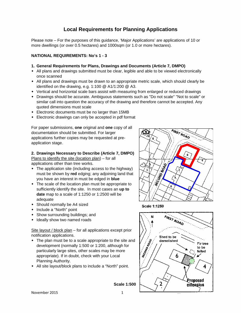
2. Drawings Necessary to Describe (Article 7, DMPO) Plans to identify the site (location plan) – for all applications other than tree works. � The application site (including access to the highway)
must be shown by red edging; any adjoining land that you have an interest in must be edged in blue
� The scale of the location plan must be appropriate to sufficiently identify the site. In most cases an up to date map to a scale of 1:1250 or 1:2500 will be adequate
� Should normally be A4 sized � Include a "North" point � Show surrounding buildings; and � Ideally show two named roads
Site layout / block plan – for all applications except prior notification applications. � The plan must be to a scale appropriate to the site and
development (normally 1:500 or 1:200, although for particularly large sites, other scales may be more appropriate). If in doubt, check with your Local Planning Authority.
� All site layout/block plans to include a “North” point.
Scale 1:500

November 2015 2
The plan should show your proposals for: � The new works in relation to the site boundaries and other buildings within and surrounding
the site; � New buildings should be shown in context with adjacent buildings including property
numbers/names where applicable and roads and footpaths adjoining the site; � On-site access, parking, and turning arrangements and facilities for cycle parking; � Vehicle access visibility splays at the highway boundary; � The species, position and spread of all trees within 12 metres of any proposed building
works; � The extent and type of any hard surfacing; � Boundary treatment (including all heights and materials); � Applications for new developments must include provision for the storage and collection of
waste and recyclables;
Floor plans - for applications altering/creating floor space or use of floor space; � These should show the existing and proposed floor layouts of each storey to be built or
altered; � They should normally be to a scale of 1:50 or 1:100; � New works should be clearly identified and show all openings;
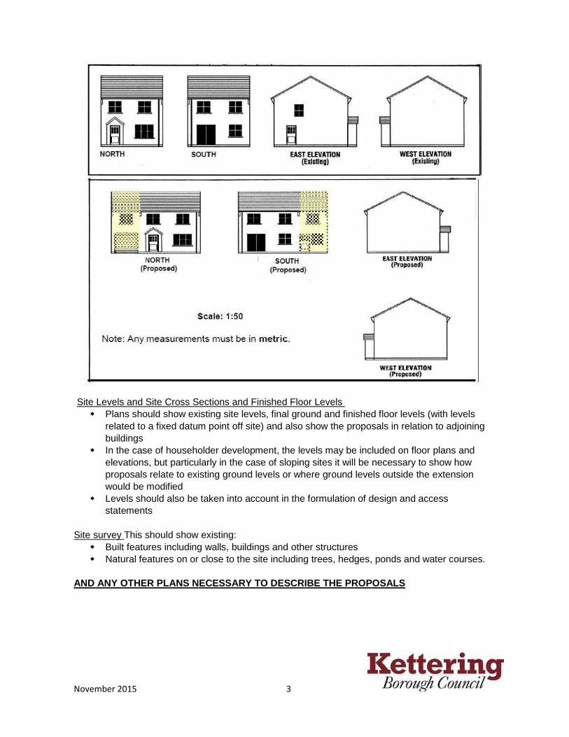
Elevations - for applications erecting or altering exteriors of buildings. � These should show the existing and proposed elevations of each storey to be built or
altered; � They should normally be to a scale of 1:50 or 1:100 � New works should be clearly identified and show all openings � These should show all faces of the building affected by the works, including blank walls � Where the elevation adjoins or is in close proximity to another building, drawings should
show the relationship between the buildings and the position of openings on each property � Existing and proposed drawings should be submitted. Again, they may be drawn separately
or the new work may be indicated by shading etc; � Each elevation should be labelled to show its compass orientation
November 2015 3
Site Levels and Site Cross Sections and Finished Floor Levels � Plans should show existing site levels, final ground and finished floor levels (with levels
related to a fixed datum point off site) and also show the proposals in relation to adjoining buildings
� In the case of householder development, the levels may be included on floor plans and elevations, but particularly in the case of sloping sites it will be necessary to show how proposals relate to existing ground levels or where ground levels outside the extension would be modified
� Levels should also be taken into account in the formulation of design and access statements
Site survey This should show existing: � Built features including walls, buildings and other structures � Natural features on or close to the site including trees, hedges, ponds and water courses.
AND ANY OTHER PLANS NECESSARY TO DESCRIBE THE PROPO SALS

November 2015 4
LOCAL REQUIREMENTS: No’s 4 - 9
4. Biodiversity Survey & Report
The Natural Environment and Rural Communities Act 2006 imposed a statutory duty on Local Authorities to have regard to the purpose of conserving biodiversity.
For major applications a Natural Environment Statement will be required to explain how the planning proposal impacts upon existing biological and geological resources both within and in the vicinity of the site, and the measures to be put in place to both mitigate loss or damage and to compensate when such loss or damage cannot be avoided. The statement will also be required to examine the scope for enhancement of the biodiversity value of the site in the context of the planning proposal, and the extent to which this might contribute to meeting both national and local Biodiversity Action Plan targets.
For all other applications a Natural Environment Statement as above will be required in respect of proposals within or adjoining or, in the opinion of the Local Planning Authority, likely to affect sites protected for their nature conservation interest, such as Sites of Special Scientific Interest, Local Nature Reserves, County Wildlife Sites and Regionally Important Geological or Geomorphological Sites.
Statements will also be required in respect of any sites with known ecological or geological interest or the habitats or potential habitats of species protected under any statutory provisions or identified as priority species under the Biodiversity Action Plan. (Information in respect of Badgers should be presented in a separate report for restricted circulation).
Biodiversity can be a complex area. If your proposal will potentially affect a habitat or species we recommend you consult the following guidance and follow the advice of a qualified ecologist. There are many various types of surveys and assessments that may need to be carried out. Some of them, such as species specific surveys can only be carried out at certain times of the year. All decisions taken on development proposals should be based upon good quality and up to date information. Natural England consider ‘up to date’ to be no older than 18 months. Therefore, survey data older than 18 months may not be accepted.
Detailed guidance on dealing with the impacts of development on biodiversity and geological conservation is given in Government Circular ODPM 06/2005 and Good Practice Guide ‘Planning for Biodiversity and Geological Conservation’:
https://www.gov.uk/government/publications/biodiversity-and-geological-conservation-circular-06-2005 A Local Biodiversity Action Plan (BAP) identifies priorities for action and gives guidance on implementing targets to reverse the loss of habitats and species. The BAP is available at:
http://www.northamptonshirebiodiversity.org/default.asp?PageID=17&n=View+th e+BAP
Where a proposal is likely to have a significant effect on biodiversity interests a broader Environment Statement may be required. This is likely to relate to large scale applications, those affecting watercourses or semi-mature natural environments. Please contact the Local

November 2015 5
Planning Authority for further advice.
Please see Natural England’s standing advice decision tree for identifying when surveys are required for legally protected species.
http://webarchive.nationalarchives.gov.uk/20140605090108/http://www.naturalengland.org.uk/Images/Decision-tree_tcm6-21619.pdf
5. Flood Risk Assessment
Flood Risk Assessments will be required in respect of all planning applications in Flood Zones 2 or 3 or applications with a site area of one hectare or greater. The need for such assessments is governed by the size and description of the proposed development and the location of the site relative to its flood risk potential. The Environment Agency has produced a flood zone map which is available at:
http://www.environment-agency.gov.uk/homeandleisure/floods/31650.aspx
If your site is identified as being at risk of flooding please contact the Local Planning Authority to establish which flood zone is applicable and therefore the need for a flood risk assessment.
Please review the Strategic Flood Risk Assessment for Kettering which is at:
http://www.kettering.gov.uk/site/scripts/documents_info.php?documentID=465&pageNumber=5
or contact Kettering Borough Council to establish which flood zone is applicable and therefore the need or otherwise for a flood risk assessment.
The flood risk assessment should identify and assess the risks of all forms of flooding to and from the development and demonstrate how these risks will be managed taking climate change into account. Technical guidance to the National Planning Policy Framework March 2012 provides guidance in relation to the undertaking of flood risk assessments and the responsibilities for controlling development where it may be directly affected by flooding or increase flooding elsewhere. The technical guidance can be found at:
https://www.gov.uk/government/publications/national-planning-policy-framework-technical-guidance
If a site falls within Flood Zones 2 or 3 and the vulnerability of the development as set out in the technical guidance, is such that a sequential test is required, the sequential test and any exception test shall accompany the planning application.
6. Heritage Statement
If the proposal will affect an historic asset, an Historical Survey or an Impact and Justification Statement will be required to accompany your application.

November 2015 6
(a) Historical Survey
Required for applications for planning permission involving operational development affecting historical sites i.e. within or adjacent to:
� a listed building/structure � the curtilage of a listed building/structure � a conservation area � an historic park or garden � a Scheduled Ancient Monument � an historic battle field
Sometimes this information may be included within a Design and Access Statement. If an application affects such a site an applicant may need to commission an assessment of existing information and submit the results as part of the application in accordance with advice in section 12 the National Planning Policy Framework:
https://www.gov.uk/government/publications/national-planning-policy-framework--2
(b) Listed Building / Conservation Area Impact and Justification Statement
Statements will be required to support all applications for Listed Building Consent.
Impact and Justification Statements
In accordance with section 12 of the National Planning Policy Framework applicants for Listed Building Consent must justify their proposals. They will need to show how the works would affect the special architectural and/or historic interest of the building and its setting. You will need to provide the Local Planning Authority with full information to enable them to assess the likely impact of your proposal. This will involve demonstrating an understanding of the part(s) of the building affected, using annotated drawings and photographs as necessary.
You may submit an assessment of the nature, history and construction of the building to which your proposals relate in order to support your application. Your assessment need only relate to the scope of the proposed works.
You will need to demonstrate to the Local Planning Authority how your proposals contribute to the long term future of the building. This may include a specialist surveyor’s or structural engineer’s report, full schedule of works or method statement detailing the effects on the fabric of the listed building, for example - wiring, plumbing and other services.
In some cases you may be required to provide additional information before your application can be fully considered.

November 2015 7
7. Land Contamination Assessment
Planning applications for any development where contamination is known or likely to exist will require a Part 1 risk assessment. Examples are development of:
� Previous/historic industrial site � Former petrol filling stations � Conversion of agricultural buildings
Applications with sensitive end uses (which include new housing development, schools, hospitals, and children’s play areas) will also require this assessment due to the likely presence of naturally occurring arsenic chromium and vanadium.
A Part 1 risk assessment will comprise:
� Desk study (identifying all previous uses and potential contaminants associated with those uses)
� Walk over site reconnaissance � Conceptual model identifying potential pollutant sources, pathways and receptors as a
basis for assessing the risks and appraising the options for remediation
Applications may also need to include an extended assessment of contamination in line with Annexe 2 of former Planning Policy Statement 23, focussed on local circumstances.
http://webarchive.nationalarchives.gov.uk/+/http://www.communities.gov.uk/publications/planningandbuilding/pps23annex2
Contaminated Land - A Guide for Developers and their advisors can be found at:
http://www.kettering.gov.uk/downloads/file/747/cont_land_developers_guide
8. Structural Survey
Applications for Planning Permission
A structural survey will be required to be submitted with applications for barn conversions. In the open countryside proposals for replacement dwellings will require special justification which may include a structural survey. A survey will also be required for applications involving demolition in a conservation area, demolition of any building identified as being of local historic importance or a building covered by an Article 4 Direction.
Applications for Listed Building Consent
A structural survey will be required for works involving demolition or loss or historic fabric, or when structural works are proposed e.g. roof strengthening or large openings in stone walls.

November 2015 8
9. Tree Survey/Arboricultural Implications
All applications involving operational development on sites containing trees/significant planting or where trees are situated on or overhang the site boundary will be required to be accompanied by an arboricultural report incorporating the recommendations set out in the current BS5837: - Trees in Relation to Construction - Recommendations. This report should include.
� Tree survey drawing and schedule showing the species, size, age, condition and life
expectancy of trees. � A consideration of the ecological value and potential of the trees/planting in question. � A categorization of the trees, tree groups or woodland in terms of their quality and
value within their existing context. � An arboricultural constraints plan showing the tree root protection areas and the effect
that the mature height and spread of retained trees would have on the development. � A tree protection plan. � An arboricultural method statement.

01.06.12 - VAT 20%
O R D N A N C E S U R V E Y R E Q U E S T
Ordnance Survey map extracts for any location within the UK may be provided to any person upon request. Copies can be provided in one of two formats, either printed paper copies or emailed as a tiff image. If a tiff image is requested the data is provided under an Internal Business Use licence that expires 12 months from the date of receipt. Where paper copies are requested, they will generally be in packs of 6 per request. Please complete this form which should be returned to the Planning and Building Reception Desk together with the appropriate fee. A receipt will be issued. Your Name: .......................................................................................................................................
Your Address: ...................................................................................................................................
...........................................................................................................................................................
Telephone Number: ..........................................................................................................................
Site address/location (including postcode): ......................................................................................
...........................................................................................................................................................
....................................................................................... Postcode ................................................
Please state which copies are required by ticking the appropriate box(es) in the table below:
Paper copy
Location plan (always required for planning applications)
Scale Area Paper Size Price (inc VAT) Required 1 to 1250 200m x 200m A4 £25 1 to 2500 400m x 400m URBAN A4 £60 1 to 2500 400m x 400m RURAL A4 £25 Block plan (may be required additionally to a location plan)
Scale Area Paper Size Price (inc VAT) Required 1 to 500 80m x 80m A4 £15
Email copy
Scale Area Paper Size Price (inc VAT) Required 1 to 500 80mx 80m A4 £30.00
1 to 1250 200m x 200m A4 £36.00 1 to 2500 400m x 400m URBAN A4 £89.95 1 to 2500 400m x 400m RURAL A4 £36.00
I would like to collect my map copies from Planning Reception after 12 noon on the next working day.
I would like my map copies to be posted first class on the next working day after the receipt of this order.
I would like my map copy emailed to me at ...........................................................................
(For office use only: Receipt Number: ………………………..….…… Date: ………..……………)


Application Fees Scale of fees from 17th January 2018
Planning Applications:
Works Category of Development Proposal size Fee Payable Maximum fee
Sch 1 Part 2 Cats 1,2,3
Outline application
Site area up to 2.5 hectares
£462 per 0.1ha £11,550
Site area over 2.5 hectares
£11,432 plus £138 per 0.1ha area in excess of 2.5ha
£150,000
Sch 1 Part 2 Cats 1,2,3
Permission in principle
£402 per 0.1ha
Sch 1 Part 2 Cat 1
New dwellings 50 units or fewer £462 per dwelling £23,100 Over 50 units £22,859 plus £138 per unit in
excess of 50 £300,000
Sch 1 Part 2 Cat 2
New buildings or extensions (except dwellings or agricultural buildings) New gross floor space:
None £234 40m2 or less £234 Between 40m2 and 75m2 £462
Between 75m2 and 3750m2 £462 per 75m2 £23,100
Exceeding 3750m2 £22,859 plus £138 per 75m2 in excess of 3750m2 £300,000
Sch 1 Part 2 Cat 3
Agricultural buildings on agricultural land (other than glasshouses) New gross floor space:
465m2 or less £96 1. Between 465m2 and 4215m2
£462 plus £462 per 75m² in excess of 540m² £23,100
Exceeding 4215m² £22,859 plus £138 per 75m2 in excess of 4215m2 £300,000
Sch 1 Part 2 Cat 4
Glasshouses on agricultural land New gross floor area
465m2 or less £96 1. Exceeding 465m2 £2,580 1.
Sch 1 Part 2 Cat 5
Plant or machinery: Erection, alteration or replacement
Site area up to 5.0 hectares £462 per 0.1 hectare £23,100
Site area over 5.0 hectares
£22,859 plus £138 per 0.1ha area in excess of 5.0ha £300,000
Sch 1 Part 2 Cat 6
Extensions or alterations to existing dwellings:
One dwelling £206 Two or more dwellings £407 1.
Sch 1 Part 2 Cat 7
Ancillary operations in curtilage of a dwelling house: gates, fences etc. and incidental buildings £206 1.
Sch 1 Part 2 Cat 8
Car parks, roads and accesses, incidental to existing use, for a single undertaking £234 1.
Sch 1 Part 2 Cat 9
Exploratory drilling for oil or gas:
Operations connected with
Site area up to 7.5 hectares £508 per 0.1 hectare £38,100
Site area over 7.5 hectares
£38,070 plus £151 per 0.1ha area in excess of 7.5ha £300,000
Sch 1 Part 2 Cat 9A
Exploratory drilling for oil or gas:
Other operations not within Cat 9 above
Site area up to 15 hectares £257 per 0.1 hectare £38,550
Site area over 15 hectares
£38,520 plus £151 per 0.1ha area in excess of 15ha £78,000
Sch 1 Part 2
Cat 10(1) Uses
Operations not within above categories Mineral operations
Site area up to 15 hectares £234 per 0.1 hectare £35,100
Site area over 15 hectares
£34,934 plus £138 per 0.1ha area in excess of 15ha
£78,000
Sch 1 Part 2
Cat 10(2)
Operations not within above categories Excluding mineral operations £234 per 0.1 hectare £2,028

Uses Category of Development Proposal size Fee Payable Maximum fee
Sch 1 Part 2 Cat 11
Change of use of a building:
(1) From existing dwelling to two or more dwellings
50 units or fewer £462 per additional dwelling £22,638 Over 50 units £22,859 plus £138 per unit in
excess of 50 £300,000
(2) From other building to one or more dwellings
50 units or fewer £462 per dwelling £23,100
Over 50 units £22,859 plus £138 per unit in excess of 50
£300,000
Sch 1 Part 2 Cat 12
Use for disposal of refuse or waste materials and open mineral storage
Site area up to 15 hectares £234 per 0.1 hectare £35,100
Site area over 15 hectares
£34,934 plus £138 per 0.1ha area in excess of 15ha £78,000
Sch 1 Part 2 Cat 13
Material change of use other than above
£462 1.
Other Applications:
Reg 17 Applications for Non-Material Amendment (a) i) Householder application £34 (b) ii) any other development £234
Reg 18 Certificates of Appropriate Alternative Development £234
Adverts Category of Development Fee Payable Reg 13
Sch 2 Cat 1 Advertisement relating to business on the premises £132
Reg 13 Sch 2 Cat 2
Advance directional signs: not visible from the premises £132
Reg 13 Sch 2 Cat 3 All other advertisements £462
Determinations Whether prior approval is required for Reg 14 Changes of use of buildings or land £96
Reg 14 Part 3 Change of use of buildings or land and building operations in connection with that change of use £206
Reg 14
Part 4 (Temporary buildings and use); Part 6 (Agricultural/forestry); Part 7 (Non domestic extensions, alterations etc); Part 11 (Heritage and demolition); Part 14 (Renewable energy)
£96
Reg 14 Part 16 (Communications)) £462 Others
Sch 1 Para 5 Variation of condition(s) on a planning permission £234 Reg 11 Certificates of Lawful Development
(3)(a) i) for existing uses or operations Same as equivalent planning application fee
(3)(b) ii) for failure to comply with a condition or limitation £234
(3)(c) iii) for proposed uses or operations Half of equivalent planning application fee
Reg 16
Confirmation of Compliance with Conditions i) relating to development to or in curtilage of a
dwelling £34
ii) relating to any other development £116
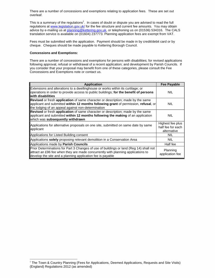
There are a number of concessions and exemptions relating to application fees. These are set out overleaf. This is a summary of the regulations1. In cases of doubt or dispute you are advised to read the full regulations at www.legislation.gov.uk/ for the fee structure and current fee amounts. You may obtain advice by e-mailing us at [email protected], or telephoning us on (01536) 534316. The CALS translation service is available on (01604) 237773. Planning application fees are exempt from VAT. Fees must be submitted with the application. Payment should be made in by credit/debit card or by cheque. Cheques should be made payable to Kettering Borough Council. Concessions and Exemptions: There are a number of concessions and exemptions for persons with disabilities; for revised applications following approval, refusal or withdrawal of a recent application; and development by Parish Councils. If you consider that your proposal may benefit from one of these categories, please consult the Fee Concessions and Exemptions note or contact us.
Application Fee Payable Extensions and alterations to a dwellinghouse or works within its curtilage; or operations in order to provide access to public buildings; for the benefit of persons with disabilities
NIL
Revised or fresh application of same character or description; made by the same applicant and submitted within 12 months following grant of permission, refusal, or the lodging of an appeal against non-determination
NIL
Revised or fresh application of same character or description; made by the same applicant and submitted within 12 months following the making of an application which was subsequently withdrawn
NIL
Applications for alternative proposals on one site, submitted on same date by same applicant
Highest fee plus half fee for each
alternative Applications for Listed Building consent NIL Applications solely proposing relevant demolition in a Conservation Area NIL Applications made by Parish Councils Half fee Prior Determinations for Part 3 Changes of use of buildings or land (Reg 14) shall not attract an £96 fee when they are made concurrently with planning applications to develop the site and a planning application fee is payable
Planning application fee
1 The Town & Country Planning (Fees for Applications, Deemed Applications, Requests and Site Visits) (England) Regulations 2012 (as amended)