yodakandyia community centre
TRANSCRIPT
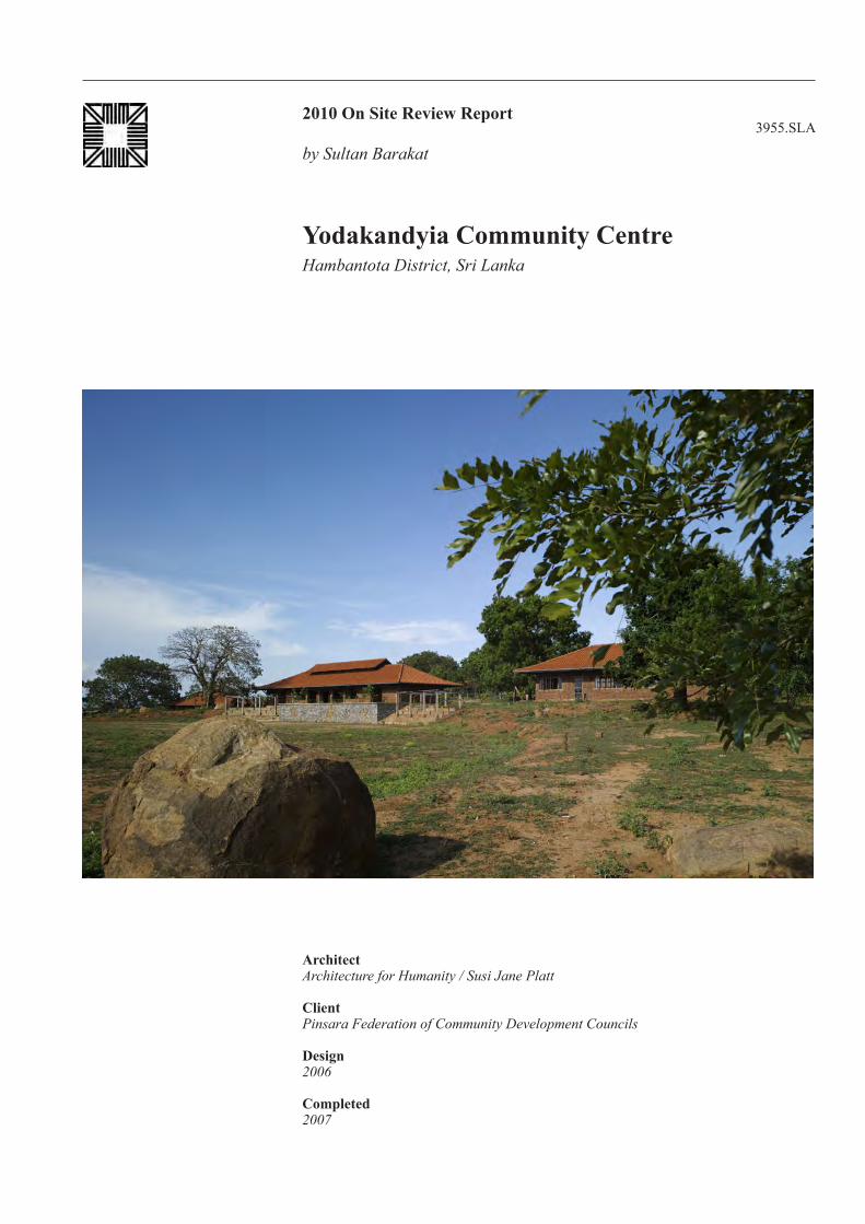
2010 On Site Review Report3955.SLA
Architect Architecture for Humanity / Susi Jane Platt
ClientPinsara Federation of Community Development Councils
Design2006
Completed2007
by Sultan Barakat
Yodakandyia Community CentreHambantota District, Sri Lanka


1
Yodakandyia Community Centre Hambantota District, Sri Lanka I. Introduction
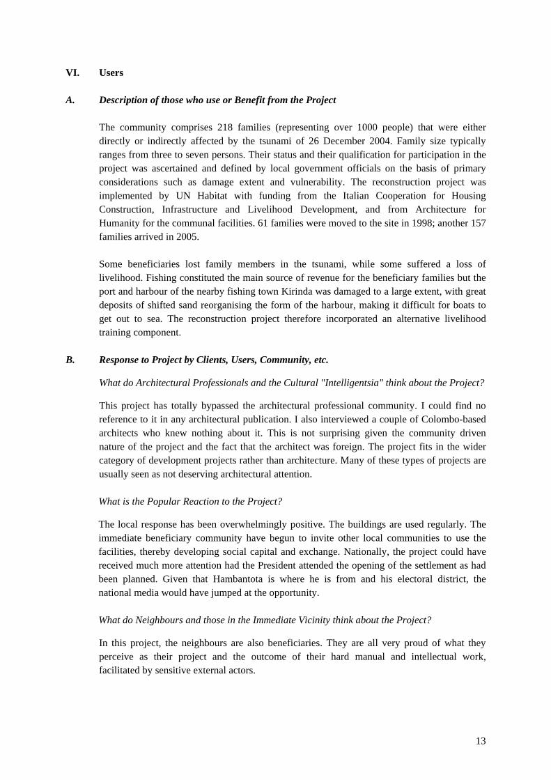
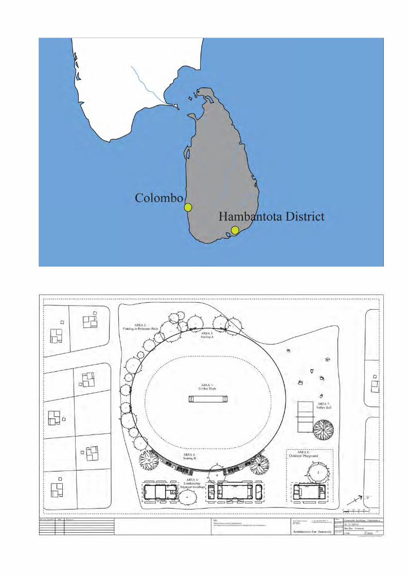
The nominated project is a three-building community centre complex. This complex is situated at the heart of the Yodakandyia housing reconstruction scheme, which was developed for 218 families affected by the 2004 Tsunami. The project is located just outside the town of Tissamaharama, Hambantota District, Sri Lanka. The project includes a community centre, a pre-school, a library and medical centre as well as a cricket pitch and volleyball court. The entire project covers a site of ten acres, of which the community complex takes up 15,125m2
. This post-tsunami reconstruction housing scheme is particularly notable for the level of community involvement in the process, and the number of collaborating funding partners, which included the local government.
The community centre was designed by Architecture for Humanity (AFH) in close consultation with the community, with technical assistance from UN Habitat. The design was commissioned in January 2006. The construction work started in July 2006, and was completed in July 2007. AFH was the sole funder for the community centre while the housing reconstruction project was funded mainly by the Italian government and the Australian Red Cross, and implemented by UN-Habitat.
II Contextual Information A. Historical Background
Tissamaharama is a small ancient town in south eastern Sri Lanka. It used to be the capital of the Sinhalese Kingdom of Ruhuna as early as the 3rd
century BC. The town is best known for its manmade water reservoir (Tissa Wewa Lake) built by King Tissa 2,500 years ago, as part of a sophisticated irrigation system. Over the years, Tissamaharama saw much colonial investment because of its salt production capacity, which, under British rule, brought Malay workers who then settled here permanently. Today, the town mostly serves as the starting point for visits to Yala National Park.
In the 1990s, the town of Tissamaharama was one of a number of settlements the government had already decided to expand in order to accommodate vulnerable groups from the coastal areas under its Village Expansion Programme (This is a longstanding Government Policy that builds on the work of the Land Development Ordinance). By 1998 the settlement had accommodated 61 families, largely former fishing families. The housing provision for this group was basic and the services were very limited. The 2004 tsunami affected great swathes of the population around Sri Lanka’s eastern and south-eastern coastline. An estimated 35,300 people lost their lives, with 21,400 injured. Over 516,000 lost their homes, possessions and livelihoods and became a displaced population.

2
In the immediate aftermath of the tsunami and as part of a wider strategy for the mitigation of its effects, the government reactivated existing laws that called for the establishment of a 300m environmental protection buffer zone along the sea. This meant that hundreds of tsunami-displaced families could not return to rebuild their homes on their original sites, and had to be relocated elsewhere. In collaboration with the government, UN Habitat identified Tissamaharama as a suitable site for expansion, and it was earmarked to accommodate a further 157 families. Given the nature of the Tsunami, the relocated families came from several different communities, but were mostly from the same all-Sinhalese area. The existence of a host community and the diverse community origins of the families meant that for the resettlement to work serious efforts needed to be invested in the building of a common community spirit. Under the guidance of UN Habitat, the government agreed on a community-driven approach for reconstruction and resettlement, which was set to achieve the following objective. “To re-establish a self-sustaining community from a vulnerable group of families affected by the Tsunami through the building of physical and social infrastructure as well as housing, in order to enable them to recover from the Trauma of the Tsunami as soon as possible” (UN-Habitat, Project Completion Report). In August 2005, UN Habitat started to mobilise the displaced communities, working in collaboration with the District Administration and using a master plan drawn up by the Divisional Secretary General as the basis of their work. Three Community Development Councils (CDCs) were formed, and these in turn were subdivided into primary groups (known to the communities as ‘bunches’). Land was provided by the government, and the community did most of the construction themselves or hired local builders to implement it on their behalf. As soon as they completed their homes, the local authorities handed over the property deeds to the families, thus guaranteeing their investment. Having completed the housing reconstruction, the CDCs then formed the Pinsara Federation, which embarked on the realisation of a community centre. It was at this stage that AFH became involved as the sole donor for the community facilities, and provided the resident architect/designer - Susi Platt.
B. Local Architectural Character
The local architectural style represents a mixture of various colonial (Portuguese, Dutch and British) and traditional styles with an evident Malay/Indonesian influence. Long verandas and columns distinguish many of the facades around the town of Tissamaharama. There is one main street comprising two rows of small two storey buildings. The traditional form of construction uses large red bricks (5”x11”) set with lime mortar rather than cement, with roofs traditionally covered by ‘country tiles’. However, more modern buildings tend to use tahlika flat tiles and/or asbestos, and many have tiles on the outside, with sheets of corrugated asbestos on the inside, used as a ceiling. Richer houses have timber ceilings. Another distinctive colonial feature is the use of cornices. Many buildings also have a traditional wooden carving, typically located above the entrance. This feature has its root in the construction of temples and rich houses.
3
C. Climatic Conditions
The climate is very dry for almost ten months of the year and the threat of drought is prevalent. There is one annual rainy season, which falls in June/July. High winds are also prevalent from May until September.
The average yearly temperature ranges from 28 °C (82.4 °F) to nearly 31°C (87.8°F). Day and night temperatures may vary by 4°C (7.20°F) to 7°C (12.60°F).
D. Immediate Surroundings of the Site
The community centre is at the heart of the Yodakandyia housing settlement. The settlement can be accessed via four metalled roads. The site occupies an elevated position, in an otherwise mostly flat landscape. It overlooks Tissa Wewa Lake, 1km away, one of the many reservoirs built around 2,500 years ago by King Tissa to help irrigate the paddy fields. Mountains are visible in the distance, beyond the reservoir. The south and east of the site border the Yala National Park. The project is several kilometres from Tissamaharama town. The entire project enjoys good vegetation cover, and overall the settlement looks and feels lived in. Unlike the community centre buildings, most of the walls of the surrounding buildings are plastered.
E. Topography of the Project Site
The community centre itself is made of three buildings on a stepped layout. The buildings occupy a prominent position of high ground within the otherwise even settlement. The administrative building occupies the highest position, one metre above the main meeting hall. This in turn is 1.5m above the pre-school. The project decreases in elevation by 2.5m in the direction of the reservoir.
III. Programme
A. History of the Inception of the Project
The space for a community centre was already reserved in the original plan of the settlement. In fact, some of the rock formations and trees on the site had already assumed a role as meeting places before the construction of the community centre. However, when the resettlement started, UN Habitat and the government of Italy’s funds were restricted to just the housing project. A new donor was sought to support the community centre. It was a coincidental meeting between AFH representative Susi Platt and an outgoing project consultant that led to AFH’s interest and subsequent role in the project. Susi Platt visited the community, and confirmed AFH’s support. For the duration of the project she lived in the area in order to create a working relationship with the beneficiaries and with UN Habitat. The Pinsara Federation initiated and drove the project, drawing up the initial brief and requests. Technical expertise was provided by AFH and UN Habitat. The design underwent many modifications and alterations, but in the end incorporated all of the federation’s requests, albeit divided into three buildings rather than one large building. The three structures fitted in well with the surrounding small houses, and the arrangement has also helped avoid excessive heat build-up.

4
B. How were the Architects and Specialists chosen?
UN Habitat was already working with the community to realise the aforementioned housing project. They had a ground team of six, including an engineer, Pushpa Kumara; a technical advisor; and community mobilisers. Susi Platt’s work was funded by AFH, which was identified by UN Habitat as a suitable partner. Prior to this, as part of the community-driven approach to housing reconstruction, 16 members of the community received construction training at the local government technical college. These men then passed on their knowledge to other community members by employing them as trainer builders on the site.
The Pinsara Federation chose all other specialists, including local builders and contractors. An established contractor was initially hired to complete the project, but since he was not able to work in accordance with the community’s plan, his contract was terminated and the Pinsara Federation took over the responsibility of construction under the direct supervision of the architect and the UN Habitat technical team.
C. General Programme Objectives
The overall objective of the project was to provide communal facilities for the Yodakandyia community of 1,100 people. Additionally, given the strength of the community, their mobilisation by UN-Habitat, and their experience in building their own houses, an evolving objective for the project was to ensure full community participation. An additional consideration in the design was to maximise the use of local materials. The sudden increase in construction rates following the tsunami had placed a strain on the availability of materials nationwide, thus the use of local material aimed to reduce the net effect on the construction process through minimising transportation. As the project matured, disaster mitigation, particularly for drought, was included in the project designs. The idea of harvesting rainwater had already been used in the housing settlement, but the Community Centre incorporated the idea on a larger scale and adopted a much more innovative design. Finally, given the low level of income in the community, it was considered important to have a design that would entail low future maintenance costs, and one that dealt with climatic constraints.
D. Functional Requirements
The community was directly involved in planning the original brief, and subsequently requested a large number of facilities. This brief then had to be adapted to consider factors such as climate, topography and available resources. The decision was taken to separate the functions into three buildings. The following structures were determined: • Community centre, with offices for the local government officer and officials of the
Pinsara Federation (the community-based organisation representing the beneficiary community).
• Library, I.T. & medical centre. • Pre-school. • Cricket pitch, volleyball pitch.

5
• Soft and hard landscaping, including retaining walls, culverts, steps, seating, site levelling/contouring and planting.
IV. Description A. Building Data
The built-up area is 894m², split into three single-storey buildings. Today, these accommodate office space, an IT suite, a mother and child care clinic, a pre-school, a communal hall and a library space. However, the total land area that belongs to the community centre is 15,165m², including the cricket and volleyball pitches.
B. Evolution of Design Concepts
Response to Physical Constraints
The site layout had already been determined by the position of the housing plots, and was in a central location. The main constraint it presented, which was exploited by the architect, was the slight slope in the direction of the reservoir, which made it necessary to construct a few small retaining walls. Other constraints included existing vegetation, and a number of trees and large rocks. The architect decided to keep these in place, and to work round them. This was partly due to the cost of removal, and also because they provide attractive seating areas that lend additional aesthetic value. The flat part of the site was reserved for the sports pitches. According to the local community, a number of redundant buildings also existed on the site. These were demolished and recycled into rubble for the foundations. The climate played a greater role in conditioning the design. The initial design of the three buildings allowed for cross ventilation, which helped to reduce passive heat build-up. The dry nature of the locality was addressed through the creation of a water-harvesting system: two large underground tanks store sufficient rainwater to provide for basic needs throughout the dry season. The rainwater harvesting system was an idea that evolved from the community, whereby each family home has a precast concrete tank to collect rainwater harvested from the roof. The FAO provided 150 of these individual tanks, while the Disaster Management Centre provided the remaining 68 needed to equip all 218 houses. One constraint of the site came from the overall geographical and political context at the time of the construction. With the site being relatively remote and with strict trade and security check points in place between the capital city and the site, the building was constructed using as many locally-sourced materials as possible. This increased the ease of construction shortened construction times and reduced expenditure. The project thus avoided some of the pitfalls of the increased rate of construction work that followed in the wake of the tsunami, which placed a strain on the island's material resources, further reducing available materials. For example, the price of bricks increased six-fold after the tsunami, while the price of sand rose by a factor of four.

6
Response to User Requirements, Spatial Organisation As mentioned above, the brief for the community centre was developed by representatives of the Pinsara Federation. A series of community action planning meetings helped transform their initial vision into a workable design. The resulting building therefore meets both the needs and desires of the community, who are also its users. However, there is a gap between what the community had in mind and what the government was capable of providing in terms of services offered at the community centre. Today, the buildings are not being used to their full capacity. The clinic, or what started as a medical centre, is an empty room, which is only staffed and equipped by a visiting health worker who comes to the settlement twice a month. The reason given for this was that the nearest fully-staffed clinic is only a few kilometres away. Similarly, the pre-school is still staffed by a volunteer, rather than a teacher employed by the government. This indicates that the brief was driven more by the wants of the community rather than a critical analysis of the practicalities of this scenario, which perhaps would have better complemented the architect’s work.
C. Structure, Materials, Technology
Structural Systems
There are three buildings, set in a line formation, and on different levels. Load-bearing concrete frames are crossed by steel trusses, which support the roofs and allow for maximum span. The roof structure has lightweight circular section steel trusses with timber rafters, purloins and reapers. Clay tiles cover the timber on a steep pitch to ensure efficient shedding of water during monsoon seasons; the angle of pitch is then reduced at the edges by sprocketed eaves (a common vernacular detail) to allow the rain water to slow down and collect in the guttering, from where it is channelled to storage tanks for re-use. The roofs are also supported by sprockets, set at 45% and attached to the concrete pillars. The pillars are encased in masonry. Roof constructions are in timber framework with clay tiles. All roofs have large projecting eaves to protect against solar gain and driving monsoon rains, and rainwater from all roofs is collected via a network of chain drains and concrete funnels into the two large underground harvesting tanks. However, I noticed on my site visit that the majority of the concrete funnels below the chains have been broken by marauding cattle. A UN Habitat grant has now provided for a protective perimeter fence, but the damage had already been done. The bricks were hand-made locally using the natural clay earth rammed into wooden moulds and fired in open-air furnaces; burning leftover rice husks from surrounding paddy fields. The bricks were nine inches in length and were laid in rat-trap bond that contains a cavity, which serves to insulate, in addition to the clay’s own good thermal capacity. According to the architect, Susi Platt, ‘The Rat-trap bond was developed by Laurie Baker in India as part of experimentations in cost-effective housing technologies conducted in the late 1960s’. The wall construction is equal in strength to a standard solid 9" brick wall, but consumes 20% fewer bricks and 20% less mortar. Plus, the bond is attractive in appearance so no plastering was needed, which reduced the cost considerably. However, the community later added plaster to the inside of the pre-school, to stop children from clambering up the walls. Certain bricks
7
were omitted in the laying sequence, forming small openings known as jalis that allow daylight in to the building without the cost of a window.
The buildings have their longest sides orientated perpendicularly to the prevailing winds and large openings on both long elevations allow available cross breezes to penetrate interior spaces. Openings have timber doors and windows, or steel grilles with peacock feathers and other local animals welded into their design for stability and to add interest. Surrounds to all openings are rendered in a mixture mainly consisting of the local earth. The only carved timber screen is over the main entrance to the central building, and bears an inscription detailing AFH’s contribution to the project.
Materials
Material selection was subject to local perceptions and some considerable persuasion was required in order to convince the beneficiaries to accept the selection that the architect felt was most appropriate. The issue was mainly that the more recently available materials such as cement blocks, plastered renders and aluminium profiled sheet roofing were considered new and therefore progressive and desirable, when in fact the locally crafted materials such as bricks made from the local earth, mud-based renders and other clay products, and woven organic roofing materials, would be far more suitable for dealing with the harsh environment. To convince the beneficiaries, the architect focussed on the beauty inherent in the natural products and demonstrated different ways in which these materials could be incorporated into the construction, for example the different bonds of brickwork or the fixing of woven reeds within structured frames, removing open edges etc.
D. Origin of Technology, Materials, Labour Force, Professionals
Technology
The technology used during construction was a mixture of local and foreign technologies. This represented the equal input of Western architectural design and local consultation and modifications. The most dominant feature is the rat-trap bond, developed by Laurie Baker in India as part of his experimentations in cost-effective housing technologies conducted over 40 years. Materials
Materials were locally sourced. Even though the tiles are in an uncommon style, they were manufactured in Sri Lanka. The bricks were made locally by hand using clay directly from the earth and ramming it into wooden moulds. The blocks are then sun-dried and fired in the open using the left over husks from rice cultivation. The handmade process gives the bricks a beautiful texture, with finger marks clearly visible. It also makes the bricks irregular in size and therefore a large mortar joint is required to accommodate the tolerance. Labour Force
The initial plan was to use a commercial contractor to undertake the construction works. Eight applications were tendered, one of which was chosen by the Pinsara Federation and approved

8
by AFH and UN Habitat. However, when that contractor reneged on his obligations approximately a quarter of the way through, the federation appointed a construction committee, which took over all site operations and oversaw the completion of the work by community members themselves.
Practical training workshops were organised to enhance and expand the existing skill set in the locality. For example, the local masons were not in the practice of laying bricks in even coursing, let alone with neat mortar joints. Consequently a masons’ training programme was organised for willing participants, run by the NGO Practical Action. This complemented the training previously organised by UN Habitat, and detailed above.
Professionals
• Pinsara Federation - owners and project managers. • Architect - Architecture for Humanity (Susi Platt). • Technical support and supervision, and community mobilisation - UN Habitat district
office (six members including technical officer and engineer Pushpa Kumara, who acted as the counterpart to Susi Platt).
• UN Habitat, particularly Lionel Hewawasam, have remained in touch with the community, despite the fact that UN Habitat no longer maintains any offices in the South. However, it is worth noting that the community expressed a certain sense of dependency on UN Habitat, in their plans for future projects.
• In addition four volunteer consultants from Challenges Worldwide were present at varying times.
V. Construction Schedule and Costs
A. History of Project Design and Implementation, with Dates
Commission: January 2006 Design start: January 2006 Design completion: July 2006 Structural commencement: July 2006 Structural completion: July 2007 Occupancy: July 2007
B. Total Costs and Main Sources of Financing
The project was funded entirely by AFH. UN Habitat provided in-kind support by funding its own staff, and meeting its own operational costs.

9
Design Fees: Geo-technical, structural and electrical engineering. Other costs: prelims, Profit & Wastage on Base-build; Furniture, Fittings & Fixtures Contract, UN Habitat operating costs, as AFH funded UN-Habitat’s office space and logistics, but not wages for the short period of time in which the community centre extended over the housing reconstruction timeframe. Funds under this item were also used to seek legal advice when the Pinsara Federation decided to break its contract with the original contractor. The exchange rate stayed approximately the same throughout the period, the US dollar gaining slightly on the Sri Lankan rupee.
C. Maintenance Costs
Some elements of maintenance were incorporated into the design. In addition, the Pinsara Federation has recently formed a committee, and carries out all maintenance. At the moment this is only general and basic maintenance - there has been no need for any major maintenance projects such as repainting. Monthly costs amount to Rs. 7,000. This is partly funded by a subscription, or charges from using the community hall. However, the community continues to provide labour on a voluntary basis. The main sign of deterioration on the site has been the destruction of parts of the water harvesting system. The cost of repairing the water-harvesting system has been estimated at Rs. 500,000.
VI. Technical Assessment
A. Functional Assessment
Initially, people were reluctant to move away from their original villages. Given that over 50% of the families living in the buffer zone engaged in fishing in some capacity leaving the cost also meant moving away from their livelihoods. However, as the programme developed and

10
their ownership of land became a reality with official deeds, people started to feel more confident about their new location and started to look for alternative forms of livelihood. The many opportunities created in the construction of the settlement helped the transition. Today, many people’s employment structure has changed, some keep cattle and goats, some working in construction, and some fish in the nearby lake.
The community meeting space in the central building is used frequently, including by people who are not resident in the housing settlement. Residents of the housing settlement and its immediate surroundings can rent it free of charge, while others must pay up to Rs. 600 per day. One building is occupied permanently by the pre-school. This has proved vital for community development and rehabilitation. However, the teacher is a volunteer and remains unpaid; the government rarely funds pre-schools. The space is well utilised and some changes have been carried out, such as rendering the interior of the room up to the window cells’ height in order to stop children from climbing the wall. Glass has also been added to one side of the building to stop animals from walking into the space. On the day I visited the project the room was nicely decorated and exhibited some of the children’s art work; however, there were sadly no books in evidence. The clinic is not in permanent use. Rather, it is only used when the nurse visits. This happens once every two months when the mobile clinic visits the settlement, and every fortnight when the mother and child clinic visits the settlement. The Ministry of Health officials were consulted about the needs for this room and were happy with its design and arrangements. It does however, lack basic amenities such as a wash basin.
The library is not functioning at all at the moment. It started with providing newspapers but that has not been sustained. Notably, the trees which were used as congregation points prior to the construction of the community centre are still valued and used for this purpose today. The importance of this traditional space was illustrated by the fact that the temporary structures associated with the New Year celebrations were erected nearby. The IT room has six computers, but is not linked to the internet. The original computers in the IT room were old computers donated by UN-Habitat; since then, the community has approached a UK based charity.
B. Response to Treatment of Water and Rainfall
The main challenge facing the Yodakandyia housing reconstruction is lack of drinking water. UN-Habitat has tried drilling boreholes, and they did hit water at a depth of 65 metres, but it was of very poor quality. The other possibility was to draw water from the nearby lake, four kilometres away, but this initially met with objections from the local farmers who feared for their share of water for irrigation. Finally, a decision was made to introduce a rainwater harvesting system until a more permanent solution is found. Every house has the possibility of gathering rainwater off its roof into a pre-cast concrete tank. The original idea was for the
11
Ministry of Health and the water board to regularly test the quality of water using UNICEF test kits, but this was never implemented. Nevertheless people continue to use the water and given the context of this settlement, there is a huge amount of merit in installing a water harvesting system. The same concept was later used in the community centre. Today the water gathered by the community centre is exclusively used for communal purposes and not for drinking.
It was disappointing to find that the majority of the concrete funnels were broken or had been taken away, as have the majority of the chains, thus rendering the system ineffective and exposing the water to pollution. Community representatives attributed the damage to wandering cattle. Since then, UN Habitat has made provision for a perimeter fence. The Water Board has now agreed that the settlement can draw water from the lake, and has invested in a limited supply, which is often interrupted, particularly during the dry season.
C. Environmental Response The internal spaces are arranged in a linear configuration creating long, thin buildings, orientated perpendicular to the prevailing wind direction for best cross ventilation. Functions are separated into three buildings in order to avoid inappropriate massing and unnecessary heat build-up within the structure. Such an arrangement also allows good ventilation of all adjacent external spaces. The roof structure has lightweight circular section steel trusses with timber rafters, purlins and reapers. Clay tiles cover the timber on a steep pitch to ensure efficient shedding of water during monsoon seasons; the angle of pitch is then reduced at the edges by sprocketed eaves (a common vernacular detail) to allow the rain water to slow down and collect in the guttering, from where it is channelled to storage tanks for re-use. The residents reported to me that this has a negative effect of climbing back up the roof and dripping into the room below. On the whole the clay tiles perform well to protect the interior of the building from the direct sun radiation and their appearance from underneath is attractive, thus doing away with the need for any ceiling. The height of the buildings permits the warm air to rise high above the occupants' heads and a high-level opening in the roof of one of the buildings allows the hot air to escape, creating the 'Venturi effect'. (Such openings were omitted from the other two buildings for reasons of cost.) However, the existing opening sometimes lets in rain, especially when the wind is blowing horizontally. Large, low-level openings have been built into the design to allow the natural breezes across the site to enter the building and assist in cooling the building down by convection. Openings are multi-directional to account for the seasonal reversal of the wind direction. For this reason the quantity of doors and windows are of maximum value. However, the installation of glass at the bottom of many of the openings has reduced the flow of cool air into the lower parts of the buildings. But this was apparently necessary to keep dogs out, even despite the existence of metal bars.

12
Open spaces built between the walls and roof allow full ventilation of the roof space. This helps to reduce the amount of heat trapped as well as controlling moisture and humidity through convection.
D. Response to, and Planning for, Emergency Situations
The design team looked at all prevailing problems, not just those brought by the tsunami. For example, to reduce the effects drought conditions have on the soil, which can expand or contract depending upon the level of moisture, a buffer zone of sand was laid in the foundations according to national guidelines. Additionally, the roofs of all the houses were anchored to the foundations to mitigate the threat of high winds. However, the roofs were considered of sufficient weight not to be troubled by high winds.
The most significant feature for mitigation is, however, the provision of household/ structural insurance as a result of hard negotiation by UN-Habitat. This unique feature was provided by a private company and has already been tested by household owners.
E. Ageing and Maintenance Problems
There are no significant ageing or maintenance problems aside from maintaining the water-harvesting system, which has also been designed with minimum requirements for maintenance. The issue of the general protection of the site from animal access has now been addressed. The mud bricks will age nicely in terms of colour and will become more integrated with the surroundings.
F. Design Features
The break-up of the functions into three buildings meant that the community centre fits appropriately with the surrounding small houses. The spaces it offers between the buildings are interesting and are used by the community. The sports field is particularly useful. The whole site offers an open space that could be further developed in terms of landscaping, but one that is elevated and can be enjoyed by the community. Overall, the buildings fit very well with the surroundings despite the fact that the brickwork is exposed which is not a traditional practice.
G. Durability and Long-time Viability of the Project
The project has been well received by the community and serves a good function, making it likely to last as a central piece of community life. However, the functions within the community centre need to be better linked to mainstream suppliers. For example, the clinic and the library are both under used. The pre-school would also benefit from formal recognition by the Ministry of Education.
H. Ease and Appropriateness of Furnishings
The space created is clean and easy to furnish. It offers the community maximum flexibility in how they can use the space, a fact that was apparent during my assessment visit, which coincided with the Sri Lankan New Year celebrations.
13
VI. Users
A. Description of those who use or Benefit from the Project The community comprises 218 families (representing over 1000 people) that were either directly or indirectly affected by the tsunami of 26 December 2004. Family size typically ranges from three to seven persons. Their status and their qualification for participation in the project was ascertained and defined by local government officials on the basis of primary considerations such as damage extent and vulnerability. The reconstruction project was implemented by UN Habitat with funding from the Italian Cooperation for Housing Construction, Infrastructure and Livelihood Development, and from Architecture for Humanity for the communal facilities. 61 families were moved to the site in 1998; another 157 families arrived in 2005. Some beneficiaries lost family members in the tsunami, while some suffered a loss of livelihood. Fishing constituted the main source of revenue for the beneficiary families but the port and harbour of the nearby fishing town Kirinda was damaged to a large extent, with great deposits of shifted sand reorganising the form of the harbour, making it difficult for boats to get out to sea. The reconstruction project therefore incorporated an alternative livelihood training component.
B. Response to Project by Clients, Users, Community, etc.
What do Architectural Professionals and the Cultural "Intelligentsia" think about the Project?
This project has totally bypassed the architectural professional community. I could find no reference to it in any architectural publication. I also interviewed a couple of Colombo-based architects who knew nothing about it. This is not surprising given the community driven nature of the project and the fact that the architect was foreign. The project fits in the wider category of development projects rather than architecture. Many of these types of projects are usually seen as not deserving architectural attention. What is the Popular Reaction to the Project?
The local response has been overwhelmingly positive. The buildings are used regularly. The immediate beneficiary community have begun to invite other local communities to use the facilities, thereby developing social capital and exchange. Nationally, the project could have received much more attention had the President attended the opening of the settlement as had been planned. Given that Hambantota is where he is from and his electoral district, the national media would have jumped at the opportunity. What do Neighbours and those in the Immediate Vicinity think about the Project?
In this project, the neighbours are also beneficiaries. They are all very proud of what they perceive as their project and the outcome of their hard manual and intellectual work, facilitated by sensitive external actors.

14
VII. Persons Involved
The client is the Pinsara Federation of Community Development Councils and the 218 related to this federation who were affected by the tsunami. The main project personnel are: Mrs Susi Platt Project Architect - AFH Mr I. A. Hameed Project Manager - UN Habitat Mr Pushpa Kumara Gunawardena Project Engineer - UN Habitat Mr Lionel Hewawasam Mr Shantha Deshapriya SM Wasantha Dissanayake District Team - UN Habitat Mr Jayantha Liyannaarachchi Pinsara Federation - Chairman PP Somipala Pinsara Federation, Key Active Client
Figure Mr Chandrasiri Master Carpenter Mr Nandasena Master Mason Siripala, Vijitha, Assagi, Jagath, Rupa, Piyathylika Key Figures in Construction activities
VIII. Bibiography
I found no published materials about the project apart from the official UN-Habitat and AFH reports.
Sultan Barakat May 2010


Entrance to the community building from the road.
South view of the community building from the inner forecourt of the premises
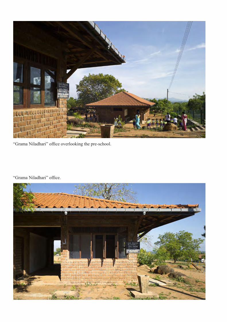
“Grama Niladhari” office overlooking the pre-school.
“Grama Niladhari” office.

Waiting area at the pre-school, overlooking at the community building.
Rear view of the community building, facing the playground.

North -East view of the community building, from the playground.
North-East view of the Community building.

Computer room.
Community gathering in the main building.

Interior view of the library.
Classroom of the pre-school.

Concrete seat of the community building, and detail of the steel grill, representing a peacock feather.
Detail of timber louvres in the computer room.
