yn - library of congress
TRANSCRIPT
Arizona t:anai Y HAER No.-AZ-19 North of the Salt River Phoenix Vicinity Maricopa County Arizona
yn.v,
PHOTOGRAPHS
WRITTEN HISTORICAL AND DESCRIPTIVE DATA
•
Historic American Engineering Record Western Regional Office
National Park Service U.S. Department of the Interior San Francisco, California 94102
HISTORIC AMERICAN ENGINEERING RECORD
Arizona Canal
UK.
HAER No. AZ-19
Location: On the north side of the Salt River, in the city limits of Scottsdale, Phoenix, Glendale, Peoria and the Salt River Indian Reservation Maricopa County, Arizona
UTM: Head: 3,708,655.200MN - 435,817.077ME Foot; 3,721,939.162MN - 386,675.533ME Zone 12
Date of Construction:
Engineers:
Present Owner:
Original - 1883-1885 Extension - 1894 Enlargement - 1907-1909 Minor relocations - 1970s, 1980s
Original construction: Andrew Barry Enlargement: 1907-1909 - W. A Farish, U.S. Reclamation Service
United States Government; operated by the Salt River Project, Phoenix, Arizona
Present use:
Significance:
Conveys water for agricultural, industrial and municipal uses
The Arizona Canal allowed for the development of over 65,000 acres in the Salt River Valley. It improved water distribution to the northside canals and provided water for the first hydropower plants to supply electricity to Phoenix.
Historian: Shelly C. Dudley Salt River Project Research Archives
Arizona Canal HAER No. AZ-19 (Page 2)
TABLE OF CONTENTS
Introduction 3
The Building of the Arizona Canal 5 Excavation Equipment 9
Completion of the Canal and Building the Arizona Dam 10
Camp Life 15
Subsequent Dams 16
Development of Land along the Arizona Canal 19 Arizona Improvement Company 19 Ingleside Inn and the City of Scottsdale 20 Consolidation of the Northside Canals 22 Arizona Water Company 26
Hydropower Plants on the Arizona Canal 27
National Reclamation and Government Purchase 28 Arizona Falls Power Plant 33
Association Repair and Maintenance of the Arizona Canal 38
Depression and World War II Hardships 40
Rehabilitation and Betterment Program 41
Later Modifications to the Arizona Canal 43
Conclusion 46
Glossary 48
Appendix 50
Bibliography 68
Arizona Canal HAER NO. AZ-19 3
Introduction The Arizona Canal is the northernmost canal in the water distribution system of the Salt River Project, located within the urban center of Phoenix in Central Arizona. (See Appendix for map.) The Salt River Valley, at the time of the canal's construction in 1883, already had canals on both the north and south side of the Salt River irrigating portions of the Valley. Yet the men who organized the Arizona Canal Company saw the scorched, desolate desert in the northern part of the Valley and envisioned thousands of additional cultivated acres if they could build another canal to provide the needed water.
Understanding that the barren land could be made more productive, these far-sighted individuals hired a railroad excavator from the Midwest to build the Arizona Canal. William J. Murphy not only was in charge of the construction of the canal, but he also spent much time and effort in financing his own work through the sale of canal company bonds. Unlike earlier canal projects where local landowners either worked on the construction of the canal or helped pay for it, the Arizona Canal was funded primarily through the sale of bonds to investors outside of Arizona. Murphy became so entranced with the Arizona Canal project that later he and his family settled in and around the city of Scottsdale.
Constructed between 1883 and 1885 the Arizona Canal initially spanned 42 miles along the northern portion of the Salt River Valley. An additional 5 miles was added by 1894 at the far western portion of the canal. Murphy employed traditional earth-grading techniques familiar to railroad excavators. Murphy did, however, use new equipment with limited success. The construction of the original Arizona Dam, because of financial constraints, was typical of wooden diversion weirs built during the end of the 19th century. The Salt River floods destroyed the dam a number of times and crews rebuilt it each time using similar methods until the U.S.- Reclamation Service constructed a more permanent structure, the Granite Reef Diversion Dam, at a different location.
Following congressional authorization of the Salt River Project, the United States government purchased the Arizona Canal system in 1906 and the Reclamation Service began a program of improvement and enlargement. The Salt River Valley Water Users1 Association, which operates the Salt River Project's water distribution system today, continues to operate and maintain the canal, making modifications when needed. Flood control projects along the Arizona Canal at both the Cave Creek and Indian Bend washes help protect the canal and the Salt River Project landowners from serious
Arizona Canal HAER No. AZ-19 4
flooding. Currently the Salt River Project is cooperating with the U.S. Army Corps of Engineers in the construction of the Arizona Canal Diversion Channel project which will provide additional flood control. Canal beautification and the multipurpose use of the canal and its right of way are also important attendant benefits of the canal to the Salt River Project today.
As initially planned the Arizona Canal would provide irrigation water for an expanding agricultural economy because of its ability to supply water to almost 100,000 additional acres on the northside of the Salt River. The Arizona Canal helped to develop the Salt. River Valley into a major urban center in the Southwest. Because of the irrigation water conveyed by Arizona Canal, people from across the United States moved to the Valley and established the towns of Scottsdale, Glendale, and Peoria. The canal allowed for citrus groves which became an important cash crop for export. Since the fruit ripened before the California orchards, Arizona citrus could be shipped East prior to the West Coast harvest. Exotic fruits were also grown beyond the staple crops of cotton and alfalfa with water supplied by the Arizona Canal.
Health-seekers came to convalesce in the dry desert climate. The wealthy soon travelled to the Salt River Valley and stayed at such resorts as the Arizona Biltmore and the ingleside Inn near the Arizona Canal.
Arizona Canal hydropower plants, although no longer in existence today, provided the first electricity to the city of Phoenix at the turn of the century. Built by private enterprise, two power houses, one at the Arizona Falls and the other on the Salt River Indian Reservation, supplied electric power to a growing population. The U.S. Reclamation Service later rebuilt the Arizona Falls Power Plant in 1913, which served the Salt River Project electric customers until 1950. Power from the plant on the Indian reservation aided in the construction of Granite Reef Dam before it stopped production.
Today the Arizona Canal provides domestic water to thousands of homes in the Valley, as well as delivering water to the remaining lands still being farmed. Two cities. Phoenix and Glendale, receive water for its treatment plants at three locations along the Arizona Canal. Many homes also receive urban irrigation to water private orchards and lawns.
The men who first conceived of the construction of the Arizona Canal would be proud of its part in the development of the Salt River Valley. From supplying irrigation water and hydroelectricity to an ever increasing number of farmers to supplying domestic water to a major portion of a large
Arizona Canal HAER No. AZ-19 5
urban center in the Southwest, the Arizona Canal has established its role in .the history of the Valley.
The Building of the Arizona Canal In December 1882 three prominent men of the Salt River Valley filed incorporation papers for the Arizona Canal Company. M. W. Kales, Clark Churchill, and William A. Hancock planned on constructing a canal which would take water from the north bank of the Salt River, three-quarters of a mile below its confluence with the Verde River, and move it westward along the northern portion of the Valley ending near the Agua Fria River. The company proposed to irrigate the lands, approximately 100,000 acres, north and beyond the existing northside canals. The company issued capital stock for $500,000 with each share having a value of $500.
In February 1883, the Arizona Canal Company obtained the water right for 50,000 inches from the Salt River filed on March 10, 1882 by Kales, Hancock, John Y. T. Smith, and W. W. Jones. The residents of the Salt River Valley watched the activities of the canal company with great interest. The Weekly Phoenix Herald, a local newspaper, proclaimed that this venture would be "one of the most extensive and valuable enterprises that our valley has yet known."
To start the project, the Board of Directors of the Arizona Canal Company contracted for the excavation of the Arizona Canal with William John Murphy in the spring of 1883. W. J. Murphy, finishing work on grading the roadbed for the Atlantic and Pacific Railroad in northern Arizona, journeyed to Phoenix when he heard of possible canal work in the Salt River Valley.
Born in the East, Murphy grew up in Canada and the Midwest, During the Civil War he served in the First Illinois Light Artillery, taking part in numerous actions from Chattanooga to Atlanta. After the war Murphy moved to Tennessee where he
Incorporation papers filed December 20, 1882; Clark Churchill to H. M. Teller, Secretary of the Interior, May 16, 1883, National Archives, Record Group 75, Special Case 190, Pima.
2 U.S. District Court, Second Judicial District, Maricopa
County, Territory of Arizona, Wormser v. Salt River Valley Canal Company; Arizona Gazette, February 20, 1883, 3:1; Weekly Phoenix Herald, November 17, 1882, 2:3.
3 Merwin L. Murphy, "W. J. Murphy and the Arizona Canal
Company," The Journal of Arizona History, 23 (Summer 1982): 141-142.
Arizona Canal HAER No. AZ-19 6
found work as a school teacher and married Mary C, Bigelow. Murphy subsequently moved his family, which included two children, back to Illinois before Mary died in 1871. Three years later Murphy married Laura Jane Fulwiler who bore him four children. In Pontiac, Illinois, he purchased a hardware store and lumber yard, handled farm equipment and attempted to farm the land himself. Murphy ended up with grading machinery and large excavators taken in lieu of bad debts. Using this equipment, Murphy obtained contracts to grade roadbeds in Illinois and Nebraska. Work took him West, winning contracts with the railroads in Colorado, New Mexico, and Arizona. In 1881, Laura Murphy and the children travelled by train to New Mexico and then by wagon to Flagstaff, Arizona, near where William J. was then working. Murphy's work with the railroad came to an end by the winter of 1882 and the family moved again, this time to Prescott, Arizona. Murphy found temporary work for his men and teams in the Prescott area whence went to Phoenix in search of employment for his crews.
By the end of April 1883 Murphy signed a contract to grade the Arizona Canal. He did not receive cash as payment for his services, however, but obtained bonds in the company which he was required to sell to finance his own work. Since local capital was not sufficient to support this venture, Murphy spent much of his time in Los Angeles, San Francisco, Chicago, and New York attempting to sell these bonds to investors while his crews worked on the canal. Earlier canals built in the Valley were funded by those landowners receiving water from the canal or who exchanged labor on the actual construction for a water right. The local backers of the Arizona Canal Company expected to garner profits not from the actual construction of the canal, but from the sale of land and water rights to new settlers.
As originally envisioned, the Arizona Canal was to extend 50 miles from its head on the Salt River, past the Agua Fria River. It was to have an approximate carrying capacity of 50,000 inches of water. The construction plans for the project called for the first 2 miles of the canal to have a width of 36 feet on the bottom with a slope of sides of 1.5
4Ibid., pp. 140-141
por an in-depth look into Murphy's activities in selling the bonds see Murphy, "W. J. Murphy and the Arizona Canal Company." Developers from outside the territory and local businessmen later organized the Arizona Improvement Company to sell land irrigated by the Arizona Canal. (For further information on this subject see the section on development of land in this report.)
Arizona Canal HAER No. AZ-19 7
to 1 feet in earth and sand, 1 to 1 feet in loose rock and .5 to 1 feet in solid rock. The canal carried a depth of 8 feet of water with a capacity of 1,000 second feet. Below the head of the canal for the first 3.5 miles, the excavation was entirely in rock or gravel, with the gravel cut being 25 feet in places. The width at the bottom of the canal later narrowed to 30 feet and at the surface 65 feet wide. Below this work, the canal was located in a gentle sloping terrain and constructed half in excavation and half in embankment, except for one short rock cut. This cut was 15 feet in depth with a fall built in solid rock 15 feet high, constructed both in order to drop the grade, and avoid excavation in the rock. It was also designed for possible future water power use. (See image AZ-19-1.) After the 22nd mile, the bed-width of the canal was reduced to 16 feet and the depth of water to 6 feet. The grade of the canal was planned at 2 feet to the mile which would give the water a velocity of 2.5 to 3 miles per hour.
The first section of the canal had no berm, but after several miles the canal had an 8-foot berm on the embankment side with the slope being 1.5 to 1-foot. The top width of the bank was 8 feet and its crest was 6 to 8 feet above the bed of the channel. All fills had extra widths and heights-while the curves in the canal were soft and favorably placed.
Construction began on the Arizona Canal on May 7, 1883, but within two weeks work ceased because the canal company had not obtained permission for a right of way on the Salt River Indian Reservation. The headgate and eastern portion of the canal were within the boundaries of the Pima and Maricopa Indians' land. Eventually, Interior Secretary Henry M. Teller approved an agreement between the Arizona Canal Company and the United States government authorising the construction of the canal across the reservation in 1884. In exchange for the right of way, the company promised to construct two bridges across the canal and keep them suitable for the crossing of livestock, as well as construct and keep in repair a water tank for the livestock at each of the bridges. Another provision of the contract required the
Herbert M. Wilson, "American Irrigation Engineering, " in J. W. Powell, Thirteenth Annual Report of the United States Geological Survey to the Secretary of the Interior, 1891-92, Part 3, Irrigation, (Washington: Government Printing Office, 1893) p. 177; Weekly Phoenix Herald, November 1, 1883, 3:1-2, December 20, 1883, 3:2-3; Arizona Gazette, November 20, 1883, 3:2-3; Arizona Agricultural Experiment Station, Bulletin, no. 8, "Irrigation in Arizona," p. 5.
Wilson, "American Irrigation Engineering," p. 177.
Arizona Canal HAER No. AZ-19 8
Arizona Canal Company to furnish the Indians with water for the irrigation of their lands when practicable. The Salt River Indians, in open council, gave their approval to the agreement. Though it took almost ten months to acquire federal authorization, the construction of the canal proceeded.
Engineer Andrew Barry surveyed the first twenty miles of the canal by May so that when Murphy took the contract to grade that portion of the canal he would be able to start as soon as possible; the contract called for Murphy to finish that segment by March 1884. Murphy subcontracted out the grading of the canal to different men: Pat McCormick had a crew of 80 men and 50 teams; William J. McCormick had 40 men and 30 teams, and Henry McKowen worked with 90 men and 60 teams. Murphy hirgd other subcontractors during the construction of the canal.
The different contractors and subcontractors each had specific sections of the canal to work. The first 800 feet of work was light until the crews struck a sand bluff where the cutting was the deepest at 16.5 feet, while the average depth was 12 feet for 2,800 feet. By August 1883, 47 men completed approximately 1.5 miles, with the cut being thirty feet wide at the bottom. J. H. Bryant, with his 30 men and 24 teams, excavated 2,800 feet and moved 43,000 cubic yards of material by November. Murphy expected to finish his five sections of work by the end of 1883. Two crew foreman, Toohey and McKeone, worked on 1.25 miles of the heaviest portion of the project, with 100,000 cubic yards of wash boulders and solid rock moved. The depth of cutting for their section averaged 10 feet with the deepest being 14 feet. P. J. McCormick employed 30 men and 14 teams on his section. The average cut in his area was four feet with sand cement in the bottom which required blasting before a plow could be used. The contractors, during excavation, were paid by the cubic yard at varying prices per yard as graded by the
Phoenix Daily Herald, May 7, 1883 3:2; Memorandum of an Agreement, February 11, 1884; H. M. Teller to the Commissioner of Indian Affairs, September 23, 1884; A. H. Jackson to How. H. Price, Commissioner of Indian Affairs, February 22, 1884, National Archives, Record Group 75, Special Case 190, Pima.
9 Phoenix Daily Herald, August 6/ 1883 3:2; Arizona
Gazette, November 20, 1883, 3:2-3, September 27, 1883, 3:2.
Arizona Canal HAER No. AZ-19 9
chief engineer. The engineer determined whether the work was soft dirt, loose rock or hard rock.
Floods in February 1884 delayed the excavation work on certain portions of the canal. Murphy was forced to move his camp two miles below his current position, not being able to continue his grading in section 17, the district hit hardest with the flood waters. One week earlier, J. T. Simms moved his camp down to the 24th mile, directly opposite J. T. Porter's crossing of the Grand Canal.
Excavation Equipment The men excavating the canal worked in crews, each with its own particular function. The initial group of men cleared away the desert vegetation along the path of the canal with axes and grubbing hoes. Teamsters followed riding long steel-rail sweeps, bolted together, drawn by four horses. The next squad of men drove six to eight mule teams with heavy railroad plows to dig into the hard desert soil along the canal banks and bottom. Their work was finished by animal-drawn steel scrapers, each team closely following the one in front. Husky men at the bottom of the canal filled the scrapers, shaped like wheel-barrows, with the loosened dirt. The drivers would then urge their teams up the embankment with a few choice "picturesque exhortations" to empty the loads at the top.
While working on sections of the canal on the Salt River Reservation, Murphy used new equipment untested in the excavation process. On the initial trial, a new excavator failed completely because of the looseness of the soil, but Murphy planned further tests of the machinery. The men did not like to work on the hard compact soil, but preferred the ground with brush and cholla which indicated a looser soil. The large excavator used in the construction of the canal was
Ibid.; Arizona Gazette, September 27, 1883, 3:2; Weekly Phoenix Herald, December 20, 1883, 3:2-3. From the information obtained, it is not possible to better define the various sections worked on by the subcontractors.
Arizona Gazette, February 11, 1884, 3:1.
Will H. Robinson, Thirsty Earth, (New York: Julian Messner, 1937), p. 102-103. Robinson, a nephew of Laura Murphy, worked on the Arizona Canal and later became an Arizona novelist and author.
Arizona Canal HAER No. AZ-19 10
later employed in-grading the railbed for the Maricopa and Phoenix Railroad.
When Murphy was in San Francisco in the summer of 1884, he ordered special wagons built for carrying lumber, probably preparing for the construction of the Arizona Dam. The wagons were heavy duty with the beds as well as the trail and drawing attachments made in California. Murphy noted that the wagons were good, yet very expensive. About the same time he ordered the wagons, Murphy also ordered a car load of powder. Both the powder and wagons were shipped on the railroad to Maricopa, Arizona where they would then be hauled to the Salt River Valley.
Completion of the Canal and Building the Arizona Dam W. J. Murphy's initial contract required he finish his portion of the canal, a distance of 20 miles, by March 1, 1884. According to local newspaper accounts, Murphy did, but not without much trouble. Because Murphy had difficulty selling the bonds to raise his capital, a number of the subcontractors refused to continue their work until they were paid. Only one contractor, probably J. T. Simms, stayed on the job and Murphy met his deadline. Murphy signed at least one subsequent contract to continue the work on the Arizona Canal.
To divert water from the Salt River into the Arizona Canal a diversion structure was necessary. By late fall 1884, construction of the Arizona Dam started. Because of time constraints imposed on the engineer of the project, a rough crib dam was built across the Salt River. The dam was
W. J. Murphy to Laura Murphy, August 17, 1883, Laura Murphy to W. J. Murphy, February 23, 1885, W. J. Murphy Collection, Arizona Collection, Arizona State University Library. Hereafter all letters authored by W. J. Murphy or Laura Murphy are cited as Murphy Collection, AC, ASUL.
14 W. J. Murphy .to Laura Murphy, September 9, 1884, Murphy Collection, AC, ASUL.
Murphy, "W. J. Murphy and the Arizona Canal Company," 144, 154-157. Simms constructed railroads in the United States and Brazil before working on the Arizona Canal. After he completed his job, Simms purchased four quarter sections of land between Black Canyon Road on the west and Cave Creek Road on the east, with the southern border one half mile north of Washington Street. Typescript, "Recollections of a Son," biographical sketch of James T. Simms, Arizona Historical Society. Laura Murphy to W. J. Murphy, January 26, 18 85, Murphy Collection, AC, ASUL.
Arizona Canal HAER No. AZ-19 11
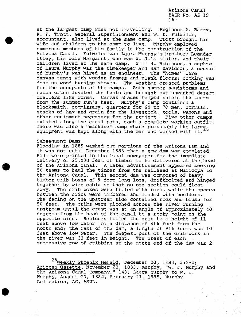
composed of rubble and crib work 173 feet in length and 16 feet in height at the deepest point. The men threw one to three ton stones in the river from a pontoon moored upstream until a bar was formed, causing the water to spill over the entire width of the channel. Shingle brought down from the river bed above filled the openings between the blocks slowing the flow of water. The men then formed cribs 12 feet by 22 feet, consisting of three 24-foot logs, each 12 inches in diameter and 6 feet apart. Four 14-foot by 12-inch logs, spiked together by iron bolts, were secured cross-wise 7 feet apart on the crib. The crew then nailed to the longitudinal logs 2-inch planking to form a platform. The cribs were constructed to a height equal to the depth of water where they were to be sunk. The men then floated the cribs out into the river and placed them in position, loaded with stone until they sunk to the stream bed. The cribs were then filled with stone to the level of the water surface, arranged diagonally to the line of the main weir so they overlapped. Fascines, made of willow two feet in diameter and filled with stone, were placed in the direction of the current, one end touching the crib work along the whole bed. An additional five rows of fascines were laid across the stream against the upper end of the first series with boulders and gravel deposited on top of them. Fascines were also located on the rock breakwater up to the level of the crib top, 16 feet above the river bed. Twenty-four fascines were laid over the crib top parallel to the stream, overlapping the boulder work and filling and binding the whole together. The crews continued to fill the weir with boulders and gravel 8.5 feet higher and top the dam with a finishing layer of fascines 10 fest long. (See figure no. 1) Towards the end of the dam's construction, the crews moved 150 tons of material every 24 hours. The dam and adjoining head works cost an estimated $10,000.
Wilson, "American Irrigation Engineering," pp. 221-222; Laura Murphy to W. J. Murphy, January 22, 1885, Murphy Collection, AC, ASUL.
Arizona Canal HAER No. AZ-19 12
Cross, section
^ji»v/i9ftvv/ff/iv\Y//j>^W^ '/A/* J-5' >
Phxn
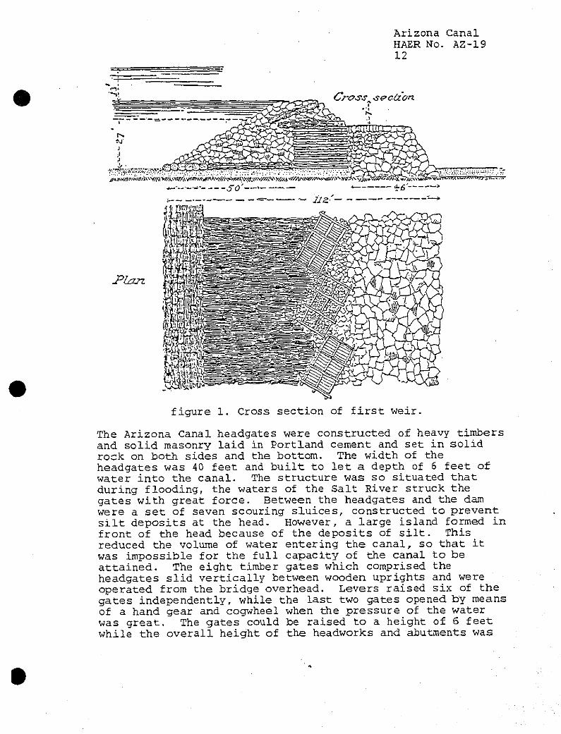
figure 1. Cross section of first weir.
The Arizona Canal headgates were constructed of heavy timbers and solid masonry laid in Portland cement and set in solid rock on both sides and the bottom. The width of the headgates was 40 feet and built to let a depth of 6 feet of water into the canal. The structure was so situated that during flooding, the waters of the Salt River struck the gates with great force. Between the headgates and the dam were a set of seven scouring sluices, constructed to prevent silt deposits at the head. However, a large island formed in front of the head because of the deposits of silt. This reduced the volume of water entering the canal, so that it was impossible for the full capacity of the canal to be attained. The eight timber gates which comprised the headgates slid vertically between wooden uprights and were operated from the bridge overhead. Levers raised six of the gates independently, while the last two gates opened by means of a hand gear and cogwheel when the pressure of the water was great. The gates could be raised to a height of 6 feet while the overall height of the headworks and abutments was
Arizona Canal HAER No. AZ-19 13
17 fef^- This would allow floodwaters of the river to pass.
East of the headgates the men built a waste weir, designed to relieve the dam from pressure during flooding and of scouring out the area above the dam at any stage of the water. Heavy timbers were used in its construction which was 40 feet wide and the same height as the dam. The weir could be either closed or opened at any time. Under the weir gate, a space was left open to allow the force of water to carry through silt, sand and other deposits.
After the construction crews finished with the headgates, they started work on the wasteway, approximately one mile below the head of the canal. The wasteway or escape allowed the discharged water from the canal back into the river. One of the weaknesses of the original Arizona Canal was the lack of wasteways or escapes with the only true wasteway located down from the head of the canal. Below the escape was a set of regulating gates located across the canal which turned the water through the wasteway. The escape, constructed of wood, contained seven simple rectangular gates, operated by a hand lever which raised the gates vertically between upright posts. The gates had a total width of 40 feet and the length of the wooden flume was 80 feet with a height of 12 feet. An apron of wood at the upper end of the escape extended at a 45 degree angle downward for 12 feet into the bed of the canal. The banks of the canal at this point were safeguarded by wooden retaining walls.
During the construction of the dam, the Salt River flooded in the winter of 1884, causing damage to the structure. Despite this setback, the main headgate was completed on December 15, 1884, while over one hundred men worked on the dam to complete it by January 1885. By the end of the month, water was turned into the canal as far as the gates of the wasteway. Most of the canal was finished except for a portion opposite Phoenix and just below the Cave Creek road. Eighteen crews worked on those sections to finish the work within a week. Murphy's men started construction on the bridges crossing the canal at the Black Canyon road, Cave Creek Crossing, McDowell Road and on the Salt River Indian
17 Wilson, "American Irrigation Engineering," pp. 238-241; Phoenix Daily Herald, June 2, 1885, 2:1-5.
18Phosnix Daily Herald, June 2, 1885, 2:2.
19 Arizona Gazette, December 15, 1884, 3:2; Wilson, "American Irrigation Engineering," pp. 246-247.
Arizona Canal HAER No. A2-19 14
20 Reservation in February, 1885. To build the bridges at these crossings, rock from the excavation at the falls was utilized.
Besides flooding problems, the construction crews encountered difficulties in the actual building of the canal. The men at the fourth, eighth, and ninth miles blasted through cemented gravel [probably caliche] and boulders, while at the twenty-sixth and twenty-seventh miles cemented material was harder than solid rock. To cross Indian Bend Wash, a 1,200 foot flume, built on oak pile bents capped with heavy timber, carried the water of the Arizona Canal. At various times during the construction, the men turned water into the canal to test it. In February 1885, at "mile 27" the canal leaked repeatedly. The first repairs did not work, which consisted of scooping out loose stone and filling in with waste material from the old corral and earth hauled in by the wheeled scraper, so an adobe mixture of one or two feet was applied to-the insides of the banks where the leaks occurred.
20 Arizona Gazette, December 15, 1884, 3:2; December 29, 1884, 3:3; January 27, 1885, 3:3; February 2, 1885, 3:1; W. J. Murphy to Laura Murphy, December 22, 1884, Laura Murphy to W. J. Murphy, February 11, 1885, Murphy Collection, AC, ASUL.
21 There has always been a need to cross the Arizona Canal, either by pedestrians or vehicles. None of the original bridges built by the Arizona Canal Company still exist. The bridges today can be decorative, such as the crossing at the Arizona Biltmore Resort (see image AZ-19-55), utilitarian (see image AZ-19-58), or modern highway (see image AZ-19-57). The distinctive Biltmore Bridge was constructed in the early 1930s utilizing the Biltmore block tile design which became a signature for the resort. Sculptor Emry Kopta adapted the original design of Biltmore architect Albert Chase McArthur for the block tiles. Candice St. Jacques Miles, Arizona Biltmore: Jewel of the Desert, (Phoenix: Arizona Biltmore, n.d.), pp. 12-14. Pedestrians can cross the canal using one of the many footbridges that span the canal (see image AZ-19-44). The Salt River Project did not construct any of these structures, but grants permits or licenses to local governments to build the bridges.
22 Phoenix Daily Herald, June 2, 1885, 2:3; Laura Murphy to W. J. Murphy, March 13, 1885, April 5, 1885, Murphy Collection, AC, ASUL; Wilson, "American Irrigation Engineering," p. 178.
Arizona Canal HAER No. A2-19 15
Because the Arizona Canal was constructed on the northern or upper portion of the Salt River Valley, flooding from desert rains would wash into the canal. The canal crossed a number of small drainage streams which had flood discharges of 3 0 to 200 second feet. Simple level inlets permitted the water to flow into the canal so that the water would not be wasted. However, the Arizona Canal also cut through the Cave Creek streambed which could have a 1,000 second foot flood discharge. During those early years there was no way to control the creek's flow, so each flood inundated the land surrounding Cave Creek and broke through the banks of the Arizona Canal. Repair work was a continued necessity until more permanent flood control measures were taken.
Though the Arizona Dam was partially swept away in the spring flooding of 1885, W. J. Murphy notified Clark Churchill, president of the Arizona Canal Company, that he completed the Arizona Canal in June. The finished Arizona Canal extended for 42 miles with headgates at every section line. The developers expected the Arizona Canal to carry 375 cubic feet per second (cfs) of water to irrigate over 75,000 acres. Churchill, Charles A. Marriner, chief engineer, F. C. Hatch, Director of the Arizona Canal Company, W. D. Fulwiler, General Superintendent, and John R. Norton, foreman, toured the canal. Murphy was unable to lead the group along the canal; he was in the East still trying to sell bonds. Churchill accepted the canal as complete and the local newspaper printed notices that the Arizona Canal Company was taking applications to furnish water for irrigating purposes.
The final cost of the Arizona Canal and its appurtenant structures was $608,498.24 which included the repairs on the canal and dam after the 1885 flood. At the time a water right was selling from the Arizona Canal Company for $50Qt-for 80 acres with the yearly water rental at $1.25 per acre.
Camp Life Both men and their work teams lived near the canal while it was under construction. The camps moved as the men finished a particular section; it took about a day and a half to move and set up a new camp. W. J. Murphy resided with his family
23 Wilson, "American Irrigation Engineering," p. 178. 24 Arizona Gazette, April 2, 1885, 3:3; Phoenix Daily
Herald, June 2, 1885, 2:1; November 16, 1886, 4:1; Weekly Phoenix Herald, June 4, 1885; Laura Murphy to W. J. Murphy, April 9, 1885, Murphy Collection, AC, ASUL.
25Arizona Gazette, July 20, 1887.
Arizona Canal HAER No. AZ-19 16
at the largest camp when not travelling. Engineer A. Barry, F. P. Trott, General Superintendent and W. D. Fulwiler, accountant, also lived at the same camp. Trott brought his wife and children to the camp to live. Murphy employed numerous members of his family in the construction of the Arizona Canal. Fulwiler was Laura Murphy's brother; Leander Utley, his wife Margaret, who was W. J.'s sister, and their children lived at the same camp. Will H. Robinson, a nephew of Laura Murphy was the timekeeper and Sam Davidson, a cousin of Murphy's was hired as an engineer. The "homes" were canvas tents with wooden frames and plank floors; cooking was done on wood burning stoves. The weather created problems for the occupants of the camps. Both summer sandstorms and rains often leveled the tents and brought out unwanted desert dwellers like worms. Canvas shades helped shield the tents from the summer sun's heat. Murphy's camp contained a blacksmith, commissary, quarters for 60 to 70 men, corrals, stacks of hay and grain for the livestock, tools, wagons and other equipment necessary for the project. Five other camps existed along the canal path, each a complete working outfit. There was. also a "machine" camp where presumably the larger- equipment was kept along with the men who worked with it.
Subsequent Dams Flooding in 1885 washed out portions of the Arizona Dam and it was not until December 1886 that a new dam was completed. Bids were printed in the local newspaper for the immediate delivery of 25,000 feet of timber to be delivered at the head of the Arizona Canal. A later advertisement appeared seeking 50 teams to haul the timber from the railhead at Maricopa to the Arizona Canal. This second dam was composed of heavy timber crib boxes of 9 foot-long logs, driftbolted and hinged together by wire cable so that no one section could float away. The crib boxes were filled with rock, while the spaces between the cribs were timbered and loaded with boulders. The facing on the upstream side contained, rock and brush for 50 feet. The cribs were pitched across the river running upstream until the crest was at an angle of approximately 40 degrees from the head of the canal to a rocky point on the opposite side. Boulders filled the crib to a height of 11 feet above low water for a distance of 416 feet from the north end; the rest of the dam, a length of 916 feet, was 10 feet above low water. The deepest part of the crib work in the river was 33 feet in height. The crest of each successive row of cribbing at the north end of the dam was 2
26 Weekly Phoenix Herald, December 20, 1883, 3:2-3;
Arizona Gazette, November 20, 1883; Murphy, "W. J. Murphy and the Arizona Canal Company," 148; Laura Murphy to W. J. Murphy, August 23, 1884, February 23, 1885, Murphy Collection, AC, ASUL.
Arizona Canal HAER No. A2-19 17
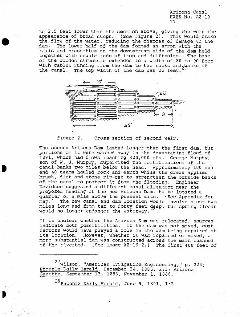
to 2.5 feet lower than the section above, giving the weir the appearance of broad steps. (See figure 2). This would brake the flow of the water, reducing the chances of damage to the dam. The lower half of the dam formed an apron with the rails and cross-ties on the downstream side of the dam held together with double rods of iron and driftbolts. The base of the wooden structure extended to a width of 80 to 90 feet with cables running from the dam to the rocks and-banks of the canal. The top width of the dam was 22 feet.
aj^7!Z7v*
'W?77777T777777?' 7/777777777777 '
k
3fe , •*%?m7i&(l_ T!) 777777T777T- <*r
45'
9 -H. \ I
* S
figure 2. Cross section of second weir
The second Arizona Dam lasted longer than the first dam, but portions of it were washed away in the devastating flood of 1891, which had flows reaching 300,000 cfs. George Murphy, son of W. J. Murphy, supervised the fortifications of the canal banks two miles below the head. Approximately 100 men and 40 teams hauled rock and earth while the crews applied brush, dirt and stone rip-rap to strengthen the outside banks of the canal to protect it from the flooding. Engineer Davidson suggested a different canal alignment near the proposed heading of the new Arizona Dam, to be located a quarter of a mile above the present site. (See Appendix for map.) The new canal and dam location would involve a cut two miles long and from ten to forty feet 4eeP/ but spring floods would no longer endanger the waterway.
It is unclear whether the Arizona Dam was relocated; sources indicate both possibilities. If the dam" was not moved, cost factors would have played a role in the dam being repaired at its location. However, whether it was repaired or moved, a more substantial dam was constructed across the main channel of the riverbed. (See image A2-19-2.) The first 400 feet of
27 Wilson, "American Irrigation Engineering," p. 223; Phoenix Daily Herald, December 24, 1886, 2:1; Arizona Gazette, September 15, 1886, November 1, 1886.
28 Phoenix Daily Herald, June 9, 1891, 1:2.
Arizona Canal HAER No. AZ-19 18
ths dam from the west bank of the Salt River was new construction. The remaining 900 feet was repaired as needed with all sizes of lumber utilized, from planking to big timbers such as 3 feet by 12 feet or 8 feet by 8 feet. Crews built the dam following a stair step design with 5 foot sections of the dam bound together with rods from top to bottom. The upstream row of cribs were planked on the upper side and on the top with its upstream edge 2 feet lower than the crest edge. The second row of cribs was 2.5 feet lower and the third row of cribs dropped another 2.5 feet. The swinging cribs at the base of the downstream side of the dam were attached by 1 inch wire cable. Sheet piling was driven at both the heel and toe of the renewed segment of the dam. This design broke the force of the water flowing over the dam with the water hitting the crest of the dam at about a 12 degree angle. The eastern portion of the dam, according to one engineering report, was constructed with only a set of main cribs and a single apron. Bedrock sometimes reached 24 feet below the river bed. The crews raised the stone walls around the headgates 4 feet and strengthened them with rip-rap. (See images AZ-19-33 and AZ-19-34.)
After the 1891 flood, engineering reports indicate a dike was constructed across the low lying bed of the Salt River from the eastern end of the Arizona Dam to the bluff on the east bank of the river. The purpose of the dike was to prevent the Salt River from creating a new channel there. The dike measured 10 feet in height and was 1,200 feet long.
Exposure to the air and Arizona summer heat caused the planking and the timbers of the dam to decay over time. Towards the end of the century the dam was strengthened and the crest was raised two feet, for a height of 13 feet. Down the whole length of the dam, crews placed four rows of 12 x 12 inch sawed piling through the structure with additional timbers laid horizontally on top. This new cribbing was filled with rock and covered with-,planking. This structure lasted until the floods of 1905.
29 A. P. Davis, "Irrigation Near Phoenix, Arizona," in U.S. Geological Survey, water-Supply and Irrigation Paper, No. 2, (Washington: Government Printing Office, 1897), p. 50; Phoenix Daily Herald, January 8, 1892, 4:1; H. F. Robinson, "Construction, Repairs and Subsequent Partial Destruction of the Arizona Canal Dam, Near Phoenix, Arizona," Engineering News, 53, (April 27, 1905).
Robinson, "Construction, Repairs and Subsequent Partial Destruction of the Arizona Canal Dam."
31Ibid.
Arizona Canal HAER No. AZ-19 19
Development of Land along the Arizona Canal The Phoenix Daily Herald, one of the Salt River Valley's local newspapers, proclaimed that the valley would not be totally settled until the Arizona Canal was completed from the Agua Fria River to the White Tank mountains. The land between the Arizona and Grand canals was becoming quickly occupied with people purchasing the land from either the government or the railroad. During the construction of the canal, developers visited the Salt River Valley to establish new communities for people from the Midwest. 0. Christy and C. A. Mariner considered purchasing land under the Arizona Canal for the settlement of 3,00.0 people.
Arizona Improvement Company To help promote the lands under the Arizona Canal, W. J. Murphy, William Christy, and Clark Churchill organized the Arizona Improvement Company in 1887. The company filed its articles of incorporation with the Maricopa County Recorder which listed J. DeBarth Shorb, Fredrick W. Sharon, Christy, and Churchill as its incorporators. The capital stock of the company was valued at $3,000,000 in 30,000 shares. The first Board of Directors was composed of Shorb, Sharon, Christy, Churchill, Andrew Crawford, Frank G. Newlands, and W. J. Murphy.
The Arizona Improvement Company expected to construct, maintain and operate dams, canals, pumps, and other structures necessary for the flow of water. It planned on purchasing and selling water and land to settlers from other sections of the country; the improvement company already owned approximately 10,000 acres between the Grand and
Phoenix Daily Herald, February 4, 1885, 3:2; W. J. Murphy to Laura Murphy, August 23, 1884, Murphy Collection, AC, ASUL.
Murphy was the largest stockholder of the Arizona Canal Company principally because he received his payment for work in the company's stocks. Leadership of the canal company also fell to Murphy from his experience in selling the Arizona Canal Company bonds. He acquired the knowledge to float loans and sell securities. Besides becoming the canal company's president, Murphy also was an officer in the Arizona Improvement Company. He owned 6,500 shares of stock in the improvement company. Merwin L. Murphy, "W. J. and the Valley: The Story of W. J. Murphy and his part in Developing the Salt River Valley in Arizona," typescript, Salt River Project Archives, 1975, pp. 39, 42.
34Phoenix Daily Herald, May 23, 1887, 2:2, December 13, 1894, 2:1; Arizona Gazette, May 24, 1887, 2:1-2.
Arizona Canal HAER No. AZ-19 20
Arizona canals which it planned to sell to new landowners. Alfred McClatchie of the Agricultural Experiment Station later claimed the company obtained approximately 40,000 acres of public domain land under the Desert Land Act. The corporate officials anticipated selling water rights to lands irrigated by the Arizona Canal, earning profits between $500,000 to $1,000,000 and having yearly water rentals bringing in an additional $100,000. The company designed Grand Avenue, a drive of 15 miles, and the construction of a new large hotel on its property along the roadway. It owned a ranch in the Glendale area with orchards which produced abundant crops in years of good water supply.
Murphy purchased various tracts of land under the Arizona Canal for himself and induced friends and relatives from the Midwest to file on other pieces of land. During the construction of the canal. Murphy and a number of his relatives were able to see the land first hand and discussed on what sections of land they should file. Nannie C. Utley, Murphy's niece filed on Section 26, Township 2 North, Range 4, while his brother Samuel entered on 480 acres of Section 27 in what is now downtown Scottsdale. Nannie Utley's uncle, Albert, filed on Section 35. These filings all occurred in 1885 and 1886. Murphy himself filed on Sections 28 and 29 which contained the Arizona Falls and the tgact of land on which he later built the Ingleside resort.
Ingleside Inn and the City of Scottsdale The development of Ingleside Resort, located near the Arizona Falls, serves as an example of the impact the Arizona Canal had on the local economy. The Arizona Improvement Company started an experimental citrus orchard with over 1,800 young orange and other fruit trees from southern California in 1889. The trees proved so successful other varieties were planted including olive and lemon. Because the Arizona fruit ripened prior to the orchards in Southern California, Arizona landowners could sell their produce to the eastern markets first. Farmers could grow the citrus trees with less acreage and work than the traditional harvests of grains. Following the success of the Arizona Improvement Company's work at
Ibid.,* Geoffrey P. Mawn, "Phoenix, Arizona: Central City of the Southwest, 1870-1920," Ph.D. dissertation, Arizona State University, 1979, pp. 110; Alfred J. McClatchie, "Utilizing Our Water Supply," Arizona Agricultural Experiment Station Bulletin No. 43, (July 28, 1902), University of Arizona, p. 81.
Richard E. Lynch, Winfield Scott: A Biography of Scottsdale's Founder, (Scottsdale: City of Scottsdale, 1978) p. 102.
Arizona Canal HAER No. AZ-19 21
Ingleside, other orchards were planted in the Valley; by the mid-189Qs over 150,000 citrus trees were growing on 1,500 acres.
In order to bring other investors to the Salt River Valley, Murphy planned and later built a private hotel called the Ingleside Club on the property near the Arizona Falls. The clubhouse was finished in 1910 and the grounds contained a golf course and asphalt tennis court. Murphy planted citrus and olive trees on this ten acre townsite with views of Camelback Mountain and the Papago Buttes. In 1912 Murphy used his men, mules, Fresno scrapers, road graders, and land leveling machines to reclaim the land surrounding Ingleside in preparation for cultivation. {See images AZ-19-10 and AZ-19-11.)
Ralph Murphy, William J. Murphy's son, took over operation of the Ingleside property and by the early 1920's it became the Ingleside Inn, the Valley's first resort know as the place, "Where Summer Winters." Ingleside provided accommodations for primarily midwestern guests who wanted to experience western living with an elegant touch. A review of the menu shows that the turkeys were olive-fed, probably from the trees on the property, and the fruit was grown in Ingleside's own orchards. Guests either stayed in the main Inn or in cottages. They could play golf, tennis, go horse-back riding up Camelback Mountain or enjoy native American Indian dances. The Inn later boasted its own polo team which played teams such as the University of Arizona on the property grounds. In 1928 homesites were sold surrounding the golf course. Ingleside Inn was later turned into the Brownmoor School for Girls and the Arizona Country Club purchased the golf course which is still in use today. The Ingleside tract is near the town of Scottsdale, which also owes its existence to the Arizona Canal.
The town of Scottsdale was created because of the construction of the Arizona Canal and its ability to irrigate new lands. Winfield Scott, founder of "the West's Most Western Town," filed on Section 23, in July 1888. He was not the first to file on that land. Morris Goldwater originally
37 Mawn, "Phoenix, Arizona: Central City of the Southwest, 1870-1920" pp. 143-144.
3 8 James E. Cook, "The First Resort," Arizona Republic, March 9, 1989, Fl; Arizona Republican, October 23, 1910, 4:1; April 14, 1912, 12:3.
39 Ibid., Arizona Republican, 1928; Patricia Myers, "First Resort," Metro Phoenix, (June 1988) p. 102.
Arizona Canal HAER No. AZ-19 22
made a Desert Land entry on all of Section 23 in April 1885, about the time the Arizona Canal was finished. Goldwater later cancelled his entry and Henry Woods of Michigan filed on 520 acres of Section 23. For some unknown reason, Woods' entry was also relinquished and Scott filed four days later. Scott's brother, George, by late February 1889, planted 80 acres in barley, 20 acres for a vineyard and started a 7 acre orchard on the land. Winfield Scott later sold portions of Section 23 to Mary Brown White and William J. Murphy.
Following the conditions established under the Desert Land Act of 1877, the settlers filed on the land in the Salt River Valley paying only 25 cents.an acre application fee. The new landowner then had three years to reclaim the land by bringing irrigation water and growing crops. He then had to pay $1.00 an acre at the time of final proof. In 1887 the price per acre-was increased to $2.50 by the Land Commissioner.
By the turn of the century, the Salt River Valley became a mecca for the health seekers from across the United States. The dry climate aided in the rehabilitation of those individuals suffering from tuberculosis. Doctors set up special camps near the Arizona Canal, such as Bonnie View, Sunny Sands, and Manzanita, where patients-stayed in tents so the open air could cure their conditions.
Consolidation of the Northside Canals The Arizona Improvement Company wanted to facilitate the delivery of water from all canals located on the north side of the Salt River to both save water and reduce animosity. To accomplish this, the company obtained an interest in the Arizona, the Grand, the Maricopa, and the Salt River Valley canals in 1887. Each canal, however, maintained its own organization, but the distribution of water would be merged.
This action also helped the Arizona Canal Company in its litigation with the other canal companies in the Valley. The
40Ibid., pp. 101-102.
41 Merwin Murphy, W. J. Murphy and the Valley, pp. 63-64.
42 Mawn, "Phoenix, Arizona: Central City of the Southwest, 1870 - 1920," p. 283.
43Arizona Gazette, April 28, 1887, 2:1; Phoenix Daily Herald, September 9, 1887, 3:3; Earl Sarbin, Salt River Project: Four Steps Forward, 1902-1910, (Phoenix: Salt River Project, 1986), p. 20.
Arizona Canal HAER No. AZ-19 23
officers of the Salt River Valley, Maricopa, San Francisco, Mesa, Tempe,Utah and Grand canal companies filed suit against the Arizona Canal Company on February 7, 1887 in District Court in the action entitled Salt River Valley Canal Company v. Arizona Canal Company. The plaintiffs claimed a prior right to the water based on their dates of appropriation, some rights as early as 1868. The canal companies declared that the Arizona Canal interfered with the flow of water in the Salt River when it constructed its canal heading and diversion dam upstream from the other canal headings in 1884, diverting water that would have flowed downstream.
J. W. Crenshaw, U..S. Court Commissioner, issued a temporary restraining order against the Arizona Canal Company after the complaint was filed. During the course of the trial the Arizona Improvement Company purchased controlling interests in the other north side canals which reduced the number of parties against the Arizona Canal Company to the Tempe Canal and Michael Wormser, owner of the San Francisco Canal. After the consolidation of the north side canals, the case became known as Wormser v. Salt River Valley Canal Company. Judge Joseph Kibbey of the Second Judicial District Court of the Territory of Arizona heard the testimony of the case and issued his decree on March 31, 1892. Kibbey's landmark decision divided the water from the Salt River among the various canals, but judicially more important, made the water appurtenant to the land.
To provide for a better distribution of water and avoid waste the Arizona Improvement Company planned on the construction of a canal linking the Arizona and Grand canals. The river bed of the Salt River between the headings of the Arizona Canal and the Grand Canal was sandy and water often sank, thus diminishing the flow. The planned diversion of water at the Arizona Dam for the northside canals would prevent waste. At the 25th mile of the Arizona Canal, a four mile long Crosscut Canal was constructed between 1888 - 1889 to link the Arizona Canal to the Grand Canal. The Crosscut Canal contained 23 falls ranging in size from 4 to 5 feet and was expected to provide 7,500 horsepower for future development.
44 Phoenix Daily Herald, February 4, 1887, 3:3; M. Wormser, et al., vs. the Salt River Valley Canal Co., et al. no. 708, in the District Court of the Second Judicial District of the Territory of Arizona, in and for the County of Maricopa, "Decree/* March 31, 1892.
Arizona Canal HAER No. AZ-19 24
The Crosscut Canal^and Power Company was organized to oversee its construction.
Water from the Arizona Canal initially irrigated crops such as grains and alfalfa. The Arizona Improvement Company planted much of its land in wheat and barley. W. J. Murphy experimented with new crops and induced the local landowners to try different types of plants. The Arizona Canal Company offered free water to the farmers if they would plant 40 or more acres of land in fruit trees. The Improvement Company's land produced prunes, almonds, apricots, figs, peaches as well as seedless Sultana, Malaga and table grapes. (See images AZ-19-8 and AZ-19-9.) In 1889 the company started orchards of citrus trees near the Arizona Falls, growing oranges and lemons that were shipped to eastern markets. Because of the success of the citrus orchards at the Falls, the Improvement Company expanded its acreage with different types of oranges and tangerines. In 1894, W. J. Murphy received a blue ribbon for his oranges at the Midwinter Fair in Southern California.
The Arizona Canal Company extended the canal on the west end of the Salt River Valley a distance of 5.41 miles to irrigate additional acreage. (See image AZ-19-24.) The company commenced work on October 5, 1893 and finished 12 days later on October 17. This brought the total length of the canal to 46.63 miles. The extension crossed Skunk Creek and New River and almost reached the Agua_Fria River. This portion of the canal was later abandoned.
To help increase the water supply to the Arizona Improvement Company's lands, a project of enlarging the canals was inaugurated in 1894. A combination of a boat and steam dredge from the Marion Steam Shovel Company enlarged the Maricopa, Salt River, Grand, and Arizona canals, thus
45 Phoenix Daily Herald, December 18, 1888, 3:3; Harry
Bashore, Assistant Commissioner of Reclamation, to Dorothy Rosenfeld, January 30, 1940, National Archives, Record Group 115, Project Correspondence File, SRP.
4fi Phoenix Daily Herald, January 23, 1890, October 23,
1890, 1:7, November 15, 1890, 2:1,January 17, 1891, 4:1, April 25, 1894, 4:2; E. S. Gill, "Phoenix, Arizona," California Illustrated Magazine, (July, 1892), pp. 239-242.
47 Arizona Canal Company, "Map of the Location of the Arizona Canal," 1894.
Arizona Canal HAER No. AZ-19 25
increasing the capacity to carry water during the rainy season.
The Arizona Improvement Company had a difficult time meeting its financial obligations due to the expenses for canal improvement and maintenance. The depression of 1893 and the drought conditions in the Salt River Valley in 1897 limited the sale of bonds, land, and water rights. On November 15, 1897, the Glendale Fruit Company as well as other water users filed suit in the Maricopa County District Court against the Arizona Canal Company. The plaintiffs requested the court appoint a receiver for the company alleging of the mismanagement of the company. The owners of the water rights under the Arizona Canal claimed they were unable to receive sufficient water to irrigate their lands and orchards because of the poor condition of the canal. The water users stated that the canal needed to be cleaned so that the necessary quantity of water could flow to the land. The plaintiffs also claimed that the company was insolvent and money paid for water rights and rentals was not utilized for the operation and maintenance of the canal.
The Merchants Loan and Trust Company filed a petition the next day against the Arizona Improvement Company and the Arizona Canal Company alleging insolvency of both companies. Both petitions requested a foreclosure of the mortgages and a receiver be appointed for each company. On December 16, Chief Justice Webster Street appointed C. J. Hall, cashier of the Phoenix National Bank, receiver for both the canal and improvement companies. Included in the assets of the Arizona Improvement Company was the Arizona Canal, over 100 miles of ditches and laterals, 5,000 acres of agricultural land, the water power canal, and over half the stock in the Grand, Maricopa, and Salt River Valley Canals.
Phoenix Daily Herald, December 13, 1894, 2:1.
49 Arizona Gazette, December 17, 1897, 1:6-7. One reason cited for the problems of the Arizona Improvement Company was the greed on the part of the company officials. Land also, according to The Irrigation Age, was priced too high so that few buyers purchased acreage under the Arizona Canal. "Why the Arizona Company Failed," The Irrigation Age, (December, 1897), p. 54-55. Before the irrigation company could provide an adequate supply of water, a large reservoir and dam needed to be built.
Ibid.; "A Big Failure," Irrigation Age, (December, 1897), p. 76; "Two Arizona Companies," United States Investor, (May 7, 1898), p. 646.
Arizona Canal HAER NO. AZ-19 26
Arizona Water Company The bondholders of the Arizona Improvement and the Arizona Canal companies formed the Arizona Water Company in 1898. Incorporation papers were filed on November 7 with Arthur Leach as President and Osborn Bright as Treasurer. They proceeded to purchase both companies at a foreclosure sale for $100,000 each to protect their initial investment. The Arizona Water Company was controlled by an eastern Board of Directors which included Leach, Frank Edmunds, Charles Millard, Hiram Steele, John Timan, Edward Sanford, and Charles Fairchild.
The actual management of the company's local property was taken care of by a general manager under the supervision of a resident vice-president. A general superintendent, in charge of the water distribution for the Arizona, Salt, Grand, and Maricopa canals, aided the general manager with repairs on the dam, headgates, and other appurtenant works. 2anjeros worked under the direction of the superintendent, delivering water to the farmers and landowners. Frank P. Trott, the Water Commissioner, moved his residence to the new crosscut canal off the Arizona Canal on the Salt River Indian Reservation, to report to the superintendents of the canal companies thet-amounts of water diverted by the north and south canals.
By the turn of the century, the Arizona Water Company controlled over 100 miles of canals on the northside of the Salt River. To increase the water supply to the landowners, the company enlarged the Arizona Canal with two dredges and raised the Arizona Dam 2.5 feet to capture a larger amount of flood waters. The Arizona Canal itself had 24 laterals varying in length from 3 to 14 miles. A comprehensive telephone system with over 70 miles of wire enabled the water company to handle the-distribution of water to the various canals and laterals.
51 Mawn, "Phoenix, Arizona: Central City of the Southwest, 1870 - 1920," p. 225; Arizona Water Company, Film File No. 4.4.29, Defunct File, Incorporation Division, Arizona Corporation Commission, in Arizona State Department Library and Archives.
52 W. H. Code, "Irrigation xn the Salt River Valley," in U.S. Department of Agriculture, Report of Irrigation Investigations for 1900, (Washington: Government Printing Office, 1902), pp. 89, 119-120.
"ibid.
Arizona Canal HAER NO. AZ-19 27
Hydropower Plants on the Arizona Canal In 1899, the Arizona Water Company intended to construct another crosscut canal on the Arizona Canal from a point in the northeast quarter section of 22 in Township 2 North, Range 6 East within the Salt River Indian Reservation, running in a southerly direction for 1,200 feet to the Salt River. On the Crosscut Canal, the Arizona Water Company planned to build a hydropower plant, use the water diverted from the Arizona Canal to turn the turbines, and then send it back down to the Salt River. A notice of appropriation for 15,000 miner's inches was filed on November 27, 1899 in the Maricopa County Recorder's Office. The notice stated that the Arizona Water Company would use the water belonging to the Tempe, Mesa and Utah canals for power purposes, but the water would be returned to the Salt River above the head of the Consolidated Canal, which delivered water to those canals.
J. Hale Sypher applied for a permit or license from Ethan Allen Hitchcock, Secretary of the Interior, to construct the power plant on the Salt River Indian Reservation. W. A. Jones, Commissioner of Indian Affairs, did not object to the construction of the hydropower plant since it did not affect any cultivated lands. On February 12, 1901, Congress granted authorization to the Arizona Water Company to build such a power plant on the reservation.
It was, however, the Phoenix Light and Fuel Company that constructed the hydropower plant on the crosscut canal twenty-three miles northeast of Phoenix. (See image AZ-19-38.) The power company signed a contract with T. T. Illness of Prescott to construct power house no. 1 in September 1901. The structure was to be completed within four months, while most of the power transmission poles for the lines were in the process of being erected in that fall of 1901. Phoenix Light and Fuel also expected to start construction on a second power house, located on the Arizona Canal at the Falls.
45.
54 Maricopa County Recorder's Office, Canal Book 2, p.
J. Hale Sypher to Ethan Allen Hitchcock, June 18, 1900; W. A. Jones to the Secretary of the Interior, January 23, 1901; "An Act to Authorize Arizona Water Company to construct power plant on Pima Indian Reservation in Maricopa County, Arizona," February 12, 1901.
Arizona Republican, September 18, 1901, 4:4.
Arizona Canal HAER No. AZ-19 28
Arizona Falls hydropower plant transmitted the first power generated by water to the city of Phoenix on March 29, 1902
^fe even though its construction began after the plant on the ^^ Salt River Indian Reservation was started. President T. W.
Pemberton of Phoenix Light and Fuel, C. 0. Mailloux, consulting engineer from New York, and D. W. Belden, electrical engineer and general superintendent, inspected the Arizona Falls power station on Friday afternoon and then turned the water wheel in motion at 5:13 p.m. Twenty thousand volts of electricity were generated, but the power was not transmitted until 10:00 a.m. Saturday morning, when it lit the lights of Phoenix. The electricity was turned off at noon to make adjustments to the water gate at the falls. Power was later restored to the city. General Electric manufactured the equipment for both hydropower plants, but only the machinery for one station arrived that early spring. By December 1902, the power plant on the Indian reservationc-7 crosscut canal supplied electricity to the city of Phoenix.
Beginning in 1897 the Salt River Valley experienced a severe drought cycle which affected the water supply. Both the farmers and the Phoenix Light and Fuel Company suffered from the lack of water flowing in the Salt River. In 1904 the water shortage in the summer caused both hydropower plants on the Arizona Canal to cease almost all operation. Too much water also created problems for the power company. Flooding in the Salt River Valley caused breaks in the Arizona Canal which disrupted the flow of water through the power houses until repairs could be achieved. Fortunately for the power company, it planned on this possibility and already constructed a steam turbine plant to provide electricity to the city.
National Reclamation and Government Purchase In 1902 the United States Congress passed the National Reclamation Act which authorized the construction of federal irrigation projects in the West. The Salt River Project was one of the first granted approval by the Secretary of the Interior. The farmers and landowners of the Salt River Valley organized themselves into the Salt River Valley Water Users' Association (Association) to repay the federal government for the construction of Theodore Roosevelt Dam and appurtenant works. The newly formed U.S. Reclamation Service was charged with the responsibility for building the dam.
Arizona Republican, March 30, 190 2, 3:3; December 4, 1902, 5:2.
58 Arizona Republican, June 10, 1904, 6:3; January 19, 1905, 3.
Arizona Canal HAER No. AZ-19 29
Work began on the project as early as fall 1902; Theodore Roosevelt Dam was completed in 1911.
During the construction period a large flood on the Salt River swept through the Roosevelt damsite, delaying work there. It also damaged the Arizona Dam further downstream. Three hundred feet of the dam washed away when the Salt River crested almost eight feet over the top of the dam. The April 1905 flood created a great hardship for the farmers on the northside of the river, since the diversion works of the Arizona Canal were destroyed and they could not get water to their lands. To irrigate their acreage, landowners installed pumps at the head of the Arizona Canal which provided some irrigation water to the citrus orchards.
Subsequent to the 1905 flood, the Association entered into negotiations with the federal government to build a new diversion dam and purchase the northside canal system. The government decided to buy the northside canals from Porter Steele who obtained possession of the Arizona Water Company in a foreclosure sale in April 1906. The government paid $235,168 for the main Arizona Canal system and $78,993 for the Crosscut, Grand, Maricopa and Salt River Valley canals and appurtenant works. At the time the Reclamation Service took over control of the northside canals, its annual report listed the length of the Arizona Canal at 42 miles. By the time the government purchased the canal, the extension constructed in 1894 was no longer functioning as part of the main canal, but formed a portion of a lateral still providing water to the remaining cultivated acreage. On May 15, 1907 the United States took over the operations of the northside canals. Temporary repairs were made to the Arizona Dam and canal to provide water to the landowners. (See image AZ-19-3.)60
By the summer of 1906, the Reclamation Service started preparations for the construction of a new diversion dam.
59 H. F. Robinson, "Construction, Repairs and Subsequent Partial Destruction of the Arizona Canal Dam"; Arizona Republican, June 13, 1905.
fiO U.S. Reclamation Service, Sixth Annual Report of the
Reclamation Service, 1906-1907, (Washington: G.P.O., 1907), p. 66; On June 22, 1907, the Reclamation Service and Phoenix Gas and Electric Company, successor to Phoenix Light and Fuel Company, signed an agreement regarding hydropower. Phoenix Gas and Electric gave up its right to develop power on the Arizona Canal and the Reclamation Service agreed to sell power to the company for resale to Phoenix. Zarbin, Salt River Project: Four Steps Forward, 1902-1910, p. 138.
Arizona Canal HAER No. A2-19 30
Granite Reef, located approximately two miles below the old Arizona Dam. The powerhouse on the crosscut canal, located on the Salt River Indian Reservation, provided electricity to the government while building the diversion dam. Nearly 1,300 feet long, Granite Reef Dam raised the flow of the Salt River to a height of 15 feet. (See images AZ-19-13 and AZ-19-30.) The new regulating gates at the Arizona Canal were given a carrying capacity of 2,000 second feet. Unlike the original Arizona Dam, Granite Reef Dam also diverted water for the-southside canals with a capacity of 1,000 second feet.
Beginning in the fall of 1907, the government started enlarging the Arizona Canal, under the direction of Engineer W. A. Parish, with a Bucyrus dredger. The machinery broke down before two miles of the canal were widened; a new boat was ordered to complete the work. By December 1908, the dredge was placed on a new boat and started operations for enlarging the Arizona Canal. During the next six months, the dredge removed over 113,000 cubic yards of material. The earth or spoil from the dredging operations was used to build a road on the south side of the canal. (See images A2-19-4 through AZ-19-7.) By the end of the 1908 fiscal year, the government spent over $76,000 repairing the earthworks, bridges, and laterals on the Arizona Canal alone. This did not include the construction of Granite Reef Dam or the~new headworks on the Arizona Canal. (See image AZ-19-35.)
The Reclamation Service purchased a new Lidgerwood Dragline excavator in 1909 and planned on starting its operation at Evergreen Wasteway. The excavator was a dry land machine and ran along the bank of the canal. Over 40 percent of the planned enlargement of the Arizona Canal was completed by June 1910. (See image AZ-19-25.) The Reclamation Service began a program of replacing wooden structures on the canals with more substantial features made of concrete. By the end of the next fiscal year, 1911, ten laterals with concrete turnouts were constructed on the canal. The excavation of the canal continued, which required blasting in certain
U.S. Reclamation Service, Fifth Annual Report of the Reclamation Service Service, 1906, (Washington: G.P.O., 1907), p. 90.
U.S. Reclamation Service, Seventh Annual Report of the Reclamation Service, 1907-1908, (Washington: G.P.O., 1908), pp. 52, 56; Arizona Republican, December 16, 1907, 12:4.
Arizona Canal HAER No. AZ-19 31
portions; crews removed over 505,500 cubic yards of material that year.
Before the dredge could enlarge the canal below the newly constructed sluice gates of the Granite Reef Dam, the rock needed to be blasted. The Reclamation Service employed approximately 500 men, working three 8-hour shifts, to drill and blow up the earth from January 19 through January 29, 1911. A gasoline engine and generator provided the electricity to power the lights so that the men could work at night. The dredge removed over 22,000 cubic yards of material from the blasting and scrapers took away an additional 3,000 cubic yards of mud and rock. The dredge worked until it reached the Arizona Falls in April 1912; it was dismantled and most of the equipment sold. Work on the canal proceeded with the excavator.
The Reclamation Service continued to widen the Ari2ona Canal as well as work on the other government canals. Between 1911 and 1913 the excavator removed over 400,000 cubic yards of material. (See image AZ-19-29). Animal-driven teams performed the work where the Arizona Canal crossed Cave Creek Wash. At Cave Creek Road the Reclamation Service built a combined check, drop and bridge over the canal. The banks along the canal were pulled down and leveled where needed including the building of a roadway on the south bank. Additional concrete structures were built; turnouts were constructed at the Indian Lateral for the Indians on the Salt River Indian Reservation and 12 other laterals within boundaries of the Salt River Project. By the end of 1912 the financial cost of the betterments, operation and maintenance of the Arizona Canal reached $249,179. The Reclamation Service listed the construction charges for the canal, which included the purchase price, at $738,727.
U.S. Reclamation Service, Eighth Annual Report of the Reclamation Service, 1908-1909, (Washington: G.P.O., 1910), p. 45; U.S. Reclamation Service, Ninth Annual Report of the Reclamation Service, 1909-1910, (Washington: G.P.O., 1911), p. 66; U.S. Reclamation Service, Tenth Annual Report of the Reclamation Service, 1910-1911, (Washington: G.P.O., 1912), p. 67-68.
64 U.S. Reclamation Service, Salt River Project History, 1911, p. 10; U.S. Reclamation Service, Salt River Project History, 1912; Arizona Republican, January 22, 1911.
U.S. Reclamation Service, Eleventh Annual Report of the Reclamation Service, 1911-1912, (Washington: G.P.O., 1913), pp. 49, 52; U.S. Reclamation Service, Twelfth Annual
(Footnote Continued)
Arizona Canal HAER No. AZ-19 32
By 1891, engineers from the U.S. Geological Survey recognized the lack of escapes on the Arizona Canal as a weakness of the original system. To correct this shortcoming, the Reclamation Service erected additional wasteways including one just below Granite Reef Dam* (See images AZ-19-36 and AZ-19-37.) In the summer of 1911, over a dozen concrete waste drains were installed at various points on the Arizona Canal laterals. Government crews started construction of turnouts at the Indian Bend and Evergreen wasteways in that same year. The structure at Indian Bend was a combination of both wastegates and spillway. Runoff from heavy rains in Paradise Valley, north of the canal, flowed southeast and impacted the canal at the Indian Bend over a 1,000 foot area, causing severe damage. The new combined gates and spillway had a maximum capacity of 3,000 cubic second feet and were operated by an electric motor with power supplied from the Arizona Falls hydropower plant. The Indian Bend Wasteway was enlarged a distance of 3,000 feet. Approximately ten acres of thick mesquite brush were cleared and over 30,000 cubic yards of dirt excavated.
Herbert J. Mann, under contract to the Reclamation Service, built both the Indian Bend and Evergreen structures. He enlarged the wasteway at Evergreen, approximately eight miles below Granite Reef Dam, to discharge the entire flow of the canal, 2,000 cfs. The reinforced concrete structure and gates were operated by a gasoline engine and friction clutches. The canal gates were 7 feet 5.5 inches high and 23 feet wide with the waste gates measuring 6 feet 6 inches high and 13 feet wide. (See image A2-19-26). The gates, manufactured of buckled steel plates, were riveted to a frame of channels and I beams. The guides were constructed from bronze faced cast iron and had a lifting stem near each end.
In designing the different turnout structures and waste drains, the Reclamation Service standardized the plans for uniformity in both construction and operation. Except for slight variations depending on the location, the width and depth of the waterway through the small laterals, the
(Footnote Continued) Report of the Reclamation Service, 1912-1913, (Washington: G.P.O., 1914), p. 52; U.S. Reclamation Service, Project History, 1911, p. 11; U.S. Reclamation Service, Project History, 1912.
U.S. Reclamation Service, Project History, 1911, p. 11, 23; Twelfth Annual Report for 1912-1913, p. 52; U.S. Reclamation Service, Salt River Project History/ 1913, p.39
U.S. Reclamation Service, Project History, 1912.
Arizona Canal HAER No. AZ-19 33
structures were designed and constructed the same. The plans for the larger laterals were also designed for the same regularity.
Arizona Falls Power Plant The Water Users' Association signed a contract with the United States on August 30, 1910 for the construction of hydropower plants on the canals. The Reclamation Service aided in the design of the new hydropower plant at the Arizona Falls while the Association was in charge of its financing and construction. (See images AZ-19-12 and AZ-19-27.) During fiscal year 191-1, the siphon spillway was completed and the foundation of the power plant commenced. The overflow spillway served as a trash overflow and was regulated by flashboards. The spillways also allowed additional water needed for irrigation to by-pass the power plant when it was not needed for the generation of electricity. According to Reclamation Engineer Robert Peabody, the siphons were a new component to the hydropower plant. The design and location of the siphons in the forebay created an air seal which permitted a discharge rate of 932 cubic second feet. The adjustable control valves allowed the siphons tOgWork independently and stop the flow of water at any time.
The power plant housed two horizontal, direct-connected, open-flume turbines mounted in reinforced concrete pits outside the building. A grill, diagonally across the canal, protected the front of the entrance while sand traps behind the grill discharged into a tunnel around the north side of the building into a tail race. Motorized buckle plated gates allowed water into the turbine pits. The single 11,000 volt line was connected to the downstream wall of the building where the switches were mounted.
The Association constructed the power plant building with reinforced concrete which contained a single generator room. It was supported by columns and foundation walls from the bottom of the lower canal. The floor was heavily reinforced to support the weight of the generators. The roof was made from galvanised, corrugated iron on wooden purlins and
22.
CO
U.S. Reclamation Service, Project History, 1911, p.
69 U.S. Reclamation Service, Eleventh Annual Report, pp. 41, 49; U.S. Reclamation Service, Project History, 1911, p. 26.
70 James M. Gaylord, Power and Pumping System of the Salt River Project, Arizona, 1914, p. 86, 88.
Arizona Canal HAER No. AZ-19 34
supported by steel trusses. The physical location of the Arizona Falls Power Plant also permitted the use of flood water from either the Salt or Verde rivers to be used in the production of electricity when the water was not needed for irrigation.
The turbines were twin horizontal, open-flume types, located in concrete pits with curved reinforced concrete draft tubes. The submerged wooden bearings were provided with clear water lubrication. The runners and guide vanes were manufactured from cast-iron. The brass piping was located below the floor when possible. The turbines and governors were left and right-handed, making the power house symmetrical and having control of all the apparatus concentrated along the center line of the plant. The two horizontal 3-phase, 25 cycle, 11,000 volt generators were connected to the turbines by solid flanged couplings.
During the summer of 1912, crews constructed the 11,000 volt transmission line between the Arizona Falls and the Crosscut Power Plant which connected the power plant to the rest of the electric system. The Water Users' Association put the Arizona Falls Power Plant into operation in May 1913 to provide electricity to the Arizona Portland Cement Company. With the exception of when the water was turned out of the canal, the plant generated electricity continuously. Because the canal below the Falls was not yet brought up to final grade, the head of 2.7 feet was less than its maximum peak and the plant produced only about 700 kw with the gates wide open. In 1914 the bedrock of the Arizona Canal near the power plant was removed to proper grade which had not been done during the original excavation of the canal. This permitted the hydropower plant to operate at its maximum efficiency. The Arizona Falls plant provided power to the Project until it was dismantled in 1950.
71Ibid., p. 88-89
72 Gaylord, Power and Pumping, p. 89-91.
73 U.S. Reclamation Service, Salt River Project History, 1913, p. 32; U.S. Reclamation Service, Salt River Project History, 1912; U.S. Reclamation Service, Salt River Project History, 1914, p. 59.
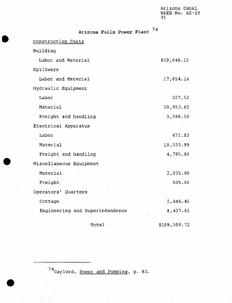
Arizona Canal HAER No. AZ-19 35
74 Arizona Falls Power Plant
Construction Costs
Building
Labor and Material $29,048.15
Spillways
Labor and Material 17,054.14
Hydraulic Equipment
Labor 327.52
Material 20,953.65
Freight and handling 3,596.59
Electrical Apparatus
Labor 671.83
Material 19,533.89
Freight and handling 4,795.89
Miscellaneous Equipment
Material 2,035.00
Freight 600.00
Operators' Quarters
Cottage 2,446.45
Engineering and Superintendence 8,437.62
Total $109,500.72
74 Gaylord, Power and Pumping, p. 83.
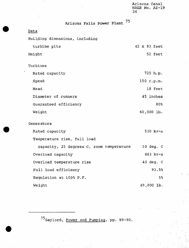
Arizona Canal HAER No. AZ-19 36
Arizona Falls Power Plant 75
Data
Building dimensions, including
turbine pits
Height
Turbines
Rated capacity
Speed
Head
Diameter of runners
Guaranteed efficiency
Weight
Generators
Rated capacity
Temperature rise, full load
capacity, 25 degrees C, room temperature
Overload capacity
Overload temperature rise
Full load efficiency
Regulation at 100% P.F.
Weight
42 x 83 feet
52 feet
725 h.p.
150 r.p.m.
18 feet
45 inches
80%
60,000 lb.
530 kv-a
3 0 deg. C
663 kv-a
40 deg. C
93.5%
5%
49,000 lb.
75 Gaylord, Power and Pumping, pp. 89-90.
Arizona Canal HAER No. AZ-19 37
In 1912, the Salt River Valley Water Users' Association constructed the new Crosscut Power Canal, replacing the older Crosscut Canal near 48th Street. (See image AZ-19-51.) The new canal would still deliver water from the Arizona Canal to the Grand Canal, but the water would also be used to generate electricity through the newly built Crosscut Hydropower Plant. The intake structure connecting both canals had two double screw stem, steel lift gates, 7 feet 10 inches by 17 inches. The gates were operated by either hand or electric motor through a shaft and gear train.
The Reclamation Service, in January 1913, surveyed the Arizona Canal in order to find out how many gaging stations would be needed to measure the amount of water reaching the water users from the main laterals. The next month, the Reclamation Service started installing-ythe gages on the main canal as well as on the sub-laterals.
H. M. Lewis, under contract with the Reclamation Service, completed the tail race structure of the canal in 1914, which created the head of Lateral 20. The original turnout for Lateral 20 was a wooden structure deemed inadequate and unsafe. The new design consisted of a check, three turnouts and an overflow spillway 50 feet long. During the construction, Lewisgand his crews excavated over 6,000 cubic yards of material.
During 1914 the Reclamation Service finished the Cave Creek cut-off. This work had been delayed because the government engineers wanted to study the situation. The problem had been that when Cave Creek flooded, it would break into the Arizona Canal. The engineers decided that the best solution would be to have the canal below the natural ground surface, leaving portions of the northside bank open to allow the flood waters into the canal. The south bank would also have openings to permit the excess flood water to escape out of the canal. Both the inlets and outlets were constructed every 600 feet with the first outlet located 300 feet downstream from the first inlet. The Reclamation Service also constructed a number of concrete turnouts to the
*7 £ U.S. Reclamation Service, Project History, 1913, p.
49. For additional information on the Crosscut Hydropower Plant see Fred Andersen and Carol Noland, "Crosscut Hydro Plant," HAER No. AZ-30, 1990.
77 U.S. Reclamation Service, Project History, 1913, pp. 78-79.
7 R U.S. Reclamation Service, Project History, 1913, p. 40.
Arizona Canal HAER No. AZ-19 38
laterals in this section of the Arizona Canal.7gThe total area encompassed by the cut-off was 3.5 miles.
The Reclamation Service considered the reconstruction of the Arizona Canal completed by February 1915.
Association Repair and Maintenance of the Arizona Canal Cave Creek continued to present problems to the Arizona Canal. The flooding in 1916 caused some property damage to the farm lands and to the canal, but the heavy flooding in November 1919 demanded the Salt River Valley Water Users' Association take action. Cave Creek flooded three times that winter, washing out the canal each time, filling it with sand and gravel for approximately one mile. The creek also cut a large channel directly to the Arizona Canal, creating a potential threat to the Project. To remedy this situation, the Association engineers designed protective timber spillways along the banks of the Arizona Canal at the crossing of Cave Creek. (See image AZ-19-31.) One-inch redwood timbers were driven into the embankment of the canal approximately two feet down and extended to within six inches of the top of the bank.
During the 1921 floods, gopher holes aided in the damage done to the Arizona Canal along the Cave Creek channel. The redwood timber bulkheads, constructed two years prior, were washed away when the Cave Creek flooded in August. The gopher holes permitted the water washing up against the embankment to break into the canal. The Association used material deposited from the flooding to repair the canal; using this type of material would also help seal it.
By the spring of 1922, various entities in Arizona, including the state government, city of Phoenix, Maricopa County, and the Santa Fe Railroad as well as the Water Users' Association, contributed money to the construction of a Cave
79 U.S. Reclamation Service, Salt River Project Supplemental History, 1914, pp. 46-47.
on U.S. Reclamation Service, Fourteenth Annual Report of
the Reclamation Service, 1914-1915, (Washington: Government Printing Office, 1915), p. 49.
81 In 1917, the United States turned over the operation and maintenance of the Salt River Project to the Water Users' Association. The Association was in charge of the repairs to the canal system. Salt River Project, Salt River Project Annual History, 1919-1920, pp. 26-27, 31-32.
82 Salt River Project, Annual, History, 1920-21, p. 45-6.
Arizona Canal HAER No. AZ-19 39
Creek Flood Control Dam. John S. Eastwood designed the multiple arch dam for the project and the contract was awarded to Lynn S. Atkinson, Jr. The dam, operated by the Water Users' Association from 1923 until the early 1970s, provided protection^needed for the Arizona Canal and surrounding lands.
The November 1919 flood also caused Association engineers to be concerned about the canal bank just below Granite Reef Dam. The flood destroyed a portion of the Consolidated Canal and to prevent such an occurrence on the Arizona Canal, the Association constructed a concrete wall along the northside of the Salt River. Crews graded material from the top of the bank and placed it near the eroded bank on the river side at a natural slope, puddled into place. (See image AZ-19-30.) The side of the canal was then paved to a height of three feet above the maximum surface of the flood waters with boulders laid in cement, having a total of 2,935 square yards paved and 246 cubic yards of dry masonry placed. The work was carried on with unskilled labor and an inspection of the canal a year later did not show any breaking or settlement. The total cost of this protection amounted to $34,000.
To aid in the protection of the Arizona Canal from other flood waters, the Association enlarged the Indian Bend Wasteway by digging a ditch through the slough, forming a better defined channel. Both mechanized and hand labor were used on the job. The P & H dragline excavated over 1.5(-miles while the men worked on 1 mile. (See image AZ-19-21.)
During the mid to late 1910s, the Salt River Project experienced an ironic fate of nature. Portions of the Project's lands became water-logged from intensive irrigation, yet additional water supplies were needed for farming. In 1918, the Association Board of Governors authorized a program of pump development to alleviate the shortage of surface water and solve the drainage problem. Wells along the Arizona Canal right of way were installed to increase the water supply beginning in 1923; the groundwater was pumped from these wells and discharged directly into the canal.
83Salt River Project, Annual History, 1921-22, p. 10, 63; Salt River Project, Annual History, 1922-23, p. 84.
84Ibid., pp. 8, 78.
85Salt River Project, Annual History, 1922-1923, p. 272.
86Salt River Project Annual History, 1918-1919, p. 9; (Footnote Continued)
Arizona Canal HAER No. AZ-19 40
Depression and World War II Hardships During the 1930s, the farmers in the Salt River Valley were hit hard by the depressed agricultural market. The Salt River Project did not have the funds to keep up with the proper maintenance of the water system- Few modifications occurred on the Arizona Canal in these years.
The Water Users' Association was able to utilise the Civilian Conservation Corps (CCC) in the maintenance of the water system between 1935-1938. (See images AZ-19-14 and AZ-19-15.) The CCC crews repaired the Arizona Canal after the summer floods of 1936 broke through one 80 foot section. Construction of concrete turnout structures and canal linings were carried out by the CCC, including a number on the Arizona Canal. The Burgess Lateral, off of the Arizona Canal, was piped with over 3,300 feet of 24 inch and 30 inch concrete pipe. The CCC also constructed a new headgate for the lateral as well as relocating 4,000 feet of the open ditch. The crews built a maintenance road og-the north side of the Arizona Canal below Granite Reef Dam.
Under contract to the U. S. Bureau of Indian Affairs, the Association constructed a turnout at the Evergreen Wasteway for the Indians on the Salt River Indian Reservation in late 1938. The banks of the Arizona Canal were raised below Granite Reef to allow for an additional 125 second cubic feet of water for 6,100 acres of Indian land. The work of building the siphon, turnout, and spillway was finished by January 1939. (See image AZ-19-16.) The cost to the Indian Service amounted to just over $10,000. The Association also updated the operating mechanism of the gates at the turnout with electrical controls andfigas stand-by. (See images A2-19-40 through AZ-19-43.)30
A new canal measuring station was constructed below the Arizona Falls power plant in September 1942. The structure included an encased stilling well anchored to the left bank of the canal with a cleanout door and inspection door as well as a recorder shelter. The staff gage was mounted on the
(Footnote Continued) Salt River Project Annual History, 1924-1925, map of well construction; for a modern example of a pump see image AZ-19-61.
87 Salt River Project, Annual History, 1936, p. 2, 5; Salt River Project, Annual History, 1937, p. 3; For a sketch of the earlier alignment of the Burgess Lateral see image AZ-19-28.
88 Salt River Project, Annual History, 1938, p. 11, 13; Salt River Project, Annual History, 1939.
Arizona Canal HAER No. AZ-19 41
downstream side of the stilling well. A steel measuring bridge with a wooden deck was located 20 feet upstream from the gage. An iron track was installed on the deck from which a boom car operated. A sheet iron shed was constructedgat the end of the bridge to house the car when not in use.
In 1940s, the Association started lining portions of the Arizona Canal to eliminate seepage. Lands near the Arizona Canal in certain areas were becoming waterlogged and the situation was worsening. World War II Italian prisoners-of-war, located in Valley camps, labored for the Association repairing and lining the canals in 1943. (See image AZ-19-19.) Because of the success of the canal lining, the Association utilized the technique to control the rising water table near the canals. The Ruth Dredger smoothed the banks of the canal after it had been graded and shaped. (See image AZ-19-20.) Crews discovered that the use of pre-mixed concrete on the bottom and gunite on the banks was the best method to line the canal. Three inches of concrete on the bottom of the canal was less expensive and would do a better job than one inch of gunite. Wire was placed on the sides of the canal before the application of the gunite and extended to the bottom so the sides and bottom would be tied together. (See images AZ-19-17 and AZ-19-18.) In 1945, below the Arizona Falls, the Arizona Canal was lined with concrete on the bottom and gunite on the banks for 3,000 feet.
Rehabilitation and Betterment Program After the war, the Salt River Valley experienced an upsurge in population. Many serviceman who were stationed in the Valley military bases returned to the Valley to establish their homes. Farm lands soon became suburban subdivisions. The Salt River Project needed to provide water now to residences and the system, having deteriorated during the war years, could not meet the demand. The United States Congress during the Truman administration, passed legislation authorizing the U.S. Bureau of Reclamation to distribute funds to modernize existing reclamation projects. The Salt River Project reguested and.received money to upgrade its water distribution system.
89 Salt River Project, Annual History, 1942, p. 5.
90 Salt River Project, Annual History, 1943, p. 2; Salt River Project, Annual History, 1944, p. 2-3; Salt River Project, Annual History, 1945, p. 2; Salt River Project, Engineering Reports, 1942-1945, located in the Research Archives.
91 Jay C. Ziemann, "The Modernization of the Salt River (Footnote Continued)

Arizona Canal HAER No. AZ-19 42
In January 1952, the Arizona Canal was lined with gunite for a distance of 13 miles under the rehabilitation and betterment program. That portion of the unlined canal experienced seepage and evaporation losses of 12 percent annually. The cost of lining the canal with shotcrete mortar was $125,000, but the lining saved an estimated 13,000 acre feet of water a year. This amounted to a yearly savings of $37,900 for the Project, thus the initial cost would be recovered in about four years. The canal lining also prevented the loss of water which would be utilized by the growing cities in the Valley as well as protect the banks from erosion during high water periods, with resulting damage to the neighboring lands.
To aid in the operation and maintenance of the canal, Association employees installed in the late 1960s trashrack structures. As part of the rehabilitation and betterment program, an automatic moss and trash removal structure was installed at the end of the Arizona Canal on lateral 20. (See image AZ-19-62.) Two other demossing bridges were built of precast concrete "T" beams with retractable screens. (See image AZ-19-54.)yj
The Salt River Project also experimented with innovative techniques in operation and maintenance during the rehabilitation and betterment program that proved successful. Laterals were lined using a slipform process or piped with a cast-in-place pipe. The slipform operation used a Fullerform plow to make a trapezoid-shaped trench to predetermined specifications and then applied concrete along the sides and bottom of the lateral. (See image AZ-19-23.) Cast-in-place pipe was made by a machine moving along a newly excavated lateral and pouring cement around a rubber balloon. The Association replaced many of the gates on the laterals with the "Sabin gate," designed by the engineers at the Project. The friction lift gate allowed field crews to raise or lower the gate easily to within a fraction of an inch. Radial gates were installed on the Arizona Canal at Scottsdale Road,
(Footnote Continued) Project; The Impact of the Rehabilitation and Betterment Program," (M. A. thesis: Arizona State University, 1987).
92 Ibid., pp. 52-53. There is a patented process of gunite called Shotcrete. Salt River Project, Annual Report, 1956, p. 9; For an example of an unlined portion of the Arizona Canal see image AZ-19-22.
93 Salt River Valley Water Users' Association, Operations and Statistics Report, 1967, p. 6; Salt River Valley Water Users' Association, Operations and Statistics Report, 1969, p. 4.
Arizona Canal HAER No. AZ-19 43
the largest structure of its type within the Project. Additional radial gates on fche Arizona Canal were placed in operation during the 1970s.
In another phase of the rehabilitation and betterment program, the Project started the construction and implementation of the Supervisory Control system in 1970. The advances in electronic equipment allowed for the design of a water distribution system covering 138 miles to be handled by a single operator. By the mid-1970s the computer equipment monitored telemetered data which displayed water levels and gate positions. The dispatcher could regulate 331 radial gates and almost one fourth of the deep well pumps belonging to the Project. With this system, the water levels of the canals,-and laterals could be maintained at a constant water level.
Later Modifications to the Arizona Canal The Arizona Canal, because of the urban growth of the Valley, also began providing water for domestic and industrial needs. In 1954, the city of Phoenix constructed the Squaw Peak filtration plant. This facility diverts water from the Arizona Canal near 20th Street to supply the needs of the city residents. Ten years later. Phoenix built an additional filter plant, Deer Valley, next to the Arizona Canal at 31st Avenue, to purify and filter water to a growing population. (See images AZ-19-59 and AZ-19-60.) The city of Glendale also obtains water for its residents from the Arizona Canal and treats it at the city's plant near 51st Avenue. Salt River Project later permitted the diversion of water from the canal at the Arizona Biltmore Resort for cooling purposes. (See image AZ-19-56.)
To help various local governments promote flood control in the Valley, the Salt River Project altered certain features of its water distribution system, including a number on the Arizona Canal. New headgates were installed on the Arizona Canal at the Old Crosscut Canal, which the City of Phoenix improved for flood control. (See image AZ-19-53.) The Project planned on receiving storm drainage from the proposed
94 Ziemann, "The Modernization of the Salt River Project," p. 56, 71, 75-76; Salt River Project, Annual Report, 1955, p. 10.
95Ibid., pp. 106-109.
96 Telephone interview. Squaw Peak Filtration Plant, February 11, 1991; Salt River Project, Annual Report 1964.
Arizona Canal HAER No. AZ-19 44
Arcadia Channel at 56th Street and_diverting it to the Salt River via the Old Crosscut Canal.
In Scottsdale, the Project, in conjunction with the U.S. Army Corps of Engineers, designed and constructed a siphon at the Arizona Canal and the Indian Bend Wash as part of that city's flood control channel program in the late 1970s. The siphon carries water from the Arizona Canal under the Indian Bend Wash. The inverted siphon structure consists of three 15 foot by 15 foot boxes at the entrance converting to three 10 foot by 11 foot boxes at the exit. The underground length of the structure is approximately 750 feet. A safety barrier also serves as a trash track at the entrance to the covered boxes. Three 8 foot high gates were installed in the open channel section of the inlet works with divider walls to separate the flows from each of the three siphon boxes. Two hundred feet upstream from the inlet transition the Project and Corps installed a wasteway with radial gates and baffled overchute. (See images AZ-19-45 through AZ-19-48.)
The Salt River Project cooperated with the U.S. Army Corps of Engineers on another flood control project for the Valley. The Arizona Canal Diversion Channel, constructed along the north side of the Arizona Canal from 40th Street to west of 75th Avenue near Bell Road, will prevent serious flood damage to areas south of the Cave Creek drainage area. The channel is intended to divert Cudia City Wash and Dreamy Draw floodwaters as well as run off from the northern portion of the Valley into Skunk Creek. Sections of the Arizona Canal, between 47th Avenue to 51st Avenue andq57th Avenue to 63rd Avenue were moved in the early 1980s.
In 1987 another section of the Arizona Canal required relocation because of the Arizona Canal Diversion Channel. Approximately 1675 feet of the canal near 23rd Avenue needed to be moved south of the existing canal. The gates of the
97 Salt River Project, Annual Report, 1973, p. 10; Salt River Project, Annual Report, 1979-80, p. 12.
98 U.S. Army Corps of Engineers, Los Angeles District, Gila River Basin, Arizona, Indian Bend Wash, Design Memorandum No. 3, Feature Design for Inlet Channel Project Design for Indian Bend Wash, January 1978, pp. V-7 - V-9. For a sketch of the Arizona Canal through the Indian Bend prior to this work, see image AZ-19-32.
99 Salt River Project, Operations and Statistics, 1981, p. 7; Salt River Project, Operations and Statistics, 1982, p. 6; Salt River Project, Operations and Statistics, 1983, p. 3; Salt River Project, Operations and Statistics, 1987, p. 4.
Arizona Canal HAER No. A2-19 45
Arizona Canal at Granite Reef Dam were closed in the fall to permit the dry-up of the canal. SRP crews from Western Construction and Maintenance then constructed dikes at either end of the job and pumped out the remaining standing water. Three to five feet of sand and mud were removed from the bottom of the canal before the crews reached solid surface to be used for the new north bank of the canal. In less than two weeks, SRP personnel built the new north bank of the Arizona Canal and raised portions of the south bank. Soil conditions required the use of a vibratory sheepsfoot to assist in the compaction of the banks. The bottom of the canal was lined with concrete and shotcrete was used on the bank lining. WorkQwas completed within a month of the project's start.
During the 1980s, the Salt River Project continued to make improvements on its canal systems. To reduce water losses through increased accuracy of water flow measurements, the Project modified an existing weir on the Arizona Canal with the installation of a broad-crested weir. This structure could more precisely measure the rate of water flowing in the canal. As part of a four year canal program completed in 1984, the Project installed safety steps and ladders. This provides a quick exit for stray animals and people who accidentally enter the canal system. The SRP crews constructed 118 safetynsteps and 26 ladders on Arizona Canal. (See image A2-19-39.)1UX
Besides improving the Arizona Canal through safety and technical features, the Salt River Project attended to the physical appearance of the canal. In 1985 crews trimmed trees and removed brush and other vegetation along approximately 16 miles of the canal. The banks of the canal have become paths for bicyclists, joggers and horseback riders. Fishing is permitted along the banks in many areas. The Project is now working with the City of Scottsdale to establish guidelines for the multiple use of the canal banks- in the downtown area. (See images AZ-19-49 and AZ-19-50.)
Project Final Report: Arizona Canal/AC-DC Lining, RT-50157, December 14, 1987.
101Salt River Project, Annual Report, 1982-83, p. 9; Salt River Project, Annual Report, 1984-85, p. 9; Salt River Valley Water Users' Association, Operations and Statistics, 1983, p. 4.
102Salt River Project, Annual Report, 1985-86, p. 10; Salt River Project, Annual Report, 1983-84, p. 8.
Arizona Canal HAER No. AZ-19 46
Concern for the environment prompted the Salt River Project, in cooperation with the cities of Tempe, Phoenix, and Chandler to construct a real-time water quality monitoring station prototype. The Arizona Canal at the old Arizona Falls power house was selected as the site for the laboratory. (See image AZ-19-52.) Water, flowing through the canal, is tested on a 24-hour basis, for ph balance, temperature, and turbidity. The breathing patterns of juvenile bluegill fish are monitored for early warning signs of potential pollution. If contamination occurs, sensors will radio the information to the water control center and the water treatment plants downstream. The Project plans to develop^jSimilar testing stations throughout the canal system.
Conclusion The Arizona Canal was not the first canal built in the Salt River Valley, but it is the longest and provides water to the most lands. With the construction of the Arizona Canal, a large, new portion of the Valley opened up to settlement. Families came and established homes and towns. Lands previously growing only cactus and brush soon flourished with orchards of citrus trees and fields of grain. The Arizona Canal provided the additional water to new lands that aided in the expansion of the Salt River Valley.
The construction of the Arizona Canal followed contemporary methods of canal building employed in the southwest with few exceptions. Men, horses, and machinery worked together to dig a 42 mile channel to carry the waters of the Salt River. W. J. Murphy started construction in 1883 and completed the project by 1885 with few interruptions. Except for some minor relocations, the Arizona Canal follows the same alignment today as first engineered. The Arizona Dam, however, was built with time and financial considerations given priority over permanence. Damaged and repaired at least three times, the United States government finally relocated the diversion works of the Arizona Canal and built Granite Reef Dam.
Following the purchase of the Arizona Canal by the federal government for the Salt River Project, the canal provided water to over 50,000 acres by 1913. Expansion of irrigated acreage continued with over 66,000 acres cultivated with waters from Arizona Canal in the 1930s. The face of the Salt River Valley changed after World War II when returning servicemen wanted to establish homes here. Farm lands became suburban subdivisions with thousands of houses constructed. The growing population needed greater amounts of domestic
103 Salt River Project, Annual Report, 1989-90, p. 9.
Arizona Canal HAER No. AZ-19 47
water in relation to the dwindling number of farms. The towns of Glendale and Phoenix erected treatment plants off of the Arizona Canal to supply the people with water to their residences. Today, the Salt River Project supplies irrigation water to over 8,000 acres of farm land and urban irrigation to 13,000 homes under the Arizona Canal, but the canal delivers over 100,000 acre feet of water to the treatment plants. The Arizona Canal still supplies water to the Salt River Valley, but its uses are now largely different.
The Ingleside property is representative of early Salt River Valley life with changes that occurred because of the construction of the Arizona Canal. Initially farmed in 1886 with traditional crops, W. J. Murphy planted orchards three years later, changing the type of harvest from a land intensive production to a more profitable cash crop which required less acreage. To show new investors the wonder of the Salt River Valley, Murphy created the Ingleside Club which later became the area's first resort, and tourism became a source of economic revenues. The city of Scottsdale has a similar history with extensive orchards planted by its founder Winfield Scott and the growth of first class resorts catering to midwestern and eastern visitors.
Though the construction of the Arizona Canal did not employ startling new technologies and its hydropower plants were not new innovations, the canal did make possible the expansion and growth of the Salt River Valley.
Arizona Canal HAER No. A2-19 48
GLOSSARY
Caliche: A more or less cemented deposit of calcium carbonate often mixed with magnesium carbonate at various depths, characteristic of many of the semi-arid and arid soils of the Southwest.
Checks: Wood planks or a concrete wall placed in a waterway for the purpose of forcing water to rise to the elevation required for making an irrigation delivery.
Crest: Top of check, weir, or dam overflow section.
Cubic Feet Per Second: (cfs) A unit of measure of flowing water. One cubic foot per second means one cubic foot of water passing a given point in an interval of one second.
Diversion Dam: A hydraulic structure constructed in a waterway to divert water from that waterway into another. A diversion dam generally has no storage capacity.
Drain: A location where waste water from an irrigated field or roadway is taken into a waste ditch, lateral, canal, or structure.
Flume: A structure which carries water from a channel over a depression, such as a canal or highway undercrossing, without altering appreciably the water level through the channel. The flume is usually constructed of wood or concrete.
Gaging Stations: A location along a stream where basic data is regularly obtained to compute stream flow at that point.
Gate, Radial: Curved steel gate which is used for canal and high capacity lateral structures. A side view of the gate resembles a 1/6 section of a circle.
Gunite: A mixture of sand, cement, to which water is added in a nozzle. Gunite is sprayed on canal banks to prevent erosion and seepage.
Head: Vertical distance between water levels indicating water pressure.
Lateral: An artificially constructed channel for the conveyance of water from a canal to delivery points in an irrigated area.
Rip-Rap: Construction of a wall made of boulders, brush, wire or timbers to prevent erosion.
Sluice Gate (Sluiceway): A structure that removes silt and sand accumulations from a lake, river, canal, or lateral

Arizona Canal HAER No. AZ-19 49
generally accomplished by opening the gate to increase the velocity of the water.
Tail race: Area downstream of an outlet work.
Wasteway: A channel into which excess water from an irrigation system can be discharged for conveyance to a disposal location.
Weir: Originally meant as a dam or obstruction built across a stream to create a storage basin or to divert water for power or irrigation or to increase the depth of a stream for navigation. The present meaning is a structure built for the purpose of measuring water flow.
Arizona Canal HAER No. AZ-19 50
Appendix
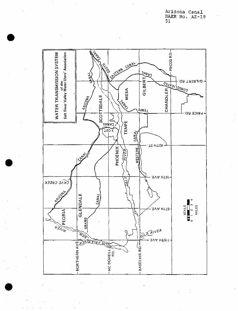
Arizona Canal HAER No. AZ-19 51
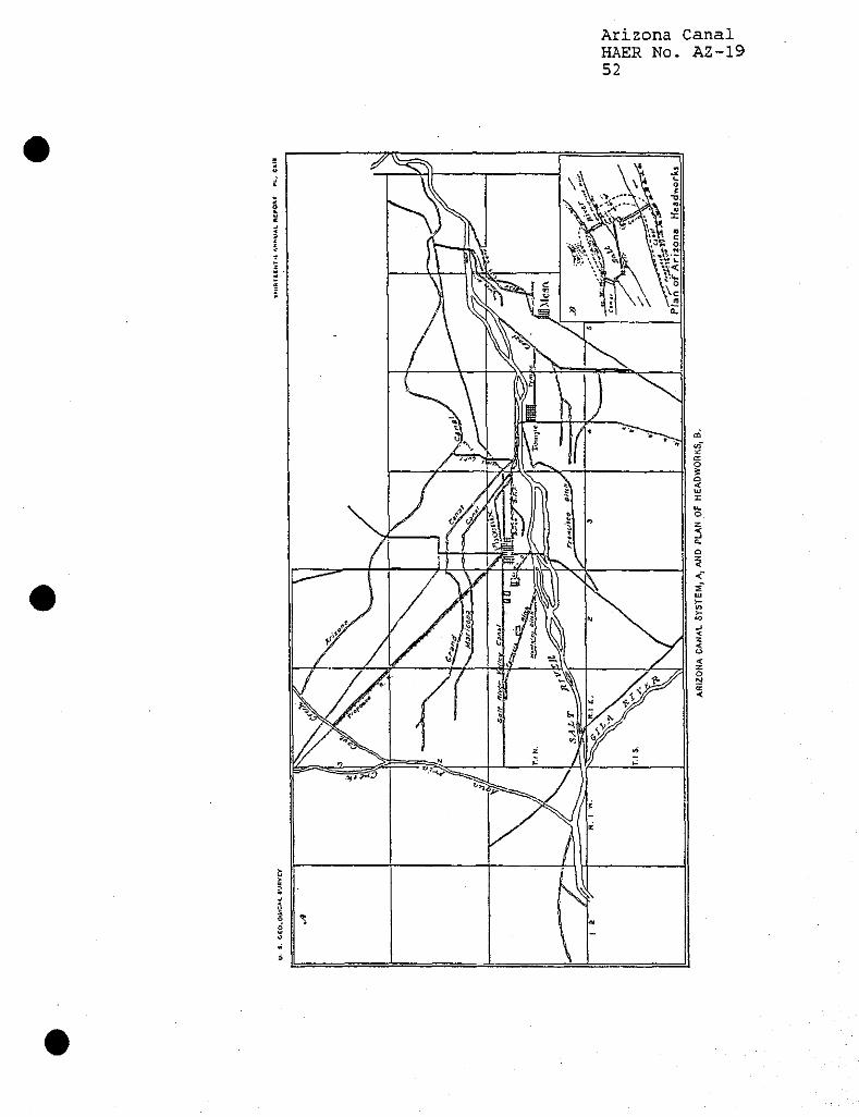
Arizona Canal HAER No. AZ-19 52
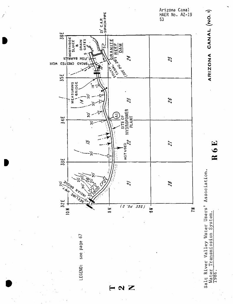
w a.
_ a. CJ w
Arizona Canal HAER No. AZ-19 53
ai3M
<u CD
CL
OJ OJ (/I
UJ
LU
0
J < z < o < z 0 N E <
H CN| 2:
Ex3 \D «
c o ■H XJ CC
•H O o w co
<C
01 U • Q) E CO QJ
£3 4-1 CO
H >, OJ «
■U)
to c 3: o
•H !>* CO Q) CO
r-H -H ^ B cd to > c
CO H M QJ EH >
•rH H • Pi Q) r>
4J X) 4J cy y\
cd —i
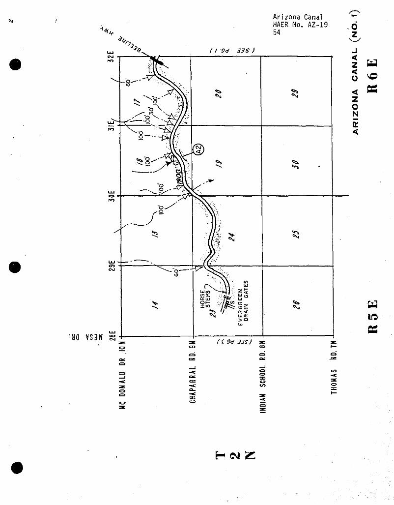
<y
'-**,.
Arizona Canal HAER No. AZ-19 54
d z
HO VS3H s ( f Vd 33$)
en CJ-
CO
H CM Z
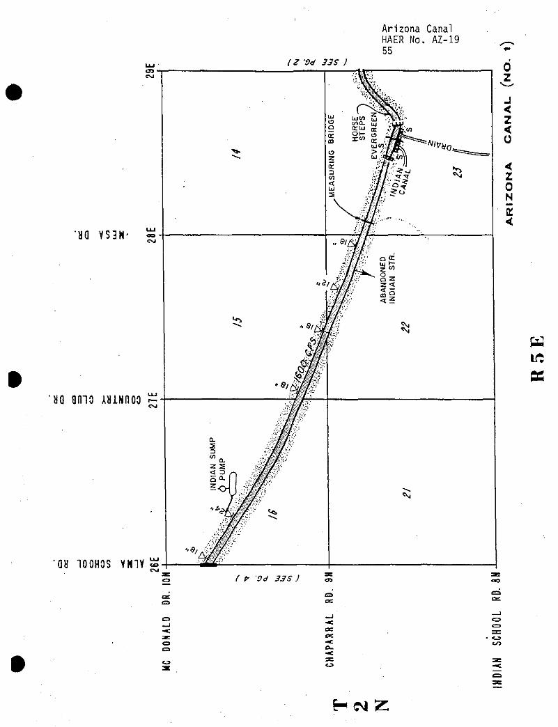
Arizona Canal HAER No. AZ-19 55
( 2 'Od 33 S )
'U VS3H
*no amo AUNnoo
GH 100HOS YN1Y «, CM
OS
( P' 9d 33S )
£3
C3
OS OS
CO
HCM Z
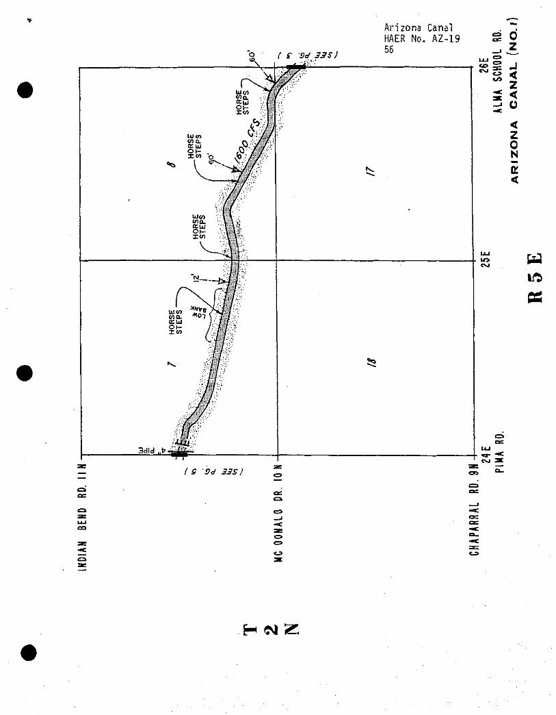
( £ -04.33$)
Arizona Canal HAER No. AZ-19 56
0 z
Ed
OS
{ S Od 33S)
LLJ CO
C3
HNZ
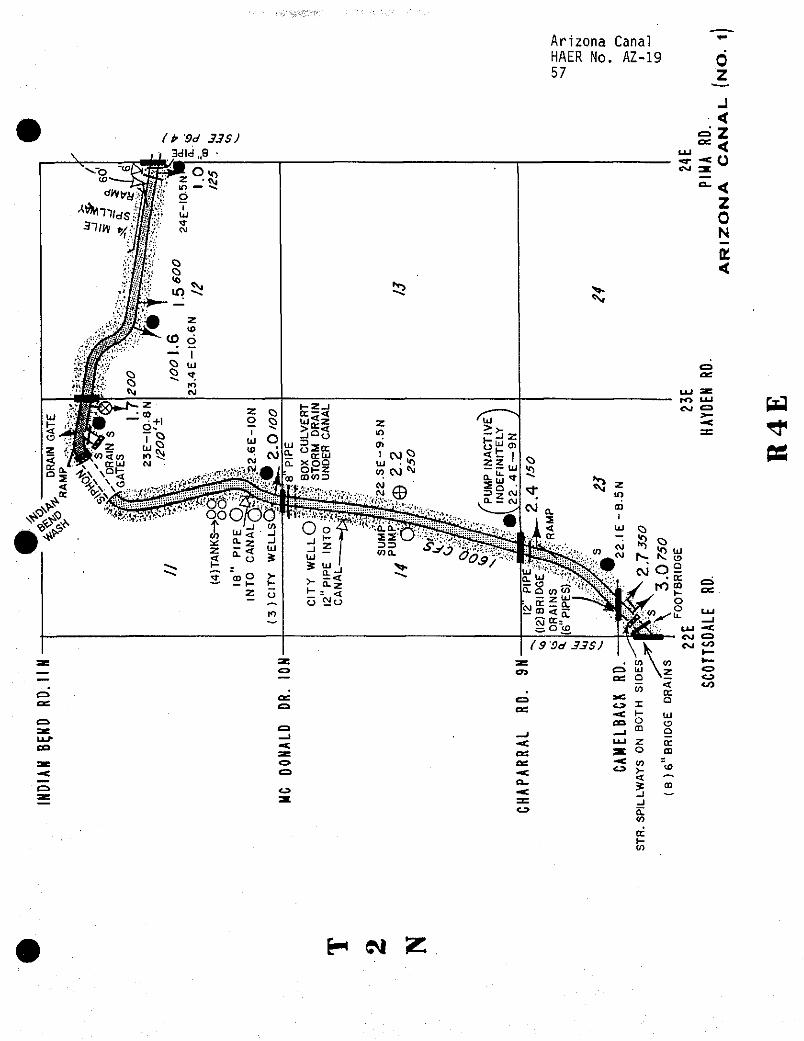
(t> 'Od 33 S) 3d!d„9 ■
<5&
Arizona Canal *" HAER No. AZ-19 n 57 Z
< Z < o < z 0 N
<
UJ to CM
CD as
ea LLJ- CO
H W Z
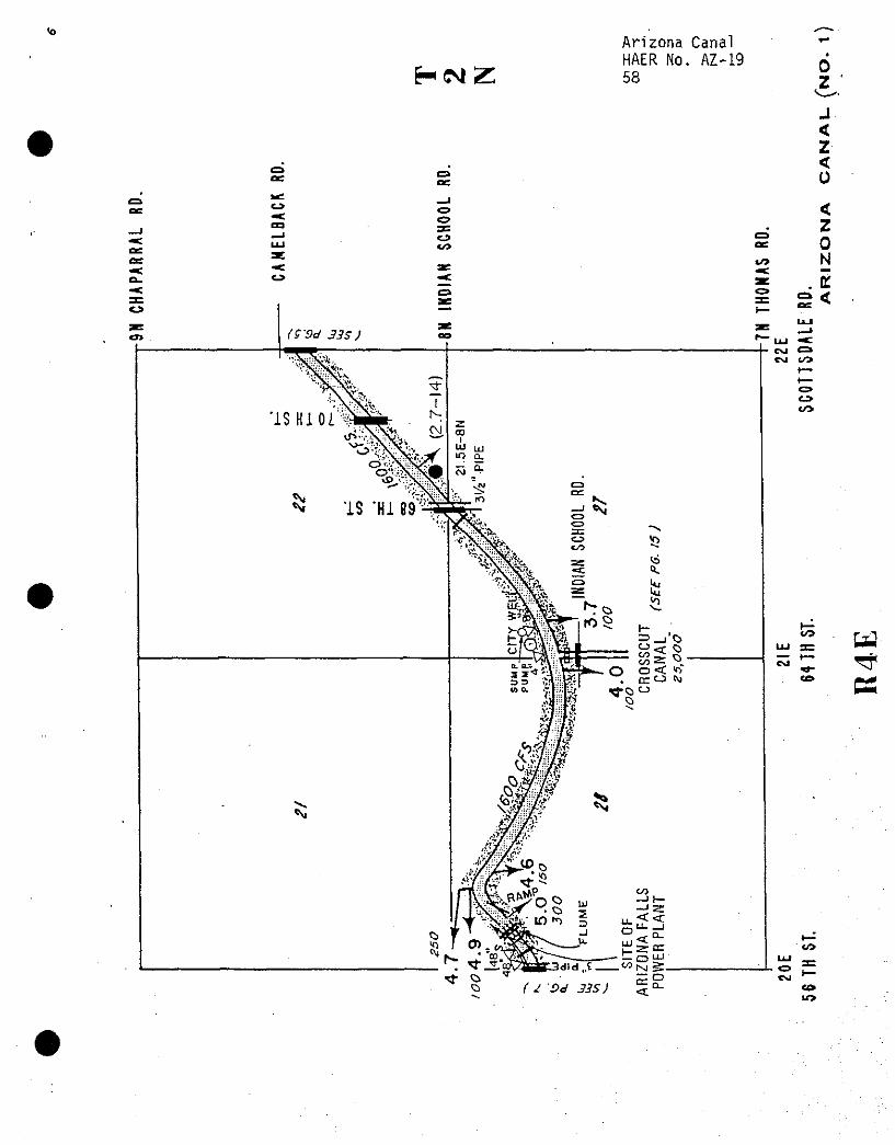
*o
HCMZ Arizona Canal HAER No. AZ-19 58
0 z
C3C
J < z < 0
to
<J»
I'P^o' JJ^y
IS HI U'%
OS
CO
< z 0 N
. E
CM C=» Ol CO
to
CO w ^ K
CO
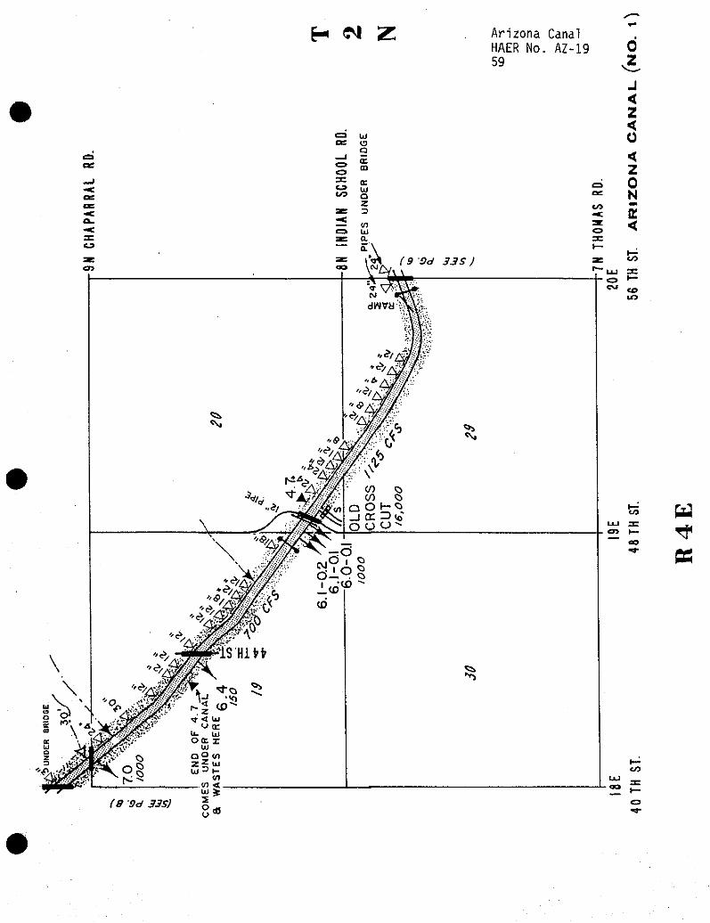
H ^ Z Arizona Canal HAER No. AZ-19 0 59 .2
& W CD 1— rf
CO ^-
fig
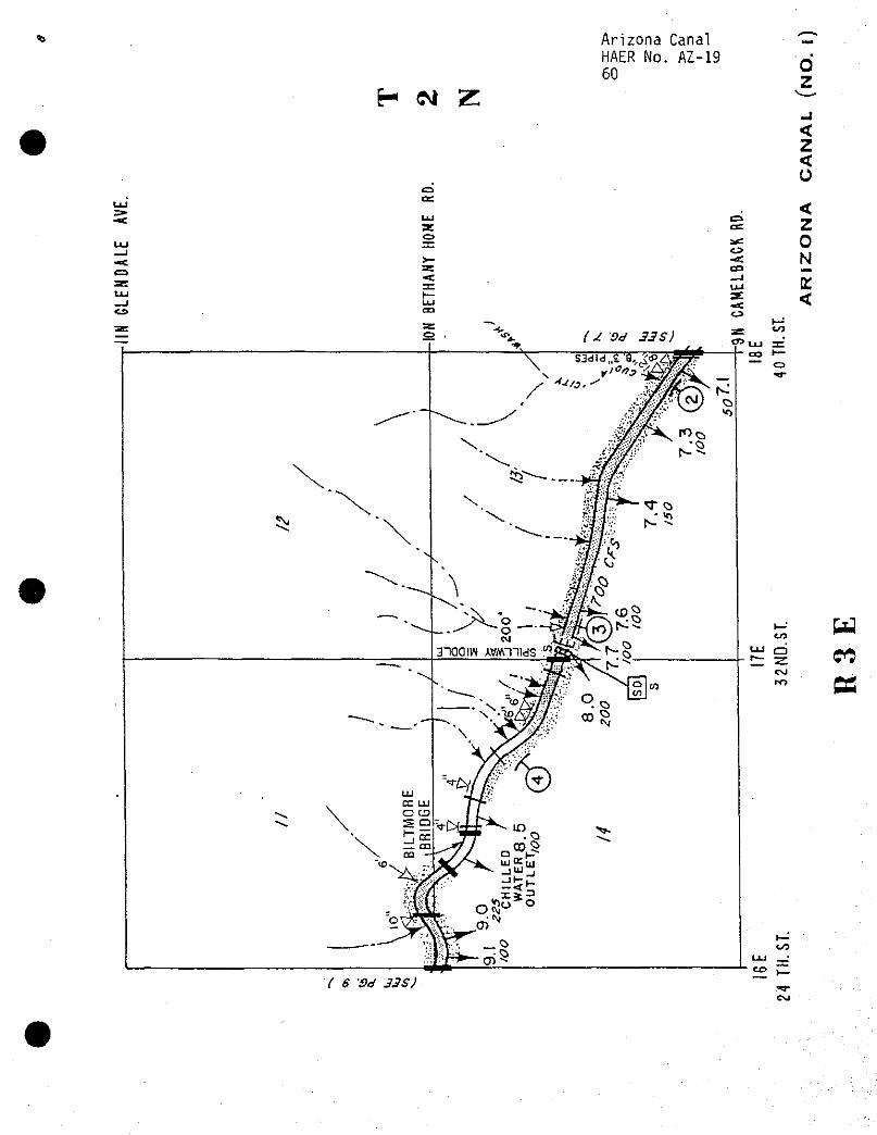
Arizona Canal HAER No. AZ-19 60
H M Z
C5 DC
Q
«L3
o
< z <
< z 0 N
£ <
to Ed CO
cc
f ff 'iv JJ$7
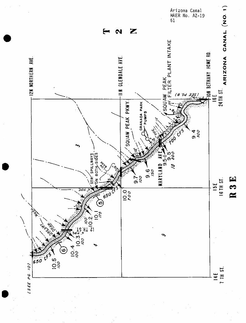
Arizona Canal HAER No. AZ-19 61
H CM Z UJ
<
0
J < z < o < z 0 N
E <
ft.
S1
CO
c©
OS
CO
re
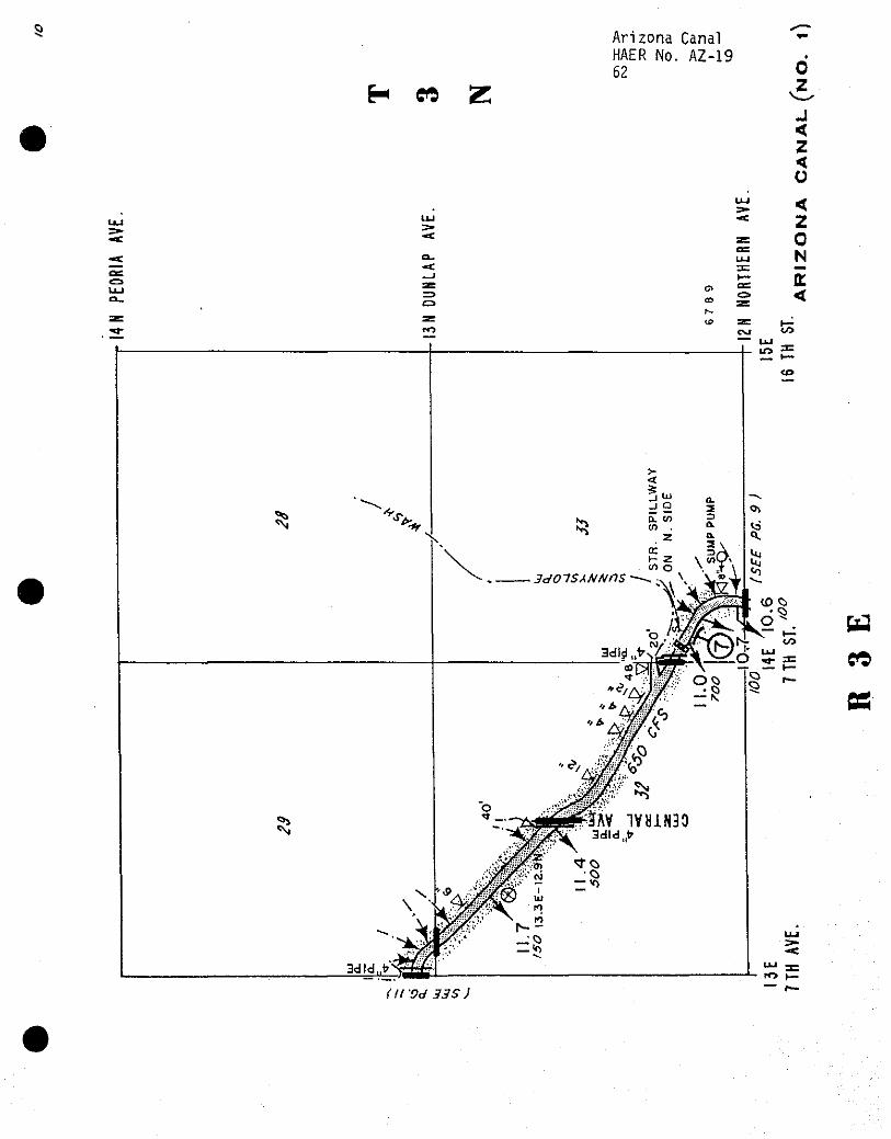
Arizona Canal HAER No. AZ-19 62
H « Z 0
J < z <
OS
(II'Od 335)
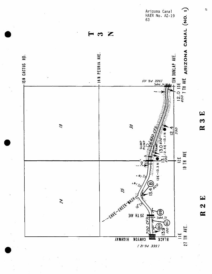
H co Z
as
CO
-*:
Arizona Canal *•
HAER No. AZ-19 63 0
z -1 < z < o <
Ll_l z -*: 0 CL. N -* mm _J
<
(01 *0d 33S) 3dld.>
CSJ
<n
AVMH9IH NOANVO — N0V19
( Zl'Od 33S)
— re
05
H CM
BS
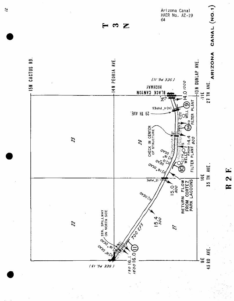
N Arizona Canal HAER No. AZ-19 64
H « Z
0 z J < z <
tu
Efc 3=
CNi
ec
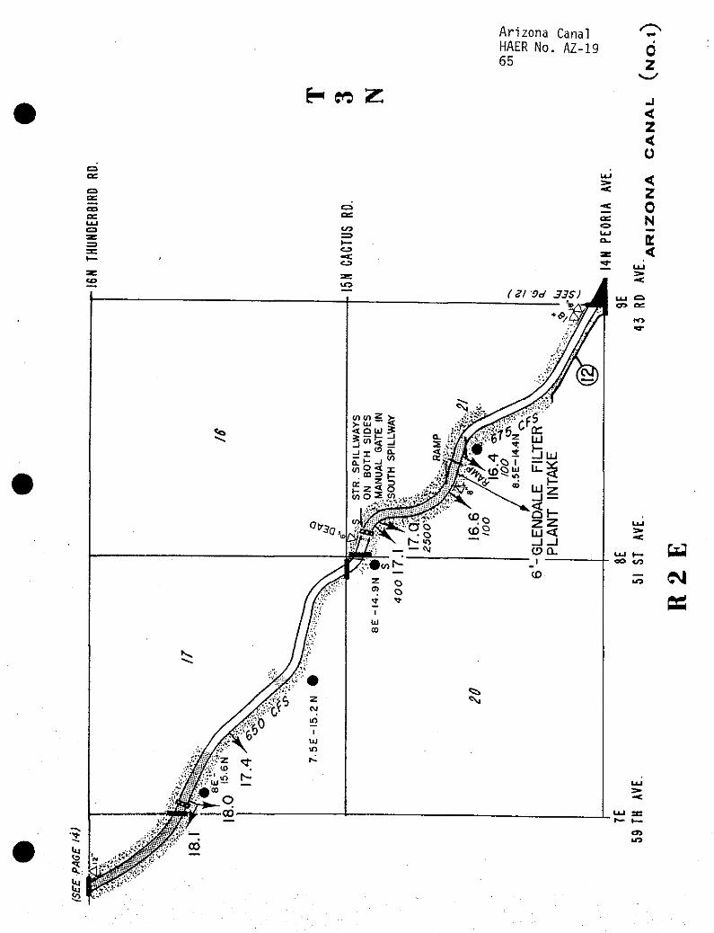
Arizona Canal HAER No. AZ-19 65
0 z
H eo Z -j
< z < o
OS
no
to
C3
5 < z 0 N
E <
( 21 Od 33S)
v> v> 3 >z < Q Li >
CM
OS
LO
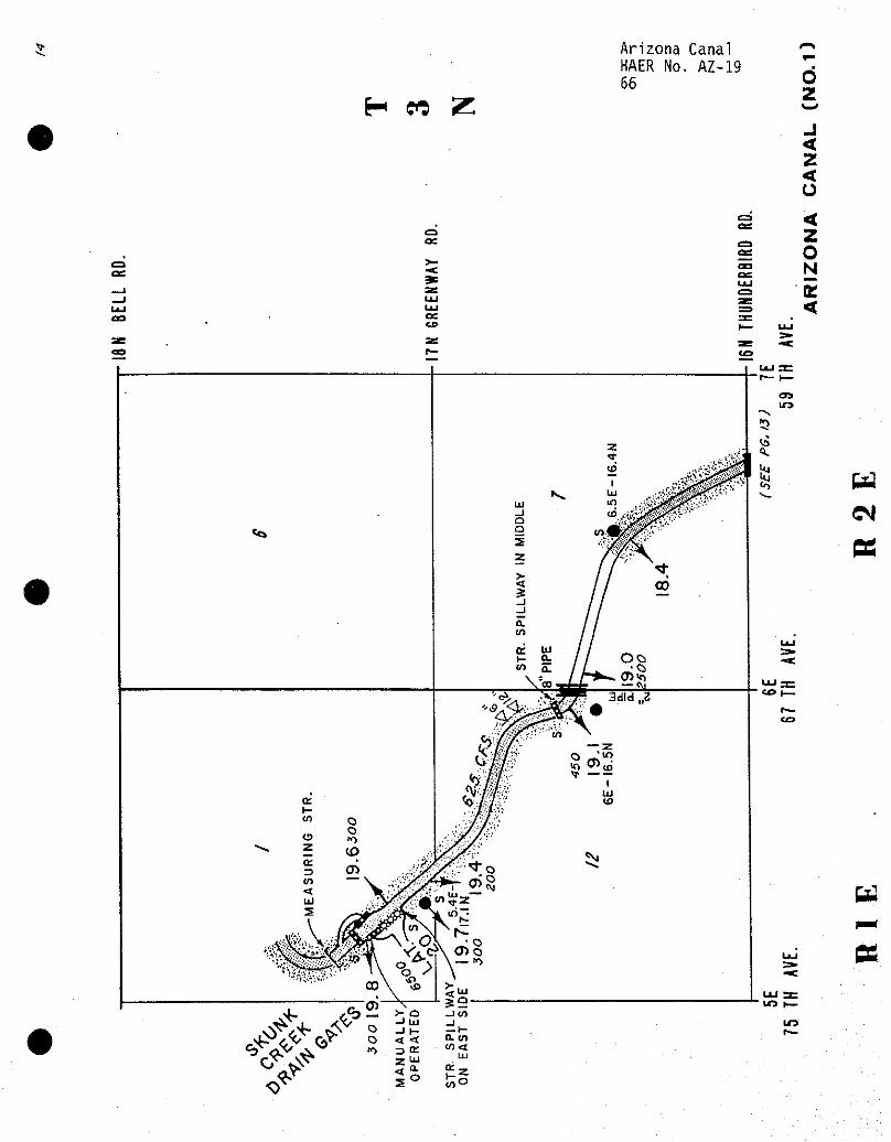
H W Z
O OS
ac
Arizona Canal C-\
HAER No. AZ-19 ^
66 0 z J < z < o
fur < t=3
z o
CT3 N K
=E <
CM
PS
IT>
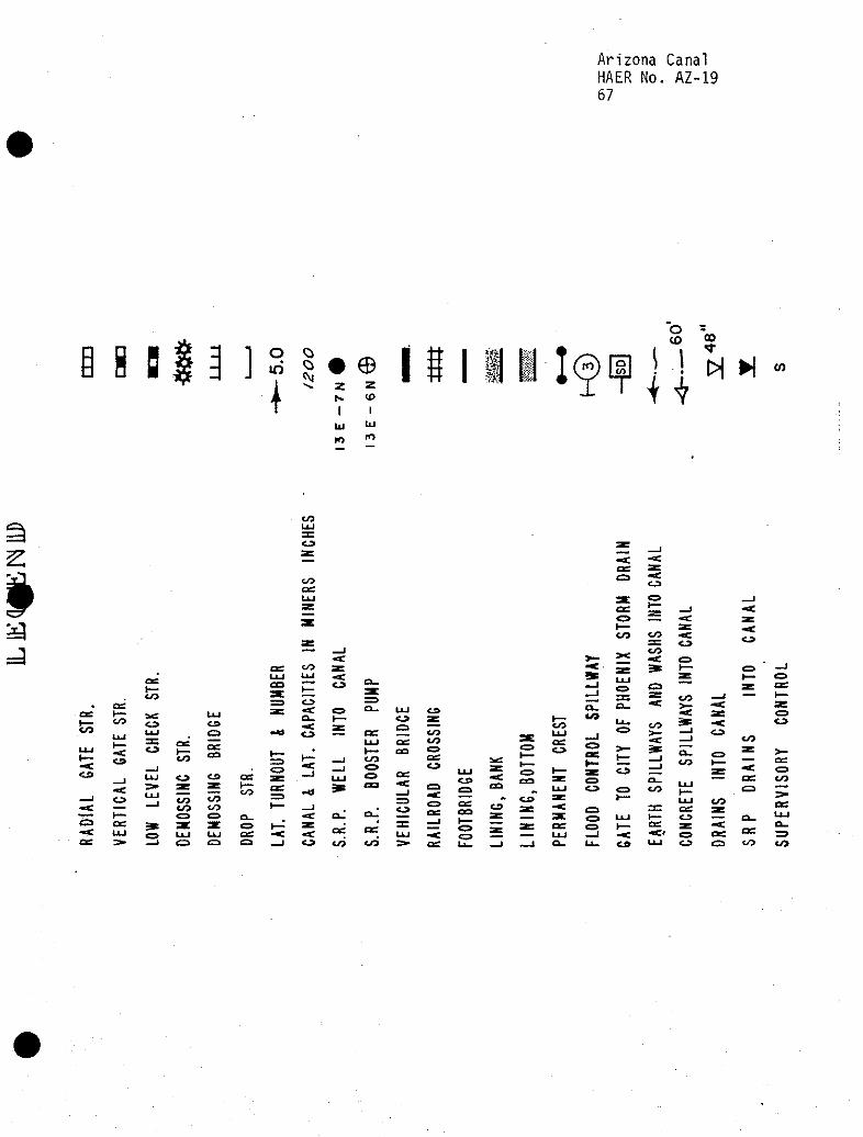
Arizona Canal HAER No. AZ-19 67
O in
t o o N e
§ «
2 Z
I I 111 ^
I I III I(?l?]i WM t 7
</)
K» in
J- I
cO
to as
as <L3
a =3
os OS h- )_ CO to
LU
LU
as (_ CO
C3
-a:
er»
o
OS UJ
CO
CO CO
C9
or CO
CO CO o
OS I— CO
SB OS
C3 ■■e a.
I—'
to
to
OS 03
OS
to CO
as
to u_i as
a_ as CO
as CO
GO
- CO Q ^
CO
CO
(=1
a_ c^ CO
m UJ i— f— ?s
to
LU tO
Ll_ CO
as ce: era
PS
to
Arizona Canal HAER No. AZ-19 68
Bibliography
I. Manuscript and Archival Collections
Arizona, Phoenix. Arizona State Library and Archives,
. Maricopa County Superior Court.
. Maricopa County Recorder's Office.
Arizona, Scottsdale. Southwest Room, Scottsdale Public Library.
Arizona, Tempe. Arizona Collection, University Library, Arizona State University.
. Research Archives, Salt River Project.
. Records Management, Salt River Project.
. Land Department, Salt River Project.
Washington, D.C. National Archives and Records Administration. Record Group 75, U.S. Bureau of Indian Affairs.
. Record Group 115, U.S. Bureau of Reclamation.
II. Government Documents
Arizona Agricultural Experiment Station. "Irrigation in Arizona." Bulletin No. 8.
"Utilizing Our Water Supply." By Alfred J. McClatchie Bulletin No. 43. University of Arizona. July 28, 1902.
U.S. Army Corps of Engineers. Los Angeles District. Gila River Basin, Arizona, Indian Bend Wash Design Memorandum No. 3, Feature Design for Inlet Channel, Project Design for Indian Bend Wash. January 1978.
U.S. Department of Agriculture. "Irrigation in the Salt River Valley." By W. H. Code in Report of Irrigation Investigations for 1900. Washington: Government Printing Office, 1902.
U.S. Department of Interior. Geological Survey. "American Irrigation Engineering." By Herbert M. Wilson, in Thirteenth Annual Report of the United States Geological Survey to the Secretary of the Interior, 1891-92, Part 3, Irrigation. Washington D. C.: Government Printing Office, 1893.
Arizona Canal HAER No. AZ-19 69
. "Irrigation Near Phoenix, Arizona." By Arthur P. Davis. Water Supply and Irrigation Paper No. 2. Washington, D.C.: Government Printing Office, 1897.
U.S. Department of Interior. Reclamation Service. Annual Reports of the U.S. Reclamation Service, 1902-1915.
. Salt River Project History. 1911-1917.
III. Newspapers
Arizona. Phoenix. Arizona Gazette.
. Arizona Republican.
. Phoenix Daily Herald.
. Weekly Phoenix Herald.
IV. Dissertations and Theses
Mawn, Geoffrey P. "Phoenix, Arizona: Central City of the Southwest, 1870-1920." Ph.D. dissertation, Arizona State University, 1979.
Ziemann, Jay C. "The Modernization of the Salt River Project; The Impact of the Rehabilitation and Betterment Program." M.A. Thesis, Arizona State University, 1987.
V. Articles, Reports, and Other Papers
Andersen, Fred and Carol Noland. "Crosscut Hydro Plant." Historic American Engineering Record No. AZ-30, 1990.
"A Big Failure." The Irrigation Age. (December 1897).
Gaylord, James M. Power and Pumping System of the Salt River Project, Arizona, 1914.
Gill, E. S. "Phoenix, Arizona." California Illustrated Magazine (July 1892).
Murphy, Merwin L. "W. J. Murphy and the Arizona Canal Company." The Journal of Arizona History 23 (Summer 1982).
. "W. J. Murphy and the Valley: The Story of W. J. Murphy and his part in Developing the Salt River Valley in Arizona." 1975.
Myers, Patricia, "First Resort." Metro Phoenix (June 1988).
Robinson, H. F. "Construction, Repairs and Subsequent Partial Destruction of the Arizona Canal Dam, Near Phoenix, Arizona." Engineering News 53 (April 27, 1905).
Arizona Canal HAER No. AZ-19 70
Salt River Project. Annual Reports, 1955-90.
Salt River Project. Reference Manual of Project Terminology. 1966.
Salt River Project. Salt River Project Annual Histories, 1918-1946.
Salt River Valley Water Users' Association. Operations and Statistics, 1967-87.
. Water Operations. Water Transmission System. 1986.
"Two Arizona Companies." United States Investor. (May 7, 1898).
"Why the Arizona Company Failed." The Irrigation Age. (December 1897).
VI. Books
Lynch, Richard E. Winfield Scott: A Biography of Scottsdale's Founder. Scottsdale: City of Scottsdale, 1978.
McElfresh, Patricia Myers. Scottsdale: Jewel in the Desert. Woodland Hills, CA: Windsor Publications, Inc., 1984.
Miles, Candice St. Jacques. Arizona Biltmore: Jewel of the Desert. Phoenix: Arizona Biltmore, n.d.
Robinson, Will H. Thirsty Earth. New York: Julian Messner, 1937.
Zarbin, Earl- Salt River Project: Four Steps Forward, 1902-1910. Phoenix: Salt River Project, 1986.
VII. Miscellaneous
Arizona Canal Company. "Map of the Location of the Arizona Canal Company," 1894.