ymc chapter 14.20.160 subdivision · web viewwhen located on existing or new bridges or other...
TRANSCRIPT

City of Yakima
2017 GMA Updates
Development Regulations to YMC Title 14, Title 15, and Title 17
Track Changes Summary Version
YMC Chapter 14.20.160 SUBDIVISION................................................................................................2
YMC Chapter 15.06 OFF STREET PARKING AND LOADING.........................................................2
YMC Chapter 15.27 CRITICAL AREAS................................................................................................2
YMC Title 17 SHORELINES.................................................................................................................46
The Yakima Municipal Code is current through Ordinance 2015-047, passed December 8, 2015.

YMC Chapter 14.20.160 SUBDIVISION
14.20.160 Preliminary Plat-Expiration of approval-Extension-Conditions.A. Approval of preliminary plats of proposed subdivisions shall expire five years in accordance with the timelines below from the date of city council approval thereof. The council shall, upon written application of the subdivision applicant at least 30 days prior to such expiration, grant an extension for a maximum period of one year upon a showing that the applicant has attempted in good faith to submit the final plat within the five year periodsubmission timeline. The timeline to submit a final plat is as follows:
1. Seven (7) years if the date of preliminary plat approval is on or before December 31, 2014.
2. Five (5) years if the date of preliminary plat approval is on or after January 1, 2015.3. Ten (10) years if the project is located within city limits, not subject to the shoreline
management act, and the preliminary plat is approved on or before December 31, 2007.
YMC Chapter 15.06 OFF STREET PARKING AND LOADING
15.06.035 Electric Vehicle Charging Stations. A. Electric Vehicle Charging Stations, as defined by RCW 36.70A.695(5), or as amended, shall be allowed as follows, except for on resource lands or in critical areas:
1. A n accessory use to an approved principal use in the B-1, B-2, HB, SCC, LCC, CBD, GC, M-1, M-2, RD, and AS zoning districts.
2. As a right-of-way use permit in public parking lots and/or on-street public parking areas.
YMC Chapter 15.27 CRITICAL AREAS
15.27.305 Document exemption for hydrologically related critical areasfish and wildlife habitat conservation and wetlands
Part Five. Fish and Wildlife Habitat and the Stream Corridor SystemConservation Areas
15.27.502 Hydrologically related critical area featuresDesignationArticle IV. Water Dependency Development Standards and Buffer Requirements
15.27.510 Use classifications.15.27.511 Water-dependent uses.15.27.512 Water-related uses.15.27.513 Non-water-oriented uses.15.27.5140 Vegetative buffers.
Article V. Land Modification Development Standards
15.27.5151 Roads, railroads, and parking.15.27.5162 Utility transmission lines and facilities.15.27.5173 Shore Bank stabilization.
The Yakima Municipal Code is current through Ordinance 2015-047, passed December 8, 2015.

15.27.5184 Dredging and excavation.15.27.5195 Filling.15.27.52016 Commercial mining of gravel.15.27.5217 Reclamation.
15.27.120 Purpose of chapter.The purpose of this chapter is to establish a single, uniform system of procedures and standards for development within designated critical areas outside of shoreline jurisdiction within the incorporated city of Yakima and its urban growth area. (Ord. 2008-46 § 1 (part), 2008).
15.27.130 Intent of chapter.A. This chapter establishes policies, standards, and other provisions pertaining to development within designated critical areas regulated under the provisions of the Growth Management Act (RCW 36.70A) and development regulated under the National Flood Insurance Program. Flood hazard areas, fish and wildlife habitat conservation areas, wetlands, geologically hazardous areas, and Wetlands, streams, stream corridors and rivers; areas with a critical recharging effect on aquifers used for potable water; fish and wildlife habitat conservation areas; frequently flooded areas; and geologically hazardous areas constitute the city of Yakima’s critical areas pursuant to WAC 365-190-030. These areas are of special concern to the people of the city of Yakima and the state of Washington because they are environmentally sensitive lands, or hazardous areas, which comprise an important part of the state’s natural resource base. The policies, standards, and procedures of this chapter are intended to:
1. Preserve development options within designated critical areas where such development will result in the level of “no net loss” of the functions and values of the critical areas;
2. Where appropriate, avoid uses and development which are incompatible with critical areas;
3. Prevent further degradation of critical areas unless the degradation has occurred beyond feasible protection;
4. Conserve and protect essential or important natural resources;
5. Protect the public health, safety, and general welfare;
6. Further the goals and policies of the 2017 Comprehensive Plan 2040Yakima urban area comprehensive plan;
7. Implement the goals and requirements of the Washington Growth Management Act (RCW 36.70A), and the National Flood Insurance Program (CFR Title 42);
8. Recognize and protect private property rights; and
9. Provide development options for landowners of all existing lots to the greatest extent possible, through the establishment of adjustment, reasonable use, and nonconforming use and facility provisions.
B. The policies, standards and procedures of this chapter are not intended to:
The Yakima Municipal Code is current through Ordinance 2015-047, passed December 8, 2015.

1. Regulate the operation and maintenance of existing, legally established uses and structures, including but not limited to vegetative buffers on existing uses that have been reduced in width prior to the effective date of this chapter;
2. Result in an unconstitutional regulatory taking of private property;
3. Require the restoration of degraded critical areas for properties in a degraded condition prior to the effective date of this chapter, unless improvement of the buffer is needed for new development proposed on the property;
4. Presume that regulatory tools are the only mechanism for protection; or
5. Prohibit the use of valid water rights. (Ord. 2008-46 § 1 (part), 2008).
15.27.140 Applicability.A. The provisions of this chapter shall apply to any new development, construction, or use within the incorporated portion of the city of Yakima, outside of shoreline jurisdiction, and its urban growth area designated as a critical area and upon any land mapped and designated as a special flood hazard area under the National Flood Insurance Program. However, this chapter does not apply to the situations below, except that the flood hazard protection provisions of Part Four of this chapter will continue to apply as determined by YMC 15.27.400 through 15.27.406:
1. Within designated critical areas, there may exist lots, structures, and/or uses which were lawfully established prior to the adoption of this chapter, as provided below, but which would be subsequently prohibited, regulated, or restricted under this chapter. Such existing lots, structures, and/or uses shall be classified as legally nonconforming uses.
2. It is the intent of this chapter to permit these pre-existing legally nonconforming uses and structures to continue until such time as conformity is possible:
a. Critical areas on federally owned lands are not subject to the provisions of this chapter;
b. Minor, temporary, or transient activities (including those of a recreational nature) that do not alter the environment or require a dedicated staging area, use area, or route (including temporary signs) are not subject to this chapter;
c. Mining, as defined in YMC 15.27.200, which is carried out under a Washington Department of Natural Resources reclamation permit is not subject to the geologically hazardous areas provisions of this chapter for erosion hazard areas, oversteepened slope hazard areas, landslide hazard areas and suspected geologic hazard areas. Other critical areas provisions continue to apply.
B. The adoption and amendment dates of the relevant regulations are provided below:
1. Critical areas ordinance adopted 1998;
2. Flood hazard ordinance adopted 1981; and
3. Other rules and regulations, including the city of Yakima subdivision ordinance (YMC Title 14), the city of Yakima urban area zoning ordinance (YMC Title 15), and the buildings ordinance (YMC Title 11), shall remain in full force and effect as they apply to a designated critical area. Wherever the requirements of this chapter conflict with the requirements of the Yakima urban area zoning ordinance, the subdivision ordinance or any other lawfully
The Yakima Municipal Code is current through Ordinance 2015-047, passed December 8, 2015.

adopted municipal rules or regulations, the most restrictive standards shall apply. (Ord. 2008-46 § 1 (part), 2008).
15.27.200 Definitions generally.Definitions listed in Part Two of this chapter shall be applied to the regulation, review, and administration of all critical areas, including flood hazard areas, unless the definition itself identifies the term as applying to flood hazard administration, in which case the definition only applies to that situation.
“Bank stabilization” means the construction or modification of bulkheads, retaining walls, dikes, levees, riprap, breakwaters, jetties, groins, weirs, and other structures along a bank, for the purpose of controlling stream undercutting or bank erosion.
“Breakwater” means a fixed or floating off-shorein-water structure that protects the shore bank from the forces of waves or currents.
“Bulkhead” means a vertical or nearly vertical erosion protection structure placed parallel to the shore bank consisting of concrete, timber, steel, rock, or other permanent material not readily subject to erosion.
“Fill” means the addition of any material, such as (by way of illustration) earth, clay, sand, rock, gravel, concrete rubble, rubble, wood chips, bark, or waste of any kind, which is placed, stored or dumped upon the surface of the ground resulting in an increase in the natural surface elevation. The physical structure of a bankshore stabilization structure shall not be considered fill. However, fill placed behind the structure is considered fill. Stream bed manipulation for irrigation diversions shall not be considered fill.
“Fish and wildlife habitat conservation” means land management for maintaining populations of species in suitable habitats within their natural geographic distribution so that the habitat available is sufficient to support viable populations over the long term and isolated subpopulations are not created. This does not mean maintaining all individuals of all species at all times, but it does mean not degrading or reducing populations or habitats so that they are no longer viable over the long term. Counties and cities should engage in cooperative planning and coordination to help assure long term population viability.
“Fish and wildlife habitat conservation areas” are areas that serve a critical role in sustaining needed habitats and species for the functional integrity of the ecosystem, and which, if altered, may reduce the likelihood that the species will persist over the long term. These areas may include, but are not limited to, rare or vulnerable ecological systems, communities, and habitat or habitat elements including seasonal ranges, breeding habitat, winter range, and movement corridors; and areas with high relative population density or species richness. Counties and cities may also designate locally important habitats and species. Fish and wildlife habitat conservation areas does not include such artificial features or constructs as irrigation delivery systems, irrigation infrastructure, irrigation canals, or drainage ditches that lie within the boundaries of, and are maintained by, a port district or an irrigation district or company.
"Habitats of local importance" are designated as fish and wildlife habitat conservation areas based on a finding by the city that they are locally important.
“Hydrologically related critical areas (HRCA)” include all those areas identified in YMC 15.27.502, which are important and deserving of protection by nature of their value for the functional properties found in YMC 15.27.504.
The Yakima Municipal Code is current through Ordinance 2015-047, passed December 8, 2015.
“Ordinary high water mark” means a mark on lakes and streams which can be found by examining the bed and banks and ascertaining where the presence and action of waters are so common and usual, and so long continued in ordinary years as to mark upon the soil or vegetation a create a character mark upon the soil distinct from that of the abutting upland. Provided, that in any area where the ordinary high water line cannot be found, the ordinary high water line is the elevation of the mean annual flood.
“Perennial stream” means a stream that flows year-round in normal water years.
“Priority habitat” means a habitat type with unique or significant value to one or more species. An area classified and mapped as priority habitat must have one or more of the following attributes: comparatively high fish or wildlife density, comparatively high fish or wildlife species diversity, fish spawning habitat, important wildlife habitat, important fish or wildlife seasonal range, important fish or wildlife movement corridor, rearing and foraging habitat, refuge, limited availability, high vulnerability to habitat alteration, unique or dependent species, or shellfish bed. A priority habitat may be described by a unique vegetation type or by a dominant plant species that is of primary importance to fish and wildlife. A priority habitat may also be described by a successional stage. Alternatively, a priority habitat may consist of a specific habitat element (such as talus slopes, caves, or snags) of key value to fish and wildlife. A priority habitat may contain priority and/or nonpriority fish and wildlife.
“Priority species” means species requiring protective measures and/or management guidelines to ensure their persistence at genetically viable population levels. Priority species are those that meet any of the criteria listed below:
A. Washington State (State) Listed or State Proposed Species. State-listed species are those native fish and wildlife species legally designated as endangered (WAC 232-12-014), threatened (WAC 232-12-011), or sensitive (WAC 232-12-011). State proposed species are those fish and wildlife species that will be reviewed by WDFW (POL-M-6001) for possible listing as endangered, threatened, or sensitive according to the process and criteria defined in WAC 232-12-297.
B. Vulnerable Aggregations. Vulnerable aggregations include those species or groups of animals susceptible to significant population declines, within a specific area or statewide, by virtue of their inclination to congregate.
C. Species of Recreational, Commercial, and/or Tribal Importance. Native and nonnative fish, shellfish, and wildlife species of recreational or commercial importance and recognized species used for tribal ceremonial and subsistence purposes that are vulnerable to habitat loss or degradation.
D. Species listed under the federal Endangered Species Act as either proposed, threatened, or endangered.
“Restore” means to re-establish the basic functional properties listed in YMC 15.27.504 that have been lost or destroyed through natural events or human activity with measures such as revegetation and removal or treatment of toxic materials.
“Restoration” does not imply a requirement for returning the site to aboriginal or pre-European settlement conditions; but rather the return of a critical area with vegetation and addressing of any toxic materials from the date of the permit.
The Yakima Municipal Code is current through Ordinance 2015-047, passed December 8, 2015.
“Restore,” “restoration” or “ecological restoration” means the reestablishment or upgrading of impaired functions, such as those listed in YMC 15.27.504 that have been lost or destroyed through natural events or human activity. This may be accomplished through measures including, but not limited to, revegetation, removal of intrusive structures, and removal or treatment of toxic materials. Restoration does not imply a requirement for returning the site to aboriginal or pre-European settlement conditions.
“Revetment” means a facing placed on a bank or bluff to protect a slope, embankment, or shore structure against erosion by wave action or currents.
“Scour” means the removal of underwater material by waves and currents, especially at the base or toe of a shore bank stabilization or other in-water structure.
“Shoreline,” as used in this chapter, means those water areas, the associated features, and the land areas that are subject to the State Shoreline Management Act, as defined in RCW 90.58.030 and the city of Yakima’s current shoreline master program (definitionsYMC 17.01.090).
“Shore stabilization” means the construction or modification of bulkheads, retaining walls, dikes, levies, riprap, breakwaters, jetties, groins, weirs, and other structures along the shore, for the purpose of controlling stream undercutting, stream erosion or lake shore erosion.
”“Species of local importance” are those species that are of local concern due to their population status or their sensitivity to habitat alteration or that are game species.
“Stream corridor,” as used in this chapter, means features listed and described in YMC 15.27.502.
“Vegetative buffer” or “buffer” means an area extending landward from the ordinary high water mark of a lake or stream and/or from the edge of a wetland which is maintained or otherwise allowed to provide support for the performance of the basic functional properties of a fish and wildlife habitat conservation area andstream corridor, wetland and other hydrologically related critical areas as set forth in YMC 15.27.504 and 15.27.603.
“Waters of the state” are all lakes, rivers, ponds, streams, inland waters, underground waters, salt waters, and all other surface waters and watercourses within the jurisdiction of the state of Washington.
15.27.301 Critical area identification form and critical area report requirements.E. The administrative official or designee shall base wetland boundary determinations on those criteria specified in the Washington State Wetlands Identification and Delineation Manual (1997). Wetland mitigation adequacy determination by the administrative official shall be consistent with Wetland Mitigation in Washington State, Parts 1 and 2 (March 2006 or as updated). (Ord. 2008-46 § 1 (part), 2008).
15.27.303 Minor activities allowed without a permit or exemption.D. Creation of private trails that are less than two feet wide that do not cross streams or wetlands that are less than two feet wide and do not involve placement of fill or grubbing of vegetation;
G. Noxious weed control outside vegetative buffers identified in YMC 15.27.5141; and
The Yakima Municipal Code is current through Ordinance 2015-047, passed December 8, 2015.

15.27.304 Documented exemption—Procedural requirements.F. The proponent of an exempt activity shall submit a written request for a documented exemption which states the following:
1. Why the exemption is being sought.
2. A project description that demonstrates the following:
a. The sequence of activities to be conducted;
b. The equipment to be used (hand or mechanical);
c. The best management practices to be used;
d. The efforts employed to minimize adverse impacts; and
e. Restoration for disturbed areas and mitigation for lost critical areas functions following the activity, including mitigation for lost wetland functions.
15.27.305 Documented exemptions for hydrologically related criticalfish and wildlife habitat conservation areas and wetlands.E. Construction of a dock in a non-shoreline waterbody for the use of a single-family or multiple-family residence;
K. A public or private project to improve fish or wildlife habitat or fish passage in a non-shoreline waterbody, if:
15.27.307 Mitigation requirements.D. If an alteration to a critical area is unavoidable, all adverse impacts to that critical area and its buffers shall be mitigated for in accordance with an approved mitigation plan and mitigation for wetland impacts shall be mitigated in accordance with the Washington State Department of Ecology Wetland Mitigation in Washington State, Parts 1 and 2 (March 2006 or as updated); and
E. Except as specified in YMC 15.27.605, Mmitigation shall be in-kind and on-site, whenever possible, and may be out-of-kind and/or off-site when deemed appropriate by the administrative official or designee. (Ord. 2008-46 § 1
Article V. Critical Areas Reports
15.27.314 Critical areas report requirements.M. Compensatory Mitigation Plans. When compensatory mitigation, as described in YMC 15.27.307, is proposed for wetlands or fish and wildlife habitat conservation areas or stream channels, the applicant shall submit a mitigation plan as part of the critical area report, which includes:
15.27.315 Supplemental report requirements for specific critical areas.A. Fish and Wildlife Habitat Conservation AreasStream Corridors. When a critical areas report is required for a fish and wildlife habitat conservation areastream corridor or hydrologically related critical area, it shall include the following:
3. A discussion of any federal, state or local management recommendations which have been developed for the species or habitats in the area, and how they will be incorporated into the project.
The Yakima Municipal Code is current through Ordinance 2015-047, passed December 8, 2015.

B. Wetlands. When a critical areas report is required for wetlands, it shall include the following:
1. The exact location of a wetland’s boundary and wetland rating as determined through the performance of a field investigation by a qualified wetland professional applying the approved federal wetland delineation manual and applicable regional supplementsWashington State Wetland Identification and Delineation Manual (Ecology Publication No. 96-94) as required by RCW 36.70A.175 and the most recent version of the Washington State Wetland Rating System for Eastern Washington;
E. Critical Aquifer Recharge Areas. The approach of the City critical area regulations is to require a level of study and analysis commensurate with potential risks to wellhead protection zones associated with particular sites and particular proposals. At a minimum, all applicants shall review the history of the site and conduct a surface reconnaissance. The purpose of a critical aquifer recharge area report is to evaluate the actual geologic conditions and determine the site’s proximity to or location within a wellhead protection zone; evaluate the safety and appropriateness of proposed activities; and recommend appropriate construction practices, monitoring programs, and other mitigation measures required to ensure achievement of the purpose and intent of these regulations. The information required by this report should be coordinated with the study and reporting requirements for any other critical areas located on the site. A critical aquifer recharge area report shall be prepared by a qualified professional who is a hydrogeologist, geologist, or engineer who is licensed in the State of Washington and who has experience in preparing hydrogeologic assessments.
1. Level One Hydrological Assessment: At sites located within Wellhead Protection Zones 1 through 3, defined in Section 15.27.820.A.1, a critical aquifer recharge areas report shall contain a level one hydrological assessment which includes the following site- and proposal-related information at a minimum:
a. Information regarding geologic and hydrogeologic characteristics of the site, including the surface location of all critical aquifer recharge areas located on-site or immediately adjacent to the site, and permeability of the unsaturated zone based on existing data.
b. Groundwater depth, flow direction, and gradient based on available information.
c. Currently available data on wells and springs within 1,300 feet of the project area.
d. Location of other critical areas, including surface waters, within 1,300 feet of the project site.
e. Available historic water quality data for the area to be affected by the proposed activity.
f. BMPs proposed to be utilized.
2. Level Two Hydrogeologic Assessment.
a. A level two hydrogeologic assessment shall be required for any of the following proposed activities at sites located within Wellhead Protection Zones 1 through 3:
i. Activities that result in 5,000 square feet or more impervious site area.
ii. Activities that divert, alter, or reduce the flow of surface or groundwaters, including dewatering or otherwise reduce the recharging of the aquifer.
The Yakima Municipal Code is current through Ordinance 2015-047, passed December 8, 2015.

iii. The storage, handling, treatment, use, production, recycling, or disposal of deleterious substances or hazardous materials, other than household chemicals used according to the directions specified on the packaging for domestic applications.
iv. The use of injection wells, including on-site septic systems, except those domestic septic systems releasing less than 14,500 gallons of effluent per day and that are limited to a maximum density of one system per one acre.
v. Any other activity determined by the Director of Community Development likely to have an adverse impact on groundwater quality or quantity, or on the recharge of the aquifer.
b. A level two hydrogeologic assessment shall include the following site and proposal-related information at a minimum, in addition to the requirements for a level one hydrogeological assessment:
i. Historic water quality and elevation data for the area to be affected by the proposed activity compiled for at least the previous five-year period.
ii. Groundwater monitoring plan provisions.
iii. Discussion of the effects of the proposed project on the groundwater quality and quantity, including:
(a) Predictive evaluation of groundwater withdrawal effects on nearby wells and surface water features.
(b) Predictive evaluation of contaminant transport based on potential releases to groundwater.
iv. Identification of the type and quantities of any deleterious substances or hazardous materials that will be stored, handled, treated, used, produced, recycled, or disposed of on the site, including but not limited to materials, such as elevator lift/hydraulic fluid, hazardous materials used during construction, materials used by the building occupants, proposed storage and manufacturing uses, etc.
v. Proposed methods of storing any of the above substances, including containment methods to be used during construction and/or use of the proposed facility.
vi. Proposed plan for implementing YMC 15.27.820.C.3.f, Protection Standards During Construction.
vii. A spill plan that identifies equipment and/or structures that could fail, resulting in an impact. Spill plans shall include provisions for regular inspection, repair, and replacement of structures and equipment that could fail.
viii. A complete discussion of past environmental investigations, sampling, spills, or incidents that may have resulted in or contributed to contaminated soil or groundwater at the site. Attach copies of all historical and current reports, and sampling results.
The Yakima Municipal Code is current through Ordinance 2015-047, passed December 8, 2015.

15.27.317 Adjustment.A. Classification Criteria. For projects not required to be processed under RCW Chapter 90.58 (Shoreline Management Act) and Title 17 YMC (Shoreline Master Program Regulations), the administrative official or designee is authorized to administratively adjust the development standards. Existing structures, parcel size, property boundaries, and other constraints may preclude conformance with building setbacks and vegetative buffers. Given such constraints, administrative adjustments may be authorized where the site plan and project design include measures to ensure the protection and performance of the functional properties identified in YMC 15.27.504. Adjustments of vVegetative buffer standards listed in Tables 27.5-1 and 27.5-2 may be reduced to the minimum buffer width listedprovided in YMC 15.27.510 and 15.27.604. Reductions below the minimum may be considered but require stricter criteria be met in subsection (C)(4) of this section. Adjustments to prohibited use limits are not allowed.
C. Decision Criteria. Decisions on adjustment permits shall be based on the general decision criteria found in YMC 15.27.311 together with the criteria below.
f. The use of buffer averaging or buffer enhancement plans by the applicant using native vegetation or other measures to enhance the functions and values of the hydrologically related critical area (HRCA).fish and wildlife habitat conservation area or wetland.
3. When granting an adjustment, the administrative official or designee may require, but is not limited to, the following alternative measures to protect the functions and values of the fish and wildlife habitat conservation area or wetlandHRCA:
a. Restoration of impaired channels and banks to conditions which support natural stream flows, fish habitat, and other values;
b. Restoration, enhancement, and preservation of soil characteristics and the quantity and variety of native vegetation;
c. Provisions for erosion control and the reduction and filtration of stormwater runoff on into the fish and wildlife habitat conservation area, wetland, orstream channel and buffer;
d. Removal or alteration of existing manmade facilities associated with stream channels or drainage ways which improve stream flow or exchange of surface waters;
e. Replacement of lost fish and wildlife habitat conservation area and wetland functions and valuesstream corridor features on an acre-for-acre basis and replacement of lost wetlands in accordance with guidance provided in the Washington State Department of Ecology’s Wetland Mitigation in Washington State, Parts 1 and 2 (March 2006 or as updated)best available science;
f. Conservation easements for key portions of fish and wildlife habitat conservation areas, wetland, or buffers stream corridor property and/or their inclusion within public or private conservation programs; or
g. Vegetative buffer averaging may be modified by averaging buffer widths. Buffer averaging is preferred in the use of mitigation sequencing (YMC 15.27.307) over a reduction in the buffer standards.
The Yakima Municipal Code is current through Ordinance 2015-047, passed December 8, 2015.

4. The following additional criteria must be met to reduce the critical areas stream and wetland buffers found in Tables 27.5-1 and 27.5-2 below the minimum listedidentified in YMC 15.27.510 and 15.27.604 in the respective tables:
15.27.401 Principles.Part Four recognizes the right and need of the river and stream channels to periodically carry more than the normal flow of water and establishes regulations to minimize loss of life and property, restrict uses and regulate structures consistent with the degree of flood hazard. In advancing the above principles, the intent of Part Four is:
Article III. Floodway Fringe Uses
15.27.409 Permitted uses.The following uses are permitted in the floodway fringe areas:
A. Permitted Uses. Any use permitted in the zoning district in accordance with this title, unless prohibited by YMC 15.27.410;. provided, that said use is in compliance with the flood hazard protection standards of YMC 15.27.407 and 15.27.408 and other applicable provisions of this chapter and will have a negligible effect upon the floodway in accordance with the floodway encroachment provisions of YMC 15.27.412(B);
B. All new encroachments, including fill, new construction and other development, if certification by a registered professional engineer is provided demonstrating through hydrologic and hydraulic analysis performed in accordance with standard engineering practice that the effect of the subject encroachment together with the cumulative effects of all similar potential encroachments shall not materially cause water to be diverted upland of the established floodway fringe, cause erosion, obstruct the natural flow of water, reduce the carrying capacity of the floodway, or result in any increase in flood levels during the occurrence of the base flood discharge;
C. All new encroachments, including fill, new construction and other development, if:
1. The new encroachment is separated from the waterbody by an existing public roadway or legal development.
2. The new encroachment is located in a residential zone with a density of greater than 1 unit per acre.
BD. Utility Transmission Lines. Utility transmission lines shall be permitted when consistent with this title and where not otherwise inconsistent with Part Four of this chapter; except that when the primary purpose of such a transmission line is to transfer bulk products or energy through a floodway fringe or special flood hazard area, such transmission line shall conform to the following:
1. Electric transmission lines shall cross floodway fringe and special flood hazard areas by the most direct route feasible. When support towers must be located within floodway fringe or special flood hazard areas, they shall be placed to avoid high floodwater velocity and/or depth areas, and shall be adequately floodproofed.
2. Buried utility transmission lines transporting hazardous materials, including but not limited to crude and refined petroleum products and natural gas, shall be buried a minimum of four feet. Such burial depth shall be maintained within the floodway fringe or special flood hazard area to the maximum extent of potential channel migration as determined by
The Yakima Municipal Code is current through Ordinance 2015-047, passed December 8, 2015.

hydrologic analyses. All such hydrologic analyses shall conform to requirements of YMC 15.27.411(CD)(3).
3. Beyond the maximum extent of potential channel migration, utility transmission lines transporting hazardous and nonhazardous materials shall be buried below existing natural and artificial drainage features.
4. Aboveground utility transmission lines, not including electric transmission lines, shall only be allowed for the transportation of nonhazardous materials. In such cases, applicants must demonstrate that line placement will have no appreciable effect upon flood depth, velocity or passage. Such lines shall be adequately protected from flood damage.
5. Aboveground utility transmission line appurtenant structures, including valves, pumping stations or other control facilities, shall not be permitted in floodway fringe or special flood hazard areas except where no other alternative is available, or in the event a floodway fringe or special flood hazard location is environmentally preferable. This does not apply to domestic water and regional wastewater transmission pipes. In such instances, aboveground structures shall be located so that no appreciable effect upon flood depth, velocity or passage is created, and shall be adequately floodproofed. (Ord. 2008-46 § 1 (part), 2008).
E. Any use permitted in the zoning district in accordance with this title, unless prohibited by YMC 15.27.410, that is unable to adhere to the standards contained in YMC 15.27.409(A-D) above may be permitted if a critical areas report is prepared by a qualified professional, in accordance with YMC 15.27.314, that addresses whether the encroachment would have an adverse impact on fish and wildlife and/or floodplain functions.
15.27.410 Prohibited uses.The following uses are prohibited in the floodway fringe areas:
A. Any structure, including manufactured homes and the expansion of manufactured home/parks, designed for or to be used for human habitation of a permanent nature (including temporary dwellings authorized by YMC 15.04.130 and 15.04.140) that does not meet the criteria in YMC 15.27.409(A-E);
New manufactured home parks and the expansion of manufactured home/parks are prohibited in floodway fringe areas. (Ord. 2008-46 § 1 (part), 2008).
B. Any encroachments, including fill, new construction and other development, unless certification by a registered professional engineer is provided demonstrating through hydrologic and hydraulic analysis performed in accordance with standard engineering practice that the effect of the subject encroachment together with the cumulative effects of all similar potential encroachments shall not materially cause water to be diverted upland of the established floodway fringe, cause erosion, obstruct the natural flow of water, reduce the carrying capacity of the floodway, or result in any increase in flood levels during the occurrence of the base flood discharge;
C. Construction or Reconstruction of residential structures within the designated floodway fringe, except for:
1. Repairs, reconstruction, or improvements to a structure which do not increase the ground floor area; and
The Yakima Municipal Code is current through Ordinance 2015-047, passed December 8, 2015.

2. Repairs, reconstruction or improvements to a structure, the cost of which does not exceed fifty percent of the assessed value of the structure either:
a. Before the repair, reconstruction or improvement is started; or
b. If the structure has been damaged and is being restored, before the damage occurred.
3. Work done on structures to correct existing violations of existing health, sanitary or safety codes, or to structures identified as historic places, shall not be included in the fifty percent.
4. If subsection B of this section is satisfied, all new construction and substantial improvements shall comply with all applicable flood hazard reduction provisions of Part Four.
Article IV. Floodway Uses
15.27.411 Permitted uses.The following uses are permitted in the floodway areas:
A. Any use permitted in the zoning district in accordance with this title; provided, that said use is in compliance with the flood hazard protection standards of YMC 15.27.407 and 15.27.408 and other applicable provisions of this chapter and will have a negligible effect upon the floodway in accordance with the floodway encroachment provisions of YMC 15.27.412(B). Permitted uses include:
AB. All new encroachments, including fill, new construction and other development unless, if certification by a registered professional engineer is provided demonstrating through hydrologic and hydraulic analysis performed in accordance with standard engineering practice that the effect of the subject encroachment together with the cumulative effects of all similar potential encroachments shall not materially cause water to be diverted from the established floodway, cause erosion, obstruct the natural flow of water, reduce the carrying capacity of the floodway, or result in any increase in flood levels during the occurrence of the base flood discharge;
BC. Surface mining; provided, that the applicant can provide clear evidence that such uses will not divert flood flows causing channel-shift or erosion, accelerate or amplify the flooding of downstream flood hazard areas, increase the flooding threat to upstream flood hazard areas, or in any other way threaten public or private properties. When allowed, such removal shall comply with the provisions of this title;
CD. Utility transmission lines, unless otherwise prohibited by this chapter; except that when the primary purpose of such a transmission line is to transfer bulk products or energy through a floodway en route to another destination, as opposed to serving customers within a floodway, such transmission lines shall conform to the following:
1. All utility transmission lines shall cross floodways by the most direct route feasible, as opposed to paralleling floodways;
2. Electric transmission lines shall span the floodway with support towers located in flood fringe areas or beyond. Where floodway areas cannot be spanned due to excessive width,
The Yakima Municipal Code is current through Ordinance 2015-047, passed December 8, 2015.

support towers shall be located to avoid high floodwater velocity and/or depth areas, and shall be adequately floodproofed;
3. Buried utility transmission lines transporting hazardous and nonhazardous materials, including but not limited to crude and refined petroleum products and natural gas, shall be buried a minimum of four feet below the maximum established scour of the waterway, as calculated on the basis of hydrologic analyses. Such burial depth shall be maintained horizontally within the hydraulic floodway to the maximum extent of potential channel migration as determined by hydrologic analyses. In the event potential channel migration extends beyond the hydraulic floodway, conditions imposed upon floodway fringe and special flood hazard areas shall also govern placement. All hydrologic analyses are subject to acceptance by the city of Yakima, which shall assume the conditions of a one-hundred-year frequency flood as verified by the U.S. Army Corps of Engineers, and shall include on-site investigations and consideration of historical meander characteristics in addition to other pertinent facts and data. The use of riprap as a meander containment mechanism within the hydraulic floodway shall be consistent with the city of Yakima shoreline master program regulations;
4. Beyond the maximum extent of potential channel migration, utility transmission lines transporting hazardous and nonhazardous materials shall be buried below existing natural and artificial drainage features; and
5. Aboveground utility transmission lines, not including electric transmission lines, shall only be allowed for the transportation of nonhazardous materials where an existing or new bridge or other structure is available and capable of supporting the line. When located on existing or new bridges or other structures with elevations below the one-hundred-year flood level, the transmission line shall be placed on the downstream side and protected from flood debris. In such instances, site-specific conditions and flood damage potential shall dictate placement, design and protection throughout the floodway. Applicants must demonstrate that such aboveground lines will have no appreciable effect upon flood depth, velocity or passage, and shall be adequately protected from flood damage. If the transmission line is to be buried except at the waterway crossing, burial specifications shall be determined as in subsection (C)(3) of this section;
DE. Construction or reconstruction of residential structures only as authorized in YMC 15.27.412(E);
EF. Improvements to existing residential structures that are not substantial improvements per YMC 15.27.200, provided the improvement complies with the requirement set forth in YMC 15.27.412(B);
FG. Water-dependent utilities and other installations which by their very nature must be in the floodway. Examples of such uses are: dams for domestic/industrial water supply; wastewater treatment and collection systems; stream crossings or wetlands; flood control and/or hydroelectric production; water diversion structures and facilities for water supply; irrigation and/or fisheries enhancement; floodwater and drainage pumping plants and facilities; hydroelectric generating facilities and appurtenant structures; and structures and nonstructural uses and practices; provided, that the applicant shall provide evidence that a floodway location is necessary in view of the objectives of the proposal; and provided further, that the proposal is consistent with other provisions of this chapter and the city’s shoreline master program. In all instances of locating utilities and other installations in floodway locations, project design must incorporate floodproofing and otherwise comply with subsection C D of this section; and,
The Yakima Municipal Code is current through Ordinance 2015-047, passed December 8, 2015.

G. Dikes; provided, the applicant can provide evidence that:
1. Adverse effects upon adjacent properties will not result relative to increased floodwater depths and velocities during the base flood or other more frequent flood occurrences;
2. Natural drainage ways are minimally affected in that their ability to adequately drain floodwaters after a flooding event is not impaired;
3. The proposal has been coordinated through the appropriate diking district where applicable, and that potential adverse effects upon other affected diking districts have been documented; and
H. Roads and bridges, subject to the regulations of subsections (C)(1) through (5) of this section. (Ord. 2008-46 § 1 (part), 2008).
15.27.412 Prohibited uses.The following uses/developments are prohibited in the floodway:
A. Any structure, including manufactured homes, designed for or to be used for human habitation of a permanent nature (including temporary dwellings authorized by YMC 15.04.130 and 15.04.140);
B. Any encroachments, including fill, new construction and other development, shall requireunless certification by a registered professional engineer is provided demonstrating through hydrologic and hydraulic analysis performed in accordance with standard engineering practice that the effect of the subject encroachment together with the cumulative effects of all similar potential encroachments shall not materially cause water to be diverted from the established floodway, cause erosion, obstruct the natural flow of water, reduce the carrying capacity of the floodway, or result in any increase in flood levels during the occurrence of the base flood discharge;
C. Aboveground utility transmission line appurtenant structures, including valves, pumping stations, or other control facilities, shall not be permitted in the floodway, except for domestic water and regional wastewater facilities where necessary;
D. Where a floodway has not been determined by preliminary Corps of Engineers’ investigations or official designation, a floodway shall be defined by qualified engineering work by the applicant on the basis of a verified one-hundred-year flood event;
E. Construction or reconstruction of residential structures within designated floodways, except for:
1. Repairs, reconstruction, or improvements to a structure which do not increase the ground floor area; and
2. Repairs, reconstruction or improvements to a structure, the cost of which does not exceed fifty percent of the assessed value of the structure either:
a. Before the repair, reconstruction or improvement is started; or
b. If the structure has been damaged and is being restored, before the damage occurred.
The Yakima Municipal Code is current through Ordinance 2015-047, passed December 8, 2015.

3. Work done on structures to correct existing violations of existing health, sanitary or safety codes, or to structures identified as historic places, shall not be included in the fifty percent.
4. If subsection B of this section is satisfied, all new construction and substantial improvements shall comply with all applicable flood hazard reduction provisions of Part Four.
F. The construction or storage of any object subject to flotation or movement during flood level periods;
G. The following uses, due to their high degree of incompatibility with the purpose of establishing and maintaining a functional floodway, are specifically prohibited:
1. The filling of wetlands, except as authorized under Part Five, Fish and Wildlife Habitat and the Stream Corridor, and Part Six, Wetlands;
2. Solid waste landfills, dumps, junkyards, outdoor storage of vehicles, and/or materials; and
3. Damming or relocation of any watercourse that will result in any downstream increase in flood levels during the occurrence of the base flood discharge (see YMC 15.27.509).
H. The construction of new dikes.
I. The listing of prohibited uses in this section shall not be construed to alter the general rule of statutory construction that any use not permitted is prohibited. (Ord. 2008-46 § 1 (part), 2008).
15.27.413 Nonconforming uses and facilities.A. Within the special flood hazard areas established by this chapter or amendments thereto, there may exist structures and uses of land and structures which were lawful before these sections were adopted or amended, but which would be prohibited or restricted under the terms of Part Four of this chapter or future amendment.
B. It is the intent of YMC Chapter 15.19 to permit these lawful preexisting nonconformities to continue until they are removed by economic forces or otherwise, but not to encourage their survival except in cases where continuance thereof would not be contrary to the public health, safety or welfare, or the spirit of this chapter. (Ord. 2008-46 § 1 (part), 2008).
Part Five. Fish and Wildlife Habitat and the Stream Corridor SystemConservation Areas
Article I. Introduction
15.27.500 Purpose and intent.The stream corridor system includes hydrologically related critical areas, streams, lakes, ponds, and wetlands and is part of a fragile and highly complex relationship of geology, soils, water, vegetation, and wildlife. Policies and standards to help conserve and protect fish and wildlife habitat conservation areas are designed to accomplish the following:
A. Meet the requirements of the Growth Management Act (RCW 36.70A.172) regarding best available science;
B. Follow the requirements pursuant to flood-resistant construction in the adopted building code;
The Yakima Municipal Code is current through Ordinance 2015-047, passed December 8, 2015.

C. Provide a zero net loss of natural wetland functions and values;
DB. Provide possible Require consideration of alternatives for necessary development, construction, and uses within fish and wildlife habitat conservation areas a designated stream corridor and other hydrologically related critical areas;
EC. Prevent decline in the quantity and quality of surface and subsurface waters;
FD. Conserve, restore, and protect fish and wildlife habitats, vegetation, and ecological relationships;
GE. Protect sensitive areas of the stream corridor fish and wildlife habitat conservation areas from the potential negative effects of development through coordinated land use planning; and,
HF. Protect fish and wildlife habitat conservation areas Tthrough voluntary agreements or government incentives, provide protection of natural wetland functions and values; and.
I. Recognize wildlife area conservation habitats within their natural geographic location through coordinated land use planning. (Ord. 2008-46 § 1 (part), 2008).
15.27.501 Protection approach.A. To maintain fish and wildlife habitat, there must be adequate environmental conditions for reproduction, foraging, resting, cover, and dispersal of animals. Factors affecting both habitat and its quality include the presence of essential resources such as food, water, cover nest building materials, and lack of disturbance and diseases. The city of Yakima protects fish and wildlife habitat through:
1. Designation of fish and wildlife habitat conservation areasProtection of habitat for aquatic species; and
2. Protection of habitat for species located near the waterApplication of development standards based on best available science to proposed activity and development in or near fish and wildlife habitat conservation areas.
B. The city of Yakima’s approach to protecting threatened, endangered, and sensitive species habitat is by using the protection approach sections of this chapter. (Ord. 2008-46 § 1 (part), 2008).
Article II. Designation and Mapping
15.27.502 Hydrologically related critical area featuresDesignation.Stream corridors and other hydrologically related critical areas include one or more of the following features:
A. Any floodway or floodplain identified as a special flood hazard area identified by the Federal Emergency Management Agency (FEMA), as identified in the flood insurance study or corresponding maps, is hereby adopted by reference and declared to be part of this chapter;
B. Perennial and intermittent streams, excluding ephemeral streams, including the stream main channel and all secondary channels within the ordinary high water mark;
C. Naturally occurring ponds under twenty acres and associated submerged aquatic beds; and manmade lakes and ponds created within a stream channel;
The Yakima Municipal Code is current through Ordinance 2015-047, passed December 8, 2015.

D. All wetlands as defined in YMC 15.27.200;
E. Any flood-prone area indicated by U.S. Soil Conservation Service soil survey data; and
F. A buffer area for a stream channel, lake, or pond or from the edge of a wetland. (Ord. 2008-46 § 1 (part), 2008).
A. Designation: Fish and wildlife habitat conservation areas are those habitat areas outside of shoreline jurisdiction that meet any of the criteria listed below.
1. Areas with which state and federal endangered, threatened, and sensitive species have a primary association;2. Habitats and species of local importance;3. Naturally occurring ponds under 20 acres and their submerged aquatic beds that provide fish or wildlife habitat;4. Waters of the state, including any required buffers and associated Federal Emergency Management Agency-mapped floodplains and floodways;5. Lakes, ponds, streams, and rivers planted with game fish by a governmental or tribal entity; and6. State natural area preserves, natural resource conservation areas, and state wildlife areas.
15.27.503 B. Habitat and habitats of local importance.A.1. Habitats of local importance are habitats or species that due to their declining population, sensitivity to habitat manipulation or other values make them important on a local level. Habitats of local importance may include a seasonal range or habitat element with which a given species has a primary association, and which, if altered, may reduce the likelihood that the species will maintain and reproduce over the long term.All species and habitats identified by WDFW’s Priority Habitats and Species program that may be found in the city of Yakima are designated as fish and wildlife habitat conservation areas and afforded protection under this chapter.
2.B. Species and habitats of local importance may be identified for protection under this chapter. State or local agencies, individuals or organizations may identify and nominate for consideration specific species and habitats, or a general habitat type, including streams, ponds or other features. Proponents shall have the burden of presenting evidence concerning the criteria set forth below. The nomination shall be processed once a year through the annual comprehensive plan amendment cycle.
Aa1. The decision for changes to species and habitats of local importance shall consider:
ai. Concern due to population status;
bii. Sensitivity to habitat manipulation;
ciii. Importance to the local community; and
div. Criteria used to identify state priority species, which include:
The Yakima Municipal Code is current through Ordinance 2015-047, passed December 8, 2015.
(ia). State candidate species that are defined by WDFW Policy M-6001 to include fish and wildlife species that WDFW will review for possible listing as state endangered, threatened, or sensitive;
iib.(b) Vulnerable aggregations, which includes those species or groups of animals susceptible to significant population declines, within a specific area, by virtue of their inclination to aggregate;
(iiic.) Species of recreational, commercial, and/or tribal importance that are vulnerable; and
(ivd.) The economic impact both positive and negative to the applicant’s property or surrounding property. Economic impact is to be determined by a properly qualified individual or firm using industry standards.
2Bb. Nominated habitats and habitats for species of local importance shall consider the following and must include maps to illustrate the proposal:
ai. A seasonal range or habitat element which, if altered, may reduce the likelihood that the species will maintain or reproduce over the long term;
bii. Areas of high relative density or species richness, breeding habitat, winter range, and movement corridors;
ciii. Habitat with limited availability or high vulnerability to alteration; and
div. Whether these habitats are already identified and protected under the provisions of this or other local ordinances or state or federal law.
3Cc. Habitat management recommendations shall be included for use in the administration of this section.
C3. Development Standards. Projects located within habitats of local importance or within 200 feet of species of local importance, as designated in subsection A B.1 and B.2 of this section, shall meet the standards below, rather than comply with the applicable development standards in YMC 15.27.508 through 15.27.521, unless review is also needed for a hydrologically related critical area. In addition, Pprojects shall be designated using management recommendations established for the species or habitat by federal and state agencies, or those adopted for species and habitats of local importance by the city of Yakima. The department shall consider the extent such recommendations are used in its decision on the proposal, and may consider recommendations and advice from agencies with expertise. (Ord. 2008-46 § 1 (part), 2008).
15.27.504 Functional properties.A. Streams, lakes, ponds and wetlandsAquatic fish and wildlife habitat conservation areas require a sufficient riparian area to support one or more of the following functional properties:
1. Stream bStabilizing banks and shore stabilization;
2. Providing a sufficient shade canopy to maintain water temperatures that support fish and their habitat;
3. Moderating the impact of stormwater runoff;
4. Filtering solids, nutrients and harmful substances;
The Yakima Municipal Code is current through Ordinance 2015-047, passed December 8, 2015.

5. Preventing Ssurface erosion prevention;
6. Providing and maintaining migratory corridors for wildlife;
7. Supporting a diversity of wildlife habitats; or
8. Allowing for the natural occurrence of woody debris and organic matter to collect in the aquatic environment.
15.27.505 Streams, lakes and pondsWater typing system.For purposes of this chapter, the city of Yakima hereby adopts a stream, lake and pond typing system, for those features designated as critical areas in YMC 15.27.502, as follows:
A. Type 1 watersstreams are those waters, within their ordinary high water mark (OHWM), meeting the criteria as “shorelines of the state” and “shorelines of statewide significance” under RCW Chapter 90.58. Waters associated with Type 1 streams as defined in RCW Chapter 90.58 are not included;
B. Type 2 waters streams are those perennial, salmonid-bearing surface water features which require protection due to the nature of their contributions to the functional properties listed in YMC 15.27.504 and are considered “streams, lakes and/or ponds of local importance,” as listed in Appendix B of this title;
C. Type 3 streams waters include all perennial non-salmonid bearing surface water features streams within the city of Yakima not classified as Type 1 or 2. (See YMC 15.27.200, “perennial stream”);
D. Type 4 waters streams are all non-fish-bearing intermittent streams surface water features within the city of Yakima not classified as Type 1, 2 or 3. (See YMC 15.27.200, “intermittent stream”);
E. Type 5 streams waters are all ephemeral streams within the city of Yakima not classified as Type 1, 2, 3 or 4. Type 5 streams are not regulated as streamsfish and wildlife habitat conservation areas. (See YMC 15.27.200, “ephemeral stream”); and
F. Lakes and Ponds.
1. Lakes and ponds not designated as a shoreline that receive water from the OHWM of a Type 2, 3, or 4 stream shall have the same surface water type as the highest stream type from which the lake or pond receives water.
2. Natural lakes and ponds, not designated as a shoreline, that do not receive water from the OHWM of a Type 1, 2, 3, or 4 stream shall be Type 3 ponds.
3. Lakes or ponds not designated as a shoreline that are connected to a Type 1 stream shall be Type 1 ponds. (Ord. 2008-46 § 1 (part), 2008).
15.27.506 Wetland rating system.A. Wetlands within the city of Yakima are defined in YMC 15.27.200 and are shown on the data maps referenced in YMC 15.27.507. Most, but not all, of the wetlands within the city of Yakima occur near streams. The functional properties for wetlands are identified in YMC 15.27.504 and 15.27.603.
The Yakima Municipal Code is current through Ordinance 2015-047, passed December 8, 2015.

B. For regulatory purposes, wetlands are classified into four categories according to the wetland rating system found in YMC 15.27.603(B). (Ord. 2008-46 § 1 (part), 2008).
15.27.507 Maps.Certain fish and wildlife habitat and hydrologically related criticalconservation areas have been inventoried and are depicted on a series of paper and electronic maps. The maps do not officially define the extent or characteristics of specific critical areas, but rather the potential physical boundaries and characteristics. Maps may be both regulatory and nonregulatory in nature as described below:
15.27.508 Prohibited uses.The following uses and activities are prohibited within a designated hydrologically related criticalfish and wildlife habitat conservation areas:
15.27.509 General policies and standardsThe following policies and standards shall apply to any development, construction, or use carried out within a designated hydrologically related critical areafish and wildlife conservation area:
N. Development, construction, or uses within the hydrologically related criticalfish and wildlife conservation area shall be mitigated using mitigation sequencing as outlined in YMC 15.27.307;
Article IV. Water Dependency Development Standards and Buffer Requirements
15.27.510 Use classifications.For purposes of this section, the components of any development, construction, or use requiring a critical area development authorization shall be classified as provided below, and shall conform to the development standards applicable to the classification provided in YMC 15.27.511 through 15.27.513:
A. Water-oriented uses are one of the following two categories of uses:
1. Water-dependent uses include dams, water diversion facilities, marinas, boat launching facilities, water intakes and outfalls, aquaculture, log booming, stream and wetland crossings for roads and railroads, stream and wetland crossings for utilities, swimming beaches, fishing sites, in-water or on-land shore stabilization structures, livestock watering sites, and other uses that cannot exist in any other location and are dependent on the water by reason of the intrinsic nature of their operations. This provision applies only to the specific portion of a project that is demonstrably dependent upon the water or shore.
2. A water-related use is one not intrinsically dependent on a waterfront location but whose economic viability is enhanced by a waterfront location, either because it requires large quantities of water or because it provides services for water-dependent uses and the proximity to its customers makes such services less expensive and/or more convenient. Examples would include thermal power plants, sewage treatment plants, water processing and treatment plants, support services for fish hatcheries or aquaculture, fly shops and boat rental shops.
B. Non-water-oriented uses include any use not qualifying as uses in subsection A of this section. (Ord. 2008-46 § 1 (part), 2008).
15.27.511 Water-dependent uses.The following provisions shall apply to water-dependent uses:
The Yakima Municipal Code is current through Ordinance 2015-047, passed December 8, 2015.

A. Structures shall be clustered at locations on the water’s edge having the least impact to the surface water and shore.
B. Use areas and structures which require direct shore locations shall be located and constructed to minimize impacts to the shore area and the vegetative buffer specified in YMC 15.27.514.
C. Use areas and structures requiring direct shore locations shall minimize any obstruction or impairment of normal public navigation of the surface water. (Ord. 2008-46 § 1 (part), 2008).
15.27.512 Water-related uses.The following provisions shall apply to water-related uses:
A. Structures and use areas shall be located as far landward from the ordinary high water mark or wetland edge as is possible and still preserve the essential or necessary relationship with the surface water.
B. Structures and use areas shall not be located within the vegetative buffer specified in YMC 15.27.514 except where existing development or the requirements associated with the use make such a location unavoidable. (Ord. 2008-46 § 1 (part), 2008).
15.27.513 Non-water-oriented uses.The following provisions shall apply to non-water-oriented uses:
A. Structures and use areas shall be set back so as not to be located within the vegetative buffer specified in YMC 15.27.514.
B. Construction abutting the vegetative buffer specified in YMC 15.27.514 shall be designed and scheduled to ensure there will not be permanent damage or loss of the vegetative buffer. (Ord. 2008-46 § 1 (part), 2008).
15.27.514510 Vegetative buffers.The establishment of a vegetative buffer system is necessary to protect the functions and values of certain hydrologically related critical areas. Standard and minimum buffers for streams, lakes, , and ponds, and wetlands are listed in (Tables 27.5-1 and 27.5-2). Buffers associated with wetlands are listed in YMC 15.27.604.
A. Vegetative buffers shall be measured from the ordinary high water mark for streams, lakes, and ponds, and from the edge of the wetlands. The width of the buffer shall be determined according to the stream or wetlandwater type. Buffer width may be reduced through an adjustment permit process (YMC 15.27.317) using one of the following methods.:
1. Where a legally established road or railway crosses a critical area buffer, the administrative official or designee may approve a modification of the minimum required buffer width to the waterward edge of the improved road if a study submitted by the applicant and prepared by a qualified professional demonstrates that the part of the buffer on the upland side of the road sought to be reduced:
a. Does not provide additional protection of the waterbody; and
b. Provides insignificant biological, geological or hydrological buffer functions relating to the waterward portion of the buffer adjacent to the waterbody.
If the improved roadway corridor is wider than twenty feet, a study is not required.
The Yakima Municipal Code is current through Ordinance 2015-047, passed December 8, 2015.

2. Buffer averaging to improve stream protection may be permitted when all of the following conditions are met:
a. The buffer has significant differences in characteristics that affect its habitat functions.
b. The buffer is increased adjacent to the higher-functioning area of habitat or more sensitive portion of the stream and decreased adjacent to the lower-functioning or less sensitive portion as demonstrated by a critical areas report from a qualified professional.
c. The total area of the buffer after averaging is equal to the area required without averaging.
d. The buffer at its narrowest point is never less than three-quarters of the required width.
3. Buffer averaging to allow reasonable use of a parcel may be permitted when all of the following are met:
a. There are no feasible alternatives to the site design that could be accomplished without buffer averaging.
b. The averaged buffer will not result in degradation of the stream’s functions and values as demonstrated by a critical areas report from a qualified professional.
c. The total buffer area after averaging is equal to the area required without averaging.
d. The buffer at its narrowest point is never less than three-quarters of the required width.
However, the administrative official may not approve reductions to the standard buffer widths for wetlands that score medium (twenty through twenty-eight points) or high (twenty-nine through thirty-six points) for wetland habitat function, except where it can be shown that a particular wildlife species’ needs within the buffer can be met with a smaller buffer.
B. Type 1 streams, lakes, and pondswaters are protected by the shoreline master program and are not part of this title.
CB. The minimum buffer widths listed in Tables 27.5-1 and 27.5-2 are the lowest possible buffer widths allowed by means of the adjustment process. Adjustments below the minimum buffer width must meet additional approval criteria as provided in YMC 15.27.317(C)(4).
D. The adequacy of these standard buffer widths presumes the existence of a relatively intact native vegetative community within the buffer zone that is deemed adequate to protect the identified critical area.
1. If the vegetation is degraded, then revegetation may be considered with any adjustment to the buffer width.
2. Where the use is being intensified, a degraded buffer may be revegetated to maintain the standard width.
The Yakima Municipal Code is current through Ordinance 2015-047, passed December 8, 2015.

Table 27.5-1
Stream Water Type Buffer Width—standard/(minimum adjustment)Type 1 shoreline streams, lakes, and ponds
100'See Table 09.030-1 in YMC 17.09.030.P.
Type 2 streams, lakes, and ponds
75'/(25')/(56.25’)100’
Type 3 streams (perennial), lakes, and ponds
50'/(25')50’/()
Type 4 and 5streams (intermittent), lakes, and ponds
25'/(15')/()25’
Type 5 streams (ephemeral)
No buffer standards. Type 5 streams are not regulated as streams, but may be protected under geologically hazardous area, floodplain, stormwater, construction, grading or other development regulations.
The administrative official may not approve reductions to the standard buffer widths for wetlands that score medium (twenty through twenty-eight points) or high (twenty-nine through thirty-six points) for wetland habitat function, except where it can be shown that a particular wildlife species’ needs within the buffer can be met with a smaller buffer.
Table 27.5-2
Type 1 Wetlands (standard/minimum)
Type 2 Wetlands (standard/minimum)
Type 3 Wetlands (standard/minimum)
Type 4 Wetlands (standard/minimum)
200'/100' 150'/75' 100'/50' 50'/25'
(Ord. 2008-46 § 1 (part), 2008).
Article V. Land Modification Development Standards
15.27.515511 Roads, railroads, and parking.The following provisions shall apply to the location and construction of roads, railroads, and parking within a designated hydrologically related criticalfish and wildlife habitat conservation area:
A. Roads and railroads shall not be located within a fish and wildlife habitat conservation area designated stream corridor except where it is necessary to cross the corridor critical area or where existing development, topography, and other conditions preclude locations outside the stream corridorcritical area;
The Yakima Municipal Code is current through Ordinance 2015-047, passed December 8, 2015.
1. Construction of roadways across stream corridors shall be by the most direct route possible having the least impact to the fish and wildlife habitat conservation areastream corridor;
2. Roadways that must run parallel to streams or wetlands shall be along routes having the greatest possible distance from stream or wetland and the least impact;
3. Roadways within the fish and wildlife habitat conservation area or its buffer stream corridor shall not hydrologically obstruct, cut off or isolate stream corridor features, unless it is clearly unavoidable;
B. Material excavated from the roadway area to achieve the design grade shall be used as fill where necessary to maintain grade or shall be transported outside the fish and wildlife habitat conservation areastream corridor;
C. Necessary fill to elevate roadways shall not impede the normal flow of floodwaters or cause displacement that would increase the elevation of flood waters such that it would cause properties not in the floodplain to be flood-prone;
D. Spoil, construction waste, and other debris shall not be used as road fill or buried within the fish and wildlife habitat conservation areastream corridor;
15.27.5162 Utility transmission lines and facilities.The following provisions shall apply to the location, construction, and installation of utility transmission lines (such as those for wastewater, water, communication, natural gas) within a designated hydrologically related critical fish and wildlife habitat conservation area:
15.27.5173 BankShore stabilization.The following provisions shall apply to shore bank stabilization projects located outside of shoreline jurisdiction:
A. ShoreBank stabilization projects shall be allowed only where there is evidence of erosion which clearly threatens existing property, structures, or facilities, and which stabilization will not jeopardize other upstream or downstream properties;
B. Stabilization projects shall be developed under the supervision of, or in consultation with, agencies or professionals with appropriate expertise;
C. Stabilization projects shall be confined to the minimum protective measures necessary to protect the threatened property;
D. The use of fill to restore lost land may accompany stabilization work, provided the resultant shore bank does not extend beyond the new original ordinary high water mark, finished grades are consistent with abutting properties, a restoration plan is approved for the area, and the fill material is in compliance with YMC 15.27.519;
E. Stabilization projects shall use design, material, and construction alternatives that do not require high or continuous maintenance, and which prevent or minimize the need for subsequent stabilization of the shore’s other segments;
F. Alternative Preferences. Vegetation, berms, bioengineering techniques, and other nonstructural alternatives which preserve the natural character of the shore bank shall be preferred over riprap, concrete revetments, bulkheads, breakwaters, and other structural
The Yakima Municipal Code is current through Ordinance 2015-047, passed December 8, 2015.

stabilization, while riprap, rock or other natural materials shall be preferred over concrete revetments, bulkheads, breakwaters and other structural stabilization;
G. Applications to construct or enlarge dikes or levees shall meet the requirements of YMC 15.27.411(G);
H. Revetments and bulkheads shall be no higher than necessary to protect and stabilize the shorebank;
I. Breakwaters shall be constructed of floating or open-pile designs rather than fill, riprap, or other solid construction methods; and
J. All new flood control projects shall define maintenance responsibilities and a funding source for operations, maintenance and repairs for the life of the project. (Ord. 2008-46 § 1 (part), 2008).
15.27.5184 Dredging and excavation.The following provisions shall apply to dredging and excavation within a designated hydrologically related criticalaquatic fish and wildlife habitat conservation area outside of shoreline jurisdiction:
E. Entries across shore and wetland edgesAccess to accomplish dredging or excavation shall be confined to the minimum area necessary to gain entry and shall be confined to locations with the least potential for site disturbance and damage.
G. Dredge spoils are also considered fill, and shall not be deposited within the stream waterbody except where such deposit is in accordance with approved procedures intended to preserve or enhance wildlife habitat, natural drainage, or other naturally occurring conditions. (Ord. 2008-46 § 1 (part), 2008).
15.27.5195 Filling.The following provisions shall apply to filling activities within a designated hydrologically related critical fish and wildlife habitat conservation area outside of shoreline jurisdiction:
A. Fill within surface waters or wetlands shall be allowed only where necessary in conjunction with water-dependent uses or an approved reclamation mitigation or restoration plan under YMC 15.27.307, 15.27.521, or approved compensatory mitigation plan under YMC 15.27.604.
B. Fill for the purpose of increasing elevation may be permitted if it can be accomplished in a manner consistent with this chapter’s policies.
C. Fill shall be the minimum necessary to accomplish the use or purpose and shall be confined to areas having the least impact to the fish and wildlife habitat conservation areastream corridor. Other alternatives should be preferred over fill to elevate new homes in the floodplain, such as increasing foundation height or zero-rise methods such as piers, posts, columns, or other methods.
G. Fill and finished surface material shall require low maintenance, provide high resistance to erosion, and prevent or control the migration of sediments and other material from the fill area to surrounding water, shore, and wetlandswaterbodies, unless the Washington Department of Fish and Wildlife indicates other options are preferred.
The Yakima Municipal Code is current through Ordinance 2015-047, passed December 8, 2015.

I. Fill should not obstruct, cut off, or isolate stream corridor featuresaquatic fish and wildlife habitat conservation areas. (Ord. 2008-46 § 1 (part), 2008).
15.27.52016 Commercial mining of gravel.The following provisions shall apply to the commercial mining of gravel within a designated hydrologically related critical fish and wildlife habitat conservation area outside of shoreline jurisdiction:
A. Prior to the authorization of a commercial gravel mining operation, the project proponent shall provide maps to scale which illustrate the following:
1. The extent to which gravel excavation and processing will affect or modify existing fish and wildlife habitat conservation areasstream corridor features, including existing riparian vegetation;
B. Wherever feasible, the operations and any subsequent use or uses shall not cause permanent impairment or loss of floodwater storage, wetland, or other stream corridor featurescritical area functions and values. Mitigation shall be provided consistent with YMC 15.27.307, 15.27.521, or 15.27.604for the feature’s replacement at equal value, except wetlands which shall be mitigated according to guidance in the Washington State Department of Ecology’s Wetland Mitigation in Washington State, Parts 1 and 2 (March 2006 or as updated).
D. Except where authorized by the city of Yakima in consultation with the State Department of Fish and Wildlife and Department of Ecology, the following shall apply:
1. The excavation zone for the removal of gravels shall be located a minimum of one hundred feet upland from the ordinary high water mark (OHWM) of the stream channela waterbody.
15.27.52117 Restorationclamation.The following guidelines shall apply to the reclamation restoration of disturbed sites resulting from development activities within a designated hydrologically related criticalfish and wildlife habitat conservation area:
B. Large-scale projects that extend over several months shall be phased to allow reclamation restoration of areas where work or operations have been completed;
C. Reclamation Restoration shall be scheduled to address precipitation, meltwater runoff, the growing season, and other seasonal variables that influence restoration and recovery;
E. Where existing development and construction prevent return of a site to its natural condition, sites may be finished to conditions comparable to surrounding properties provided suitable protective measures are used to prevent stream corridor degradation of fish and wildlife habitat conservation areas;
F. Cut-and-fill slopes shall be stabilized at, or at less than, the normal angle of repose for the materials involved; and
G. For the replacement or enhancement of vegetation within fish and wildlife habitat conservation areas and their wetlands and required vegetative buffers naturally occurring, native plant species shall be used; and
The Yakima Municipal Code is current through Ordinance 2015-047, passed December 8, 2015.

H. In other parts of the stream, naturally occurring, native plant species shall be used, unless a showing of good cause acceptable to the administrative official or designee is provided. Should good cause be shown, then self-maintaining or low-maintenance plant species compatible with the native vegetation shall be used in place of non-native and high-maintenance species. (Ord. 2008-46 § 1 (part), 2008).
Part Six. Wetlands
15.27.601 Designating and mapping.A. Wetlands are all areas meeting the definition for wetlands as defined in YMC 15.27.200 and are hereby designated critical areas which are subject to this chapter, except the following:Wetlands shall be delineated using the procedures outlines in the approved federal wetland delineation manual and applicable regional supplements.
B. Wetlands are all areas meeting the definition of wetlands as defined in YMC 15.27.200 and are hereby designated critical areas which are subject to this chapter, except the following:
1. Irrigation systems that create an artificial wetland; and
2. Areas where changes in irrigation practices have caused wetland areas to dry up.
BC. The approximate location and extent of wetlands are shown on maps maintained by the city of Yakima. These maps may include information from the National Wetlands Inventory produced by the U.S. Fish and Wildlife Service and are to be used as a guide for the city of Yakima. (Ord. 2008-46 § 1 (part), 2008).
15.27.602 Protection approach.Wetlands will be protected using the protection approach for hydrologically related critical areasfish and wildlife habitat conservation areas found in YMC 15.27.501. Wetlands and their functions will be protected using the standards found in Part Four. (Ord. 2008-46 § 1 (part), 2008).
15.27.603 Wetland functions and rating.B. Wetlands shall be rated based on categories that reflect the functions and values of each wetland and shall be based on the criteria provided in the Washington State Wetland Rating System for Eastern Washington, revised August 2004October 2014 (Ecology Publication No. 14-06-03004-06-15, or as revised) which are summarized below:
1. Category I wetlands are more sensitive to disturbance than most wetlands; relatively undisturbed; and contain ecological attributes that are difficult to replace. Generally, these wetlands are not common and make up a very small percentage of the wetlands within the city of Yakima. The following types of wetlands are classified as Category I:
a. Wetlands scoring seventy points or more (out of one hundred) in the Eastern Washington Wetland Rating System (EWWRS);
b. Alkali wetlands;
c. Natural heritage wetlands (wetlands identified by Washington Department of Natural Resources Natural Heritage Program scientists); and
d. Bogs.those that 1) represent a unique or rare wetland type; or 2) are more sensitive to disturbance than most wetlands; or 3) are relatively undisturbed and contain ecological attributes that are impossible to replace in a human lifetime; or 4) provide a high level of
The Yakima Municipal Code is current through Ordinance 2015-047, passed December 8, 2015.

functions. Risk of any degradation to these wetlands must be avoided because their functions and values are too difficult to replace. Generally, these wetlands are not common and make up a small percentage of the wetlands in the region.
2. Category II wetlands are difficult, but not impossible, to replace and provide high levels of some functions. Category II wetlands include:
a. Wetlands scoring between fifty-one and sixty-nine points (out of one hundred) in the EWWRS;
b. Unassociated vernal pools; and
c. Forested wetlands.These wetlands occur more commonly than Category 1 wetlands, but still need a relatively high level of protection.
3. Category III wetlands are often smaller, less diverse, and/or more isolated from other natural resources. Category III wetlands include:
a. Wetlands with a moderate level of functions (scoring between thirty and fifty points) in the EWWRS; and
b. Associated vernal pools.wetlands with a moderate level of functions and can often be adequately replaced with a well-planned mitigation project. These wetlands generally have been disturbed in some ways and are often less diverse or more isolated from other natural resources in the landscape than Category II wetlands.
4. Category IV wetlands have the lowest levels of functions, scoring less than thirty points in the EWWRS. Category IV wetlands and are often heavily disturbed. and are wetlands that should be able to be replaced.These are wetlands that should be able to be replaced and, in some cases, improved. However, experience has shown that replacement cannot be guaranteed in any specific case. These wetlands may provide some important functions and also need to be protected.
C. Wetlands shall be rated as they exist on the day of project application submission. Information regarding the original condition of illegally modified wetlands that can notcannot be discerned from aerial photographs or other reliable information sources shall use the highest appropriate points value within each missing data field of the Washington State Wetland Rating System for Eastern Washington: 2014 UpdateEWWRS rating sheet to complete the rating. (Ord. 2008-46 § 1 (part), 2008).
15.27.604 Wetland BuffersA. Buffer Requirements. The following buffer widths have been established in accordance with the best available science. They are based on the category of wetland and the habitat score as determined by a qualified professional using the Washington State Wetland Rating System for Eastern Washington: 2014 Update (Ecology Publication #14-06-030, or as revised). The adjacent land use intensity is assumed to be high.
1. For wetlands that score 5 points or more for habitat function, the buffers in Table 27.6-1 can be used if both of the following criteria are met:
a. A relatively undisturbed, vegetated corridor at least 100 feet wide is protected between the wetland and any other Priority Habitats as defined by the Washington State Department of Fish and Wildlife (http://wdfw.wa.gov/hab/phshabs.htm).
The Yakima Municipal Code is current through Ordinance 2015-047, passed December 8, 2015.

The corridor must be protected for the entire distance between the wetland and the Priority Habitat by some type of legal protection such as a conservation easement.
Presence or absence of a nearby habitat must be confirmed by a qualified biologist. If no option for providing a corridor is available, Table 27.6-1 may be used with the required measures in Table 27.6-2 alone.
b. The measures in Table 27.6-2 are implemented, where applicable, to minimize the impacts of the adjacent land uses.
2. For wetlands that score 3-4 habitat points, only the measures in Table 27.6-2 are required for the use of Table 27.6-1.
3. If an applicant chooses not to apply the mitigation measures in Table 27.6-2, or is unable to provide a protected corridor where available, then Table 27.6-3 shall be used.
4. The buffer widths in Table 27.6-1 and 27.6-3 assume that the buffer is vegetated with a native plant community appropriate for the ecoregion. If the existing buffer is unvegetated, sparsely vegetated, or vegetated with invasive species that do not perform needed functions, the buffer should either be planted to create the appropriate plant community or the buffer should be widened to ensure that adequate functions of the buffer are provided.
Table 27.6-1: Wetland Buffer Requirements if Table 27.6-2 is implemented and corridor provided
Buffer Width (feet) based on habitat scoreWetland Category 3-4 5 6-7 8-9
Category 1: Based on total score 75 90 120 150
Category 1: Forested 75 90 120 150Category 1: Bogs and Wetlands of High Conservation Value
190
Category 1: Alkali 150Category II: Based on total score 75 90 120 150
Category II: Vernal Pool 150
Category II: Forested 75 90 120 150Category III (all) 60 90 120 150Category IV (all) 40
The Yakima Municipal Code is current through Ordinance 2015-047, passed December 8, 2015.

Table 27.6-2: Required measures to minimize impacts to wetlands
Disturbance Required Measures to Minimize ImpactsLights Direct lights away from wetlandNoise Locate activity that generates noise away from wetland
If warranted, enhance existing buffer with native vegetation for plantings adjacent to noise source
For activities that generate relatively continuous, potentially disruptive noise, such as certain heavy industry or mining, establish an additional 10-feet heavily vegetated buffer strip immediately adjacent to the outer wetland buffer.
Toxic Runoff Route all new, untreated runoff away from wetland while ensuring wetland is not dewatered
Establish covenants limiting use of pesticides within 150-feet of wetland
Apply integrated pest managementStormwater Runoff
Retrofit stormwater detention and treatment for roads and existing adjacent development
Prevent channelized flow from lawns that directly enters the buffer Use Low Intensity Development techniques
Changes in water regime
Infiltrate or treat, detain, and disperse into buffer new runoff from impervious surfaces and new lawns.
Pets and human disturbance
Use privacy fencing OR plan dense vegetation to delineate buffer edge and to discourage disturbance using vegetation appropriate for the ecoregion
Place wetland and its buffer in a separate tract or protect with a conservation easement
Dust Use best management practices to control dust
Table 27.6-3: Wetland Buffer Requirements if Table 27.6-2 is NOT implemented and corridor NOT provided
Buffer Width (feet) based on habitat scoreWetland Category 3-4 5 6-7 8-9
Category 1: Based on total score 100 130 180 200
Category 1: Forested 100 130 180 200Category 1: Bogs and Wetlands of High Conservation Value
250
Category 1: Alkali 200Category II: Based on total score 100 130 180 200
Category II: Vernal Pool 200
Category II: Forested 100 130 180 200Category III (all) 80 130 180 200Category IV (all) 50
The Yakima Municipal Code is current through Ordinance 2015-047, passed December 8, 2015.
5. Increased Wetland Buffer Area Width. Buffer widths shall be increased on a case-by-case basis as determined by the administrative official when a larger buffer is necessary to protect wetland functions and values. This determination shall be supported by appropriate documentation showing that it is reasonably related to protection of the functions and values of the wetland. This documentation shall include, but not be limited to, the following criteria:
a. The wetland is used by a state or federally listed plant or animal species, or has unusual nesting or resting sites such as heron rookeries or raptor nesting trees; or
b. The adjacent land is susceptible to severe erosion, and erosion-control measures will not effectively prevent adverse wetland impacts; or
c. The adjacent land has minimal vegetative cover or slopes greater than 30 percent.
6. Buffer averaging to improve wetland protection may be permitted when all of the following conditions are met:
a. The wetland has significant differences in characteristics that affect its habitat functions, such as a wetland with a forested component adjacent to a degraded emergent component or a “dual-rated” wetland with a Category 1 area adjacent to a lower-rated area.
b. The buffer is increased adjacent to the higher-functioning area of habitat or more-sensitive portion of the wetland and decreased adjacent to the lower-functioning or less-sensitive portion as demonstrated by a critical areas report from a qualified wetland professional.
c. The total area of the buffer after averaging is equal to the area required without averaging.
d. The buffer at its narrowest point is never less than either ¾ of the required width or 75-feet for Category I and II, 50-feet for Category III, and 25-feet for Category IV, whichever is greater.
[1.] Averaging to allow reasonable use of a parcel may be permitted when all of the following are met:
e. There are no feasible alternatives to the site design that could be accomplished without buffer averaging.
f. The averaged buffer will not result in degradation of the wetland’s functions and values as demonstrated by a critical areas report from a qualified wetland professional.
g. The total buffer area of the buffer after averaging is equal to the area without averaging.
h. The buffer at its narrowest point is never less than either ¾ of the required width or 75-feet for Category I and II, 50-feet for Category III, and 25-feet for Category IV, whichever is greater.
B. To facilitate long-range planning using a landscape approach, the Administrative Official may identify and pre-assess wetlands using the rating system and establish appropriate wetland buffer widths for such wetlands. The Administrative Official will prepare maps of wetlands that have been pre-assessed in this manner.
C. Measurement of Wetland Buffers. All buffers shall be measured perpendicular from the wetland boundary as surveyed in the field. The buffer for a wetland created, restored, or
The Yakima Municipal Code is current through Ordinance 2015-047, passed December 8, 2015.
enhanced as compensation for approved wetland alterations shall be the same as the buffer required for the category of the created, restored, or enhanced wetland. Buffers must be fully vegetated in order to be included in buffer area calculations. Lawns, walkways, driveways, and other mowed or paved areas will not be considered buffers or included in buffer area calculations.
D. Buffers on Mitigation Sites. All wetland mitigation sites shall have buffers consistent with the buffer requirements of this Chapter. Buffers shall be based on the expected or target category of the proposed wetland mitigation site.
E. Buffer Maintenance. Except as otherwise specified or allowed in accordance with this chapter, wetland buffers shall be retained in an undisturbed or enhanced condition. In the case of compensatory mitigation sites, removal of invasive non-native weeds is required for the duration of the mitigation bond, YMC § 15.27.605(10)(b)(i)(10).
F. Impacts to Buffers. Requirements for the compensation for impacts to buffers are outlined in YMC § 15.27.605.
G. Overlapping Critical Area Buffers. If buffers for two contiguous critical areas overlap (such as buffers for a stream and a wetland), the wider buffer applies.
H. Allowed Buffer Uses. The following uses may be allowed within a wetland buffer in accordance with the review procedures of this Chapter, provided they are not prohibited by any other applicable law and they are conducted in a manner so as to minimize impacts to the buffer and adjacent wetland:
1. Conservation and Restoration Activities. Conservation or restoration activities aimed at protecting the soil, water, vegetation, or wildlife.
2. Passive recreation. Passive recreation facilities designed and in accordance with an approved critical area report, including:
a. Walkways and trails, provided that those pathways are limited to minor crossings having no adverse impact on water quality. They should be generally parallel to the perimeter of the wetland, located only in the outer twenty-five percent (25%) of the wetland buffer area, and located to avoid removal of significant trees. They should be limited to pervious surfaces no more than five (5) feet in width for pedestrian use only. Raised boardwalks utilizing non-treated pilings may be acceptable.
b. Wildlife-viewing structures.
3. Educational and scientific research activities.
4. Normal and routine maintenance and repair of any existing public or private facilities within an existing right-of-way, provided that the maintenance or repair does not increase the footprint or use of the facility or right-of-way.
5. The harvesting of wild crops in a manner that is not injurious to natural reproduction of such crops, chemical applications, or alteration of the wetland by changing existing topography, water conditions, or water sources.
6. Drilling for utilities/utility corridors under a buffer, with entrance/exit portals located completely outside of the wetland buffer boundary, provided that the drilling does not interrupt the ground water connection to the wetland or percolation of surface water down through the soil column. Specific studies by a hydrologist are necessary to determine whether the ground water connection to the wetland or percolation of surface water down through the soil column is disturbed.
The Yakima Municipal Code is current through Ordinance 2015-047, passed December 8, 2015.
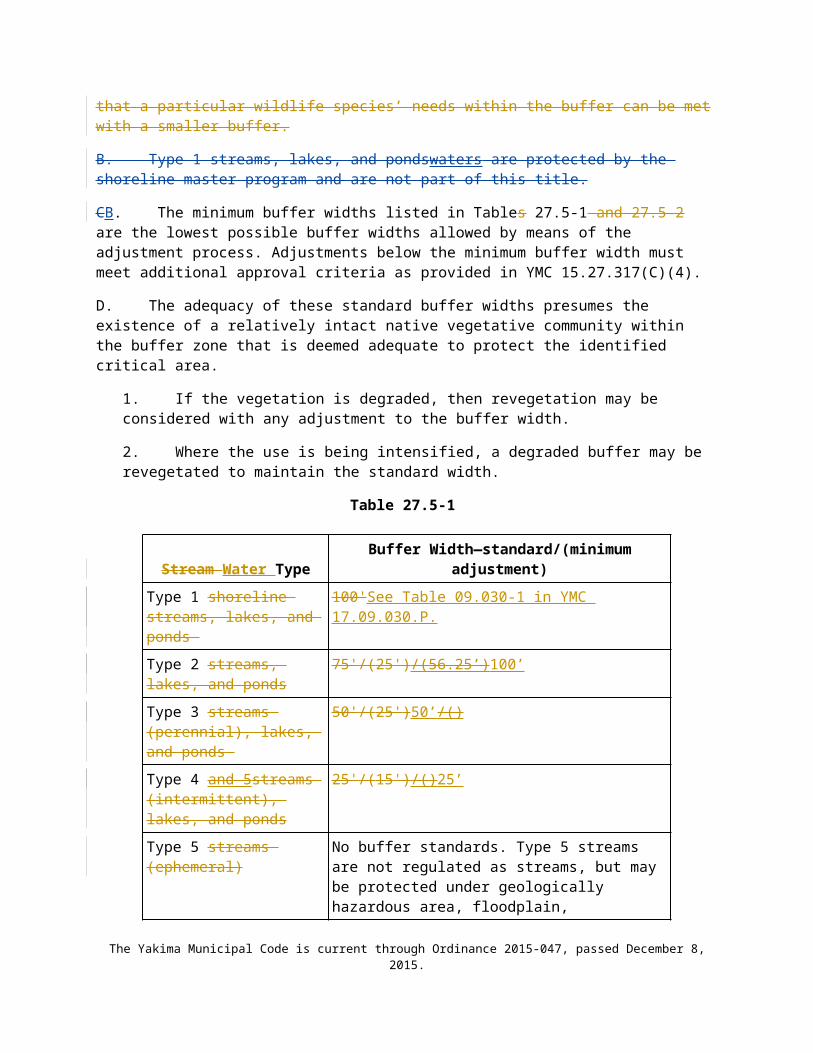
7. Enhancement of a wetland buffer through the removal of non-native invasive plant species. Removal of invasive plant species shall be restricted to hand removal. All removed plant material shall be taken away from the site and appropriately disposed of. Plants that appear on the Washington State Noxious Weed Control Board list of noxious weeds must be handled and disposed of according to a noxious weed control plan appropriate for that species. Revegetation with appropriate native species at natural densities is allowed in conjunction with removal of invasive plant species.
8. Repair and maintenance of non-conforming uses or structures, where legally established within the buffer, provided they do not increase their degree of nonconformity.
I. Signs and Fencing of Wetlands and Buffers.
1. Temporary markers. The outer perimeter of the wetland buffer and the clearing limits identified by an approved permit or authorization shall be marked in the field with temporary “clearing limits” fencing in such a way as to ensure that no unauthorized intrusion will occur. The marking is subject to inspection by the Administrative Official prior to the commencement of permitted activities. This temporary marking shall be maintained throughout construction and shall not be removed until permanent signs, if required, are in place.
2. Permanent signs. As a condition of any permit or authorization issued pursuant to this chapter, the Administrative Official may require the applicant to install permanent signs along the boundary of a wetland or buffer.
a. Permanent signs shall be made of an enamel-coated metal face and attached to a metal post or other non-treated material of equal durability. Signs must be posted at an interval of one (1) every 50-feet, or one (1) per lot if the lot is less than 50-feet wide, and must be maintained by the property owner in perpetuity. The signs shall be worded as follows or with alternative language approved by the Administrative Official:
Protected Wetland AreaDo Not Disturb
Contact the City of YakimaRegarding Uses, Restrictions, and Opportunities for Stewardship
b. The provisions of Subsection (a) may be modified as necessary to assure protection of sensitive features or wildlife.
3. Fencing.
a. The applicant shall be required to install a permanent fence around the wetland or buffer when domestic grazing animals are present or may be introduced on site.
b. Fencing installed as part of a proposed activity, or as required in this Subsection, shall be designed so as not to interfere with species mitigation, including fish runs, and shall be constructed in a manner that minimizes impacts to the wetland and associated habitat.
15.27.605 Compensatory mMitigation requirements.A. Mitigation Sequencing. Before impacting any wetland or its buffer, an applicant shall demonstrate that the following actions have been taken. Actions are listed in the order of preference:
1. Avoid the impact altogether by not taking a certain action or parts of an action.
The Yakima Municipal Code is current through Ordinance 2015-047, passed December 8, 2015.

2. Minimize impacts by limiting the degree or magnitude of the action and its implementation, by using appropriate technology, or by taking affirmative steps to avoid or reduce impacts.
3. Rectify the impact by repairing, rehabilitating, or restoring the affected environment.
4. Reduce or eliminate the impact over time by preservation and maintenance operations.
5. Compensate for the impact by replacing, enhancing, or providing substitute resources or environments.
6. Monitor the required compensation and take remedial or corrective measures when necessary.
B. Requirements for Compensatory Mitigation:
1. Compensatory mitigation for alterations to wetlands shall be used only for impacts that cannot be avoided or minimized and shall achieve equivalent or greater biologic functions. Compensatory mitigation plans shall be consistent with Wetland Mitigation in Washington State – Part 2: Developing Mitigation Plans—Version 1, (Ecology Publication #06-06-011b, Olympia, WA, March 2006 or as revised), and Selecting Wetland Mitigation Sites Using a Watershed Approach (Eastern Washington) (Publication #10-06-07, November 2010).
2. Mitigation ratios may also be determined using the credit/debit tool describe in “Calculating Credits and Debits for Compensatory Mitigation in Wetlands of Eastern Washington: Final Report (Ecology Publication #11-06-045, August 2012), consistent with subsection 8 of this Chapter.
3. Compensating for Lost or Affected Functions. Compensatory mitigation shall address the functions affected by the proposed project, with an intention to achieve functional equivalency or improvement of functions. The goal shall be for the compensatory mitigation to provide similar wetland functions as those lost, except when either:
a. The lost wetland provides minimal functions, and the proposed compensatory mitigation action(s) will provide equal or greater functions or will provide functions shown to be limiting within a watershed through a formal Washington state watershed assessment plan or protocol; or
b. Out-of-kind replacement of wetland type or functions will best meet watershed goals formally identified by the City, such as replacement of historically diminished wetland types.
C. Approaches to Compensatory Mitigation. Mitigation for lost or diminished wetland and buffer functions shall rely on the approaches listed below.
1. Wetland mitigation banks. Credits from a certified wetland mitigation bank may be used to compensate for impacts located within the service area specified in the mitigation bank instrument. Use of credits from a wetland mitigation bank certified under Chapter 173-700 WAC is allowed if:
a. The approval authority determines that it would provide appropriate compensation for the proposed impacts; and
b. The impact site is located in the service area of the bank.
c. The proposed use of credits is consistent with the terms and conditions of the certified mitigation bank instrument.
The Yakima Municipal Code is current through Ordinance 2015-047, passed December 8, 2015.

d. Replacement ratios for projects using bank credits is consistent with replacement ratios specified in the certified mitigation bank instrument.
2. In-Lieu Fee Mitigation: Credits from an approved in-lieu-fee program may be used when all of the following apply:
a. The approval authority determines that it would provide environmentally appropriate compensation for the proposed impacts.
b. The proposed use of credits is consistent with the terms and conditions of the approved in-lieu-fee program instrument.
c. Projects using in-lieu-fee credits shall have debits associated with the proposed impacts calculated by the applicant’s qualified wetland professional using the credit assessment method specified in the approved instrument for the in-lieu-fee program.
d. The impacts are located within the service area specified in the approved in-lieu-fee instrument.
3. Permittee-responsible mitigation. In this situation, the permittee performs the mitigation after the permit is issued and is ultimately responsible for implementation and success of the mitigation. Permittee-responsible mitigation may occur at the site of the permitted impacts or at an off-site location within the same watershed. Permittee-responsible mitigation shall be used only if the applicant’s qualified wetland professional demonstrates to the approval authority’s satisfaction that the proposed approach is ecologically preferable to use of a bank or ILF program, consistent with the criteria in this section.
D. Types of Compensatory Mitigation. Mitigation for lost or diminished wetland and buffer functions shall rely on a type listed below in order of preference. A lower-preference form of mitigation shall be used only if the applicant’s qualified wetland professional demonstrates to the approval authority’s satisfaction that all higher-ranked types of mitigation are not viable, consistent with the criteria in this section.
1. Restoration: The manipulation of the physical, chemical, or biological characteristics of a site with the goal of returning natural or historic functions to a former or degraded wetland. For the purpose of tracking net gains in wetland acres, restoration is divided into:
a. Re-establishment: The manipulation of the physical, chemical, or biological characteristics of a site with the goal of returning natural or historic functions to a former wetland. Re-establishment results in a gain in wetland acres (and functions). Activities could include removing fill material, plugging ditches, or breaking drain tiles.
b. Rehabilitation: The manipulation of the physical, chemical, or biological characteristics of a site with the goal of repairing natural or historic functions of a degraded wetland. Rehabilitation results in a gain in wetland function but does not result in a gain in wetland acres. Activities could involve breaching a dike to reconnect wetlands to a floodplain or return tidal influence to a wetland.
2. Establishment (Creation): The manipulation of the physical, chemical, or biological characteristics of a site to develop a wetland on an upland or deepwater site where a wetland did not previously exist. Establishment results in a gain in wetland acres. Activities typically involve excavation of upland soils to elevations that will produce a wetland hydroperiod, create hydric soils, and support the growth of hydrophytic plant species.
If a site is not available for wetland restoration to compensate for expected wetland and/or buffer impacts, the approval authority may authorize creation of a wetland and buffer upon demonstration by the applicant’s qualified wetland professional that:
The Yakima Municipal Code is current through Ordinance 2015-047, passed December 8, 2015.

a. The hydrology and soil conditions at the proposed mitigation site are conducive for sustaining the proposed wetland and that creation of a wetland at the site will not likely cause hydrologic problems elsewhere;
b. Adjacent land uses and site conditions do not jeopardize the viability of the proposed wetland and buffer (e.g., due to the presence of invasive plants or noxious weeds, stormwater runoff, noise, light, or other impacts); and
c. The proposed wetland and buffer will eventually be self-sustaining with little or no long-term maintenance.
3. Enhancement. The manipulation of the physical, chemical, or biological characteristics of a wetland site to heighten, intensify, or improve specific function(s) or to change the growth stage or composition of the vegetation present. Enhancement is undertaken for specified purposes such as water quality improvement, flood water retention, or wildlife habitat. Enhancement results in a change in some wetland functions and can lead to a decline in other wetland functions, but does not result in a gain in wetland acres. Activities typically consist of planting vegetation, controlling non-native or invasive species, modifying site elevations or the proportion of open water to influence hydroperiods, or some combination of these activities. Applicants proposing to enhance wetlands or associated buffers shall demonstrate how the proposed enhancement will increase the wetland’s/buffer’s functions, how this increase in function will adequately compensate for the impacts, and how existing wetland functions at the mitigation site will be protected.
4. Protection/Maintenance (Preservation). Removing a threat to, or preventing the decline of, wetland conditions by an action in or near a wetland. This includes the purchase of land or easements, or repairing water control structures or fences. This term also includes activities commonly associated with the term preservation. Preservation does not result in a gain of wetland acres. Permanent protection of a Category I or II wetland and associated buffer at risk of degradation can be used only if:
a. The approval authority determines that the proposed preservation is the best mitigation option;
b. The proposed preservation site is under threat of undesirable ecological change due to permitted, planned, or likely actions that will not be adequately mitigated under existing regulations;
c. The area proposed for preservation is of high quality or critical for the health of the watershed or basin due to its location. Some of the following features may be indicative of high-quality sites:
i. Category I or II wetland rating (using the wetland rating system for westernEastern Washington)
ii. Rare or irreplaceable wetland type (for example, bogs, mature forested wetlands, estuarine wetlands) or aquatic habitat that is rare or a limited resource in the area;
iii. The presence of habitat for priority or locally important wildlife species; or also list has provides biological and/or hydrological connectivity;
iv. Provides biological and/or hydrological connectivity;
v. Priority sites in an adopted watershed plan.
The Yakima Municipal Code is current through Ordinance 2015-047, passed December 8, 2015.

d. Permanent preservation of the wetland and buffer will be provided through a conservation easement or tract held by an appropriate natural land resource manager, such as a land trust.
e. The approval authority may approve other legal and administrative mechanisms in lieu of a conservation easement if it determines they are adequate to protect the site.
f. Ratios for preservation in combination with other forms of mitigation generally range from 10:1 to 20:1, as determined on a case-by-case basis, depending on the quality of the wetlands being impacted and the quality of the wetlands being preserved. Ratios for preservation as the sole means of mitigation generally start at 20:1.
E. Location of Compensatory Mitigation. Compensatory mitigation actions shall generally be conducted within the same sub-drainage basin and on the site of the alteration except when the applicant can demonstrate that off-site mitigation is ecologically preferable. The following criteria will be evaluated when determining whether the proposal is ecologically preferable. When considering off-site mitigation, preference should be given to using alternative mitigation, such as a mitigation bank, an in-lieu-fee program, or advance mitigation.
1. There are no reasonable opportunities on site or within the sub-drainage basin (e.g., on-site options would require elimination of high-functioning upland habitat), or opportunities on site or within the sub-drainage basin do not have a high likelihood of success based on a determination of the capacity of the site to compensate for the impacts. Considerations should include: anticipated replacement ratios for wetland mitigation, buffer conditions and proposed widths, available water to maintain anticipated hydrogeomorphic classes of wetlands when restored, proposed flood storage capacity, and potential to mitigate riparian fish and wildlife impacts (such as connectivity);
2. On-site mitigation would require elimination of high-quality upland habitat.
3. Off-site mitigation has a greater likelihood of providing equal or improved wetland functions than the altered wetland.
4. Off-site locations shall be in the same sub-drainage basin unless:
a. Established watershed goals for water quality, flood storage or conveyance, habitat, or other wetland functions have been established by the City and strongly justify location of mitigation at another site; or
b. Credits from a state-certified wetland mitigation bank are used as compensation, and the use of credits is consistent with the terms of the certified bank instrument;
c. Fees are paid to an approved in-lieu fee program to compensate for the impacts.
d. The design for the compensatory mitigation project needs to be appropriate for its location (i.e., position in the landscape). Therefore, compensatory mitigation should not result in the creation, restoration, or enhancement of an atypical wetland.
F. Timing of Compensatory Mitigation.
1. It is preferred that compensatory mitigation projects be completed prior to activities that will disturb wetlands. At the least, compensatory mitigation shall be completed immediately following disturbance and prior to use or occupancy of the action or development. Construction of mitigation projects shall be timed to reduce impacts to existing fisheries, wildlife, and flora.
2. The Administrator may authorize a one-time temporary delay in completing construction or installation of the compensatory mitigation when the applicant provides a written
The Yakima Municipal Code is current through Ordinance 2015-047, passed December 8, 2015.

explanation from a qualified wetland professional as to the rationale for the delay. An appropriate rationale would include identification of the environmental conditions that could produce a high probability of failure or significant construction difficulties (e.g., project delay lapses past a fisheries window, or installing plants should be delayed until the dormant season to ensure greater survival of installed materials). The delay shall not create or perpetuate hazardous conditions or environmental damage or degradation, and the delay shall not be injurious to the health, safety, or general welfare of the public. The request for the temporary delay must include a written justification that documents the environmental constraints that preclude implementation of the compensatory mitigation plan. The justification must be verified and approved by the City.
G. Wetland Mitigation Ratios:
Category and Type of Wetland
Creation or Re-establishment Rehabilitation Enhancement
Category I: Bog, Natural Heritage Site
Not considered possible Case by Case Case by Case
Category I: Mature Forested 6:1 12:1 24:1
Category I: Based on functions 4:1 8:1 16:1
Category II 3:1 6:1 12:1
Category III 2:1 4:1 8:1
Category IV 1.5:1 3:1 6:1Ratios for rehabilitation and enhancement may be reduced when combined with 1:1 replacement through creation or re-establishment. See Table 1b, Wetland Mitigation in Washington State – Part 1: Agency Policies and Guidance--Version 1, (Ecology Publication #06-06-011a, Olympia, WA, March 2006 or as revised). See also Paragraph D.4 for more information on using preservation as compensation.
H. Credit/Debit Method. To more fully protect functions and values, and as an alternative to the mitigation ratios found in the joint guidance “Wetland Mitigation in Washington State Parts I and II” (Ecology Publication #06-06-011a-b, Olympia, WA, March, 2006), the administrator may allow mitigation based on the “credit/debit” method developed by the Department of Ecology in “Calculating Credits and Debits for Compensatory Mitigation in Wetlands of Eastern Washington: Final Report” (Ecology Publication #11-06-015, August 2012, or as revised).
I. Compensatory Mitigation Plan. When a project involves wetland and/or buffer impacts, a compensatory mitigation plan prepared by a qualified professional shall be required, meeting the following minimum standards:
1. Wetland Critical Area Report. A critical area report for wetlands must accompany or be included in the compensatory mitigation plan and include the minimum parameters identified in YMC 15.27.314 and 15.27.315.B.
2. Compensatory Mitigation Report. The report must include a written report and plan sheets that must contain, at a minimum, the following elements. Full guidance can be found in Wetland Mitigation in Washington State–Part 2: Developing Mitigation Plans (Version 1) (Ecology Publication #06-06-011b, Olympia, WA, March 2006 or as revised).
a. The written report must contain, at a minimum:The Yakima Municipal Code is current through Ordinance 2015-047, passed December 8, 2015.

i. The name and contact information of the applicant; the name, qualifications, and contact information for the primary author(s) of the compensatory mitigation report; a description of the proposal; a summary of the impacts and proposed compensation concept; identification of all the local, state, and/or federal wetland-related permit(s) required for the project; and a vicinity map for the project.
ii. Description of how the project design has been modified to avoid, minimize, or reduce adverse impacts to wetlands.
iii. Description of the existing wetland and buffer areas proposed to be impacted. Include acreage (or square footage), water regime, vegetation, soils, landscape position, surrounding lands uses, and functions. Also describe impacts in terms of acreage by Cowardin classification, hydrogeomorphic classification, and wetland rating, based on Wetland Ratings, YMC 15.27.603.
iv. Description of the compensatory mitigation site, including location and rationale for selection. Include an assessment of existing conditions: acreage (or square footage) of wetlands and uplands, water regime, sources of water, vegetation, soils, landscape position, surrounding land uses, and functions. . Estimate future conditions in this location if the compensation actions are NOT undertaken (i.e., how would this site progress through natural succession?).
v. Surface and subsurface hydrologic conditions, including an analysis of existing and proposed hydrologic regimes for enhanced, created, or restored compensatory mitigation areas. Include illustrations of how data for existing hydrologic conditions were used to determine the estimates of future hydrologic conditions
vi. A description of the proposed actions for compensation of wetland and upland areas affected by the project. Include overall goals of the proposed mitigation, including a description of the targeted functions, hydrogeomorphic classification, and categories of wetlands.
vii. A description of the proposed mitigation construction activities and timing of activities.
viii. Performance standards (measurable standards for years post-installation) for upland and wetland communities, a monitoring schedule, and a maintenance schedule and actions proposed by year.
ix. A discussion of ongoing management practices that will protect wetlands after the development project has been implemented, including proposed monitoring and maintenance programs (for remaining wetlands and compensatory mitigation wetlands).
x. A bond estimate for the entire compensatory mitigation project, including the following elements: site preparation, plant materials, construction materials, installation oversight, maintenance twice per year for up to five (5) years, annual monitoring field work and reporting, and contingency actions for a maximum of the total required number of years for monitoring.
xi. Proof of establishment of Notice on Title for the wetlands and buffers on the project site, including the compensatory mitigation areas.
b. The scaled plan sheets for the compensatory mitigation must contain, at a minimum:
The Yakima Municipal Code is current through Ordinance 2015-047, passed December 8, 2015.
i. Surveyed edges of the existing wetland and buffers, proposed areas of wetland and/or buffer impacts, location of proposed wetland and/or buffer compensation actions.
ii. Existing topography, ground-proofed, at two-foot contour intervals in the zone of the proposed compensation actions if any grading activity is proposed to create the compensation area(s). Also existing cross-sections of on-site wetland areas that are proposed to be impacted, and cross-section(s) (estimated one-foot intervals) for the proposed areas of wetland or buffer compensation.
iii. Conditions expected from the proposed actions on site, including future hydrogeomorphic types, vegetation community types by dominant species (wetland and upland), and future water regimes.
iv. Required wetland buffers for existing wetlands and proposed compensation areas. Also, identify any zones where buffers are proposed to be reduced or enlarged outside of the standards identified in this Chapter.
v. A planting plan for the compensation area, including all species by proposed community type and water regime, size and type of plant material to be installed, spacing of plants, typical clustering patterns, total number of each species by community type, and timing of installation.
3. Buffer Mitigation Ratios. Impacts to buffers shall be mitigated at a minimum 1:1 ratio. Compensatory buffer mitigation shall replace those buffer functions lost from development.
4. Protection of the Mitigation Site. The area where the mitigation occurred and any associated buffer shall be located in a critical area tract or a conservation easement consistent with YMC 15.27 Part six.
5. Monitoring. Mitigation monitoring shall be required for a period necessary to establish that performance standards have been met, but not for a period less than five years. If a scrub-shrub or forested vegetation community is proposed, monitoring may be required for ten years or more. The project mitigation plan shall include monitoring elements that ensure certainty of success for the project’s natural resource values and functions. If the mitigation goals are not obtained within the initial five-year period, the applicant remains responsible for restoration of the natural resource values and functions until the mitigation goals agreed to in the mitigation plan are achieved.
6. Advance Mitigation. Mitigation for projects with pre-identified impacts to wetlands may be constructed in advance of the impacts if the mitigation is implemented according to federal rules, state policy on advance mitigation, and state water quality regulations consistent with Interagency Regulatory Guide: Advance Permittee-Responsible Mitigation (Ecology Publication #12-06-015, Olympia, WA, December 2012).
7. Alternative Mitigation Plans. The administrative official or designee Administrator may approve alternative wetland mitigation plans that are based on best available science, such as priority restoration plans that achieve restoration goals identified in the SMP. Alternative mitigation proposals must provide an equivalent or better level of protection of wetland functions and values than would be provided by the strict application of this chapter. The administrative official or designee Administrative Official shall consider the following for approval of an alternative mitigation proposal:
a. The proposal uses a watershed approach consistent with Selecting Wetland Mitigation Sites Using a Watershed Approach (Eastern Washington) (Ecology Publication #10-06-07, November 2010).
The Yakima Municipal Code is current through Ordinance 2015-047, passed December 8, 2015.

b. Creation or enhancement of a larger system of natural areas and open space is preferable to the preservation of many individual habitat areas.
c. Mitigation according to Section EYMC 15.27.605(D) is not feasible due to site constraints such as parcel size, stream type, wetland category, or geologic hazards.
d. There is clear potential for success of the proposed mitigation at the proposed mitigation site.
e. The plan shall contain clear and measurable standards for achieving compliance with the specific provisions of the plan. A monitoring plan shall, at a minimum, meet the provisions in Section JYMC 15.27.605(I).
f. The plan shall be reviewed and approved as part of overall approval of the proposed use.
g. A wetland of a different type may be justified based on regional needs or functions and values; the replacement ratios may not be reduced or eliminated unless the reduction results in a preferred environmental alternative.
h. Mitigation guarantees shall meet the minimum requirements as outlined in SectionYMC 15.27. 10.B.i.8605(I)(2)(a)(viii).
i. Qualified professionals in each of the critical areas addressed shall prepare the plan.
j. The City may consult with agencies with expertise and jurisdiction over the critical areas during the review to assist with analysis and identification of appropriate performance measures that adequately safeguard critical areas.
Projects that propose compensation for wetland acreage and/or functions are subject to state and federal regulations. Compensatory mitigation for alterations to wetlands shall provide for no net loss of wetland functions and values, and must be consistent with the mitigation plan requirements of YMC 15.27.314(M). The following documents were developed to assist applicants in meeting the above requirements:
A. Compensatory mitigation plans must be consistent with “Guidance on Wetland Mitigation in Washington State Part 2: Guidelines for Developing Wetland Mitigation Plans and Proposals” or as revised (Washington State Department of Ecology, U.S. Army Corps of Engineers Seattle District, and U.S. Environmental Protection Agency Region 10; Ecology Publication No. 04-06-013B).
B. Compensatory mitigation application and ratios for mitigation of wetlands shall be consistent with “Wetlands in Washington State—Volume 2: Guidance for Protecting and Managing Wetlands—Appendix 8-D—Section 8-D3” or as revised (Washington State Department of Ecology. Publication No. 05-06-008). (Ord. 2008-46 § 1 (part), 2008).
15.27.605 Wetland mitigation banks.A. Credits from a wetland mitigation bank may be approved for use as compensation for unavoidable impacts to wetlands when:
1. The bank is certified under RCW Chapter 90.84 or WAC Chapter 173-700;
2. The administrative official determines that the wetland mitigation bank can provide appropriate compensation for the authorized impacts; and
3. The proposed use of credits is consistent with the terms and conditions of the bank’s certification.
The Yakima Municipal Code is current through Ordinance 2015-047, passed December 8, 2015.

B. Replacement ratios for projects using bank credits shall be consistent with replacement ratios specified in the bank’s certification.
C. Credits from a certified wetland mitigation bank may be used to compensate for impacts located within the service area specified in the bank’s certification. In some cases, bank service areas may include portions of more than one adjacent drainage basin for specific wetland functions. (Ord. 2008-46 § 1 (part), 2008).
Part Seven. Geologically Hazardous Areas
15.27.701 Mapping and designation.A. Geologically hazardous areas are areas that are susceptible to one or more of the following, based on WAC 365-190-080(4)(b) through (h):
1. Erosion hazards;
2. Landslide hazards, which include:
a. Oversteepened slopes;
b. Alluvial fan/flash flooding;
c. Avalanche; and
d. Stream Channel migration zones and stream undercutting;
3. Seismic hazards (referred to below as earthquake hazards); and
4. Volcanic hazards.
C. The approximate location and extent of geologically hazardous areas are shown on the city’s critical area map titled “Geologically Hazardous Areas of the City of Yakima.” The following geologically hazardous areas have been mapped and classified using the criteria found in WAC 365-190-120080(4)(b) through (h):
15.27.702 Geologically hazardous areas protection approach.The geologically hazardous areas protection approach can be met by following the guidelines below and by implementing the appropriate sections of the Building Code as adopted in YMC Title 11.
A. Erosion Hazard Areas. Protection measures for erosion hazard areas will be accomplished by implementing the regulatory standards for erosion and drainage control required under YMC Title 11, building code. YMC Title 11 requirements can be met by the application of the Best Management Practices (BMPs) in the Stormwater Management Manual for Eastern Washington Stormwater Manual (WDOEcology publication number 04-10-076, or most recent version); equivalent manual adopted by the city of Yakima; or any other approved manual deemed appropriate by the administrative official.
D. Stream Undercutting Hazard Areas. Protection measures for stream undercutting hazard areas will be accomplished by critical areas review for flood hazards, and streams, and shoreline jurisdiction.
The Yakima Municipal Code is current through Ordinance 2015-047, passed December 8, 2015.

15.27.703 Development review procedure for geologically hazardous areas.B. Developments that receive an affirmative determination of hazard by the administrative official under subsection A of this section must conduct a geologic hazard report as provided in YMC 15.27.315(C), which may be part of a geotechnical report required below.
1. If the geologic hazard report determines that no hazard exists or that the project area lies outside the hazard, then no geologic hazard review is needed.
2. The administrative official is authorized to waive further geologic hazard review for oversteepened slopes on the basis that the hazards identified by the geologic hazard report will be adequately mitigated through conditions applied to the issuance of a grading or construction permit.
Part Eight. Critical Aquifer Recharge Areas (CARA)
15.27.810 Maps and Reference Documentsping.A. Mapping Methodology. The CARA is depicted in the map titled “Critical Aquifer Recharge Areas of the City of Yakima” located within the city of Yakima’s 2006 2017 Urban Area Comprehensive Plan 20252040. The CARA map was developed through a geographic information system (GIS) analysis using the methodology outlined in the Washington Department of Ecology “Critical Aquifer Recharge Areas Guidance Document for the Establishment of Critical Aquifer Recharge Area Ordinances” (Publication No. 97-30Morgan 2005). The approximate location and extent of critical aquifer recharge areas are depicted on the above-mentioned map, and are to be used solely as a guide for the city. The CARA map estimates areas of moderate, high, and extreme susceptibility to contamination, as well as wellhead protection areas. In characterizing the hydrogeologic susceptibility of these recharge areas with regard to contamination, the following physical characteristics were utilized:
B. Guidance Documents. The latest guidance documents shall be consulted when updating CARA maps:
1. U.S. Department of Agriculture Soil Survey: http://websoilsurvey.sc.egov.usda.gov/App/WebSoilSurvey.aspx
2. Washington Department of Health Group A and B Maps: https://fortress.wa.gov/doh/eh/maps/SWAP/index.html
3. Soil Survey of Yakima County Area, Washington (report only): http://nrcs.usda.gov/Internet/FSE_MANUSCRIPTS/washington/yakimaWA1985/yakimaWA1985-I.pdf
4. City of Yakima Wellhead Protection Plan: http://www.yakimacounty.us/669/City-of-Yakima-Wellhead-Protection-Plan
5. Hydrogeologic Framework of Sedimentary Deposits in Six Structural Basins, Yakima River Basin, Washington: http://pubs.usgs.gov/sir/2006/5116/pdf/sir20065116.pdf and Yakima Basin plate http://pubs.usgs.gov/sir/2006/5116/pdf/sir20065116_plate4.pdf
15.27.820 Protection approach.A. Classification and Rating of Critical Aquifer Recharge Areas. To promote consistent application of the standards and requirements of this section, Critical Aquifer Recharge Areas within the City shall be rated or classified according to their characteristics, function and value, and/or their sensitivity to disturbance.
The Yakima Municipal Code is current through Ordinance 2015-047, passed December 8, 2015.

1. Critical Aquifer Recharge Areas Classification. Critical aquifer recharge areas are those areas with a critical recharging effect on aquifers used for potable water. Wellhead protection involves the management of activities that have a potential to degrade the quality of groundwater produced by a supply well. The City is classified into four wellhead protection zones that are based on proximity to and travel time of groundwater to Group A and Group B water source wells within the City limits, and are designated using guidance from the Washington Department of Health Wellhead Protection Program pursuant to Chapter 246-290 WAC.
a. Wellhead Protection Zone 1 represents the land area overlying the six-month time-of-travel zone of any Group A water source well and/or land area overlying any Group B wellhead protection area.
b. Wellhead Protection Zone 2 represents the land area that overlies the one-year time-of-travel zone of any Group A water source well, excluding the land area contained within Wellhead Protection Zone 1.
c. Wellhead Protection Zone 3 represents the land area that overlies the five-year and ten-year time-of-travel zones of any Group A water source well, excluding the land area contained within Wellhead Protection Zones 1 or 2.
d. Wellhead Protection Zone 4 represents all the remaining land area in the City not included in Wellhead Protection Zones 1, 2, or 3.
2, Classification of wellhead protection zones shall be determined in accordance with the City’s Wellhead Protection Plan and the Washington State Department of Health, Office of Drinking Water, Source Water Assessment Program (SWAP) Mapping Application, which designates time of travel and wellhead protection zones that correspond to Zones 1 through 4, noted in subsection 1 above.
B. Prohibited Activities in Wellhead Protection Zones.
1. Land uses or activities for new development or redevelopment that pose a significant hazard to the City’s groundwater resources, resulting from storing, handling, treating, using, producing, recycling, or disposing of hazardous materials or other deleterious substances, shall be prohibited in Wellhead Protection Zones 1 and 2. These land uses and activities include, but are not limited to:
a. Large on-site sewage systems, as defined in WAC Chapter 246-272A;
b. Hazardous liquid pipelines as defined in RCW Chapter 81.88;
c. Solid waste landfills or transfer stations, including hazardous or dangerous waste, municipal solid waste, special waste, wood waste, and inert and demolition waste;
d. Liquid petroleum refining, reprocessing, and storage;
e. Bulk storage facilities;
f. Hard rock and sand and gravel mining, unless located within the mineral resource designation;
The Yakima Municipal Code is current through Ordinance 2015-047, passed December 8, 2015.

g. The storage or distribution of gasoline treated with the additive methyl tertiary butyl ether;
h. Hazardous waste treatment, storage, and disposal facilities except those defined under permit by rule for industrial wastewater treatment processes per WAC 173-303-802(5)(a);
i. Chemical manufacturing, including but not limited to, organic and inorganic chemicals, plastics and resins, pharmaceuticals, cleaning compounds, paints and lacquers, and agricultural chemicals;
j. Dry cleaning establishments using the solvent perchloroethylene or similarly toxic compounds;
k. Primary and secondary metal industries that manufacture, produce, smelt, or refine ferrous and nonferrous metals from molten materials;
l. Wood treatment facilities that allow any portion of the treatment process to occur over permeable surfaces (both natural and manmade);
m. Mobile fleet fueling operations;
n. Class I, Class III, Class IV, and the following types of Class V wells: 5A7, 5F01, 5D03, 5F04, 5W09, 5W10, 5W11, 5W31, 5X13, 5X14, 5X15, 5W20, 5X28, and 5N24 as regulated under RCW Chapter 90.48 and WAC Chapters 173-200 and 173-218, as amended;
o. Permanent dewatering of the aquifer for new projects and redevelopment;
p. Facilities that store, process, or dispose of radioactive substances; and
q. Irrigation with graywater or reclaimed water.
2. Other land uses and activities that the City determines would pose a significant groundwater hazard to Group A and Group B groundwater supplies within the City limits, or would significantly reduce the recharge to aquifers currently or potentially used as a potable water source.
C. Wellhead Protection Zone Performance Standards.
1. Activities may only be permitted in a critical aquifer recharge area if the applicant can show that the proposed activity will not cause contaminants to enter the aquifer and that the proposed activity will not adversely affect the recharging of the aquifer.
2. Any uses or activities which involve storing, handling, treating, using, producing, recycling, or disposing of hazardous materials or other deleterious substances shall comply with the following standards that apply to the wellhead protection zone in which they are located. Residential uses of hazardous materials or deleterious substances are exempt from the following standards.
3. If a property is located in more than one wellhead protection zone, the Director of Community Development shall determine which standards shall apply based on an assessment evaluation of the risk posed by the facility or activity. The assessment
The Yakima Municipal Code is current through Ordinance 2015-047, passed December 8, 2015.

evaluation shall include, but not be limited to: (a) the location, type, and quantity of the hazardous materials or deleterious substances on the property; (b) the geographic and geologic characteristics of the site; and (c) the type and location of infiltration on the site.
4. Development within Wellhead Protection Zones 1 or 2, and any facility or activity existing as of adoption of this Title within which hazardous materials or other deleterious substances are present, shall implement the following relevant performance standards:
a. Secondary Containment.
i. The owner or operator of any facility or activity shall provide secondary containment for hazardous materials or other deleterious substances in aggregate quantities equal to or greater than 20 gallons liquid or 200 pounds solid or in quantities specified in the Yakima Fire Code, YMC Chapter 10.05, whichever is smaller.
ii. Hazardous materials stored in tanks that are subject to regulation by the Washington State Department of Ecology (Ecology) under WAC Chapter 173-360, Underground Storage Tank Regulations, are exempt from the secondary containment requirements of this section, provided that documentation is provided to demonstrate compliance with those regulations.
b. Vehicle Fueling, Maintenance, and Storage Areas. Fleet and automotive service station fueling, equipment maintenance, and vehicle washing areas shall have a containment system for collecting and treating all runoff from such areas and preventing release of fuels, oils, lubricants, and other automotive fluids into soil, surface water, or groundwater. Appropriate emergency response equipment and spill kits shall be kept on-site during transfer, handling, treatment, use, production, recycling, or disposal of hazardous materials or other deleterious substances.
c. Loading and Unloading Areas. Secondary containment or equivalent Best Management Practices (BMPs), as approved by the Director of Public Works, shall be required at loading and unloading areas that store, handle, treat, use, produce, recycle, or dispose of hazardous materials or other deleterious substances in aggregate quantities equal to or greater than 20 gallons liquid or 200 pounds solid.
d. Stormwater Infiltration Systems. Design and construction of new stormwater infiltration systems must address site-specific risks of releases posed by all hazardous materials on-site. These risks may be mitigated by physical design means or equivalent BMPs in accordance with an approved Hazardous Materials Management Plan. Design and construction of said stormwater infiltration systems shall also be in accordance with YMC Chapter 7.83 and the latest edition of the Stormwater Management Manual for Eastern Washington, approved local equivalent, or another technical stormwater manual approved by Ecology, and shall be certified for compliance with the requirements of this section by a professional engineer or engineering geologist registered in the State of Washington.
e. The record and construction details of any well regulated under Chapter 173-160 WAC, Construction and Maintenance of Wells, and any well excluded per WAC 173-160-010(2) that is constructed or decommissioned in Zones 1 and 2, shall be provided to
The Yakima Municipal Code is current through Ordinance 2015-047, passed December 8, 2015.

the Department of Community Development within 60 days of well completion or decommissioning.
f. Protection Standards During Construction. The following standards shall apply to construction activities occurring where construction vehicles will be refueled on-site and/or the quantity of hazardous materials that will be stored, dispensed, used, or handled on the construction site is in aggregate quantities equal to or greater than 20 gallons liquid or 200 pounds solid, exclusive of the quantity of hazardous materials contained in fuel or fluid reservoirs of construction vehicles. As part of the City’s project permitting process, the City may require any or all of the following items:
i. A development agreement;
ii. Detailed monitoring and construction standards;
iii. Designation of a person on-site during operating hours who is responsible for supervising the use, storage, and handling of hazardous materials and who has appropriate knowledge and training to take mitigating actions necessary in the event of fire or spill;
iv. Hazardous material storage, dispensing, refueling areas, and use and handling areas shall be provided with secondary containment adequate to contain the maximum release from the largest volume container of hazardous substances stored at the construction site;
v. Practices and procedures to ensure that hazardous materials left on-site when the site is unsupervised are inaccessible to the public. Locked storage sheds, locked fencing, locked fuel tanks on construction vehicles, or other techniques may be used if they will preclude access;
vi. Practices and procedures to ensure that construction vehicles and stationary equipment that are found to be leaking fuel, hydraulic fluid, and/or other hazardous materials will be removed immediately or repaired on-site immediately. The vehicle or equipment may be repaired in place, provided the leakage is completely contained;
vii. Practices and procedures to ensure that storage and dispensing of flammable and combustible liquids from tanks, containers, and tank trucks into the fuel and fluid reservoirs of construction vehicles or stationary equipment on the construction site are in accordance with the Yakima Fire Code, YMC Chapter 10.05; and
viii. Practices and procedures, and/or on-site materials adequate to ensure the immediate containment and cleanup of any release of hazardous substances stored at the construction site. On-site cleanup materials may suffice for smaller spills whereas cleanup of larger spills may require a subcontract with a qualified cleanup contractor. Releases shall immediately be contained, cleaned up, and reported if required under state or federal law. Contaminated soil, water, and other materials shall be disposed of according to state and local requirements.
g. Fill Materials. Fill material shall comply with the standards in YMC Chapter 7.82 and the following:
The Yakima Municipal Code is current through Ordinance 2015-047, passed December 8, 2015.

i. Fill material shall not contain concentrations of contaminants that exceed cleanup standards for soil specified in WAC 173-340-740, Model Toxics Control Act, regardless of whether all or part of the contamination is due to natural background levels at the fill source site. Where the detection limit (lower limit at which a chemical can be detected by a specified laboratory procedure) for a particular soil contaminant exceeds the cleanup standard for soil specified in WAC 173-340-740, the detection limit shall be the standard for fill material quality.
ii. Fill materials in quantities greater than 10 cubic yards placed directly on or in the ground in excess of six months shall meet the following requirements:
1. A fill material source statement shall be provided to the Department of Community Development and shall be reviewed and accepted by the Department prior to stockpiling or grading imported fill materials at the site. The source statement shall be issued by a professional engineer, geologist, engineering geologist or hydrogeologist licensed in the State of Washington demonstrating the source’s compliance with standards of the Model Toxics Control Act. The source statement shall be required for each different source location from which fill will be obtained.
2. Analytical results demonstrating that fill materials do not exceed cleanup standards specified in WAC 173-340-740 may be used in lieu of a fill material source statement, provided the regulated facility submits a sampling plan to, and which is approved by, the Director of Community Development. The regulated facility must then adhere to the approved sampling plan, and maintain analytical data on-site and available for inspection for a minimum of five years from the date that the fill was accepted.
iii. The Department of Community Development may accept a fill material source statement that does not include results of sampling and analysis of imported fill if it determines that adequate information is provided indicating that the source location is free of contamination. Such information may include, but is not limited to:
1. Results of field testing of earth materials to be imported to the site with instruments capable of detecting the presence of contaminants; or
2. Results of previous sampling and analysis of earth materials to be imported to the site.
iv. A fill material source statement is not required if documents confirm that imported fill will be obtained from a Washington State Department of Transportation approved source.
v. The Director of Community Development shall have the authority to require corrective measures regarding noncompliant fill materials, including independent sampling and analysis, if the property owner or operator fails to accomplish such measures in a timely manner. The property owner or operator shall be responsible for any costs incurred by the City in the conduct of such activities.
h. Cathodic Protection Wells. Cathodic protection wells shall be constructed such that the following do not occur.
The Yakima Municipal Code is current through Ordinance 2015-047, passed December 8, 2015.

i. Vertical cross-connection of aquifers normally separated by confining units;
ii. Migration of contaminated surface water along improperly sealed well borings or casings;
iii. Introduction of electrolytes or related solutions into the subsurface; and
iv. Any of the above conditions caused by improperly abandoned cathodic protection wells that are no longer in use.
i. Underground Hydraulic Elevator Cylinders. All underground hydraulic elevator pressure cylinders shall be encased in an outer plastic casing constructed of Schedule 40 or thicker-wall polyethylene or polyvinyl chloride pipe, or equivalent. The plastic casing shall be capped at the bottom, and all joints shall be solvent- or heat-welded to ensure water tightness. The neck of the plastic casing shall provide a means of inspection to monitor the annulus between the pressurized hydraulic elevator cylinder and the protective plastic casing.
j. Best Management Practices (BMPs). All development or redevelopment shall implement BMPs for water quality and quantity, as approved by the Director of Community Development, such as biofiltration swales and use of oil-water separators, BMPs appropriate to the particular use proposed, clustered development, and limited impervious surfaces.
5. Development within Wellhead Protection Zone 3 shall implement appropriate BMPs and comply with the performance standards for vehicle fueling, maintenance, and storage areas; loading and unloading areas; well construction and operation; fill materials; cathodic protection wells; and underground hydraulic elevator cylinders in applicable subsections in C.4 of this section.
6. Development within Wellhead Protection Zone 4 shall implement BMPs for water quality and quantity.
7. An incremental environmental improvement to a system protective of groundwater shall not alter, expand, or intensify an existing legal nonconformance, but may proceed without having to meet the following City codes:
a. Restrictions associated with critical areas and critical area buffers, if the footprint of the original system protective of groundwater is located within the same critical area buffer, and it can be demonstrated through BAS that there will be no significant adverse impacts to the critical area and its buffer;
b. Any requirement to bring all or any portion of the facility or the development it serves up to current building, fire, or land use codes that is triggered by the value or design of the incremental environmental improvement to a system protective of groundwater; and
c. The incremental improvement shall not qualify as a redevelopment that would otherwise be prohibited by Title 15 YMC.
A. Maps shall be used only as an informational resource to communicate with applicants regarding potential problems in meeting the applicable laws on a particular site. The maps
The Yakima Municipal Code is current through Ordinance 2015-047, passed December 8, 2015.

indicate that areas of high susceptibility tend to be located in valley bottoms and follow along floodplain and stream corridors. Extreme susceptibility locations are located largely within floodplains and along streams and wetlands.
B. Land uses are subject to many existing federal, state, local, or tribal laws regarding the handling of substances that may contaminate CARAs. Disclosure, educational information, and coordination of existing laws during existing review processes can accomplish the requirement to protect the CARA. Consequently, the city of Yakima’s protection of the CARA shall be accomplished through normal project permit review under various Yakima Municipal Code sections, especially the stream protection standards in this chapter (Part Five, Fish and Wildlife Habitat and the Stream Corridor System); YMC Title 11, which provides detailed construction, use, and fire/life safety standards for the storage and handling of dangerous and hazardous substances to a greater extent than most existing state and federal laws.
C. The administrative official shall develop and maintain a list of the relevant laws noted above. This list shall be informational and it is intended to be used in coordination with development permit review. This list shall be periodically reviewed and updated so as to provide the most comprehensive list possible to inform project applicants of the requirements of other agencies.
D. The administrative official shall also develop and maintain a table of land uses with the potential of being subject to the relevant laws noted above. The table shall be generated and maintained using the intent stated in YMC 15.27.800(D).
E. The administrative official and water/irrigation manager shall cooperatively develop questionnaires, to be filled out by new development permit applicants, which comprehensively establish the potential use, storage, and handling methods within the project for substances that have the potential to contaminate groundwater. The questionnaires are intended to ensure full application of existing building and construction codes related to such substances in order to forestall new regulations.
F. The administrative official and water/irrigation manager shall develop technical assistance and information materials to assist landowners and developers with understanding and meeting relevant existing federal, state, and local laws relating to CARAs. (Ord. 2009-42 § 12, 2009: Ord. 2008-46 § 1 (part), 2008).
APPENDIX BDesignated Type 2 Stream Corridors
The following stream reaches within Yakima County are designated critical areas
under the City of Yakima’s Critical Areas Ordinance:
1. Bachelor Creek: From source at Ahtanum Creek (SEC13-TWP12N-RGE16 EWM)
downstream to its mouth at Ahtanum Creek (SEC1-TWP12N-RGE18E).
2. Cottonwood Canyon Creek: From the south line of SEC32-TWP13N-RGE17E,
downstream to mouth at Wide Hollow Creek (SEC36-TWP13N-RGE17E).
The Yakima Municipal Code is current through Ordinance 2015-047, passed December 8, 2015.

3. Hatton Creek: From its source at Ahtanum Creek (SEC18-TWP12N-RGE17)
downstream to its confluence with Ahtanum Creek (SEC18-TWP12N-RGE18E).
4. Wide Hollow Creek: From the east line of the SW1/4 of the NW1/4 (SEC28-
TWP13N-RGE17E) downstream to the mouth at the Yakima River.
5. Cowiche Creek: that portion which is not designated Type 1.
6. Spring Creek and associated tributaries.
YMC Title 17 SHORELINES
17.01.090 Definitions.
“Fill” means the addition of soil, sand, rock, gravel, sediment, earth retaining structure, or other material to an area waterward of the OHWM, in wetlands, or on shorelands in a manner that raises the elevation or creates dry land. The physical structure of a bank stabilization structure shall not be considered fill. However, fill placed behind the structure is considered fill. Stream bed manipulation for irrigation diversions or restoration shall not be considered fill.
“Fish and wildlife habitat conservation” means land management for maintaining populations of species in suitable habitats within their natural geographic distribution so that the habitat available is sufficient to support viable populations over the long term and isolated subpopulations are not created. This does not mean maintaining all individuals of all species at all times, but it does mean not degrading or reducing populations or habitats so that they are no longer viable over the long term. Counties and cities should engage in cooperative planning and coordination to help assure long term population viability.
“Fish and wildlife habitat conservation areas” are areas that serve a critical role in sustaining needed habitats and species for the functional integrity of the ecosystem, and which, if altered, may reduce the likelihood that the species will persist over the long term. These areas may include, but are not limited to, rare or vulnerable ecological systems, communities, and habitat or habitat elements including seasonal ranges, breeding habitat, winter range, and movement corridors; and areas with high relative population density or species richness. Counties and cities may also designate locally important habitats and species. Fish and wildlife habitat conservation areas does not include such artificial features or constructs as irrigation delivery systems, irrigation infrastructure, irrigation canals, or drainage ditches that lie within the boundaries of, and are maintained by, a port district or an irrigation district or company.
"Habitats of local importance" are designated as fish and wildlife habitat conservation areas based on a finding by the city that they are locally important.
“Hydrologically related critical areas (HRCA)” include all those areas identified in YMC 17.09.030(C) within the city of Yakima which are important and deserving of protection by nature of their value for the functional properties found in YMC 17.09.030(E).
The Yakima Municipal Code is current through Ordinance 2015-047, passed December 8, 2015.

“Ordinary high water mark” (OHWM) means that mark on lakes and streams which will be found by examining the bed and banks and ascertaining where the presence and action of waters are so common and usual, and so long continued in ordinary years, as to mark upon the soil or vegetation a character distinct from that of the abutting upland. Provided, that in any area where the ordinary high water line cannot be found, the ordinary high water line is the elevation of the mean annual flood.
“Scour” means the removal of underwater material by waves and currents, especially at the base or toe of a shore bank stabilization or other in-water structure.
“Species of local importance” are those species that are of local concern due to their population status or their sensitivity to habitat alteration or that are game species.
“Stream corridor,” as used in this title, means those features listed and described in YMC 17.09.030(C).
“Vegetative buffer” or “buffer” means an area extending landward from the ordinary high water mark of a lake or stream and/or from the edge of a wetland which is maintained or otherwise allowed to provide, under optimal conditions, adequate soil conditions and native vegetation for the performance of the basic functional properties of a fish and wildlife conservation areastream corridor, wetland and other hydrologically related critical areas as set forth in YMC 17.09.030(E) (Functional Properties) and YMC 17.09.040(D) (Wetland Functions and Rating). It is understood that optimal conditions do not always exist due to degradation of the vegetative buffer before establishment of this title, or due to colonization by nonnative species. Such conditions still provide functional properties, though at a lower level, depending on the difference from natural conditions.
“Waters of the state” are all lakes, rivers, ponds, streams, inland waters, underground waters, salt waters, and all other surface waters and watercourses within the jurisdiction of the state of Washington.
17.09.020 Flood hazard areas.
FLOODWAY FRINGE USESJ. Permitted Uses. The following uses are permitted in the floodway fringe areas:
1. Permitted Uses. Any use permitted in the zoning district in accordance with YMC Title 15 and in the environment designation in accordance with this title, unless prohibited by subsection K of this section; that said use is in compliance with the flood hazard protection standards of YMC 17.09.020(H) and other applicable provisions of this Title and will have a negligible effect upon the floodway in accordance with the floodway encroachment provisions of YMC 17.09.020(J)(2).
2. All new encroachments, including fill, new construction and other development, if certification by a registered professional engineer is provided demonstrating through hydrologic and hydraulic analysis performed in accordance with standard engineering practice that the effect of the subject encroachment together with the cumulative effects of all similar potential encroachments shall not materially cause water to be diverted upland of the established floodway fringe, cause erosion, obstruct the natural flow of
The Yakima Municipal Code is current through Ordinance 2015-047, passed December 8, 2015.

water, reduce the carrying capacity of the floodway, or result in any increase in flood levels during the occurrence of the base flood discharge;
3. All new encroachments, including fill, new construction and other development if:a. The new encroachment is separated from the waterbody by an existing public
roadway or legal development.b. The new encroachment is located in a residential zone with a density of greater
than 1 unit per acre.
4. . Utility Transmission Lines. Utility transmission lines shall be permitted when consistent with YMC Title 15 and where not otherwise inconsistent with this section; except that when the primary purpose of such a transmission line is to transfer bulk products or energy through a floodway fringe or special flood hazard area, such transmission line shall conform to the following:
a. Electric transmission lines shall cross floodway fringe and special flood hazard areas by the most direct route feasible. When support towers must be located within floodway fringe or special flood hazard areas, they shall be placed to avoid high floodwater velocity and/or depth areas, and shall be adequately floodproofed.b. Buried utility transmission lines transporting hazardous materials, including but not limited to crude and refined petroleum products and natural gas, shall be buried a minimum of four feet. Such burial depth shall be maintained within the floodway fringe or special flood hazard area to the maximum extent of potential channel migration as determined by hydrologic analyses. All such hydrologic analyses shall conform to requirements of YMC 17.05.060(C)(3)(c).c. Beyond the maximum extent of potential channel migration, utility transmission lines transporting hazardous and nonhazardous materials shall be buried below existing natural and artificial drainage features.d. Aboveground utility transmission lines, not including electric transmission lines, shall only be allowed for the transportation of nonhazardous materials. In such cases, applicants must demonstrate that line placement will have no appreciable effect upon flood depth, velocity or passage. Such lines shall be adequately protected from flood damage.e. Aboveground utility transmission line appurtenant structures, including valves, pumping stations or other control facilities, shall not be permitted in floodway fringe or special flood hazard areas except where no other alternative is available, or in the event a floodway fringe or special flood hazard location is environmentally preferable. This does not apply to domestic water and regional wastewater transmission pipes. In such instances, aboveground structures shall be located so that no appreciable effect upon flood depth, velocity or passage is created, and shall be adequately floodproofed.
5. Any use permitted in the zoning district in accordance with YMC Title 15, unless prohibited by YMC 17.09.020(J)(1-4) above may be permitted if a Critical Areas Report is prepared by a qualified individual, in accordance with this Title, that addresses whether the encroachment would have an adverse impact on fish and wildlife and/or floodplain functions.
K. Prohibited Uses. The following uses are prohibited in the floodway fringe areas:
The Yakima Municipal Code is current through Ordinance 2015-047, passed December 8, 2015.
1. Any structure, including manufactured homes and the expansion of manufactured home/parks, designed for or to be used for human habitation of a permanent nature (including temporary dwellings authorized by YMC 15.04.130 and 15.04.140) that does not meet the criteria in YMC 17.09.020(J)(1-5);New manufactured home parks and the expansion of manufactured home/parks are prohibited in floodway fringe areas.
2. Any new encroachments, including fill, new construction and other development, unless certification by a registered professional engineer is provided demonstrating through hydrologic and hydraulic analysis performed in accordance with standard engineering practice that the effect of the subject encroachment together with the cumulative effects of all similar potential encroachments shall not materially cause water to be diverted upland of the established floodway fringe, cause erosion, obstruct the natural flow of water, reduce the carrying capacity of the floodway fringe, or result in any increase in flood levels during the occurrence of the base flood discharge;
3. Construction or reconstruction of residential structures within the designated floodway fringe, except for:
a. Repairs, reconstruction, or improvements to a structure which do not increase the ground floor area; and b. Repairs, reconstruction or improvements to a structure, the cost of which does not exceed fifty percent of the assessed value of the structure either:
1. Before the repair, reconstruction or improvement is started; or2. If the structure has been damaged and is being restored, before the damage occurred.
c. Work done on structures to correct existing violations of existing health, sanitary or safety codes, or to structures identified as historic places, shall not be included in the fifty percent. d. If subsection 2 of this section is satisfied, all new construction and substantial improvements shall comply with all applicable flood hazard reduction provisions of Part Four.
FLOODWAY USES
L. Permitted Uses. Permitted uses include any use permitted in the zoning district in accordance with YMC Title 15 and in the environment designation in accordance with this title; provided, that said use is in compliance with the flood hazard protection standards of subsections H and I of this section, YMC 17.05.050 and other applicable provisions of this title, and will have a negligible effect upon the floodway as certified by a registered professional engineer through hydrologic and hydraulic analysis performed in accordance with standard engineering practice. The analysis must demonstrate that the effect of the subject encroachment together with the cumulative effects of all similar potential encroachments shall not:
1. Materially cause water to be diverted from the established floodway;
2. Cause erosion;
3. Obstruct the natural flow of water;
4. Reduce the carrying capacity of the floodway; or
The Yakima Municipal Code is current through Ordinance 2015-047, passed December 8, 2015.

5. Result in any increase in flood levels during the occurrence of the base flood discharge.
M. Prohibited Uses. The following uses/developments are prohibited in the floodway:
1. Any structure, including manufactured homes, designed for or to be used for human habitation of a permanent nature (including temporary dwellings authorized by YMC 15.04.130 and 15.04.140);
2. Any encroachments, including fill, new construction and other development unless demonstrated by a registered professional engineer through hydrologic and hydraulic analysis performed in accordance with standard engineering practice that the effect of the subject encroachment together with the cumulative effects of all similar potential encroachments shall materially cause water to be diverted from the established floodway, cause erosion, obstruct the natural flow of water, reduce the carrying capacity of the floodway, or result in any increase in flood levels during the occurrence of the base flood discharge;
3. Aboveground utility transmission line appurtenant structures, including valves, pumping stations, or other control facilities, shall not be permitted in the floodway, except for domestic water and regional wastewater facilities where necessary;
4. Where a floodway has not been determined by preliminary Corps of Engineers’ investigations or official designation, a floodway shall be defined by qualified engineering work by the applicant on the basis of a verified one-hundred-year flood event;
5. Construction or reconstruction of residential structures within designated floodways, except as allowed under Chapter 17.11 YMC;
6. The construction or storage of any object subject to flotation or movement during flood level periods;
7. The following uses, due to their high degree of incompatibility with the purpose of establishing and maintaining a functional floodway, are specifically prohibited:
a. The filling of wetlands, except as authorized under YMC 17.09.030, Fish and wildlife habitat and the stream corridor system, and YMC 17.09.040, Wetlands;b. Solid waste landfills, dumps, junkyards, outdoor storage of vehicles, and/or materials; andc. Damming or relocation of any watercourse that will result in any downstream increase in flood levels during the occurrence of the base flood discharge (see YMC 17.09.030(J)).
8. The listing of prohibited uses in this section shall not be construed to alter the general rule of statutory construction that any use not permitted is prohibited.
N. Nonconforming Uses and Structures. Existing structures and uses within the special flood hazard areas established by this section or amendments thereto, which were lawful before these sections were adopted or amended, but which would be prohibited, or restricted under the terms of this section or future amendment, are governed under Chapter 17.11 YMC.
The Yakima Municipal Code is current through Ordinance 2015-047, passed December 8, 2015.

17.09.030 Fish and wildlife habitat conservation areas.
A. Purpose and Intent. The stream corridor system includes hydrologically related critical areas, streams, lakes, ponds, and wetlands and is part of a fragile and highly complex relationship of geology, soils, water, vegetation, and wildlife. Policies and standards to help conserve and protect fish and wildlife habitat conservation areas are designed to accomplish the following:
1. Meet the requirements of the Shoreline Management Act (Chapter 90.58 RCW) regarding best available science that is applicable to the issues of concern;2. Follow the requirements pursuant to flood-resistant construction in the adopted building code;3. Provide a zero net loss of natural wetland functions and values;4. Provide possible Require consideration of alternatives for necessary development, construction, and uses within fish and wildlife habitat conservation areas;53. Prevent decline in the quantity and quality of surface and subsurface waters;64. Conserve, restore, and protect fish and wildlife habitats, vegetation, and ecological relationships;75. Protect fish and wildlife habitat conservation areas from the potential negative effects of development through coordinated land use planning; and,86. Protect fish and wildlife habitat conservation areas through voluntary agreements or government incentives.9. Recognize wildlife area conservation habitats within their natural geographic location through coordinated land use planning.
B. Protection Approach.1. To maintain fish and wildlife habitat, there must be adequate environmental conditions for reproduction, foraging, resting, cover, and dispersal of animals. Factors affecting both habitat and its quality include the presence of essential resources such as food, water, covernest building materials, and lack of disturbance and diseases. The city of Yakima protects fish and wildlife habitat through:a. Protection of habitat for aquatic speciesDesignation of fish and wildlife habitat conservation areas; andb. Protection of habitat for species located near the waterApplication of development standards based on best available science to proposed activity and development in or near fish and wildlife habitat conservation areas.2. The City of Yakima’s approach to protecting threatened, endangered, and sensitive species habitat is by using the protection approach sections of this chapter.
DESIGNATION AND MAPPING
C. Hydrologically Related Critical Area Features. Stream corridors and other hydrologically related critical areas include one or more of the following featuresDesignation: Fish and wildlife habitat conservation areas are those habitat areas that meet any of the criteria listed below:
1. Areas with which state and federal endangered, threatened, and sensitive species have a primary association;
2. Habitats and species of local importance;3. Naturally occurring ponds under 20 acres and their submerged aquatic beds that
provide fish or wildlife habitat;4. Waters of the state, including any required buffers and associated Federal Emergency
Management Agency-mapped floodplains and floodways;
The Yakima Municipal Code is current through Ordinance 2015-047, passed December 8, 2015.

5. Lakes, ponds, streams, and rivers planted with game fish by a governmental or tribal entity; and
6. State natural area preserves, natural resource conservation areas, and state wildlife areas.
1. Any floodway or floodplain identified as a special flood hazard area identified by the Federal Emergency Management Agency (FEMA), as identified in the flood insurance study or corresponding maps, is hereby adopted by reference and declared to be part of this chapter;2. Perennial and intermittent streams, excluding ephemeral streams, including the stream main channel and all secondary channels within the ordinary high water mark;3. Naturally occurring ponds under twenty acres and associated submerged aquatic beds; and manmade lakes and ponds created within a stream channel;4. All wetlands as defined in YMC 17.01.090;5. Any flood-prone area indicated by U.S. Soil Conservation Service soil survey data; and6. A buffer area for a stream channel, lake, or pond or from the edge of a wetland.
D. Habitat and Habitats of Local Importance.
1. Habitats of local importance are habitats or species that due to their declining population, sensitivity to habitat manipulation or other values make them important on a local level. Habitats of local importance may include a seasonal range or habitat element with which a given species has a primary association, and which, if altered, may reduce the likelihood that the species will maintain and reproduce over the long term.All species and habitats identified by WDFW’s Priority Habitats and Species program that may be found in the city of Yakima are designated as fish and wildlife habitat conservation areas and afforded protection under this chapter.
3. Development Standards. Projects located within habitats of local importance, or within 200 feet of species of local importance, as designated in subsection (D)(1) of this section, shall comply with the applicable development standards in subsections I through P of this section. In addition, projects shall be designated using management recommendations established for the species or habitat by federal and state agencies, or those adopted for species and habitats of local importance by the city of Yakima. The department shall consider the extent such recommendations are used in its decision on the proposal, and may consider recommendations and advice from agencies with expertise.
E. Functional Properties.
1. Streams, lakes, ponds and wetlandsAquatic fish and wildlife habitat conservation areas require a sufficient riparian area to support one or more of the following functional properties:
a. Stream Stabilizing banks;b. Providing a sufficient shade canopy to maintain water temperatures that support fish and their habitat;c. Moderating the impact of stormwater runoff;d. Filtering solids, nutrients and harmful substances;e. Preventing surface erosion;f. Providing and maintaining migratory corridors for wildlife;
The Yakima Municipal Code is current through Ordinance 2015-047, passed December 8, 2015.
g. Providing food in the form of various insects and other benthic macroinvertebrates;h. Supporting a diversity of wildlife habitats; ori. Allowing for the natural occurrence of woody debris and organic matter to collect in the aquatic environment.
F. Streams, Lakes and PondsWater Typing System. For purposes of this chapter, the city of Yakima hereby adopts a stream, lake and pond typing system for those features designated as critical areas in subsection C of this section as follows:
1. Type 1 streams waters are those waters, within their ordinary high water mark (OHWM), meeting the criteria as “shorelines of the state” and “shorelines of statewide significance” under Chapter 90.58 RCW. Other waters associated with Type 1 waters are not considered Type 1 waters;
2. Type 2 streams waters are those surface water features which require protection due to the nature of their contributions to the functional properties listed in subsection E of this section and are considered “streams, lakes and/or ponds of local importance,” as listed in Appendix B of this title.
3. Type 3 waters streams include all perennial non-salmonid-bearing streams within the city of Yakima not classified as Type 1 or 2 (see YMC 17.01.090, “perennial stream”);
4. Type 4 streams .are all non-fish-bearing intermittent streams within the city of Yakima not classified as Type 1, 2 or 3 (see YMC 17.01.090, “intermittent stream”);
5. Type 5 waters streams are all ephemeral streams within the city of Yakima not classified as Type 1, 2, 3 or 4. Type 5 streams are not regulated as streams (see YMC 17.01.090, “ephemeral stream”); and
6. Lakes and Ponds.a. Lakes and ponds not designated as a shoreline that receive water from of the OHWM of a Type 2, 3, or 4 stream shall have the same surface water type as the highest stream type from which the lake or pond receives water.b. Natural lakes and ponds, not designated as a shoreline, that do not receive water from of the OHWM of a Type 1, 2, 3, or 4 stream shall be Type 3 ponds.c. Lakes or ponds not designated as a shoreline that are connected to a Type 1 stream shall be Type 2 ponds.
G. Wetland Rating System.1. Wetlands within the city of Yakima are defined in YMC 17.01.090 and are shown on the data maps referenced in subsection H of this section. 2. For regulatory purposes, wetlands are classified into four categories according to the wetland rating system found in YMC 17.09.040(D)(2).
H. Maps. Certain fish and wildlife habitat and hydrologically related criticalconservation areas have been inventoried and are depicted on a series of paper and electronic maps. The maps do not officially define the extent or characteristics of specific critical areas, but rather the potential physical boundaries and characteristics. Maps may be both regulatory and nonregulatory in nature as described below:
The Yakima Municipal Code is current through Ordinance 2015-047, passed December 8, 2015.
1. Regulatory maps include any floodway or floodplain identified as a special flood hazard area by the Federal Emergency Management Agency (FEMA) as identified in the flood insurance studies (FIRMs).
2. Informational maps indicate the approximate presence, location and/or typing of the potential critical area. Informational maps include, but are not limited to, the following:
a. Wetlands;b. Streams;c. Channel migration zone; andd. Species and habitats of local importance. Note: This map will be generated at such a time when the city of Yakima formally adopts a species or habitat of local importance.
3. Other nonregulatory information sources include maps or other data sources, but are not limited to:
a. Comprehensive flood hazard management plans;b. Soil survey of the city of Yakima;c. Surface geologic maps;d. Historic and current aerial photo series; ande. Geohydraulic studies—geologic cross-sections showing aquifers and confining units.
GENERAL DEVELOPMENT STANDARDS
I. Prohibited Uses. The following uses and activities are prohibited within a designated hydrologically related criticalfish and wildlife habitat conservation area:
1. Storage, handling, and disposal of material or substances that are dangerous or hazardous with respect to water quality and life safety;2. The placement of mining tailings, spoilage, and mining waste materials, except for that associated with the mining of gravel;3. The draining or filling of a wetland, lake or pond, except as provided for in YMC 17.07.060(B);4. The removal and transport of material for fill outside of the stream corridor;5. Site runoff storage ponds, holding tanks and ponds, and other similar waste disposal facilities. Note: This provision does not include regional wastewater plant facilities, collection pipes, septic systems approved by a local or state agency, and other related facilities;6. Solid waste disposal sites;7. Automobile wrecking yards;8. Fill for the sole purpose of increasing land area within the stream corridor;9. Uses located within the floodway fringe that are listed in YMC 17.09.020(K); and10. Uses located within the floodway that are listed in YMC 17.09.020(M).
J. General Policies and Standards. The following policies and standards shall apply to any development, construction, or use carried out within a designated hydrologically related critical area:
1. The ordinary high water mark of a stream or lake, and the edge of a wetland, shall be marked on the ground before any development, construction, or use is initiated;
The Yakima Municipal Code is current through Ordinance 2015-047, passed December 8, 2015.
2. Existing vegetation and any vegetative species pertinent to the critical area identified on the project site within the stream corridor shall only be disturbed to the minimum extent possible;3. Nesting areas and other sensitive habitat identified within a stream corridor shall be disturbed to the minimum extent possible;4. Projects within the stream corridor shall be scheduled to occur at times and during seasons having the least impact to spawning, nesting, or other sensitive wildlife activities. Scheduling recommendations from the appropriate state and/or federal agency may be considered;5. The following measures are incorporated into stormwater permits approved by a local, state or federal agency and transportation projects using the Stormwater Management Manual for Eastern Washington. Developments that do not require a stormwater permit shall also incorporate the following elements into project design:
a. Excavation, grading, cut/fills, compaction, and other modifications which contribute to erosion of soils shall be confined to the minimum necessary to complete the authorized work and avoid increased sediment load;b. The removal of ground-cover vegetation, excavation, and grading shall be scheduled for periods when soils are the least vulnerable to erosion, compaction and movement unless suitable protective measures are used to prevent erosion;c. Increases in impervious surface area, compaction of soil, changes in topography, and other modifications of land within a stream corridor shall provide on-site facilities for detention, control, and filtration if potential increases have been identified to occur;d. The discharge point for controlled stormwater runoff shall be designed and constructed to avoid erosion; ande. Matting or approved temporary ground cover shall be used to control erosion until natural vegetative ground cover is successfully established;
6. Prior to the approval of development, construction, or uses within a designated stream corridor, any existing source of biochemical or thermal degradation identified as originating on the project property shall be corrected;7. Facilities which use fertilizers, pesticides or herbicides shall use landscaping, low-risk products, application schedules, and other protective methodology to minimize the surface and subsurface transfer of biochemical materials into the stream corridor;8. Modifications to natural channel gradient, channel morphology, drainage patterns, and other stream features shall not permanently alter or obstruct the natural volume or flow of surface waters;9. Development, construction, or uses within the stream corridor shall not alter or divert flood flows, cause channel shift, erosion, and increase or accelerate the flooding of upstream or downstream flood hazard areas;10. Structures placed in close proximity to the outer edge of bends in stream channels shall be located to minimize the hazard from stream undercutting and stream bank erosion stemming from potential future stream migration;11. The Department of Ecology and adjacent communities shall be notified prior to any alteration or relocation of a watercourse and evidence of such notification shall be submitted to the Federal Emergency Management Agency;12. Maintenance shall be provided for the altered or relocated portion of said watercourse so that the flood-carrying capacity is not diminished;13. Development shall not obstruct, cut off, or isolate stream corridor features;14. Nothing in these regulations shall constitute authority of any person to trespass or in any way infringe upon the rights of private ownership;
The Yakima Municipal Code is current through Ordinance 2015-047, passed December 8, 2015.
15. Projects located within the floodway must meet the requirements of YMC 17.09.020(L); and16. Any portion of the vegetative buffer temporarily damaged or disturbed as a result of construction activities (excluding approved permanent use areas) shall be repaired at the completion of construction using the reclamation found in subsection Q of this section.
WATER DEPENDENCY DEVELOPMENT STANDARDS AND BUFFER REQUIREMENTS
K. Use Classifications. For purposes of this section, the components of any development, construction, or use requiring a critical area development authorization shall be classified as provided below, and shall conform to the development standards applicable to the classification provided in subsections L through O of this section:
1. Water-oriented uses are one of the following three categories of uses, as defined in YMC 17.01.090: water-dependent, water-related, or water-enjoyment, or a combination of such uses.2. Nonwater-oriented uses include any use not qualifying as uses in subsection (K)(1) of this section.
L. Water-Dependent Uses. The following provisions shall apply to water-dependent uses:1. Structures shall be clustered at locations on the water’s edge having the least impact to the surface water and shore.2. Use areas and structures which require direct shore locations shall be located and constructed to minimize impacts to the shore area and the vegetative buffer specified in subsection P of this section.3. Use areas and structures requiring direct shore locations shall minimize any obstruction or impairment of normal public navigation of the surface water.
M. Water-Related Uses. The following provisions shall apply to water-related uses:1. Structures and use areas shall be located as far landward from the ordinary high water mark or wetland edge as is possible and still preserve the essential or necessary relationship with the surface water.2. Structures and use areas shall not be located within the vegetative buffer specified in subsection P of this section except where existing development or the requirements associated with the use make such a location unavoidable.
N. Water-Enjoyment Uses. The following provisions shall apply to water-enjoyment uses:1. Structures and use areas shall be located as far landward from the ordinary high water mark or wetland edge as is possible and still preserve the essential or necessary relationship with the surface water.2. Structures and use areas may be located within the vegetative buffer specified in subsection P of this section; provided, that the location and construction shall be conducted to minimize impacts to the shore area and the vegetative buffer.
O. Nonwater-Oriented Uses. The following provisions shall apply to nonwater-oriented uses: 1. Structures and use areas shall be set back so as not to be located within the vegetative buffer specified in subsection P of this section.2. Construction abutting the vegetative buffer specified in subsection P of this section shall be designed and scheduled to ensure there will not be permanent damage or loss of the vegetative buffer.
The Yakima Municipal Code is current through Ordinance 2015-047, passed December 8, 2015.

P. Vegetative Buffers. The establishment of a vegetative buffer system is necessary to protect the functions and values of certain hydrologically related critical areas. Standard and minimum buffers for streams, lakes, and ponds ( Table 09.030-1) See YMC 17.09.040 for wetland buffer regulations.
1. Vegetative buffers shall be measured from the ordinary high water mark for streams, lakes, and ponds. The width of the buffer shall be determined according to the stream water type.2. The adequacy of these standard buffer widths presumes the existence of a relatively intact native vegetative community within the buffer zone that is deemed adequate to protect the identified critical area.
a. If the vegetation is degraded, then revegetation may be considered with any adjustment to the buffer width. b. Where the use is being intensified, a degraded buffer may be revegetated to maintain the standard width.
Table 09.030-1. Standard Stream Buffers Stream Type Buffer Width
Type 1 shoreline streams and lakes, and ponds
High Intensity: Streams: 75'Lakes: 50'Essential Public Facilities: 100'Floodway/CMZ: 100'Shoreline Residential:
Streams: 80'Lakes: 20'
Urban Conservancy: 100'Type 2 75'Type 3 65'Type 4 50’'Type 5 No buffer standards. Type 5 streams are not regulated as streams, but may
be protected under geologically hazardous area, floodplain, stormwater, construction, grading or other development regulations.
17.09.040 Wetlands.
A. Purpose and Intent. The purpose and intent of the provisions protecting wetland critical areas is equivalent to the purpose and intent for YMC 17.09.030.
B. Designating and Mapping.1. Consistent with WAC 173-22-035, wWetlands in shoreline jurisdiction shall be delineated using the procedure outlined in the approved federal wetland delineation manual and applicable regional supplements.
The Yakima Municipal Code is current through Ordinance 2015-047, passed December 8, 2015.
2. Wetlands are all areas meeting the definition for wetlands as defined in YMC 17.01.090 and are hereby designated critical areas which are subject to this chapter, except the following:a. Irrigation systems that create an artificial wetlands; andb. Areas where changes in irrigation practices have caused wetland areas to dry up.3. The approximate location and extent of wetlands are shown on maps maintained by the city of Yakima. These maps may include information from the National Wetlands Inventory produced by the U.S. Fish and Wildlife Service and are to be used as a guide for the city of Yakima.
C. Protection Approach. Wetlands will be protected using the protection approach for hydrologically related critical areas found in YMC 17.09.030(B). Wetlands and their functions will be protected using the standards found in this section and in YMC 17.09.030.
D. Wetland Functions and Rating.1. Wetlands are unique landscape features that are the interface between the aquatic and terrestrial environments. Wetlands provide the following functions:
a. Biogeochemical functions, which improve water quality in the watershed (such as nutrient retention and transformation, sediment retention, metals, and toxics retention and transformation).b. Hydrologic functions, which maintain the water regime in a watershed, such as: flood flow attenuation, decreasing erosion, and groundwater recharge.c. Food and habitat functions, which include habitat for invertebrates, amphibians, anadromous fish, resident fish, birds, and mammals.
2. Wetlands shall be rated based on categories that reflect the functions and values of each wetland and shall be based on the criteria provided in the Washington State Wetland Rating System for Eastern Washington, revised March 2007October 2014 (Ecology Publication Number 04-06-1514-06-030, or as revised) which are summarized below.
a. Category I wetlands are those that 1) represent a unique or rare wetland type; or 2) are more sensitive to disturbance than most wetlands; or 3) are relatively undisturbed and contain ecological attributes that are impossible to replace in a human lifetime; or 4) provide a high level of functions. Risk of any degradation to these wetlands must be avoided because their functions and values are too difficult to replace. Generally, these wetlands are not common and make up a small percentage of the wetlands in the region.
more sensitive to disturbance than most wetlands, relatively undisturbed, and contain ecological attributes that are difficult to replace. Generally, these wetlands are not common and make up a very small percentage of the wetlands within the city of Yakima. The following types of wetlands are classified as Category I:i. Wetlands scoring seventy points or more (out of one hundred) in the Washington State Wetland Rating System for Eastern Washington (WRSEW);ii. Alkali wetlands;iii. Natural heritage wetlands (wetlands identified by Washington Department of Natural Resources Natural Heritage Program scientists); andiv. Bogs.
b. Category II wetlands are difficult but not impossible to replace and provide high levels of some functions. These wetlands occur more commonly than Category 1
The Yakima Municipal Code is current through Ordinance 2015-047, passed December 8, 2015.
wetlands, but still need a relatively high level of protection. Category II wetlands include:
i. Wetlands scoring between fifty-one to sixty-nine (out of one hundred) in the WRSEW;ii. Unassociated vernal pools; andiii. Forested wetlands.
c. Category III wetlands are wetlands with a moderate level of functions and can often be adequately replaced with a well-planned mitigation project. These wetlands generally have been disturbed in some ways and are often less diverse or more isolated from other natural resources in the landscape than Category II wetlands.
often smaller, less diverse, and/or more isolated from other natural resources. Category III wetlands include:i. Wetlands with a moderate level of functions (scoring between thirty to fifty points) in the WRSEW; andii. Associated vernal pools.
d. Category IV wetlands have the lowest levels of functions, scoring less than thirty points in the WRSEW. Category IV wetlands and are often heavily disturbed and are wetlands that should be able to be replaced.. These are wetlands that should be able to be replaced and, in some cases, improved. However, experience has shown that replacement cannot be guaranteed in any specific case. These wetlands may provide some important functions and also need to be protected.
3. Wetlands shall be rated as they exist on the day of project application submission. Information regarding the original condition of illegally modified wetlands that cannot be discerned from aerial photographs or other reliable information sources shall use the highest appropriate points value within each missing data field of the WRSEW rating sheet to complete the rating.
E. Wetland Buffers.
The Yakima Municipal Code is current through Ordinance 2015-047, passed December 8, 2015.

7. Buffer Requirements. The following buffer widths have been established in accordance with the best available science. They are based on the category of wetland and the habitat score as determined by a qualified professional using the Washington State Wetland Rating System for Eastern Washington: 2014 Update (Ecology Publication #14-06-030, or as revised). The adjacent land use intensity is assumed to be high.
a. For wetlands that score 5 points or more for habitat function, the buffers in Table 27.6-1 can be used if both of the following criteria are met: 1. A relatively undisturbed, vegetated corridor at least 100 feet wide is protected
between the wetland and any other Priority Habitats as defined by the Washington State Department of Fish and Wildlife (http://wdfw.wa.gov/hab/phshabs.htm).
The corridor must be protected for the entire distance between the wetland and the Priority Habitat by some type of legal protection such as a conservation easement.
Presence or absence of a nearby habitat must be confirmed by a qualified biologist. If no option for providing a corridor is available, Table 27.6-1 may be used with the required measures in Table 27.6-2 alone.
2 The measures in Table 27.6-2 are implemented, where applicable, to minimize the impacts of the adjacent land uses.
b. For wetlands that score 3-4 habitat points, only the measures in Table 27.6-2 are required for the use of Table 27.6-1.
c. If an applicant chooses not to apply the mitigation measures in Table 27.6-2, or is unable to provide a protected corridor where available, then Table 27.6-3 shall be used.
d. The buffer widths in Table 27.6-1 and 27.6-3 assume that the buffer is vegetated with a native plant community appropriate for the ecoregion. If the existing buffer is unvegetated, sparsely vegetated, or vegetated with invasive species that do not perform needed functions, the buffer should either be planted to create the appropriate plant community or the buffer should be widened to ensure that adequate functions of the buffer are provided.
Table 27.6-1: Wetland Buffer Requirements if Table 27.6-2 is implemented and corridor provided
Buffer Width (feet) based on habitat scoreWetland Category 3-4 5 6-7 8-9
Category 1: Based on total score 75 90 120 150
Category 1: Forested 75 90 120 150
Category 1: Bogs and Wetlands of High Conservation Value
190
Category 1: Alkali 150
Category II: Based on 75 90 120 150
The Yakima Municipal Code is current through Ordinance 2015-047, passed December 8, 2015.

total scoreCategory II: Vernal Pool 150
Category II: Forested 75 90 120 150
Category III (all) 60 90 120 150
Category IV (all) 40
The Yakima Municipal Code is current through Ordinance 2015-047, passed December 8, 2015.
Table 27.6-2: Required measures to minimize impacts to wetlands
Disturbance Required Measures to Minimize ImpactsLights Direct lights away from wetlandNoise Locate activity that generates noise away from wetland
If warranted, enhance existing buffer with native vegetation for plantings adjacent to noise source
For activities that generate relatively continuous, potentially disruptive noise, such as certain heavy industry or mining, establish an additional 10-feet heavily vegetated buffer strip immediately adjacent to the outer wetland buffer.
Toxic Runoff Route all new, untreated runoff away from wetland while ensuring wetland is not dewatered
Establish covenants limiting use of pesticides within 150-feet of wetland
Apply integrated pest managementStormwater Runoff
Retrofit stormwater detention and treatment for roads and existing adjacent development
Prevent channelized flow from lawns that directly enters the buffer Use Low Intensity Development techniques
Changes in water regime
Infiltrate or treat, detain, an disperse into buffer new runoff from impervious surfaces and new lawns.
Pets and human disturbance
Use privacy fencing OR plan dense vegetation to delineate buffer edge and to discourage disturbance using vegetation appropriate for the ecoregion
Place wetland and its buffer in a separate tract or protect with a conservation easement
Dust Use best management practices to control dust
The Yakima Municipal Code is current through Ordinance 2015-047, passed December 8, 2015.

Table 27.6-3: Wetland Buffer Requirements if Table 27.6-2 is NOT implemented and corridor NOT provided
Buffer Width (feet) based on habitat scoreWetland Category 3-4 5 6-7 8-9
Category 1: Based on total score 100 130 180 200
Category 1: Forested 100 130 180 200
Category 1: Bogs and Wetlands of High Conservation Value
250
Category 1: Alkali 200
Category II: Based on total score 100 130 180 200
Category II: Vernal Pool 200
Category II: Forested 100 130 180 200
Category III (all) 80 130 180 200
Category IV (all) 50
The Yakima Municipal Code is current through Ordinance 2015-047, passed December 8, 2015.

e. Increased Wetland Buffer Area Width. Buffer widths shall be increased on a case-by-case basis as determined by the administrative official when a larger buffer is necessary to protect wetland functions and values. This determination shall be supported by appropriate documentation showing that it is reasonably related to protection of the functions and values of the wetland. This documentation shall include, but not be limited to, the following criteria:
i. The wetland is used by a state or federally listed plant or animal species, or has unusual nesting or resting sites such as heron rookeries or raptor nesting trees; or
ii. The adjacent land is susceptible to severe erosion, and erosion-control measures will not effectively prevent adverse wetland impacts; or
iii. The adjacent land has minimal vegetative cover or slopes greater than 30 percent.
f. Buffer averaging to improve wetland protection may be permitted when all of the following conditions are met:
i. The wetland has significant differences in characteristics that affect its habitat functions, such as a wetland with a forested component adjacent to a degraded emergent component or a “dual-rated” wetland with a Category 1 area adjacent to a lower-rated area.
ii. The buffer is increased adjacent to the higher-functioning area of habitat or more-sensitive portion of the wetland and decreased adjacent to the lower-functioning or less-sensitive portion as demonstrated by a critical areas report from a qualified wetland professional.
iii. The total area of the buffer after averaging is equal to the area required without averaging.
iv. The buffer at its narrowest point is never less than either ¾ of the required width or 75-feet for Category I and II, 50-feet for Category III, and 25-feet for Category IV, whichever is greater.
g. Averaging to allow reasonable use of a parcel may be permitted when all of the following are met:
i. There are no feasible alternatives to the site design that could be accomplished without buffer averaging.
ii. The averaged buffer will not result in degradation of the wetland’s functions and values as demonstrated by a critical areas report from a qualified wetland professional.
iii. The total buffer area of the buffer after averaging is equal to the area without averaging.
iv. The buffer at its narrowest point is never less than either ¾ of the required width or 75-feet for Category I and II, 50-feet for Category III, and 25-feet for Category IV, whichever is greater.
2. To facilitate long-range planning using a landscape approach, the Administrative Official may identify and pre-assess wetlands using the rating system and establish appropriate wetland buffer widths for such wetlands. The Administrative Official will prepare maps of wetlands that have been pre-assessed in this manner.
The Yakima Municipal Code is current through Ordinance 2015-047, passed December 8, 2015.
3. Measurement of Wetland Buffers. All buffers shall be measured perpendicular from the wetland boundary as surveyed in the field. The buffer for a wetland created, restored, or enhanced as compensation for approved wetland alterations shall be the same as the buffer required for the category of the created, restored, or enhanced wetland. Buffers must be fully vegetated in order to be included in buffer area calculations. Lawns, walkways, driveways, and other mowed or paved areas will not be considered buffers or included in buffer area calculations.
4. Buffers on Mitigation Sites. All wetland mitigation sites shall have buffers consistent with the buffer requirements of this Chapter. Buffers shall be based on the expected or target category of the proposed wetland mitigation site.
5. Buffer Maintenance. Except as otherwise specified or allowed in accordance with this chapter, wetland buffers shall be retained in an undisturbed or enhanced condition. In the case of compensatory mitigation sites, removal of invasive non-native weeds is required for the duration of the mitigation bond, YMC § 15.27.605(10)(b)(i)(10).
The Yakima Municipal Code is current through Ordinance 2015-047, passed December 8, 2015.

6. Impacts to Buffers. Requirements for the compensation for impacts to buffers are outlined in YMC § 15.27.605.
7. Overlapping Critical Area Buffers. If buffers for two contiguous critical areas overlap (such as buffers for a stream and a wetland), the wider buffer applies.
8. Allowed Buffer Uses. The following uses may be allowed within a wetland buffer in accordance with the review procedures of this Chapter, provided they are not prohibited by any other applicable law and they are conducted in a manner so as to minimize impacts to the buffer and adjacent wetland:a. Conservation and Restoration Activities. Conservation or restoration activities aimed
at protecting the soil, water, vegetation, or wildlife.b. Passive recreation. Passive recreation facilities designed and in accordance with an
approved critical area report, including:1. Walkways and trails, provided that those pathways are limited to minor crossings
having no adverse impact on water quality. They should be generally parallel to the perimeter of the wetland, located only in the outer twenty-five percent (25%) of the wetland buffer area, and located to avoid removal of significant trees. They should be limited to pervious surfaces no more than five (5) feet in width for pedestrian use only. Raised boardwalks utilizing non-treated pilings may be acceptable.
2. Wildlife-viewing structures.c. Educational and scientific research activities.d. Normal and routine maintenance and repair of any existing public or private facilities
within an existing right-of-way, provided that the maintenance or repair does not increase the footprint or use of the facility or right-of-way.
e. The harvesting of wild crops in a manner that is not injurious to natural reproduction of such crops, chemical applications, or alteration of the wetland by changing existing topography, water conditions, or water sources.
f. Drilling for utilities/utility corridors under a buffer, with entrance/exit portals located completely outside of the wetland buffer boundary, provided that the drilling does not interrupt the ground water connection to the wetland or percolation of surface water down through the soil column. Specific studies by a hydrologist are necessary to determine whether the ground water connection to the wetland or percolation of surface water down through the soil column is disturbed.
g. Enhancement of a wetland buffer through the removal of non-native invasive plant species. Removal of invasive plant species shall be restricted to hand removal. All removed plant material shall be taken away from the site and appropriately disposed of. Plants that appear on the Washington State Noxious Weed Control Board list of noxious weeds must be handled and disposed of according to a noxious weed control plan appropriate for that species. Revegetation with appropriate native species at natural densities is allowed in conjunction with removal of invasive plant species.
h. Repair and maintenance of non-conforming uses or structures, where legally established within the buffer, provided they do not increase their degree of nonconformity.
9. Signs and Fencing of Wetlands and Buffers.
The Yakima Municipal Code is current through Ordinance 2015-047, passed December 8, 2015.

a. Temporary markers. The outer perimeter of the wetland buffer and the clearing limits identified by an approved permit or authorization shall be marked in the field with temporary “clearing limits” fencing in such a way as to ensure that no unauthorized intrusion will occur. The marking is subject to inspection by the Administrative Official prior to the commencement of permitted activities. This temporary marking shall be maintained throughout construction and shall not be removed until permanent signs, if required, are in place.
b. Permanent signs. As a condition of any permit or authorization issued pursuant to this chapter, the Administrative Official may require the applicant to install permanent signs along the boundary of a wetland or buffer.1. Permanent signs shall be made of an enamel-coated metal face and attached to
a metal post or other non-treated material of equal durability. Signs must be posted at an interval of one (1) every 50-feet, or one (1) per lot if the lot is less than 50-feet wide, and must be maintained by the property owner in perpetuity. The signs shall be worded as follows or with alternative language approved by the Administrative Official:
Protected Wetland AreaDo Not Disturb
Contact the City of YakimaRegarding Uses, Restrictions, and Opportunities for Stewardship
2. The provisions of Subsection (a) may be modified as necessary to assure protection of sensitive features or wildlife.
c. Fencing.1. The applicant shall be required to install a permanent fence around the wetland
or buffer when domestic grazing animals are present or may be introduced on site.
2. Fencing installed as part of a proposed activity, or as required in this Subsection, shall be designed so as not to interfere with species mitigation, including fish runs, and shall be constructed in a manner that minimizes impacts to the wetland and associated habitat.
1. Vegetative buffers shall be measured from the edge of the wetland. The width of the buffer shall be determined according to the wetland type. The standard buffer widths are provided in Table 09.040-1 below.2. The use of the standard buffer widths requires the implementation of the measures in Table 09.040-2, where applicable, to minimize the impacts of the adjacent land uses. 3. If an applicant chooses not to apply the mitigation measures in Table 09.040-2, then a thirty-three percent increase in the width of all buffers is required. For example, a seventy-five-foot buffer with the mitigation measures would be a one-hundred-foot buffer.4. The adequacy of these standard buffer widths presumes the existence of a relatively intact native vegetative community within the buffer zone that is deemed adequate to protect the identified critical area.
a. If the vegetation is degraded, then revegetation may be considered with any adjustment to the buffer width. b. Where the use is being intensified, a degraded buffer may be revegetated to maintain the standard width.
The Yakima Municipal Code is current through Ordinance 2015-047, passed December 8, 2015.
Table 09.040-1. Standard Wetland Buffers
Wetland Category
Standard Buffer Width
Additional buffer width if
wetland scores 21-25 habitat
points
Additional buffer width if
wetland scores 26-29 habitat
points
Additional buffer width if
wetland scores 30-36 habitat
points Category I: Based on total score 75 ft Add 15 ft Add 45 ft Add 75 ft
Category I: Forested 75 ft Add 15 ft Add 45 ft Add 75 ftCategory I: Bogs 190 ft NA NA NACategory I: Alkali 150 ft N/A NA NACategory I: Natural Heritage Wetlands 190 ft N/A NA NA
Category II: Based on total score 75 ft Add 15 ft Add 45 ft Add 75 ft
Category II: Vernal pool 150 NA NA NACategory II: Forested 75 ft Add 15 ft Add 45 ft Add 75 ftCategory III (all) 60 ft Add 30 ft Add 60 ft NACategory IV (all) 40 ft NA NA NA
Table 09.040-2. Required measures to minimize impacts to wetlands
(Measures are required, where applicable to a specific proposal)Disturbance Required Measures to Minimize Impacts
Lights Direct lights away from wetland Noise • Locate activity that generates noise away from wetland
• If warranted, enhance existing buffer with native vegetation plantings adjacent to noise source
• For activities that generate relatively continuous, potentially disruptive noise, such as certain heavy industry or mining, establish an additional 10-foot heavily vegetated buffer strip immediately adjacent to the outer wetland buffer
Toxic runoff • Route all new, untreated runoff away from wetland while ensuring wetland is not dewatered
• Establish covenants limiting use of pesticides within 150 feet of wetland • Apply integrated pest management
Stormwater runoff • Retrofit stormwater detention and treatment for roads and existing adjacent development
• Prevent channelized flow from lawns that directly enters the buffer • Use low intensity development techniques (per PSAT publication on LID
techniques) Change in water regime
Infiltrate or treat, detain, and disperse into buffer new runoff from impervious surfaces and new lawns
The Yakima Municipal Code is current through Ordinance 2015-047, passed December 8, 2015.

Table 09.040-2. Required measures to minimize impacts to wetlands (Measures are required, where applicable to a specific proposal)
Disturbance Required Measures to Minimize Impacts Pets and human disturbance
• Use privacy fencing OR plant dense vegetation to delineate buffer edge and to discourage disturbance using vegetation appropriate for the ecoregion.
• Place wetland and its buffer in a separate tract or protect with a conservation easement
Dust Use best management practices to control dust Disruption of corridors or connections
• Maintain connections to offsite areas that are undisturbed • Restore corridors or connections to offsite habitats by replanting
5. Buffer averaging to improve wetland protection may be permitted when all of the following conditions are met:
a. The wetland has significant differences in characteristics that affect its habitat functions, such as a wetland with a forested component adjacent to a degraded emergent component or a “dual-rated” wetland with a Category I area adjacent to a lower-rated area. b. The buffer is increased adjacent to the higher-functioning area of habitat or more sensitive portion of the wetland and decreased adjacent to the lower functioning or less sensitive portion as demonstrated by a critical areas report from a qualified wetland professional. c. The total area of the buffer after averaging is equal to the area required without averaging. d. The buffer at its narrowest point is never less than either three-quarters of the required width or seventy-five feet for Category I and II, fifty feet for Category III and twenty-five feet for Category IV, whichever is greater.
6. The shoreline administrator may not approve averaging reductions to the standard buffer widths for wetlands that score medium (twenty-six through twenty-nine points) or high (thirty through thirty-six points) for wetland habitat function, except where it can be shown that a particular wildlife species’ needs within the buffer can be met with a smaller buffer.7. All other proposals to reduce a wetland buffer may only be approved through the shoreline variance process.
F. Compensatory Mitigation Requirements.
6. Mitigation Sequencing. Before impacting any wetland or its buffer, an applicant shall demonstrate that the following actions have been taken. Actions are listed in the order of preference:a. Avoid the impact altogether by not taking a certain action or parts of an action.b. Minimize impacts by limiting the degree or magnitude of the action and its
implementation, by using appropriate technology, or by taking affirmative steps to avoid or reduce impacts.
c. Rectify the impact by repairing, rehabilitating, or restoring the affected environment.d. Reduce or eliminate the impact over time by preservation and maintenance
operations.e. Compensate for the impact by replacing, enhancing, or providing substitute
resources or environments.The Yakima Municipal Code is current through Ordinance 2015-047, passed December 8, 2015.

f. Monitor the required compensation and take remedial or corrective measures when necessary.
7. Requirements for Compensatory Mitigation:a. Compensatory mitigation for alterations to wetlands shall be used only for impacts
that cannot be avoided or minimized and shall achieve equivalent or greater biologic functions. Compensatory mitigation plans shall be consistent with Wetland Mitigation in Washington State – Part 2: Developing Mitigation Plans—Version 1, (Ecology Publication #06-06-011b, Olympia, WA, March 2006 or as revised), and Selecting Wetland Mitigation Sites Using a Watershed Approach (Eastern Washington) (Publication #10-06-07, November 2010).
b. Mitigation ratios may also be determined using the credit/debit tool describe in “Calculating Credits and Debits for Compensatory Mitigation in Wetlands of Eastern Washington: Final Report (Ecology Publication #11-06-045, August 2012), consistent with subsection 8 of this Chapter.
8. Compensating for Lost or Affected Functions. Compensatory mitigation shall address the functions affected by the proposed project, with an intention to achieve functional equivalency or improvement of functions. The goal shall be for the compensatory mitigation to provide similar wetland functions as those lost, except when either:
a. The lost wetland provides minimal functions, and the proposed compensatory mitigation action(s) will provide equal or greater functions or will provide functions shown to be limiting within a watershed through a formal Washington state watershed assessment plan or protocol; or
b. Out-of-kind replacement of wetland type or functions will best meet watershed goals formally identified by the City, such as replacement of historically diminished wetland types.
9. Approaches to Compensatory Mitigation. Mitigation for lost or diminished wetland and buffer functions shall rely on the approaches listed below.
a. Wetland mitigation banks. Credits from a certified wetland mitigation bank may be used to compensate for impacts located within the service area specified in the mitigation bank instrument. Use of credits from a wetland mitigation bank certified under Chapter 173-700 WAC is allowed if:i. The approval authority determines that it would provide appropriate
compensation for the proposed impacts; andii. The impact site is located in the service area of the bank.iii. The proposed use of credits is consistent with the terms and conditions of the
certified mitigation bank instrument.iv. Replacement ratios for projects using bank credits is consistent with
replacement ratios specified in the certified mitigation bank instrument.b. In-Lieu Fee Mitigation: Credits from an approved in-lieu-fee program may be
used when all of the following apply:i. The approval authority determines that it would provide environmentally
appropriate compensation for the proposed impacts.ii. The proposed use of credits is consistent with the terms and conditions of
the approved in-lieu-fee program instrument.iii. Projects using in-lieu-fee credits shall have debits associated with the
proposed impacts calculated by the applicant’s qualified wetland professional using the credit assessment method specified in the approved instrument for the in-lieu-fee program.
The Yakima Municipal Code is current through Ordinance 2015-047, passed December 8, 2015.

iv. The impacts are located within the service area specified in the approved in-lieu-fee instrument.
c. Permittee-responsible mitigation. In this situation, the permittee performs the mitigation after the permit is issued and is ultimately responsible for implementation and success of the mitigation. Permittee-responsible mitigation may occur at the site of the permitted impacts or at an off-site location within the same watershed. Permittee-responsible mitigation shall be used only if the applicant’s qualified wetland professional demonstrates to the approval authority’s satisfaction that the proposed approach is ecologically preferable to use of a bank or ILF program, consistent with the criteria in this section.
10. Types of Compensatory Mitigation. Mitigation for lost or diminished wetland and buffer functions shall rely on a type listed below in order of preference. A lower-preference form of mitigation shall be used only if the applicant’s qualified wetland professional demonstrates to the approval authority’s satisfaction that all higher-ranked types of mitigation are not viable, consistent with the criteria in this section.
a. Restoration: The manipulation of the physical, chemical, or biological characteristics of a site with the goal of returning natural or historic functions to a former or degraded wetland. For the purpose of tracking net gains in wetland acres, restoration is divided into:
i. Re-establishment: The manipulation of the physical, chemical, or biological characteristics of a site with the goal of returning natural or historic functions to a former wetland. Re-establishment results in a gain in wetland acres (and functions). Activities could include removing fill material, plugging ditches, or breaking drain tiles.
ii. Rehabilitation: The manipulation of the physical, chemical, or biological characteristics of a site with the goal of repairing natural or historic functions of a degraded wetland. Rehabilitation results in a gain in wetland function but does not result in a gain in wetland acres. Activities could involve breaching a dike to reconnect wetlands to a floodplain or return tidal influence to a wetland.
b. Establishment (Creation): The manipulation of the physical, chemical, or biological characteristics of a site to develop a wetland on an upland or deepwater site where a wetland did not previously exist. Establishment results in a gain in wetland acres. Activities typically involve excavation of upland soils to elevations that will produce a wetland hydroperiod, create hydric soils, and support the growth of hydrophytic plant species.
i. If a site is not available for wetland restoration to compensate for expected wetland and/or buffer impacts, the approval authority may authorize creation of a wetland and buffer upon demonstration by the applicant’s qualified wetland professional that:
1. The hydrology and soil conditions at the proposed mitigation site are conducive for sustaining the proposed wetland and that creation of a wetland at the site will not likely cause hydrologic problems elsewhere;
2. Adjacent land uses and site conditions do not jeopardize the viability of the proposed wetland and buffer (e.g., due to the presence of invasive plants or noxious weeds, stormwater runoff, noise, light, or other impacts); and
3. The proposed wetland and buffer will eventually be self-sustaining with little or no long-term maintenance.
The Yakima Municipal Code is current through Ordinance 2015-047, passed December 8, 2015.

c. Enhancement. The manipulation of the physical, chemical, or biological characteristics of a wetland site to heighten, intensify, or improve specific function(s) or to change the growth stage or composition of the vegetation present. Enhancement is undertaken for specified purposes such as water quality improvement, flood water retention, or wildlife habitat. Enhancement results in a change in some wetland functions and can lead to a decline in other wetland functions, but does not result in a gain in wetland acres. Activities typically consist of planting vegetation, controlling non-native or invasive species, modifying site elevations or the proportion of open water to influence hydroperiods, or some combination of these activities. Applicants proposing to enhance wetlands or associated buffers shall demonstrate how the proposed enhancement will increase the wetland’s/buffer’s functions, how this increase in function will adequately compensate for the impacts, and how existing wetland functions at the mitigation site will be protected.
d. Protection/Maintenance (Preservation). Removing a threat to, or preventing the decline of, wetland conditions by an action in or near a wetland. This includes the purchase of land or easements, or repairing water control structures or fences. This term also includes activities commonly associated with the term preservation. Preservation does not result in a gain of wetland acres. Permanent protection of a Category I or II wetland and associated buffer at risk of degradation can be used only if:
i. The approval authority determines that the proposed preservation is the best mitigation option;
ii. The proposed preservation site is under threat of undesirable ecological change due to permitted, planned, or likely actions that will not be adequately mitigated under existing regulations;
iii. The area proposed for preservation is of high quality or critical for the health of the watershed or basin due to its location. Some of the following features may be indicative of high-quality sites:
1. Category I or II wetland rating (using the wetland rating system for western Washington)
2. Rare or irreplaceable wetland type (for example, bogs, mature forested wetlands, estuarine wetlands) or aquatic habitat that is rare or a limited resource in the area;
3. The presence of habitat for priority or locally important wildlife species; or also list has provides biological and/or hydrological connectivity;
4. Provides biological and/or hydrological connectivity;5. Priority sites in an adopted watershed plan.
iv. Permanent preservation of the wetland and buffer will be provided through a conservation easement or tract held by an appropriate natural land resource manager, such as a land trust.
v. The approval authority may approve other legal and administrative mechanisms in lieu of a conservation easement if it determines they are adequate to protect the site.
vi. Ratios for preservation in combination with other forms of mitigation generally range from 10:1 to 20:1, as determined on a case-by-case basis, depending on the quality of the wetlands being impacted and the quality of the wetlands being preserved. Ratios for preservation as the sole means of mitigation generally start at 20:1.
The Yakima Municipal Code is current through Ordinance 2015-047, passed December 8, 2015.
11. Location of Compensatory Mitigation. Compensatory mitigation actions shall generally be conducted within the same sub-drainage basin and on the site of the alteration except when the applicant can demonstrate that off-site mitigation is ecologically preferable. The following criteria will be evaluated when determining whether the proposal is ecologically preferable. When considering off-site mitigation, preference should be given to using alternative mitigation, such as a mitigation bank, an in-lieu-fee program, or advance mitigation.
a. There are no reasonable opportunities on site or within the sub-drainage basin (e.g., on-site options would require elimination of high-functioning upland habitat), or opportunities on site or within the sub-drainage basin do not have a high likelihood of success based on a determination of the capacity of the site to compensate for the impacts. Considerations should include: anticipated replacement ratios for wetland mitigation, buffer conditions and proposed widths, available water to maintain anticipated hydrogeomorphic classes of wetlands when restored, proposed flood storage capacity, and potential to mitigate riparian fish and wildlife impacts (such as connectivity);
b. On-site mitigation would require elimination of high-quality upland habitat.c. Off-site mitigation has a greater likelihood of providing equal or improved wetland
functions than the altered wetland.d. Off-site locations shall be in the same sub-drainage basin unless:
i. Established watershed goals for water quality, flood storage or conveyance, habitat, or other wetland functions have been established by the City and strongly justify location of mitigation at another site; or
ii. Credits from a state-certified wetland mitigation bank are used as compensation, and the use of credits is consistent with the terms of the certified bank instrument;
iii. Fees are paid to an approved in-lieu fee program to compensate for the impacts.
e. The design for the compensatory mitigation project needs to be appropriate for its location (i.e., position in the landscape). Therefore, compensatory mitigation should not result in the creation, restoration, or enhancement of an atypical wetland.
12. Timing of Compensatory Mitigation. It is preferred that compensatory mitigation projects be completed prior to activities that will disturb wetlands. At the least, compensatory mitigation shall be completed immediately following disturbance and prior to use or occupancy of the action or development. Construction of mitigation projects shall be timed to reduce impacts to existing fisheries, wildlife, and flora.
a. The Administrator may authorize a one-time temporary delay in completing construction or installation of the compensatory mitigation when the applicant provides a written explanation from a qualified wetland professional as to the rationale for the delay. An appropriate rationale would include identification of the environmental conditions that could produce a high probability of failure or significant construction difficulties (e.g., project delay lapses past a fisheries window, or installing plants should be delayed until the dormant season to ensure greater survival of installed materials). The delay shall not create or perpetuate hazardous conditions or environmental damage or degradation, and the delay shall not be injurious to the health, safety, or general welfare of the public. The request for the temporary delay must include a written justification that documents the environmental constraints that preclude implementation of the
The Yakima Municipal Code is current through Ordinance 2015-047, passed December 8, 2015.
compensatory mitigation plan. The justification must be verified and approved by the City.
13. Wetland Mitigation Ratios:Category and Type
of WetlandCreation or
Re-establishment Rehabilitation EnhancementCategory I: Bog, Natural Heritage Site
Not considered possible Case by Case Case by Case
Category I: Mature Forested 6:1 12:1 24:1
Category I: Based on functions 4:1 8:1 16:1
Category II 3:1 6:1 12:1Category III 2:1 4:1 8:1Category IV 1.5:1 3:1 6:1 Ratios for rehabilitation and enhancement may be reduced when combined with 1:1 replacement through creation or re-establishment. See Table 1b, Wetland Mitigation in Washington State – Part 1: Agency Policies and Guidance--Version 1, (Ecology Publication #06-06-011a, Olympia, WA, March 2006 or as revised). See also Paragraph D.4 for more information on using preservation as compensation.
14. Credit/Debit Method. To more fully protect functions and values, and as an alternative to the mitigation ratios found in the joint guidance “Wetland Mitigation in Washington State Parts I and II” (Ecology Publication #06-06-011a-b, Olympia, WA, March, 2006), the administrator may allow mitigation based on the “credit/debit” method developed by the Department of Ecology in “Calculating Credits and Debits for Compensatory Mitigation in Wetlands of Eastern Washington: Final Report” (Ecology Publication #11-06-015, August 2012, or as revised).
15. Compensatory Mitigation Plan. When a project involves wetland and/or buffer impacts, a compensatory mitigation plan prepared by a qualified professional shall be required, meeting the following minimum standards:
a. Wetland Critical Area Report. A critical area report for wetlands must accompany or be included in the compensatory mitigation plan and include the minimum parameters described in Minimum Standards for Wetland Reports (Section XX.060.B) of this Chapter.
b. Compensatory Mitigation Report. The report must include a written report and plan sheets that must contain, at a minimum, the following elements. Full guidance can be found in Wetland Mitigation in Washington State–Part 2: Developing Mitigation Plans (Version 1) (Ecology Publication #06-06-011b, Olympia, WA, March 2006 or as revised).
i. The written report must contain, at a minimum:1. The name and contact information of the applicant; the name,
qualifications, and contact information for the primary author(s) of the compensatory mitigation report; a description of the proposal; a summary of the impacts and proposed compensation concept; identification of all the local, state, and/or federal wetland-related permit(s) required for the project; and a vicinity map for the project.
The Yakima Municipal Code is current through Ordinance 2015-047, passed December 8, 2015.

2. Description of how the project design has been modified to avoid, minimize, or reduce adverse impacts to wetlands.
3. Description of the existing wetland and buffer areas proposed to be impacted. Include acreage (or square footage), water regime, vegetation, soils, landscape position, surrounding lands uses, and functions. Also describe impacts in terms of acreage by Cowardin classification, hydrogeomorphic classification, and wetland rating, based on Wetland Ratings, YMC 15.27.603.
4. Description of the compensatory mitigation site, including location and rationale for selection. Include an assessment of existing conditions: acreage (or square footage) of wetlands and uplands, water regime, sources of water, vegetation, soils, landscape position, surrounding land uses, and functions. . Estimate future conditions in this location if the compensation actions are NOT undertaken (i.e., how would this site progress through natural succession?).
5. Surface and subsurface hydrologic conditions, including an analysis of existing and proposed hydrologic regimes for enhanced, created, or restored compensatory mitigation areas. Include illustrations of how data for existing hydrologic conditions were used to determine the estimates of future hydrologic conditions
6. A description of the proposed actions for compensation of wetland and upland areas affected by the project. Include overall goals of the proposed mitigation, including a description of the targeted functions, hydrogeomorphic classification, and categories of wetlands.
7. A description of the proposed mitigation construction activities and timing of activities.
8. Performance standards (measurable standards for years post-installation) for upland and wetland communities, a monitoring schedule, and a maintenance schedule and actions proposed by year.
9. A discussion of ongoing management practices that will protect wetlands after the development project has been implemented, including proposed monitoring and maintenance programs (for remaining wetlands and compensatory mitigation wetlands).
10. A bond estimate for the entire compensatory mitigation project, including the following elements: site preparation, plant materials, construction materials, installation oversight, maintenance twice per year for up to five (5) years, annual monitoring field work and reporting, and contingency actions for a maximum of the total required number of years for monitoring.
11. Proof of establishment of Notice on Title for the wetlands and buffers on the project site, including the compensatory mitigation areas.
ii. The scaled plan sheets for the compensatory mitigation must contain, at a minimum:
1. Surveyed edges of the existing wetland and buffers, proposed areas of wetland and/or buffer impacts, location of proposed wetland and/or buffer compensation actions.
The Yakima Municipal Code is current through Ordinance 2015-047, passed December 8, 2015.

2. Existing topography, ground-proofed, at two-foot contour intervals in the zone of the proposed compensation actions if any grading activity is proposed to create the compensation area(s). Also existing cross-sections of on-site wetland areas that are proposed to be impacted, and cross-section(s) (estimated one-foot intervals) for the proposed areas of wetland or buffer compensation.
3. Conditions expected from the proposed actions on site, including future hydrogeomorphic types, vegetation community types by dominant species (wetland and upland), and future water regimes.
4. Required wetland buffers for existing wetlands and proposed compensation areas. Also, identify any zones where buffers are proposed to be reduced or enlarged outside of the standards identified in this Chapter.
5. A planting plan for the compensation area, including all species by proposed community type and water regime, size and type of plant material to be installed, spacing of plants, typical clustering patterns, total number of each species by community type, and timing of installation.
16. Buffer Mitigation Ratios. Impacts to buffers shall be mitigated at a minimum 1:1 ratio. Compensatory buffer mitigation shall replace those buffer functions lost from development.
17. Protection of the Mitigation Site. The area where the mitigation occurred and any associated buffer shall be located in a critical area tract or a conservation easement consistent with YMC 15.27 Part six.
18. Monitoring. Mitigation monitoring shall be required for a period necessary to establish that performance standards have been met, but not for a period less than five years. If a scrub-shrub or forested vegetation community is proposed, monitoring may be required for ten years or more. The project mitigation plan shall include monitoring elements that ensure certainty of success for the project’s natural resource values and functions. If the mitigation goals are not obtained within the initial five-year period, the applicant remains responsible for restoration of the natural resource values and functions until the mitigation goals agreed to in the mitigation plan are achieved.
19. Advance Mitigation. Mitigation for projects with pre-identified impacts to wetlands may be constructed in advance of the impacts if the mitigation is implemented according to federal rules, state policy on advance mitigation, and state water quality regulations consistent with Interagency Regulatory Guide: Advance Permittee-Responsible Mitigation (Ecology Publication #12-06-015, Olympia, WA, December 2012).
20. Alternative Mitigation Plans. The Administrator may approve alternative wetland mitigation plans that are based on best available science, such as priority restoration plans that achieve restoration goals identified in the SMP. Alternative mitigation proposals must provide an equivalent or better level of protection of wetland functions and values than would be provided by the strict application of this chapter. The Administrative Official shall consider the following for approval of an alternative mitigation proposal:
The Yakima Municipal Code is current through Ordinance 2015-047, passed December 8, 2015.
a. The proposal uses a watershed approach consistent with Selecting Wetland Mitigation Sites Using a Watershed Approach (Eastern Washington)(Ecology Publication #10-06-07, November 2010).
b. Creation or enhancement of a larger system of natural areas and open space is preferable to the preservation of many individual habitat areas.
c. Mitigation according to Section E is not feasible due to site constraints such as parcel size, stream type, wetland category, or geologic hazards.
d. There is clear potential for success of the proposed mitigation at the proposed mitigation site.
e. The plan shall contain clear and measurable standards for achieving compliance with the specific provisions of the plan. A monitoring plan shall, at a minimum, meet the provisions in Section J.
f. The plan shall be reviewed and approved as part of overall approval of the proposed use.
g. A wetland of a different type may be justified based on regional needs or functions and values; the replacement ratios may not be reduced or eliminated unless the reduction results in a preferred environmental alternative.
h. Mitigation guarantees shall meet the minimum requirements as outlined in Section 10.B.i.8.
i. Qualified professionals in each of the critical areas addressed shall prepare the plan.
j. The City may consult with agencies with expertise and jurisdiction over the critical areas during the review to assist with analysis and identification of appropriate performance measures that adequately safeguard critical areas.
Projects that propose compensation for wetland acreage and/or functions are subject to state and federal regulations. Compensatory mitigation for alterations to wetlands shall provide for no net loss of wetland functions and values, and must be consistent with the mitigation plan requirements of YMC 17.09.010(P)(13). The following documents were developed to assist applicants in meeting the above requirements.1. Compensatory mitigation plans must be consistent with Guidance on Wetland Mitigation in Washington State Part 2: Guidelines for Developing Wetland Mitigation Plans and Proposals or as revised (Washington State Department of Ecology, U.S. Army Corps of Engineers Seattle District, and U.S. Environmental Protection Agency Region 10; Ecology Publication Number 04-06-013B).2. Compensatory mitigation application and ratios for mitigation of wetlands shall be consistent with Wetlands in Washington State —Volume 2: Guidance for Protecting and Managing Wetlands—Appendix 8-D—§ 8-D3 or as revised (Washington State Department of Ecology. Publication Number 05-06-008). G. Wetland Mitigation Banks.1. Credits from a wetland mitigation bank may be approved for use as compensation for unavoidable impacts to wetlands when: a. The bank is certified under Chapter 90.84 RCW or Chapter 173-700 WAC; b. The shoreline administrator determines that the wetland mitigation bank can provide appropriate compensation for the authorized impacts; andc. The proposed use of credits is consistent with the terms and conditions of the bank’s certification.2. Replacement ratios for projects using bank credits shall be consistent with replacement ratios specified in the bank’s certification.3. Credits from a certified wetland mitigation bank may be used to compensate for impacts located within the service area specified in the bank’s certification. In some cases, bank service
The Yakima Municipal Code is current through Ordinance 2015-047, passed December 8, 2015.

areas may include portions of more than one adjacent drainage basin for specific wetland functions. (Ord. 2015-002 § 1 (Exh. A)(part)).APPENDIX BDesignated Type 2 Stream Corridors
The following stream reaches within Yakima County are designated critical areas
under the City of Yakima’s Critical Areas Ordinance:
1. Bachelor Creek: From source at Ahtanum Creek (SEC13-TWP12N-RGE16 EWM)
downstream to its mouth at Ahtanum Creek (SEC1-TWP12N-RGE18E).
2. Cottonwood Canyon Creek: From the south line of SEC32-TWP13N-RGE17E,
downstream to mouth at Wide Hollow Creek (SEC36-TWP13N-RGE17E).
3. Hatton Creek: From its source at Ahtanum Creek (SEC18-TWP12N-RGE17)
downstream to its confluence with Ahtanum Creek (SEC18-TWP12N-RGE18E).
4. Wide Hollow Creek: From the east line of the SW1/4 of the NW1/4 (SEC28-
TWP13N-RGE17E) downstream to the mouth at the Yakima River.
5. Cowiche Creek: that portion which is not designated Type 1.
6. Spring Creek and associated tributaries.
The Yakima Municipal Code is current through Ordinance 2015-047, passed December 8, 2015.