year 2006 303(d) list - tennessee state government · year 2006 303(d) list august, 2006 tennessee...
TRANSCRIPT

Final Version
YEAR 2006 303(d) LIST
August, 2006
TENNESSEE DEPARTMENT OF ENVIRONMENT AND CONSERVATION
Division of Water Pollution Control Planning and Standards Section
6th Floor, L & C Annex 401 Church Street
Nashville, Tennessee 37243-1534


Table of Contents Page Guidance for Understanding and Interpreting the Final 303(d) List 1 2006 Public Meeting Schedule 8 Summary of Public Comments and Division Responses 9 Key to the 303(d) List 25 TMDL Priorities 26 Final 2006 303(d) List 27 Barren River Watershed 27 Upper Cumberland Basin 27 Obey River Watershed 30 Cordell Hull Watershed 31 Collins River Watershed 31 Caney Fork River Watershed 32 Old Hickory Watershed 37 Cheatham Reservoir Watershed 38 Stones River Watershed 42 Harpeth River Watershed 48 Barkley Reservoir Watershed 56 Red River Watershed 56 North Fork Holston River Watershed 58 South Fork Holston River Watershed 59 Watauga River Watershed 63 Holston River Basin 66 Upper French Broad River Basin 68 Lower French Broad River Basin 70 Nolichucky River Watershed 74 Upper Tennessee River Basin 83 Little Tennessee River Basin 93 Upper Clinch River Watershed 94 Upper Powell River Watershed 95 Lower Clinch River Watershed 96 Emory River Watershed 100 Lower Tennessee Basin 102 Hiwassee River Watershed 107 Conasauga River Watershed 111 Ocoee River Watershed 111 Sequatchie River Watershed 113 Guntersville Reservoir 114 Wheeler Lake Watershed 115 Elk River Basin 116

Table of Contents (cont.) Pickwick – Shoal Creek Basin 120 Upper Kentucky Reservoir 121 Duck River Basin 122 Buffalo River 131 Lower Kentucky Reservoir 132 East Fork Clarks River 134 Mississippi River Basin 134 Obion River Basin 136 South Fork Obion River 140 North Fork Forked Deer River 142 South Fork Forked Deer River 148 Hatchie River Basin 150 Loosahatchie River Basin 153 Wolf River Basin 156 Nonconnah Creek 160 APPENDICES Appendix A. Streams (or pollutants) on the 2004 303(d) List That Have Been Delisted in 2006 For Reasons Related to Water Quality 163 Appendix B. Federally Listed Endangered Aquatic Species In the State Of Tennessee 170

GUIDANCE FOR UNDERSTANDING AND INTERPRETING THE FINAL 2006 303(d) LIST
November, 2006
What Is the 303(d) List and Why Is It Important? The 303(d) List is a compilation of the streams and lakes in Tennessee that are “water quality limited” or are expected to exceed water quality standards in the next two years and need additional pollution controls. Water quality limited streams are those that have one or more properties that violate water quality standards. They are considered impaired by pollution and not fully meeting designated uses. Additionally, the 303(d) List prioritizes impacted streams for specialized studies called Total Maximum Daily Load (TMDL). The 2006 303(d) List will update and replace the previous one published in 2004. Once a stream has been placed on the 303(d) List, it is considered a priority for water quality improvement efforts. These efforts include traditional regulatory approaches such as permit issuance, but also include efforts to control pollution sources that have historically been exempted from regulations, such as certain agricultural and forestry activities. If a stream is on the 303(d) List, the Division cannot authorize additional loadings of the same pollutant(s). In extreme cases, it may mean that dischargers will not be allowed to expand or locate on 303(d) listed streams until the sources of pollution have been controlled.
WHAT’S NEW FOR 2006
Reassessment of Group 3 and Partial Reassessment of Group 4 Watersheds. In developing the draft 2006 assessment, the Division used all readily available information. Consistent with the Division’s watershed approach, the major difference between the 2004 and 2006 versions of the List is the reassessment of the Group 3 and 4 watersheds. It is in these areas of the state that the reviewer will note the most significant assessment changes. When the assessments for the Group 4 watersheds were undertaken, chemical data were available. However, many of the RBPIII biological samples had not yet been fully processed. (In an RBPIII survey, invertebrate collections are taken to a laboratory for identification to genera.) As a result of the department’s desire to meet the statutory deadline of April 1, 2006 for completing the assessment, only chemical data could be used in this revision. For Group 4 watersheds, the biological results will be incorporated later in 2006. Continued Incorporation of Elements of EPA’s Integrated Reporting Guidance. In the 2006 303(d) List, we have continued the use of EPA’s new assessment categories. These categories are explained in more detail on the following page.
1

303(d) ASSESSMENT CATEGORIES USED IN 2006
The assessment categories suggested by EPA have been incorporated into the development of the 2006 303(d) List. Each stream or lake in Tennessee has been placed into one of the following categories. Category 1 Waterbody or waterbody segment meets all designated uses. Category 2 Waterbody or waterbody segment meets some designated uses, but data are not available in order to determine whether all uses are being met. Category 3 Insufficient data exists to determine whether any uses are being met. Category 4A One or more uses are not being met. However, TMDLs have been completed and approved for all listed pollutants. Category 4B One or more uses are not being met. However, a TMDL is not needed because compliance with water quality standards will be achieved in the short-term by a more traditional approach, such as permitting or enforcement. Category 4C One or more uses are not being met. However, the impairment is not being caused by a pollutant. Category 5 One or more uses are not being met. A TMDL is needed for the listed pollutants. Notes concerning the above categories: 1. Tennessee placed segments impacted by flow alteration into Category 4C, if no additional pollutants were present. Tennessee does not feel that TMDLs are helpful in flow alteration scenarios. 2. Additionally, we did not place any streams into Category 4B. If, during the public review period, listed streams are identified where traditional approaches such as permitting or enforcement will lead to water quality standards being met in the short-term, we will consider changing the category for those streams. However, it should be noted that this approach does not lead to the “delisting” of the segment, only to a change in category. 3. Category 4A was only used for those streams where all TMDLs have been completed. If additional TMDLs are needed in a segment, it was identified as Category 5.
2

How Were the Waters of Tennessee Assessed for this Document? The assessment of Tennessee’s waters was based on a water quality evaluation that took place during 2005 and early 2006. Water quality data collected at hundreds of streams in Tennessee were compared to existing water quality criteria (Chapter 1200-4-3-.03). Data were compared to numeric water quality criteria, or in the case of substances with narrative criteria (criteria based on verbal “free from” statements), data were compared to ecoregion reference stream data from the appropriate sub-ecoregion. Details of the monitoring design and assessment process are provided in TDEC’s Quality Assurance Project Plan (QAPP) for 106 Monitoring in the Division of Water Pollution Control. This document is posted on the department’s webpage. Which Tennessee Streams Are Not On the 303(d) List? Streams considered unpolluted (Categories 1 or 2), plus streams that the Division cannot assess due to a lack of water quality information (Category 3), are not found on the List. Thus, any stream not on the 303(d) List can be assumed to be either unassessed or unpolluted. On What Basis Can Waterbodies Be Removed From the 303(d) If They Were Listed In a Previous Version? The 303(d) List is designed to be a flexible document that can be updated as new information becomes available. EPA must approve revisions to the document and has identified several acceptable reasons for removing or delisting a stream from the 303(d) List:
The stream was listed in error originally. An example of this might be if a water quality standard was improperly applied, such as the wrong hardness was used to calculate metals criteria. The stream’s status changes. A waterbody or a portion of a waterbody might be ruled a wet weather conveyance rather than a stream. (Different criteria apply to wet weather conveyances.) Water quality standards change. The 303(d) is a compilation of streams that violate state water quality standards. If standards change through the triennial review process, the list can be adjusted. The stream has improved. If the quality of the stream improves and no longer violates criteria for the parameter(s) of concern, the stream can be removed from the List. Documentation of the improvement is necessary. Appendix A contains a list of the streams proposed for delisting due to water quality improvement. A rationale for each delisting is provided. Did the Division Use All “Readily Available Data” In the Water Quality Assessment Process? The Division utilized its own water quality data, plus that collected by other agencies and entities in Tennessee. EPA’s STORET database was utilized as a primary source of water quality data.
3

Additionally, the Tennessee Valley Authority, the U.S. Army Corps of Engineers, the U.S Geological Survey, the National Park Service, and the Office of Surface Mining were contacted directly as none of these agencies currently use STORET. In December of 2005, the Division issued a public notice informing Tennesseans that a statewide water quality assessment would be performed in 2006. The notice requested the submittal of water quality data. Most of the data submitted were from other agencies.
Are There Any Data Sources That the Division Chose To Not Use in the Assessment Process? No. We used all the data that were submitted. However, it should be noted that not all data submitted were used to independently list streams as impacted. Where questions about sampling techniques or analysis methodologies could not be easily resolved, submitted data were used to screen streams for future studies. If, during the review process for the draft 303(d), additional water quality data are brought to our attention, we will try to factor those into our final decision concerning the status of a stream.
Agency Data Submitted for Consideration in the 2006 303(d) Assessment Process
Agency Physical
Data Biological Data
Chemical Data
BacteriologicalData
US Army Corp of Engineers X X X X US Office of Surface Mining X X Tennessee Valley Authority X X X X US Geological Survey X X X X Tennessee Wildlife Resources Agency
X X
National Park Service, Great Smoky Mountains National Park (Chemical and physical data collected by the University of Tennessee.)
X X X
4

What Is the Watershed Cycle? In 1996, the Division of Water Pollution Control restructured monitoring and permitting activities on a rotating watershed basis. Each watershed will be examined on a five-year cycle as illustrated by the map on the next page. A typical cycle will generally include: Year 1 Hold planning meetings
with “stakeholders”. Stakeholders include citizens, environmental groups, other governmental agencies, municipalities, industries, and other interested parties. Develop a monitoring plan.
Year 2 Collect water quality data.
Year 3 Collect water quality data.
Year 4 Water quality assessment activities.
Perform modeling and TMDL generation
Year 5 Publish a watershed plan,
which includes the proposed actions to be taken to insure that water quality standards will be met. Issue draft NPDES permits and hold public hearings.
Year 6 Issue final permits after comments have been addressed. Begin cycle again in sixth year.
Stream inventoried on the 303(d) List as violating one or more water quality criteria must be scheduled, on some priority basis, to have a TMDL developed to assist in the identification of control strategies.
PlanningReview Existing Data
Public Outreach
Monitoring Strategiesand
Data Collection
Watershed Assessmentand
Public Update
TMDL Developmentand
Wasteload Allocation
Draft Management Plansand
Draft Permits
Public Noticefor Plans and Permits
NPDES PermitsIssued in 6th year
START
Stakeholder
Involvement
8-DigitHydrologic
Units
5

6

What Is a TMDL? A Total Maximum Daily Load (TMDL) is a study that (1) quantifies the amount of a pollutant in a stream, (2) identifies the sources of the pollutant, (3) and recommends regulatory or other actions that may need to be taken in order for the stream to no longer be polluted. Following are actions that might be recommended: • Re-allocate limits on the sources
of pollutants documented as impacting streams. It might be necessary to lower the amount of pollutants being discharged under NPDES permits or to require the installation of other control measures, if necessary, to insure that standards will be met.
• For sources the Division does not have regulatory authority over, such as agricultural or forestry activities, provide information and technical assistance to other agencies that work directly with these groups to install appropriate BMPs.
Even for impacted streams on the 303(d) List, TMDL development is not considered appropriate for all bodies of water. Additionally, in cases involving pollution sources in other states, the recommendation may be that another state or EPA develop the TMDL. How Are the TMDLs Prioritized? Tennessee’s TMDL prioritization schedule has been based on a 1998 agreement between EPA and the Department. Under this schedule, the Department committed to the development of all TMDLs for 303(d) listed streams by the year 2011. For its part, EPA committed to provide better guidance and new tools for TMDL generation.
A few years later, the same schedule was formalized by being included as part of a Consent Decree between EPA and environmental groups. Thus, for the next two years, the Division has decided to base its TMDL priority for each body of water on the 303(d) List based on the agreement reached with EPA. How Did Citizens Participate? Following the publication of the draft 303(d) in March, 2006, the Division accepted written comments until August 3, 2006. Additionally, citizens were given the opportunity to make verbal comments at a series of public meetings held in May. The list of these meetings appears on the next page. A formal response was prepared for each comment and are included in this document. The responses indicate whether or not a revision was be made based on the specific comment received. If a comment did not result in a revision, we explained our rationale for not doing so. On What Basis Does EPA Approve Tennessee’s 303(d) List? Here are some general evaluation criteria used by EPA in their review of the list (not prioritized):
1. Did Tennessee use all “readily available data” in the water quality assessment process?
2. Was the public provided an opportunity to participate in the development of the list?
3. Is the document consistent with federal regulations? Additionally, did the state follow its own rules and guidance documents in assessing water quality?
Questions about the EPA approaval process should be directed to EPA, Region 4 in Atlanta.
7

2006 303(d) List Public Meeting Schedule WATERSHED DATE LOCATION LOCAL
TIME Southeastern Tennessee
May 15, 2006
Chattanooga EFO Main Auditorium State Office Building 540 McCallie Ave, Chattanooga
1:30 pm
Middle Tennessee
May 17, 2006
Ruth Neff Conference Room 17st Floor, L & C Tower 401 Church Street, Nashville
1:30 pm
Upper East Tennessee
May 18, 2006
Sycamore Shoals State Park Visitors Center Auditorium 1651 West Elk Avenue, Elizabethton
7:00 pm
East Tennessee
May 19, 2006
Knoxville EFO West Conference Room 2700 Middlebrook Pike, Knoxville
1:30 pm
West Tennessee
May 22, 2006
Jackson EFO Conference Room 1625 Hollywood Drive, Jackson
1:30 pm
West Tennessee
May 23, 2006
Memphis EFO Conference Room Suite E-645 Perimeter Park 2510 Mount Moriah Road, Memphis
1:30 pm
8

9
Final Version of the 2006 303(d) List
Summary of Public Comments and Division Responses
(Note: in some instances, public comments have been summarized in order to group similar observations by multiple reviewers.)
I. GENERAL COMMENTS: Review Process Comment I-1. The Department’s original publication of two different ending dates for public review of the draft 303(d) list was confusing. Response: When the Department realized that this error had been made, we notified the public that the later date would be honored. We regret any confusion this caused. Comment I-2. The public needs maps within the 303(d) in order to be able to review the stream listings. Response: The department feels that the interactive mapping service it maintains on the University of Memphis’s server is a more useful resource than maps at the scale that would be possible within the 303(d). A link to the mapping service is posted on our webpage: http://state.tn.us/environment/water.shtml Comment I-3. The water quality assessment mapping service on the University of Memphis server is too difficult for citizens to use. Response: When the link to the mapping service is activated, a tutorial appears which describes how to use the site. Additionally, division staff have on numerous occasions assisted people having trouble with the site. Comment I-4. The department should make maps for people that request them. Response: The department tries to provide assistance to people when requested. However, our ability to mass-produce and distribute maps may be more limited than the commenter envisions. That is one of the reasons that the department maintains the water quality database on the University of Memphis server that can be used by the public to produce maps. Comment I-5. Citizens cannot conveniently attend afternoon public meetings.

Response: Our approach to scheduling public meetings is to consider previous attendance patterns in an area. Evening meetings are scheduled in areas in which participation has occurred in the past. Comment I-6. The commenter requests an individual response to their concerns about the 303(d) List. Response: It would be impractical to provide an individual response to each commenter. Additionally, it would be unfair to the other reviewers of the list if they could not read and consider the department’s responses to the issues raised by the other commenters.
II. GENERAL COMMENTS: Use of General Water Quality Criteria Comment II-1. Tennessee has not yet gone to EPA recommended recreational criterion for mercury which is based on a fish tissue level of 0.3 parts per million. As a result, consumers of Tennessee fish are less protected and streams that should be 303(d) listed, are not. Response: The commenter is correct that Tennessee has not yet adopted the fish-tissue based national water quality criterion for mercury. The reason for this is that EPA has not yet completed its implementation guidance document. In the meantime, we have proposed a revision to the water quality criteria to make it clear that when considering the need for fishing advisories, the Commissioner has flexibility to consider criteria other than the ones published by the Food and Drug Administration.
III. GENERAL COMMENTS: Assessment Methodologies Comment III-1. Any stream assessed as impacted by flow alteration should be placed in Category 4c rather than Category 5 since loss of flow is not a pollutant in the sense that a TMDL can be developed. Response: We agree and will indicate on any stream in which flow alteration is identified as a cause of impairment that the TMDL priority is “not applicable.” However, please note that streams impacted by pollutants in addition to flow alteration will need to remain in Category 5.
10

Comment III-2. While the commenter appreciates that the division requested data for use in the statewide assessment of water quality, more than six weeks should have been given to the public to collect samples and report data. Response: The statutory responsibility of each state is to report statewide water quality conditions every even-numbered year. The goal of our December, 2005, public notice was to request that citizens submit any readily available data so that they could be incorporated into the 2006 assessment. The public notice did not intend to encourage people to think in terms of designing new monitoring efforts, collecting samples, and reporting results to the division in the short period of time provided. Comment III-3. The division should not have changed from the previously used system of “fully, partially, and not supporting designated uses” to the system used now based on categories. Response: EPA asked that states make this change as part of a change to an integrated 303(d)/305(b). Because the “category system” helps account for the need for a TMDL in each stream, we prefer to use this system on the 303(d). Comment III-4. It is difficult for the public to determine trends in water quality from the way information is presented in the 303(d) List. Response: Identifying trends in water quality, where possible, is more the job of the narrative 305(b) Report. The 303(d) List is simply a compilation of stream segments violating water quality. The number of segments on the list is based on the precision in which streams are subdivided and in the last ten years, it has been Tennessee’s policy to try to make listed segments as precise as possible with existing data. Thus, our listed segments tend to be smaller and more numerous. The 305(b) can be accessed on the Department’s web page at: http://state.tn.us/environment/wpc/publications/2006305b.pdf Comment III-5. The information in the 303(d) List should match the assessment information in the 305(b) Report. Response: The commenter did not identify any specific areas in which the two documents do not agree. Generally, they do match. However, the 2006 305(b) was released in final form on March 31 while the 303(d) was published as a draft. Changes to the 303(d) List made in response to public comments might lead to small differences between the two reports.
11

Comment III-6. The 303(d) listings should tell which uses are impacted and how bad the pollution is. Response: This level of detail has not traditionally been included in the 303(d) List. However, it is stored in the division’s assessment database and is reported in the 305(b) Report. Comment III-7. The commenter feels that “it is important that the list fully and accurately inform the public” regarding improvements made in stream segments. Response: While we agree that it is important for the department to provide information to the public concerning the status of stream segments and any efforts to improve or restore them, the 303(d) is not necessarily the best vehicle for this level of detail. Other departmental documents, such as the 305(b) Report, TMDLs, and Watershed Management Plans are better suited for this purpose. The primary goal of a 303(d) listing is to provide the reviewer with information concerning the basis for the listing and the strategy for TMDL development.
IV. GENERAL COMMENTS: Miscellaneous Comment IV-1. The commenter believes that the department does not aggressively pursue enforcement cases and that certain interest groups have an unofficial exemption from water quality regulations. Response: The department’s goal in implementing Tennessee’s clean water laws is to insure compliance by whichever technique, or combination of techniques, works best. At times, education and technical assistance is needed. At other times, enforcement is necessary to remove the economic advantage that might be gained from noncompliance and also to compensate the citizens of Tennessee for the loss of a resource. Even the two categories of activities that do not require a permit – agriculture and forestry activities – must be undertaken in a way that does not cause pollution. Comment IV-2. The department should reconsider the agriculture and silviculture exemptions. Response: These exemptions were put in the statute by the General Assembly. Revision of the law would be required to enact this change.
12

Comment IV-3 According to USGS, 60% of the rivers and streams are polluted by pesticide runoff from farms. This does not seem to be reflected in the 303(d) List. Response: We are aware that studies have shown that pesticides can be detected at very low concentrations in many surface waters, especially during certain times of the year. However, we are not aware of any streams in Tennessee that violate water quality criteria due to pesticides from farms and do not believe that USGS has identified any that do. Comment IV-4 Cattle and other livestock should not have free access to streams. Response: We agree and are very supportive of programs that assist farmers to water their cattle and provide lounging areas away from streams. Comment IV-5 The full extent of impacts to surface waters from landfills is not well documented in the 2006 303(d) List. Response: Where we have data documenting water quality standard violations in streams from landfills, we have listed the segment. According to the 2006 305(b) Report, 46 miles of streams are considered impacted by landfills. Comment IV-6 The true extent of impacts to surface waters from construction activities is not fully documented in the 2006 303(d) List. Response: Silt is the most frequently cited pollutant in streams in Tennessee and in a significant number of cases, the source is construction activities. However, the commenter may be correct that the extent of construction impacts is not fully quantified. Pollution originating from construction sites tends to be episodic by nature and we’re not always there to document impacts as they occur. Where we have data documenting water quality standard violations in streams from construction sites, we have listed the segment. Comment IV-7 The commenter disagrees with the targeting of certain agricultural funding sources to streams on the 303(d) List. Monies should be available to prevent stream impacts as well as to restore impacted segments. Response: While the department is not the decision-maker on how the various sources of agricultural assistance funds are targeted, we support the direction of funding towards restoration of impaired streams. According to the Tennessee
13

Department of Agriculture, there are numerous sources of assistance and only one has been specifically targeted to 303(d) listed streams. Comment IV-8. According to EPA’s Toxics Release Inventory, there are a number of facilities discharging mercury to Tennessee waters. Additionally, coal-fired power plants both in Tennessee and nearby states such as Alabama add mercury to the atmosphere. What steps has Tennessee taken to ensure that these facilities are not causing a public health issue? Response: This question goes beyond the scope of the 303(d) Listing process. Generally, multiple agencies, plus members of the regulated community, have collected and analyzed fish from waters throughout Tennessee. At the trigger points currently used, the obvious mercury issues are limited to the North Fork Holston River and to East Fork Poplar Creek. Some of these historical fish tissue data are in STORET and can be accessed at EPA’s webpage. Agencies can also be contacted directly for data. Some of the Department’s fish tissue data are available in a report on our webpage at: http://state.tn.us/environment/wpc/publications/FishReport9297.pdf. Information concerning fish tissue advisories has been posted on the Department’s webpage: http://state.tn.us/environment/wpc/publications/advisories.pdf Comment IV-9. TVA requests that segments TN06010102014_1000, TN06010104001_2000, TN06010107006_2000, TN06010207019_2000, and TN06030003015_1000 be modified so that the following language appears in the comment field: “TVA has taken action to improve dissolved oxygen and flow conditions downstream of the dam.” Response: We will adjust the language already in these comments fields as requested. We note that not all of these segments are assessed as being impacted by both dissolved oxygen and flow issues. Comment IV-10. TVA requests that segments TN06010201001_2000 and TN06040002030_1000 be modified so that the following language appears in the comment field: “TVA has taken action to improve dissolved oxygen conditions downstream of the dam.” Response: We will adjust the language already in these comments fields as requested.
14

Comment IV-11. The commenter notes that although several streams in the Nashville area, including Otter Creek, the Little Harpeth, and Beech Creek are identified as being impacted by “land development,” apparently the department still allows construction to continue in these watersheds. Response: Permits must be obtained for construction sites larger than one acre. Permits are written to prevent the type of water quality impacts noted by the commenter. The permitting process does not presume that new construction sites will be in noncompliance with permit requirements. Additionally, the provisions of stormwater construction permits are more stringent along silt-impaired streams. (And in high quality streams also.) For example, buffer zones along streams must be maintained. Storm water runoff from development is also controlled through a Municipal Separate Storm Sewer System (MS4) permit issued by the state to Metropolitan Nashville and Davidson County. Comment IV-12. The title of Appendix A is misleading in that some of these streams are not being completely delisted. Response: The commenter is correct that in some cases, a stream in Appendix A is only being delisted for certain pollutants and remains on the list for other things. We will revise this heading.
V. SPECIFIC COMMENTS Comment V-1. Should White Oak Creek (TN05130101016_0100) be listed for E. coli? Response: We reviewed this assessment and agree that the frequency of E. coli violations justifies the addition of this pollutant to the existing listing for this stream. Comment V-2. TVA supports the placement of Caney Fork section TN05130108025_1000 into Category 4c due to impacts caused by a condition (flow alteration) rather than a pollutant. Response: No response needed.
15

Comment V-3. Spencer Creek in Wilson County (TN05130201001T_1400) is listed in the draft 303(d) even though information stored in the division’s assessment database indicate that water quality has improved. Response: The commenter is correct. Spencer Creek should have been moved to Appendix A as a stream where water quality has improved and water quality standards are no longer being violated. Comment V-4. The mileage for the impaired section of Wartrace Creek in Robertson County is incorrect. There are less than 6.8 miles of the creek below the dam. Response: The commenter is correct. We will change this mileage to 0.72 miles. Comment V-5. The East Fork of the Stones River should be identified as impacted by the landfill adjacent to the river. Response: The commenter did not explain why they believe the river is impacted, other than the presence of the landfill. We are not aware of data documenting violations of water quality standards in this area. Comment V-6. The streams in the vicinity of the Dickson County Landfill should be identified as impacted by trichloroethylene (TCE). Response: TCE is known to contaminate ground water in the area around the landfill, but is not documented in surface waters at levels that impact uses. Comment V-7. The ground water in the vicinity of the Dickson County Landfill should be identified as impacted by trichloroethylene (TCE). Response: The 303(d) List is a compilation of surface waters. Comment V-8. Flatrock Branch (TN05130204009_1211) is identified on the 303(d) List as being in Davidson and Cheatham Counties. It is actually only in Cheatham County. Response: The commenter is correct that none of Flatrock Creek is in Davidson County. However, we believe that it is in both Cheatham and Williamson counties. We will revise this listing accordingly.
16

Comment V-9. The North Fork Holston River is identified as being impacted by mercury. What has the state done to document mercury levels in fish and control mercury sources? Why is the TMDL for this section identified as low priority? Response: Several different agencies have collected fish tissue data in the North Fork Holston, in addition to the Department. These include the Tennessee Wildlife Resources Agency and the Tennessee Valley Authority. Tennessee has known about the mercury in the North Fork Holston since the 70s. The source was an industrial facility in Saltville, Virginia. Substantial effort has been put into attempts to physically remove mercury from the riverbed, however, concentrations in fish remain at levels that pose a threat to fishermen. In recent years, Tennessee has pursued a Natural Resources Damage Assessment to compensate Tennesseans for the loss of this resource. In spite of the legacy mercury issue, the North Fork Holston is a high quality ecological resource with outstanding biological diversity. Additionally, it provides habitat for several endangered species. The reason that a TMDL for this stream is considered a low priority is that we feel that EPA should take the lead on interstate pollution issues. Additionally, it is a fair question to ask how much benefit a TMDL would be in situations where the legacy effect of contaminated sediment is at issue, rather than a current discharge. Comment V-10. Weyerhaeuser supports the division’s decision to “delist” the most downstream segment on the South Fork Holston River (TN06010102001_1000). This decision is supported by data collected in the river by the company. Response: No response necessary. Comment V-11. According to EPA’s Toxics Release Inventory, there are facilities discharging mercury into the South Fork Holston near Kingsport. What steps has Tennessee taken to ensure that these facilities are not causing a public health issue? Response: Multiple agencies, plus in some cases, the facilities themselves, have collected and analyzed fish from these waters. Mercury levels on average are not above the FDA Action Level triggers currently used. Additionally, facilities discharging mercury have very stringent permit limits to insure that public health is not threatened.
17

Comment V-12. The same segment of Muddy Creek (TN06010102237_1000) is listed twice in this section. Response: We will delete one of the entries. Comment V-13. Should Miller Branch (TN06010102046_0300) be listed for E. coli? Response: We reviewed this assessment and agree that the frequency of E. coli violations justify the addition of this pollutant to the existing listing for this stream. Comment V-14. The mileage for Johns Creek (TN06010105003_1100) appears too long. Response: We agree and will change the mileage to 1.45 miles. Comment V-15. Do data indicate that Blackley Creek (TN06010108030_0410) should be listed for pathogens? Response: The commenter is correct and we will list the stream for E. coli. Comment V-16. The Clinch River arm of Watts Bar Reservoir is listed under both the Upper Tennessee Watershed and the Lower Clinch. Response: This section of Watts Bar Reservoir is properly placed in the Lower Clinch watershed. We will delete the listing in the Upper Tennessee River watershed. Comment V-17. The source of impacts to Caney Branch (TN06010201026_0200) are more likely pasture grazing than the quarry cited in the 303(d) List. Response: After reviewing this assessment, we agree with the commenter and will change the source on this segment. Comment V-18. Have recently collected pathogen data from Short Creek (TN06010201032_0810) documented that the stream is now meeting water quality standards for E. coli? Can Short Creek be delisted for E. coli?
18

Response: We reviewed the new data and agree that the water quality standard is now being met. The stream was monitored at five different locations in 2004-05 and none of the 106 observations exceeded the criterion. We will add Short Creek to Appendix A of the 303(d) for E. coli. Comment V-19. West Prong Little Pigeon River (TN06010705010_2000) in Pigeon Forge is currently assessed as being impacted by pathogens. In light of the data collected by the Corps of Engineers in 2001-02, plus the data collected by the department in 2005, couldn’t the listing be reconsidered and the stream possibly delisted? Response: We reviewed this assessment, but do not agree with the commenter that the data prove that the criterion is being met. The Corps data, collected at multiple sites above, within, and below Pigeon Forge, document very elevated fecal coliform levels. At the time the sampling was done, Tennessee had a fecal coliform criterion. While we no longer have the fecal coliform criterion in the regulation, we cannot ignore the previous violations. At the stations sampled by the department in 2005 at mile 1.7 and at mile 8.7, there were violations of the single sample maximum level for E. coli. Additionally, we requested the data collected by Pigeon Forge in the last three years at three stations both upstream and downstream of the sewage treatment plant outfall. These data documented elevated fecal coliform concentrations in the river. In reviewing the recent data for this stream, we now feel that the water quality issues in this stream go beyond the ones currently identified in the 303(d) List. Total phosphorus levels are higher than the regional nutrient goals. Additionally, stream temperatures in the summer are considerably higher than the maximum level identified for “recognized trout waters” (20º C). We will add total phosphorus as a cause of impacts to the West Prong Little Pigeon River in segments TN06010705010_1000, 2000 & 3000. We will collect additional data on temperature and dissolved oxygen, but in the meantime, will consider these same segments to be “threatened” for these parameters. Comment V-20. Multiple high elevation streams within the Great Smoky Mountain National Park violate Tennessee’s water quality standard for pH and should be listed. Some of these streams have documented loss of native trout populations. Response: We obtained the data collected by the University of Tennessee for the National Park Service and there are a number of streams that consistently
19

violate Tennessee’s pH criterion range for wadeable streams (6.0 - 9.0). Many of these streams are above an elevation of 4,500 feet. We prepared an initial list of high elevation streams violating the pH criterion and requested that National Park Service staff advise us as to which sites might have depressed pH levels due to natural conditions, rather than a man-induced condition such as atmospheric deposition. Park Service staff identified three streams, Lowes Creek, Cannon Creek, and Eagle Rocks Prong, as high elevation tributaries to the Middle Prong Little Pigeon River that have lost fish populations. Based on existing information, natural sources of acidity such as anakeesta rock formations do not exist in these subwatersheds. Brook trout range has also been lost in the headwaters of Buck Fork, but it is highly possible that anakeesta rock formations occur in this watershed. For several additional streams, Shutts Prong, Otter Creek, Copperhead Branch, Upper Road Prong, Inadu Creek, Goshen Prong, an Unnamed Trib. to Fish Camp Prong, and Upper Rock Creek, NPS staff were less certain regarding the relative contributions of natural and man-made sources in creating the stream conditions. For Walker Camp Prong and upper Porters Creek, NPS staff cited natural disturbance (landslides) of anakeesta formations as the primary source of acidity. Upper Porters Creek in particular has been impacted by historic anakeesta slides. Based on these data and information, the department will add the above streams, with the exception of Walker Camp Prong and upper Porters Creek, to the 2006 303(d) and will identify the pollutant as “low pH.” The acidity source for Lowes Prong, Cannon Creek, and Eagle Rocks Prong will be identified as “atmospheric deposition.” The source of acidity for the other streams will be “undetermined.” EPA will be asked to take the lead in the development of TMDLs for these streams. Comment V-21. Long Bottom Creek, a small stream in West Knoxville, has been impacted by silt from a development and should be on the 303(d) List for siltation. Response: We do not have water quality data from the stream in question, although we note that the commenter provided photographs. We looked at the stream in response to this comment and noted silt accumulations. Additionally, our inspector visited the construction site suggested by the commenter as the primary source of silt. As a result of that inspection, the enforcement process was initiated for failure to control runoff from the site. We believe that this
20

enforcement action will result in the correction of problems in this stream and that listing of this stream is unnecessary. Comment V-22. The mileage for the upper section of Pond Creek (TN06010201013_2000) appears too long. Response: We agree and will change the mileage to 4.18 miles. Comment V-23. In the Upper Tennessee watershed, the reach numbers for Cardiff Creek, Caney Creek, Fourth Creek, Williams Creek, Baker Creek, Goose Creek, and Polecat Creek are incorrect. Response: We agree and will make these corrections. Comment V-24. The wrong segment number has been identified for Centenary Creek (TN06010204042_0200). It should be segment 0100. Response: We agree and will make this revision. Comment V-25. The mileage for Baker Creek (TN06010204043_1000) appears too long. Response: We agree and will change the mileage to 18.22 miles. Comment V-26. The lower section of Bullrun Creek is in Anderson as well as Knox County. Response: We agree and will make this change. Comment V-27. The upper section of Bullrun Creek is in Grainger and Union counties rather than Knox County. Response: We agree and will make this change. Comment V-28. Thompson Creek (TN06010205064_0110), a tributary to Ollis Creek, should be listed for pH. Response: We reviewed the new data from this stream and agree with the commenter. This stream does not meet Tennessee’s biological integrity criterion
21

and pH levels run well below 6.0, the lowest acceptable level in the criterion range for wadeable streams. We will add this stream to the list. Comment V-29. East Fork Poplar Creek is identified as being impacted by mercury. What has the state done to document mercury levels in fish and control mercury sources? Why is the TMDL for this section identified as low priority? Response: Tennessee has known about the mercury in the East Fork Poplar Creek since the 70s. The source is the Department of Energy’s historical industrial activities on the Oak Ridge Reservation. A substantial amount of mercury was lost from this facility over time and now contaminates the sediment in the East Fork Poplar Creek. Fish in this stream would pose a public health threat if consumed by local fishermen. Both the department and the federal Department of Energy monitor fish tissue in this stream. The reason that a TMDL for this stream is considered a low priority is that we feel that EPA should take the lead on significant pollution issues at federal facilities. Additionally, it is a fair question to ask how much benefit a TMDL would be in situations where the legacy effect of contaminated sediment is at issue, rather than a current discharge. Comment V-30. The listings for Mitchell Branch (TN06010207020_1300) and Whiteoak Creek (TN06010207247_1000) state that they are in Anderson County. They are actually in Roane County. Response: We will make this revision. Comment V-31. The mileages for the East Fork Poplar Creek segments TN06010207026_1000 and TN06010207247_2000 state that the total mileage is 21 miles. This is incorrect as the stream is only 15 miles long. Response: The segment mileage identified in the 303(d) List for East Fork Poplar Creek includes some small tributaries in addition to the mainstem. Comment V-32. The causes and sources for the two East Fork Poplar Creek segments TN06010207026_1000 and TN06010207247_2000 are different. Why is that? Response: The upstream part of this stream is primarily impacted by the Y-12 facility. The more downstream segment is impacted by both Y-12 and the urban area of Oak Ridge.
22

Comment V-33. According to EPA’s Toxics Release Inventory, there are facilities discharging mercury into the Hiwassee River near Charleston. What steps has Tennessee taken to ensure that these facilities are not causing a public health issue? Response: Multiple agencies, plus in some cases, the facilities themselves, have collected and analyzed fish from these waters. Mercury levels on average are not above the FDA Action Level triggers currently used. Additionally, facilities discharging mercury have very stringent permit limits to insure that public health is not threatened. Fish tissue data from these streams can be accessed by the public either from national databases, or by direct contact to the agencies that collected the samples. Comment V-34. TVA supports the placement of two Hiwassee River segments (TN06020002018_3000 & 4000) into Category 4c due to impacts caused by a condition (flow alteration) rather than a pollutant. Response: No response needed. Comment V-35. Data recently collected in support of a TMDL document that South Suck Creek (TN06020001421-0100) no longer violates the water quality criterion for iron. Response: We agree and will move this segment to Appendix A for iron. Comment V-36. The mileage for Mud Creek (TN06040005032_0900) appears too long. Response: We agree and will change the mileage to 8.53 miles. Comment V-37. According to EPA’s Toxics Release Inventory, there are facilities discharging mercury into Kentucky Lake near New Johnsonville. What steps has Tennessee taken to ensure that these facilities are not causing a public health issue? Response: Multiple agencies have collected and analyzed fish from these waters. Mercury levels on average are not above the FDA Action Level triggers currently used. Additionally, facilities discharging mercury have very stringent permit limits to insure that public health is not threatened.
23

Comment V-38. The mileage for the lower section of the North Fork Forked Deer River (TN08010204001_1000) appears too long. Response: We agree and will change the mileage to 8.34 miles. Comment V-39. Jacobs Creek (TN08010205010_0200) is in Haywood County rather than Crockett County. Response: We agree and will make this change. Comment V-40. The mileage for Sumrow Creek (TN08010205036_0200) appears too long. Response: We agree and will change the mileage to 9.64 miles.
24

Key to 303(d) List
WATERBODY ID In 1988, the Division divided the state’s waters into “waterbodies” and created a database of information about each. Each waterbody has an ID based on EPA’s River Reach System. The first eight digits of the ID (after TN) are the USGS HUC Code number. The next three or four digits are the reach number assigned to the stream by EPA. The last four digits is the segment number assigned to each stream section for the Assessment Database (ADB). There is also a GIS coverage for listed streams. The 303(d) List is sorted in hydrologic order within each major watershed basin. The NRCS watershed number for the segment is available through the ADB.
WATERBODY The name of the main body of water within the waterbody
is provided as NAME. COUNTY The county or counties where the waterbody is located. MILES/ACRES IMPAIRED If the stream is considered impaired (not meetings water
quality standards), the number of impacted miles or acres (according to Reachfile 3) are shown in this column. Lake acres are noted as “ac”.
CAUSE The pollutant or pollutants exceeding water quality
standards is identified. SOURCE The general source of each pollutant exceeding water
quality standards within the waterbody is identified. (For both causes and sources, the Division uses categories provided by EPA in order to be consistent with language used by other states.)
25

TMDL Priorities It should be noted that TMDL priorities are parameter specific and methodologies have not yet been developed for all substances or conditions. Thus a stream that has multiple causes of impairment may be high priority for one cause, but low priority for another. HIGH (H) Tools are available to produce the TMDL and the stream
is in one of the watersheds being studied in the next two years. The TMDL will be produced in the next two years.
MEDIUM (M) Tools are available to produce the TMDL, but the stream
is not in a watershed being studied in the next two years. TMDL will be produced in the next five years.
LOW (L) Tools are not currently available to produce the TMDL
and the stream is not in the watershed being studied in the next two years. TMDL will be produced in the next twelve years.
NOT APPLICABLE (NA) 4a - A TMDL has already been completed, submitted to
EPA, and approved by EPA. 4c – The impact to the stream is not being caused by a pollutant.
26

Final Version - YEAR 2006 303(d) LIST FOR THE STATE OF TENNESSEE Barren River Watershed This small basin is USGS Hydrologic Unit Code 05110002 and flows into Kentucky as part of the Barren River watershed. Waterbody ID
Impacted Waterbody County Miles/Acres Impaired
CAUSE / TMDL Priority Pollutant Source COMMENTS
TN05110002008 – 0600
DONAHO BRANCH Sumner 3.0 Nitrate M Phosphate M Other Habitat Alterations H Escherichia coli H
Collection System Failure Urbanized High Density Area Channelization
Stream is Category 5. (One or more uses impaired.)
TN05110002010 – 0500
LITTLE TRAMMEL CREEK
Sumner 11.0 Phosphate M Nitrates M
Minor Municipal Point Source Stream is Category 5. (One or more uses impaired.)
TN05110002027 – 0421
TOWN CREEK Macon 3.7 Unionized Ammonia M Nitrates M Phosphates M Low dissolved oxygen L Escherichia coli H
Minor Municipal Point Source Urbanized High Density Area
Stream is Category 5. (One or more uses impaired.)
TN05110002CTYLKPO_1000
CITY LAKE PORTLAND
Sumner 34 ac Loss of biological integrity due to siltation L Low dissolved oxygen L Nutrients L Taste & odor L
Urbanized High Density Area Animal Feeding Area
Stream is Category 5. (One or more uses impaired.)
TN05110002CITYLKW_1000
CITY LAKE WESTMORELAND
Sumner 11.0 ac Nutrients L Low dissolved oxygen L Taste & odor L
Pastureland Urbanized High Density Area
Stream is Category 5. (One or more uses impaired.)
Upper Cumberland Basin This basin contains the following USGS Hydrologic Unit Codes: 05130101 (Clear Creek) and 05130104 (South Fork Cumberland). Waterbody ID
Impacted Waterbody County Miles/Acres Impaired
CAUSE (Pollutant) Pollutant Source COMMENTS
TN05130101015 – 2000
CLEAR FORK Claiborne Campbell
9.65 Escherichia coli H Septic Tanks Stream is Category 5. (One or more uses impaired.)
TN05130101016 – 0100
WHITE OAK CREEK Campbell 6.7 Loss of biological integrity due to siltation H Escherichia coli H
Undetermined Source Septic Tanks
Stream is Category 5. (One or more uses impaired.)
TN05130101016 – 0200
DAVIS CREEK Campbell 24.0 Escherichia coli H Septic Tanks Stream is Category 5. (One or more uses impaired.)
TN05130101016 – 2000
HICKORY CREEK Campbell 9.5 Escherichia coli H Septic Tanks Stream is Category 5. (One or more uses impaired.)
TN05130101091 – 0300
LITTLE ELK CREEK Campbell 9.9 Escherichia coli H Septic Tanks Stream is Category 5. (One or more uses impaired.)
27

Final 2006 303(d) LIST (Upper Cumberland Basin cont.) Waterbody ID
Impacted Waterbody County Miles/Acres Impaired
CAUSE / TMDL Priority Pollutant Source COMMENTS
TN05130101091 – 1000
ELK FORK CREEK Campbell 3.9 Loss of biological integrity due to siltation H Other Habitat Alterations H Escherichia coli H
Abandoned Mining Septic Tanks
Category 5. (One or more uses impaired.) This stream
provides habitat for a federally listed fish, blackside dace
(Phoxinus cumberlandensis). TN05130104044 – 0500
STRAIGHT FORK CREEK
Scott 25.4 pH L Other Anthropogenic Substrate Alterations L
Abandoned Mining Channelization
Stream is Category 5. (One or more uses impaired.)
TN05130104048 – 0200
NORTH FORK PINE CREEK
Scott 1.5 Escherichia coli NA Septic Tanks Water contact advisory. Stream is Category 4a. (One or more uses impaired, but
EPA has approved a pathogen TMDL that addresses the
known pollutants.) TN05130104048 - 0300
LITTON FORK PINE CREEK
Scott 2.5 Escherichia coli NA Collection System Failure Septic Tanks
Water contact advisory. Stream is Category 4a. (One or more uses impaired, but
EPA has approved a pathogen TMDL that addresses the
known pollutants.) TN05130104048 - 0400
EAST FORK PINE CREEK
Scott 2.8 Escherichia coli NA Collection System Failure Septic Tanks
Water contact advisory. Stream is Category 4a. (One or more uses impaired, but
EPA has approved a pathogen TMDL that addresses the
known pollutants.) TN05130104048 - 0410
UNNAMED TRIB TO EAST FORK PINE CREEK
Scott 2.4 Escherichia coli NA Collection System Failure Septic Tanks
Water contact advisory. Stream is Category 4a. (One or more uses impaired, but
EPA has approved a pathogen TMDL that addresses the
known pollutants.) TN05130104048 - 0500
SOUTH FORK PINE CREEK
Scott 1.7 Escherichia coli NA Collection System Failure Septic Tanks
Water contact advisory. Stream is Category 4a. (One or more uses impaired, but
EPA has approved a pathogen TMDL that addresses the
known pollutants.) TN05130104048 - 1000
PINE CREEK Scott 3.2 Escherichia coli NA Minor Municipal Point Source Collection System Failure
Water contact advisory. Category 4a, one or more uses impaired. EPA has approved
a pathogen TMDL that addresses the known pollutant.
28

Final 2006 303(d) LIST (Upper Cumberland Basin cont.) Waterbody ID
Impacted Waterbody County Miles/Acres Impaired
CAUSE / TMDL Priority Pollutant Source COMMENTS
TN05130104048 - 2000
PINE CREEK Scott 4.1 Creosote L Nutrients L Loss of biological integrity due to siltation H Low dissolved oxygen L Other Habitat Alterations H Escherichia coli NA
Minor Municipal Point Source Collection System Failure Septic Tanks Channelization Contaminated sediments
Water contact advisory due to failing septic tanks. Superfund
site source of organics in sediment. Stream is Category
5. (One or more uses impaired.) EPA has approved
a pathogen TMDL that addresses some of the known
pollutants. TN05130104048 - 3000
PINE CREEK Scott 3.0 Creosote L Loss of biological integrity due to siltation H Nutrients L Low dissolved oxygen L Other Habitat Alterations H Escherichia coli NA
Collection System Failure Septic Tanks Channelization Contaminated sediments
Water contact advisory due to failing septic tanks. Superfund
site source of organics. Stream is Category 5. (One or
more uses impaired.) EPA has approved a pathogen
TMDL that addresses some of the known pollutants.
TN05130104050 - 0100
EAST BRANCH BEAR CREEK
Scott 5.7 Iron L pH L Loss of biological integrity due to siltation L
Abandoned Mining Stream is Category 5. (One or more uses impaired.)
TN05130104050 - 1000
BEAR CREEK Scott 2.6 pH L Loss of biological integrity due to siltation L
Abandoned Mining Stream is Category 5. (One or more uses impaired.)
TN05130104051 - 1000
ROARING PAUNCH CREEK
Scott 17.9 Loss of biological integrity due to siltation L
Petroleum Activities Stream is Category 5. (One or more uses impaired.)
TN05130104PKTLK_1000
PICKETT LAKE Pickett 5.0 ac Nutrients L pH L Noxious aquatic plants L
Hydrologic Modification Stream is Category 5. (One or more uses impaired.)
29

Obey River Watershed This basin contains the following USGS Hydrologic Unit Codes: 05130105 (Obey River) Waterbody ID
Impacted Waterbody County Miles/Acres Impaired
CAUSE / TMDL Priority Pollutant Source COMMENTS
TN05130105001 – 1000
OBEY RIVER Clay 6.8 Low dissolved oxygen L Habitat loss due to stream flow alteration NA
Upstream Impoundment Impacted by poor quality Dale Hollow Reservoir releases.
Stream is Category 5 overall (one or more uses impaired),
but flow alteration is 4c (impact not caused by a pollutant).
TN05130105015 – 0300
CUB CREEK Overton 7.2 Manganese L Iron L pH L
Abandoned Mining Stream is Category 5. (One or more uses impaired.)
TN05130105015 – 2000
WEST FORK OBEY RIVER
Overton 13.1 Metals L pH L Loss of biological integrity due to siltation L
Abandoned Mining Stream is Category 5. (One or more uses impaired.)
TN05130105019 – 0300
ROCKCASTLE CREEK
Fentress 8.9 Nutrients L Low DO L Thermal Modifications L Escherichia coli L
Minor Municipal Point Source Urbanized High Density Area
Stream is Category 5. (One or more uses impaired.)
TN05130105019 – 0750
MEADOW CREEK Cumberland 1.4 Low DO L Industrial Permitted Runoff Stream is Category 5. (One or more uses impaired.)
TN05130105019 – 1100
BIG LAUREL CREEK Fentress Overton
9.2 Iron L pH L
Abandoned Mining Stream is Category 5. (One or more uses impaired.)
TN05130105019 – 1110
LITTLE LAUREL CREEK
Fentress Overton
3.6 Iron L pH L
Abandoned Mining Stream is Category 5. (One or more uses impaired.)
TN05130105019 – 1200
BIG PINEY CREEK Fentress Overton
18.6 pH L Loss of biological integrity due to siltation L
Resource Extraction Stream is Category 5. (One or more uses impaired.)
TN05130105019 – 2000
EAST FORK OBEY RIVER
Fentress Overton
22.6 Metals L pH L Loss of biological integrity due to siltation L
Resource Extraction Stream is Category 5. (One or more uses impaired.)
TN05130105019 – 3000
EAST FORK OBEY RIVER
Putnam Overton
11.1 Metals L pH L Loss of biological integrity due to siltation L
Resource Extraction Stream is Category 5. (One or more uses impaired.)
TN05130105033 – 1400
TOWN BRANCH Pickett 3.1 Nitrates L Phosphates L Loss of biological integrity due to siltation L Escherichia coli L
Minor Municipal Point Source Sludge Undetermined Source
Byrdstown area. Stream is Category 5. (One or more
uses impaired.)
30

Cordell Hull Watershed This basin contains the following USGS Hydrologic Unit Codes: 05130106 (Cordell Hull Lake). Waterbody ID
Impacted Waterbody County Miles/Acres Impaired
CAUSE / TMDL Priority Pollutant Source COMMENTS
TN05130106007-0500
FLAT CREEK Overton 23.6 Escherichia coli L Undetermined Source Stream is Category 5. (One or more uses impaired.)
TN05130106007-0700
CARR CREEK Overton 4.5 Low dissolved oxygen L Upstream Impoundment Stream is Category 5. (One or more uses impaired.)
TN05130106007-0710
TOWN CREEK Overton 6.2 Nutrients L Low dissolved oxygen L Escherichia coli L
Collection System Failure Urbanized High Density Area
Stream is Category 5. (One or more uses impaired.)
TN05130106008-1000
BLACKBURN FORK Jackson 15.9 Escherichia coli L Undetermined Source Stream is Category 5. (One or more uses impaired.)
TN05130106010-2000
SPRING CREEK Putnam Overton
20.7 Escherichia coli L Pasture Grazing Stream is Category 5. (One or more uses impaired.)
Collins River Watershed This basin contains the following USGS Hydrologic Unit Codes: 05130107 (Collins River). Waterbody ID
Impacted Waterbody County Miles/Acres Impaired
CAUSE / TMDL Priority Pollutant Source COMMENTS
TN05130107001 – 0100
UNNAMED TRIB TO COLLINS RIVER
Warren 2.42 Loss of biological integrity due to siltation NA
Undetermined Source Stream is Category 4A. Stream is impaired, but EPA
has already approved a siltation and habitat alteration
TMDL for this watershed. TN05130107002 – 0100
GATH BRANCH Warren 2.9 Habitat loss due to alteration in stream-side or littoral vegetative cover NA
Specialty Crop Production Pasture Grazing
Stream is Category 4A. Stream is impaired, but EPA
has already approved a siltation and habitat alteration
TMDL for this watershed. TN05130107002 – 0300
UNNAMED TRIB TO MOUNTAIN CREEK
Warren 1.9 Loss of biological integrity due to siltation NA Habitat loss due to alteration in stream-side or littoral vegetative cover NA
Pasture Grazing Livestock in Stream Loss of Riparian Habitat
Stream is Category 4A. Stream is impaired, but EPA
has already approved a siltation and habitat alteration
TMDL for this watershed. TN05130107004 – 0100
HICKORY GROVE BRANCH
Warren 10.99 Habitat loss due to alteration in stream-side or littoral vegetative cover NA
Specialty Crop Production Pasture Grazing Loss of Riparian Vegetation
Stream is Category 4A. Stream is impaired, but EPA
has already approved a siltation and habitat alteration
TMDL for this watershed.
31

Final Version 2006 303(d) LIST (Collins River Basin cont.) Waterbody ID
Impacted Waterbody County Miles/Acres Impaired
CAUSE / TMDL Priority Pollutant Source COMMENTS
TN05130107006 – 0310
MUD CREEK Coffee 14.0 Loss of biological integrity due to siltation NA Habitat loss due to alteration in stream-side or littoral vegetative cover NA
Pasture Grazing Non-irrigated Crop Production
Stream is Category 4A. Stream is impaired, but EPA
has already approved a siltation and habitat alteration
TMDL for this watershed. TN05130107006 – 0500
DOG BRANCH Warren 9.2 Habitat loss due to alteration in stream-side or littoral vegetative cover NA Loss of biological integrity due to siltation NA
Pasture Grazing Stream is Category 4A. Stream is impaired, but EPA
has already approved a siltation and habitat alteration
TMDL for this watershed. TN05130107006 – 0700
OAKLAND BRANCH Warren 6.3 Habitat loss due to alteration in stream-side or littoral vegetative cover NA Loss of biological integrity due to siltation NA
Land Development Discharges from MS4 area
Stream is Category 4A. Stream is impaired, but EPA
has already approved a siltation and habitat alteration
TMDL for this watershed. TN05130107016 – 0150
SAVAGE CREEK Grundy Sequatchie
22.1 Biological integrity loss due to undetermined cause L
Undetermined Source Stream is Category 5. (One or more uses impaired.)
TN05130107016 – 2000
COLLINS RIVER Grundy 5.8 Iron L Manganese L pH L
Coal Mining Discharges Stream is Category 5. (One or more uses impaired.)
TN05130107023 – 0200
DRY CREEK Warren Sequatchie
31.25 Sulfates M pH M Manganese M Iron M
Abandoned Mining Stream is Category 5. (One or more uses impaired.)
Caney Fork River Watershed This basin contains the following USGS Hydrologic Unit Codes: 05130108 (Caney Fork River). Waterbody ID
Impacted Waterbody County Miles/Acres Impaired
CAUSE / TMDL Priority Pollutant Source COMMENTS
TN05130108001 – 0100
SNOW CREEK Smith 7.6 Loss of biological integrity due to siltation NA Habitat loss due to alteration in stream-side or littoral vegetative cover NA
Pasture Grazing Stream is Category 4a, one or more uses impaired. EPA has approved siltation and habitat alteration TMDLs that address
the known pollutants. TN05130108001 – 0200
FERGUSON BRANCH Smith 5.8 Habitat loss due to alteration in stream-side or littoral vegetative cover NA
Loss of Riparian Habitat Stream is Category 4a, one or more uses impaired. EPA has approved a habitat alteration
TMDL that addresses the known pollutants.
32

Final Version 2006 303(d) LIST (Caney Fork River Basin cont.) Waterbody ID
Impacted Waterbody County Miles/Acres Impaired
CAUSE / TMDL Priority Pollutant Source COMMENTS
TN05130108002 – 2000
HICKMAN CREEK Smith DeKalb
10.16 Habitat loss due to alteration in stream-side or littoral vegetative cover NA Low dissolved oxygen M Nitrates M Phosphates M Escherichia coli NA
Municipal Point Source Grazing Related Sources
Stream is Category 5. (One or more uses impaired.) EPA
has approved habitat alteration and pathogen TMDLs that
address some of the known pollutants.
TN05130108004 –0110
DRIVERS BRANCH DeKalb 2.79 Loss of biological integrity due to siltation L
Hwy/Road/Bridge Construction Stream is Category 5. (One or more uses impaired.)
TN05130108012 – 1000
CANEY FORK RIVER Smith DeKalb
6.4 Low dissolved oxygen L Habitat loss due to stream flow alteration NA Thermal modification L
Upstream impoundment (Center Hill Reservoir)
Stream is Category 5 overall (one or more uses impaired),
but flow alteration is 4c (impact not caused by a pollutant).
This section provides habitat for the following listed
mussels: Oyster mussel (E. capsaeformis), Cumberland
combshell (E. brevidens), Pink mucket pearly mussel (Lampsilis abrupta),
Dromedary pearly mussel (Dromus dromus), Fanshell
(Cyprogenia stegarias), Clubshell (Pleurobema clava),
Cumberland bean (Villosa trabalis).
TN05130108024 –1000
ROCKY RIVER Van Buren Warren
8.7 Loss of biological integrity due to siltation NA
Hwy/Road/Bridge Construction Stream is Category 4a. One or more uses impaired, but
EPA has approved a habitat alteration TMDL that
addresses the known pollutant. TN05130108024 – 4000
ROCKY RIVER Van Buren Warren
17.0 pH H Manganese H
Abandoned Mining Stream is Category 5. (One or more uses impaired.) Upper Rocky River provides habitat for the federally listed fish, slender chub (Erimystax
cahni). TN05130108025 – 0400
HICKORY VALLEY BRANCH
White 8.2 Low dissolved oxygen H Habitat loss due to alteration in stream-side or littoral vegetative cover NA
Pasture Grazing Stream is Category 5. (One or more uses impaired.) EPA
has approved a habitat alteration TMDL that
addresses some of the known pollutants.
33

Final Version 2006 303(d) LIST (Caney Fork River Basin cont.) Waterbody ID
Impacted Waterbody County Miles/Acres Impaired
CAUSE / TMDL Priority Pollutant Source COMMENTS
TN05130108025 – 1000
CANEY FORK RIVER DeKalb White
1.4 Habitat loss due to stream flow alteration NA
Upstream Impoundment Stream is Category 4c. (One or more uses impaired, but
impacts are not caused by a pollutant.) Section of Caney
Fork de-watered by Great Falls Reservoir.
TN05130108027 – 0300
GARDNER CREEK Bledsoe 3.1 Manganese L Abandoned mining Stream is Category 5. (One or more uses impaired.)
TN05130108027 – 0600
FALL CREEK Van Buren 0.5 Habitat loss due to stream flow alteration NA Iron L Physical substrate habitat alterations L
Upstream Impoundment Stream is Category 5 overall (one or more uses impaired),
but flow alteration is 4c (impact not caused by a pollutant). Iron precipitated out of lake coats substrate and causes
orange waterfall. TN05130108027 – 0750
PINEY CREEK Van Buren 12.28 Iron M pH M Physical substrate habitat alterations L
Abandoned Mining Stream is Category 5. (One or more uses impaired.)
TN05130108027 – 0850
DRY FORK Van Buren 16.7 Iron H pH H Physical substrate habitat alterations L
Abandoned Mining Stream is Category 5. (One or more uses impaired.) Upper
portion of watershed is impacted.
TN05130108033 – 0200
BEAVERDAM CREEK Bledsoe 19.9 Habitat loss due to alteration in stream-side or littoral vegetative cover NA Loss of biological integrity due to siltation NA
Pasture Grazing Stream is Category 4a. One or more uses impaired, but EPA has approved siltation
and habitat alteration TMDLs that address known pollutants.
TN05130108033 – 0210
LITTLE BEAVERDAM CREEK
Bledsoe 6.9 Loss of biological integrity due to siltation NA
Pasture Grazing Stream is Category 4a. One or more uses impaired, but
EPA has approved a habitat alteration TMDL that
addresses the known pollutant. TN05130108033 – 0310
BRADDEN CREEK Bledsoe 10.7 Low dissolved oxygen H Habitat loss due to alteration in stream-side or littoral vegetative cover NA
Pasture Grazing Stream is Category 5. One or more uses impaired, but EPA
has approved a habitat alteration TMDL that
addresses some of the known pollutants.
34
Final Version 2006 303(d) LIST (Caney Fork River Basin cont.) Waterbody ID
Impacted Waterbody County Miles/Acres Impaired
CAUSE / TMDL Priority Pollutant Source COMMENTS
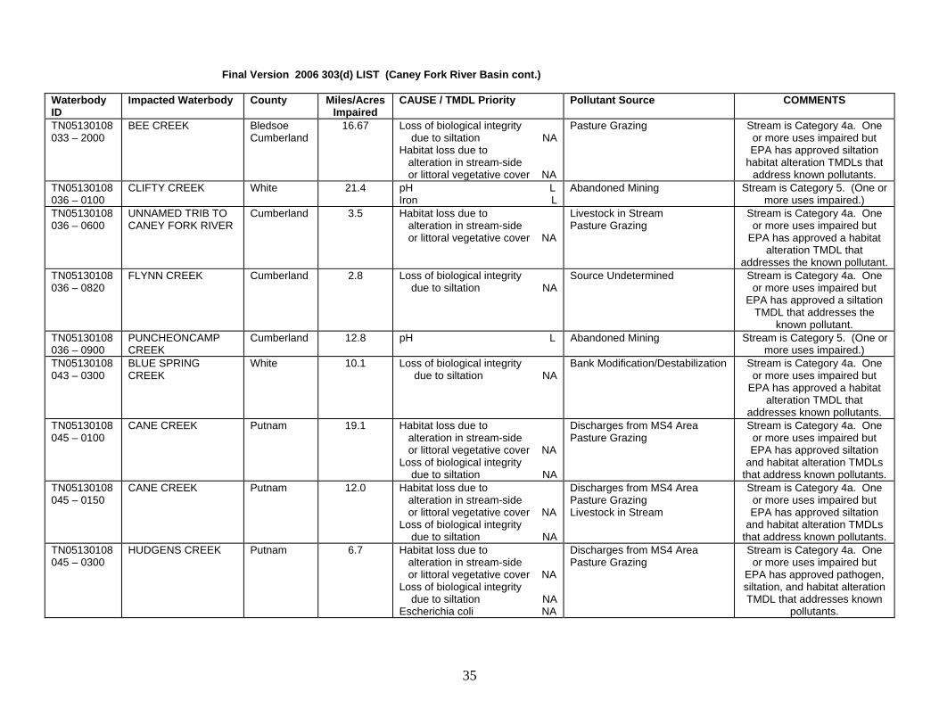
TN05130108033 – 2000
BEE CREEK Bledsoe Cumberland
16.67 Loss of biological integrity due to siltation NA Habitat loss due to alteration in stream-side or littoral vegetative cover NA
Pasture Grazing Stream is Category 4a. One or more uses impaired but EPA has approved siltation
habitat alteration TMDLs that address known pollutants.
TN05130108036 – 0100
CLIFTY CREEK White 21.4 pH L Iron L
Abandoned Mining Stream is Category 5. (One or more uses impaired.)
TN05130108036 – 0600
UNNAMED TRIB TO CANEY FORK RIVER
Cumberland 3.5 Habitat loss due to alteration in stream-side or littoral vegetative cover NA
Livestock in Stream Pasture Grazing
Stream is Category 4a. One or more uses impaired but
EPA has approved a habitat alteration TMDL that
addresses the known pollutant. TN05130108036 – 0820
FLYNN CREEK Cumberland 2.8 Loss of biological integrity due to siltation NA
Source Undetermined Stream is Category 4a. One or more uses impaired but
EPA has approved a siltation TMDL that addresses the
known pollutant. TN05130108036 – 0900
PUNCHEONCAMP CREEK
Cumberland 12.8 pH L Abandoned Mining Stream is Category 5. (One or more uses impaired.)
TN05130108043 – 0300
BLUE SPRING CREEK
White 10.1 Loss of biological integrity due to siltation NA
Bank Modification/Destabilization Stream is Category 4a. One or more uses impaired but
EPA has approved a habitat alteration TMDL that
addresses known pollutants. TN05130108045 – 0100
CANE CREEK Putnam 19.1 Habitat loss due to alteration in stream-side or littoral vegetative cover NA Loss of biological integrity due to siltation NA
Discharges from MS4 Area Pasture Grazing
Stream is Category 4a. One or more uses impaired but EPA has approved siltation
and habitat alteration TMDLs that address known pollutants.
TN05130108045 – 0150
CANE CREEK Putnam 12.0 Habitat loss due to alteration in stream-side or littoral vegetative cover NA Loss of biological integrity due to siltation NA
Discharges from MS4 Area Pasture Grazing Livestock in Stream
Stream is Category 4a. One or more uses impaired but EPA has approved siltation
and habitat alteration TMDLs that address known pollutants.
TN05130108045 – 0300
HUDGENS CREEK Putnam 6.7 Habitat loss due to alteration in stream-side or littoral vegetative cover NA Loss of biological integrity due to siltation NA Escherichia coli NA
Discharges from MS4 Area Pasture Grazing
Stream is Category 4a. One or more uses impaired but
EPA has approved pathogen, siltation, and habitat alteration TMDL that addresses known
pollutants.
35

Final Version 2006 303(d) LIST (Caney Fork River Basin cont.) Waterbody ID
Impacted Waterbody County Miles/Acres Impaired
CAUSE / TMDL Priority Pollutant Source COMMENTS
TN05130108045 – 0400
PIGEON ROOST CREEK
Putnam 2.4 Nitrates M Phosphorus M Physical substrate habitat alteration NA Escherichia coli NA
Municipal Point Source Discharges from MS4 Area Channelization
Stream is Category 5. Impaired, but EPA has
approved pathogen and habitat alteration TMDLs that address some of the known
pollutants. TN05130108045 – 0450
PIGEON ROOST CREEK
Putnam 3.2 Nitrates M Phosphorus M Physical substrate habitat alteration NA Escherichia coli NA
Discharges from MS4 Area Channelization
Stream is Category 5. Impaired, but EPA has
approved habitat alteration and pathogen TMDLs that address some of the known pollutants.
TN05130108045 – 0500
POST OAK CREEK White 8.3 Loss of biological integrity due to siltation NA Habitat loss due to alteration in stream-side or littoral vegetative cover NA
Pasture Grazing Stream is Category 4a. One or more uses impaired but EPA has approved siltation
and habitat alteration TMDLs that address known pollutants.
TN05130108045 – 1000
FALLING WATER RIVER
Putnam White
8.8 Low Dissolved Oxygen Nitrates M Loss of biological integrity due to siltation NA
Pasture Grazing Municipal Point Source Discharges from MS4 Area
Stream is Category 5. Impaired, but EPA has
approved siltation and habitat alteration TMDLs that address some of the known pollutants.
TN05130108045 – 3000
FALLING WATER RIVER
Putnam 11.2 Nutrients M Low Dissolved Oxygen M
Municipal Point Source Stream is Category 5. (One or more uses impaired.)
TN05130108097 – 2000
MINE LICK CREEK Putnam 4.23 Escherichia coli NA Nitrates M
Collection System Failure Water contact advisory due to Baxter STP overflows. Stream
is Category 5. One or more uses impaired, but EPA has approved a pathogen TMDL that addresses some of the
known pollutants. TN05130108684 – 1000
FALL CREEK DeKalb 9.8 Loss of biological integrity due to siltation NA Nutrients M Low dissolved oxygen M Escherichia coli NA Other anthropogenic substrate alterations NA
Major Municipal Point Source Upstream Impoundment
Stream is Category 5. (One or more uses impaired.) EPA has approved pathogen and habitat alteration TMDLs that address some of the known
pollutants.
TN05130108684 – 2000
FALL CREEK DeKalb 6.7 Other anthropogenic substrate alterations NA
Urbanized High Density Area Stream is Category 4a. One or more uses impaired but
EPA has approved a habitat alteration TMDL that
addresses known pollutants.
36

Old Hickory Watershed This basin contains the following USGS Hydrologic Unit Codes: 05130201 (Old Hickory Lake). Waterbody ID
Impacted Waterbody County Miles/Acres Impaired
CAUSE / TMDL Priority Pollutant Source COMMENTS
TN05130201001T-0200
TOWN CREEK Sumner 12.1 Loss of biological integrity due to siltation M Other Habitat Alterations M
Discharges from MS4 area Hydromodification
Gallatin area impacts. Stream is Category 5. (One or more
uses impaired.) TN05130201011-0100
NORTH FORK CEDAR CREEK
Wilson 4.2 Loss of biological integrity due to siltation M Other Habitat Alteration M
Highway Construction Land Development
Stream is Category 5. (One or more uses impaired.)
TN05130201011-0200
MIDDLE FORK CEDAR CREEK
Wilson 4.3 Loss of biological integrity due to siltation M Other Habitat Alteration M
Highway Construction Land Development
Stream is Category 5. (One or more uses impaired.)
TN05130201011-0400
WILSON CREEK Wilson 8.1 Loss of biological integrity due to siltation M Other Habitat Alteration M
Highway Construction Land Development
Stream is Category 5. (One or more uses impaired.)
TN05130201013-4000
SPRING CREEK Wilson 9.0 Escherichia coli M Pasture Grazing Livestock in Stream
Stream is Category 5. (One or more uses impaired.)
TN05130201015-0200
JOHNSON BRANCH Wilson 7.6 Escherichia coli M Pasture Grazing Stream is Category 5. (One or more uses impaired.)
TN05130201021-0300
NEAL BRANCH Wilson 3.7 Phosphorus M Loss of biological integrity due to siltation M Escherichia coli M
Livestock in Stream Stream is Category 5. (One or more uses impaired.)
TN05130201021-0400
BEECH LOG CREEK Wilson 8.5 Phosphorus M Loss of biological integrity due to siltation M Escherichia coli M
Pasture Grazing Stream is Category 5. (One or more uses impaired.)
TN05130201021-0600
BIG CANEY BRANCH Wilson 6.3 Loss of biological integrity due to siltation M Other Habitat Alteration M
Pasture Grazing Stream is Category 5. (One or more uses impaired.)
TN05130201021 – 2000
ROUND LICK CREEK Smith Wilson
8.7 Nutrients M Loss of biological integrity due to siltation M Low dissolved oxygen M Other Habitat Alteration M Escherichia coli M
Minor Municipal Point Source Pasture Grazing
Area impacts include Watertown STP. Stream is Category 5. (One or more
uses impaired.)
TN05130201021 – 3000
ROUND LICK CREEK Wilson 8.8 Loss of biological integrity due to siltation M Other Habitat Alteration M
Pasture Grazing Stream is Category 5. (One or more uses impaired.)
TN05130201028-0100
LITTLE GOOSE CREEK
Trousdale Macon
12.7 Other Habitat Alteration M Escherichia coli M
Hydromodification Undetermined Source
Stream is Category 5. (One or more uses impaired.)
TN05130201028-0150
LITTLE GOOSE CREEK
Trousdale Macon
10.0 Escherichia coli M Pasture Grazing Stream is Category 5. (One or more uses impaired.)
37

Final Version 2006 303(d) LIST (Old Hickory Watershed cont.) Waterbody ID
Impacted Waterbody County Miles/Acres Impaired
CAUSE / TMDL Priority Pollutant Source COMMENTS
TN05130201055-0200
SINKING CREEK Wilson 7.4 Nutrients M Other Anthropogenic Substrate Alterations M Escherichia coli M
Collection System Failure Discharges from MS4 Area
Stream is Category 5. (One or more uses impaired.)
TN05130201055-0250
SINKING CREEK Wilson 10.0 Alteration in stream-side or littoral vegetative cover M Other Anthropogenic Substrate Alterations M Escherichia coli M
Pasture Grazing Land Development Highway, Road, and Bridge Construction
Stream is Category 5. (One or more uses impaired.)
TN05130201055-1000
BARTONS CREEK Wilson 5.0 Escherichia coli M Collection System Failure Stream is Category 5. (One or more uses impaired.)
Cheatham Reservoir Watershed This basin contains the following USGS Hydrologic Unit Code: 05130202 (Cheatham Lake) Waterbody ID
Impacted Waterbody County Miles/Acres Impaired
CAUSE / TMDL Priority Pollutant Source COMMENTS
TN05130202001 – 3000
CHEATHAM RESERVOIR Bordeaux Bridge to Woodland Street.
Davidson 994 ac Escherichia coli M Combined Sewer Overflows Major Municipal Wet Weather discharge Discharges from MS4 area
Water contact advisory. Stream is Category 5. (One or
more uses impaired.)
TN05130202001T - 0100
UNNAMED TRIB TO CHEATHAM RES.
Cheatham 2.0 Loss of biological integrity due to siltation M Other Habitat Alterations M
Urbanized High Density Area Ashland City area trib. Stream is Category 5. (One or more
uses impaired.) TN05130202007 – 0100
SIMS BRANCH Davidson 1.5 Nutrients M Low dissolved oxygen M Other Habitat Alteration M Escherichia coli M
Discharges from MS4 area Industrial Permitted Stormwater Hydromodification
Provides habitat for the federally listed Nashville
crayfish (Orconectes shoupi). Stream is Category 5. (One or
more uses impaired.) TN05130202007 – 0150
SIMS BRANCH Davidson 1.4 Low dissolved oxygen M Other Habitat Alteration M
Discharges from MS4 area Industrial Permitted Stormwater Hydromodification
Stream is Category 5. (One or more uses impaired.)
TN05130202007 – 0300
FINLEY BRANCH Davidson 1.2 Chlorine M Escherichia coli M
Discharges from MS4 area Major Industrial Point Source
Stream is Category 5. (One or more uses impaired.)
TN05130202007 – 0600
COLLINS CREEK Davidson 6.7 Loss of biological integrity due to siltation M
Land Development Provides habitat for the federally listed Nashville
crayfish (O. shoupi). Stream is Category 5. (One or more
uses impaired.) TN05130202007 – 0700
TURKEY CREEK Davidson 1.6 Loss of biological integrity due to siltation M
Land Development Stream is Category 5. (One or more uses impaired.)
38

Final Version 2006 303(d) LIST (Cheatham Reservoir Watershed cont.) Waterbody ID
Impacted Waterbody County Miles/Acres Impaired
CAUSE / TMDL Priority Pollutant Source COMMENTS
TN05130202007 – 0800
INDIAN CREEK Davidson 5.7 Phosphorus M Land Development Provides habitat for the federally listed Nashville
crayfish (O. shoupi). Stream is Category 5. (One or more
uses impaired.) TN05130202007 – 0920
UNNAMED TRIB TO OWL CREEK
Williamson 1.6 Loss of biological integrity due to siltation M Other Habitat Alterations M
Land Development Stream is Category 5. (One or more uses impaired.)
TN05130202007 – 1000
MILL CREEK Davidson 3.5 Nutrients M Loss of biological integrity due to siltation M Low dissolved oxygen M
Collection System Failure Discharges from MS4 area
Provides habitat for the federally listed Nashville
crayfish (O. shoupi). Stream is Category 5. (One or more
uses impaired.) TN05130202007 – 1100
HOLT CREEK Davidson 6.2 Loss of biological integrity due to siltation M
Land Development Stream is Category 5. (One or more uses impaired.)
TN05130202007 – 1200
WHITTEMORE BRANCH
Davidson 2.9 Other Habitat Alterations M Discharges from MS4 area Provides habitat for the federally listed Nashville
crayfish (O. shoupi). Stream is Category 5. (One or more
uses impaired.) TN05130202007 – 1300
SORGHUM BRANCH Davidson 3.1 Loss of biological integrity due to siltation M Other Habitat Alterations M
Discharges from MS4 area Provides habitat for the federally listed Nashville
crayfish (O. shoupi). Stream is Category 5. (One or more
uses impaired.) TN05130202007 – 1400
SEVENMILE CREEK Davidson 2.4 Nutrients M Other Habitat Alteration M Escherichia coli M
Discharges from MS4 area Hydromodification
Provides habitat for the federally listed Nashville
crayfish (O. shoupi). Stream is Category 5. (One or more
uses impaired.) TN05130202007 – 1410
SHASTA BRANCH Davidson 1.0 Escherichia coli M Discharges from MS4 area Provides habitat for the federally listed Nashville
crayfish (O. shoupi). Stream is Category 5. (One or more
uses impaired.) TN05130202007 – 1450
SEVENMILE CREEK Davidson 2.0 Nutrients M Escherichia coli M
Discharges from MS4 area Hydromodification
Provides habitat for the federally listed Nashville
crayfish (O. shoupi). Stream is Category 5. (One or more
uses impaired.) TN05130202007 – 1500
PAVILLION BRANCH Davidson 1.3 Escherichia coli M Discharges from MS4 area Stream is Category 5. (One or more uses impaired.)
39

Final Version 2006 303(d) LIST (Cheatham Reservoir Watershed cont.) Waterbody ID
Impacted Waterbody County Miles/Acres Impaired
CAUSE / TMDL Priority Pollutant Source COMMENTS
TN05130202007 – 2000
MILL CREEK Davidson 4.0 Loss of biological integrity due to siltation M Low dissolved oxygen M Nutrients M
Collection System Failure Discharges from MS4 area
Provides habitat for the federally listed Nashville
crayfish (O. shoupi). Stream is Category 5. (One or more
uses impaired.) TN05130202007 – 3000
MILL CREEK Davidson 5.9 Loss of biological integrity due to siltation M Nutrients M Low dissolved oxygen M Escherichia coli M
Collection System Failure Discharges from MS4 area
Provides habitat for the federally listed Nashville
crayfish (O. shoupi). Stream is Category 5. (One or more
uses impaired.) TN05130202007 – 5000
MILL CREEK Davidson Williamson
8.1 Nutrients M Loss of biological integrity due to siltation M Low dissolved oxygen M Escherichia coli M
Minor Municipal Point Source Livestock in Stream
Provides habitat for the federally listed Nashville
crayfish (O. shoupi). Stream is Category 5. (One or more
uses impaired.) TN05130202010 – 0200
DRAKES BRANCH Davidson 2.7 Escherichia coli M Collection System Failure Stream is Category 5. (One or more uses impaired.)
TN05130202010 – 0300
DRY FORK Davidson 9.9 Escherichia coli M Undetermined Source Stream is Category 5. (One or more uses impaired.)
TN05130202010 – 0400
EARTHMAN FORK Davidson 11.0 Escherichia coli M Undetermined Source Stream is Category 5. (One or more uses impaired.)
TN05130202010 – 0600
CUMMINGS BRANCH Davidson 2.6 Escherichia coli M Livestock in Stream Stream is Category 5. (One or more uses impaired.)
TN05130202010 – 0700
LITTLE CREEK Davidson 1.1 Loss of biological integrity due to siltation M Escherichia coli M
Land Development Collection System Failure
Stream is Category 5. (One or more uses impaired.)
TN05130202010 – 0800
EWING CREEK Davidson 17.6 Escherichia coli M Other Habitat Alterations M
Discharges from MS4 area Hydromodification
Stream is Category 5. (One or more uses impaired.)
TN05130202010 – 1000
WHITES CREEK Davidson 2.9 Escherichia coli M Nutrients M
Collection System Failure Water contact advisory. Stream is Category 5. (One or
more uses impaired.) TN05130202014 – 0400
NORTH FORK SYCAMORE CREEK
Robertson 15.4 Loss of biological integrity due to siltation M Other Habitat Alterations M
Hydromodification Stream is Category 5. (One or more uses impaired.)
TN05130202023 – 0100
EAST FORK BROWN'S CREEK
Davidson 2.2 Nutrients M Other Habitat Alterations M Escherichia coli M Oil and Grease M
Minor Industrial Point Source Discharges from MS4 area Hydromodification
Impacted by spills and runoff from Radnor Yards. Stream is
Category 5. (One or more uses impaired.)
TN05130202023 – 0200
MIDDLE FORK BROWN'S CREEK
Davidson 3.5 Other Habitat Alterations M Land Development Stream is Category 5. (One or more uses impaired.)
TN05130202023 – 0300
WEST FORK BROWN'S CREEK
Davidson 3.6 Nutrients M Escherichia coli M
Discharges from MS4 area Stream is Category 5. (One or more uses impaired.)
40

Final Version 2006 303(d) LIST (Cheatham Reservoir Watershed cont.) Waterbody ID
Impacted Waterbody County Miles/AcresImpaired
CAUSE / TMDL Priority Pollutant Source COMMENTS
TN05130202023 – 1000
BROWN'S CREEK Davidson 0.2 Nutrients M Other Habitat Alterations M Escherichia coli M Oil and Grease M
Minor Industrial Point Source Collection System Failure Discharges from MS4 area Hydromodification
Water contact advisory. Stream is Category 5. (One or
more uses impaired.)
TN05130202023 – 2000
BROWN'S CREEK Davidson 4.1 Nutrients M Other Habitat Alterations M Escherichia coli M Oil and Grease M
Minor Industrial Point Source Discharges from MS4 area Hydromodification
Water contact advisory. Stream is Category 5. (One or
more uses impaired.)
TN05130202027 – 1000
DRY CREEK Davidson 0.5 Escherichia coli M Collection System Failure Water contact advisory. Stream is Category 5. (One or
more uses impaired.) TN05130202027 – 2000
DRY CREEK Davidson 5.9 Other Habitat Alterations M Hydromodification Stream is Category 5. (One or more uses impaired.)
TN05130202202 – 1000
PAGES BRANCH Davidson 0.6 Escherichia coli M Collection System Failure Discharges from MS4 area
Stream is Category 5. (One or more uses impaired.)
TN05130202202 – 2000
PAGES BRANCH Davidson 4.5 Escherichia coli M Discharges from MS4 area Stream is Category 5. (One or more uses impaired.)
TN05130202209 – 1000
COOPER CREEK Davidson 3.9 Other Habitat Alterations M Escherichia coli M
Discharges from MS4 area Stream is Category 5. (One or more uses impaired.)
TN05130202211 – 1000
LOVES BRANCH Davidson 2.0 Other Habitat Alterations M Hydromodification Stream is Category 5. (One or more uses impaired.)
TN05130202212 – 0100
NEELEYS BRANCH Davidson 1.7 Escherichia coli M Discharges from MS4 area Stream is Category 5. (One or more uses impaired.)
TN05130202212 – 1000
GIBSON CREEK Davidson 3.7 Habitat loss due to stream flow alteration NA Other Habitat Alterations M Escherichia coli M
Discharges from MS4 area Hydromodification
Stream is Category 5 overall (one or more uses impaired),
but flow alteration is 4c (impact not caused by a pollutant).
TN05130202220 – 0100
LUMSLEY FORK Davidson 4.7 Escherichia coli M Undetermined Source Stream is Category 5. (One or more uses impaired.)
TN05130202220 – 0200
WALKERS CREEK Davidson 7.8 Escherichia coli M Undetermined Source Stream is Category 5. (One or more uses impaired.)
TN05130202220 – 0300
SLATERS CREEK Sumner 11.3 Loss of biological integrity due to siltation M Escherichia coli M
Discharges from MS4 area Bank Modification
Stream is Category 5. (One or more uses impaired.)
TN05130202220 – 0400
MADISON CREEK Sumner 14.4 Loss of biological integrity due to siltation M
Land Development Stream is Category 5. (One or more uses impaired.)
TN05130202220 – 1000
MANSKERS CREEK Davidson Sumner
7.9 Loss of biological integrity due to siltation M Escherichia coli M
Discharges from MS4 area Land Development
Water contact advisory. Stream is Category 5. (One or
more uses impaired.) TN05130202220 – 2000
MANSKERS CREEK Davidson Sumner
7.6 Loss of biological integrity due to siltation M Escherichia coli M
Discharges from MS4 area Land Development
Stream is Category 5. (One or more uses impaired.)
41

Final Version 2006 303(d) LIST (Cheatham Reservoir Watershed cont.) Waterbody ID
Impacted Waterbody County Miles/Acres Impaired
CAUSE / TMDL Priority Pollutant Source COMMENTS
TN05130202314 – 0100
UNNAMED TRIB TO RICHLAND CREEK
Davidson 1.1 Escherichia coli M Discharges from MS4 area Tributary near I-40. Stream is Category 5. (One or more
uses impaired.) TN05130202314 – 0200
MURPHY ROAD BRANCH
Davidson 1.5 Escherichia coli M Discharges from MS4 area Stream is Category 5. (One or more uses impaired.)
TN05130202314 – 0300
BOSLEY SPRINGS BRANCH
Davidson 1.5 Other Habitat Alterations M Escherichia coli M
Discharges from MS4 area Hydromodification
Stream is Category 5. (One or more uses impaired.)
TN05130202314 – 0400
SUGARTREE CREEK Davidson 4.3 Nutrients M Other Habitat Alterations M Escherichia coli M
Discharges from MS4 area Hydromodification
Stream is Category 5. (One or more uses impaired.)
TN05130202314 – 0700
VAUGHNS GAP BRANCH
Davidson 0.6 Other Habitat Alterations M Escherichia coli M
Collection System Failure Hydromodification
Stream is Category 5. (One or more uses impaired.)
TN05130202314 – 0750
VAUGHNS GAP BRANCH
Davidson 1.9 Other Habitat Alterations M Escherichia coli M
Discharges from MS4 area Hydromodification
Stream is Category 5. (One or more uses impaired.)
TN05130202314 – 0800
JOCELYN HOLLOW BRANCH
Davidson 2.0 Escherichia coli M Discharges from MS4 area Stream is Category 5. (One or more uses impaired.)
TN05130202314 – 1000
RICHLAND CREEK Davidson 1.9 Escherichia coli M Other Habitat Alterations M
Collection System Failure Hydromodification
Water contact advisory due to Metro collection system
overflows. Stream is Category 5. (One or more uses
impaired.) TN05130202314 – 2000
RICHLAND CREEK Davidson 6.7 Escherichia coli M Other Habitat Alterations M
Collection System Failure Hydromodification
Water contact advisory due to Metro collection system
overflows. Stream is Category 5. (One or more uses
impaired.) TN05130202314 – 3000
RICHLAND CREEK Davidson 4.0 Nutrients M Other Habitat Alterations M Escherichia coli M
Collection System Failure Discharges from MS4 area Hydromodification
Stream is Category 5. (One or more uses impaired.)
Stones River Watershed This basin contains the following USGS Hydrologic Unit Code: 05130203 (Stones River) Waterbody ID
Impacted Waterbody County Miles/Acres Impaired
CAUSE / TMDL Priority Pollutant Source COMMENTS
TN05130203001 – 0100
MCCRORY CREEK Davidson 1.4 Nitrates H Habitat loss due to alteration in stream-side or littoral vegetative cover NA Escherichia coli NA
Highway, Roads, Bridges, Infrastructure Construction Discharges from MS4 Area Collection System Failure
This stream is Category 5. Impaired, but EPA has
approved habitat alteration and pathogen TMDLs that address some of the known pollutants.
42

Final Version 2006 303(d) LIST (Stones River Watershed cont.) Waterbody ID
Impacted Waterbody County Miles/AcresImpaired
CAUSE / TMDL Priority Pollutant Source COMMENTS
TN05130203001 – 0150
MCCRORY CREEK Davidson 10.7 Nitrates H Habitat loss due to alteration in stream-side or littoral vegetative cover NA Escherichia coli NA
Discharges from MS4 Area This stream is Category 5. The stream is impaired for one or more uses, however, EPA
has approved a siltation/ habitat alteration TMDL, plus a
pathogen TMDL, that addresses some of the known
pollutants in this stream. TN05130203001 – 1000
STONES RIVER Davidson 6.7 Sulfide-hydrogen sulfide L Low dissolved oxygen L Habitat loss due to stream flow alteration NA Odor threshold number L
Upstream Impoundment Stream is Category 5 overall (one or more uses impaired),
but flow alteration is 4c (impact not caused by a pollutant).
Sulfides cause odor problem below dam.
TN05130203003T – 0100
FINCH BRANCH Rutherford 5.7 Nutrients H Habitat loss due to alteration in stream-side or littoral vegetative cover NA Escherichia coli H
Land Development Collection System Failure
This stream is Category 5. The stream is impaired for one or more uses, however, EPA
has approved a siltation/ habitat alteration TMDL that
addresses some of the known pollutants in this stream.
TN05130203010 – 0200
OLIVE BRANCH Rutherford 8.1 Physical substrate habitat alterations NA
Land Development This stream is Category 4a. The stream is impaired for one or more uses, however, EPA
has approved a siltation/ habitat alteration TMDL that
addresses the known pollutants in this stream.
TN05130203010 – 0300
HARTS BRANCH Rutherford 3.9 Loss of biological integrity due to siltation NA
Discharges from MS4 area This stream is Category 4a. The stream is impaired for one or more uses, however, EPA
has approved a siltation/ habitat alteration TMDL that
addresses the known pollutants in this stream.
TN05130203010 – 0310
ROCK SPRING BRANCH
Rutherford 5.6 Loss of biological integrity due to siltation NA Physical substrate habitat alterations NA
Highways, Roads, Bridges, Infrastructure Construction
This stream is Category 4a. The stream is impaired for one or more uses, however, EPA
has approved a siltation/ habitat alteration TMDL that
addresses the known pollutants in this stream.
43

Final Version 2006 303(d) LIST (Stones River Watershed cont.) Waterbody ID
Impacted Waterbody County Miles/AcresImpaired
CAUSE / TMDL Priority Pollutant Source COMMENTS
TN05130203010 – 1000
STEWARTS CREEK Rutherford 7.0 Nitrates M Loss of biological integrity due to siltation NA
Municipal Point Source Discharges from MS4 area
This stream is Category 4a. The stream is impaired for one or more uses, however, EPA
has approved a siltation/ habitat alteration TMDL that
addresses some of the known pollutants in this stream.
TN05130203018 – 0100
SINKING CREEK Rutherford 5.5 Habitat loss due to alteration in stream-side or littoral vegetative cover L Escherichia coli H
Land Development Discharges from MS4 area
This stream is Category 5. The stream is impaired for one
or more uses.
TN05130203018 – 0210
CHRISTMAS CREEK Rutherford 12.3 Loss of biological integrity due to siltation L Escherichia coli NA
Pasture Grazing This stream is Category 5. The stream is impaired for one or more uses, however, EPA has approved a pathogens
TMDL that addresses some of the known pollutants.
TN05130203018 - 2000
WEST FORK STONES RIVER
Rutherford 1.3 Nitrates L Loss of biological integrity due to siltation L
Municipal Point Source Land Development
This stream is Category 5. The stream is impaired for one
or more uses. TN05130203018 - 3000
WEST FORK STONES RIVER
Rutherford 5.1 Loss of biological integrity due to siltation L
Land Development This stream is Category 5. The stream is impaired for one
or more uses. TN05130203018 - 5000
WEST FORK STONES RIVER
Rutherford 5.0 Loss of biological integrity due to siltation L
Land Development Pasture Grazing
This stream is Category 5. The stream is impaired for one
or more uses TN05130203018 - 7000
WEST FORK STONES RIVER
Rutherford 7.2 Low dissolved oxygen M Pasture Grazing Livestock in stream
Stream is Category 5. (One or more uses impaired.)
TN05130203021 - 0100
HURRICANE CREEK Rutherford 18.1 Loss of biological integrity due to siltation NA
Pasture Grazing This stream is Category 4A. The stream is impaired, but
EPA has approved a siltation/ habitat alteration TMDL for the
known pollutants. TN05130203021 - 0320
HENRY CREEK Rutherford 4.2 Loss of biological integrity due to siltation NA
Pasture Grazing This stream is Category 4A. The stream is impaired, but
EPA has approved a siltation/ habitat alteration TMDL for the
known pollutants. TN05130203022 –0100
UNNAMED TRIB TO LYTLE CREEK
Rutherford 1.0 Low dissolved oxygen H Escherichia coli L
Undetermined Source Stream is Category 5. (One or more uses impaired.)
44
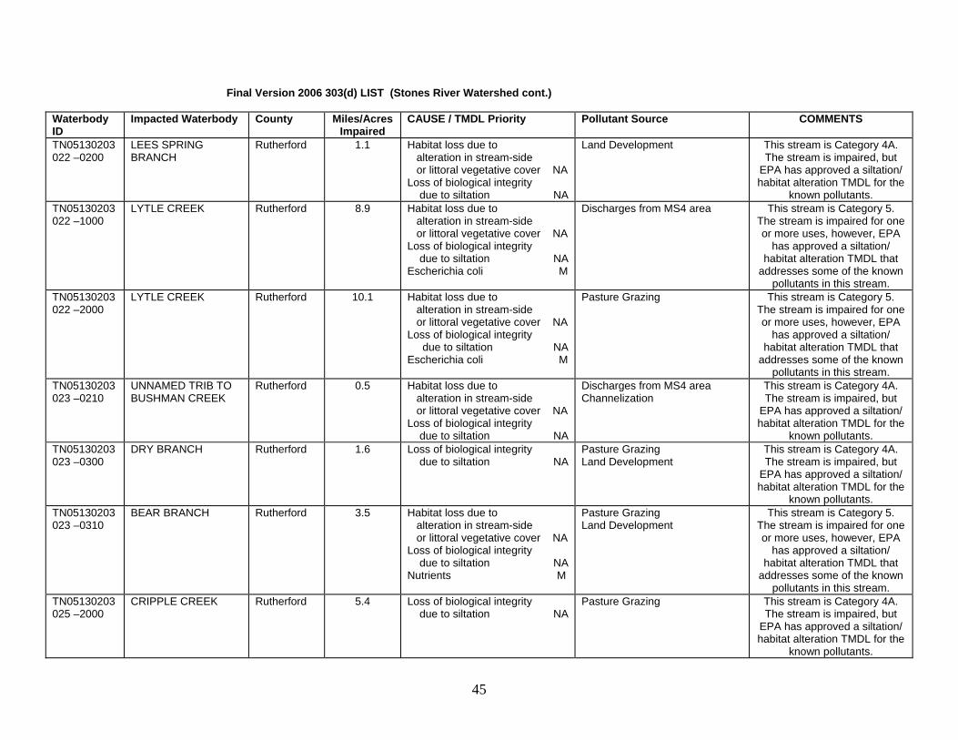
Final Version 2006 303(d) LIST (Stones River Watershed cont.) Waterbody ID
Impacted Waterbody County Miles/AcresImpaired
CAUSE / TMDL Priority Pollutant Source COMMENTS
TN05130203022 –0200
LEES SPRING BRANCH
Rutherford 1.1 Habitat loss due to alteration in stream-side or littoral vegetative cover NA Loss of biological integrity due to siltation NA
Land Development This stream is Category 4A. The stream is impaired, but
EPA has approved a siltation/ habitat alteration TMDL for the
known pollutants. TN05130203022 –1000
LYTLE CREEK Rutherford 8.9 Habitat loss due to alteration in stream-side or littoral vegetative cover NA Loss of biological integrity due to siltation NA Escherichia coli M
Discharges from MS4 area This stream is Category 5. The stream is impaired for one or more uses, however, EPA
has approved a siltation/ habitat alteration TMDL that
addresses some of the known pollutants in this stream.
TN05130203022 –2000
LYTLE CREEK Rutherford 10.1 Habitat loss due to alteration in stream-side or littoral vegetative cover NA Loss of biological integrity due to siltation NA Escherichia coli M
Pasture Grazing This stream is Category 5. The stream is impaired for one or more uses, however, EPA
has approved a siltation/ habitat alteration TMDL that
addresses some of the known pollutants in this stream.
TN05130203023 –0210
UNNAMED TRIB TO BUSHMAN CREEK
Rutherford 0.5 Habitat loss due to alteration in stream-side or littoral vegetative cover NA Loss of biological integrity due to siltation NA
Discharges from MS4 area Channelization
This stream is Category 4A. The stream is impaired, but
EPA has approved a siltation/ habitat alteration TMDL for the
known pollutants. TN05130203023 –0300
DRY BRANCH Rutherford 1.6 Loss of biological integrity due to siltation NA
Pasture Grazing Land Development
This stream is Category 4A. The stream is impaired, but
EPA has approved a siltation/ habitat alteration TMDL for the
known pollutants. TN05130203023 –0310
BEAR BRANCH Rutherford 3.5 Habitat loss due to alteration in stream-side or littoral vegetative cover NA Loss of biological integrity due to siltation NA Nutrients M
Pasture Grazing Land Development
This stream is Category 5. The stream is impaired for one or more uses, however, EPA
has approved a siltation/ habitat alteration TMDL that
addresses some of the known pollutants in this stream.
TN05130203025 –2000
CRIPPLE CREEK Rutherford 5.4 Loss of biological integrity due to siltation NA
Pasture Grazing This stream is Category 4A. The stream is impaired, but
EPA has approved a siltation/ habitat alteration TMDL for the
known pollutants.
45

Final Version 2006 303(d) LIST (Stones River Watershed cont.) Waterbody ID
Impacted Waterbody County Miles/AcresImpaired
CAUSE / TMDL Priority Pollutant Source COMMENTS
TN05130203026 –0200
MCKNIGHT BRANCH Rutherford Cannon
18.8 Habitat loss due to alteration in stream-side or littoral vegetative cover NA
Pasture Grazing This stream is Category 4A. The stream is impaired, but
EPA has approved a siltation/ habitat alteration TMDL for the
known pollutants. TN05130203029 – 0100
JARMAN BRANCH Rutherford Wilson
4.4 Habitat loss due to alteration in stream-side or littoral vegetative cover NA Loss of biological integrity due to siltation NA Nutrients H
Pasture Grazing Land Development
This stream is Category 5. The stream is impaired for one or more uses, however, EPA
has approved a siltation/ habitat alteration TMDL that
addresses some of the known pollutants in this stream.
TN05130203029 – 0200
UNNAMED TRIB TO BRADLEY CREEK
Rutherford 2.7 Habitat loss due to alteration in stream-side or littoral vegetative cover NA Nutrients H
Pasture Grazing Livestock in Stream
This stream is Category 5. The stream is impaired for one or more uses, however, EPA
has approved a siltation/ habitat alteration TMDL that
addresses some of the known pollutants in this stream.
TN05130203029 – 0300
UNNAMED TRIB TO BRADLEY CREEK
Rutherford 1.7 Habitat loss due to alteration in stream-side or littoral vegetative cover NA Nutrients H
Pasture Grazing Livestock in Stream
This stream is Category 5. The stream is impaired for one or more uses, however, EPA
has approved a siltation/ habitat alteration TMDL that
addresses some of the known pollutants in this stream.
TN05130203032 – 0100
UNNAMED TRIB TO FALL CREEK
Wilson 3.0 Habitat loss due to alteration in stream-side or littoral vegetative cover NA Loss of biological integrity due to siltation NA
Pasture Grazing This stream is Category 4A. The stream is impaired, but
EPA has approved a siltation/ habitat alteration TMDL for the
known pollutants. TN05130203032 – 0200
CEDAR CREEK Wilson 1.7 Habitat loss due to alteration in stream-side or littoral vegetative cover NA
Pasture Grazing Livestock in Stream
This stream is Category 4A. The stream is impaired, but
EPA has approved a siltation/ habitat alteration TMDL for the
known pollutants. TN05130203035 – 0400
UNNAMED TRIB TO STONERS CREEK
Davidson 1.4 Loss of biological integrity due to siltation NA
Industrial Stormwater Discharge This stream is Category 4A. The stream is impaired, but
EPA has approved a siltation/ habitat alteration TMDL for the
known pollutants.
46

Final Version 2006 303(d) LIST (Stones River Watershed cont.) Waterbody ID
Impacted Waterbody County Miles/AcresImpaired
CAUSE / TMDL Priority Pollutant Source COMMENTS
TN05130203035 – 1000
STONERS CREEK Davidson 1.9 Loss of biological integrity due to siltation NA Escherichia coli NA
Land Development Collection System Failure
This stream is Category 4a. The stream is impaired for one or more uses, however, EPA
has approved a siltation/ habitat alteration and
pathogenTMDL that addresses the known pollutants in this
stream. TN05130203036 – 0100
EAST BRANCH HURRICANE CREEK
Rutherford 7.3 Habitat loss due to alteration in stream-side or littoral vegetative cover NA Loss of biological integrity due to siltation NA
Discharges from MS4 area Channelization Loss of Riparian Habitat
This stream is Category 4A. The stream is impaired, but
EPA has approved a siltation/ habitat alteration TMDL for the
known pollutants. TN05130203036 – 0200
WEST BRANCH HURRICANE CREEK
Rutherford 3.5 Nutrients M Loss of biological integrity due to siltation NA
Land Development This stream is Category 5. The stream is impaired for one or more uses, however, EPA
has approved a siltation/ habitat alteration TMDL that
addresses some of the known pollutants in this stream.
TN05130203036 – 1000
HURRICANE CREEK Rutherford 8.5 Nutrients H Loss of biological integrity due to siltation NA
Industrial Point Source Land Development
This stream is Category 5. The stream is impaired for one or more uses, however, EPA
has approved a siltation/ habitat alteration TMDL that
addresses some of the known pollutants in this stream.
TN05130203232 – 1000
SUGGS CREEK Davidson Wilson
18.1 Loss of biological integrity due to siltation L
Pasture Grazing This stream is Category 5. The stream is impaired for one
or more uses. TN05130203539 – 0100
WEST FORK HAMILTON CREEK
Davidson 1.8 Habitat loss due to alteration in stream-side or littoral vegetative cover L Loss of biological integrity due to siltation L
Discharges from MS4 area Channelization Loss of Riparian Habitat
This stream is Category 5. The stream is impaired for one
or more uses.
TN05130203539 – 1000
EAST FORK HAMILTON CREEK
Davidson 6.0 Physical substrate habitat alterations L Loss of biological integrity due to siltation L
Channelization Land Development
This stream is Category 5. The stream is impaired for one
or more uses.
47

Harpeth River Watershed This basin contains the following USGS Hydrologic Unit Code: 05130204 (Harpeth River) Waterbody ID
Impacted Waterbody County Miles/AcresImpaired
CAUSE / TMDL Priority Pollutant Source COMMENTS
TN05130204001 –0600
TRACE CREEK Cheatham Dickson
8.3 Escherichia coli NA Collection System Failure Stream is Category 4a. One or more uses impaired but
EPA has approved a pathogen TMDL that addresses the
known pollutants. TN05130204002 –0500
UNNAMED TRIB. TO JONES CREEK
Dickson 0.5 Other anthropogenic substrate alterations NA Loss of biological integrity due to siltation NA
Golf Course This stream is Category 4a. The stream is impaired, but
EPA has approved a siltation/ habitat alteration TMDL for the
known pollutants. TN05130204002 –0600
SPICER BRANCH Dickson 4.6 Physical substrate habitat alterations NA Loss of biological integrity due to siltation NA
Channelization Land Development
This stream is Category 4a. The stream is impaired, but
EPA has approved a siltation/ habitat alteration TMDL for the
known pollutants. TN05130204002 –2000
JONES CREEK Dickson 7.0 Nutrients L Escherichia coli NA
Municipal Point Source Pasture Grazing
This stream is Category 5, impaired for one or more uses. EPA has approved a pathogen TMDL for some of the known
pollutants in this stream. TN05130204002 –3000
JONES CREEK Dickson 8.1 Nutrients L Loss of biological integrity due to siltation NA
Land Development Pasture Grazing
This stream is Category 5, impaired for one or more uses. However, EPA has approved a
siltation/ habitat alteration TMDL for some of the known
pollutants in this stream. TN05130204006 –0300
TIDWELL BRANCH Williamson 1.1 Loss of biological integrity due to siltation NA
Highways, Roads, Bridge, Infrastructure Construction
This stream is Category 4a. The stream is impaired, but
EPA has approved a siltation/ habitat alteration TMDL for the
known pollutants. TN05130204006 –0400
UNNAMED TRIB TO BIG TURNBULL CREEK
Williamson 0.5 Loss of biological integrity due to siltation NA
Undetermined Source This stream is Category 4a. The stream is impaired, but
EPA has approved a siltation/ habitat alteration TMDL for the
known pollutants. TN05130204006 –0500
UNNAMED TRIB TO BIG TURNBULL CREEK
Williamson 1.0 Biological integrity loss due to undetermined cause L
Undetermined Source This stream is Category 5. The stream is impaired for one or more uses. (Stream does not meet biological integrity
goals for region.)
48
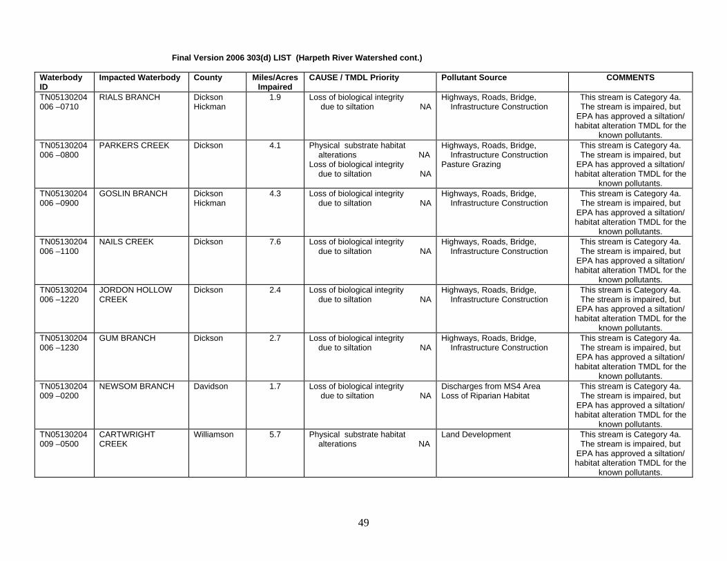
Final Version 2006 303(d) LIST (Harpeth River Watershed cont.) Waterbody ID
Impacted Waterbody County Miles/AcresImpaired
CAUSE / TMDL Priority Pollutant Source COMMENTS
TN05130204006 –0710
RIALS BRANCH Dickson Hickman
1.9 Loss of biological integrity due to siltation NA
Highways, Roads, Bridge, Infrastructure Construction
This stream is Category 4a. The stream is impaired, but
EPA has approved a siltation/ habitat alteration TMDL for the
known pollutants. TN05130204006 –0800
PARKERS CREEK Dickson 4.1 Physical substrate habitat alterations NA Loss of biological integrity due to siltation NA
Highways, Roads, Bridge, Infrastructure Construction Pasture Grazing
This stream is Category 4a. The stream is impaired, but
EPA has approved a siltation/ habitat alteration TMDL for the
known pollutants. TN05130204006 –0900
GOSLIN BRANCH Dickson Hickman
4.3 Loss of biological integrity due to siltation NA
Highways, Roads, Bridge, Infrastructure Construction
This stream is Category 4a. The stream is impaired, but
EPA has approved a siltation/ habitat alteration TMDL for the
known pollutants. TN05130204006 –1100
NAILS CREEK Dickson 7.6 Loss of biological integrity due to siltation NA
Highways, Roads, Bridge, Infrastructure Construction
This stream is Category 4a. The stream is impaired, but
EPA has approved a siltation/ habitat alteration TMDL for the
known pollutants. TN05130204006 –1220
JORDON HOLLOW CREEK
Dickson 2.4 Loss of biological integrity due to siltation NA
Highways, Roads, Bridge, Infrastructure Construction
This stream is Category 4a. The stream is impaired, but
EPA has approved a siltation/ habitat alteration TMDL for the
known pollutants. TN05130204006 –1230
GUM BRANCH Dickson 2.7 Loss of biological integrity due to siltation NA
Highways, Roads, Bridge, Infrastructure Construction
This stream is Category 4a. The stream is impaired, but
EPA has approved a siltation/ habitat alteration TMDL for the
known pollutants. TN05130204009 –0200
NEWSOM BRANCH Davidson 1.7 Loss of biological integrity due to siltation NA
Discharges from MS4 Area Loss of Riparian Habitat
This stream is Category 4a. The stream is impaired, but
EPA has approved a siltation/ habitat alteration TMDL for the
known pollutants. TN05130204009 –0500
CARTWRIGHT CREEK
Williamson 5.7 Physical substrate habitat alterations NA
Land Development This stream is Category 4a. The stream is impaired, but
EPA has approved a siltation/ habitat alteration TMDL for the
known pollutants.
49

Final Version 2006 303(d) LIST (Harpeth River Watershed cont.) Waterbody ID
Impacted Waterbody County Miles/AcresImpaired
CAUSE / TMDL Priority Pollutant Source COMMENTS
TN05130204009 –0600
MURRAY BRANCH Williamson 3.6 Habitat loss due to alteration in stream-side or littoral vegetative cover NA Loss of biological integrity due to siltation NA
Pasture Grazing This stream is Category 4a. The stream is impaired, but
EPA has approved a siltation/ habitat alteration TMDL for the
known pollutants. TN05130204009 –0700
BROWN CREEK Williamson 5.3 Loss of biological integrity due to siltation NA
Pasture Grazing This stream is Category 4a. The stream is impaired, but
EPA has approved a siltation/ habitat alteration TMDL for the
known pollutants. TN05130204009 –0800
UNNAMED TRIB TO HARPETH RIVER
Williamson 2.1 Habitat loss due to alteration in stream-side or littoral vegetative cover NA Loss of biological integrity due to siltation NA
Pasture Grazing This stream is Category 4a. The stream is impaired, but
EPA has approved a siltation/ habitat alteration TMDL for the
known pollutants. TN05130204009 –0900
TRACE CREEK Davidson Williamson
4.9 Physical substrate habitat alteration NA
Land Development This stream is Category 4a. The stream is impaired, but
EPA has approved a siltation/ habitat alteration TMDL for the
known pollutants. TN05130204009 – 1100
BEECH CREEK Davidson 3.6 Nutrients NA Habitat loss due to alteration in stream-side or littoral vegetative cover NA Loss of biological integrity due to siltation NA
Pasture Grazing Discharges from MS4 area Loss of Riparian Habitat Land Development
This stream is Category 5. The stream is impaired for one or more uses. However, EPA
has approved a siltation/ habitat alteration and organic
enrichment TMDL for the known pollutants in this
stream. TN05130204009 – 1211
FLATROCK BRANCH Cheatham Williamson
3.5 Nutrients L Municipal Point Source Fairview STP. This stream is Category 5. The stream is
impaired for one or more uses. TN05130204009 – 2000
HARPETH RIVER Cheatham Davidson
18.8 Nutrients NA Low dissolved oxygen NA
Municipal Point Sources Discharges from MS4 area
This stream is Category 4a. The stream is impaired, but
EPA has approved an organic enrichment TMDL for the
known pollutants. TN05130204009 – 3000
HARPETH RIVER Davidson Williamson
16.8 Nutrients NA Low dissolved oxygen NA
Municipal Point Sources Discharges from MS4 area
This stream is Category 4a. The stream is impaired, but
EPA has approved an organic enrichment TMDL for the
known pollutants.
50

Final Version 2006 303(d) LIST (Harpeth River Watershed cont.) Waterbody ID
Impacted Waterbody County Miles/AcresImpaired
CAUSE / TMDL Priority Pollutant Source COMMENTS
TN05130204010 – 0600
ARKANSAS CREEK Williamson 5.7 Escherichia coli NA Undetermined Source This stream is Category 4a, impaired, but EPA has
approved a pathogen TMDL for the known pollutants.
TN05130204013 – 0100
HATCHER SPRING CREEK
Williamson 6.5 Habitat loss due to alteration in stream-side or littoral vegetative cover NA Loss of biological integrity due to siltation NA
Pasture Grazing This stream is Category 4a. The stream is impaired, but
EPA has approved a siltation/ habitat alteration TMDL for the
known pollutants. TN05130204013 – 0200
POLK CREEK Williamson 8.8 Habitat loss due to alteration in stream-side or littoral vegetative cover NA Loss of biological integrity due to siltation NA
Pasture Grazing Loss of Riparian Habitat
This stream is Category 4a. The stream is impaired, but
EPA has approved a siltation/ habitat alteration TMDL for the
known pollutants. TN05130204013 – 0300
UNNAMED TRIB TO WEST HARPETH RIVER
Williamson 1.8 Loss of biological integrity due to siltation NA
Highways, Roads, Bridge, Infrastructure Construction
This stream is Category 4a. The stream is impaired, but
EPA has approved a siltation/ habitat alteration TMDL for the
known pollutants. TN05130204013 – 0400
UNNAMED TRIB TO WEST HARPETH RIVER
Williamson 1.3 Loss of biological integrity due to siltation NA
Highways, Roads, Bridge, Infrastructure Construction
This stream is Category 4a. The stream is impaired, but
EPA has approved a siltation/ habitat alteration TMDL for the
known pollutants. TN05130204013 – 0500
KENNEDY CREEK Williamson 4.8 Physical substrate habitat alterations NA Loss of biological integrity due to siltation NA
Land Development This stream is Category 4a. The stream is impaired, but
EPA has approved a siltation/ habitat alteration TMDL for the
known pollutants. TN05130204013 – 0600
UNNAMED TRIB TO WEST HARPETH RIVER
Williamson 6.5 Loss of biological integrity due to siltation NA
Highways, Roads, Bridge, Infrastructure Construction
This stream is Category 4a. The stream is impaired, but
EPA has approved a siltation/ habitat alteration TMDL for the
known pollutants. TN05130204013 – 0710
RATTLESNAKE BRANCH
Williamson 6.5 Habitat loss due to alteration in stream-side or littoral vegetative cover NA Nutrients NA
Loss of Riparian Vegetation Pasture Grazing
This stream is Category 4a. Impaired for one or more uses,
but EPA has approved a siltation/ habitat alteration and organic enrichment TMDL for
the known pollutants.
51

Final Version 2006 303(d) LIST (Harpeth River Watershed cont.) Waterbody ID
Impacted Waterbody County Miles/AcresImpaired
CAUSE / TMDL Priority Pollutant Source COMMENTS
TN05130204013 – 0720
CAYCE BRANCH Williamson 5.9 Physical substrate habitat alteration NA Loss of biological integrity due to siltation NA
Pasture Grazing Livestock in Stream
This stream is Category 4a. The stream is impaired, but
EPA has approved a siltation/ habitat alteration TMDL for the
known pollutants. TN05130204013 – 0730
WEST PRONG MURFREES FORK
Williamson 6.0 Low dissolved oxygen L Escherichia coli NA
Pasture Grazing Stream is Category 5. The stream is impaired but EPA has approved a pathogen
TMDL for the known pollutants TN05130204013 – 0750
MURFREES FORK Williamson 18.4 Loss of biological integrity due to siltation NA Escherichia coli NA
Pasture Grazing This stream is Category 4a. The stream is impaired for one or more uses. However, EPA has approved a pathogen and
siltation/ habitat alteration TMDL for some of the known
pollutants in this stream. TN05130204013 – 1000
WEST HARPETH RIVER
Williamson 13.4 Low dissolved oxygen NA Loss of biological integrity due to siltation NA
Pasture Grazing This stream is Category 4a. Impaired, but EPA has
approved a siltation and organic enrichment TMDL for the pollutants in this stream.
TN05130204013 – 2000
WEST HARPETH RIVER
Williamson 10.9 Escherichia coli NA Pasture Grazing Stream is Category 4a. One or more uses impaired, but
EPA has approved a pathogen TMDL for the known pollutant.
TN05130204013 – 3000
WEST HARPETH RIVER
Williamson 7.4 Habitat loss due to alteration in stream-side or littoral vegetative cover NA Physical substrate habitat alterations NA Loss of biological integrity due to siltation NA
Pasture Grazing Highways, Roads, Bridge, Infrastructure Construction
This stream is Category 4a. The stream is impaired, but
EPA has approved a siltation/ habitat alteration TMDL for the
known pollutants.
TN05130204016 – 0100
LYNWOOD CREEK Williamson 5.4 Habitat loss due to alteration in stream-side or littoral vegetative cover NA Loss of biological integrity due to siltation NA
Pasture Grazing Land Development
This stream is Category 4a. The stream is impaired, but
EPA has approved a siltation/ habitat alteration TMDL for the
known pollutants. TN05130204016 – 0200
SPENCER CREEK Williamson 19.9 Loss of biological integrity due to siltation NA
Land Development This stream is Category 4a. Impaired, but EPA has
approved a siltation TMDL for the known pollutants.
52

Final Version 2006 303(d) LIST (Harpeth River Watershed cont.) Waterbody ID
Impacted Waterbody County Miles/AcresImpaired
CAUSE / TMDL Priority Pollutant Source COMMENTS
TN05130204016 – 0300
WATSON BRANCH Williamson 6.8 Loss of biological integrity due to siltation NA
Land Development This stream is Category 4a. The stream is impaired, but
EPA has approved a siltation/ habitat alteration TMDL for the
known pollutants. TN05130204016 – 0800
STARNS CREEK Williamson 10.0 Habitat loss due to alteration in stream-side or littoral vegetative cover NA Loss of biological integrity due to siltation NA
Pasture Grazing This stream is Category 4a. The stream is impaired, but
EPA has approved a siltation/ habitat alteration TMDL for the
known pollutants. TN05130204016 –1000
HARPETH RIVER Williamson 6.8 Low dissolved oxygen NA Phosphate NA
Municipal Point Source Discharges from MS4 area
This stream is Category 4a. The stream is impaired, but
EPA has approved an organic enrichment TMDL for the
known pollutants. TN05130204016 – 1100
FIVEMILE CREEK Williamson 14.4 Loss of biological integrity due to siltation NA Escherichia coli NA
Pasture Grazing This stream is Category 4a. Impaired for one or more uses,
but EPA has approved pathogen and siltation/ habitat
alteration TMDLs for the known pollutants.
TN05130204016 – 1200
DONELSON CREEK Williamson 3.4 Loss of biological integrity due to siltation NA
Land Development This stream is Category 4a. The stream is impaired, but
EPA has approved a siltation/ habitat alteration TMDL for the
known pollutants. TN05130204016 – 1300
UNNAMED TRIB TO HARPETH RIVER
Williamson 4.0 Habitat loss due to alteration in stream-side or littoral vegetative cover NA Loss of biological integrity due to siltation NA
Land Development This stream is Category 4a. The stream is impaired, but
EPA has approved a siltation/ habitat alteration TMDL for the
known pollutants. TN05130204016 – 1400
SPARKS CREEK Williamson 4.9 Habitat loss due to alteration in stream-side or littoral vegetative cover NA Loss of biological integrity due to siltation NA
Discharges from MS4 area This stream is Category 4a. The stream is impaired, but
EPA has approved a siltation/ habitat alteration TMDL for the
known pollutants.
53

Final Version 2006 303(d) LIST (Harpeth River Watershed cont.) Waterbody ID
Impacted Waterbody County Miles/AcresImpaired
CAUSE / TMDL Priority Pollutant Source COMMENTS
TN05130204016 – 2000
HARPETH RIVER Williamson 3.9 Low Dissolved Oxygen NA Phosphate NA Loss of biological integrity due to siltation NA Escherichia coli NA
Discharges from MS4 area Highways, Roads, Bridges, Infrastructure Construction Pasture Grazing
This stream is Category 4a. The stream is impaired, but
EPA has approved pathogen, siltation/ habitat alteration, and organic enrichment TMDLs for
the known pollutants. TN05130204016 – 3000
HARPETH RIVER Williamson 9.0 Low Dissolved Oxygen NA Loss of biological integrity due to siltation NA
Pasture Grazing Removal of Riparian Vegetation
This stream is Category 4a. The stream is impaired, but
EPA has approved a siltation/ habitat alteration and organic
enrichment TMDL for the known pollutants.
TN05130204016 – 4000
HARPETH RIVER Williamson 7.5 Low Dissolved Oxygen NA Loss of biological integrity due to siltation NA
Pasture Grazing Removal of Riparian Vegetation
This stream is Category 4a. The stream is impaired, but
EPA has approved a siltation/ habitat alteration and organic
enrichment TMDL for the known pollutants.
TN05130204018 – 0200
CONCORD CREEK Rutherford 15.1 Habitat loss due to alteration in stream-side or littoral vegetative cover NA Loss of biological integrity due to siltation NA
Pasture Grazing Removal of Riparian Habitat
This stream is Category 4a. The stream is impaired, but
EPA has approved a siltation/ habitat alteration TMDL for the
known pollutants. TN05130204018 – 0300
UNNAMED TRIB TO HARPETH RIVER
Rutherford 1.3 Habitat loss due to alteration in stream-side or littoral vegetative cover NA Loss of biological integrity due to siltation NA
Pasture Grazing This stream is Category 4a. The stream is impaired, but
EPA has approved a siltation/ habitat alteration TMDL for the
known pollutants. TN05130204018 – 0400
KELLEY CREEK Rutherford 9.3 Habitat loss due to alteration in stream-side or littoral vegetative cover NA Loss of biological integrity due to siltation NA Escherichia coli NA
Pasture Grazing This stream is Category 4a. The stream is impaired for one or more uses. But, EPA has
approved pathogen and siltation/ habitat alteration
TMDLs for the known pollutants.
TN05130204018 – 0500
CHEATHAM BRANCH Rutherford 3.4 Habitat loss due to alteration in stream-side or littoral vegetative cover NA Loss of biological integrity due to siltation NA
Pasture Grazing This stream is Category 4a. The stream is impaired, but
EPA has approved a siltation/ habitat alteration TMDL for the
known pollutants.
54

Final Version 2006 303(d) LIST (Harpeth River Watershed cont.) Waterbody ID
Impacted Waterbody County Miles/AcresImpaired
CAUSE / TMDL Priority Pollutant Source COMMENTS
TN05130204018 – 2000
HARPETH RIVER Rutherford 2.7 Lead NA Industrial Point Source Discharge Contaminated Sediment
This stream is Category 4a The stream is impaired, but EPA has approved a lead
TMDL for the known pollutant. TN05130204018 – 3000
HARPETH RIVER Rutherford 7.4 Low Dissolved Oxygen NA Habitat loss due to alteration in stream-side or littoral vegetative cover NA Loss of biological integrity due to siltation NA
Pasture Grazing Removal of Riparian Vegetation
This stream is Category 4a. It is impaired, but EPA has
approved a siltation/ habitat alteration and organic
enrichment TMDL for the known pollutants in this
stream. TN05130204021 – 0100
OTTER CREEK Davidson 4.6 Habitat loss due to alteration in stream-side or littoral vegetative cover NA Loss of biological integrity due to siltation NA
Land Development This stream is Category 4a. The stream is impaired, but
EPA has approved a siltation/ habitat alteration TMDL for the
known pollutants. TN05130204021 – 0200
BEECH CREEK Williamson 7.7 Habitat loss due to alteration in stream-side or littoral vegetative cover NA Loss of biological integrity due to siltation NA
Land Development This stream is Category 4a. The stream is impaired, but
EPA has approved a siltation/ habitat alteration TMDL for the
known pollutants. TN05130204021 – 1000
LITTLE HARPETH RIVER
Davidson Williamson
4.1 Low dissolved oxygen NA Habitat loss due to alteration in stream-side or littoral vegetative cover NA Loss of biological integrity due to siltation NA Escherichia coli NA
Land Development
This stream is Category 4a. It is impaired for one or more uses. However, EPA has
approved pathogen, siltation/ habitat alteration, and organic
enrichment TMDLs for the known pollutants in this
stream.
55

Barkley Reservoir Watershed This basin contains the following USGS Hydrologic Unit Code: 05130205 (Lake Barkley) Waterbody ID
Impacted Waterbody County Miles/Acres Impaired
CAUSE / TMDL Priority Pollutant Source COMMENTS
TN05130205015T - 1100
WALL BRANCH Montgomery 4.8 Nutrients L Escherichia coli L
Collection System Failure Stream is Category 5. (One or more uses impaired.)
TN05130205015T - 1300
BRUSH CREEK Montgomery 11.6 Loss of biological integrity due to siltation L
Pasture Grazing Stream is Category 5. (One or more uses impaired.)
TN05130205015T - 1900
BUDDS CREEK Montgomery 13.9 Loss of biological integrity due to siltation L Other Habitat Alterations L
Nonirrigated Crop Production Pasture Grazing
Stream is Category 5. (One or more uses impaired.)
TN05130205015T - 1910
ANTIOCH CREEK Montgomery 15.8 Loss of biological integrity due to siltation L Other Habitat Alterations L
Nonirrigated Crop Production Pasture Grazing
Stream is Category 5. (One or more uses impaired.)
TN05130205020 - 1000
EAST FORK YELLOW CREEK
Montgomery 5.5 Escherichia coli L Pasture Grazing Stream is Category 5. (One or more uses impaired.)
TN05130205038 - 2000
BIG MCADOO CREEK Montgomery 5.8 Loss of biological integrity due to siltation L Nutrients L
Nonirrigated Crop Production Land Development
Stream is Category 5. (One or more uses impaired.)
TN051302051735 - 1000
WELLS CREEK Houston 9.9 Escherichia coli L Undetermined Source Stream is Category 5. (One or more uses impaired.)
Red River Watershed This basin contains the following USGS Hydrologic Unit Code: 05130206 Waterbody ID
Impacted Waterbody County Miles/Acres Impaired
CAUSE / TMDL Priority Pollutant Source COMMENTS
TN05130206002 - 0100
DUNBAR CAVE CREEK
Montgomery 2.7 Loss of biological integrity due to siltation M Other Habitat Alterations M
Discharges from MS4 area Land Development
Stream is Category 5. (One or more uses impaired.)
TN05130206002 - 0200
ELK FORK CREEK Robertson 3.9 Other Habitat Alterations M Pasture Grazing Stream is Category 5. (One or more uses impaired.)
TN05130206002 - 0400
BUZZARD CREEK Robertson 11.0 Escherichia coli M Pasture Grazing Stream is Category 5. (One or more uses impaired.)
TN05130206002 - 0700
SEVEN SPRINGS Montgomery 1.1 Loss of biological integrity due to siltation M Escherichia coli M
Discharges from MS4 area Stream is Category 5. (One or more uses impaired.)
TN05130206002 - 1000
RED RIVER Montgomery 2.4 Loss of biological integrity due to siltation M Escherichia coli M Other Habitat Alterations M Nutrients M
Nonirrigated Crop Production Collection System Failure Land Development
Stream is Category 5. (One or more uses impaired.)
TN05130206002 - 2000
RED RIVER Montgomery 22.9 Nutrients M Pasture Grazing Stream is Category 5. (One or more uses impaired.)
56

Final Version 2006 303(d) LIST (Red River Watershed cont.) Waterbody ID
Impacted Waterbody County Miles/Acres Impaired
CAUSE (Pollutant) Pollutant Source COMMENTS
TN05130206002 - 3000
RED RIVER MontgomeryRobertson
17.5 Nitrates M Nonirrigated Crop Production Stream is Category 5. (One or more uses impaired.)
TN05130206002 - 4000
RED RIVER Robertson 4.5 Nitrates M Nonirrigated Crop Production Stream is Category 5. (One or more uses impaired.)
TN05130206002 - 5000
RED RIVER Robertson 3.3 Other Habitat Alterations M Nitrates M
Nonirrigated Crop Production Pasture Grazing
Stream is Category 5. (One or more uses impaired.)
TN05130206003 - 1100
WARTRACE CREEK Robertson 0.72 Temperature Alterations M Flow Alterations NA
Upstream Impoundment Stream is Category 5 overall (one or more uses impaired),
but flow alteration is 4c (impact not caused by a pollutant).
TN05130206003 - 1200
CARR CREEK Robertson 2.9 Escherichia coli M Collection System Failure Stream is Category 5. (One or more uses impaired.)
TN05130206003 - 1220
UNNAMED TRIB TO CARR CREEK
Robertson 1.6 Nutrients M Thermal Modifications L Escherichia coli M
Minor Municipal Point Source Stream is Category 5. (One or more uses impaired.)
TN05130206003 - 1250
CARR CREEK Robertson 7.8 Nitrates M Phosphates M
Collection System Failure Stream is Category 5. (One or more uses impaired.)
TN05130206003 - 1255
CARR CREEK Robertson 11.3 Nitrates M Phosphates M Escherichia coli M
Collection System Failure Stream is Category 5. (One or more uses impaired.)
TN05130206003 - 3000
SULPHUR FORK Robertson 1.9 Nitrates M Phosphates M Loss of biological integrity due to siltation H
Major Municipal Point Source Discharges from MS4 area
Stream is Category 5. (One or more uses impaired.)
TN05130206019 - 0321
FREY BRANCH Robertson 7.2 Unionized Ammonia M Phosphates M Loss of biological integrity due to siltation M Escherichia coli M
Minor Municipal Point Source Livestock in Stream
Stream is Category 5. (One or more uses impaired.)
TN05130206019 - 0600
SMITH BRANCH Robertson 4.1 Loss of biological integrity due to siltation H Other Habitat Alterations H
Pasture Grazing Stream is Category 5. (One or more uses impaired.)
TN05130206024 - 0150
SUMMERS BRANCH Robertson Sumner
12.6 Phosphate M Loss of biological integrity due to siltation M Escherichia coli M
Major Municipal Point Source Urbanized High Density Area
Impacts include Portland STP. Stream is Category 5. (One or
more uses impaired.)
TN05130206024 - 0200
BUNTIN BRANCH Robertson Sumner
7.6 Loss of biological integrity due to siltation M Other Habitat Alterations M
Pasture Grazing Stream is Category 5. (One or more uses impaired.)
TN05130206024 - 0300
AUSTIN BRANCH Sumner 3.9 Loss of biological integrity due to siltation M
Pasture Grazing Stream is Category 5. (One or more uses impaired.)
57

Final Version 2006 303(d) LIST (Red River Watershed cont.) Waterbody ID
Impacted Waterbody County Miles/Acres Impaired
CAUSE (Pollutant) Pollutant Source COMMENTS
TN05130206024 - 0400
HALL TOWN CREEK Sumner 6.4 Loss of biological integrity due to siltation M Other Habitat Alterations M
Pasture Grazing Stream is Category 5. (One or more uses impaired.)
TN05130206024 - 0600
SOMERVILLE BRANCH
Robertson Sumner
4.3 Biological integrity loss due to undetermined cause M
Undetermined Source Stream is Category 5. (One or more uses impaired.)
TN05130206034 - 0100
FLETCHERS FORK Montgomery 25.3 Other Habitat Alterations M Habitat Modification Stream is Category 5. (One or more uses impaired.)
TN05130206034 - 0110
RACCOON BRANCH Montgomery 7.7 Loss of biological integrity due to siltation M Other Habitat Alterations M
Land Development Hydromodification
Stream is Category 5. (One or more uses impaired.)
TN05130206034 - 0200
PINEY FORK Stewart Montgomery
38.5 Loss of biological integrity due to siltation M
Habitat Modification Stream is Category 5. (One or more uses impaired.)
TN05130206034 - 1000
LITTLE WEST FORK Montgomery 7.2 Phosphate M Loss of biological integrity due to siltation M Low Dissolved Oxygen M
Major Municipal Point Source Habitat Modification
Stream is Category 5. (One or more uses impaired.)
TN05130206039 - 0150
SPRING CREEK Montgomery 22.5 Loss of biological integrity due to siltation M Phosphates M Nitrates M Other Habitat Alterations M
Nonirrigated Crop Production Removal of Riparian Vegetation Sources Outside State
Stream is Category 5. (One or more uses impaired.)
TN05130206039 - 1000
WEST FORK RED RIVER
Montgomery 10.2 Loss of biological integrity due to siltation M Nitrates M Phosphates M Other Habitat Alterations M
Land Development Discharges from MS4 Area
Stream is Category 5. (One or more uses impaired.)
North Fork Holston River This basin contains the following USGS Hydrologic Unit Codes: 06010101 (North Fork Holston) Waterbody ID
Impacted Waterbody County Miles/AcresImpaired
CAUSE / TMDL Priority Pollutant Source COMMENTS
TN06010101001 – 1000
NORTH FORK HOLSTON RIVER
Hawkins Sullivan
6.1 Mercury L Industrial Point Source Source in Other State Contaminated Sediment
Stream is Category 5. Provides habitat for the
federally listed mussel, five-rayed pigtoe (Fusconaia
cuneolus) and fish, spotfin chub (Cyprinella monacha).
Advisory due to Hg historically discharged from Olin. EPA/VA
should do TMDL.
58

South Fork Holston River This basin contains the following USGS Hydrologic Unit Codes: 06010102 (South Fork Holston). Waterbody ID
Impacted Waterbody County Miles/AcresImpaired
CAUSE / TMDL Priority Pollutant Source COMMENTS
TN06010102001 – 0100
MADD BRANCH Sullivan 2.7 Physical Substrate Habitat Alterations H
Discharges from MS4 area Channelization
Stream is Category 5. (One or more uses impaired.)
TN06010102001 – 2000
SOUTH FORK HOLSTON RIVER
Sullivan 2.4 Low dissolved oxygen L Habitat loss due to stream flow alterations NA Thermal Modifications L
Upstream Impoundment Stream is Category 5 overall (one or more uses impaired),
but flow alteration is 4c (impact not caused by a pollutant).
TN06010102003 – 0100
MILL CREEK Sullivan 6.6 Loss of biological integrity due to siltation H
Pasture Grazing Urbanized High Density Area
Stream is Category 5. (One or more uses impaired.)
TN06010102003 – 0200
UNNAMED TRIB TO HORSE CREEK
Sullivan Washington
3.8 Habitat loss due to alteration in stream-side or littoral vegetative cover H
Pasture Grazing Stream is Category 5. (One or more uses impaired.)
TN06010102003 – 0410
LYNCH BRANCH Sullivan 3.06 Esherichia coli L Pasture Grazing Stream is Category 5. (One or more uses impaired.)
TN06010102003 – 0500
BEAR CREEK Sullivan 4.6 Habitat loss due to alteration in stream-side or littoral vegetative cover H
Pasture Grazing Stream is Category 5. (One or more uses impaired.)
TN06010102003 – 0600
LITTLE HORSE CREEK
Sullivan 6.46 Habitat loss due to alteration in stream-side or littoral vegetative cover H Loss of biological integrity due to siltation H
Pasture Grazing Stream is Category 5. (One or more uses impaired.)
TN06010102003 – 1000
HORSE CREEK Sullivan 3.1 Habitat loss due to alteration in stream-side or littoral vegetative cover H Escherichia coli L
Discharges from MS4 area Stream is Category 5. (One or more uses impaired.)
TN06010102003 – 3000
HORSE CREEK Sullivan 4.35 Habitat loss due to alteration in stream-side or littoral vegetative cover H
Pasture Grazing Stream is Category 5. (One or more uses impaired.)
TN06010102006 – 1000
BOONE RESERVOIR Washington Sullivan
4400 ac PCBs L Chlordane L
Contaminated Sediment
This stream is Category 5. The stream is impaired for one or more uses. Fishing advisory
due to PCBs. TN06010102006T – 0100
GAMMON CREEK Sullivan 3.8 Habitat loss due to alteration in stream-side or littoral vegetative cover H
Channelization Discharges from MS4 area
Stream is Category 5. (One or more uses impaired.)
TN06010102006T – 0200
WAGNER CREEK Sullivan 5.5 Habitat loss due to alteration in stream-side or littoral vegetative cover H Loss of biological integrity due to siltation H Escherichia coli L
Pasture Grazing Discharges from MS4 area
Stream is Category 5. (One or more uses impaired.)
59

Final Version 2006 303(d) LIST (South Fork Holston River Basin cont.) Waterbody ID
Impacted Waterbody County Miles/AcresImpaired
CAUSE / TMDL Priority Pollutant Source COMMENTS
TN06010102006T – 0300
CANDY CREEK Sullivan 3.2 Habitat loss due to alteration in stream-side or littoral vegetative cover H Loss of biological integrity due to siltation H Escherichia coli L
Pasture Grazing Stream is Category 5. (One or more uses impaired.)
TN06010102012 – 0100
UNNAMED TRIB TO SOUTH FORK HOLSTON RIVER
Sullivan 2.0 Habitat loss due to alteration in stream-side or littoral vegetative cover H Loss of biological integrity due to siltation H Escherichia coli L
Pasture Grazing Stream is Category 5. (One or more uses impaired.)
TN06010102012 – 0200
PADDLE CREEK Sullivan 4.44 Habitat loss due to alteration in stream-side or littoral vegetative cover H
Pasture Grazing Stream is Category 5. (One or more uses impaired.)
TN06010102012 – 0300
UNNAMED TRIB TO SOUTH FORK HOLSTON RIVER
Sullivan 3.89 Habitat loss due to alteration in stream-side or littoral vegetative cover H Loss of biological integrity due to siltation H Escherichia coli L
Pasture Grazing Stream is Category 5. (One or more uses impaired.)
TN06010102012 – 0400
MORRELL CREEK Sullivan 4.89 Escherichia coli L Pasture Grazing Stream is Category 5. (One or more uses impaired.)
TN06010102012 – 0700
DRY CREEK Sullivan 1.01 Habitat loss due to alteration in stream-side or littoral vegetative cover H Loss of biological integrity due to siltation H Escherichia coli L
Animal Feeding Operations (NPS)
Stream is Category 5. (One or more uses impaired.)
TN06010102012 – 0800
INDIAN CREEK Sullivan 1.86 Polycyclic Aromatic Hydrocarbons (PAHs) L
Other Spill Related Impacts Stream is Category 5. (One or more uses impaired.)
TN06010102012 – 0810
BIG ARM BRANCH Sullivan 5.77 Habitat loss due to alteration in stream-side or littoral vegetative cover H Loss of biological integrity due to siltation H Escherichia coli L
Land Development Streambank Modification On-site Treatment Systems (Septic Tanks)
Stream is Category 5. (One or more uses impaired.)
TN06010102012 – 0820
WOODS BRANCH Sullivan 3.05 Polycyclic Aromatic Hydrocarbons (PAHs) H Escherichia coli L
Other Spill Related Impacts Pasture Grazing
Stream is Category 5. (One or more uses impaired.)
TN06010102012 – 0900
WEAVER BRANCH Sullivan 5.9 Escherichia coli L Pasture Grazing Stream is Category 5. (One or more uses impaired.)
60

Final Version 2006 303(d) LIST (South Fork Holston River Basin cont.) Waterbody ID
Impacted Waterbody County Miles/AcresImpaired
CAUSE / TMDL Priority Pollutant Source COMMENTS
TN06010102014 – 1000
SOUTH FORK HOLSTON RIVER
Sullivan 4.4 Habitat loss due to stream flow alterations NA Thermal modifications L
Upstream Impoundment Stream is Category 5 overall (one or more uses impaired),
but flow alteration is 4c (impact not caused by a pollutant).
River is impacted by discharges from South Holston
Reservoir. TVA has taken action to improve dissolved oxygen and flow conditions
downstream of the dam. TN060101020250 – 0900
WATERS BRANCH Johnson 1.82 Escherichia coli L Pasture Grazing Stream is Category 5. (One or more uses impaired.)
TN060101020250 – 2000
LAUREL CREEK Johnson 3.8 Escherichia coli L Pasture Grazing Stream is Category 5. (One or more uses impaired.)
TN06010102042 – 0200
BACK CREEK Sullivan 14.1 Nitrates M Loss of biological integrity due to siltation H Physical Substrate Habitat Alterations H Escherichia coli L
Discharges from MS4 area Pasture Grazing Livestock in Stream Channelization
Stream is Category 5. (One or more uses impaired.)
TN06010102042 – 0400
LITTLE CREEK Sullivan 0.3 Escherichia coli NA Discharges from MS4 area Sources Outside State Borders
This stream is Category 4a. The stream is impaired for one
or more uses. Almost the entire watershed for Little
Creek is in Virginia. Virginia has an approved completed a
TMDL for this watershed. TN06010102042 – 0500
CEDAR CREEK Sullivan 11.8 Nitrates M Loss of biological integrity due to siltation H Other Anthropogenic Habitat Alterations H Escherichia coli L
Discharges from MS4 Area Land Development
Stream is Category 5. (One or more uses impaired.)
TN06010102042 – 1000
BEAVER CREEK Sullivan 11.1 Nitrates M Escherichia coli H
Discharges from MS4 Area Pasture Grazing
Stream is Category 5. (One or more uses impaired.) Water
contact advisory. TN06010102042 – 2000
BEAVER CREEK Sullivan 10.5 Habitat loss due to alteration in stream-side or littoral vegetative cover H Nitrates M Loss of biological integrity due to siltation H Escherichia coli H
Channelization Pasture Grazing Discharges from MS4 Area Sources Outside State Borders
Stream is Category 5. (One or more uses impaired.) Water contact advisory. Bacterial
levels higher at stateline than further downstream.
61

Final Version 2006 303(d) LIST (South Fork Holston River Basin cont.) Waterbody ID
Impacted Waterbody County Miles/AcresImpaired
CAUSE / TMDL Priority Pollutant Source COMMENTS
TN06010102045 – 1000
FALL CREEK Sullivan 6.25 Habitat loss due to alteration in stream-side or littoral vegetative cover H Loss of biological integrity due to siltation H
Discharges from MS4 area Pasture Grazing
Stream is Category 5. (One or more uses impaired.)
TN06010102046 – 0100
TRANSBARGER BRANCH
Sullivan 1.4 Other Anthropogenic Habitat Alterations H
Discharges from MS4 Area Stream is Category 5. (One or more uses impaired.)
TN06010102046 – 0200
GRAVELLY CREEK Sullivan 4.9 Habitat loss due to alterations in stream-side or littoral vegetative cover H
Discharges from MS4 Area Stream is Category 5. (One or more uses impaired.)
TN06010102046 – 0300
MILLER BRANCH Sullivan 2.15 Loss of biological integrity due to siltation H Escherichia coli L
Discharges from MS4 Area Stream is Category 5. (One or more uses impaired.)
TN06010102046 – 0500
UNNAMED TRIB TO REEDY CREEK
Sullivan 3.88 Loss of biological integrity due to siltation H
Discharges from MS4 Area Stream is Category 5. (One or more uses impaired.)
TN06010102046 – 0600
CLARK BRANCH Sullivan 3.75 Loss of biological integrity due to siltation H
Discharges from MS4 Area Stream is Category 5. (One or more uses impaired.)
TN06010102046 – 0800
TIMBERTREE BRANCH
Sullivan 2.0 Loss of biological integrity due to siltation H Habitat loss due to alterations in stream-side or littoral vegetative cover H
Discharges from MS4 Area Stream is Category 5. (One or more uses impaired.)
TN06010102046 – 1000
REEDY CREEK Sullivan 2.0 Loss of biological integrity due to siltation H Other Anthropogenic Habitat Alterations H
Discharges from MS4 Area Stream is Category 5. (One or more uses impaired.)
TN06010102047 – 0100
FORD CREEK Sullivan 5.5 Loss of biological integrity due to siltation H
Discharges from MS4 Area Stream is Category 5. (One or more uses impaired.)
TN060101020540 – 0800
PAINT SPRING BRANCH
Sullivan 1.0 Habitat loss due to alteration in stream-side or littoral vegetative cover H Loss of biological integrity due to siltation H Escherichia coli L
Pasture Grazing Stream is Category 5. (One or more uses impaired.)
TN06010102237 – 0100
BOOHER CREEK Sullivan 7.2 Escherichia coli L Pasture Grazing Stream is Category 5. (One or more uses impaired.)
62
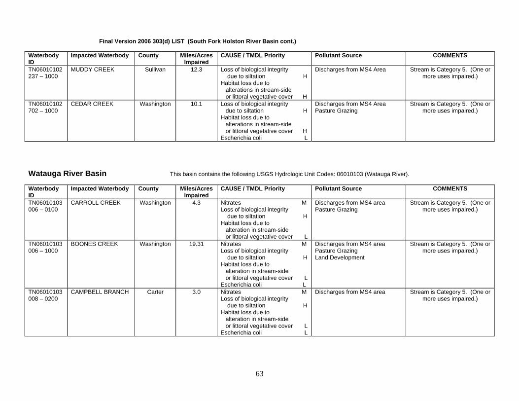
Final Version 2006 303(d) LIST (South Fork Holston River Basin cont.) Waterbody ID
Impacted Waterbody County Miles/AcresImpaired
CAUSE / TMDL Priority Pollutant Source COMMENTS
TN06010102237 – 1000
MUDDY CREEK Sullivan 12.3 Loss of biological integrity due to siltation H Habitat loss due to alterations in stream-side or littoral vegetative cover H
Discharges from MS4 Area Stream is Category 5. (One or more uses impaired.)
TN06010102702 – 1000
CEDAR CREEK Washington 10.1 Loss of biological integrity due to siltation H Habitat loss due to alterations in stream-side or littoral vegetative cover H Escherichia coli L
Discharges from MS4 Area Pasture Grazing
Stream is Category 5. (One or more uses impaired.)
Watauga River Basin This basin contains the following USGS Hydrologic Unit Codes: 06010103 (Watauga River). Waterbody ID
Impacted Waterbody County Miles/AcresImpaired
CAUSE / TMDL Priority Pollutant Source COMMENTS
TN06010103006 – 0100
CARROLL CREEK Washington 4.3 Nitrates M Loss of biological integrity due to siltation H Habitat loss due to alteration in stream-side or littoral vegetative cover L
Discharges from MS4 area Pasture Grazing
Stream is Category 5. (One or more uses impaired.)
TN06010103006 – 1000
BOONES CREEK Washington 19.31 Nitrates M Loss of biological integrity due to siltation H Habitat loss due to alteration in stream-side or littoral vegetative cover L Escherichia coli L
Discharges from MS4 area Pasture Grazing Land Development
Stream is Category 5. (One or more uses impaired.)
TN06010103008 – 0200
CAMPBELL BRANCH Carter 3.0 Nitrates M Loss of biological integrity due to siltation H Habitat loss due to alteration in stream-side or littoral vegetative cover L Escherichia coli L
Discharges from MS4 area Stream is Category 5. (One or more uses impaired.)
63

Final Version 2006 303(d) LIST (Watauga River Watershed cont.) Waterbody ID
Impacted Waterbody County Miles/AcresImpaired
CAUSE / TMDL Priority Pollutant Source COMMENTS
TN06010103008 – 0400
DAVIS BRANCH Carter 5.9 Habitat loss due to stream flow alteration M Habitat loss due to alteration in stream-side or littoral vegetative cover L
Discharges from MS4 area Upstream Impoundment
Stream is Category 5. (One or more uses impaired.)
TN06010103008 – 0800
GAP BRANCH Carter 15.93 Habitat loss due to alteration in stream-side or littoral vegetative cover L
Discharges from MS4 area Streambank Modification
Stream is Category 5. (One or more uses impaired.)
TN06010103009 – 1000
BRUSH CREEK Washington 20.3 Nutrients M Loss of biological integrity due to siltation H Other Anthropogenic Habitat Alterations H
Discharges from MS4 area Stream is Category 5. (One or more uses impaired.)
TN06010103013 – 0300
HAMPTON CREEK Carter 6.2 Physical Substrate Habitat Alterations L
Channelization Stream is Category 5. (One or more uses impaired.)
TN06010103020T – 0200
SINK BRANCH Johnson 2.0 Habitat loss due to alteration in stream-side or littoral vegetative cover L Nitrates M Escherichia coli L
Pasture Grazing Stream is Category 5. (One or more uses impaired.)
TN06010103034 – 0300
TOWN CREEK Johnson 3.0 Solids H Escherichia coli NA
Municipal Point Source Discharge
This stream is Category 5. However, EPA has approved a
fecal coliform TMDL that addresses some of the known
pollutants in this stream. TN06010103034 – 0310
GOOSE CREEK Johnson 15.4 Habitat loss due to alteration in stream-side or littoral vegetative cover L
Land Development Stream is Category 5. (One or more uses impaired.)
TN06010103034 – 0320
FURNACE CREEK Johnson 15.51 Habitat loss due to alteration in stream-side or littoral vegetative cover L
Channelization Stream is Category 5. (One or more uses impaired.)
TN06010103034 – 1000
ROAN CREEK Johnson 6.8 Loss of biological integrity due to siltation H
Pasture Grazing Stream is Category 5. (One or more uses impaired.)
However, EPA has approved a fecal coliform TMDL that
addresses some of the known pollutants in this stream.
TN06010103034 – 2000
ROAN CREEK Johnson 6.0 Nitrates M Loss of biological integrity due to siltation H Escherichia coli NA
Municipal Point Source Discharge Pasture Grazing
Stream is Category 5. (One or more uses impaired.)
However, EPA has approved a fecal coliform TMDL that
addresses some of the known pollutants in this stream.
64

Final Version 2006 303(d) LIST (Watauga River Watershed cont.) Waterbody ID
Impacted Waterbody County Miles/AcresImpaired
CAUSE / TMDL Priority Pollutant Source COMMENTS
TN06010103037 – 0400
CAMPBELL CREEK Johnson 10.8 Escherichia coli L Septic Tanks Pasture Grazing
Stream is Category 5. (One or more uses impaired.)
TN06010103046 – 1000
SINKING CREEK WashingtonCarter
10.0 Escherichia coli NA Discharges from MS4 area Pasture Grazing
Water contact advisory. This stream is Category 4a. The stream is impaired, but EPA
has approved a fecal coliform TMDL that addresses the
known pollutants. TN06010103061 – 1000
REEDY CREEK Washington 10.7 Nitrates M Physical Substrate Habitat Alterations L Loss of biological integrity due to siltation H
Discharges from MS4 area Pasture Grazing Channelization
Stream is Category 5. (One or more uses impaired.)
TN06010103635 – 0100
CASH HOLLOW CREEK
Washington 3.48 Habitat loss due to alteration in stream-side or littoral vegetative cover L Escherichia coli NA
Discharges from MS4 area Water contact advisory. This stream is Category 5. The
stream is impaired for one or more uses. However, EPA
has approved a fecal coliform TMDL that addresses some of
the known pollutants in this stream.
TN06010103635 – 0200
COBB CREEK Washington 4.5 Habitat loss due to alteration in stream-side or littoral vegetative cover L Loss of biological integrity due to siltation L
Discharges from MS4 area Stream is Category 5. (One or more uses impaired.)
TN06010103635 – 1000
KNOB CREEK Washington 12.13 Habitat loss due to alteration in stream-side or littoral vegetative cover L Nitrates M Loss of biological integrity due to siltation L Escherichia coli L
Discharges from MS4 area Pasture Grazing
Stream is Category 5. (One or more uses impaired.)
65

Holston River Basin This basin contains the following USGS Hydrologic Unit Codes: 06010104 (Holston River). Waterbody ID
Impacted Waterbody County Miles/Acres Impaired
CAUSE / TMDL Priority Pollutant Source COMMENTS
TN06010104001 - 0100
LOVE CREEK Knox 9.7 Loss of biological integrity due to siltation M Habitat loss due to alteration in stream-side or littoral vegetative cover M
Land Development Stream is Category 5. (One or more uses impaired.)
TN06010104001 - 0500
ROSEBERRY CREEK Knox 20.0 Escherichia coli M Pasture Grazing Septic Tanks
Stream is Category 5. (One or more uses impaired.)
TN06010104001 - 0800
LOST CREEK Jefferson 26.8 Loss of biological integrity due to siltation M Escherichia coli M
Pasture Grazing Septic Tanks
Stream is Category 5. (One or more uses impaired.)
TN06010104001 - 0900
BEAVER CREEK Jefferson 21.0 Escherichia coli M Pasture Grazing Stream is Category 5. (One or more uses impaired.)
TN06010104001 - 1400
SWANPOND CREEK Knox 16.3 Loss of biological integrity due to siltation M Habitat loss due to alteration in stream-side or littoral vegetative cover M Escherichia coli M
Land Development Channelization Discharges from MS4 Area
Stream is Category 5. (One or more uses impaired.)
TN06010104001 - 2000
HOLSTON RIVER Grainger Jefferson
26.9 Low DO L Habitat loss due to stream flow alteration NA
Upstream Impoundment Stream is Category 5 overall (one or more uses impaired),
but flow alteration is 4c (impact not caused by a pollutant).
Provides habitat for the federally listed pink mucket pearly mussel (Lampsilis
abrupta). Impacted by low DO releases from Cherokee Res.
TVA has taken action to improve dissolved oxygen and flow conditions downstream of
the dam. TN06010104004T - 0600
UNNAMED TRIB TO RED HOUSE BR. EMBAYMENT
Hawkins 1.5 Loss of biological integrity due to siltation L
Resource Extraction Category 5. (One or more uses impaired.)
TN06010104004T - 0900
STOCK CREEK Hawkins 4.2 Habitat loss due to alteration in stream-side or littoral vegetative cover M
Pasture Grazing Stream is Category 5. (One or more uses impaired.)
TN06010104004T - 1150
CANEY CREEK Hawkins 16.8 Escherichia coli M Pasture Grazing Stream is Category 5. (One or more uses impaired.)
TN06010104004T - 1200
CROCKETT CREEK Hawkins 5.3 Loss of biological integrity due to siltation M Escherichia coli M
Land Development Discharges from MS4 area
Stream is Category 5. (One or more uses impaired.)
66

Final Version 2006 303(d) LIST (Holston River Watershed cont.) Waterbody ID
Impacted Waterbody County Miles/Acres Impaired
CAUSE / TMDL Priority Pollutant Source COMMENTS
TN06010104004T - 2100
TURKEY CREEK Hamblen 8.0 Loss of biological integrity due to siltation M Habitat loss due to alteration in stream-side or littoral vegetative cover M Escherichia coli M
Collection System Failure Discharges from MS4 area
Water contact advisory due to pathogens. Stream is
Category 5. (One or more uses impaired.)
TN06010104004T - 2400
MOSSY CREEK Jefferson 9.1 Zinc L Loss of biological integrity due to siltation M Escherichia coli M
Collection System Failure Discharges from MS4 area Resource Extraction
Stream is Category 5. (One or more uses impaired.)
TN06010104011 - 0100
SINKING CREEK Hawkins 2.7 Escherichia coli M Pasture Grazing Stream is Category 5. (One or more uses impaired.)
TN06010104011 - 0200
FORGEY CREEK Hawkins 3.6 Escherichia coli M Pasture Grazing Stream is Category 5. (One or more uses impaired.)
TN06010104011 - 0300
SURGOINSVILLE CREEK
Hawkins 7.0 Escherichia coli M Pasture Grazing Septic Tanks
Stream is Category 5. (One or more uses impaired.)
TN06010104011 - 0400
STONEY POINT CREEK
Hawkins 13.1 Escherichia coli M Pasture Grazing Stream is Category 5. (One or more uses impaired.)
TN06010104011 - 0500
BRADLEY CREEK Hawkins 9.2 Escherichia coli M Livestock in Stream Stream is Category 5. (One or more uses impaired.)
TN06010104011 - 0510
RENFROE CREEK Hawkins 12.5 Escherichia coli M Livestock in Stream Stream is Category 5. (One or more uses impaired.)
TN06010104011 - 0700
HORD CREEK Hawkins 8.9 Escherichia coli M Discharges from MS4 area Pasture Grazing
Stream is Category 5. (One or more uses impaired.)
TN06010104011 - 0800
ALEXANDER CREEK Hawkins 1.0 Biological integrity loss due to undetermined cause M Escherichia coli M
Discharges from MS4 area Stream is Category 5. (One or more uses impaired.)
TN06010104011 - 0850
ALEXANDER CREEK Hawkins 12.5 Escherichia coli M Discharges from MS4 area Pasture Grazing
Stream is Category 5. (One or more uses impaired.)
TN06010104011 - 0900
SMITH CREEK Hawkins 4.6 Habitat loss due to alteration in stream-side or littoral vegetative cover M Escherichia coli M
Discharges from MS4 area Pasture Grazing Land Development
Stream is Category 5. (One or more uses impaired.)
TN06010104011 - 1100
ARNOTT CREEK Hawkins 2.8 Thermal Modifications L Habitat loss due to stream flow alterations NA
Major Industrial Point Source Stream is Category 5 overall (one or more uses impaired),
but flow alteration is 4c (impact not caused by a pollutant).
TN06010104011 - 1600
HUNT CREEK Hawkins 7.7 Escherichia coli M Livestock in Stream Stream is Category 5. (One or more uses impaired.)
TN06010104018 - 1000
RICHLAND CREEK Grainger 26.7 Escherichia coli M Pasture Grazing Stream is Category 5. (One or more uses impaired.)
67

Final Version 2006 303(d) LIST (Holston River Watershed cont.) Waterbody ID
Impacted Waterbody County Miles/Acres Impaired
CAUSE / TMDL Priority Pollutant Source COMMENTS
TN06010104019 - 0100
LITTLE FLAT CREEK Knox 30.3 Escherichia coli M Confined Animal Feeding Operations (NPS)
Stream is Category 5. (One or more uses impaired.)
TN06010104019 - 2000
FLAT CREEK Union Knox
2.8 Loss of biological integrity due to siltation M Habitat loss due to alteration in stream-side or littoral vegetative cover M Escherichia coli M
Hydromodification Dam Construction Pasture Grazing Collection System Failure
Stream is Category 5. (One or more uses impaired.)
Upper French Broad River Basin This basin contains the following USGS Hydrologic Unit Codes: 06010105 (Upper French Broad) and 06010106 (Pigeon River), Waterbody ID
Impacted Waterbody County Miles/Acres Impaired
CAUSE / TMDL Priority Pollutant Source COMMENTS
TN06010105001 - 0100
CLEAR CREEK Cocke 28.0 Escherichia coli L Pasture Grazing Stream is Category 5. (One or more uses impaired.)
TN06010105003 – 1100
JOHNS CREEK Cocke 1.45 Escherichia coli L Septic Tanks Water contact advisory due to pathogens. Stream is
Category 5. (One or more uses impaired.)
TN06010105003 – 1110
BAKER CREEK Cocke 4.4 Escherichia coli L Septic Tanks Water contact advisory due to pathogens. Stream is
Category 5. (One or more uses impaired.)
TN06010106001 – 1100
ENGLISH CREEK Cocke 15.3 Escherichia coli L Pasture Grazing Stream is Category 5. (One or more uses impaired.)
TN06010106001 – 4000
PIGEON RIVER- Cocke 5.03 Color L Major Industrial Point Source Source in Other State
Fishing advisory lifted in 2003. Color from Blue Ridge Paper is
still objectionable at times in this segment. NC or EPA
should do TMDL. Stream is Category 5. (One or more
uses impaired.) TN06010106002 – 1000
SINKING CREEK Cocke 6.8 Escherichia coli L Undetermined Source Stream is Category 5. (One or more uses impaired.)
68
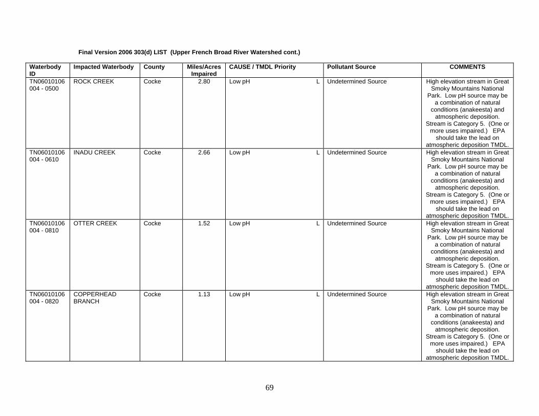
Final Version 2006 303(d) LIST (Upper French Broad River Watershed cont.) Waterbody ID
Impacted Waterbody County Miles/Acres Impaired
CAUSE / TMDL Priority Pollutant Source COMMENTS
TN06010106004 - 0500
ROCK CREEK Cocke 2.80 Low pH L Undetermined Source High elevation stream in Great Smoky Mountains National
Park. Low pH source may be a combination of natural
conditions (anakeesta) and atmospheric deposition.
Stream is Category 5. (One or more uses impaired.) EPA
should take the lead on atmospheric deposition TMDL.
TN06010106004 - 0610
INADU CREEK Cocke 2.66 Low pH L Undetermined Source High elevation stream in Great Smoky Mountains National
Park. Low pH source may be a combination of natural
conditions (anakeesta) and atmospheric deposition.
Stream is Category 5. (One or more uses impaired.) EPA
should take the lead on atmospheric deposition TMDL.
TN06010106004 - 0810
OTTER CREEK Cocke 1.52 Low pH L Undetermined Source High elevation stream in Great Smoky Mountains National
Park. Low pH source may be a combination of natural
conditions (anakeesta) and atmospheric deposition.
Stream is Category 5. (One or more uses impaired.) EPA
should take the lead on atmospheric deposition TMDL.
TN06010106004 - 0820
COPPERHEAD BRANCH
Cocke 1.13 Low pH L Undetermined Source High elevation stream in Great Smoky Mountains National
Park. Low pH source may be a combination of natural
conditions (anakeesta) and atmospheric deposition.
Stream is Category 5. (One or more uses impaired.) EPA
should take the lead on atmospheric deposition TMDL.
69

Lower French Broad River Basin This basin contains the following USGS Hydrologic Unit Codes: 06010107 (Lower French Broad) Waterbody ID
Impacted Waterbody County Miles/Acres Impaired
CAUSE / TMDL Priority Pollutant Source COMMENTS
TN06010107003 - 1000
BOYDS CREEK Sevier 15.4 Escherichia coli NA Pasture Grazing Stream is Category 4a. One or more uses impaired, but
EPA has approved a pathogen TMDL that addresses the
known pollutants. TN06010107006 - 2000
FRENCH BROAD RIVER
Sevier 4.9 Low Dissolved Oxygen L Thermal Modifications L Habitat loss due to stream flow alteration NA
Upstream Impoundment Provides habitat for the federally listed fish, the snail
darter (Percina tanasi). Segment impacted by Douglas
Reservoir releases (low DO and flow alteration). Stream is Category 5 (one or more uses impaired), but flow alteration is
4c (impact not caused by a pollutant). TVA has taken action to improve dissolved oxygen and flow conditions
downstream of the dam. TN06010107007 – 1000 & 2000
LITTLE PIGEON RIVER
Sevier 5.9 Escherichia coli NA Septic Tanks Collection System Failure
Water contact advisory. Stream is Category 4a. One or more uses impaired, but
EPA has approved a pathogen TMDL that addresses the
known pollutants. TN06010107007 - 0700
BUCK FORK Sevier 3.8 Low pH L Undetermined Source High elevation stream in Great Smoky Mountains National
Park. Acidity source may be a combination of natural
conditions (anakeesta) and atmospheric deposition.
Stream is Category 5. (One or more uses impaired.) EPA
should take the lead on TMDL. TN06010107007 - 0900
EAGLE ROCKS PRONG
Sevier 6.4 Low pH L Atmospheric Deposition - Acidity High elevation stream in Great Smoky Mountains National Park. Documented loss of native trout populations.
Stream is Category 5. (One or more uses impaired.) EPA
should take the lead on atmospheric deposition TMDL.
70

Final Version 2006 303(d) LIST (Lower French Broad River cont.) Waterbody ID
Impacted Waterbody County Partial CAUSE / TMDL Priority Pollutant Source COMMENTS
TN06010107007 - 1120
SHUTTS PRONG Sevier 4.79 Low pH L Undetermined Source High elevation stream in Great Smoky Mountains National
Park. Acidity source is likely a combination of natural
conditions (anakeesta) and atmospheric deposition.
Stream is Category 5. (One or more uses impaired.) EPA
should take the lead on TMDL. TN06010107007 - 1130
LOWES CREEK Sevier 2.22 Low pH L Atmospheric Deposition - Acidity High elevation stream in Great Smoky Mountains National Park. Documented loss of native trout populations.
Stream is Category 5. (One or more uses impaired.) EPA
should take the lead on atmospheric deposition TMDL.
TN06010107007 - 1140
CANNON CREEK Sevier 3.72 Low pH L Atmospheric Deposition - Acidity High elevation stream in Great Smoky Mountains National Park. Documented loss of native trout populations.
Stream is Category 5. (One or more uses impaired.) EPA
should take the lead on atmospheric deposition TMDL.
TN06010107007 - 1650
MIDDLE CREEK Sevier 3.3 Biological integrity loss due to undetermined cause L
Undetermined Source Stream is Category 5. (One or more uses impaired.)
TN06010107010 - 0100
GNATTY BRANCH Sevier 1.8 Escherichia coli NA Septic Tanks Contact advisory. Stream is Category 4a. Impaired, but
EPA has approved a pathogen TMDL that addresses the
known pollutants. TN06010107010 - 0200
KING BRANCH Sevier 2.5 Escherichia coli NA Septic Tanks Contact advisory. Stream is Category 4a. Impaired, but
EPA has approved a pathogen TMDL that addresses the
known pollutants. TN06010107010 – 0300
BEECH BRANCH Sevier 1.0 Escherichia coli NA Septic Tanks Contact advisory. Stream is Category 4a. Impaired, but
EPA has approved a pathogen TMDL that addresses the
known pollutants.
71

Final Version 2006 303(d) LIST (Lower French Broad River cont.) Waterbody ID
Impacted Waterbody County Partial CAUSE / TMDL Priority Pollutant Source COMMENTS
TN06010107010 – 0400
DUDLEY CREEK Sevier 5.7 Escherichia coli NA Septic Tanks Contact advisory. Stream is Category 4a. Impaired, but
EPA has approved a pathogen TMDL that addresses the
known pollutants. TN06010107010 - 0500
ROARING FORK Sevier 1.5 Escherichia coli NA Collection System Failure Water contact advisory. Stream is Category 4a. One or more uses impaired, but
EPA has approved a pathogen TMDL that addresses the
known pollutants. TN06010107010 - 0600
BASKINS CREEK Sevier 1.3 Escherichia coli NA Collection System Failure Water contact advisory. Stream is Category 4a. One or more uses impaired, but
EPA has approved a pathogen TMDL that addresses the
known pollutants. TN06010107010 - 1000
WEST PRONG LITTLE PIGEON RIVER
Sevier 8.1 Escherichia coli NA Loss of biological integrity due to siltation H Phosphorus M The trout stream portion of this segment is considered “threatened by elevated water temperatures and low DO.
Septic Tanks Collection System Failure Land Development Channelization Municipal Point Source Discharges from MS4 Area
Water contact advisory. Development between
Sevierville and Pigeon Forge adding silt to river. Stream is
Category 5. One or more uses impaired, but EPA has
approved a pathogen TMDL that addresses some of the
known pollutants. TN06010107010 - 1100
ROAD PRONG Sevier 4.6 Low pH L Undetermined Source High elevation stream in Great Smoky Mountains National
Park. Acidity source may be a combination of natural
conditions (anakeesta) and atmospheric deposition.
Stream is Category 5. (One or more uses impaired.) EPA
should take the lead on TMDL. TN06010107010 - 1300
HOLY BRANCH Sevier 1.0 Escherichia coli NA Collection System Failure Water contact advisory. Stream is Category 4a. One or more uses impaired, but
EPA has approved a pathogen TMDL that addresses the
known pollutants.
72

Final Version 2006 303(d) LIST (Lower French Broad River cont.) Waterbody ID
Impacted Waterbody County Partial CAUSE / TMDL Priority Pollutant Source COMMENTS
TN06010107010 - 1800
MILL CREEK Sevier 5.9 Physical Substrate Habitat Alterations H Escherichia coli NA
Collection System Failure Channelization
Stream is Category 5. One or more uses impaired, but EPA
has approved a pathogen TMDL that addresses some of
the known pollutants. TN06010107010 – 1900
WALDEN CREEK Sevier 2.6 Loss of biological integrity due to siltation H Escherichia coli NA
Pasture Grazing Land Development Septic Tanks
Stream is Category 5. One or more uses impaired, but EPA
has approved a pathogen TMDL that addresses some of
the known pollutants. TN06010107010 - 1950
WALDEN CREEK Sevier 8.6 Loss of biological integrity due to siltation H Habitat loss due to alteration in stream-side or littoral vegetative cover H
Pasture Grazing Land Development
Stream is Category 5. (One or more uses impaired.)
TN06010107010 - 2000
WEST PRONG LITTLE PIGEON RIVER
Sevier 5.7 Biological integrity loss due to undetermined cause H Escherichia coli NA Phosphorus M This section is a trout stream and is considered threatened by low dissolved oxygen and elevated water temperatures.
Septic Tanks Collection System Failure Discharges from MS4 area Municipal Point Sources
Water contact advisory due to pathogens. Stream is
Category 5. One or more uses impaired, but EPA has
approved a pathogen TMDL that addresses some of the
known pollutants.
TN06010107010 - 3000
WEST PRONG LITTLE PIGEON RIVER
Sevier 5.4 Phosphorus M Escherichia coli NA This section is a trout stream and is considered threatened by low dissolved oxygen and elevated water temperatures.
Municipal Point Sources Discharges from MS4 Area Septic Tanks Collection System Failure
Water contact advisory. Stream is Category 5. One or more uses impaired. EPA has approved a pathogen TMDL that addresses some of the
known pollutants.
TN06010107029T - 0400
LEADVALE CREEK Jefferson 4.4 Escherichia coli L Pasture/Grazing Water contact advisory. Stream is Category 5. One or
more uses impaired. TN06010107029T - 1100
CLEAR CREEK Jefferson 3.3 Escherichia coli NA Pasture Grazing Stream is Category 4a. One or more uses impaired, but
EPA has approved a pathogen TMDL that addresses the
known pollutants.
73

Final Version 2006 303(d) LIST (Lower French Broad River cont.) Waterbody ID
Impacted Waterbody County Partial CAUSE / TMDL Priority Pollutant Source COMMENTS
TN06010107029T - 1150
CLEAR CREEK Jefferson Cocke
13.6 Nutrients M Escherichia coli NA
Pasture Grazing Stream is Category 5. One or more uses impaired, but EPA
has approved a pathogen TMDL that addresses the
known pollutants. TN06010107038 - 1000
DUMPLIN CREEK Jefferson Sevier
19.1 Loss of biological integrity due to siltation H Physical Substrate Habitat Alterations H
Pasture Grazing Land Development Channelization
Stream is Category 5. (One or more uses impaired.)
Nolichucky River This basin contains the following USGS Hydrologic Unit Codes: 06010108 (Nolichucky River) Waterbody ID
Impacted Waterbody County Miles/Acres Impaired
CAUSE / TMDL Priority Pollutant Source COMMENTS
TN06010108001 - 0100
FLAT CREEK Hamblen 4.9 Escherichia coli H Pasture Grazing Stream is Category 5. (One or more uses impaired.)
TN06010108001 - 0110
ROBINSON CREEK Hamblen 3.4 Loss of biological integrity due to siltation H
Pasture Grazing Stream is Category 5. (One or more uses impaired.)
TN06010108001 - 0200
TURKEY CREEK Hamblen 5.8 Loss of biological integrity due to siltation H
Pasture Grazing Stream is Category 5. (One or more uses impaired.)
TN06010108001 - 1000
NOLICHUCKY RIVER Hamblen Cocke
4.0 Loss of biological integrity due to siltation H Escherichia coli H
Agriculture Source in Other State
Stream is Category 5. (One or more uses impaired.)
TN06010108001 - 2000
NOLICHUCKY RIVER Hamblen Cocke
7.7 Escherichia coli H Pasture Grazing Stream is Category 5. (One or more uses impaired.) Provides habitat for the federally listed oyster mussel (Epioblasma
capsaeformis) and the fish, the snail darter (Percina tanasi).
TN06010108001 - 3000
NOLICHUCKY RIVER Greene Cocke
9.0 Loss of biological integrity due to siltation H
Agriculture Source in Other State
Stream is Category 5. (One or more uses impaired.) Provides habitat for the federally listed snail darter (Percina tanasi).
TN06010108005 - 0310
PRIVET BRANCH Greene 1.4 Pasture Grazing Stream is Category 5. (One or more uses impaired.)
Loss of biological integrity due to siltation H Habitat loss due to alteration in stream-side or littoral vegetative cover H
74

Final Version 2006 303(d) LIST (Nolichucky River Watershed cont.) Waterbody ID
Impacted Waterbody County Miles/Acres Impaired
CAUSE / TMDL Priority Pollutant Source COMMENTS
TN06010108005 - 0500
GREGG BRANCH Greene 2.7 Loss of biological integrity due to siltation H
Pasture Grazing Stream is Category 5. (One or more uses impaired.)
TN06010108005 - 0710
SHELTON BRANCH Greene 1.23 Loss of biological integrity due to siltation H Habitat loss due to alteration in stream-side or littoral vegetative cover H
Pasture Grazing Channelization
Stream is Category 5. (One or more uses impaired.)
TN06010108005 - 0800
KYKER BRANCH Greene 2.5 Loss of biological integrity due to siltation H
Pasture Grazing Stream is Category 5. (One or more uses impaired.)
TN06010108005 - 1000
NOLICHUCKY RIVER Greene 9.4 Loss of biological integrity due to siltation H
Agriculture Source in Other State
Stream is Category 5. (One or more uses impaired.)
TN06010108005 - 1121
RADER BRANCH Cocke 2.0 Habitat loss due to alteration in stream-side or littoral vegetative cover H
Pasture Grazing Stream is Category 5. (One or more uses impaired.)
TN06010108005 - 2000
NOLICHUCKY RIVER Greene Cocke
6.6 Loss of biological integrity due to siltation H Escherichia coli H
Agriculture Source in Other State
Stream is Category 5. (One or more uses impaired.)
TN06010108005 - 3000
NOLICHUCKY RIVER Greene Cocke
6.4 Loss of biological integrity due to siltation H
Agriculture Source in Other State
Stream is Category 5. (One or more uses impaired.)
TN06010108007 - 1000
MEADOW CREEK Greene Cocke
23.4 Escherichia coli H Livestock in Stream Stream is Category 5. (One or more uses impaired.)
TN06010108009 - 0300
CEDAR CREEK Greene 5.4 Loss of biological integrity due to siltation H
Pasture Grazing Stream is Category 5. (One or more uses impaired.)
TN06010108009 - 1000
COVE CREEK Greene 29.7 Loss of biological integrity due to siltation H
Pasture Grazing Stream is Category 5. (One or more uses impaired.)
TN06010108010 - 0200
HOLLEY CREEK Greene 8.5 Loss of biological integrity due to siltation H
Land Development Discharges from MS4 area
Stream is Category 5. (One or more uses impaired.)
TN06010108010 - 0300
COLLEGE CREEK Greene 9.3 Loss of biological integrity due to siltation H Habitat loss due to alteration in stream-side or littoral vegetative cover H
Pasture Grazing Land Development
Stream is Category 5. (One or more uses impaired.)
TN06010108010 - 0400
MOON CREEK Greene 8.7 Habitat loss due to alteration in stream-side or littoral vegetative cover H
Pasture Grazing Stream is Category 5. (One or more uses impaired.)
TN06010108010 - 0500
PUDDING CREEK Greene 5.5 Loss of biological integrity due to siltation H Habitat loss due to alteration in stream-side or littoral vegetative cover H
Pasture Grazing Stream is Category 5. (One or more uses impaired.)
75

Final Version 2006 303(d) LIST (Nolichucky River Watershed cont.) Waterbody ID
Impacted Waterbody County Miles/Acres Impaired
CAUSE / TMDL Priority Pollutant Source COMMENTS
TN06010108010 - 0750
RHEATOWN CREEK Greene 6.7 Loss of biological integrity due to siltation H Habitat loss due to alteration in stream-side or littoral vegetative cover H
Pasture Grazing Land Development
Stream is Category 5. (One or more uses impaired.)
TN06010108010 - 0800
HICE CREEK Greene 2.1 Loss of biological integrity due to siltation H Habitat loss due to alteration in stream-side or littoral vegetative cover H
Pasture Grazing Stream is Category 5. (One or more uses impaired.)
TN06010108010 - 0900
SNAPP BRANCH Washington 1.9 Loss of biological integrity due to siltation H Habitat loss due to alteration in stream-side or littoral vegetative cover H
Pasture Grazing Stream is Category 5. (One or more uses impaired.)
TN06010108010 – 1000, 2000 & 3000
NOLICHUCKY RIVER Greene Washington
38.5 Loss of biological integrity due to siltation H
Agriculture Source in Other State
Stream is Category 5. (One or more uses impaired.)
TN06010108010 - 1100
ASBURY CREEK Washington 2.33 Loss of biological integrity due to siltation H Habitat loss due to alteration in stream-side or littoral vegetative cover H
Pasture Grazing Stream is Category 5. (One or more uses impaired.)
TN06010108010 - 1200
KNAVE BRANCH Washington 4.6 Habitat loss due to alteration in stream-side or littoral vegetative cover H
Pasture Grazing Stream is Category 5. (One or more uses impaired.)
TN06010108010 - 1300
KEPLINGER CREEK Washington 5.3 Loss of biological integrity due to siltation H Habitat loss due to alteration in stream-side or littoral vegetative cover H
Pasture Grazing Stream is Category 5. (One or more uses impaired.)
TN06010108010 - 1400
LEBANON BRANCH Washington 1.9 Loss of biological integrity due to siltation H Habitat loss due to alteration in stream-side or littoral vegetative cover H
Pasture Grazing Stream is Category 5. (One or more uses impaired.)
TN06010108010 - 1900
MARTINS CREEK Unicoi 8.3 Habitat loss due to alteration in stream-side or littoral vegetative cover H
Discharges from MS4 area Stream is Category 5. (One or more uses impaired.)
TN06010108010 - 1910
SPRING CREEK Unicoi 1.7 Habitat loss due to alteration in stream-side or littoral vegetative cover H
Discharges from MS4 area Stream is Category 5. (One or more uses impaired.)
76

Final Version 2006 303(d) LIST (Nolichucky River Watershed cont.) Waterbody ID
Impacted Waterbody County Miles/Acres Impaired
CAUSE / TMDL Priority Pollutant Source COMMENTS
TN06010108010 - 3100
KATY BRANCH Washington 0.8 Loss of biological integrity due to siltation H
Agriculture Stream is Category 5. (One or more uses impaired.)
TN06010108010 - 3600
MOORE BRANCH Washington 7.7 Loss of biological integrity due to siltation H Habitat loss due to alteration in stream-side or littoral vegetative cover H
Pasture Grazing Stream is Category 5. (One or more uses impaired.)
TN06010108010 - 3800
WOLF BRANCH Greene 1.3 Loss of biological integrity due to siltation H Habitat loss due to alteration in stream-side or littoral vegetative cover H
Nonirrigated Crop Production Stream is Category 5. (One or more uses impaired.)
TN06010108010 - 6000
NOLICHUCKY RIVER Unicoi 2.06 Loss of biological integrity due to siltation M
Source in Other State Stream is Category 5. (One or more uses impaired.)
Provides habitat for the federally listed Appalachian
elktoe (Alasmidonta rayeneliana). North Carolina or EPA should do the TMDL for this section of the river.
TN06010108029 - 0300
SCIOTO CREEK Unicoi 14.8 Loss of biological integrity due to siltation H
Land Development Stream is Category 5. (One or more uses impaired.)
TN06010108029 – 0900
TATE SPRINGS Unicoi 1.0 Suspended Solids H Aquaculture Stream is Category 5. (One or more uses impaired.)
TN06010108029 - 1000
NORTH INDIAN CREEK
Unicoi 8.0 Loss of biological integrity due to siltation H
Discharges from MS4 area Stream is Category 5. (One or more uses impaired.)
TN06010108030 - 0100
CEDAR CREEK Greene 3.3 Loss of biological integrity due to siltation H Habitat loss due to alteration in stream-side or littoral vegetative cover H
Pasture Grazing Stream is Category 5. (One or more uses impaired.)
TN06010108030 - 0200
JOCKEY CREEK Greene 8.0 Nitrate M Loss of biological integrity due to siltation H Escherichia coli H
Pasture Grazing Stream is Category 5. (One or more uses impaired.)
TN06010108030 - 0210
SPLATTER CREEK Greene 3.6 Loss of biological integrity due to siltation H Habitat loss due to alteration in stream-side or littoral vegetative cover H
Pasture Grazing Livestock in Stream
Stream is Category 5. (One or more uses impaired.)
77

Final Version 2006 303(d) LIST (Nolichucky River Watershed cont.) Waterbody ID
Impacted Waterbody County Miles/Acres Impaired
CAUSE / TMDL Priority Pollutant Source COMMENTS
TN06010108030 - 0220
CARSON CREEK Greene Washington
17.9 Nitrate M Loss of biological integrity due to siltation H Escherichia coli H
Pasture Grazing Livestock in Stream
Stream is Category 5. (One or more uses impaired.)
TN06010108030 - 0300
KEEBLER BRANCH Washington 7.4 Loss of biological integrity due to siltation H Habitat loss due to alteration in stream-side or littoral vegetative cover H
Pasture Grazing Stream is Category 5. (One or more uses impaired.)
TN06010108030 - 0400
CLEAR FORK Washington 12 Loss of biological integrity due to siltation H Habitat loss due to alteration in stream-side or littoral vegetative cover H
Pasture Grazing Stream is Category 5. (One or more uses impaired.)
TN06010108030 - 0420
UNNAMED TRIB TO CLEAR FORK
Washington 6.9 Loss of biological integrity due to siltation H Habitat loss due to alteration in stream-side or littoral vegetative cover H
Pasture Grazing Stream is Category 5. (One or more uses impaired.)
TN06010108030 - 0410
BLACKLEY CREEK Washington 16.0 Escherichia coli H Pasture Grazing Stream is Category 5. (One or more uses impaired.)
TN06010108030 - 0430
MUDDY FORK Washington 23.8 Escherichia coli H Agriculture Stream is Category 5. (One or more uses impaired.)
TN06010108030 - 0431
LEESBURG BRANCH Washington 3.4 Loss of biological integrity due to siltation H Habitat loss due to alteration in stream-side or littoral vegetative cover H
Pasture Grazing Stream is Category 5. (One or more uses impaired.)
TN06010108030 - 1000
BIG LIMESTONE CREEK
Greene Washington
3.1 Escherichia coli H Pasture Grazing Stream is Category 5. (One or more uses impaired.)
TN06010108030 - 2000
BIG LIMESTONE CREEK
Washington 8.8 Phosphorus H Nitrate H Loss of biological integrity due to siltation H Escherichia coli H
Pasture Grazing Stream is Category 5. (One or more uses impaired.)
TN06010108033 - 0100
BUFFALO CREEK Greene 3.0 Loss of biological integrity due to siltation H Habitat loss due to alteration in stream-side or littoral vegetative cover H
Pasture Grazing Stream is Category 5. (One or more uses impaired.)
78

Final Version 2006 303(d) LIST (Nolichucky River Watershed cont.) Waterbody ID
Impacted Waterbody County Miles/Acres Impaired
CAUSE / TMDL Priority Pollutant Source COMMENTS
TN06010108033 - 1000
PIGEON CREEK Greene 8.8 Escherichia coli H Pasture Grazing Stream is Category 5. (One or more uses impaired.)
TN06010108035 - 0200
POTTER CREEK Greene 15.3 Loss of biological integrity due to siltation H Habitat loss due to alteration in stream-side or littoral vegetative cover H Escherichia coli H
Pasture Grazing Stream is Category 5. (One or more uses impaired.)
TN06010108035 - 0400
MUD CREEK Greene 4.4 Habitat loss due to alteration in stream-side or littoral vegetative cover H
Pasture Grazing Stream is Category 5. (One or more uses impaired.)
TN06010108035 - 0700
LICK BRANCH Greene 1.2 Habitat loss due to alteration in stream-side or littoral vegetative cover H
Pasture Grazing Stream is Category 5. (One or more uses impaired.)
TN06010108035 - 0900
PUNCHEON CAMP CREEK
Greene 11.5 Nutrients M Loss of biological integrity due to siltation H Escherichia coli H
Agriculture Stream is Category 5. (One or more uses impaired.)
TN06010108035 - 1000
LICK CREEK Greene 3.9 Nutrients M Loss of biological integrity due to siltation H Other Habitat Alterations H Escherichia coli H
Pasture Grazing Stream is Category 5. (One or more uses impaired.)
TN06010108035 - 1110
BABB CREEK Greene 4.6 Other Habitat Alterations H Pasture Grazing Stream is Category 5. (One or more uses impaired.)
TN06010108035 – 1400
GARDINER CREEK Greene 5.4 Other Habitat Alterations H Pasture Grazing Stream is Category 5. (One or more uses impaired.)
TN06010108035 – 1410
WATTENBARGER CREEK
Greene 5.3 Other Habitat Alterations H Pasture Grazing Stream is Category 5. (One or more uses impaired.)
TN06010108035 – 1800
PYBORN CREEK Greene 6.4 Escherichia coli H Pasture Grazing Stream is Category 5. (One or more uses impaired.)
TN06010108035 – 1900
CLEAR CREEK Greene Washington
19.9 Loss of biological integrity due to siltation H
Pasture Grazing Stream is Category 5. (One or more uses impaired.)
TN06010108035 – 2000
LICK CREEK Greene 2.3 Escherichia coli H Pasture Grazing Stream is Category 5. (One or more uses impaired.)
TN06010108035 – 2300
HORSE FORK Greene 1.6 Other Habitat Alterations H Pasture Grazing Stream is Category 5. (One or more uses impaired.)
TN06010108035 – 2310
UNION TEMPLE CREEK
Greene 23.9 Loss of biological integrity due to siltation H Other Habitat Alterations H
Pasture Grazing Stream is Category 5. (One or more uses impaired.)
79

Final Version 2006 303(d) LIST (Nolichucky River Watershed cont.) Waterbody ID
Impacted Waterbody County Miles/Acres Impaired
CAUSE / TMDL Priority Pollutant Source COMMENTS
TN06010108035 – 2320
DAVIS CREEK Greene 2.8 Loss of biological integrity due to siltation H Other Habitat Alterations H
Pasture Grazing Stream is Category 5. (One or more uses impaired.)
TN06010108035 – 2400
HOODLEY BRANCH Greene 5.3 Other Habitat Alterations H Pasture Grazing Stream is Category 5. (One or more uses impaired.)
TN06010108035 – 2521
POSSUM CREEK Greene 7.5 Other Habitat Alterations H Pasture Grazing Stream is Category 5. (One or more uses impaired.)
TN06010108035 – 2800
MINK CREEK Greene 9.1 Escherichia coli H Pasture Grazing Stream is Category 5. (One or more uses impaired.)
TN06010108035 – 2810
POND CREEK Greene 2.2 Other Habitat Alterations H Pasture Grazing Stream is Category 5. (One or more uses impaired.)
TN06010108035 – 2900
FOX BRANCH Greene 1.5 Other Habitat Alterations H Pasture Grazing Stream is Category 5. (One or more uses impaired.)
TN06010108035 – 3000
LICK CREEK Greene 7.4 Nutrients M Loss of biological integrity due to siltation H Habitat loss due to alteration in stream-side or littoral vegetative cover H Escherichia coli H
Pasture Grazing Stream is Category 5. (One or more uses impaired.)
TN06010108035 – 4000
LICK CREEK Greene 4.9 Escherichia coli H Pasture Grazing Stream is Category 5. (One or more uses impaired.)
TN06010108035 – 5000, 6000 & 7000
LICK CREEK Greene 36.1 Nutrients M Loss of biological integrity due to siltation H Habitat loss due to alteration in stream-side or littoral vegetative cover H Escherichia coli H
Pasture Grazing Stream is Category 5. (One or more uses impaired.)
TN06010108035 - 8000
LICK CREEK Greene 7.2 Escherichia coli H Pasture Grazing Stream is Category 5. (One or more uses impaired.)
TN06010108035 - 9000
LICK CREEK Greene 7.7 Nutrients M Loss of biological integrity due to siltation H Escherichia coli H
Pasture Grazing Stream is Category 5. (One or more uses impaired.)
TN06010108042 - 0100
HALE BRANCH Hamblen 7.1 Habitat loss due to alteration in stream-side or littoral vegetative cover H
Pasture Grazing Stream is Category 5. (One or more uses impaired.)
TN06010108042 - 0110
SLOP CREEK Hamblen 1.7 Habitat loss due to alteration in stream-side or littoral vegetative cover H
Pasture Grazing Stream is Category 5. (One or more uses impaired.)
80

Final Version 2006 303(d) LIST (Nolichucky River Watershed cont.) Waterbody ID
Impacted Waterbody County Miles/Acres Impaired
CAUSE / TMDL Priority Pollutant Source COMMENTS
TN06010108042 - 0600
MUD CREEK Hamblen Hawkins
8.2 Escherichia coli H Pasture Grazing Stream is Category 5. (One or more uses impaired.)
TN06010108042 - 0612
COLDSPRING BRANCH
Hawkins 1.1 Loss of biological integrity due to siltation H Habitat loss due to alteration in stream-side or littoral vegetative cover H
Pasture Grazing Stream is Category 5. (One or more uses impaired.)
TN06010108042 - 1000
BENT CREEK Hamblen 13.7 Escherichia coli H Pasture Grazing Stream is Category 5. (One or more uses impaired.)
TN06010108043 - 0200
CRIDER CREEK Hamblen 6.2 Loss of biological integrity due to siltation H Habitat loss due to alteration in stream-side or littoral vegetative cover H
Pasture Grazing Stream is Category 5. (One or more uses impaired.)
TN06010108043 - 0300
SARTAIN CREEK Jefferson Hamblen
4.4 Loss of biological integrity due to siltation H Habitat loss due to alteration in stream-side or littoral vegetative cover H
Pasture Grazing Stream is Category 5. (One or more uses impaired.)
TN06010108043 - 0310
CARTER BRANCH Jefferson Hamblen
3.5 Loss of biological integrity due to siltation H Habitat loss due to alteration in stream-side or littoral vegetative cover H
Pasture Grazing Livestock in Stream
Stream is Category 5. (One or more uses impaired.)
TN06010108043 - 0400
CEDAR CREEK Hamblen Jefferson
7.5 Loss of biological integrity due to siltation H
Pasture Grazing Stream is Category 5. (One or more uses impaired.)
TN06010108043 - 1000
LONG CREEK Jefferson Hamblen
13.5 Escherichia coli H Pasture Grazing Stream is Category 5. (One or more uses impaired.)
TN06010108064 – 1000 & 2000
SINKING CREEK Greene 23.4 Escherichia coli H Pasture Grazing Stream is Category 5. (One or more uses impaired.)
TN06010108088 - 0200
ALEXANDER CREEK Greene 2.8 Loss of biological integrity due to siltation H Habitat loss due to alteration in stream-side or littoral vegetative cover H
Pasture Grazing Stream is Category 5. (One or more uses impaired.)
TN06010108102 - 0100
UNNAMED TRIB TO RICHLAND CREEK
Greene 4.05 Loss of biological integrity due to siltation H Habitat loss due to alteration in stream-side or littoral vegetative cover H
Pasture Grazing Stream is Category 5. (One or more uses impaired.)
81

Final Version 2006 303(d) LIST (Nolichucky River Watershed cont.) Waterbody ID
Impacted Waterbody County Miles/Acres Impaired
CAUSE / TMDL Priority Pollutant Source COMMENTS
TN06010108102 - 0200
SIMPSON CREEK Greene 1.87 Loss of biological integrity due to siltation H Habitat loss due to alteration in stream-side or littoral vegetative cover H
Pasture Grazing Stream is Category 5. (One or more uses impaired.)
TN06010108102 – 0300
TIPTON CREEK Greene 1.60 Loss of biological integrity due to siltation H Habitat loss due to alteration in stream-side or littoral vegetative cover H
Pasture Grazing Stream is Category 5. (One or more uses impaired.)
TN06010108102 - 0400
EAST FORK RICHLAND CREEK
Greene 4.96 Habitat loss due to alteration in stream-side or littoral vegetative cover H
Pasture Grazing Stream is Category 5. (One or more uses impaired.)
TN06010108102 - 2000
RICHLAND CREEK Greene 8.51 Nutrients M Loss of biological integrity due to siltation H Habitat loss due to alteration in stream-side or littoral vegetative cover H Escherichia coli H
Pasture Grazing Discharges from MS4 area
Stream is Category 5. (One or more uses impaired.)
TN06010108456 - 0200
DRY CREEK Greene 3.3 Loss of biological integrity due to siltation H Habitat loss due to alteration in stream-side or littoral vegetative cover H
Resource Extraction Stream is Category 5. (One or more uses impaired.)
TN06010108510 - 0100
BROWN BRANCH Washington 8.3 Loss of biological integrity due to siltation H Habitat loss due to alteration in stream-side or littoral vegetative cover H
Pasture Grazing Land Development
Stream is Category 5. (One or more uses impaired.)
TN06010108510 - 0200
BACON BRANCH Washington 4.6 Loss of biological integrity due to siltation H Habitat loss due to alteration in stream-side or littoral vegetative cover H
Pasture Grazing Stream is Category 5. (One or more uses impaired.)
TN06010108510 - 0300
FEIST BRANCH Washington 2.3 Loss of biological integrity due to siltation H
Pasture Grazing Stream is Category 5. (One or more uses impaired.)
TN06010108510 - 0400
HOMINY CREEK Washington 7.0 Nitrate H Escherichia coli H
Agriculture Stream is Category 5. (One or more uses impaired.)
TN06010108510 - 0500
ONION CREEK Washington 4.0 Loss of biological integrity due to siltation H
Pasture Grazing Land Development
Stream is Category 5. (One or more uses impaired.)
TN06010108510 - 1000
LITTLE LIMESTONE CREEK
Washington 8.0 Nitrate H Escherichia coli H
Pasture Grazing Stream is Category 5. (One or more uses impaired.)
82

Final Version 2006 303(d) LIST (Nolichucky River Watershed cont.) Waterbody ID
Impacted Waterbody County Miles/Acres Impaired
CAUSE / TMDL Priority Pollutant Source COMMENTS
TN06010108510 - 2000
LITTLE LIMESTONE CREEK
Washington 13.5 Habitat loss due to alteration in stream-side or littoral vegetative cover H Escherichia coli H
Pasture Grazing Stream is Category 5. (One or more uses impaired.)
TN06010108536 - 0100
LOYD CREEK Washington 4.2 Loss of biological integrity due to siltation H Habitat loss due to alteration in stream-side or littoral vegetative cover H
Pasture Grazing Stream is Category 5. (One or more uses impaired.)
TN06010108536 - 0200
LITTLE CHEROKEE CREEK
Washington 7.2 Loss of biological integrity due to siltation H Habitat loss due to alteration in stream-side or littoral vegetative cover H
Pasture Grazing Land Development
Stream is Category 5. (One or more uses impaired.)
TN06010108536 – 1000 & 2000
CHEROKEE CREEK Washington 20.8 Loss of biological integrity due to siltation H
Pasture Grazing Land Development
Stream is Category 5. (One or more uses impaired.)
TN06010108DCROCKETT – 1000
DAVY CROCKETT RESERVOIR
Greene 383 ac Loss of biological integrity due to siltation H
Agriculture Source in Other State
Stream is Category 5. (One or more uses impaired.)
TN06010108DCTRIBS-0100
MUTTON CREEK Greene 1.7 Loss of biological integrity due to siltation H Habitat loss due to alteration in stream-side or littoral vegetative cover H
Pasture Grazing Stream is Category 5. (One or more uses impaired.)
TN06010108DCTRIBS – 0200
JOHNSON CREEK Greene 1.4. Loss of biological integrity due to siltation H
Pasture Grazing Stream is Category 5. (One or more uses impaired.)
TN06010108DCTRIBS – 0500
MUD CREEK Greene 21.4 Loss of biological integrity due to siltation H
Pasture Grazing Land Development
Stream is Category 5. (One or more uses impaired.)
TN06010108DCTRIBS – 0600
FLAG BRANCH Greene 5.8 Loss of biological integrity due to siltation H Habitat loss due to alteration in stream-side or littoral vegetative cover H
Pasture Grazing Channelization
Stream is Category 5. (One or more uses impaired.)
83

Upper Tennessee River Basin This basin contains the following USGS Hydrologic Unit Codes: 06010201 (Watts Bar Res., Fort Loudoun Res., and Little River). Waterbody ID
Impacted Waterbody County Miles/Acres Impaired
CAUSE / TMDL Priority Pollutant Source COMMENTS
TN06010201001 - 1000
WATTS BAR RESERVOIR
Rhea Roane Meigs
34075 ac PCBs L Contaminated sediments Fishing advisory due to PCBs. Category 5, impaired for one
or more uses. TN06010201001 – 2000
UPPER WATTS BAR RESERVOIR Sweetwater Creek to Fort Loudoun Dam.
Loudon 1790 ac
Low DO L PCBs L
Upstream Impoundment Contaminated Sediment
Fishing advisory due to PCBs. This stream is Category 5.
The stream is impaired for one or more uses. Provides
habitat for the federally listed fish, snail darter (Percina tanasi) and the following
mussels: orange-foot pimpleback pearly mussel (Plethobasus cooperianus)
and pink mucket pearly mussel (Lampsilis abrupta). TVA has
taken action to improve dissolved oxygen conditions
downstream of the dam. TN06010201011 - 1000
PAINT ROCK CREEK Roane 12.2 Escherichia coli NA Pasture Grazing Stream is Category 4a. One or more uses impaired, but
EPA has approved a pathogen TMDL that addresses the
known pollutants. TN06010201013 - 0100
MUD CREEK Loudon Monroe
7.2 Escherichia coli NA Pasture Grazing Stream is Category 4a. One or more uses impaired, but
EPA has approved a pathogen TMDL that addresses the
known pollutants. TN06010201013 - 0200
GREASY BRANCH Loudon Monroe
7.3 Escherichia coli NA Pasture Grazing Category 4a. Impaired, but EPA has approved a pathogen
TMDL that addresses the known pollutants.
TN06010201013 – 1000
POND CREEK Loudon Monroe
13.57 Nitrates M Physical Substrate Habitat Alteration M Escherichia coli NA
Pasture Grazing Livestock in Stream Animal Feeding Operations (NPS)
This stream is Category 5. Impaired, but EPA has
approved a pathogen TMDL that addresses some of the
known pollutants. TN06010201013 – 2000
POND CREEK Loudon Monroe
4.18 Nitrates M Escherichia coli NA
Pasture Grazing Livestock in Stream
Stream is Category 5. Impaired, but EPA has
approved a pathogen TMDL that addresses some of the
known pollutants.
84

Final Version 2006 303(d) LIST (Upper Tennessee River Watershed cont.) Waterbody ID
Impacted Waterbody County Miles/Acres Impaired
CAUSE / TMDL Priority Pollutant Source COMMENTS
TN06010201015 – 0100
BACON CREEK Loudon Monroe
10.2 Escherichia coli NA Pasture Grazing Animal Feeding Operations (NPS)
Stream is Category 4a. One or more uses impaired, but
EPA has approved a pathogen TMDL that addresses the
known pollutants. TN06010201015 - 1000
SWEETWATER CREEK
Loudon Monroe
29.3 Nitrates M Loss of biological integrity due to siltation H Escherichia coli NA
Municipal Point Source Discharge Channelization Pasture Grazing Land Development Animal Feeding Operation (NPS)
This stream is Category 5. One or more uses impaired,
but EPA has approved a pathogen TMDL that addresses the known
pollutants. TN06010201020 - 1000
FORT LOUDOUN RESERVOIR
Knox Loudon
14600 ac PCBs L Contaminated Sediment Fishing advisory due to PCBs. Stream is Category 5. (One or
more uses impaired.) TN06010201022 – 1000
GALLAGHER CREEK Blount 13.2 Loss of biological integrity due to siltation NA
Pasture Grazing Stream is Category 4a. One or more uses impaired, but
EPA has approved a siltation TMDL that addresses the
known pollutant. TN06010201026 – 0100
RODDY BRANCH Blount Knox
6.4 Habitat loss due to alteration in stream-side or littoral vegetative cover NA Physical Substrate Habitat Alteration NA Loss of biological integrity due to siltation NA Escherichia coli NA
Pasture Grazing Channelization Removal of Riparian Habitat
Stream is Category 4a. One or more uses impaired, but
EPA has approved pathogen, siltation, and habitat alteration
TMDLs that address the known pollutants.
TN06010201026 – 0200
CANEY BRANCH Blount 2.0 Physical Substrate Habitat Alteration NA
Pasture Grazing Stream is Category 4a. One or more uses impaired, but
EPA has approved a habitat alteration TMDLs that address
the known pollutant. TN06010201026 – 0300
HOLLYBROOK BRANCH
Blount 2.78 Habitat loss due to alteration in stream-side or littoral vegetative cover NA Loss of biological integrity due to siltation NA
Pasture Grazing Stream is Category 4a. Impaired, but EPA has
approved siltation and habitat alteration TMDLs to address
the known pollutants. TN06010201026 – 0400
PISTOL CREEK Blount 7.66 Loss of biological integrity due to siltation NA Escherichia coli NA
Discharges from MS4 area Stream is Category 4a. One or more uses impaired, but
EPA has approved pathogen and siltation TMDLs that
address the known pollutants.
85
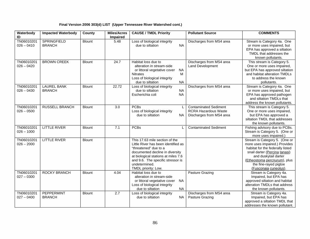
Final Version 2006 303(d) LIST (Upper Tennessee River Watershed cont.) Waterbody ID
Impacted Waterbody County Miles/Acres Impaired
CAUSE / TMDL Priority Pollutant Source COMMENTS
TN06010201026 – 0410
SPRINGFIELD BRANCH
Blount 5.48 Loss of biological integrity due to siltation NA
Discharges from MS4 area Stream is Category 4a. One or more uses impaired, but
EPA has approved a siltation TMDL that addresses the
known pollutants. TN06010201026 – 0420
BROWN CREEK Blount 24.7 Habitat loss due to alteration in stream-side or littoral vegetative cover NA Nitrates M Loss of biological integrity due to siltation NA
Discharges from MS4 area Land Development
This stream is Category 5. One or more uses impaired,
but EPA has approved siltation and habitat alteration TMDLs
to address the known pollutants.
TN06010201026 – 0430
LAUREL BANK BRANCH
Blount 22.72 Loss of biological integrity due to siltation NA Escherichia coli NA
Discharges from MS4 area Stream is Category 4a. One or more uses impaired, but
EPA has approved pathogen and siltation TMDLs that
address the known pollutants. TN06010201026 – 0500
RUSSELL BRANCH Blount 3.0 PCBs L Loss of biological integrity due to siltation NA
Contaminated Sediment RCRA Hazardous Waste Discharges from MS4 area
This stream is Category 5. One or more uses impaired,
but EPA has approved a siltation TMDL that addresses
the known pollutants. TN06010201026 – 1000
LITTLE RIVER Blount 7.1 PCBs L Contaminated Sediment Fishing advisory due to PCBs. Stream is Category 5. (One or
more uses impaired.) TN06010201026 – 2000
LITTLE RIVER Blount This 17.63 mile section of the Little River has been identified as “threatened” due to a documented decline in diversity at biological stations at miles 7.6 and 9.6. The specific stressor is undetermined. TMDL priority: Low.
Stream is Category 5. (One or more uses impaired.) Provides habitat for the federally listed snail darter (Percina tanasi)
and duskytail darter (Etheostoma percnurum), plus
the fine-rayed pigtoe (Fusconaia cuneolus).
TN06010201027 – 0300
ROCKY BRANCH Blount 4.04 Habitat loss due to alteration in stream-side or littoral vegetative cover NA Loss of biological integrity due to siltation NA
Pasture Grazing Stream is Category 4a. Impaired, but EPA has
approved siltation and habitat alteration TMDLs that address
the known pollutants. TN06010201027 – 0400
PEPPERMINT BRANCH
Blount 2.7 Loss of biological integrity due to siltation NA
Discharges from MS4 area Pasture Grazing
Stream is Category 4a. Impaired, but EPA has
approved a siltation TMDL that addresses the known pollutant.
86

Final Version 2006 303(d) LIST (Upper Tennessee River Watershed cont.) Waterbody ID
Impacted Waterbody County Miles/Acres Impaired
CAUSE / TMDL Priority Pollutant Source COMMENTS
TN06010201028 – 0100
SPICEWOOD BRANCH
Blount 2.23 Loss of biological integrity due to siltation NA
Streambank Modifications Stream is Category 4a. Impaired, but EPA has
approved a siltation TMDL that addresses the known pollutant.
TN06010201028 – 0300
SOUTH FORK CROOKED CREEK
Blount 8.21 Habitat loss due to alteration in stream-side or littoral vegetative cover NA Loss of biological integrity due to siltation NA
Pasture Grazing Stream is Category 4a. Impaired, but EPA has
approved siltation and habitat alteration TMDLs that address
the known pollutants. TN06010201028 – 0500
FLAG BRANCH Blount 7.8 Habitat loss due to alteration in stream-side or littoral vegetative cover NA Loss of biological integrity due to siltation NA
Pasture Grazing Discharges from MS4 area
Stream is Category 4a. Impaired, but EPA has
approved siltation and habitat alteration TMDLs that address
the known pollutants. TN06010201028 – 1000
CROOKED CREEK Blount 13.91 Loss of biological integrity due to siltation NA Escherichia coli NA
Pasture Grazing Livestock in Stream
Stream is Category 4a. Impaired, but EPA has approved siltation and
pathogen TMDLs that address the known pollutants.
TN06010201032 - 0510
GOSHEN PRONG Sevier 6.66 Low pH L Undetermined Source High elevation stream in Great Smoky Mountains National
Park. Low pH source may be a combination of natural
conditions (anakeesta) and atmospheric deposition.
Stream is Category 5. (One or more uses impaired.) EPA
should take the lead on atmospheric deposition TMDL.
TN06010201032 - 0530
UNNAMED TRIB. TO FISH CAMP PRONG
Sevier 1.34 Low pH L Undetermined Source High elevation stream in Great Smoky Mountains National
Park. Low pH source may be a combination of natural
conditions (anakeesta) and atmospheric deposition.
Stream is Category 5. (One or more uses impaired.) EPA
should take the lead on atmospheric deposition TMDL.
87

Final Version 2006 303(d) LIST (Upper Tennessee River Watershed cont.) Waterbody ID
Impacted Waterbody County Miles/Acres Impaired
CAUSE / TMDL Priority Pollutant Source COMMENTS
TN06010201032 – 0810
TIPTON BRANCH Blount 2.5 Habitat loss due to alteration in stream-side or littoral vegetative cover NA Loss of biological integrity due to siltation NA
Upstream Impoundments Stream is Category 4a. Impaired, but EPA has
approved siltation and habitat alteration TMDLs that address
the known pollutants. TN06010201033-0100
LITTLE ELLEJOY CREEK
Blount 14.7 Nitrate M Escherichia coli NA
Pasture Grazing Animal Feeding Operations
Stream is Category 5. Impaired, but EPA has
approved a pathogen TMDL that addresses the known
pollutant. TN06010201033 – 0200
PITNER CREEK Blount 13.5 Escherichia coli NA Pasture Grazing Stream is Category 4a. Impaired, but EPA has
approved a pathogen TMDL that addresses the known
pollutants. TN06010201033 – 0400
SOUTH FORK ELLEJOY CREEK
Sevier 2.02 Habitat loss due to alteration in stream-side or littoral vegetative cover NA
Pasture Grazing Stream is Category 4a. Impaired, but EPA has
approved a habitat alteration TMDL that addresses the
known pollutants. TN06010201033 – 0500
CARTER BRANCH Sevier 4.63 Habitat loss due to alteration in stream-side or littoral vegetative cover NA
Pasture Grazing Stream is Category 4a. Impaired, but EPA has
approved a habitat alteration TMDL that addresses the
known pollutants. TN06010201033 - 1000
ELLEJOY CREEK Blount 14.78 Escherichia coli NA Pasture Grazing Stream is Category 4a. Impaired, but EPA has
approved a pathogen TMDL that addresses the known
pollutants. TN06010201033 - 2000
ELLEJOY CREEK Blount 5.37 Nitrates M Loss of biological integrity due to siltation NA Escherichia coli NA
Pasture Grazing This stream is Category 5. Impaired, but EPA has approved siltation and pathogen TMDLs that
addresses some of the known pollutants.
TN06010201034 - 0200
WILDWOOD BRANCH Blount 6.26 Habitat loss due to alteration in stream-side or littoral vegetative cover NA Escherichia coli NA
Pasture Grazing Stream is Category 4a. Impaired, but EPA has
approved pathogen and habitat alteration TMDLs that address the known pollutants.
88

Final Version 2006 303(d) LIST (Upper Tennessee River Watershed cont.) Waterbody ID
Impacted Waterbody County Miles/Acres Impaired
CAUSE / TMDL Priority Pollutant Source COMMENTS
TN06010201034 – 1000
NAILS CREEK Blount Sevier
24.5 Escherichia coli NA Pasture Grazing Stream is Category 4a. EPA has approved a pathogen TMDL that addresses the
known pollutants. TN06010201037 – 1000
LITTLE TURKEY CREEK
Knox 14.0 Loss of biological integrity due to siltation NA
Discharges from MS4 area Stream is Category 4a. EPA has approved a siltation TMDL
that addresses the known pollutant.
TN06010201040 –0600
BLACK CREEK Roane 16.7 Polycyclic Aromatic Hydrocarbons (PAHs) L Nutrients M Physical Substrate Habitat Alterations L Escherichia coli NA
Municipal Point Source Discharges Collection System Failures RCRA Hazardous Waste Channelization
CERCLA site discharging PAHs. This stream is
Category 5. Impaired, but EPA has approved a pathogen TMDL that addresses some of
the known pollutants. TN06010201065 – 1000
STEEKEE CREEK Loudon 11.0 Physical Substrate Habitat Alterations L Loss of biological integrity due to siltation L Escherichia coli NA
Pasture Grazing This stream is Category 5. Impaired, but EPA has
approved a pathogen TMDL that addresses some of the
known pollutants. TN06010201066 – 0100
CASTEEL BRANCH Knox 2.0 Loss of biological integrity due to siltation NA
Pasture Grazing Discharges from MS4 area
Stream is Category 4a. Impaired, but EPA has
approved a siltation TMDL that addresses known pollutants.
TN06010201066 – 0200
TWIN BRANCH Knox 1.87 Habitat loss due to alteration in stream-side or littoral vegetative cover NA Loss of biological integrity due to siltation NA
Pasture Grazing Discharges from MS4 area
Stream is Category 4a. Impaired, but EPA has
approved siltation and habitat alteration TMDLs that address
the known pollutants. TN06010201066 – 0400
GRANDVIEW BRANCH
Knox 1.7 Escherichia coli NA Discharges from MS4 area Stream is Category 4a. EPA has approved a pathogen TMDL that addresses the
known pollutant. TN06010201066 – 0500
McCALL BRANCH Knox 1.73 Loss of biological integrity due to siltation NA
Discharges from MS4 area Streambank Modification
Stream is Category 4a. Impaired, but EPA has
approved a siltation TMDL that addresses the known pollutant.
TN06010201066 – 0600
HIGH BLUFF BRANCH
Knox 1.25 Escherichia coli NA Discharges from MS4 area Stream is Category 4a. EPA has approved a pathogen TMDL that addresses the
known pollutant.
89

Final Version 2006 303(d) LIST (Upper Tennessee River Watershed cont.) Waterbody ID
Impacted Waterbody County Miles/Acres Impaired
CAUSE / TMDL Priority Pollutant Source COMMENTS
TN06010201066 – 1000
STOCK CREEK Knox 3.77 Physical Substrate Habitat Alterations NA Loss of biological integrity due to siltation NA Escherichia coli NA
Pasture Grazing Channelization
Stream is Category 4a. Impaired, but EPA has
approved siltation, pathogen, and habitat alteration TMDLs
that address known pollutants. TN06010201066 – 1200
GUN HOLLOW BRANCH
Knox 1.36 Escherichia coli NA Pasture Grazing Stream is Category 4a. Impaired, but EPA has
approved a pathogen TMDL that addresses the known
pollutant. TN06010201066 – 2000
STOCK CREEK Knox 1.98 Escherichia coli NA Pasture Grazing Stream is Category 4a. Impaired, but EPA has
approved a pathogen TMDL that addresses the known
pollutant. TN06010201067 – 1000
THIRD CREEK Knox 20.7 Nitrates M Loss of biological integrity due to siltation NA Other Anthropogenic Habitat Alterations NA Esherichia coli NA
Discharges from MS4 area Urbanized High Density Area Land Development Collection System Failure
Water contact advisory due to pathogens. This stream is
Category 5, impaired for one or more uses. However, EPA
has approved siltation, pathogen, and habitat
alteration TMDLs that address some of the known pollutants.
TN06010201080 – 0100
WHITES CREEK Knox 10.2 Other Anthropogenic Habitat Alterations NA Escherichia coli L
Discharges from MS4 area Streambank Modification
This stream is Category 5, impaired for one or more uses. However, EPA has approved a
habitat alteration TMDL that addresses some of the known
pollutants. TN06010201080 – 1000
FIRST CREEK Knox 16.1 Nitrates M Loss of biological integrity due to siltation NA Other Anthropogenic Habitat Alterations NA Escherichia coli NA
Discharges from MS4 area Urbanized High Density Area Collection System Failure
Water contact advisory. This stream is Category 5, impaired
for one or more uses. EPA has approved siltation, pathogen, and habitat
alteration TMDLs that address some of the known pollutants.
TN06010201083 – 1000
FLOYD CREEK Loudon Blount
7.7 Loss of biological integrity due to siltation NA Escherichia coli NA
Pasture Grazing This stream is Category 4a, impaired for one or more uses.
EPA has approved siltation and pathogen TMDLs that
address the known pollutants.
90

Final Version 2006 303(d) LIST (Upper Tennessee River Watershed cont.) Waterbody ID
Impacted Waterbody County Miles/Acres Impaired
CAUSE / TMDL Priority Pollutant Source COMMENTS
TN06010201087 – 1000
HINES CREEK Loudon Roane
20.3 Escherichia coli NA Pasture Grazing This stream is Category 4a. Impaired, but EPA has
approved a pathogen TMDL that addresses the known
pollutant. TN06010201097- 1000
SECOND CREEK Knox 12.8 Other Anthropogenic Habitat Alterations NA Nitrates M Loss of biological integrity due to siltation NA Escherichia coli NA
Discharges from MS4 area Urbanized High Density Area Collection System Failure
Water contact advisory. Stream is Category 5. Impaired, but EPA has
approved siltation, pathogen, and habitat alteration TMDLs
that address some of the known pollutants.
TN06010201340 – 1000
TURKEY CREEK Knox 15.8 Loss of biological integrity due to siltation NA Escherichia coli L
Discharges from MS4 area Stream is Category 5. Impaired, but EPA has
approved a siltation TMDL that addresses some of the known
pollutants. TN060102011015 – 1000
CLOYD CREEK Loudon 11.3 Loss of biological integrity due to siltation NA Physical Substrate Habitat Alterations NA Escherichia coli NA
Pasture Grazing Livestock in Stream
This stream is Category 4a. Impaired, but EPA has
approved siltation, pathogen, and habitat alteration TMDLs
that address the known pollutants.
TN060102011149 – 1000
POLECAT CREEK Loudon 13.1 Escherichia coli NA Pasture Grazing This stream is Category 4a. Impaired, but EPA has
approved a pathogen TMDL that addresses the known
pollutants. TN060102011330 – 1000
SINKING CREEK Knox 1.5 Escherichia coli L Discharges from MS4 area Water contact advisory. Stream is Category 5. (One or
more uses impaired.) TN060102011330 – 2000
SINKING CREEK Knox 21.9 Habitat loss due to alteration in stream-side or littoral vegetative cover NA Loss of biological integrity due to siltation NA
Discharges from MS4 area This stream is Category 4a. Impaired, but EPA has
approved siltation and habitat alteration TMDLs that address
the known pollutants. TN06010201620 – 1000
CARDIFF CREEK Roane 3.8 Chrome, hexavalent L pH L
CERCLA site Hexavalent chrome levels exceed acute criteria in this
stream. This stream is Category 5. The stream is
impaired for one or more uses.
91

Final Version 2006 303(d) LIST (Upper Tennessee River Watershed cont.) Waterbody ID
Impacted Waterbody County Miles/Acres Impaired
CAUSE / TMDL Priority Pollutant Source COMMENTS
TN06010201621 – 1000
CANEY CREEK Roane 13.2 Physical Substrate Habitat Alteration L Loss of biological integrity due to siltation L Escherichia coli NA
Pasture Grazing Collection System Failure
This stream is Category 5. Impaired, but EPA has
approved a pathogen TMDL that addresses some of the
known pollutants. TN06010201697 – 1000
FOURTH CREEK Knox 14.9 Physical Substrate Habitat Alterations NA Escherichia coli NA
Discharges from MS4 area Channelization
This stream is Category 4a. Impaired, but EPA has
approved pathogen and habitat alteration TMDLs that address the known pollutants.
TN06010201719 – 1000
WILLIAMS CREEK Knox 2.8 Other Anthropogenic Habitat Alterations NA Escherichia coli NA
Discharges from MS4 area Collection System Failure
This stream is Category 4a. Impaired, but EPA has
approved pathogen and habitat alteration TMDLs that address the known pollutants.
TN06010201721 – 1000
BAKER CREEK Knox 3.3 Nitrates M Other Anthropogenic Habitat Alterations NA Escherichia coli NA
Discharges from MS4 area Collection System Failure
Stream is Category 5. Impaired, but EPA has
approved pathogen and habitat alteration TMDLs that address some of the known
pollutants. TN06010201723 – 1000
GOOSE CREEK Knox 4.9 Loss of biological integrity due to siltation NA Other Anthropogenic Habitat Alterations NA PCBs L Escherichia coli NA
Collection System Failure Discharges from MS4 area RCRA Hazardous Waste
Water contact advisory due to pathogens. Witherspoon Superfund site. Stream is Category 5. Impaired, but
EPA has approved siltation, pathogen, and habitat
alteration TMDLs that address some of the known pollutants.
TN06010201983 – 1000
POLECAT CREEK Blount 1.85 Habitat loss due to alteration in stream-side or littoral vegetative cover NA Loss of biological integrity due to siltation NA
Land Development Channelization
This stream is Category 4a. Impaired, but EPA has
approved siltation and habitat alteration TMDLs that address
the known pollutants.
92

Little Tennessee River Basin This basin contains the following USGS Hydrologic Unit Codes: 06010204 (Little Tennessee River). Waterbody ID
Impacted Waterbody County Miles/Acres Impaired
CAUSE / TMDL Priority Pollutant Source COMMENTS
TN06010204001 - 1000
TELLICO RESERVOIR
Loudon Monroe
16500 ac PCBs L Contaminated Sediment Fishing advisory-PCBs in catfish. The Tellico River was once habitat for the federally listed snail darter (Percina
tanasi). This stream is Category 5. The stream is
impaired for one or more uses. TN06010204002 - 1000
FORK CREEK Loudon Monroe
19.3 Nitrate L Loss of biological integrity due to siltation H Escherichia coli H
Pasture Grazing Stream is Category 5. (One or more uses impaired.)
TN06010204004 - 0200
CRAIGHEAD CREEK Monroe 8.5 Alteration in stream-side or littoral vegetative cover H Loss of biological integrity due to siltation H
Pasture Grazing Stream is Category 5. (One or more uses impaired.)
TN06010204004 - 1000
BAT CREEK Monroe 19.1 Escherichia coli H Collection System Failure Pasture Grazing
Stream is Category 5. (One or more uses impaired.)
TN06010204020 - 1000
LITTLE TENNESSEE RIVER
Monroe Blount
1.1 Habitat loss due to stream flow alteration NA
Upstream Impoundment Flow is diverted around this section of the Little Tennessee
River below Calderwood Reservoir. This stream is
Category 4c. The impact is not caused by a pollutant.
TN06010204042 – 0100
CENTENARY CREEK Blount 3.25 Alteration in stream-side or littoral vegetative cover H Loss of biological integrity due to siltation H
Pasture Grazing Stream is Category 5. (One or more uses impaired.)
TN06010204042 - 0311
UNNAMED TRIBUTARY TO BIG SPRINGS BRANCH
Blount 0.2 Temperature Alterations H Upstream Impoundment This stream is Category 5. The stream is impaired for one
or more uses. TN06010204043 – 0300
LITTLE BAKER CREEK
Blount 6.1 Alteration in stream-side or littoral vegetative cover H Loss of biological integrity due to siltation H
Pasture Grazing Stream is Category 5. (One or more uses impaired.)
TN06010204043 – 1000
BAKER CREEK Blount Loudon
18.22 Alteration in stream-side or littoral vegetative cover H Escherichia coli M
Pasture Grazing Stream is Category 5. (One or more uses impaired.)
TN06010204044 – 0100
CANE CREEK Monroe 29.3 Escherichia coli M Undetermined Source Stream is Category 5. (One or more uses impaired.)
93

Final Version 2006 303(d) LIST (Little Tennessee River Watershed cont.) Waterbody ID
Impacted Waterbody County Miles/Acres Impaired
CAUSE / TMDL Priority Pollutant Source COMMENTS
TN06010204045 – 0100
NORTH FORK NOTCHY CREEK
Monroe 12.8 Alteration in stream-side or littoral vegetative cover H Loss of biological integrity due to siltation H
Pasture Grazing Stream is Category 5. (One or more uses impaired.)
TN06010204045 – 1000
NOTCHY CREEK Monroe 11.2 Alteration in stream-side or littoral vegetative cover H Loss of biological integrity due to siltation H Escherichia coli M
Pasture Grazing Stream is Category 5. (One or more uses impaired.)
TN06010204056 – 0150
LAUREL CREEK Monroe 0.47 Habitat loss due to stream flow alteration NA
Upstream Impoundment The stream is Category 4c. The impact is not caused by a
pollutant. TN06010204056 – 1000
BIG CREEK Monroe 14.65 Escherichia coli M Pasture Grazing Stream is Category 5. (One or more uses impaired.)
TN06010204065 – 1000
ISLAND CREEK Monroe 10.0 Escherichia coli M Pasture Grazing Stream is Category 5. (One or more uses impaired.)
Upper Clinch River This basin contains the following USGS Hydrologic Unit Codes: 06010205 (Upper Clinch River). Waterbody ID
Impacted Waterbody County Miles Acres Impaired
CAUSE / TMDL Priority Pollutant Source COMMENTS
TN06010205013 - 0500
GREASY ROCK CREEK
Hancock 5.7 Habitat loss due to alteration in stream-side or littoral vegetative cover H Escherichia coli H
Pasture Grazing Land Development
Stream is Category 5. (One or more uses impaired.)
TN06010205013 - 0620
EAST FORK PAINTHER CREEK
Hancock 5.5 Escherichia coli H Pasture Grazing Stream is Category 5. (One or more uses impaired.)
TN06010205014 - 0400
FLAT GAP CREEK Hancock Hawkins
5.5 Biological integrity loss due to undetermined cause L
Undetermined Source Stream is Category 5. (One or more uses impaired.)
TN06010205064 - 0110
THOMPSON CREEK Campbell 7.3 Low pH L Abandoned Mining Stream is Category 5. (One or more uses impaired.)
TN06010205064 - 1000
BIG CREEK Campbell 1.2 Biological integrity loss due to undetermined cause L Nutrients L
Minor Municipal Point Source Stream is Category 5. (One or more uses impaired.)
TN06010205064 – 2000
BIG CREEK Campbell 1.9 Nutrients L Discharges from MS4 area Stream is Category 5. (One or more uses impaired.)
94

Upper Powell River This basin contains the following USGS Hydrologic Unit Codes: 06010206 (Powell River). Waterbody ID
Impacted Waterbody County Miles/Acres Impaired
CAUSE / TMDL Priority Pollutant Source COMMENTS
TN06010206006 – 0200
GAP CREEK Claiborne 12.7 Escherichia coli H Septic Tanks Collection System Failure
Stream is Category 5. (One or more uses impaired.)
TN06010206006 – 0310
UNNAMED TRIB TO BLAIRS CREEK
Claiborne 1.8 Loss of biological integrity due to siltation H
Hwy/Road/Bridge Construction Stream is Category 5. (One or more uses impaired.)
TN06010206007 – 0100
LITTLE CREEK Claiborne 9.4 Escherichia coli H Septic Tanks Stream is Category 5. (One or more uses impaired.)
TN06010206007 – 0700
MULBERRY CREEK Hancock 26.6 Escherichia coli H Pasture Grazing Stream is Category 5. (One or more uses impaired.)
TN06010206007 – 0710
LITTLE MULBERRY CREEK
Claiborne Hancock
4.0 Escherichia coli H Pasture Grazing Stream is Category 5. (One or more uses impaired.)
TN06010206008 – 1000
RUSSELL CREEK Claiborne 8.1 Nitrates M Phosphates M Escherichia coli M
Discharges from MS4 Area Pasture Grazing
Stream is Category 5. (One or more uses impaired.)
TN06010206008 – 2000
RUSSELL CREEK Claiborne 7.0 Nutrients M Loss of biological integrity due to siltation H
Discharges from MS4 area Tazewell area impacts. Stream is Category 5. (One or
more uses impaired.) TN06010206026 – 0100
CAWOOD BRANCH Claiborne 5.2 Escherichia coli H Pasture Grazing Stream is Category 5. (One or more uses impaired.)
TN06010206026 – 0200
RUSSELL BRANCH Claiborne 3.5 Nitrate M Loss of biological integrity due to siltation H Habitat loss due to alteration in stream-side or littoral vegetative cover H Escherichia coli H
Pasture Grazing Stream is Category 5. (One or more uses impaired.)
TN06010206026 – 1000
DAVIS CREEK Campbell Claiborne
8.0 Nutrients M Loss of biological integrity due to siltation H Escherichia coli H
Confined Animal Feeding Operation (point and nonpoint)
Dairy operations. Stream is Category 5. (One or more
uses impaired.)
TN06010206026 – 2000
DAVIS CREEK Claiborne 5.1 Nitrate M Loss of biological integrity due to siltation H Habitat loss due to alteration in stream-side or littoral vegetative cover H Escherichia coli H
Pasture Grazing Confined Animal Feeding Operation (nonpoint)
Dairy operations. Stream is Category 5. (One or more
uses impaired.)
TN06010206026 – 3000
DAVIS CREEK Claiborne 3.6 Nitrate M Loss of biological integrity due to siltation H Escherichia coli H
Pasture Grazing Confined Animal Feeding Operation (nonpoint)
Dairy operations. Stream is Category 5. (One or more
uses impaired.)
95

Final Version 2006 303(d) LIST (Upper Powell River Watershed cont.) Waterbody ID
Impacted Waterbody County Miles/Acres Impaired
CAUSE / TMDL Priority Pollutant Source COMMENTS
TN06010206026 – 4000
DAVIS CREEK Claiborne 2.6 Nutrients M Loss of biological integrity due to siltation H Escherichia coli H
Pasture Grazing Confined Animal Feeding Operation (nonpoint)
Dairy operations. Stream is Category 5. (One or more
uses impaired.)
Lower Clinch River This basin contains the following USGS Hydrologic Unit Codes: 06010207 (Clinch River). Waterbody ID
Impacted Waterbody County Miles/Acres Impaired
CAUSE / TMDL Priority Pollutant Source COMMENTS
TN06010207001 - 1000
WATTS BAR RESERVOIR, CLINCH RIVER ARM
Roane 2336 ac PCBs L Chlordane L Mercury L
Industrial Point Source Contaminated Sediments
Fishing advisory due to PCBs. DOE Reservation impacts.
Mercury is metal of concern. Stream is Category 5. (One or
more uses impaired.) EPA should produce TMDL for
pollutants from DOE facilities. TN06010207004 – 0100
GRABLE BRANCH Knox 1.3 Oil & Grease L Loss of biological integrity due to siltation L Physical Substrate Habitat Alterations M
Minor Industrial Point Source Channelization Industrial Permitted Runoff Discharges from MS4 area
Truck stops near I-40. Stream is Category 5. (One or more
uses impaired.)
TN06010207006 - 1000
MELTON HILL RESERVOIR
Anderson Knox Loudon Roane
5690 ac PCBs L Chlordane L
Contaminated Sediment Fishing advisory due to PCBs and chlordane. Stream is Category 5. (One or more
uses impaired.) EPA should produce TMDL for pollutants
from DOE facilities. TN06010207006T – 0700
MCCOY BRANCH Anderson 1.17 Arsenic L CERCLA NPL Sites Stream is Category 5. (One or more uses impaired.) EPA should produce TMDL for
pollutants from DOE facilities. TN06010207006T – 0900
SCARBORO CREEK Anderson 1.99 Escherichia coli L Municipal Urbanized Area Stream is Category 5. (One or more uses impaired.)
TN06010207006T – 1100
ERNIES CREEK Anderson 4.1 Escherichia coli L Municipal Urbanized Area Stream is Category 5. (One or more uses impaired.)
96

Final Version 2006 303(d) LIST (Clinch River cont.) Waterbody ID
Impacted Waterbody County Miles/Acres Impaired
CAUSE /TMDL Priority Pollutant Source COMMENTS
TN06010207011 – 0300
WILLOW FORK Knox 5.9 Habitat loss due to alteration in stream-side or littoral vegetative cover M Loss of biological integrity due to siltation L Escherichia coli L
Discharges from MS4 area Stream is Category 5. (One or more uses impaired.)
TN06010207011 – 0400
COX CREEK Knox 4.5 Escherichia coli L Discharges from MS4 area Stream is Category 5. (One or more uses impaired.)
TN06010207011 – 0500
HINES BRANCH Knox 3.2 Habitat loss due to other anthropogenic substrate alterations M Escherichia coli L
Discharges from MS4 area Stream is Category 5. (One or more uses impaired.)
TN06010207011 – 0600
KNOB FORK Knox 8.1 Loss of biological integrity due to siltation M Habitat loss due to other anthropogenic substrate alteration in stream-side or littoral vegetative cover M Escherichia coli L
Discharges from MS4 area Stream is Category 5. (One or more uses impaired.)
TN06010207011 – 0700
GRASSY CREEK Knox 8.2 Loss of biological integrity due to siltation M Escherichia coli L
Discharges from MS4 Area Stream is Category 5. (One or more uses impaired.)
TN06010207011 – 0800
MEADOW CREEK Knox 4.96 Escherichia coli L Discharges from MS4 Area Stream is Category 5. (One or more uses impaired.)
TN06010207011 – 0900
PLUM CREEK Knox 5.3 Escherichia coli L Discharges from MS4 Area Stream is Category 5. (One or more uses impaired.)
TN06010207011 – 1000
BEAVER CREEK Knox 22.5 Phosphorus M Nitrates M Escherichia coli NA Low Dissolved Oxygen Loss of biological integrity due to siltation M Physical Substrate Habitat Alterations M
Major Municipal Point Source Pasture Grazing Discharges from MS4 Area
Stream is Category 5. Impaired, but EPA has
approved a pathogen TMDL that addresses some of the
known pollutants.
TN06010207011 – 2000
BEAVER CREEK Knox 13.7 Escherichia coli NA Loss of biological integrity due to siltation M Physical Substrate Habitat alterations M
Pasture Grazing Discharges from MS4 Area
Stream is Category 5. Impaired, but EPA has
approved a pathogen TMDL that addresses some of the
known pollutants.
97

Final Version 2006 303(d) LIST (Clinch River cont.) Waterbody ID
Impacted Waterbody County Miles/Acres Impaired
CAUSE /TMDL Priority Pollutant Source COMMENTS
TN06010207011 – 3000
BEAVER CREEK Knox 7.5 Escherichia coli NA Loss of biological integrity due to siltation M Physical Substrate Habitat alterations M
Pasture Grazing Discharges from MS4 Area
Stream is Category 5. Impaired, but EPA has
approved a pathogen TMDL that addresses some of the
known pollutants. TN06010207014 – 0100
WILLIAMS BRANCH Knox 2.4 Loss of biological integrity due to siltation M
Industrial Permitted Runoff Stream is Category 5. (One or more uses impaired.)
TN06010207014 – 1000
BULLRUN CREEK Knox Anderson
11.8 Loss of biological integrity due to siltation M Physical Substrate Habitat Alteration M Escherichia coli NA
Discharges from MS4 Area Pasture Grazing Channelization
Stream is Category 5. Impaired, but EPA has
approved a pathogen TMDL that addresses some of the
known pollutants. TN06010207014 – 3000
BULLRUN CREEK Union Grainger
11.4 Escherichia coli NA Pasture Grazing Stream is Category 4a. Impaired, but EPA has
approved a pathogen TMDL that addresses the known
pollutants. TN06010207016 – 0200
BYRAMS CREEK Anderson Union
22.4 Escherichia coli L Pasture Grazing Stream is Category 5. (One or more uses impaired.)
TN06010207016 – 1000
HINDS CREEK Anderson 6.7 Loss of biological integrity due to siltation M Habitat loss due to alteration in stream-side or littoral vegetative cover M Escherichia coli NA
Pasture Grazing Stream is Category 5. Impaired, but EPA has
approved a pathogen TMDL that addresses some of the
known pollutants.
TN06010207019 – 2000
CLINCH RIVER Anderson 7.4 Thermal Modifications L Habitat loss due to stream flow alteration NA
Upstream Impoundment The Clinch River below Norris does not meet biocriteria due to rapid temperature and flow changes. Stream is Category 5 overall (one or more uses
impaired), but flow alteration is 4c (impact not caused by a pollutant). TVA has taken action to improve dissolved oxygen and flow conditions
downstream of the dam. TN06010207020 – 0400
INDIAN CREEK Roane 6.8 Loss of biological integrity due to siltation M Habitat loss due to alteration in stream-side or littoral vegetative cover M
Channelization Pasture Grazing
Stream is Category 5. (One or more uses impaired.)
98

Final Version 2006 303(d) LIST (Clinch River cont.) Waterbody ID
Impacted Waterbody County Miles/Acres Impaired
CAUSE /TMDL Priority Pollutant Source COMMENTS
TN06010207020 – 1300
MITCHELL BRANCH Anderson 1.0 PCBs L Physical Substrate Habitat Alterations M
CERCLA site Channelization
Stream is Category 5,.uses impaired.) TMDLs for DOE
sites should be done by EPA. TN06010207026 – 0600
BEAR CREEK Roane 10.87 Nitrates M Escherichia coli L
CERCLA site Undetermined Source
Stream is Category 5, uses impaired. TMDLs for DOE
sites should be done by EPA. TN06010207026 – 1000
EAST FORK POPLAR CREEK
Roane 9.7 PCBs L Mercury L Escherichia coli NA Loss of biological integrity due to siltation M Nitrates M Phosphates M
Industrial Point Source Municipal Point Source Contaminated Sediments Collection System Failure High Density Municipal Area
Stream impacted by releases at DOE’s Oak Ridge facilities (K-25, Y-12, ORNL). Fishing advisory due to mercury and
PCBs. Bacteria levels are also elevated due to sources in the
Oak Ridge area. Stream is Category 5. Impaired, but
EPA has approved a pathogen TMDL that addresses some of
the known pollutants. EPA should develop the TMDL for
pollutants originating from DOE facilities.
TN06010207026 – 2000
EAST FORK POPLAR CREEK
Anderson Roane
11.3 PCBs L Mercury L Escherichia coli NA Loss of biological integrity due to siltation M Nutrients M Other Anthoprogenic Habitat Alterations M
Industrial Point Source Contaminated Sediments High Density Municipal Area
Same as above. Stream is Category 5. Impaired, but
EPA has approved a pathogen TMDL that addresses some of
the known pollutants. EPA should develop the TMDL for
pollutants originating from DOE facilities.
TN06010207028 – 1000
CANEY CREEK Roane 7.4 Loss of biological integrity due to siltation M Habitat loss due to alteration of stream-side or littoral vegetative cover M
Pasture Grazing Stream is Category 5. (One or more uses impaired.)
TN06010207029 – 1000
COAL CREEK Anderson 10.9 Biological integrity loss due to undetermined cause L Escherichia coli NA
Minor Municipal Point Source Stream is Category 5. Impaired, but EPA has
approved a pathogen TMDL that addresses some of the
known pollutants. TN06010207029 – 2000
COAL CREEK Anderson 15.0 Escherichia coli NA On-site Treatment Systems Stream is Category 4a. Impaired, but EPA has
approved a pathogen TMDL that addresses the known
pollutants.
99

Final Version 2006 303(d) LIST (Clinch River cont.) Waterbody ID
Impacted Waterbody County Miles/Acres Impaired
CAUSE /TMDL Priority Pollutant Source COMMENTS
TN06010207247 – 0100
MELTON BRANCH Roane 2.0 Strontium L CERCLA site Stream is Category 5. (One or more uses impaired.) EPA
should develop the TMDL for pollutants originating from
DOE facilities. TN06010207247 – 1000
WHITEOAK CREEK Anderson 5.3 Cesium L Strontium L Biological integrity loss due to undetermined cause L
CERCLA site Stream is Category 5. (One or more uses impaired.) EPA
should develop the TMDL for pollutants originating from
DOE facilities. Emory River This basin contains the following USGS Hydrologic Unit Codes: 06010208 (Emory River). Waterbody ID
Impacted Waterbody County Miles/Acres Impaired
CAUSE TMDL Priority Pollutant Source COMMENTS
TN06010208001 – 1000
WATTS BAR RESERVOIR, EMORY RIVER ARM
Roane Morgan
1258.7 ac PCBs L Chlordane L
Industrial Point Source Contaminated Sediments
Fishing advisory due to PCBs. This stream is Category 5,
impaired for one or more uses. TN06010208004 – 0200
FLAT FORK Morgan 3.7 Nitrates L Physical Substrate Habitat Alterations H Loss of biological integrity due to siltation H
Pasture Grazing Channelization
This stream is Category 5. The stream is impaired for one
or more uses.
TN06010208004 – 1000
CROOKED FORK Morgan 6.9 Nitrates L Municipal Point Source Discharge Pasture Grazing
This stream is Category 5. The stream is impaired for one
or more uses. TN06010208004 – 2000
CROOKED FORK Morgan 16.7 Nitrates L Physical Substrate Habitat Alterations L Loss of biological integrity due to siltation L
Permitted Small Flows Abandoned Mining Channelization
This stream is Category 5. The stream is impaired for one
or more uses.
TN06010208008 – 2000
CLEAR CREEK Morgan 1.41 Oil L Petroleum Activities Serious oil spill in this section in the Obed National Wild and Scenic River. This stream is Category 5, impaired for one or more uses. The stream
provides habitat for the listed Spotfin chub (Cyprinella
monacha) and Tangerine darter (Percina aurantiaca).
100

Final Version 2006 303(d) LIST (Emory River Watershed cont.) Waterbody ID
Impacted Waterbody County Miles/Acres Impaired
CAUSE / TMDL Priority Pollutant Source COMMENTS
TN06010208013 – 0400
DROWNING CREEK Cumberland 13.1 Loss of biological integrity due to siltation H Physical Substrate Habitat Alterations H
Animal Feeding Operations (Nonpoint)
This stream is Category 5. The stream is impaired for one
or more uses.
TN06010208013 – 1000
OBED RIVER Cumberland This 12.4 mile section of the Obed River has been identified as “threatened” by the Division due to a documented decline in diversity at biological stations. TMDL Priority: Low.
This stream is Category 5. The stream is threatened for one or more uses. Federally-
listed species have been documented downstream of this section, in the Wild and
Scenic River section. TN06010208013 – 2000
OBED RIVER Cumberland 3.2 Habitat loss due to stream flow alterations NA Physical Substrate Habitat Alterations L
Discharges from MS4 area Upstream Impoundment
A significant loss of expected diversity below Lake Holiday near Crossville. Stream is Category 5 overall (one or
more uses impaired), but flow alteration is 4c (impact not
caused by a pollutant). TN06010208015 – 0510
LONG BRANCH Cumberland 2.2 Loss of biological integrity due to siltation L
Abandoned Mine Lands Category 5 stream (impaired for one or more uses).
TN06010208015 – 0800
BYRD CREEK Cumberland 38.6 Impairment Undetermined L Undetermined Source Category 5 stream (impaired for one or more uses).
TN06010208015 – 0810
ONE MILE CREEK Cumberland 8.5 Loss of biological integrity due to siltation H
Land Development Category 5 stream (impaired for one or more uses).
TN06010208020 – 0100
SMITH BRANCH Morgan 5.4 pH NA Abandoned Mines This stream is Category 4a (impaired for one or more uses). However, EPA has approved a pH TMDL that
addresses the known pollutants in this stream.
TN06010208020 – 0400
GOLLIHER CREEK Morgan 5.6 Manganese NA Iron NA pH NA
Abandoned Mines This stream is Category 4a. The stream is impaired, but
EPA has approved a pH TMDL that addresses the known pollutants in this stream.
TN06010208020 – 0500
FAGON MILL CREEK Morgan 2.6 Manganese NA pH NA
Abandoned Mines This stream is Category 4a. The stream is impaired, but
EPA has approved a pH TMDL that addresses the known pollutants in this stream.
101

Final Version 2006 303(d) LIST (Emory River Watershed cont.) Waterbody ID
Impacted Waterbody County Miles/Acres Impaired
CAUSE / TMDL Priority Pollutant Source COMMENTS
TN06010208020 – 0600
LAUREL CREEK Morgan 2.7 pH NA Abandoned Mines This stream is Category 4A. The stream is impaired, but
EPA has approved a pH TMDL that addresses the known pollutants in this stream.
TN06010208020 – 2000
CRAB ORCHARD CREEK
Morgan 2.3 pH NA Abandoned Mines This stream is Category 4a. The stream is impaired, but
EPA has approved a pH TMDL that addresses the known pollutants in this stream.
TN06010208020 – 3000
CRAB ORCHARD CREEK
Morgan 7.9 Manganese NA pH NA
Abandoned Mines This stream is Category 4a. The stream is impaired, but
EPA has approved a pH TMDL that addresses the known pollutants in this stream.
Lower Tennessee Basin This basin contains the following USGS Hydrologic Unit Codes: 06020001 (Nickajack/Chickamauga Reservoirs). Waterbody ID
Impacted Waterbody County Miles/Acres Impaired
CAUSE / TMDL Priority Pollutant Source COMMENTS
TN06020001001 – 1000
NICKAJACK RESERVOIR
Marion Hamilton
10370.0 ac PCBs L Dioxins L
Contaminated Sediment Precautionary fishing advisory for catfish due to PCBs and dioxin. The federally listed
fish, the snail darter (Percina tansi), has been documented. Stream is Category 5. (One or
more uses impaired.) TN06020001001T – 0200
NORTH MARKET STREET BRANCH
Hamilton 2.5 Escherichia coli M Collection System Failure In North Chattanooga. Stream is Category 5, uses impaired.
TN06020001007 – 0100
FRIAR BRANCH Hamilton 18.94 Loss of biological integrity due to siltation H Nutrients M Habitat loss due to alteration in stream-side or littoral vegetative cover H Escherichia coli M
Land Development Discharges from MS4 area Collection System Failure
Stream is Category 5. (One or more uses impaired.)
102

Final Version 2006 303(d) LIST (Lower Tennessee River Watershed cont.) Waterbody ID
Impacted Waterbody County Miles/Acres Impaired
CAUSE / TMDL Priority Pollutant Source COMMENTS
TN06020001007 – 0200
UNNAMED TRIB TO SOUTH CHICKAMAUGA CR.
Hamilton 1.1 Nutrients M Escherichia coli M Habitat loss due to alteration in stream-side or littoral vegetative cover NA
Collection System Failure Discharges from MS4 area Hydromodification
Stream is Category 5. (One or more uses impaired.) The stream is in Category 4c for
“Alterations of stream-side or littoral vegetative cover.”
TN06020001007 – 0510
SPRING CREEK Hamilton 9.6 Escherichia coli M Collection System Failure Stream is Category 5. (One or more uses impaired.)
TN06020001007 – 1000
SOUTH CHICKAMAUGA CREEK
Hamilton 17.6 Phosphorus M Physical Substrate Habitat Alterations H Escherichia coli M Loss of biological integrity due to siltation H
Land Development Discharges from MS4 area Channelization Sources Outside of State Collection System Failure
The federally list fish, the snail darter (Percina tansi), has
been documented. Stream is Category 5. (One or more
uses impaired.) Some pollutants from GA. EPA
should do TMDL. TN06020001029 – 0300
LEWIS BRANCH Hamilton 1.5 Habitat loss due to alteration in stream-side or littoral vegetative cover H Nitrates L Phosphate L Low Dissolved Oxygen L Escherichia coli M
Confined Animal Feeding Operations (Nonpoint) Pasture Grazing
Stream is Category 5. (One or more uses impaired.)
TN06020001029 – 1000
LONG SAVANNAH CREEK
Hamilton 15.0 Escherichia coli M Pasture Grazing Stream is Category 5. (One or more uses impaired.)
TN06020001041 – 0320
BIVENS BRANCH McMinn 2.2 Low Dissolved Oxygen M Escherichia coli M
Confined Animal Feeding Operations (Nonpoint)
Stream is Category 5. (One or more uses impaired.)
TN06020001048 – 0450
LAUREL CREEK Rhea 0.63 Habitat loss due to stream flow alteration NA Low Dissolved Oxygen L
Upstream Impoundment Stream is Category 5 overall (one or more uses impaired),
but flow alteration is 4c (impact not caused by a pollutant).
TN06020001049 – 1000
LITTLE RICHLAND CREEK
Rhea 20.4 Habitat loss due to alteration in stream-side or littoral vegetative cover H Physical Substrate Habitat Alterations H Loss of biological integrity due to siltation H
Confined Animal Feeding Operations (Nonpoint) Urbanized High Density Area Channelization
Stream is Category 5. (One or more uses impaired.)
TN06020001057 – 0200
ROARING CREEK Rhea 5.3 Physical Substrate Habitat Alteration H
Channelization Stream is Category 5. (One or more uses impaired.)
TN06020001062 – 1000
POSSUM CREEK Hamilton Bledsoe
13.19 Physical Substrate Habitat Alteration H
Channelization Stream is Category 5. (One or more uses impaired.)
103

Final Version 2006 303(d) LIST (Lower Tennessee River Watershed cont.) Waterbody ID
Impacted Waterbody County Miles/Acres Impaired
CAUSE / TMDL Priority Pollutant Source COMMENTS
TN06020001067 – 0100
UNNAMED TRIB TO N. CHICKAMAUGA CREEK
Hamilton 4.3 Loss of biological integrity due to siltation H Habitat loss due to alteration in stream-side or littoral vegetative cover H
Land Development Hydromodification
Near Grubb Road. Stream is Category 5. (One or more
uses impaired.)
TN06020001067 – 0210
NINEMILE BRANCH Hamilton 4.0 Low Dissolved Oxygen M Physical Substrate Habitat Alterations H
Pasture Grazing Channelization
Stream is Category 5. (One or more uses impaired.)
TN06020001067 – 0500
BOSTON CREEK Hamilton 1.12 Habitat loss due to stream flow alteration NA
Upstream Impoundment Stream is Category 4c. Impacts are not caused by a
pollutant. TN06020001067 – 0600
STANDIFER CREEK Sequatchie 3.9 pH NA Abandoned Mining Stream is Category 4a. One or more uses impaired,
however, EPA has approved a pH TMDL that addresses the
known pollutant. TN06020001067 – 1100
HOGSKIN BRANCH Hamilton 2.0 pH NA Abandoned Mining Stream is Category 4a. Impaired, however, EPA has
approved a pH TMDL that addresses the known pollutant.
TN06020001067 – 1400
ROGERS BRANCH Hamilton 1.9 Low dissolved oxygen M Habitat loss due to stream flow alterations NA
Discharges from MS4 area Upstream Impoundment
Stream is Category 5 overall (one or more uses impaired),
but flow alteration is 4c (impact not caused by a pollutant).
TN06020001067 – 2000
N. CHICKAMAUGA CREEK
Hamilton 4.08 pH NA Physical Substrate Habitat Alterations H
Abandoned Mining Hydromodification
Stream is Category 5. Impaired, but EPA has
approved a pH TMDL that addresses some of the known
pollutants. TN06020001067 – 4000
N. CHICKAMAUGA CREEK
Hamilton Sequatchie
8.02 pH NA Abandoned Mining Stream is Category 4a. Impaired, however, EPA has
approved a pH TMDL that addresses the known pollutant.
TN06020001087 – 1000
SHOAL CREEK Hamilton 5.4 Escherichia coli M Discharges from MS4 Area Stream is Category 5. (One or more uses impaired.)
TN06020001109 – 0100
SHORT CREEK Hamilton 2.5 Escherichia coli M Discharges from MS4 Area Stream is Category 5. (One or more uses impaired.)
104

Final Version 2006 303(d) LIST (Lower Tennessee River Watershed cont.) Waterbody ID
Impacted Waterbody County Miles/Acres Impaired
CAUSE / TMDL Priority Pollutant Source COMMENTS
TN06020001109 – 0300
FRUEDENBERG CREEK
Hamilton 1.4 Iron L Low Dissolved Oxygen L pH L
Abandoned Mining Stream is Category 5. (One or more uses impaired.)
TN06020001109 – 0400
BEE CREEK Hamilton 1.55 Escherichia coli M Discharges from MS4 Area Stream is Category 5. (One or more uses impaired.)
TN060200011240 – 0100
UNNAMED TRIB TO CITICO CREEK
Hamilton 1.2 Low Dissolved Oxygen M Phosphorus M Thermal Modifications L Escherichia coli M Habitat loss due to alteration in stream-side or littoral vegetative cover H
Collection System Failure Discharges from MS4 area Hydromodification
Water contact advisory. Orchard Grove area of
Chattanooga. Stream is Category 5. (One or more
uses impaired.)
TN060200011240 – 1000
CITICO CREEK Hamilton 6.1 Nutrients M Low dissolved oxygen M Escherichia coli M Habitat loss due to alteration in stream-side or littoral vegetative cover L
Collection System Failure Hydromodification
Stream is Category 5. (One or more uses impaired.)
TN060200011244 – 0100
DOBBS BRANCH Hamilton 5.3 Unionized Ammonia M Low dissolved oxygen M Escherichia coli M Habitat loss due to alteration in stream-side or littoral vegetative cover H
Collection System Failure Hydromodification
Stream is Category 5. (One or more uses impaired.)
TN060200011244 – 0200
UNNAMED TRIB TO CHATTANOOGA CR.
Hamilton 1.4 Escherichia coli M Habitat loss due to alteration in stream-side or littoral vegetative cover H
Combined Sewer Overflow Hydromodification
Near Cedar Hill School. Stream is Category 5. (One or
more uses impaired.)
TN060200011244 – 0300
MCFARLAND SPRINGS BRANCH
Hamilton 1.2 Escherichia coli L Source in Other State Sources in Rossville. Stream is Category 5. (One or more
uses impaired.) GA or EPA should do TMDL.
TN060200011244 – 0400
GILLESPIE SPRINGS BRANCH
Hamilton 1.9 Escherichia coli M Habitat loss due to alteration in stream-side or littoral vegetative cover H
Discharges from MS4 area Hydromodification
Stream is Category 5. (One or more uses impaired.)
105

Final Version 2006 303(d) LIST (Lower Tennessee River Watershed cont.) Waterbody ID
Impacted Waterbody County Miles/Acres Impaired
CAUSE / TMDL Priority Pollutant Source COMMENTS
TN060200011244 – 1000
CHATTANOOGA CREEK
Hamilton 8.4 PCBs L Dioxins L Low dissolved oxygen M Escherichia coli M Habitat loss due to alteration in stream-side or littoral vegetative cover H Oil and Grease L
Combined Sewer Overflow Discharges from MS4 area Non-Industrial Permitted Hydromodification Spills Contaminated Sediment
Water contact and fishing advisories in the section.
Some contaminated sediment removed by Superfund.
Stream is Category 5. (One or more uses impaired.)
TN060200011244 – 2000
CHATTANOOGA CREEK
Hamilton 3.5 Escherichia coli M Source in Other State Water contact advisory. Stream is Category 5. (One or
more uses impaired.) Pathogens in this section
originate in GA. GA or EPA should do TMDL.
TN06020001421 – 0100
SOUTH SUCK CREEK
Marion 9.2 pH L Loss of biological integrity due to siltation H
Abandoned Mining Stream is Category 5. (One or more uses impaired.)
TN06020001421 – 0200
NORTH SUCK CREEK
Marion Sequatchie
10.48 pH L Abandoned Mining Stream is Category 5. (One or more uses impaired.)
TN06020001426 – 0100
STRINGERS BRANCH
Hamilton 5.8 Escherichia coli M Habitat loss due to alteration in stream-side or littoral vegetative cover H
Collection System Failure Discharges from MS4 area Hydrologic Modification
Water contact advisory. Stream heavily culverted and otherwise altered. Stream is Category 5. (One or more
uses impaired.) TN06020001426 – 1000
MOUNTAIN CREEK Hamilton 3.2 Habitat loss due to alteration in stream-side or littoral vegetative cover H
Land Development Discharges from MS4 area
Biological integrity impacted by development. Stream is
Category 5. (One or more uses impaired.)
TN06020001497 - 1000
UNNAMED TRIB. TO CHICKAMAUGA RESERVOIR
Hamilton 3.5 Biological integrity loss due to undetermined cause L
Undetermined Source Stream near Daisy Dallas Road. Biological integrity
impacted according to TVA. Stream is Category 5. (One or
more uses impaired.) TN06020001880 – 1000
ROGERS BRANCH Hamilton 10.4 Escherichia coli L Discharges from MS4 Area Stream is Category 5. (One or more uses impaired.)
TN06020001889 – 0300
WILKERSON BRANCH
Hamilton 5.8 Escherichia coli L Discharges from MS4 Area Stream is Category 5. (One or more uses impaired.)
TN06020001889 – 1000
WOLFTEVER CREEK Hamilton 11.1 Escherichia coli L Discharges from MS4 Area Stream is Category 5. (One or more uses impaired.)
106

Hiwassee River This basin contains the following USGS Hydrologic Unit Codes: 06020002 (Hiwassee River). Waterbody ID
Impacted Waterbody County Miles/Acres Impaired
CAUSE / TMDL Priority Pollutant Source COMMENTS
TN06020002001 - 0100
AGENCY CREEK Meigs 32.7 Escherichia coli NA Pasture Grazing Stream is Category 4a. Impaired, but EPA has
approved a pathogen TMDL that addresses the known
pollutants. TN06020002005 - 0900
BEAVERDAM CREEK Bradley 3.07 Loss of biological integrity due to siltation NA Habitat loss due to alteration in stream-side or littoral vegetative cover NA
Pasture Grazing Stream is Category 4a. Impaired, but EPA has
approved siltation and habitat alteration TMDLs that address
the known pollutants. TN06020002005 - 1000
CANDIES CREEK Bradley 9.65 Loss of biological integrity due to siltation NA
Discharges from MS4 area Pasture Grazing
Stream is Category 4a. Impaired, but EPA has
approved a siltation TMDL that addresses known pollutants.
TN06020002005 - 1100
UNNAMED TRIB TO CANDIES CREEK
Bradley 1.55 Physical Substrate Habitat Alterations NA Loss of biological integrity due to siltation NA
Pasture Grazing Stream is Category 4a. Impaired, but EPA has
approved siltation and habitat alteration TMDLs that address
the known pollutants. TN06020002005 - 1200
UNNAMED TRIB TO CANDIES CREEK
Bradley 0.95 Habitat loss due to alteration in stream-side or littoral vegetative cover NA Loss of biological integrity due to siltation NA
Pasture Grazing Stream is Category 4a. Impaired, but EPA has
approved siltation and habitat alteration TMDLs that address
the known pollutants. TN06020002005 - 1300
UNNAMED TRIB TO CANDIES CREEK
Bradley 1.14 Loss of biological integrity due to siltation NA
Undetermined Source Stream is Category 4a. Impaired, but EPA has
approved a siltation TMDL that addresses known pollutants.
TN06020002005 - 2000
CANDIES CREEK Bradley 16.32 Physical Substrate Habitat Alterations NA Loss of biological integrity due to siltation NA
Discharges from MS4 area Pasture Grazing Streambank Modifications
Stream is Category 4a. Impaired, but EPA has
approved siltation and habitat alteration TMDLs that address
the known pollutants. TN06020002005 - 3000
CANDIES CREEK Bradley 9.51 Loss of biological integrity due to siltation NA
Pasture Grazing Stream is Category 4a. Impaired, but EPA has
approved a siltation TMDL that addresses known pollutants.
TN06020002008 – 1000
HIWASSEE RIVER Bradley McMinn
7.7 Escherichia coli NA Collection System Failure Pasture Grazing
Stream is Category 4a. Impaired, but EPA has
approved a pathogen TMDL that addresses the known
pollutants.
107
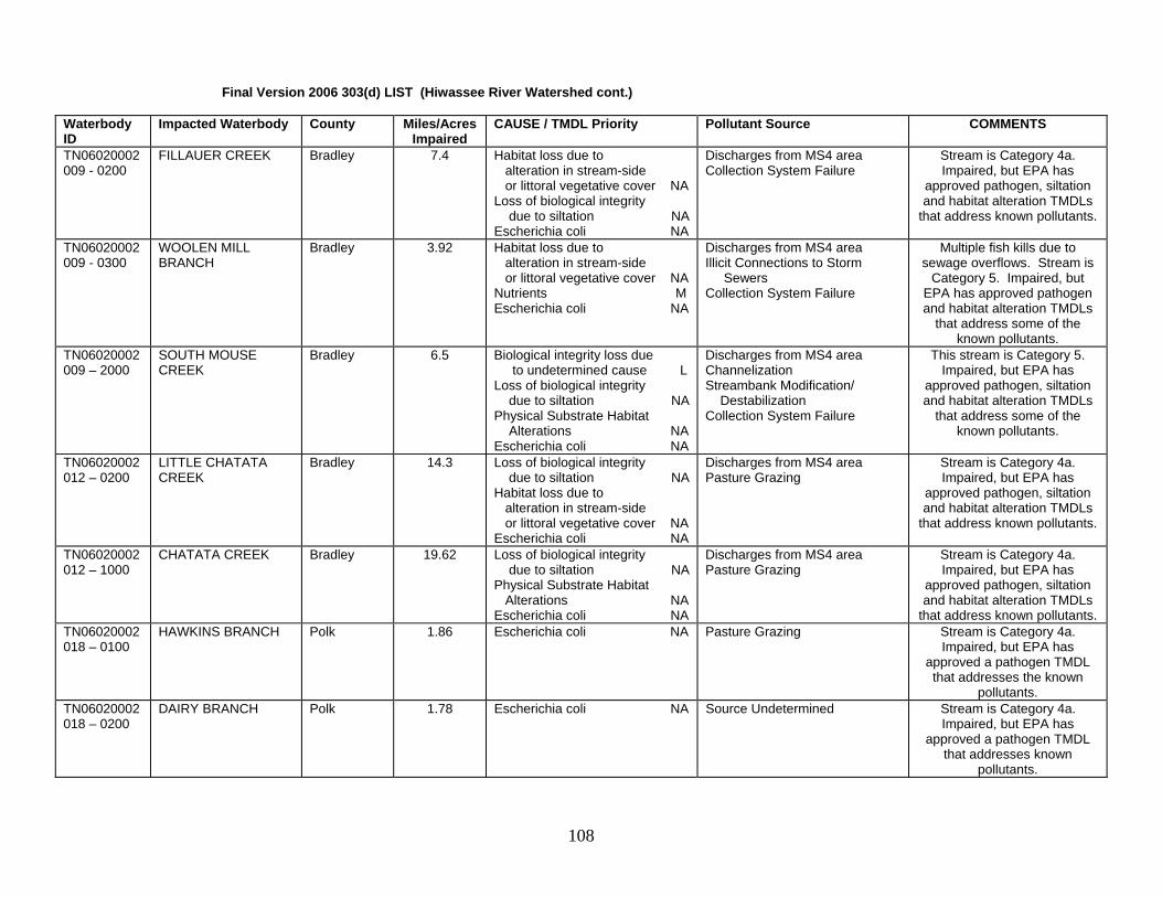
Final Version 2006 303(d) LIST (Hiwassee River Watershed cont.) Waterbody ID
Impacted Waterbody County Miles/Acres Impaired
CAUSE / TMDL Priority Pollutant Source COMMENTS
TN06020002009 - 0200
FILLAUER CREEK Bradley 7.4 Habitat loss due to alteration in stream-side or littoral vegetative cover NA Loss of biological integrity due to siltation NA Escherichia coli NA
Discharges from MS4 area Collection System Failure
Stream is Category 4a. Impaired, but EPA has
approved pathogen, siltation and habitat alteration TMDLs
that address known pollutants.
TN06020002009 - 0300
WOOLEN MILL BRANCH
Bradley 3.92 Habitat loss due to alteration in stream-side or littoral vegetative cover NA Nutrients M Escherichia coli NA
Discharges from MS4 area Illicit Connections to Storm Sewers Collection System Failure
Multiple fish kills due to sewage overflows. Stream is
Category 5. Impaired, but EPA has approved pathogen and habitat alteration TMDLs
that address some of the known pollutants.
TN06020002009 – 2000
SOUTH MOUSE CREEK
Bradley 6.5 Biological integrity loss due to undetermined cause L Loss of biological integrity due to siltation NA Physical Substrate Habitat Alterations NA Escherichia coli NA
Discharges from MS4 area Channelization Streambank Modification/ Destabilization Collection System Failure
This stream is Category 5. Impaired, but EPA has
approved pathogen, siltation and habitat alteration TMDLs
that address some of the known pollutants.
TN06020002012 – 0200
LITTLE CHATATA CREEK
Bradley 14.3 Loss of biological integrity due to siltation NA Habitat loss due to alteration in stream-side or littoral vegetative cover NA Escherichia coli NA
Discharges from MS4 area Pasture Grazing
Stream is Category 4a. Impaired, but EPA has
approved pathogen, siltation and habitat alteration TMDLs
that address known pollutants.
TN06020002012 – 1000
CHATATA CREEK Bradley 19.62 Loss of biological integrity due to siltation NA Physical Substrate Habitat Alterations NA Escherichia coli NA
Discharges from MS4 area Pasture Grazing
Stream is Category 4a. Impaired, but EPA has
approved pathogen, siltation and habitat alteration TMDLs
that address known pollutants. TN06020002018 – 0100
HAWKINS BRANCH Polk 1.86 Escherichia coli NA Pasture Grazing Stream is Category 4a. Impaired, but EPA has
approved a pathogen TMDL that addresses the known
pollutants. TN06020002018 – 0200
DAIRY BRANCH Polk 1.78 Escherichia coli NA Source Undetermined Stream is Category 4a. Impaired, but EPA has
approved a pathogen TMDL that addresses known
pollutants.
108

Final Version 2006 303(d) LIST (Hiwassee River Watershed cont.) Waterbody ID
Impacted Waterbody County Miles/Acres Impaired
CAUSE / TMDL Priority Pollutant Source COMMENTS
TN06020002018 – 3000 & 4000
HIWASSEE RIVER Polk 11.4 Habitat loss due to stream flow alteration NA
Upstream Impoundment Provides habitat for the federally listed Cumberland bean pearly mussel (Villosa trabalis). Section between
Apalachia Dam and Powerhouse impacted by flow
diversions. Stream is Category 4c. (Impacts are not caused by a pollutant.) TVA has plans to increase flows in
the “bypass section.” TN06020002081 – 1000
CONASAUGA CREEK McMinn Monroe
33.99 Loss of biological integrity due to siltation NA
Discharges from MS4 area Pasture Grazing
Stream is Category 4a. Impaired, but EPA has
approved a pathogen TMDL that addresses the known
pollutants. TN06020002082 – 0200
LITTLE CHESTUEE CREEK
McMinn Monroe
13.3 Escherichia coli NA Pasture Grazing Stream is Category 4a. Impaired, but EPA has
approved a pathogen TMDL that addresses the known
pollutants. TN06020002082 – 2000
CHESTUEE CREEK McMinn Monroe
17.9 Escherichia coli NA Pasture Grazing Stream is Category 4a. Impaired, but EPA has
approved a pathogen TMDL that addresses the known
pollutants. TN06020002083 – 1000
OOSTANAULA CREEK
McMinn 5.7 Escherichia coli NA Pasture Grazing This stream is Category 4a. The stream is impaired for one or more uses. However, EPA
has approved a pathogen TMDL that addresses the
known pollutants. TN06020002083 – 2000
OOSTANAULA CREEK
McMinn 21.1 Escherichia coli NA Pasture Grazing This stream is Category 4a. The stream is impaired for one or more uses. However, EPA
has approved a pathogen TMDL that addresses the
known pollutants.
109

Final Version 2006 303(d) LIST (Hiwassee River Watershed cont.) Waterbody ID
Impacted Waterbody County Miles/Acres Impaired
CAUSE / TMDL Priority Pollutant Source COMMENTS
TN06020002083 – 3000
OOSTANAULA CREEK
McMinn 7.4 Phosphate M Loss of biological integrity due to siltation NA Escherichia coli NA
Municipal Point Source Discharge Discharge from MS4 area
Water contact advisory. Stream is Category 5. Impaired, but EPA has
approved pathogen and siltation TMDLs that address
some of the known pollutants. TN06020002083 – 4000
OOSTANAULA CREEK
McMinn 8.5 Escherichia coli NA Pasture Grazing This stream is Category 4a. The stream is impaired for one or more uses. However, EPA
has approved a pathogen TMDL that addresses some of
the known pollutants. TN06020002083 – 5000
OOSTANAULA CREEK
Monroe 6.2 Escherichia coli NA Pasture Grazing This stream is Category 4a. The stream is impaired for one or more uses. However, EPA
has approved a pathogen TMDL that addresses the
known pollutants. TN06020002084 - 1000
NORTH MOUSE CREEK
McMinn 38.36 Escherichia coli NA Pasture Grazing Discharges from MS4 area
Stream is Category 4a. Impaired, but EPA has
approved a pathogen TMDL that addresses the known
pollutants. TN06020002085 - 1000
SPRING CREEK McMinn 33.8 Escherichia coli NA Pasture Grazing Stream is Category 4a. Impaired, but EPA has
approved a pathogen TMDL that addresses the known
pollutants. TN06020002087 - 1000
ROGERS CREEK McMinn 21.6 Habitat loss due to alteration in stream-side or littoral vegetative cover NA Escherichia coli NA
Pasture Grazing Stream is Category 4a. Impaired, but EPA has
approved pathogen and habitat alteration TMDLs that addresses known pollutants.
TN06020002088 - 1000
PRICE CREEK Meigs 6.9 Escherichia coli NA Pasture Grazing Stream is Category 4a. Impaired, but EPA has
approved a pathogen TMDL that addresses the known
pollutants.
110

Conasauga River This basin contains the following USGS Hydrologic Unit Codes: 03150101 (Conasauga River). Waterbody ID
Impacted Waterbody County Miles/Acres Impaired
CAUSE / TMDL Priority Pollutant Source COMMENTS
TN03150101012 - 0200
MILL CREEK Bradley Polk
20.1 Nitrate M Escherichia coli NA
Pasture Grazing This stream is Category 5. Impaired, but EPA has
approved a pathogen TMDL that addresses some of the
known pollutants. TN03150101012 - 0300
BALL PLAY CREEK Polk 7.44 Loss of biological integrity due to siltation M Escherichia coli NA
Pasture Grazing Septic Tanks
This stream is Category 5. Impaired, but EPA has
approved a pathogen TMDL that addresses some of the
known pollutants. Ocoee River This basin contains the following USGS Hydrologic Unit Codes: 06020003 (Ocoee River). Waterbody ID
Impacted Waterbody County Miles/Acres Impaired
CAUSE / TMDL Priority Pollutant Source COMMENTS
TN06020003001 - 0100
FOURMILE CREEK Polk 4.8 Escherichia coli NA Discharges from MS4 area Pasture Grazing
Stream is Category 4a. Impaired, but EPA has
approved a pathogen TMDL that addresses the known
pollutants. TN06020003001 - 1000
OCOEE RIVER Polk 13.0 pH L Zinc L
Mill Tailings Mine Tailings Contaminated Sediments Impacts from Abandoned Mines Upstream Impoundment
Biological integrity criteria not met below Parksville. This
stream is Category 5 (impaired for one or more uses).
TN06020003004 – 1000 & 2000
PARKSVILLE RES-Ocoee Dam #1 to Baker Cr is partial. From Baker Cr to reservoir headwaters is not supporting.
Polk 1280 ac Copper L Iron L Zinc L Loss of biological integrity due to siltation L
Mill Tailings Mine Tailings Contaminated Sediments Impacts from Abandoned Mines
Parksville Reservoir fishery is improving, but sediment
contamination exerts toxic effect near head of lake. This stream is Category 5, impaired
for one or more uses. TN06020003013 - 1000
OCOEE RIVER - Parksville Res. to Ocoee #2 Dam.
Polk 7.18 Copper L Iron L Zinc L Habitat loss due to stream flow alteration NA
Mill Tailings Mine Tailings Contaminated Sediments Impacts from Abandoned Mines Upstream Impoundment
Use is impacted by metals and flow alteration for power generation. Stream is
Category 5 overall (one or more uses impaired), but flow
alteration is 4c (impact not caused by a pollutant). TVA
provides flows for recreational uses per existing agreements.
111

Final Version 2006 303(d) LIST (Ocoee River Basin cont.) Waterbody ID
Impacted Waterbody County Miles/Acres Impaired
CAUSE TMDL Priority Pollutant Source COMMENTS
TN06020003013.5 – 1000
OCOEE NUMBER 2 Reservoir
Polk 494 ac Copper L Iron L Zinc L Loss of biological integrity due to siltation L Habitat loss due to stream flow alteration NA
Mill Tailings Mine Tailings Contaminated Sediments Impacts from Abandoned Mines Upstream Impoundment
Upstream power generation causes flow alteration. Stream
is Category 5 overall (one or more uses impaired), but flow
alteration is 4c (impact not caused by a pollutant).
TN06020003013.55–1000
OCOEE RIVER- From Res. #2 to Dam #3.
Polk 3.9 Copper L Iron L Zinc L Loss of biological integrity due to siltation L Habitat loss due to stream flow alteration NA
Mill Tailings Mine Tailings Contaminated Sediments Impacts from Abandoned Mines Upstream Impoundment
Upstream water diversion for power generation causes flow alteration. Stream is Category
5 overall (one or more uses impaired), but flow alteration is
4c (impact not caused by a pollutant). TVA provides flows
for recreational uses per existing agreements.
TN06020003013.7 – 1000
OCOEE NUMBER THREE RESERVOIR
Polk 480 ac Copper L Iron L Zinc L Loss of biological integrity due to siltation L
Mill Tailings Mine Tailings Contaminated Sediments Impacts from Abandoned Mines
This stream is Category 5. The stream is impaired for one
or more uses.
TN06020003014 - 0100
NORTH POTATO CREEK
Polk 6.3 Physical Substrate Habitat Alterations L Copper L Iron L Zinc L pH L Loss of biological integrity due to siltation L
Abandoned Mining Mine Tailings Channelization Contaminated Sediments
Acid mine drainage from historical mining operations.
Erosion from historic smelting operation. This stream is Category 5. The stream is
impaired for one or more uses.
TN06020003014 - 0110
BURRA BURRA CREEK
Polk 2.2 Copper L Iron L Zinc L pH L Loss of biological integrity due to siltation L
Mill Tailings Mine Tailings Impacts from Abandoned Mines
Acid mine drainage from historical mining operations. This stream is Category 5.
The stream is impaired for one or more uses.
TN06020003014 - 0120
ELLIS BRANCH Polk 2.8 Copper L Zinc L Iron L
Mill Tailings Abandoned Mining
Historical mining operations. This stream is Category 5.
The stream is impaired for one or more uses.
112

Final Version 2006 303(d) LIST (Ocoee River Basin cont.) Waterbody ID
Impacted Waterbody County Miles/Acres Impaired
CAUSE TMDL Priority Pollutant Source COMMENTS
TN06020003014 - 0200
DAVIS MILL CREEK Polk 3.8 Copper L Iron L Zinc L pH L Loss of biological integrity due to siltation L
Mill Tailings Abandoned Mining
This stream is Category 5. The stream is impaired for one
or more uses.
TN06020003014 - 1000
OCOEE RIVER Polk 2.5 Iron L Copper L Zinc L pH L Loss of biological integrity due to siltation L
Mill Tailings Mine Tailings Contaminated Sediments Impacts from Abandoned Mines
This stream is Category 5. The stream is impaired for one
or more uses.
Sequatchie River This basin contains the following USGS Hydrologic Unit Codes: 06020004 (Sequatchie River). Waterbody ID
Impacted Waterbody County Miles/Acres Impaired
CAUSE / TMDL Priority Pollutant Source COMMENTS
TN06020004001 - 0110
STANDIFER BRANCH Marion 18.0 Loss of biological integrity due to siltation M
Land Development Stream is Category 5. (One or more uses impaired.)
TN06020004001 - 0600
UNNAMED TRIB TO SEQUATCHIE RIVER
Marion 2.04 Escherichia coli M Pasture Grazing Stream is Category 5. (One or more uses impaired.)
TN06020004001 - 0910
UNNAMED TRIB TO SHELTON CREEK
Marion 6.3 Escherichia coli M Pasture Grazing Stream is Category 5. (One or more uses impaired.)
TN06020004001 - 1100
UNNAMED TRIB TO SEQUATCHIE RIVER
Marion 1.7 Escherichia coli M Pasture Grazing Stream is Category 5. (One or more uses impaired.)
TN06020004001 – 1300
PECK BRANCH Marion 2.4 Escherichia coli M Pasture Grazing Stream is Category 5. (One or more uses impaired.)
TN06020004005 – 0500
MCWILLIAMS CREEK Bledsoe Sequatchie
11.2 Escherichia coli M Pasture Grazing Stream is Category 5. (One or more uses impaired.)
TN06020004007 – 0400
HALL CREEK Bledsoe 10.0 Escherichia coli M Pasture Grazing Stream is Category 5. (One or more uses impaired.)
TN06020004007 – 0600
LITTLE CREEK Bledsoe 8.7 Escherichia coli M Pasture Grazing Stream is Category 5. (One or more uses impaired.)
TN06020004007 – 0630
BROWNS CREEK Bledsoe 2.8 Escherichia coli M Pasture Grazing Stream is Category 5. (One or more uses impaired.)
TN06020004007 – 0800
SWAFFORD BRANCH Bledsoe 6.5 Escherichia coli M Pasture Grazing Stream is Category 5. (One or more uses impaired.)
TN06020004007 – 0900
STEPHENS BRANCH Bledsoe Cumberland
8.8 Escherichia coli M Pasture Grazing Stream is Category 5. (One or more uses impaired.)
113

Final Version 2006 303(d) LIST (Sequatchie River Basin cont.) Waterbody ID
Impacted Waterbody County Miles/Acres Impaired
CAUSE TMDL Priority Pollutant Source COMMENTS
TN06020004007 – 1200
MANNING SPRINGS Cumberland 1.4 Escherichia coli M Pasture Grazing Stream is Category 5. (One or more uses impaired.)
TN06020004007 – 1400
UNNAMED TRIB TO SEQUATCHIE RIVER
Bledsoe 1.4 Escherichia coli M Pasture Grazing Stream is Category 5. (One or more uses impaired.)
TN06020004007 – 2200
SKILLERN CREEK Bledsoe 10.60 Escherichia coli M Pasture Grazing Stream is Category 5. (One or more uses impaired.)
TN06020004007 – 2800
UNNAMED TRIB TO SEQUATCHIE RIVER
Bledsoe 2.3 Escherichia coli M Pasture Grazing Stream is Category 5. (One or more uses impaired.)
TN06020004008 – 0200
MAISE CREEK Bledsoe 4.7 Escherichia coli M Pasture Grazing Stream is Category 5. (One or more uses impaired.)
TN06020004009 – 0500
GLADY FORK Sequatchie 4.99 Manganese L Other Anthropogenic Substrate Alterations L
Surface Mining Stream is Category 5. (One or more uses impaired.)
TN06020004009 – 0510
UNNAMED TRIB TO GLADY FORK
Sequatchie 1.45 Loss of biological integrity due to siltation L
Silviculture Harvesting Logging of area to convert to pasture put excessive silt in
the stream. Stream is Category 5. (One or more
uses impaired.) TN06020004009 – 1000
BIG BRUSH CREEK Sequatchie 9.3 Manganese L Other Anthropogenic Substrate Alterations L
Surface Mining Stream is Category 5. (One or more uses impaired.)
TN06020004009 – 2000
BIG BRUSH CREEK Sequatchie Bledsoe
12.4 Manganese L Other Anthropogenic Substrate Alterations L
Surface Mining Stream is Category 5. (One or more uses impaired.)
TN06020004012 – 0100
UNNAMED TRIB TO WOODCOCK CREEK
Sequatchie 1.7 Iron L pH L
Inactive Mining Underground mining impacts. Stream is
Category 5. (One or more uses impaired.)
TN06020004014 – 0100
DANIEL CREEK Marion 2.2 Escherichia coli M Pasture Grazing Stream is Category 5. (One or more uses impaired.)
Guntersville Reservoir This basin contains the following USGS Hydrologic Unit Codes: 06030001 (Guntersville Reservoir and misc. tribs). Waterbody ID
Impacted Waterbody County Miles/Acres Impaired
CAUSE / TMDL Priority Pollutant Source COMMENTS
TN06030001057 - 0511
UNNAMED TRIB TO LAUREL LAKE
Marion 0.5 Nonpriority Organics L Escherichia coli M
Collection System Failure Waste Storage/Tank Leaks
Laurel Lake is the water supply for Monteagle.
Stream is Category 5. (One or more uses impaired.)
114

Final Version 2006 303(d) LIST (Guntersville Reservoir Basin cont.) Waterbody ID
Impacted Waterbody County Miles/Acres Impaired
CAUSE TMDL Priority Pollutant Source COMMENTS
TN06030001057 - 0811
HEDDEN BRANCH Grundy 1.5 Escherichia coli M Pasture Grazing Septic Tanks
Water contact advisory. No sewage treatment facility in
Tracy City. Stream is Category 5. (One or more
uses impaired.) TN06030001057 - 0812
CLOUSE HILL BRANCH
Grundy 1.9 Escherichia coli M Septic Tanks Same as above. Stream is Category 5. (One or more
uses impaired.) TN06030001057 - 0815
LITTLE FIERY GIZZARD CREEK
Grundy 3.7 Escherichia coli M Pasture Grazing Septic Tanks
Same as above. Stream is Category 5. (One or more
uses impaired.) Wheeler Lake Watershed This basin contains the following USGS Hydrologic Unit Codes: 06030002 (Wheeler Lake). Waterbody ID
Impacted Waterbody County Miles/AcresImpaired
CAUSE / TMDL Priority Pollutant Source COMMENTS
TN060300021124 - 0200
UNNAMED TRIB TO HESTER CREEK
Lincoln 2.5 Escherichia coli M Undetermined Source Stream is Category 5. (One or more uses impaired.)
TN060300021124 - 1000
HESTER CREEK Lincoln 14.8 Loss of biological integrity due to siltation H
Nonirrigated Crop Production Stream is Category 5. (One or more uses impaired.)
TN060300021149 - 0100
COTTRELL SPRING BRANCH
Lincoln 8.7 Habitat loss due to alteration in stream-side or littoral vegetative cover H Loss of biological integrity due to siltation H
Nonirrigated Crop Production This stream is Category 5. The stream is impaired for one
or more uses.
TN060300021149 - 0600
BIG HUCKLEBERRY CREEK
Lincoln 12.2 Habitat loss due to alteration in stream-side or littoral vegetative cover H Loss of biological integrity due to siltation H
Nonirrigated Crop Production This stream is Category 5. The stream is impaired for one
or more uses.
TN060300021149 - 1000
FLINT RIVER Lincoln 22.0 Loss of biological integrity due to siltation H Physical Substrate Habitat Alterations H
Nonirrigated Crop Production This stream is Category 5. The stream is impaired for one
or more uses.
TN060300021216 - 0210
WASHBURN BRANCH
Lincoln 17.3 Habitat loss due to alteration in stream-side or littoral vegetative cover H Loss of biological integrity due to siltation H
Nonirrigated Crop Production This stream is Category 5. The stream is impaired for one
or more uses.
115

Elk River Basin This basin contains the following USGS Hydrologic Unit Codes: 06030003 (Upper Elk River) and 06030004 (Lower Elk River). Waterbody ID
Impacted Waterbody County Miles/Acres Impaired
CAUSE (Pollutant) Pollutant Source COMMENTS
TN06030003010 – 1000
ELK RIVER Lincoln 13.91 Escherichia coli M Pasture Grazing Stream is Category 5. (One or more uses impaired.)
TN06030003012 – 0400
ROBINSON CREEK Franklin Lincoln
23.0 Loss of biological integrity due to siltation NA
Pasture Grazing This stream is Category 4a. The stream is impaired, but
EPA has approved a siltation/habitat alteration
TMDL which addresses the known pollutants.
TN06030003015 – 1000
ELK RIVER Franklin Moore
15.4 Thermal Modification L Habitat loss due to stream flow alteration NA
Upstream Impoundment This segment provides habitat for the federally listed shiny pigtoe and slabside pearly
mussel. Stream is Category 5 overall (one or more uses
impaired), but flow alteration is 4c (impact not caused by a pollutant). TVA has taken action to improve dissolved oxygen and flow conditions
downstream of the dam. TN06030003026 – 1000
DRY CREEK Franklin 21.1 Loss of biological integrity due to siltation M
Pasture Grazing Stream is Category 5. (One or more uses impaired.)
TN06030003032 – 1000
WAGNER CREEK Franklin 18.8 Nitrates H Physical Substrate Habitat Alterations NA Escherichia coli M
Urbanized High Density Area Municipal Point Source Channelization
This stream is Category 5. The stream is impaired, but
EPA has approved a siltation/habitat alteration
TMDL which addresses some of the known pollutants.
TN06030003035 –1000
ELK RIVER Franklin 6.2 Habitat loss due to stream flow alteration NA Low Dissolved Oxygen L
Upstream Impoundment Stream is Category 5 overall (one or more uses impaired),
but flow alteration is 4c (impact not caused by a pollutant).
TN06030003036 – 1000
WOODS RESERVOIR Franklin Coffee
3908 ac PCBs L Contaminated Sediments Fishing advisory due to PCBs. Historical PCB releases from AEDC. Stream is Category 5. (One or more uses impaired.)
TN06030003041 – 0100
YELLOW BRANCH Franklin 7.1 Habitat loss due to alteration in stream-side or littoral vegetative cover NA Loss of biological integrity due to siltation NA
Pasture Grazing This stream is Category 4a. The stream is impaired, but
EPA has approved a siltation/habitat alteration
TMDL which addresses the known pollutants.
116

Final Version 2006 303(d) LIST (Elk River Basin cont.) Waterbody ID
Impacted Waterbody County Miles/Acres Impaired
CAUSE / TMDL Priority Pollutant Source COMMENTS
TN06030003044 – 0100
BETSY WILLIS CREEK
Coffee Grundy
22.5 Habitat loss due to alteration in stream-side or littoral vegetative cover NA Loss of biological integrity due to siltation NA Physical Substrate Habitat Alterations NA
Pasture Grazing Sand/Gravel/Rock Mining
This stream is Category 4a. The stream is impaired, but
EPA has approved a siltation/habitat alteration
TMDL which addresses the known pollutants.
TN06030003044 – 0200
PATTON CREEK Grundy 4.2 Habitat loss due to alteration in stream-side or littoral vegetative cover NA Loss of biological integrity due to siltation NA
Pasture Grazing This stream is Category 4a. The stream is impaired, but
EPA has approved a siltation/habitat alteration
TMDL which addresses the known pollutants.
TN06030003044 – 0721
JUANITA CREEK Grundy 0.8 Escherichia coli M Collection System Failure Stream is Category 5. (One or more uses impaired.)
TN06030003044 – 0730
TRUSSEL CREEK Grundy 4.3 Nutrients H Low Dissolved Oxygen H Solids L Whole Effluent Toxicity L
Municipal Point Source Discharge
Monteagle STP. Stream is Category 5. (One or more
uses impaired.)
TN06030003053 – 0100
BLUE CREEK Franklin Coffee
10.9 Biological integrity loss due to undetermined cause L
Undetermined Source Stream is Category 5. (One or more uses impaired.)
TN06030003053 – 2000
ROCK CREEK Franklin Coffee
16.1 Low Dissolved Oxygen H Nitrate H Phosphate H Habitat loss due to stream flow alteration NA Thermal Modification L Loss of biological integrity due to siltation NA
Major Municipal Point Source Discharges from MS4 area Land Development
Area impacts include Tullahoma STP. Stream is Category 5 overall (one or
more uses impaired), but flow alteration is 4c (impact not
caused by a pollutant). EPA has approved a siltation/
habitat alteration TMDL which addresses some of the known
pollutants. TN06030003056 – 0100
WEST FORK MULBERRY CREEK
Lincoln Moore
55.9 Escherichia coli M Pasture Grazing Stream is Category 5. (One or more uses impaired.)
TN06030003056 – 0250
EAST FORK MULBERRY CREEK
Moore 16.8 Nitrates M Loss of biological integrity due to siltation NA Low Dissolved Oxygen M Escherichia coli M
Municipal Point Source Discharges Pasture Grazing
Stream is Category 5. The stream is impaired, but EPA
has approved a siltation/habitat alteration
TMDL which addresses some of the known pollutants.
117

Final Version 2006 303(d) LIST (Elk River Basin cont.) Waterbody ID
Impacted Waterbody County Miles/Acres Impaired
CAUSE / TMDL Priority Pollutant Source COMMENTS
TN06030003060 – 1000
CANE CREEK Lincoln Marshall
44.5 Escherichia coli NA Undetermined Source This stream is Category 4A . The stream is impaired, but
EPA has approved a pathogen TMDL which addresses some
of the known pollutants. TN06030003063 – 2000
SWAN CREEK Lincoln Marshall
9.9 Nitrates H Phosphates H Low Dissolved Oxygen H Escherichia coli NA
Animal Feeding Operation (NPS) Fish kills from animal feeding operation. This stream is Category 5. The stream is
impaired for one or more uses. EPA has approved a fecal
coliform TMDL that addresses some of the known pollutants.
TN06030003085 – 1000
CHILDER CREEK Franklin 8.9 Loss of biological integrity due to siltation NA
Pasture Grazing This stream is Category 4a. The stream is impaired for one
or more uses, but EPA has approved a siltation/habitat
alteration TMDL that addresses the known pollutant.
TN06030003435 – 1000
ROLLINS CREEK Franklin Coffee
11.9 Thermal Modifications L Habitat loss due to stream flow alterations NA
Industrial Point Source Biology very poor downstream of AEDC. Stream is Category 5 (one or more uses impaired), but flow alteration is 4c (impact
not caused by a pollutant). TN06030003552 – 1000
GUM CREEK Franklin 12.9 Loss of biological integrity due to siltation NA Physical Substrate Habitat Alterations NA
Nonirrigated Crop Production Channelization
This stream is Category 4a. Impaired, but EPA has
approved a siltation/habitat alteration TMDL which
addresses known pollutants. TN06030003567 – 1000
HESSEY BRANCH Franklin 9.6 Nutrients H Physical Substrate Habitat Alteration NA Loss of biological integrity due to siltation NA
Nonirrigated Crop Production Pasture Grazing Channelization
This stream is Category 5. The stream is impaired, but
EPA has approved a siltation/habitat alteration
TMDL which addresses some of the known pollutants.
TN06030004013 – 1000
ELK RIVER Giles 7.4 Escherichia coli M Undetermined Source Section is habitat for two federally listed fish species:
the snail darter (Percina tanasi) and the boulder darter
(Etheostoma wapiti). This stream is Category 5. The
stream is impaired for one or more uses.
118

Final Version 2006 303(d) LIST (Elk River Basin cont.) Waterbody ID
Impacted Waterbody County Miles/Acres Impaired
CAUSE / TMDL Priority Pollutant Source COMMENTS
TN06030004017 – 0300
EVERLY BRANCH Giles 2.41 Loss of biological integrity due to siltation NA
Sand/Gravel/Rock Mining This stream is Category 4a. The stream is impaired, but
EPA has approved a siltation/habitat alteration
TMDL which addresses the known pollutants.
TN06030004017 – 0600
UNNAMED TRIB TO RICHLAND CREEK
Giles 3.2 Other Anthropogenic Substrate Alterations NA Loss of biological integrity due to siltation NA
Industrial/Commercial Site Stormwater Discharge
This stream is Category 4a. The stream is impaired, but
EPA has approved a siltation/habitat alteration
TMDL which addresses the known pollutants.
TN06030004017 – 2000
RICHLAND CREEK Giles 26.7 Loss of biological integrity due to siltation NA Oil and Grease L Escherichia coli NA
Industrial Point Source Collection System Failure Land Development Urbanized High Density Area Pasture Grazing
Pulaski area impacts include Denbo (oil and grease) and collection system problems. This stream is Category 5.
The stream is impaired for one or more uses, however EPA
has approved a fecal coliform and habitat alteration TMDL that addresses some of the
known pollutants. TN06030004023 – 0300
ROBERTSON FORK CREEK
Giles Marshall
47.2 Escherichia coli H Pasture Grazing This stream is Category 5. The stream is impaired for one
or more uses. TN06030004043 – 0300
CORN CREEK Marshall 4.0 Loss of biological integrity due to siltation NA Nutrients H Escherichia coli NA
Pasture Grazing Livestock in Stream
This stream is Category 5. The stream is impaired for one or more uses, however EPA
has approved a fecal coliform and habitat alteration TMDL that addresses some of the
known pollutants in this stream.
TN06030004043 – 0400
TOWN CREEK Marshall 12.5 Nitrates H Phosphates H Escherichia coli NA
Pasture Grazing Municipal Point Source Discharges
Town Creek impacts include Cornersville STP. This
stream is Category 5. The stream is impaired for one or more uses, however EPA has
approved a fecal coliform TMDL that addresses some of
the known pollutants in this stream.
119

Final Version 2006 303(d) LIST (Elk River Basin cont.) Waterbody ID
Impacted Waterbody County Miles/Acres Impaired
CAUSE / TMDL Priority Pollutant Source COMMENTS
TN06030004043 – 0600
COFFEY BRANCH Marshall 3.4 Escherichia coli NA Pasture Grazing This stream is Category 4A. The stream is impaired for one or more uses, however EPA
has approved a fecal coliform TMDL that addresses the
known pollutants. TN06030004043 – 1000
RICHLAND CREEK Giles Marshall
42 Escherichia coli NA Pasture Grazing This stream is Category 4a. The stream is impaired for one or more uses, however EPA
has approved a fecal coliform TMDL that addresses the
known pollutants. Pickwick – Shoal Creek Basin This basin contains the following USGS Hydrologic Unit Codes: 06030005 (Pickwick Reservoir, including Shoal Creek). Waterbody ID
Impacted Waterbody County Miles/Acres Impaired
CAUSE / TMDL Priority Pollutant Source COMMENTS
TN06030005078 – 1000
SHOAL CREEK Lawrence 13.2 Nitrates M Habitat loss due to alteration in stream-side or littoral vegetative cover M
Industrial Point Source Municipal Point Source Removal of Riparian Vegetation
This stream is Category 5. The stream is impaired for one
or more uses.
TN06030005081 – 1000
SHOAL CREEK Lawrence 21.3 Nitrates M Loss of biological integrity due to siltation M
Major Industrial Point Source Major Municipal Point Source Land Development
This stream is Category 5. The stream is impaired for one
or more uses. TN06030005082 – 0100
BIG DRY BRANCH Lawrence 7.4 Habitat loss due to alteration in stream-side or littoral vegetative cover M
Pasture Grazing This stream is Category 5. The stream is impaired for one
or more uses. TN06030005082 – 1000
SHOAL CREEK Lawrence 2.3 Nitrates M Loss of biological integrity due to siltation M Escherichia coli M
Nonirrigated Crop Production Industrial Point Source Municipal Point Source Pasture Grazing Land Development Collection System Failure
This stream is Category 5. The stream is impaired for one
or more uses.
120

Upper Kentucky Reservoir This basin contains the following USGS Hydrologic Unit Codes: 06040001 (Upper Kentucky Reservoir). Waterbody ID
Impacted Waterbody County Miles/Acres Impaired
CAUSE /TMDL Priority Pollutant Source COMMENTS
TN06040001043 - 0100
CHALK CREEK Hardin 14.0 Loss of biological integrity due to siltation L Physical Substrate Habitat Alterations L
Pasture Grazing Channelization
Stream is Category 5. (One or more uses impaired.)
TN06040001043 - 0200
MUD CREEK Hardin 13.4 Loss of biological integrity due to siltation L Low dissolved oxygen L Physical Substrate Habitat Alterations L
Pasture Grazing Channelization
Stream is Category 5. (One or more uses impaired.)
TN06040001043 - 0820
BINGHAM CREEK Hardin Henderson
8.5 Physical Substrate Habitat Alterations L
Channelization Stream is Category 5. (One or more uses impaired.)
TN06040001043 - 1000
WHITEOAK CREEK Hardin 15.1 Loss of biological integrity due to siltation L Low dissolved oxygen L
Nonirrigated Crop Production Channelization
Stream is Category 5. (One or more uses impaired.)
TN06040001054 – 1000
SNAKE CREEK McNairy Hardin
9.3 Low dissolved oxygen L Loss of biological integrity due to siltation L
Municipal Point Source Irrigated Crop Production
Stream is Category 5. (One or more uses impaired.)
TN06040001060 - 0300
WARDLOW CREEK McNairy 10.92 Loss of biological integrity due to siltation L
Pasture Grazing Nonirrigated Crop Production
Stream is Category 5. (One or more uses impaired.)
TN06040001060 - 2000
CHAMBERS CREEK McNairy 4.0 Loss of biological integrity due to siltation L Low dissolved oxygen L
Pasture Grazing Stream is Category 5. (One or more uses impaired.)
TN06040001364 – 3000
EAGLE CREEK Benton Decatur
5.1 Unionized Ammonia NA Low dissolved oxygen NA Escherichia coli L
Minor Municipal Point Source Onsite Wastewater System (Septic Tanks)
Stream is Category 5. (One or more uses impaired.)
However, EPA has approved an ammonia/organic
enrichment/low dissolved oxygen TMDL that addresses some of the known pollutants
in this stream. TN06040001651 – 1000
GOODIN BRANCH Decatur 2.87 Habitat loss due to stream flow alteration NA
Upstream Impoundment Stream is Category 4c. Impacts are not caused by a
pollutant. TN06040001802 – 1650
BROWN’S CREEK Henderson 0.3 Temperature Alterations L Habitat loss due to stream flow alteration NA
Upstream Impoundment Stream impacted by poor quality discharges from
Browns Reservoir. Stream is Category 5 overall (one or
more uses impaired), but flow alteration is 4c (impact not
caused by a pollutant).
121
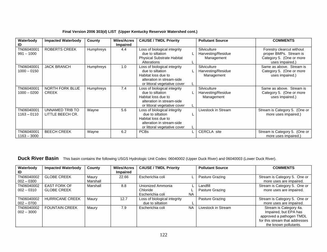
Final Version 2006 303(d) LIST (Upper Kentucky Reservoir Watershed cont.) Waterbody ID
Impacted Waterbody County Miles/Acres Impaired
CAUSE / TMDL Priority Pollutant Source COMMENTS
TN06040001991 – 1000
ROBERTS CREEK Humphreys 4.4 Loss of biological integrity due to siltation L Physical Substrate Habitat Alterations L
Silviculture Harvesting/Residue Management
Forestry clearcut without proper BMPs. Stream is
Category 5. (One or more uses impaired.)
TN060400011000 – 0150
JACK BRANCH Humphreys 1.0 Loss of biological integrity due to siltation L Habitat loss due to alteration in stream-side or littoral vegetative cover L
Silviculture Harvesting/Residue Management
Same as above. Stream is Category 5. (One or more
uses impaired.)
TN060400011000 – 0200
NORTH FORK BLUE CREEK
Humphreys 7.4 Loss of biological integrity due to siltation L Habitat loss due to alteration in stream-side or littoral vegetative cover L
Silviculture Harvesting/Residue Management
Same as above. Stream is Category 5. (One or more
uses impaired.)
TN060400011163 – 0110
UNNAMED TRIB TO LITTLE BEECH CR.
Wayne 5.6 Loss of biological integrity due to siltation L Habitat loss due to alteration in stream-side or littoral vegetative cover L
Livestock in Stream Stream is Category 5. (One or more uses impaired.)
TN060400011163 – 3000
BEECH CREEK Wayne 6.2 PCBs L CERCLA site Stream is Category 5. (One or more uses impaired.)
Duck River Basin This basin contains the following USGS Hydrologic Unit Codes: 06040002 (Upper Duck River) and 06040003 (Lower Duck River). Waterbody ID
Impacted Waterbody County Miles/Acres Impaired
CAUSE / TMDL Priority Pollutant Source COMMENTS
TN06040002002 – 0300
GLOBE CREEK Maury Marshall
22.66 Escherichia coli L Pasture Grazing Stream is Category 5. One or more uses are impaired.
TN06040002002 – 0310
EAST FORK OF GLOBE CREEK
Marshall 8.8 Unionized Ammonia L Chloride L Escherichia coli NA
Landfill Pasture Grazing
Stream is Category 5. One or more uses are impaired.
TN06040002002 – 0700
HURRICANE CREEK Maury 12.7 Loss of biological integrity due to siltation L
Pasture Grazing Stream is Category 5. One or more uses are impaired.
TN06040002002 – 3000
FOUNTAIN CREEK Maury 7.9 Escherichia coli NA Livestock in Stream Stream is Category 4a. Impaired, but EPA has
approved a pathogen TMDL for this stream that addresses
the known pollutants.
122

Final Version 2006 303(d) LIST (Duck River Watershed cont.) Waterbody ID
Impacted Waterbody County Miles/Acres Impaired
CAUSE / TMDL Priority Pollutant Source COMMENTS
TN06040002008 – 1000
CEDAR CREEK Maury Marshall
7.62 Nitrates M Escherichia coli L
Pasture Grazing Non-irrigated Crop Production
Stream is Category 5. One or more uses are impaired.
TN06040002010 – 0100
RICH CREEK Marshall Bedford
10.81 Nitrates M Escherichia coli L
Pasture Grazing Non-irrigated Crop Production
Stream is Category 5. One or more uses are impaired.
TN06040002012 - 0100
EAST ROCK CREEK Marshall 14.17 Nitrates M Loss of biological integrity due to siltation H Physical Substrate Habitat Alterations H
Pasture Grazing Stream is Category 5. (One or more uses impaired.)
TN06040002012 - 0400
COLLINS CREEK
Marshall 5.3 Loss of biological integrity due to siltation H
Pasture Grazing Non-irrigated Crop Production
Stream is Category 5. (One or more uses impaired.)
TN06040002012 - 0500
SANDERS CREEK Marshall 4.5 Loss of biological integrity due to siltation H Alteration in stream-side or littoral vegetative cover H
Pasture Grazing Stream is Category 5. (One or more uses impaired.)
TN06040002012 - 0700
SNELL BRANCH
Marshall 4.5 Loss of biological integrity due to siltation H Alteration in stream-side or littoral vegetative cover H
Land Development Channelization
Stream is Category 5. (One or more uses impaired.)
TN06040002012 - 2000
BIG ROCK CREEK
Marshall 9.0 Nitrates H Loss of biological integrity due to siltation H Low dissolved oxygen M
Major Municipal Point Source Discharges from MS4 area
Lewisburg area impacts. Stream is Category 5. (One or
more uses impaired.)
TN06040002012 - 3000
BIG ROCK CREEK Marshall 6.0 Loss of biological integrity due to siltation H Physical Substrate Habitat Alterations H Low Dissolved Oxygen M
Pasture Grazing Stream is Category 5. (One or more uses impaired.)
TN06040002020 - 1000
DUCK RIVER Bedford 29.8 Escherichia coli L Discharges from MS4 area Shelbyville area pathogen sources. Stream is Category 5. (One or more uses impaired.)
TN06040002021 - 0100
LITTLE SINKING CREEK
Bedford 7.6 Loss of biological integrity due to siltation H Alteration in stream-side or littoral vegetative cover H
Pasture Grazing Stream is Category 5. (One or more uses impaired.)
123

Final Version 2006 303(d) LIST (Duck River Watershed cont.) Waterbody ID
Impacted Waterbody County Miles/Acres Impaired
CAUSE / TMDL Priority Pollutant Source COMMENTS
TN06040002021 – 1000
SINKING CREEK Bedford 12.0 Loss of biological integrity due to siltation H Alteration in stream-side or littoral vegetative cover H
Pasture Grazing Stream is Category 5. (One or more uses impaired.)
TN06040002024 - 0100
DAVIS BRANCH Bedford 2.2 Loss of biological integrity due to siltation H
Pasture Grazing Stream is Category 5. (One or more uses impaired.)
TN06040002024 - 1000
SUGAR CREEK Bedford 21.7 Nitrates M Phosphates M Alteration in stream-side or littoral vegetative cover H Escherichia coli M
Pasture Grazing Stream is Category 5. (One or more uses impaired.)
TN06040002027 - 0200
BOMAR CREEK Bedford 4.1 Nutrients M Low dissolved oxygen M
Discharges from MS4 Area Shelbyville area impacts. Stream is Category 5. (One or
more uses impaired.) TN06040002027 – 1000
DUCK RIVER Bedford 1.6 Escherichia coli NA Loss of biological integrity due to siltation H
Collection System Failure Discharges from MS4 area
Shelbyville area impacts. Stream is Category 5. One or
more uses are impaired, however EPA has approved a fecal coliform TMDL for this
stream that addresses some of the known pollutants.
TN06040002030 – 0200
DODDY CREEK Bedford 2.2 Habitat loss due to flow alteration NA
Upstream Impoundment Stream is Category 4c. Impacts are not caused by a
pollutant. TN06040002030 - 1000
DUCK RIVER Bedford 12.1 Thermal Modification L Habitat loss due to stream flow alteration NA Manganese L
Upstream Impoundment Duck River impacted by discharges from Normandy.
TVA has taken action to improve dissolved oxygen
conditions downstream of the dam. Stream is Category 5
(One or more uses impaired), however, it is 4c for flow
alteration (caused by condition rather than a pollutant).
TN06040002032 - 0300
CLEAR BRANCH Coffee 7.3 Alteration of stream-side or littoral vegetation L Phosphate NA Low dissolved oxygen NA Escherichia coli NA
Dairies Pasture Grazing
Stream is Category 5. One or more uses are impaired,
however EPA has approved DO, nutrient, and pathogen TMDLs for this stream that address some of the known
pollutants.
124

Final Version 2006 303(d) LIST (Duck River Watershed cont.) Waterbody ID
Impacted Waterbody County Miles/Acres Impaired
CAUSE / TMDL Priority Pollutant Source COMMENTS
TN06040002032 - 0310
MUDDY BRANCH Coffee 5.1 Alteration of stream-side or littoral vegetation L Phosphate NA Low dissolved oxygen NA Escherichia coli NA
Dairies Pasture Grazing
Stream is Category 5. One or more uses are impaired, but
EPA has approved DO, nutrient, and pathogen TMDLs
for this stream that address some of the known pollutants.
TN06040002032 - 2000
DUCK RIVER Coffee 1.25 Escherichia coli NA Collection System Failure Water contact advisory due to elevated bacteria levels from
Manchester area sewer overflows and urban runoff. Stream is Category 4a. One or more uses are impaired,
however EPA has approved a fecal coliform TMDL for this stream that addresses the
known pollutants. TN06040002033 - 0300
BELL BUCKLE CREEK
Bedford 11.1 Loss of biological integrity due to siltation H Physical Substrate Habitat Alterations H Escherichia coli NA
Minor Municipal Point Source Livestock in Stream
Bell Buckle area impacts, incl. Bell Buckle STP. Stream is
Category 5. One or more uses are impaired, however EPA
has approved a fecal coliform TMDL for this stream that
addresses some of the known pollutants.
TN06040002033 - 0600
MUSE CREEK Bedford 3.0 Loss of biological integrity due to siltation H Alterations in stream-side or littoral vegetative cover H
Livestock in Stream Stream is Category 5. One or more uses are impaired.
TN06040002033 - 1000
WARTRACE CREEK Bedford 15.0 Escherichia coli NA Pasture Grazing Stream is Category 4a. One or more uses are impaired,
however EPA has approved a fecal coliform TMDL that
addresses known pollutants. TN06040002038 - 0300
HURRICANE CREEK Bedford 22.03 Escherichia coli NA Loss of biological integrity due to siltation H Other Habitat Alterations H
Pasture Grazing Stream is Category 5. One or more uses are impaired,
however EPA has approved a fecal coliform TMDL for this
stream that addresses some of the known pollutants.
125

Final Version 2006 303(d) LIST (Duck River Watershed cont.) Waterbody ID
Impacted Waterbody County Miles/Acres Impaired
CAUSE / TMDL Priority Pollutant Source COMMENTS
TN06040002038 - 1000
FALL CREEK Bedford 11.4 Escherichia coli NA Pasture Grazing Stream is Category 4a. One or more uses are impaired,
however EPA has approved a fecal coliform TMDL for this stream that addresses the
known pollutants. TN06040002039 - 0200
WEAKLEY CREEK Bedford 6.2 Escherichia coli NA Pasture Grazing Stream is Category 4a. One or more uses are impaired,
however EPA has approved a fecal coliform TMDL for this stream that addresses the
known pollutants. TN06040002039 - 0250
WEAKLEY CREEK Bedford Rutherford
13.1 Loss of biological integrity due to siltation H Nutrients NA Escherichia coli NA
Pasture Grazing Stream is Category 5. One or more uses are impaired, but EPA has approved nutrient
and pathogen TMDLs for this stream that address some of
the known pollutants. TN06040002039 - 0300
ALEXANDER CREEK Bedford Rutherford
21.1 Loss of biological integrity due to siltation H Escherichia coli NA
Pasture Grazing Stream is Category 5. One or more uses are impaired,
however EPA has approved a fecal coliform TMDL for this
stream that addresses some of the known pollutants.)
TN06040002039 – 1000
NORTH FORK CREEK
Bedford 3.7 Escherichia coli NA Pasture Grazing Stream is Category 4a. One or more uses are impaired,
however EPA has approved a fecal coliform TMDL for this stream that addresses the
known pollutants. TN06040002039 – 2000
NORTH FORK CREEK
Bedford 4.0 Escherichia coli NA Nutrients NA
Pasture Grazing Stream is Category 4a. One or more uses are impaired, but
EPA has approved DO, nutrient, and pathogen TMDLs
for this stream that address some of the known pollutants.
126

Final Version 2006 303(d) LIST (Duck River Watershed cont.) Waterbody ID
Impacted Waterbody County Miles/Acres Impaired
CAUSE / TMDL Priority Pollutant Source COMMENTS
TN06040002039 – 3000
NORTH FORK CREEK
Bedford 9.2 Loss of biological integrity due to siltation H Nutrients NA Escherichia coli NA
Pasture Grazing Stream is Category 5. One or more uses are impaired, but EPA has approved nutrient and pathogen TMDLs that
address some of the known pollutants.
TN06040002046 - 1000
WILSON CREEK Marshall Bedford
19.5 Escherichia coli NA Nitrate NA Physical Substrate Habitat Alterations H
Pasture Grazing Stream is Category 5. One or more uses are impaired, but EPA has approved nutrient and pathogen TMDLs that
address some of the known pollutants.
TN06040002047 - 0100
WEST FORK Marshall Williamson
3.5 Alterations in stream-side or littoral vegetative cover H
Pasture Grazing Stream is Category 5. One or more uses are impaired.
TN06040002047 - 0200
EAST FORK Marshall Rutherford
3.1 Alterations in stream-side or littoral vegetative cover H
Pasture Grazing Stream is Category 5. One or more uses are impaired.
TN06040002047 - 0300
LICK CREEK Marshall Rutherford
8.8 Escherichia coli NA Livestock in Stream Stream is Category 4a. One or more uses are impaired, but EPA has approved a pathogen
TMDL that addresses the known pollutants.
TN06040002047 – 1000
SPRING CREEK Marshall Rutherford
13.2 Escherichia coli NA Livestock in Stream Stream is Category 4a. One or more uses are impaired, but EPA has approved a pathogen
TMDL that addresses the known pollutants.
TN06040002048 - 0100
THICK CREEK Marshall Williamson
13.4 Loss of biological integrity due to siltation H Physical Substrate Habitat Alterations H Escherichia coli NA
Pasture Grazing Stream is Category 5. One or more uses are impaired, but
EPA has approved a pathogen TMDL that addresses some of
the known pollutants. TN06040002048 - 1000
CANEY CREEK Marshall Williamson
13.1 Nitrate NA Loss of biological integrity due to siltation H
Livestock in Stream Stream is Category 5. One or more uses are impaired, but EPA has approved a nutrient
TMDL that addresses some of the known pollutants.
TN06040002049 - 0400
WALLACE BRANCH Maury Williamson
3.8 Escherichia coli NA Pasture Grazing Stream is Category 4a. One or more uses are impaired, but EPA has approved a pathogen
TMDL that addresses the known pollutants.
127

Final Version 2006 303(d) LIST (Duck River Watershed cont.) Waterbody ID
Impacted Waterbody County Miles/Acres Impaired
CAUSE / TMDL Priority Pollutant Source COMMENTS
TN06040002502 - 0220
SHANKLIN BRANCH Coffee 4.87 Alteration to stream-side or littoral vegetative cover L Loss of biological integrity due to siltation L
Pasture Grazing Stream is Category 5. One or more uses are impaired.
TN06040002502 - 0230
ROAN BUCK BRANCH
Coffee 3.83 Alteration to stream-side or littoral vegetative cover L Low Dissolved Oxygen L Loss of biological integrity due to siltation L
Pasture Grazing Stream is Category 5. One or more uses are impaired.
TN06040002502 – 1000
LITTLE DUCK RIVER Coffee 10.6 Escherichia coli NA Collection System Failure Water contact advisory due to Manchester area sewage
collection system problems. Stream is Category 4a. One
or more uses are impaired, but EPA has approved a fecal
coliform TMDL that addresses the known pollutants.)
TN06040003019 - 0200
PATTERSON CREEK Maury 5.8 Alteration to stream-side or littoral vegetative cover L Loss of biological integrity due to siltation L
Pasture Grazing Stream is Category 5. One or more uses are impaired.
TN06040003019 – 2000
BIG BIGBY CREEK Maury 4.6 Nitrate M Phosphates M Escherichia coli NA
Major Municipal Point Source Pasture Grazing
Stream is Category 5. One or more uses are impaired, but EPA has approved a fecal
coliform TMDL that addresses some of he known pollutants.
TN06040003023 – 0100
QUALITY CREEK Maury 7.1 Unionized Ammonia H Loss of biological integrity due to siltation NA Physical Substrate Habitat Alterations NA
Minor Industrial Point Source Urbanized High Density Area Abandoned Mining
Stream is Category 5. One or more uses are impaired, but EPA has approved a habitat
alteration TMDL that addresses some of the known
pollutants. TN06040003023 - 0200
SUGAR CREEK Maury 13.6 Loss of biological integrity due to siltation NA Salinity/TDS/Chlorides L Other Habitat Alterations NA
Urbanized High Density Area Landfills Abandoned Mines
Smelter Services landfill. Associated Commodity landfill. Stream is Category 5. One or more uses are impaired, but EPA has approved a habitat
alteration TMDL that addresses some of the known
pollutants.
128

Final Version 2006 303(d) LIST (Duck River Watershed cont.) Waterbody ID
Impacted Waterbody County Miles/Acres Impaired
CAUSE / TMDL Priority Pollutant Source COMMENTS
TN06040003023 - 1000
SUGAR FORK Maury 1.77 Solids L Phosphorus M Nitrates M Escherichia coli NA
Major Municipal Point Source Mt Pleasant area sources include municipal STP.
Stream is Category 5. One or more uses are impaired, but EPA has approved a coliform TMDL that addresses some of
the known pollutants. TN06040003023 - 2000
SUGAR FORK Maury 1.13 Loss of biological integrity due to siltation L Phosphorus M Nitrates M Escherichia coli NA
Collection System Failure Urbanized High Density Area
Mt Pleasant area sources. Stream is Category 5. One or more uses are impaired, but EPA has approved a coliform TMDL that addresses some of
the known pollutants. TN06020002024 – 0100
BEASLEY HOLLOW Maury 1.0 Habitat loss due to flow alteration NA Low Dissolved Oxygen L
Upstream Impoundment Stream is Category 5 overall (one or more uses impaired),
but flow alteration is 4c (impact not caused by a pollutant).
TN06040003026 - 1000
DUCK RIVER Maury 7.43 Phosphorus M Low Dissolved Oxygen L
Major Municipal Point Source Discharges from MS4 Area
Columbia area impacts. Stream is Category 5. (One or
more uses are impaired.) TN06040003027 – 0100
UNNAMED TRIB TO LITTLE BIGBY CR.
Maury 2.0 Physical Substrate Habitat Alterations H
Discharges from MS4 area Channelization
Stream is Category 5. (One or more uses impaired.)
TN06040003027 – 1000
LITTLE BIGBY CREEK
Maury 18.77 Loss of biological integrity due to siltation H
Discharges from MS4 area Pasture Grazing
Stream is Category 5. (One or more uses impaired.)
TN06040003030 - 0100
UNNAMED TRIB TO LYTLE CREEK
Maury 1.6 Loss of biological integrity due to siltation NA Physical Substrate Habitat Alterations NA
Discharges from MS4 area Channelization
Stream is Category 4a. One or more uses are impaired, but
EPA has approved a habitat alteration TMDL that
addresses the known pollutants.
TN06040003030 - 1000
LYTLE CREEK Maury 2.4 Loss of biological integrity due to siltation NA
Discharges from MS4 area Highway Construction
Stream is Category 4a. One or more uses are impaired, but
EPA has approved a habitat alteration TMDL that
addresses the known pollutants.
129

Final Version 2006 303(d) LIST (Duck River Watershed cont.) Waterbody ID
Impacted Waterbody County Miles/Acres Impaired
CAUSE / TMDL Priority Pollutant Source COMMENTS
TN06040003034 – 0300
MCCUTCHEON CREEK
Maury Williamson
12.27 Loss of biological integrity due to siltation NA
Land Development Discharges from MS4 area
Stream is Category 4a. Uses are impaired, but EPA has
approved a habitat alteration TMDL that addresses the
known pollutants. TN06040003034 – 0410
GRASSY BRANCH Maury Williamson
7.18 Alteration in Stream-side or littoral vegetative cover NA Loss of biological integrity due to siltation NA
Land Development Urbanized High Density Area
Stream is Category 4a. Uses are impaired, but EPA has
approved a habitat alteration TMDL that addresses the
known pollutants. TN06040003034 – 0700
CROOKED CREEK Maury 2.5 Loss of biological integrity due to siltation NA Physical Substrate Habitat Alterations NA
Pasture Grazing Stream is Category 4a. Uses are impaired, but EPA has
approved a habitat alteration TMDL that addresses the
known pollutants. TN06040003034 – 2000
RUTHERFORD CREEK
Maury Williamson
12.5 Loss of biological integrity due to siltation NA Nitrates L Phosphorus L
Minor Municipal Point Source Land Development
Stream is Category 5. One or more uses are impaired, but EPA has approved a habitat
alteration TMDL that addresses some of the known
pollutants. TN06040003041 – 0800
POTTS BRANCH Maury 2.9 Escherichia coli NA Confined Animal Feeding Operation (nonpoint)
Stream is Category 4a. One or more uses are impaired, but EPA has approved a pathogen TMDL that addresses some of
the known pollutants. TN06040003041 – 0950
LUNNS BRANCH Hickman Maury
2.4 Escherichia coli NA Concentrated Animal Feeding Operation (permitted point)
Stream is Category 4a. One or more uses are impaired, but EPA has approved a pathogen TMDL that addresses some of
the known pollutants. TN06040003041 – 1150
DOG BRANCH Maury 2.0 Escherichia coli NA Concentrated Animal Feeding Operation (permitted point)
Stream is Category 4a. Impaired, but EPA approved a
pathogen TMDL that addresses known pollutants.
TN06040003050 - 0620
GRAB BRANCH Dickson 3.94 Escherichia coli L Pasture Grazing Discharges from MS4 area
Stream is Category 5. One or more uses are impaired.
TN06040003062 – 3000
BLUE CREEK Humphreys 5.1 Nitrates M Phosphorus M Low dissolved oxygen M Solids L Escherichia coli NA
Minor Municipal Point Source McEwen STP. Category 5. Uses are impaired, but EPA has approved a pathogen
TMDL that addresses some of the known pollutants.
130

Buffalo River This basin contains the following USGS Hydrologic Unit Codes: 06040004 (Buffalo River). Waterbody ID
Impacted Waterbody County Miles/Acres Impaired
CAUSE / TMDL Priority Pollutant Source COMMENTS
TN06040004001 – 0250
BLACK BRANCH Humphreys 8.9 Polycyclic Aromatic Hydrocarbons (PAHs) L
Leaking Underground Storage Tanks
Petroleum products being lost from business(es) near I-40.
Stream is Category 5. (One or more uses impaired.)
TN06040004001 – 0900
TANYARD CREEK HumphreysPerry
2.1 Loss of biological integrity due to siltation H Physical Substrate Habitat Alterations H
Logging Road Construction/ Maintenance
Road constructed for forestry activities without proper BMPs Stream is Category 5. (One or
more uses impaired.) TN06040004013 - 0110
SQUAW BRANCH Lewis Lawrence
4.33 Habitat loss due to stream flow alteration NA Low Dissolved Oxygen L
Upstream Impoundment Stream is Category 5 overall (one or more uses impaired),
but flow alteration is 4c (impact not caused by a pollutant).
TN06040004013 - 0150
CHIEF CREEK Lewis Lawrence
3.98 Habitat loss due to stream flow alteration NA
Upstream Impoundment Creek is impacted by lack of flow and poor quality releases
from Dan Maddox Lake. Stream is Category 4c.
Impacts not due to a pollutant. TN06040004013 - 0200
WEAVER BRANCH Lawrence 1.3 Habitat loss due to stream flow alteration NA Low dissolved oxygen L
Upstream Impoundment Creek is impacted by lack of flow and poor quality releases
from VFW Lake. Stream is Category 5 overall (one or
more uses impaired), but flow alteration is 4c (impact not
caused by a pollutant). TN06040004025 - 0200
BOOKER HOLLOW Lewis 1.8 Nitrate M Phosphorus M Low dissolved oxygen M Thermal Modification L Escherichia coli NA
Municipal Point Source Discharges Failing Collection System
Hohenwald area impacts include collection system problems and poor quality effluent from the sewage
treatment plant. Uses are impaired (Category 5), but
EPA has approved a coliform TMDL that addresses some of
the known pollutants. TN06040004025 - 2000
ROCKHOUSE CREEK Lewis 5.1 Phosphorus M Nitrate M Physical Substrate Habitat Alterations H Escherichia coli NA
Municipal Point Source Dredging
Same as above. Stream is Category 5. Uses are impaired, but EPA has
approved a coliform TMDL that addresses some of the known
pollutants.
131

Lower Kentucky Reservoir This basin contains the following USGS Hydrologic Unit Codes: 06040005 (Lower Kentucky Reservoir). Waterbody ID
Impacted Waterbody County Miles/Acres Impaired
CAUSE / TMDL Priority Pollutant Source COMMENTS
TN06040005019 – 1000
BLOOD RIVER Henry 5.6 Physical Substrate Habitat Alterations L
Nonirrigated Crop Production Channelization
Stream shared with Kentucky. Monitored for TN-KY Project. Headwaters in Tennessee are
extensively channelized. Stream is Category 5. (One or more
uses impaired.) TN06040005038 - 0100
WEST SANDY EMBAYMENT
Henry 3.7 ac Nutrients L Low dissolved oxygen L Loss of biological integrity due to siltation L
Septic Tanks Upstream Impoundment
Stream is Category 5. (One or more uses impaired.)
TN06040005020T - 0510
UNNAMED TRIB TO FORD CREEK
Benton 3.53 Habitat loss due to stream flow alteration NA
Upstream Impoundment Creek is impacted by lack of flow and poor quality releases from
Blackburn Lake. Stream is Category 4c. Impacts not
caused by a pollutant. TN06040005023 – 0500
CLIFTY CREEK Henry 15.8 Low dissolved oxygen L Loss of biological integrity due to siltation L
Pasture Grazing Nonirrigated Crop Production
Stream is Category 5. (One or more uses impaired.)
TN06040005024 - 0111
UNNAMED TRIB TO TOWN CREEK
Henry 0.55 Habitat loss due to stream flow alteration NA
Upstream Impoundment Creek is impacted by lack of flow and poor quality releases from Green Acres Lake. Stream is
Category 4c. Impacts not caused by a pollutant.
TN06040005024 - 0113
THREEMILE BRANCH Henry 4.72 Habitat loss due to stream flow alteration NA
Upstream Impoundment Creek is impacted by lack of flow and poor quality releases from
Smith Lake. Category 4c. Impacts not caused by a
pollutant. TN06040005024 – 1000
HOLLY FORK CREEK Henry 13.8 Nitrates L Escherichia coli NA Physical Substrate Habitat Alterations L
Animal Feeding Operations (NPS) Channelization
Stream is Category 5. Impaired, but EPA has approved a
pathogen TMDL that addresses some of the known pollutants.
TN06040005027 - 0350
DRY CREEK Benton 1.4 Habitat loss due to stream flow alteration NA
Upstream Impoundment Creek is impacted by lack of flow and poor quality releases from
Cedar Lake #2. Stream is Category 4c. Impacts are not
caused by a pollutant. TN06040005032 – 0150
MAPLE CREEK Carroll 4.0 Habitat loss due to stream flow alterations NA
Upstream Impoundment Creek impacted by poor quality releases from Maple Creek Lake. Stream is Category 4c. Impacts
not caused by a pollutant.
132

Final Version 2006 303(d) LIST (Lower Kentucky Reservoir Watershed cont.) Waterbody ID
Impacted Waterbody County Miles/Acres Impaired
CAUSE / TMDL Priority Pollutant Source COMMENTS
TN06040005032 – 0700
BIG BEAVER CREEK Henderson 13.13 Physical Substrate Habitat Alterations L
Channelization Stream is Category 5. (One or more uses impaired.)
TN06040005032 – 0720
LITTLE BEAVER CREEK
Henderson 5.84 Nitrates L Phosphorus L Physical Substrate Habitat Alterations L Escherichia coli NA
Pasture Grazing Channelization
Stream is Category 5. Uses are impaired, but EPA has approved
a pathogen TMDL that addresses some of the known
pollutants. TN06040005032 – 0900
MUD CREEK Carroll Henderson
8.53 Nutrients L Low dissolved oxygen L Escherichia coli NA
Pasture Grazing Stream is Category 5. Uses are impaired, but EPA has approved
a pathogen TMDL that addresses some of the known
pollutants. TN06040005032 – 1000
BIG SANDY RIVER Carroll 7.3 Escherichia coli NA Pasture Grazing Stream is Category 4a. Uses are impaired, but EPA has approved
a pathogen TMDL that addresses the known pollutants.
TN06040005032 – 2000
BIG SANDY RIVER Carroll Henderson
12.5 Nitrates L Phosphates L Low dissolved oxygen L Escherichia coli NA
Pasture Grazing Stream is Category 5. Uses are impaired, but EPA has approved a coliform TMDL that addresses some of the known pollutants.
TN06040005050 – 2000
TRACE CREEK Humphreys 8.4 Loss of biological integrity due to siltation L Nitrates L Phosphorus L Low dissolved oxygen L Physical Substrate Habitat Alterations L
Major Municipal Point Source Land Development
Waverly area impacts, including Waverly STP. Stream is
Category 5. (One or more uses impaired.)
TN06040005063 - 0250
SOUTH FORK HURRICANE CREEK
Houston 3.3 Habitat loss due to stream flow alteration NA Low Dissolved Oxygen L
Upstream Impoundment Creek is impacted by lack of flow and poor quality releases from
Lakeview Circle Lake. Stream is Category 5 overall (one or more
uses impaired), but flow alteration is 4c (impact not
caused by a pollutant). TN06040005870 - 0310
CHARLIE CREEK Benton 4.6 Habitat loss due to stream flow alteration NA Low Dissolved Oxygen L
Upstream Impoundment Creek is impacted by lack of flow and poor quality releases from
Shannon Lake. Stream is Category 5 overall (one or more
uses impaired), but flow alteration is 4c (impact not
caused by a pollutant).
133

East Fork Clarks River This basin contains the following USGS Hydrologic Unit Codes: 06040006 (East Fork Clarks River). Waterbody ID
Impacted Waterbody County Miles/Acres Impaired
CAUSE / TMDL Priority Pollutant Source COMMENTS
TN06040006014 - 0100
WHITE OAK CREEK Henry 1.09 Physical Substrate Habitat Alterations L
Nonirrigated Crop Production Stream is Category 5. (One or more uses impaired.) Sampled
as part of TN/KY Project. TN06040006014 – 0200
DRY CREEK Henry 4.99 Physical Substrate Habitat Alterations L
Nonirrigated Crop Production Stream is Category 5. (One or more uses impaired.) Sampled
as part of TN/KY Project. TN06040006014 – 0300
PLEASANT GROVE CREEK
Henry 1.63 Physical Substrate Habitat Alterations L
Nonirrigated Crop Production Stream is Category 5. (One or more uses impaired.) Sampled
as part of TN/KY Project. TN06040006014 – 1000
EAST FORK CLARKS RIVER
Henry 5.90 Physical Substrate Habitat Alterations L
Nonirrigated Crop Production Stream is Category 5. (One or more uses impaired.) Sampled
as part of TN/KY Project. Mississippi River Basin This basin contains the following USGS Hydrologic Unit Codes: 08010100 (Mississippi River). Waterbody ID
Impacted Waterbody County Miles/Acres Impaired
CAUSE / TMDL Priority Pollutant Source COMMENTS
TN08010100001 - 0200
BLUE BANK BAYOU Lake 15.46 Nutrients L Loss of biological integrity due to siltation L
Agriculture Stream is Category 5. (One or more uses impaired.)
TN08010100001 –1000
MISSISSIPPI RIVER Shelby 24.9 PCBs L Dioxin L Chlordane L Nitrate L Loss of biological integrity due to siltation L Other Habitat Alterations L
Agriculture Discharges from MS4 area Dredging Contaminated Sediments Sources Outside the State
Fishing advisory originally due to chlordane. Stream is
Category 5. (One or more uses impaired.) EPA should develop TMDL for this large
interstate water.
TN08010100001 - 1100
MCKELLAR LAKE Shelby 13.0 PCBs L Chlordane L Dioxin L Loss of biological integrity due to siltation L Low dissolved oxygen L Escherichia coli L
Collection System Failure Discharges from MS4 area Dredging Contaminated Sediment
Fishing advisory originally due to chlordane. McKellar Lake is
not really a lake. Stream is Category 5. (One or more
uses impaired.)
134

Final Version 2006 303(d) LIST (Mississippi River Watershed cont.) Waterbody ID
Impacted Waterbody County Miles/Acres Impaired
CAUSE / TMDL Priority Pollutant Source COMMENTS
TN08010100001 - 2000
MISSISSIPPI RIVER Shelby Tipton
40.0 PCBs L Dioxin L Chlordane L Nitrate L Loss of biological integrity due to siltation L Other Habitat Alterations L
Agriculture Dredging Contaminated Sediment Sources from Other States
Stream is Category 5. (One or more uses impaired.) EPA
should develop TMDL for this large interstate water.
TN08010100001 - 3000
MISSISSIPPI RIVER Tipton Lauderdale
45.2 PCBs L Dioxin L Chlordane L Nitrate L Loss of biological integrity due to siltation L Other Habitat Alterations L
Agriculture Dredging Contaminated Sediment Sources from Other States
Stream is Category 5. (One or more uses impaired.) EPA
should develop TMDL for this large interstate water.
TN08010100001 - 4000
MISSISSIPPI RIVER Dyer Lake
74.0 PCBs L Dioxin L Chlordane L Nitrate L Loss of biological integrity due to siltation L Other Habitat Alterations L
Agriculture Dredging Contaminated Sediment Sources from Other States
Documented habitat for a federally listed fish: the pallid
sturgeon (Scaphirhynchus albus). Stream is Category 5. (One or more uses impaired.) EPA should develop TMDL for
this large interstate water. TN08010100001 - 5000
MISSISSIPPI RIVER Lake 10.2 PCBs L Dioxin L Chlordane L Nitrate L Loss of biological integrity due to siltation L Other Habitat Alterations L
Agriculture Dredging Contaminated Sediment Sources from Other States
Stream is Category 5. (One or more uses impaired.) EPA
should develop TMDL for this large interstate water.
TN08010100POPLARTLK_1000
POPLAR TREE LAKE Shelby 125 ac Nutrients L Agriculture Stream is Category 5. (One or more uses impaired.) No recent data on this lake.
135

Obion River Basin This basin contains the following USGS Hydrologic Unit Codes: 08010202 (Obion River and North Fork Obion River). Waterbody ID
Impacted Waterbody County Miles/Acres Impaired
CAUSE TMDL Priority Pollutant Source COMMENTS
TN08010202001 - 0100
UNNAMED TRIB TO OBION RIVER`
Obion Dyer
25.8 Loss of biological integrity due to siltation L Physical Substrate Habitat Alterations L
Nonirrigated Crop Production Channelization
Stream is Category 5. (One or more uses impaired.)
TN08010202001 - 0600
DRY CREEK Obion 6.8 Loss of biological integrity due to siltation L Physical Substrate Habitat Alterations L
Nonirrigated Crop Production Channelization
Stream is Category 5. (One or more uses impaired.)
TN08010202001 - 0900
MURRAY CREEK Dyer 6.4 Loss of biological integrity due to siltation L Physical Substrate Habitat Alterations L
Nonirrigated Crop Production Channelization
Stream is Category 5. (One or more uses impaired.)
TN08010202001 – 1000, 2000 & 3000
OBION RIVER Dyer Obion
65.6 Loss of biological integrity due to siltation L Physical Substrate Habitat Alterations L
Nonirrigated Crop Production Channelization
Stream is Category 5. (One or more uses impaired.)
TN08010202001 - 4000
OBION RIVER Obion 7.6 Loss of biological integrity due to siltation L Physical Substrate Habitat Alterations L Escherichia coli M
Nonirrigated Crop Production Channelization Undetermined Source
Stream is Category 5. (One or more uses impaired.)
TN08010202003 - 0200
PARKER BRANCH Gibson 10.0 Loss of biological integrity due to siltation L Habitat loss due to alteration in stream-side or littoral vegetative cover L
Nonirrigated Crop Production Stream is Category 5. (One or more uses impaired.)
TN08010202003 - 1000
REEDS CREEK Dyer Gibson
8.3 Loss of biological integrity due to siltation L Physical Substrate Habitat Alterations L
Nonirrigated Crop Production Channelization
Stream is Category 5. (One or more uses impaired.)
TN08010202009 - 0200
TOMMY CREEK Weakley 7.4 Loss of biological integrity due to siltation L Physical Substrate Habitat Alterations L
Channelization Stream is Category 5. (One or more uses impaired.)
TN08010202009 - 0700
BIGGS CREEK Weakley 2.2 Escherichia coli M Agriculture Stream is Category 5. (One or more uses impaired.)
136

Final Version 2006 303(d) LIST (Obion River Watershed cont.) Waterbody ID
Impacted Waterbody County Miles/Acres Impaired
CAUSE / TMDL Priority Pollutant Source COMMENTS
TN08010202009 - 0710
HURRICANE CREEK Weakley 13.6 Nutrients L Loss of biological integrity due to siltation L Habitat loss due to alteration in stream-side or littoral vegetative cover L Escherichia coli M
Agriculture Nonirrigated Crop Production Channelization
Stream is Category 5. (One or more uses impaired.)
TN08010202009 - 1000
NORTH FORK OBION RIVER
Obion Weakley
14.61 Loss of biological integrity due to siltation L Physical Substrate Habitat Alterations L
Nonirrigated Crop Production Channelization
Stream is Category 5. (One or more uses impaired.)
TN08010202009 - 1100
DRY CREEK Henry 6.3 Loss of biological integrity due to siltation L Habitat loss due to alteration in stream-side or littoral vegetative cover L
Nonirrigated Crop Production Stream is Category 5. (One or more uses impaired.)
TN08010202009 - 1700
SPRING HILL CREEK Henry 11.6 Loss of biological integrity due to siltation L Habitat loss due to alteration in stream-side or littoral vegetative cover L
Upstream Impoundment Removal of Riparian Vegetation
Stream is Category 5. (One or more uses impaired.)
TN08010202009 - 1900
MAYO BRANCH Weakley 7.4 Habitat loss due to alteration in stream-side or littoral vegetative cover L
Nonirrigated Crop Production Stream is Category 5. (One or more uses impaired.)
TN08010202009 - 2300
STEPHENS CREEK Weakley 9.2 Loss of biological integrity due to siltation L Habitat loss due to alteration in stream-side or littoral vegetative cover L
Nonirrigated Crop Production Stream is Category 5. (One or more uses impaired.)
TN08010202009 - 2400
CAMP GROUND CREEK
Weakley 20.5 Habitat loss due to alteration in stream-side or littoral vegetative cover L
Nonirrigated Crop Production Stream is Category 5. (One or more uses impaired.)
TN08010202024 - 1000
RICHLAND CREEK Weakley Obion
12.2 Loss of biological integrity due to siltation L Physical Substrate Habitat Alterations L
Nonirrigated Crop Production Channelization
Stream is Category 5. (One or more uses impaired.)
TN08010202025 - 1000
HARRIS FORK CREEK
Obion 9.6 Loss of biological integrity due to siltation L Physical Substrate Habitat Alterations L
Nonirrigated Crop Production Discharges from MS4 Area Channelization
South Fulton area impacts. Stream is Category 5. (One or
more uses impaired.)
137

Final Version 2006 303(d) LIST (Obion River Watershed cont.) Waterbody ID
Impacted Waterbody County Miles/Acres Impaired
CAUSE / TMDL Priority Pollutant Source COMMENTS
TN08010202026 - 1000
DAVIDSON CREEK Obion 14.6 Loss of biological integrity due to siltation L Physical Substrate Habitat Alterations L
Nonirrigated Crop Production Pasture Grazing Channelization
Stream is Category 5. (One or more uses impaired.)
TN08010202027 - 1000
RICHLAND CREEK Obion 11.2 Loss of biological integrity due to siltation L Physical Substrate Habitat Alterations L
Nonirrigated Crop Production Channelization
Stream is Category 5. (One or more uses impaired.)
TN08010202028 - 1000
CLOVER CREEK Obion 11.7 Loss of biological integrity due to siltation L
Nonirrigated Crop Production Stream is Category 5. (One or more uses impaired.)
TN08010202029 – 1000
RUNNING REELFOOT BAYOU
Obion Lake
23.8 Loss of biological integrity due to siltation L Habitat loss due to stream flow alteration NA Nutrients L Physical Substrate Habitat Alterations L
Nonirrigated Crop Production Channelization Upstream Impoundment Landfill
Two fully supporting tributaries, Paw Paw Creek
and Rock Branch are reference streams for the West
TN uplands. Stream is Category 5 overall (one or
more uses impaired), but flow alteration is 4c (impact not
caused by a pollutant). TN08010202036 - 1000
REELFOOT CREEK Obion 8.0 Loss of biological integrity due to siltation H Nutrients L Habitat loss due to stream flow alteration NA Escherichia coli M
Nonirrigated Crop Production Upstream Impoundment Channelization
Channelization, erosion, agricultural runoff, and the
building of sedimentation dams have caused impacts. Stream is Category 5 overall (one or
more uses impaired), but flow alteration is 4c (impact not
caused by a pollutant). TN08010202040 - 1000
BLUE BASIN, REELFOOT LAKE
Obion Lake
10950.0 ac pH L Loss of biological integrity due to siltation H Nutrients L Low dissolved oxygen L Habitat loss due to stream flow alteration NA
Nonirrigated Crop Production Land Development Internal Nutrient Cycling Drainage/filling wetlands Habitat Modification
The Blue Basin has been impacted by shoreline
development, sedimentation, low DO, high pH, and the
effects of accelerated eutrophication. Stream is Category 5 overall (one or
more uses impaired), but flow alteration is 4c (impact not
caused by a pollutant). TN08010202040 - 2000
BUCK BASIN, REELFOOT LAKE
Obion 2900 ac Nutrients L Loss of biological integrity due to siltation L Noxious Aquatic Plants L Low dissolved oxygen L
Nonirrigated Crop Production Habitat Modification Internal Nutrient Cycling
Buck Basin impacted by sedimentation, low DO,
aquatic plants, and accelerated eutrophication.
Stream is Category 5. (One or more uses impaired.)
138

Final Version 2006 303(d) LIST (Obion River Watershed cont.) Waterbody ID
Impacted Waterbody County Miles/Acres Impaired
CAUSE / TMDL Priority Pollutant Source COMMENTS
TN08010202040 - 3000
UPPER BLUE BASIN, REELFOOT LAKE
Obion 1650 ac Nutrients L Loss of biological integrity due to siltation L Noxious Aquatic Plants L Low DO L
Nonirrigated Crop Production Habitat Modification Internal Nutrient Cycling
Upper Blue Basin has been impacted by sedimentation,
low DO, submerged & emergent aquatic plants, and
the effects of accelerated eutrophication. Stream is Category 5. (One or more
uses impaired.) TN08010202040T - 0500
INDIAN CREEK Obion 11.5 Loss of biological integrity due to siltation L Habitat loss due to stream flow alteration NA
Nonirrigated Crop Production Upstream Impoundment
Sedimentation lake has altered stream flows. Stream is
Category 5 overall (one or more uses impaired), but flow
alteration is 4c (impact not caused by a pollutant).
TN08010202041 - 1000
BAYOU DU CHIEN Obion 5.3 Nutrients L Loss of biological integrity due to siltation L Low dissolved oxygen L
Nonirrigated Crop Production Stream is Category 5. (One or more uses impaired.)
TN08010202048 - 1000
CLOVERDALE CREEK
Obion Dyer
8.7 Physical Substrate Habitat Alterations L
Nonirrigated Crop Production Channelization
Stream is Category 5. (One or more uses impaired.)
TN08010202054 - 1000
BIFFLE CREEK Dyer 7.8 Physical Substrate Habitat Alterations L
Nonirrigated Crop Production Channelization
Stream is Category 5. (One or more uses impaired.)
TN08010202419 - 1000
HOOSIER CREEK Obion 10.3 Loss of biological integrity due to siltation L Habitat loss due to alteration in stream-side or littoral vegetative cover L
Nonirrigated Crop Production Channelization
Stream is Category 5. (One or more uses impaired.)
TN08010202500 - 1000
CYPRESS CREEK Obion Weakley
12.1 Physical Substrate Habitat Alterations L
Nonirrigated Crop Production Channelization
Stream is Category 5. (One or more uses impaired.)
TN08010202948 - 1000
MILL CREEK Obion 17.2 Loss of biological integrity due to siltation L Physical Substrate Habitat Alterations L
Nonirrigated Crop Production Channelization
Stream is Category 5. (One or more uses impaired.)
139

South Fork Obion River This basin contains the following USGS Hydrologic Unit Codes: 08010203 (South Fork Obion River and Rutherford Fork Obion River). Waterbody ID
Impacted Waterbody County Miles/Acres Impaired
CAUSE / TMDL Priority Pollutant Source COMMENTS
TN08010203001 - 0700
CLEAR CREEK Carroll 3.6 Loss of biological integrity due to siltation L Low dissolved oxygen L Physical Substrate Habitat Alterations L Escherichia coli M
Channelization Upstream Impoundment Undetermined Source
Stream is Category 5. (One or more uses impaired.)
TN08010203001 - 0900
DeMOSS CREEK Carroll 24.2 Loss of biological integrity due to siltation L Habitat loss due to alteration in stream-side or littoral vegetative cover L
Nonirrigated Crop Production Stream is Category 5. (One or more uses impaired.)
TN08010203001 – 1000 & 2000
SOUTH FORK OBION RIVER
Obion Weakley Gibson
42.8 Loss of biological integrity due to siltation L Physical Substrate Habitat Alterations L
Nonirrigated Crop Production Channelization
Stream is Category 5. (One or more uses impaired.)
TN08010203001 - 1100
THOMPSON CREEK Carroll Gibson
20.2 Loss of biological integrity due to siltation L Habitat loss due to alteration in stream-side or littoral vegetative cover L
Nonirrigated Crop Production Stream is Category 5. (One or more uses impaired.)
TN08010203001 - 1200
DOLAN CREEK Gibson 7.7 Loss of biological integrity due to siltation L Physical Substrate Habitat Alterations L
Nonirrigated Crop Production Channelization
Stream is Category 5. (One or more uses impaired.)
TN08010203001 - 1600
LICK CREEK Gibson 6.6 Loss of biological integrity due to siltation L Habitat loss due to alteration in stream-side or littoral vegetative cover L
Nonirrigated Crop Production Stream is Category 5. (One or more uses impaired.)
TN08010203001 - 1610
UNNAMED TRIB TO LICK CREEK
Gibson 4.4 Loss of biological integrity due to siltation L
Nonirrigated Crop Production Stream is Category 5. (One or more uses impaired.)
TN08010203007 - 1000
REEDY CREEK Carroll 19.3 Loss of biological integrity due to siltation L Habitat loss due to alteration in stream-side or littoral vegetative cover L
Nonirrigated Crop Production Stream is Category 5. (One or more uses impaired.)
TN08010203010 - 2000
BEAVER CREEK Carroll 3.4 Nutrients L Loss of biological integrity due to siltation L Low dissolved oxygen L
Minor Municipal Point Source Nonirrigated Crop Production Urban Runoff/Storm Sewers
Stream is Category 5. (One or more uses impaired.)
TN08010203010 - 3000
BEAVER CREEK Carroll 8.8 Loss of biological integrity due to siltation L
Nonirrigated Crop Production Stream is Category 5. (One or more uses impaired.)
140

Final Version 2006 303(d) LIST (South Fork Obion River Watershed cont.) Waterbody ID
Impacted Waterbody County Miles/Acres Impaired
CAUSE / TMDL Priority Pollutant Source COMMENTS
TN08010203011 - 1000
CROOKED CREEK Carroll 4.7 Physical Substrate Habitat Alterations L
Nonirrigated Crop Production Channelization
Stream is Category 5. (One or more uses impaired.)
TN08010203015 - 0100
TERRELL BRANCH Weakley 4.6 Loss of biological integrity due to siltation L Habitat loss due to alteration in stream-side or littoral vegetative cover L
Nonirrigated Crop Production Stream is Category 5. (One or more uses impaired.)
TN08010203015 - 0600
THOMPSON CREEK Weakley 6.2 Physical Substrate Habitat Alterations L Habitat loss due to stream flow alteration NA
Upstream Impoundment Channelization
Segment below Garrett Lake impacted by flow alteration
from the lake, plus channelization. Stream is Category 5 overall (one or
more uses impaired), but flow alteration is 4c (impact not
caused by a pollutant). TN08010203015 - 1400
SUMMERS CREEK Weakley 3.7 Loss of biological integrity due to siltation L Habitat loss due to alteration in stream-side or littoral vegetative cover L
Nonirrigated Crop Production Stream is Category 5. (One or more uses impaired.)
TN08010203015 - 1500
MORRIS BRANCH Weakley 4.2 Nutrients L Habitat loss due to alteration in stream-side or littoral vegetative cover L
Nonirrigated Crop Production Stream is Category 5. (One or more uses impaired.)
TN08010203015 - 1800
BUCKOR DITCH Weakley 6.2 Loss of biological integrity due to siltation L Habitat loss due to alteration in stream-side or littoral vegetative cover L
Nonirrigated Crop Production Stream is Category 5. (One or more uses impaired.)
TN08010203015 – 2000 & 3000
MIDDLE FORK OBION RIVER
Weakley Henry
26.9 Nitrate L Loss of biological integrity due to siltation L
Nonirrigated Crop Production Channelization
Stream is Category 5. (One or more uses impaired.)
TN08010203020 – 0100
CANE CREEK Obion Weakley
16.7 Habitat loss due to alteration in stream-side or littoral vegetative cover L
Discharges from MS4 area Stream is Category 5. (One or more uses impaired.)
TN08010203020 - 2000
MUD CREEK Weakley 11.6 Loss of biological integrity due to siltation L Physical Substrate Habitat Alterations L
Nonirrigated Crop Production Channelization
Stream is Category 5. (One or more uses impaired.)
TN08010203032 – 1000, 2000, & 3000
RUTHERFORD FORK OBION RIVER
Obion Gibson Carroll
54.3 Loss of biological integrity due to siltation L Physical Substrate Habitat Alterations L
Nonirrigated Crop Production Channelization
Stream is Category 5. (One or more uses impaired.)
141

Final Version 2006 303(d) LIST (South Fork Obion River Watershed cont.) Waterbody ID
Impacted Waterbody County Miles/Acres Impaired
CAUSE / TMDL Priority Pollutant Source COMMENTS
TN08010203032 – 1200
JOHNS CREEK Carroll 21.7 Nonpriority Organics L Hazardous Waste Stream is Category 5. (One or more uses impaired.)
TN08010203032 – 1210
HALLS BRANCH Carroll 11.4 Nonpriority Organics L Hazardous Waste Stream is Category 5. (One or more uses impaired.)
TN08010203032 – 1300
WOLF CREEK Gibson 21.6 Nonpriority Organics L Loss of biological integrity due to siltation L
Hazardous Waste Channelization
Stream is Category 5. (One or more uses impaired.)
TN08010203032 – 1310
EAST FORK WOLF CREEK
Gibson Carroll
8.2 Nonpriority Organics L Loss of biological integrity due to siltation L
Hazardous Waste Channelization
Stream is Category 5. (One or more uses impaired.)
TN08010203032 – 1900
EDMUNDSON CREEK
Gibson 14.7 Loss of biological integrity due to siltation L Habitat loss due to alteration in stream-side or littoral vegetative cover L
Nonirrigated Crop Production Stream is Category 5. (One or more uses impaired.)
North Fork Forked Deer River This basin contains the following USGS Hydrologic Unit Codes: 08010204 (North and Middle Forks Forked Deer River). Waterbody ID
Impacted Waterbody County Miles/Acres Impaired
CAUSE / TMDL Priority Pollutant Source COMMENTS
TN08010204001 - 1000
NORTH FORK FORKED DEER RIVER
Gibson Dyer
8.34 Phosphate M Loss of biological integrity due to siltation L Escherichia coli NA
Nonirrigated Crop Production Discharges from MS4 area Channelization Undetermined Fecal Source
This stream is Category 5. The stream is impaired for one or more uses, however EPA
has approved a fecal coliform TMDL that addresses some of
the known pollutants. TN08010204003 - 0100
TUCKER CREEK Crockett 8.74 Physical Substrate Habitat Alteration L Loss of biological integrity due to siltation L Escherichia coli NA
Nonirrigated Crop Production Pasture Grazing Channelization
This stream is Category 5. The stream is impaired for one or more uses, however EPA
has approved a fecal coliform TMDL that addresses some of
the known pollutants. TN08010204003 - 1000
POND CREEK Dyer Crockett
24.7 Low Dissolved Oxygen M Phosphorus M Loss of biological integrity due to siltation L Physical Substrate Habitat Alterations L Escherichia coli NA
Nonirrigated Crop Production Channelization Undetermined Fecal Source
This stream is Category 5. The stream is impaired for one or more uses, however EPA
has approved a fecal coliform TMDL that addresses some of
the known pollutants.
142

Final Version 2006 303(d) LIST (North Fork Forked Deer River Watershed cont.) Waterbody ID
Impacted Waterbody County Miles/Acres Impaired
CAUSE / TMDL Priority Pollutant Source COMMENTS
TN08010204004 - 0100
BETHEL BRANCH Dyer Gibson
30.4 Nitrates M Phosphorus M Physical Substrate Habitat Alterations L Escherichia coli M
Nonirrigated Crop Production Pasture Grazing Channelization
This stream is Category 5. The stream is impaired for one
or more uses.
TN08010204004 - 0300
NASH CREEK Dyer 11.06 Physical Substrate Habitat Alterations L
Channelization Stream is Category 5. (One or more uses impaired.)
TN08010204005 - 1000
STOKES CREEK Dyer Crockett
31 Loss of biological integrity due to siltation L Physical Substrate Habitat Alterations L
Nonirrigated Crop Production Channelization
This stream is Category 5. The stream is impaired for one
or more uses.
TN08010204007 - 0100
BUCK CREEK Crockett Gibson
29.4 Physical Substrate Habitat Alterations L
Channelization This stream is Category 5. The stream is impaired for one
or more uses. TN08010204007 - 1000
MIDDLE FORK FORKED DEER RIVER
Gibson Crockett
15.3 Loss of biological integrity due to siltation L Physical Substrate Habitat Alterations L Escherichia coli NA
Nonirrigated Crop Production Channelization Undetermined Fecal Source
This stream is Category 5. The stream is impaired for one or more uses, however EPA
has approved a fecal coliform TMDL that addresses some of
the known pollutants. TN08010204009 - 0100
SAND CREEK Crockett 14.29 Loss of biological integrity due to siltation L Physical Substrate Habitat Alterations L
Nonirrigated Crop Production Channelization
This stream is Category 5. The stream is impaired for one
or more uses.
TN08010204009 - 0200
UNNAMED TRIB TO CYPRESS CREEK
Crockett 3.19 Physical Substrate Habitat Alterations L
Channelization Stream is Category 5. (One or more uses impaired.)
TN08010204009 - 1000
CYPRESS CREEK Crockett 13.0 Physical Substrate Habitat Alterations L Loss of biological integrity due to siltation L
Nonirrigated Crop Production Channelization
This stream is Category 5. The stream is impaired for one
or more uses.
TN08010204010 - 0100
BARNETT BRANCH Gibson 15.6 Loss of biological integrity due to siltation L Physical Substrate Habitat Alterations L
Nonirrigated Crop Production Channelization
This stream is Category 5. The stream is impaired for one
or more uses.
TN08010204010 - 0400
POPLAR CREEK Madison 9.7 Physical Substrate Habitat Alterations L Loss of biological integrity due to siltation L
Land Development Channelization
This stream is Category 5. The stream is impaired for one
or more uses.
TN08010204010 - 0500
JOHNSON CREEK Madison 11.0 Physical Substrate Habitat Alterations L Loss of biological integrity due to siltation L
Nonirrigated Crop Production Channelization Land Development
This stream is Category 5. The stream is impaired for one
or more uses.
143

Final Version 2006 303(d) LIST (North Fork Forked Deer River Watershed cont.) Waterbody ID
Impacted Waterbody County Miles/Acres Impaired
CAUSE / TMDL Priority Pollutant Source COMMENTS
TN08010204010 - 0600
DYER CREEK Madison 30.6 Loss of biological integrity due to siltation L Physical Substrate Habitat Alterations L
Discharges from MS4 area Land Development Channelization
This stream is Category 5. The stream is impaired for one
or more uses.
TN08010204010 - 0700
MOIZE CREEK Madison 12.8 Loss of biological integrity due to siltation L Physical Substrate Habitat Alterations L
Discharges from MS4 area Channelization
This stream is Category 5. The stream is impaired for one
or more uses.
TN08010204010 - 0800
DE LOACH CREEK Madison 13.4 Loss of biological integrity due to siltation L Physical Substrate Habitat Alterations L
Discharges from MS4 area Nonirrigated Crop Production Channelization
This stream is Category 5. The stream is impaired for one
or more uses.
TN08010204010 - 0900
MATTHEWS CREEK Madison 16.1 Loss of biological integrity due to siltation L Physical Substrate Habitat Alterations L
Discharges from MS4 area Nonirrigated Crop Production Channelization
This stream is Category 5. The stream is impaired for one
or more uses.
TN08010204010 - 1000
MIDDLE FORK FORKED DEER RIVER
Crockett Gibson
9.5 Escherichia coli NA Undetermined Fecal Source This stream is Category 4a. The stream is impaired for one or more uses, however EPA
has approved a fecal coliform TMDL that addresses the
known pollutants. TN08010204010 - 1100
BEECH CREEK Madison Crockett
23.8 Physical Substrate Habitat Alterations L Escherichia coli NA
Nonirrigated Crop Production Channelization Undetermined Fecal Source
This stream is Category 5. The stream is impaired for one or more uses, however EPA
has approved a fecal coliform TMDL that addresses some of
the known pollutants. TN08010204010 - 1200
WARREN DITCH Crockett 9.0 Loss of biological integrity due to siltation L Physical Substrate Habitat Alterations L
Nonirrigated Crop Production Channelization
This stream is Category 5. The stream is impaired for one
or more uses.
TN08010204013 – 1000
GILME’S CREEK Madison 15.3 Physical Substrate Habitat Alterations L
Channelization Stream is Category 5. (One or more uses impaired.)
TN08010204014 – 0100
DRY CREEK Madison Carroll
9.0 Physical Substrate Habitat Alterations L Escherichia coli NA
Pasture Grazing Channelization
This stream is Category 5. The stream is impaired for one or more uses, however EPA
has approved a fecal coliform TMDL that addresses some of
the known pollutants. TN08010204014 - 0600
SPRING CREEK Henderson 19.2 Physical Substrate Habitat Alterations L
Pasture Grazing Channelization
Stream is Category 5. (One or more uses impaired.)
144

Final Version 2006 303(d) LIST (North Fork Forked Deer River Watershed cont.) Waterbody ID
Impacted Waterbody County Miles/Acres Impaired
CAUSE / TMDL Priority Pollutant Source COMMENTS
TN08010204015 – 1000
TURKEY CREEK Madison Gibson
24.3 Loss of biological integrity due to siltation L Physical Substrate Habitat Alterations L
Channelization Nonirrigated Crop Production Land Development
This stream is Category 5. The stream is impaired for one
or more uses.
TN08010204016 - 1000
SUGAR CREEK Gibson 26.5 Loss of biological integrity due to siltation L Physical Substrate Habitat Alterations L
Nonirrigated Crop Production Channelization Land Development
This stream is Category 5. The stream is impaired for one
or more uses.
TN08010204017 – 0100
DAVIS CREEK Gibson 32.6 Nitrates L Phosphates L Physical Substrate Habitat Alterations L Escherichia coli NA
Nonirrigated Crop Production Channelization Undetermined Pathogen Source
This stream is Category 5. The stream is impaired for one or more uses, however EPA
has approved a fecal coliform TMDL that addresses some of
the known pollutants. TN08010204017 – 0110
REAGAN CREEK Gibson 13.3 Physical Substrate Habitat Alterations L Low dissolved oxygen
Nonirrigated Crop Production Channelization
Stream is Category 5. (One or more uses impaired.)
TN08010204017 – 1000
BUCK CREEK Gibson 39.8 Low Dissolved Oxygen M Phosphate M Loss of biological integrity due to siltation L Physical Substrate Habitat Alterations L Escherichia coli NA
Nonirrigated Crop Production Channelization Undetermined Pathogen Source
This stream is Category 5. The stream is impaired for one or more uses, however EPA
has approved a fecal coliform TMDL that addresses some of
the known pollutants.
TN08010204020 – 0100
BUZZARD ROOST CREEK
Gibson 5.28 Physical Substrate Habitat Alterations L Loss of biological integrity due to siltation L
Nonirrigated Crop Production Channelization
This stream is Category 5. The stream is impaired for one
or more uses.
TN08010204020 – 0200
ROGERS BRANCH Gibson 4.59 Physical Substrate Habitat Alterations L Loss of biological integrity due to siltation L
Nonirrigated Crop Production Channelization
This stream is Category 5. The stream is impaired for one
or more uses.
TN08010204020 – 0300
UNNAMED TRIB TO NORTH FORK FORKED DEER RIVER
Gibson 4.44 Physical Substrate Habitat Alterations L Loss of biological integrity due to siltation L
Nonirrigated Crop Production Channelization
This stream is Category 5. The stream is impaired for one
or more uses.
TN08010204020 – 0500
BEE CREEK Gibson 2.64 Physical Substrate Habitat Alterations L Loss of biological integrity due to siltation L
Nonirrigated Crop Production Channelization
This stream is Category 5. The stream is impaired for one
or more uses.
145

Final Version 2006 303(d) LIST (North Fork Forked Deer River Watershed cont.) Waterbody ID
Impacted Waterbody County Miles/Acres Impaired
CAUSE / TMDL Priority Pollutant Source COMMENTS
TN08010204020 – 0600
HOG CREEK Gibson 6.2 Physical Substrate Habitat Alterations L Loss of biological integrity due to siltation L
Nonirrigated Crop Production Channelization
This stream is Category 5. The stream is impaired for one
or more uses.
TN08010204020 – 0700
WALLSMITH BRANCH
Gibson 6.8 Physical Substrate Habitat Alterations L Loss of biological integrity due to siltation L
Nonirrigated Crop Production Channelization
This stream is Category 5. The stream is impaired for one
or more uses.
TN08010204020 – 0800
PARKER BRANCH Gibson 12.0 Physical Substrate Habitat Alterations L Loss of biological integrity due to siltation L
Nonirrigated Crop Production Channelization
This stream is Category 5. The stream is impaired for one
or more uses.
TN08010204020 – 0900
CAIN CREEK Gibson 27.1 Physical Substrate Habitat Alterations L Loss of biological integrity due to siltation L
Nonirrigated Crop Production Channelization
This stream is Category 5. The stream is impaired for one
or more uses.
TN08010204020 – 1000
NORTH FORK FORKED DEER RIVER
Gibson 10.9 Physical Substrate Habitat Alterations L Loss of biological integrity due to siltation L
Nonirrigated Crop Production Channelization
This stream is Category 5. The stream is impaired for one
or more uses.
TN08010204020 - 2000
NORTH FORK FORKED DEER RIVER
Gibson 8.2 Physical Substrate Habitat Alterations L
Channelization This stream is Category 5. The stream is impaired for one
or more uses. TN08010204020 - 3000
NORTH FORK FORKED DEER RIVER
Gibson 9.7 Physical Substrate Habitat Alterations L Loss of biological integrity due to siltation L
Nonirrigated Crop Production Channelization
This stream is Category 5. The stream is impaired for one
or more uses.
TN08010204021 - 0100
DRY CREEK Gibson 5.73 Physical Substrate Habitat Alterations L
Channelization This stream is Category 5. The stream is impaired for one
or more uses. TN08010204021 - 0200
COW CREEK Gibson 11.8 Oil and Grease L Physical Substrate Habitat Alterations L Loss of biological integrity due to siltation L
Undetermined Source Channelization
This stream is Category 5. The stream is impaired for one
or more uses.
TN08010204021 - 1000
MUD CREEK Gibson 33.56 Physical Substrate Habitat Alterations L
Channelization This stream is Category 5. The stream is impaired for one
or more uses.
146

Final Version 2006 303(d) LIST (North Fork Forked Deer River Watershed cont.) Waterbody ID
Impacted Waterbody County Miles/Acres Impaired
CAUSE / TMDL Priority Pollutant Source COMMENTS
TN08010204022 - 0100
HARRIS CREEK Dyer 11.6 Physical Substrate Habitat Alterations L Escherichia coli NA
Pasture Grazing Channelization
This stream is Category 5. The stream is impaired for one or more uses, however EPA
has approved a fecal coliform TMDL that addresses some of
the known pollutants. TN08010204022 - 1000
DOAKVILLE CREEK Dyer 36.0 Loss of biological integrity due to siltation L Physical Substrate Habitat Alterations L Low dissolved oxygen L Escherichia coli NA
Nonirrigated Crop Production Channelization Undetermined Pathogen Source
This stream is Category 5. The stream is impaired for one or more uses, however EPA
has approved a fecal coliform TMDL that addresses some of
the known pollutants. TN08010204023 – 0200
JONES CREEK Dyer 50.6 Physical Substrate Habitat Alterations L Escherichia coli NA
Channelization Undetermined Pathogen Source
This stream is Category 5. The stream is impaired for one or more uses, however EPA
has approved a fecal coliform TMDL that addresses some of
the known pollutants. TN08010204023 – 0210
LIGHT CREEK Dyer 30.91 Physical Substrate Habitat Alterations L Escherichia coli NA
Channelization Undetermined Pathogen Source
This stream is Category 5. The stream is impaired for one or more uses, however EPA
has approved a fecal coliform TMDL that addresses some of
the known pollutants. TN08010204023 - 1000
LEWIS CREEK Dyer 46.3 Loss of biological integrity due to siltation L Other Habitat Alterations L Escherichia coli NA
Nonirrigated Crop Production Discharges from MS4 area Channelization
This stream is Category 5. The stream is impaired for one or more uses, however EPA
has approved a fecal coliform TMDL that addresses some of
the known pollutants. TN08010204HUMBOLDTLK – 1000
HUMBOLDT LAKE Crockett 87 ac Nutrients L Agriculture This stream is Category 5. The stream is impaired for one
or more uses.
147

South Fork Forked Deer River This basin contains the following USGS Hydrologic Unit Codes: 08010205 (South Fork Forked Deer River) and 08010206 (Forked Deer River).
Waterbody ID
Impacted Waterbody County Miles/Acres Impaired
CAUSE / TMDL Priority Pollutant Source COMMENTS
TN08010205001 – 1000
SOUTH FORK FORKED DEER RIVER
Lauderdale Dyer
15.6 Loss of biological integrity due to siltation L Physical Substrate Habitat Alterations L Escherichia coli L
Nonirrigated Crop Production Channelization Undetermined Pathogen Source
This stream is Category 5. The stream is impaired for one
or more uses.
TN08010205003 – 1000
SOUTH FORK FORKED DEER RIVER
Crockett Lauderdale
6.8 Loss of biological integrity due to siltation L Physical Substrate Habitat Alterations L Escherichia coli NA
Nonirrigated Crop Production Channelization Undetermined Pathogen Source
This stream is Category 5. The stream is impaired for one or more uses, however EPA
has approved a fecal coliform TMDL that addresses some of
the known pollutants. TN08010205005 –0100
LITTLE NIXON CREEK
Haywood 15.3 Loss of biological integrity due to siltation L Physical Substrate Habitat Alterations L Escherichia coli L
Channelization Discharges from MS4 area
This stream is Category 5. The stream is impaired for one
or more uses.
TN08010205005 –0200
MERIDIAN CREEK Haywood 44.0 Loss of biological integrity due to siltation L Physical Substrate Habitat Alterations L Escherichia coli L
Pasture Grazing Channelization
This stream is Category 5. The stream is impaired for one
or more uses.
TN08010205005 –0310
OTTER CREEK Lauderdale Haywood
15.31 Loss of biological integrity due to siltation L Physical Substrate Habitat Alterations L
Sand/Rock/Gravel Mining Channelization
This stream is Category 5. The stream is impaired for one
or more uses.
TN08010205005 –1000
NIXON CREEK Haywood 20.4 Loss of biological integrity due to siltation L Phosphate M Physical Substrate Habitat Alterations L Escherichia coli L
Nonirrigated Crop Production Channelization Discharges from MS4 area
This stream is Category 5. The stream is impaired for one
or more uses.
TN08010205010 –0200
JACOBS CREEK Haywood 25.9 Physical Substrate Habitat Alterations L
Nonirrigated Crop Production Channelization
This stream is Category 5. The stream is impaired for one
or more uses. TN08010205010 - 1000
SOUTH FORK FORKED DEER RIVER
Haywood Crockett
13.2 Loss of biological integrity due to siltation L Physical Substrate Habitat Alterations L Escherichia coli NA
Nonirrigated Crop Production Channelization Undetermined Fecal Source
This stream is Category 5. The stream is impaired for one or more uses, however EPA
has approved a fecal coliform TMDL that addresses some of
the known pollutants.
148

Final Version 2006 303(d) LIST (South Fork Forked Deer River Basin cont.) Waterbody ID
Impacted Waterbody County Miles/Acres Impaired
CAUSE / TMDL Priority Pollutant Source COMMENTS
TN08010205011 – 1000
MUD CREEK Haywood 42.9 Physical Substrate Habitat Alterations L
Channelization Stream is Category 5. (One or more uses impaired.)
TN08010205012 – 0400
SANDY CREEK Madison 4.3 Physical Substrate Habitat Alterations L Escherichia coli NA
Discharges from MS4 area Channelization
This stream is Category 5. The stream is impaired for one or more uses, however EPA
has approved a fecal coliform TMDL that addresses some of
the known pollutants. TN08010205012 – 0500
CENTRAL CREEK Madison 2.0 Escherichia coli NA Collection System Failure Discharges from MS4 area
This stream is Category 4a. The stream is impaired, but EPA has approved a fecal
coliform TMDL that addresses the known pollutant.
TN08010205012 – 0600
ANDERSON BRANCH Madison 5.2 Biological integrity loss due to undetermined cause L Escherichia coli NA
Collection System Failure Industrial Point Source
This stream is Category 5. The stream is impaired for one or more uses, however EPA
has approved a fecal coliform TMDL that addresses some of
the known pollutants. TN08010205012 – 0700
BOND CREEK Madison 9.7 Habitat loss due to alteration in stream-side or littoral vegetative cover L Escherichia coli NA
Discharges from MS4 area Streambank Modifications
This stream is Category 5. The stream is impaired for one or more uses, however EPA
has approved a fecal coliform TMDL that addresses some of
the known pollutants. TN08010205012 - 0900
HICKS CREEK Madison 28.5 Loss of biological integrity due to siltation L
Sand/Rock/Gravel Mining Stream is Category 5. (One or more uses impaired.)
TN08010205012 – 1000
SOUTH FORK FORKED DEER RIVER
Crockett Madison
21.6 Phosphorus M Loss of biological integrity due to siltation L Physical Substrate Habitat Alterations L Escherichia coli NA
Discharges from MS4 area Nonirrigated Crop Production Dredge Mining Sand/Rock/Gravel Mining Land Development Channelization
This stream is Category 5. The stream is impaired for one or more uses, however EPA
has approved a fecal coliform TMDL that addresses some of
the known pollutants. TN08010205012 - 1100
JOHNSON CREEK Madison 44.2 Loss of biological integrity due to siltation L Physical Substrate Habitat Alterations L
Land Development Nonirrigated Crop Production Channelization
This stream is Category 5. The stream is impaired for one
or more uses.
149

Final Version 2006 303(d) LIST (South Fork Forked Deer River Basin cont.) Waterbody ID
Impacted Waterbody County Miles/Acres Impaired
CAUSE / TMDL Priority Pollutant Source COMMENTS
TN08010205012 - 1200
CUB CREEK Madison 27.0 Escherichia coli NA Animal Feeding Operations (NPS)
This stream is Category 4a. The stream is impaired for one or more uses, however EPA
has approved a fecal coliform TMDL that addresses the
known pollutants. TN08010205012 - 1300
CYPRESS CREEK Madison 36.9 Low Dissolved Oxygen L Undetermined Source Stream is Category 5. (One or more uses impaired.)
TN08010205031 - 1000
BLACK CREEK Crockett 12.9 Nutrient Biological Indicators L Low Dissolved Oxygen M Physical Substrate Habitat Alterations L Loss of biological integrity due to siltation L Escherichia coli L
Pasture Grazing Nonirrigated Crop Production Channelization
This stream is Category 5. The stream is impaired for one
or more uses.
TN08010205036 - 0200
SUMROW CREEK Lauderdale 9.64 Loss of biological integrity due to siltation L
Nonirrigated Crop Production Channelization
Stream is Category 5. (One or more uses impaired.)
TN08010205036 - 1000
HALLS CREEK Lauderdale 15.7 Escherichia coli L Undetermined Source This stream is Category 5. The stream is impaired for one
or more uses. TN08010206001 - 1000
FORKED DEER RIVER
Dyer Lauderdale
14.9 Loss of biological integrity due to siltation L Physical Substrate Habitat Alterations L
Channelization This stream is Category 5. The stream is impaired for one
or more uses.
Hatchie River Basin This basin contains the following USGS Hydrologic Unit Codes: 08010207 (Upper Hatchie River) and 08010208 (Lower Hatchie River). Waterbody ID
Impacted Waterbody County Miles/Acres Impaired
CAUSE / TMDL Priority Pollutant Source COMMENTS
TN08010207031 - 1000
CYPRESS CREEK Mc Nairy 16.7 Loss of biological integrity due to siltation H
Agriculture Channelization
Stream is Category 5. (One or more uses impaired.)
TN08010207044 - 1000
TUSCUMBIA RIVER Mc Nairy 8.9 Loss of biological integrity due to siltation L
Sources Outside of State Channelization in Mississippi. Stream is Category 5. (One or more uses impaired.) EPA or Mississippi should do TMDL.
TN08010208001 -0200
COPPER SPRINGS CREEK
Lauderdale 13.9 Low Dissolved Oxygen M Nonirrigated Crop Production Stream is Category 5. (One or more uses impaired.)
150

Final Version 2006 303(d) LIST (Hatchie River Basin cont.) Waterbody ID
Impacted Waterbody County Miles/Acres Impaired
CAUSE / TMDL Priority Pollutant Source COMMENTS
TN08010208001 -0600
WADE CREEK Hardeman Chester
27.4 Loss of biological integrity due to siltation L Physical Substrate Habitat Alterations L
Nonirrigated Crop Production Channelization
Stream is Category 5. (One or more uses impaired.)
TN08010208001 -0800
CUB CREEK Hardeman 26.4 Physical Substrate Habitat Alterations L
Channelization Stream is Category 5. (One or more uses impaired.)
TN08010208001 –1300
SHORT CREEK Hardeman 19.2 Physical Substrate Habitat Alterations L
Channelization Stream is Category 5. (One or more uses impaired.)
TN08010208001 -1600
HICKORY CREEK Hardeman 25.5 Loss of biological integrity due to siltation L Physical substrate Habitat Alterations L
Channelization Stream is Category 5. (One or more uses impaired.)
TN08010208002 - 0810
EAST FORK HURRICANE CREEK
Tipton 11.1 Habitat loss due to stream flow alteration NA
Upstream Impoundment Glenn Springs Lake’s poor quality releases impact
downstream uses. Stream is Category 4c (impact not caused by a pollutant).
TN08010208007 -0200
CATRON CREEK Fayette 17.2 Escherichia coli H Pasture Grazing Permitted Confined Animal Feeding Operation
Stream is Category 5. (One or more uses impaired.)
TN08010208007 -1000
BIG MUDDY CREEK Haywood 7.5 Physical Substrate Habitat Alterations L
Channelization Stream is Category 5. (One or more uses impaired.)
TN08010208009 - 4100
PRAIRIE CREEK Haywood 4.7 Low Dissolved Oxygen M Nonirrigated Crop Production Stream is Category 5. (One or more uses impaired.)
TN08010208009 - 1000
POPLAR CREEK Haywood Fayette
17.8 Loss of biological integrity due to siltation L
Nonirrigated Crop Production Channelization
Stream is Category 5. (One or more uses impaired.)
TN08010208011 - 0100
LITTLE CREEK Fayette Hardeman
23.6 Nitrates L Undetermined Source Stream is Category 5. (One or more uses impaired.)
TN08010208011 - 2000
BEAR CREEK Fayette 7.9 Loss of biological integrity due to siltation L
Agriculture Channelization
Stream is Category 5. (One or more uses impaired.)
TN08010208031 - 1000
SUGAR CREEK Haywood 10.5 Loss of biological integrity due to siltation L
Agriculture Discharges from MS4 area
Brownsville area impacts. Stream is Category 5. (One or
more uses impaired.) TN08010208032 - 1000
CYPRESS CREEK Haywood 19.2 Loss of biological integrity due to siltation L Low dissolved oxygen M
Nonirrigated Crop Production Stream is Category 5. (One or more uses impaired.)
TN08010208033 - 0100
CAMP CREEK Lauderdale Haywood
20.2 Low dissolved oxygen M Physical Substrate Habitat Alterations L
Nonirrigated Crop Production Stream is Category 5. (One or more uses impaired.)
TN08010208033 - 1000
LAGOON CREEK Lauderdale Haywood
19.3 Low dissolved oxygen M Undetermined Source Stream is Category 5. (One or more uses impaired.)
151

Final Version 2006 303(d) LIST (Hatchie River Basin cont.) Waterbody ID
Impacted Waterbody County Miles/Acres Impaired
CAUSE / TMDL Priority Pollutant Source COMMENTS
TN08010208034 - 0100
OLD CHANNEL OF NELSON CREEK
Lauderdale 2.0 Copper L Nutrients M Escherichia coli H
Major Industrial Point Source Undetermined Fecal Source
Extremely high nutrient levels. Stream is Category 5. One or more uses impaired. EPA has
approved a copper TMDL, however, the criteria
established by the TMDL are still being violated.
TN08010208034 - 0200
NELSON CREEK Lauderdale 10.6 Physical Substrate Habitat Alterations L
Channelization Stream is Category 5. One or more uses impaired.
TN08010208034 - 0300
HYDE CREEK Lauderdale 5.7 Nitrate M Escherichia coli H Loss of biological integrity due to siltation L
Major Industrial Point Source Collection System Failure Channelization Urbanized High Density Area
Stream is Category 5. One or more uses impaired.
TN08010208034 - 0310
UNNAMED TRIB TO HYDE CREEK
Lauderdale 1.2 Nitrate M Major Industrial Point Source Extremely high nutrient levels. Stream is Category 5. One or more uses impaired. EPA has approved a copper TMDL for
this segment. TN08010208034 - 1000
CANE CREEK Lauderdale 14.1 Nitrate M Physical Substrate Habitat Alterations L
Major Industrial Point Source Channelization
Stream is Category 5. One or more uses impaired. EPA has approved a copper TMDL for
this segment. TN08010208034 - 2000
CANE CREEK Lauderdale 4.5 Copper L Nitrate M Physical Substrate Habitat Alterations L Escherichia coli H
Major Industrial Point Source Collection System Failure Channelization
Extremely high nutrient levels. Stream is Category 5. One or more uses impaired, however EPA has approved a copper
TMDL that addresses some of the known pollutants.
TN08010208034 - 3000
CANE CREEK Lauderdale 1.0 Nitrate M Physical Substrate Habitat Alterations L Escherichia coli H
Major Industrial Point Source Collection System Failure Channelization
Extremely high nutrient levels. Stream is Category 5. One or more uses impaired. EPA has approved a copper TMDL for
this segment. TN08010208056 - 1000
FLAT CREEK Tipton 8.1 Phosphate M Loss of biological integrity due to siltation L Physical Substrate Habitat Alterations L Escherichia coli H
Agriculture Channelization
Stream is Category 5. (One or more uses impaired.)
152

Final Version 2006 303(d) LIST (Hatchie River Basin cont.) Waterbody ID
Impacted Waterbody County Miles/Acres Impaired
CAUSE / TMDL Priority Pollutant Source COMMENTS
TN08010208072 - 1000
RICHLAND CREEK Haywood Hardeman
11.0 Loss of biological integrity due to siltation L Habitat loss due to alteration in stream-side or littoral vegetative cover L
Nonirrigated Crop Production Stream is Category 5. (One or more uses impaired.)
TN08010208073 - 1000
RICHLAND CREEK Tipton 11.0 Phosphate M Loss of biological integrity due to siltation L Physical Substrate Habitat Alterations L Escherichia coli H
Agriculture Channelization
Stream is Category 5. (One or more uses impaired.)
TN08010208946 - 1000
LITTLE MUDDY CREEK
Haywood 14.5 Low Dissolved Oxygen M Undetermined Source Stream is Category 5. (One or more uses impaired.)
TN08010208896 - 1000
TOWN CREEK Tipton 11.3 Low Dissolved Oxygen M Undetermined Source Stream is Category 5. (One or more uses impaired.)
TN080102081866 - 1000
CARTER CREEK Haywood 6.4 Physical Substrate Habitat Alterations L
Channelization Stream is Category 5. (One or more uses impaired.)
Loosahatchie River Basin This basin contains the following USGS Hydrologic Unit Codes: 08010209 (Loosahatchie River). Waterbody ID
Impacted Waterbody County Miles/Acres Impaired
CAUSE / TMDL Priority Pollutant Source COMMENTS
TN08010209001 - 0100
TODD BRANCH Shelby 4.9 Low Dissolved Oxygen M Physical substrate Habitat Alterations L Escherichia coli NA
Discharges from MS4 area Channelization Collection System Failure
This stream is Category 5. The stream is impaired for one or more uses, however EPA
has approved a fecal coliform TMDL that addresses some of
the known pollutants. TN08010209001 - 1000
LOOSAHATCHIE RIVER
Shelby 7.8 PCBs L Dioxins L Chlordane L Loss of biological integrity due to siltation L Physical Substrate Habitat Alterations L Escherichia coli NA
Discharges from MS4 area Contaminated Sediment Channelization
Fishing advisory originally due to chlordane. This stream is Category 5. The stream is
impaired for one or more uses, however EPA has approved a
fecal coliform TMDL that addresses some of the known
pollutants in this stream.
153

Final Version 2006 303(d) LIST (Loosahatchie River Basin cont.) Waterbody ID
Impacted Waterbody County Miles/Acres Impaired
CAUSE / TMDL Priority Pollutant Source COMMENTS
TN08010209002 - 0200
OLIVER CREEK Shelby 7.4 Loss of biological integrity due to siltation L Escherichia coli NA
Discharges from MS4 area Land Development
This stream is Category 5. The stream is impaired for one or more uses, however EPA
has approved a fecal coliform TMDL that addresses some of
the known pollutants. TN08010209002 - 0300
BUCKHEAD CREEK Shelby 14.59 Low Dissolved Oxygen M Loss of biological integrity due to siltation L Escherichia coli NA
Discharges from MS4 area Land Development
This stream is Category 5. The stream is impaired for one or more uses, however EPA
has approved a fecal coliform TMDL that addresses some of
the known pollutants. TN08010209002 - 1000
LOOSAHATCHIE RIVER
Shelby 10.3 Chlordane L PCBs L Dioxin L Loss of biological integrity due to siltation L Physical Substrate Habitat Alterations L Escherichia coli NA
Contaminated Sediment Discharges from MS4 area Land Development Channelization
This stream is Category 5. The stream is impaired for one or more uses, however EPA
has approved a fecal coliform TMDL that addresses some of
the known pollutants in this stream.
TN08010209002 - 2000
LOOSAHATCHIE RIVER
Shelby 8.2 Physical Substrate Habitat Alterations L Escherichia coli NA
Land Development Channelization Pasture Grazing
This stream is Category 5. The stream is impaired for one or more uses, however EPA
has approved a fecal coliform TMDL that addresses some of
the known pollutants. TN08010209003 - 1000
CYPRESS CREEK Shelby Fayette
20.5 Phosphate M Physical Substrate Habitat Alterations L Loss of biological integrity due to siltation L Escherichia coli NA
Animal Feeding Operations (NPS) Channelization
This stream is Category 5. The stream is impaired for one or more uses, however EPA
has approved a fecal coliform TMDL that addresses some of
the known pollutants. TN08010209004 – 0100
BLACK ANKLE CREEK
Fayette 27.0 Low Dissolved Oxygen M Phosphate L
Nonirrigated Crop Production Stream is Category 5. (One or more uses impaired.)
TN08010209004 – 1000
LOOSAHATCHIE RIVER
Shelby Fayette
10.0 Physical Substrate Habitat Alterations L
Channelization Stream is Category 5. (One or more uses impaired.)
TN08010209007 – 1000
LOOSAHATCHIE RIVER
Fayette 9.6 Physical Substrate Habitat Alterations L
Channelization Stream is Category 5. (One or more uses impaired.)
TN08010209010 – 1000
JONES CREEK Fayette 36.9 Loss of biological integrity due to siltation L Escherichia coli H
Pasture Grazing This stream is Category 5. The stream is impaired for one
or more uses. TN08010209011 – 2000
LOOSAHATCHIE RIVER
Fayette 14.1 Physical Substrate Habitat Alterations L
Channelization Stream is Category 5. (One or more uses impaired.)
154

Final Version 2006 303(d) LIST (Loosahatchie River Basin cont.) Waterbody ID
Impacted Waterbody County Miles/Acres Impaired
CAUSE / TMDL Priority Pollutant Source COMMENTS
TN08010209014 – 1000
LITTLE LAUREL CREEK CANAL
Fayette 38.2 Low Dissolved Oxygen M Physical Substrate Habitat Alterations M
Nonirrigated Crop Production Channelization
This stream is Category 5. The stream is impaired for one
or more uses. TN08010209015 – 1000
LITTLE CYPRESS CREEK
Fayette 17.14 Low Dissolved Oxygen M Physical Substrate Habitat Alterations L
Nonirrigated Crop Production Channelization
This stream is Category 5. The stream is impaired for one
or more uses. TN08010209016 – 0100
WEST BEAVER CREEK
Shelby Tipton
56.6 Low Dissolved Oxygen M Phosphate M Loss of biological integrity due to siltation L Physical Substrate Habitat Alterations L
Nonirrigated Crop Production Channelization
This stream is Category 5. The stream is impaired for one
or more uses.
TN08010209016 – 0300
MIDDLE BEAVER CREEK
Tipton 44.8 Low Dissolved Oxygen M Phosphate M Loss of biological integrity due to siltation L Physical Substrate Habitat Alterations L Escherichia coli L
Nonirrigated Crop Production Pasture Grazing Channelization
This stream is Category 5. The stream is impaired for one
or more uses.
TN08010209016 – 0400
EAST BEAVER CREEK
Tipton Fayette
84.5 Low Dissolved Oxygen M Nitrates M Phosphate M Loss of biological integrity due to siltation L Physical Substrate Habitat Alterations L
Nonirrigated Crop Production This stream is Category 5. The stream is impaired for one
or more uses.
TN08010209016 – 0410
BAXTER BOTTOM Tipton 38.1 Low Dissolved Oxygen M Physical Substrate Habitat Alterations L
Nonirrigated Crop Production Channelization
This stream is Category 5. The stream is impaired for one
or more uses. TN08010209016 – 1000
BEAVER CREEK Shelby 28.9 Low Dissolved Oxygen M Loss of biological integrity due to siltation L Physical Substrate Habitat Alterations L
Nonirrigated Crop Production Channelization
This stream is Category 5. The stream is impaired for one
or more uses.
TN08010209016 – 2000
UPPER MIDDLE BEAVER CREEK
Tipton Shelby
26.7 Low Dissolved Oxygen M Phosphate M Physical Substrate Habitat Alterations L
Nonirrigated Crop Production Channelization
This stream is Category 5. The stream is impaired for one
or more uses.
TN08010209021 – 0100
JAKES CREEK Shelby 22.8 Loss of biological integrity due to siltation L
Nonirrigated Crop Production Stream is Category 5. (One or more uses impaired.)
TN08010209021 – 0110
BEAR CREEK Shelby Tipton
14.5 Low Dissolved Oxygen M Nonirrigated Crop Production Stream is Category 5. (One or more uses impaired.)
155

Final Version 2006 303(d) LIST (Loosahatchie River Basin cont.) Waterbody ID
Impacted Waterbody County Miles/Acres Impaired
CAUSE / TMDL Priority Pollutant Source COMMENTS
TN08010209021 – 0200
ROYSTER CREEK Shelby Tipton
37.4 Low Dissolved Oxygen M Physical Substrate Habitat Alterations L
Nonirrigated Crop Production Channelization
This stream is Category 5. The stream is impaired for one
or more uses. TN08010209021 – 0300
NORTH FORK CREEK
Shelby Tipton
37.6 Low Dissolved Oxygen M Physical Substrate Habitat Alteration L Loss of biological integrity due to siltation L
Nonirrigated Crop Production Channelization
This stream is Category 5. The stream is impaired for one
or more uses.
TN08010209021 – 0500
CROOKED CREEK CANAL
Shelby 31.21 Low Dissolved Oxygen M Physical Substrate Habitat Alteration L
Nonirrigated Crop Production Channelization
This stream is Category 5. The stream is impaired for one
or more uses. TN08010209021 – 1000
BIG CREEK Shelby 19.5 Low Dissolved Oxygen M Nitrates M Phosphates M Physical Substrate Habitat Alteration L Loss of biological integrity due to siltation L Escherichia coli NA
Discharges from MS4 area Municipal Point Source Discharge Channelization
This stream is Category 5. The stream is impaired for one or more uses, however EPA
has approved a fecal coliform TMDL that addresses some of
the known pollutants.
TN08010209021 – 2000
BIG CREEK Shelby Tipton
30.9 Low Dissolved Oxygen M Physical Substrate Habitat Alteration L Loss of biological integrity due to siltation L
Nonirrigated Crop Production Channelization
This stream is Category 5. The stream is impaired for one
or more uses.
Wolf River Basin This basin contains the following USGS Hydrologic Unit Codes: 08010210 (Wolf River). Waterbody ID
Impacted Waterbody County Miles/Acres Impaired
CAUSE / TMDL Priority Pollutant Source COMMENTS
TN08010210001 – 0100
HARRINGTON CREEK
Shelby 16.5 Arsenic Phosphate M Low dissolved oxygen M Escherichia coli H
Discharges from MS4 area This stream is Category 5. The stream is impaired for one
or more uses.
TN08010210001 - 0300
WORKHOUSE BAYOU
Shelby 3.7 Habitat loss due to alteration in stream-side or littoral vegetative cover L Phosphate M Escherichia coli NA
Discharges from MS4 area This stream is Category 5. The stream is impaired for one or more uses, however EPA
has approved a fecal coliform TMDL that addresses some of
the known pollutants.
156

Final Version 2006 303(d) LIST (Wolf River Basin cont.) Waterbody ID
Impacted Waterbody County Miles/Acres Impaired
CAUSE / TMDL Priority Pollutant Source COMMENTS
TN08010210001 – 1000
WOLF RIVER Shelby 12.8 Lead L Chlordane L PCBs L Dioxin L Loss of biological integrity due to siltation L Escherichia coli NA
Discharges from MS4 area RCRA Hazardous Waste Site Channelization Contaminated sediments
Fishing advisory on Wolf River. This stream is Category 5.
The stream is impaired for one or more uses, however EPA
has approved a fecal coliform TMDL that addresses some of
the known pollutants. TN08010210002 – 0100
SWEETBRIAR CREEK
Shelby 2.5 Physical Substrate Habitat Alterations L
Hydromodification Stream is Category 5. (One or more uses impaired.)
TN08010210002 – 1000
WOLF RIVER Shelby 6.3 Chlordane L PCBs L Dioxin L Lead L Loss of biological integrity due to siltation L Escherichia coli NA
RCRA Hazardous Waste Site Contaminated Sediments Channelization Discharges from MS4 area
Fishing advisory on Wolf River. This stream is Category 5.
The stream is impaired for one or more uses, however EPA
has approved a fecal coliform TMDL that addresses some of
the known pollutants. TN08010210002 – 2000
WOLF RIVER Shelby 3.8 Lead L Loss of biological integrity due to siltation L Escherichia coli H
RCRA Hazardous Waste Site Channelization Discharges from MS4 area
This stream is Category 5. The stream is impaired for one
or more uses.
TN08010210003 – 0100
JOHNSON CREEK Shelby Fayette
10.4 Escherichia coli H Pasture Grazing Stream is Category 5. (One or more uses impaired.)
TN08010210003 – 1000
WOLF RIVER Shelby 9.7 Lead L RCRA Hazardous Waste Site Stream is Category 5. (One or more uses impaired.)
TN08010210004 – 0100
HURRICANE CREEK Fayette 12.5 Escherichia coli H Pasture Grazing Stream is Category 5. (One or more uses impaired.)
TN08010210004 – 0400
UNNAMED TRIB TO WOLF RIVER
Fayette 23.6 Escherichia coli H Pasture Grazing Stream is Category 5. (One or more uses impaired.)
TN08010210004 – 0500
RUSSELL CREEK Fayette 12.8 Escherichia coli H Pasture Grazing Stream is Category 5. (One or more uses impaired.)
TN08010210005 - 0100
TEAGUE BRANCH Fayette 17.0 Loss of biological integrity due to siltation L Physical Substrate Habitat Alterations L Escherichia coli H
Pasture Grazing This stream is Category 5. The stream is impaired for one
or more uses.
TN08010210005 - 0200
STOUT CREEK Fayette 6.7 Physical Substrate Habitat Alterations L Low dissolved oxygen M
Pasture Grazing Channelization
Stream is Category 5. (One or more uses impaired.)
157

Final Version 2006 303(d) LIST (Wolf River Basin cont.) Waterbody ID
Impacted Waterbody County Miles/Acres Impaired
CAUSE / TMDL Priority Pollutant Source COMMENTS
TN08010210005 - 1000
GRISSUM CREEK Fayette 17.9 Loss of biological integrity due to siltation L Low dissolved oxygen M Escherichia coli NA
Pasture Grazing Channelization
This stream is Category 5. The stream is impaired for one or more uses, however EPA
has approved a fecal coliform TMDL that addresses some of
the known pollutants. TN08010210009 – 0100
UNNAMED TRIB TO WOLF RIVER
Fayette 2.44 Nutrients M Pasture Grazing Stream is Category 5. (One or more uses impaired.)
TN08010210009 – 0300
EARLY GROVE CREEK
Fayette 2.5 Escherichia coli H Pasture Grazing Sources Outside of State
Stream is Category 5. (One or more uses impaired.)
TN08010210019 - 0300
MOODY CREEK Hardeman 3.1 Habitat loss due to stream flow alteration NA
Upstream Impoundment Creek is impacted by lack of flow and poor quality releases
from Indian Creek Lake #8. Category 4c. Impacts not
caused by a pollutant. TN08010210020 – 0300
MCKINNIE CREEK Fayette Hardeman
35.1 Low Dissolved Oxygen M Escherichia coli H
Pasture Grazing Stream is Category 5. (One or more uses impaired.)
TN08010210020 – 0310
MAY CREEK Fayette Hardeman
27.1 Escherichia coli H Pasture Grazing Stream is Category 5. (One or more uses impaired.)
TN08010210020 – 0400
NORTH FORK CREEK
Fayette Hardeman
39.0 Escherichia coli H Pasture Grazing Stream is Category 5. (One or more uses impaired.)
TN08010210020 – 2000
NORTH FORK WOLF RIVER
Fayette 10.79 Escherichia coli H Pasture Grazing Stream is Category 5. (One or more uses impaired.)
TN08010210021 – 0100
ALEXANDER CREEK Fayette 21.8 Low Dissolved Oxygen M Escherichia coli H
Pasture Grazing Stream is Category 5. (One or more uses impaired.)
TN08010210021 - 1000
SHAWS CREEK Fayette 20.1 Lead L Low dissolved oxygen M Escherichia coli H
Undetermined Source Pasture Grazing
Stream is Category 5. (One or more uses impaired.)
TN08010210022 - 0100
UNNAMED TRIB TO GRAYS CREEK
Shelby 8.4 Loss of biological integrity due to siltation L Physical Substrate Habitat Alteration L Phosphate M Low Dissolved Oxygen M Escherichia coli H
Discharges from MS4 area This stream is Category 5. The stream is impaired for one
or more uses.
TN08010210022 - 0300
MARYS CREEK Shelby 17.4 Loss of biological integrity due to siltation L Phosphorus M Low dissolved oxygen M Escherichia coli H
Discharges from MS4 Area Upstream Impoundment
Stream is Category 5. (One or more uses impaired.)
158

Final Version 2006 303(d) LIST (Wolf River Basin cont.) Waterbody ID
Impacted Waterbody County Miles/Acres Impaired
CAUSE / TMDL Priority Pollutant Source COMMENTS
TN08010210022 - 0350
MARYS CREEK Shelby Fayette
2.5 Habitat loss due to stream flow alteration NA Escherichia coli H
Upstream Impoundment Pasture Grazing
Mary’s Creek below Herb Parson’s Lake impacted by lack of releases. Stream is Category 5 overall (one or
more uses impaired), but flow alteration is 4c (impact not
caused by a pollutant). TN08010210022 - 1000
GRAYS CREEK Shelby Fayette
15.8 Arsenic L Copper L Lead L Phosphorus M Physical Substrate Habitat Alterations L Loss of biological integrity due to siltation L
Discharges from MS4 Area Nonirrigated Crop Production Channelization
Stream is Category 5. (One or more uses impaired.)
TN08010210023 – 0100
UNNAMED TRIB TO FLETCHER CREEK
Shelby 23.1 Escherichia coli NA Discharges from MS4 area This stream is Category 4a. The stream is impaired for one or more uses, however EPA
has approved a fecal coliform TMDL that addresses some of
the known pollutants. TN08010210023 – 0200
UNNAMED TRIB TO FLETCHER CREEK
Shelby 6.5 Low Dissolved Oxygen M Phosphate M Escherichia coli NA
Discharges from MS4 area Pasture Grazing Livestock Feeding Operations
This stream is Category 5. The stream is impaired for one or more uses, however EPA
has approved a fecal coliform TMDL that addresses some of
the known pollutants. TN08010210023 – 1000
FLETCHER CREEK Shelby 10.7 Arsenic L Lead L Low Dissolved Oxygen L Phosphate M Physical Substrate Habitat Alterations L Escherichia coli NA
Pasture Grazing Discharges from MS4 area Channelization
This stream is Category 5. The stream is impaired for one or more uses, however EPA
has approved a fecal coliform TMDL that addresses some of
the known pollutants.
TN08010210032 - 1000
CYPRESS CREEK Shelby 13.6 Lead L Low Dissolved Oxygen M Phosphate M Physical Substrate Habitat Alterations L Escherichia coli NA
Discharges from MS4 area Channelization
Some sections of Cypress Creek concreted. This stream is Category 5. The stream is
impaired for one or more uses, however EPA has approved a
fecal coliform TMDL that addresses some of the known
pollutants.
159

Nonconnah Creek Basin This basin contains the following USGS Hydrologic Unit Codes: 08010211 (Nonconnah Creek). Waterbody ID
Impacted Waterbody County Miles/Acres Impaired
CAUSE / TMDL Priority Pollutant Source COMMENTS
TN08010211001 – 1000
HORN LAKE CREEK Shelby 10.3 Low Dissolved Oxygen L Loss of biological integrity due to siltation L Escherichia coli L
Discharges from MS4 area This stream is Category 5. The stream is impaired for one
or more uses.
TN08010211001 – 2000
HORN LAKE CREEK Shelby 5.2 Low Dissolved Oxygen L Loss of biological integrity due to siltation L Escherichia coli L
Sources Outside of State Land Development
This stream is Category 5. The stream is impaired for one
or more uses. TMDLs for pollution sources outside of
Tennessee should be done by Mississippi or EPA..
TN08010211007 – 1000
CYPRESS CREEK Shelby 18.2 Low Dissolved Oxygen M Phosphate M Escherichia coli NA
Discharges from MS4 area This stream is Category 5. The stream is impaired for one or more uses, however EPA
has approved a fecal coliform TMDL that addresses some of
the known pollutants. TN0801021100711– 0200
CANE CREEK Shelby 7.2 Low Dissolved Oxygen M Phosphate M Physical Substrate Habitat Alteration M Escherichia coli NA
Discharges from MS4 area Channelization
This stream is Category 5. The stream is impaired for one or more uses, however EPA
has approved a fecal coliform TMDL that addresses some of
the known pollutants. TN0801021100711– 0300
BLACK BAYOU Shelby 7.9 Phosphate M Physical Substrate Habitat Alteration M Escherichia coli NA
Discharges from MS4 area Channelization
This stream is Category 5. The stream is impaired for one or more uses, however EPA
has approved a fecal coliform TMDL that addresses some of
the known pollutants. TN0801021100711– 0400
TENMILE CREEK Shelby 13.3 Low Dissolved Oxygen M Phosphate M Loss of biological integrity due to siltation M Escherichia coli NA
Discharges from MS4 area This stream is Category 5. The stream is impaired for one or more uses, however EPA
has approved a fecal coliform TMDL that addresses some of
the known pollutants. TN0801021100711– 0500
HURRICANE CREEK Shelby 13.3 Low Dissolved Oxygen M Phosphate M Other anthropogenic substrate alterations L Escherichia coli NA
Discharges from MS4 area Industrial Stormwater Discharge Channelization
This stream is Category 5. The stream is impaired for one or more uses, however EPA
has approved a fecal coliform TMDL that addresses some of
the known pollutants.
160

Final Version 2006 303(d) LIST (Nonconnah Creek Watershed cont.) Waterbody ID
Impacted Waterbody County Miles/Acres Impaired
CAUSE / TMDL Priority Pollutant Source COMMENTS
TN0801021100711– 0600
DAYS CREEK Shelby 10.6 Phosphate M Other anthropogenic substrate alterations L Escherichia coli NA
Discharges from MS4 area Channelization
This stream is Category 5. The stream is impaired for one or more uses, however EPA
has approved a fecal coliform TMDL that addresses some of
the known pollutants. TN0801021100711– 1000
NONCONNAH CREEK
Shelby 4.86 PCBs L Dioxins L Chlordane L Phosphate M Loss of biological integrity due to siltation L Physical Substrate Habitat Alterations L Escherichia coli NA
Discharges from MS4 area Collection System Failure Contaminated Sediment Channelization
Fishing advisory. This stream is Category 5. The stream is
impaired for one or more uses, however EPA has approved a
fecal coliform TMDL that addresses some of the known
pollutants in this stream.
TN0801021100711– 2000
NONCONNAH CREEK
Shelby 5.0 Phosphate M Loss of biological integrity due to siltation L Physical Substrate Habitat Alterations L Escherichia coli NA
Discharges from MS4 area Channelization
This stream is Category 5. The stream is impaired for one or more uses, however EPA
has approved a fecal coliform TMDL that addresses some of
the known pollutants. TN0801021100711– 3000
NONCONNAH CREEK
Shelby 4.1 Loss of biological integrity due to siltation L Physical Substrate Habitat Alterations L Escherichia coli NA
Discharges from MS4 area Channelization
This stream is Category 5. The stream is impaired for one or more uses, however EPA
has approved a fecal coliform TMDL that addresses some of
the known pollutants. TN0801021100720– 0100
UNNAMED TRIB TO NONCONNAH CREEK
Shelby 9.5 Phosphate M Loss of biological integrity due to siltation L Escherichia coli NA
Pasture Grazing Nonirrigated Crop Production Sources Outside State Borders
This stream is Category 5. The stream is impaired for one or more uses, however EPA
has approved a fecal coliform TMDL that addresses some of
the known pollutants. TN0801021100720– 0110
UNNAMED TRIB TO THE UNNAMED TRIB TO NONCONNAH CREEK
Shelby 2.6 Low Dissolved Oxygen M Phosphate M Loss of biological integrity due to siltation L Escherichia coli NA
Pasture Grazing Sources Outside State Borders
This stream is Category 5. The stream is impaired for one or more uses, however EPA
has approved a fecal coliform TMDL that addresses some of
the known pollutants.
161

Final Version 2006 303(d) LIST (Nonconnah Creek Watershed cont.) Waterbody ID
Impacted Waterbody County Miles/Acres Impaired
CAUSE / TMDL Priority Pollutant Source COMMENTS
TN0801021100720– 0200
UNNAMED TRIB TO NONCONNAH CREEK
Shelby 9.5 Low Dissolved Oxygen M Phosphate M Loss of biological integrity due to siltation L Escherichia coli NA
Discharges from MS4 area Land Development
This stream is Category 5. The stream is impaired for one or more uses, however EPA
has approved a fecal coliform TMDL that addresses some of
the known pollutants. TN0801021100720– 1000
NONCONNAH CREEK
Shelby 8.3 Phosphate L Loss of biological integrity due to siltation L Physical Substrate Habitat Alterations L Escherichia coli NA
Discharges from MS4 area Channelization
This stream is Category 5. The stream is impaired for one or more uses, however EPA
has approved a fecal coliform TMDL that addresses some of
the known pollutants. TN0801021100720– 2000
NONCONNAH CREEK
Shelby 6.2 Low Dissolved Oxygen M Loss of biological integrity due to siltation L Physical Substrate Habitat Alterations L Escherichia coli NA
Discharges from MS4 area Land Development Channelization
This stream is Category 5. The stream is impaired for one or more uses, however EPA
has approved a fecal coliform TMDL that addresses some of
the known pollutants. TN0801021100720– 3000
NONCONNAH CREEK
Shelby Fayette
6.5 Physical Substrate Habitat Alterations L Escherichia coli NA
Discharges from MS4 area Channelization
This stream is Category 5. The stream is impaired for one or more uses, however EPA
has approved a fecal coliform TMDL that addresses some of
the known pollutants. TN08010211 176 – 1000
JOHN'S CREEK Shelby 13.7 Phosphate M Loss of biological integrity due to siltation M Escherichia coli NA
Discharges from MS4 area Land Development Collection System Failure
This stream is Category 5. The stream is impaired for one or more uses, however EPA
has approved a fecal coliform TMDL that addresses some of
the known pollutants.
162

APPENDIX A: Streams (or pollutants) on the 2004 303 (d) List That Have Been Delisted in 2006 For Reasons Related to Water Quality
Waterbody ID
2004 Impacted Waterbody County
Miles Impact
ed 2004 CAUSE (Pollutant)
2002 Pollutant Source Reason For Delisting
TN05110002010 – 0500
LITTLE TRAMMEL CREEK
Sumner 11.0 Chlorine Escherichia coli
Minor Municipal Point Source
In 2005, TDEC established a chemical monitoring station at mile 8.7 (Bishop Trout Road). Chlorine residuals and E. coli concentrations were low. The stream will need to remain
listed for nutrients. TN05130106007-0700
CARR CREEK Overton 4.5 Escherichia coli
Collection System Failure Urban Runoff/Storm Sewers
In 2004, TDEC established a chemical monitoring station at mile 4.6 (d/s Livingston Lake). E. coli concentrations were
low. The stream will need to remain listed for low dissolved oxygen.
TN05130201001T-1400
SPENCER CREEK
Wilson 11.6 Nutrients Escherichia coli
Pasture Grazing In 2005, TDEC established a chemical and biological monitoring station at mile 5.0 (Northern Road). The biorecon got an excellent score, 15, and documented 11 EPT families, 5 intolerant, and 23 total families. The habitat score was 107. None of the E. coli samples violated the pathogen criterion.
TN05130201055-1000
BARTONS CREEK
Wilson 16.9 Nitrate Loss of biological integrity due to siltation
Collection System Failure Urban Runoff/Storm Sewers Land Development
In 2004, TDEC established biological stations at mile 7.4 (Maple Hill Road) and at mile 13.9 (Tuckers Gap Road). Biorecons at each station scored 15, a very good score.
Chemical stations were established at mile 7.4 (Maple Hill Road), at mile 9.6 (Hartman Drive), at mile 11.5 (Hidden
Acres), and at mile 15.3 (Franklin Road). Except for E. coli at the most downstream station, all chemical criteria were met. The lower portion of the stream will remain listed for E. coli
due to collection system bypassing. TN05130206002 - 0700
SEVEN SPRINGS Montgomery 1.1 Nutrients Pesticides
Discharges from MS4 area Groundwater Loadings
In 2004, TDEC established a chemical station at mile 0.1 (Terrace Drive). E. coli levels were elevated, but there was no evidence that pesticides or nutrients were violating water quality criteria. The stream will remain listed for silt and E.
coli. TN06010102001 – 1000
SOUTH FORK HOLSTON RIVER
Sullivan 5.5 Habitat loss due to stream flow alterations Thermal modifications
Upstream Impoundment
In 2003, the Division established chemical stations at mile 1.2 (Ridgefield) and at mile 5.6 (Dennis Bypass Bridge). Data
were generally good, although phosphorus levels were a little elevated and one slightly low dissolved oxygen reading was documented (4.81). Additionally, an RBPIII biological survey
was undertaken at mile 1.0 (d/s Ridgefield Bridge). The index score at this site was 36, better than the regional goal
for this area, 32. The South Fork Holston section just
163

APPENDIX A: Streams (or pollutants) on the 2004 303 (d) List That Have Been
Delisted in 2006 For Reasons Related to Water Quality Waterbody ID
2004 Impacted Waterbody County
Miles Impact
ed 2004 CAUSE (Pollutant)
2002 Pollutant Source Reason For Delisting
upstream of this segment will remain listed.
TN06010201032 –0800
SHORT CREEK Blount 10.7 Escherichia coli
Undetermined Source In 2004-05, bacteriological stations were established at mile 0.1 (near mouth), at mile 0.5, at mile 0.7, at mile 1,4 and at mile 1.9. Zero out of 107 E. coli observations exceeded the
water quality criterion. It appears that conditions have improved in this stream.
TN06010204042 – 1000
NINEMILE CREEK
Blount 17.1 Escherichia coli
Pasture Grazing The previous assessment of pathogen impacts was based on 1999 data. In 2003, a bacteriological station was again
established at mile 4.8 (Trigonia Road). Zero out of 10 E. coli observations exceeded the water quality criterion. It appears
that conditions have improved in this stream. TN06010205013 - 0710
SWEET CREEK Hancock 4.3 Escherichia coli
Septic Tanks The previous assessment of pathogen impacts was based on 1999 data. In 2004, a bacteriological station was established
at mile 1.1 (Sweet Creek Road). Zero out of 16 E. coli observations exceeded the water quality criterion. It appears
that conditions have improved in this stream. TN06010205016 - 0100
NORTH FORK CLINCH RIVER
Hancock 1.7 Escherichia coli
Sources Outside of State
The previous assessment of pathogen impacts was based on 1999 data. In 2004, a bacteriological station was established
at mile 0.1 (Johnson Cemetery). Zero out of 12 E. coli observations exceeded the water quality criterion. It appears
that conditions have improved in this stream. TN06010205016 - 0400
MILL CREEK Hancock Hawkins
5.1 Escherichia coli
Septic Tanks The previous assessment of pathogen impacts was based on 1999 data. In 2004, a bacteriological station was established at mile 1.1 (Highway 70). Zero out of 12 E. coli observations
exceeded the water quality criterion. It appears that conditions have improved in this stream.
TN06010207014 – 0110
FOSTER BRANCH
Knox 1.2 Siltation Industrial Permitted Runoff
The 2004 assessment was based on impacts from a quarry operation (American Limestone). Following enforcement and remediation, the stream was resurveyed in 2003. The RBPIII
biological survey was performed at mile 0.1 (just u/s of mouth). The survey documented 15 EPT genera and 33 total
genera. Foster Branch’s new Index score was 36, which is better than the regional goal (32).
TN06010207014 – 0300
NORTH FORK BULLRUN CREEK
Knox 19.0 Biological integrity loss due to undetermined cause
Minor Municipal Point Source
Following enforcement actions at Maynardville sewage treatment plant and remediation efforts by the city, the stream has dramatically improved. 2002 and 2003 RBPIII biological
surveys performed d/s of the sewage treatment plant indicated that biological integrity is meeting state goals (Index
scores 32 & 38).
164

APPENDIX A: Streams (or pollutants) on the 2004 303 (d) List That Have Been
Delisted in 2006 For Reasons Related to Water Quality Waterbody ID
2004 Impacted Waterbody County
Miles Impact
ed 2004 CAUSE (Pollutant)
2002 Pollutant Source Reason For Delisting
TN06010207016 – 0100
BUFFALO CREEK
Anderson 19.9 Biological integrity loss due to undetermined cause
Pasture Grazing Land Development
This stream was listed in 2002 due to the appearance of impacts in 1999 when a biorecon was performed. At that time, there were no obvious reasons for impacts and the
stream habitat was excellent (168). The stream was resurveyed during the next watershed cycle. A RBPIII biological survey performed at mile 0.7 (Bethel Road) documented 5 EPT genera and 26 total genera. This provided an Index score of 34, which is better than the
regional goal (32). TN06010207016 – 3000
HINDS CREEK Anderson Union
8.9 Escherichia coli
Pasture Grazing In 2004, TDEC set up two stations within this segment in order to collect data for the development of a TMDL. Out of
twenty observations, only 2 were above the grab-sample criteria of 941. Both criteria violations were rain event
samples. TN06020001067 – 1400
ROGERS BRANCH
Hamilton 1.9 Pesticides Spills A pest control business along the creek had periodic pesticide spills in the past. This operation is now out of
business and no longer impacting the stream. TN06020001421 – 0100
SOUTH SUCK CREEK
Marion 9.2 Iron Abandoned Mining TDEC established a monitoring station on South Suck Creek in support of a TMDL being developed. The data indicated that levels of iron have been reduced in the water column
and there was little evidence of interference with habitat due to iron precipitant. Based on the results of the TMDL, the
stream can be delisted for iron, but will need to remain listed for pH and siltation.
TN06040001041 - 0200
EAST PRONG DOE CREEK
Decatur Henderson
18.1 Physical Substrate Habitat Alterations
Channelization This stream was listed in 2002 due to the appearance of impacts in 1999 when a biorecon was performed. Since that time, the stream has been resampled twice, by TVA in 2001
and by TDEC in 2003. Both surveys indicated that the stream had recovered since 1999. TDEC’s biorecon was
performed at mile 1.8 (Presley Road). It documented 7 EPT families, one of which was intolerant, and 22 total families.
This provided the good biorecon score of 13. TN06040001054 – 0800
LICK CREEK McNairy 20.0 Loss of biological integrity due to siltation Physical Substrate Habitat Alterations
Nonirrigated Crop Production
The 2002 assessment was based on a 2000 survey. At that time, the Division had not developed its index scale for biorecon surveys. Using the index in 2004, the 4 EPT
genera, 2 intolerant genera, and 15 total genera have been rescored. The resulting score of 11 for this subecoregion
(65e) is within the acceptable range.
TN06040001054 – 1100
STANLEY BRANCH
McNairy 9.8 Loss of biological
Pasture Grazing Landfills
The 2002 assessment was based on a 2000 survey. At that time, the Division had not developed its index scale for
165

APPENDIX A: Streams (or pollutants) on the 2004 303 (d) List That Have Been
Delisted in 2006 For Reasons Related to Water Quality Waterbody ID
2004 Impacted Waterbody County
Miles Impact
ed 2004 CAUSE (Pollutant)
2002 Pollutant Source Reason For Delisting
integrity due to siltation Low dissolved oxygen Habitat loss due to alteration in stream-side or littoral cover
biorecon surveys. Using the index in 2004, the 5 EPT genera, 2 intolerant genera, and 14 total genera have been rescored. The resulting score of 11 for this subecoregion
(65e) is within the acceptable range.
In addition, a chemical station at mile 1.0 (Hickory Flat Road) was monitored during 2003. Dissolved oxygen levels meet
the criterion.
TN06040001060 - 0500
HOOVER BRANCH
Hardin 4.3 Biological integrity loss due to undetermined cause
Undetermined Source The 2002 assessment was based on a 2000 survey. It is now believed that the low biorecon score was due to drought conditions. The stream was reassessed in 2003 at mile 0.3
(Center Hill Road). The biorecon documented 7 EPT families, 1 intolerant, and 20 total families. The score of 13 for this subecoregion (65e) is within the acceptable range.
TN06040001364 – 2000
EAGLE CREEK Benton Decatur
3.9 Nutrients Minor Municipal Point Source Onsite Wastewater System (Septic Tanks)
The section of Eagle Creek was reassessed in 2003 at mile 11.3 (Pauline Road). The biorecon documented 11 EPT families, 6 intolerant families, and 17 total families. The
resulting score of 13 for this subecoregion (65e) is within the acceptable range.
TN06040002001 - 0300
GOOSE CREEK Maury 7.3 Other Habitat Alteration
Pasture Grazing The 2004 assessment was based on a 2000 survey. Goose Creek was revisited and found to be dry. It is now believed
that the appearance of impacts in the 2000 survey was based on frequent periods of dryness.
TN06040002027 - 0300
BUTLER CREEK Bedford 14.2 Other Habitat Alterations
Pasture Grazing Land Development
The 2004 assessment was based on a 1999 survey. (Later, the creek was revisited and found to be dry.) With our new
biorecon evaluation system, we have rescored this assessment. The 6 EPT families, 4 intolerant, and 22 total families documented at mile 0.2 (Mullings Mill Road) are in
the fully supporting range for this subecoregion. TN06040002030 – 0310
CASCADE CREEK
Bedford Coffee
2.7 Nutrients Escherichia coli
Confined Animal Feeding Operations (NPS)
The 2004 assessment was based on a 2000 survey and complaints about an animal feeding operation. However, the
animal feeding facility is now gone. In most recent RBPIII sampling, 8 EPT genera and 28 total genera were
documented. The Index score for the station was 38, much better than the regional goal of 32. Pathogen sampling also
indicated much lower bacteria levels. TN06040002032 - 0100
BASHAW CREEK Coffee 16.4 Biological integrity loss due to undetermined
Undetermined Source This stream was listed in 2002 based on the appearance of impacts when a biorecon was performed. At that time, there were no obvious reasons for impacts and the habitat score of the stream was excellent (157). The stream was resurveyed
166

APPENDIX A: Streams (or pollutants) on the 2004 303 (d) List That Have Been
Delisted in 2006 For Reasons Related to Water Quality Waterbody ID
2004 Impacted Waterbody County
Miles Impact
ed 2004 CAUSE (Pollutant)
2002 Pollutant Source Reason For Delisting
cause at several locations during the next watershed cycle. A RBPIII biological survey performed at mile 0.1 (just u/s of mouth) documented 10 EPT genera and 32 total genera.
This provided a new Index score of 40, which is considerably better than the regional goal (32). Two tributaries, Haggard
and Brewer creek also scored well in biorecons. TN06040002038 - 0300
HURRICANE CREEK
Bedford 22.03 Nutrients Pasture Grazing Chemical and biological stations were established on this stream in 2004. While the stream was found to still be impacted and will remain listed for pathogens, habitat
alterations, and silt, the chemical data indicated general low nutrient levels.
TN06040002038 - 1000
FALL CREEK Bedford 11.4 Nutrients Loss of biological integrity due to siltation Habitat Alterations
Pasture Grazing Chemical and biological stations were established on this stream in 2004. While the stream was found to still be
impacted by pathogens and will remain listed on that basis, RBPIII surveys at two different locations documented Index scores (36 and 32) that met Tennessee’s biological integrity
goals.
TN06040002039 - 0100
CLEM CREEK Bedford 14.2 Nutrients Escherichia coli
Pasture Grazing Chemical and biological stations were established on this stream in 2004. Pathogens levels were lower than
previously, perhaps due to successful TMDL implementation. Biological surveys and observations of the stream in 2004
indicate that the previous appearance of impacts may have been due to frequent low flows.
TN06040002047 - 0300
LICK CREEK Marshall Rutherford
8.8 Other Habitat Alterations
Livestock in Stream In most recent RBPIII sampling at mile 1.8 (Mt. Vernon Road), 6 EPT genera and 23 total genera were documented. The Index score for the station was 36, much better than the regional goal of 32. Since biological integrity appears to no longer be impaired, the stream should be delisted for habitat
alteration. However, the stream will remain listed for pathogens.
TN06040003023 - 0200
SUGAR CREEK Maury 13.6 Unionized Ammonia Low DO
Landfills This stream remains impaired, but in 2003-2004 chemical sampling near the mouth of this creek, ammonia levels were
meeting criteria and dissolved oxygen levels were good. TN06040003041 – 0800
POTTS BRANCH Maury 2.9 Nutrients Suspended Solids
Confined Animal Feeding Operation (nonpoint)
The stream will need to remain listed for pathogens, however, 2003 biorecon at mile 0.1 scored a perfect score on
the biorecon scale. (12 EPT families, 4 intolerant, and 25 total families.) Improvements have been made at the dairy
on this stream.
167

APPENDIX A: Streams (or pollutants) on the 2004 303 (d) List That Have Been
Delisted in 2006 For Reasons Related to Water Quality Waterbody ID
2004 Impacted Waterbody County
Miles Impact
ed 2004 CAUSE (Pollutant)
2002 Pollutant Source Reason For Delisting
TN06040003041 – 0950
LUNNS BRANCH Hickman Maury
2.4 Nutrients Low dissolved oxygen
Concentrated Animal Feeding Operation (permitted point)
The stream will need to remain listed for pathogens, however, 2003 biorecon at mile 0.2 scored a perfect score on
the biorecon scale. (12 EPT families, 6 intolerant, and 26 total families.) Improvements have been made at the dairy
on this stream. TN06040003041 – 1150
DOG BRANCH Maury 2.0 Nutrients Low dissolved oxygen
Concentrated Animal Feeding Operation (permitted point)
The stream will need to remain listed for pathogens, however, 2003 biorecon at mile 1.8 scored a perfect score on
the biorecon scale. (13 EPT families, 8 intolerant, and 22 total families.) Improvements have been made at the dairy
on this stream. TN06040003050 - 0610
GRAB BRANCH Dickson 3.9 Biological integrity loss due to undetermined cause Loss of biological integrity due to siltation
Pasture Grazing Discharges from MS4 area Industrial Permitted Runoff
The stream will need to go on the 303(d) List for pathogens. However, 2003 biorecon at mile 1.3 documented an
acceptable score on the biorecon scale. (9 EPT families, 4 intolerant, and 20 total families.)
TN06040005023 – 1000
WEST SANDY CREEK
Henry 15.0 Nutrients Loss of biological integrity due to siltation Habitat loss due to alteration in stream-side or littoral vegetative cover
Agriculture Urbanized High Density Area Bank or Shoreline Modification
In most recent biological sampling at mile 10.5 (Highway 641), 5 EPT family, 1 intolerant, and 19 total families were documented. The biorecon score for the station was 13,
which is in the good range. Additionally, chemical stations were established at mile 4.4 (Elkhorn Road), at mile 8.2
(Highway 69), and at mile 10.5 (Highway 641). These data indicated that the stream is meeting water quality standards.
TN06040005027 – 0300
DRY CREEK Benton 17.8 Loss of biological integrity due to siltation Habitat loss due to alteration in
Nonirrigated Crop Production Pasture Grazing
In most recent biological sampling at mile 0.7 (Big Sandy River Road), 4 EPT family, 1 intolerant, and 23 total families were documented. The biorecon score for the station was
11, which is in the good range. Additionally, a chemical station was established at the same location. These data
indicated that the stream is meeting water quality standards. In the previous assessment, concern was expressed that the appearance of impacts may have been more due to recent
168

APPENDIX A: Streams (or pollutants) on the 2004 303 (d) List That Have Been
Delisted in 2006 For Reasons Related to Water Quality Waterbody ID
2004 Impacted Waterbody County
Miles Impact
ed 2004 CAUSE (Pollutant)
2002 Pollutant Source Reason For Delisting
stream-side or littoral vegetative cover
dryness than pollution. This theory was supported by the more recent survey results.
TN06040005027 – 1000
BIG SANDY RIVER
Carroll Benton
27.7 Loss of biological integrity due to siltation Physical Substrate Habitat Alterations
Channelization In most recent biological RBPIII sampling at mile 29.5 (Old SR 1, Bruceton), 10 EPT genera and 39 total genera were documented. The Index score for the station was 34, which is better than the regional goal of 32. Additionally, chemical stations were established at mile 4.4 (Elkhorn Road), at mile 8.2 (Highway 69), and at mile 10.5 (Highway 641). These
data indicated that the stream is meeting water quality standards. Additionally, it appears to have recovered from
some of the effects of historic channelization. TN06040005032 – 1000
BIG SANDY RIVER
Carroll 7.3 Low dissolved oxygen
Pasture Grazing The stream will need to remain listed for pathogens. However, in most recent biological RBPIII sampling at mile 45.2 (Hwy 424), 12 EPT genera and 47 total genera were
documented. The Index score for the station was 40, which is much better than the regional goal of 32. Additionally,
chemical stations were established at mile 36.4 (Hwy 114) and at mile 45.2 (Hwy 424). Additionally, a diurnal DO study
was done in 2002 at mile 36.4. DO levels stayed above 7 mg/L even during low flow periods. These DO data, along with the high biological integrity scores, indicated that the
stream is meeting water quality standards. TN06040005047 –0800
FOURTEEN CREEK
Benton 20.7 Loss of biological integrity due to siltation Low dissolved oxygen
Pasture Grazing A biological station was established on this stream in 2003. 5 EPT genera, zero intolerant, and 20 total genera were
documented. The resulting biorecon score of 11 is in the good range. Surveys and observations of the stream in 2004 indicate that the appearance of impacts during the previous
assessment cycle may have been due to very low flow conditions.
169

APPENDIX B: Federally Listed Endangered Aquatic Species in the State of Tennessee
Scientific Name Common Name Status Total Obs.
Pre-1975 obs.
Post-1975 obs.
HUC location of endangered species post-1975
Extirpated since 11/1975
When Listed
Federal Register Citation
Fish
Cyprinella caerulea Blue shiner T 9 1 obs. 1974
8 obs. 1982-2000 03150101 No 462 57 FR 14790;
April 22,1992
Cyprinella monacha Spotfin chub T 38 17 obs. 1936-08/1975
21 obs. 1977-2000
06010208 06010204 06010104 06010101 06010205 06010206 06040004
No 28 42 FR 45528; Sept. 9, 1977
Erimystax cahni Slender chub T 15 5 obs. 1941-1974
10 obs. 1979-1993
06010205 06010206 05130108
No 28 42 FR 45528; Sept. 9, 1977
Etheostoma boschungi Slackwater darter T 15 5 obs. 1971-1974
10 obs. 1976-1994
06040004 06030005 06030002
No 28 42 FR 45528; Sept. 9, 1977
Etheostoma percnurum Duskytail darter E 11 1 obs. 1947
10 obs. 1992-2000
06010201 05130104 06010201 06010204
No 502 58 FR 25763; April 27, 1993
Etheostoma wapiti Boulder darter E 11 0 11 obs. 1983-2001
06030004 06030003 No 322 53 FR 33998;
Sept. 1, 1988
Notropis albizonatus Palezone shiner E 2 1 obs. 1936
1 obs. 1978 06010205 Yes* 502 58 FR 25763;
April 27, 1993
Noturus baileyi Smoky madtom E 16 1 obs. 1957
15 obs. 1981-1995 06010204 No 163 49 FR 43069;
Oct. 26, 1984
Noturus flavipinnis Yellowfin madtom T 11 5 obs. 1884-1970
6 obs. 1981-1998
06010206 06010204 06010207
No
28 Or 317
42 FR 455528; Sept. 9, 1977 Or 53 FR 29337; Aug. 4, 1988
Noturus stanauli Pygmy madtom E 5 1 obs. 1974
4 obs. 1978-1996
06040003 06010205 No 502 58 FR 25763;
April 27, 1993
Percina antesella Amber darter E 6 3 obs. 1969-1973
3 obs. 1976-1978 05130101 No 196 50 FR 31603;
Aug. 5, 1985
Percina jenkinsi Conasauga logperch E 7 3 obs. 1969
4 obs. 1985-2001 03150101 No 196 50 FR 31603;
Aug. 5, 1985
170

APPENDIX B: Federally Listed Endangered Aquatic Species in the State of Tennessee
Scientific Name Common Name Status Total Obs.
Pre-1975 obs.
Post-1975 obs.
HUC location of endangered species post-1975
Extirpated since 11/1975
When Listed
Federal Register Citation
Percina tanasi Snail darter T 47 3 obs. 1974-09/1975
44 obs. 1976-2000
06010201 06020001 06020002 06010204 06020004 06030004 06010104 06010108 06010107 06010201 06020003
No
12 Or 150
40 FR 47506; Oct. 9, 1975 Or 49 FR 27514; July 5, 1984
Phoxninus cumberlandensis
Blackside dace T 26 0 26 obs. 1985-2000 05130101 No 273 52 FR 22585;
June 12, 1987
Scaphirhynchus albus Pallid sturgeon E 3 0 3 obs. 1990 08010100 No 399 55 FR 36647;
Sept. 6, 1990
Crustaceans
Orconectes shoupi Nashville crayfish E 57 0 57 obs 1981-2000 5130202 No 242 51 FR 34412;
Sept. 26, 1986
Mollusca Alasmidonta atropurpurea Cumberland elktoe E 19 0 19 obs.
1978-2000 05130104 05130107 No 602 62 FR 1657;
Jan. 10, 1997 Alasmidonta raveneliana Appalachian elktoe E 1 0 1 obs.
1992 06010108 Yes* 563 59 FR 60334; Nov. 23, 1994
Cyprogenia stegaria (irrorata)
Eastern fanshell pearlymussel E 30 4 obs
1936-1974 26 obs 1978-1999
05130108 06010205 06020001 06040001
No 391 55 FR 25595; June 21, 1990
Dromus dromas Dromedary pearlymussel E 71
32 obs 1899-1964
39 obs 1975-1999
05130108 05130201 06010205 06010206 06020001
No 15 41 FR 24064; June 14, 1976
171

APPENDIX B: Federally Listed Endangered Aquatic Species in the State of Tennessee
Scientific Name Common Name Status Total Obs.
Pre-1975 obs.
Post-1975 obs.
HUC location of endangered species post-1975
Extirpated since 11/1975
When Listed
Federal Register Citation
Epioblasma brevidens Cumberlandian combshell E 46 0 46 obs 1975-2000
05130104 05130108 05130201 05130202 06010205 06010206 06040002 06040003
No 602 62 FR 1657; Jan. 10, 1997
Epioblasma capsaeformis
Oyster mussel E 38 0 38 obs 1979-2000
05130108 06010205 06010206 06040002
No 602 62 FR 1657; Jan. 10, 1997
Epioblasma florentina florentina
Yellow-blossom pearlymussel E 25 23 obs
1913-1973 2 obs 1979-1981 05130201 Yes* 15 41 FR 24064;
June 14, 1976
Epioblasma metastriata Upland combshell E 1 1 obs pre-1974 0 03150101 Yes* 495 58 FR 14339;
March 17, 1993 Epioblasma obliquata obliquata
Purple cat’s paw pearlymussel E 2 0 2 obs
1979-1982 05130201 No 394 55 FR 28213; July 10, 1990
Epioblasma torulosa gubernaculums
Green-blossom pearlymussel E 13 11 obs
1913-1935 2 obs 1975-1979
06010205 06010206 Yes* 15 41 FR 24064;
June 14, 1976 Epioblasma torulosa torulosa
Tubercled-blossom pearlymussel E 8 6 obs
1919-1965 2 obs 1981 05130201 Yes* 15 41 FR 24064;
June 14, 1976
Epioblasma turgidula Turgid-blossom pearlymussel E 17
16 obs pre-1886-1972
1 obs 1979 06040003 Yes* 15 41 FR 24064;
June 14, 1976
Fusconaia cor (edgariana) Shiny pigtoe E 56 16 obs
1913-1967 40 obs 1975-1998
06010205 06010206 06030003
No 15 41 FR 24064; June 14, 1976
Fusconaia cuneolus Fine-rayed pigtoe E 49 21 obs 1899-1973
28 obs 1978-1998
06010101 06010201 06010205 06010206 06030003
No 15 41 FR 24064; June 14, 1976
Hemistena lata Cracking pearlymussel E 33 9 obs 1914-1970
24 obs 1975-1999
06010205 06010206 06030003 06040001
No 36 43 FR 12691; March 27, 1978
172

APPENDIX B: Federally Listed Endangered Aquatic Species in the State of Tennessee
Scientific Name Common Name Status Total Obs.
Pre-1975 obs.
Post-1975 obs.
HUC location of endangered species post-1975
Extirpated since 11/1975
When Listed
Federal Register Citation
Lampsilis abrupta Pink mucket pearlymussel E 81 12 obs 1920-1973
69 obs 1975-2001
05130108 05130201 06010104 06010107 06010201 06010205 06010207 06020001 06040001 06030001 06040005
No 15 41 FR 24064; June 14, 1976
Lampsilis virescens Alabama lampmussel E 6 5 obs 1915-1974
1 obs 1995 06030002 Yes* 15 41 FR 24064;
June 14, 1976
Medionidus parvulus Coosa moccasinshell E 8 1 obs 1973
7 obs 1997-1999 03150101 No 495 58 FR 14339;
March 17, 1993
Obovaria retusa Ring pink mussel E 14 7 obs 1924-1964
7 obs 1978-1999
05130201 06040001 No 369 54 FR 40112;
Sept. 29, 1989
Pegias fabula Little-wing pearlymussel E 11 5 obs 1914-1966
6 obs 1981-2000
05130104 05130107 05130108
No 342 53 FR 45865; Nov. 14, 1988
Plethobasus cicatricosus
White wartyback pearlymussel E 11 4 obs
1956-1964 7 obs 1978-1987
05130201 06040001 No 15 41 FR 24064;
June 14, 1976
Plethobasus cooperianus
Orange-foot pimpleback pearlymussel E 41 19 obs
1895-1970 22 obs 1978-1999
05130201 06010201 06010206 06020001 06040001
No 15 41 FR 24064; June 14, 1976
Pleurobema clava Clubshell E 3 0 3 obs 1978-1992
5130108 06040001 No 488 58 FR 5642;
Jan. 22, 1993 Pleurobema georgianum Southern pigtoe E 11 1 obs
pre-1975 10 obs 1995-1997 03150101 No 495 58 FR 14339;
March 17, 1993
Pleurobema gibberum Cumberland pigtoe E 13 0 13 obs 1976-1998
05130107 05130108 06030003
No 423 56 FR 21087; May 7, 1991
Pleurobema plenum Rough pigtoe E 17 3 obs 1920-1964
14 obs 1979-1998
05130201 06010205 06020001 06040001
No 15 41 FR 24064; June 14, 1976
Ptychobranchus greeni Triangular kidneyshell E 2 0 2 obs 1980-1995 03150101 Yes* 495 58 FR 14339;
March 17, 1993
173

APPENDIX B: Federally Listed Endangered Aquatic Species in the State of Tennessee
Scientific Name Common Name Status Total Obs.
Pre-1975 obs.
Post-1975 obs.
HUC location of endangered species post-1975
Extirpated since 11/1975
When Listed
Federal Register Citation
Quadrula cylindrica strigillata Rough rabbitfoot E 24 1 obs
1960 23 obs 1975-1999
06010205 06010206 No 602 62 FR 1657;
Jan. 10, 1997
Quadrula intermedia Cumberland monkeyface pearlymussel E 45 15 obs
1900-1973 30 obs 1975-2001
06010206 06030003 06040002
No 15 41 FR 24064; June 14, 1976
Quadrula sparsa Applachian monkeyface pearlymussel E 11 2 obs
1958-1964 9 obs 1976-1998
05130201 06010206
No 15 41 FR 24064; June 14, 1976
Toxolasma cylindrellus Pale lilliput pearlymussel E 13 10 obs 1886-1970
3 obs 1982-1995
06030002 06040002 06040003
Yes* 15 41 FR 24064; June 14, 1976
Villosa perpurpurea Purple bean E 10 3 obs 1913-1970
7 obs 1985-2000
06010104 06010208 No 602 62 FR 1657;
Jan. 10, 1997
Villosa trabalis Cumberland bean pearlymussel E 17 4 obs
1913-1939 13 obs 1980-2000
05130104 05130108 06010104 06010208 06020002
No 15 41 FR 24064; June 14, 1976
Snails
Athearnia anthonyi Anthonys River Snail E 14 6 obs 1941-1965
8 obs 1975-1994
06010201 06010205 06020004 06030001
No 538 59 FR 17998; April 15, 1994
Pyrgulopsis (Marstonia) ogmorhaphe
Royal marstonia (Obese snail) E 4 0 4 obs
1997 03150101 No 538 59 FR 17998; April 15, 1994
*Note: None of the extirpated species have been found on segments listed as partially or non-supporting on the 2002 303(d) List. See the 2002 303 (d) List for endangered species located on partially or not-supporting waterbody segments. Status: E = Endangered T = Threatened
174