wreck of the burlington horse ferry - klein marine … · mile off the lake champlain coast in...
TRANSCRIPT

Alittleknownmeansoftransportationinthemiddleofthe19thcenturywasthehorseferry.Horse‐poweredferries,orhorseteamboatswereactiveinOhio,Wisconsin,NovaScotia,NewYork,ontheMississippiRiver,NewHampshireandVermont1.In1983,thewreckofahorse‐poweredferryboatwasdiscoveredinBurlingtonBay.
Thefirst"team‐boat"wasactuallyusedinNewYorkCityaround1815.Initiallythesevesselshadhorsesthatwalkedincircles,therebyturningacentralpost.In1819,BarnabasLangdoninventedahorseferrythatmadeuseofthetreadmillcon‐cept,wherethehorseswalkedinplacewhilethetread‐wheelundertheirhoovesrotated,inturnrotatingapaddlewheel.
TheBurlingtonHorseFerryisofthistype.
Thesevesselswerewell‐suitedforshortpas‐sagesandwereareliableservicethatwasrelativelyindependentofwindandcurrent,comparedtosailboatsandrowboats.Theywerealsofreeoftheexplosionsthatsome‐timesoccurredonsteamboats.Fromabout1820to1850,therewereapproximatelyfivehorseferrycrossingsonLakeChamplain.TheBurlingtonHorseFerrywas63ftlongand23ftwide,poweredbytwohorses,wasprobablycapableofcarrying40passengers.Itisbelievedthattheferrywasundockedduringastormandsubsequentlywascrushedbytheiceinthebay.
WeimagedtheBurlingtonHorseFerryinSeptember,2016withourKleinS4900SideScanSonar2onboardtheR/VDavidFolger,withtheassistanceofDr.TomManleyofMiddleburyCollege.
Thewreckliesin50ftofwater,lessthan1/2mileofftheLakeChamplaincoastinBurling‐ton,Vermont.
Wreck of The Burlington Horse Ferry Lake Champlain, VT (circa 1820~1850)
Klein System 4900 at a glance
EX
PE
DIT
ION
AR
Y N
OT
ES
KL
EI
N M
AR
IN
E S
YS
TE
MS
Volume 1, Issue 1
November 2016
Dual,SimultaneousFrequencies CHIRPandCWModesofOperation DepthRatedto300m OptionalMagnetometerandResponder SearchandRecovery,UXO,InlandWater,
Dredge,Hydrographic&BOEMSurveys,PortandHarborSecurity,Archaeological/Treasure/WreckHunting,HullSurveys
The Surveyor Notebook
EX
PE
DIT
ION
AR
Y N
OT
ES
KL
EI
N M
AR
IN
E S
YS
TE
MS
Volume 1, Issue 1
November 2016
For this survey we towed the Klein S4900 side scan sonar2, fitted with a K-Wing I depressor, using a light-weight Kevlar-reinforced coaxial cable, through the A-frame of the R/V David Folger, planned, acquired and reviewed survey data using SonarPro® V14.1 survey and targeting software.
The invasive zebra mussel (Dreissena polymorpha) blankets the bottom of Lake Champlain, as shown in the Klein 4900 side scan backscatter (images to left and above). The photograph4 image to far left is an example of lake bottom coverage by the invasive species.
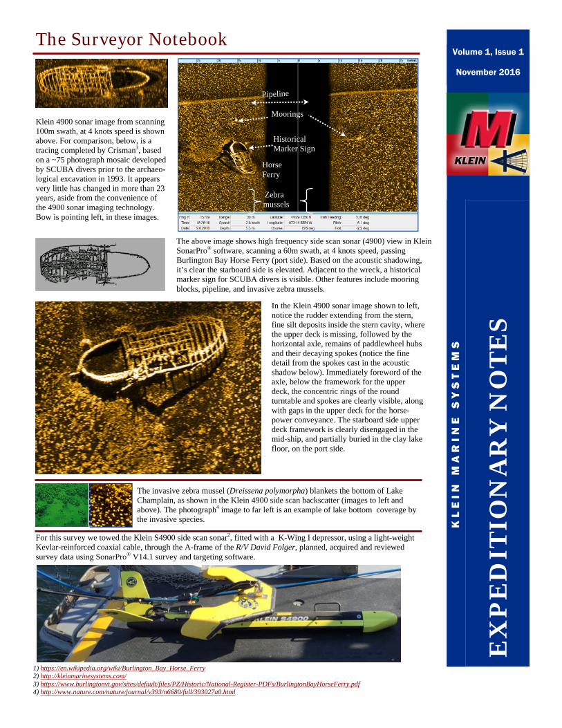
The above image shows high frequency side scan sonar (4900) view in Klein SonarPro® software, scanning a 60m swath, at 4 knots speed, passing Burlington Bay Horse Ferry (port side). Based on the acoustic shadowing, it’s clear the starboard side is elevated. Adjacent to the wreck, a historical marker sign for SCUBA divers is visible. Other features include mooring blocks, pipeline, and invasive zebra mussels.
Pipeline
Horse Ferry
Historical Marker Sign
Zebra mussels
Klein 4900 sonar image from scanning 100m swath, at 4 knots speed is shown above. For comparison, below, is a tracing completed by Crisman3, based on a ~75 photograph mosaic developed by SCUBA divers prior to the archaeo-logical excavation in 1993. It appears very little has changed in more than 23 years, aside from the convenience of the 4900 sonar imaging technology. Bow is pointing left, in these images.
1) https://en.wikipedia.org/wiki/Burlington_Bay_Horse_Ferry 2) http://kleinmarinesystems.com/
3) https://www.burlingtonvt.gov/sites/default/files/PZ/Historic/National-Register-PDFs/BurlingtonBayHorseFerry.pdf 4) http://www.nature.com/nature/journal/v393/n6680/full/393027a0.html
In the Klein 4900 sonar image shown to left, notice the rudder extending from the stern, fine silt deposits inside the stern cavity, where the upper deck is missing, followed by the horizontal axle, remains of paddlewheel hubs and their decaying spokes (notice the fine detail from the spokes cast in the acoustic shadow below). Immediately foreword of the axle, below the framework for the upper deck, the concentric rings of the round turntable and spokes are clearly visible, along with gaps in the upper deck for the horse-power conveyance. The starboard side upper deck framework is clearly disengaged in the mid-ship, and partially buried in the clay lake floor, on the port side.
Moorings