wq_gkm-year-in-review_08-01-16.pdf -...
TRANSCRIPT

August 1, 2016
Long-term Monitoring

The Colorado Department of Public Health and Environment, San Juan Basin Health and San Juan County Public Health are monitoring surface water, sediment and aquatic life in the Upper Animas River basin from spring 2016 (the first runoff season after the mine spill) through summer 2017 (after the second runoff season).
2
It has been a year since the Gold King Mine spill. Community partners have been working diligently to create and
implement solutions specific to the mine and the long-term health and viability of the river’s ecosystem.
Created partnerships with San Juan Basin Health and
San Juan County Public Health to engage local
agencies in monitoring the river to protect public
health.
Worked with EPA to provide reimbursement (pass-
through EPA money) for those affected by the GKM
spill. This includes Silverton, San Juan County, La
Plata County and San Juan Basin Health.
All WQCD post-spill water quality data checked for
quality assurance and quality control and sent to
EPA's WQX/STORET database for public consumption.
Facilitated a joint funding agreement with US
Geological Survey to rent, install and operate four
stream gages in the Upper Animas, including
telemetry to feed live data to the USGS website.
Hosted a meeting in Durango that inspired the multi-
jurisdictional Preparedness Plan for the Upper
Animas and San Juan rivers.
Established a Colorado long-term monitoring plan to
collect water quality and sediment data during spring
runoff in 2016 and 2017 as well as low-flow monthly
samples in between. Included training event.
Worked with EPA management and local stakeholders to
reach consensus on the potential listing of a NPL site for
portions of the Upper Animas basin near Silverton, San
Juan County, Colorado.
Supported EPA remedial investigation and community
outreach efforts for the proposed Bonita Peak NPL site.
Established CO Interim Alert Notification Thresholds for
Cement Creek and Animas River.
Provided free OSHA 24-Hour Health and Safety training for
residents in Durango (18) and Silverton (14).
Continue working with the local communities to keep
apprised of what is happening at the proposed Bonita Peak
NPL site and what is forthcoming.

The Colorado Department of Public Health and Environment, San Juan Basin Health and San Juan County Public Health are monitoring surface water, sediment and aquatic life in the Upper Animas River basin from spring 2016 (the first runoff season after the mine spill) through
summer 2017 (after the second runoff season).
The key objective is to monitor water quality conditions in the Upper Animas River basin to assess risks to public health and the environment using a combination of instantaneous field measurements and samples that are analyzed in a laboratory. Sampling measures the concentration of metals in river water or in river sediment. It’s a snapshot of water quality and sediment quality at a point in time and space. Samples are taken at
four locations, once a week.
At the same time, we have continuous monitoring of water quality at three locations. These monitoring stations don’t directly measure metals, but they report indicators of metals contamination 24 hours a day. We use a mathematical relationship to estimate metals concentrations at any given time from these continuous
monitoring results.
Continuous monitoring this spring has given us more information than we’ve ever had to understand how this river system works. We see a river that has metals contamination in various forms, and whose water quality during the spring is impacted by how much snowmelt is
entering the river.
2
3
During the Gold King Mine spill, water quality in Cement Creek exhibited characteristics of acid mine drainage such as very low pH and high concentrations of dissolved metals. As the acidic water flowed from the Gold King Mine adit into Cement Creek, the surge of water eroded additional contaminants and sediments from the streambed and banks. The spill and subsequent erosion created a plume of metals and sediment that transported total metals and sediment downstream to
the Animas River.
Metal ions are highly reactive, they seek to bind or attach to other charged surfaces present in the plume, such as eroded sediment particles. Once the dissolved metal ions attached to these sediments, they formed particles that remained suspended in the water column. Discoloration of the creek occurred as unseen dissolved metals were transformed into visible suspended solids. Due to extremely low pH levels, very little deposition of
solids occurred in lower Cement Creek.
However, as Cement Creek entered the Animas River, higher pH levels in the river caused the dissolved and visible suspended metal solids to precipitate to and settle on the bottom of the river. Heavy deposition occurred below Silverton and downstream to the Bakers Bridge with less and less deposition as the spill approached the San Juan River in New Mexico. The types of metals deposited differently within the Animas River. This is because chemical reactions dictate how different metals transition between liquid (dissolved), and total
phases.
Some metals, such as copper and lead, had a tendency to settle just below Silverton because of lower pH levels in the river immediately below the confluence of Cement Creek and the Animas River, but other metals, such as zinc, had a tendency to settle further downstream, where pH levels were much higher. Cement Creek continues to discolor the Animas River due to iron and aluminum oxides that form once the acidic levels of Cement Creek are neutralized by the
Animas River.
The key objectives of the Long-Term Monitoring Plan are to monitor water quality conditions in the Upper Animas River basin to assess risks to public health and the environment using a combination of instantaneous field measurements
and grab samples that are analyzed in a laboratory.
The time-series graphs presented in each section of this report illustrate concentrations of six dissolved metals across time, at four sites currently monitored in the Upper Animas River basin. Brief summaries are included to detail how recent dissolved metals concentrations compare to those conditions prior to and immediately after the spill, as well as to characterize how those dissolved concentrations
relate to streamflow and pH levels.
The Gold King Mine is located north of Silverton, Colorado on Cement Creek in the Upper Animas River Basin. The Upper Animas River Basin is a heavily mineralized area which for thousands of years has produced acidic runoff as the area’s heavy metals reacted to atmospheric conditions such as air and water.
The basin was also mined for metals like gold and silver from the 1870s to the mid-1990s, exposing even more of the mineralized rock. This exposure increased the heavy metals and acidity reaching surface water and sediments, known as acid mine drainage.
The most common heavy metals associated with acid mine drainage in the basin are zinc, copper, lead, aluminum, iron, and manganese, with lesser amounts of other metals.
Risks to the public and environment are generally measured by comparing dissolved metals concentrations to acceptable recreational screening levels or state-level water quality standards. Metals concentrations can be expressed as total or dissolved. Dissolved metals are considered the most toxic form of metals for fish and aquatic insects. Dissolved metals are in the liquid portion of the river and total metals are particles suspended in the water. Metals concentrations in water can switch between total and dissolved based on fluctuating pH
levels and other environmental factors.

6
The Long-Term Monitoring Plan includes four monitoring locations
where water quality samples and instantaneous field measurements
were collected on a set schedule throughout the 2016 spring runoff
season. Additional monitoring will continue into late summer and
fall/winter but at a reduced frequency. Monitoring locations were
selected based on the availability of historical water quality data
and/or were sampled immediately after the spill. These locations
allow the state to compare current water quality conditions to
historic conditions and derive conclusions that can be used to inform
past, present and future risks to public health and the environment.
Three of four monitoring locations (*) were deliberately selected near
U.S. Geological Survey (USGS) flow gages. The three USGS gages were
equipped to capture instantaneous field measurements at 15-minute
increments. The field measurements are temperature, pH, specific
conductance and turbidity. Readouts are electronically transmitted to
the National Water Information System and displayed graphically on a
web interface. URLs to these pages are provided on the independent
sampling data page in this report.
A field measurement exceeding established alert notification
thresholds will activate additional sampling at the location where the
threshold was exceeded. If additional sampling confirms that the
alert notification threshold continues to be exceeded, then an official
alert will be issued to local emergency operations.
Sampling locations
Site CEM49 – Cement Creek at mouth *
Site 82 – Animas River near Silverton *
Site 81 – Animas River at Baker’s
Bridge
Site 9423A – Animas River at 9th
Street Bridge in Durango *
4
Water quality monitoring conducted between October 2015 and March 2016 indicated the highest concentrations of
dissolved metals occurred during periods of low flow. These low-flow conditions, combined with old mines leaking
acid mine drainage from headwater tributaries, were favorable to lower pH levels, which transformed metals in
deposited solids to the dissolved phase. Dissolved concentrations during low-flow were generally within the historical
range of metals concentrations prior to the spill, although some metals, such as zinc, were more persistent in the
dissolved phase in Cement Creek and the Animas River near Silverton, chiefly because zinc had a tendency to settle
further downstream in high pH waters.
Water quality monitoring during the 2016 spring runoff indicates that overall dissolved metals concentrations
decreased and suspended particulates increased with higher flows.
Measurements of flow and specific conductance at three U.S. Geological Survey (USGS) gages along Cement Creek and
the Animas River confirm these findings. Real-time monitoring points to an inverse relationship between river flow
(discharge) and specific conductance, which is the measure of how well water can conduct an electrical current. As
flows increased, conductivity decreased due to decreasing amounts and mobility of dissolved metals ions. Further
supporting these findings, measurements of turbidity (the cloudiness of the river), at the same gages generally
indicated a positive relationship between flow and turbidity. As flows increased or intermittently spiked on warmer
days, turbidity would increase. This relationship corresponds to suspended particulates during agitation of riverbed
sediments.
Weekly sampling of water chemistry and sediment continued through July 2016 and transitions to bi-monthly sampling
until spring 2017. Real-time monitoring of flow, temperature, turbidity and pH will continue on a daily basis at the
three USGS gages. All water quality data will be analyzed throughout the duration of Colorado’s Long-Term Monitoring
Plan to identify changes in water and sediment quality as well as to distinguish when metals concentrations pose a
threat to the public and the environment. Based on previous water quality observations in the Upper Animas River
basin, we anticipate that as flows and pH levels decrease in late summer and fall, deposited metals solids will be re-
mobilized to the dissolved phase, meaning an increase in dissolved metals concentrations.
Elements: Aluminum, Copper, Iron, Lead, Manganese, Zinc These elements were selected because
most are considered to be heavy metals
which can be toxic to humans, livestock,
wildlife and aquatic life. Although lead is
considered a trace metal and not a heavy
metal, it is important to recognize because
it poses potential health risks from short-
term or long-term exposure.

5

6
Site CEM49 is located in the upper Animas watershed on Cement Creek just
above the confluence with the Animas River. It is located approximately one
-half mile downstream of USGS gage 09358550. CEM49 has been monitored
since 1991 and was sampled shortly after the Gold King Mine spill. Data
collected at this location represents cumulative water quality conditions
throughout the Cement Creek sub-basin.
Alert notification - The alert notification threshold at this site is 1465 µs/cm
specific conductance. Specific conductance readings at USGS gage 09358550
have not exceeded the threshold during spring runoff.
Trend analysis over time at this site indicates that the dissolved metals
concentrations have returned to pre-spill conditions during spring runoff.
Data results indicate that dissolved and suspended particulate metals are
both present at this site. However, because pH levels have increased during
runoff, the solid form of metals that deposited onto the sediments of
Cement Creek have remained relatively unchanged, thus contributing to the
persistent orange color of the sediment. It is anticipated that when spring
runoff declines, pH levels will decrease, resulting in chemical transformation
into the more dissolved form.
5/3/
2016
4/10
/201
4
4/6/
2011
4/10
/200
8
3/15
/200
6
11/1
0/20
04
6/2/
2003
9/5/
2001
10/1
4/19
99
8/29
/199
7
9/5/
1991
25000
20000
15000
10000
5000
0
Date
Alu
min
um
, D
isso
lved
(u
g/l
)
Temporal Trend - Cement Creek at Silverton
Dissolved aluminum contributed approximately 13 percent of the dissolved major metals during the spill.1
Dissolved aluminum concentrations are within the historic range of values found in Cement Creek prior to the spill.
Dissolved aluminum follows the historic pattern of lower concentrations during spring runoff, when flows are high and higher concentrations during low flow.
Dissolved copper contributed approximately 2.8 percent of the dissolved major metals during the spill.1
At this location, dissolved copper concentrations were slow to decrease in the months after the spill. During periods of low-flow, both the dissolved and suspended particulate concentrations remain relatively unchanged in relation to each other, but during high-flow periods, such as spring runoff, the dissolved form typically decreased while the suspended particulate increased.
Data collected in late May 2016 indicates that dissolved copper concentrations are within the historic range of values found in Cement Creek prior to the spill.
5/3/
2016
11/7
/201
2
6/3/
2008
9/15
/200
5
8/14
/200
3
9/6/
2000
10/7
/199
8
10/1
5/19
97
1/15
/199
7
11/1
5/19
95
9/5/
1991
2500
2000
1500
1000
500
0
Date
Cop
per,
Dis
solv
ed
(u
g/l
)
Temporal Trend - Cement Creek at Silverton
Detailed site data: waterdata.usgs.gov/co/nwis/uv/?site_no=09358550&agency_cd=USGS

7
Dissolved zinc contributed approximately 10 percent of the dissolved major metals during the spill.1
Dissolved zinc concentrations are within the historic range of values found in Cement Creek prior to the spill.
At this location, dissolved zinc concentrations were slow to decrease in the months after the spill. During periods of low-flow, dissolved zinc concentrations increased slightly while the suspended particulate form remained unchanged. With increased flows during spring runoff, dissolved zinc concentrations decreased while the suspended particulate form increased slightly.
Dissolved manganese contributed approximately 14 percent of the dissolved major metals during the spill.1
Dissolved manganese concentrations are within the historic range of values found in Cement Creek prior to the spill.
Much of the orange discoloration in sediment at this site is due to the oxidation of iron and manganese, which formed suspended particles and then precipitated as solids. The fact that dissolved manganese concentrations decreased could imply that most manganese concentrations remained in the deposited suspended aggregate during spring runoff, likely due to increased pH levels from higher streamflows and treatment process at the Gold King Mine adit.
Dissolved lead contributed a small fraction to the dissolved trace metals makeup during the spill.
Dissolved lead concentrations are within the historic range of values found in Cement Creek prior to the spill.
Lead attaches to other particulates and is deposited when pH is low. It may be able to re-dissolve during periods of low-flow and low pH.
Dissolved iron contributed approximately 61 percent of the dissolved major metals during the spill.1
Dissolved iron concentrations are within the historic range of values found in Cement Creek prior to the spill.
Much of the orange discoloration in sediment at this site is due to the oxidation of iron and manganese, which form suspended particulates and then precipitate as solids. The fact that dissolved iron concentrations decreased could mean that most iron remained in the solid form during spring runoff, likely due to increased pH levels from higher streamflows and the treatment process at the Gold King Mine adit.
4/10
/201
3
11/7
/200
8
12/2
0/20
05
10/4
/200
3
12/6
/200
0
11/1
8/19
98
11/2
6/19
97
2/25
/199
7
3/20
/199
6
9/5/
1991
30000
25000
20000
15000
10000
5000
0
Date
Iron
, D
isso
lved
(u
g/l
)Temporal Trend - Cement Creek at Silverton
5/26
/201
6
6/5/
2013
3/4/
2009
2/8/
2006
5/5/
2004
8/1/
2001
2/24
/199
9
11/1
2/19
97
10/2
3/19
96
10/1
1/19
95
9/5/
1991
80
70
60
50
40
30
20
10
0
Date
Lead
, D
isso
lved
(u
g/l
)
Temporal Trend - Cement Creek at Silverton
6/1/
2016
4/10
/201
3
10/6
/200
8
11/2
/200
5
10/4
/200
3
2/6/
2001
1/13
/199
9
12/1
7/19
97
3/5/
1997
2/14
/199
6
9/5/
1991
12000
10000
8000
6000
4000
2000
0
Date
Man
gan
ese
, D
isso
lved
(u
g/l
)
Temporal Trend - Cement Creek at Silverton
5/26
/201
6
2/7/
2013
9/3/
2008
10/1
3/20
05
10/4
/200
3
1/3/
2001
11/1
8/19
98
11/2
6/19
97
1/15
/199
7
9/13
/199
5
9/5/
1991
9000
8000
7000
6000
5000
4000
3000
2000
1000
0
Date
Zin
c,
Dis
solv
ed
(u
g/l
)
Temporal Trend - Cement Creek at Silverton
1. US EPA Gold King Mine Team. “Gold King Mine Release—Analysis of Fate and Transport in the Animas and San Juan Rivers.” National Exposure Research Lab/ORD. 12 June 2016. Powerpoint presentation.

Site 82 is located on the Animas River in the upper watershed below the
confluence with Mineral Creek. It is located approximately one-half mile
downstream of the town of Silverton and is near USGS gage 09359020. Site
82 is a CDPHE Water Quality Control Division trend site and has been
monitored since 1988. It was sampled shortly after the spill. Data collected
at this location is representative of cumulative water quality conditions
flowing from the Bonita Peaks Mining District.
Alert notification - The alert notification threshold at this site is pH 5.3. pH
readings at USGS gage 09359020 have not exceeded the threshold during
spring runoff.
Trend analysis over time at this site indicates that dissolved metals
concentrations have returned to pre-spill conditions during spring runoff.
EPA indicated that the majority of the spill metals deposited just upstream
of this location due to low pH waters from Cement Creek commingling with
high pH waters of the Animas River. Data results indicate that dissolved and
suspended particulate can both co-exist at this site. However, due to
relatively unchanged pH levels during the spring runoff most of the total
metal load is presently either in suspended particulate or solid phases.
8
Dissolved aluminum concentrations during the 2015-16 low flow period were lower than concentrations seen in previous low flow periods prior to the spill.
Dissolved aluminum concentrations are within the historic range of values found in the Animas River prior to the spill.
Dissolved aluminum follows the historic pattern of lower concentrations during spring runoff, when flows are high, and higher concentrations during low flow.
Dissolved copper concentrations are within the historic range of values found in the Animas River prior to the spill.
Data indicates that most of the copper concentrations at this site are in the dissolved or suspended particulate form since most copper load settled with lower pH conditions in Cement Creek.
4/10
/201
5
2/7/
2013
8/12
/200
9
11/1
/200
6
7/6/
2005
5/28
/200
4
3/9/
2003
5/16
/200
1
5/20
/199
9
5/22
/199
6
12000
10000
8000
6000
4000
2000
0
Date
Alu
min
um
, D
isso
lved
(u
g/l
)
Temporal Trend - Animas River near Silverton
5/3/
2016
6/6/
2014
7/18
/201
1
10/4
/200
7
11/2
/200
5
7/7/
2004
4/24
/200
3
10/4
/200
0
2/13
/199
8
8/19
/199
2
6/9/
1988
1400
1200
1000
800
600
400
200
0
Date
Cop
per,
Dis
solv
ed
(u
g/l
)
Temporal Trend - Animas River near Silverton
Detailed site data: waterdata.usgs.gov/co/nwis/uv/?site_no=09359020&agency_cd=USGS

9
Dissolved zinc concentrations are within the historic range of values found in the Animas River prior to the spill.
Dissolved zinc follows the historic pattern of lower concentrations during spring runoff, when the flows are high, and higher concentrations during low flow.
Dissolved zinc attaches to adjacent particles when pH is high and is deposited near this site. Due to higher pH levels, zinc has remained in the solid form but will mobilize to the dissolved or suspended particulate forms during lower flows and lower pH levels.
Dissolved iron concentrations at this site are representative of acid mine drainage flow from mining sources with heavy deposits of pyrite or iron sulfide.
Dissolved iron follows the historic pattern of lower concentrations during spring runoff, when flows are high, and higher concentrations during low flow.
5/3/
2016
5/1/
2014
6/30
/201
1
9/5/
2007
11/2
/200
5
7/7/
2004
4/24
/200
3
5/2/
2001
2/4/
1999
1/31
/199
7
6/9/
1988
6000
5000
4000
3000
2000
1000
0
Date
Iron
, D
isso
lved
(u
g/l
)Temporal Trend - Animas River near Silverton
Dissolved lead contributed a small fraction to the dissolved trace metals makeup during the spill.
Dissolved lead concentrations are within the historic range of values found in the Animas River prior to the spill.
Data indicates that most of the lead concentrations at this site are in the dissolved or suspended particulate form since most lead load settled in Cement Creek with lower pH conditions.
7/10
/201
5
10/8
/201
3
9/7/
2011
10/2
2/20
08
8/16
/200
6
9/15
/200
4
1/9/
2003
6/21
/199
5
10/8
/199
0
6/9/
1988
50
40
30
20
10
0
Date
Lead
, D
isso
lved
(u
g/l
)
Temporal Trend - Animas River near Silverton
Dissolved manganese concentrations are within the historic range of values found in the Animas River prior to the spill.
Much of the orange discoloration in bank-side sediment at this site is due to the oxidation of iron and manganese, which formed suspended particles and then precipitated as solids. The fact that dissolved manganese concentrations decreased could mean that most manganese concentrations remained in the solid form during spring runoff, likely due to higher pH levels. 4/
19/2
016
3/5/
2014
11/2
/201
0
5/11
/200
7
7/6/
2005
2/13
/200
4
7/3/
2002
2/2/
2000
4/8/
1998
6/15
/199
3
6/9/
1988
7000
6000
5000
4000
3000
2000
1000
0
Date
Man
gan
ese
, D
isso
lved
(u
g/l
)
Temporal Trend - Animas River near Silverton
5/3/
2016
4/10
/201
4
11/3
/201
0
5/11
/200
7
7/6/
2005
3/10
/200
4
7/23
/200
2
2/9/
2000
4/8/
1998
6/15
/199
3
6/9/
1988
4000
3000
2000
1000
0
Date
Zin
c,
Dis
solv
ed
(u
g/l
)
Temporal Trend - Animas River near Silverton

10
Site 81 is located north of Durango on the Animas River
at Baker’s Bridge. It is located just downstream of
County Road 250 in La Plata County approximately one-
quarter mile from Highway 550. Site 81 has been
monitored since 1988. It was sampled shortly after the
spill. Data collected at this location is representative of
cumulative water quality conditions to this point on the
Animas River.
Alert notification - There are presently no alert
notification thresholds for this site.
Overall, the trend analysis (over time) at this site
indicates that the metals concentrations have returned
to pre-spill conditions during spring runoff. However,
based on its location at the end of the post-spill
depositional area, some dissolved metals
concentrations, such as aluminum and iron, are increasing in relation to concentrations measured during pre-runoff.
This is because aluminum and iron are associated with most of the sediment deposition after the spill and their
concentrations are elevating with increased streamflow as well as suspended particulates. Because of this spatial
proximity downstream of the spill depositional area near the Town of Silverton; this location will be consistently
prone to some higher dissolved metals during periods of high flow.
Dissolved aluminum concentrations decreased substantially during the months following the spill, but have since increased during spring runoff. This is because aluminum is typically associated with suspended sediment concentrations. As increased streamflows churn up sediment, the dissolved aluminum concentrations will increase accordingly.
Spring runoff dissolved aluminum concentrations are above the historic range of values found in the Animas River prior to the spill.
Dissolved copper concentrations are within the historic range of values found in the Animas River prior to the spill.
Data indicates that most of the copper concentrations at this site are in the dissolved or suspended particulate form since most copper load settled in Cement Creek with lower pH conditions.
8/12
/201
5
10/2
/201
4
4/10
/201
3
8/1/
2011
8/12
/200
9
2/11
/200
8
7/10
/200
6
2/15
/200
5
7/14
/200
3
11/2
/199
6
1400
1200
1000
800
600
400
200
0
Date
Alu
min
um
, D
isso
lved
(u
g/l
)
Temporal Trend - Animas River at Bakers Bridge
5/19
/201
6
4/10
/201
4
12/7
/201
0
11/1
2/20
07
1/11
/200
5
5/22
/199
8
3/13
/199
7
8/10
/199
5
5/19
/199
4
1/28
/199
3
5/30
/198
9
200
150
100
50
0
Date
Cop
per,
Dis
solv
ed
(u
g/l
)
Temporal Trend - Animas River at Bakers Bridge
11
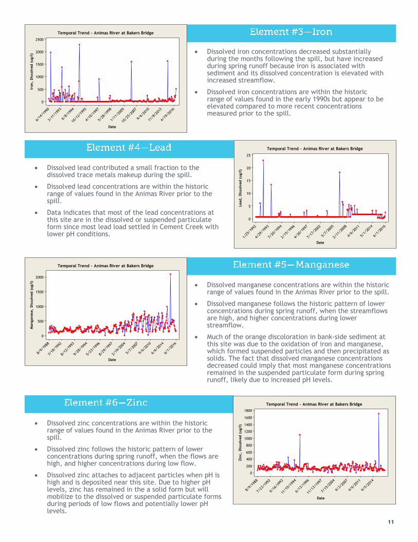
Dissolved zinc concentrations are within the historic range of values found in the Animas River prior to the spill.
Dissolved zinc follows the historic pattern of lower concentrations during spring runoff, when the flows are high, and higher concentrations during low flow.
Dissolved zinc attaches to adjacent particles when pH is high and is deposited near this site. Due to higher pH levels, zinc has remained in the a solid form but will mobilize to the dissolved or suspended particulate forms during periods of low flows and potentially lower pH levels.
Dissolved manganese concentrations are within the historic range of values found in the Animas River prior to the spill.
Dissolved manganese follows the historic pattern of lower concentrations during spring runoff, when the streamflows are high, and higher concentrations during lower streamflow.
Much of the orange discoloration in bank-side sediment at this site was due to the oxidation of iron and manganese, which formed suspended particles and then precipitated as solids. The fact that dissolved manganese concentrations decreased could imply that most manganese concentrations remained in the suspended particulate form during spring runoff, likely due to increased pH levels.
Dissolved lead contributed a small fraction to the dissolved trace metals makeup during the spill.
Dissolved lead concentrations are within the historic range of values found in the Animas River prior to the spill.
Data indicates that most of the lead concentrations at this site are in the dissolved or suspended particulate form since most lead load settled in Cement Creek with lower pH conditions.
Dissolved iron concentrations decreased substantially during the months following the spill, but have increased during spring runoff because iron is associated with sediment and its dissolved concentration is elevated with increased streamflow.
Dissolved iron concentrations are within the historic range of values found in the early 1990s but appear to be elevated compared to more recent concentrations measured prior to the spill.
4/19
/201
6
11/8
/201
3
9/6/
2010
10/2
5/20
07
1/11
/200
5
5/28
/199
8
4/10
/199
7
10/1
2/19
95
6/8/
1994
3/11
/199
3
6/14
/199
0
2500
2000
1500
1000
500
0
Date
Iron
, D
isso
lved
(u
g/l
)Temporal Trend - Animas River at Bakers Bridge
6/1/
2016
5/1/
2014
4/6/
2011
2/11
/200
8
5/7/
2005
7/17
/200
2
4/30
/199
7
2/15
/199
6
7/20
/199
4
4/29
/199
3
1/25
/199
2
25
20
15
10
5
0
DateLead
, D
isso
lved
(u
g/l
)
Temporal Trend - Animas River at Bakers Bridge
6/1/
2016
6/6/
2014
9/6/
2010
5/7/
2007
3/19
/200
4
8/29
/199
7
5/23
/199
6
9/28
/199
4
8/12
/199
3
7/18
/199
2
8/9/
1988
2000
1500
1000
500
0
Date
Man
gan
ese
, D
isso
lved
(u
g/l
)
Temporal Trend - Animas River at Bakers Bridge
9/5/
2014
4/6/
2011
9/3/
2007
7/15
/200
4
11/1
3/19
97
6/13
/199
6
11/1
0/19
94
9/16
/199
3
7/23
/199
2
8/9/
1988
1800
1600
1400
1200
1000
800
600
400
200
0
Date
Zin
c,
Dis
solv
ed
(u
g/l
)
Temporal Trend - Animas River at Bakers Bridge

12
Site 9423A is located on the Animas River just above
the 9th Street Bridge. It is located approximately one-
half mile downstream of USGS gage 09361500. Site
9423A was not monitored prior to the spill but has
been monitored since. Data collected at this location
is representative of cumulative water quality
conditions to this point on the Animas River.
Alert notification - There are presently no alert
notification thresholds for this site.
Water quality data collected from this site was
combined with similar data from Rotary Park in
Durango to bolster the overall dataset bracketing
USGS gage 09361500. The results indicate that
dissolved metals concentrations generally decreased
during lower streamflows but have increased during
spring runoff due to higher streamflows. This pattern
suggests that deposited metals further upstream between Silverton and Baker’s Bridge are mobilizing into the
dissolved or suspended particulate forms when streamflow increases.
Dissolved aluminum concentrations decreased substantially during the months following the spill, but have increased during spring runoff because aluminum is associated with sediment and its dissolved concentration is elevated with increased streamflow.
It is anticipated that dissolved aluminum concentrations will diminish with decreased streamflow.
Dissolved copper concentrations decreased during the months following the spill, but have increased with increased streamflow.
Recent data indicates that dissolved copper concentrations will continue to slightly increase during the peak runoff but will decrease during the remainder of the year.
Suspended particulate concentrations of copper will significantly increase during spring runoff and diminish during low streamflow.
6/1/
2016
5/11
/201
6
4/19
/201
6
4/8/
2016
3/29
/201
6
3/15
/201
6
10/2
7/20
15
8/13
/201
5
8/7/
2015
8/6/
2015
900
800
700
600
500
400
300
200
100
0
Date
Alu
min
um
, D
isso
lved
(u
g/l
)
Temporal Trend - Animas River at Durango
6/1/
2016
5/11
/201
6
4/19
/201
6
4/8/
2016
3/29
/201
6
3/24
/201
6
3/1/
2016
10/2
7/20
15
8/7/
2015
8/6/
2015
16
14
12
10
8
6
4
2
0
Date
Cop
per,
Dis
solv
ed
(u
g/l
)
Temporal Trend - Animas River at Durango
Detailed site data: waterdata.usgs.gov/co/nwis/uv/?site_no=09361500&agency_cd=USGS

13
During periods of high streamflow dissolved zinc concentrations will decrease while suspended particulate will increase.
The irregular pattern shown in the graph indicates that dissolved zinc will fluctuate in concentration based on variations in streamflow. This could be due to zinc having settled further downstream in the Animas River after the spill and can readily transform to the dissolved form with decreased streamflow.
Dissolved manganese follows the historic pattern of lower concentrations during spring runoff, when the flows are high, and higher concentrations during low streamflow.
Dissolved lead concentrations decreased during the months following the spill, but have increased with increased streamflow.
Dissolved iron concentrations decreased and remained steady during the months following the spill, but have increased with increased streamflow because iron that deposited further upstream are readily converting to the dissolved form.
5/19
/201
6
4/26
/201
6
4/12
/201
6
4/4/
2016
3/24
/201
6
2/15
/201
6
8/7/
2015
8/6/
2015
2500
2000
1500
1000
500
0
Date
Iron
, D
isso
lved
(u
g/l
)Temporal Trend - Animas River at Durango
5/19
/201
6
4/26
/201
6
4/12
/201
6
4/4/
2016
3/24
/201
6
2/15
/201
6
8/13
/201
5
8/7/
2015
8/6/
2015
18
16
14
12
10
8
6
4
2
0
Date
Lead
, D
isso
lved
(u
g/l
)
Temporal Trend - Animas River at Durango
5/19
/201
6
4/26
/201
6
4/12
/201
6
4/4/
2016
3/24
/201
6
3/15
/201
6
10/2
7/20
15
8/13
/201
5
8/7/
2015
8/6/
2015
700
600
500
400
300
200
100
0
Date
Man
gan
ese
, D
isso
lved
(u
g/l
)
Temporal Trend - Animas River at Durango
5/19
/201
6
4/26
/201
6
4/12
/201
6
4/4/
2016
3/24
/201
6
3/15
/201
6
10/2
7/20
15
8/13
/201
5
8/7/
2015
8/6/
2015
140
120
100
80
60
40
20
0
Date
Zin
c,
Dis
solv
ed
(u
g/l
)
Temporal Trend - Animas River at Durango

6
14
Abandoned Mines
Information Hub
The Water Quality Control Division contracted with
the Colorado Geological Survey to create an online
information hub about abandoned mines in Colorado.
The information hub will use existing abandoned mine
inventories to help interested people identify a mine
or mines and direct them where to get more
information about safety, mine reclamation or
environmental issues.
Project partners include the U.S. Forest Service,
Bureau of Land Management, U.S. Environmental
Protection Agency, U.S. Department of Energy,
National Park Service, U.S. Fish and Wildlife Service,
Colorado Division of Reclamation, Mining, and Safety,
Colorado Division of Hazardous Materials and Waste
Management, and History Colorado. The project is
expected to be completed by mid 2017. Inquires about
this project can be directed to Andrew Ross -
Draining Mines Study
During the summer of 2016, the Colorado Division of
Reclamation, Mining, and Safety (DRMS) and the
Water Quality Control Division of the Colorado
Department of Public Health and Environment are
working cooperatively to investigate approximately
150 abandoned mines that are thought to be causing
water pollution.
DRMS will obtain water quality samples at the
draining mines and the WQCD will evaluate water
quality data.
The fieldwork portion of the project is expected to
be completed by November 2016 with a final report
published in early 2017. Inquires about this project
can be directed to Skip Feeney -
Future Actions
Local public health staff in Silverton and Durango are ready to take water samples on short notice during storm events if water quality monitoring suggests that metals levels are on the rise, beyond normal variability. Samples will be analyzed for
metals concentrations.
Beginning in late fall 2016, San Juan Basin Health will offer free well water testing to a limited number of Animas Valley residents. These tests will look for levels of metals, bacteria and nutrients. Everyone who drinks water from a private well should get a comprehensive well test at least once. Contact San Juan Basin Health at 970-335-2030 to set up a testing appointment, beginning in
September 2016.
Local response agencies are continually monitoring river conditions to ensure the health and safety of the community.
A local alert and notification plan was developed collaboratively by San Juan Basin Health, La Plata County, City of Durango, Southern Ute Indian Tribe, San Juan County Public Health, San Juan County Emergency Management and is supported by two state agencies including CDPHE.
This alert and notification plan relies on both community member reports and local agency observations of river conditions. The plan consists of three levels of notification: green, yellow and red, depending on the severity of the situation.
As a situation gets more serious, more agencies are notified automatically.
Green-level conditions create a notification to public health and emergency management in both San Juan and La Plata counties, and the Southern Ute Tribe.
Yellow-level conditions create an additional notification to a larger group of partner and response agencies including some at the state level, and if the condition is serious enough, officials in downstream states and tribes.
In addition to a large group of local, state and federal agencies, a red-level condition notifies the public directly with health and safety recommendations. Red-level notifications will be generated only for the most serious situations that pose an immediate health or safety risk.
We encourage the you to sign up for these notifications on La Plata County’s website through the Code Red System: www.co.laplata.co.us/emergency.

15

www.colorado.gov/cdphe/animas-river-spill [email protected] 303-692-3500
San Juan Basin Health sjbhd.org/public-health-news/animas-river-health-updates
San Juan County Public Health www.sanjuancountycolorado.us/public-health
Town of Silverton www.colorado.gov/townofsilverton
City of Durango www.durangogov.org
La Plata County www.co.laplata.co.us/emergency
Southern Ute Indian Tribe www.southernute-nsn.gov/environmental-programs/water-quality
Environmental Protection Agency www.epa.gov/goldkingmine