wos 2014 ready for printing - bobcat science - home
TRANSCRIPT
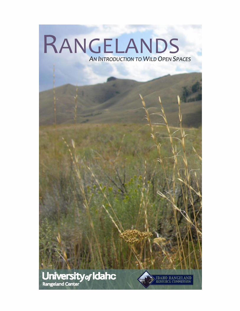
RANGELANDS AN INTRODUCTION TO WILD OPEN SPACES
2
Rangelands An Introduction to Idaho’s Wild Open Spaces
2014
Rangeland Center University of Idaho P.O. Box 441135
Moscow, ID 83844 (208) 885-6536
[email protected] www.uidaho.edu/range
Idaho Rangeland Resource Commission P. O. Box 126
Emmett, ID 83617 (208) 398-7002
[email protected] www.idahorange.org
The University of Idaho Rangeland Center and the Idaho Rangeland Resource Commission are mutually dedicated to fostering the understanding and sustainable stewardship of Idaho’s vast rangeland landscapes by providing science-based educational resources about rangeland ecology and management.
Many people are credited with writing, editing, and developing this handbook, including: Lovina Roselle, Karen Launchbaugh, Tess Jones, Ling Babcock, Richard Ambrosek, Andrea Stebleton, Tracy Brewer, Ken Sanders, Jodie Mink, Jenifer Haley, Gretchen Hyde, and Joan Jones.
3
TableofContents
Rangelands Overview .................................................................................................................................... 4
Rangeland Plants ......................................................................................................................................... 19
Rangeland Animals ...................................................................................................................................... 23
Describing and Monitoring Rangelands ...................................................................................................... 30
Forces of Ecological Change ........................................................................................................................ 39
Glossary of Rangeland Terms ...................................................................................................................... 50
4
RangelandsOverview
What are Rangelands?
How Much Rangeland Is There?
Rangelands of the World
Rangeland Regions of North America
Rangeland Vegetation Types of North America
Mediterranean Region
Pacific Northwest
Great Basin
Southwest Desert
Great Plains
Uses and Values of Rangelands
What is Rangeland Management?
History of Rangeland Use and Ownership
Who Owns and Manages Rangelands?
References and Additional Information
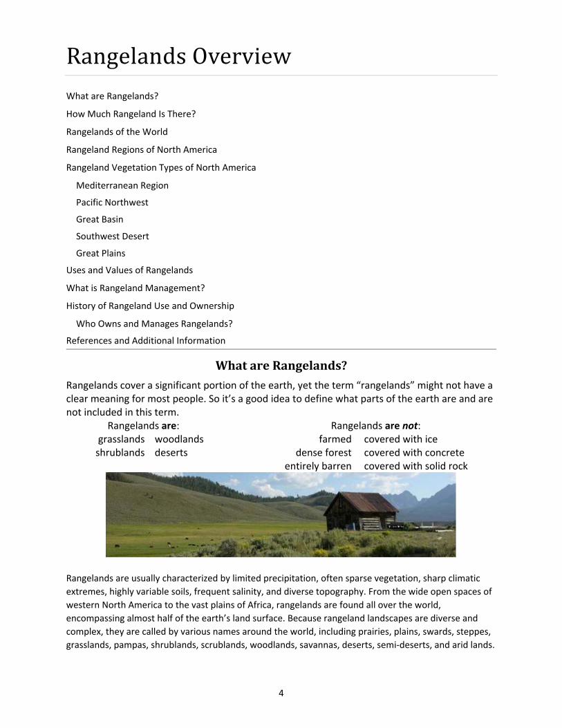
WhatareRangelands?
Rangelands cover a significant portion of the earth, yet the term “rangelands” might not have a clear meaning for most people. So it’s a good idea to define what parts of the earth are and are not included in this term.
Rangelands are: Rangelands are not: grasslands woodlands farmed covered with ice shrublands deserts dense forest covered with concrete
entirely barren covered with solid rock
Rangelands are usually characterized by limited precipitation, often sparse vegetation, sharp climatic
extremes, highly variable soils, frequent salinity, and diverse topography. From the wide open spaces of
western North America to the vast plains of Africa, rangelands are found all over the world,
encompassing almost half of the earth’s land surface. Because rangeland landscapes are diverse and
complex, they are called by various names around the world, including prairies, plains, swards, steppes,
grasslands, pampas, shrublands, scrublands, woodlands, savannas, deserts, semi‐deserts, and arid lands.

5
Grasslands are ecosystems that are dominated by grasses. Globally,
grasslands go by many names, including prairies, steppes, pampas,
swards, meadows and velds. In North America, grassland biomes
include the tallgrass prairie, shortgrass prairie,
alpine meadows, California annual grasslands,
Palouse prairie, southern mixed prairie, marshes,
wet meadows, tundra grasslands, and desert
grasslands.
Shrublands are dominated by shrubs, with an
understory of grasses and herbaceous plants.
Shrublands across the world are called
chaparrals, cerrados, shrub‐steppe, maquis, and
scrublands. In North America, shrubland biomes
include chaparrals, sagebrush‐steppes, salt‐
desert shrublands, tundra shrublands, and
mountain browse.
Woodlands and Savannas are dominated by
widely‐spaced trees including junipers, oaks,
mesquite and pines with an understory of grasses
and forbs. Woodland ecosystems across the
world take the names of the trees that dominate
the landscape. In North America, the largest
woodland biome is the pinyon‐juniper
woodland. Other woodland and savanna ecosystems include oak
woodlands, aspen savannas, and mesquite woodlands.
Deserts are the driest rangelands and experience
extreme water shortages and unpredictable
precipitation. These ecosystems are dominated by
shrubs and succulent cactus plants. Deserts and
arid lands in the world cover massive areas and
include the Sahara, Namib, Arabian, Atacama,
Australian Outback, and Kalahari deserts. The hot
desert biomes in North America are found in the
southwest and include the Mojave, Sonoran, and
Chihuahuan deserts.
All photos on this page are courtesy of K. Launchbaugh and J. Peterson
6
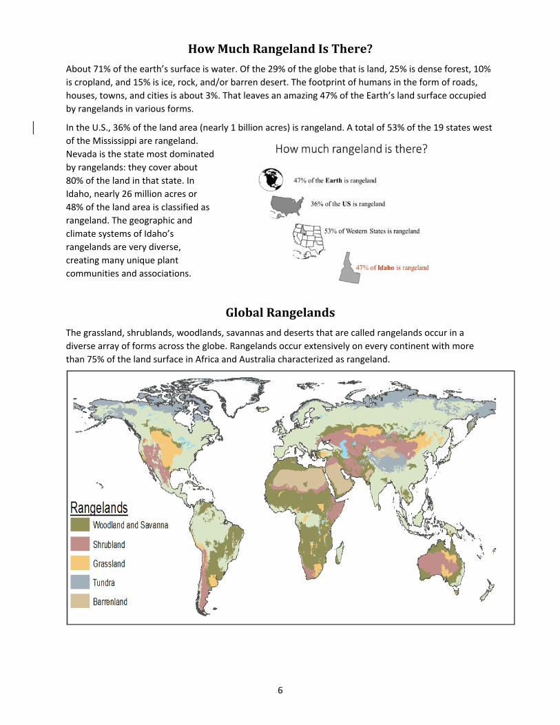
HowMuchRangelandIsThere?
About 71% of the earth’s surface is water. Of the 29% of the globe that is land, 25% is dense forest, 10%
is cropland, and 15% is ice, rock, and/or barren desert. The footprint of humans in the form of roads,
houses, towns, and cities is about 3%. That leaves an amazing 47% of the Earth’s land surface occupied
by rangelands in various forms.
In the U.S., 36% of the land area (nearly 1 billion acres) is rangeland. A total of 53% of the 19 states west
of the Mississippi are rangeland.
Nevada is the state most dominated
by rangelands: they cover about
80% of the land in that state. In
Idaho, nearly 26 million acres or
48% of the land area is classified as
rangeland. The geographic and
climate systems of Idaho’s
rangelands are very diverse,
creating many unique plant
communities and associations.
GlobalRangelands
The grassland, shrublands, woodlands, savannas and deserts that are called rangelands occur in a
diverse array of forms across the globe. Rangelands occur extensively on every continent with more
than 75% of the land surface in Africa and Australia characterized as rangeland.

7
RangelandRegionsofNorthAmerica
The rangelands of the continental United States occur in roughly five geographic zones that vary in
topography, climate, and soil type. On the southwest coast, along the Pacific Ocean, is the
Mediterranean Region, with a climate similar to the lands that surround the Mediterranean Sea
between southern Europe and northern Africa. A Mediterranean climate is characterized by hot, dry
summers, and mild, wet, cool winters. More than 90% of the annual precipitation in this region occurs
during the winter months. In the northwest corner of the United States is a region also heavily
influenced by the Pacific Ocean: known as the Pacific Northwest, it is characterized by cool, dry
summers and cool, wet winters. The Pacific climate is very similar to the Mediterranean region but with
greater precipitation and slightly wetter summers.
The Great Basin Region is (as its name suggests) a large dish or basin. It is bound by two mountain
ranges: the Rockies on the east and the Sierra Nevadas on the west. Nearly all the moisture that falls in
the region does not flow to an ocean; rather, it settles in lowlands throughout the basin. As water
accumulates in the lower flat valleys, the moisture
evaporates, leaving areas with salty (and often
alkaline) soils. For example, the Great Salt Lake is a
large lake that accumulates water and soil salts that
never flow to the ocean. The climate of this region is
strongly influenced by the Pacific Ocean, so it shares
the cool, wet winters and dry summers of the
Mediterranean and Pacific Climates. However, the
Sierra Nevada Mountains intercept moisture heading
east from the Pacific Ocean, creating a dry area on the
east or leeward side of the mountains. This effect is
known as a “rain shadow.” Because the Great Basin is
set in this rain shadow, it receives very limited
precipitation, just 8 to 20 inches per year in most
areas.
The Southwestern Desert Region includes the Mojave, Sonoran, and Chihuahuan deserts. These deserts
are collectively known as the “hot deserts” because they are characterized by hot, dry summers and
warm winters. Most areas of the region receive less than 15 inches of rain per year: some areas receive
rain only once every few years. The Southwest Desert Region experiences a monsoon season of rains
from July through September. After a dry spring and early summer, the prevailing winds change from
western to southerly, bringing moisture in from the Pacific Ocean and Gulf Coast. This leads to almost
daily thundershowers which may occur in one location while an area a short distance away is left dry.
East of the Rocky Mountains is the Great Plains Region: vast flat or rolling landscapes that fall away from
the mountains and stretch to the Mississippi River. The Rocky Mountains intercept moisture from the
Pacific Ocean and create a strong rain shadow such that the driest part of the Great Plains is directly east
of the Rockies. The amount of annual precipitation increases from west to east across the Great Plains so
that areas receiving the most annual precipitation are near the Mississippi. Moisture in the Great Plains
materializes largely during the spring and summer.

8
RangelandVegetationTypesofNorthAmerica
The grasslands, shrublands,
woodlands, and deserts that
dominate North American
landscapes take many different
forms. Each of the five rangeland
regions in North America has
characteristic vegetation adapted
to its unique combination of soils
and climate.
A. W. Kuchler, an American
geographer and naturalist, is
recognized as having produced
one of the first reliable maps of
vegetation in the continental
United States. Kuchler produced
his map by looking at existing
maps and photos and by visiting
many sites across the country: his
work is still widely used today.
However, most modern vegetation
maps are created by remote sensing
technology that takes pictures and collects light waves using cameras mounted on satellites orbiting the
earth.
MediterraneanRegion
Annual Grasslands Before European
settlement, the annual grassland region in
California was a bunchgrass prairie dominated
by needlegrasses. Exotic annual plants such as
cheatgrass and medusahead were accidentally
introduced at a time when heavy grazing was
occurring in an effort to produce meat to feed
miners of the gold rush and homestead era.
These plants were well‐adapted to California’s
Mediterranean climate. The region was quickly
converted from perennial bunchgrasses to
annual plants. Nearly all of the range plants in
unfarmed areas of this region today are annuals and exotics.
The region is characterized by mild wet winters and long dry summers. Annual precipitation varies
greatly from 30 or more inches near the ocean to as little as 8 inches in the foothills of the Sierra Nevada
Mountains. Soils range from prairies soils (called mollisols) to desert soils (called aridisols). Many of
these soils are excellent for farming. More than half of the region today is now farmed and is important
for truck crops such as tomatoes, almonds, grapes, strawberries, apricots, and asparagus.
Simplified map of major rangeland vegetation types based on
A.W. Kuchler’s Potential Natural Vegetation (K. Launchbaugh).
9
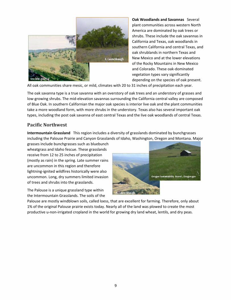
Oak Woodlands and Savannas Several
plant communities across western North
America are dominated by oak trees or
shrubs. These include the oak savannas in
California and Texas, oak woodlands in
southern California and central Texas, and
oak shrublands in northern Texas and
New Mexico and at the lower elevations
of the Rocky Mountains in New Mexico
and Colorado. These oak‐dominated
vegetation types vary significantly
depending on the species of oak present.
All oak communities share mesic, or mild, climates with 20 to 31 inches of precipitation each year.
The oak savanna type is a true savanna with an overstory of oak trees and an understory of grasses and
low‐growing shrubs. The mid‐elevation savannas surrounding the California central valley are composed
of Blue Oak. In southern Californian the major oak species is interior live oak and the plant communities
take a more woodland form, with more shrubs in the understory. Texas also has several important oak
types, including the post oak savanna of east central Texas and the live oak woodlands of central Texas.
PacificNorthwest
Intermountain Grassland This region includes a diversity of grasslands dominated by bunchgrasses
including the Palouse Prairie and Canyon Grasslands of Idaho, Washington, Oregon and Montana. Major
grasses include bunchgrasses such as bluebunch
wheatgrass and Idaho fescue. These grasslands
receive from 12 to 25 inches of precipitation
(mostly as rain) in the spring. Late summer rains
are uncommon in this region and therefore
lightning‐ignited wildfires historically were also
uncommon. Long, dry summers limited invasion
of trees and shrubs into the grasslands.
The Palouse is a unique grassland type within
the Intermountain Grasslands. The soils of the
Palouse are mostly windblown soils, called loess, that are excellent for farming. Therefore, only about
1% of the original Palouse prairie exists today. Nearly all of the land was plowed to create the most
productive u‐non‐irrigated cropland in the world for growing dry land wheat, lentils, and dry peas.
10
GreatBasin
Sagebrush Steppe The sagebrush steppe is one of the most extensive range types in western North
America. The term “steppe” refers to
dry grassland and treeless regions.
Therefore, the sagebrush steppe is a
region with an overstory of shrubs,
mostly sagebrush and rabbit brush,
and abundant stands of bunchgrasses,
mostly bluebunch wheatgrass, Idaho
fescue, and Sandberg bluegrass,
between the shrubs. There are about
20 different species of sagebrush
found in the sagebrush steppe,
though big sagebrush is by far the
most common.
The sagebrush steppe has a semiarid climate, with 8 to 20 inches of precipitation per year, characterized
by wet springs and long dry summers. Fires were historically patchy: small areas of shrubs would burn
and perennial grasses would grow for several years in the burned areas until shrubs became
reestablished. At lower elevations in the sagebrush steppe regions, invasive annual grasses have created
a fine fuel leading to more frequent, and more damaging, fires. Fires that occurred once in several
decades in the past may now occur every few years in areas where annual grasses have taken over. A
fire regime with such frequent fires has created a situation where native grasses and shrubs have
difficulty becoming reestablished between fires, and where the annual grasses now dominate some
areas. Sagebrush steppe areas at higher elevation have a different relationship with fire. On colder,
higher elevation sites, annual grasses do not grow as well and are less invasive that at lower (and
warmer) elevations. However, juniper and other evergreen plants can invade sagebrush communities. In
these regions, prescribed fire is very important to reduce evergreen trees and to allow sagebrush and
grasses to grow and dominate the sites.
Salt Desert Shrublands In the Great Basin, at level areas in the lower elevations of the landscape, salt
accumulates and supports a plant shrub community that is well adapted to dry salty soils: these are the
salt desert shrublands. This region has a very dry climate with only 3 to 10 inches of precipitation each
year. Dominant shrubs, such as
shadscale, saltbrush, and
winterfat, are mostly of the
Chenopodiaceae family. Like
most shrubs, these are nutritious
in the winter and thus important
for winter grazing by wildlife,
sheep, and cattle. Invasive annual
plants are the greatest threat to
this vegetation type.
11
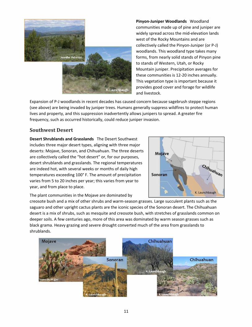
Pinyon‐Juniper Woodlands Woodland
communities made up of pine and juniper are
widely spread across the mid‐elevation lands
west of the Rocky Mountains and are
collectively called the Pinyon‐Juniper (or P‐J)
woodlands. This woodland type takes many
forms, from nearly solid stands of Pinyon pine
to stands of Western, Utah, or Rocky
Mountain juniper. Precipitation averages for
these communities is 12‐20 inches annually.
This vegetation type is important because it
provides good cover and forage for wildlife
and livestock.
Expansion of P‐J woodlands in recent decades has caused concern because sagebrush steppe regions
(see above) are being invaded by juniper trees. Humans generally suppress wildfires to protect human
lives and property, and this suppression inadvertently allows junipers to spread. A greater fire
frequency, such as occurred historically, could reduce juniper invasion.
SouthwestDesert
Desert Shrublands and Grasslands The Desert Southwest
includes three major desert types, aligning with three major
deserts: Mojave, Sonoran, and Chihuahuan. The three deserts
are collectively called the “hot desert” or, for our purposes,
desert shrublands and grasslands. The regional temperatures
are indeed hot, with several weeks or months of daily high
temperatures exceeding 100° F. The amount of precipitation
varies from 5 to 20 inches per year; this varies from year to
year, and from place to place.
The plant communities in the Mojave are dominated by
creosote bush and a mix of other shrubs and warm‐season grasses. Large succulent plants such as the
saguaro and other upright cactus plants are the iconic species of the Sonoran desert. The Chihuahuan
desert is a mix of shrubs, such as mesquite and creosote bush, with stretches of grasslands common on
deeper soils. A few centuries ago, more of this area was dominated by warm season grasses such as
black grama. Heavy grazing and severe drought converted much of the area from grasslands to
shrublands.
K. Launchbaugh
12
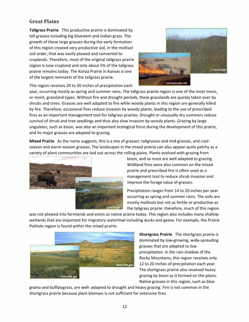
GreatPlains
Tallgrass Prairie This productive prairie is dominated by
tall grasses including big bluestem and Indian grass. The
growth of these large grasses during the early formation
of this region created very productive soil, in the mollisol
soil order, that was easily plowed and converted to
croplands. Therefore, most of the original tallgrass prairie
region is now cropland and only about 5% of the tallgrass
prairie remains today. The Konza Prairie in Kansas is one
of the largest remnants of the tallgrass prairie.
This region receives 20 to 30 inches of precipitation each
year, occurring mostly as spring and summer rains. The tallgrass prairie region is one of the most mesic,
or moist, grassland types. Without fire and drought periods, these grasslands are quickly taken over by
shrubs and trees. Grasses are well adapted to fire while woody plants in this region are generally killed
by fire. Therefore, occasional fires reduce invasion by woody plants, leading to the use of prescribed
fires as an important management tool for tallgrass prairies. Drought or unusually dry summers reduce
survival of shrub and tree seedlings and thus also slow invasion by woody plants. Grazing by large
ungulates, such as bison, was also an important ecological force during the development of this prairie,
and its major grasses are adapted to grazing.
Mixed Prairie As the name suggests, this is a mix of grasses: tallgrasses and mid‐grasses, and cool‐
season and warm‐season grasses. The landscapes in the mixed prairie can also appear quite patchy as a
variety of plant communities are laid out across the rolling plains. Plants evolved with grazing from
bison, and so most are well adapted to grazing.
Wildland fires were also common on the mixed
prairie and prescribed fire is often used as a
management tool to reduce shrub invasion and
improve the forage value of grasses.
Precipitation ranges from 14 to 20 inches per year
occurring as spring and summer rains. The soils are
mostly mollisols but not as fertile or productive as
the tallgrass prairie: therefore, much of this region
was not plowed into farmlands and exists as native prairie today. This region also includes many shallow
wetlands that are important for migratory waterfowl including ducks and geese. For example, the Prairie
Pothole region is found within the mixed prairie.
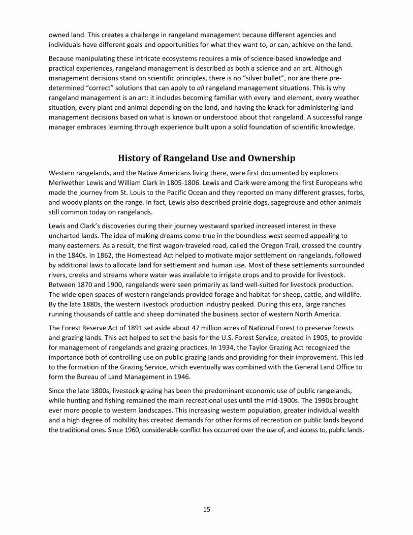
Shortgrass Prairie The shortgrass prairie is
dominated by low‐growing, wide‐spreading
grasses that are adapted to low
precipitation. In the rain shadow of the
Rocky Mountains, this region receives only
12 to 20 inches of precipitation each year.
The shortgrass prairie also received heavy
grazing by bison as it formed on the plains.
Native grasses in this region, such as blue
grama and buffalograss, are well‐ adapted to drought and heavy grazing. Fire is not common in the
shortgrass prairie because plant biomass is not sufficient for extensive fires.
13
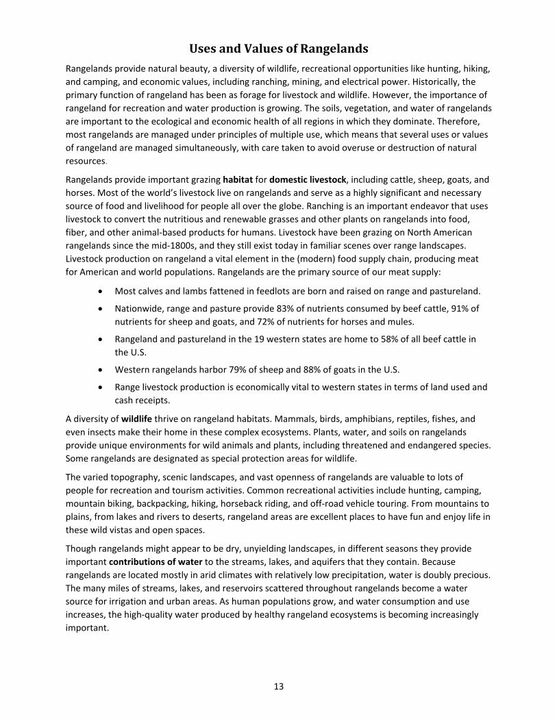
UsesandValuesofRangelands
Rangelands provide natural beauty, a diversity of wildlife, recreational opportunities like hunting, hiking,
and camping, and economic values, including ranching, mining, and electrical power. Historically, the
primary function of rangeland has been as forage for livestock and wildlife. However, the importance of
rangeland for recreation and water production is growing. The soils, vegetation, and water of rangelands
are important to the ecological and economic health of all regions in which they dominate. Therefore,
most rangelands are managed under principles of multiple use, which means that several uses or values
of rangeland are managed simultaneously, with care taken to avoid overuse or destruction of natural
resources.
Rangelands provide important grazing habitat for domestic livestock, including cattle, sheep, goats, and
horses. Most of the world’s livestock live on rangelands and serve as a highly significant and necessary
source of food and livelihood for people all over the globe. Ranching is an important endeavor that uses
livestock to convert the nutritious and renewable grasses and other plants on rangelands into food,
fiber, and other animal‐based products for humans. Livestock have been grazing on North American
rangelands since the mid‐1800s, and they still exist today in familiar scenes over range landscapes.
Livestock production on rangeland a vital element in the (modern) food supply chain, producing meat
for American and world populations. Rangelands are the primary source of our meat supply:
Most calves and lambs fattened in feedlots are born and raised on range and pastureland.
Nationwide, range and pasture provide 83% of nutrients consumed by beef cattle, 91% of
nutrients for sheep and goats, and 72% of nutrients for horses and mules.
Rangeland and pastureland in the 19 western states are home to 58% of all beef cattle in
the U.S.
Western rangelands harbor 79% of sheep and 88% of goats in the U.S.
Range livestock production is economically vital to western states in terms of land used and
cash receipts.
A diversity of wildlife thrive on rangeland habitats. Mammals, birds, amphibians, reptiles, fishes, and
even insects make their home in these complex ecosystems. Plants, water, and soils on rangelands
provide unique environments for wild animals and plants, including threatened and endangered species.
Some rangelands are designated as special protection areas for wildlife.
The varied topography, scenic landscapes, and vast openness of rangelands are valuable to lots of
people for recreation and tourism activities. Common recreational activities include hunting, camping,
mountain biking, backpacking, hiking, horseback riding, and off‐road vehicle touring. From mountains to
plains, from lakes and rivers to deserts, rangeland areas are excellent places to have fun and enjoy life in
these wild vistas and open spaces.
Though rangelands might appear to be dry, unyielding landscapes, in different seasons they provide
important contributions of water to the streams, lakes, and aquifers that they contain. Because
rangelands are located mostly in arid climates with relatively low precipitation, water is doubly precious.
The many miles of streams, lakes, and reservoirs scattered throughout rangelands become a water
source for irrigation and urban areas. As human populations grow, and water consumption and use
increases, the high‐quality water produced by healthy rangeland ecosystems is becoming increasingly
important.
14
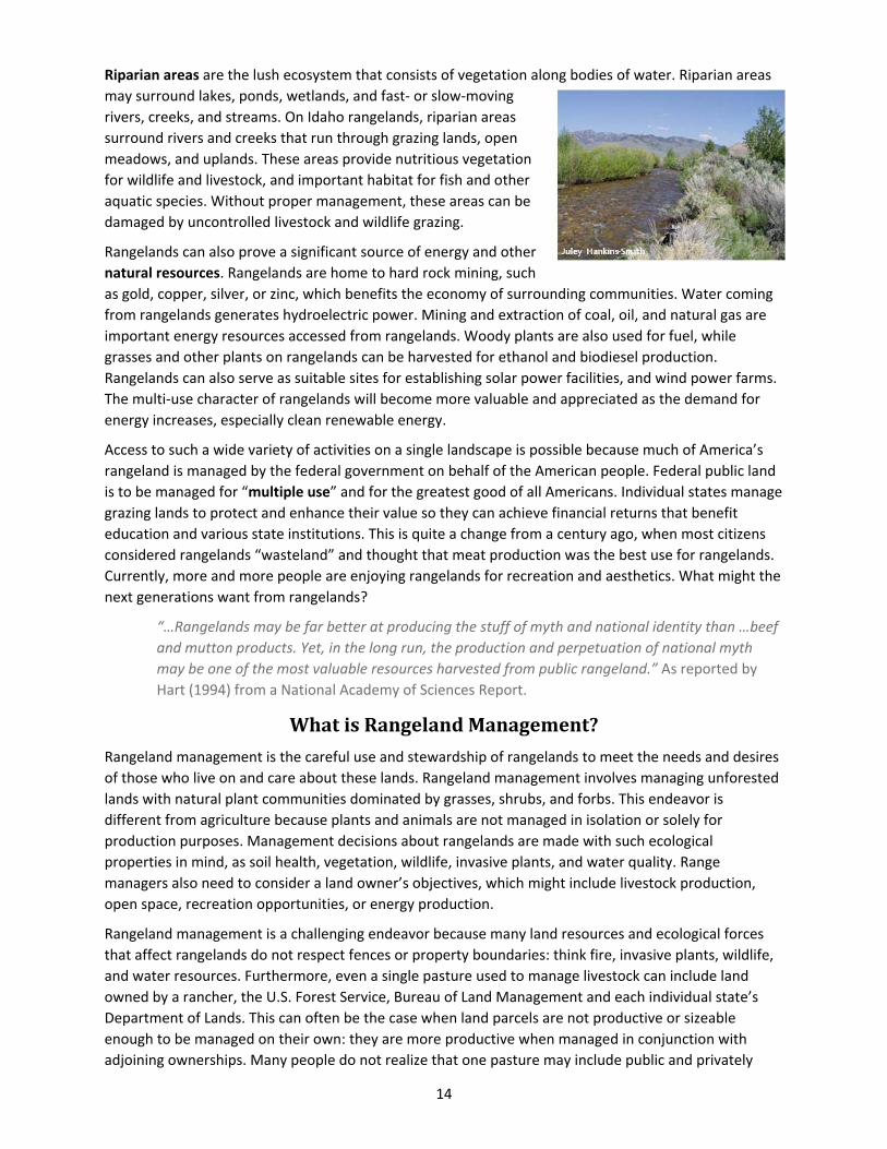
Riparian areas are the lush ecosystem that consists of vegetation along bodies of water. Riparian areas
may surround lakes, ponds, wetlands, and fast‐ or slow‐moving
rivers, creeks, and streams. On Idaho rangelands, riparian areas
surround rivers and creeks that run through grazing lands, open
meadows, and uplands. These areas provide nutritious vegetation
for wildlife and livestock, and important habitat for fish and other
aquatic species. Without proper management, these areas can be
damaged by uncontrolled livestock and wildlife grazing.
Rangelands can also prove a significant source of energy and other
natural resources. Rangelands are home to hard rock mining, such
as gold, copper, silver, or zinc, which benefits the economy of surrounding communities. Water coming
from rangelands generates hydroelectric power. Mining and extraction of coal, oil, and natural gas are
important energy resources accessed from rangelands. Woody plants are also used for fuel, while
grasses and other plants on rangelands can be harvested for ethanol and biodiesel production.
Rangelands can also serve as suitable sites for establishing solar power facilities, and wind power farms.
The multi‐use character of rangelands will become more valuable and appreciated as the demand for
energy increases, especially clean renewable energy.
Access to such a wide variety of activities on a single landscape is possible because much of America’s
rangeland is managed by the federal government on behalf of the American people. Federal public land
is to be managed for “multiple use” and for the greatest good of all Americans. Individual states manage
grazing lands to protect and enhance their value so they can achieve financial returns that benefit
education and various state institutions. This is quite a change from a century ago, when most citizens
considered rangelands “wasteland” and thought that meat production was the best use for rangelands.
Currently, more and more people are enjoying rangelands for recreation and aesthetics. What might the
next generations want from rangelands?
“…Rangelands may be far better at producing the stuff of myth and national identity than …beef
and mutton products. Yet, in the long run, the production and perpetuation of national myth
may be one of the most valuable resources harvested from public rangeland.” As reported by
Hart (1994) from a National Academy of Sciences Report.
WhatisRangelandManagement?
Rangeland management is the careful use and stewardship of rangelands to meet the needs and desires
of those who live on and care about these lands. Rangeland management involves managing unforested
lands with natural plant communities dominated by grasses, shrubs, and forbs. This endeavor is
different from agriculture because plants and animals are not managed in isolation or solely for
production purposes. Management decisions about rangelands are made with such ecological
properties in mind, as soil health, vegetation, wildlife, invasive plants, and water quality. Range
managers also need to consider a land owner’s objectives, which might include livestock production,
open space, recreation opportunities, or energy production.
Rangeland management is a challenging endeavor because many land resources and ecological forces
that affect rangelands do not respect fences or property boundaries: think fire, invasive plants, wildlife,
and water resources. Furthermore, even a single pasture used to manage livestock can include land
owned by a rancher, the U.S. Forest Service, Bureau of Land Management and each individual state’s
Department of Lands. This can often be the case when land parcels are not productive or sizeable
enough to be managed on their own: they are more productive when managed in conjunction with
adjoining ownerships. Many people do not realize that one pasture may include public and privately
15
owned land. This creates a challenge in rangeland management because different agencies and
individuals have different goals and opportunities for what they want to, or can, achieve on the land.
Because manipulating these intricate ecosystems requires a mix of science‐based knowledge and
practical experiences, rangeland management is described as both a science and an art. Although
management decisions stand on scientific principles, there is no “silver bullet”, nor are there pre‐
determined “correct” solutions that can apply to all rangeland management situations. This is why
rangeland management is an art: it includes becoming familiar with every land element, every weather
situation, every plant and animal depending on the land, and having the knack for administering land
management decisions based on what is known or understood about that rangeland. A successful range
manager embraces learning through experience built upon a solid foundation of scientific knowledge.
HistoryofRangelandUseandOwnership
Western rangelands, and the Native Americans living there, were first documented by explorers
Meriwether Lewis and William Clark in 1805‐1806. Lewis and Clark were among the first Europeans who
made the journey from St. Louis to the Pacific Ocean and they reported on many different grasses, forbs,
and woody plants on the range. In fact, Lewis also described prairie dogs, sagegrouse and other animals
still common today on rangelands.
Lewis and Clark’s discoveries during their journey westward sparked increased interest in these
uncharted lands. The idea of making dreams come true in the boundless west seemed appealing to
many easterners. As a result, the first wagon‐traveled road, called the Oregon Trail, crossed the country
in the 1840s. In 1862, the Homestead Act helped to motivate major settlement on rangelands, followed
by additional laws to allocate land for settlement and human use. Most of these settlements surrounded
rivers, creeks and streams where water was available to irrigate crops and to provide for livestock.
Between 1870 and 1900, rangelands were seen primarily as land well‐suited for livestock production.
The wide open spaces of western rangelands provided forage and habitat for sheep, cattle, and wildlife.
By the late 1880s, the western livestock production industry peaked. During this era, large ranches
running thousands of cattle and sheep dominated the business sector of western North America.
The Forest Reserve Act of 1891 set aside about 47 million acres of National Forest to preserve forests
and grazing lands. This act helped to set the basis for the U.S. Forest Service, created in 1905, to provide
for management of rangelands and grazing practices. In 1934, the Taylor Grazing Act recognized the
importance both of controlling use on public grazing lands and providing for their improvement. This led
to the formation of the Grazing Service, which eventually was combined with the General Land Office to
form the Bureau of Land Management in 1946.
Since the late 1800s, livestock grazing has been the predominant economic use of public rangelands,
while hunting and fishing remained the main recreational uses until the mid‐1900s. The 1990s brought
ever more people to western landscapes. This increasing western population, greater individual wealth
and a high degree of mobility has created demands for other forms of recreation on public lands beyond
the traditional ones. Since 1960, considerable conflict has occurred over the use of, and access to, public lands.

16
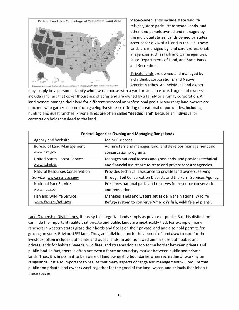
WhoOwnsandManagesRangelands?
The question of who owns land can be
examined in three categories: Federal,
State and Private (public lands include
both federal and state lands).
Federal lands are those owned and
managed by federal agencies such as
the Bureau of Land Management (BLM),
U.S. Forest Service (USFS), National Park
Service (NPS), National Wildlife Refuge
System, Army Corp of Engineers, and
U.S. Military bases. Federal lands are
26.0% (about one‐quarter) of U.S.
lands. However, it is clear from this
figure entitled “Federal Land as a
Percentage of Total State Land Area”
that almost half (48.6%) of the thirteen
western states are federal lands.
These federal lands are owned by all
U.S. citizens and they are managed and
cared for on our behalf by various
federal agencies. The BLM manages the
greatest area, overseeing 31.4% of all
federal land (10.9% of all U.S. land). The
USFS manages 24.5% of federal land
(8.5% U.S.). The NPS oversees 22.2% of
federal lands (7.7% U.S.) and National
Wildlife Refuges account for 11.3% of
federal land (3.9% U.S.).
%
Federal %
State %
Private
‐‐‐‐‐‐ 13 Western States‐‐‐‐
Alaska 60.2 29.0 10.8
Arizona 41.1 12.5 46.4
California 40.1 2.3 57.6
Colorado 35.5 4.4 60.1
Hawaii 12.8 0.6 86.6
Idaho 61.4 5.2 33.5
Montana 29.3 5.6 65.1
New Mexico 29.4 11.2 59.4
Nevada 80.9 0.2 18.9
Oregon 26.7 4.9 68.4
Utah 63.1 7.3 29.6
Washington 27.3 9.1 63.6
Wyoming 48.4 6.2 45.4
13 Western States Combined 48.6 13.5 37.9
‐‐‐‐‐‐‐‐ 6 Plains States‐‐‐‐‐‐
Kansas 0.3 0.6 99.1
Nebraska 1.1 0.5 98.4
North Dakota 3.1 1.8 95.1
Oklahoma 1.3 1.0 97.7
South Dakota 7.4 0.2 92.5
Texas 1.4 0.5 98.1
6 Plains States Combined 2.1 0.7 97.2
‐‐‐‐‐‐ 31 Eastern States‐‐‐‐
31 Eastern States Combined 4.7 5.9 89.4
‐‐‐‐‐‐ All 50 States‐‐‐‐
All 50 States 26.0 8.7 65.3
Source: www.nrcm.org/documents/publiclandownership.pdf
17
State‐owned lands include state wildlife
refuges, state parks, state school lands, and
other land parcels owned and managed by
the individual states. Lands owned by states
account for 8.7% of all land in the U.S. These
lands are managed by land care professionals
in agencies such as Fish and Game agencies,
State Departments of Land, and State Parks
and Recreation.
Private lands are owned and managed by
individuals, corporations, and Native
American tribes. An individual land owner
may simply be a person or family who owns a house with a yard or small pasture. Large land owners
include ranchers that cover thousands of acres and are owned by a family or a family corporation. All
land owners manage their land for different personal or professional goals. Many rangeland owners are
ranchers who garner income from grazing livestock or offering recreational opportunities, including
hunting and guest ranches. Private lands are often called “deeded land” because an individual or
corporation holds the deed to the land.
Land Ownership Distinctions. It is easy to categorize lands simply as private or public. But this distinction
can hide the important reality that private and public lands are inextricably tied. For example, many
ranchers in western states graze their herds and flocks on their private land and also hold permits for
grazing on state, BLM or USFS land. Thus, an individual ranch (the amount of land used to care for the
livestock) often includes both state and public lands. In addition, wild animals use both public and
private lands for habitat. Weeds, wild fires, and streams don’t stop at the border between private and
public land. In fact, there is often not even a fence or boundary marker between public and private
lands. Thus, it is important to be aware of land ownership boundaries when recreating or working on
rangelands. It is also important to realize that many aspects of rangeland management will require that
public and private land owners work together for the good of the land, water, and animals that inhabit
these spaces.
Federal Agencies Owning and Managing Rangelands
Agency and Website Major Purposes
Bureau of Land Management
www.blm.gov
Administers and manages land, and develops management and
conservation programs.
United States Forest Service
www.fs.fed.us
Manages national forests and grasslands, and provides technical
and financial assistance to state and private forestry agencies.
Natural Resources Conservation
Service www.nrcs.usda.gov
Provides technical assistance to private land owners, serving
through Soil Conservation Districts and the Farm Services Agency.
National Park Service
www.nps.gov
Preserves national parks and reserves for resource conservation
and recreation.
Fish and Wildlife Service
www.fws.gov/refuges/
Manages lands and waters set aside in the National Wildlife
Refuge system to conserve America's fish, wildlife and plants.
18
ReferencesandAdditionalInformation
Fazio, J.R. 1999. Lewis and Clark in Idaho—A lesson in science under stress. Rangelands 21:3‐5. Available
at:
http://digitalcommons.library.arizona.edu/objectviewer?o=http://rangelands.library.arizona.edu/V
olume21/Number5/azu_rangelands_v21_n5_3_7_m.pdf
Heady, H.F. and R.D. Child. 1994. Rangeland Ecology and Management. Westview Press, Inc. Boulder, CO.
Holecheck, J. 2000. Range Management: Principles and Practices. 4th edition. Prentice‐Hall, Inc. Upper
Saddle River, NJ.
Marlow, C.B. 2000. Perspectives: Science in rangeland management. Rangelands 22:57‐59. Available at:
http://digitalcommons.library.arizona.edu/objectviewer?o=http://rangelands.library.arizona.edu/V
olume22/Number4/azu_rangelands_v22_n4_57_59_m.pdf
Miller, R.K. 1981. Improved Stewardship Through Innovation and Cooperation. Rangelands 3:126.
Available at:
http://digitalcommons.library.arizona.edu/objectviewer?o=http://rangelands.library.arizona.edu/V
olume3/Number3/azu_rangelands_v3_n3_126_m.pdf
Mosley, J.C. 1985. Let’s not forget the art in range management. Rangelands 7:154‐155. Available at:
http://digitalcommons.library.arizona.edu/objectviewer?o=http://rangelands.library.arizona.edu/V
olume7/Number4/azu_rangelands_v7_n4_154_155_m.pdf
NLCD Land Cover Statistics. USGS Land Cover Institute. Available at: http://landcover.usgs.gov/nlcd.php
O’Laughlin, J., W.R. Hundrup, and P.S. Cook. 1998. History and analysis of federally administered lands in
Idaho. Policy Analysis Group Report #16. College of Natural Resources, University of Idaho. Available
at: http://www.uidaho.edu/~/media/Files/orgs/CNR/PAG/Reports/PAGReport16.
Thomas, H.S. 1994. History of public land grazing. Rangelands 16:250‐255. Available at:
http://digitalcommons.library.arizona.edu/objectviewer?o=http://rangelands.library.arizona.edu/V
olume16/Number6/azu_rangelands_v16_n6_250_255_m.pdf
Tisdale, E.W. 1986. Native vegetation of Idaho. Rangelands 8:202‐206. Available at:
http://digitalcommons.library.arizona.edu/objectviewer?o=http://rangelands.library.arizona.edu/V
olume8/Number5/azu_rangelands_v8_n5_202_207_m.pdf

19
RangelandPlants
Types of Rangeland Plants
Plant Type or Life Form
Lifespan
Growth Season
Origin
Weed Designation
Woody or Herbaceous
Forage Value
References and Additional Information
Most management decisions on rangelands are made by first knowing the various plants inhabiting
rangelands and knowing their growth habits. Correctly identifying rangeland plants requires knowledge
of plant characteristics and plant types. One of the most important identifying characteristics of plants is
the shape of a plant’s leaf. Other important distinguishing characteristics include the margins and
venation (pattern of veins) of leaves.
TypesofRangelandPlants
Range plants can be classified and
grouped in many different ways, including
growth form, life span, season of growth,
origin, and forage value.
PlantTypeorGrowthForm
Grasses are plants with long narrow
leaves and hollow, jointed stems. Leaves
on grasses are in two rows on the stem
with veins that are parallel. Grasses do
not have colored flowers and they
produce grain‐like seeds. Ecosystems
dominated by grasses are called
“grasslands” covering more than one‐fifth
of the earth’s land surface.
Grass‐like plants look like grasses but
have solid stems (not hollow) without
joints. Stems are often triangular. Veins in
the leaves are parallel. Sedges and rushes
are in this group of plants.
Forbs are herbaceous (non‐woody) plants
that usually have broad leaves and showy
Created by Liz
Smith
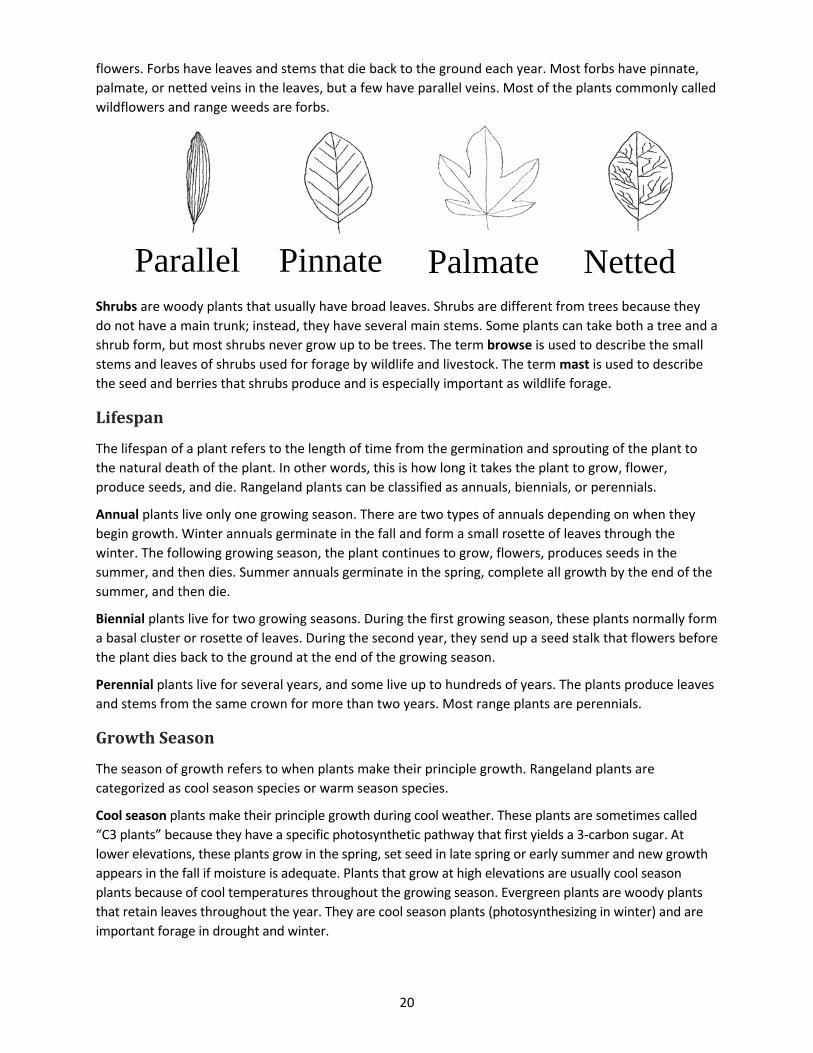
20
flowers. Forbs have leaves and stems that die back to the ground each year. Most forbs have pinnate,
palmate, or netted veins in the leaves, but a few have parallel veins. Most of the plants commonly called
wildflowers and range weeds are forbs.
Shrubs are woody plants that usually have broad leaves. Shrubs are different from trees because they
do not have a main trunk; instead, they have several main stems. Some plants can take both a tree and a
shrub form, but most shrubs never grow up to be trees. The term browse is used to describe the small
stems and leaves of shrubs used for forage by wildlife and livestock. The term mast is used to describe
the seed and berries that shrubs produce and is especially important as wildlife forage.
Lifespan
The lifespan of a plant refers to the length of time from the germination and sprouting of the plant to
the natural death of the plant. In other words, this is how long it takes the plant to grow, flower,
produce seeds, and die. Rangeland plants can be classified as annuals, biennials, or perennials.
Annual plants live only one growing season. There are two types of annuals depending on when they
begin growth. Winter annuals germinate in the fall and form a small rosette of leaves through the
winter. The following growing season, the plant continues to grow, flowers, produces seeds in the
summer, and then dies. Summer annuals germinate in the spring, complete all growth by the end of the
summer, and then die.
Biennial plants live for two growing seasons. During the first growing season, these plants normally form
a basal cluster or rosette of leaves. During the second year, they send up a seed stalk that flowers before
the plant dies back to the ground at the end of the growing season.
Perennial plants live for several years, and some live up to hundreds of years. The plants produce leaves
and stems from the same crown for more than two years. Most range plants are perennials.
GrowthSeason
The season of growth refers to when plants make their principle growth. Rangeland plants are
categorized as cool season species or warm season species.
Cool season plants make their principle growth during cool weather. These plants are sometimes called
“C3 plants” because they have a specific photosynthetic pathway that first yields a 3‐carbon sugar. At
lower elevations, these plants grow in the spring, set seed in late spring or early summer and new growth
appears in the fall if moisture is adequate. Plants that grow at high elevations are usually cool season
plants because of cool temperatures throughout the growing season. Evergreen plants are woody plants
that retain leaves throughout the year. They are cool season plants (photosynthesizing in winter) and are
important forage in drought and winter.
Parallel Pinnate Palmate Netted
21
Warm season plants make most of their growth during late spring and summer. These plants are also
called “C4 plants” because a 4‐carbon sugar is the first compound produced from the specific type of
photosynthesis of these plants. Seeds in warm‐season develop in mid‐summer and early fall. Southern
states such as Texas and New Mexico have nearly all warm season plants. There is another pathway for
photosynthesis called CAM (Crassulacean Acid Metabolism) that is common in plants such as cacti which
grow in warm desert regions.
Origin
The “origin” of a rangeland plant is the area where it developed and evolved. Knowing the origin of a
plant is important because it can affect the way the plant responds to the environment or help predict
spread of species. Rangeland plants can be characterized as either native or exotic.
Native plants are those that originated and evolved in North America.
Exotic or introduced plants are plants that were brought to North America from another continent,
either on purpose or by accident. Several plants were intentionally introduced to rangelands because
they have good forage value. Others were accidentally introduced, usually as contaminants in crop
seeds, packing materials or other imported items. Some weedy introduced plants were brought to this
continent for their ornamental value, but then “escaped” into rangelands. When these become
widespread and problematic, they are known as “invasive species”.
WeedDesignation
A weed is a plant that creates a problem for humans. Weeds might reduce yield of crops, pastures,
gardens, or yards. Weeds can also be spiny and cause pain, be poisonous, or have odors or pollens that
make it difficult to breath. These problematic plants can affect how ecosystems function by accelerating
soil erosion, changing natural fire regimes, affecting populations of grazing animals or pollinators, or
decreasing water infiltration into soil. Weeds are often detrimental because they outcompete and
reduce populations of native plants on land or in streams, lakes, or other aquatic ecosystems. (More
information at: The Weed Center http://www.weedcenter.org/inv_plant_info/impacts.html.)
WoodyorHerbaceous
Rangeland plants can also be described in terms of how much woody tissue they contain. This is
important because it affects forage value, watershed characteristics of the landscape, habitat
characteristics, and fire fuel loads.
Herbaceous plants include grasses, grass‐like plants, and forbs. These plants contain little or no wood
and they die back to the ground each year.
Woody plants are shrubs, trees, and woody vines that have woody stems. Wood is created by the
binding of plant fiber (i.e., cellulose) with lignin, a strong and indigestible compound.
Trees are different from shrubs because they generally have a single main stem or trunk. Shrubs
generally have several main stems. Woody plants can be deciduous, which means they lose their leaves
every fall, or evergreen because they maintain some live leaves throughout the year, even winter.
ForageValue
The forage value of a plant refers to how well it provides nutrients to grazing animals. The forage value
of a plant varies depending on which animal is eating it because nutritional needs and dietary
preferences of grazing animals differ by species. For example, a plant could have excellent forage value
22
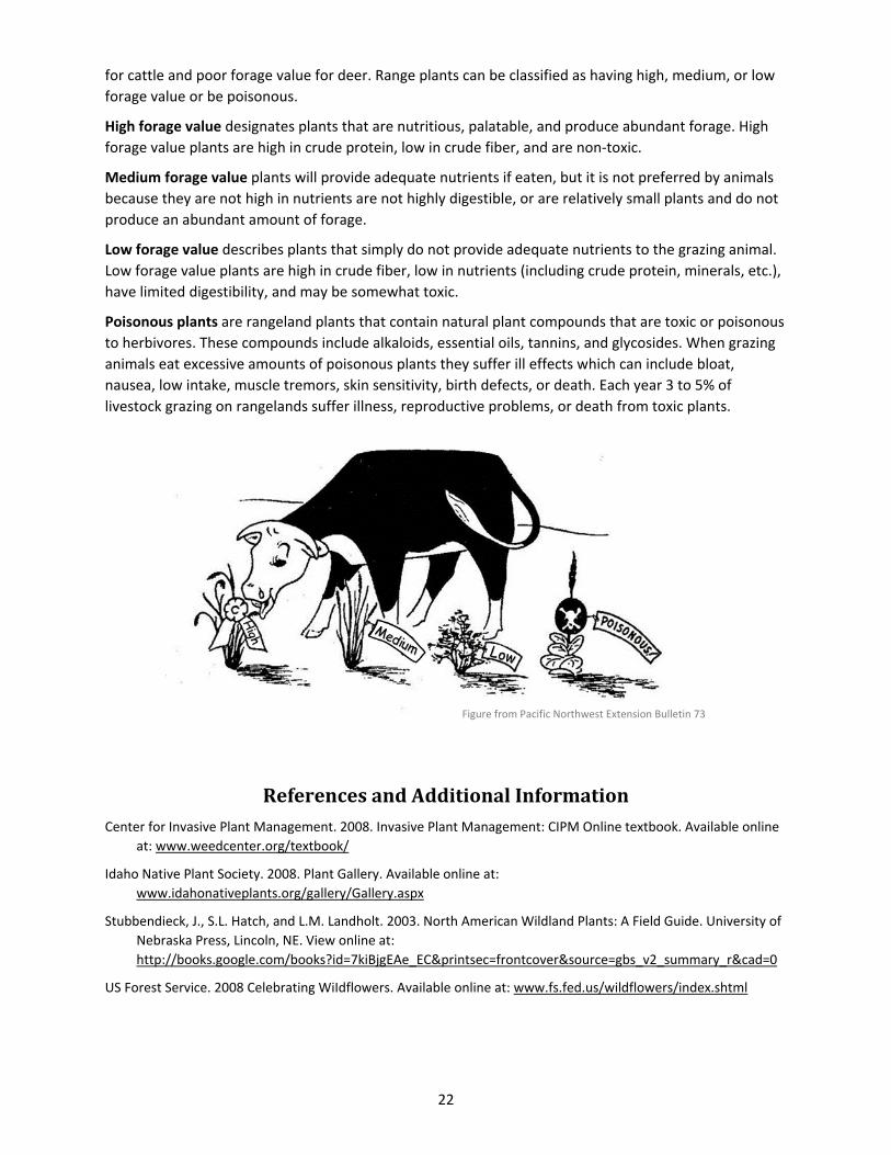
for cattle and poor forage value for deer. Range plants can be classified as having high, medium, or low
forage value or be poisonous.
High forage value designates plants that are nutritious, palatable, and produce abundant forage. High
forage value plants are high in crude protein, low in crude fiber, and are non‐toxic.
Medium forage value plants will provide adequate nutrients if eaten, but it is not preferred by animals
because they are not high in nutrients are not highly digestible, or are relatively small plants and do not
produce an abundant amount of forage.
Low forage value describes plants that simply do not provide adequate nutrients to the grazing animal.
Low forage value plants are high in crude fiber, low in nutrients (including crude protein, minerals, etc.),
have limited digestibility, and may be somewhat toxic.
Poisonous plants are rangeland plants that contain natural plant compounds that are toxic or poisonous
to herbivores. These compounds include alkaloids, essential oils, tannins, and glycosides. When grazing
animals eat excessive amounts of poisonous plants they suffer ill effects which can include bloat,
nausea, low intake, muscle tremors, skin sensitivity, birth defects, or death. Each year 3 to 5% of
livestock grazing on rangelands suffer illness, reproductive problems, or death from toxic plants.
ReferencesandAdditionalInformationCenter for Invasive Plant Management. 2008. Invasive Plant Management: CIPM Online textbook. Available online
at: www.weedcenter.org/textbook/
Idaho Native Plant Society. 2008. Plant Gallery. Available online at:
www.idahonativeplants.org/gallery/Gallery.aspx
Stubbendieck, J., S.L. Hatch, and L.M. Landholt. 2003. North American Wildland Plants: A Field Guide. University of
Nebraska Press, Lincoln, NE. View online at:
http://books.google.com/books?id=7kiBjgEAe_EC&printsec=frontcover&source=gbs_v2_summary_r&cad=0
US Forest Service. 2008 Celebrating WiIdflowers. Available online at: www.fs.fed.us/wildflowers/index.shtml
Figure from Pacific Northwest Extension Bulletin 73

23
RangelandAnimals
Major Types of Animals on Rangelands
Diet Selection: Plants, Animals or Both
Digestion Strategies of Herbivores
Wild, Domestic, and Feral Animals
Habitat Needs of Rangeland Animals
Limiting Habitat Factors
Stocking Rates and Carrying Capacity
Rangeland Animal Interactions
Types of Interactions
Livestock and Wildlife Interactions
References and Additional Information
MajorTypesofAnimalsonRangelandsRangelands provide habitat for countless mammals, birds, amphibians, fishes, and insects. A great
majority (84%) of mammals found in North America spend at least a portion of their life in rangeland
ecosystems. Large hoofed animals, called ungulates, are perhaps the most iconic rangeland animals.
Wild grazing animals such as bison, elk, pronghorn, and deer, as well as livestock species including cattle,
sheep, goats, and horses, all inhabit rangeland landscapes. Other mammals commonly found on
rangelands include rodents and rabbits.
Rangelands are also characterized by the presence a variety of birds. Large game birds such as grouse,
quail, pheasants, and turkeys call rangelands home. Migratory song birds including meadowlarks,
buntings, sparrows, and doves fill the grasslands, shrublands, and woodlands with color and song.
Raptors including hawks and falcons can often be found in the rangeland skies. Some birds are so
attached to rangelands that vegetation types are in their name: prairie falcon, meadow lark, sage
thrasher, and scrub jay.
Insects are productive inhabitants of rangelands, as diverse as the grasses, forbs, and shrubs on which
they live. Insects play many ecological roles on rangelands, which can be either beneficial or
detrimental. Periodic large outbreaks of certain insects, such as grasshoppers or Mormon crickets, can
cause great devastation to rangeland ecosystems when they eat rangeland plants and adjacent
croplands. Even in unremarkable years, many insects eat plants that could be used as forage by wildlife
and livestock. However, because of their small size and inconspicuous nature, they are often overlooked
in both stocking rate estimates and forage assessments. Insects also play a vital role in decomposing
dead plant material by incorporating it into the soil and improving soil aeration. In addition, insects
pollinate plants, thus sustaining genetic diversity among flowering rangeland plants.
24
Many insects are completely dependent on a single plant species for their survival; these insects are
called “host‐specific.” If an exotic plant is invading into rangelands and becoming a pest it is often
possible to identify host‐specific insects in their country of origin that can be introduced to bring the
weed under control. Introducing a host‐specific insect to control a weed is a process known as
biocontrol.
DietSelection:Plants,AnimalsorBoth
Animals that live on rangeland can be categorized based on their foraging habits. Classification is first
based on whether the animals eat plants, other animals, or both.
Herbivores are animals that eat only plants. They can be classified further:
Grazers, such as cattle, elk and bison, eat mostly grasses.
Browsers include deer and goats that eat some grasses, but mostly shrubs. The leaves and small
stems of woody plants are called “browse” so these animals are called browsers.
Intermediate feeders eat a mix of grasses, forbs and shrubs depending on which is most nutritious
at the time. Sheep and pronghorn antelope are examples of these opportunistic feeders that each
eat grasses and forbs in the spring and summer and then switch to shrubs in the winter.
Carnivores eat other animals. That diet can include insects, birds, reptiles, and/or mammals.
Omnivores are animals, such as humans or bears, which eat a combination of animals and plants.
DigestionStrategiesofHerbivores
Herbivores can be further classified based on how they digest the grasses and forbs that dominate
rangelands. These plants have large amounts of cellulose‐containing fiber. Cellulose is a type of
carbohydrate that cannot be digested by mammals. However, most grazing and browsing mammals
have both a specialized fermentation organ and a symbiotic relationship with bacteria, protozoa, and
fungi that can break down cellulose and turn it into nutritional compounds that can be used by the
grazing animal.
Ruminants include animals such as cows, sheep, goats, deer, elk, and moose. These animals have
specialized digestive systems, including a rumen to ferment the cellulose abundant in the cell walls
of rangeland plants.
Hind‐gut fermenters include rodents, rabbits, and horses. These animals have an enlarged cecum or
colon that houses microbes that ferment forage particles and release energy compounds that can be
absorbed and used by the animal. The cecum and colon are located past the true stomach in the
digestive track (i.e., behind the gut) –these animals are therefore called “hind‐gut fermenters.”
Concentrate‐selectors are animals that do not have a way to digest fiber and so must avoid cellulose
by foraging carefully, selecting berries, seeds, or roots that are low in cellulose. These animals
include birds and bears that find an adequate diet on rangeland by carefully selecting plants and
plant parts low in cellulose.
25
Wild,Domestic,andFeralAnimals
Humans have developed varying levels of relationships with animals over time. Our influence over
animals can vary from strong and close to weak and distant.
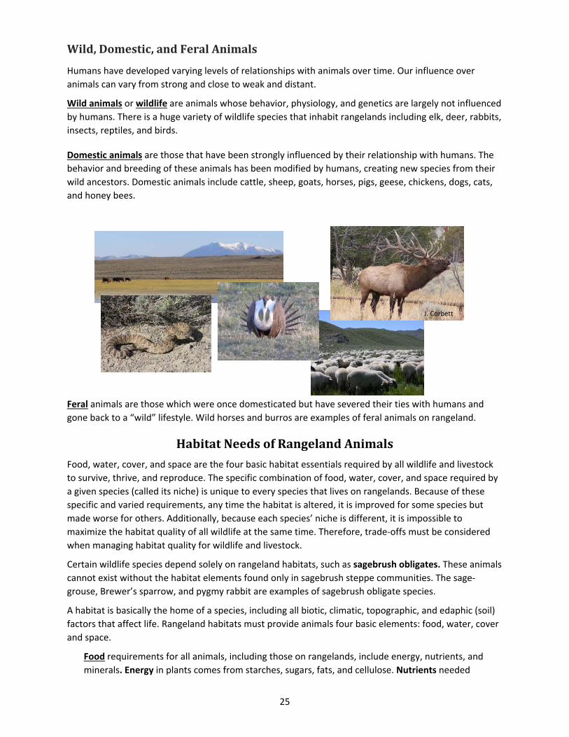
Wild animals or wildlife are animals whose behavior, physiology, and genetics are largely not influenced
by humans. There is a huge variety of wildlife species that inhabit rangelands including elk, deer, rabbits,
insects, reptiles, and birds.
Domestic animals are those that have been strongly influenced by their relationship with humans. The
behavior and breeding of these animals has been modified by humans, creating new species from their
wild ancestors. Domestic animals include cattle, sheep, goats, horses, pigs, geese, chickens, dogs, cats,
and honey bees.
Feral animals are those which were once domesticated but have severed their ties with humans and
gone back to a “wild” lifestyle. Wild horses and burros are examples of feral animals on rangeland.
HabitatNeedsofRangelandAnimals
Food, water, cover, and space are the four basic habitat essentials required by all wildlife and livestock
to survive, thrive, and reproduce. The specific combination of food, water, cover, and space required by
a given species (called its niche) is unique to every species that lives on rangelands. Because of these
specific and varied requirements, any time the habitat is altered, it is improved for some species but
made worse for others. Additionally, because each species’ niche is different, it is impossible to
maximize the habitat quality of all wildlife at the same time. Therefore, trade‐offs must be considered
when managing habitat quality for wildlife and livestock.
Certain wildlife species depend solely on rangeland habitats, such as sagebrush obligates. These animals
cannot exist without the habitat elements found only in sagebrush steppe communities. The sage‐
grouse, Brewer’s sparrow, and pygmy rabbit are examples of sagebrush obligate species.
A habitat is basically the home of a species, including all biotic, climatic, topographic, and edaphic (soil)
factors that affect life. Rangeland habitats must provide animals four basic elements: food, water, cover
and space.
Food requirements for all animals, including those on rangelands, include energy, nutrients, and
minerals. Energy in plants comes from starches, sugars, fats, and cellulose. Nutrients needed
J. Corbett
Peterson
D. Loomis
26
include mostly protein and vitamins. Mineral requirements include phosphorus and potassium. The
types of vegetation present, the diet preferences of animals, and the spatial arrangement of
available food plants must be assessed to determine the food or forage value of rangeland habitat.
Different types of animals require different amounts of food each day. As a general rule, ruminants
like bison, deer, cattle, and sheep will eat about 2.5% of their body weight per day (in dry weight of
forage); hind‐gut fermenters such as horses and rabbits will eat about 3.0% of their body weight
each day; and concentrate selectors such as birds, bears, and mice will eat about 0.25% of their
body weight daily.
Water requirements vary depending on the animal species and weather conditions. In general,
sheep and goats require 1‐1½ gallons of water once every two days; donkeys require 3‐4 gallons of
water every day; horses require 5‐8 gallons of water each day; and cattle and bison require 8‐10
gallons of water every day or two. Rangeland animals meet their water requirement by drinking
fresh water and obtaining water from forage. Plants can contain significant amounts of water. For
example, immature grasses may be up to 75% water by weight ‐‐ if an animal eats 28 pounds of
immature forage, it will consume about 2.5 gallons of water.
Cover is required for shelter from weather conditions and from predators. Thermal protection is
provided by plants when animals are shaded in the summer and sheltered from cold in the winter.
Thermal cover for rangeland animals is provided mostly by trees and shrubs. Plants can also offer
hiding cover for animals to protect them from predators. Many animals use large plants to hide
under or to gain protection through visual obstruction. However, other animals, like pronghorn
antelope and prairie dogs, gain protection from predators by a lack of visual obstruction. These
animals prefer to be out in the open where they can see predators coming and escape by running
away or retreating underground.
Space is an important consideration for breeding and nesting, home range, social intolerance, and
disease transmission. An animal’s home range is the area in which an individual animal conducts its
normal daily and yearly activities. This area can be shared with others of their own species, or with
other species. The home range of an animal is directly related to its body weight; larger animals
generally have a larger home range. Home ranges also vary by foraging habits: carnivores have very
large home ranges while the home ranges of herbivores are comparatively smaller.
FactorsLimitingHabitat
Location and size of home ranges and habitats are set by limiting factors such as water, food, climate,
and topography. These factors are basic requirements that restrict the size, growth, and/or vigor of an
animal population. Rangeland habitats can be influenced by human activities that either add or remove
limiting factors. For example, when ranchers add water tanks to pastures they may remove a habitat‐
limiting factor (i.e., access to water) for wild and domestic animals. On the other hand, building roads
and housing subdivisions may create factors that limit access to food and cover. However, habitat
modification does not always affect a wildlife species’ ability to survive, thrive, and reproduce.
27
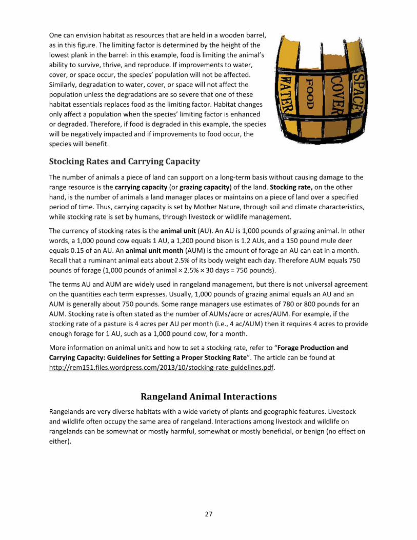
One can envision habitat as resources that are held in a wooden barrel,
as in this figure. The limiting factor is determined by the height of the
lowest plank in the barrel: in this example, food is limiting the animal’s
ability to survive, thrive, and reproduce. If improvements to water,
cover, or space occur, the species’ population will not be affected.
Similarly, degradation to water, cover, or space will not affect the
population unless the degradations are so severe that one of these
habitat essentials replaces food as the limiting factor. Habitat changes
only affect a population when the species’ limiting factor is enhanced
or degraded. Therefore, if food is degraded in this example, the species
will be negatively impacted and if improvements to food occur, the
species will benefit.
StockingRatesandCarryingCapacity
The number of animals a piece of land can support on a long‐term basis without causing damage to the
range resource is the carrying capacity (or grazing capacity) of the land. Stocking rate, on the other
hand, is the number of animals a land manager places or maintains on a piece of land over a specified
period of time. Thus, carrying capacity is set by Mother Nature, through soil and climate characteristics,
while stocking rate is set by humans, through livestock or wildlife management.
The currency of stocking rates is the animal unit (AU). An AU is 1,000 pounds of grazing animal. In other
words, a 1,000 pound cow equals 1 AU, a 1,200 pound bison is 1.2 AUs, and a 150 pound mule deer
equals 0.15 of an AU. An animal unit month (AUM) is the amount of forage an AU can eat in a month.
Recall that a ruminant animal eats about 2.5% of its body weight each day. Therefore AUM equals 750
pounds of forage (1,000 pounds of animal × 2.5% × 30 days = 750 pounds).
The terms AU and AUM are widely used in rangeland management, but there is not universal agreement
on the quantities each term expresses. Usually, 1,000 pounds of grazing animal equals an AU and an
AUM is generally about 750 pounds. Some range managers use estimates of 780 or 800 pounds for an
AUM. Stocking rate is often stated as the number of AUMs/acre or acres/AUM. For example, if the
stocking rate of a pasture is 4 acres per AU per month (i.e., 4 ac/AUM) then it requires 4 acres to provide
enough forage for 1 AU, such as a 1,000 pound cow, for a month.
More information on animal units and how to set a stocking rate, refer to “Forage Production and
Carrying Capacity: Guidelines for Setting a Proper Stocking Rate”. The article can be found at
http://rem151.files.wordpress.com/2013/10/stocking‐rate‐guidelines.pdf.
RangelandAnimalInteractions
Rangelands are very diverse habitats with a wide variety of plants and geographic features. Livestock
and wildlife often occupy the same area of rangeland. Interactions among livestock and wildlife on
rangelands can be somewhat or mostly harmful, somewhat or mostly beneficial, or benign (no effect on
either).
28
TypesofInteractions
Any of the following relationships can exist depending on the animal and its habitat requirements:
Mutualism (or Protocooperation): a relationship between two animals in which both benefit
from the association. For example: Cattle egrets (a type of bird) often perch on the backs of cattle
or bison and eat insects and grubs. The insects benefit the birds as a food source. The cows and
bison get the benefit of getting rid of the bothersome insect pests.
Commensalism: a relationship between two individuals in which one derives some benefit while
the other is unaffected. For example: Dung beetles eat the feces of ruminant animals like cows
or elk. The dung is a food source for the beetles (a benefit), but this activity has no effect on the
ruminant animals.
Antagonism: one species benefits at the expense of another (i.e., predation/parasitism). For
example: When a coyote eats a rabbit or lamb, the coyote gets the benefit of a food source, but
the rabbit or lamb is harmed (i.e., killed).
Amensalism: a relationship between two animals in which one is adversely affected and the
other is unaffected by the association. For example: Bison can carry brucellosis (a bacterial
disease) with no apparent symptoms. When bison interact with domestic cattle they can infect
the cattle with brucellosis which can cause spontaneous abortion. The cattle are therefore
harmed and bison are unaffected.
Competition: if two animals use the same resource (such as food or water) and if that resource
is in limited supply this may cause harm to both animals because neither will have enough to
meet their requirement. For example: When elk and cattle eat the same forage and it becomes
limited, both the elk and cattle may be harmed: they may not have enough to eat and may
become thin. Animals are “competing” for a resource only if there is not enough for both of them
to meet their requirements. Just because animals are using the same resource doesn’t mean that
they are in competition with one another. If the resource is abundant, competition is not
occurring.
Neutralism: a relationship between two species that interact or share the same habitat but do
not affect each other. For example: Meadow larks or bluebirds are largely unaffected by cattle or
elk, and cattle and elk have no real effect on meadow larks or bluebirds.
LivestockandWildlifeInteractions
Ranch management and subsequent grazing management strategies can negatively or positively impact
wildlife that inhabit landscapes also used by livestock. Livestock can be also an important management
tool for improving wildlife habitat. In other words, livestock grazing can be used to purposefully
manipulate forage to improve wildlife habitat for a chosen wildlife species. Livestock managers can alter
the timing, frequency, intensity, and type of livestock grazing to achieve wildlife habitat management
goals. For example, spring grazing by cattle on the mountain benches, such as those above Boise or Salt
Lake City, encourages the growth of shrubs that are important winter forage for deer and elk. This
process is referred to as prescribed or targeted livestock grazing, and is the strategic use of livestock
grazing to achieve specific landscape goals.
29
In other situations, livestock grazing can damage habitat value if it is not carefully applied and
purposefully planned with wildlife habitat in mind. Potentially negative impacts of livestock and wildlife
interaction include parasite/disease transmission, reduction of cover, or changes of the types of plants
available as forage. Several aspects of ranching such as fences and roads can also be detrimental to
wildlife species.
Good land stewardship and conscientious grazing management strategies that account for wildlife can
be used to limit negative interactions, enhance habitat quality, and promote complementary
relationships between wildlife and livestock on rangelands.
ReferencesandAdditionalInformation
Barnes, T.G., R.K. Heitschmidt, and L.W. Varner. 1991. Wildlife. In: R.K. Heitschmidt and J.W. Stuth
[EDS.]. Grazing management: An ecological perspective. Portland, OR: Timber Press. p. 179‐189.
Available online at: http://cnrit.tamu.edu/rlem/textbook/Chapter8.htm.
Budd, B. 1999. Livestock, wildlife, plants, and landscapes: Putting it all together. In: Launchbaugh, K.L.,
K.D. Sanders, and J.C. Mosley [EDS.]. Grazing behavior of livestock and wildlife. Moscow, ID:
University of Idaho. Idaho Forest, Wildlife and Range Experiment Station Bulletin Number 70.
Holecheck, J.L. 1981. Range management for upland game‐birds. Rangelands 3:163‐165. Available online
at:
http://digitalcommons.library.arizona.edu/objectviewer?o=http://rangelands.library.arizona.edu/V
olume3/Number4/azu_rangelands_v3_n4_163_165_m.pdf
Mosley, J.C., and T.K. Brewer. 2006. Targeted livestock grazing for wildlife habitat improvement. In: K.
Launchbaugh and J. Walker [EDS.]. Targeted grazing: A natural approach to vegetation management
and landscape enhancement. Centennial, CO: Cottrell Printing. p. 115‐128. Available online at:
www.cnr.uidaho.edu/rx‐grazing/Handbook.htm.
Severson, K.E., and P.J. Urness. 1994. Livestock grazing: A tool to improve wildlife habitat. In: M. Vavra,
W.A. Laycock, and R.D. Pieper [EDS.]. Ecological implications of livestock herbivory in the West.
Denver, CO: Society for Range Management. p. 232‐249.
Skinner, K.M. 2000.The Past, Present, and Future of Rangeland Grasshopper Management. Rangelands
22:24‐28 Available online at:
http://digitalcommons.library.arizona.edu/objectviewer?o=http://rangelands.library.arizona.edu/V
olume22/Number2/azu_rangelands_v22_n2_24_28_m.pdf
Torstenson, W. L.F., J.C. Mosley, T.K. Brewer, M.W. Tess, and J. E. Knight. 2006. Elk, mule deer, and
cattle foraging relationships on foothill and mountain rangeland. Rangeland Ecology and
Management 59:80–87.
Vavra, M., M.J. Willis and D.P. Sheehy. 1999. Livestock‐big game relationships: Conflicts and
compatibilities. In: Launchbaugh, K.L., K.D. Sanders, and J.C. Mosley [EDS.]. Grazing behavior of
livestock and wildlife. Moscow, ID: University of Idaho. Idaho Forest, Wildlife and Range Experiment
Station Bulletin Number 70.
Watts, J.G., E.W. Huddleston, and J.C. Owens. 1982. Rangeland entomology. Annual Review of
Entomology 27:283‐311.
30
DescribingandMonitoringRangelands
Ecological Sites
Soils
Topography and Watersheds
What is a Watershed?
Uplands vs. Riparian
Measuring and Monitoring Plant Communities
Assessment and Monitoring
Attributes
References and Additional Information
Rangelands are vast landscapes that are composed of differing abiotic (non‐living chemical and physical
parts of the environment, e.g. slope, aspect, minerals, moisture, temperature) and biotic (living or once
living, e.g. plants, animals, bacteria, fungi) components. Rangeland ecosystems also change dramatically
from month to month and year to year. It is a great challenge for scientists and managers to describe
and measure rangelands in ways that will help us understand what causes them to change or stay the
same. Being good land stewards requires sound methods for describing rangeland conditions and
monitoring their change over time in order to make wise management decisions.
EcologicalSites
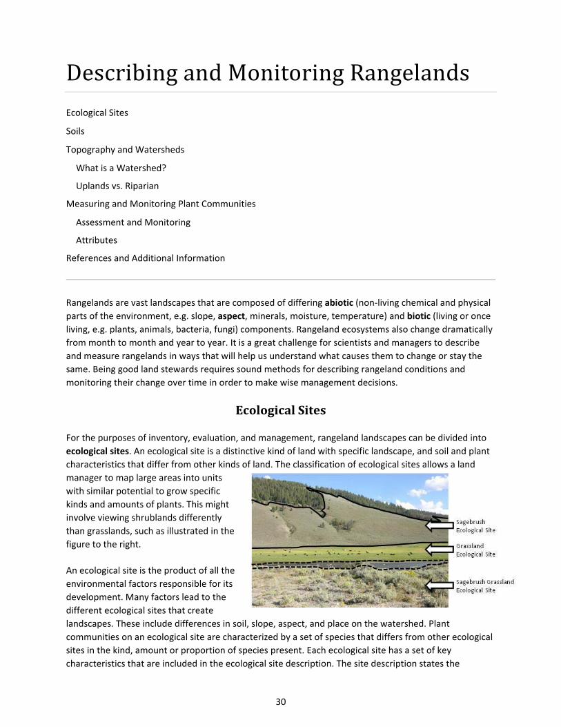
For the purposes of inventory, evaluation, and management, rangeland landscapes can be divided into
ecological sites. An ecological site is a distinctive kind of land with specific landscape, and soil and plant
characteristics that differ from other kinds of land. The classification of ecological sites allows a land
manager to map large areas into units
with similar potential to grow specific
kinds and amounts of plants. This might
involve viewing shrublands differently
than grasslands, such as illustrated in the
figure to the right.
An ecological site is the product of all the
environmental factors responsible for its
development. Many factors lead to the
different ecological sites that create
landscapes. These include differences in soil, slope, aspect, and place on the watershed. Plant
communities on an ecological site are characterized by a set of species that differs from other ecological
sites in the kind, amount or proportion of species present. Each ecological site has a set of key
characteristics that are included in the ecological site description. The site description states the
31
physiographic factors: climate, water, soil, and plant communities the site could possibly support. Site
descriptions are available through the Natural Resource Conservation Service, and are accessible online
at: http://www.nrcs.usda.gov/wps/portal/nrcs/main/national/technical/ecoscience/desc/.
Soils
Soil is defined as a complex mix of ingredients: minerals, air, water, and organic matter—countless
organisms and the decaying remains of once‐living things (Soil Science Society of America). Soil is an
important aspect of rangeland communities, and ecological sites have characteristic soils that have
developed over time. Factors affecting soil development are: climate, living organisms, topographic
relief or landscape position, parent material, and time. These factors lead to soil development or
degradation through the processes of loss, addition, translocation, and transformation. Soil forming
processes create horizons in the soil that are layers distinguishable from other layers by a change in
composition of abiotic and biotic components. Two key physical characteristics of soil, texture and
structure, strongly influence the vegetation type that occurs at a particular rangeland site.
Texture class is an important aspect of soils, and is related to weathering and parent material. The
differences in horizons are due, in part, to the differences in texture of their respective parent materials.
The texture of a soil depends upon the relative proportions of each type of soil particle within the soil.
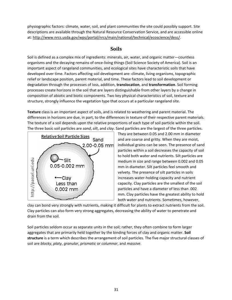
The three basic soil particles are sand, silt, and clay. Sand particles are the largest of the three particles.
They are between 0.05 and 2.00 mm in diameter
and are coarse and gritty. When they are moist,
individual grains can be seen. The presence of sand
particles within a soil decreases the capacity of soil
to hold both water and nutrients. Silt particles are
medium in size and range between 0.002 and 0.05
mm in diameter. Silt particles feel smooth and
velvety. The presence of silt particles in soils
increases water‐holding capacity and nutrient
capacity. Clay particles are the smallest of the soil
particles and have a diameter of less than .002
mm. Clay particles have the greatest ability to hold
both water and nutrients. Sometimes, however,
clay can bond very strongly with nutrients, making it difficult for plants to extract nutrients from the soil.
Clay particles can also form very strong aggregates, decreasing the ability of water to penetrate and
drain from the soil.
Soil particles seldom occur as separate units in the soil; rather, they often combine to form larger
aggregates that are primarily held together by the binding forces of clay and organic matter. Soil
structure is a term which describes the arrangement of soil particles. The five major structural classes of
soil are blocky, platy, granular, prismatic or columnar, and massive.
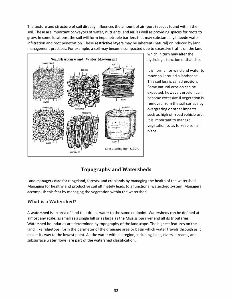
32
The texture and structure of soil directly influences the amount of air (pore) spaces found within the
soil. These are important conveyors of water, nutrients, and air, as well as providing spaces for roots to
grow. In some locations, the soil will form impenetrable barriers that may substantially impede water
infiltration and root penetration. These restrictive layers may be inherent (natural) or induced by land
management practices. For example, a soil may become compacted due to excessive traffic on the land
which in turn may alter the
hydrologic function of that site.
It is normal for wind and water to
move soil around a landscape.
This soil loss is called erosion.
Some natural erosion can be
expected; however, erosion can
become excessive if vegetation is
removed from the soil surface by
overgrazing or other impacts
such as high off‐road vehicle use.
It is important to manage
vegetation so as to keep soil in
place.
TopographyandWatersheds
Land managers care for rangeland, forests, and croplands by managing the health of the watershed.
Managing for healthy and productive soil ultimately leads to a functional watershed system. Managers
accomplish this feat by managing the vegetation within the watershed.
WhatisaWatershed?
A watershed is an area of land that drains water to the same endpoint. Watersheds can be defined at
almost any scale, as small as a single hill or as large as the Mississippi river and all its tributaries.
Watershed boundaries are determined by topography of the landscape. The highest features on the
land, like ridgetops, form the perimeter of the drainage area or basin which water travels through as it
makes its way to the lowest point. All the water within a region, including lakes, rivers, streams, and
subsurface water flows, are part of the watershed classification.
Line drawing from USDA
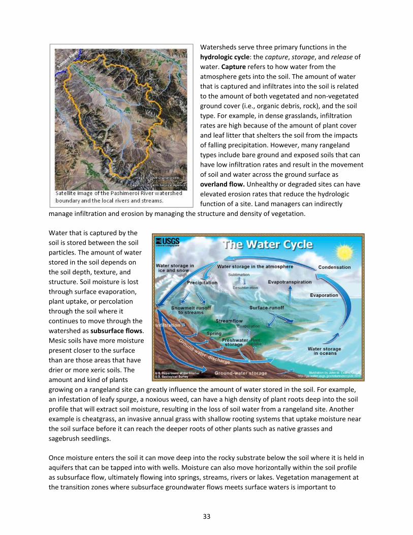
33
Watersheds serve three primary functions in the
hydrologic cycle: the capture, storage, and release of
water. Capture refers to how water from the
atmosphere gets into the soil. The amount of water
that is captured and infiltrates into the soil is related
to the amount of both vegetated and non‐vegetated
ground cover (i.e., organic debris, rock), and the soil
type. For example, in dense grasslands, infiltration
rates are high because of the amount of plant cover
and leaf litter that shelters the soil from the impacts
of falling precipitation. However, many rangeland
types include bare ground and exposed soils that can
have low infiltration rates and result in the movement
of soil and water across the ground surface as
overland flow. Unhealthy or degraded sites can have
elevated erosion rates that reduce the hydrologic
function of a site. Land managers can indirectly
manage infiltration and erosion by managing the structure and density of vegetation.
Water that is captured by the
soil is stored between the soil
particles. The amount of water
stored in the soil depends on
the soil depth, texture, and
structure. Soil moisture is lost
through surface evaporation,
plant uptake, or percolation
through the soil where it
continues to move through the
watershed as subsurface flows.
Mesic soils have more moisture
present closer to the surface
than are those areas that have
drier or more xeric soils. The
amount and kind of plants
growing on a rangeland site can greatly influence the amount of water stored in the soil. For example,
an infestation of leafy spurge, a noxious weed, can have a high density of plant roots deep into the soil
profile that will extract soil moisture, resulting in the loss of soil water from a rangeland site. Another
example is cheatgrass, an invasive annual grass with shallow rooting systems that uptake moisture near
the soil surface before it can reach the deeper roots of other plants such as native grasses and
sagebrush seedlings.
Once moisture enters the soil it can move deep into the rocky substrate below the soil where it is held in
aquifers that can be tapped into with wells. Moisture can also move horizontally within the soil profile
as subsurface flow, ultimately flowing into springs, streams, rivers or lakes. Vegetation management at
the transition zones where subsurface groundwater flows meets surface waters is important to
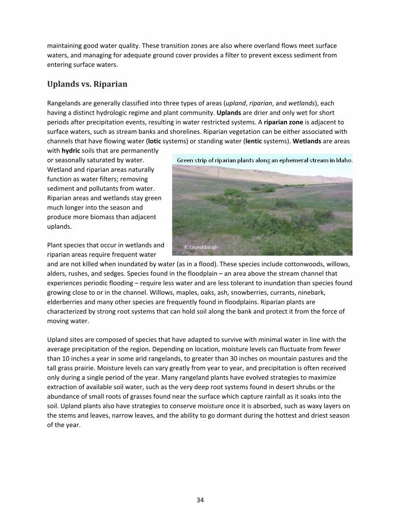
34
maintaining good water quality. These transition zones are also where overland flows meet surface
waters, and managing for adequate ground cover provides a filter to prevent excess sediment from
entering surface waters.
Uplandsvs.Riparian
Rangelands are generally classified into three types of areas (upland, riparian, and wetlands), each
having a distinct hydrologic regime and plant community. Uplands are drier and only wet for short
periods after precipitation events, resulting in water restricted systems. A riparian zone is adjacent to
surface waters, such as stream banks and shorelines. Riparian vegetation can be either associated with
channels that have flowing water (lotic systems) or standing water (lentic systems). Wetlands are areas
with hydric soils that are permanently
or seasonally saturated by water.
Wetland and riparian areas naturally
function as water filters; removing
sediment and pollutants from water.
Riparian areas and wetlands stay green
much longer into the season and
produce more biomass than adjacent
uplands.
Plant species that occur in wetlands and
riparian areas require frequent water
and are not killed when inundated by water (as in a flood). These species include cottonwoods, willows,
alders, rushes, and sedges. Species found in the floodplain – an area above the stream channel that
experiences periodic flooding – require less water and are less tolerant to inundation than species found
growing close to or in the channel. Willows, maples, oaks, ash, snowberries, currants, ninebark,
elderberries and many other species are frequently found in floodplains. Riparian plants are
characterized by strong root systems that can hold soil along the bank and protect it from the force of
moving water.
Upland sites are composed of species that have adapted to survive with minimal water in line with the
average precipitation of the region. Depending on location, moisture levels can fluctuate from fewer
than 10 inches a year in some arid rangelands, to greater than 30 inches on mountain pastures and the
tall grass prairie. Moisture levels can vary greatly from year to year, and precipitation is often received
only during a single period of the year. Many rangeland plants have evolved strategies to maximize
extraction of available soil water, such as the very deep root systems found in desert shrubs or the
abundance of small roots of grasses found near the surface which capture rainfall as it soaks into the
soil. Upland plants also have strategies to conserve moisture once it is absorbed, such as waxy layers on
the stems and leaves, narrow leaves, and the ability to go dormant during the hottest and driest season
of the year.
K. Launchbaugh
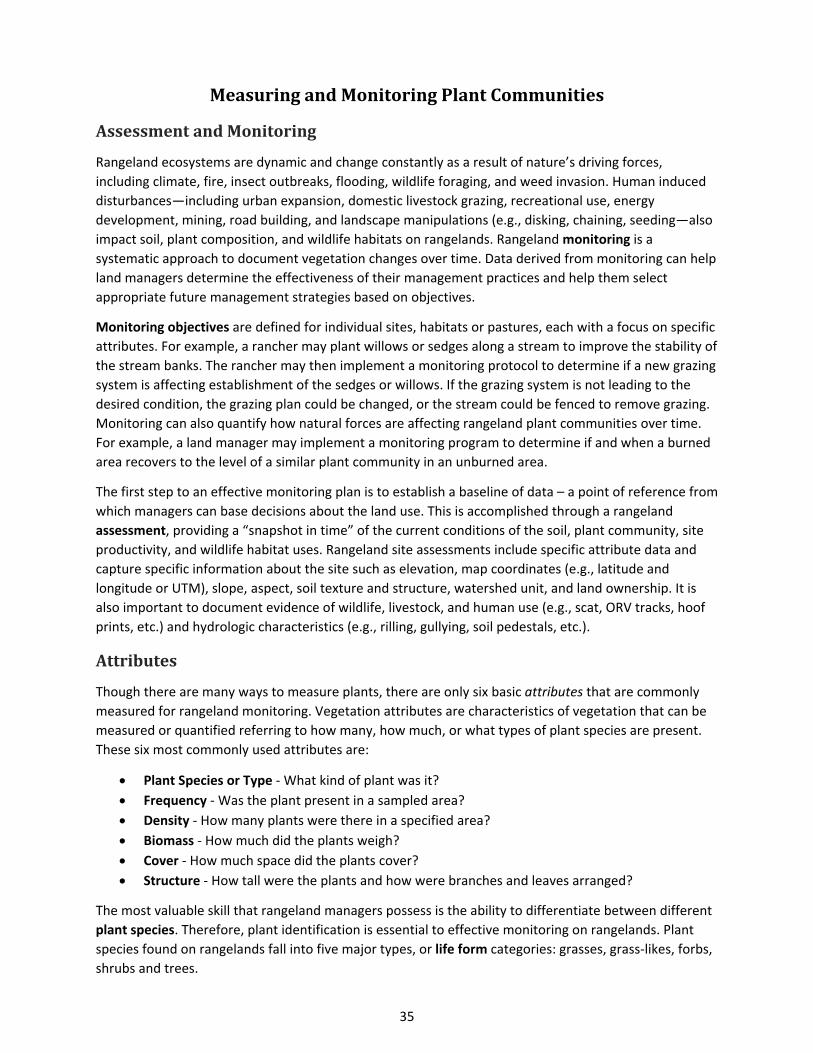
35
MeasuringandMonitoringPlantCommunities
AssessmentandMonitoring
Rangeland ecosystems are dynamic and change constantly as a result of nature’s driving forces,
including climate, fire, insect outbreaks, flooding, wildlife foraging, and weed invasion. Human induced
disturbances—including urban expansion, domestic livestock grazing, recreational use, energy
development, mining, road building, and landscape manipulations (e.g., disking, chaining, seeding—also
impact soil, plant composition, and wildlife habitats on rangelands. Rangeland monitoring is a
systematic approach to document vegetation changes over time. Data derived from monitoring can help
land managers determine the effectiveness of their management practices and help them select
appropriate future management strategies based on objectives.
Monitoring objectives are defined for individual sites, habitats or pastures, each with a focus on specific
attributes. For example, a rancher may plant willows or sedges along a stream to improve the stability of
the stream banks. The rancher may then implement a monitoring protocol to determine if a new grazing
system is affecting establishment of the sedges or willows. If the grazing system is not leading to the
desired condition, the grazing plan could be changed, or the stream could be fenced to remove grazing.
Monitoring can also quantify how natural forces are affecting rangeland plant communities over time.
For example, a land manager may implement a monitoring program to determine if and when a burned
area recovers to the level of a similar plant community in an unburned area.
The first step to an effective monitoring plan is to establish a baseline of data – a point of reference from
which managers can base decisions about the land use. This is accomplished through a rangeland
assessment, providing a “snapshot in time” of the current conditions of the soil, plant community, site
productivity, and wildlife habitat uses. Rangeland site assessments include specific attribute data and
capture specific information about the site such as elevation, map coordinates (e.g., latitude and
longitude or UTM), slope, aspect, soil texture and structure, watershed unit, and land ownership. It is
also important to document evidence of wildlife, livestock, and human use (e.g., scat, ORV tracks, hoof
prints, etc.) and hydrologic characteristics (e.g., rilling, gullying, soil pedestals, etc.).
Attributes
Though there are many ways to measure plants, there are only six basic attributes that are commonly
measured for rangeland monitoring. Vegetation attributes are characteristics of vegetation that can be
measured or quantified referring to how many, how much, or what types of plant species are present.
These six most commonly used attributes are:
Plant Species or Type ‐ What kind of plant was it?
Frequency ‐ Was the plant present in a sampled area?
Density ‐ How many plants were there in a specified area?
Biomass ‐ How much did the plants weigh?
Cover ‐ How much space did the plants cover?
Structure ‐ How tall were the plants and how were branches and leaves arranged?
The most valuable skill that rangeland managers possess is the ability to differentiate between different
plant species. Therefore, plant identification is essential to effective monitoring on rangelands. Plant
species found on rangelands fall into five major types, or life form categories: grasses, grass‐likes, forbs,
shrubs and trees.
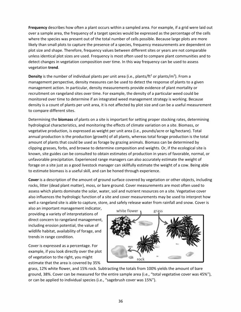
36
Frequency describes how often a plant occurs within a sampled area. For example, if a grid were laid out
over a sample area, the frequency of a target species would be expressed as the percentage of the cells
where the species was present out of the total number of cells possible. Because large plots are more
likely than small plots to capture the presence of a species, frequency measurements are dependent on
plot size and shape. Therefore, frequency values between different sites or years are not comparable
unless identical plot sizes are used. Frequency is most often used to compare plant communities and to
detect changes in vegetation composition over time. In this way frequency can be used to assess
vegetation trend.
Density is the number of individual plants per unit area (i.e., plants/ft2 or plants/m2). From a
management perspective, density measures can be used to detect the response of plants to a given
management action. In particular, density measurements provide evidence of plant mortality or
recruitment on rangeland sites over time. For example, the density of a particular weed could be
monitored over time to determine if an integrated weed management strategy is working. Because
density is a count of plants per unit area, it is not affected by plot size and can be a useful measurement
to compare different sites.
Determining the biomass of plants on a site is important for setting proper stocking rates, determining
hydrological characteristics, and monitoring the effects of climate variation on a site. Biomass, or
vegetative production, is expressed as weight per unit area (i.e., pounds/acre or kg/hectare). Total
annual production is the production (growth) of all plants, whereas total forage production is the total
amount of plants that could be used as forage by grazing animals. Biomass can be determined by
clipping grasses, forbs, and browse to determine composition and weights. Or, if the ecological site is
known, site guides can be consulted to obtain estimates of production in years of favorable, normal, or
unfavorable precipitation. Experienced range managers can also accurately estimate the weight of
forage on a site just as a good livestock manager can skillfully estimate the weight of a cow. Being able
to estimate biomass is a useful skill, and can be honed through experience.
Cover is a description of the amount of ground surface covered by vegetation or other objects, including
rocks, litter (dead plant matter), moss, or bare ground. Cover measurements are most often used to
assess which plants dominate the solar, water, soil and nutrient resources on a site. Vegetative cover
also influences the hydrologic function of a site and cover measurements may be used to interpret how
well a rangeland site is able to capture, store, and safely release water from rainfall and snow. Cover is
also an important management indicator,
providing a variety of interpretations of
direct concern to rangeland management,
including erosion potential, the value of
wildlife habitat, availability of forage, and
trends in range condition.
Cover is expressed as a percentage. For
example, if you look directly over the plot
of vegetation to the right, you might
estimate that the area is covered by 35%
grass, 12% white flower, and 15% rock. Subtracting the totals from 100% yields the amount of bare
ground, 38%. Cover can be measured for the entire sample area (i.e., “total vegetative cover was 45%”),
or can be applied to individual species (i.e., “sagebrush cover was 15%”).g
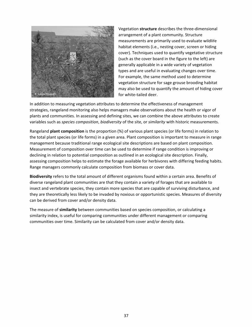
37
Vegetation structure describes the three‐dimensional
arrangement of a plant community. Structure
measurements are primarily used to evaluate wildlife
habitat elements (i.e., nesting cover, screen or hiding
cover). Techniques used to quantify vegetative structure
(such as the cover board in the figure to the left) are
generally applicable in a wide variety of vegetation
types and are useful in evaluating changes over time.
For example, the same method used to determine
vegetation structure for sage grouse brooding habitat
may also be used to quantify the amount of hiding cover
for white‐tailed deer.
In addition to measuring vegetation attributes to determine the effectiveness of management
strategies, rangeland monitoring also helps managers make observations about the health or vigor of
plants and communities. In assessing and defining sites, we can combine the above attributes to create
variables such as species composition, biodiversity of the site, or similarity with historic measurements.
Rangeland plant composition is the proportion (%) of various plant species (or life forms) in relation to
the total plant species (or life forms) in a given area. Plant composition is important to measure in range
management because traditional range ecological site descriptions are based on plant composition.
Measurement of composition over time can be used to determine if range condition is improving or
declining in relation to potential composition as outlined in an ecological site description. Finally,
assessing composition helps to estimate the forage available for herbivores with differing feeding habits.
Range managers commonly calculate composition from biomass or cover data.
Biodiversity refers to the total amount of different organisms found within a certain area. Benefits of
diverse rangeland plant communities are that they contain a variety of forages that are available to
insect and vertebrate species, they contain more species that are capable of surviving disturbance, and
they are theoretically less likely to be invaded by noxious or opportunistic species. Measures of diversity
can be derived from cover and/or density data.
The measure of similarity between communities based on species composition, or calculating a
similarity index, is useful for comparing communities under different management or comparing
communities over time. Similarity can be calculated from cover and/or density data.
K. Launchbaugh
K. Launchbaugh
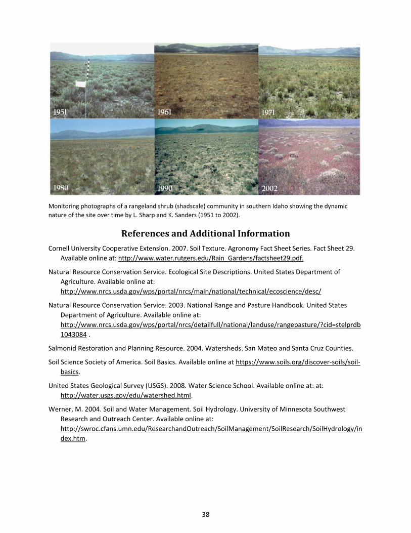
38
Monitoring photographs of a rangeland shrub (shadscale) community in southern Idaho showing the dynamic
nature of the site over time by L. Sharp and K. Sanders (1951 to 2002).
ReferencesandAdditionalInformation
Cornell University Cooperative Extension. 2007. Soil Texture. Agronomy Fact Sheet Series. Fact Sheet 29.
Available online at: http://www.water.rutgers.edu/Rain_Gardens/factsheet29.pdf.
Natural Resource Conservation Service. Ecological Site Descriptions. United States Department of
Agriculture. Available online at:
http://www.nrcs.usda.gov/wps/portal/nrcs/main/national/technical/ecoscience/desc/
Natural Resource Conservation Service. 2003. National Range and Pasture Handbook. United States
Department of Agriculture. Available online at:
http://www.nrcs.usda.gov/wps/portal/nrcs/detailfull/national/landuse/rangepasture/?cid=stelprdb
1043084 .
Salmonid Restoration and Planning Resource. 2004. Watersheds. San Mateo and Santa Cruz Counties.
Soil Science Society of America. Soil Basics. Available online at https://www.soils.org/discover‐soils/soil‐
basics.
United States Geological Survey (USGS). 2008. Water Science School. Available online at: at:
http://water.usgs.gov/edu/watershed.html.
Werner, M. 2004. Soil and Water Management. Soil Hydrology. University of Minnesota Southwest
Research and Outreach Center. Available online at:
http://swroc.cfans.umn.edu/ResearchandOutreach/SoilManagement/SoilResearch/SoilHydrology/in
dex.htm.
39
ForcesofEcologicalChange
Grazing
Impacts of Grazing on Ecosystems
Plant Response to Grazing
How Grazing Changes Plant Communities
What is Overgrazing?
Invasive Plants
Invasive Plant Terminology
Why Are Weeds Bad?
Wildland Fire
Wildfire vs. Prescribed Burning
Effects of Fire on Plants
Fire Return Intervals
Positive Aspects of Wildfire
Weather and Climate
Fragmentation of Rangelands
References and Additional Information
Rangelands are incredibly dynamic ecosystems. Drastic changes can be observed among seasons within
a year and among years and decades. There are five major factors that cause rangelands to change over
time – grazing, fire, invasive plants, weather and climate, and fragmentation due to human influences.
These factors change the plants and animals that inhabit rangeland sometimes in ways that land
managers and users find desirable and other times in ways that are considered adverse.
Grazing
The grasses, forbs, and shrubs that grow on rangelands are important sources of forage for grazing
animals. Rangeland plants photosynthesize, using energy from the sun to turn carbon dioxide, water,
and nutrients into organic compounds such as carbohydrates and proteins. When herbivores consume
plant material, these compounds are digested, providing energy and nutrients for herbivores. Grazing is
a natural ecological process that occurs on all rangelands.
PlantResponsetoGrazing
Rangeland plants live in ecosystems full of herbivores that range from small insects to large grazing
animals. Losing leaves or stems to herbivores is a common event in the life of a rangeland plant. For
these plants to remain healthy and productive, enough vegetation must remain after grazing so plants
can photosynthesize and manufacture energy to produce more leaves, stems, and seeds. Plants also
need to produce and store a little energy as starches and sugars in roots and crowns to successfully start
the next season of growth. When too much of the plant is removed the plant suffers in a way that yields
40
lasting detrimental effects. Substantial damage to rangeland plants generally only occurs under repeated
and heavy grazing.
The impact of grazing on plant growth depends greatly on when the grazing occurs during the growing
season and at what stage of the plant’s life cycle. Plants are generally less damaged by grazing early in
the season when time, soil moisture, and nutrients needed for regrowth are abundant, or very late in
the season once necessary growth has taken place. Plants are most likely to be damaged by grazing
when the plant is beginning to produce flowers and seeds. This is when the plant has high energy
demands to produce seeds, complete growth for the season, and store energy to get through the
dormant season. Plus, this generally occurs at the peak of summer when the environment is hot and dry
and not favorable for regrowth. Once the plant produces seeds and turns brown (i.e., begin to senesce
and becomes dormant), the leaves are not photosynthesizing and are no longer being used by the plant.
At this time, it is no longer sensitive to grazing.
Because plants evolved with grazing animals, it is not surprising that plants have attributes and
processes to reduce the potential of being eaten, and to recover from the loss of plant material after
grazing. One way that plants can reduce the impacts of grazing is to have characteristics that reduce the
likelihood that herbivores will even take a bite. These characteristics that reduce the probability or
severity of grazing are called mechanisms for grazing avoidance. These include physical features like
thorns, prickles, and spines that make plants less likely to be grazed by large herbivores such as cattle or
elk. Similarly, a hairy or waxy leaf surface may be avoided by insect herbivores. The size, shape, or
arrangement of leaves may also make it difficult for animals to access and graze the plant.
The buds or growing points (meristems) of a plant are especially important to protect from grazing
because they will be the source of new stems and leaves for continued growth after grazing. Grasses
have a unique strategy of protecting meristems – they are kept near the ground surface (within the
crown of the plant) while the leaves and sheaths grow upwards. Some forbs also adapt this tactic by
forming a basal rosette of leaves that photosynthesize right near the ground surface – out of the reach
of grazing animals. The meristems of these rosette forming plants are kept in the center of the rosette
and are not elevated and made accessible to grazing animals until later in the growing season.
Some plants also contain toxic compounds that are harmful to the grazing animal. These compounds,
called secondary compounds, can cause illness, neurological disorders, birth defects, or even death.
Secondary compounds such as alkaloids, tannins, and essential oils are common in plants. Most often
these compounds do not kill the animal, but simply make it feel sick or nauseated so that the plant
becomes distasteful and undesirable to the herbivore. Some plants, however, contain toxic compounds
that are very powerful even in small amounts. For example, tall larkspur contains a mixture of alkaloids
that, if eaten, can cause muscular paralysis, leading to respiratory failure, bloat and often death.
Plants also have attributes that facilitate their re‐growth and recovery after grazing. The morphological
and physiological characteristics that promote rapid plant growth are termed mechanisms of grazing
tolerance. For instance, some plants have a higher potential to mobilize stored energy sources and
replace leaves after defoliation.
Plants vary in how well they can tolerate and avoid grazing. In fact, many plants can benefit from the
effects of grazing. For example, grazing animals can remove the older and less efficient leaves making
space and resources for younger more efficient leaves. Grazing can also stimulate the plant to produce
more seeds and stems than if they had never been grazed. So, the effects of grazing can be detrimental
or beneficial depending on the: 1) plant species, 2) season when grazing occurs, and 3) intensity of
grazing (how many leaves remain after grazing).
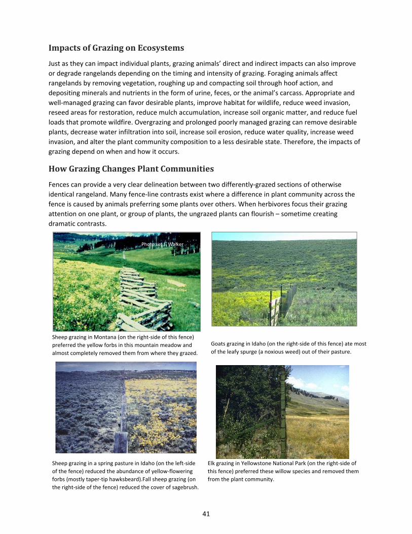
41
ImpactsofGrazingonEcosystems
Just as they can impact individual plants, grazing animals’ direct and indirect impacts can also improve
or degrade rangelands depending on the timing and intensity of grazing. Foraging animals affect
rangelands by removing vegetation, roughing up and compacting soil through hoof action, and
depositing minerals and nutrients in the form of urine, feces, or the animal’s carcass. Appropriate and
well‐managed grazing can favor desirable plants, improve habitat for wildlife, reduce weed invasion,
reseed areas for restoration, reduce mulch accumulation, increase soil organic matter, and reduce fuel
loads that promote wildfire. Overgrazing and prolonged poorly managed grazing can remove desirable
plants, decrease water infiltration into soil, increase soil erosion, reduce water quality, increase weed
invasion, and alter the plant community composition to a less desirable state. Therefore, the impacts of
grazing depend on when and how it occurs.
HowGrazingChangesPlantCommunities
Fences can provide a very clear delineation between two differently‐grazed sections of otherwise
identical rangeland. Many fence‐line contrasts exist where a difference in plant community across the
fence is caused by animals preferring some plants over others. When herbivores focus their grazing
attention on one plant, or group of plants, the ungrazed plants can flourish – sometime creating
dramatic contrasts.
Sheep grazing in a spring pasture in Idaho (on the left‐side
of the fence) reduced the abundance of yellow‐flowering
forbs (mostly taper‐tip hawksbeard).Fall sheep grazing (on
the right‐side of the fence) reduced the cover of sagebrush.
Elk grazing in Yellowstone National Park (on the right‐side of
this fence) preferred these willow species and removed them
from the plant community.
Sheep grazing in Montana (on the right‐side of this fence)
preferred the yellow forbs in this mountain meadow and
almost completely removed them from where they grazed.
Goats grazing in Idaho (on the right‐side of this fence) ate most
of the leafy spurge (a noxious weed) out of their pasture.
Photo set J. Walker
J. Walker
J. Walker
J. Walker
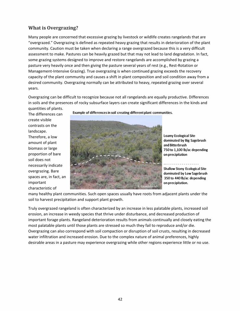
42
WhatisOvergrazing?
Many people are concerned that excessive grazing by livestock or wildlife creates rangelands that are
“overgrazed.” Overgrazing is defined as repeated heavy grazing that results in deterioration of the plant
community. Caution must be taken when declaring a range overgrazed because this is a very difficult
assessment to make. Pastures can be heavily grazed but that may not lead to land degradation. In fact,
some grazing systems designed to improve and restore rangelands are accomplished by grazing a
pasture very heavily once and then giving the pasture several years of rest (e.g., Rest‐Rotation or
Management‐Intensive Grazing). True overgrazing is when continued grazing exceeds the recovery
capacity of the plant community and causes a shift in plant composition and soil condition away from a
desired community. Overgrazing normally can be attributed to heavy, repeated grazing over several
years.
Overgrazing can be difficult to recognize because not all rangelands are equally productive. Differences
in soils and the presences of rocky subsurface layers can create significant differences in the kinds and
quantities of plants.
The differences can
create visible
contrasts on the
landscape.
Therefore, a low
amount of plant
biomass or large
proportion of bare
soil does not
necessarily indicate
overgrazing. Bare
spaces are, in fact, an
important
characteristic of
many healthy plant communities. Such open spaces usually have roots from adjacent plants under the
soil to harvest precipitation and support plant growth.
Truly overgrazed rangeland is often characterized by an increase in less palatable plants, increased soil
erosion, an increase in weedy species that thrive under disturbance, and decreased production of
important forage plants. Rangeland deterioration results from animals continually and closely eating the
most palatable plants until those plants are stressed so much they fail to reproduce and/or die.
Overgrazing can also correspond with soil compaction or disruption of soil crusts, resulting in decreased
water infiltration and increased erosion. Due to the complex nature of animal preferences, highly
desirable areas in a pasture may experience overgrazing while other regions experience little or no use.
K. Launchbaugh
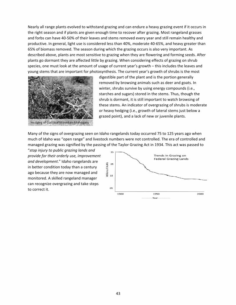
43
Nearly all range plants evolved to withstand grazing and can endure a heavy grazing event if it occurs in
the right season and if plants are given enough time to recover after grazing. Most rangeland grasses
and forbs can have 40‐50% of their leaves and stems removed every year and still remain healthy and
productive. In general, light use is considered less than 40%, moderate 40‐65%, and heavy greater than
65% of biomass removed. The season during which the grazing occurs is also very important. As
described above, plants are most sensitive to grazing when they are flowering and forming seeds. After
plants go dormant they are affected little by grazing. When considering effects of grazing on shrub
species, one must look at the amount of usage of current year’s growth – this includes the leaves and
young stems that are important for photosynthesis. The current year’s growth of shrubs is the most
digestible part of the plant and is the portion generally
removed by browsing animals such as deer and goats. In
winter, shrubs survive by using energy compounds (i.e.,
starches and sugars) stored in the stems. Thus, though the
shrub is dormant, it is still important to watch browsing of
these stems. An indicator of overgrazing of shrubs is moderate
or heavy hedging (i.e., growth of lateral stems just below a
grazed point), and a lack of new or juvenile plants.
Many of the signs of overgrazing seen on Idaho rangelands today occurred 75 to 125 years ago when
much of Idaho was “open range” and livestock numbers were not controlled. The era of controlled and
managed grazing was signified by the passing of the Taylor Grazing Act in 1934. This act was passed to
“stop injury to public grazing lands and
provide for their orderly use, improvement
and development.” Idaho rangelands are
in better condition today than a century
ago because they are now managed and
monitored. A skilled rangeland manager
can recognize overgrazing and take steps
to correct it.
44
InvasivePlants
One of the most serious threats to the health and sustainability of rangeland ecosystems in Idaho is exotic
invasive plants. As European settlers explored, homesteaded, and developed the West, they brought with
them many plants that have colonized and taken up residence on Idaho rangelands. Some of these plants
were introduced deliberately as ornamental plants, such as leafy spurge and purple loosestrife. Others, like
cheatgrass, came in accidentally in grains and feed. Some of the plants the people brought to Idaho have a
malicious attribute of invading native rangelands, forests, and croplands, choking out the desirable native
plants or crops.
InvasivePlantTerminology
The term “weed” can mean different things to different people. Basically, a weed is a plant in a place
where it is not wanted, or a plant of little value. Others describe weeds as plants that compete with
crops and native plants or as troublesome pests that reduce the health of land and its value for livestock
or wildlife. Ross & Lembi, in their book Applied Weed Science (1999), define weeds as “plants that
interfere with the growth of desirable plants and that are unusually persistent and pernicious. They
negatively impact human activities and as such are undesirable.”
Exotic, alien, or nonindigenous plants are not native to a region and have been brought into the region
either by accident or for a specific purpose. These exotic species often have an advantage over native
plants because they lack the natural predators and diseases that keep them in check in their native
environment. For example, spotted knapweed seldom dominates native communities in its homelands
in Eurasia. In its native habitats, knapweed is naturally suppressed by insect predators that feed on the
roots and seeds. When the plant made the trip across the ocean, these native insects were left behind.
However, not all exotic plants are invasive or bad. Many plants were introduced as forages for livestock,
like crested wheatgrass, or as agricultural commodities such as the plants we eat. These are exotic
species but they seldom take over native rangelands and become weeds.
Invasive plants are those that exhibit “weedy” or aggressive growth characteristics. Once established,
invasive species will out‐compete native species, and often spread throughout and dominate wildland
plant communities. Invasive species are not limited to any one particular plant life form, and can be
grasses, forbs, shrubs, or trees. Common examples of invasive plants in western North America include:
cheatgrass, leafy spurge, spotted knapweed, and salt cedar. Invasive plants may persist at relatively
insignificant densities for a period of time until ideal conditions occur and then the plant will spread and
dominate a site. Most invasive plants of concern are exotic. However, some native plants, like western
juniper, can become invasive and start to dominate plant communities when climatic or fire conditions
change
Noxious weed is a specific term held for particularly problematic plants that are recognized by the
county, state, or federal government as so serious that they need to be controlled or contained. Noxious
is therefore a legal definition used to describe weeds that have been recognized by the government as
injurious to public health, agriculture, recreation, wildlife, and/or property. Idaho state law has
recognized 57 noxious weeds and requires that landowners attempt to control or contain these weeds
when they occur on their property. If a landowner chooses not to take action, counties can treat the
infestation, and bill the landowner for incurred expenses.
45
WhyAreWeedsBad?
Exotic invasive plants can have many detrimental effects on healthy rangeland ecosystems. The negative
ecological effects can include:
Reducing the abundance of native plants and animals – even rare plants can be displaced.
Replacing diverse communities containing many species with a monoculture where only one
species dominates.
Reducing water infiltration and changing the hydrologic characteristics of the land.
Altering soil characteristics and increasing soil erosion and runoff.
Altering fire intensity and frequency.
Weeds can also have serious impacts on human activities and economic profitability. Some weeds such
as Scotch thistle and yellow starthistle can form dense, nearly impenetrable stands which reduce the
value of land and inhibit recreation such as hiking and hunting. Weeds can also reduce the abundance of
forage plants on rangelands, thereby reducing their value for grazing. Additionally, the cost and time
spent controlling weeds and keeping them in check can seriously reduce the profitability of ranchlands.
WildlandFire
Wildfires are a natural occurrence on rangelands and have helped shape the plant and animal
communities that we recognize today. Fire naturally served a role in maintaining rangeland health, plant
composition and diversity in many communities. Plants, animals, and insects in fire‐adapted ecosystems
have evolved mechanisms to tolerate or even benefit from fire. Adaptations include: long‐lived seeds
that are activated by fire; quick germination and regrowth after fire; thick bark resilient to fire; and, seed
production activated by fire. For example, plants in the Ceanothus genus (a rangeland shrub) contain a
waxy coating on the seed surface that is dependent on heat treatment from fire to break seed dormancy
and promote germination. Antelope bitterbrush, rabbitbrush, and several other rangeland shrubs have
adapted to sprout quickly after a fire, utilizing the increase of minerals and nutrients that are present in
the ash. Grasses often come to dominate shrublands and woodlands after fire because the woody plants
are removed and the grasses are better adapted to fire.
Fire is also one of nature’s tools for consuming the dead and decadent biomass that can accumulate in
rangeland plant communities. Most rangelands are characterized by dry climates which can slow
biological decomposition – the rate at which plant material is incorporated into organic matter in the
soil. Fire rapidly converts that dead and decadent plant growth into inorganic ash that frees nutrients
and minerals for new plant growth. However, if fires are too frequent or intense, plant cover and
organic matter at the soil surface can be reduced. Fire almost always results in a loss of nutrients
through volatilization, oxidation, ash transport, and erosion. However, fires can also convert nutrients to
inorganic forms that are more available to plants for growth. Fire also increases soil nutrient turnover
rates and affects the distribution of nutrients in the soil horizons. Of course, the potential damage to
plants and amount of dead plant material that is converted to bio‐available nutrients depends on how
hot the fire burned. Generally, low‐intensity burns increase plant productivity, while high‐intensity burns
result in decreased productivity and plant diversity.
Wildfirevs.PrescribedBurning
All fires need heat or a source of ignition, oxygen, and fuel. However, fires can occur under two
scenarios: a wildfire or prescribed burning. The main difference between a wildfire and a prescribed
burn lies in how and when they are ignited. Wildfires could be naturally caused through lightning, or
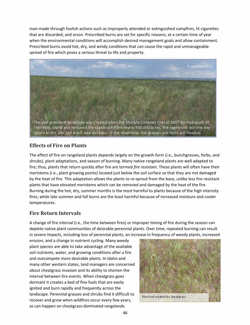
46
man‐made through foolish actions such as improperly attended or extinguished campfires, lit cigarettes
that are discarded, and arson. Prescribed burns are set for specific reasons, at a certain time of year
when the environmental conditions will accomplish desired management goals and allow containment.
Prescribed burns avoid hot, dry, and windy conditions that can cause the rapid and unmanageable
spread of fire which poses a serious threat to life and property.
EffectsofFireonPlants
The effect of fire on rangeland plants depends largely on the growth form (i.e., bunchgrasses, forbs, and
shrubs), plant adaptations, and season of burning. Many native rangeland plants are well adapted to
fire; thus, plants that return quickly after fire are termed fire resistant. These plants will often have their
meristems (i.e., plant growing points) located just below the soil surface so that they are not damaged
by the heat of fire. This adaptation allows the plants to re‐sprout from the base, unlike less fire resistant
plants that have elevated meristems which can be removed and damaged by the heat of the fire.
Burning during the hot, dry, summer months is the most harmful to plants because of the high intensity
fires, while late summer and fall burns are the least harmful because of increased moisture and cooler
temperatures.
FireReturnIntervals
A change of fire interval (i.e., the time between fires) or improper timing of fire during the season can
deplete native plant communities of desirable perennial plants. Over time, repeated burning can result
in severe impacts, including loss of perennial plants, an increase in frequency of weedy plants, increased
erosion, and a change in nutrient cycling. Many weedy
plant species are able to take advantage of the available
soil nutrients, water, and growing conditions after a fire
and outcompete more desirable plants. In Idaho and
many other western states, land managers are concerned
about cheatgrass invasion and its ability to shorten the
interval between fire events. When cheatgrass goes
dormant it creates a bed of fine fuels that are easily
ignited and burn rapidly and frequently across the
landscape. Perennial grasses and shrubs find it difficult to
recover and grow when wildfires occur every few years,
as can happen on cheatgrass‐dominated rangelands.
K. Launchbaugh
L. Roselle

47
Fire suppression or the exclusion of fire can also impact landscapes over time. Fire suppression policies
and actions over the past century were aimed at controlling fires when they occurred on rangelands.
Fire suppression can result in an unnatural accumulation of fuels that may increase the probability of
large, high‐intensity wildfires that pose a threat to the long‐term sustainability of the ecosystem. Fire
suppression has also lead to an increase in woody species and problems with the invasion of juniper and
other evergreen trees onto rangelands naturally dominated by shrubs and grasses. Thus, a lack of fire
can upset the balance between shrubs, grasses, and trees, giving the trees a competitive edge to
dominate landscapes.
PositiveAspectsofWildfire
Fire can have some positive impacts on range livestock and wildlife management. The flush of nutritious
and digestible green plant growth following fire creates patches of nutrient‐rich habitat that draw
domestic and wild animals. Wildfires and prescribed burns can also create patchy landscapes of
grasslands, shrublands, and woodlands that provide a diversity of habitats for wildlife, allowing for both
feeding and secure cover in a relatively small area.
WeatherandClimate
Weather and climate are highly influential factors determining how rangelands change over time. Water
is the primary limiting resource
on rangelands, and vegetation
production depends heavily on
both water availability and
suitable growing temperatures.
Idaho’s rangelands, while for
the most part very dry and
cool, can experience great
variation in moisture and
temperature depending on
region, slope, and aspect.
Idaho landscapes vary greatly
depending on their aspect and
elevation, which in turn affects
the amount of solar radiation and moisture loss. Precipitation that is received on a landscape can vary
substantially from year to year. For example, on this site near New Meadows, ID (see chart, above), the
long‐term precipitation average is about 24 inches per year. However, that annual amount can vary
from 6 to 36 inches per year. In other words, there can be a 6‐fold increase or decrease in the
precipitation that occurs from year to year.
These vast swings in the precipitation that a site receives each year result in massive variation in the amount
of biomass that the site can produce annually. For example, biomass of grass varied from 140 to 1,090
pounds/acre on a site where crested wheatgrass biomass was measured yearly for 35 years near Malta, ID
(see below).
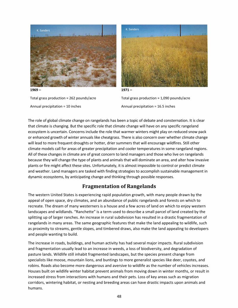
48
1969 –
Total grass production = 262 pounds/acre
Annual precipitation = 10 inches
1971 –
Total grass production = 1,090 pounds/acre
Annual precipitation = 16.5 inches
The role of global climate change on rangelands has been a topic of debate and consternation. It is clear
that climate is changing. But the specific role that climate change will have on any specific rangeland
ecosystem is uncertain. Concerns include the role that warmer winters might play on reduced snow pack
or enhanced growth of winter annuals like cheatgrass. There is also concern over whether climate change
will lead to more frequent droughts or hotter, drier summers that will encourage wildfires. Still other
climate models call for areas of greater precipitation and cooler temperatures in some rangeland regions.
All of these changes in climate are of great concern to land managers and those who live on rangelands
because they will change the type of plants and animals that will dominate an area, and alter how invasive
plants or fire might affect these sites. Unfortunately, it is almost impossible to control or predict climate
and weather. Land managers are tasked with finding strategies to accomplish sustainable management in
dynamic ecosystems, by anticipating change and thinking through possible responses.
FragmentationofRangelands
The western United States is experiencing rapid population growth, with many people drawn by the
appeal of open space, dry climates, and an abundance of public rangelands and forests on which to
recreate. The dream of many westerners is a house and a few acres of land on which to enjoy western
landscapes and wildlands. “Ranchette” is a term used to describe a small parcel of land created by the
splitting up of larger ranches. An increase in rural subdivision has resulted in a drastic fragmentation of
rangelands in many areas. The same geographic features that make the land appealing to wildlife, such
as proximity to streams, gentle slopes, and timbered draws, also make the land appealing to developers
and people wanting to build.
The increase in roads, buildings, and human activity has had several major impacts. Rural subdivision
and fragmentation usually lead to an increase in weeds, a loss of biodiversity, and degradation of
pasture lands. Wildlife still inhabit fragmented landscapes, but the species present change from
specialists like moose, mountain lions, and buntings to more generalist species like deer, coyotes, and
robins. Roads also become more dangerous and aversive to wildlife as the number of vehicles increases.
Houses built on wildlife winter habitat prevent animals from moving down in winter months, or result in
increased stress from interactions with humans and their pets. Loss of key areas such as migration
corridors, wintering habitat, or nesting and breeding areas can have drastic impacts upon animals and
humans.
K. Sanders K. Sanders
49
The effects of rural subdivision on plant communities can also be devastating. Ranchettes have a higher
frequency and density of exotic invasive species in comparison to adjacent ranches. Roadways and paths
are areas of disturbance for invasive species to establish. Small horse pastures are frequently overgrazed
and highly degraded, resulting in loss of habitat and increased soil erosion. Many rare and sensitive
species who are specific to certain ecological sites may find themselves in danger. However, more
resources are being made available more frequently to help small land owners learn about land
management and how best to conserve their meadows and pastures.
ReferencesandAdditionalInformationBrown, J.K., and J.K. Smith, eds. 2000. Wildland fire in ecosystems: effects of fire on flora. Gen. Tech. Rep. RMRS‐
GTR‐42‐vol. 2. Ogden, UT: USDA Forest Service, Rocky Mountain Research Station. 257 p. Available online at:
www.fs.fed.us/rm/pubs/rmrs_gtr042_2.pdf.
Brown, J.R., R.R. Blank. G.R. McPherson, and K.W. Tate. 2005. Rangelands a global change. Published by the Society
for Range Management. Available online at: http://www.rangelands.org/pdf/Global_Issue_Paper.pdf.
Fire Effects on Rangeland Ecosystems ‐‐ Factsheet Series. 2007. Government of British Columbia, Ministry of
Agriculture and Lands. Available online at: www.agf.gov.bc.ca/range/publications/documents/fire1.htm.
Idaho State Department of Agriculture. Idaho’s 65 Noxious Weeds. Accessed 20 August, 2014. Available online at:
www.agri.state.id.us/Categories/PlantsInsects/NoxiousWeeds/watchlist.php
Holechek, J.L, H. Gomez, F. Molinar and D. Galt. 1999. Grazing studies: What we’ve learned. Rangelands 21:12‐16.
Available online at:
http://digitalcommons.library.arizona.edu/objectviewer?o=http://rangelands.library.arizona.edu/Volume21/
Number2/azu_rangelands_v21_n2_12_16_m.pdf
Kostivkovsky, V. and J.A. Young. 2000. Invasive exotic rangeland weeds: A glimpse at some of their native habitats.
Rangelands 22:3‐6. Available online at:
http://digitalcommons.library.arizona.edu/objectviewer?o=http://rangelands.library.arizona.edu/Volume22/
Number6/azu_rangelands_v22_n6_3_6_m.pdf
Mitchell, J.E., R.L. Knight, R.L. and R.J. Camp. 2002. Landscape attributes of subdivided ranches. Rangelands. 17:3‐
9. Available online at:
http://digitalcommons.library.arizona.edu/objectviewer?o=http://rangelands.library.arizona.edu/Volume24/
Number1/azu_rangelands_v24_n1_3_9_m.pdf
Sharp, L.A., K.D. Sanders, and N.Rimby. 1992. Variability of Crested Wheatgrass Production over 35 Years.
Rangelands 14:153‐168. Available online at:
http://digitalcommons.library.arizona.edu/objectviewer?o=http://rangelands.library.arizona.edu/Volume14/
Number3/azu_rangelands_v14_n3_153_168_m.pdf
Sheley, R.L. 1995. Integrated rangeland weed management. Rangelands 17:222‐223. Available online at:
http://digitalcommons.library.arizona.edu/objectviewer?o=http://rangelands.library.arizona.edu/Volume17/
Number6/azu_rangelands_v17_n6_222_223_m.pdf
USDA‐Soil Conservation Service. 1986. USDA‐SCS Prescribed Burning Fact Sheet. Rangelands 8(4):177‐178.
Available online at:
http://digitalcommons.library.arizona.edu/objectviewer?o=http://rangelands.library.arizona.edu/Volume8/N
umber4/azu_rangelands_v8_n4_177_178_m.pdf
Ypsilantis, W.G. 2003. Risk of cheatgrass invasion after fire in selected sagebrush community types. Resource Notes
(63):1‐2. Bureau of Land Management. Available online at:
www.blm.gov/nstc/resourcenotes/respdf/RN63.pdf.
Terms from A Glossary of Terms Used in Range Management 2nd edition, Society for Range Management,
1974.
GlossaryofRangelandTerms
ANIMAL UNIT – Considered to be one mature (1,000lb.) cow or the equivalent based upon average daily forage consumption of 26 lbs. dry matter per day. Abbr., A.U. cf. animal‐unit conversion factor. ANIMAL‐UNIT MONTH – (1) The amount of feed or forage required by an animal‐unit for one month. (2) Tenure of one animal‐unit for period of one month. Not synonymous with animal‐month. Abbr., A.U.M. ANNUAL PLANT – A plant that completes its life cycle and dies in one year or less. ARID – A term applied to regions or climates where lack of sufficient moisture severely limits growth and production of vegetation. The limits of precipitation vary considerably according to temperature conditions, with an upper annual limit for cool regions of 10 inches or less and for tropical regions as much as 15 to 20 inches. cf. semi‐arid. ASPECT‐ The direction in which a slope faces. BROWSE – (n) That part of leaf and twig growth of shrubs, woody vines and trees available for animal consumption. (v) To consume, browse. cf. of graze. BUNCHGRASS – A grass that grows in tufts, or bunches. Its roots extend downward and outward from the base of the bunch, but do not sprout laterally like sodgrasses. CARRYING CAPACITY – The maximum stocking rate possible without inducing damage to vegetation or related resources. It may vary from year to year on the same area due to fluctuating forage production. Syn. grazing capacity. CLIMATE – The average weather conditions of a place over a period of years. CONSERVATION – The use and management of a natural resources according to principles that assure their sustained, highest economic and/or social benefits without impairment of environmental quality. CONTINUOUS GRAZING – The grazing of a specific unit by livestock throughout a year or for that part of the year during which grazing is feasible. The term is not necessarily synonymous with yearlong grazing. COOL‐SEASON PLANT – A plant which generally makes the major portion of its growth during the winter and early spring, because it is adapted to climates with winter precipitation and summer drought. cf. warm‐season plant.
DECREASER – Plant species of the original or climax vegetation that will decrease in relative amount with continued overuse. DEFERMENT – Delay or discontinuance of livestock grazing on an area for an adequate period of time to provide for plant reproduction, establishment of new plants, or restoration of vigor of existing plants. cf. deferred grazing. DEFERRED GRAZING – The use of deferment in grazing management of a management unit, but not in a systematic rotation including other units. Cf. grazing system. DESERT – Land that experiences extreme water shortage and unpredictable precipitation, dominated by shrubs and succulent plants such as cacti. DROUGHT – Prolonged dry weather, generally when precipitation is less than the average annual amount. ECOLOGY – The study of the interrelationships of organisms with their environment. ENVIRONMENT – The sum of all external conditions that affect an organism or community to influence its development or existence. EROSION – (v) Detachment and movement of soil or rock fragments by water, wind, ice or gravity. (n) The land surface worn away by running water, wind, ice, or other geological agents, including such processes as gravitational creep. FINE FUEL – Light, thin plant material with high surface area, typically grasses, that fire can easily ignite and consume quickly. FIRE REGIME – The frequency, intensity, and severity that fire burns. FIRE RETURN INTERVAL – The time interval between wildfire occurrences. FORAGE – (n) All browse and herbaceous foods that are available to grazing animals. It may be grazed or harvested for feeding. Cf. concentrating feed and cured and range forage. (v) Act of consuming forage. Syn., graze. FORAGE PRODUCTION – The weight of forage that is produced within a designated period of time on a given area. The weight may be expressed as either green, air‐dry or oven‐dry. The term may also be modified as to time of production, such as annual, current year’s or seasonal forage production.
51
FREQUENCY OF GRAZING – The recurrence of grazing—how soon animals are put back in a pasture after grazing it previously. Or, how soon an animal takes a second or third bite from the same plant during a grazing period. FORB – “Weeds and wildflowers.” A broad‐leaved flowering plant that is not a grass or grass‐like plant, often having netted leaf venation and solid non‐woody stems. These plants die back to the ground every year. FREQUENCY OF GRAZING – How often or the number of times animals return to the pasture or allotment in one year or growing season. FUEL – Living or dead plant material, which provides organic matter for fire to consume. FUEL LOAD – The amount of fuel present on a specified land area. GRASS – A member of the plant family Poaceae (Gramineae). Grass has round, hollow stems with leaves that connect to stems (jointed). GRASS‐LIKE PLANT – Herbaceous plants that look similar to grasses; members of the sedge or rush family. They typically grow in moist environments like forest floors or riparian areas. GRASSLAND – Land on which grasses are the dominant plant cover. Syn., grassveld. GRAZE – (1) The consumption of standing forage by livestock or wildlife. (2) To put livestock to feed on standing forage. GRAZING PERIOD – The length of time that livestock are grazed on a specific area. GRAZING SEASON – On public lands, an established period for which grazing permits are issued. Also, on private land in a grazing management plan. GRAZING SYSTEM – A specialization of grazing management which defines systematically recurring periods of grazing and deferment for two or more pastures or management units. Descriptive common names of different grazing systems such as “Merrill,” “Hormay,” “South African switchback,” etc., may be used. Cf. deferred grazing, intermittent grazing, deferred‐rotation grazing, and short duration grazing. GROWTH FORM – The characteristic shape or appearance of an organism. HABITAT – An area that provides forage, water, cover, and space; the “home” of a species
HEAVY GRAZING – A comparative term which indicates that the stocking rate of a pasture is relatively greater than that of other pastures. Often erroneously used to mean overuse. cf. light and moderate grazing. HERBACEOUS PLANT – A non‐woody plant (cultivated or non‐cultivated) that has leaves and stems, such as grasses and forbs. INCREASER – Plant species of the original vegetation that increase in relative amount, at least for a time, under overuse. INTENSITY OF GRAZING – The level of grazing a pasture experiences. This takes into account stocking rate, and frequency and duration of grazing. INTRODUCED SPECIES – A species not part of the original fauna or flora of the area in question. cf. native and resident species. INVADER – Plant species that were absent or present in very small amounts in undisturbed portions of the original vegetation of a specific range site and will invade following disturbance or continued overuse. LIGHT GRAZING – A comparative term which indicates that the stocking rate of one pasture in relatively less than that of other pastures. Often erroneously used to mean underuse. cf. heavy and moderate grazing. NATIVE SPECIES – A species which is part of the original fauna or flora of the area in question. cf. introduced and resident species. Syn., indigenous. NOXIOUS WEEDS – A subset of invasive plants that are recognized and designated by local, state, and federal governments as requiring control or attention. OPEN RANGE – (1) Range which has not been forced into management units. (2) All suitable range of an area upon which grazing is permitted. (3) Untimbered rangeland. (4) Range on which the livestock owner is not required to confine his livestock. OVERGRAZING – Continued overuse creating a deteriorated range. OVERSTOCKING – Placing a number of animals on a given area that will result in overuse if continued to the end of the planned grazing period. Not to be confused with overgrazing because an area may be overstocked for a short period, but the animals may be removed before the area is overused. However, continued overstocking will lead to overgrazing. OVERUSE – Utilize an excessive amount of the current year’s growth, which, if continued, will result in overgrazing and range deterioration. Syn., overutilization.

52
PASTURE – (1) A grazing area enclosed and separated from other areas by fence. (2) Forage plants used as food by grazing animals. PASTURELAND– Grazing lands, planted to primarily introduced or domesticated native forage species that receive periodic renovation and/or cultural treatments such as tillage, fertilization, mowing, weed control, and irrigation. PERENNIAL PLANT – A plant that has a life cycle of three or more years. POTENTIAL NATURAL COMMUNITY (PNC) – A historical term originally defined by A. W. Kuchler as the stable vegetation community which could occupy a site under current climatic conditions without further influence by people; formerly called “climax”. PRAIRIE – An extensive tract of level or rolling land that was originally treeless and grass‐covered. PRESCRIBED BURNING – The use of fire as a management tool under specified conditions for burning a predetermined area. Cf. maintenance burning and reclamation burning. PRIMARY SUCCESSION – The process of initial plant establishment and growth upon bare rock or soil that has never had plants before—ever. PROPER GRAZING – The act of continuously obtaining proper use. PROPER STOCKING – Placing a number of animals on a given area that will result in proper use at the end of the planned grazing period. Continued proper stocking will lead to proper grazing. PROPER USE – A degree and time of use of current year’s growth, which, if continued, will either maintain or improve the range condition consistent with conservation of other natural resources. Syn., proper utilization. RANCH – An establishment with specific boundaries, together with its lands and improvements, used for the grazing and production of domestic livestock and/or wildlife. RANGE – Embraces rangelands and also many forest lands which support an understory or periodic cover of herbaceous or shrubby vegetation amenable to certain range management principles or practices. Syn. veld. cf. grazable woodland. RANGE CONDITION – The current productivity of a range relative to what the range is naturally capable of producing.
RANGE CONDITION CLASS – One of a series of arbitrary categories used to classify range condition and usually expressed as either excellent, good, RANGE IMPROVEMENT – (1) Any structure or excavation to facilitate management of range or livestock. (2) Any practice designed to improve range condition or facilitate more efficient utilization of the range. (3) An increase in the grazing capacity of range, i.e., improvement in range condition. RANGE INVENTORY – An itemized list of resources of a management area, i.e., range sites, range condition classes, range condition trends, range use, estimated proper stocking rates, physical developments and natural conditions such as water, barriers, etc. RANGE MANAGEMENT – A distinct discipline founded on ecological principles and dealing with the use of rangelands and range resources for a variety of purposes. These purposes include use as watersheds, wildlife habitat, grazing by livestock, recreation, and aesthetics, as well as other associated uses. RANGE SCIENCE – The organized body of knowledge upon which the practice of range management is based. RANGE SITE – A distinctive kind of rangeland, which in the absence of abnormal disturbance and physical site deterioration, has the potential to support a native plant community typified by an association of species different from that of other sites. This differentiation is based upon significant differences in kind or proportion of species, or total productivity. Syn., ecological site. RANGE TREND – The direction of change in an attribute observed over time, and is described as up, down, or not apparent. RANGELAND – Land on which the indigenous vegetation (climax or natural potential) is predominantly grasses, grass‐like plants, forbs, or shrubs and is managed as a natural ecosystem. If plants are introduced, they are managed similarly. Rangeland includes natural grasslands, savannas, shrublands, many deserts, tundras, alpine communities, marshes and meadows. cf. range. REST – Absence of grazing for the entire growing season for one year, instead of just a portion of the year. RESTORATION – The process of a rangeland being improved in health and function after it has been degraded or largely disturbed. RETROGRESSION – The change from a more highly developed plant community to a less developed plant community due to a physiological disturbance; succession that recedes from the potential natural community.

53
RIPARIAN AREA – Referring to or relating to areas adjacent to water or influenced by free water associated with streams or rivers on geologic surfaces occupying the lowest position on a watershed. ROTATIONAL GRAZING – System of pasture utilization embracing short periods of heavy stocking followed by periods of rest for herbage recovery during the same season. Generally used on pasture or cropland pasture. RUSH – A general type of grass‐like plant that has a round, solid stem and two leaves clasped around it. SAVANNA – A grassland with scattered trees, whether as individuals or clumps; often a transitional type between true grassland and forest. Syn. bushveld. SECONDARY SUCCESSION – The development of a new plant community on a site following a disturbance. SEDGE – A general type of grass‐like plant. Instead of round, hollow stems, the stem is solid and has edges or has a triangular shape when a cross‐section is viewed. SHRUB – A plant that has persistent, woody stems and a relatively low growth habitat, and that generally produces several basal shoots instead of a single bole. It differs from a tree by its low stature and non‐tree form. SHRUBLAND – Land that has shrubs as the dominant plant form. SOIL – (1) The unconsolidated mineral and organic material on the immediate surface of the earth that serves as a natural medium for the growth of land plants. (2) The unconsolidated mineral matter on the surface of the earth that has been subjected to and influenced by genetic and environmental factors of parent material, climate (including moisture and temperature effects), macro‐and micro‐organisms, and topography, all acting over a period of time and producing a product soil‐that differs from the material from which it was derived in many physical, chemical, biological, and morphological properties and characteristics. STOCKING RATE – The relationship between the number of animals and the grazing management unit utilized over a specified time period. May be expressed as animal units per unit of land area (animal units over a described time period/area of land). cf. stocking density.
SUCCESSION – The concept that vegetation communities change throughout time until a relatively stable plant community persists. TARGETED GRAZING – “Prescription grazing.” A special grazing system that involves the application of livestock grazing at a specified season, duration and intensity to accomplish specific vegetation management goals of reducing weeds. TRANSFORMATION‐ A Chemical or biological process in which soil forming material is added to the soil profile. For example leaves falling from trees or tree roots dying beneath the soil. TRANSLOCATION‐ Movement of soil forming element from the surface layer to the lower layers of the soil profile. This is done by burrowing animals, bacteria, leaching, and calcification. UNDERSTOCKING – Placing a number of animals on a given area that will result in underuse at the end of the planned grazing period. UNDERUSE – A degree of use less than desired. USE – (1) The proportion of a current year’s forage production that is consumed or destroyed by grazing animals. May refer either to a single species or to the vegetation as a whole. Syn., degree of use. (2) The putting of range to a purpose such as grazing, bedding, shelter, trailing, watering, watershed, recreation, forestry, etc. VEGETATION – Plants in general, or the sum total of the plant life above and below the ground in an area. cf. vegetative. WARM‐SEASON PLANT – A plant which makes most or all of its growth during the spring, summer, or fall and is usually dormant in winter. WATERSHED – (1) A total area of land above a given point on a waterway that contributes runoff water to the flow at that point. (2) A major subdivision of a drainage basin. WILDLIFE – Undomesticated vertebrate animals considered collectively, with the exception of fishes. cf. game. WOODLAND – Land dominated by widely‐spaced trees including junipers, oaks, mesquite, and pines, with an understory of grasses and forbs.
Rangelands An Introduction to Wild Open Spaces
2014
Rangeland Center University of Idaho P.O. Box 441135
Moscow, ID 83844 (208) 885-6536
[email protected] www.uidaho.edu/range
Idaho Rangeland Resource Commission P. O. Box 126
Emmett, ID 83617 (208) 398-7002
[email protected] www.idahorange.org
www.lifeontherange.org