world bank documentdocuments.worldbank.org/curated/en/... · project of guiyang rural road...
TRANSCRIPT
Guiyang Rural Road Project (P129401)
Financed by the World Bank Loan
ENVIRONMENTAL CODE OF PRACTICES
Guizhou Institute of Environmental Science and Designing
Guo Huan Ping Zheng: Jia Zi No. 3302
July 2013 · Guiyang
SFG3301 V2
Pub
lic D
iscl
osur
e A
utho
rized
Pub
lic D
iscl
osur
e A
utho
rized
Pub
lic D
iscl
osur
e A
utho
rized
Pub
lic D
iscl
osur
e A
utho
rized
Project of Guiyang Rural Road Construction Financed by the World Bank Loan Environmental Code of Practices
I
Contents
1 Preface .................................................................................................................................. 1
1.1 Background of project .......................................................................................... 1
1.2 Environmental assessment (EA) .......................................................................... 1
1.3 Purpose, criterion and scope of drawing up environmental code of practices ..... 1
1.4 Relevant laws, rules and security policies ............................................................ 3
1.5 Experience summary of rural road subproject of “Guiyang transport project” ...... 4
1.6 Structure of the report ......................................................................................... 10
2 Outline of Basic Information of Guiyang City ............................................................. 12
2.1 Natural environment ........................................................................................... 12
2.2 Social environment ............................................................................................. 27
3 Implementation Management of Environmental Code of Practices ........................ 32
3.1 Organization structuring and main responsibilities ............................................ 32
3.2 Settings and main responsibilities of environmental administrative staff .......... 33
3.3 Construction preparation and environmental supervision .................................. 34
3.4 Document management and report ..................................................................... 36
4 Environmental Code of Practices for Site Construction ............................................ 38
4.1 Environment code of practices for site environment .......................................... 38
4.2 Environmental code of practices for site construction ....................................... 39
5 Environmental Code of Practices for Site Cleaning .................................................... 42
5.1 Contents of site cleaning .................................................................................... 42
5.2 Environmental code of practices for site cleaning ............................................. 42
6 Environmental Code of Practices for Access road ...................................................... 44
6.1 Site selection requirements of access road ......................................................... 44
6.2 Environmental impact analysis on access road .................................................. 44
6.3 Environmental code of practices for access road ............................................... 44
7 Environmental Code of Practices for Quarry and Borrow Area .............................. 46
7.1 Site selection requirements of quarry and borrow area ...................................... 46
7.2 Analysis of quarry and borrow area on environment ......................................... 46
7.3 Environmental code of practices for quarry and borrow area ............................ 46
8 Environmental Code of Practices for Spoil/Waste Residue Ground ........................ 48
8.1 Site selection requirements of spoil/waste residue ground ................................ 48
8.2 Analysis on environmental impact factors of spoil/waste residue ground ......... 48

Project of Guiyang Rural Road Construction Financed by the World Bank Loan Environmental Code of Practices
II
8.3 Environmental code of practices for spoil/waste residue ground ....................... 48
9 Environmental Code of Practices for Slope Stability and Earth Squaring/Filling 50
9.1 Analysis on common damages appearing on road slope and formation cause .. 50
9.2 Type of slope protection ..................................................................................... 51
9.3 Environmental code of practices for slope protection ........................................ 54
10 Environmental Code of Practices for Drainage System ........................................... 56
10.1 The importance of drainage system to rural road ............................................. 56
10.2 Types of drainage system of rural road ............................................................ 56
10.3 Environmental code of practices for drainage system ...................................... 56
11 Environmental Code of Practices for Bridge Construction ..................................... 61
11.1 Features and damage causes of rural road bridge ............................................. 61
11.2 Analysis of impact of bridge construction on the environment ........................ 62
11.3 Environmental code of practices for bridge construction ................................. 63
12 Environmental Code of Practices for Pipe Culvert ................................................... 68
12.1 Classification and applicable conditions of pipe culvert .................................. 68
12.2 Analysis of impact of pipe culvert construction on the environment ............... 68
12.3 Environmental code of practices for pipe culvert............................................. 68
13 Environmental Code of Practices for Maintenance Station and Overloading
Control Station ............................................................................................................... 75
13.1 Requirements of site selection of maintenance station and overloading control
station ............................................................................................................... 75
13.2 Analysis of impact of maintenance station and overloading control station on
the environment ............................................................................................... 75
13.3 Environmental code of practices for maintenance station and overloading
control station ................................................................................................... 75
14 Environmental Code of Practices for Preventing Water and Soil Loss ................. 79
14.1 Soil and water conservation measures and construction arrangement ............. 79
14.2 Prevention area of the main works ................................................................... 79
14.3 Prevention area of concrete mixing station ...................................................... 80
14.4 Prevention area of access road ......................................................................... 81
14.5 Prevention area of temporary spoil (residue) ground ....................................... 81
15 Management of Social Interference ............................................................................. 83
15.1 Connectivity of water conservancy system ...................................................... 83
15.2 Connectivity of branch line .............................................................................. 84
15.3 Environmental code of practices for noise influence ....................................... 84
Project of Guiyang Rural Road Construction Financed by the World Bank Loan Environmental Code of Practices
III
15.4 Flying dust management measures ................................................................... 85
15.5 Solid waste management measures .................................................................. 85
15.6 Organizational planning of construction transportation ................................... 86
16 Environmental Code of Practices for Sewage Treatment ........................................ 87
16.1 Types of sewage from construction and operation of road ............................... 87
16.2 Environmental code of practices for sewage treatment .................................... 87
16.3 Emergency management system and emergency measures suggested ............ 88
17 Environmental Code of Practices for Historic Preservation ................................... 90
18 Environmental Code of Practices for Safety and Health ......................................... 92
18.1 Analysis of construction safety and health ....................................................... 92
18.2 Measures for construction safety and health .................................................... 92
18.3 Road Traffic Safety Signs and Facilities .......................................................... 93
19 Environmental Code of Practices for Hazardous Waste and Chemical Waste .... 94
19.1 Measures for managing hazardous waste and chemical waste ......................... 94
19.2 Risk prevention measures and emergency plan ................................................ 94
20 Environmental Code of Practices for Public Consultation ...................................... 96
20.1 The purpose of public participation .................................................................. 96
20.2 General requirements of public participation ................................................... 96
20.3 Organizational forms and findings of public participation ............................... 96
21 Training and Capacity Building ................................................................................. 110
Attached Maps: ................................................................................................................... 111
Appendixes: ......................................................................................................................... 115
Project of Guiyang Rural Road Construction Financed by the World Bank Loan Environmental Code of Practices
IV
Abbreviation:
1. WB --- the World Bank
2. EA --- Environmental Assessment
3. EIA --- Environmental Impact Assessment
4. ECOPs --- Environmental Code of Practices
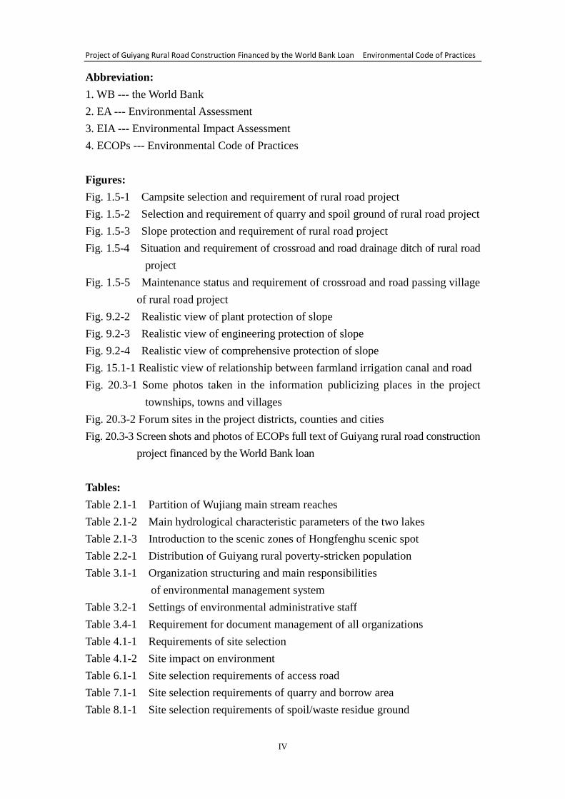
Figures:
Fig. 1.5-1 Campsite selection and requirement of rural road project
Fig. 1.5-2 Selection and requirement of quarry and spoil ground of rural road project
Fig. 1.5-3 Slope protection and requirement of rural road project
Fig. 1.5-4 Situation and requirement of crossroad and road drainage ditch of rural road
project
Fig. 1.5-5 Maintenance status and requirement of crossroad and road passing village
of rural road project
Fig. 9.2-2 Realistic view of plant protection of slope
Fig. 9.2-3 Realistic view of engineering protection of slope
Fig. 9.2-4 Realistic view of comprehensive protection of slope
Fig. 15.1-1 Realistic view of relationship between farmland irrigation canal and road
Fig. 20.3-1 Some photos taken in the information publicizing places in the project
townships, towns and villages
Fig. 20.3-2 Forum sites in the project districts, counties and cities
Fig. 20.3-3 Screen shots and photos of ECOPs full text of Guiyang rural road construction
project financed by the World Bank loan
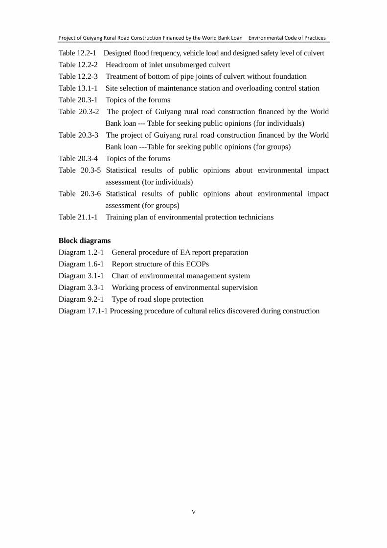
Tables:
Table 2.1-1 Partition of Wujiang main stream reaches
Table 2.1-2 Main hydrological characteristic parameters of the two lakes
Table 2.1-3 Introduction to the scenic zones of Hongfenghu scenic spot
Table 2.2-1 Distribution of Guiyang rural poverty-stricken population
Table 3.1-1 Organization structuring and main responsibilities
of environmental management system
Table 3.2-1 Settings of environmental administrative staff
Table 3.4-1 Requirement for document management of all organizations
Table 4.1-1 Requirements of site selection
Table 4.1-2 Site impact on environment
Table 6.1-1 Site selection requirements of access road
Table 7.1-1 Site selection requirements of quarry and borrow area
Table 8.1-1 Site selection requirements of spoil/waste residue ground
Project of Guiyang Rural Road Construction Financed by the World Bank Loan Environmental Code of Practices
V
Table 12.2-1 Designed flood frequency, vehicle load and designed safety level of culvert
Table 12.2-2 Headroom of inlet unsubmerged culvert
Table 12.2-3 Treatment of bottom of pipe joints of culvert without foundation
Table 13.1-1 Site selection of maintenance station and overloading control station
Table 20.3-1 Topics of the forums
Table 20.3-2 The project of Guiyang rural road construction financed by the World
Bank loan --- Table for seeking public opinions (for individuals)
Table 20.3-3 The project of Guiyang rural road construction financed by the World
Bank loan ---Table for seeking public opinions (for groups)
Table 20.3-4 Topics of the forums
Table 20.3-5 Statistical results of public opinions about environmental impact
assessment (for individuals)
Table 20.3-6 Statistical results of public opinions about environmental impact
assessment (for groups)
Table 21.1-1 Training plan of environmental protection technicians
Block diagrams
Diagram 1.2-1 General procedure of EA report preparation
Diagram 1.6-1 Report structure of this ECOPs
Diagram 3.1-1 Chart of environmental management system
Diagram 3.3-1 Working process of environmental supervision
Diagram 9.2-1 Type of road slope protection
Diagram 17.1-1 Processing procedure of cultural relics discovered during construction

Project of Guiyang Rural Road Construction Financed by the World Bank Loan Environmental Code of Practices
1
1 Preface
1.1 Background of project
Objective of the project of Guiyang Rural road Project financed by the World
Bank loan is to provide improved transport accessibility in select areas of Guiyang, in a
sustainable manner.
Per the request of the Guiyang Municipal Government, the proposed Project will
partly support the implementation of the activities under Guiyang Rural Roads
Development 12th Five-Year-Plan, with a particular focus on the
upgrading/improvement of existing lower class roads and the rehabilitation of county
and township roads in poor condition. In addition, the Project will help build the
capacity for rural roads maintenance. To this end, the Project will include the
following four components:
Component A: Upgrading/improving county and township roads (~RMB 1.113
billion: 57% of the total project cost) will provide all-season roads to villagers and
increase transport capacity in key corridors. Physical outputs include: (1) upgrading
one county road from Class IV to Class II; and (2) improving unclassified county and
township roads to Class IV.
Component B: Rehabilitation of county and township roads (~ RMB 755
million: 39% of the total project cost) supports the rehabilitation of deteriorated
county and township roads. The physical outputs of the component include
rehabilitated roads, with improved safety and drainage features.
Component C: Rural road maintenance pilot (~ RMB76 million: 5% of the total
project cost) will enable the Guiyang Municipal Transport Bureau to test and verify
methods that could improve the cost efficiency and efficacy of the Guiyang
Municipality rural road maintenance program. The component comprises three
distinct parts: (a) Development of the rural road maintenance pilot design; (b)
Implementation of the rural road maintenance pilot; and (c) Improvement of the
Guiyang Rural Road Management Information System.
Component D: Technical assistance (TA) (~RMB 6 million: <1% total project
cost) supports the implementation of two technical assistance programs that contribute
to the longer term sustainability of the rural road program: (a) Rural road network
plan and (b) Training and study tours.
The first 22 roads (see the Attached Table 6) served in 2013, which belong to the
improvement of county or township roads under the subproject B, were identified in
the preparatory stage of the project. Other roads under subproject A and subproject B
will be selected from the relevant road planning scope in the 12th
five-year plan of
Guiyang during the project implementation period.
1.2 Environmental assessment (EA)
Environmental assessment of this project should accord with relevant EA policies,
rules and technical guideline of China and the World Bank. In view of little potential
environmental impact decided by the construction nature of this project, the World
Bank (WB) proposes that the form of Environmental Code of Practices (ECOPs) is
taken for the EA report of this project, which makes environmental protection request
for typical constructions included in the investment activities with different forms
(such as road improvement, upgrading, construction of maintenance base and
overweight control station). Environmental code of practice should be fully combined
Project of Guiyang Rural Road Construction Financed by the World Bank Loan Environmental Code of Practices
2
with design and contractor must comply with it in construction. For those extended
and large-upgraded roads, project owner should act in accordance with the procedure
specified in the code to prepare specific EA and environmental management plan.
The 22 roads identified in the preparatory stage of the project have a small
construction scale and an unobvious environmental impact. According to the above
WB proposal, it is not needed to prepare special EA and environment management
plan for these roads for WB examination and approval.
General procedure prepared for EA report is as follows:
(1) Preparatory stage of subproject
Mainly including subproject screening, preparation of EA documents, public
consultation and information announcement.
① Environment screening of subproject
Environmental assessment organization should assist the Project Office to review
subproject, definite EA grade, report form, applicable rules and WB environmental
safeguard policy, assessment scope and degree, examination requirements, and so on.
Environmental assessment organization should assist the Project Office to fill in the
environment screening form (the Attached Table 1) for each subproject, which will be
signed and confirmed by the person in charge of the Project Office. Each subproject
screening form should be filed properly for review of WB and department concerned.
Note: According to WB environmental assessment policy, this project is
categorized in Class B. If a proposed subproject is identified in the screening to
have heavier environmental impact and involve higher sensitive area, it maybe
categorized in Class A environmental assessment project. Thus, its subproject
cannot be included in this project.
② Preparation of EA documents
After screening, if it is confirmed that environmental impact of a subproject is
small, this ECOPs can be applied directly. For those extended and large-upgraded
roads, project owner should prepare specific EA documents, i.e. an environmental
impact assessment (EA) report and an environmental management plan, or only
prepare an environmental management plan. Before the subprojects are practiced, the
Project Office should submit the environment screening form and other relevant
documents of the subprojects in this class to the World Bank, at the same time, should
make a suggestion for the form, scope, degree and applicable policy of EA report. The
World Bank will make examination and give advice.
③ Public consultation
(a) The Project Office is responsible for carrying out information announcement
and public consultation; while environmental assessment organization is responsible
for offering technical support.
(b) Public consultation is aimed at hearing stakeholders’ suggestions on
environmental impact of the project. The impacted parties or individuals will
determine their important environment issues. Any important suggestion in public
consultation will be included in EA documents.
(c) Public consultation should be conducted once at least. EA documents of the
project, including this environment code of practices as well as the EA documents of
Project of Guiyang Rural Road Construction Financed by the World Bank Loan Environmental Code of Practices
3
specific subproject (if any), should be announced in full text and guaranteed to be
obtained by the public. Ways of effective consultation will include questionnaire,
interview, meeting, etc. Announcement and consultation course, analysis and results
should be included in EA documents.
④ Examination and approval of EA documents
This ECOPs must be examined and approved by WB and departments concerned
in the project appraisal stage. EA and other relevant documents (e.g. water and soil
conservation plan) related to the specific subproject should be also approved by WB,
environmental protection authority and other administrative departments before
project implementation.
Note: This ECOPs and environmental management plan (if any) should be
brought into road design. The road design of subproject should refer to this ECOPs;
design institute and the environmental administrators of the Project Office should
hold coordination meeting of environmental design at regular intervals.
(2) Practice stage
This ECOPs and the environmental management plan (if any) of subproject must
be included in civil work bidding documents and construction contract, and must be
implemented during the period of construction.
① Requirement for bidding documents
In project bidding, the Project Office is responsible for ensuring that ECOPs and
the environmental management plan (if any) are fully included in the bidding
documents and the contract. Satisfying these conditions is necessary for bidder to win
the bidding. In addition, the Project Office will ensure terms and conditions of
subproject construction contract conforming to Chinese relevant rules.
② Monitoring
The Project Office will ensure effective setup, personnel available, practice
arrangement and relevant environmental protection systems, and will supervise
effective implementation of the construction code of environmental protection and the
environmental management plan of subproject.
③ Report
On schedule, the Project Office should semiannually submit semi-annual
implementation report of environmental management to WB. The report should cover
environment screening form of subproject, practice of environmental protection, etc.
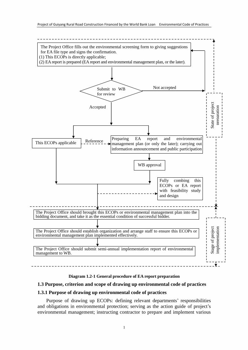
General procedure of EA preparation is shown in Diagram 1.2-1.
Project of Guiyang Rural Road Construction Financed by the World Bank Loan Environmental Code of Practices
1
Diagram 1.2-1 General procedure of EA report preparation
1.3 Purpose, criterion and scope of drawing up environmental code of practices
1.3.1 Purpose of drawing up environmental code of practices
Purpose of drawing up ECOPs: defining relevant departments’ responsibilities
and obligations in environmental protection; serving as the action guide of project’s
environmental management; instructing contractor to prepare and implement various
Submit to WB
for review
Accepted
This ECOPs applicable Preparing EA report and environmental
management plan (or only the later); carrying out
information announcement and public participation
Not accepted
WB approval
The Project Office should brought this ECOPs or environmental management plan into the bidding document, and take it as the essential condition of successful bidder.
The Project Office should establish organization and arrange staff to ensure this ECOPs or environmental management plan implemented effectively.
The Project Office should submit semi-annual implementation report of environmental management to WB.
Sta
te o
f p
roje
ct
pre
par
atio
n
Sta
ge
of
pro
ject
imple
men
tati
on
Reference
Fully combing this
ECOPs or EA report
with feasibility study
and design
The Project Office fills out the environmental screening form to giving suggestions
for EA file type and signs the confirmation.
(1) This ECOPs is directly applicable;
(2) EA report is prepared (EA report and environmental management plan, or the later).
Project of Guiyang Rural Road Construction Financed by the World Bank Loan Environmental Code of Practices
2
measures to alleviate adverse environmental impact during the period of construction;
instructing all project owners to take environmental protection measures specified in
the contract after the project is completed and put into operation. In this code, a
standard operation procedure is set up, which aims at adverse environmental impact in
the course of construction of road transport project. A set of detailed and operable
environmental measures is drawn up, which is feasible in technology and sustainable
in finance, so as to eliminate or reduce project’s adverse impact on environment and
society to an acceptable level. Specific objectives include:
(1) Defining the environmental management obligations of contractor and
operator
Environmental assessment organization and relevant design institute should make
detailed site verification to the environmental protection objective in the project area;
at the same time, according to the environmental characteristics and project features
of the project area, draw up practical environmental protection measures and bring the
measures into the engineering design, as the contract responsibilities of contractor and
operator.
(2) Serving as the operation guide of environmental management
Relevant environmental protection measures in construction period and operation
period provided in ECOPs can ensure the effective implementation of environmental
control and impact alleviation. In construction period and operation period, this
ECOPs will be provided to construction consulting organization, environmental
supervision company and other units concerned, so as to definite the responsibilities
of relevant functional departments and administrative organizations, and to introduce
the channel and manner of exchange among the departments.
(3) This ECOPs should be fully combined with project’s engineering design and
provide design guidance.
1.3.2 Principle of drawing up environmental code of practices
(1) Principle of scientificity, objectivity and fairness: ECOPs must be scientific,
objective and fair. Possible impact on various environmental elements and their
ecosystem, resulted from the implementation of this code, should be comprehensively
taken into account, to provide decision-making with scientific basis.
(2) Principle of integrity: Taking integrity into account, ECOPs should be
connected with the policies, schemes, plans and relevant project related to the code.
(3) Principle of public participation: In the course of ECOPs implementation,
public participation should be encouraged and supported, fully taking the interests and
proposals of all social circles into account.
(4) Principle of consistency: ECOPs should keep pace with construction level and
degree.
(5) Principle of operability: Simple, practical and feasible methods should be
selected as far as possible; ECOPs should be operable.
1.3.3 Applicable scope of environmental code of practices
Environmental assessment of World Bank safeguard policy (OP4.01) is
applicable for this project. According to the requirement of environment screening
and classification of this policy, through the environment screening of project type,
Project of Guiyang Rural Road Construction Financed by the World Bank Loan Environmental Code of Practices
3
location, sensitivity and scale as well as the characteristics and degree of potential
environmental impact, this project is categorized in Class B. In order to safeguard
constructors and the personnel in the sensitive area, and to prevent the interference of
construction period to the sensitive area and surroundings, it is needed to draw up
environmental code of practices (ECOPs). This report is related to rural road project
ECOPs, applicable to new construction and reconstruction projects of rural road and
counterpart infrastructure. These projects will produce a certain impact on
environment during construction period and operation period. Although the impact is
slight and the measures are mature, it is still required to draw up ECOPs to provide
relevant environmental management mechanism, control and alleviation measures to
minimize the impact.
1.4 Relevant laws, rules and security policies
Relevant laws, rules and security policies are listed in the Table 1.4-1.
Table 1.4-1 Relevant laws, rules and security policies
SN Relevant laws, rules and security policies Implementation date
and document No.
(1) Environmental protection law of the People’s Republic of China 26/12/1989
(2) Law of the People’s Republic of China on environmental impact
assessment 01/09/2003
(3) Law of the People’s Republic of China on prevention and control of
atmosphere pollution 01/09/2000
(4) Law of the People’s Republic of China on prevention and control of
water pollution 28/02/2008
(5) Law of the People’s Republic of China on prevention and control of
noise pollution 29/10/1996
(6) Law of the People’s Republic of China on water and soil
conservation 01/03/2011
(7) Law of the People’s Republic of China on land management 29/08/1998
(8) Forest law of the People’s Republic of China Modified in 1998
(9) Law of the People’s Republic of China on cultural relics protection 29/12/2007
(10) Law of the People's Republic of China on the protection of wildlife 08/11/1988
(11) Regulations of the People’s Republic of China on the protection of
wild plants 01/01/1997
(12) Regulations on the administration of environmental protection of
construction projects 29/11/1998
(13) Classification and management list of environmental impact
assessment of construction projects 01/10/2008
(14)
Management regulations on environmental protection acceptance of
“three-simultaneity” supervision, inspection and completion of
construction projects, the Ministry of Environmental Protection (trial)
17/12/2009
(15) Measures on environmental protection acceptance and management
of construction project completion 01/02/2002
(16) Management measures on environmental protection of transport
construction projects Degree No.5, 2003
(17) Code for design of environmental protection of roads JTG B04-2010
(18) Provisions on water and soil conservation of road construction
projects
[2001]No.12,
MWR, MOC
(19) Policy for prevention and control technology of ground traffic noise
pollution HF [2010] No.7
(20) Notice on launching environmental supervision of traffic projects JHF [2004]
No.314
Project of Guiyang Rural Road Construction Financed by the World Bank Loan Environmental Code of Practices
4
(21) Code for design of road drainage JTJ018-97
(22) Technical standard for highway engineering JTGB01-2003
(23)
Management regulations on environmental protection acceptance of
“three-simultaneity” supervision, inspection and completion of
construction projects, the Environmental Protection Department of
Guizhou Province (trial)
04/09/2011
(24)
Regulations of Guizhou Province on graded examination and
approval of environmental impact assessment documents of
construction projects
Revised, 2012
(25) Code of Guizhou Province for environmental protection
management of construction projects
(26) Regulations of Guizhou Province on environmental protection June 2009
(27) Operation manual of the World Bank --- environmental assessment OP/BP4.01
(28) Operation manual of the World Bank --- natural habitat OP/BP 4.04
(29) Operation manual of the World Bank --- material culture resources OP/BP 4.11
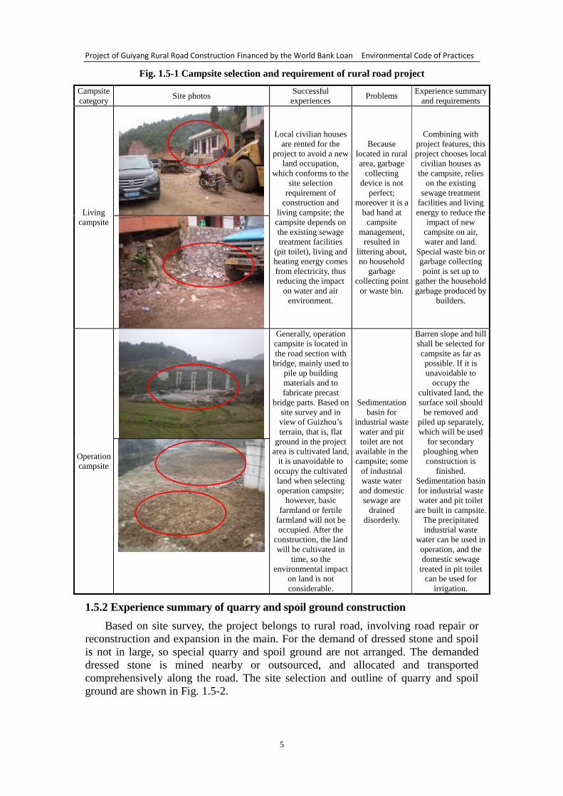
1.5 Experience summary of rural road subproject of “Guiyang transport project”
The rural road subproject under the “Guiyang transport project” financed by the
World Bank loan is being implemented, which can offer reference for this Guiyang
rural road project. In this section, the requirements for environmental management of
construction site and project operation are summarized, mainly including construction
camp, access road, borrow area, spoil ground, asphalt mixing station, slope treatment,
traffic safety, road maintenance and management, etc. Now, they are described
respectively as follows:
1.5.1 Experience summary of construction camp
Based on site survey, the project belongs to rural road and along the road there are
a number of civilian houses, which are rented for the living campsite of the
implemented Guiyang transport project that is financed by the World Bank loan.
Operation campsite is a new land, which will be earthed up or afforested after the
construction is finished. The selection and outline of operation campsite and living
campsite are shown in Fig. 1.5-1.
Project of Guiyang Rural Road Construction Financed by the World Bank Loan Environmental Code of Practices
5
Fig. 1.5-1 Campsite selection and requirement of rural road project
Campsite
category Site photos
Successful
experiences Problems
Experience summary
and requirements
Living
campsite
Local civilian houses
are rented for the
project to avoid a new
land occupation,
which conforms to the
site selection
requirement of
construction and
living campsite; the
campsite depends on
the existing sewage
treatment facilities
(pit toilet), living and
heating energy comes
from electricity, thus
reducing the impact
on water and air
environment.
Because
located in rural
area, garbage
collecting
device is not
perfect;
moreover it is a
bad hand at
campsite
management,
resulted in
littering about,
no household
garbage
collecting point
or waste bin.
Combining with
project features, this
project chooses local
civilian houses as
the campsite, relies
on the existing
sewage treatment
facilities and living
energy to reduce the
impact of new
campsite on air,
water and land.
Special waste bin or
garbage collecting
point is set up to
gather the household
garbage produced by
builders.
Operation
campsite
Generally, operation
campsite is located in
the road section with
bridge, mainly used to
pile up building
materials and to
fabricate precast
bridge parts. Based on
site survey and in
view of Guizhou’s
terrain, that is, flat
ground in the project
area is cultivated land,
it is unavoidable to
occupy the cultivated
land when selecting
operation campsite;
however, basic
farmland or fertile
farmland will not be
occupied. After the
construction, the land
will be cultivated in
time, so the
environmental impact
on land is not
considerable.
Sedimentation
basin for
industrial waste
water and pit
toilet are not
available in the
campsite; some
of industrial
waste water
and domestic
sewage are
drained
disorderly.
Barren slope and hill
shall be selected for
campsite as far as
possible. If it is
unavoidable to
occupy the
cultivated land, the
surface soil should
be removed and
piled up separately,
which will be used
for secondary
ploughing when
construction is
finished.
Sedimentation basin
for industrial waste
water and pit toilet
are built in campsite.
The precipitated
industrial waste
water can be used in
operation, and the
domestic sewage
treated in pit toilet
can be used for
irrigation.
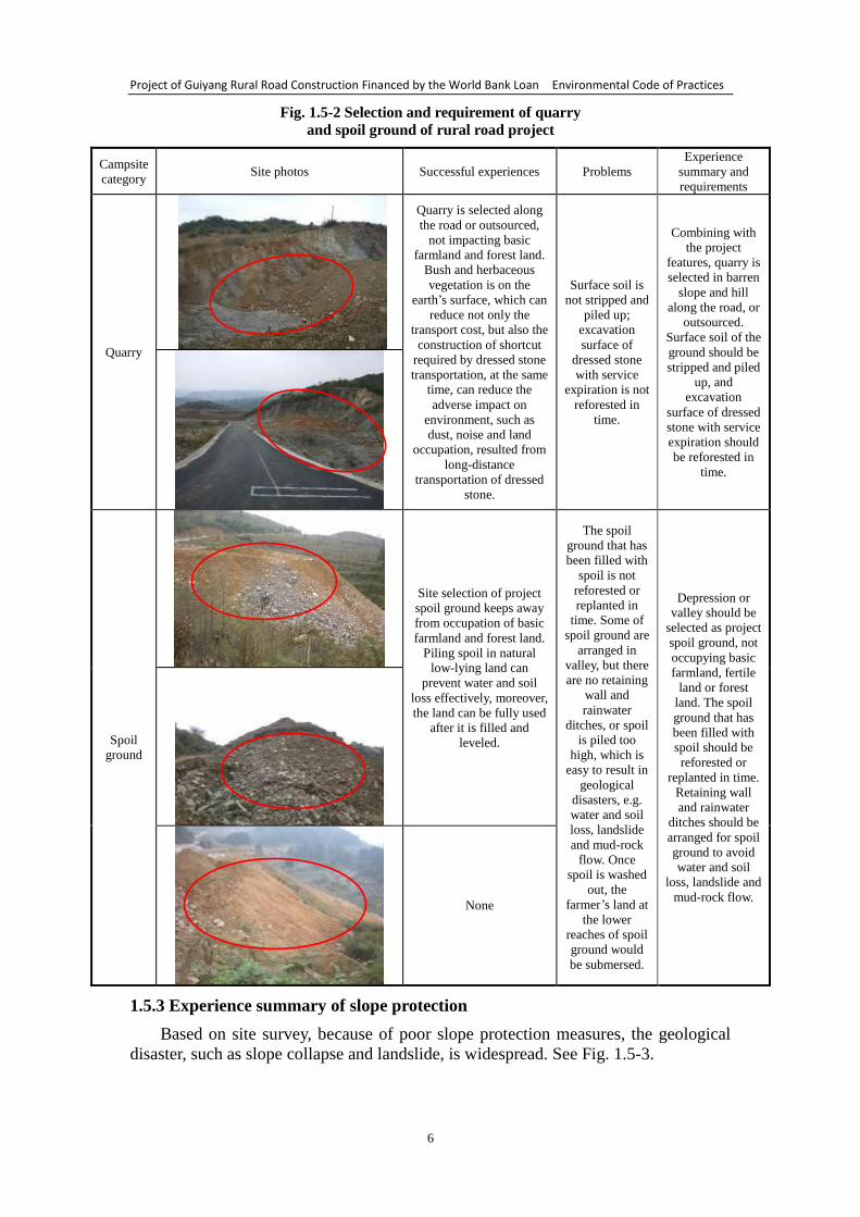
1.5.2 Experience summary of quarry and spoil ground construction
Based on site survey, the project belongs to rural road, involving road repair or
reconstruction and expansion in the main. For the demand of dressed stone and spoil
is not in large, so special quarry and spoil ground are not arranged. The demanded
dressed stone is mined nearby or outsourced, and allocated and transported
comprehensively along the road. The site selection and outline of quarry and spoil
ground are shown in Fig. 1.5-2.
Project of Guiyang Rural Road Construction Financed by the World Bank Loan Environmental Code of Practices
6
Fig. 1.5-2 Selection and requirement of quarry
and spoil ground of rural road project
Campsite
category Site photos Successful experiences Problems
Experience
summary and
requirements
Quarry
Quarry is selected along
the road or outsourced,
not impacting basic
farmland and forest land.
Bush and herbaceous
vegetation is on the
earth’s surface, which can
reduce not only the
transport cost, but also the
construction of shortcut
required by dressed stone
transportation, at the same
time, can reduce the
adverse impact on
environment, such as
dust, noise and land
occupation, resulted from
long-distance
transportation of dressed
stone.
Surface soil is
not stripped and
piled up;
excavation
surface of
dressed stone
with service
expiration is not
reforested in
time.
Combining with
the project
features, quarry is
selected in barren
slope and hill
along the road, or
outsourced.
Surface soil of the
ground should be
stripped and piled
up, and
excavation
surface of dressed
stone with service
expiration should
be reforested in
time.
Spoil
ground
Site selection of project
spoil ground keeps away
from occupation of basic
farmland and forest land.
Piling spoil in natural
low-lying land can
prevent water and soil
loss effectively, moreover,
the land can be fully used
after it is filled and
leveled.
The spoil
ground that has
been filled with
spoil is not
reforested or
replanted in
time. Some of
spoil ground are
arranged in
valley, but there
are no retaining
wall and
rainwater
ditches, or spoil
is piled too
high, which is
easy to result in
geological
disasters, e.g.
water and soil
loss, landslide
and mud-rock
flow. Once
spoil is washed
out, the
farmer’s land at
the lower
reaches of spoil
ground would
be submersed.
Depression or
valley should be
selected as project
spoil ground, not
occupying basic
farmland, fertile
land or forest
land. The spoil
ground that has
been filled with
spoil should be
reforested or
replanted in time.
Retaining wall
and rainwater
ditches should be
arranged for spoil
ground to avoid
water and soil
loss, landslide and
mud-rock flow.
None
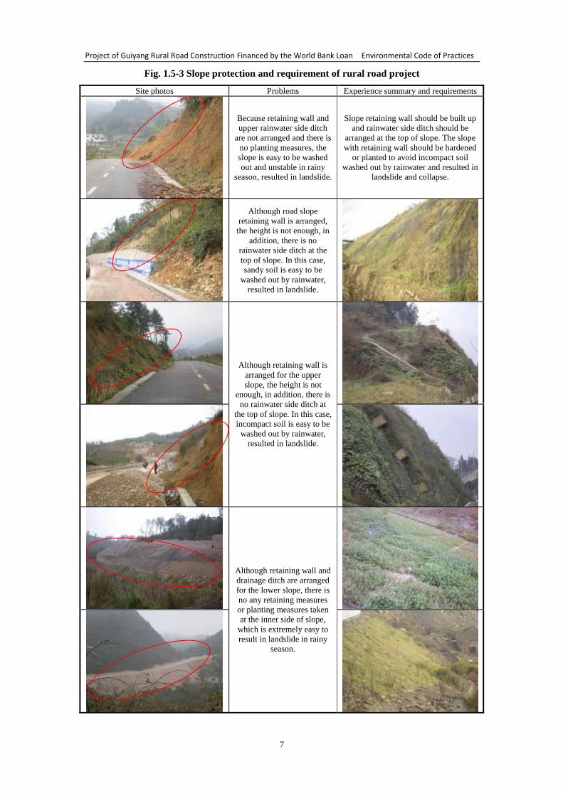
1.5.3 Experience summary of slope protection
Based on site survey, because of poor slope protection measures, the geological
disaster, such as slope collapse and landslide, is widespread. See Fig. 1.5-3.
Project of Guiyang Rural Road Construction Financed by the World Bank Loan Environmental Code of Practices
7
Fig. 1.5-3 Slope protection and requirement of rural road project
Site photos Problems Experience summary and requirements
Because retaining wall and
upper rainwater side ditch
are not arranged and there is
no planting measures, the
slope is easy to be washed
out and unstable in rainy
season, resulted in landslide.
Slope retaining wall should be built up
and rainwater side ditch should be
arranged at the top of slope. The slope
with retaining wall should be hardened
or planted to avoid incompact soil
washed out by rainwater and resulted in
landslide and collapse.
Although road slope
retaining wall is arranged,
the height is not enough, in
addition, there is no
rainwater side ditch at the
top of slope. In this case,
sandy soil is easy to be
washed out by rainwater,
resulted in landslide.
Although retaining wall is
arranged for the upper
slope, the height is not
enough, in addition, there is
no rainwater side ditch at
the top of slope. In this case,
incompact soil is easy to be
washed out by rainwater,
resulted in landslide.
Although retaining wall and
drainage ditch are arranged
for the lower slope, there is
no any retaining measures
or planting measures taken
at the inner side of slope,
which is extremely easy to
result in landslide in rainy
season.
Project of Guiyang Rural Road Construction Financed by the World Bank Loan Environmental Code of Practices
8
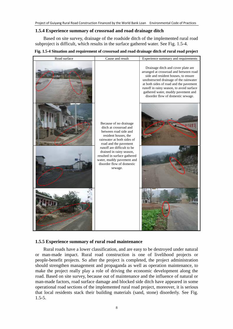
1.5.4 Experience summary of crossroad and road drainage ditch
Based on site survey, drainage of the roadside ditch of the implemented rural road
subproject is difficult, which results in the surface gathered water. See Fig. 1.5-4.
Fig. 1.5-4 Situation and requirement of crossroad and road drainage ditch of rural road project
Road surface Cause and result Experience summary and requirements
Because of no drainage
ditch at crossroad and
between road side and
resident houses, the
rainwater at both sides of
road and the pavement
runoff are difficult to be
drained in rainy season,
resulted in surface gathered
water, muddy pavement and
disorder flow of domestic
sewage.
Drainage ditch and cover plate are
arranged at crossroad and between road
side and resident houses, to ensure
unobstructed drainage of the rainwater
at both sides of road and the pavement
runoff in rainy season, to avoid surface
gathered water, muddy pavement and
disorder flow of domestic sewage.
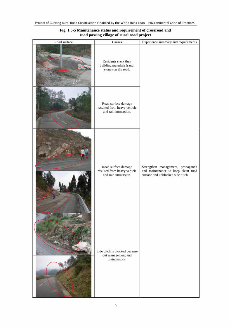
1.5.5 Experience summary of rural road maintenance
Rural roads have a lower classification, and are easy to be destroyed under natural
or man-made impact. Rural road construction is one of livelihood projects or
people-benefit projects. So after the project is completed, the project administration
should strengthen management and propaganda as well as operation maintenance, to
make the project really play a role of driving the economic development along the
road. Based on site survey, because out of maintenance and the influence of natural or
man-made factors, road surface damage and blocked side ditch have appeared in some
operational road sections of the implemented rural road project, moreover, it is serious
that local residents stack their building materials (sand, stone) disorderly. See Fig.
1.5-5.
Project of Guiyang Rural Road Construction Financed by the World Bank Loan Environmental Code of Practices
9
Fig. 1.5-5 Maintenance status and requirement of crossroad and
road passing village of rural road project
Road surface Causes Experience summary and requirements
Residents stack their
building materials (sand,
stone) on the road.
Strengthen management, propaganda
and maintenance to keep clean road
surface and unblocked side ditch.
Road surface damage
resulted from heavy vehicle
and rain immersion.
Road surface damage
resulted from heavy vehicle
and rain immersion.
Side ditch is blocked because
out management and
maintenance.
Project of Guiyang Rural Road Construction Financed by the World Bank Loan Environmental Code of Practices
10
1.6 Structure of the report
This environmental code of practices (ECOPs) is divided into three parts, i.e.
preface, text and appendixes, totaling 21 chapters.
The preface covers project background, EA procedure, ECOPs objective, criterion
and scope, as well as applicable laws, rules and security policies, with the purpose of
making readers learn about ECOPs composition background and relevant information.
Main contents of the text include the general requirement of environmental
management control of rural road construction and the specific requirements of
construction progress. The characteristics, impact on environment, and measures to
alleviate environmental impact of all divisional works are described in accordance
with different subprojects. When project construction is involved in the environmental
impact of a specific work, please refer to the environmental code of practices for the
specific work.
Appendixes mainly include attached maps and attached tables. The former covers
geographic position map, drainage map and sensitive object distribution map, with the
purpose of making readers have an overall knowledge about Guiyang’s geographic
position in Guizhou, China, as well as drainage system and sensitive area distribution.
The later covers environment screening form, summary sheet of environmental
supervision of project, checklist of environmental protection review in construction
period, rectification notice of environmental protection issued by environment
supervisor to contractor, checklist of environmental protection before acceptance and
so on, with the purpose of supervising and reviewing the environmental behavior of
all works in the course of project construction; meanwhile, correcting the
unreasonable environmental behavior.
This code is drawn up in accordance with the impact of road project on
environment, suitable for design institute to prepare the environment chapter of
feasibility study report and design report, for general contractor in construction site
management and environmental supervision, and for project owner and authority in
site supervision and management.
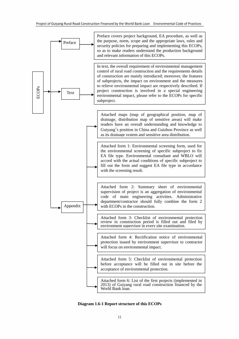
The structure of this ECOPs is shown in Diagram 1.6-1.
Project of Guiyang Rural Road Construction Financed by the World Bank Loan Environmental Code of Practices
11
Diagram 1.6-1 Report structure of this ECOPs
EC
OP
s Preface
Text
Appendix
Preface covers project background, EA procedure, as well as
the purpose, norm, scope and the appropriate laws, rules and
security policies for preparing and implementing this ECOPs,
so as to make readers understand the production background
and relevant information of this ECOPs.
In text, the overall requirement of environmental management
control of rural road construction and the requirements details
of construction are mainly introduced; moreover, the features
of subprojects, the impact on environment and the measures
to relieve environmental impact are respectively described. If
project construction is involved in a special engineering
environmental impact, please refer to the ECOPs for specific
subproject.
Attached maps (map of geographical position, map of
drainage, distribution map of sensitive areas) will make
readers have an overall understanding and knowledge to
Guiyang’s position in China and Guizhou Province as well
as its drainage system and sensitive area distribution.
Attached form 1: Environmental screening form, used for
the environmental screening of specific subproject to fix
EA file type. Environmental consultant and WBLO will
accord with the actual conditions of specific subproject to
fill out the form and suggest EA file type in accordance
with the screening result.
Attached form 2: Summary sheet of environmental
supervision of project is an aggregation of environmental
code of main engineering activities. Administrative
department/contractor should fully combine the form 2
with ECOPs in the construction.
Attached form 3: Checklist of environmental protection review in construction period is filled out and filed by environment supervisor in every site examination.
Attached form 4: Rectification notice of environmental
protection issued by environment supervisor to contractor
will focus on environmental impact.
Attached form 5: Checklist of environmental protection
before acceptance will be filled out in site before the
acceptance of environmental protection.
Attached form 6: List of the first projects (implemented in 2013) of Guiyang rural road construction financed by the World Bank loan.
Project of Guiyang Rural Road Construction Financed by the World Bank Loan Environmental Code of Practices
12
2 Outline of Basic Information of Guiyang City
2.1 Natural environment
2.1.1 Geographic position
Guiyang, the capital of Guizhou Province, is one of the key cities in the southwest
of China, also is a significant transportation junction, industrial base, and commercial,
trading and tourism center. Guiyang is located at 106°07′-107°17′ E and 26°11′-26°55′
N, bordering Weng’an County, Longli County, Huishui County and Changshun
County in the southeast, Pingba County and Zhijin County in the west, Qianxi County,
Jinsha County and Zunyi County in the north, with total land area of 8034 km2,
accounting for 4.56% of the provincial area. The area of administrative districts of the
city is 230 km2, of which Yunyan District is 67.5 km
2, Nanming District is 89.68 km
2,
Huaxi District is 1020.73 km2, Wudang District is 964.9 km
2, Baiyun District is 272
km2, and Guanshanhu District is 307 km
2. Total area of “one city and three counties”
(i.e. Qingzhen City, Kaiyang County, Xifeng County and Xiuwen County) is 5625.5
km2, of which Qingzhen City is 1492 km
2, Xiuwen County is 1071 km
2, Xifeng
County is 1036.5 km2 and Kaiyang is 2026 km
2.
Guiyang’s geographic position in Guizhou, China is shown in Attached Map 1.
2.1.2 Topography
Guiyang is located in the middle part of plateau hills of central Guizhou, a
watershed between the Yangtze River and the Pearl River, with the topography of
higher in the southwest and lower in the northeast. Denuded hills are alternate with
basin, valley and depression. Relative height difference is 100-200m. The peak is at
Miaowoding of Shuitian Town, with the elevation of 1659m; the lowest is at the outlet
of Nanming River, with the elevation of 880m. Stratified landform is obvious, mainly
including Guiyang-Zhongcaosi syncline basin, Baiyun-Huaxi-Qingyan composed
multistage platform and karst depression. Peak cluster, dishing depression, funnel,
underground stream and karst cave are developed. Flat grounds are distributed in
Huaxi, Mengguan, Wudang, Jinhua and Zhuchang. Nanming River flows through the
downtown from the southwest to the northeast, with the drainage area accounting for
70% of the total urban area. The landform belongs to hill-plain basin, dominated by
mountains and hills, of which mountain area is 4218 km2, hill area is 2842 km
2 and
plain area is 912 km2. In addition, gorge area accounts for 1.2% of the total.
2.1.3 Climate and weather
Guiyang falls into Ferrell circulation, controlled by westerly zone and belonging
to subtropical humid mild climate. Annual average temperature is 15.3℃, annual
extreme maximum temperature is 35.1℃ and annual extreme minimum temperature is
-7.3℃; annual average relative humidity is 78%; annual average precipitation is
1129.5 mm; annual average thunder climate is 49.1 days; annual average overcast
climate is 235.1 days; annual average sunshine duration is 1148.3 hours; annual
average snowfall is only 11.3 days. Predominant wind direction of all year round is
northeaster, souther in summer and northeaster in winter, with average wind speed of
2.2m/s.
2.1.4 Hydrology
2.1.4.1 Surface water
(1) Main rivers
Project of Guiyang Rural Road Construction Financed by the World Bank Loan Environmental Code of Practices
13
Guiyang is located at the watershed between the Yangtze River system and the
Pearl River system, bounded by Tongmuling of Huaxi District. The rivers to the south
of Tongmuling belong to the Pearl River system, with drainage area of 415 km2,
accounting for 5.2% of Guiyang’s land area; the rivers to the north of Tongmuling
belong to the Yangtze River system, with drainage area of 7631.67 km2, accounting
for 94.8% of Guiyang’s land area. Main rivers flowing through Guiyang include
Wujiang River, Qingshuijiang River, Nanming River, Maotiao River, Yuliang River
and so on, which are separately described as follows:
① Wujiang River
Wujiang’s tributaries present feather-like distribution with higher density of river
network. The river length is about 17 km/100 km2. The drainage area of the left bank
is more than that of the right bank. There are 16 tributaries with each drainage area
above 1000 km2. Besides Liuchong River of the north source, the tributaries with each
drainage area above 2000 km2 include Maotiao River, Qingshuijiang River, Shiqian
River, Zhaishui River and Yujiang River at the right bank as well as Yeji River,
Hongdu River, Furongjiang River and Daxi River at the left bank. The partition of
Wujiang main stream reaches is shown in Table 2.1-1.
Table 2.1-1 Partition of Wujiang main stream reaches
Reaches From … to Catchment area (km2) Length
(km)
Water head
(m)
Gradient
(‰) Interval Accumulation
North source From Liuchong River source to
Huawuji 110 273.4 273.4 1293.5 4.73
Upstream From Sancha River source to
Huawuji 7264 18138 325.6 1298.5 4.29
Middle
stream From Huawuji to Sinan 33132 51270 368.8 503.7 1.37
Downstream From Sinan to Hekou 36650 87920 342.6 221.3 0.65
Whole river From Sancha River source to
Hekou 87920 87920 1037 2123.3 2.05
② Qingshuijiang River
Qingshuijiang is a main stream at the upper reaches of Yuanjiang in Hunan
Province. It originates from Qinggangpo at the south foot of Mt. Doupeng in Guiding
County, Guizhou Province, and flows in Jinping County, flowing through Duyun,
Majiang, Kaili and Taijiang counties (cities), including 12 towns/townships and 32
villages, with the drainage area of 1532 km2. The flowing reaches is 81.9 km long, of
which 13.1 km is as the boundary river between Jianhe County and Taijiang County.
Riverbed is 50m-200m wide. Maximum and minimum flow rates are 14693m3/s and
47m3/s respectively with the average value of 158.22m
3/s. Water head is 123m, that is,
inlet head is 471m and outlet head is 348m. Qingshuijiang has 52 streams in the
county, of which 29 streams travel down from the north bank and 23 streams from the
south bank.
③ Nanming River
Nanming River is the left source of Qingshuijiang River --- a tributary of Wujiang
River. As the longest river in Guiyang, it flows through the west part, the middle part
and the northeast part of Guiyang, from southwest to northeast. The river has two
sources. The main source is Lengshuichong in Linka of Pingba County, which flows
into Guiyang from the northeast of Pingba, named Malu River; another source is
Cigutang in Zhongba farm of Qingzhen City, which flows into Guiyang from the
southeast, named Cigushui. These two sources meet at the northeast of Huajie, Shiban
Project of Guiyang Rural Road Construction Financed by the World Bank Loan Environmental Code of Practices
14
Town, Huaxi District, and then flow to the east, flow through Banbianshan and
Dazhai, and at last reach to Huaxi Jifan Bridge, named Huaxi River, which first turns
to the north, flows through Zhongcaosi, where it takes in Chenliang River and Madi
River, then brings Xiaoche River into it at the northeast of Wuyanqiao, turns to the
east and flows through Zhaikoutan, and at last reaches to the south of Guiyang
downtown, named Nanming River. The river flows round the south of the downtown,
takes in Shixi River and Guancheng River at Cinanmen and Liudongqiao respectively,
then turns to the northeast and flows out of Tongjiqiao from Shuikousi, renamed
Jiaodu River. The river flows to the northeast at first, flows through Dayuzhai to
Gaozhaitian Daliangkou and takes in Xintian riverlet, flows through Hongjiqiao to
Luowan and takes in Longjing riverlet, then turns to the southeast to Wudang and
takes in Longdong River. On the flow way, it successively takes in Ganba River, a
riverlet, Baishui River and Xima River at Dingpa, Puduzhai, Xiaba and Laping
respectively. In Songjiadu, it flows out of the city boundary and into Longli and
Kaiyang counties. At last, it joins with Dushui River, which comes from Guiding
County and flows through Longli County, at Liangchahe --- the junction of Longli,
Kaiyang and Fuquan counties, where it is named Qingshuijiang River. After taking in
Xini River in Kaiyang County, Qingshuijiang River flows into Wujiang River at
Lianghekou of the county.
From the source to the outlet, Nanming River is 150 km long, with the water head
of 462m and the average gradient of 3‰. The gradient from Huaxi to Guiyang
downtown is the flattest, only 1.8‰ against the length of 23.4m and the water head of
42m; while the gradient from Zhuanjiaolongtang to the outlet is the steepest, up to
4.7‰ against the length of 13.5 km and the water head of 63m. The catchment area
that is controlled by Guiyang Hydrometric Station is 757 km2. Annual average runoff
is 491.8×10⁶m
3 with the flow rate of 13.3m
3/s; the runoff volume in the driest year is
only 230.8×10⁶m
3; the runoff volume for general dry year is 335×10
6m
3 with the flow
rate of 10.6m3/s.
(a) Xiaoche River
Xiaoche River is one of larger tributary of Nanming River, having three sources,
i.e. north source, west source and south source. The west source comes out of
Majingxiang of Jinhua Town, Wudang District, flowing to the east through
Shangbanya, Xiabanya and Baiyanzhai, and reaching Hangjiaqiao, about 21.6 km
long; the north source (Caijiaguan River) comes out of Hunshui Longtan of Babaao,
flowing to the south through Huishuitian, Gaoposhao, Jinguan and Caijiaguan,
reaching Hangjiaqiao, about 20.16 km; the south source (Youyudong River) comes
out of Dongping Longtan of Maiping Township, flowing to the northeast through
Datongzhai and Youyudong, reaching Hangjiaqiao, about 20 km long. The above
three sources meet in Hangjiaqiao to form Xiaoche River, which flows 7 km to the
east and joins Nanming River at Wuyanqiao. The total length of the river, from the
main source (south source) to the outlet, is about 28 km.
(b) Chenliang River
Chenliang River originates from Chenliang Town, Huaxi District, flowing from
the south to the north through Chenliang, Xiaomachang, Gaobang and Sunjiayuan,
reaching Sanjiangkou, where it joins Nanming River, 21.9 km long and 5-7m wide.
Elevation of riverbed is 1072.3-1073.7m. Because of unobvious topographic relief
and little gradient, the water flows gently. Water level elevation of flood of one in
hundred years is 1076m.
Project of Guiyang Rural Road Construction Financed by the World Bank Loan Environmental Code of Practices
15
(c) Shixi River
Shixi River originates from Bangshang of Qianling Township and joins Nanming
River near Yizhongqiao of Guiyang downtown, with the total length of 16.2 km, the
catchment area of 42.0 km2, the annual average flow rate of 0.74 m
3/s and the annual
average runoff is 23.4×10⁶m
3.
(d) Yuliang River
Yuliang River originates from Pojiao of Gujiao Town, Longli County, flowing
through Xiaobi Township of Huaxi District, Longdongbao area of Nanming District,
Yongle Township and Dongfeng Town of Wudang District, at last joining Nanming
River, from its right bank, at Jiuyanqiao of Mairang Village, Dongfeng Town. The
river is 40.8 km long, including 34.8 km within the borders, with average gradient of
5.9‰ and catchment area of 374.1km2 (including 214.3 km
2 within the borders).
The annual average natural flow, which joins Nanming River, is 6.5m3/s; the
drainage area of the right bank is larger than that of the left bank. It is a larger
primary tributary of Nanming River.
(e) Yudong River (also known as New River)
Two riverlets at the upper reaches are taken in this river, one of which comes
from Shisungou of Yongle Township and another from Maochang Township of Longli
County. The two riverlets collect the underground water from Yudong and join
Yuliang River at Toubao, and then flow into Nanming River. Yudong River is
perennial, about 30 km long and 20m wide.
④ Maotiao River
Maotiao River flows through the southwest boundary of Xiuwen County and
joins Wujiang River at Sanchahe of Liuguang Township. The river length within the
borders is 49.65 km, with drainage area of 3195 km2, annual average flow rate of 55.9
m3/s and annual runoff of 1763×10
6m
3. It originates from Dabaiyan of Chashan
Village, Shi’an Township. The source is known as Huaqiao River, which flows
through Chong’en Township, Changba Township and Saping Township, and join
Maotiao River at the junction of Zhongzhai Township and Wuli Township. Its
drainage area is 149.4km2, river length is 20 km, annual average flow rate is 2.2m
3/s
and runoff is 69×106m
3.
(a) Xiuwen River
As a primary tributary of Maotiao River, Xiuwen River is located in the middle of
Xiuwen County. It originates from the northeastern Mengchong of Dongqing Village,
Jiuchang Town, flows through Shi’an, Majiaqiao, Zhouguan and Chengguan, joins
Maotiao River at the southwestern outlet and at last flows into Wujiang River. Its
length is 37 km and drainage area is 228.2 km2.
(b) Maijia River
Maijia River is the largest in Baiyun District, originating from the northern
Xiuwen County’s Shibanshao and the west foot of Mt. Zhouwu. It flows, from the
north to the south, through Shatian reservoir, Bianshan and Jinjia, turns at
Mahcangying to the west, then flows through Guoyuan, Maijia, Mayan and Zhuchang,
at last into Maotiao River, with the total length of 26.15 km, drainage area of
150.2km2 and annual average flow rate of 2.70m
3/s.
(c) Tiaodun River (also known as Anliu River)
Project of Guiyang Rural Road Construction Financed by the World Bank Loan Environmental Code of Practices
16
As a primary tributary of Maotiao River --- the primary tributary of Wujiang
River, Tiaodun River originates from Laocaishan of Jiujia Township, Pingba County
and flows into the city boundary at Xiaoluohai of Pingbao Village. Then it flows
through Gaole, Xiguan, Gangou, Liwo, Caishui, Yongle, Wangzhuang, Anliu and
Muke villages, underflows into a cave in Anliu. It is exposed about 300m in
Xiangshuihe and again underflows into Yangpi Cave in Yangqiao Village, at last
forms a 30m waterfall and empty into Maotiao River. The total river length is 66.7 km,
with the drainage area of 299.2km2, average flow rate of 5.08m
3/s and dry season flow
rate of 1.01 m3/s.
(d) Ganhe River
Ganhe River belongs to a primary tributary of underflow, originating from
Houshan of Zhongzhai, at the southwest foot of Mt. Pagoda. It flows through
Wengtong Tianba, Toudaohe, Yanlong, Fengxiangba, Pingzhai, Yongle Tianba,
Xiniutun and Hujiazhai, underflows into a cave, then is exposed in Dacao, at last
empty into the underflow. The total river length is 30.0 km, with the drainage area of
73.0 km2 and average flow rate of 1.31m
3/s.
⑤ Qingshui River
Qingshui River originates from Bainitian of Machang Town, Pingba County,
Guizhou Province and the source elevation is 1310m. It empties into Wujian River at
Qingshuikou, the northeast of Kaiyang County with the confluence elevation of 510m.
The total length of main stream is 219 km, with total water head of 800m, average
gradient of 3.65‰ and 3.32 riverway bending coefficient. Drainage system is
developed. There are 22 primary tributaries, of which 10 tributaries have the drainage
area of above 100 km2 respectively; Yuliang River, Toubao River and Dumu River
have the drainage area of above 300 km2 respectively.
(a) Yuliang River
Yuliang River is a secondary tributary of Wujiang River, located in the southeast
of Xiuwen County. It originates from Longjinggou of Sanyuan Village, Zhazuo Town,
flows through Zhazuo Town from the south to the north and then turns to the northeast
(also known as Zhazuo River from the source to Sanli Bridge, and known as Taoyuan
River at the lower reaches of Sanli Bridge). At Sanli Bridge, Gema River is joined
from the north. After confluence, it is named Yuliang River. The river turns to the east,
flows through Yujingba and into the reservoir of Xiangbafang Hydropower Station.
And then, passing through Sandaoxiang and Taoyuan Sanzhai, it flows into Kaiyang
County at Dongtang of Xiaomu Village. It joins Qingshui River in Kaiyang County
and at last empties into Wujiang River. The source elevation of Yuliang River is
1350m, with annual average flow rate of 3.6m3/s, annual average runoff of 114×10
6m
3
and the drainage area within the borders of 375.91 km2.
(b) Gema River
Gema River, located in the east of Xiuwen County, originates from Yanjingchong
of Lushan Village, Jiuchang Town. It flows through Qingshui and Qingrang townships,
and joins Taoyuan River near the Sanli Bridge of Zhazuo Town. It is mainly used for
irrigation, with the drainage area of 64 km2, river length of 11.8 km, annual average
flow rate of 1.17m3/s, annual average runoff of 37×10
6m
3 and dry season flow (in
January 2009) of 0.18 m3/s.
(c) Guangdong River
Project of Guiyang Rural Road Construction Financed by the World Bank Loan Environmental Code of Practices
17
Guangdong River originates from Xifeng County. As a boundary river between
Xiuwen County and Kaiyang County, it flows into Kaiyang County at first, and then
into Xiuwen County at Dalinpo of Liutun Township. At the river dike of Liutun
Township, it flows underground and out of Xiuwen County, and joins Yuliang River in
Kaiyang County. Before underflow, the drainage area is 119.4km2 and the length
within Xiuwen borders is 3.8 km, with annual average flow rate of 1.01m3/s and
runoff of 37×106m
3.
(d) Lengshui River
Lengshui River originates from Poshang and flows through Chengguan and
Fengsan towns of Kaiyang County, with the total length of 12.7 km, drainage area of
39.81km2 and annual average flow rate of 0.47m
3/s. Lengshui River joins Macha
River at Lengshuihe (place name) nearby. After 5 km of confluence, the river joins
Qingshui River at Fengxiangao, at last it emptied into Wujiang River.
⑥ Yangshui River
Yangshui River originates from Laofangzi of Yongwen Township, Kaiyang
County. From the south to the north, it flows through Kaiyang Phosphate Mine,
Jinzhong and Hongshuiba and joins Gucha River at Menqianba. After 500m of
confluence, it empties into Wujiang River. The main reach of Yangshui River is 49.9
km, river width is 10-50m and drainage area is 158.0 km2. There is no any important
water conservation or hydropower facility. According to the calculation made by
Dongtou Hydrometric Station, referring to Qingshui River with similar drainage, the
average flow rate in wet year, normal year and dry year is 3.47m3/s, 2.79m
3/s and
2.18m3/s respectively. The driest month in dry year is March with average monthly
flow rate of only 0.80m3/s.
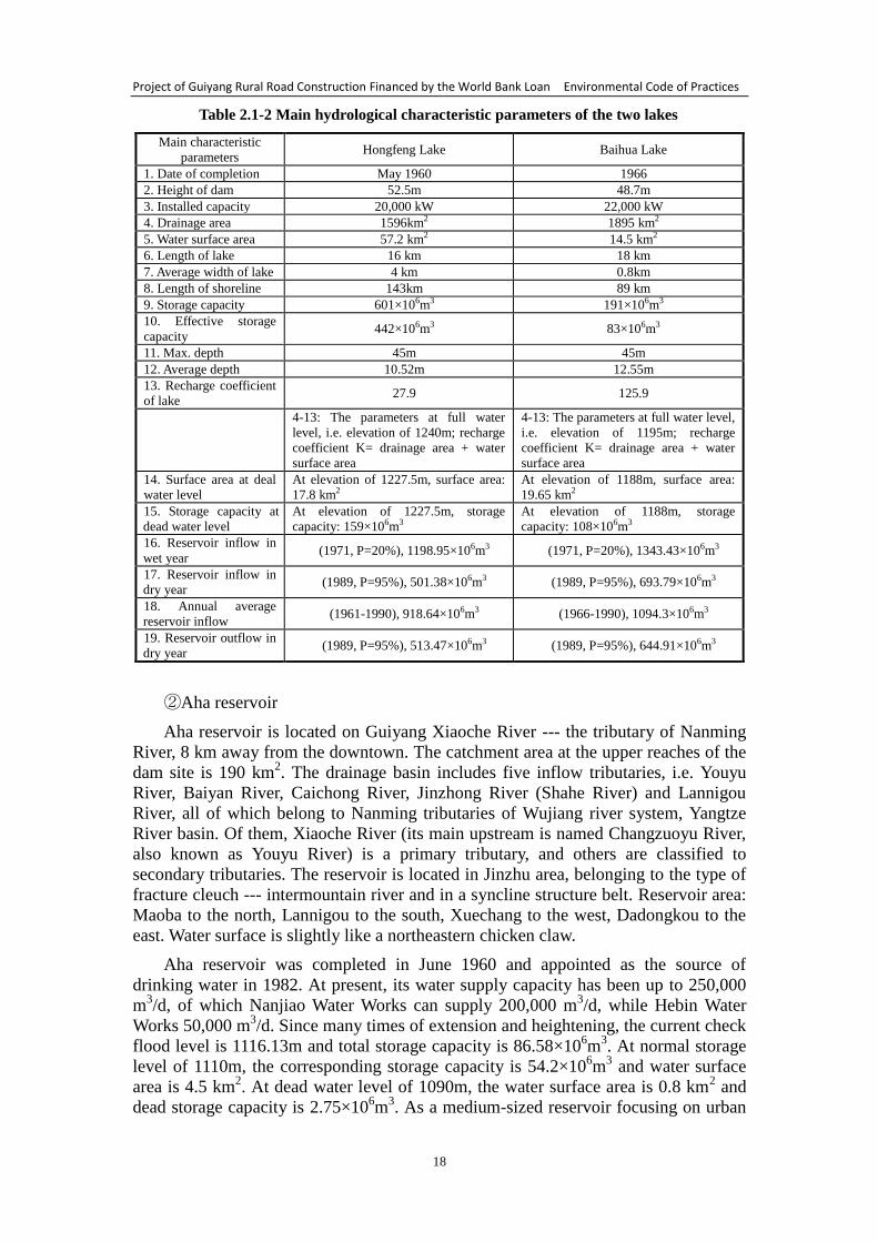
(2) Lakes and reservoirs
① Hongfeng Lake, Baihua Lake
Hongfeng Lake is located at 106°19´-106°28´ E and 26°26´-26°35´ N, with
drainage area of 1596 km2. At normal water level, i.e. elevation of 1240m, the lake
has a water surface area of 57.2 km2, total storage capacity of 601×10
6m
3, length of
16 km, average width of 4 km, shoreline of 143 km, max. depth of 45m and average
depth of 10.52m; at dead water level, i.e. elevation of 1227.5m, the corresponding
storage capacity is 159×106m
3. The total effective storage capacity of Hongfeng Lake
is 442×106m
3 and the installed capacity of dam power station is 20,000 kW.
Baihua Lake is at the lower reaches of Hongfeng Lake, located at 106°27´
-106°34´ E and 26°35´-26°42´ N. The catchment area between Hongfeng Lake dam
and Baihua Lake dam is 299 km2. At full water level, i.e. elevation of 1195m, the lake
has a water surface area of 14.5 km2, total storage capacity of 191×10
6m
3, max.
backwater line of 21 km; at dead water level, i.e. elevation of 1188m, the
corresponding storage capacity is 108×106m
3. The total effective storage capacity of
Baihua Lake is 83×106m
3.
At present, the above two lakes are Guiyang’s drinking water source. The
hydrological characteristics of the two lakes (reservoirs) are shown in Table 2.1-2.
Project of Guiyang Rural Road Construction Financed by the World Bank Loan Environmental Code of Practices
18
Table 2.1-2 Main hydrological characteristic parameters of the two lakes
Main characteristic
parameters Hongfeng Lake Baihua Lake
1. Date of completion May 1960 1966
2. Height of dam 52.5m 48.7m
3. Installed capacity 20,000 kW 22,000 kW
4. Drainage area 1596km2 1895 km2
5. Water surface area 57.2 km2 14.5 km2
6. Length of lake 16 km 18 km
7. Average width of lake 4 km 0.8km
8. Length of shoreline 143km 89 km
9. Storage capacity 601×106m3 191×106m3
10. Effective storage
capacity 442×106m3 83×106m3
11. Max. depth 45m 45m
12. Average depth 10.52m 12.55m
13. Recharge coefficient
of lake 27.9 125.9
4-13: The parameters at full water
level, i.e. elevation of 1240m; recharge
coefficient K= drainage area + water
surface area
4-13: The parameters at full water level,
i.e. elevation of 1195m; recharge
coefficient K= drainage area + water
surface area
14. Surface area at deal
water level
At elevation of 1227.5m, surface area:
17.8 km2
At elevation of 1188m, surface area:
19.65 km2
15. Storage capacity at
dead water level
At elevation of 1227.5m, storage
capacity: 159×106m3
At elevation of 1188m, storage
capacity: 108×106m3
16. Reservoir inflow in
wet year (1971, P=20%), 1198.95×106m3 (1971, P=20%), 1343.43×106m3
17. Reservoir inflow in
dry year (1989, P=95%), 501.38×10⁶m3 (1989, P=95%), 693.79×10⁶m3
18. Annual average
reservoir inflow (1961-1990), 918.64×10⁶m3 (1966-1990), 1094.3×106m3
19. Reservoir outflow in
dry year (1989, P=95%), 513.47×10⁶m3 (1989, P=95%), 644.91×10⁶m3
② Aha reservoir
Aha reservoir is located on Guiyang Xiaoche River --- the tributary of Nanming
River, 8 km away from the downtown. The catchment area at the upper reaches of the
dam site is 190 km2. The drainage basin includes five inflow tributaries, i.e. Youyu
River, Baiyan River, Caichong River, Jinzhong River (Shahe River) and Lannigou
River, all of which belong to Nanming tributaries of Wujiang river system, Yangtze
River basin. Of them, Xiaoche River (its main upstream is named Changzuoyu River,
also known as Youyu River) is a primary tributary, and others are classified to
secondary tributaries. The reservoir is located in Jinzhu area, belonging to the type of
fracture cleuch --- intermountain river and in a syncline structure belt. Reservoir area:
Maoba to the north, Lannigou to the south, Xuechang to the west, Dadongkou to the
east. Water surface is slightly like a northeastern chicken claw.
Aha reservoir was completed in June 1960 and appointed as the source of
drinking water in 1982. At present, its water supply capacity has been up to 250,000
m3/d, of which Nanjiao Water Works can supply 200,000 m
3/d, while Hebin Water
Works 50,000 m3/d. Since many times of extension and heightening, the current check
flood level is 1116.13m and total storage capacity is 86.58×10⁶m
3. At normal storage
level of 1110m, the corresponding storage capacity is 54.2×10⁶m
3 and water surface
area is 4.5 km2. At dead water level of 1090m, the water surface area is 0.8 km
2 and
dead storage capacity is 2.75×10⁶m
3. As a medium-sized reservoir focusing on urban
Project of Guiyang Rural Road Construction Financed by the World Bank Loan Environmental Code of Practices
19
water supply and flood control, it will retain the water coming from Xiaoche River ---
the tributary of Nanming River in flood season, thus to assist urban flood control. At
the same time, it is one of the main sources of Guiyang urban water supply.
At present, the reservoir is Guiyang’s drinking water source.
③ Huaxi reservoir
Huaxi reservoir is located at the upper reaches of Nanming River, which
originates from Lengshuichong in Linka of Pingba County. From the west to the east,
the river in Huaxi reach flows through Songbaishan reservoir, Huaxi reservoir and
Huaxi Town, then turns to the north and flows 5 km to the intake of Zhongcao Water
Works. The geographical position is 106°38′40.5″ E and 26°26′07.33″ N.
Huaxi reservoir was constructed from July 1958, the dam was completed in July
1959, water was stored in June 1960, and power was generated in June 1962. The
catchment area of upstream Songbaishan reservoir is 139km2. It is a medium-sized
reservoir with annual average flow rate of 5.3m3/s, normal storage level of 1137.9m
and storage capacity of 20×106m
3, focusing on water supply and giving consideration
to power generation. In 2002, the reservoir was expanded and heightened. After that,
the total storage capacity is increased to 31.4×10⁶m
3, normal storage level is up to
1140.0m, the elevation of check flood level is controlled to 11.45×10⁶m
3, utilizable
storage capacity is 28.4×10⁶m
3 and flood-control storage capacity is increased from 0
to 11.4×10⁶m
3. Huaxi reservoir has become a hydraulic complex, which focuses on
flood control and integrates urban water supply, water for environment and power
generation into a whole, to produce comprehensive benefit.
Huaxi Water Works, with the design scale of 50,000 t/d, was completed and put
into operation in 1978, mainly supplying water for Huaxi urban area. It is located in
Jilin Village of Huaxi District, and intake source is Huaxi River, which is from the
lower reaches of Huaxi reservoir dam to the entrance of Huaxi Park. There dense
buildings and large population make it become a lively area.
At present, the reservoir is Guiyang’s drinking water source.
④ Songbaishan reservoir
Songbaishan reservoir is located at the middle and lower reaches of Malu River
--- the main source of Huaxi River, with the catchment area of 139 km2 at the upper
reaches of the dam site. The main stream comes from Huolongshan spring group,
located in Kuchakan of Hujiaqiao, Longshan, on the left side of middle part of the
reservoir. It originates from Bainitian of Machang Town, Pingba County and it is also
the source of Nanming River. From Bainitian, it flows through Fenglibao, Kaizhang
and Zimujing, there the main stream is narrowed gradually; at Baiyanjiao, it goes
underground. Then it is exposed in Huolongshan. In Yang’ai Farm and neighboring
area, surface water goes underground many times, and also exposed in Huolongshan.
At the site of downstream 5.5 km of Bainitian, Kaizhang reservoir was built in 1959,
with the storage capacity of 3.5×10⁶m
3 and the catchment area of 12 km
2. From the
lower reaches of Kaizhang reservoir to Zhongzhai, there is a stream joined from
Xujiajing. The catchment area at the upper reaches of Huolongshan springs is about
55 km2, with higher flow rate in dry season. The major tributary is Linka River,
originating from Dalongjing of Minidapo, which is also the first tributary of Nanming
River. From the source Dalongjing, it flows through Kulishan and Shizhuang to
Sancha River, and is known as Kailun River at the lower reaches of Sancha River and
known as Linka River after confluence of Kailun River and Lengshuichong. Linka
Project of Guiyang Rural Road Construction Financed by the World Bank Loan Environmental Code of Practices
20
River flows into the reservoir at Xinpanjing Xiaozhai, with the catchment area of 45
km2.
At present, the reservoir is Guiyang’s drinking water source.
⑥ Wujiangdu reservoir
Wujiangdu reservoir is located on the main stream of Wujiang River and the dam
site is in Wujiang Town of Zunyi County. It is a large-sized reservoir, focusing on
power generation and flood control, and giving consideration to shipping. The project
was constructed from 1970 and completed in 1983. The reservoir has a normal storage
level of 760m and storage capacity of 2140×106m
3. The catchment area at the upper
reaches of the dam site is 27790 km2, of which the catchment area at the upper
reaches of Yachihe Hydrometric Station is 18187 km2. Total installed capacity is up to
1250 MW and annual average generating capacity is 4140×106 kW·h. It is the first
hydropower station with the installed capacity above a million-scale in Wujiang
drainage basin.
⑦ Dongfeng reservoir
Dongfeng reservoir is located in the reach of Yachi River --- the main stream of
Wujiang River, by which a II-step hydropower station is formed. The installed
capacity of the station is 510 MW, total storage capacity is 1016×106m
3, regulation
storage capacity is 491×106m
3, catchment area at the upper reaches of the dam site is
18161 km2, and normal storage level is 970m.
⑧ Suofengying reservoir
Suofengying reservoir is located in the reach of Liuguang River --- the main
stream of Wujiang River. As a III-step hydropower station in Wujian main stream, it
installed capacity is 600 MW, normal storage level is 837m, storage capacity is
168×106m
3, and the catchment area at the upper reached of the dam site is 21862 km
2.
Guiyang’s water system composed of main surface water (rivers, reservoirs) is
shown in the Attached Map 2.
2.1.4.2 Underground water
(1) Type of underground water
Karstic water is the main component of Guiyang underground water and clasolite
fissure water takes the second place. Pore water is very poor. According to aquifer
lithology, combination feature and formation cause of water-bearing space, the
underground water of the survey area can be categorized to three types, that is,
carbonatite karstic water, bedrock fissure water and loose-rock pore water.
① Carbonatite karstic water
It is a major underground water type characterized by widespread distribution,
thick aquifer and rich water yield. For its complex structure, it can be further
categorized to two subclasses in accordance with stratum combination feature, that is,
pure carbonatite karstic water (carbonatite stratum>70%) and carbonatite mixed with
clasolite karstic water.
② Bedrock fissure water
Distribution area is 546 km2, accounting for 22.65% of the region area.
Water-bearing stratum is composed of sandshale, mudstone and coal-bearing series.
Project of Guiyang Rural Road Construction Financed by the World Bank Loan Environmental Code of Practices
21
Underground water occurs in structural fracture and weathering fracture. The
thickness of water-bearing stratum is varied and obviously influenced by terrain and
geological structure.
③ Loose-rock pore water
Distribution area is about 70 km2, accounting for 2.91% of the region area, and
outcrops in the alluvial or proluvial eluvial-slope wash at the bottom of basin valley
and large karst depression. Water-bearing stratum is distributed discontinuously and
buried depth of underground water is 0.5m-3m.
(2) Underground water recharge --- runoff --- discharge
① Conditions of recharge, runoff and discharge of loose-rock pore water: Pore
water mainly comes from atmospheric precipitation, recharged by a little bedrock
aquifer and river water. Pore aquifer is mainly distributed in gentle basin and valley,
where hydraulic slope is gently, so underground water runoff is very slower. Plane
leakage flow is the main discharge form. Because pore water is buried shallowly and
moreover farm crops are widespread, ground evaporation and plant transpiration are
also the important discharge.
② Conditions of recharge, runoff and discharge of bedrock fissure water:
Bedrock fissure water mainly comes from atmospheric precipitation. The recharge is
closely related to the landform, fissure development and cutting. Clasolite weathering
fissure is developed, but not deep and with poor continuity. So fissure water has a
short runoff channel, and it is discharged from the earth surface in the form of small
spring, forming intermountain stream. More springs, lower flow rate and bigger
dynamic change can be found in severe slope place; while less springs but higher flow
rate and stable change appear in gentle area. There are many housing estates and
domestic wells in clasolite area, so people and livestock drinking is an important
consumption channel of fissure water.
③ Conditions of recharge, runoff and discharge of karstic water: Karstic
underground water mainly comes from atmospheric precipitation, which penetrates
into ground through karstic fussure, doline, ponor, puddle, underground stream scuttle.
Other recharge sources of karstic underground water include river water, reservoir
seepage and farmland water seepage. Because karstic underground water is controlled
by geological structure landform and hydrological network, runoff conditions are
complex. The watershed between Yangtze River system and Pearl River system
traverses the south part of the survey area. Northern side of the watershed belongs to
Wujiang drainage basin, accounting for 82.6% of the survey area and including 25
rivers. South side of the watershed belongs to Mengjiang drainage basin, including 8
rivers. On the whole, underground watershed of the survey area is as the same as that
of surface watershed. The primary watershed controls the general trend of runoff and
discharge of underground water; while the secondary watershed controls the runoff
conditions of underground water in a small drainage basin, which results in a very
complex pattern of runoff movement of karstic underground water. The geological
structure and stratigraphy constitute multiple hydrogeological structures, which
controls the local movement rule of underground water. The intermediate layered
hydrogeological structure is widely distributed, and the movement along stratum trend
becomes an important form of karstic water runoff. When aquifer is cut transversely
by river or fault, underground water will outcrop, forming an outlet of large spring or
underground stream.
Project of Guiyang Rural Road Construction Financed by the World Bank Loan Environmental Code of Practices
22
2.1.5 Animals and plants
According to generation nature, Guiyang’s vegetation can be classified to two
categories: natural vegetation and artificial vegetation. Natural vegetation covers
coniferous forest, broad-leaved forest, bushwood or grass cluster. Coniferous forest
mainly includes masson pine, cedarwood, keteleeria; broad- leaved forest mainly
includes cyclobalanopsis glauca, photinia davidsoniae, cinnamomum glanduliferum,
carpinus turczaninowii, geman oak, betula luminifera, sweetgum; bushwood or grass
cluster mainly includes itea ilicifolia, cotinus coggygria, pyracantha, smallfruit rose
root, quercus tabri, seguinii, distylium racemosum, linden viburnum, pteridium
aquilinum, dogstail, heteropogon contortus, themeda japonica, arthraxon hispidus, etc.
Artificial vegetation mainly include Chinese fir forest, masson pine forest, Chinese
white pine forest, tea-oil tree, tea grove, fruit tree, rice field vegetation, corn-wheat-rape
dryland vegetation, vegetable crop, etc.
According to general zoological classification system, Guiyang’s animal can be
classified to two categories: invertebrate and vertebrate. Invertebrate mainly includes
amoeba, polyp, planaria, philodina, pheretima, vivipara, caridina, etc. Of the
vertebrate, birds, fishes and small beasts are in the main. Fishes mainly include
crucian carp, grass carp, black carp, spotted silver carp, silver carp, loach, rice field
eel, etc. Amphibians mainly include giant salamander and rana limnocharis. Reptiles
mainly include tortoise, trionyx sinensis, gekko japonicus, takydromus septentrionalis,
adder, rhabdophis tigrina, trimeresurus stejnegeri, etc. Birds mainly include mandarin
duck, golden pheasant, streptopelia orientalis, grey crane, cuckoo, small skylark meat,
sparrow, etc. Mammals mainly include great roundleaf bat, squirrel, harvest mouse,
etc. In recent years, frequent interference from urban construction, road/railway
construction, deforestation and human activities has harmed animal’s living
environment and made Guiyang’s large animals reduced rapidly.
2.1.6 Sensitive area
2.1.6.1 Scenic spots
(1) Hongfenghu (Hongfeng Lake) scenic spot
Hongfenghu scenic spot is located to the west of Qingzhen city proper, stretching
across Qingzhen City and Pingba County, 28 km away from Guiyang, with the area of
200 km2, of which water area is up to 57.2 km
2. As one of the largest artificial lake in
Guizhou plateau, it was approved by the State Council as the national key scenic spot
in 1988 and was rated by the National Tourism Administration as the national AAAA
tourist area in 2001.
According to scenic spot demarcation, that is, taking scenery resource distribution
as the basis, starting from benefiting scenery resources and meeting landscape
requirement and applying the method that combines ridge line with administrative
division, the area of Hongfenghu scenic spot is delimited to 200 km2 (including water
area of 57.2 km2). It stretches across Qingzhen City and Pingba County and covers 4
towns, 8 districts, 29 villages and 3 farms (all or partial land). Planned boundary line:
from northern Laowangchong, Huangjiawan and Tuanpo of Qingzhen City to
southern Zhengjiawan, Qingyutang, Baobaoshang, Huajiaoguan and Guankouzhai on
Pingba line; from western Sandaogou and Luojiaqiao of Qingzhen City and Mawutun
of Pingba County to eastern Ganheba, Shizishan, Lumaotang and Tongmuzhai of
Qingzhen City.
This scenic spot is characterized by plateau karst lake scene, karst landform and
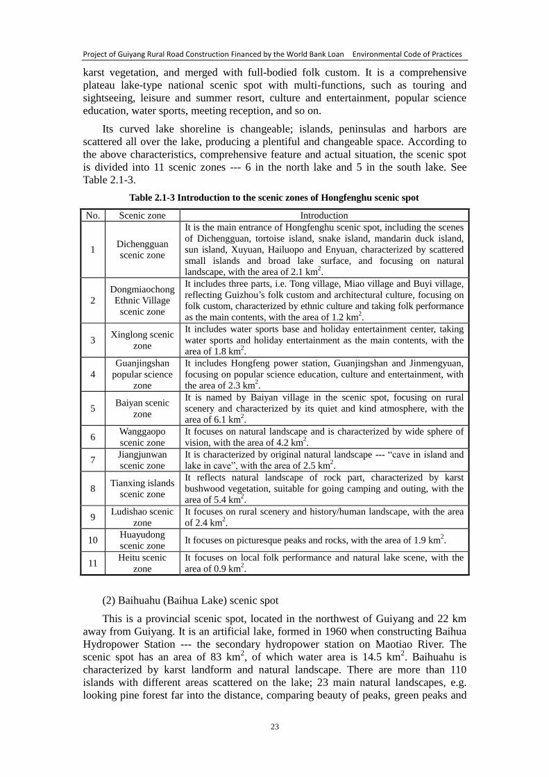
Project of Guiyang Rural Road Construction Financed by the World Bank Loan Environmental Code of Practices
23
karst vegetation, and merged with full-bodied folk custom. It is a comprehensive
plateau lake-type national scenic spot with multi-functions, such as touring and
sightseeing, leisure and summer resort, culture and entertainment, popular science
education, water sports, meeting reception, and so on.
Its curved lake shoreline is changeable; islands, peninsulas and harbors are
scattered all over the lake, producing a plentiful and changeable space. According to
the above characteristics, comprehensive feature and actual situation, the scenic spot
is divided into 11 scenic zones --- 6 in the north lake and 5 in the south lake. See
Table 2.1-3.
Table 2.1-3 Introduction to the scenic zones of Hongfenghu scenic spot
No. Scenic zone Introduction
1 Dichengguan
scenic zone
It is the main entrance of Hongfenghu scenic spot, including the scenes
of Dichengguan, tortoise island, snake island, mandarin duck island,
sun island, Xuyuan, Hailuopo and Enyuan, characterized by scattered
small islands and broad lake surface, and focusing on natural
landscape, with the area of 2.1 km2.
2
Dongmiaochong
Ethnic Village
scenic zone
It includes three parts, i.e. Tong village, Miao village and Buyi village,
reflecting Guizhou’s folk custom and architectural culture, focusing on
folk custom, characterized by ethnic culture and taking folk performance
as the main contents, with the area of 1.2 km2.
3 Xinglong scenic
zone
It includes water sports base and holiday entertainment center, taking
water sports and holiday entertainment as the main contents, with the
area of 1.8 km2.
4
Guanjingshan
popular science
zone
It includes Hongfeng power station, Guanjingshan and Jinmengyuan,
focusing on popular science education, culture and entertainment, with
the area of 2.3 km2.
5 Baiyan scenic
zone
It is named by Baiyan village in the scenic spot, focusing on rural
scenery and characterized by its quiet and kind atmosphere, with the
area of 6.1 km2.
6 Wanggaopo
scenic zone
It focuses on natural landscape and is characterized by wide sphere of
vision, with the area of 4.2 km2.
7 Jiangjunwan
scenic zone
It is characterized by original natural landscape --- “cave in island and
lake in cave”, with the area of 2.5 km2.
8 Tianxing islands
scenic zone
It reflects natural landscape of rock part, characterized by karst
bushwood vegetation, suitable for going camping and outing, with the
area of 5.4 km2.
9 Ludishao scenic
zone
It focuses on rural scenery and history/human landscape, with the area
of 2.4 km2.
10 Huayudong
scenic zone It focuses on picturesque peaks and rocks, with the area of 1.9 km
2.
11 Heitu scenic
zone
It focuses on local folk performance and natural lake scene, with the
area of 0.9 km2.
(2) Baihuahu (Baihua Lake) scenic spot
This is a provincial scenic spot, located in the northwest of Guiyang and 22 km
away from Guiyang. It is an artificial lake, formed in 1960 when constructing Baihua
Hydropower Station --- the secondary hydropower station on Maotiao River. The
scenic spot has an area of 83 km2, of which water area is 14.5 km
2. Baihuahu is
characterized by karst landform and natural landscape. There are more than 110
islands with different areas scattered on the lake; 23 main natural landscapes, e.g.
looking pine forest far into the distance, comparing beauty of peaks, green peaks and
Project of Guiyang Rural Road Construction Financed by the World Bank Loan Environmental Code of Practices
24
islands, double monkeys guarding garden, double gorges in Baihua, and island
paradise; moreover many human landscapes, such as Guanin Cave in Mt. Maoli,
Hongwu temple in Mt. Moon, Gupanying in Chafan Village, old castle in Zhuchang,
Huilong temple in Huaqiao, etc.
(3) Huaxi scenic spot
This is a provincial scenic spot with the total area of 350.5 km2, composed of 7
scenic zones, that is, ten-mile river beach, Tianhetan scenery, famous historical and
cultural Qingyan, Qiantao-Mengguan zone, Gaopo zone, Yanlou-Maling zone.
(4) Anliuhe (undercurrent stream) scenic spot
The scenic spot is located in Anliu Township of Qingzhen City, Guizhou Province,
65 km away from Guiyang, with the planning area of 50 km2. Its name comes from an
undercurrent stream, which flows through Anliu Township and into underground cave.
Fully developed karst landform is its scenery source. Many charming scenes are
available in it, for example, unique Dawan karst cave, Yangpidong waterfall, hot
spring, underground river, sky hole, scuttle, blind valley, face upward sky, echo water
and flow cloud, plunging waterfall, singing swallow in the ninth heaven, skyscraper
cave, gorge, and so on, as well as full-bodied Miao’s folk custom zone. According to
the assessment of scenic spot sources made by experts, 70% of its sources have been
up to the provincial standard and 30% up to the national standard. This scenic spot
was approved by Guizhou Provincial People’s Government in 2003.
(5) Xiangzhigou scenic spot
In February 2000, it was approved by Guizhou Provincial People’s Government
as a provincial scenic spot. The spot is located in Xinbao Buyi Township at the
northeast of Guiyang, with total area of 50.8 km2, 42 km away from the city proper.
There the elevation is 960-1563m, annual precipitation is above 1200 mm and annual
average temperature is 15℃, with abundant rainfall and pleasant climate, without
severe cold in winter and intense heat in summer.
Xiangzhigou has beautiful natural scenery and biological diversity, where Buyi
folk custom is simple and full-bodied, traditional paper workshops are scattered all
over, caravan bells are sweet-sounding, and Buyi’s pinup pictures are shown
ingeniously. There are 8 scenes in the spot, i.e. Longjingwan, Guodiqing,
Majiaochong, Xiangzhigou, Baishuihe, Hongzigou, Huluchong and pinery fishing
area, which integrates mountain, river, forest, bamboo, suspended spring, plunging
waterfall, rare peak and fairy stone into a whole.
(6) Yangming scenic spot
Taking Yangming cave as the center, Xiuwen sceneries cover 4 zones, i.e.
Liuguanghe (Liuguang River) gorge, Maotiao River, Yanyingshan reservoir and
Zhazuo forest farm, of which Yangming scenic spot, with the area of 161 km2, is
world-renowned for famous philosopher and educator Wang Yangming, who lived in
the Ming dynasty, once resided in Longchangyi of Xiuwen County and established
Yangming heart-mind theory after realized the truth. Liuguanghe is the boundary river
of Xiuwen, Qianxi and Jinsha counties at the upper reaches of Wujiang River. From
Baimatan to the downstream county boundary --- Huangjin Village, the valley is 35
km long, including 7 gorges and 40 scenes, such as Baima gorge, Houchou gorge,
Feilong gorge, Buyi Shangri-la, silver fine rain and fighting goshawk. Maotiao River
is a tributary in the south bank of Wujiang, 181 km long. The main scenes include
Project of Guiyang Rural Road Construction Financed by the World Bank Loan Environmental Code of Practices
25
Maotiaoshi (a stone like a jumping cat), Gongjishan (a mount like a cock) and
Houershan (a mount like a monkey). Yanyingshan reservoir is to the north of county
town, 13 km away. Reservoir dam is arched, built by laying square stones, with 124
stone steps. It was completed in 1971 and won the national award of scientific and
technological achievement.
(7) Xiangsihe (Xiangsi River) scenic spot
Xiangsihe provincial scenic spot is located in Shuitian Town and Xianba
Township of Wudang District, 26 km away to the northeast of Guiyang, Guizhou
Province, with the area of 68 km2. It borders Xiangzhigou scenic spot to the north,
Yandi Miao Village to the east, Ma-Bai highway to the south and Gui-Kai highway to
the west. Within the scenic spot, there are 52 sceneries, including 33 natural scenes
and 19 human scenes, and covering the types of rock peak, gorge, river bend, lake,
waterfall, spring, trees, bamboo forest, ancient temple, ancient bridge, ancient courier
rout, as well as Buyi and Miao villages with local features. With deep valley and
dense forest, trees spread all over the scenic zone; the vegetation coverage is up to
76% while the forest coverage up to 41%. The area of masson pine forest and Chinese
amand pine forest in Fenghuanshan forest farm, Hulushan forest farm and Guodiqing
forest farm is over 67 km2, there are also a number of bamboo forests. Yandi Miao
Village can be approached by two natural viaducts; Kabao Miao Village is located in
mountains and keeps full-bodied folk custom and original style; Wangbi Buyi Village
is simple but elegant with rich folk custom; all of the historic site of Laping Xuanfusi
seat, historic buildings in the late of Ming dynasty and early of Qing dynasty, and
business street are conserved very well.
(8) Xifeng scenic spot
Xifeng scenic spot is located in Xifeng County with the total area of 35.543 km2,
including 6 scenic zones, i.e. Hot spring, Mt. Tiantai, Mt. Nanshan, Xuantian cave, Mt.
Tuanyuan and Mt. Xiwang, of which Hot spring and Mt. Tiantai are located in
Wenquan (hot spring) Town. The former, with scenic area of 1.27 km2, is
characterized by tour for hot spring and relaxation on holiday; the later, with scenic
area of 1.529 km2, is characterized by its original secondary forest --- Tiantai jungle,
which is conserved very well in the middle of Guizhou. In the scenic zone, forest is
dense and natural plants are abundant. It focused on the ecological protection of forest
and the utilization of good ecological environment to properly develop ecotourism.
Mt. Nanshan scenic zone is located in Yongjing Town, with the area of 5.456 km2,
covering forest farm headquarters and nursery garden. Artificial pore masson pine
forest is the main forest vegetation, at the same time grassland scenery in forest is
obtained. According to the forest landscape characteristics, forest recreation is taken
as the main direction; moreover the ecological protection of forest is promoted
vigorously. Xuantian cave scenic zone is located in Yongjing Town, with the area of
7.25 km2, covering Xuantian cave and Pingtianba. Pore masson pine forest is the main
forest landscape, and considerable grassland landscape is got in the forest. Moreover,
Xuantian cave is a patriotic education base for General Yang Hucheng was locked up
here. Combining with the scenery and forest features, patriotic education is taken as
the main direction; at the same time entertainment and forest exploration are
developed properly. Mt. Tuanyuan scenic zone is located in Yongjing Town, closing to
Xifeng county seat, bordering Gui-Zun highway to the east, Yami Village to the south,
Dizhaihe to the west and Xi-Jiu highway to the north, with the area of 12.708 km2.
Forest recreation is its development direction. Mt. Xiwang scenic zone is located in

Project of Guiyang Rural Road Construction Financed by the World Bank Loan Environmental Code of Practices
26
Xishan Town, bordering Xiaolywo to the east, Shiluguan to the west, a road to the
south and Erhuoyan to the north, with the area of 7.33 km2. Here geographic
landscape, human landscape and biological landscape are concentrated; forest
vegetation is dense. This scenic zone takes forest sightseeing and Buddhist cultural
tour as the direction.
(9) Kaiyang scenic spot
It includes Nanjiang gorge scenic spot and Zijiang gorge scenic spot. Nanjiang
River flows through Nanjiang gorge, which belongs to Wujiang drainage basin with
the total gorge length of about 40 km. Now the developed section, from the western
Longguangqiao to the eastern Houzitian, is 18.5m long and 218m water head, with the
area of 40 km2. Most of the sceneries are concentrated on Nanjiang River valley and
the zone, which the tributary passes through (accounting for 55% of the main scenes).
The valley integrates gorge, green mountain and river, magical cave, dangerous rock,
deep pool, rapid stream, plunging waterfall, mountain spring, dense forest, as well as
the newly constructed rope bridge and viaduct into a whole, with charming and
changeable landscape. In addition, the largest national calcified waterfalls are
conserved in the valley.
Zijiang gorge scenic spot is characterized by its plunging waterfall. Unique karst
landform is magnificent; picturesque peaks and rocks have a great variety of fantasies.
Here river reach forms a geofracture, from which impetuous river, gathered in a 1.9m
wide narrow fracture, pours down. In central part of the scenic spot, vegetation
coverage is above 90%. Within the scenic spot, suspended spring and plunging
waterfall are spectacular. Along the river, beautiful scenery comes into view. Drift
across geofracture, scientific investigation, sightseeing and ecoenvironment education
can be developed here.
2.1.6.2 Forest park
(1) Changpoling national forest park
According to the “Overall planning of Guiyang Changpoling national forest park”,
the park is located at 106°38′-106°40′ E and 26°38′-26°40′ N, bordering Yunyan
District to the southeast and Guanshanhu District to the southwest, 2.8 km wide from
the east to the west and 4 km long from the south to the north, with the total area of
10.75 km2. Predecessor of the park is Changpoling forest farm, Duxi forest farm and
parts of collective forest land of Heishitou Village and Yulengshui Village, Dula
Township.
In the park, the native vegetation type belongs to mid-subtropical evergreen and
deciduous broad-leaved mixed forest; but it has been destroyed. The existing forest
vegetation includes the coniferous forest with masson pine and Chinese white pine as
the main, the broad-leaved forest with poplar and locust tree as the main, the mixed
broadleaf-conifer forest with masson pine, Chinese white pine, locust tree and catalpa
as the main, and the mixed conifer forest with masson pine and Chinese white pine as
the main, with the forest coverage of 66.1%. At present, there are 107 species and 249
genera of vascular plant species in the park, including some national and Guizhou’s
key protective plants, such as tulip tree, gingko and yacca. There are 59 species of
wild animal, including 30 species of birds, 12 species of beasts, 10 species of reptiles
and 7 species of amphibians.
(2) Qianling Park
Project of Guiyang Rural Road Construction Financed by the World Bank Loan Environmental Code of Practices
27
Qianling Park is a national AAAA tourist area, located in the north west of
Guiyang city proper, connecting Zaoshan Road to the south, Bageyan Road to the east,
Shibei Road to the northeast, Guandaoyan and Xiaoguan reservoir to the north,
Changpoling forest farm, Qichongling, Sanqiao and Shengquan to the west, 1.5km
away from the city proper and with the area of 426 km2. Mt. Qianling is a part of
middle Qianzhong mountain plateau, with the elevation of 1100-1396m, topographic
relief and not changeable relative height difference (200m or so), containing
Baixiangling, Bajiaoyan, Daluoling, Xiangwangshan, Qichongling, Tanshan,
Zhangboshan, of which Daluoling (1396m elevation) is the first peak in the park and
in the northwest of Guiyang city proper. Because of complex geological structure,
more stratums are outcropped within small scope, including Maokou group of lower
series, Wujiaping group and Changxing group of upper series, Permian system; Daye
group and Anshun group of lower series, Guiyang group of middle series, Sanqiao
group and Erqiao group of upper series, Triassic system; Ziliujing group of lower
series, Jurassic system.
(3) Nanjiao Park
Nanjiao Park is located in the southwest of Guiyang city proper, connecting
Xiaochehe (Xiaoche River) nursery garden to the west, reaching the northern
Xiaochehe, and connecting with Taiciqiao through Cheshui Road to the northeast, 1.5
km away from Taiciqiao with convenient traffic. The part was constructed from 1966,
with the same status as the central Hebin Park, the southeastern Forest Park and the
downtown Qianling Park. They jointly constitute Guiyang’s park system at city level.
As an early developed karst cave in Guizhou, Nanjiao Park has a rugged and varied
topography, mainly composed of Bailongdong scenic spot, outside scenic spot and
Xiaochehe scenic spot.
(4) Hebin Park
Hebin Park is located in the southwest of Guiyang city proper with very
convenient traffic. In the park, nanmu garden, as well as bamboo room, corridor,
pavilion and fence are the good places for tourists’ tea drinking, chess playing, fishing,
swimming and relaxation.
2.1.6.3 Water conservation area
Water conservation areas within the boundary mainly include Hongfenghu water
conservation area, Baihuahu water conservation area, Huaxi reservoir water
conservation area, Songbaishan reservoir water conservation area and Aha reservoir
water conservation area. Outline of all water conservation areas is shown in the
Section 2.1.4 of this report.
Distribution of main sensitive spots in Guiyang (scenic spots, forest parks, water
conservation areas and folk custom places) is shown in the Attached Map 3.
2.2 Social environment
2.2.1 Population development status of the project area
Status of population size, structure, quality and distribution is the basic
background of social and economic development for a region. According to the
“Social impact assessment report on the infrastructure construction projects of urban
and rural overall development in Guiyang City” drawn up by the social impact
assessment group of Wuhan University, Guiyang’s population status presents the
following features:
Project of Guiyang Rural Road Construction Financed by the World Bank Loan Environmental Code of Practices
28
(1) Considering from population size: In 2010 Guiyang’s permanent resident
population was 4,325,000, increased by 606,000 in ten years compared with
3,718,000 in 2000, with annual average increase of 1.52%. The average population
per household is 2.93, decreased by 0.31 compared with 3.24 of the fifth population
census in 2000. It can be seen that the household size presents a reduction trend.
(2) Considering from the sex structure of population: Of Guiyang’s permanent
resident population, male population is 2,226,700, accounting for 51.49% and female
population is 2,097,800, accounting for 48.51%. Total sex ratio of population (taking
female as 100 to see male proportion to female) is decreased to 106.14 from 110.84 of
the fifth population census in 2000. Considering from age structure, of Guiyang’s
permanent resident population, the 0-14 aged population is 742,700, accounting
17.17%; the 15-64 aged population is 3,239,500, accounting for 74.91%; the 65 or
above aged population is 342,300, accounting for 7.92%. Compared with the fifth
population census in 2000, the 0-14 aged population proportion is decreased by 5.77%,
the 15-64 aged population proportion is increased by 3.83% and the 65 or above aged
population proportion is increased by 1.94%. It can be seen that aged tendency of
population appears.
(3) Considering from population quality: Of Guiyang’s permanent resident
population, the population with university (above junior college) degree is 660,000,
that with senior high school (including technical secondary school) degree is 598,000,
that with junior high school degree is 1,430,000, that with primary school degree is
1,161,700, and illiterate population (15 or above aged) is 167,700 with the illiterate
rate of 3.88%, of which rural illiterate or semiliterate population is about 80,000,
accounting for 6% of the total rural population, the rural population with junior high
school degree is about 500,000, accounting for 38% of the total rural population.
About 80% of the 320,000 poor people are illiteracy or semiliteracy, or only have
primary school degree.
(4) Considering from population distribution: Of Guiyang’s permanent resident
population, urban population is 2,946,300, accounting for 68.13%; rural population is
1,378,200, accounting for 31.87%. Compared with those of the fifth population
census in 2000, urban population is increased by 671,600 and rural population is
decreased by 65,500. The proportion of urban population is increased by 6.96%.
2.2.2 Economic development status of the project area
Guiyang is located in the western China. In the past, because of inferior
geographical location, little land resources and short development history, its
economic development level lags behind the eastern coastal regions relatively, which
is reflected by Guiyang’s small economic aggregate, weak economic strength, lower
per capita GDP and income, backward infrastructure, lower industrial level, and
inferior innovation capacity and competitiveness. The current economic development
status of the project area can be summarized as follows.
(1) Guiyang has a weak economic foundation and the development is relatively
backward, but the development potential is sufficient. At present, it is in a pursuant
development stage and has become one of the regions with the fastest growth in
China.
According to the statistics for the year 2011, the gross regional GDP and social
fixed asset investment of Guiyang were up to RMB 138.8 billion and 160 billion
respectively. And both rankings in the provincial capitals were raised by one place
Project of Guiyang Rural Road Construction Financed by the World Bank Loan Environmental Code of Practices
29
respectively, compared with those in 2006. Gross output value of the industrial
enterprises above specified size was up to RMB 143.66 billion. The growth of added
value came to the top among the western provincial capitals, increased by 2.8 times or
14.2% annual average growth compared with those before ten years. Guiyang will
become the “locomotive” to drive social and economic development of the province
and the “engine” to appear in the economic zone of the middle Guizhou.
(2) Guiyang is accelerating industrialization course. Under the strategic guidance
of booming the city by developing industry, industry and service are developed
rapidly.
In 2009, Guiyang started the implementation of the strategy of booming the city
by developing industry. CPC Guiyang committee and the municipal government drew
up the “Suggestion on some policies to promote industrial economy” to unswervingly
implement new industrialization, achieve great speed acceleration and benefit growth,
and promote Guiyang’s industrial economy. Guiyang industrialization has stepped in a
rapid development stage. At the same time of rapid industrial growth, Guiyang’s
service trade realizes the growth in the same pace. The added value of service is
increased by 3.3 times with annual average growth of 15.6%, compared with that
before ten years; its GDP proportion is increased from 45.3% to 53.0%. And the
proportion of added value of modern service in the whole service trade is above 30%.
(3) Now, Guiyang is being in rapid urbanization development stage, in which
urban scale is expanded and urban population size and proportion are grown rapidly.
In the past ten years, Guiyang energetically implemented the strategy urbanization
drive. Taking transportation system structure as the link and taking “old town
diversion” and “new town construction” as the carrier, Guiyang’s urban function is
perfected, urban space is expanded and urbanization level is raised continuously. Now,
the construction land area is extended to 230 km2, and the urbanization rate is
increased from 62.0% in 2002 to 69.2% in 2011.
(4) Guiyang is still lack of rural infrastructure, but the conditions have been
improved greatly.
According to the data of the 2nd
agricultural survey, at the end of 2006, railway
stations were built in 22.08% towns/townships, and second-class road passed through
37.66% towns/townships. Post office, savings bank, park, comprehensive market and
special farm products market are obtained in 61.04%, 87.01%, 10.39%, 77.92 and
23.38% of the towns/townships respectively. Centralized water supply is carried out in
96.55% towns, domestic sewage is treated in 31.03% towns, and waste is disposed in
41.38% towns. Of Guiyang, road, electric power, telephone and TV program are
connected with 97.94%, 99.49%, 96.91% and 98.20% of villages respectively.
Drinking water of 35.68% villages is purified, garbage is collected for treatment in
21.36% villages, methane-generating pit is constructed in 95.88% villages, and
general sore or supermarket with the area of above 50m2 is available in 17.84%
villages.
2.2.3 Rural social development status of the project area
As the capital of Guizhou Province, Guiyang’s social and economic development
level is higher relatively. But in some rural area under the jurisdiction of Guiyang,
social development level is backward, especially some poor rural areas with
inconvenient transportation. Because of information blockage, residents’ ideology is
relatively backward and conservative. They are lack of modern market economy
Project of Guiyang Rural Road Construction Financed by the World Bank Loan Environmental Code of Practices
30
concept and competition sense. Considerable people have a lower educational level.
All of the above restrict local social development. Current rural social development
status in Guiyang can be summarized as follows.
(1) Guiyang is still in a society with obvious urban-rural dual structure, the state
of imbalance between urban and rural area is not yet changed.
Guiyang’s urbanization rate in 2011 was up to 69.2%, but urban-rural dual
structure still exist and urban-rural gap is more prominent. According to the statistic,
per capita disposable income of Guiyang urban residents in 2012 was RMB 21796
yuan and that of rural residents was RMB 8488 yuan, with the income ratio of urban
and rural residents is 2.57:1. It can seen that the development imbalance between
urban and rural area still exist. Rural labor forces, especially young laborers go to
cities and towns in succession to be engaged in industry or trade. Most of the residents
in rural area are mainly women, children and elderly people.
(2) In Guiyang rural area, living environment is beautiful, climate is pleasant and
dwelling conditions are improved greatly, however the infrastructure, e.g. road, is still
backward.
In Guiyang rural area, climate is pleasant, scenery is picturesque and environment
is beautiful. For the past few years, along with the increase of farmers’ income, they
constructed or reconstructed a lot of housings and their dwelling conditions are
improved greatly. According to the statistics, at the end of 2006, 96.59% of the rural
households had their own house with average dwelling area of 124.9m2; 79.91% of
the households made use of pipe water and 79.33% of the household took coal as the
cooking energy. Per hundred households had 79.2 sets of color TV, 30.7 sets of
telephones, 53.9 sets of mobile, 1.4 sets of computer, 17.1 sets of motorcycle and 3.7
sets of vehicle. Moreover, farmer family’s private property was increased obviously.
But there is still lack of infrastructure, such as road transport. The problems of lower
road network density, access rate and technical level exist in rural area. The hardening
ratio of assess road is about 70% and that of main road in villages is about 50%.
Because of lack of road maintenance, the roads that pass through poverty-stricken
villages is in poor conditions. It is required to expend a lot of finances and labors.
(3) The rural area under the jurisdiction of Guiyang is distributed with large
number of poverty-stricken population.
According to the poverty line, that is, per capita annual pure income of RMB
2,300 yuan, adjusted by the state in 2011, now Guiyang’s poverty-stricken population
is still 323,200, accounting for 16.8% of the total rural population, which is mainly
concentrated in Xiuwen, Kaiyang, Xifeng, Qingzhen, Wudang and Huaxi districts
(cities, counties), of which the rural poverty-stricken population in Xiuwen, Kaiyang,
Xifeng and Qingzhen districts (cities, counties) is above 50,000 respectively, with a
vast size.
Guiyang’s poverty incidence is also higher. According to the statistics, there are
77 rural towns (townships) in Guiyang, of which 18 belong to poverty-stricken towns
(townships), accounting for 23.38% of the total. There are 1166 administrative
villages in Guiyang, of which 449 belong to poverty-stricken villages, accounting for
38.50% of the total. The districts (cities, counties) in the order of poverty incidence
are listed as follow: Xifeng County (poverty-stricken population is 51,200, accounting
for 25.4% of the total county population), Xiuwen County (poverty-stricken
population is 56,200, accounting for 21.4% of the total county population), Huaxi
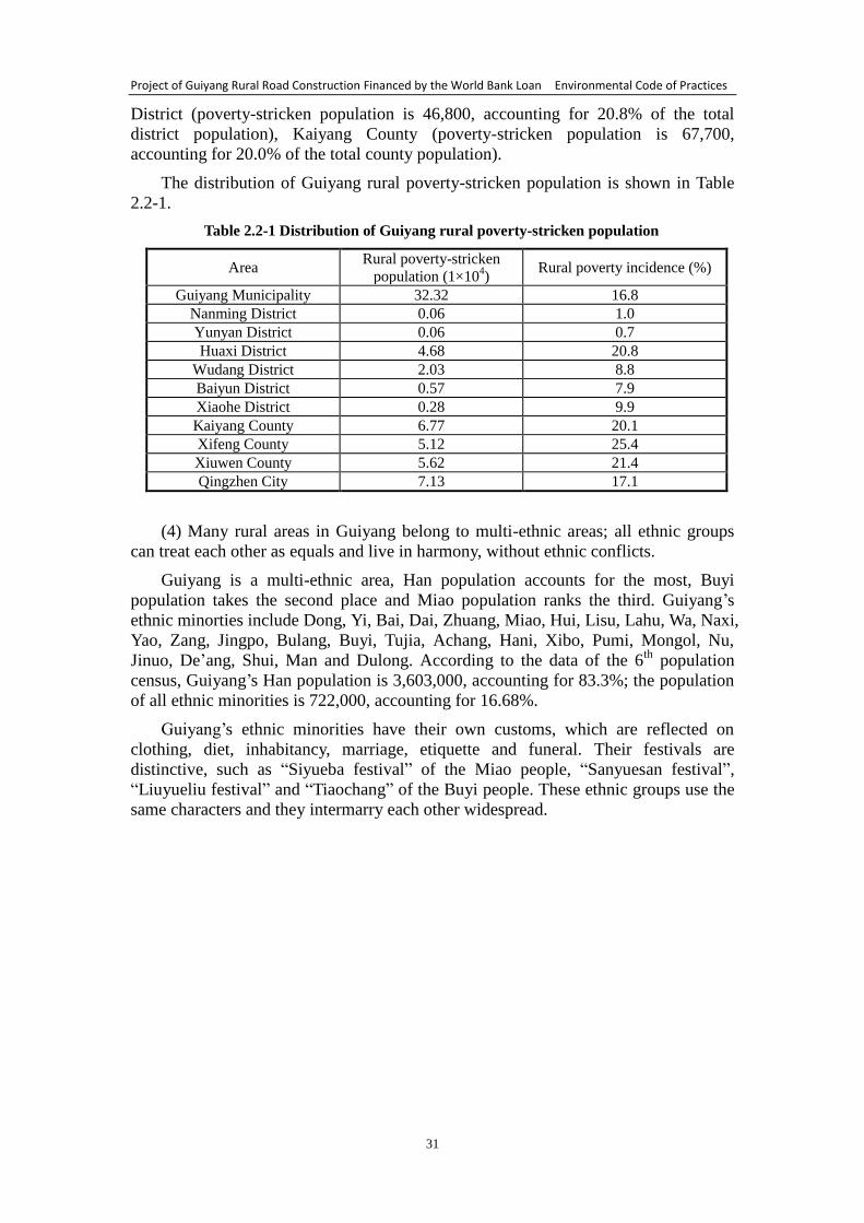
Project of Guiyang Rural Road Construction Financed by the World Bank Loan Environmental Code of Practices
31
District (poverty-stricken population is 46,800, accounting for 20.8% of the total
district population), Kaiyang County (poverty-stricken population is 67,700,
accounting for 20.0% of the total county population).
The distribution of Guiyang rural poverty-stricken population is shown in Table
2.2-1.
Table 2.2-1 Distribution of Guiyang rural poverty-stricken population
Area Rural poverty-stricken
population (1×10⁴)
Rural poverty incidence (%)
Guiyang Municipality 32.32 16.8
Nanming District 0.06 1.0
Yunyan District 0.06 0.7
Huaxi District 4.68 20.8
Wudang District 2.03 8.8
Baiyun District 0.57 7.9
Xiaohe District 0.28 9.9
Kaiyang County 6.77 20.1
Xifeng County 5.12 25.4
Xiuwen County 5.62 21.4
Qingzhen City 7.13 17.1
(4) Many rural areas in Guiyang belong to multi-ethnic areas; all ethnic groups
can treat each other as equals and live in harmony, without ethnic conflicts.
Guiyang is a multi-ethnic area, Han population accounts for the most, Buyi
population takes the second place and Miao population ranks the third. Guiyang’s
ethnic minorties include Dong, Yi, Bai, Dai, Zhuang, Miao, Hui, Lisu, Lahu, Wa, Naxi,
Yao, Zang, Jingpo, Bulang, Buyi, Tujia, Achang, Hani, Xibo, Pumi, Mongol, Nu,
Jinuo, De’ang, Shui, Man and Dulong. According to the data of the 6th
population
census, Guiyang’s Han population is 3,603,000, accounting for 83.3%; the population
of all ethnic minorities is 722,000, accounting for 16.68%.
Guiyang’s ethnic minorities have their own customs, which are reflected on
clothing, diet, inhabitancy, marriage, etiquette and funeral. Their festivals are
distinctive, such as “Siyueba festival” of the Miao people, “Sanyuesan festival”,
“Liuyueliu festival” and “Tiaochang” of the Buyi people. These ethnic groups use the
same characters and they intermarry each other widespread.
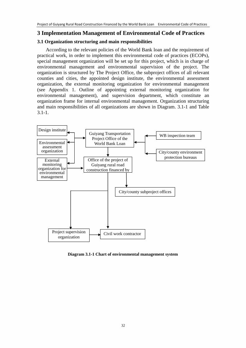
Project of Guiyang Rural Road Construction Financed by the World Bank Loan Environmental Code of Practices
32
3 Implementation Management of Environmental Code of Practices
3.1 Organization structuring and main responsibilities
According to the relevant policies of the World Bank loan and the requirement of
practical work, in order to implement this environmental code of practices (ECOPs),
special management organization will be set up for this project, which is in charge of
environmental management and environmental supervision of the project. The
organization is structured by The Project Office, the subproject offices of all relevant
counties and cities, the appointed design institute, the environmental assessment
organization, the external monitoring organization for environmental management
(see Appendix 1. Outline of appointing external monitoring organization for
environmental management), and supervision department, which constitute an
organization frame for internal environmental management. Organization structuring
and main responsibilities of all organizations are shown in Diagram. 3.1-1 and Table
3.1-1.
Diagram 3.1-1 Chart of environmental management system
Guiyang Transportation
Project Office of the World Bank Loan
Design institute
Environmental assessment
organization
WB inspection team
City/county environment
protection bureaus
City/county subproject offices
Civil work contractor Project supervision
organization
External monitoring
organization for environmental management
Office of the project of
Guiyang rural road
construction financed by
the World Bank loan
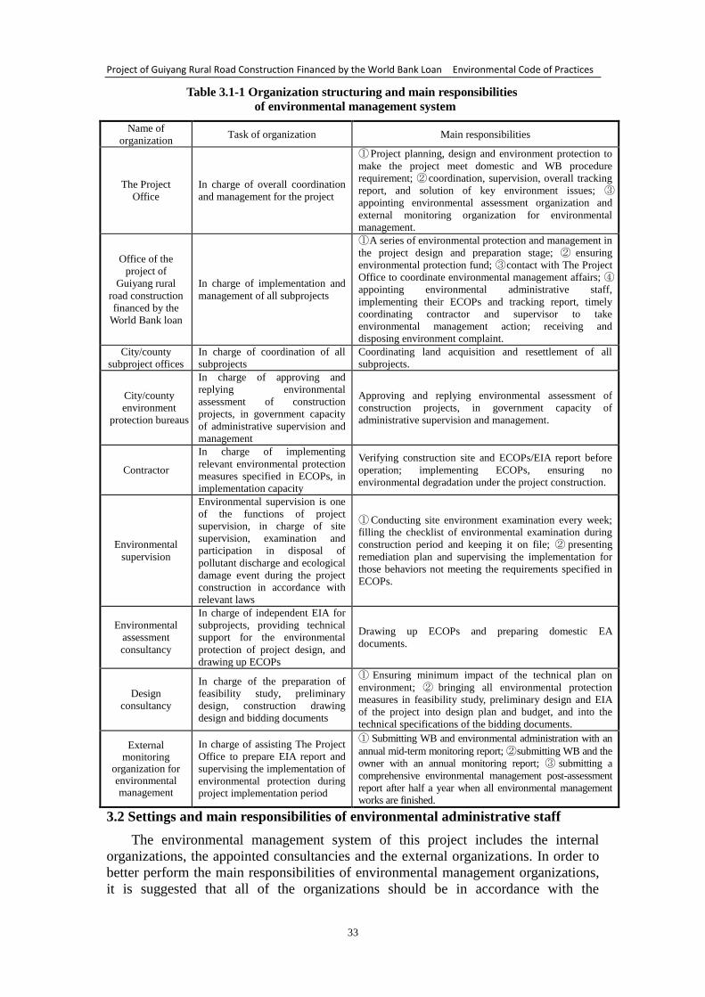
Project of Guiyang Rural Road Construction Financed by the World Bank Loan Environmental Code of Practices
33
Table 3.1-1 Organization structuring and main responsibilities
of environmental management system
Name of
organization Task of organization Main responsibilities
The Project
Office
In charge of overall coordination
and management for the project
① Project planning, design and environment protection to
make the project meet domestic and WB procedure
requirement; ② coordination, supervision, overall tracking
report, and solution of key environment issues; ③
appointing environmental assessment organization and
external monitoring organization for environmental
management.
Office of the
project of
Guiyang rural
road construction
financed by the
World Bank loan
In charge of implementation and
management of all subprojects
① A series of environmental protection and management in
the project design and preparation stage; ② ensuring
environmental protection fund; ③ contact with The Project
Office to coordinate environmental management affairs; ④
appointing environmental administrative staff,
implementing their ECOPs and tracking report, timely
coordinating contractor and supervisor to take
environmental management action; receiving and
disposing environment complaint.
City/county
subproject offices
In charge of coordination of all
subprojects
Coordinating land acquisition and resettlement of all
subprojects.
City/county
environment
protection bureaus
In charge of approving and
replying environmental
assessment of construction
projects, in government capacity
of administrative supervision and
management
Approving and replying environmental assessment of
construction projects, in government capacity of
administrative supervision and management.
Contractor
In charge of implementing
relevant environmental protection
measures specified in ECOPs, in
implementation capacity
Verifying construction site and ECOPs/EIA report before
operation; implementing ECOPs, ensuring no
environmental degradation under the project construction.
Environmental
supervision
Environmental supervision is one
of the functions of project
supervision, in charge of site
supervision, examination and
participation in disposal of
pollutant discharge and ecological
damage event during the project
construction in accordance with
relevant laws
① Conducting site environment examination every week;
filling the checklist of environmental examination during
construction period and keeping it on file; ② presenting
remediation plan and supervising the implementation for
those behaviors not meeting the requirements specified in
ECOPs.
Environmental
assessment
consultancy
In charge of independent EIA for
subprojects, providing technical
support for the environmental
protection of project design, and
drawing up ECOPs
Drawing up ECOPs and preparing domestic EA
documents.
Design
consultancy
In charge of the preparation of
feasibility study, preliminary
design, construction drawing
design and bidding documents
① Ensuring minimum impact of the technical plan on
environment; ② bringing all environmental protection
measures in feasibility study, preliminary design and EIA
of the project into design plan and budget, and into the
technical specifications of the bidding documents.
External monitoring
organization for environmental management
In charge of assisting The Project
Office to prepare EIA report and
supervising the implementation of
environmental protection during
project implementation period
① Submitting WB and environmental administration with an
annual mid-term monitoring report; ② submitting WB and the
owner with an annual monitoring report; ③ submitting a
comprehensive environmental management post-assessment
report after half a year when all environmental management
works are finished.
3.2 Settings and main responsibilities of environmental administrative staff
The environmental management system of this project includes the internal
organizations, the appointed consultancies and the external organizations. In order to
better perform the main responsibilities of environmental management organizations,
it is suggested that all of the organizations should be in accordance with the
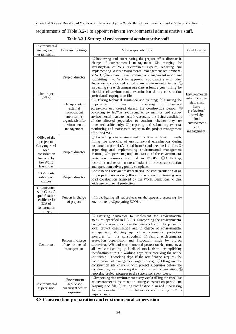
Project of Guiyang Rural Road Construction Financed by the World Bank Loan Environmental Code of Practices
34
requirements of Table 3.2-1 to appoint relevant environmental administrative staff.
Table 3.2-1 Settings of environmental administrative staff
Environmental
management
organization
Personnel settings Main responsibilities Qualification
The Project
Office
Project director
① Reviewing and coordinating the project office director in
charge of environmental management; ② arranging the
investigation of WB environment experts; reporting and
implementing WB’s environmental management requirements
to WB; ③ summarizing environmental management report and
submitting it to WB for approval; coordinating with other
departments concerned to solve key environmental issues; ④
inspecting site environment one time at least a year; filling the
checklist of environmental examination during construction
period and keeping it on file. Environmental
administrative
staff must
have
professional
knowledge
about
environment
and
management.
The appointed
external
independent
monitoring
organization for
environmental
management
① Offering technical assistance and training; ② assisting the
preparation of plan for recovering the damaged
ecoenvironment caused during the construction period; ③
according to ECOPs requirements to monitor and survey
environmental management; ④ assessing the living conditions
of the affected population to confirm whether they are
recovered sufficiently; ⑤ preparing and submitting external
monitoring and assessment report to the project management
office and WB.
Office of the
project of
Guiyang rural
road
construction
financed by
the World
Bank loan
Project director
① Inspecting site environment one time at least a month;
filling the checklist of environmental examination during
construction period (Attached form 3) and keeping it on file; ②
organizing and implementing environmental management
training; ③ supervising implementation of the environmental
protection measures specified in ECOPs; ④ Collecting,
recording and reporting the complaint in project construction
and operation; solving public complaint.
City/county
subproject
offices
Project director
Coordinating relevant matters during the implementation of all
subprojects; cooperating Office of the project of Guiyang rural
road construction financed by the World Bank loan to deal
with environmental protection.
Organization with Class-A qualification certificate for
EIA of construction
projects
Person in charge
of project
① Investigating all subprojects on the spot and assessing the
environment; ② preparing ECOPs.
Contractor
Person in charge
of environmental
management
① Ensuring contractor to implement the environmental
measures specified in ECOPs; ② reporting the environmental
emergency, which occurs in the construction, to the person of
local project organization and in charge of environmental
management; drawing up all environmental protection
measures for the construction; ③ facing environmental
protection supervision and inspection made by project
supervisor, WB and environmental protection departments at
all levels; ④ setting up feedback mechanism; accomplishing
rectification within 3 working days after receiving the notice
(or within 10 working days if the rectification requires the
coordination of management organization); ⑤ filling out the
construction site checklist with project supervisor before the
construction, and reporting it to local project organization; ⑥
reporting project progress to the supervisor every week.
Environmental
supervision
Environment
supervisor,
concurrent project
supervisor
① Inspecting site environment every week; filling the checklist
of environmental examination during construction period and
keeping it on file; ② raising rectification plan and supervising
the implementation for the behaviors not meeting ECOPs
requirements.
3.3 Construction preparation and environmental supervision
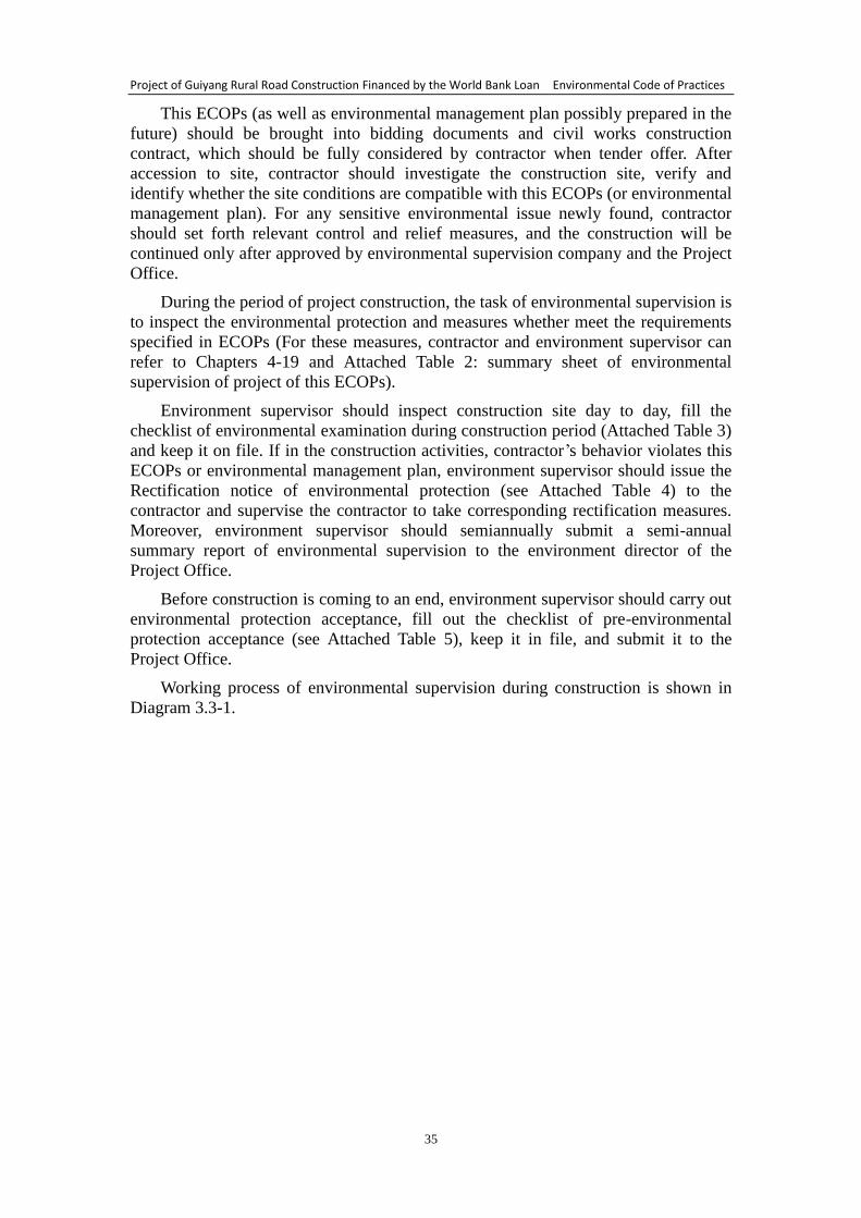
Project of Guiyang Rural Road Construction Financed by the World Bank Loan Environmental Code of Practices
35
This ECOPs (as well as environmental management plan possibly prepared in the
future) should be brought into bidding documents and civil works construction
contract, which should be fully considered by contractor when tender offer. After
accession to site, contractor should investigate the construction site, verify and
identify whether the site conditions are compatible with this ECOPs (or environmental
management plan). For any sensitive environmental issue newly found, contractor
should set forth relevant control and relief measures, and the construction will be
continued only after approved by environmental supervision company and the Project
Office.
During the period of project construction, the task of environmental supervision is
to inspect the environmental protection and measures whether meet the requirements
specified in ECOPs (For these measures, contractor and environment supervisor can
refer to Chapters 4-19 and Attached Table 2: summary sheet of environmental
supervision of project of this ECOPs).
Environment supervisor should inspect construction site day to day, fill the
checklist of environmental examination during construction period (Attached Table 3)
and keep it on file. If in the construction activities, contractor’s behavior violates this
ECOPs or environmental management plan, environment supervisor should issue the
Rectification notice of environmental protection (see Attached Table 4) to the
contractor and supervise the contractor to take corresponding rectification measures.
Moreover, environment supervisor should semiannually submit a semi-annual
summary report of environmental supervision to the environment director of the
Project Office.
Before construction is coming to an end, environment supervisor should carry out
environmental protection acceptance, fill out the checklist of pre-environmental
protection acceptance (see Attached Table 5), keep it in file, and submit it to the
Project Office.
Working process of environmental supervision during construction is shown in
Diagram 3.3-1.
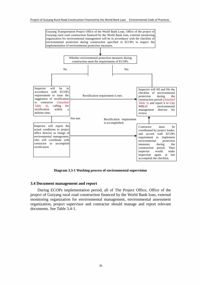
Project of Guiyang Rural Road Construction Financed by the World Bank Loan Environmental Code of Practices
36
Diagram 3.3-1 Working process of environmental supervision
3.4 Document management and report
During ECOPs implementation period, all of The Project Office, Office of the
project of Guiyang rural road construction financed by the World Bank loan, external
monitoring organization for environmental management, environmental assessment
organization, project supervisor and contractor should manage and report relevant
documents. See Table 3.4-1.
Guiyang Transportation Project Office of the World Bank Loan, Office of the project of
Guiyang rural road construction financed by the World Bank loan, external monitoring
organization for environmental management will be in accordance with the checklist of
environmental protection during construction specified in ECOPs to inspect the
implementation of environmental protection measures.
Whether environmental protection measures during
construction meet the requirements of ECOPs.
Inspector will be in
accordance with ECOPs
requirements to issue the
suggestion of rectification
to contractor (Attached
Table 4), calling for
rectification within a
definite time.
Inspector will fill and file the checklist of environmental protection during the construction period (Attached Table 3) and report it to City WBLO environmental management director for review.
No Yes
Rectification requirement is met.
Inspector will report the
actual conditions to project
office director in charge of
environmental management,
who will coordinate with
contractor to accomplish
rectification
Contractor must be
coordinated by project leader,
and accord with ECOPs
requirement to implement
environmental protection
measures during the
construction period. Then
inspector would make
inspection again, at last
accomplish the checklist.
Not met Rectification requirement
is accomplished.
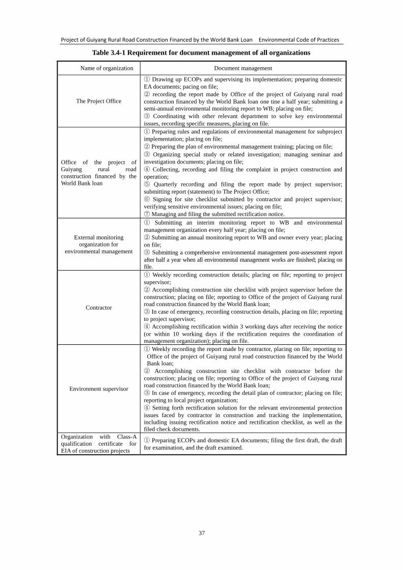
Project of Guiyang Rural Road Construction Financed by the World Bank Loan Environmental Code of Practices
37
Table 3.4-1 Requirement for document management of all organizations
Name of organization Document management
The Project Office
① Drawing up ECOPs and supervising its implementation; preparing domestic
EA documents; pacing on file;
② recording the report made by Office of the project of Guiyang rural road
construction financed by the World Bank loan one tine a half year; submitting a
semi-annual environmental monitoring report to WB; placing on file;
③ Coordinating with other relevant department to solve key environmental
issues, recording specific measures, placing on file.
Office of the project of
Guiyang rural road
construction financed by the
World Bank loan
① Preparing rules and regulations of environmental management for subproject
implementation; placing on file;
② Preparing the plan of environmental management training; placing on file;
③ Organizing special study or related investigation; managing seminar and
investigation documents; placing on file;
④ Collecting, recording and filing the complaint in project construction and
operation;
⑤ Quarterly recording and filing the report made by project supervisor;
submitting report (statement) to The Project Office;
⑥ Signing for site checklist submitted by contractor and project supervisor;
verifying sensitive environmental issues; placing on file;
⑦ Managing and filing the submitted rectification notice.
External monitoring
organization for
environmental management
① Submitting an interim monitoring report to WB and environmental
management organization every half year; placing on file;
② Submitting an annual monitoring report to WB and owner every year; placing
on file;
③ Submitting a comprehensive environmental management post-assessment report
after half a year when all environmental management works are finished; placing on
file.
Contractor
① Weekly recording construction details; placing on file; reporting to project
supervisor;
② Accomplishing construction site checklist with project supervisor before the
construction; placing on file; reporting to Office of the project of Guiyang rural
road construction financed by the World Bank loan;
③ In case of emergency, recording construction details, placing on file; reporting
to project supervisor;
④ Accomplishing rectification within 3 working days after receiving the notice
(or within 10 working days if the rectification requires the coordination of
management organization); placing on file.
Environment supervisor
① Weekly recording the report made by contractor, placing on file; reporting to
Office of the project of Guiyang rural road construction financed by the World
Bank loan;
② Accomplishing construction site checklist with contractor before the
construction; placing on file; reporting to Office of the project of Guiyang rural
road construction financed by the World Bank loan;
③ In case of emergency, recording the detail plan of contractor; placing on file;
reporting to local project organization;
④ Setting forth rectification solution for the relevant environmental protection
issues faced by contractor in construction and tracking the implementation,
including issuing rectification notice and rectification checklist, as well as the
filed check documents.
Organization with Class-A
qualification certificate for
EIA of construction projects
① Preparing ECOPs and domestic EA documents; filing the first draft, the draft
for examination, and the draft examined.

Project of Guiyang Rural Road Construction Financed by the World Bank Loan Environmental Code of Practices
38
4 Environmental Code of Practices for Site Construction
4.1 Environment code of practices for site environment
Site mainly includes construction camp, concrete mixing station, asphalt mixing
station, and so on. According to the different functions, construction camp can be
divided into living campsite, operation campsite and living/operation campsite. The
living campsite is used for constructors’ board and lodging; operation campsite is
mainly used for placing building materials, concrete mixing, fabrication of precast
bridge parts, etc.; living/operation campsite integrates living and operation as a whole,
suitable for contractors’ board and lodging, building materials placing and fabrication
of precast bridge parts. Asphalt mixing station is mainly used for mixing asphalt
required by pavement laying.
(1) Requirements of site selection
The requirements of site selection are shown in the Table 4.1-1.
Table 4.1-1 Requirements of site selection
Not selected Selected
• Main sensitive places, such as residence and school, and the
land within 200m from upwind
• Basic farmland
• House site
• Forest land
• The land within 200m from river course
• The land within upstream 1000m or downstream 500m from
the intake of drinking water source so as to avoid water
conservation area, as well as sensitive environmental area,
such as scenic spot and forest park
• Depression or paddy field
• The land well covered by vegetation
• Dangerous collapse and landslide area
• Susceptible area of debris flow
• The land for special use
• Renting local civilian houses
• The land within the scope of
permanent use for road
• Uncultivated land
• Abandoned land
• Land parcel with a higher
terrain
• Other poor land
(2) Analysis of site impact on environment
Site impact on environment mainly includes noise of construction machinery,
drainage of industrial wastewater and domestic sewage, construction dust, cooking oil
fume, construction waste and household garbage. See Table 4.1-2
Project of Guiyang Rural Road Construction Financed by the World Bank Loan Environmental Code of Practices
39
Table 4.1-2 Site impact on environment
Site category Environmental
elements Impact on environment
Operation
campsite
Water Impact of industrial wastewater on water environment
Air Impact of construction flying dust on ambient air
Sound Impact of construction machinery on sound environment
Solid waste Impact of construction waste on environment
Living
campsite
Water Impact of domestic sewage produced from constructors’ board and
lodging on water environment
Air Impact of constructors’ residential heating and cooking oil fume
on ambient air
Sound Impact of constructors’ shouting on sound environment
Solid waste Impact of domestic garbage on environment
Society Impact of constructors’ access on local social environment
Asphalt
mixing station
Air Impact of asphalt fume on ambient air
Sound Impact of mixer noise on sound environment
(3) Environmental code of practices for site
According to the requirement of site selection and combining with the actual
conditions of the project, site selection should abide by the following requirements:
① The project should rent the civilian houses along the line as far as possible;
arrange the collecting station and or container to gather domestic garbage; electric
energy or other clean energies can be used for residence and heating.
② Constructors should abide by local village regulations and non-governmental
agreements, accord with civilized construction and deal well with local residents.
③ Pit toilet and sedimentation basin should be arranged in operation campsite.
After precipitated, the industrial waste water can be recycled in operation, not
discharged to outside. The domestic sewage (from constructors’ toileting) treated in
pit toilet can be used for agricultural irrigation. Construction waste in the camps
should be recycled as far as possible, or transported to the appointed place at regular
intervals, prohibiting littered everywhere.
④ Barren slope, brushwood land and poor land have a prior selection to
operation campsite. Cultivated land is prohibited to be occupied. If it is inevitable to
occupy cultivated land, the occupation of basic farmland is prohibited. Before
construction, it is required to strip the cultivated surface soil and temporarily stack it
in a flat ground, retaining with packed earth, arranging temporary drainage ditch and
desilting measures, and covered with dust screen. After the construction is finished,
the soil can be used as cover earth for second ploughing or green planting.
⑤ Special concrete mixing station and asphalt mixing station are not set up for
this project; all of concrete and asphalt will be purchased from outside.
4.2 Environmental code of practices for site construction
(1) Provisions of construction time
① Construction time: day shift: 6:00-22:00; night shift: 22:00-6:00; suspended:
12:00-14:00. The access time of construction vehicle must accord with local
government’s requirements.
② Night construction is restricted. If unavoidable, the surrounding residents
Project of Guiyang Rural Road Construction Financed by the World Bank Loan Environmental Code of Practices
40
should be informed by public announcement. At the same time relevant formalities
must be handled and it is needed to take measures to reduce the impact on the
surrounding residents.
(2) Management of building materials
Building materials for this project mainly include sand, stone, cement, etc. If the
management is improper in transportation, storage and application, these materials
will impact environment with varying degree. So it is required to take corresponding
environmental protection measures to minimize the impact.
The measures to be taken for the building materials in transportation, storage and
application are as follows:
① Vehicle should be low-noisy and transportation of day shift must be strictly
executed, strengthening management and reducing night transport times in abnormal
working conditions.
② Speed of transport vehicle must be restricted. When passing through
environmental protection objects (e.g. hospital, residential area, school), vehicle must
be driven slowly with lower speed.
③ Vehicular access sign should be available; driver should control his/her
automobile in a civilized way to ensure safe transportation.
④ Powdery materials, such as cement and lime, should be canned or bagged,
prohibiting bulk transportation. The truck, with which aggregate and other
construction materials are transported, must be equipped with anti-falling device,
covered by felt, and not fully loaded to prevent the materials blown off. Transport
route and time should be planned to reduce the impact on sensitive environmental area
as far as possible.
⑤ The stacking place of powdery materials should be selected at 300m far from
the downwind sensitive environmental area. It is needed to reduce stack volume and
consume it in time; in addition, take wind-proof and rain-proof measures, build up
fence if necessary, sprinkle water at regular time to prevent flying dust, and is covered
by felt in severe weather.
⑥ Construction truck must be inspected at regular intervals and the damaged
truck bed should be repaired in time to avoid the building materials or construction
waste fallen from the truck when the truck is driven.
⑦ Surface of access road should be hardened or treated by sprinkling water, so
as to control the impact of rolling compaction of motor vehicle wheels and reduce
flying dust pollution.
⑧ During construction period, it is required to strengthen the management of
powdery (or granular) materials transport and use, and to sprinkle and clean the
working surface, on which reentrainment of dust is easy to occur.
(3) Management of construction equipments
Construction equipments mainly include loading machine, road roller, excavator,
blender, vibrator, tamper, and so on. During construction period, these equipments
will generate noise, tailgas and possible leakage, which maybe impact the environment
of project area. In order to minimize the harmful influence, it is planned to take
Project of Guiyang Rural Road Construction Financed by the World Bank Loan Environmental Code of Practices
41
following management measures:
① Construction equipments should be placed in the specified construction area,
not allowed to be arbitrarily parked outside the construction site to occupy other land
and destroy vegetation and soil.
② It is better to use low-noise equipment.
③ Muffler will be installed in the noise source of equipment, that is, in the
proper position of various exhaust or unloading devices, e.g. air inlet/outlet; in
addition, damping foundation or damping support can be used.
④ Fuel oil machinery and vehicle must be in normal conditions, ensuring waste
gas emission up to the standard.
⑤ Equipment should be properly used, maintained and repaired to prevent it
from leakage and impact surface water environment and soil environment of the
project area.
Project of Guiyang Rural Road Construction Financed by the World Bank Loan Environmental Code of Practices
42
5 Environmental Code of Practices for Site Cleaning
5.1 Contents of site cleaning
Site cleaning include vegetation, surface soil, old roadbed, side ditch, pavement
concrete, concrete structure, garbage, waste residue and other barriers pointed out by
supervisor. And the scope covers the surface of all area of construction site to be
cleaned, such as permanent or temporary work area, stock ground, storage area, waste
disposal area, etc.
5.2 Environmental code of practices for site cleaning
(1) Vegetation cleaning of construction site surface of main works must be
extended to the max. excavation sideline shown in the construction drawing, or 5m at
least from the outside of building foundation sideline.
(2) In case of vegetation cleaning of main works, the scope of tree stump
excavation must be extended to the max. excavation sideline shown in the
construction drawing, or filling line shown in the construction drawing, or 3m at least
from the outside of building foundation.
(3) It is required to pay attention to the natural vegetation protection around the
cleaning area. For the damage of forest resource around the cleaning area as well as
the harmful impact on environment protection resulted from improper construction,
the contract should bear the compensation.
(4) Within the scope of site cleaning, the sawn lumber or the materials with
business value obtained by contractor should belong to employer. Contractor should
be in accordance with supervisor’s direction to transport them to an appointed place.
(5) All unworthy combustibles should be burned down by fire as quickly as
possible, during which, contractor should take necessary fireproofing measures and
should be responsible for combustion results.
(6) All of debris removals, which cannot be fully burn out or will impact
environment severely, must be buried in the area that is specified by supervisor. It is
not allowed to obstruct natural drainage or pollute rivers.
(7) The cultural relics and historical sites found in site cleaning should be treated
in accordance with the regulations of Chapter 17 of this ECOPs.
(8) Surface soil cleaning should be in accordance with the excavation depth
specified by supervisor. The excavated organic soil must be transported to a specified
stack area, preventing the soil washed out. The stacked organic soil can be used for
environmental protection of the project. According to the contract requirements and
employer’s overall environmental planning, organic soil should be used properly.
(9) Waste and organic residue within roadbed scope, as well as humus, grass sod,
tree stump and crop root on the original soil pit surface (100-300 mm deep) should be
cleared away and put them together in the place specified by supervisor or stack them
in spoil ground. After site cleaning, the pits within roadbed scope should be backfilled
and compacted entirely, making the density up to the specified standard.
(10) When explosion or other operation is needed for the removed structure or
barrier, it must be finished before new work to avoid the possible damage of new
structure. In order to avoid unnecessary loss, all utilizable materials should be stacked
properly in the specified place. All potholes should be backfilled and compacted,

Project of Guiyang Rural Road Construction Financed by the World Bank Loan Environmental Code of Practices
43
making the density up to the specified standard.
(11) Demolishment of side ditch, culvert, pavement and other barriers is made
only after properly arranging normal transportation and drainage. As for the
underground part of original structures, both excavation depth and scope should
accord with supervisor’s requirements.
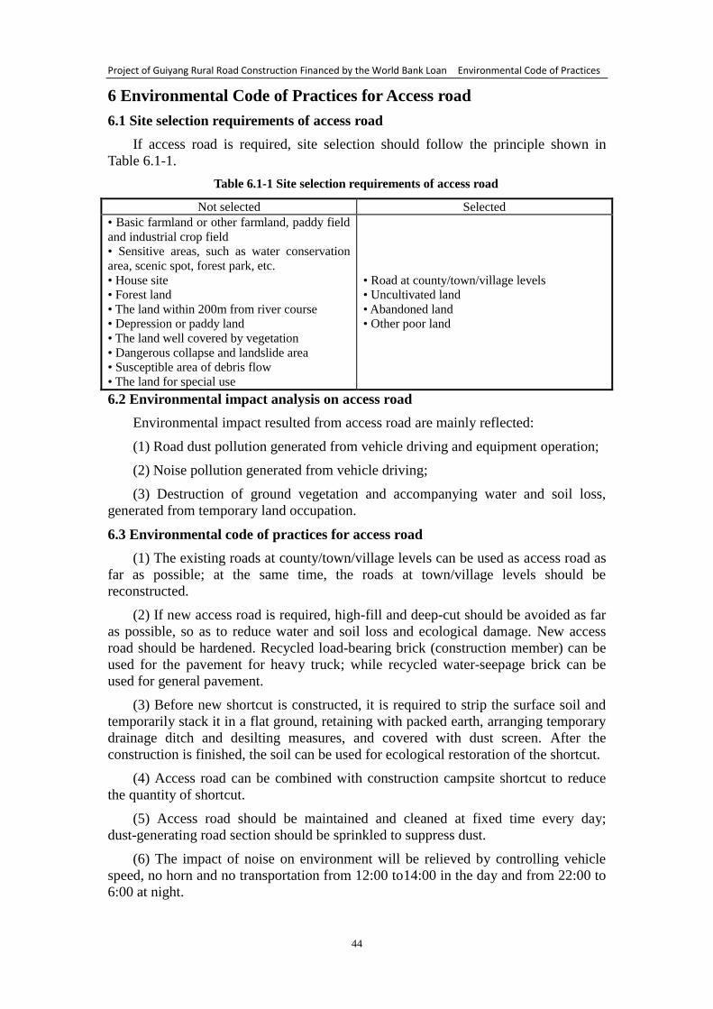
Project of Guiyang Rural Road Construction Financed by the World Bank Loan Environmental Code of Practices
44
6 Environmental Code of Practices for Access road
6.1 Site selection requirements of access road
If access road is required, site selection should follow the principle shown in
Table 6.1-1.
Table 6.1-1 Site selection requirements of access road
Not selected Selected
• Basic farmland or other farmland, paddy field
and industrial crop field
• Sensitive areas, such as water conservation
area, scenic spot, forest park, etc.
• House site
• Forest land
• The land within 200m from river course
• Depression or paddy land
• The land well covered by vegetation
• Dangerous collapse and landslide area
• Susceptible area of debris flow
• The land for special use
• Road at county/town/village levels
• Uncultivated land
• Abandoned land
• Other poor land
6.2 Environmental impact analysis on access road
Environmental impact resulted from access road are mainly reflected:
(1) Road dust pollution generated from vehicle driving and equipment operation;
(2) Noise pollution generated from vehicle driving;
(3) Destruction of ground vegetation and accompanying water and soil loss,
generated from temporary land occupation.
6.3 Environmental code of practices for access road
(1) The existing roads at county/town/village levels can be used as access road as
far as possible; at the same time, the roads at town/village levels should be
reconstructed.
(2) If new access road is required, high-fill and deep-cut should be avoided as far
as possible, so as to reduce water and soil loss and ecological damage. New access
road should be hardened. Recycled load-bearing brick (construction member) can be
used for the pavement for heavy truck; while recycled water-seepage brick can be
used for general pavement.
(3) Before new shortcut is constructed, it is required to strip the surface soil and
temporarily stack it in a flat ground, retaining with packed earth, arranging temporary
drainage ditch and desilting measures, and covered with dust screen. After the
construction is finished, the soil can be used for ecological restoration of the shortcut.
(4) Access road can be combined with construction campsite shortcut to reduce
the quantity of shortcut.
(5) Access road should be maintained and cleaned at fixed time every day;
dust-generating road section should be sprinkled to suppress dust.
(6) The impact of noise on environment will be relieved by controlling vehicle
speed, no horn and no transportation from 12:00 to14:00 in the day and from 22:00 to
6:00 at night.

Project of Guiyang Rural Road Construction Financed by the World Bank Loan Environmental Code of Practices
45
(7) Before construction is finished, the ecological status of new access road
should be recovered at least as before.
(8) The occupied or destructive local road will be transformed or maintained, and
the pavement will be recovered and greening after construction. At the same time, it is
required to pay local government a certain compensations to safeguard the legitimate
interests of local government and residents.
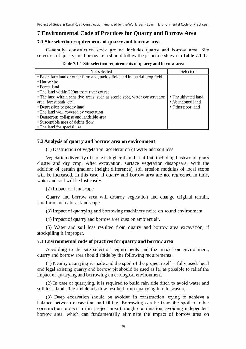
Project of Guiyang Rural Road Construction Financed by the World Bank Loan Environmental Code of Practices
46
7 Environmental Code of Practices for Quarry and Borrow Area
7.1 Site selection requirements of quarry and borrow area
Generally, construction stock ground includes quarry and borrow area. Site
selection of quarry and borrow area should follow the principle shown in Table 7.1-1.
Table 7.1-1 Site selection requirements of quarry and borrow area
Not selected Selected
• Basic farmland or other farmland, paddy field and industrial crop field
• House site
• Forest land
• The land within 200m from river course
• The land within sensitive areas, such as scenic spot, water conservation
area, forest park, etc.
• Depression or paddy land
• The land well covered by vegetation
• Dangerous collapse and landslide area
• Susceptible area of debris flow
• The land for special use
• Uncultivated land
• Abandoned land
• Other poor land
7.2 Analysis of quarry and borrow area on environment
(1) Destruction of vegetation; acceleration of water and soil loss
Vegetation diversity of slope is higher than that of flat, including bushwood, grass
cluster and dry crop. After excavation, surface vegetation disappears. With the
addition of certain gradient (height difference), soil erosion modulus of local scope
will be increased. In this case, if quarry and borrow area are not regreened in time,
water and soil will be lost easily.
(2) Impact on landscape
Quarry and borrow area will destroy vegetation and change original terrain,
landform and natural landscape.
(3) Impact of quarrying and borrowing machinery noise on sound environment.
(4) Impact of quarry and borrow area dust on ambient air.
(5) Water and soil loss resulted from quarry and borrow area excavation, if
stockpiling is improper.
7.3 Environmental code of practices for quarry and borrow area
According to the site selection requirements and the impact on environment,
quarry and borrow area should abide by the following requirements:
(1) Nearby quarrying is made and the spoil of the project itself is fully used; local
and legal existing quarry and borrow pit should be used as far as possible to relief the
impact of quarrying and borrowing on ecological environment.
(2) In case of quarrying, it is required to build rain side ditch to avoid water and
soil loss, land slide and debris flow resulted from quarrying in rain season.
(3) Deep excavation should be avoided in construction, trying to achieve a
balance between excavation and filling. Borrowing can be from the spoil of other
construction project in this project area through coordination, avoiding independent
borrow area, which can fundamentally eliminate the impact of borrow area on
Project of Guiyang Rural Road Construction Financed by the World Bank Loan Environmental Code of Practices
47
environment.
(4) Concentrated quarrying and borrowing will be adopted for the project to
reduce quarry and borrow area.
(5) It is needed to pay attention to water sprinkling and dust suppression in
quarrying and borrowing operation, so as to reduce the dust pollution resulted from
earth excavation.
(6) In order to prevent water and soil loss, cutoff ditch and drainage ditch should
be arranged in quarry and borrow area, which can avoid the lost sediment directly
flowing into surface water along with the runoff in the drainage ditch, resulted in
lower water quality.
(7) In the operation of excavation, the topsoil should be retained for land
rehabilitation. The topsoil will be temporarily stacked on a flat ground, retaining with
packed earth, arranging temporary drainage ditch and desilting measures, and covered
with dust screen. After the construction is finished, the soil can be used for ecological
restoration of the borrow area.
(8) The principle of simple and easy conservation will be followed, and the
greening can combine tree, bush with grass, thus to form plant community landscape,
recover natural ecology of quarry and borrow area, and reduce water and soil loss.
(9) Working hours must be controlled strictly. If there is any sensitive object, such
as housing estate, within noise effect scope, quarrying and borrowing operation
should be prohibited from 12:00 to 14:00 in the day and from 22:00 to 6:00 at night.
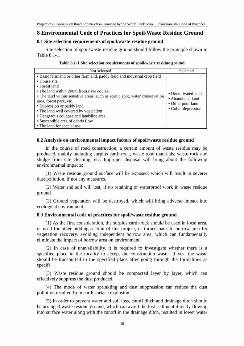
Project of Guiyang Rural Road Construction Financed by the World Bank Loan Environmental Code of Practices
48
8 Environmental Code of Practices for Spoil/Waste Residue Ground
8.1 Site selection requirements of spoil/waste residue ground
Site selection of spoil/waste residue ground should follow the principle shown in
Table 8.1-1.
Table 8.1-1 Site selection requirements of spoil/waste residue ground
Not selected Selected
• Basic farmland or other farmland, paddy field and industrial crop field
• House site
• Forest land
• The land within 200m from river course
• The land within sensitive areas, such as scenic spot, water conservation
area, forest park, etc.
• Depression or paddy land
• The land well covered by vegetation
• Dangerous collapse and landslide area
• Susceptible area of debris flow
• The land for special use
• Uncultivated land
• Abandoned land
• Other poor land
• Col or depression
8.2 Analysis on environmental impact factors of spoil/waste residue ground
In the course of road construction, a certain amount of waste residue may be
produced, mainly including surplus earth-rock, waste road materials, waste rock and
sludge from site cleaning, etc. Improper disposal will bring about the following
environmental impacts:
(1) Waste residue ground surface will be exposed, which will result in severer
dust pollution, if not any measures.
(2) Water and soil will lost, if no retaining or waterproof work in waste residue
ground.
(3) Ground vegetation will be destroyed, which will bring adverse impact into
ecological environment.
8.3 Environmental code of practices for spoil/waste residue ground
(1) As the first consideration, the surplus earth-rock should be used in local area,
or used for other bidding section of this project, or turned back to borrow area for
vegetation recovery, avoiding independent borrow area, which can fundamentally
eliminate the impact of borrow area on environment.
(2) In case of unavailability, it is required to investigate whether there is a
specified place in the locality to accept the construction waste. If yes, the waste
should be transported to the specified place after going through the formalities as
specifi
(3) Waste residue ground should be compacted layer by layer, which can
effectively suppress the dust produced.
(4) The mode of water sprinkling and dust suppression can reduce the dust
pollution resulted from earth surface explosion.
(5) In order to prevent water and soil loss, cutoff ditch and drainage ditch should
be arranged waste residue ground, which can avoid the lost sediment directly flowing
into surface water along with the runoff in the drainage ditch, resulted in lower water

Project of Guiyang Rural Road Construction Financed by the World Bank Loan Environmental Code of Practices
49
quality, during construction period and operation period.
(6) Before waste residue ground is put into use, the surface soil should be
excavated out and used for land rehabilitation. The surface soil should temporarily
stacked in a flat ground, retaining with packed earth, arranging temporary drainage
ditch and desilting measures, and covered with dust screen. After the construction is
finished, the soil can be used for ecological restoration of the waste residue ground.
(7) The principle of simple and easy conservation will be followed, and the
greening can combine tree, bush with grass, thus to form plant community landscape,
recover natural ecology of spoil/waste residue ground, and reduce water and soil loss.
(8) Prohibit disorderly spoil stacking and discarding.
Project of Guiyang Rural Road Construction Financed by the World Bank Loan Environmental Code of Practices
50
9 Environmental Code of Practices for Slope Stability and Earth
Squaring/Filling
9.1 Analysis on common damages appearing on road slope and formation cause
9.1.1 Type of damages appearing on road slope
Damages often appear on mountainous rural road slope because of lower
construction level, shortage of fund, rough design and lower constructional and
technical standards, which severely influences normal use of road. The damages on
rural road slope are mainly reflected in following aspects.
(1) Stripping
The rock on road slope is easy to be weathered, so rock stripping appears easily in
the use of road.
(2) Rockfall
Because of incomplete construction, the rock with loose blocky structure or
fragmentary structure remains on the slope. With the time passing and external force
influence, the rock is easy to fall on the pavement and consequently bring about risk.
(3) Collapse
If slope rock mass is too precipitous, the top fracture maybe occurs and results in
slope collapse.
(4) Crumpling
If slope excavation is too precipitous, the tension fissure maybe occurs and
extends to side hill gradually, resulted in crumpling.
(5) Surface slide fall
If weak soil mass or fractured hard rock are distributed on the slope surface, it
maybe occurs that surface fractured soil mass slides and falls down along local weak
surface under the effect of air weathering and water erosion. The collapsed stone and
earth fall on road and severely influence the normal use of road.
(6) Weathered stripping
The rock-soil slope surface with easy weathering will be severely weathered
under external force impacts, such as rainwater and sunlight, after it is excavated. And
a loose layer with certain thickness will be formed after the slope is weathered. Under
the effect of gravity and rainwater, the loose layer will slide down along the slope,
resulted in weathered stripping.
(7) Shallow-layer slide of slope surface
If weak rock-soil mass or fractured hard rock are distributed on the shallow layer
of slope, it maybe occurs that the shallow-layer rock and soil slide down integrally
with horizontal displacement in the main, along certain weak surface or belt, under the
effect of natural force and gravity. Shallow-layer slide will result in large damage to
the pavement.
9.1.2 Influence factors of slope stability
(1) Rock mass structure
Structure surface of slope is one of the key factors of influencing the stability of
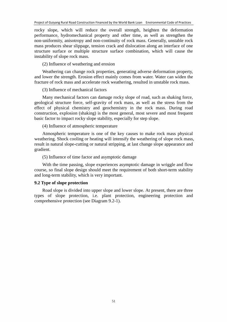
Project of Guiyang Rural Road Construction Financed by the World Bank Loan Environmental Code of Practices
51
rocky slope, which will reduce the overall strength, heighten the deformation
performance, hydromechanical property and other time, as well as strengthen the
non-uniformity, anisotropy and non-continuity of rock mass. Generally, unstable rock
mass produces shear slippage, tension crack and dislocation along an interface of one
structure surface or multiple structure surface combination, which will cause the
instability of slope rock mass.
(2) Influence of weathering and erosion
Weathering can change rock properties, generating adverse deformation property,
and lower the strength. Erosion effect mainly comes from water. Water can widen the
fracture of rock mass and accelerate rock weathering, resulted in unstable rock mass.
(3) Influence of mechanical factors
Many mechanical factors can damage rocky slope of road, such as shaking force,
geological structure force, self-gravity of rock mass, as well as the stress from the
effect of physical chemistry and geochemistry in the rock mass. During road
construction, explosion (shaking) is the most general, most severe and most frequent
basic factor to impact rocky slope stability, especially for step slope.
(4) Influence of atmospheric temperature
Atmospheric temperature is one of the key causes to make rock mass physical
weathering. Shock cooling or heating will intensify the weathering of slope rock mass,
result in natural slope-cutting or natural stripping, at last change slope appearance and
gradient.
(5) Influence of time factor and asymptotic damage
With the time passing, slope experiences asymptotic damage in wriggle and flow
course, so final slope design should meet the requirement of both short-term stability
and long-term stability, which is very important.
9.2 Type of slope protection
Road slope is divided into upper slope and lower slope. At present, there are three
types of slope protection, i.e. plant protection, engineering protection and
comprehensive protection (see Diagram 9.2-1).
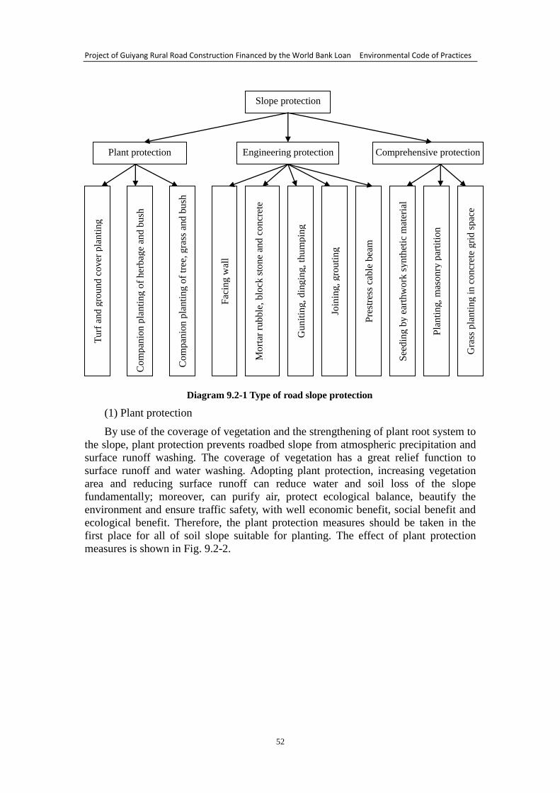
Project of Guiyang Rural Road Construction Financed by the World Bank Loan Environmental Code of Practices
52
Diagram 9.2-1 Type of road slope protection
(1) Plant protection
By use of the coverage of vegetation and the strengthening of plant root system to
the slope, plant protection prevents roadbed slope from atmospheric precipitation and
surface runoff washing. The coverage of vegetation has a great relief function to
surface runoff and water washing. Adopting plant protection, increasing vegetation
area and reducing surface runoff can reduce water and soil loss of the slope
fundamentally; moreover, can purify air, protect ecological balance, beautify the
environment and ensure traffic safety, with well economic benefit, social benefit and
ecological benefit. Therefore, the plant protection measures should be taken in the
first place for all of soil slope suitable for planting. The effect of plant protection
measures is shown in Fig. 9.2-2.
Slope protection
Engineering protection Plant protection Comprehensive protection
Turf
and
gro
und
cover
pla
nti
ng
Com
pan
ion p
lanti
ng
of
her
bag
e an
d b
ush
Com
pan
ion p
lan
tin
g o
f tr
ee, g
rass
an
d b
ush
Fac
ing
wal
l
Mort
ar r
ubble
, b
lock
sto
ne
and
co
ncr
ete
Gunit
ing
, d
ing
ing
, th
um
pin
g
Join
ing
, g
rou
tin
g
Pre
stre
ss c
able
bea
m
See
din
g b
y e
arth
wo
rk s
yn
thet
ic m
ater
ial
Pla
nti
ng
, m
aso
nry
par
titi
on
Gra
ss p
lanti
ng
in
co
ncr
ete
gri
d s
pac
e
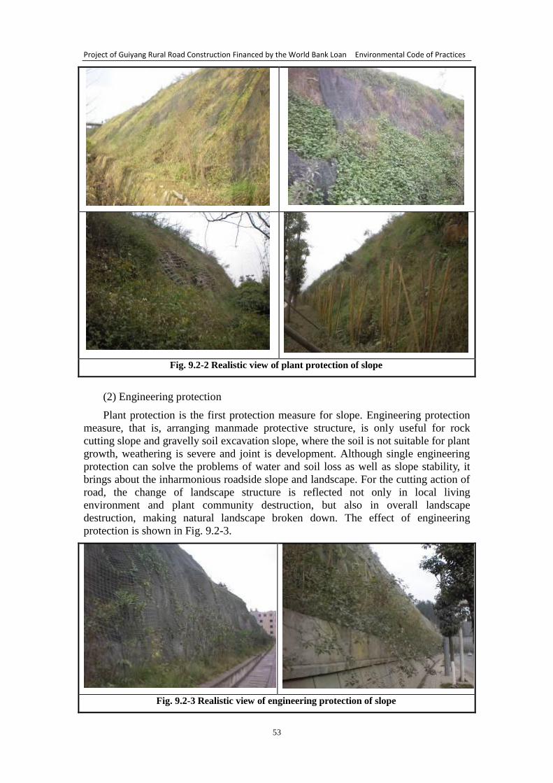
Project of Guiyang Rural Road Construction Financed by the World Bank Loan Environmental Code of Practices
53
Fig. 9.2-2 Realistic view of plant protection of slope
(2) Engineering protection
Plant protection is the first protection measure for slope. Engineering protection
measure, that is, arranging manmade protective structure, is only useful for rock
cutting slope and gravelly soil excavation slope, where the soil is not suitable for plant
growth, weathering is severe and joint is development. Although single engineering
protection can solve the problems of water and soil loss as well as slope stability, it
brings about the inharmonious roadside slope and landscape. For the cutting action of
road, the change of landscape structure is reflected not only in local living
environment and plant community destruction, but also in overall landscape
destruction, making natural landscape broken down. The effect of engineering
protection is shown in Fig. 9.2-3.
Fig. 9.2-3 Realistic view of engineering protection of slope
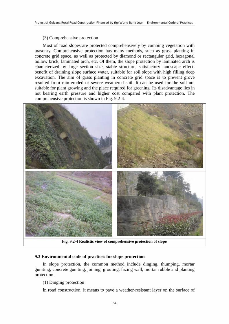
Project of Guiyang Rural Road Construction Financed by the World Bank Loan Environmental Code of Practices
54
(3) Comprehensive protection
Most of road slopes are protected comprehensively by combing vegetation with
masonry. Comprehensive protection has many methods, such as grass planting in
concrete grid space, as well as protected by diamond or rectangular grid, hexagonal
hollow brick, laminated arch, etc. Of them, the slope protection by laminated arch is
characterized by large section size, stable structure, satisfactory landscape effect,
benefit of draining slope surface water, suitable for soil slope with high filling deep
excavation. The aim of grass planting in concrete grid space is to prevent grove
resulted from rain-eroded or severe weathered soil. It can be used for the soil not
suitable for plant growing and the place required for greening. Its disadvantage lies in
not bearing earth pressure and higher cost compared with plant protection. The
comprehensive protection is shown in Fig. 9.2-4.
Fig. 9.2-4 Realistic view of comprehensive protection of slope
9.3 Environmental code of practices for slope protection
In slope protection, the common method include dinging, thumping, mortar
guniting, concrete guniting, joining, grouting, facing wall, mortar rubble and planting
protection.
(1) Dinging protection
In road construction, it means to pave a weather-resistant layer on the surface of
Project of Guiyang Rural Road Construction Financed by the World Bank Loan Environmental Code of Practices
55
easily weathered and soft rock cutting slope so as to isolate the atmosphere and
prevent weathering. Common dinging materials include lime compound mortar and
cement mortar, with the thickness of 3-7 cm. Also, an asphalt protective layer can be
covered on the slope surface.
(2) Thumping protection
In road construction, dinging protection can be carried out for the soil slope that
is easily washed out or the rocky slope that is easily weathered and stripped. The
method is as the same as that of dinging protection. The difference between the two
protections is that thumping surface is thicker than dinging surface and its strength is
higher.
(3) Mortar guniting and concrete guniting
The protection of mortar guniting and concrete guniting can be used for the rocky
slope surface with easy weathering, developed joint fissure and cataclastic structure,
with the effect of sealing slope rock fissure and joint, preventing surface water from
entering into the slope, preventing the rock weathered continuously, strengthening
slope stability and preventing the slope from rock falling and collapse.
(4) Joining and grouting
The rocky cutting slope, which is harder and difficult to be weathered, and the
slope with more joints and fissures, can be joined and grouted with cement.
(5) Dry-laid rubble protection
By utilizing local resource, dry-laid rubble protection can used for the filling or
excavating roadbed slope that is earthy, soft, easy weathering and severely destructed.
In masonry protection, the first selection is dry-laid rubble structure, which not only
reduces investment, but also adapts more deformed slope, preventing surface soil
layer from washing out and relieving floater’s impact. In addition, cushion (or
reversed filter) composed of macadam or gravel can be arranged under the dry-laid
rubble layer. The cushion is also replaced by geotextile.
(6) Mortar rubble protection
Generally, mortar rubble protection is suitable for the soil slope that is easily
eroded by water, the soft rocky slope that is severely stripped, the rocky slope that is
intensely weathered or crushed, and the loose slope that has thicker slide rock layer.
(7) Planting protection of road slope
In order to prevent slope damage, thicker vegetation can be planted on the slope
in the later stage of construction to stabilize the mountain mass. Considering from the
function of slope protection, the first requirement of planting protection is to reinforce
and stabilize the slope, green and improve road environment. The plants, which will
be used for planting protection of slope, must have the following characteristics:
developed root system, good effect of soil fixation and slope protection, extensive
coverage, higher density, long green period, perennial, trample resistance, suitable for
extensive management, easy transplant and reproduction (natural reproduction at best),
easy management, having a stronger ability of antipollution and air purification.
Project of Guiyang Rural Road Construction Financed by the World Bank Loan Environmental Code of Practices
56
10 Environmental Code of Practices for Drainage System
10.1 The importance of drainage system to rural road
As the technical standard of rural road is low, without favorable drainage system,
the road will be soaked in water. This may cause problems, ranging from upheaval,
subsidence and potholes of roadbed and raveling and chuckhole of pavement to
destroy of roadbed, threat to pavement and traffic interruption at worse. So the traffic
capacity will be affected. However, if the rural road has favorable drainage system,
then the stable, solid and dense roadbed, smooth pavement, suitable road hump, traffic
safety and comfort, long service life of rural road and high social efficacy can be
ensured.
10.2 Types of drainage system of rural road
According to the relevant provisions of “Design Specifications of Highway
Drainage” (JTJ018-97) and “Technical Standard of Highway Engineering”
(JTGB01-2003), the drainage of rural road is divided into roadway surface drainage,
subsurface drainage, transverse drainage and drainage of road section passing through
the town.
10.3 Environmental code of practices for drainage system
10.3.1 Roadway surface drainage scheme
(1) Pavement surface drainage
① Cross slope
To give full play to the design function of the road, reasonable road humps on the
road surface must be designed to rule out surface gathered water. This may contribute
to the reduction of water accumulation. Therefore, the gradient slightly higher than the
lowest road hump should be implemented in the road section where possible. The
specific methods are as follows: a. for the mountain road, if ditches along both sides
of the road are unavailable, then road humps should be applied to let the road surface
lean to one side, so the water on the traffic lane can be drained to the side ditches; b.
when the road is restricted by the designated lowest road hump on the ramp, the
relatively suitable way is to make the road hump no less than 50% of the longitudinal
gradient. This is very important to ensure that the surface gathered water flows to the
road shoulder.
② Longitudinal slope
The longitudinal slope plays a role in letting the rainwater gathered on the road
surface drain without strain, and can be applied to the internal drainage of the surface
layer. The longitudinal gradient to 0.3% is suitable for the purpose of drainage.
(2) Slope surface drainage
① Intercepting ditch of natural slope surface
When the surface runoff flowing from the natural cutting or bank slope to the
roadway is larger, a ditch should be applied to intercept the surface water. For the
roads in a township or county, there should be at least one roughly-paralleled
intercepting ditch on the slope with long confluence as required. The intercepting
ditch should be in accordance with the surrounding terrain and parallel with the
contour line. The intercepting ditch should be about 5m from the cutting slope or 2m
from the bank slope toe, but the former may be no less than 2m if the soil property is
Project of Guiyang Rural Road Construction Financed by the World Bank Loan Environmental Code of Practices
57
favorable and the cutting slope is not high.
② Side ditch of side slope surface and drainage ditch
The side ditch of side slope surface is applied at the slope toe to contain the water
from the road surface and slope surface. The sections of side ditch are usually
trapezoid, U shape, triangle and canal shape.
The drainage ditch, also known as outlet drain, is mainly used to drain the water
beyond the side ditch, intercepting ditch, borrow pit or roadbed to the depression or
natural river beyond the bridge and culvert and roadbed. The cross section of the
drainage ditch is generally trapezoid. The width and depth of the ditch should be no
less than 0.5m. The longitudinal gradient of the drainage ditch is usually 0.3% to
0.8%, no larger than 3% and no less than 0.12%; the drainage ditch should be shorter
rather than longer, usually within 500m.
③ Vertical drainage ditch (suspended ditch)
On the slope surface of high-fill embankment and deep cutting, vertical drainage
ditch (suspended ditch) is needed when the water is drained down from the slope crest
or slope surface in a vertical and concentrated way. The suspended ditch is usually
paved with mortar rubbles, with rectangular and trapezoidal cross section composed
of concrete members. The energy dissipation measures (such as drop well and baffle
bank) should be created at the exit of the drainage facility to prevent the rapid flow
from scouring the side ditch of the roadbed.
④ Hydraulic drop and chute
For the low-grade mountain road, in the sections where the rain is heavier and the
gradient of side slope is larger, the water flowing from the slope surface is liable to
scour the vegetation on the surface. Even if protective measures are applied to the
slope surface, sometimes the side slope is inevitably washed out, which may result in
collapse and water and soil loss, and even has a greater impact on the surrounding
ecological environment. The chute, a kind of steep artificial gutter channel, is usually
in the entrance and exit sections of steep hillside and culvert not allowed for washout
geologically. The purpose is to dissipate the energy of water flow intensively and slow
down the flow after the drainage through the steep slope. At the stage of design of
chute, the measure like increasing the roughness of the bottom of channel may be
considered for energy dissipation and slowdown of flow, or single-stage and
multi-stage hydraulic drop may be adopted to dissipate energy.
10.3.2 Roadway underdrainage scheme
Main sources of ground water: retained water penetrating from the ground and
not reaching the under layer; frequent phreatic water under the ground; fissure water
flowing along the fissure of rock stratum; still interbedded fissure water in the broken
sedimentary rock.
The underdrainage facility of roadbed is mainly to collect water flows by way of
seepage and to drain from the roadbed nearby. For roads in a township or county,
blind drain and underdrain are usually used. For the emergence of new materials,
geotextile may be used to drain the ground water from economic considerations.
① Blind drain
When the roadbed confronts some spring (spring welling up) and detour is
unavailable, people may ditch between the mouth of the spring and water outlet and
Project of Guiyang Rural Road Construction Financed by the World Bank Loan Environmental Code of Practices
58
construct blind drain or concealed conduit to let the spring flow out of the fill slope
toe or to drain it through digging a square side ditch. The blind drain is about 20cm
high and 20-30cm wide. As for well depth, the depth of fill on the top of cover plate
should be≥50cm, and the longitudinal gradient at the bottom of trench is suggested to
be≥1%.
② Underdrain
To make the ground water collected in the ditch through penetration and drain the
water to the designated place through channel at the bottom of trench. The underdrain
plays the roles in dewatering the surface soil, increasing the slope stability, cutting off
the ground water for diversion, lowering ground water and preventing the fine soil
underground from being washed away. The rock-fill underdrain (blind drain) is
frequently applied, whose longitudinal gradient is 5% and the groove width depends
on the ditch depth. If the ditch depth is 2m, the width should be 0.6-0.8m; but if the
ditch depth is 3-4m, the width should be≥1 m. The gravel packing used for draining
and water penetration in the ditch should be filtered and washed.
③ Horizontal drain pipe (hole)
The horizontal drain pipe may be inserted into the water-bearing layer to release
the hydrostatic pressure in the slope and increase the slope stability. Generally, a
perforated plastic drainpipe with a diameter of 50mm is drilled into the slope with a
gradient of 10%-15%. The circular aperture of the perforated drainpipe is 10mm and
the longitudinal spacing is 75mm. They should be arranged evenly in three lines
around the pipe. The plastic drainpipe without holes should be applied to the area
1-10m from the water outlet, and the gap between the drill holes and drain holes
should be blocked up with clay within the area at least 60cm from the water outlet.
④ Blind ditch
Horizontal and longitudinal blind ditches may be built inside the roadbed to avoid
cutoff of ground water flow due to building of roadbed which may cause difference of
ground water level of side slope at both sides of the route, and to remain the seepage
fields in the roadbed unchanged. At the time of setting up longitudinal blind ditch,
inverted filter may be applied to one side of the upstream face and water-resisting
layer may be applied to the other side; while the water-resisting layer is needed at
both sides of the horizontal blind ditch to let the ground water flow through the route
without affecting the roadbed stability.
10.3.3 Transverse drainage
Using drainage facilities such as side ditch and intercepting ditch to cut off the
water flowing from the slope to and on the roadbed sectionally, in other words, letting
the surface water on the upper side of the roadway (or roadbed) flow across the
roadbed to the natural cleugh, wasteland, borrow pit or swale on the lower side of the
roadway. If the water diversion is obstructed, the slope toe of roadbed will be washed
out and the pavement will be destroyed. So the construction of transverse drainage –
culvert is necessary. The factors such as depth of fill on the top of the culvert, design
flow, foundation status, vehicle load, existing waterway in the upstream and
downstream regions, highway classification and terrain should be taken into
consideration at the time of selecting and designing the culvert.
10.3.4 Drainage of road section passing through the town
Project of Guiyang Rural Road Construction Financed by the World Bank Loan Environmental Code of Practices
59
Reasonable drainage measure for the road section of the town will not only
minimize the damage of the rainwater to roadbed and pavement, prolong their service
life, but also can improve the traffic capacity greatly. According to the data, the main
subgrade drainage facilities of the existing rural roads include earthy side ditch,
rectangular and trapezoid mortar side ditch. The decentralized drainage through road
hump and cross slope is applied to surface drainage. There are many drainage
methods for the road section passing through the town, but those frequently used are
side ditch with cover plates, side ditch with parapet, etc.
① The method of side ditch with cover plates
The method is to cover the side ditches at both sides of the road passing through
the town with plates for fear of blockage of side ditches and for pedestrians’
convenience. For surface drainage, drain opening may be applied to intensive
drainage as needed, or making slotted holes on the cover plates for drainage. The top
of the cover plate with slotted holes is usually flush with the pavement, so the
rainwater can flow to the cover plates along the road hump and then flow into the side
ditch through the slotted holes on the cover plates. The cover plates without slotted
holes are usually set up combining with kerb. There is a drain opening every other
20m at the side of kerb, and the surface water flows into the side ditch along the drain
opening. The mortar rubbles and brick structure are usually applied to side ditch. This
method is suitable for the road section passing through the town with small traffic
volume or small transverse interference.
② The method of side ditch with parapet
The method of side ditch with parapet combines side ditch for drainage and
parapet for isolation. Openings on the parapet and cover plates on the side ditch are
needed accordingly at a certain distance, so pedestrians could walk through. This is
one of the effective measures for the arterial highway passing through the town with
large traffic volume. The mortar rubbles, bricks and mortar surface are usually applied
to brickwork like parapet and side ditch. The sign “«” is painted on the side of the
parapet in red and white color to show driving direction. In addition to parapet, hedge
or metal barrier can also be applied for isolation. As the side ditch is not covered with
plates, the maintenance should be strengthened and the sundries and garbage in the
side ditch should be cleared away timely, so as to ensure the drainage unblocked.
10.3.5 Cleaning, maintenance and inspection of drainage
Whether the roadbed drainage system can work normally directly affects the
stability of roadbed. Therefore, the strengthening of daily maintenance of the drainage
facilities is a key point to ensure the stability of roadbed.
Before the corn snow, especially before the flood season and in the rainy season,
the drainage facilities such as side ditch, intercepting ditch and blind ditch must be
dredged to keep the water flowing smoothly and prevent the rainwater from
destroying the embankment intensively. Extensive inspection should be implemented
after the rainstorm. Timely repair and reinforcement are needed in case of washout or
damage; and timely dredging is necessary in case of blockage.
As for earthy side ditch, regular design section should be ensured to meet the
requirement of drainage, and attention must be paid to the setting of outfall and
unobstructed drainage. The longitudinal gradient of 0.5% at the bottom of trench
should be ensured, and no less than 0.3% for the road section in flat area with

Project of Guiyang Rural Road Construction Financed by the World Bank Loan Environmental Code of Practices
60
drainage difficulty. The crops can not be grown in the side ditch, not to mention using
the side ditch as a channel for irrigation.
Project of Guiyang Rural Road Construction Financed by the World Bank Loan Environmental Code of Practices
61
11 Environmental Code of Practices for Bridge Construction
11.1 Features and damage causes of rural road bridge
11.1.1 Features of rural road bridge
(1) The medium and small span is taken as the principal: nearly half of the rural
road bridges have a small span of 5m-10m, and 10% of the bridges with a span over
20m.
(2) The concrete is the main material. There are a lot of stone bridges in the area
rich in building stones. There are a few brick arch and wooden bridges in some areas.
(3) The types of bridges mainly include beam bridge, slab bridge and arch bridge,
but most are beam bridges.
(4) The mixed traffic dominates the traffic condition, and the load distribution is
relatively chaotic.
(5) Most bridges are located in near residential district, and are obviously
influenced by human.
11.1.2 Damage investigation and cause analysis of rural road bridge
(1) The factor of design
① Lower design. The traffic types in rural areas are numerous and complicated.
However, there is no specialized design specifications or guide for rural bridge so far.
The design is done mainly through drawing on the experience of road or urban bridge,
and a considerable part of the bridges are built by local residents by experience. The
bridges built under the circumstances are hard to match the actual load requirements.
② Unreasonable structure. The selection of bridge design scheme depends on
many factors such as local hydrogeological condition, construction technology and
method, economic indicators and operating requirements. Unreasonable choice of
structure or layout, like type of bridge structure, form of component construction,
bridge section form, partition of bridge span and arrangement of pier height, will lead
to various defects during the service period of the bridge.
③ Miscalculation. The miscalculation in bridge design may make the bridge
congenitally deficient.
④ Imperfect construction drawing. For bridges with a medium and small span,
only the overall structural design is emphasized and the refined design of some local
structures is neglected. For instance, the thickness of web is insufficient; the
constructional reinforcements are not enough, and the ability of the structure to resist
various factors rather than the load is weakened; the loading capacity of some parts is
not enough; the influences of secondary stress like drying shrinkage and temperature
stress are poorly conceived; the thickness of the protective layer of structure is
relatively thin, resulting in poor structural durability and premature problems.
⑤ Imperfect design theory. At present, there is no suitable design and construction
standard for rural road bridge. As a result, there is no basis for direct reference when
doing the conceptual design of bridge, so the design is done through borrowing ideas
from the road or urban bridge with the same span, but some concrete issues can not be
directly manifested.
(2) Factor of construction quality
Project of Guiyang Rural Road Construction Financed by the World Bank Loan Environmental Code of Practices
62
The construction is a process to implement the design. Whether the design is
correct and perfect will be tested in the construction. Meanwhile, the strength and
weakness of construction quality will affect the overall performance of the bridge. In
the construction of bridge, although the design is correct, but if the construction
method is unsuitable and the construction quality is not strictly controlled, the
carrying capacity of bridge will be weakened in case of some unpredictable disasters
such as flood and earthquake in the construction process. Naturally the desired
objectives of design can not be achieved. And the carrying capacity of bridge in the
future is not strong enough due to the construction. The failure of the quality of
materials such as concrete, reinforcing bars and gravel used in the construction to
meet the code requirements is the internal cause resulting in various quality defects of
the structure. The construction of bridge is with multiple types of work and
procedures. In addition, it is a site construction, so each constructor often needs to
undertake different types of work. A little negligence will lead to mistakes and
structural defects.
(3) The problem of maintenance
① There is no sufficient and stable maintenance machinery and technicians. The
local transport agency is responsible for the maintenance of rural road, but there is not
enough funds to purchase maintenance machinery due to financial difficulties.
Consequently, the maintenance level and mechanization level are low. What’s worse,
the maintenance workers are transferred from each township every year, so the
quantity of professional workers can not meet the requirements of rural road
maintenance. As the maintenance workers are underpaid and not fully funded, there is
not a stable maintenance team, resulting in ubiquity of pavement damage, subsidence
of roadbed, etc. of rural road. Meanwhile, the service level of rural road is affected.
② There is a lack of management of overloaded vehicles. The management of
bridge should not only include management of bridge structure, but also the
management of various loads on the bridge. The design standard of rural road bridge
is already low, and the influence of overloaded vehicles is unavoidable in the service
period. The overload may lead to fatigue, on the other hand, as the internal damage of
bridge caused by overload is irrecoverable, the working condition of the bridge in
normal load effect will change, and the safety and durability of the bridge will be
threatened.
③ The lack or incompleteness of relevant technical data of bridge will not support
the maintenance and management. Each bridge should have complete archival data, so
as to make program decisions at the time of repair.
④ Without technical standard of maintenance suitable to rural road bridge, the
maintenance has no principle to follow, and the strength of maintenance technology is
weak.
11.2 Analysis of impact of bridge construction on the environment
(1) Surface destruction, water and soil loss. The ground will be excavated
inevitably in the bridge construction, and the surface and ground vegetation will also
be destructed, resulting in exposed soil and rock, and water and soil loss easily.
Without further prevention and control, the soil will be washed away into the river.
(2) Air pollution. A lot of dust may be generated from the fields stacked with lime
or gravel, or used for mixing of concrete. And the building materials may also
generate dust in the transportation process. Without protective measures, the dust will
Project of Guiyang Rural Road Construction Financed by the World Bank Loan Environmental Code of Practices
63
have a certain influence on the ambient air.
(3) Water pollution. At present, the mechanical work method of bored pile is
usually applied to the construction of bridge substructure - pier. In the early stage of
construction, the river bottom around the working site will be partly disturbed due to
cofferdam and nidification, and the suspended matter like silt in some water will
increase. In addition, the drilling of pier will generate some boring muds which will
choke the downstream channel, degrade the water quality and cause pollution within a
certain period and certain scope when discharged at will. In the construction of bridge
superstructure, some construction wastes and dust will fall into the river inevitably to
affect the water quality. The oily sewage running out, springing out, dripping or
leaking out in the process of repair and maintenance of construction machinery or
operation process, and the production and sanitary sewage from the bridge
construction camps, as well as the wash water of concrete mixing equipment will flow
into the river to affect the water quality.
(4) Noise pollution. The construction machinery noise, especially the bridge
piling, will have a greater influence on the acoustic environment.
(5) Solid waste. The boring muds, soil, sand, gravel and other waste materials as
well as the huddle of household garbage will affect the environment.
11.3 Environmental code of practices for bridge construction
11.3.1 Environmental code of practices at the design stage
(1) Combined with actual conditions of rural road bridge, the experimental study
may be conducted combining the relevant projects through investigation and analysis
of corrosion, abutment, expansion joint and bridge deck pavement, and then to bring
forward the design method to prevent the damage, in an attempt to solve the problems
of concrete bridge thoroughly.
(2) The ideas of safety and smoothness should be persisted in the process of
design, including safety in construction, materials, geology, site selection, design,
quality, function and use, etc.
(3) The rural development situation should be fully considered to design the load
and bridge deck width. The moderately advanced principle may be used to improve
the traffic capacity and operating requirements of bridge.
(4) The mountain condition, landform, riverbed as well as pattern and features of
flows in ditches and channels should be fully considered when selecting bridge
location, the transfer rule between the approach bank of roadbed and mechanical
behavior characteristics and the potential risk of unfavorable geology should also be
considered.
(5) The bridge type should be confirmed scientifically, and the type of bridge
structure which is with mature technology, widely used and easy to maintain should
be prioritized.
11.3.2 Environmental code of practices at the construction stage
(1) Management measures
① Supervision company of environmental protection. The employer should
initiatively cooperate with the administrative department of environmental protection
in establishing an environmental protection management office which is responsible
Project of Guiyang Rural Road Construction Financed by the World Bank Loan Environmental Code of Practices
64
for the inspection and supervision of environmental protection measures and the
implementation of the employer at the construction stage.
② Monitoring of the environmental protection during the construction. The
administrative department of environmental protection will conduct real-time
monitoring of the deforestation, land occupation, water and soil loss, noise pollution,
air pollution, water pollution and landscape devastation during the construction, and
will timely instruct the employer to rectify and reform in case of exceeding standard
or any behavior adverse to environmental protection.
③ Giving full play to the supervisory role of the supervising engineer. The
supervising engineer should check whether the environmental engineering design is
implemented, whether the quality meets the requirements and whether the
environmental engineering funds fall into place; and should cooperate with the
functional department of environmental protection in detecting and supervising the
environmental protection during the construction.
(2) Measures for reducing water and soil loss
①According to the actual excavation-and-fill soil texture, reasonably setting the
gradient of side slope and temporary drainage system at the excavation-and-fill
construction site of earth and stone, and timely dredging the rainwater to relieve the
washout of rainwater to the excavation-and-fill soil slope. The fill slope should be
timely tamped and slope greening is needed. The place for borrowing or spoiling
should be confirmed reasonably, the aggregate site should be exploited reasonably,
and the dressed stones, discarded soils and waste residues should be sorted and
disposed.
② When selecting place to stack earth and stone, the redundant earth and stone
should be laid on the slop surface on the spot. If the earth and stone have to be taken
out, they should be carted to a designated place without nature conservation value.
The discarded soils should not destroy or bury the ground flora.
(3) Measures for preventing air pollution
① The wastes on the construction site should be cleared timely. Appropriate
watering is needed to reduce the flying dust. Littering at will should be prohibited.
The coke button, brick rubble or concrete may be paved on the surface of the
temporary access road to reduce the flying dust, meanwhile, the road surface
destroyed by construction should be repaired at all times to prevent floating dust.
② Regularly watering the construction site to shorten the time of flowing dust
pollution, reduce the pollution scope and minimize the dust emission.
③ The constructors suffer most from the environmental and air pollution in the
process of construction, so the employer should take preventive and labor protection
measures for the constructors emphatically, for instance, shortening working hours
and providing dust mask, etc.
(4) Measures for preventing water pollution
① The sedimentation basin is necessary at the site where the concrete and mortar
are mixed. The waste water discharged into the sedimentation basin will be recovered
after twice sedimentation for dust suppression. The untreated muddy water can not be
discharged into the river and sewage conduit directly.
② The silt and top soil should be cleared away from the roadbed, and then
Project of Guiyang Rural Road Construction Financed by the World Bank Loan Environmental Code of Practices
65
recycled back to the road or shipped to the designated place for stockpiling; the
discarded stone and soil should be shipped to a reasonable place, and should not be
stacked at random or stagnate the river channel; as for cofferdam of bridge, the
cofferdam soil should be cleared away and shipped out after the completion of
construction, for fear of blocking the river channel.
③ The simple and effective oil separator is needed for the sewage from the
temporary canteen at the construction site. The sewage generated will flow through
the oil separator through the sewer pipe. At ordinary times, people should strengthen
management and dispose the oil regularly to prevent pollution.
④ The construction of pile foundation works should be conducted in the dry
season rather than flood season.
(5) Measures for preventing noise pollution
① The employer must use the construction equipment and transport vehicles up to
the relevant national standards, and should try to use the construction machinery and
technology with low noise. The vibration attenuation engine base should be installed
on the fixed mechanical equipment that vibrates excessively, and the blimp should be
applied to the fixed strong noise source (such as generator car). Meanwhile, the
maintenance of various construction equipments should be strengthened for well
function, so as to reduce the noise source fundamentally.
② The loud construction machinery should stop working at night (22:00-06:00).
For the construction site where continuous construction and operation are necessary,
the employer must get in touch with the local environmental protection department in
time according to the specific situation to apply for the Night Construction Permit in
accordance with the regulations, and should publish notice to acquire support from the
masses up to the hilt. If there are groups of residents within 50m around the site, then
the transportation of building materials on the service road at night should be
prohibited.
③ The processing and manufacture of finished products or semi-finished products,
which will generate strong noise, should be finished in the factory or workshop, so as
to reduce the noise generated from field processing and manufacture.
④ The management of construction site should be strengthened, especially the
noise from man-made beating and shouting should be eliminated to prevent the
residents from being disturbed.
⑤ In order to ensure the constructors’ health, the employer should reasonably
arrange workers to take turns to operate the construction machinery with intense
radiation and strong noise, so as to reduce their time to contact noise. For the
constructors close to the intense radiation and strong noise source, their working hours
should be shortened appropriately apart from the labor protection measures such as
bring earplugs or wearing a helmet.
⑥ The development unit should instruct the employer to announce the complaints
hotline, and the employer should timely get in touch with the local environmental
protection department after receiving a report, with the aim of settling various
environmental disputes without delay.
11.3.3 Environmental code of practices for bridge maintenance
(1) Defining subject of liability, and strengthening the responsibility of the
Project of Guiyang Rural Road Construction Financed by the World Bank Loan Environmental Code of Practices
66
supervising authority
The management system of “unified leadership and level-to-level administration”
is applied to the maintenance management of road bridge. Based on the principles of
“consistent powers or authority of office, and clear responsibility”, dividing according
to the supervising unit and maintenance unit to define the administrative leaders in
charge of maintenance management of bridge and specific technicians, and to
determine their job duties reasonably. The details are below:
① The Transportation Bureau of the county/district/city is the supervising unit of
all bridges and maintenance unit of bridges over the county roads and major country
roads under its jurisdiction. The bureau is responsible for raising funds for bridge
maintenance, supervising the maintenance management of bridges over the country
roads and village roads of the road maintenance management stations of the
townships (towns), and providing technical guidance; checking the assessment of
technical conditions of type IV and V bridges according to the regulations, and
drawing up the technical proposals and countermeasures for the major and medium
building and reconstruction works of dangerous bridges.
② The road maintenance management stations of the townships (towns) are the
maintenance units of the bridges over the country roads and village roads under their
jurisdictions. They are responsible for the daily minor repair, disasters resisting and
emergency rescue of the bridges over the country roads and village roads under their
jurisdictions, organizing frequent and regular inspections of the bridges, timely
reporting the conditions of damages of bridges due to natural disasters or other factors,
filing an application for special examination of bridges as needed, establishing the
double-post responsibility system of “administrative person in charge and technical
person in charge” and then making a bulletin board on the bridges identified as
dangerous bridges.
③ The maintenance unit shall shoulder the major responsibility for a safety
accident of bridge, if the maintenance unit neglects the maintenance management of
road bridge, fails to grasp the technical conditions of the bridge accurately according
to the relevant regulations, or does not take the relevant measures in time.
(2) Strengthening the inspection of bridge, and assuring safety through timely
maintenance management
① The frequent inspection refers to daily walkaround inspection of technical
conditions of the facilities of the bridge deck, superstructure, substructure and
accessorial structure through visual inspection with simple tools. The inspection cycle
should be once a month at least, but the inspection frequency should be increased in
the flood season.
② The regular inspection includes follow-up and comprehensive inspection of
technical conditions of the major structure and accessorial structure of the bridge, and
rating of technical conditions of the bridge mainly through visual inspection with
inspection by instruments. The inspection cycle should be at least once every three
years, and once a year for the bridge with special construction.
③ The special inspection refers to appraisal of technical conditions of the bridge
under specific conditions, in order to find out the causes of problems, degree of
damage, carrying capacity or anti-disaster ability of the bridge mainly through
inspection by instruments. A scientific and explicit judgment of defects, causes of
problems, carrying capacity or anti-disaster ability of the bridge should be made
Project of Guiyang Rural Road Construction Financed by the World Bank Loan Environmental Code of Practices
67
through the method of detection or testing, and combining theoretical analysis. And
the targeted maintenance and disposal measures and suggestions should be proposed
according to the testing results.
According to the inspection results, the minor repair and maintenance of the
bridges whose technical conditions belong to type Ⅰ and Ⅱ should be strengthened to
prevent obvious problems. The medium repair of the bridges whose technical
conditions belong to type Ⅲ should be conducted in time to prevent the problems from
becoming more serious and affecting the bridge safety. As for the bridges whose
technical conditions belong to type Ⅳ and Ⅴ, the relevant safety management
regulations should be made according to the special inspection results and technical
argument and analysis of the bridge; the type and quantity of warning signs, and
management measures should be made clear; and then the major repair or
reconstruction should be arranged.
(3) Intensifying supervision to remove potential risks
① As the supervising unit of road bridges, the Transportation Bureau of the
county/district/city should supervise and inspect the maintenance management of the
road bridges under its jurisdiction according to the relevant laws and regulations. The
road maintenance management stations of the townships (towns) should consciously
accept the supervision and inspection conducted by the Transportation Bureau of the
County according to law, and shall not prevaricate or refuse for any reason.
② When conducting supervision and inspection of the maintenance management
of road bridges, the Transportation Bureau of the county/district/city should put the
implementation of maintenance plan and management of maintenance engineering
into practice in the bridge maintenance management site; should take necessary
technical detection means to evaluate the bridge conditions and remove the risks in
time; should instruct the unit concerned to correct the problems found; and should
give feedback to the unit concerned after the completion of supervision and
inspection.

Project of Guiyang Rural Road Construction Financed by the World Bank Loan Environmental Code of Practices
68
12 Environmental Code of Practices for Pipe Culvert
12.1 Classification and applicable conditions of pipe culvert
(1) The culvert is divided into stone culvert, concrete culvert, reinforced concrete
culvert, steel corrugated culvert, etc. according to building materials.
(2) The culvert is divided into pipe culvert, slab culvert, arch culvert, box culvert,
etc. according to the structural pattern.
(3) The culvert is divided into open culvert and buried culvert according to the
depth of fill. It is called open culver when the depth of fill on the top of the culvert is
less than 0.5m, and buried culver when greater than or equal to 0.5m.
(4) The culvert is divided into three types according to the hydraulic properties,
namely inlet unsubmerged culvert, inlet submerged culvert and outlet submerged
culvert.
The reinforced concrete culvert has better adaptability to the roadbed and
mechanical performance, with simple structure. Generally, single span is applied, but
no more than three bores at most. The reinforced concrete culvert is suitable for the
small-span buried culvert with enough depth of fill in the area lacking building stones;
the reinforced concrete slab culvert is suitable for the area without building stones and
open culvert or buried culvert with large discharge area; the arch culvert is suitable for
crossing trench or high-fill embankment; the reinforced concrete box culvert is
suitable for soft soil roadbed; the stone slab culvert is suitable for small culvert rich in
building stones and with small discharge area; the inverted siphon pipe culvert is
suitable for irrigation canal when the cutting excavation height can not meet the
requirement of clearance of aqueduct, and not suitable for flood discharge channel;
and the steel corrugated culvert is suitable for the roadbed with low bearing capacity
of foundation soil or with obvious settlement and deformation.
12.2 Analysis of impact of pipe culvert construction on the environment
(1) The unreasonable culvert design and unsatisfactory discharge capacity may
result in flooding of road, damage of pavement and roadbed, etc.
(2) The noise from construction machinery, dust, waste water, earth and stone,
ground excavation, etc. may affect the environment.
(3) The ineffective or neglectful culvert maintenance may result in blocking and
loss of discharge capacity of culvert, moreover, destroy of roadbed, flooding of road,
damage of pavement due to long-term immersion in water, etc.
12.3 Environmental code of practices for pipe culvert
12.3.1 Environmental code of practices for pipe culvert at the design stage
(1) Principles of culvert layout
① Combining the route drainage system according to the conditions of terrain,
geology and hydrology along the line, the culvert should be laid out economically and
reasonably for the irrigation and drainage of farmland.
② The culvert should be laid out in the spanned drainage groove, channel for
irrigation and drainage of farmland, swale or mud flat where the route of plain terrain
passes through a long distance, the region near the mountain or region where the
surface runoff along the streams will gather during the downpour, and where needed
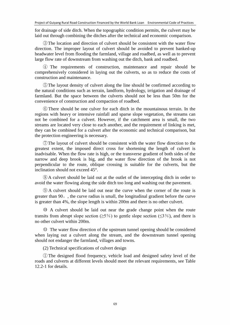
Project of Guiyang Rural Road Construction Financed by the World Bank Loan Environmental Code of Practices
69
for drainage of side ditch. When the topographic condition permits, the culvert may be
laid out through combining the ditches after the technical and economic comparison.
③ The location and direction of culvert should be consistent with the water flow
direction. The improper layout of culvert should be avoided to prevent banked-up
headwater level from flooding the farmland, village and roadbed, as well as to prevent
large flow rate of downstream from washing out the ditch, bank and roadbed.
④ The requirements of construction, maintenance and repair should be
comprehensively considered in laying out the culverts, so as to reduce the costs of
construction and maintenance.
⑤ The layout density of culvert along the line should be confirmed according to
the natural conditions such as terrain, landform, hydrology, irrigation and drainage of
farmland. But the space between the culverts should not be less than 50m for the
convenience of construction and compaction of roadbed.
⑥ There should be one culver for each ditch in the mountainous terrain. In the
regions with heavy or intensive rainfall and sparse slope vegetation, the streams can
not be combined for a culvert. However, if the catchment area is small, the two
streams are located very close to each another, and the requirement of linking is met,
they can be combined for a culvert after the economic and technical comparison, but
the protection engineering is necessary.
⑦ The layout of culvert should be consistent with the water flow direction to the
greatest extent, the imposed direct cross for shortening the length of culvert is
inadvisable. When the flow rate is high, or the transverse gradient of both sides of the
narrow and deep brook is big, and the water flow direction of the brook is not
perpendicular to the route, oblique crossing is suitable for the culverts, but the
inclination should not exceed 45°.
⑧ A culvert should be laid out at the outlet of the intercepting ditch in order to
avoid the water flowing along the side ditch too long and washing out the pavement.
⑨ A culvert should be laid out near the curve when the corner of the route is
greater than 90。, the curve radius is small, the longitudinal gradient before the curve
is greater than 4%, the slope length is within 200m and there is no other culvert.
○10 A culvert should be laid out near the grade change point when the route
transits from abrupt slope section (≥5%) to gentle slope section (≤3%), and there is
no other culvert within 200m.
○11 The water flow direction of the upstream tunnel opening should be considered
when laying out a culvert along the stream, and the downstream tunnel opening
should not endanger the farmland, villages and towns.
(2) Technical specifications of culvert design
① The designed flood frequency, vehicle load and designed safety level of the
roads and culverts at different levels should meet the relevant requirements, see Table
12.2-1 for details.
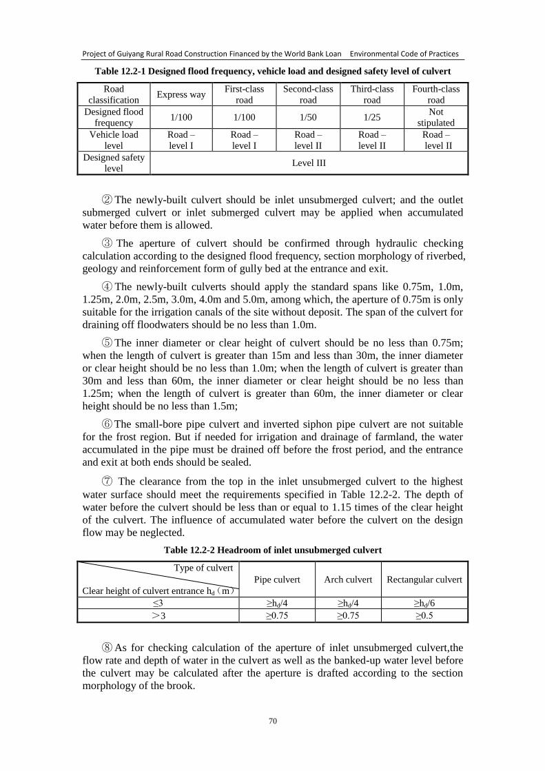
Project of Guiyang Rural Road Construction Financed by the World Bank Loan Environmental Code of Practices
70
Table 12.2-1 Designed flood frequency, vehicle load and designed safety level of culvert
Road
classification Express way
First-class
road
Second-class
road
Third-class
road
Fourth-class
road
Designed flood
frequency 1/100 1/100 1/50 1/25
Not
stipulated
Vehicle load
level
Road –
level I
Road –
level I
Road –
level II
Road –
level II
Road –
level II
Designed safety
level Level III
② The newly-built culvert should be inlet unsubmerged culvert; and the outlet
submerged culvert or inlet submerged culvert may be applied when accumulated
water before them is allowed.
③ The aperture of culvert should be confirmed through hydraulic checking
calculation according to the designed flood frequency, section morphology of riverbed,
geology and reinforcement form of gully bed at the entrance and exit.
④ The newly-built culverts should apply the standard spans like 0.75m, 1.0m,
1.25m, 2.0m, 2.5m, 3.0m, 4.0m and 5.0m, among which, the aperture of 0.75m is only
suitable for the irrigation canals of the site without deposit. The span of the culvert for
draining off floodwaters should be no less than 1.0m.
⑤ The inner diameter or clear height of culvert should be no less than 0.75m;
when the length of culvert is greater than 15m and less than 30m, the inner diameter
or clear height should be no less than 1.0m; when the length of culvert is greater than
30m and less than 60m, the inner diameter or clear height should be no less than
1.25m; when the length of culvert is greater than 60m, the inner diameter or clear
height should be no less than 1.5m;
⑥ The small-bore pipe culvert and inverted siphon pipe culvert are not suitable
for the frost region. But if needed for irrigation and drainage of farmland, the water
accumulated in the pipe must be drained off before the frost period, and the entrance
and exit at both ends should be sealed.
⑦ The clearance from the top in the inlet unsubmerged culvert to the highest
water surface should meet the requirements specified in Table 12.2-2. The depth of
water before the culvert should be less than or equal to 1.15 times of the clear height
of the culvert. The influence of accumulated water before the culvert on the design
flow may be neglected.
Table 12.2-2 Headroom of inlet unsubmerged culvert
Type of culvert
Clear height of culvert entrance hd(m)
Pipe culvert Arch culvert Rectangular culvert
≤3 ≥hd/4 ≥hd/4 ≥hd/6
>3 ≥0.75 ≥0.75 ≥0.5
⑧ As for checking calculation of the aperture of inlet unsubmerged culvert,the
flow rate and depth of water in the culvert as well as the banked-up water level before
the culvert may be calculated after the aperture is drafted according to the section
morphology of the brook.
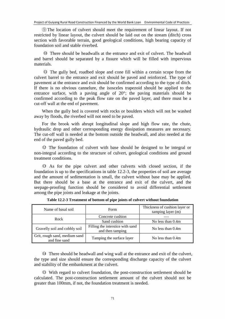
Project of Guiyang Rural Road Construction Financed by the World Bank Loan Environmental Code of Practices
71
⑨ The location of culvert should meet the requirement of linear layout. If not
restricted by linear layout, the culvert should be laid out on the stream (ditch) cross
section with favorable terrain, good geological conditions, high bearing capacity of
foundation soil and stable riverbed.
○10 There should be headwalls at the entrance and exit of culvert. The headwall
and barrel should be separated by a fissure which will be filled with impervious
materials.
○11 The gully bed, roadbed slope and cone fill within a certain scope from the
culvert barrel to the entrance and exit should be paved and reinforced. The type of
pavement at the entrance and exit should be confirmed according to the type of ditch.
If there is no obvious cannelure, the isosceles trapezoid should be applied to the
entrance surface, with a paving angle of 20°; the paving materials should be
confirmed according to the peak flow rate on the paved layer, and there must be a
cut-off wall at the end of pavement.
When the gully bed is covered with rocks or boulders which will not be washed
away by floods, the riverbed will not need to be paved.
For the brook with abrupt longitudinal slope and high flow rate, the chute,
hydraulic drop and other corresponding energy dissipation measures are necessary.
The cut-off wall is needed at the bottom outside the headwall, and also needed at the
end of the paved gully bed.
○12 The foundation of culvert with base should be designed to be integral or
non-integral according to the structure of culvert, geological conditions and ground
treatment conditions.
○13 As for the pipe culvert and other culverts with closed section, if the
foundation is up to the specifications in table 12.2-3, the properties of soil are average
and the amount of sedimentation is small, the culvert without base may be applied.
But there should be a base at the entrance and exit of the culvert, and the
seepage-proofing function should be considered to avoid differential settlement
among the pipe joints and leakage at the joints.
Table 12.2-3 Treatment of bottom of pipe joints of culvert without foundation
Name of basal soil Form Thickness of cushion layer or
tamping layer (m)
Rock Concrete cushion ----
Sand cushion No less than 0.4m
Gravelly soil and cobbly soil Filling the interstice with sand
and then tamping No less than 0.4m
Grit, rough sand, medium sand
and fine sand Tamping the surface layer No less than 0.4m
○14 There should be headwall and wing wall at the entrance and exit of the culvert,
the type and size should ensure the corresponding discharge capacity of the culvert
and stability of the embankment at the culvert.
○15 With regard to culvert foundation, the post-construction settlement should be
calculated. The post-construction settlement amount of the culvert should not be
greater than 100mm, if not, the foundation treatment is needed.
Project of Guiyang Rural Road Construction Financed by the World Bank Loan Environmental Code of Practices
72
12.3.2 Environmental code of practices during the construction period
(1) General provisions
① To evaluate through regarding each culvert as a subdivisional work. The
construction quality of each part and procedure must be strictly controlled in the
process of construction.
② The requirement of filling on the culvert should be the same as the roadbed.
③ For the channel whose span or overall length is up to the standards of culvert,
the quality may be evaluated referring to the standards in this chapter.
④ For the culvert with chute, the quality of culvert and chute may be evaluated
respectively, and then an average will be taken.
⑤ The quality evaluation of the precast concrete units (such as pipe joint and
cover plate), pile foundation of culvert and reinforcement of box culvert should be
conducted according to the relevant standards.
⑥ The construction time should be strictly controlled .If there are residents living
at the construction site, construction from 12:00 to 14:00 in the day and from 22:00 to
6:00 at night should be prohibited.
⑦ Watering at the construction site is needed to prevent flowing dust pollution.
⑧ A sedimentation basin should be built at the construction site, and the industrial
wastewater should be recycled after the sedimentation, instead of being drained off.
⑨ The earth and stone generated should be removed as filling materials, and the
redundant parts should be shipped to the designed place for stacking. Dumping and
leaving about should be prohibited.
⑩ The surface soils dug up should be stockpiled with a bumper plate, and should
be backfilled after the construction, and then the revegetation is necessary.
(2) Code for practice of pipe culvert
① The bought-in reinforced concrete circular tubes, whose quality must meet the
design requirements specified by the construction specifications, may be installed
after the site acceptance. The precast pipe joints may be installed after being evaluated
to be qualified according to the relevant standards.
② The slit width of pipe joint and choke materials should strictly meet the
requirements of design and specifications.
③ The bearing capacity of foundation soil must meet the design requirements.
(3) Slab culvert and box culvert
① Only the precast cover plates which have been assessed to be qualified may be
installed. The concrete quality of box culvert must meet the design requirements
specified by the specifications.
② The settlement joint, waterproof layer and back filling behind abutment should
be constructed according to the construction specifications and design requirements.
③ The culvert abutment’s bearing capacity of foundation soil must meet the
design requirements.
④ When used as channel, its clearance must meet the design requirements.
Project of Guiyang Rural Road Construction Financed by the World Bank Loan Environmental Code of Practices
73
(3) Arch culvert
① The masonry or pouring of arch ring should meet the code requirements.
② Only when the arch ring is up to the intensity required by the design, the shelf
may be taken down and the soil may be backfilled. In case of fissure of the arch ring,
it must be dealt with after the reason is found out
③ The settlement joint, waterproof layer and back filling behind abutment should
be constructed according to the construction specifications and design requirements.
④ The culvert abutment’s bearing capacity of foundation soil must meet the
design requirements.
(4) Inverted siphon
① The waterproofing work should be applied to the pipe joints and seams of
entrance and exit to avoid leakage. The water filling test should be conducted before
the filling.
② The quality of pipe joints must meet the construction specifications and design
requirements. Only the precast pipe joints which have been assessed to be qualified
according to the requirements in section 6.13 may be installed.
③ The bearing capacity of foundation soil must meet the design requirements.
(5) Bridge and culvert to which the jack-in method is applied
① The foundation bottom should be solid with enough bearing capacity.
② The construction with water should be prohibited.
③ The abutment wall of working pit must be perpendicular to the axis of the
bridge and culvert, and should have enough strength to bear the jacking force.
④ The waterproofing work should be applied to the seams according to the design
requirements.
12.3.3 Environmental code of practices for maintenance management of pipe
culvert
(1) In case of any damage, deformation, or subsidence of the paving layers at the
bottom and entrance of the culvert, they should be repaired in time. And the groove
upstream and downstream should be renovated to ensure smooth gradient of the water
flow.
(2) In case of fissure at the juncture of the entrance to culvert and water fall or
torrent slope at the water outlet, it may be filled with dry oakum soaked with bitumen.
So it can be closely integrated with the entrance to culvert.
(3) The inverted siphon which is apt to rupture or leak should be particularly
checked. In case of any wet spots, it should not be used anymore and should be
repaired after removing the earth. For instance, to replace the softened earth fill of
roadbed and ruptured pipe joints. In a word, the joints should be tightly stuffed
(4) When the sealing materials at the joints of pipe culvert and at the seams of
hinge points of quadri-hinge culvert pipe come off, instead of daubing the crack with
mortar, the dry oakum soaked with bitumen should be used to fill solidly.
(5) If somewhere on the top of the brick arch culvert leaks, the excavation and
filling are needed. The high-grade cement mortar should be used for filling, and then

Project of Guiyang Rural Road Construction Financed by the World Bank Loan Environmental Code of Practices
74
the plaster waterproof layer or oil felt waterproof layer of 10-15m should be paved.
The whole construction process should be serious and careful to prevent leaking
again.
Project of Guiyang Rural Road Construction Financed by the World Bank Loan Environmental Code of Practices
75
13 Environmental Code of Practices for Maintenance Station and
Overloading Control Station
13.1 Requirements of site selection of maintenance station and overloading
control station
The site selection of maintenance station and overloading control station should
follow the principles shown in Table 13.1-1.
Table 13.1-1 Site selection of maintenance station and overloading control station
The following should not be selected The following should be selected
• Basic farmland or other farmland, paddy field and cash
crop farmland
• Sensitive areas such as water conservation district,
scenic spot and forest park.
• Land with large vegetational cover rate
• Dangerous area of collapse and landslide
• Susceptible area of debris flow
• Land for special use
• Construction land
• Wasteland
• Derelict land
• Other inferior land
13.2 Analysis of impact of maintenance station and overloading control station
on the environment
13.2.1 Environmental impact analysis during the construction period
(1) The impact of construction dust on the ambient air;
(2) The impact of discharge of industrial wastewater and sanitary sewage on the
water environment;
(3) The impact of noise from construction machinery on the acoustic
environment;
(4) The impact of earthwork engineering, construction waste and household
garbage on the environment;
(5) The impact of land occupation and destroy of ground vegetation on the
ecological environment.
13.2.2 Environmental impact analysis during the operation period
(1) The impact of domestic lampblack made the staff of the maintenance station
and overloading control station on the ambient air;
(2) The impact of sanitary sewage discharged by the staff of the maintenance
station and overloading control station on the water environment;
(3) The impact of household garbage dumped by the staff of the maintenance
station and overloading control station on the environment.
13.3 Environmental code of practices for maintenance station and overloading
control station
13.3.1 Environmental code of practices during the construction period
(1) Measures for preventing air pollution during the construction
① The closed construction method should be applied to the construction site, i.e.,
separating the construction site from the surrounding environment. Guardrail may be
built around the construction site to avoid the impact of construction dust and flying
Project of Guiyang Rural Road Construction Financed by the World Bank Loan Environmental Code of Practices
76
ash on the surrounding environment.
② The transport vehicles should be freighted with building materials or muck
according to the authorized loading capacity. The loaded materials that may cause
flying dust should be covered in the transportation process to prevent flying and
spattering.
③ The wheels of vehicles driving away from the construction site must be
cleaned to avoid the mud of the construction site from being brought into the urban
road environment.
④ The civilized construction should be adhered to. There should be a special site
to stack building materials, which should be covered by tarpaulin in the process of
stacking to avoid dust of building materials.
⑤ The specially-assigned persons should clean the roads and inspect the
civilized construction every day. The roads around the construction site should be kept
clean, if any building materials or mud scatter or the vehicles with mud affect the
cleanliness of road surface, the employer is responsible for organizing people to clean.
⑥ The clean energy should be applied to the constructors’ cooking and heating
as far as possible, so as to reduce the smoke dust caused by fire coal and the impact of
SO2 on the air environment. But the pollutants discharged have a smaller impact on
the air environment because of the short construction period.
(2) Measures for preventing water environment pollution during the construction
① The industrial wastewater generated during the construction period flows into
the sedimentation basin through the collecting gutter, the supernatant liquor of
wastewater after the sedimentation should be used to wash vehicles, prevent dust at
the construction site, and water the temporary mound, etc.
② The construction team should make the most of the public facilities like public
toilet near the construction site, and should build a pit toilet if there is not any public
facility. The sanitary sewage generated will flow to the pit toilet and then shipped out
by the hired farmers for farm irrigation. The pit toilet will be earthed up and buried
after the completion of construction.
(3) Measures for preventing noise pollution during the construction
① The employer should work out the construction organization design before
entering the site; specify the adopted unit type, noise level and operation
specifications; define the measures and facilities for preventing noise, and then submit
to the environmental supervision department for examination and filing.
② Planning reasonably to reduce equipment noise and man-made noise.
③ The construction time should be arranged reasonably. The facilities with strong
noise should not be used at the same time, and the level of local noise should not be
too high. The “Environmental Noise Emission Standards of Construction Site” should
be strictly enforced. The equipment with strong noise should not be used from 22:00
at night to the early morning and from 12:00 to 14:00 in the day. If the engineering
construction must be conducted at night, the employer should get the approval of the
local environmental protection bureau before the construction, and should notice the
residents nearby.
④ Measures for preventing other noise

Project of Guiyang Rural Road Construction Financed by the World Bank Loan Environmental Code of Practices
77
For the mechanical equipment with relatively fixed position, the operation should
be finished in the work shed as far as possible. But if the operation can not be finished
in the work shed, sonic barrier equipment may be installed at the sensitive side.
(4) Measures for preventing solid waste pollution
The surface soils during the construction should be piled up properly and be
covered with felt, so as to avoid rain wash and flying dust caused by strong wind. The
soils, which will be used for afforestation after the completion of construction, should
not be cluttered up and left about.
The earth and stone and construction waste generated during the construction
should be shipped to the designated construction waste treatment site in the locality,
and the household garbage should be cleared in time and then shipped to the
designated municipal solid waste landfill for concentrated disposal.
(5) Measures for preventing ecological environment pollution during the
construction
① The principle of optimal land utilization should be adhered to during the
project construction, and less land should be occupied. The earth and stone works
should be excavated for filling, meanwhile, high filling and deep excavation should be
avoided. The goals of less borrowed earth, less spoil and less occupation of land
should be achieved. The excavation and filling of earth and stone should achieve a
balance, and the temporary ground should be minimized.
② The influence of abandoned earth and stone mainly lies in the temporary stock
dump. The facilities for protection, flood prevention and drainage of the stock dump
should be prepared before the construction, and the temporary drainage facility should
be combined with the permanent drainage facility as far as possible. The measures for
preventing water and soil loss should be taken, like building an acceptable retaining
wall around the construction site. The principles of cutting and covering, compacting
and filling, no loose soil, no dumping of soil should be adhered to, so as to reduce
water and soil loss during the construction and prevent rainwash and water pollution.
For the road section digged deeply, the slope protection works should be conducted in
time, such as slope protection works by vegetation and slope protection works by
cement mortar. In addition, there should be strict construction management system;
construction in rainy season should be avoided; the abandoned soils (stones or
residues) for leveling the ground should be piled up reasonably; the shed for preparing
materials must be built in the charging area for the stockpiling of earth and stone
materials; and the impact of water and soil loss on the environment should be
minimized. The civilized construction should be carried out throughout the project
construction, and the “balance between excavating and filling” should be ensured as
far as possible to minimize the impact of water and soil loss.
③ After the completion of construction, the vacant land should be reclaimed and
afforested in time to preserve the ecological environment and vegetation.
13.3.2 Environmental code of practices during the operation period
(1) The sanitary sewage from the overloading control station and maintenance
station with complete municipal facilities should be discharged into the municipal
pipe. If unavailable, a pit toilet should be built to collect and treat the sanitary sewage
which will be shipped out for irrigation.
(2) The clean energy (like liquefied gas or electricity) should be used, and the

Project of Guiyang Rural Road Construction Financed by the World Bank Loan Environmental Code of Practices
78
smoke exhaust ventilator should be installed in the canteen.
(3) The household garbage should be timely shipped to the designated rubbish
dump in the locality for disposal.
Project of Guiyang Rural Road Construction Financed by the World Bank Loan Environmental Code of Practices
79
14 Environmental Code of Practices for Preventing Water and Soil Loss
The principles of “combining erosion and torrent control works with main work
of road; laying equal stress on the main work and ancillary works as well as
temporary works; putting prevention first; treating comprehensively; treating both
symptoms and root causes; integrating prevention and treatment” should be carried
out when preventing water and soil loss of road construction project. Meanwhile, the
soil and water conservation facilities should be arranged reasonably according to the
local conditions with an emphasis on actual effect; the soil and water conservation
during the construction should be highlighted; the afforestation and reclamation of the
borrow area and spoil ground should be emphasized; and the spoil ground should be
baffled before the spoiling.
14.1 Soil and water conservation measures and construction arrangement
(1) Arrangement of controlling measures
The water and soil loss which may result from project construction mainly occur
in roadbed area and spoil ground. As the construction time of the roadbed construction
area is the longest, the slope treatment and layout of drainage works should be the
emphases on prevention; and the prevention measures of the spoil ground should
focus on temporary obstructing, drainage facility and vegetation recovery.
(2) Arrangement of construction progress
The water and soil loss which may result from project construction mainly occur
in the project construction period. As the water erosion predominate the types of
erosion, the prevention should focus on the drainage of rainwater. As the main work is
designed with impeccable rainwater system, some rainwater system should be put into
practice in advance through connecting the natural channels and existing drainage
facility, for the purpose of giving a full play to the function of water and soil
conservation.
14.2 Prevention area of the main works
The water and soil loss which may result from project construction mainly occur
in the period from roadbed filling to the completion of pavement construction. A lot of
soils and stones will be transported in the process of roadbed filling, and the loose
soils may slip off easily; after the construction period, as the pavement is compacted
by rolling, and the flow rate becomes larger, the road runoff will wash the roadbed
slope. The gully erosion is the main type of soil erosion, accompanied by extensive
surface erosion and rain splash erosion. Consequently, the emphases on preventing
water and soil loss in this area include drainage of both sides of the roadbed, slope
protection and temporary protective measures during the construction.
(1) Construction requirements:
① The side ditch of roadbed should be prior to the roadbed filling, so as to reduce
the influence of roadbed filling on both sides;
② The slope protection should be conducted in time after the roadbed forms;
③ The drainage ditch and desilting basin should be dredged regularly in the rainy
season, and the silt soils should be paved on the filling slope and then compacted;
④ If an irrigation channel is occupied by the roadbed, it should be rechannelled
and dredged as soon as possible to avoid the influence on the normal agricultural
Project of Guiyang Rural Road Construction Financed by the World Bank Loan Environmental Code of Practices
80
production.
(2) Protective measures:
① Stripping and protection of surface soil
Principles of piling up surface soil: The surface soils can not be piled up at the
places where the surface runoffs meet; where the construction may be affected or the
road is unobstructed; where the vacant land is with high elevation, in order to reduce
the work amount of protective measures. The surface soils piled up for a short time
refer to those stripped from the farmland before the roadbed filling, and will be used
for slope greening in the later period. The surface soils should be piled up temporarily
within the scope of land acquisition at both sides of the roadbed. In order to prevent
the soils from slipping off, the woven earth bags should be applied around the mound
for retaining.
② Water retaining ridge at the road shoulder and temporary chute
When the roadbed forms after the filling, the ridge should be built at the road
shoulder and chute should be built on the side slope. Then the road runoff will be led
to the chute to avoid washing the side slope. The ridge may be built with the
redundant soils of the road shoulder during the roadbed filling, with a width of 0.2m
and a height of 0.1m. The chute should be built every other 100m with a dishing
section, and with a width of 0.3m and a depth of 0.15m. The mortar should be used to
protect the surface in the range 1m from the entrance, with a thickness of 0.05m and a
gradient of 2%. As for the surface protection of chute, mortar (3cm), color bar or
woven bag may be used. The investigation shows that the mortar top has the
characteristics of simple construction, lasting protection, effortless removal, etc.;
although the color bar costs less, it is difficult to stick to the ditch, and needs
maintenance due to the unstable protecting effect; it’s difficult to use the woven earth
bag to protect the surface, and the woven bag is easy to be weathered and then loses
the function of water proofing.
③ Desilting measure
A desilting basin should be built at the exit of drain ditch of the roadbed.
14.3 Prevention area of concrete mixing station
(1) Construction requirements
① The concrete mixing station should be built according to the principles of “less
stationing and concentrated construction”, the temporary occupation of land should be
minimized;
② The land with higher elevation should be chosen to build concrete mixing
station, in order to avoid the scour of water outside;
③ The ground of concrete mixing station should be hardened with cement;
④ The necessary measures for prevention and suppression of dust should be
applied to the concrete mixing station, for instance, the dust keeper should be applied
to the cement container, etc.;
⑤ The concrete mixing station should be regularly watered to suppress dust on
sunny days (dry days);
⑥ The desilting basin should be dredged in time, and the silt soils can not be piled
up around the desilting basin at will.
Project of Guiyang Rural Road Construction Financed by the World Bank Loan Environmental Code of Practices
81
(2) Protective measures:
The prevention emphasis of the concrete mixing station is the surface water in the
area. Because of the frequent passing vehicles and need of stockpiling, the area is
suggested to be wholly hardened with cement. The area is piled up with lots of gravel
and the surface water contains more mud and sand on rainy days, besides, the waste
water, which contains more cement after cleaning the cement tanker and mixing
equipment, will pollute the water if discharged directly. Therefore, a desilting basin
should be built at each concrete mixing station, and the surface water in the area will
be utilized comprehensively after the sedimentation in the desilting basin.
The land will be reclaimed at a later stage of the engineering. The main tasks are
to remove the construction facilities, to clear the building materials such as pebbles
and sand spilled in the process of concrete mixing, and to afforest or reclaim the land
where the project is located for recovery as far as possible.
14.4 Prevention area of access road
The access road of this project refers to the channel used for transportation of
building materials and spoil (residue). In case a new access road needs to be built, the
waste land or dry land should be chosen preferentially. Meanwhile, the range of
access road should be narrowed as much as possible, so as to minimize the damage of
temporary land occupation to vegetation and soil
(1) Construction requirements
① The existing road should be chosen as the access road, and should be widened
and hardened with the invested funds after the consultation with the local department
for a win-win result;
② The heavy excavation and land along the river should be avoided when
building a new service road;
③ Watering is regularly needed for dust suppression on sunny days and windy
days.
(2) Design of protective measures:
The drainage ditches should be built at both sides of the access road, and the
trapezoidal cross-section of type II should be selected.
14.5 Prevention area of temporary spoil (residue) ground
(1) The site selection of spoil ground should be emphasized; when the spoil
(residue) ground destroys the existing ground vegetation or changes the original
gradient and causes bare slope, afforestation and reclamation are needed.
The swale, waste ravine, waste land or other field which is rich in reserves and
with low elevation, and is not apt to be scoured by water flow should be selected as
the temporary spoil (residue) ground, which should not be built on the basic farmland,
forest land or other fields that may result in geological disasters or roadbed problems.
The temporary spoil (residue) ground should not be built in the debris flow gully,
or above the sliding mass, etc.
(2) The temporary spoil (residue) ground should be afforested, reclaimed or
utilized comprehensively in time after the soils are abandoned. The renovation
requirements are as follows:
Project of Guiyang Rural Road Construction Financed by the World Bank Loan Environmental Code of Practices
82
The surface soils should be put together for stockpiling before the abandonment,
and then be utilized after all soils are abandoned; the spoil ground after the renovation
or reclamation will be reasonably utilized according to the land quality, irrigation
conditions, climatic characteristics, production function and planning conditions.
(3) The barrier of residues and slope protection works of the spoil ground should
be reasonably confirmed according to the location, nature and estimated height of
abandoned soils, etc. A residue dam should be built when the abandoned soils are
piled up in the trench.
(4) The drainage system of spoil ground should be set up after the overall
consideration of terrain, geology and hydrologic conditions of the borrow area, and of
facilities such as canal and farmland irrigation, so as to avoid the water flow scouring
the soil mass or changing the conditions of surface runoff, as well as to avoid the
scouring of farmland and sloping field. The spoil ground located in the ravine or
sloping field must have impeccable drainage facility; when there is a confluence
around the spoil ground, the water flow may be channeled and discharged through the
measures of interception and drainage.
In addition, when recovering the vegetation of the prevention area of main work,
prevention area of access road, prevention area of concrete mixing station and
temporary spoil (residue) ground after the completion of the project, the native species
rather than alien species should be adopted.

Project of Guiyang Rural Road Construction Financed by the World Bank Loan Environmental Code of Practices
83
15 Management of Social Interference
The social interference during the project construction refers to the impact on the
production and life of the residents nearby. The impact is mainly from the
connectivity of water conservancy, connectivity of branch line, construction noise,
dust, construction waste and household garbage, etc.
15.1 Connectivity of water conservancy system
The project is rural road, along which a large number of water conservancy
facilities such as farmland irrigation canal are distributed. Therefore, during the
project construction, the connectivity of water conservancy facilities such as farmland
irrigation canal along the road must be fully considered to ensure that it will not be
affected by the project construction, and the following measures should be taken.
(1) For the road section where the project and the farmland irrigation canal
intersect, the buried closed conduit or slab culvert should be applied to ensure the
connectivity of the farmland irrigation canal, shown in Fig. 15.1-1.
Fig. 15.1-1 Realistic view of relationship between farmland irrigation canal and road
(2) For the road section where the farmland irrigation canal parallels the road, the
farmland irrigation canal should be hardened. The roadbed can be protected in this
way; on the other hand, the water for farmland irrigation will not leak due to the
project construction.
(3) After the completion of construction, the employer should repair the rural
roads and canals damaged during the construction, or compensate the local
government appropriately to protect the legitimate interests of the local government
and residents.
Project of Guiyang Rural Road Construction Financed by the World Bank Loan Environmental Code of Practices
84
15.2 Connectivity of branch line
This project is rural road for the convenience of traveling of the masses nearby
and cargo transportation. Therefore, the connection between the main line and branch
line connecting the village should be seriously considered into the design. When the
technical standard is met, the smooth and safe connection between the branch line and
main line should be ensured.
15.3 Environmental code of practices for noise influence
The noise sources will have different effects on the acoustic environment quality
of the project area at different stages of the construction period, so the management
should be strengthened and corresponding environmental prevention measures should
be taken to minimize the effects.
(1) The advanced and reliable low noise equipment should be selected.
(2) The construction should start from 6:00 in the morning to 22:00 in the evening,
and should be prohibited from 12:00 at noon to 14:00 in the afternoon during the noon
break period. Meanwhile, construction at night should be restricted. If the continuous
construction at night is really necessary, a certificate should be issued by the
administrative department of construction after the approval of administrative
department of environmental protection, and the residents nearby should be notified.
(3) The construction period should be arranged reasonably. The large machineries
with strong noise can not be operated in the same time at the same construction site.
The construction progress should be accelerated against time, and the time of noise
effect should be shortened to minimize the impact of construction noise on the
operating personnel.
(4) The basic shock absorption or shock mount should be applied to the
mechanical equipment with strong noise through wrapping up the damping material.
(5) The noise from vehicle transport may have a certain influence on the acoustic
environment along the road. Therefore, the employer should strengthen the
constructors’ awareness of environmental protection; know the local folk customs and
living habits in time; arrange the transport time reasonably; consciously take measures
to limit the speed and prohibit the use of horn of the construction machinery in the
environmentally sensitive section like residential area; and then the results of
preventing and mitigating the noise effect can be achieved.
(6) The mechanical equipment with strong noise should be placed on one side of
the construction site far away from the residential area. A barrier with noise reduction
function should be built at the construction site less than 5m from the dwelling house
or school.
(7) The employer should reasonably arrange the constructors to shorten the
workers’ time to operate the machinery with strong noise. The constructors may be
provided with earmuffs to mitigate the effect.
(8) All mechanical equipment should be maintained and repaired regularly and
effectively to achieve the aims of maintaining good condition, reducing noise and
extending the service life.
(9) The requirements of management of construction intensity, operators of
machinery and vehicles, operation specifications, etc. should be strict.
Project of Guiyang Rural Road Construction Financed by the World Bank Loan Environmental Code of Practices
85
15.4 Flying dust management measures
(1) The access road should be paved with macadam and watered regularly to
reduce the flying dust.
(2) The granular materials piled up at the construction site should be sealed or
covered; and the surface of material pile should be watered according to the material
property to suppress the dust actively.
(3) The fence-type barrier should be applied when the road construction passes
the environmental sensitive spot (area).
(4) The construction wastes should be removed with closed container handling
vehicle, and throwing about in the air should be strictly prohibited. The construction
wastes should be stored by categories and then cleared and disposed in time according
to the relevant regulations on systematic management of municipal wastes, and
appropriate watering is necessary before the garbage removal.
(5) The management of transport vehicles should be strengthened, and the
vehicles which will generate flying dust during transport should be covered with
tarpaulins.
(6) The measure of suppressing dust through water spray should be taken to
dismantle the engineering construction; and the muck should be removed within 3
days from the date of completion of dismantling construction according to the
relevant regulations on management of dismantlement work.
(7) The measures such as baffle plate or watering should be taken to keep out and
suppress the flying dust at the construction field.
(8) The earths of the construction site should be piled up concentratedly and
covered; the vehicles should not be overloaded in order to avoid vibration and
scattering in transit.
(9) The measure to ensure the cleanness of vehicles should be applied to the
entrance and exit of the construction site. The dirt adhering to the surface of the
vehicles should be cleared before the vehicles leave the construction site.
(10) The areas for the storage of materials and large templates at the construction
site must be flat and solid.
(11) The construction site should be watered and cleaned in time.
(12) The predominant wind direction and surrounding environmental protection
goals should be taken into consideration to position the storage yard of granular
materials or other main dust sources at the downwind direction 300m from the
surrounding environmental protection goals.
(13) The incineration of all kinds of wastes should be strictly prohibited.
15.5 Solid waste management measures
(1) The construction wastes should be comprehensively utilized combined with
the simultaneous small civil construction project and road works; the rest of the
wastes should be concentratedly piled up at the designated storage yard of the
construction site, and then removed timely to the refuse landfill of the project site for
disposal according to the construction progress.
(2) The construction wastes should be removed with closed container handling
Project of Guiyang Rural Road Construction Financed by the World Bank Loan Environmental Code of Practices
86
vehicle, and throwing about in the air should be strictly prohibited. The construction
wastes should be stored by categories and then cleared and disposed in time according
to the relevant regulations on systematic management of wastes.
(3) The construction wastes should be appropriately watered before the removal.
(4) The household garbage should be collected in the garbage cans or garbage
bags at the construction site, and then removed uniformly to the refuse landfill of the
project site for disposal.
(5) The mellow soils among the abandoned soils should be used for the
reclamation and afforestation of the wasteland at the project site, and the remainder
may be used as roadbed filling and padding at both sides of the channel in the
neighborhood.
(6) The poisonous and harmful substances can not be burned at the construction
site, and should be disposed according to the relevant regulations.
15.6 Organizational planning of construction transportation
The reasonable construction scheme should be worked out during the project
construction period, and half-range construction scheme is applicable. A warning sign
should be set up at the construction section, and two traffic wardens should be
arranged to disperse the traffic so as to minimize the adverse impact of road
construction on the traffic capacity along the road. Meanwhile, the impact of all-over
road construction on the transportation should be avoided. If the construction of a
whole road section needs to be conducted, a temporary passage should be built before
the construction.
Project of Guiyang Rural Road Construction Financed by the World Bank Loan Environmental Code of Practices
87
16 Environmental Code of Practices for Sewage Treatment
16.1 Types of sewage from construction and operation of road
The waster water generated during the construction and operation of road mainly
includes industrial wastewater (such as wastewater in foundation pit, and wastewater
after flushing the machineries, vehicles, building materials and concrete mixing
equipment), sanitary sewage, waste road runoff, etc.
16.2 Environmental code of practices for sewage treatment
(1) The construction of foundation engineering of bridge pile should be carried
out in the dry season instead of flood season as far as possible.
(2) The contract for a construction project should specify the clause about the
prevention of spilling or leakage of road-building materials (such as bitumen, oil
materials and chemicals). The storage yard should not be set up at the road section
near the river, in order to prevent the road-building materials from being washed into
the river along with the rainwater, and to avoid pollution of surface water.
(3) The storage yard of harmful construction materials such as oil materials and
chemicals should be fenced and covered with tarpaulin to avoid the pollution caused
by rain wash.
(4) The boring residue of pile foundation and construction wastes can not be
discharged into the surface water; the construction site near the river should have
necessary drainage ditch for the dredging of construction wastewater, and the soil
slope of drainage ditch should be tamped in time.
(5) The construction wastewater should be recycled after the treatment by the
sedimentation basin.
(6) The advanced equipment and machinery should be used to effectively reduce
the amount of running, springing, dripping and leaking as well as times of mechanical
maintenance, and thus to reduce the quantity of oily sewage. In the process of running,
springing, dripping and leaking which are unavoidable, the solid oil absorption
materials (such as cotton yarn, saw dust and oil-absorbing sheet) should be used to
absorb the waste oil into solid matter to avoid excessive oily sewage. The greasy dirt
leaked into the soils should be timely collected with scraping apparatus and sealed up,
and then shipped to a competent site for centralized processing.
(7) The maintenance of machinery, equipment and transport vehicle should be
centralized at the maintenance point of each road section as much as possible, for the
convenience of collection of oily sewage; if the maintenance can not be conducted at
the same time, as the quantity of oily sewage is normally not greater than 0.5m3/d, all
the oily sewage can be absorbed by and mixed with solid oil absorption materials, and
then sealed up and shipped out.
(8) The horizontal sedimentation tank should be built at the construction site and
mechanical maintenance site to collect the oily sewage. After the simple treatment like
acid-base neutralization, sedimentation, oil isolation and residue removal, the
concentration of oils and other pollutants will lower. The sedimentation tank should
be buried with earth after the completion of construction.
(9) After being packed and sealed up, the waste oil absorption materials collected
should be shipped out together with other dangerous solid wastes of the construction
site to a certified site nearby for disposal.
Project of Guiyang Rural Road Construction Financed by the World Bank Loan Environmental Code of Practices
88
(10) The construction site should be far away from the section where the rivers
are concentratedly distributed. The modified septic tank should be set up near the
construction site to separately collect the fecal sewage and catering washing-up
sewage. The excrement should be used to fertilize the soil, while the catering
washing-up sewage, after being treated in the oil separation tank, should be disposed
with the fecal sewage in the septic tank, and then used to irrigate the farmland after
meeting the water quality standard of farmland irrigation. The septic tank should be
regularly dredged by the commissioned villagers nearby, and buried with earth after
the completion of construction. The residential area along the road should be used to
build construction camp as far as possible, and sewage prevention measures should be
taken to prevent the sanitary sewage flowing into the water body.
(11) The centralized and unified management should be applied to the dining and
washing of the constructors, like centralized dining and washing, to reduce the
quantity of sanitary sewage. The use of detergent in the washing process should be
limited to reduce the content of detergent in the sewage.
(12) During the construction, the retaining wall and drainage facility should be set
up around the water well along the road to prevent the waste residues and sewage
from entering the well. Meanwhile, the temporary storage yard of waste residues or
construction materials should not be set up within 50m around the water well, in order
to avoid the adverse impact of waste residues and construction materials on the water
quality of the well.
During the operation, the drainage ditch and crash barrier should be set up at the
road section where there is a well, so as to prevent the initial rainwater on the road
surface and accidental sewage from flowing into the drinking water and affecting the
water quality.
(13) Befouled runoff on the road surface (bridge floor)
The runoff on the road surface (bridge floor) is formed mainly by water
accumulated on the road surface and bridge crossing the river when it rains.
According to the analog data, in the road runoff, the average value of pH is about 7.4,
the mean concentration of SS is about 100mg/L, of BOD5 is about 5.0 and of
petroleum is about 11.25mg/L. The drainage of surface rainwater runoff will have a
certain adverse impact on the water quality of surface water body, but the impact is
only limited to the initial rainfall (about 20 minutes generally). As the rainfall
increases, the concentration of water will lower, and the impact on the surface water
body will be mitigated naturally. In general, the road runoff only has a small effect on
the surface water body.
16.3 Emergency management system and emergency measures suggested
In order to protect the water environment along the road, great importance should
be attached to the risk of carriage of dangerous goods at the proposed river-crossing
road section and sensitive road section with a well. Therefore, the governments at all
levels along the road should bring the emergency rescue of risk of carriage at the
aforementioned road sections into the emergency plan of accident of road
transportation of dangerous chemicals. The emergency plan should include
organizational structure, responsibilities and system, emergency work procedures,
principles of management, etc. The cantonal leaders in charge of road transport bureau,
public security bureau and environmental protection bureau should jointly establish
the coordination group of dangerous chemicals transportation accident, which is
Project of Guiyang Rural Road Construction Financed by the World Bank Loan Environmental Code of Practices
89
responsible for organizing and coordinating the rescue and handling of dangerous
goods transportation accident. The responsibilities mainly include researching on and
formulating the safety precautions and policies of road transportation of dangerous
chemicals in the districts; filing the operators, vehicles and staff of road transportation
of dangerous chemicals under the jurisdiction; regularly carrying out safety inspection
on the operators of road transportation of dangerous chemicals; regularly holding a
meeting among the coordination and leading group members to report the conditions
of accidents of road transportation of dangerous chemicals; regularly organizing the
responsible persons, drivers, supercargos, loading and unloading staff of road
transportation of chemicals for professional training and exercising the contingency
plan; actively implementing multiform propaganda to strengthen the masses’ and
employed persons’ awareness of safety production; counting up and reporting the
accidents of road transportation of dangerous chemicals. The emergency work
procedures and principles of management include:
(1) Once an accident happens, the discoverer should report to the local
coordination group of dangerous chemicals transportation accident through the
contact number of maintenance people on the roadside sign or other communication
mode.
(2) After receiving the accident report, the local coordination group should
immediately notify the neighboring fire department which will send fire engine and
firefighters to the place for rescue.
(3) If the dangerous goods are solid, they may be cleaned, and the accident should
be recorded and filed.
(4) But if the dangerous goods are gaseous and toxic, they should be disposed by
firefighters with gas masks. If the escape of dangerous goods is unavoidable, the
environmental protection bureau and public security department should be informed
promptly; the people within the pollution scope along the road should be evacuated
when necessary to avoid poisoning, injuries and deaths.
(5) If the dangerous goods are liquid and have flowed into the public water body,
the environmental protection bureau should immediately send some environmental
protection experts and supervisors to the scene for monitoring analysis after receiving
the notice, and should timely cooperate with the relevant departments in salvaging the
containers of dangerous goods falling into the water body.
(6) The crash barrier should be designed designedly and then installed at both
sides of the river-crossing bridge to avoid the impact of accident of dangerous
chemicals transportation vehicle on the water quality of river.
Project of Guiyang Rural Road Construction Financed by the World Bank Loan Environmental Code of Practices
90
17 Environmental Code of Practices for Physical Cultural Relics
In case cultural relics and historic sports are discovered or suspected during the
construction, the employer should immediately preserve the scene according to the
requirements of “Cultural Relics Protection Law of the People’s Republic of China”
coming into effect on December 29, 2007, should report to the local cultural relics
bureau, and should resume the construction after they are dealt with by the cultural
relics bureau. See Diagram 17.1-1 for the reporting procedure of cultural relics.
In case cultural relics and historic sports are discovered or suspected during the
construction, Chance-find procedures must be followed.
(1) The employer should terminate construction at the site where the cultural
relics are found and strengthen the protection of the scene;
(2) The contractor should timely report to the police department and competent
department of cultural relics for identification and disposal;
(3) The employer should delimit the scope of protection immediately once they
are defined as cultural relics;
(4) The employer should rescue and excavate the cultural relics due to the
urgency of construction period or danger of natural destroys indeed;
(5) The rescue and excavation of cultural relics should be conducted by
professionals with special equipment, the contractor should not excavate without
authorization;
(6) Once it is determined to be great discovery of cultural relics, whether the
project should be constructed in another place should be demonstrated.

Project of Guiyang Rural Road Construction Financed by the World Bank Loan Environmental Code of Practices
91
Diagram 17.1-1 Processing procedure of cultural relics discovered during the construction
Report to local competent administrative department for cultural relics/PCR
The cultural relics management department puts forward treatment suggestions
The employer prepares construction scheme for the road section of cultural relics/PCR
Terminate construction and preserve the scene
Discover the cultural relics/physical cultural resources
Suggestions of cultural relics department
Disagrees
Agrees
The employer starts to work according to the construction scheme
Project of Guiyang Rural Road Construction Financed by the World Bank Loan Environmental Code of Practices
92
18 Environmental Code of Practices for Safety and Health
18.1 Analysis of construction safety and health
The employer and regulatory organization are responsible for taking all
reasonable measures to protect the personal safety of the workers and security of the
buildings nearby, and to protect them from the accidental damage from construction.
The enterprise should employ a contractor that has the ability to manage the
occupational health of employees and safety matters, and should also require the
contractor to perform its risk management rules through a standard purchase
agreement. The construction safety and health of this project include design and
operation of general facility, communication and training, personal risk and
supervision.
18.2 Measures for construction safety and health
The employer has the responsibility to follow all national and local safety
requirements and to take other measures which can avoid accidents, in order to assure
the constructors’ safety and health.
(1) The integrity of all buildings within the construction site should be assured;
the temporary buildings should be structurally safe and reliable enough to resist the hit
of heavy weather of the region, and should have adequate light to isolate partial flying
dust and noise.
(2) The employer should make sure that it can give satisfactory first aid treatment.
The construction site should be equipped with necessary first-aid tools; there should
be written emergency procedures in the remote area, so the patients can be transferred
to the suitable medical establishment.
(3) The occupational health and safety training should be conducted for all new
constructors; and the basic working rules, physical protection rules and the way to
protect other workers from injuries should be introduced to them.
(4) The danger areas (such as switching room and compressor room), device,
materials, safety measures and emergency exit should be equipped with correct
signboards.
(5) If the workers’ hands and arms vibrate due to the use of manual tools or
electric tools, or their whole bodies vibrate when standing or sitting on the vibratory
surface, the vibration should be controlled through equipment selection, installation of
anti-vibration pad of damping device, and limit of exposure time.
(6) The danger of nipping should be eliminated when designing machine to make
sure that the projecting part of machinery will not do harm to human body under
normal operational circumstances.
(7) Warning boards should be placed on all galvanical electric actuators and
electric wires; all wires, cables, manual and electric tools should be checked to avoid
frayed and exposed wires, and the allowable maximum working voltage of manual
tools should be confirmed according to the suggestions of the manufacturer; double
insulation and earth connection should be applied to all electrical equipment used in
humid (or likely humid) environment.
(8) All operators participating in or assisting the welding should be provided with
eye protection equipment (like welding goggles and/or mask).
Project of Guiyang Rural Road Construction Financed by the World Bank Loan Environmental Code of Practices
93
(9) The protective barrier should be installed at the edge of fragile and dangerous
area (one rod in the middle and baffle plate around), meanwhile, the constructors
should use the fall prevention device (including safety belt and distance limit lanyard).
(10) The employer should determine and offer the suitable personal protection
equipment to the constructors to adequately protect the workers, other workers and
occasional visitors, and should avoid the inconvenience to the users.
(11) The employer should establish the procedure and system of reporting and
recording occupational accident, damage and dangerous situation.
(12) The health education for constructors should be implemented; for instance,
implementing the strategy of information communication, strengthening face-to-face
consultation, solving the systematic problems affecting individual behaviors,
encouraging the individuals to take protective measures, avoid passing on the damage
to others through using condoms. In addition, the constructors should be encouraged
to use anophelifuge, clothes, mosquito net and other things to prevent the spread of
damages caused by mosquito bites.
18.3 Road Traffic Safety Signs and Facilities
18.3.1 The necessity of traffic safety signs and facilities
The traffic safety signs and facilities may enable the drivers to foresee the road
conditions ahead and conditions of sensitive spots like village and school, and to
focus their attention and lower their speed to effectively avoid the happening of traffic
accidents or minimize the extent of damage from traffic accidents. Therefore, the
traffic safety signs and facilities are necessary.
18.3.2 Environmental code of practices for traffic safety signs and facilities
(1) The guardrail or railing should be applied to the road section with a river, lake,
swamp, cliff, or gorge aside, and to the road section or bridge which may cause
serious traffic accidents. The night reflecting marking should be applied to the
guardrail and railing.
(2) A warning board should be set up at the road section where there is a pond
with a depth greater than 3m, embankment or shallow ridge with an altitude difference
greater than 4m, and at the roadside10m from a bridge.
(3) A reflective convex mirror should be set up at the road section with
disadvantageous sighting distance resulting from sharp turn or structure of the
mountain.
(4) The speed hump or deceleration strip should be built at the road section before
a town, village or school to impel the drivers to lower their speed and assure the safety
of pedestrians in the town or village. According to the limited speed of the town or
village to be passed through, the corresponding signs of speed limit, avoiding
pedestrians, watching for children, etc. may be set up before the speed humps or
deceleration strips.
(5) A warning sign of school or limiting speed should be set up near a school at
the side of the road, and traffic lights may be used for control at the passageway for
students, speed hump or stone-paved road when necessary.
Project of Guiyang Rural Road Construction Financed by the World Bank Loan Environmental Code of Practices
94
19 Environmental Code of Practices for Hazardous Waste and
Chemical Waste
19.1 Measures for managing hazardous waste and chemical waste
The project construction involves storage and transportation of partial hazardous
wastes and chemical wastes which will have a great impact on the environment if not
disposed properly. The management measures of hazardous waste and chemical waste
are below:
(1) The chemicals should be stored properly and labeled;
(2) The storage of dangerous goods should meet the requirements of regulations
on storage type and data specified in the Storage Certificate;
(3) The greasy dirt should be collected by a special container during the
maintenance of mechanical equipment;
(4) The tools and materials such as antifouling box/sand/saw dust should be
prepared to absorb the leaked chemicals.
19.2 Risk prevention measures and emergency plan
19.2.1 Risk prevention measures
(1) To set up the emergency network, establish the emergency accident leading
group, and assign the emergency commander.
The project organization unit should take the lead in establishing the emergency
network with the relevant departments such as environmental protection bureau,
public security bureau, fire brigade, environmental monitor station and water
conservancy department. For the emergency management of dangerous goods
transportation accidents, the accident management group consisting of people from
the relevant departments which are capable of handling accidents should be
established.
(2) To lay down strict management rules and regulations on transportation of oils
and chemicals through investigation, and strengthen the management and prevention
of unexpected environmental pollution accident on the road.
(3) To strengthen the management of dangerous chemicals transportation and
work out the emergency plan of traffic accident of dangerous goods; the dangerous
goods transportation should be registered and filed by the public security department
and transport agency; on-the-job training for the relevant managers and employees
should be conducted and employment with certificates should be ensured to avoid a
leakage accident.
(4) In the course of transportation of dangerous goods, the driver must
concentrate and pay attention to the road signs, and should value traffic safety
especially when passing by a residential area and river, and should not stop off at will.
(5) The collision avoidance sign, speed limit sign for dangerous goods vehicles
and warning board should be set up at both sides of the bridge; the alarm telephone
should be indicated; and the drivers should be prompted to drive with care.
19.2.2 Emergency plan of risk
The employer should work out the detailed emergency plan, unify the emergency
action, and specify the responsibilities of person in charge of emergency and the
Project of Guiyang Rural Road Construction Financed by the World Bank Loan Environmental Code of Practices
95
relevant departments, so as to make sure that the accident will be controlled within the
shortest time and to mitigate the damage to the environment. The emergency plan of
this project should be integrated with the regional emergency plan, so the rescue effort
can be made at full speed when a dangerous chemicals accident happens, and the
damage and loss caused by accident may be reduced. The emergency rescue
headquarters of dangerous chemicals accident should be established to uniformly
organize and direct the rescue operation of an accident within the jurisdiction. The
main contents of the emergency plan include:
(1) Contact way of alarm and communication;
(2) Hierarchical response procedure;
(3) Environmental monitoring, emergency processing, rescue and control
measures;
(4) Organizational planning of personnel evacuation;
(5) Recovery measures.
The accident recovery mainly refers to the recovery of soil and water polluted.
The polluted topsoil should be scraped off the seriously polluted soil and then sent to
the hazardous waste center for disposal. The affirmative measure of purification
should be applied to the polluted water, for instance, skimming the surface pollutants.
The skimmed pollutants should be sent to the sewage treatment plant for disposal or
burned away.
(6) Emergency training plan.
Project of Guiyang Rural Road Construction Financed by the World Bank Loan Environmental Code of Practices
96
20 Environmental Code of Practices for Public Consultation
The public participation is a kind of two-way communication between the
construction party and the public. After the normal mechanism that the public
participates in supervision and management of the environment is established, the
public of the area affected by the project can timely know the information about
environmental issues, and will have the opportunity to express their opinions through
a normal channel. The project will be scientized and democratized in the
decision-making process. This is very important for decision making and smooth
implementation of the construction scheme.
20.1 The purpose of public participation
(1) To let the public know the purpose, scale and location of project construction
through participation, the pollution of surrounding environment during the project
construction and operation, as well as the prevention measures proposed; to let the
public express their opinions so as to obtain their understanding, support and
cooperation.
(2) Seeking for the local permanent residents’ firsthand experience and Intuitive
feelings of their living environment may assist the analysis of current situation,
quality and level of environmental elements of the region, so as to reflect the
objectivity of environmental assessment and protect the vital interests of the public.
20.2 General requirements of public participation
The general requirements of public participation include disclosing environmental
information and seeking for opinions of the public. The employer or the
commissioned environmental impact assessment organization or competent
administrative department for environmental protection should disclose the
information about environmental impact assessment to the public by the means known
to the public according to the provisions of the relevant laws and regulations. They
may bulletin the information through a forum, announcement at the construction site
and questionnaires, etc. known to the public. After the relevant information is
disclosed, the public may submit their written opinions to the employer or the
commissioned environmental impact assessment organization through letters, faxes,
e-mails or other ways required by the relevant public notice. The employer or the
commissioned environmental impact assessment organization should archive the
sources of feedback for future reference.
As for the principles, the information should be released in due time and in the
forms accessible to the affected individuals, groups and organizations.
20.3 Organizational forms and findings of public participation
20.3.1 Organizational forms of public participation
(1) Announcement
The employer or the person chiefly in charge of the commissioned environmental
impact assessment organization may disclose the construction project overview to the
public society in the form of announcement in the township, town or village in which
the project is located, including the basic information, scale, contents, quantities, land
occupation, main factors and consequences of environmental impact, prevention
measures and desired effect related to the construction project. The contact number
and address should be disclosed for feedback. Fig. 20.3-1 shows some photos about
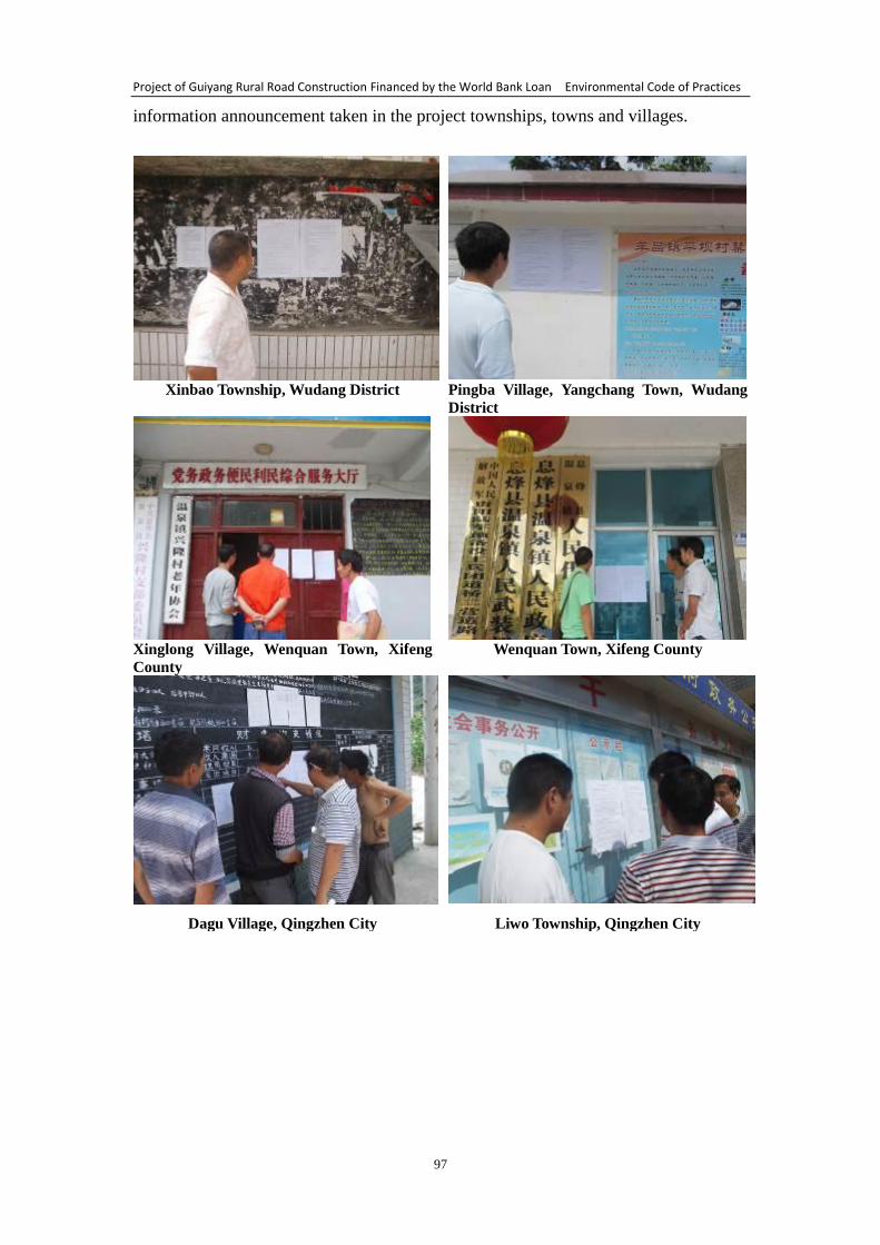
Project of Guiyang Rural Road Construction Financed by the World Bank Loan Environmental Code of Practices
97
information announcement taken in the project townships, towns and villages.
Xinbao Township, Wudang District Pingba Village, Yangchang Town, Wudang
District
Xinglong Village, Wenquan Town, Xifeng
County Wenquan Town, Xifeng County
Dagu Village, Qingzhen City Liwo Township, Qingzhen City
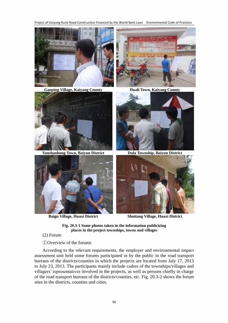
Project of Guiyang Rural Road Construction Financed by the World Bank Loan Environmental Code of Practices
98
Gaoping Village, Kaiyang County Huali Town, Kaiyang County
Yanshanhong Town, Baiyun District Dula Township, Baiyun District
Baigu Village, Huaxi District Shuitang Village, Huaxi District
Fig. 20.3-1 Some photos taken in the information publicizing
places in the project townships, towns and villages
(2) Forum
① Overview of the forums
According to the relevant requirements, the employer and environmental impact
assessment unit held some forums participated in by the public in the road transport
bureaus of the districts/counties in which the projects are located from July 17, 2013
to July 23, 2013. The participants mainly include cadres of the townships/villages and
villagers’ representatives involved in the projects, as well as persons chiefly in charge
of the road transport bureaus of the districts/counties, etc. Fig. 20.3-2 shows the forum
sites in the districts, counties and cities.
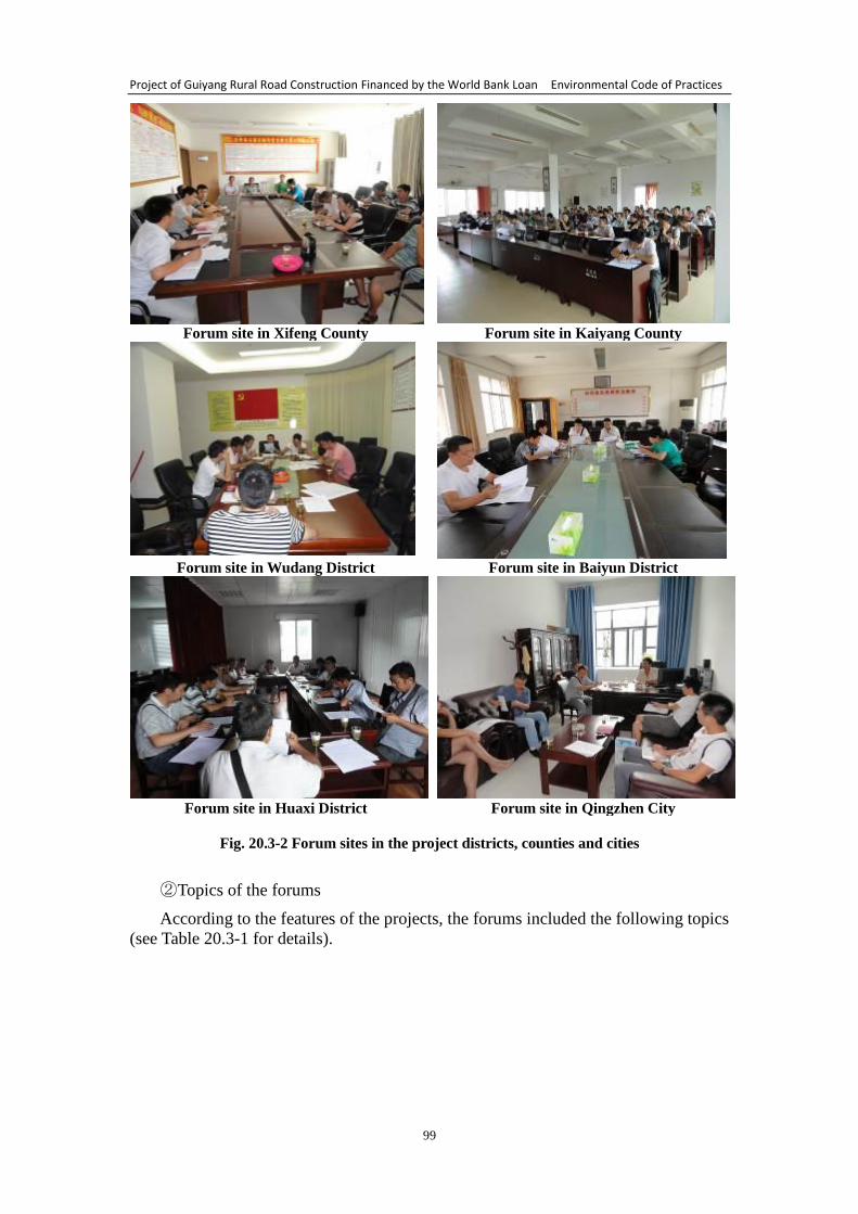
Project of Guiyang Rural Road Construction Financed by the World Bank Loan Environmental Code of Practices
99
Forum site in Xifeng County Forum site in Kaiyang County
Forum site in Wudang District Forum site in Baiyun District
Forum site in Huaxi District Forum site in Qingzhen City
Fig. 20.3-2 Forum sites in the project districts, counties and cities
② Topics of the forums
According to the features of the projects, the forums included the following topics
(see Table 20.3-1 for details).
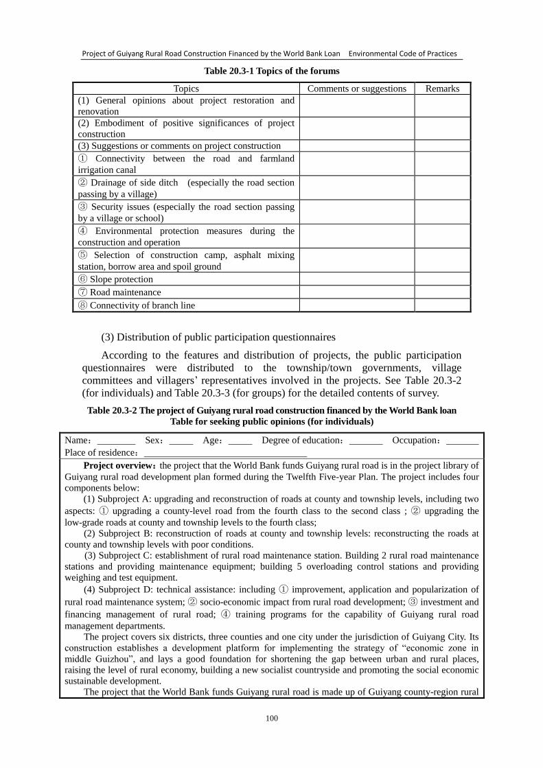
Project of Guiyang Rural Road Construction Financed by the World Bank Loan Environmental Code of Practices
100
Table 20.3-1 Topics of the forums
Topics Comments or suggestions Remarks
(1) General opinions about project restoration and
renovation
(2) Embodiment of positive significances of project
construction
(3) Suggestions or comments on project construction
① Connectivity between the road and farmland
irrigation canal
② Drainage of side ditch (especially the road section
passing by a village)
③ Security issues (especially the road section passing
by a village or school)
④ Environmental protection measures during the
construction and operation
⑤ Selection of construction camp, asphalt mixing
station, borrow area and spoil ground
⑥ Slope protection
⑦ Road maintenance
⑧ Connectivity of branch line
(3) Distribution of public participation questionnaires
According to the features and distribution of projects, the public participation
questionnaires were distributed to the township/town governments, village
committees and villagers’ representatives involved in the projects. See Table 20.3-2
(for individuals) and Table 20.3-3 (for groups) for the detailed contents of survey.
Table 20.3-2 The project of Guiyang rural road construction financed by the World Bank loan
Table for seeking public opinions (for individuals)
Name: Sex: Age: Degree of education: Occupation:
Place of residence:
Project overview:the project that the World Bank funds Guiyang rural road is in the project library of
Guiyang rural road development plan formed during the Twelfth Five-year Plan. The project includes four
components below:
(1) Subproject A: upgrading and reconstruction of roads at county and township levels, including two
aspects: ① upgrading a county-level road from the fourth class to the second class ; ② upgrading the
low-grade roads at county and township levels to the fourth class;
(2) Subproject B: reconstruction of roads at county and township levels: reconstructing the roads at
county and township levels with poor conditions.
(3) Subproject C: establishment of rural road maintenance station. Building 2 rural road maintenance
stations and providing maintenance equipment; building 5 overloading control stations and providing
weighing and test equipment.
(4) Subproject D: technical assistance: including ① improvement, application and popularization of
rural road maintenance system; ② socio-economic impact from rural road development; ③ investment and
financing management of rural road; ④ training programs for the capability of Guiyang rural road
management departments.
The project covers six districts, three counties and one city under the jurisdiction of Guiyang City. Its
construction establishes a development platform for implementing the strategy of “economic zone in
middle Guizhou”, and lays a good foundation for shortening the gap between urban and rural places,
raising the level of rural economy, building a new socialist countryside and promoting the social economic
sustainable development.
The project that the World Bank funds Guiyang rural road is made up of Guiyang county-region rural
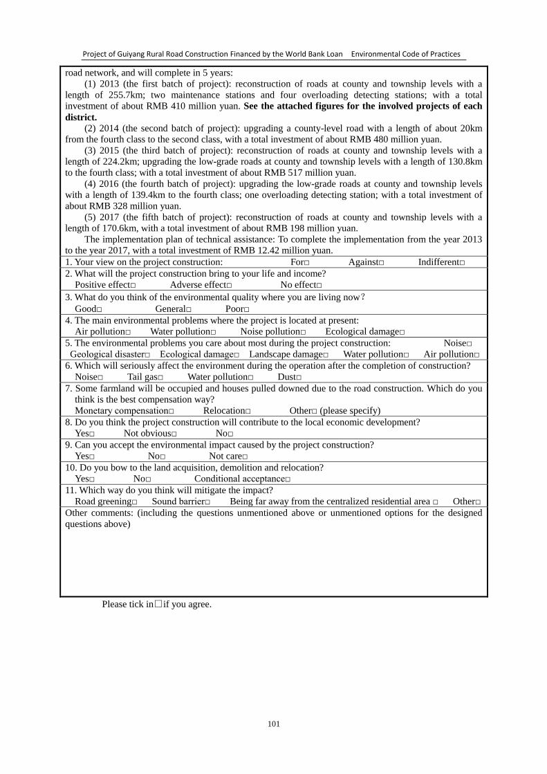
Project of Guiyang Rural Road Construction Financed by the World Bank Loan Environmental Code of Practices
101
road network, and will complete in 5 years:
(1) 2013 (the first batch of project): reconstruction of roads at county and township levels with a
length of 255.7km; two maintenance stations and four overloading detecting stations; with a total
investment of about RMB 410 million yuan. See the attached figures for the involved projects of each
district.
(2) 2014 (the second batch of project): upgrading a county-level road with a length of about 20km
from the fourth class to the second class, with a total investment of about RMB 480 million yuan.
(3) 2015 (the third batch of project): reconstruction of roads at county and township levels with a
length of 224.2km; upgrading the low-grade roads at county and township levels with a length of 130.8km
to the fourth class; with a total investment of about RMB 517 million yuan.
(4) 2016 (the fourth batch of project): upgrading the low-grade roads at county and township levels
with a length of 139.4km to the fourth class; one overloading detecting station; with a total investment of
about RMB 328 million yuan.
(5) 2017 (the fifth batch of project): reconstruction of roads at county and township levels with a
length of 170.6km, with a total investment of about RMB 198 million yuan.
The implementation plan of technical assistance: To complete the implementation from the year 2013
to the year 2017, with a total investment of RMB 12.42 million yuan.
1. Your view on the project construction: For□ Against□ Indifferent□
2. What will the project construction bring to your life and income?
Positive effect□ Adverse effect□ No effect□
3. What do you think of the environmental quality where you are living now?
Good□ General□ Poor□
4. The main environmental problems where the project is located at present:
Air pollution□ Water pollution□ Noise pollution□ Ecological damage□
5. The environmental problems you care about most during the project construction: Noise□
Geological disaster□ Ecological damage□ Landscape damage□ Water pollution□ Air pollution□
6. Which will seriously affect the environment during the operation after the completion of construction?
Noise□ Tail gas□ Water pollution□ Dust□
7. Some farmland will be occupied and houses pulled downed due to the road construction. Which do you
think is the best compensation way?
Monetary compensation□ Relocation□ Other□ (please specify)
8. Do you think the project construction will contribute to the local economic development?
Yes□ Not obvious□ No□
9. Can you accept the environmental impact caused by the project construction?
Yes□ No□ Not care□
10. Do you bow to the land acquisition, demolition and relocation?
Yes□ No□ Conditional acceptance□
11. Which way do you think will mitigate the impact?
Road greening□ Sound barrier□ Being far away from the centralized residential area □ Other□
Other comments: (including the questions unmentioned above or unmentioned options for the designed
questions above)
Please tick in□if you agree.
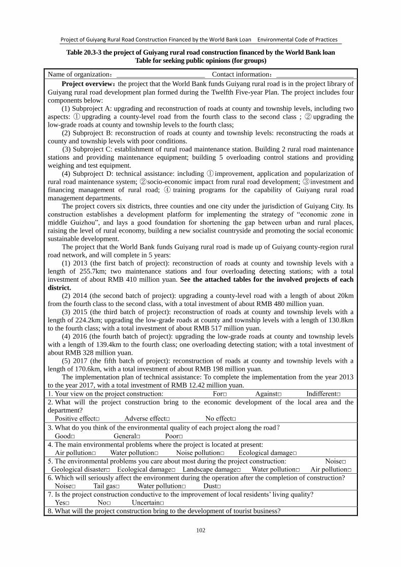
Project of Guiyang Rural Road Construction Financed by the World Bank Loan Environmental Code of Practices
102
Table 20.3-3 the project of Guiyang rural road construction financed by the World Bank loan
Table for seeking public opinions (for groups)
Name of organization: Contact information:
Project overview:the project that the World Bank funds Guiyang rural road is in the project library of
Guiyang rural road development plan formed during the Twelfth Five-year Plan. The project includes four
components below:
(1) Subproject A: upgrading and reconstruction of roads at county and township levels, including two
aspects: ① upgrading a county-level road from the fourth class to the second class ; ② upgrading the
low-grade roads at county and township levels to the fourth class;
(2) Subproject B: reconstruction of roads at county and township levels: reconstructing the roads at
county and township levels with poor conditions.
(3) Subproject C: establishment of rural road maintenance station. Building 2 rural road maintenance
stations and providing maintenance equipment; building 5 overloading control stations and providing
weighing and test equipment.
(4) Subproject D: technical assistance: including ① improvement, application and popularization of
rural road maintenance system; ② socio-economic impact from rural road development; ③ investment and
financing management of rural road; ④ training programs for the capability of Guiyang rural road
management departments.
The project covers six districts, three counties and one city under the jurisdiction of Guiyang City. Its
construction establishes a development platform for implementing the strategy of “economic zone in
middle Guizhou”, and lays a good foundation for shortening the gap between urban and rural places,
raising the level of rural economy, building a new socialist countryside and promoting the social economic
sustainable development.
The project that the World Bank funds Guiyang rural road is made up of Guiyang county-region rural
road network, and will complete in 5 years:
(1) 2013 (the first batch of project): reconstruction of roads at county and township levels with a
length of 255.7km; two maintenance stations and four overloading detecting stations; with a total
investment of about RMB 410 million yuan. See the attached tables for the involved projects of each
district. (2) 2014 (the second batch of project): upgrading a county-level road with a length of about 20km
from the fourth class to the second class, with a total investment of about RMB 480 million yuan.
(3) 2015 (the third batch of project): reconstruction of roads at county and township levels with a
length of 224.2km; upgrading the low-grade roads at county and township levels with a length of 130.8km
to the fourth class; with a total investment of about RMB 517 million yuan.
(4) 2016 (the fourth batch of project): upgrading the low-grade roads at county and township levels
with a length of 139.4km to the fourth class; one overloading detecting station; with a total investment of
about RMB 328 million yuan.
(5) 2017 (the fifth batch of project): reconstruction of roads at county and township levels with a
length of 170.6km, with a total investment of about RMB 198 million yuan.
The implementation plan of technical assistance: To complete the implementation from the year 2013
to the year 2017, with a total investment of RMB 12.42 million yuan.
1. Your view on the project construction: For□ Against□ Indifferent□
2. What will the project construction bring to the economic development of the local area and the
department?
Positive effect□ Adverse effect□ No effect□
3. What do you think of the environmental quality of each project along the road?
Good□ General□ Poor□
4. The main environmental problems where the project is located at present:
Air pollution□ Water pollution□ Noise pollution□ Ecological damage□
5. The environmental problems you care about most during the project construction: Noise□
Geological disaster□ Ecological damage□ Landscape damage□ Water pollution□ Air pollution□
6. Which will seriously affect the environment during the operation after the completion of construction?
Noise□ Tail gas□ Water pollution□ Dust□
7. Is the project construction conductive to the improvement of local residents’ living quality?
Yes□ No□ Uncertain□
8. What will the project construction bring to the development of tourist business?
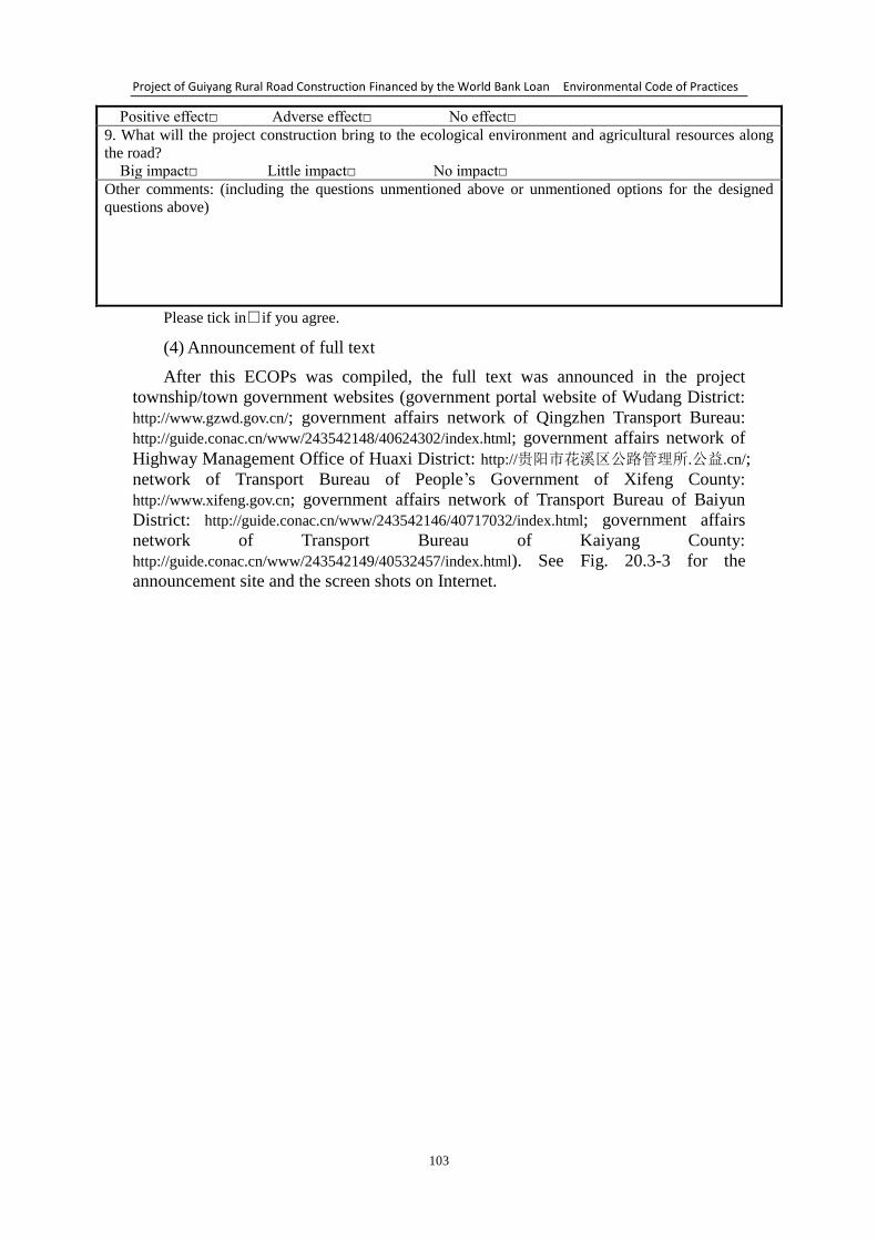
Project of Guiyang Rural Road Construction Financed by the World Bank Loan Environmental Code of Practices
103
Positive effect□ Adverse effect□ No effect□
9. What will the project construction bring to the ecological environment and agricultural resources along
the road?
Big impact□ Little impact□ No impact□
Other comments: (including the questions unmentioned above or unmentioned options for the designed
questions above)
Please tick in□if you agree.
(4) Announcement of full text
After this ECOPs was compiled, the full text was announced in the project
township/town government websites (government portal website of Wudang District:
http://www.gzwd.gov.cn/; government affairs network of Qingzhen Transport Bureau:
http://guide.conac.cn/www/243542148/40624302/index.html; government affairs network of
Highway Management Office of Huaxi District: http://贵阳市花溪区公路管理所.公益.cn/;
network of Transport Bureau of People’s Government of Xifeng County:
http://www.xifeng.gov.cn; government affairs network of Transport Bureau of Baiyun
District: http://guide.conac.cn/www/243542146/40717032/index.html; government affairs
network of Transport Bureau of Kaiyang County:
http://guide.conac.cn/www/243542149/40532457/index.html). See Fig. 20.3-3 for the
announcement site and the screen shots on Internet.
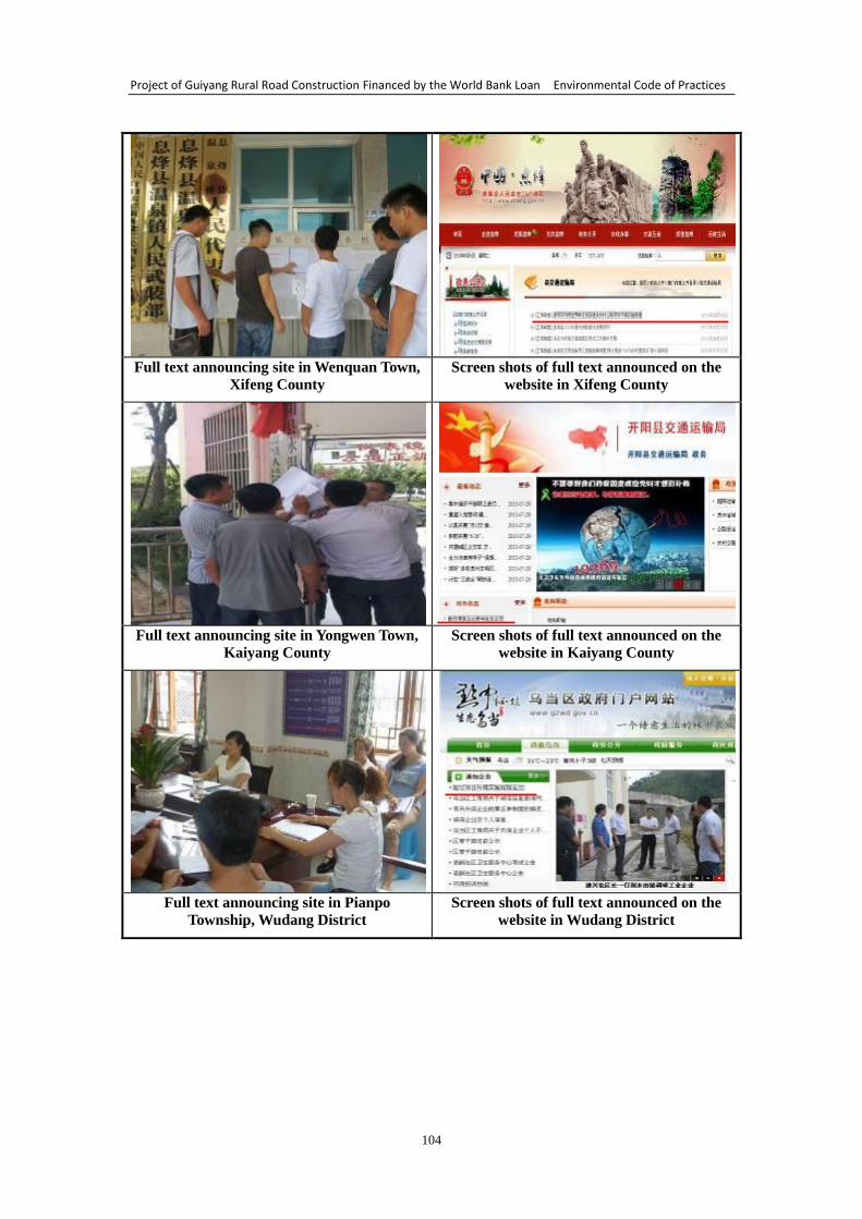
Project of Guiyang Rural Road Construction Financed by the World Bank Loan Environmental Code of Practices
104
Full text announcing site in Wenquan Town,
Xifeng County
Screen shots of full text announced on the
website in Xifeng County
Full text announcing site in Yongwen Town,
Kaiyang County
Screen shots of full text announced on the
website in Kaiyang County
Full text announcing site in Pianpo
Township, Wudang District
Screen shots of full text announced on the
website in Wudang District
Project of Guiyang Rural Road Construction Financed by the World Bank Loan Environmental Code of Practices
105
Full text announcing site in Shawen Town,
Baiyun District
Screen shots of full text announced on the
website in Baiyun District
Full text announcing site in Liwo Township,
Qingzhen City
Screen shots of full text announced on the
website in Qingzhen City
Full text announcing site in Yanlou Township,
Huaxi District
Screen shots of full text announced on the
website in Huaxi District
Fig. 20.3-3 Screen shots and photos of ECOPs full text of Guiyang rural road
construction project financed by the World Bank loan
20.3.2 Findings
(1) Announcement
The site survey and visit reflect that all the masses along the road strongly support
the project construction and hope that the construction will start as soon as possible.
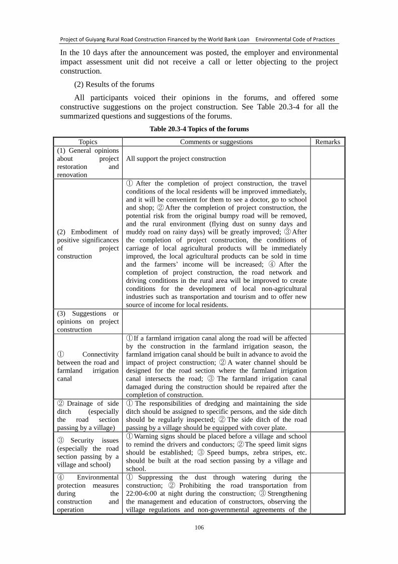
Project of Guiyang Rural Road Construction Financed by the World Bank Loan Environmental Code of Practices
106
In the 10 days after the announcement was posted, the employer and environmental
impact assessment unit did not receive a call or letter objecting to the project
construction.
(2) Results of the forums
All participants voiced their opinions in the forums, and offered some
constructive suggestions on the project construction. See Table 20.3-4 for all the
summarized questions and suggestions of the forums.
Table 20.3-4 Topics of the forums
Topics Comments or suggestions Remarks
(1) General opinions
about project
restoration and
renovation
All support the project construction
(2) Embodiment of
positive significances
of project
construction
① After the completion of project construction, the travel
conditions of the local residents will be improved immediately,
and it will be convenient for them to see a doctor, go to school
and shop; ② After the completion of project construction, the
potential risk from the original bumpy road will be removed,
and the rural environment (flying dust on sunny days and
muddy road on rainy days) will be greatly improved; ③ After
the completion of project construction, the conditions of
carriage of local agricultural products will be immediately
improved, the local agricultural products can be sold in time
and the farmers’ income will be increased; ④ After the
completion of project construction, the road network and
driving conditions in the rural area will be improved to create
conditions for the development of local non-agricultural
industries such as transportation and tourism and to offer new
source of income for local residents.
(3) Suggestions or
opinions on project
construction
① Connectivity
between the road and
farmland irrigation
canal
① If a farmland irrigation canal along the road will be affected
by the construction in the farmland irrigation season, the
farmland irrigation canal should be built in advance to avoid the
impact of project construction; ② A water channel should be
designed for the road section where the farmland irrigation
canal intersects the road; ③ The farmland irrigation canal
damaged during the construction should be repaired after the
completion of construction.
② Drainage of side
ditch (especially
the road section
passing by a village)
① The responsibilities of dredging and maintaining the side
ditch should be assigned to specific persons, and the side ditch
should be regularly inspected; ② The side ditch of the road
passing by a village should be equipped with cover plate.
③ Security issues
(especially the road
section passing by a
village and school)
① Warning signs should be placed before a village and school
to remind the drivers and conductors; ② The speed limit signs
should be established; ③ Speed bumps, zebra stripes, etc.
should be built at the road section passing by a village and
school.
④ Environmental
protection measures
during the
construction and
operation
① Suppressing the dust through watering during the
construction; ② Prohibiting the road transportation from
22:00-6:00 at night during the construction; ③ Strengthening
the management and education of constructors, observing the
village regulations and non-governmental agreements of the
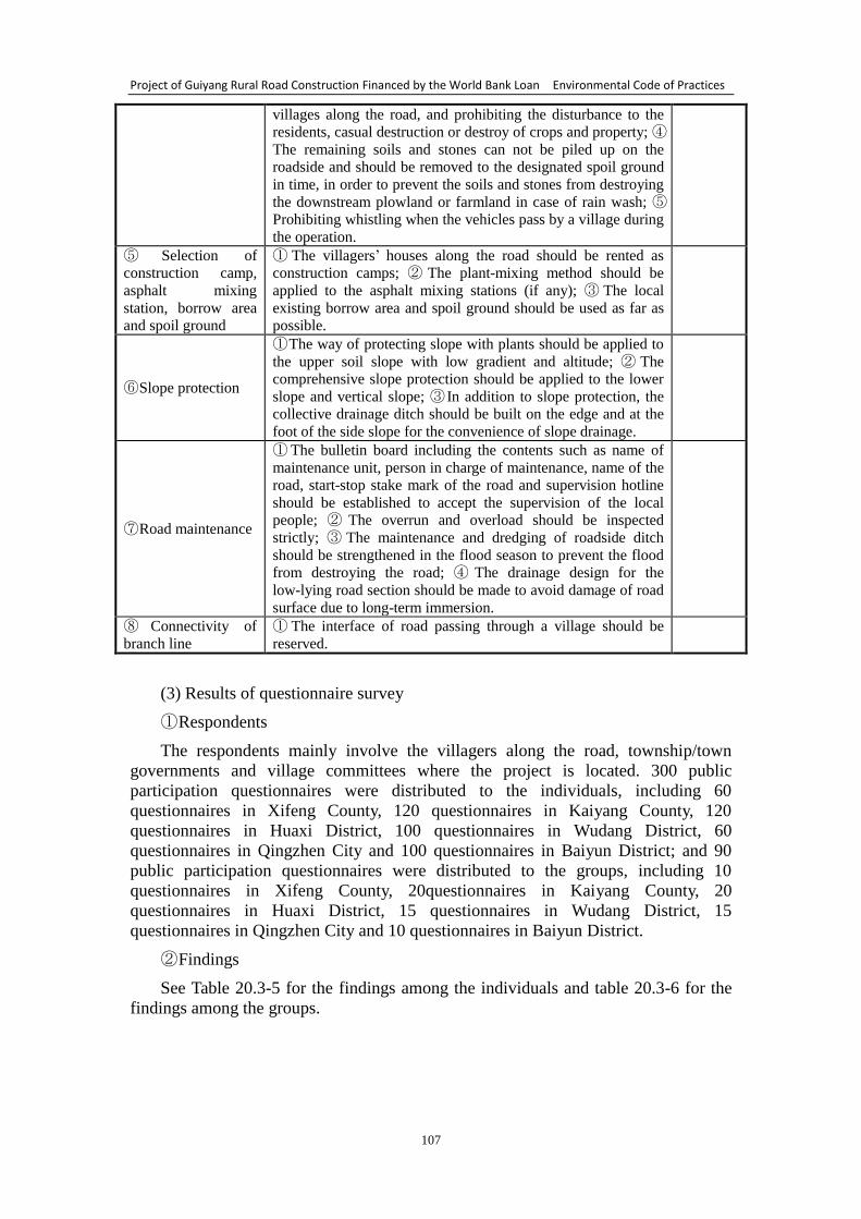
Project of Guiyang Rural Road Construction Financed by the World Bank Loan Environmental Code of Practices
107
villages along the road, and prohibiting the disturbance to the
residents, casual destruction or destroy of crops and property; ④
The remaining soils and stones can not be piled up on the
roadside and should be removed to the designated spoil ground
in time, in order to prevent the soils and stones from destroying
the downstream plowland or farmland in case of rain wash; ⑤
Prohibiting whistling when the vehicles pass by a village during
the operation.
⑤ Selection of
construction camp,
asphalt mixing
station, borrow area
and spoil ground
① The villagers’ houses along the road should be rented as
construction camps; ② The plant-mixing method should be
applied to the asphalt mixing stations (if any); ③ The local
existing borrow area and spoil ground should be used as far as
possible.
⑥ Slope protection
① The way of protecting slope with plants should be applied to
the upper soil slope with low gradient and altitude; ② The
comprehensive slope protection should be applied to the lower
slope and vertical slope; ③ In addition to slope protection, the
collective drainage ditch should be built on the edge and at the
foot of the side slope for the convenience of slope drainage.
⑦ Road maintenance
① The bulletin board including the contents such as name of
maintenance unit, person in charge of maintenance, name of the
road, start-stop stake mark of the road and supervision hotline
should be established to accept the supervision of the local
people; ② The overrun and overload should be inspected
strictly; ③ The maintenance and dredging of roadside ditch
should be strengthened in the flood season to prevent the flood
from destroying the road; ④ The drainage design for the
low-lying road section should be made to avoid damage of road
surface due to long-term immersion.
⑧ Connectivity of
branch line
① The interface of road passing through a village should be
reserved.
(3) Results of questionnaire survey
① Respondents
The respondents mainly involve the villagers along the road, township/town
governments and village committees where the project is located. 300 public
participation questionnaires were distributed to the individuals, including 60
questionnaires in Xifeng County, 120 questionnaires in Kaiyang County, 120
questionnaires in Huaxi District, 100 questionnaires in Wudang District, 60
questionnaires in Qingzhen City and 100 questionnaires in Baiyun District; and 90
public participation questionnaires were distributed to the groups, including 10
questionnaires in Xifeng County, 20questionnaires in Kaiyang County, 20
questionnaires in Huaxi District, 15 questionnaires in Wudang District, 15
questionnaires in Qingzhen City and 10 questionnaires in Baiyun District.
② Findings
See Table 20.3-5 for the findings among the individuals and table 20.3-6 for the
findings among the groups.
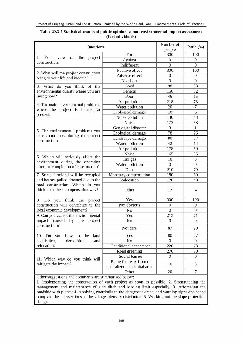
Project of Guiyang Rural Road Construction Financed by the World Bank Loan Environmental Code of Practices
108
Table 20.3-5 Statistical results of public opinions about environmental impact assessment
(for individuals)
Questions Number of
people Ratio (%)
1. Your view on the project
construction:
For 300 100
Against 0 0
Indifferent 0 0
2. What will the project construction
bring to your life and income?
Positive effect 300 100
Adverse effect 0 0
No effect 0 0
3. What do you think of the
environmental quality where you are
living now?
Good 98 33
General 156 52
Poor 46 15
4. The main environmental problems
where the project is located at
present:
Air pollution 218 73
Water pollution 20 7
Ecological damage 18 6
Noise pollution 130 43
5. The environmental problems you
care about most during the project
construction:
Noise 173 58
Geological disaster 3 1
Ecological damage 78 26
Landscape damage 80 27
Water pollution 42 14
Air pollution 178 59
6. Which will seriously affect the
environment during the operation
after the completion of construction?
Noise 165 55
Tail gas 10 3
Water pollution 0 0
Dust 210 70
7. Some farmland will be occupied
and houses pulled downed due to the
road construction. Which do you
think is the best compensation way?
Monetary compensation 180 60
Relocation 120 40
Other 13 4
8. Do you think the project
construction will contribute to the
local economic development?
Yes 300 100
Not obvious 0 0
No 0 0
9. Can you accept the environmental
impact caused by the project
construction?
Yes 213 71
No 0 0
Not care 87 29
10. Do you bow to the land
acquisition, demolition and
relocation?
Yes 80 27
No 0 0
Conditional acceptance 220 73
11. Which way do you think will
mitigate the impact?
Road greening 270 90
Sound barrier 0 0
Being far away from the
centralized residential area 10 3
Other 20 7
Other suggestions and comments are summarized below:
1. Implementing the construction of each project as soon as possible; 2. Strengthening the
management and maintenance of side ditch and loading limit especially; 3. Afforesting the
roadside with plants; 4. Applying guardrails to the dangerous areas, and warning signs and speed
bumps to the intersections in the villages densely distributed; 5. Working out the slope protection
design.
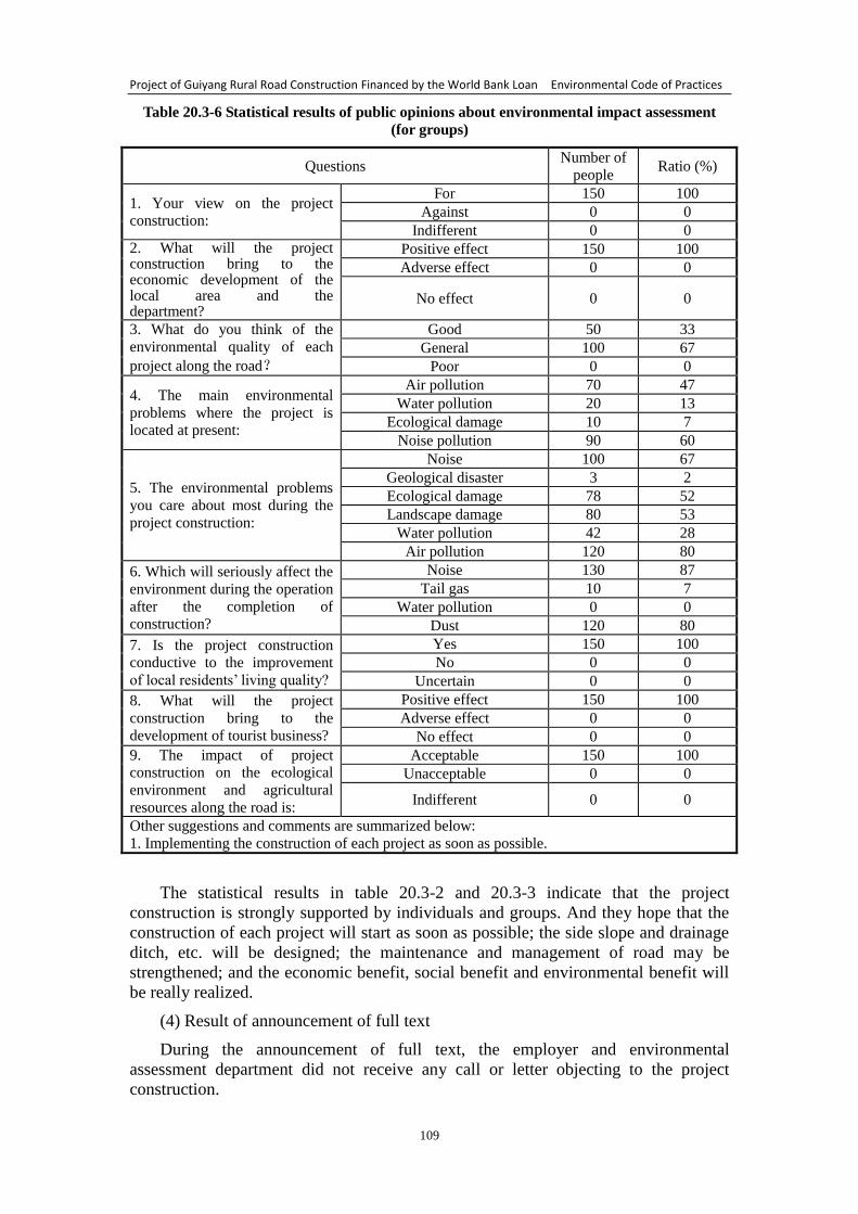
Project of Guiyang Rural Road Construction Financed by the World Bank Loan Environmental Code of Practices
109
Table 20.3-6 Statistical results of public opinions about environmental impact assessment
(for groups)
Questions Number of
people Ratio (%)
1. Your view on the project
construction:
For 150 100
Against 0 0
Indifferent 0 0
2. What will the project construction bring to the economic development of the local area and the department?
Positive effect 150 100
Adverse effect 0 0
No effect 0 0
3. What do you think of the
environmental quality of each
project along the road?
Good 50 33
General 100 67
Poor 0 0
4. The main environmental
problems where the project is
located at present:
Air pollution 70 47
Water pollution 20 13
Ecological damage 10 7
Noise pollution 90 60
5. The environmental problems
you care about most during the
project construction:
Noise 100 67
Geological disaster 3 2
Ecological damage 78 52
Landscape damage 80 53
Water pollution 42 28
Air pollution 120 80
6. Which will seriously affect the
environment during the operation
after the completion of
construction?
Noise 130 87
Tail gas 10 7
Water pollution 0 0
Dust 120 80
7. Is the project construction
conductive to the improvement
of local residents’ living quality?
Yes 150 100
No 0 0
Uncertain 0 0
8. What will the project
construction bring to the
development of tourist business?
Positive effect 150 100
Adverse effect 0 0
No effect 0 0
9. The impact of project
construction on the ecological
environment and agricultural
resources along the road is:
Acceptable 150 100
Unacceptable 0 0
Indifferent 0 0
Other suggestions and comments are summarized below:
1. Implementing the construction of each project as soon as possible.
The statistical results in table 20.3-2 and 20.3-3 indicate that the project
construction is strongly supported by individuals and groups. And they hope that the
construction of each project will start as soon as possible; the side slope and drainage
ditch, etc. will be designed; the maintenance and management of road may be
strengthened; and the economic benefit, social benefit and environmental benefit will
be really realized.
(4) Result of announcement of full text
During the announcement of full text, the employer and environmental
assessment department did not receive any call or letter objecting to the project
construction.
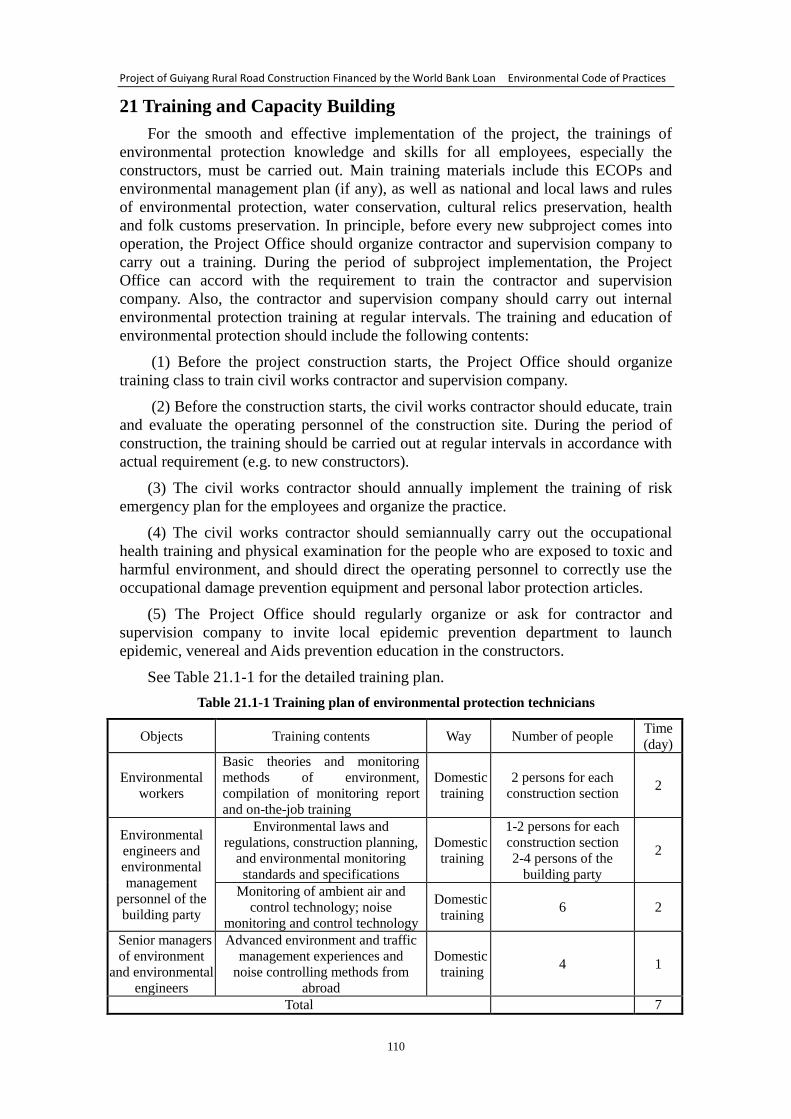
Project of Guiyang Rural Road Construction Financed by the World Bank Loan Environmental Code of Practices
110
21 Training and Capacity Building
For the smooth and effective implementation of the project, the trainings of
environmental protection knowledge and skills for all employees, especially the
constructors, must be carried out. Main training materials include this ECOPs and
environmental management plan (if any), as well as national and local laws and rules
of environmental protection, water conservation, cultural relics preservation, health
and folk customs preservation. In principle, before every new subproject comes into
operation, the Project Office should organize contractor and supervision company to
carry out a training. During the period of subproject implementation, the Project
Office can accord with the requirement to train the contractor and supervision
company. Also, the contractor and supervision company should carry out internal
environmental protection training at regular intervals. The training and education of
environmental protection should include the following contents:
(1) Before the project construction starts, the Project Office should organize
training class to train civil works contractor and supervision company.
(2) Before the construction starts, the civil works contractor should educate, train
and evaluate the operating personnel of the construction site. During the period of
construction, the training should be carried out at regular intervals in accordance with
actual requirement (e.g. to new constructors).
(3) The civil works contractor should annually implement the training of risk
emergency plan for the employees and organize the practice.
(4) The civil works contractor should semiannually carry out the occupational
health training and physical examination for the people who are exposed to toxic and
harmful environment, and should direct the operating personnel to correctly use the
occupational damage prevention equipment and personal labor protection articles.
(5) The Project Office should regularly organize or ask for contractor and
supervision company to invite local epidemic prevention department to launch
epidemic, venereal and Aids prevention education in the constructors.
See Table 21.1-1 for the detailed training plan.
Table 21.1-1 Training plan of environmental protection technicians
Objects Training contents Way Number of people Time
(day)
Environmental
workers
Basic theories and monitoring
methods of environment,
compilation of monitoring report
and on-the-job training
Domestic
training
2 persons for each
construction section 2
Environmental
engineers and
environmental
management
personnel of the
building party
Environmental laws and
regulations, construction planning,
and environmental monitoring
standards and specifications
Domestic
training
1-2 persons for each
construction section
2-4 persons of the
building party
2
Monitoring of ambient air and
control technology; noise
monitoring and control technology
Domestic
training 6 2
Senior managers
of environment
and environmental engineers
Advanced environment and traffic
management experiences and
noise controlling methods from abroad
Domestic
training 4 1
Total 7

Project of Guiyang Rural Road Construction Financed by the World Bank Loan Environmental Code of Practices
111
Attached Maps:
Attached map 1:Map of Guiyang’s geographical position in Guizhou, China
Attached map 2:Map of main surface drainages (river and reservoir) in Guiyang
Attached map 3:Distribution map of main sensitive areas (scenic spot, forest park,
water conservation district, folk customs spot, etc.) in Guiyang
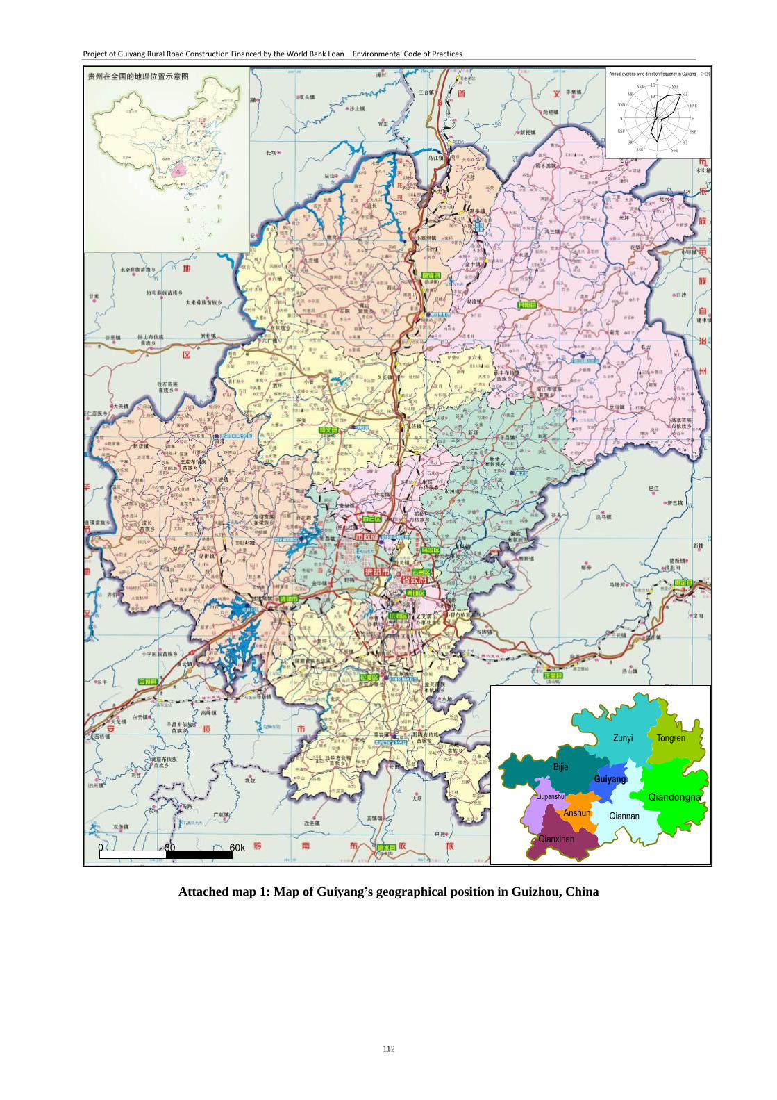
Project of Guiyang Rural Road Construction Financed by the World Bank Loan Environmental Code of Practices
112
Attached map 1: Map of Guiyang’s geographical position in Guizhou, China
Guiyang
Zunyi Tongren
Qiandongna
n Qiannan
Bijie
Liupanshui
Anshun
Qianxinan 0 30 60k
m
Annual average wind direction frequency in Guiyang C=24
0 5
10
15 N NNE NE
ENE
E
ESE SE
SSE S
SSW SW
WSW
W
WNW NW
NNW
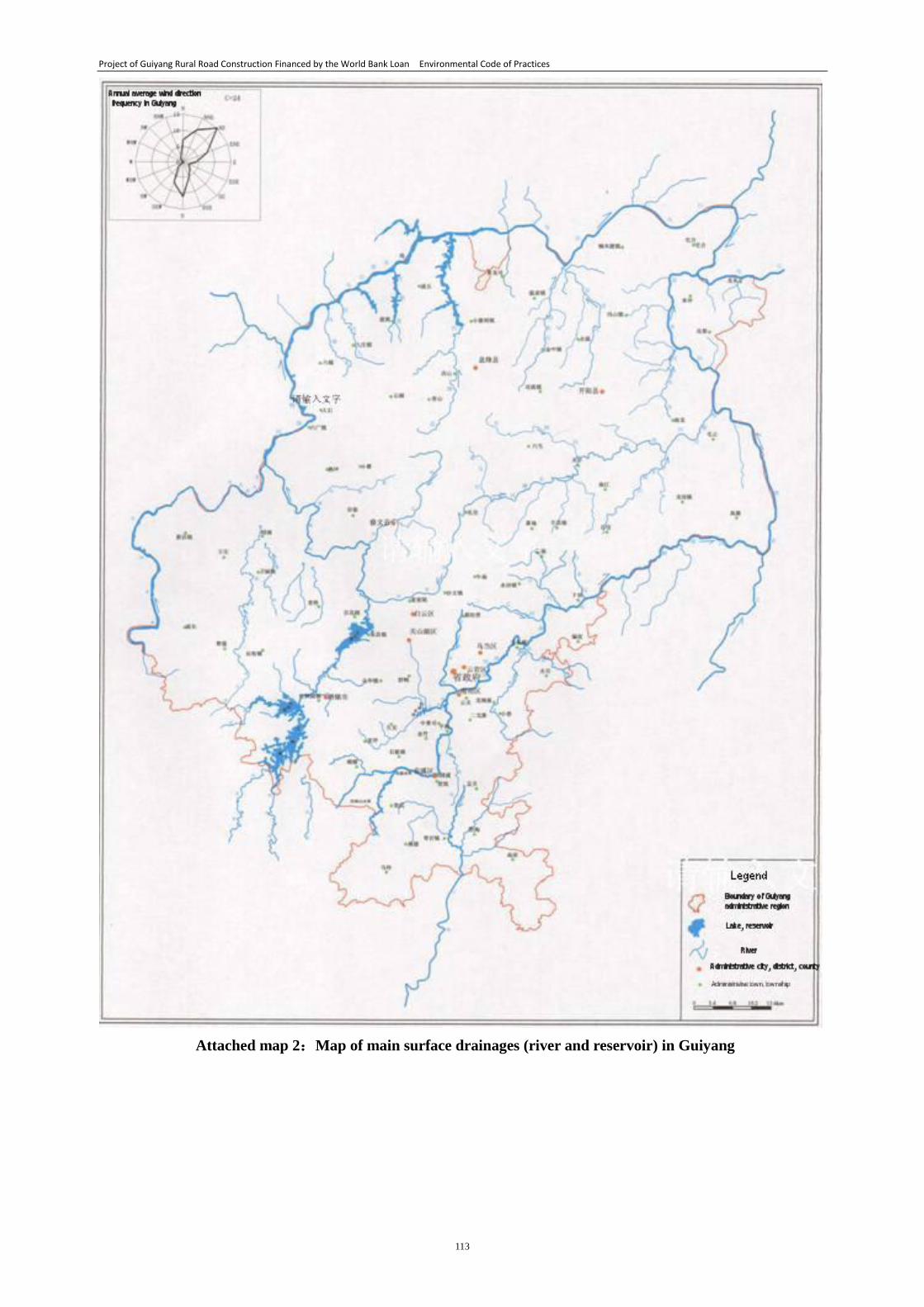
Project of Guiyang Rural Road Construction Financed by the World Bank Loan Environmental Code of Practices
113
Attached map 2:Map of main surface drainages (river and reservoir) in Guiyang
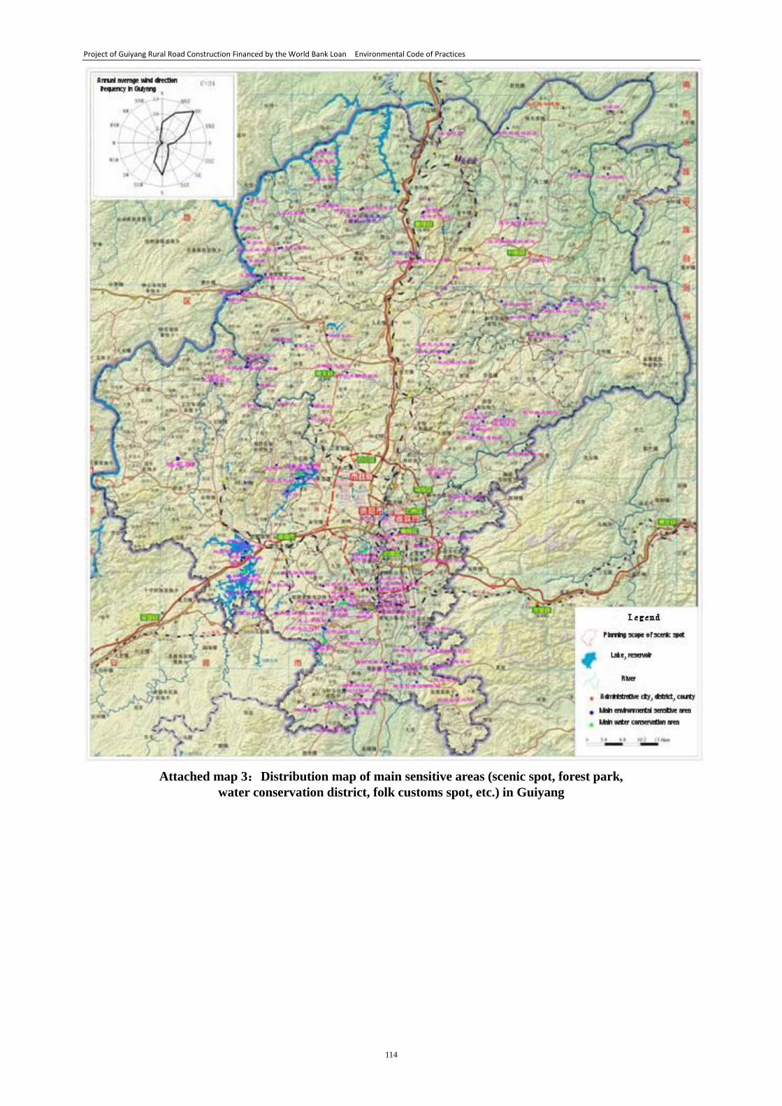
Project of Guiyang Rural Road Construction Financed by the World Bank Loan Environmental Code of Practices
114
Attached map 3:Distribution map of main sensitive areas (scenic spot, forest park,
water conservation district, folk customs spot, etc.) in Guiyang
Project of Guiyang Rural Road Construction Financed by the World Bank Loan Environmental Code of Practices
115
Appendixes:
A. Abbreviations & Technical Terms
1. The World Bank (WB)
A specialized agency under the United Nations, an international financial
institution responsible for long-term loans
2. World Bank Safeguard Policy
In order to properly consider the social and environmental impact brought by the
projects funded by the World Bank, including analysis of possible impact and
mitigation measures of negative impact
3. Environmental Assessment(EA)
Giving value assessment, judgment and to propose solution for environment
system condition
4. Environmental Impact Assessment(EIA)
The method and system for implementing analysis, prediction and assessment on
the environmental impact of programs and construction projects that might incur after
they are carried out, proposing countermeasures and matures for preventing or
mitigating adverse environmental impacts and making follow-up monitoring
5. Environmental Code of Practices(ECOPs)
Refers to the countermeasures, measures, methods and system for preventing or
mitigating adverse environmental impacts of programs and construction projects that
might incur after they are carried out
6. Roadway Surface Drainage
Refers to the surface drainage within the road land range, including pavement
surface drainage, central dividing strip drainage, slope drainage, and drainage of water
within the road that flow from adjacent roads or cross ways
7. Pavement Surface Drainage
Refers to the drainage of surface water within the pavement and shoulder
8. Slope Drainage
Refers to the drainage of surface water within the embankment slope, cut slope
and natural slope tending to the road
9. Underdrains
Refers to the drainage ditch under the ground or set in roadbed, which is made of
drain-pipe or drain-hole, water permeability backfill pellets and filtration fabrics or
inverted filter formed to block or reduce the groundwater level
10. Culvert
A small structure built to ensure overland flow can crosses beneath a road
11. Pipe Culvert
A culvert with pipe-shape body
Project of Guiyang Rural Road Construction Financed by the World Bank Loan Environmental Code of Practices
116
12. Arch Culvert
A culvert with arch top
13. Box Culvert
A culvert with reinforced concrete body, box-type section and arch top
14. Slab Culvert
A culvert with reinforced concrete slab, slate, etc. body
15. Outlet Submerged Culvert
A culvert with both inlet and outlet submerged in water, filled with water in the
whole body and the top of body withstanding head pressure
16. Inlet Submerged Culvert
A culvert with inlet submerged in water, only partial body withstanding head
pressure
17. Inlet Unsubmerged Culvert
A culvert with the flow under non-pressure
18. Inverted Siphon Culvert
A culvert with water pressure on both sides of the roadbed through the shape of
inverted siphon.
19. Back Water
The phenomenon that the upstream water level arising caused by compression of
water flow or jacking of tidal water level, main stream water level
20. Sediment
The phenomenon that the silt carried by water deposited due to slow flow
B. Attached Tables
Attached Table 1. Environmental screening form
Attached Table 2. Summary sheet of environmental supervision of project
Attached Table 3. Checklist of environmental protection review in construction period
Attached Table 4. Rectification notice of environmental protection issued by environment
supervisor to contractor
Attached Table 5. Checklist of environmental protection before acceptance
Attached Table 6. List of the first projects
C. Appendix
Appendix 1. Outline of appointing external monitoring organization for environmental
management
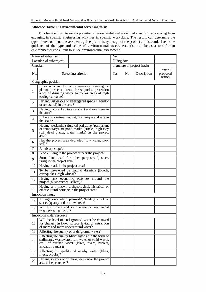
Project of Guiyang Rural Road Construction Financed by the World Bank Loan Environmental Code of Practices
117
Attached Table 1: Environmental screening form
This form is used to assess potential environmental and social risks and impacts arising from
engaging in specific engineering activities in specific workplace. The results can determine the
type of environmental assessment, guide preliminary design of the project and is conducive to the
guidance of the type and scope of environmental assessment, also can be as a tool for an
environmental consultant to guide environmental assessment.
Name of subproject No.
Location of subproject Filling date
Checker Signature of project leader
No. Screening criteria Yes No Description Remark/ proposed
action
Geographic position
1
In or adjacent to nature reserves (existing or planned), scenic areas, forest parks, protection areas of drinking water source or areas of high ecological value?
2 Having vulnerable or endangered species (aquatic or terrestrial) in the area?
3 Having natural habitats / ancient and rare trees in the area?
4 If there is a natural habitat, is it unique and rare in the scale?
5
Having wetlands, saturated soil zone (permanent or temporary), or pond marks (cracks, high-clay soil, dead plants, water marks) in the project area?
6 Has the project area degraded (low water, poor soil)?
7 An abrupt slope?
8 People living in the project or near the project?
9 Some land used for other purposes (pasture, farm) in the project area?
10 Having roads in the project area?
11 To be threatened by natural disasters (floods, earthquakes, high winds)?
12 Having any economic activities around the project (businessmen, sellers)?
13 Having any known archaeological, historical or other cultural heritage in the project area?
Impact on nature
14 A large excavation planned? Needing a lot of stones (quarry and borrow area)?
15 Will the project add solid waste or mechanical waste (waste oil, etc.)?
Impact on water resource
16 Will the level of underground water be changed for changes in flow, surface laying or extraction of more and more underground water?
17 Affecting the quality of underground water?
18
Affecting the quality (discharged with the form of sediments, wastewater, rain water or solid waste, etc.) of surface water (lakes, rivers, brooks, irrigation canals)?
19 Affecting the quality of nearby water (lakes, rivers, brooks)?
20 Having sources of drinking water near the project area to be protected?
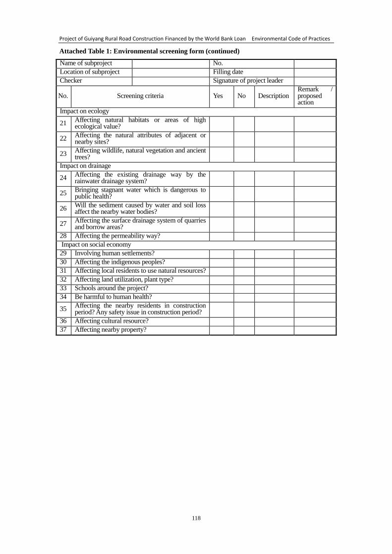
Project of Guiyang Rural Road Construction Financed by the World Bank Loan Environmental Code of Practices
118
Attached Table 1: Environmental screening form (continued)
Name of subproject No.
Location of subproject Filling date
Checker Signature of project leader
No. Screening criteria Yes No Description Remark / proposed action
Impact on ecology
21 Affecting natural habitats or areas of high ecological value?
22 Affecting the natural attributes of adjacent or nearby sites?
23 Affecting wildlife, natural vegetation and ancient trees?
Impact on drainage
24 Affecting the existing drainage way by the rainwater drainage system?
25 Bringing stagnant water which is dangerous to public health?
26 Will the sediment caused by water and soil loss affect the nearby water bodies?
27 Affecting the surface drainage system of quarries and borrow areas?
28 Affecting the permeability way?
Impact on social economy
29 Involving human settlements?
30 Affecting the indigenous peoples?
31 Affecting local residents to use natural resources?
32 Affecting land utilization, plant type?
33 Schools around the project?
34 Be harmful to human health?
35 Affecting the nearby residents in construction period? Any safety issue in construction period?
36 Affecting cultural resource?
37 Affecting nearby property?
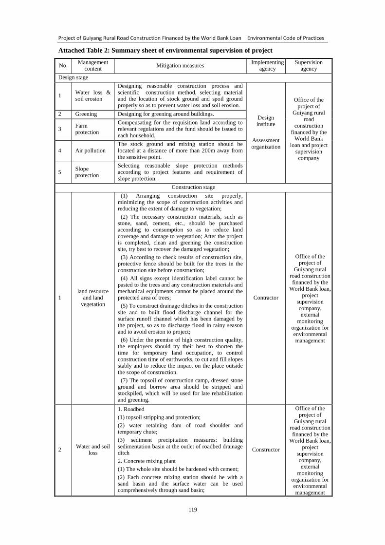
Project of Guiyang Rural Road Construction Financed by the World Bank Loan Environmental Code of Practices
119
Attached Table 2: Summary sheet of environmental supervision of project
No. Management
content Mitigation measures
Implementing agency
Supervision agency
Design stage
1 Water loss & soil erosion
Designing reasonable construction process and scientific construction method, selecting material and the location of stock ground and spoil ground properly so as to prevent water loss and soil erosion.
Design institute
Assessment organization
Office of the project of
Guiyang rural road
construction financed by the
World Bank loan and project
supervision company
2 Greening Designing for greening around buildings.
3 Farm protection
Compensating for the requisition land according to relevant regulations and the fund should be issued to each household.
4 Air pollution The stock ground and mixing station should be located at a distance of more than 200m away from the sensitive point.
5 Slope protection
Selecting reasonable slope protection methods according to project features and requirement of slope protection.
Construction stage
1 land resource
and land vegetation
(1) Arranging construction site properly, minimizing the scope of construction activities and reducing the extent of damage to vegetation;
(2) The necessary construction materials, such as stone, sand, cement, etc., should be purchased according to consumption so as to reduce land coverage and damage to vegetation; After the project is completed, clean and greening the construction site, try best to recover the damaged vegetation;
(3) According to check results of construction site, protective fence should be built for the trees in the construction site before construction;
(4) All signs except identification label cannot be pasted to the trees and any construction materials and mechanical equipments cannot be placed around the protected area of trees;
(5) To construct drainage ditches in the construction site and to built flood discharge channel for the surface runoff channel which has been damaged by the project, so as to discharge flood in rainy season and to avoid erosion to project;
(6) Under the premise of high construction quality, the employers should try their best to shorten the time for temporary land occupation, to control construction time of earthworks, to cut and fill slopes stably and to reduce the impact on the place outside the scope of construction.
(7) The topsoil of construction camp, dressed stone ground and borrow area should be stripped and stockpiled, which will be used for late rehabilitation and greening.
Contractor
Office of the project of
Guiyang rural road construction financed by the
World Bank loan, project
supervision company, external
monitoring organization for environmental management
2 Water and soil
loss
1. Roadbed
(1) topsoil stripping and protection;
(2) water retaining dam of road shoulder and temporary chute;
(3) sediment precipitation measures: building sedimentation basin at the outlet of roadbed drainage ditch
2. Concrete mixing plant
(1) The whole site should be hardened with cement;
(2) Each concrete mixing station should be with a sand basin and the surface water can be used comprehensively through sand basin;
Constructor
Office of the project of
Guiyang rural road construction financed by the
World Bank loan, project
supervision company, external
monitoring organization for environmental management
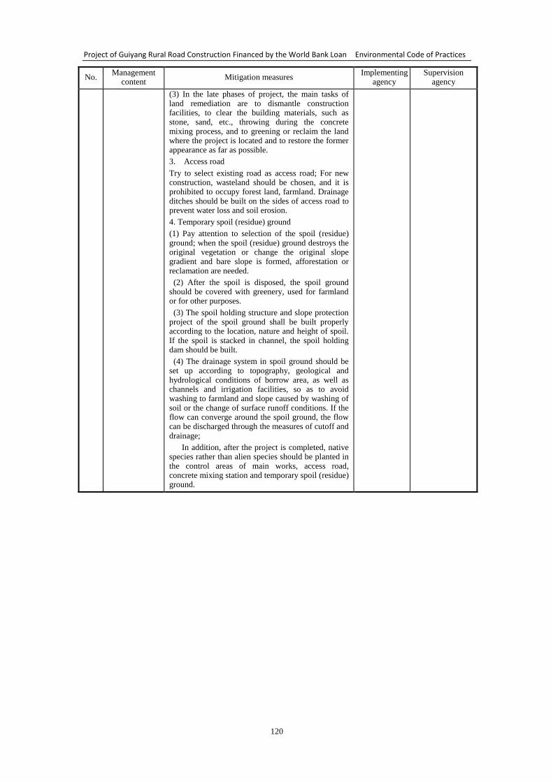
Project of Guiyang Rural Road Construction Financed by the World Bank Loan Environmental Code of Practices
120
No. Management
content Mitigation measures
Implementing agency
Supervision agency
(3) In the late phases of project, the main tasks of land remediation are to dismantle construction facilities, to clear the building materials, such as stone, sand, etc., throwing during the concrete mixing process, and to greening or reclaim the land where the project is located and to restore the former appearance as far as possible.
3. Access road
Try to select existing road as access road; For new construction, wasteland should be chosen, and it is prohibited to occupy forest land, farmland. Drainage ditches should be built on the sides of access road to prevent water loss and soil erosion.
4. Temporary spoil (residue) ground
(1) Pay attention to selection of the spoil (residue) ground; when the spoil (residue) ground destroys the original vegetation or change the original slope gradient and bare slope is formed, afforestation or reclamation are needed.
(2) After the spoil is disposed, the spoil ground should be covered with greenery, used for farmland or for other purposes.
(3) The spoil holding structure and slope protection project of the spoil ground shall be built properly according to the location, nature and height of spoil. If the spoil is stacked in channel, the spoil holding dam should be built.
(4) The drainage system in spoil ground should be set up according to topography, geological and hydrological conditions of borrow area, as well as channels and irrigation facilities, so as to avoid washing to farmland and slope caused by washing of soil or the change of surface runoff conditions. If the flow can converge around the spoil ground, the flow can be discharged through the measures of cutoff and drainage;
In addition, after the project is completed, native species rather than alien species should be planted in the control areas of main works, access road, concrete mixing station and temporary spoil (residue) ground.
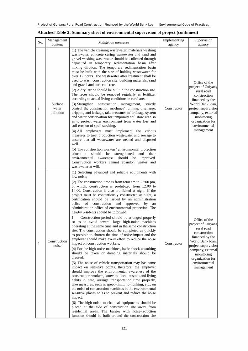
Project of Guiyang Rural Road Construction Financed by the World Bank Loan Environmental Code of Practices
121
Attached Table 2: Summary sheet of environmental supervision of project (continued)
No. Management
content Mitigation measures
Implementing
agency
Supervision
agency
3
Surface
water
pollution
(1) The vehicle cleaning wastewater, materials washing
wastewater, concrete curing wastewater and sand and
gravel washing wastewater should be collected through
deposited in temporary sedimentation basin after
mixing dilution. The temporary sedimentation basin
must be built with the size of holding wastewater for
over 12 hours. The wastewater after treatment shall be
used to wash construction site, building materials, sand
and gravel and cure concrete.
(2) A dry latrine should be built in the construction site.
The feces should be removed regularly as fertilizer
according to actual living conditions in rural area.
(3) Strengthen construction management, strictly
control the construction machines’ running, discharge,
dripping and leakage, take measures of drainage system
and water conservation for temporary soil store area so
as to protect water environment from water loss and
soil erosion of spoil stocking.
(4) All employers must implement the various
measures to treat production wastewater and sewage to
ensure that all wastewater are treated and disposed
well.
(5) The construction workers’ environmental protection
education should be strengthened and their
environmental awareness should be improved.
Construction workers cannot abandon wastes and
wastewater at will.
Constructor
Office of the
project of Guiyang
rural road
construction
financed by the
World Bank loan,
project supervision
company, external
monitoring
organization for
environmental
management
4 Construction
noise
(1) Selecting advanced and reliable equipments with
low noise;
(2) The construction time is from 6:00 am to 22:00 pm,
of which, construction is prohibited from 12:00 to
14:00. Construction is also prohibited at night. If the
project must be contentiously constructed at night, a
certification should be issued by an administration
office of construction and approved by an
administration office of environmental protection. The
nearby residents should be informed.
1. Construction period should be arranged properly
so as to avoid several large high-noise machines
operating at the same time and in the same construction
site. The construction should be completed as quickly
as possible to shorten the time of noise impact and the
employer should make every effort to reduce the noise
impact on construction workers.
(4) For the high-noise machines, basic shock-absorbing
should be taken or damping materials should be
dressed.
(5) The noise of vehicle transportation may has some
impact on sensitive points, therefore, the employer
should improve the environmental awareness of the
construction workers, know the local custom and living
habits in time, arrange transportation time properly,
take measures, such as speed-limit, no-honking, etc., on
the noise of construction machines in the environmental
sensitive places so as to prevent and reduce the noise
impact.
(6) The high-noise mechanical equipments should be
placed at the side of construction site away from
residential areas. The barrier with noise-reduction
function should be built around the construction site
Constructor
Office of the
project of Guiyang
rural road
construction
financed by the
World Bank loan,
project supervision
company, external
monitoring
organization for
environmental
management
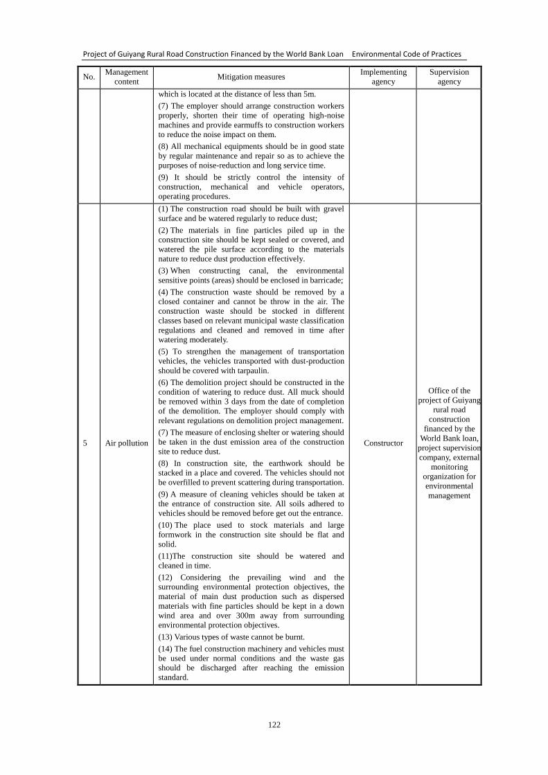
Project of Guiyang Rural Road Construction Financed by the World Bank Loan Environmental Code of Practices
122
No. Management
content Mitigation measures
Implementing
agency
Supervision
agency
which is located at the distance of less than 5m.
(7) The employer should arrange construction workers
properly, shorten their time of operating high-noise
machines and provide earmuffs to construction workers
to reduce the noise impact on them.
(8) All mechanical equipments should be in good state
by regular maintenance and repair so as to achieve the
purposes of noise-reduction and long service time.
(9) It should be strictly control the intensity of
construction, mechanical and vehicle operators,
operating procedures.
5 Air pollution
(1) The construction road should be built with gravel
surface and be watered regularly to reduce dust;
(2) The materials in fine particles piled up in the
construction site should be kept sealed or covered, and
watered the pile surface according to the materials
nature to reduce dust production effectively.
(3) When constructing canal, the environmental
sensitive points (areas) should be enclosed in barricade;
(4) The construction waste should be removed by a
closed container and cannot be throw in the air. The
construction waste should be stocked in different
classes based on relevant municipal waste classification
regulations and cleaned and removed in time after
watering moderately.
(5) To strengthen the management of transportation
vehicles, the vehicles transported with dust-production
should be covered with tarpaulin.
(6) The demolition project should be constructed in the
condition of watering to reduce dust. All muck should
be removed within 3 days from the date of completion
of the demolition. The employer should comply with
relevant regulations on demolition project management.
(7) The measure of enclosing shelter or watering should
be taken in the dust emission area of the construction
site to reduce dust.
(8) In construction site, the earthwork should be
stacked in a place and covered. The vehicles should not
be overfilled to prevent scattering during transportation.
(9) A measure of cleaning vehicles should be taken at
the entrance of construction site. All soils adhered to
vehicles should be removed before get out the entrance.
(10) The place used to stock materials and large
formwork in the construction site should be flat and
solid.
(11)The construction site should be watered and
cleaned in time.
(12) Considering the prevailing wind and the
surrounding environmental protection objectives, the
material of main dust production such as dispersed
materials with fine particles should be kept in a down
wind area and over 300m away from surrounding
environmental protection objectives.
(13) Various types of waste cannot be burnt.
(14) The fuel construction machinery and vehicles must
be used under normal conditions and the waste gas
should be discharged after reaching the emission
standard.
Constructor
Office of the
project of Guiyang
rural road
construction
financed by the
World Bank loan,
project supervision
company, external
monitoring
organization for
environmental
management
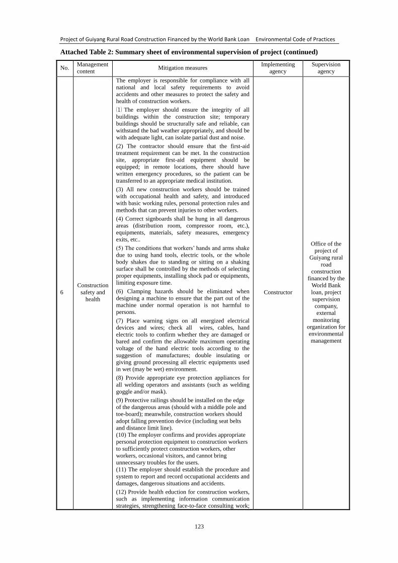
Project of Guiyang Rural Road Construction Financed by the World Bank Loan Environmental Code of Practices
123
Attached Table 2: Summary sheet of environmental supervision of project (continued)
No. Management
content Mitigation measures
Implementing
agency
Supervision
agency
6
Construction
safety and
health
The employer is responsible for compliance with all
national and local safety requirements to avoid
accidents and other measures to protect the safety and
health of construction workers.
⑴ The employer should ensure the integrity of all
buildings within the construction site; temporary
buildings should be structurally safe and reliable, can
withstand the bad weather appropriately, and should be
with adequate light, can isolate partial dust and noise.
(2) The contractor should ensure that the first-aid
treatment requirement can be met. In the construction
site, appropriate first-aid equipment should be
equipped; in remote locations, there should have
written emergency procedures, so the patient can be
transferred to an appropriate medical institution.
(3) All new construction workers should be trained
with occupational health and safety, and introduced
with basic working rules, personal protection rules and
methods that can prevent injuries to other workers.
(4) Correct signboards shall be hung in all dangerous
areas (distribution room, compressor room, etc.),
equipments, materials, safety measures, emergency
exits, etc..
(5) The conditions that workers’ hands and arms shake
due to using hand tools, electric tools, or the whole
body shakes due to standing or sitting on a shaking
surface shall be controlled by the methods of selecting
proper equipments, installing shock pad or equipments,
limiting exposure time.
(6) Clamping hazards should be eliminated when
designing a machine to ensure that the part out of the
machine under normal operation is not harmful to
persons.
(7) Place warning signs on all energized electrical
devices and wires; check all wires, cables, hand
electric tools to confirm whether they are damaged or
bared and confirm the allowable maximum operating
voltage of the hand electric tools according to the
suggestion of manufactures; double insulating or
giving ground processing all electric equipments used
in wet (may be wet) environment.
(8) Provide appropriate eye protection appliances for
all welding operators and assistants (such as welding
goggle and/or mask).
(9) Protective railings should be installed on the edge
of the dangerous areas (should with a middle pole and
toe-board); meanwhile, construction workers should
adopt falling prevention device (including seat belts
and distance limit line).
(10) The employer confirms and provides appropriate
personal protection equipment to construction workers
to sufficiently protect construction workers, other
workers, occasional visitors, and cannot bring
unnecessary troubles for the users.
(11) The employer should establish the procedure and
system to report and record occupational accidents and
damages, dangerous situations and accidents.
(12) Provide health eduction for construction workers,
such as implementing information communication
strategies, strengthening face-to-face consulting work;
Constructor
Office of the
project of
Guiyang rural
road
construction
financed by the
World Bank
loan, project
supervision
company,
external
monitoring
organization for
environmental
management
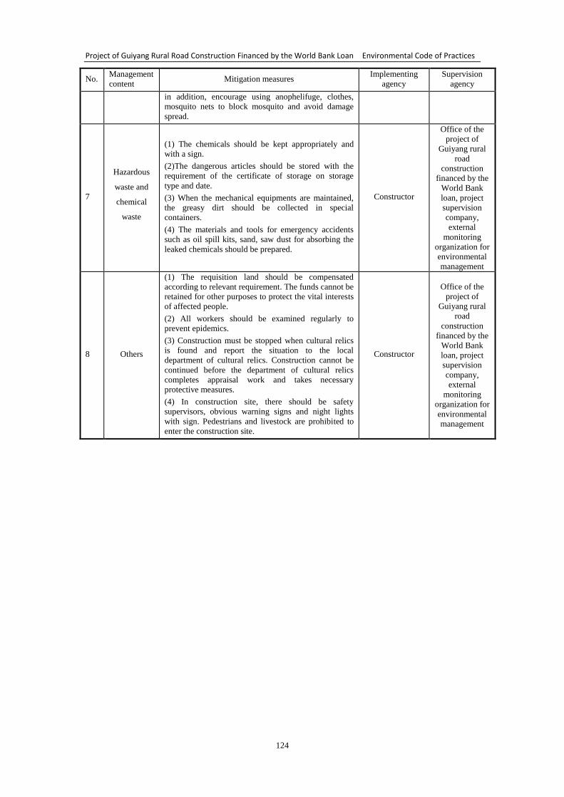
Project of Guiyang Rural Road Construction Financed by the World Bank Loan Environmental Code of Practices
124
No. Management
content Mitigation measures
Implementing
agency
Supervision
agency
in addition, encourage using anophelifuge, clothes,
mosquito nets to block mosquito and avoid damage
spread.
7
Hazardous
waste and
chemical
waste
(1) The chemicals should be kept appropriately and
with a sign.
(2)The dangerous articles should be stored with the
requirement of the certificate of storage on storage
type and date.
(3) When the mechanical equipments are maintained,
the greasy dirt should be collected in special
containers.
(4) The materials and tools for emergency accidents
such as oil spill kits, sand, saw dust for absorbing the
leaked chemicals should be prepared.
Constructor
Office of the
project of
Guiyang rural
road
construction
financed by the
World Bank
loan, project
supervision
company,
external
monitoring
organization for
environmental
management
8 Others
(1) The requisition land should be compensated
according to relevant requirement. The funds cannot be
retained for other purposes to protect the vital interests
of affected people.
(2) All workers should be examined regularly to
prevent epidemics.
(3) Construction must be stopped when cultural relics
is found and report the situation to the local
department of cultural relics. Construction cannot be
continued before the department of cultural relics
completes appraisal work and takes necessary
protective measures.
(4) In construction site, there should be safety
supervisors, obvious warning signs and night lights
with sign. Pedestrians and livestock are prohibited to
enter the construction site.
Constructor
Office of the
project of
Guiyang rural
road
construction
financed by the
World Bank
loan, project
supervision
company,
external
monitoring
organization for
environmental
management
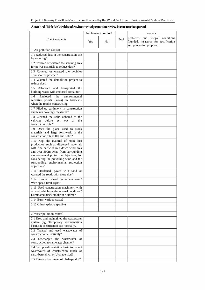
Project of Guiyang Rural Road Construction Financed by the World Bank Loan Environmental Code of Practices
125
Attached Table 3: Checklist of environmental protection review in construction period
Check elements
Implemented or not?
N/A
Remark
Yes No
Problems and illegal conditions
founded, measures for rectification
and prevention proposed
1. Air pollution control
1.1 Reduced dust in the construction site
by watering?
1.2 Covered or watered the stacking area
for power materials to reduce dust?
1.3 Covered or watered the vehicles
transported powder?
1.4 Watered the demolition project to
reduce dust.
1.5 Allocated and transported the
building waste with enclosed container
1.6 Enclosed the environmental
sensitive points (areas) in barricade
when the road is constructing;
1.7 Piled up earthwork in construction
and taken coverage measures?
1.8 Cleaned the solid adhered to the
vehicles before get out of the
construction site?
1.9 Does the place used to stock
materials and large formwork in the
construction site is flat and solid?
1.10 Kept the material of main dust
production such as dispersed materials
with fine particles in a down wind area
and over 300m away from surrounding
environmental protection objectives, for
considering the prevailing wind and the
surrounding environmental protection
objectives?
1.11 Hardened, paved with sand or
watered the roads with more dust?
1.12 Limited speed on access road?
With speed-limit signs?
1.13 Used construction machinery with
oil and vehicles under normal condition?
Eliminated black smoke at runtime?
1.14 Burnt various waste?
1.15 Others (please specify)
……
2. Water pollution control
2.1 Used and maintained the wastewater
system (eg. Temporary sedimentation
basin) in construction site normally?
2.2 Treated and used wastewater of
construction effectively?
2.3 Discharged the wastewater of
construction to rainwater channel?
2.4 Set up sedimentation basin to collect
wastewater of construction (such as
earth-bank ditch or U-shape slot)?
2.5 Removed sediment of U-shape slot?
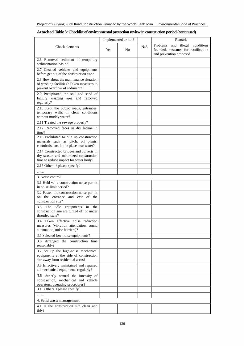
Project of Guiyang Rural Road Construction Financed by the World Bank Loan Environmental Code of Practices
126
Attached Table 3: Checklist of environmental protection review in construction period (continued)
Check elements
Implemented or not?
N/A
Remark
Yes No
Problems and illegal conditions
founded, measures for rectification
and prevention proposed
2.6 Removed sediment of temporary
sedimentation basin?
2.7 Cleaned vehicles and equipments
before get out of the construction site?
2.8 How about the maintenance situation
of washing facilities? Taken measures to
prevent overflow of sediment?
2.9 Precipitated the soil and sand of
facility washing area and removed
regularly?
2.10 Kept the public roads, entrances,
temporary walls in clean conditions
without muddy water?
2.11 Treated the sewage properly?
2.12 Removed feces in dry latrine in
time?
2.13 Prohibited to pile up construction
materials such as pitch, oil plants,
chemicals, etc. in the place near water?
2.14 Constructed bridges and culverts in
dry season and minimized construction
time to reduce impact for water body?
2.15 Others(please specify)
……
3. Noise control
3.1 Held valid construction noise permit
in noise-limit period?
3.2 Pasted the construction noise permit
on the entrance and exit of the
construction site?
3.3 The idle equipments in the
construction sire are turned off or under
throttled state?
3.4 Taken effective noise reduction
measures (vibration attenuation, sound
attenuation, noise barriers)?
3.5 Selected low-noise equipments?
3.6 Arranged the construction time
reasonably?
3.7 Set up the high-noise mechanical
equipments at the side of construction
site away from residential areas?
3.8 Effectively maintained and repaired
all mechanical equipments regularly?
3.9 Strictly control the intensity of
construction, mechanical and vehicle
operators, operating procedures?
3.10 Others(please specify)
……
4. Solid waste management
4.1 Is the construction site clean and
tidy?
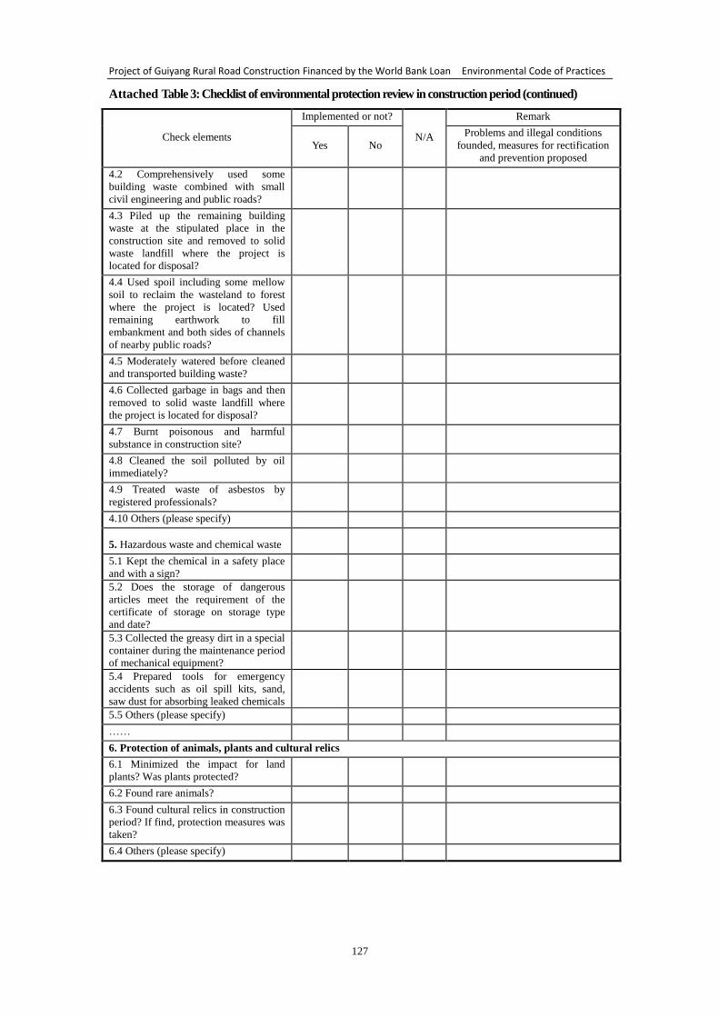
Project of Guiyang Rural Road Construction Financed by the World Bank Loan Environmental Code of Practices
127
Attached Table 3: Checklist of environmental protection review in construction period (continued)
Check elements
Implemented or not?
N/A
Remark
Yes No
Problems and illegal conditions
founded, measures for rectification
and prevention proposed
4.2 Comprehensively used some
building waste combined with small
civil engineering and public roads?
4.3 Piled up the remaining building
waste at the stipulated place in the
construction site and removed to solid
waste landfill where the project is
located for disposal?
4.4 Used spoil including some mellow
soil to reclaim the wasteland to forest
where the project is located? Used
remaining earthwork to fill
embankment and both sides of channels
of nearby public roads?
4.5 Moderately watered before cleaned
and transported building waste?
4.6 Collected garbage in bags and then
removed to solid waste landfill where
the project is located for disposal?
4.7 Burnt poisonous and harmful
substance in construction site?
4.8 Cleaned the soil polluted by oil
immediately?
4.9 Treated waste of asbestos by
registered professionals?
4.10 Others (please specify)
5. Hazardous waste and chemical waste
5.1 Kept the chemical in a safety place
and with a sign?
5.2 Does the storage of dangerous
articles meet the requirement of the
certificate of storage on storage type
and date?
5.3 Collected the greasy dirt in a special
container during the maintenance period
of mechanical equipment?
5.4 Prepared tools for emergency
accidents such as oil spill kits, sand,
saw dust for absorbing leaked chemicals
5.5 Others (please specify)
……
6. Protection of animals, plants and cultural relics
6.1 Minimized the impact for land
plants? Was plants protected?
6.2 Found rare animals?
6.3 Found cultural relics in construction
period? If find, protection measures was
taken?
6.4 Others (please specify)
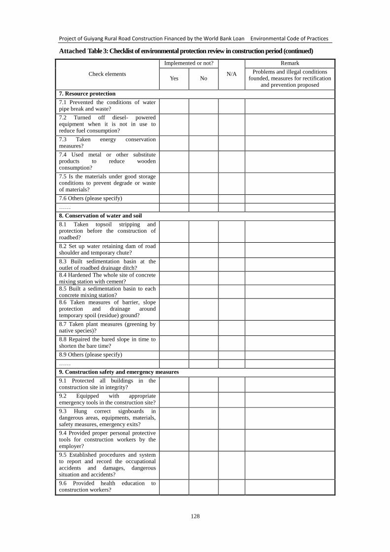
Project of Guiyang Rural Road Construction Financed by the World Bank Loan Environmental Code of Practices
128
Attached Table 3: Checklist of environmental protection review in construction period (continued)
Check elements
Implemented or not?
N/A
Remark
Yes No Problems and illegal conditions
founded, measures for rectification and prevention proposed
7. Resource protection
7.1 Prevented the conditions of water pipe break and waste?
7.2 Turned off diesel- powered equipment when it is not in use to reduce fuel consumption?
7.3 Taken energy conservation measures?
7.4 Used metal or other substitute products to reduce wooden consumption?
7.5 Is the materials under good storage conditions to prevent degrade or waste of materials?
7.6 Others (please specify)
……
8. Conservation of water and soil
8.1 Taken topsoil stripping and protection before the construction of roadbed?
8.2 Set up water retaining dam of road shoulder and temporary chute?
8.3 Built sedimentation basin at the outlet of roadbed drainage ditch?
8.4 Hardened The whole site of concrete mixing station with cement?
8.5 Built a sedimentation basin to each concrete mixing station?
8.6 Taken measures of barrier, slope protection and drainage around temporary spoil (residue) ground?
8.7 Taken plant measures (greening by native species)?
8.8 Repaired the bared slope in time to shorten the bare time?
8.9 Others (please specify)
……
9. Construction safety and emergency measures
9.1 Protected all buildings in the construction site in integrity?
9.2 Equipped with appropriate emergency tools in the construction site?
9.3 Hung correct signboards in dangerous areas, equipments, materials, safety measures, emergency exits?
9.4 Provided proper personal protective tools for construction workers by the employer?
9.5 Established procedures and system to report and record the occupational accidents and damages, dangerous situation and accidents?
9.6 Provided health education to construction workers?
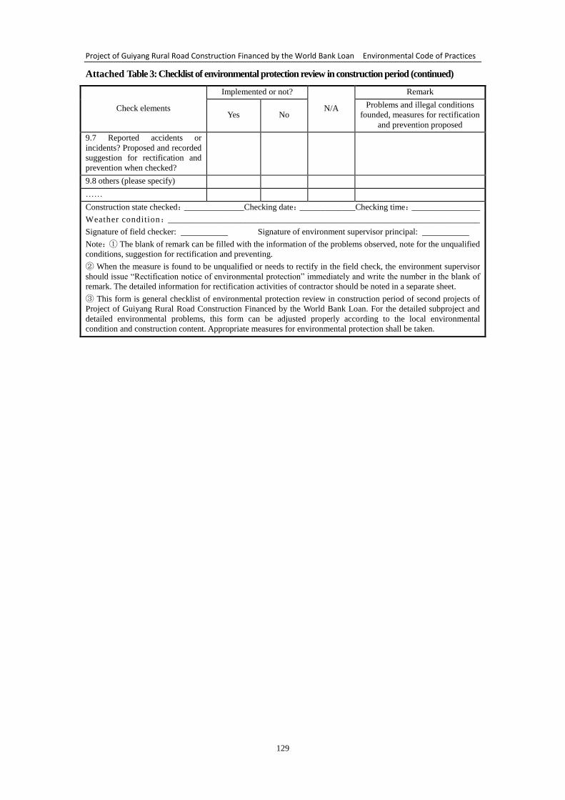
Project of Guiyang Rural Road Construction Financed by the World Bank Loan Environmental Code of Practices
129
Attached Table 3: Checklist of environmental protection review in construction period (continued)
Check elements
Implemented or not?
N/A
Remark
Yes No
Problems and illegal conditions
founded, measures for rectification
and prevention proposed
9.7 Reported accidents or
incidents? Proposed and recorded
suggestion for rectification and
prevention when checked?
9.8 others (please specify)
……
Construction state checked:______________Checking date:_____________Checking time:________________
Weather condition:_________________________________________________________________________
Signature of field checker: Signature of environment supervisor principal:
Note:① The blank of remark can be filled with the information of the problems observed, note for the unqualified
conditions, suggestion for rectification and preventing.
② When the measure is found to be unqualified or needs to rectify in the field check, the environment supervisor
should issue “Rectification notice of environmental protection” immediately and write the number in the blank of
remark. The detailed information for rectification activities of contractor should be noted in a separate sheet.
③ This form is general checklist of environmental protection review in construction period of second projects of
Project of Guiyang Rural Road Construction Financed by the World Bank Loan. For the detailed subproject and
detailed environmental problems, this form can be adjusted properly according to the local environmental
condition and construction content. Appropriate measures for environmental protection shall be taken.
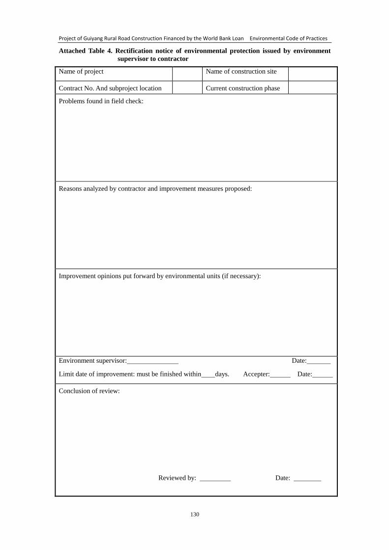
Project of Guiyang Rural Road Construction Financed by the World Bank Loan Environmental Code of Practices
130
Attached Table 4. Rectification notice of environmental protection issued by environment
supervisor to contractor
Name of project Name of construction site
Contract No. And subproject location Current construction phase
Problems found in field check:
Reasons analyzed by contractor and improvement measures proposed:
Improvement opinions put forward by environmental units (if necessary):
Environment supervisor: Date:
Limit date of improvement: must be finished within days. Accepter: Date:
Conclusion of review:
Reviewed by: Date:
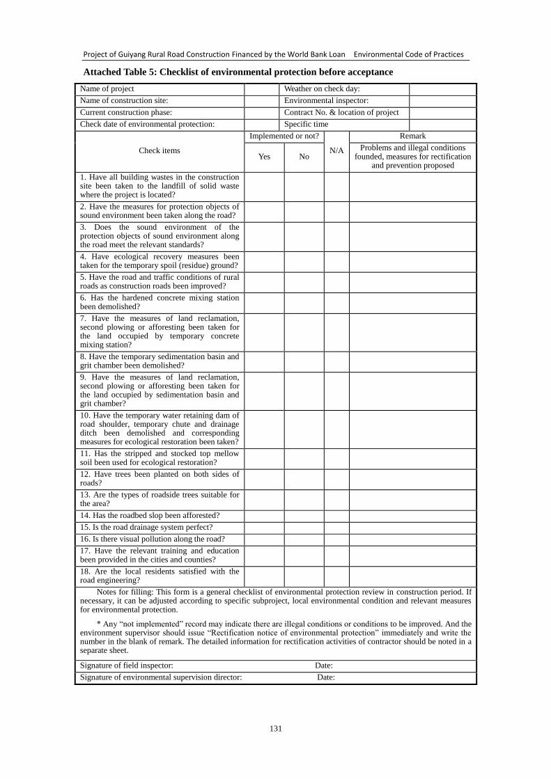
Project of Guiyang Rural Road Construction Financed by the World Bank Loan Environmental Code of Practices
131
Attached Table 5: Checklist of environmental protection before acceptance
Name of project Weather on check day:
Name of construction site: Environmental inspector:
Current construction phase: Contract No. & location of project
Check date of environmental protection: Specific time
Check items
Implemented or not?
N/A
Remark
Yes No Problems and illegal conditions
founded, measures for rectification and prevention proposed
1. Have all building wastes in the construction site been taken to the landfill of solid waste where the project is located?
2. Have the measures for protection objects of sound environment been taken along the road?
3. Does the sound environment of the protection objects of sound environment along the road meet the relevant standards?
4. Have ecological recovery measures been taken for the temporary spoil (residue) ground?
5. Have the road and traffic conditions of rural roads as construction roads been improved?
6. Has the hardened concrete mixing station been demolished?
7. Have the measures of land reclamation, second plowing or afforesting been taken for the land occupied by temporary concrete mixing station?
8. Have the temporary sedimentation basin and grit chamber been demolished?
9. Have the measures of land reclamation, second plowing or afforesting been taken for the land occupied by sedimentation basin and grit chamber?
10. Have the temporary water retaining dam of road shoulder, temporary chute and drainage ditch been demolished and corresponding measures for ecological restoration been taken?
11. Has the stripped and stocked top mellow soil been used for ecological restoration?
12. Have trees been planted on both sides of roads?
13. Are the types of roadside trees suitable for the area?
14. Has the roadbed slop been afforested?
15. Is the road drainage system perfect?
16. Is there visual pollution along the road?
17. Have the relevant training and education been provided in the cities and counties?
18. Are the local residents satisfied with the road engineering?
Notes for filling: This form is a general checklist of environmental protection review in construction period. If necessary, it can be adjusted according to specific subproject, local environmental condition and relevant measures for environmental protection.
* Any “not implemented” record may indicate there are illegal conditions or conditions to be improved. And the environment supervisor should issue “Rectification notice of environmental protection” immediately and write the number in the blank of remark. The detailed information for rectification activities of contractor should be noted in a separate sheet.
Signature of field inspector: Date:
Signature of environmental supervision director: Date:
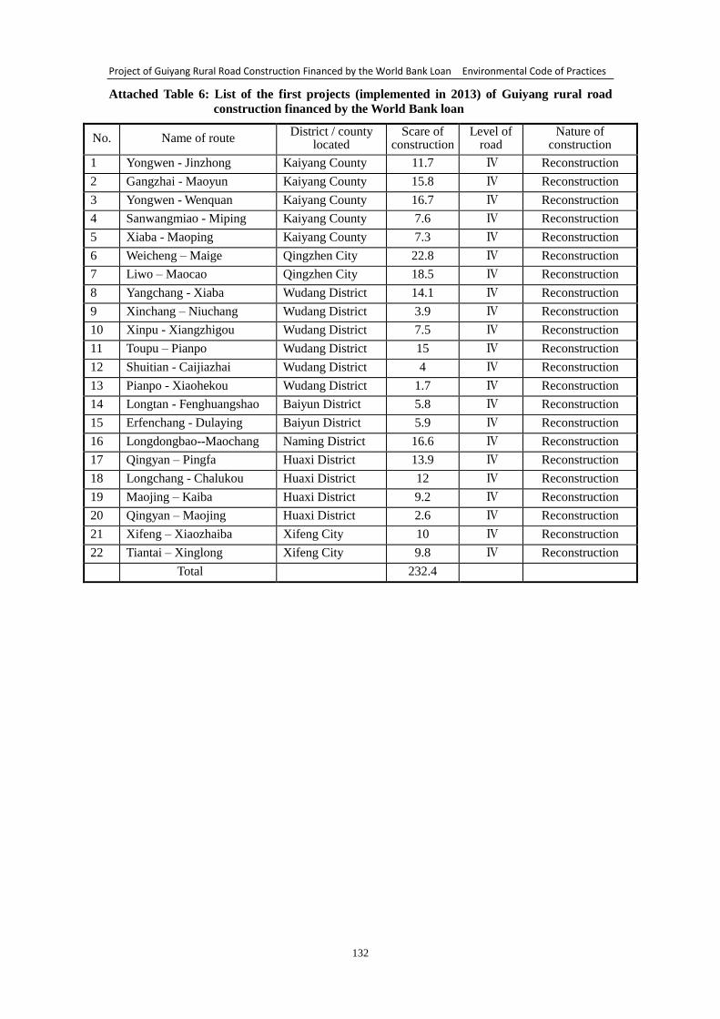
Project of Guiyang Rural Road Construction Financed by the World Bank Loan Environmental Code of Practices
132
Attached Table 6: List of the first projects (implemented in 2013) of Guiyang rural road
construction financed by the World Bank loan
No. Name of route District / county
located Scare of
construction Level of
road Nature of
construction
1 Yongwen - Jinzhong Kaiyang County 11.7 Ⅳ Reconstruction
2 Gangzhai - Maoyun Kaiyang County 15.8 Ⅳ Reconstruction
3 Yongwen - Wenquan Kaiyang County 16.7 Ⅳ Reconstruction
4 Sanwangmiao - Miping Kaiyang County 7.6 Ⅳ Reconstruction
5 Xiaba - Maoping Kaiyang County 7.3 Ⅳ Reconstruction
6 Weicheng – Maige Qingzhen City 22.8 Ⅳ Reconstruction
7 Liwo – Maocao Qingzhen City 18.5 Ⅳ Reconstruction
8 Yangchang - Xiaba Wudang District 14.1 Ⅳ Reconstruction
9 Xinchang – Niuchang Wudang District 3.9 Ⅳ Reconstruction
10 Xinpu - Xiangzhigou Wudang District 7.5 Ⅳ Reconstruction
11 Toupu – Pianpo Wudang District 15 Ⅳ Reconstruction
12 Shuitian - Caijiazhai Wudang District 4 Ⅳ Reconstruction
13 Pianpo - Xiaohekou Wudang District 1.7 Ⅳ Reconstruction
14 Longtan - Fenghuangshao Baiyun District 5.8 Ⅳ Reconstruction
15 Erfenchang - Dulaying Baiyun District 5.9 Ⅳ Reconstruction
16 Longdongbao--Maochang Naming District 16.6 Ⅳ Reconstruction
17 Qingyan – Pingfa Huaxi District 13.9 Ⅳ Reconstruction
18 Longchang - Chalukou Huaxi District 12 Ⅳ Reconstruction
19 Maojing – Kaiba Huaxi District 9.2 Ⅳ Reconstruction
20 Qingyan – Maojing Huaxi District 2.6 Ⅳ Reconstruction
21 Xifeng – Xiaozhaiba Xifeng City 10 Ⅳ Reconstruction
22 Tiantai – Xinglong Xifeng City 9.8 Ⅳ Reconstruction
Total 232.4
Project of Guiyang Rural Road Construction Financed by the World Bank Loan Environmental Code of Practices
133
Appendix 1:
Outline of appointing external monitoring organization for environmental management
In accordance with relevant requirement of WB, the project office will choose
external monitoring organization with environmental management experience to
monitor and assess the implementation of environmental management and restoration
during the implementing procedure of environmental management, so as to ensure the
environmental management is carried out with the ECOPs.
1. Purpose of external monitoring
External monitoring and assessment will be practiced by an qualified institution
independent of project office and environmental assessment institution, aims to
monitor and assessment the restoration of social disruption, sewage treatment, cultural
relic protection, safety and health, air pollution, water loss and soil erosion, noise
monitoring and to propose assessment options and recommendations. Through
external monitoring and assessment, the implementation results of environmental
protection work will be guaranteed by the way of taking systematic measures to
identify problems and taking remedial measures and following up in time.
2. In order to successfully complete the external independent monitoring of this
project, the project office will appoint an experienced professional organization to
practice the external monitoring of the project. In selecting participants of the external
monitoring, the main factors to be considered are as follows:
(1) Participated in a similar work, has rich experience in social survey,
understands the requirements of ECOPs of WB, masters relevant policies and
regulations on environmental management issued by the state and local government.
(2) Can make social investigation independently, with good communication
ability and quality, with hard working spirit.
3. According to the preliminary arrangements for the project, an independent
organization with experience will be appointed to practice external monitoring and
assessment. The works of independent monitoring organization are:
(1) offering technical assistance and training;
(2) assisting the preparation of (recovery) plan for the ecological environment
destroyed during the construction period;
(3) monitoring and investing the environment management according to the
requirements of ECOPs;
(4) assessing the living conditions of affected people to determine whether they
are recovered sufficiently; and
(5) preparing and submitting external monitoring and assessment reports to the
project management office and WB.
4. Report system of external monitoring
Based on observation and investigation, the external monitoring organization
writes report of external monitoring and reports to WB and the project office
independently. The external monitoring organization should report to WB and the
project office with the following time:
(1) submitting an interim monitoring report about the environmental management
Project of Guiyang Rural Road Construction Financed by the World Bank Loan Environmental Code of Practices
134
condition of the year to WB and the organization of environmental management
implementation before June 30 every year.
(2) submitting an annual monitoring report to WB and the owner before
December 31 every year.