workshop proceedings on land and use zoning: …pemsea.org/sites/default/files/eas-wp2010-06.pdf ·...
TRANSCRIPT

1
The East Asian Seas Congress 2009 “Partnerships at Work: Local Implementation and Good Practices”
Manila, Philippines, 23-27 November 2009
Theme 1: Coastal and Ocean GovernanceWorkshop 6: Land and Sea Use Zoning: Challenges and Opportunities
23 November 2009
Co-Convening Agency: PEMSEA Network of Local Governments
for Sustainable Coastal Development (PNLG)
Chair:Dr. Kem Lowry,
Department of Urban and Regional Planning,University of Hawaii, Manoa, USA
BACKGROUND
The East Asian Region is undergoing rapid change – economic expansion in the last decade has resulted to various challenges such as multiple use conflicts, massive coastal reclamation and the consequent degradation of the productive capacity of coastal and marine resources.
Historically, cities and urban areas are largely concentrated along waterways and coastal areas as rivers and coasts provide cheaper means of transportation and promote agricultural production necessary for survival.
With the increase of population over the years, coastal and river areas have become highly urbanized. Urban spatial expansion can be considered as a process of continually occupying the spatial resource suitable to urban development for social economic development (Tao Lin). Nowhere is this more pronounced than in China. China’s rapid urbanization led to the total sea reclamation of about 12000 km2 or an average of 200 km2 per year since the 1950s. Coastal reclamation projects in China were driven by various factors such as the salt industry in the 1950s, expansion of farm lands in the 1960s to the 1970s and the increased demand for aquaculture products in 1980s-1990s and comprehensive uses in late 1990s to now.
Reclamation in PR China1 is permitted, with different government agencies responsible for granting permits. However reclamation has its impacts and ecosystem valuation resulted to an estimated loss of US$15.947 million/km2.
1There were three presentations which discussed sea reclamation in China, including its impacts and challenges. (1)
Impacts of Sea Reclamation on the Coastal Ecosystem, Dr. Zhang Zhaohui, First Institute of Oceanography, State

2
0
0.5
1
1.5
2
2.5
3
1973 1987 1995 2004 2007year
LU
II
0
20
40
60
80
100
120
ES
V m
ilio
n Y
uan
LUII
ESV
0
5
10
15
20
25
30
35
40
45
50
1973 1987 1995 2004 2007Year
ES
V m
illi
on
Yu
an
W o o d lan d
Farmlan d
W ater b o d y
T id a l fla t
Source: Sea Area Management Bulletin 2002-2008; Expected 2009.
An example of a developing area in PR China is Xiamen. Since its establishment in 1980s as a Special Economic Zone, Xiamen has undergone rapid urbanization with its urban population reaching 0.94 million in 2008. Land and coastal area utilization patterns in Xiamen are indicated in Figure 1.
Figure 1. China permitted sea reclamation areas.
Oceanic Administration of PR China; Su Weixiao, Environment Science and Technology School, Ocean University of China; Wang Zongling, First Institute of Oceanography, SOA; (2) Monetary Evaluation on Depletion of Coastal Ecosystem Services, Ms. Xuan Wang, Dr. Weiqi Chen, Prof. Luoping Zhang, Coastal and Ocean Management/Environmental Science; (3) Urban Spatial Expansion and its Effects on Island Ecosystem: A Case Study of the Island City of Xiamen, Southeast China, Dr. Lin Tao, Zhao Qianjun, Cui Shenghui, Shi Longya, Gao Lijie, Institute of Urban Environment, Chinese Academy, Xiamen, China.
Figure 2. Dynamic changes of land use intensity index and ecosystem service of Xiamen Island during 1973-2007.
2002 2003 2004 2005 2006 2007 2008 2009
Reclamation 2033 2123 5352 11662 11293 13425 11000 15000
0
2000
4000
6000
8000
10000
12000
14000
16000
SeaArea(ha)
ReclamationArea (ha)
3
Extensive reclamation and land conversion patterns in Xiamen put pressure on the productivity of the island ecosystem. To determine the impact of these pressures, several ecosystem valuation models below are used to determine the impact of urbanization and reclamation to the ecosystem:
Ecosystem service evaluation Stress of urban expansion on ecological landscape Natural ecosystem eroded index (NEEI) Landscape isolation index (LII)
There are different concepts and methods used to determine the impact of coastal reclamation. But many of the existing ecosystem valuation methods do not factor in the real ‘value’ of ecosystem services. This results to the underestimation on the true cost of ecosystem services, resulting to a lower ‘price tag’ of ecosystem services when computing for the real cost of reclamation. The actual losses may be greater due to the limitations of methods and data. For instance, user fee for sea reclamation in Tong’an bay is RMB 7.5 m-2 – RMB 22.5 m-2 — which is too low to reflect the external cost of reclamation. Such a low fee cannot deter excessive sea reclamation and protect the coastal environment.
While there are varying methods to valuate the loss in ecosystem services, the massive reclamation has tremendous impact on the capacity of the coastal ecosystem to provide services. The integrity of the coastal ecosystem can only be retained by effective coastal use zoning.
Zoning for coastal and marine management is seen as a strategy and a tool to effectively and efficiently appropriate scarce resources among various stakeholders. Similarly, reclamation remains to be a major challenge in the effective implementation of zoning schemes.
While a recognized tool for effective coastal resource management, a quick survey of sites in the East Asian region point to common challenges that impede effective implementation of the zoning schemes. Issues range from governance concerns to technical process and details of the zoning process itself (EAS Congress Pre-Workshop, 2009).
Many local governments in the region have limited capacity to prepare effective zoning schemes. This difficulty stems from the limited capacity among local agencies to determine scientific basis for zoning such as technical guidelines for specific areas. For some sites which have developed their zoning schemes, there are inconsistencies on local and national policies, institutional arrangements, and enforcement strategies, information, public awareness and stakeholder coordination.
In local governments where zoning is being implemented, the process of reviewing and evaluating zoning schemes through time is also a challenge among local governments. Incorporating climate change concerns into zoning plans should also be a major consideration in the review of zoning plans.

4
For many sites and countries which need to relocate stakeholders, user rights, compensation schemes and alternative livelihoods for families/individuals affected by zoning are only some of the difficulties.
Apart from PR China which developed a marine functional zoning scheme, the countries in the region are at different stages of zoning development and implementation. While zoning is recognized to be an important management tool for coastal and marine resources, countries in the region are still challenged by various technical, legal and institutional concerns in the implementation process.
The session at the International Conference aimed to facilitate a sharing of ideas and strategies on how existing zoning plans can be strengthened and effectively enforced at the local level. It aimed to answer the following:
How can local governments zone for climate change? Can land and sea-use zoning scheme be used as a market-based
instrument for managing coastal and marine areas? How are local governments effectively implementing land and sea-use
zoning?
CONCEPTS OF ZONING
Ecological Zoning as a Policy Tool for Sustainable Development Dr. Candido Cabrido, Dean, School of Urban and Regional Planning, University of the Philippines Diliman
Zoning is commonly employed as a land and water use planning and regulatory tool to guide and direct the type of development most favorable or advantageous to the growth and development of an area considering its ecological constraints and socioeconomic objectives. In the Philippines, the zoning of land is a requirement by the government among local government units at the city and municipal levels to regulate the uses of their lands according to their most suitable and best uses from the perspectives of economics, social and environmental sustainability.
Hence, urban areas are zoned into residential, commercial, industrial, and institutional uses while non-urban lands are broadly zoned into agriculture, forest and coastal uses. However, there are now new initiatives to zone forest and coastal areas into more specific classes based on their ecological characteristics and sustainable uses. Several coastal municipalities have prepared the zoning of their coastal waters, which extends to 15 km offshore from the shoreline but the challenge remains in the implementation of the allowable uses of their coastal areas.
Aside from the standard zoning requirement, three types of ecological zoning have also been developed and applied in the Philippines at the ecosystem and local level.
Agroecological Zoning (AEZ), which was patterned after the UN FAO’s Agroecological Zoning model that was developed for application at the global scale in the early 1980s. The AEZ model was applied at the provincial level using Palawan

5
Province as a case study. This model was used to delineate and map agricultural lands according to their level of edaphic and climatic suitabilities to various crops and also predicted their potential yield based on a mix of technology inputs. Because of the limited copies of the maps and reports and the absence of a program to disseminate the results of the AEZ study at the local level, very few planners and farmers have actually used and benefitted from it.
Protected Areas Zoning was developed by the Protected Areas and Wildlife Bureau (PAWB) of the Department of Environment and Natural Resources (DENR) with technical assistance from the consultants commissioned by the European Communities in the early 1990s.
Areas declared as Protected Areas (PAs) are zoned based on their present use, ecological conditions and level of biodiversity importance. Zoning categories for terrestrial ecosystems include: (1) Strict Protection Zone; (2) Sustainable use zone; (3) Restoration zone; (4) Habitat Management Zone; (5) Multiple use zone; (6) Buffer zone; (7) Cultural zone; (8) Recreational zone; and (9) Special use zone. PA zoning is a regulatory instrument that is applied at the ecosystem level such as forest and coastal marine ecosystems and habitats that usually comprise two or more provinces or several municipalities within a province or several provinces. The enforcement of the zoning regulations remain inadequate because of the low priority they receive in the allotment of government funds.
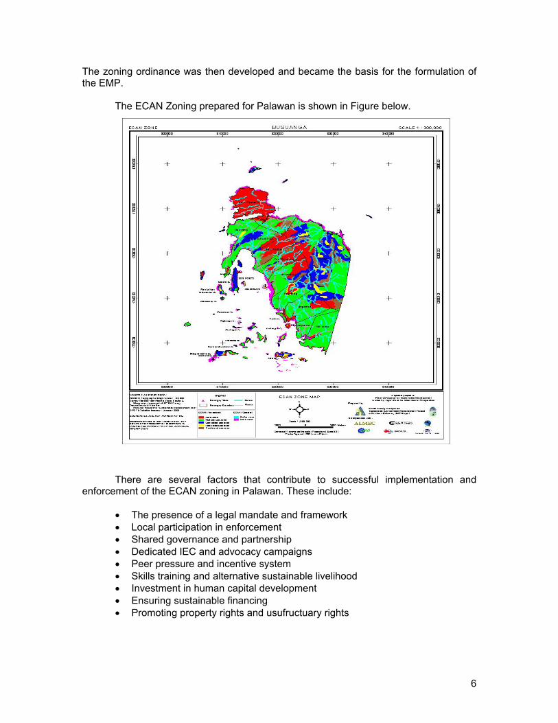
Environmentally-critical areas network (ECAN) Zoning was developed for application to the Palawan Province, which is considered as the last remaining frontier in the Philippines. ECAN Zoning is mandated in the Strategic Environmental Plan (SEP) law or Republic Act 7611 that was enacted in 1992, and how it should be carried out is also fully described in this law. ECAN zoning relates terrestrial and aquatic resources planning in a landscape and seascape continuum and regulates the uses and management of the natural environment of the Province. ECAN zoning categories are almost similar to the PA zoning except for some categories that are distinct from PA zoning. The zoning categories of ECAN for the terrestrial component are: (1) Core zone; (2) Buffer use zone; and (3) Multiple use zone.
The zoning categories for coastal and marine components comprise the following: (1) Coastal/Marine Core Zone; (2) Coastal/Marine Multiple Use Zone; and (3) Ancestral Coastal/Marine Waters.
Ecological zoning is the process of assessing, delineating and marking areas based on their biophysical or natural and anthropogenic attributes to regulate land uses and natural resources development in accordance with their ecological integrity and carrying capacity. In discussing this, Dean Cabrido provided an overview on the characteristics and criteria for Ecological Area Network (ECAN) Zoning and how it was applied in Palawan, Philippines.
The presentation covered (1) legal basis for the ECAN zoning done in Palawan (2) description of the terrestrial and coastal/marine component part of the zonal classification (3) ECAN zoning criteria.
The Environmental Management Plan (EMP) provides the policies, strategies, actions, institutions and funding to implement the ECAN Zones Management Guidelines.
6
The zoning ordinance was then developed and became the basis for the formulation of the EMP.
The ECAN Zoning prepared for Palawan is shown in Figure below.
There are several factors that contribute to successful implementation and enforcement of the ECAN zoning in Palawan. These include:
The presence of a legal mandate and framework Local participation in enforcement Shared governance and partnership Dedicated IEC and advocacy campaigns Peer pressure and incentive system Skills training and alternative sustainable livelihood Investment in human capital development Ensuring sustainable financing Promoting property rights and usufructuary rights

7
CASE STUDIES
Moreton Bay Marine Park Zoning Plan Review: Strategies and lessons Mr. Mark Simmons, Queensland Environmental Protection Agency
An example of a zoning plan done in Moreton Bay was presented by Mr. Mark Simmons of the Queensland Environmental Protection Agency. The presentation focused on the review of the Moreton Bay marine park zoning since it expired in September 1, 2008.
Moreton Bay Marine Park’s significant economic contribution to Australia can be shown in the revenue generation of the following sectors:
Tourism: ~$500 million per annum (2006) Commercial fishing: ~$24 million per annum (2006) value of landed catch Recreational fishing: ~$194 million per annum (2000-2001) total associated
expenditure Aquaculture: ~$15 million per annum (2005-2006)
To maintain the resources brought by the park, the review takes into consideration the changes in patterns and the levels of use over the past 10 years. Mr. Simmons described the previous zoning plans and the process undertaken as shown in Figure 3.
Figure 3. Timeline for the review.
Mr. Simmons identified the key factors that led to successful review: Political support, as it had the backing of major national and local politicians; Decisions had strong scientific basis; Extensive and well-planned communication and consultation. Stakeholders
were involved; and Clear process.
The new zoning plan resulted to commitments of the Queensland Government in the financing and monitoring program, including a commitment to review the program over five years through a partnership approach to assess the ecological and social effectiveness of the zoning. The QLD has also allocated $14 million in structural

8
The Zoning Process
Xxx
The Marine
Spatial Use Plan
of Tawi-tawi,
Philippines
(Final)
adjustment package to minimize the cost of zoning to the commercial fishing sector and a $1 million allocation for the artificial reef program.
Fisheries Use Zoning: A FISH Project Initiative to Enhance Fisheries Resource Management Interventions Nygiel Armada, FISH Project
Mr. Armada described the fisheries use zoning applied in the FISH project which was guided by the application of marine spatial planning (MSP) in the Great Barrier Reef, but modified in consideration to a smaller geographical scale, related initiatives in the site, technical staff, and available financial resources. Experiences from other tropical areas in the East Asian region were also considered such as those applied in the Tun Sakaran Marine Park, Semporna Islands, Sabah, Malaysia; Wakatobi and Komodo National Parks, Indonesia, Integrated Coastal zone management (ICZM) zoning scheme for Xiamen, China; the Integrated Land, Coastal, and Sea Use Zoning of Batangas Bay and Bataan Province, Philippines.
The fisheries-use zoning was done to change the management patterns for fisheries and in effect, increasing fishcatch by 10%. This target was based on a simulation model to project potential scenarios if either management or business as usual management is employed.
The zoning process was followed: orientation and objective setting; mapping of current fisheries and other water uses; determining and evaluating interaction among the various uses to identify
possible multiple use conflicts and use and habitat incompatibilities; mapping of current and future uses taking into consideration resolution of
conflicts; field validation with stakeholders and representatives of resource users; consultation with local government executives and legislators; finalization of fisheries use zoning maps; consultation with a broad base of stakeholders and resource users; and legitimizing zoning plans through legislation or other kinds of policy
instruments.

9
MSP, in general, or fisheries use zoning, in particular, linked the various fisheries resource management initiatives. It enhances the objectives for doing registration and licensing. It further puts spatial perspective to species-specific and fishing gear-specific management interventions. It rationalizes enforcement efforts and sets the ground for the still on-going project activity to limit fishing effort and in implementing an appropriate fishing effort configuration for each particular unit of marine ecosystem shared by various users.
Choosing Boundaries to Marine Protected Areas and Zoning the MPAs for Restricted Use and Management Dr. Hugh Kirkman, Marine Science and Ecology, Australia
The South Australian Government has established a carefully designed network of 19 multi-use MPAs. A key milestone in the process was the delineation and proclamation of the outer boundaries of this network of MPAs. These boundaries were developed by the South Australian Government with assistance and advice from a range of State Government agencies, ministerial advisory groups and scientific experts. The boundaries were selected through a rigorous process of technical assessment and were refined through consultation process.
The boundaries represent the outcome of applying chosen Design Principles to build a robust network that meets the objectives of the Marine Parks Act 2007 and reflect the world’s best practice in marine parks design.
Fourteen biophysical design principles were adopted by the South Australian Department for Environment and Heritage to guide the development of South Australia’s marine park boundaries:
1. Use of precautionary or anticipatory approach 2. Ensure comprehensiveness 3. Ensure adequacy 4. Ensure representativeness 5. Ensure connectivity and linkages 6. Ensure resilience and vulnerability 7. Account for ecological importance 8. Complement and synergize with existing protected areas 9. Accompany other conservation practices and agreements 10. Consider all marine uses 11. Consider indigenous interests and culture 12. Consider cultural heritage 13. Facilitate identification and compliance and enforcement 14. Facilitate education, appreciation and recreation.
He noted that the first four are the overarching biophysical principles that guide the boundary of the MPA as a whole. The secondary biophysical design principles serve to focus on key/irreplaceable areas within a region. The last seven are related to the socioeconomic principles that recognize varied users of the marine environment and seek to align marine parks so that those uses continue and are sustained in the future.
With the delineation of the boundaries, the MPA zoning then took place. The general zones include:

10
General Managed Use; Habitat Protection; Sanctuary Use; Restricted Access; and Special Purpose Areas.
The same 14 design principles will be applied but others may be invoked to assist with demonstrating a scientific approach to zoning, e.g., buffering or having more restrictive zones within less restrictive zones; complementarity or considering surrounding terrestrial and marine uses; commitment to a monitoring and evaluation process, cost-effective and co-operative operation of parks, and developing indicators to simplify monitoring; and a principle seeking to meet international obligations.
Dr. Kirkman emphasized the importance of community consultation throughout the zoning process. He said that the selection of the South Australian marine parks has taken five years of scientific deliberations, community, government, institutional and international experts’ participation to ensure the support of various stakeholders and to generate the necessary data to support the zoning process.
Public-Private Sector Partnership Participation in the Development and Implementation of Coastal Land and Sea-Use Zoning Plan in Bataan Engr. Alexander Baluyot, Bataan Integrated Coastal Management Program, Bataan Province, Philippines
The Bataan land and sea-use zoning was developed as a mechanism to resolve five major problems including:
Pollution from land- and sea-based activity Illegal and destructive fishing methods Siltation and Sedimentation Proliferation of informal settlers Habitat degradation.
Apart from these issues, multiple use conflicts are the primary reasons for zoning. Conflicts arose:
Between shipping and port zone with fishing and aquaculture activities; Due to reclamation activities within mangroves and mudflat protection
areas; Due to various land development in agriculture and fishpond areas; and Due to proliferation of informal settlers within tourism areas, mangroves
zones and even in the river banks, among other areas.
Zoning is seen as a tool that will lessen the impact of problems and will harmonize conflicts. The Coastal Land- and Sea-use Zoning Plan had been formulated to define the uses of the different zones in the Bataan Coastal Area and municipal water. These zones are being classified and designated based on the level of development, utilization and/or resources available in the area.

11
There are two pilot sites — Abucay and Balanga. These municipalities are implementing zoning by ensuring that activities within designated zones are observed. The role of the private sector is in the implementation of zoning, i.e., providing support to municipalities and communities in implementing appropriate projects on the ground. Some of these activities include providing livelihood projects consistent with permitted activities in the zone. Information and public awareness campaigns are also some of the activities supported by the private sector.
Local Climate Change Adaptation Measures in Hawaii Dr. Kem Lowry, University of Hawaii, Manoa, USA
Dr. Lowry’s presentation focused on sea level rise in Hawaii and the importance of zoning in planning coastal area uses. In Hawaii, sea level rise is estimated at 0.24 m by 2050 and 1 m by 2100. Based on the 2007 State of Hawaii Multi-Hazard Mitigation Plan, 2007 erosion multiplier of 150 would result in beach retreat of 36 m.
Erosion and retreat has already led to a loss of 4 miles of beaches over the last 50 years. Twenty-five percent of sandy beaches on island of Oahu have been lost or narrowed because of shoreline hardening.
In order to manage these, several tools are used such as: Beach nourishment. Beach nourishment is a costly process. In the case of Waikiki, the cost has been more than $25 million over five years. Shoreline setbacks. The shoreline setback entails a minimum of 40’ setback line required by state law in Hawaii. Variable setback lines were established on Maui and Kauai in consideration to the life expectancy of structures which is generally 70-100 years multiplied by the erosion rate (adjusted for sea level rise). Permanent structures are not allowed within setback area. Special Management Area [ICM]. This is applied to coastal zone management area extending a minimum of 300 ft. landward from shoreline. Land use requires a special management area permit from the county which is subject to coastal policies.

12
Coastal policies require adequate shoreline access, consistency with county land use plans, no substantial adverse environmental impacts, minimal alteration of landforms, no alteration of beach size etc.
Urban zoning is helpful as it defines multiple categories of land use including residential, commercial, industrial, public facilities — and hazard and open space. It provides control over location, density, building height and lot siting. It also creates presumption of right to build.
Tsunami zones have been designated on all islands. Flood zone designation establishes areas within which flood insurance is
required.
Possible adaptation initiatives in Hawaii include:
Stricter enforcement of illegal seawalls regulations; More beach protection plans with increased community involvement; Stricter building code requirements in flood-prone areas; Reduced insurance subsidies for new or re-built structures in most flood-prone areas; and Identification of potential 75-100-year sea level rise “impact zones” on each island.
There are key assumptions about longer term inundation scenarios. Many of the questions associated with sea level rise are primarily technical. However, identifying some of the impacts of sea level rise and designing strategies to address them will create economic winners and losers — and is likely to be intensely political. Dr. Lowry emphasized the importance of developing solutions that are regarded as both effective and legitimate. This requires both technical analysis and transparent deliberative processes involving experts, managers, politicians and citizens.
In selecting the best intervention, the following criteria could be used: Construction and maintenance costs Community risk – Is the strategy appropriate for anticipated sea level rise? Economic efficiency – Is the benefit greater than the resources applied to other approaches Equity – who benefits and who pays in direct costs and dislocations? Institutional feasibility – Is it acceptable to the public? Does it require new institutions to implement?
Distributional Range of Mangroves in Catanduanes Island, Philippines: Inputs to Biobelting and Biosheltering Program for Typhoons, Tidal Surges and Tsunamis Dr. Jimmy T. Masagca and Manrico T. Masagca, De La Salle University-Dasmarinas, Cavite, Philippines; College of Business and Economics, De La Salle University-Manila, Taft Avenue, Manila, Philippines
As one of the measures on climate change adaptation, the presentation focused on the role of mangroves and how this can be improved to be effective in biobelting and biosheltering under the Sustainable Resource Management for Mangrove Biodiversity Conservation (SURMABIOCON).

13
Initial research conducted in the site served as input in reforestation efforts in Palnab-Pajo and Magnesia del Sur in the Municipality of Virac, Catanduanes. These sites focus on mangrove habitat restoration that considers anthropogenic degradation and restoration following natural disturbances.
Some of the following methods are being adopted in Catanduanes Island, Philippines:
structural manipulation (trees, land and water):planting trees and hydrological engineering; and compositional manipulation (species diversity and habitat recovery): seeding and planting multiple species to increase productivity.
Dr. Masagca articulated that while the communities have moved forward in mangrove reforestation, there are some specific needs of the project that should be considered such as:
a. specific tools for land and sea-use zoning, tools of ICM (integrated coastal management) and ecosystem-based management (EBM) concepts;
b. the information [e.g., existing stressors or resistant areas] on managing mangroves for resilience to climate change; and
c. designs and strategies in presenting to the local coastal dwelling communities vis-a-vis sea level rise, typhoons, tidal or storm surges and tsunamis.
He also identified some of the obstacles that impede the reforestation initiatives: inappropriate political intervention at the municipal/provincial levels; lack of knowledge, expertise and baseline data about the biophysical
conditions of the mangrove areas under study; and diverse intents on the mangrove resources leading to communication gaps.
OPEN FORUM AND DISCUSSION
Among the clarifications made were as follows:
Dr. Kem Lowry’s Presentation: Is the general trend in Hawaii letting nature take its course or building infrastructures to cope with climate change?
Dr. Lowry replied that Hawaii is ‘letting nature take its course’ in some areas and adopting several measures to prevent potential impacts of climate change in others.
On ecosystem valuation on coastal reclamation (Wen): What are the bases in selecting the models and variables in the recommended models for ecosystem valuation?
Ms. Wen replied that the models and parameters are based on various considerations. Ms. Wen said that it would be difficult for her to explain due to language problem.
14
Suffice to say that there is a need to adjust user fee standards for sea reclamation, taking into consideration the different ecosystem services and economic potential of the reclaimed area. This would help regulate the level of reclamation and safeguard sustainable development of the coastal zone.
A participant commented that the technical aspect of zoning may be easy but the commitment of the national and local governments to implement zoning is one of the challenges in the region. This was seconded by a participant in the Philippines saying that local-national delineation and functions on implementation and enforcement are major concerns.
ANALYSIS, CONCLUSIONS AND RECOMMENDATIONS
Zoning is generally recognized as an important tool for sustainable management of land and sea areas. The level of technical zoning done by countries and sites ranges from specific habitats to broader zoning for sea and coastal areas. Despite its importance in the sustainable allocation of uses and resources, countries in the EAS region have yet to fully implement land and sea-use zoning schemes due to various challenges in administrative and local capacity. Meanwhile, in some countries which developed comprehensive land and sea use zoning schemes, enforcement and policy support continues to be among the major issues.
As emphasized in the land and sea-use training prior to the EAS Congress workshop, there is a need to distinguish zoning as a technical exercise and zonation as a legal instrument (Serote). Zonation can only be effective if governments are able to provide the necessary legal mechanisms at the national and local levels to enforce and implement regulations and policies. Developing and harmonizing national and local guidelines based on national and international standards
The implementation of these guidelines also depends on technical skills of local and national implementers. Capacity development for local institutions on technical and legal aspects of zonation should be continually pursued in countries if zoning schemes are to be implemented effectively.
Since zoning cuts across various sectors and geographic boundaries, there is a need to have an institutional mechanism for inter-agency decisionmaking regarding resources in shared jurisdictions.
As a market-based instrument for managing coastal and marine areas and resources, creating the right incentives for the private sector to comply with the zoning schemes and regulations should also be considered.
In terms of the technical aspect, there is a need to: a. Develop a set of criteria [e.g., elevation, spatial extent of resource] for
designating boundaries of zones to guide the local planners in the process. b. Match governmental management activities with the degree of risks and
uncertainty associated with climate change. c. Insure that the designated size of marine protected areas reflects
community management capacity and resource characteristics. d. Insure that zoning schemes are implemented equitably.
15
There is general agreement that case studies on the implementation of zoning are needed by countries to guide them in the implementation process. However, such case studies would need to be contextualized or understood in a broader political and legal framework and will have to be understood in specific political and social contexts.
There is a need to determine management objectives and clearly define the dominant uses (both current and future) of land and sea areas. One of the major problems in the zoning is the uncertainty of resource use and coastal-area allocation over time, making it almost impossible to ‘predict’ resource use patterns over time. Hence, effective land and sea-use plans need to carefully consider development plans and resource patterns in the site.
Furthermore, there needs to be a clear reconciliation of the priority uses and the management objectives of the areas being zoned (e.g. zoning for conservation areas).

16
PRESENTATIONS AND SOURCES
Impacts of Sea Reclamation on the Coastal Ecosystem Dr. Zhang Zhaohui, First Institute of Oceanography, State Oceanic Administration of China, Su Weixiao, Environment Science and Technology School, Ocean University of China, Wang Zongling, First Institute of Oceanography, SOA
Monetary Evaluation on Depletion of Coastal Ecosystem ServicesMs. Xuan Wang, Dr. Weiqi Chen, Prof. Luoping Zhang, Coastal and Ocean Management/Environmental Science
Urban Spatial Expansion and its Effects on Island Ecosystem: A Case Study of the Island City of Xiamen, Southeast ChinaDr. Lin Tao, Zhao Qianjun, Cui Shenghui, Shi Longya, Gao Lijie, Institute of Urban Environment, Chinese Academy, Xiamen, China
Ecological Zoning as a Policy Tool for Sustainable DevelopmentDr. Candido Cabrido, Dean, School of Urban and Regional Planning, UP Diliman
Moreton Bay Marine Park Zoning Plan Review: Strategies and lessonsMr. Mark Simmons, Queensland Environmental Protection Agency
Fisheries Use Zoning: A FISH Project Initiative to Enhance Fisheries Resource Management InterventionsNygiel Armada, FISH Project
Choosing Boundaries to Marine Protected Areas and Zoning the MPAs for Restricted Use and ManagementDr. Hugh Kirkman, Marine Science and Ecology, Australia
Public-Private Sector Partnership Participation in the Development and Implementation of Coastal Land and Sea-Use Zoning Plan in BataanEngr. Alexander Baluyot, Bataan Integrated Coastal Management Program, Philippines
Local Climate Change Adaptation Measures in HawaiiDr. Kem Lowry, University of Hawaii
Distributional Range of Mangroves in Catanduanes Island, Philippines: Inputs to Biobelting and Biosheltering Program for Typhoons, tidal surges and tsunamisDr. Jimmy T. Masagca and Manrico T. Masagca, De La Salle University-Dasmarinas, Cavite 4115, Philippines; College of Business and Economics, De La Salle University-Manila, Taft Avenue, Manila, Philippines