woodman point regional park
TRANSCRIPT
Woodman Point Regional Park
Management Plan
2010
Conservation Commission of Western Australia
Department of Environment and Conservation
City of Cockburn
Department of Transport
Department of Sport and Recreation
ii
Woodman Point Regional Park
Management Plan
2010
PLANNING TEAM The Planning Team, representing the managers of Woodman Point Regional Park, coordinated the development of this plan on behalf of the Conservation Commission of Western Australia. The Planning Team was assisted by a consultancy team led by CoastWise. Jacinta Overman Department of Environment and Conservation Brendan Dooley Department of Environment and Conservation Tim Bowra Department of Environment and Conservation Tim Swart Department of Sport and Recreation James Holder Department of Transport Robert Avard City of Cockburn
iii
How to Use This Plan This Plan is divided into chapters and sections as set out in the table of contents. Guiding principles are stated at the beginning of each chapter. An objective is given at the beginning of each section, followed by a discussion of the main issues and then strategies, which list responsible agencies and a priority rating. Priority ratings provide an indication of the relative importance of a strategy. Key performance indicators are listed in the Plan and outline performance measures, targets and reporting requirements. A number of issues raised in this Plan are interrelated and are dealt with under more than one section. Where this is the case, the discussion refers the reader to other related sections. ACKNOWLEDGEMENTS Numerous individuals and groups have contributed valuable ideas and information in the preparation of this Plan and their efforts are gratefully acknowledged. In particular, the contribution of the Woodman Point Regional Park Community Advisory Committee is appreciated. The assistance of the CoastWise consultancy team is also appreciated. NOMENCLATURE Inclusion of a name in this publication does not imply its approval by the relevant nomenclature authority. THE CONSERVATION COMMISSION OF WESTERN AUSTRALIA AND THE DEPARTMENT OF ENVIRONMENT AND CONSERVATION All national parks, conservation parks, nature reserves, and other similar reserves are vested in the Conservation Commission of Western Australia. These reserves are managed on behalf of the Conservation Commission of Western Australia by the Department of Environment and Conservation. As the controlling body, the Conservation Commission of Western Australia is responsible for having management plans prepared for all lands that are vested in it. This plan has been prepared by the Department of Environment and Conservation on behalf of the Conservation Commission of Western Australia.
iv
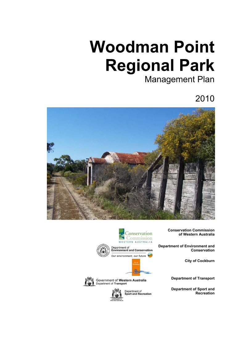
Preface Regional parks consist of areas of land that have been identified as having outstanding conservation, landscape and recreation values. Regional parks may consist of land areas managed by a range of different management agencies, and private landowners. Regional parks therefore, provide the opportunity for a consortium of land managers and land owners to work together to develop a coordinated management approach. The concept of regional parks was first proposed in 1955 in the Stephenson-Hepburn Report. This report recommended that land required for future public purposes be identified and reserved. The Perth Metropolitan Region Scheme (MRS) was established in 1963 and the process of reserving land for ‘Parks and Recreation’ began. Since then, State planning agencies have been reserving and acquiring land in anticipation of the time when regional parks would formally be created. In 1997, the Government of Western Australia announced a commitment to introduce legislation to give regional parks legal standing and vesting in the former National Parks and Nature Conservation Authority, now the Conservation Commission of Western Australia (Conservation Commission). To date eleven regional parks have been established in the Perth metropolitan area with coordination of their management progressively transferred to the Department of Environment and Conservation (DEC). However, many of the reserves within regional parks remain the management responsibility of local government and other management agencies such as the Department of Sport and Recreation (DSR). DEC plays an important coordinating role in bringing all management agencies together. In addition, DEC facilitates the involvement of Community Advisory Committees, which provide ongoing community input to the management of the parks. This management plan represents a commitment by DEC, DSR, the Department of Transport (DoT), the City of Cockburn, and the community to cooperatively manage Woodman Point Regional Park. The primary responsibility of DEC is to manage the areas of the Park that are vested in the Conservation Commission and coordinate the involvement of other management agencies. DSR is primarily involved in managing the Woodman Point Recreation Camp, and the City of Cockburn continues to manage the reserves vested in it. DoT is responsible for the management of the Woodman Point Recreational Boating Precinct and associated infrastructure. Woodman Point Regional Park is important for its nature conservation value, its cultural heritage and for the recreational opportunities it provides. The Park protects a threatened ecological community of Rottnest cypress and Rottnest tea tree. It has cultural significance for Aboriginal people, and is rich in heritage places relating to the development of Western Australia. Woodman Point is intrinsically linked to Cockburn Sound, Jervoise Bay and Owen Anchorage and provides a regionally important access point to these protected embayments for water-based recreation activities in the southern metropolitan area. While the Park has undoubtedly high nature conservation value, it is at the same time beset by a number of management issues such as widespread weed invasion, fire risk, feral animal impacts, development pressures and vandalism. This management plan, which is based on previously prepared ecological, recreational and historical surveys and information collected during the study period, seeks to establish a clear vision as to how best to manage and protect Woodman Point Regional Park. The Woodman Point Regional Park Community Advisory Committee was established early in the planning process to provide input during the preparation of the plan. The draft plan was released for public comment on 30 August 2002 until 30 November 2002. This final plan reflects the outcomes of the investigative and consultative periods and provides the way forward for the sustainable and cooperative management of the Woodman Point Regional Park. It is recognised that a considerable period of time has elapsed since the draft management plan was released for public comment in 2002. The delay in preparing the final management plan in no way diminishes the value of the contributions made by any organisation or individual. These contributions are important, and remain critical to the integrity of the management plan and ultimately, to the management of the Park. Some issues that impacted on the draft management plan in 2002 may no longer be current or may have changed. New issues have also arisen. In finalising the management plan, DEC has attempted to capture the changes that have occurred since 2002 with individual stakeholders and managing agencies, without compromising the integrity of the original process of developing the draft plan.
v
Table of Contents A. INTRODUCTION 1 1. Purpose and Status of the Management Plan ........................................................................1 2. Regional Parks........................................................................................................................1 3. Woodman Point Regional Park...............................................................................................2 4. The Management Planning Process and Community Involvement........................................5 B. PRINCIPAL MANAGEMENT DIRECTIONS 6 5. The Vision for the Park............................................................................................................6 6. Legislation and Management Policies ....................................................................................6 7. Park Boundary ........................................................................................................................6 8. Land Tenure............................................................................................................................7 9. Park Management Zones........................................................................................................8 10. Integrated Management of the Park .....................................................................................12 11. Key Performance Indicators, Monitoring and Reporting .......................................................12 12. Research...............................................................................................................................13 C. CONSERVING THE NATURAL ENVIRONMENT 14 13. Guiding Principles for Conserving the Natural Environment.................................................14 14. Geomorphology, Geology, Soils and Hydrology...................................................................14 15. The Coast and Foreshore .....................................................................................................15 16. Flora and Vegetation.............................................................................................................17 17. Fauna ....................................................................................................................................21 18. Weeds ...................................................................................................................................23 19. Fire ........................................................................................................................................24 20. Pets and Problem Animals....................................................................................................25 21. Rehabilitation ........................................................................................................................27 22. Park Aesthetics and Landscape Amenity ............................................................................28 23. Regional Ecological Linkages and Greenways.....................................................................29 D. MANAGING CULTURAL HERITAGE 30 24. Guiding Principles for Managing Cultural Heritage...............................................................30 25. Aboriginal Cultural Heritage ..................................................................................................30 26. Non-Aboriginal Cultural Heritage ..........................................................................................31 E. MANAGING RECREATION 34 27. Guiding Principles for Managing Recreation........................................................................34 28. Visitor Use.............................................................................................................................34 29. Recreation Masterplan..........................................................................................................36 30. Recreation Sites and Facilities..............................................................................................36 31. Park Access and Circulation .................................................................................................40 32. Signs .....................................................................................................................................42 33. Visitor Safety .........................................................................................................................42 F. MANAGING SUSTAINABLE RESOURCE USE 43 34. Guiding Principles for Managing Sustainable Resources Use .............................................43 35. Commercial Concessions – Leases and Licences ...............................................................43 36. Mining and the Extraction of Basic Raw Materials................................................................47 37. Utilities and Park Services ....................................................................................................48 38. Development Proposals Affecting the Park ..........................................................................49 G. WORKING WITH THE COMMUNITY 50 39. Guiding Principles for Working with the Community.............................................................50 40. Community Involvement........................................................................................................50 41. Information, Interpretation and Education.............................................................................51 H. IMPLEMENTING AND EVALUATING THE PLAN 53 42. Priorities, Staff and Funding Arrangements..........................................................................53 43. Term of the Plan....................................................................................................................53 44. Performance Assessment.....................................................................................................53 REFERENCES AND BIBLIOGRAPHY 57
vi
APPENDICES 61 Appendix A - Department of Environment and Conservation Policies Referred to in this Plan.........61 Appendix B - Abbreviations used in this Plan ....................................................................................62 Appendix C - Glossary .......................................................................................................................63 Appendix D - Contacts .......................................................................................................................65 FIGURES Figure 1 - Regional Park Planning Hierarchy......................................................................................2 Figure 2 - Park Location......................................................................................................................3 Figure 3 - Land Tenure and Park Boundary .......................................................................................9 Figure 4 - Management Zones and Areas ........................................................................................10 Figure 5 - Conceptual view of shoreline movement since 1942 .......................................................16 Figure 6 - Vegetation Distribution .....................................................................................................20 Figure 7 - Recreation Masterplan .....................................................................................................39 TABLES Table 1 - Management Zones and Tenure Arrangements................................................................11 Table 2 - Floristic Community Types at Woodman Point Regional Park..........................................17 Table 3 - Performance Assessment..................................................................................................55
Part A. Introduction
1
A. INTRODUCTION
1. Purpose and Status of the
Management Plan PURPOSE OF THE PLAN The purpose of this management plan (‘the Plan’) is to provide the overarching approach for the protection and enhancement of the conservation, recreation and landscape values of Woodman Point Regional Park (‘the Park’). The Plan includes strategies aimed at conserving the special features of the Park and providing for future community requirements. The Plan will also help to sustainably manage significant nature conservation and cultural values while allowing for an appropriate level of use by the community. Given the strategic nature of the Plan, more detailed planning (referred to as subsidiary plans) is required prior to significant works taking place within the Park (these are listed in Section 42). STATUS OF THE PLAN The Plan has been prepared in accordance with the Conservation and Land Management Act 1984 (CALM Act). It provides the statutory framework for the management of lands within the Park vested in the Conservation Commission and managed by the DEC on the Commission's behalf. The Plan also guides DEC in coordinating the involvement of other managing agencies. The Conservation Commission and DEC will seek to ensure that planning undertaken by other managing agencies for areas within the Park is consistent with the overall direction and principles of the Plan. In consultation with DEC, the WAPC will use the Plan to assist with assessing development proposals on lands within and adjoining Woodman Point Regional Park to ensure that proposed land use is compatible, and to limit impacts upon the conservation and social values of the Park. The strategies contained in the Plan have been endorsed by the Park’s managing agencies, namely DSR, DoT and the City of Cockburn. These management agencies will manage their respective landholdings in accordance with the Plan and in consultation with DEC. 2. Regional Parks
WHAT IS A REGIONAL PARK? Regional parks are areas identified as having regionally significant conservation, landscape and recreation values. Regional parks are a land management system that provides the opportunity for a coordinated planning and management approach by a number of management agencies and private land owners.
Regional parks may comprise Crown lands vested in State government agencies or local governments, or private lands, where the agreement of the landowner is obtained. As such regional parks may comprise lands with a variety of tenures and reserve purposes, drawn together for coordinated management by DEC. Woodman Point Regional Park, for example, consists of land comprising Crown reserves vested in the City of Cockburn, the Conservation Commission, the Minister for Sport and Recreation, and the Minister for Transport. It also contains land leased to Cockburn Cement Ltd. THE REGIONAL PARK CONCEPT The concept of regional open space was first introduced to Western Australia by the Stephenson-Hepburn Report in 1955, which recommended a statutory region plan be prepared for Perth which reserved private land required for future public purposes. The Perth Metropolitan Region Scheme (MRS) was established in 1963 and under the scheme, land was reserved for ‘Parks and Recreation.’ This land (subject to amendments of the MRS) has been gradually acquired by State planning authorities with the intention of protecting open space of regional significance for conservation and recreation. Areas with regionally significant conservation, landscape and recreation value were identified by the Environmental Protection Authority (EPA) in Conservation Reserves for Western Australia, The Darling System – System 6 (Department of Conservation and Environment, 1983). This report also recommended areas of land to be managed as regional parks. A system of regional parks was envisaged which included the land reserved for ‘Parks and Recreation’ in the MRS at Woodman Point, namely the quarantine station and explosives magazine reserves (Locality M90 in the System 6 Report). In 1989, the State government decided that the responsibility for managing regional parks would be established with the then Department of Conservation and Land Management, now DEC, and that the responsibility for planning the acquisition of lands for regional open space would be retained by the then Department for Planning and Urban Development (DPUD, now DoP) on behalf of the Western Australian Planning Commission (WAPC). In 1991, a task-force report outlined proposed administration, planning and management of regional open space (Regional Parks Taskforce, 1990). The EPA’s Red Book Status Report (Environmental Protection Authority, 1993) describes the transformation of regional parks from concept to

2
reality as being difficult because of the range of land tenure involved and the funding requirements for continual management of the parks. In June 1997, the State government announced a commitment to introduce legislation to give regional parks legal standing and vesting in the former National Parks and Nature Conservation Authority, now the Conservation Commission. It was established that the coordination of management of metropolitan regional parks, including Woodman Point Regional Park, would be progressively transferred to DEC. REGIONAL PARK PLANNING Planning for regional parks occurs at a number of levels. Regional park management plans are a part of a broad suite of planning undertaken by the relevant managing agencies. Figure 1 illustrates the planning levels typically undertaken for regional parks. Legislation Agency policies, and corporate / business plans Regional park management plans
Local area management plans Subsidiary plans e.g. fire response plans, weed management plans, site development plans Operational/action plans, annual works programmes
Source: ANZECC 2000. Figure 1 - Regional Park Planning Hierarchy Implementation of local area management plans, subsidiary plans, operational/ action plans and annual works programmes will be consistent with the overall direction of this Plan. 3. Woodman Point Regional Park
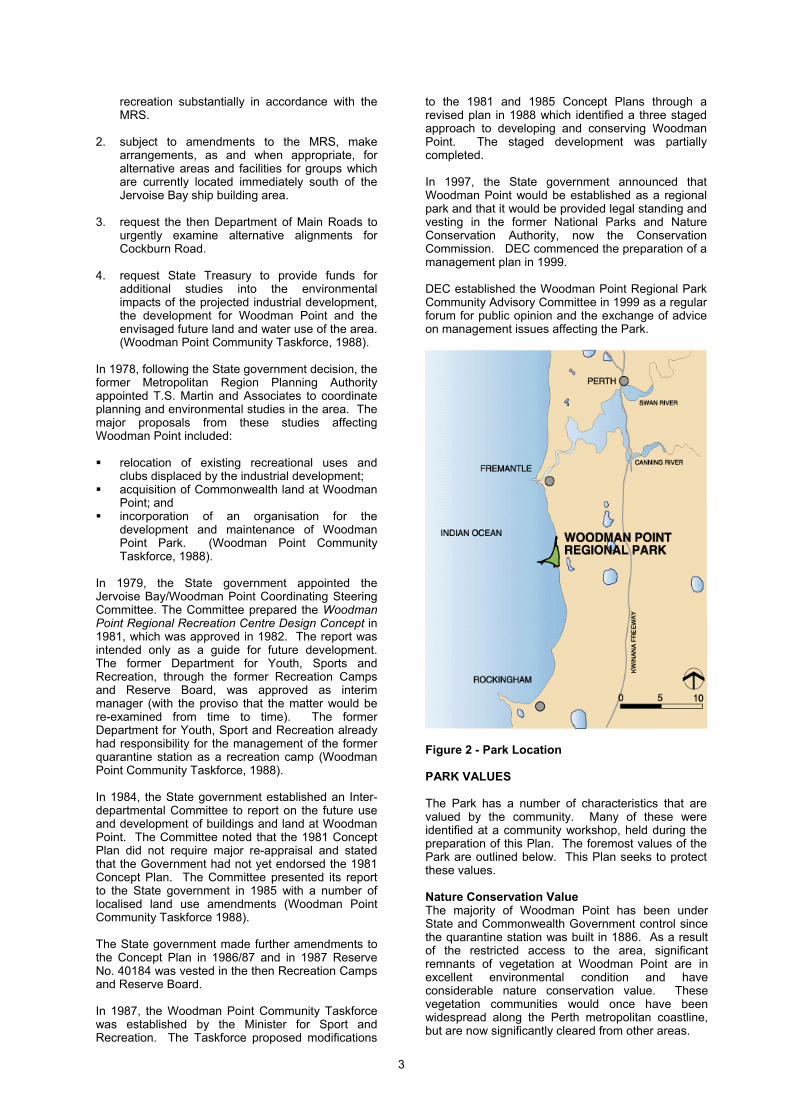
Woodman Point Regional Park is located on the coast approximately 9 kilometres south of Fremantle (Figure 2) within the municipality of the City of Cockburn. The Park is accessed by road from Cockburn Road which is a main road linking Fremantle, Kwinana and Rockingham. The Park covers an area of 251.8 hectares and is situated on a relatively narrow beach-ridge plain extending to a peninsula which formed as a result of sediment accumulation during the Holocene period, since the end of the Pleistocene period (Department of Conservation and Environment, 1980). Woodman Point, and its associated offshore tombola, separates Owen Anchorage from Jervoise Bay and also marks the northern extent of Cockburn Sound. To the east
of the Park, a west-facing slope and dominant north-south ridgeline of Tamala Limestone provides a geological border to the peninsula formation. Woodman Point is an important component of a series of regionally significant bushland reserves in the southern metropolitan area. The western chain of wetlands of Beeliar Regional Park and Henderson Foreshore are located to the east and south. Woodman Point provides a vegetated east-west corridor link to the wetland chain from the coast. Such corridors are not common in the Perth metropolitan area. The Cockburn coast, of which Woodman Point is a part, is an important recreation resource in a sector of the Perth Metropolitan Region that is growing rapidly. Population projections for the City of Cockburn indicate population growth to around 114,000 residents by 2021. This will see an almost doubling of the City's population from 2004 (Western Australian Planning Commission, 2005). The City of Fremantle, to the north, and Town of Kwinana, to the south, are also projected to grow in population. These areas are within a ten kilometre catchment of Woodman Point, and the increased population will create greater demand for access to the coast, as well as the Park’s recreation facilities (Ecoscape/Coastwise, 1999). The Park attracts visitors from a broad area within metropolitan Perth, as indicated in surveys of visitor use completed by Barnes in 1998 and Colmar Brunton in 2001 and 2005 (Section 28). Access to the southern metropolitan coastline is increasingly restricted by industrial and residential development. Woodman Point Regional Park represents one of the few places between Fremantle and northern Rockingham where the coast is maintained for conservation and recreation. The pressures on the Park and challenges of the managing agencies will continue to grow over time. It will be the role of the Park managers, with support from the community, to implement this Plan to effectively manage and counter those pressures. ESTABLISHMENT OF WOODMAN POINT REGIONAL PARK During the 1970s the State government, conscious of the need for an area for the construction and repair of larger ships in the environs of Perth, commissioned Maunsell-Yard to report on the matter. Reports were submitted in 1974 and 1975 that recommended development of suitable marine facilities for industry in Jervoise Bay, just south of Woodman Point. This development increased the importance of Woodman Point as the major focus for coastal recreation between Fremantle and Rockingham (Woodman Point Community Taskforce 1988). On the basis of a subsequent report in 1976 by the Department of Industrial Development titled Proposed Rationalisation of Jervoise Bay for Marine-based Industries and Recreation, the State government resolved in 1978 that – 1. the State government will progressively acquire
land at Woodman Point and reserve it for
3
recreation substantially in accordance with the MRS.
2. subject to amendments to the MRS, make
arrangements, as and when appropriate, for alternative areas and facilities for groups which are currently located immediately south of the Jervoise Bay ship building area.
3. request the then Department of Main Roads to
urgently examine alternative alignments for Cockburn Road.
4. request State Treasury to provide funds for
additional studies into the environmental impacts of the projected industrial development, the development for Woodman Point and the envisaged future land and water use of the area. (Woodman Point Community Taskforce, 1988).
In 1978, following the State government decision, the former Metropolitan Region Planning Authority appointed T.S. Martin and Associates to coordinate planning and environmental studies in the area. The major proposals from these studies affecting Woodman Point included: relocation of existing recreational uses and
clubs displaced by the industrial development; acquisition of Commonwealth land at Woodman
Point; and incorporation of an organisation for the
development and maintenance of Woodman Point Park. (Woodman Point Community Taskforce, 1988).
In 1979, the State government appointed the Jervoise Bay/Woodman Point Coordinating Steering Committee. The Committee prepared the Woodman Point Regional Recreation Centre Design Concept in 1981, which was approved in 1982. The report was intended only as a guide for future development. The former Department for Youth, Sports and Recreation, through the former Recreation Camps and Reserve Board, was approved as interim manager (with the proviso that the matter would be re-examined from time to time). The former Department for Youth, Sport and Recreation already had responsibility for the management of the former quarantine station as a recreation camp (Woodman Point Community Taskforce, 1988). In 1984, the State government established an Inter-departmental Committee to report on the future use and development of buildings and land at Woodman Point. The Committee noted that the 1981 Concept Plan did not require major re-appraisal and stated that the Government had not yet endorsed the 1981 Concept Plan. The Committee presented its report to the State government in 1985 with a number of localised land use amendments (Woodman Point Community Taskforce 1988). The State government made further amendments to the Concept Plan in 1986/87 and in 1987 Reserve No. 40184 was vested in the then Recreation Camps and Reserve Board. In 1987, the Woodman Point Community Taskforce was established by the Minister for Sport and Recreation. The Taskforce proposed modifications
to the 1981 and 1985 Concept Plans through a revised plan in 1988 which identified a three staged approach to developing and conserving Woodman Point. The staged development was partially completed. In 1997, the State government announced that Woodman Point would be established as a regional park and that it would be provided legal standing and vesting in the former National Parks and Nature Conservation Authority, now the Conservation Commission. DEC commenced the preparation of a management plan in 1999. DEC established the Woodman Point Regional Park Community Advisory Committee in 1999 as a regular forum for public opinion and the exchange of advice on management issues affecting the Park.
Figure 2 - Park Location PARK VALUES The Park has a number of characteristics that are valued by the community. Many of these were identified at a community workshop, held during the preparation of this Plan. The foremost values of the Park are outlined below. This Plan seeks to protect these values. Nature Conservation Value The majority of Woodman Point has been under State and Commonwealth Government control since the quarantine station was built in 1886. As a result of the restricted access to the area, significant remnants of vegetation at Woodman Point are in excellent environmental condition and have considerable nature conservation value. These vegetation communities would once have been widespread along the Perth metropolitan coastline, but are now significantly cleared from other areas.
4
The Park includes tracts of undisturbed coastal vegetation, including tuart (Eucalyptus gomphocephala) woodland, and significant stands of Rottnest cypress (Callitris preissii) and Rottnest tea tree (Melaleuca lanceolata) that have been identified as a threatened ecological community (see Glossary). Given the decline in tuart populations, the occurrence of healthy tuart woodland in the Park is also of environmental significance. The significance of Woodman Point vegetation communities is also recognised by its permanent listing on the Register of the National Estate. Some parts of Woodman Point have not suffered fire disturbance for over 100 years and therefore remain as benchmark examples of the floristic composition that would have been present in the area before European settlement in the early 1800s (Powell and Emberson, 1981). Woodman Point Regional Park contains a wide variety of ecosystems including shrubland, heath and scrub, and Quindalup woodlands. The coastal foreshore of Woodman Point Regional Park is a habitat for a diverse bird population, some of which are trans-equatorial migratory birds (How et al. 1996). The coastal habitat also provides an important breeding ground for local shore-birds. The tuart woodland is a refuge for a range of bush birds and other species. The flora and fauna of the Park are discussed further in Sections 16 and 17 respectively. Recreation Value Woodman Point Regional Park is one of Perth's most popular beachside areas and provides boating access to Cockburn Sound and Owen Anchorage. The area hosts many activities that are linked to the ocean including swimming, snorkelling, scuba diving, sailing and fishing. The Park also offers picnic and barbecue facilities and many other land-based recreational activities including bird watching, bushwalking, bike riding and heritage interpretation. Major recreation nodes accessible within and from the Park include:
John Graham Recreation Reserve, which contains grassed picnic areas, children’s playgrounds and beach access;
Woodman Point Beach, adjacent to John Graham Recreation Reserve, which provides access to the Woodman Point Jetty and is popular for swimming, fishing, snorkelling and scuba diving;
Coogee Beach, with a popular swimming beach and fishing jetty;
Woodman Point Recreational Boating Precinct, which contains public boat ramps as well as commercial lease areas; and
Woodman Point Headland, a popular fishing location, with Jervoise Bay Sailing Club located on the north shore.
Recreation sites are discussed further in Section 30.
The Park provides excellent opportunities to promote programmes like DEC’s ‘Healthy Parks, Healthy People’, and other healthy lifestyle programmes, which encourage people to visit and enjoy themselves in parks by raising the awareness of the physical, mental and social health benefits of spending time in nature. The Woodman Point Recreation Camp is a strategic community asset managed by DSR providing overnight accommodation (dormitories) and a wide range of aquatic and other recreational activity programmes for camp users. There are two caravan and camping parks offering accommodation within the Park - Woodman Point Holiday Park and Coogee Beach Holiday Park. Cultural Heritage Value Research indicates a large presence of Aboriginal people in the Cockburn district during the early 1800s, prior to European settlement. Artefacts and rock engravings found in the Cockburn district reflect the use of the land by Aboriginal (Nyoongar) people. Consultation with local Nyoongar Elders has revealed strong cultural connections with the Cockburn coast (Ecoscape and Coastwise, 1999). One Aboriginal site within the Park is listed by the Department of Indigenous Affairs (DIA). This is a mythological site which covers part of the Woodman Point headland. Other listed sites adjoin the Park. It is important to note that other sites may exist in or adjacent to the Park that are not yet identified by DIA. Research undertaken by McDonald, Hales and Associates (1997) in consultation with Nyoongar Elders provides information on two sites with mythological significance in the vicinity of Woodman Point. The first relates to the limestone ridge that runs parallel to the coastline immediately to the east of the Park, and the second relates to Woodman Point itself. The significance of these sites is described in Section 25. Woodman Point is also important for the many historical remnants of European settlement including the former quarantine station, crematorium and gravesites, railway link to Fremantle, explosives magazines and jetty, as well as the naval shed and groyne. The former munitions magazines and the former quarantine station (Woodman Point Recreation Camp) are permanently listed on the State Register of Heritage Places. The former quarantine station is also listed on the Register of the National Estate and is classified by the National Trust. A brief account of the European history of Woodman Point is outlined in Section 26. Landscape Value Woodman Point Regional Park provides significant landscape and amenity value to the region. Views of the ocean, including the island landscapes of Garden Island, Carnac Island and Rottnest Island can be appreciated from many vantage points around the Park. It is also possible to watch recreational water sports from the Park. These views are an important part of the Park’s identity and should not be compromised.
5
A variety of landforms contribute to the overall high visual quality of the Park ranging from coastal woodland areas, coastal foreshore dunes, sandy beaches which allow for extensive views, well-maintained areas of grassed parkland and remnants of historical buildings. The relationship of adjoining land uses to the Park landscape can have a significant impact on the overall amenity of the Park. Landscape management is discussed in Section 22. Research and Education Value Woodman Point Regional Park has significant research and scientific value because it contains well-preserved remnant ecosystems that can offer knowledge about the original coastal environments of the region. The Park offers ongoing research opportunities regarding the impact of urban development on conservation, recreation and landscape values. Research and education are discussed further in Sections 12 and 41 respectively. 4. The Management Planning Process and
Community Involvement The Plan for the Park has been prepared in five phases. 1. The first phase was aimed at identifying the
relevant planning and management issues. This was achieved by undertaking a literature review, analysing the existing condition of the Park and organising a community workshop. The community was made aware of the preparation of this Plan through direct liaison with community groups, newspaper advertising, articles and publications produced by the Park’s managing agencies. A community workshop was held in March 1999 as part of the management planning process. The workshop was attended by people representing broad community interests as well as representatives from local government and DEC. Native Title claimants were notified of the Plan’s preparation at the commencement of the process.
2. The second phase was the preparation of the
draft Plan. This involved identifying planning strategies to protect the Park’s values and address the issues identified in phase one. Within this phase, specialists within DEC, the City of Cockburn, DSR, and the Woodman Point Regional Park Community Advisory Committee provided advice on the development of the Plan.
3. The third phase involved presenting the draft
Plan for public comment. The draft was open for public comment for a period of three months and its availability for review was widely advertised.
4. Phase four comprised the acknowledgement
and analysis of public submissions to the draft Plan.
5. The fifth phase involved the preparation of this final Plan, incorporating issues or comments raised in public submissions and comments from State government agencies and the City of Cockburn. The revised Plan has been endorsed by the managing agencies involved in the Park the Conservation Commission. It has been approved for release by the Minister for Environment.
Part B. Principal Management Directions
6
B. PRINCIPAL MANAGEMENT DIRECTIONS
5. The Vision for the Park The long-term vision for the Park is: ‘Woodman Point Regional Park will be a well-managed coastal park supporting and preserving species and habitat diversity in a sustainable manner. The Park will provide for the conservation and preservation of cultural heritage values, as well as providing for the recreational needs of the community, in a visually harmonious way.’ Strategy 1. Manage the Park for conservation, and
allow recreation and other uses to occur to the extent that they do not adversely impact on other Park values. (DEC, DSR, DoT, CoC) [High]
6. Legislation and Management Policies The objective is for DEC to manage the Park in accordance with the CALM Act and to integrate the policies of the other managing agencies to support the vision for the Park. LEGISLATION This Plan has been prepared in accordance with the CALM Act. In managing the Park, DEC will utilise the provisions of the CALM Act, Wildlife Conservation Act 1950 and associated regulations, as well as the provisions of any new legislation under which DEC may have responsibilities for implementation. The CALM Act will need to be amended to provide for the management of regional parks. MANAGEMENT POLICIES Department of Environment and Conservation Policies This Plan is consistent with DEC policies. These policies provide direction and guidance for the application of the CALM Act, Wildlife Conservation Act 1950 and associated regulations. The policies specifically mentioned in this Plan are listed in Appendix A and are available to the public. A number of these policies were under review at the time of writing. Should there be any inconsistencies between this Plan and any revised policy, future management will be in accordance with the new policy. City of Cockburn The management actions of the City of Cockburn in managing its landholdings should be consistent with this Plan.
Department of Sport and Recreation The management actions of DSR in managing the recreation camp should be consistent with this Plan. Department of Transport The management actions of DoT in developing and managing the Recreational Boating Precinct should be consistent with this Plan. Strategy 1. Apply DEC policies in the management of
the Park. (DEC) [Ongoing] 7. Park Boundary The objective is to clearly define the Park boundary for the implementation of this Plan. The Woodman Point Regional Park boundary has been determined by the WAPC and it reflects the existing MRS, under which the entire Park is reserved as ‘Parks and Recreation’. The Park boundary is shown in Figure 3. The coastal boundary of Woodman Point Regional Park extends to the high water mark. Operationally, the City of Cockburn has the jurisdiction and resources for managing beaches abutting the Park. The City administers local laws, which can be used to address management issues such as nude bathing and exercising dogs on the beaches. Management and planning for these beaches therefore requires close interaction between the City of Cockburn and the other managing agencies. Inclusion of other lands into Woodman Point Regional Park The WAPC has jurisdiction for overall planning and the acquisition of lands for regional parks. The inclusion of additional areas into Woodman Point Regional Park is therefore the responsibility of the WAPC, in consultation with DEC, the Conservation Commission and the City of Cockburn. The WAPC is guided by Bush Forever in determining areas to be acquired for conservation purposes (Government of Western Australia, 2000). Bush Forever is a strategic plan that aims to identify and conserve regionally significant bushland on the Swan Coastal Plain portion of the Perth Metropolitan Region. Bush Forever proposes that certain areas of regionally significant bushland be reserved for ‘Parks and Recreation’ in the MRS and/ or acquired by the WAPC for inclusion in the conservation estate. The criteria for assessing additions to a regional park such as Woodman Point are: 1. that the area is identified by Bush Forever as
being regionally significant; 2. that the area is reserved for ‘Parks and
Recreation’ in the MRS; 3. that the area has an appropriate tenure (such
as an existing Crown reserve or freehold land
Part B. Principal Management Directions
7
acquired by the WAPC for inclusion in the Park); and
4. that the area provides a physical link to another area of the Park.
Once potential additions to the Park have been identified against the above criteria, the following considerations are taken into account to ensure that the Park boundary is manageable: condition of the land; future recreational demand; the enhancement of views; fire management; and provision of future services and roads. In addition to the above factors, management resources need to be carefully considered when additional lands are being proposed for inclusion to the Park. Based on the above criteria, and taking into account the above considerations, the Park boundary may be amended to include the following areas. These areas are shown in Figure 4. 1. A portion of the railway reserve adjoins the
Park to the northeast, and is located west of Cockburn Road. This area is reserved for ‘Railways’ in the MRS and is vested with the Minister for Transport. As this area abuts the Park and contains naturally regenerating vegetation, it constitutes a logical extension to the Park boundary should it not be required for the widening of Cockburn Road. An amendment to the MRS to reserve the land for ‘Parks and Recreation’ would be required.
2. The land east of Cockburn Road containing
the Coogee Lighthouse and associated cottages is reserved ‘Public Purposes’ in the MRS. The area contains remnant vegetation and sites of historical significance. A MRS amendment to reserve the land for ‘Parks and Recreation’, would be required for the land to be included in the Park.
Strategy 1. Adopt the Park boundary as shown on
Figure 3. The boundary will be modified should additional lands be included in the Park. (Conservation Commission, DEC, WAPC, DoT, DSR, CoC) [High]
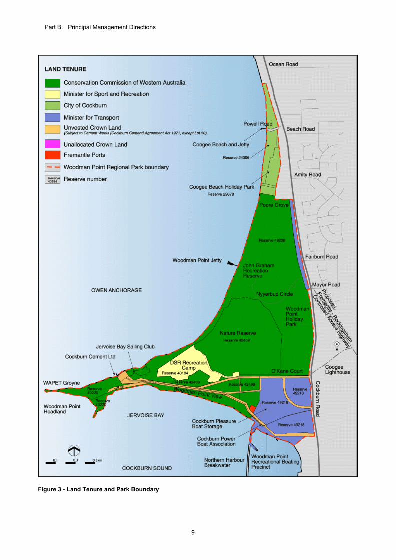
8. Land Tenure The objective is to ensure that the values of the Park are protected by security of tenure and reserve purpose. Land within the Park consists of reserves administered under the Land Administration Act 1997 and vested in a number of State government agencies and the City of Cockburn. The tenure of these reserves has been amended using the management areas outlined in Table 1 and Figure 4 as a guide. Crown reserves have been given an appropriate classification and purpose under the Land Administration Act 1997. The tenure of the nature reserve (Reserve 42469), which is vested in the Conservation Commission, is to remain unchanged. It will continue to be managed for the maintenance and restoration of the
natural environment, and to protect, care for and promote the study of indigenous flora and fauna and to preserve any feature of archaeological, historic or scientific interest. The Woodman Point Recreation Camp (Reserve 40184), which is managed by DSR, has been excised from what is now Reserve 49220 (vested with the Conservation Commission), and created as a new, separate reserve. The recreation camp is retained within the Park and will continue to be managed by DSR. Access from the camp to the coast will be provided in three locations through DEC-managed land and is by agreement between DEC and DSR. The City of Cockburn will continue to manage the reserves vested in it. The City may also assume management responsibility for land currently managed by DEC at Poore Grove, pending the development of the proposed Coogee Beach Surf Life Saving Club. The Recreational Boating Precinct (Reserve 49218) at Woodman Point is vested in the Minister for Transport for the purposes of providing a Recreational Boating Facility. It is subject to management arrangements under the Marine and Harbours Act 1981. The area will continue to be managed as part of Woodman Point Regional Park. Cockburn Cement Ltd leases a portion of Lot 59 Woodman Point View under the provisions of the Cement Works (Cockburn Cement Limited) Agreement Act 1971. The lease is managed by the Department of State Development. It is not the intent for the Plan to change the tenure arrangements of the Crown land which is subject to this Act. The rights of Cockburn Cement Ltd to remain at its present location within the Park in accordance with the Cement Works (Cockburn Cement Limited) Agreement Act 1971 are acknowledged. The company also has the right to construct and maintain an electricity supply, use roads, park vehicles, and construct and maintain pipelines for pumping water, sand or spoil at specified locations within the Park. Details of these locations are outlined in the Cement Works (Cockburn Cement Limited) Agreement Act 1971. For further information in relation to Cockburn Cement Ltd, refer to Section 35. Other Crown reserves utilised for services, such as drainage or navigation beacons, will retain their existing reserve purpose and tenure arrangements. Should additional land be included within the boundary of the Park during the term of this Plan, its tenure arrangements will be consistent with the protection and enhancement of the Park’s values. Strategies 1. Retain the existing tenure arrangements for
the operation of Cockburn Cement Ltd in the Park in accordance with in the Cement Works (Cockburn Cement Limited) Agreement Act 1971. (DRDL) [Ongoing]
2. Maintain access from the recreation camp
to the coast. (DEC, CoC) [Ongoing]
Part B. Principal Management Directions
8
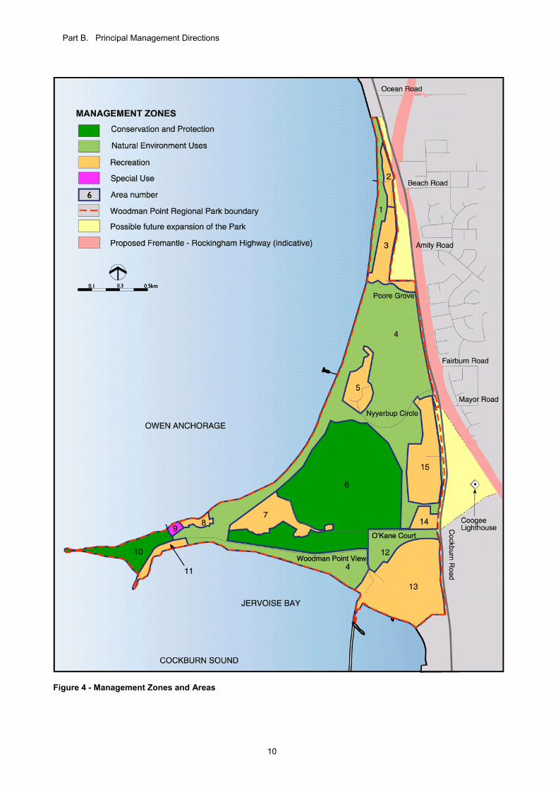
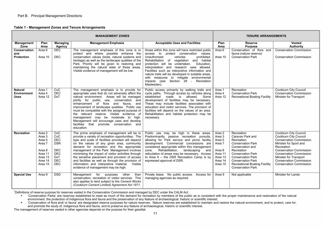
9. Park Management Zones The objective is to adopt a management zoning system that protects conservation values, provides for appropriate recreation and other uses, and provides for efficient management of the Park. Management zones are a framework for protecting the Park by identifying areas of conservation and recreation value, and determining appropriate uses and activities. The aim is to minimise existing and potential conflicts between uses and activities. Management zones provide broad guidance to public use and management activities which are appropriate in certain Park areas and indicate which management objectives have priority in a given area. A clear zoning scheme also helps to communicate management intentions to the public. The management zones and areas for the Park are illustrated in Figure 4. Four zones have been identified for managing the Park: a) Conservation and Protection; b) Natural Environment Uses; c) Recreation; and d) Special Use. Refer to Table 1 for the management emphasis and acceptable uses and facilities within each zone. The zoning scheme does not affect the tenure arrangements or management of the service and utility reserves in the Park. Strategy 1. Manage the Park in accordance with the
management zones (Figure 4 and Table 1). (DEC, DSR, DoT, CoC) [Ongoing]
Part B. Principal Management Directions
9
Figure 3 - Land Tenure and Park Boundary
Part B. Principal Management Directions
10
Figure 4 - Management Zones and Areas
Part B. Principal Management Directions
11
Table 1 - Management Zones and Tenure Arrangements
MANAGEMENT ZONES
TENURE ARRANGEMENTS
Management Zone
Plan Area
Managing Agency
Management Emphasis Acceptable Uses and Facilities Plan Area
Reserve Purpose
Vested Authority
Conservation and Protection
Area 6 Area 10
DEC DEC
The management emphasis of this zone is to protect and where possible enhance the conservation values (biota, natural systems and heritage) as well as the landscape qualities of the Park. Priority will be given to restoring and maintaining the natural state of these areas. Visible evidence of management will be low.
Areas within this zone will have restricted public access to protect conservation values. Unauthorised vehicles prohibited. Rehabilitation of vegetation and habitat protection will be undertaken. Education, interpretation and research uses allowed. Facilities such as interpretive information and nature trails will be developed in suitable areas, with measures to mitigate environmental impacts (see Section 29 - Recreation Masterplan).
Area 6 Area 10
Conservation of flora and fauna (nature reserve) Conservation Park
Conservation Commission Conservation Commission
Natural Environment Uses
Area 1 Area 4 Area 12
CoC DEC DoT
The management emphasis is to provide for appropriate uses that do not adversely affect the natural environment. Areas will be managed jointly for public use, conservation and enhancement of flora and fauna, and improvement of landscape qualities. Public use must be compatible with the assigned purpose of the relevant reserve. Visible evidence of management may be moderate to high. Management will encourage uses and develop facilities that promote conservation and education.
Public access primarily by walking trails and cycle paths. Through access by vehicles along established roads is allowed. Some development of facilities may be necessary. These may include facilities associated with education and visitor services. The provision of facilities will depend on the values of an area. Rehabilitation and habitat protection may be necessary.
Area 1 Area 4 Area 12
Recreation Conservation Park Recreational Boating Facility
Cockburn City Council Conservation Commission Minister for Transport
Recreation Area 2 Area 3 Area 5 Area 7 Area 8 Area 11 Area 13 Area 14 Area 15
CoC CoC DEC DSR DEC DEC DoT DEC DEC
The prime emphasis of management will be to provide a variety of recreation opportunities. The type and scale of facilities provided will depend on the values of any given area, community demand for recreation and the appropriate management of the Park. Management involves minimising the impact of visitor activities through the sensitive placement and provision of access and facilities as well as through the provision of information and interpretive material. Visible evidence of management may be high.
Public use may be high in these areas. Predominantly passive recreation pursuits, allowing for Park service and picnic facility development. Commercial concessions are considered appropriate within this management zone. Rehabilitation, landscaping and reticulation of areas may be necessary. Access to Area 6 – the DSR Recreation Camp is by expressed approval of DSR.
Area 2 Area 3 Area 5 Area 7 Area 8 Area 11 Area 13 Area 14 Area 15
Recreation Caravan Park and Recreation Conservation Park Conservation and Recreation Conservation Park Conservation Park Conservation Park Recreational Boating Facility Conservation Park
Cockburn City Council Cockburn City Council Conservation Commission Minister for Sport and Recreation Conservation Commission Conservation Commission Minister for Transport Conservation Commission Conservation Commission
Special Use Area 9 DSD Management for purposes other than conservation, recreation or visitor services. This also applies to land subject to the Cement Works (Cockburn Cement Limited) Agreement Act 1971.
Private lease. No public access. Access for managing agencies as required.
Area 9 Not applicable Minister for Lands
1Definitions of reserve purpose for reserves vested in the Conservation Commission and managed by DEC under the CALM Act:
‘Conservation Parks’ are reserves established to meet as much of the demand for recreation by members of the public as is consistent with the proper maintenance and restoration of the natural environment, the protection of indigenous flora and fauna and the preservation of any feature of archaeological, historic or scientific interest;
‘Conservation of flora and/ or fauna’ are designated reserve purposes for nature reserves. Nature reserves are established to maintain and restore the natural environment, and to protect, care for, and promote the study of, indigenous flora and fauna, and to preserve any feature of archaeological, historic or scientific interest.
The management of reserves vested in other agencies depends on the purpose for their gazettal.
Part B. Principal Management Directions
12
10. Integrated Management of the Park The objective is to provide for the effective involvement of the managing agencies and the community in the management of the Park. The managers of the Park are DEC, the City of Cockburn, DoT and DSR. Their areas of responsibility are set out in Table 1. Management will be in accordance with the strategies outlined in this Plan. DEC is the most appropriate agency to provide a strong integrated framework for managing complex conservation and recreation areas. The Department is responsible for managing areas of the Park vested in the Conservation Commission and for the overall coordination of management. DSR manages the recreation camp, DoT manages the Recreational Boating Precinct, and the City of Cockburn manages areas of the Park vested in it, in accordance with the strategies outlined in this Plan. Responsibility for overall planning such as changes to the MRS for regional parks is retained by the WAPC. Close cooperation is required by the managing agencies and the community for the Plan to be implemented efficiently and effectively. Management decisions will involve input and negotiation between the management agencies. DEC will refer strategic and policy issues to the Conservation Commission for consideration as required. Where appropriate, joint working parties comprising representatives from DEC, DSR, DoT and the City of Cockburn will be established to facilitate the preparation of detailed subsidiary plans for the Park. The different levels of planning are illustrated in Figure 1. Subsidiary plans have been and will be prepared in consultation with the community. There is a strong interest by Aboriginal people to be involved in the management of conservation estate in Western Australia and to strengthen cultural ties to the land. By working together with Aboriginal people to care for the land, there will be benefits for the preservation of heritage and conservation of the environment, as well as for cross-cultural awareness. The State government has shown a commitment to joint management arrangements for conservation reserves with traditional owners. A consultation paper outlining options for ownership, administration and joint management of conservation lands in Western Australia was prepared and released for public comment (Department of Environment and Conservation, 2003). This includes options for the management of conservation reserves, irrespective of the status of Native Title. A common management direction This Plan represents the establishment of common objectives and strategies and agreement on priorities, and has been developed collaboratively by DEC, DSR, DoT and the City of Cockburn, in consultation with the community. DEC will liaise with other managing agencies and the Woodman Point Regional Park Community Advisory
Committee to review management projects and priorities. Strategies 1. Establish, where appropriate, joint working
parties representing the relevant managing agencies and the community for subsidiary and other implementation plans. (DEC, DSR, DoT, CoC) [High]
2. Consult with the Woodman Point Regional
Park Community Advisory Committee when preparing subsidiary plans and implementing management projects and priorities for the Park. (DEC, DSR, DoT, CoC) [High]
3. Collaborate with relevant agencies on
issues affecting the Park. (DEC, DSR, DoT, CoC) [Ongoing]
4. Refer policy issues to the Conservation
Commission for consideration as required. (DEC) [Ongoing]
11. Key Performance Indicators,
Monitoring and Reporting The objective is to set performance criteria for assessing the implementation of this Plan, in order to track the effectiveness of the Plan in meeting its objectives. Defining key performance indicators (KPIs) in management plans reflects the need for the Park managers to take an outcome-based approach from which the effectiveness of management can be assessed. The role of KPIs is to measure: 1. ecosystem health in the Park; 2. use of the Park by the community; and 3. the performance of DEC in implementing the
Plan. KPIs do not cover all objectives or strategies, but they have been selected to give a strategic indication of how well the values of the Park are being maintained through the implementation of key objectives and strategies. KPIs therefore relate specifically to the key conservation and social values of the Park (see Table 3). KPIs have been identified in the following sections of the Plan: Flora and Vegetation (Section 16); Fauna (Section 17); Weeds (Section 18); Visitor Use (Section 28); Community Involvement (Section 40).
KPIs underpin the audit process of this Plan (see Section 44). MONITORING AND REPORTING DEC will monitor the KPIs and will periodically report to the Conservation Commission. DEC and the Conservation Commission will take appropriate action where performance targets are not met.
Part B. Principal Management Directions
13
Community groups can play a valuable role in monitoring and will be encouraged to be involved and provided with training where feasible. DEC will liaise with agencies and organisations maintaining monitoring activities in the Park. This will help to ensure an integrated approach that avoids duplication and allows programmes to be assigned appropriate priorities. Strategies 1. Establish baseline information and ongoing
monitoring programmes within the Park, using the KPIs as a basis. (DEC) [High]
2. Report to the Conservation Commission on
Park management as required. (DEC) [High] 3. Audit and measure the overall effectiveness
of Park management based on the KPIs. (Conservation Commission) [Ongoing]
12. Research The objective is to further develop and maintain knowledge in regard to visitor use, management, natural processes and other external influences on the Park. There are many opportunities for research within the Park. Research projects need to be coordinated to maximise the outcomes and application of knowledge. The floral assemblages of the Park are representative of communities that were once more widespread on the Swan Coastal Plain. They therefore offer an insight into changes that have occurred since European settlement. Threatened ecological communities, priority flora and tuart stands (including the longicorn beetle) in the Park should be focal points of research. Research on the effects of urban development on coastal ecosystems would provide information to assist decision making and management, and would ensure conservation values are protected. There is also scope for research on the cultural and historical significance of the Park, both Aboriginal and non-Aboriginal. Visitor impacts and management impacts need to be subject to continual review and evaluation. DEC will periodically undertake studies to provide information on which to make management decisions. The involvement of educational institutions, community groups and individual researchers should be encouraged so as to promote community ownership, while also gaining valuable knowledge for use in managing the Park. The involvement of such groups also reduces the cost of research and monitoring for the managing agencies and enables important projects, which possibly would not otherwise be given priority or consideration, to be undertaken. Community groups will be encouraged to be involved in research where appropriate.
A scientific purposes licence is required for the taking of flora and/ or fauna from the Park for research purposes. Strategies 1. Support and where possible seek grant
applications to encourage research within the Park. (DEC, CoC) [Ongoing]
2. Encourage the participation of volunteers,
educational institutions and other organisations and individuals in research projects within the Park. (DEC, CoC) [High]
Part C. Conserving the Natural Environment
14
C. CONSERVING THE NATURAL ENVIRONMENT
13. Guiding Principles for Conserving the Natural Environment
1. Conservation and protection of the natural
environment Natural processes and biodiversity will be managed to maintain their inherent values. External impacts from human use, the surrounding urban area and management practices will be minimised in order to maintain the biodiversity of natural systems over the long-term. 2. Park management priorities The Park will be managed for conservation and environmental enhancement. Recreation and other uses will be allowed to occur to the extent that they do not adversely impact on the natural environment. 3. Restoration of the natural environment Restoration of the natural environment will be undertaken to protect and maintain biodiversity and natural systems. Areas with high nature conservation value will be considered priorities for restoration. 4. Features requiring special protection Declared rare flora, priority and significant flora species, threatened ecological communities, priority fauna and other specially protected fauna will be given priority for conservation and restoration. 5. Consistency of management policies The land managers involved in the Park will apply consistent and coordinated management policy. 6. Appropriate reserve purpose Reserves within the Park will be assigned an appropriate purpose for the protection of biodiversity and natural systems over the long-term. 7. Recognition of cultural and social values The Park will be managed in a way that delivers community benefits by maintaining cultural traditions and places of cultural significance and by providing opportunities for recreation, education and research. 8. Precautionary principle If there are threats of serious or irreversible environmental damage, the lack of full scientific certainty should not be used as a reason for postponing measures to prevent environmental degradation. Strategy 1. Apply the above principles as required in
conserving the natural environment of the Park. (DEC, DSR, DoT, CoC) [Ongoing]
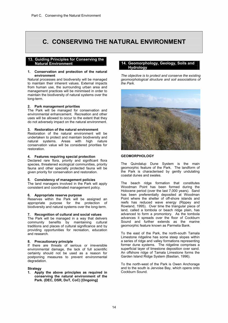
14. Geomorphology, Geology, Soils and
Hydrology The objective is to protect and conserve the existing geomorphological structure and soil associations of the Park.
GEOMORPHOLOGY The Quindalup Dune System is the main geomorphic feature of the Park. The landform of the Park is characterised by gently undulating coastal dunes and swales. The beach ridge formation that constitutes Woodman Point has been formed during the Holocene period (over the last 7,000 years). Sand has been preferentially deposited at Woodman Point where the shelter of off-shore islands and reefs has reduced wave energy (Rippey and Rowland, 1995). Over time the triangular piece of land, called a tombola or beach ridge plain, has advanced to form a promontory. As the tombola advances it spreads over the floor of Cockburn Sound and further extends as the marine geomorphic feature known as Parmelia Bank. To the east of the Park, the north-south Tamala Limestone ridgeline has some steep slopes within a series of ridge and valley formations representing former dune systems. The ridgeline comprises a superficial layer of limestone deposition over sand. An offshore ridge of Tamala Limestone forms the Garden Island Ridge System (Bastian, 1996). To the north-west of the Park is Owen Anchorage and to the south is Jervoise Bay, which opens onto Cockburn Sound.
15
GEOLOGY The soils of Woodman Point are Quindalup Sands, which are made up of quartz grains and fragments of sea shells (McArthur and Bettenay, 1960). The shell-lime or calcium carbonate makes the sand very alkaline (Rippey and Rowland, 1995). The soils of Woodman Point generally have a small content of plant nutrients and humus, and have a poor capacity to hold water (Powell and Emberson, 1981). HYDROLOGY The groundwater of the Woodman Point area is characterised by a freshwater lens in the Quindalup Sands. The groundwater is recharged from direct winter rainfall or seepage from the adjacent Tamala Limestone ridge to the east. An interface exists between the ocean saltwater and the fresh groundwater, which changes its lateral location marginally from season to season depending on the relative amount of recharge. Fluctuations in the level of water in saline Lake Coogee, which correspond with tidal movements, suggest that there is a direct link with the ocean via limestone caverns. Such movements may occur beneath the Quindalup Sands. THREATS TO GEOLOGY, SOILS AND GROUNDWATER Erosion Unrestricted vehicle and pedestrian access has created tracks and pathways (particularly throughout the coastal dunes) in unsuitable locations, making them susceptible to erosion. ‘Blowouts’ have formed in dunes south of Woodman Point View, where direct surface contact and trampling has lead to the removal of vegetation cover, therefore exposing the dunes to predominant south-westerly winds. Enhancement works have been undertaken at this site to restrict vehicle access and re-direct pedestrian access through formal paths in the dunes. Uncontrolled access in the Park will be reduced by formalising paths and restricting access to areas at risk from erosion. This is discussed further in Section 31. Groundwater contamination The groundwater is unconfined and its surface occurs close to, or at natural ground surface on a seasonal cycle from a high in late winter to a low in late summer. The proximity of the groundwater to the surface makes it susceptible to contamination by pollutants derived from urban land uses and should be considered in development approval processes within or near to the Park. Strategy 1. Restrict access to areas at risk from
erosion by implementing the Recreation Masterplan and site enhancement plans (Section 30) and by providing fencing, signs and information (Sections 32 and 41). (DEC, DSR, DoT, CoC) [Ongoing]
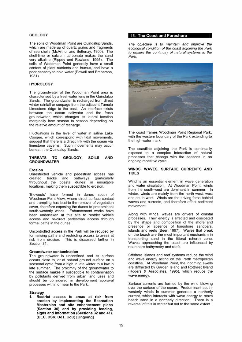
15. The Coast and Foreshore
The objective is to maintain and improve the ecological condition of the coast adjoining the Park to ensure the continuity of natural systems in the Park.
The coast frames Woodman Point Regional Park, with the western boundary of the Park extending to the high water mark. The coastline adjoining the Park is continually exposed to a complex interaction of natural processes that change with the seasons in an ongoing repetitive cycle. WINDS, WAVES, SURFACE CURRENTS AND TIDES Wind is an essential element in wave generation and water circulation. At Woodman Point, winds from the south-west are dominant in summer. In winter, winds are mainly from the north-west, west and south-west. Winds are the driving force behind waves and currents, and therefore affect sediment movement. Along with winds, waves are drivers of coastal processes. Their energy is affected and dissipated by the shape and composition of the shore and presence or absence of longshore sandbars, islands and reefs (Beer, 1997). Waves that break on the beach are the most important mechanism in transporting sand in the littoral (shore) zone. Waves approaching the coast are influenced by nearshore bathymetry and reefs. Offshore islands and reef systems reduce the wind and wave energy acting on the Perth metropolitan coastline. At Woodman Point, the incoming swells are diffracted by Garden Island and Rottnest Island (Rogers & Associates, 1995), which reduce the wave energy. Surface currents are formed by the wind blowing over the surface of the ocean. Predominant south-westerly winds in summer generate a northerly current, which interacts with wave energy to move beach sand in a northerly direction. There is a reversal of this in winter but not to the same extent.
16
The amplitude of tides in Cockburn Sound is relatively small: 0.3 metres during neap tides and 0.5 metres during spring tides. Surges usually associated with storms and cyclonic activity can raise water levels by as much as one metre. SEDIMENT MOVEMENT The complex interaction of winds, waves, surface currents and tides causes sediment to be transported onshore and offshore as well as along the coastline. The presence of artificial structures in the coastal zone can affect patterns of sediment movement. There are seasonal trends to sediment movement. In summer, relatively low energy waves deposit sand on the beaches. At the same time onshore winds transport beach sand onto the foredunes where it is trapped by dune vegetation. Winter storms and summer cyclones may generate high energy swell and wind waves, which erode the beaches and foredunes, causing landward movement of the coastline. Sand deposited in longshore sand bars in winter during storms is returned to the beach during calmer periods (Oma et al., 1992). It is possible to identify longer term trends in sediment movement, as coastlines may erode (lose sand), accrete (gain sand) or remain relatively constant. Both the processes of erosion and accretion are currently occurring at the beaches adjoining the Park. An inspection of Shoreline Movement Maps (1942 to 1994) prepared by DoT has provided the following trends at specific points on the coast: Coogee Jetty: 8m recession; Woodman Point Jetty: 24m accretion; Adjacent to Woodman Point Recreation Camp
(north track): 86m accretion; and Jervoise Bay (Western Beach): 48m accretion
(Department of Transport, Shoreline Movement Maps Drawing Numbers: 374-03-02, 374-04-02, 374-05-02). Figure 5 conceptually illustrates accretion at Woodman Point since 1942. Despite the above trends, anecdotal information suggests that an area east of the Jervoise Bay Sailing Club is eroding. Erosion and accretion trends need to be considered when planning facilities, buildings and conservation programmes in the coastal zone. Artificial Structures in the Coastal Zone The construction of marine engineering structures in the coastal zone may have a range of impacts on the movement of sediment. Groyne structures such as the Woodman Point Groyne and Western Australian Petroleum Pty Ltd (WAPET) Groyne often accumulate sediment depending on the season and direction of sediment movement. At Woodman Point, the groynes have led to accumulation of sediment between the groynes and on the northern side of the point.
There appears to be some loss of sediment (recession) on the southern beaches. The Coogee and Woodman Point Jetties, which are piled structures, allow marine processes to continue underneath. They have less effect on sediment movement. Conversely, rock revetments often cause sand to be scoured away and such structures should be avoided unless required for essential services. Erosion has also occurred on the eastern end of Jervoise Bay Beach adjacent to the breakwater for the Northern Harbour. Investigations by Rogers and Associates (1999) indicate that the coastline may be returning to a former position, before 200,000m3 sand was placed on the beach in the 1970s in association with the construction of the Ocean Endeavour oil rig. Rogers and Associates (1999) also indicated that a contributing factor may be the original groyne, and later the extended breakwater, which has changed the dynamics of the area. The extended breakwater was constructed by the former Department of Industry and Resources, (now Department of Mines and Petroleum) and is be managed by Landcorp as part of the Australian Marine Complex in Jervoise Bay. Beach erosion mitigation works may need to be undertaken periodically, in liaison with DoT, to ensure there is no safety risk to Park visitors and users of the Northern Harbour Breakwater.
Figure 5 - Conceptual view of shoreline movement since 1942 Strategies 1. Prepare specific works plans for areas at
risk from erosion prior to undertaking mitigation works. (DEC, CoC, DoT) [Ongoing]
17
2. Ensure long-term planning for the Park and developments within the coastal zone consider the likelihood of coastal erosion and accretion. (DEC, CoC, DoT) [Ongoing]
16. Flora and Vegetation
The objective is to protect, conserve and rehabilitate local flora and vegetation communities in the Park, especially the threatened ecological community.
Much of the vegetation along the Perth metropolitan coastline has been altered or cleared for urban development. The vegetation of Woodman Point has experienced some disturbances but it has survived as an example of a relatively intact coastal vegetation community. It now stands as an important benchmark for interpreting coastal vegetation that would have been present over much of the southern Perth metropolitan coastline before disturbances occurred (Powell and Emberson, 1981). The area has a history of uses such as a quarantine station for cattle, a quarantine station for humans and an ammunition storage area. The resulting enclosures and restricted access have effectively protected the vegetation in some areas of Woodman Point. The recorded history of the enclosures suggests that fires have been infrequent (at least by modern standards), also largely due to the exclusion of people. The best examples of coastal vegetation are contained within the nature reserve (Reserve 42469). Some areas outside the reserve have been affected by road and infrastructure corridors that fragment the Park. Other disturbances, such as uncontrolled access and continuing weed invasion, are steadily degrading natural ecosystems in the Park. FLORISTIC COMMUNITIES Gibson et al. (1994) classified the flora of the southern Swan Coastal Plain into floristic communities. These floristic community types are based on analysis of detailed floristic data from a large number of quadrats located throughout the region (Gibson et al., 1994 and subsequent work undertaken as part of Bush Forever, Government
of Western Australia, 2000). The floristic community types that occur in the Park are shown in Table 2.
Floristic Community Types 29a Coastal shrublands on shallow sands 29b Acacia shrublands on taller dunes 30a2 Callitris preissii and/or Melaleuca lanceolata forests and woodlands 30b Quindalup Eucalyptus gomphocephala and/or Agonis flexuosa woodlands 30c2 Woodlands and shrublands on Holocene Dunes
Table 2 - Floristic Community Types at Woodman Point Regional Park (adapted from Government of Western Australia, 2000) Woodman Point Regional Park has representative examples of most community types that occur on the Quindalup Dune System of the Swan Coastal Plain (Gibson et al., 1994). The presence of floristic community type 30a2 within the Park makes this area regionally and nationally significant (Keighery et al., 1997). Community type 30a2, comprised of Rottnest cypress (Callitris preissii) and Rottnest tea tree (Melaleuca lanceolata) forests and woodlands, is restricted to a small area from Perth to Garden Island. It is therefore recognised as a threatened ecological community and is rated in a vulnerable condition (see Glossary) (English, Keighery and Blythe, 1996). Community type 30a2 has one of the lowest species diversity of all Quindalup community types owing to the high canopy density which limits light penetration. Community type 30b is dominated by tuart (Eucalyptus gomphocephala) and/or peppermint (Agonis flexuosa) woodlands and is found from the Leschenault Peninsula south to Busselton, although its distribution is now much reduced. Community type 30c2 contains Wabling Hill mallee (Eucalyptus argutifolia) and Dryandra scrub/thicket. It is significant because it is restricted to three plots on Holocene dunes (Gibson et al., 1994). The two shrubland communities (type 29a and 29b) occur on shallow coastal sands from Seabird to Garden Island. Neither of the communities have a single dominant species. Powell and Emberson (1981) undertook an assessment of the vegetation communities of the area. Importantly, their study describes the cultural and known fire history of Woodman Point and it provides a photographic account of the flora species present in the Park as well as its condition. FLORA A survey of vascular flora of the nature reserve at Woodman Point by Keighery (2001) found a total of 161 species, of which 94 are native.
18
There have been no species of declared rare flora recorded in the Park. There are taxa present in the Park that are considered significant, namely: 1. Dodonaea hackettiana (Priority Four Taxa); 2. Grevillea thelemanniana (Priority Four Taxa); 3. Diplolaena dampieri, (most northern
population); and 4. Amyema miquelli (one of the few remaining
populations on the Swan Coastal Plain) (Government of Western Australia, 2000; Regeneration Technology, 2002); (see Glossary for definitions). Keighery et al., 1997 also identified the presence of Leucopogon insularis within the Park. This species is only known from a few localities on the Swan Coastal Plain and is thought not to occur within any other conservation reserve. THREATS TO FLORA AND VEGETATION The main threats to the flora and vegetation of the Park are as follows:
weeds (Section 18); wildfire (Section 19); plant diseases; insect borers; and urban interface issues and uncontrolled
access by vehicles and pedestrians. Plant diseases Honey fungus (Armillaria luteobubalina) occurs on coastal vegetation (on the Quindalup and Spearwood Dune Systems) and is the main plant disease in the Park. Up to 40% of coastal species are susceptible to honey fungus, including many of the dominant small trees and shrubs. Honey fungus affects both the structure and composition of coastal dune vegetation (Shearer et al., 1998). The fungus denudes susceptible vegetation, leaving relatively open areas composed mainly of sedges or small shrubs and creepers, with more bare ground than nearby healthy vegetation. At Woodman Point, honey fungus threatens the geographically restricted Rottnest cypress and its associated plant community. Although honey fungus occurs naturally in the south-west of Western Australia, its normally slow rate of spread by direct root contact may be exacerbated by the movement of infected root material associated with soil disturbance. The characteristic fruiting bodies of the fungus generally grow in clumps on tree bases, stumps or roots, and appear in June/July each year. There are no known controls of the disease, except clearing the site. In comparison to honey fungus, dieback pathogen (Phytophthora cinnamoni) is generally not found in the Quindalup Dune System on the coastal strip. Phytophthora dieback is thought not to be an issue in managing the Park. Insect borers The native tuart longicorn beetle (Phoracantha impavida) is a natural part of the tuart ecosystem. This borer lays eggs in the upper branches of the
tuart and the larvae eat the cambium layer beneath the bark and thus ring-bark the branches leading to death of the limb. The tree can usually repair some damage by shooting from lower down, and by exuding sap, which engulfs the young larvae. Whilst a small level of insect attack is normal, repeated attack may ultimately cause the tree’s death. Tuarts are more susceptible to borer attacks when they are stressed. The decline of the tuart populations has increased in the recent past; the primary cause is likely to be a combination of environmental issues including the impact of borers, climate change, and fire frequency, which are placing stress on the tuarts. Further research is required to understand this phenomenon and to determine appropriate management measures. Urban interface issues and uncontrolled access Maintaining the integrity of bushland in urban areas requires management of threats such as weed invasion, uncontrolled access, and rubbish-dumping. These issues are addressed in Sections 18 and 31. All native flora is protected by the Wildlife Conservation Act 1950. Incidences of wilful damage to vegetation in the Park will be investigated and appropriate action taken by DEC. Strategies 1. Implement the Woodman Point Regional
Park Weed Control and Revegetation Plan. The plan includes a description of vegetation communities, detailed bushland condition assessment and rehabilitation priorities (Section 20) using local species, such as those identified by Keighery (2001) and Gibson et al. (1994). Special emphasis is to be placed on protecting the threatened ecological community in the Park. (DEC, DSR, DoT, CoC) [High]
2. Develop and implement a targeted and
integrated monitoring programme of bushland condition, weed proliferation and changes to vegetation communities with particular reference to the threatened ecological community. (DEC, CoC) [High]
3. Implement strategies outlined in Section 19
to reduce the risk of wildfire. (DEC, CoC) [Ongoing]
4. Provide information and interpretive
material to the public that: promotes an understanding and
appreciation of the Park’s flora and vegetation;
encourages the planting of local species in areas surrounding the Park; and
encourages community involvement in weed control and rehabilitation works (Section 40). (DEC, CoC) [Ongoing]
5. Investigate any wilful damage to vegetation
in the Park and take appropriate action. (DEC, CoC) [Ongoing]
19
6. Use local species, such as those identified
by Keighery (2001) and Gibson et al. (1994) for landscape and amenity plantings. If non-local species are required, they should not include invasive species. (DEC, DSR, DoT, CoC). [Ongoing]
7. Reduce the risk of introducing and
spreading plant diseases in the Park by limiting access to areas sensitive to infection and by ensuring appropriate hygiene standards for machinery when undertaking works within the Park. Soil introduced to the Park is to be free of disease. (DEC, DSR, DoT, CoC) [Ongoing]
8. Encourage research into the wood-boring
beetle Phoracantha impavida to better understand and manage the issues causing behind tuart decline. (DEC) [Medium]
KPIs for flora and vegetation The success of the strategies will be measured by: 1. Changes in the abundance of selected flora
species. 2. Changes in the condition and distribution of the
threatened ecological community. 3. Existence of a weed control and rehabilitation
plan. Target: 1. No decline in the abundance of selected flora
species from baseline levels. 2. No decline in the condition and distribution of
the threatened ecological community. 3. Implementation of the weed control and
rehabilitation plan. Reporting: 1. Every 5 years. 2. Every 5 years. 3. Every 5 years.
20
Source: Regeneration Technology (2002) Figure 6 - Vegetation Distribution
21
17. Fauna The objective is to protect and conserve naturally-occurring fauna species in the Park, particularly threatened and priority species. BIRDS The high structural diversity and variety of vegetation in the Park provides a range of habitats that support local and trans-equatorial migratory birds (How et al., 1996) as well as numerous bush-bird species (Newman et al., 1976). A total of 93 bird species has been recorded at Woodman Point (Royal Australasian Ornithologists Union, 1996). Of these, 36 species are shore-birds and other waterbirds. The coastal foreshore at the western extremity of the headland is an important breeding ground for local species, as well as a roosting and feeding area for local and trans-equatorial migratory species (How et al., 1996). Works undertaken by DEC have provided greater protection for these bird habitats by consolidating the existing parking at Woodman Point Headland, preventing vehicle access into the coastal dunes and rehabilitating existing tracks throughout the area where birds breed (See Section 30). Shore-birds and other waterbirds recorded at the Park include the Caspian tern (Hydroprogne caspia); crested tern (Sterna bergii); fairy tern (Sterna nereis); bridled tern (Sterna anaethetus); pied cormorant (Phalacrocarax varius); little pied cormorant (Phalacrocarax melanoleucos); darter (Anhinga sp.); pied oystercatcher (Haematopus longirostris); sooty oystercatcher (Haematopus fuliginosus); grey plover (Pluvialis squatarola); red-necked stint (Calidris ruficollis); sanderling (Calidris alba); ruddy turnstone (Arenaria interpres); and Australian pelican (Pelecanus conspicillatus). Bush-birds present in the Park include the blue wren; weebill (Smicrornis brevirostris); inland thornbill (Acanthiza apicalis); white-browed scrub wren (Sericornis frontalis); and splendid fairy wren (Malurus splendens). The population of golden whistlers (Pachycephala pectoralis) is very significant at Woodman Point owing to the scarcity of the species within bushland areas in Perth (How et al. 1996). The tall tuart trees (Eucalyptus gomphocephala) present at the Park also provide nesting sites for brown goshawks (Accipiter fasciatus) which breed infrequently on the Swan Coastal Plain. A number of migratory birds listed under the Japan-Australia Migratory Birds Agreement (JAMBA), the China-Australia Migratory Birds Agreement (CAMBA), and the Republic of Korea Migratory Birds Agreement (ROKAMBA) have been recorded at the Park. Australia is a signatory to these international agreements that support the conservation of migratory birds and their habitats. The intent of the JAMBA, CAMBA and ROKAMBA migratory bird agreements will be applied in the management of the Park. The trans-equatorial migratory birds covered by these agreements are also protected under the Commonwealth
Environment Protection and Biodiversity Conservation Act 1999. The peregrine falcon (Falco peregrinus) is likely to be present in the Park. It is specially protected under the Wildlife Conservation Act 1950. MAMMALS The quenda (Isoodon obesulus fusciventer) has been recorded in the Park and recent diggings indicate that it is present in relatively large numbers. It is considered that brushtail possums (Trichosurus vulpecula) are also present. Other mammals that may once have occurred in the Park area include the western grey kangaroo (Macropus fuliginosus), and the western brush wallaby (Macropus irma) (How et al., 1996). REPTILES AND AMPHIBIANS The Park has a relatively low species richness of reptiles and amphibians with only 14 reptile and one frog species sighted during a survey in 1996 (How et al., 1996). Three of the reptile species recorded by How et al. (1996) were only sighted at Woodman Point and two other survey locations in the metropolitan area, namely the lined skink (Lerista lineata), western heath dragon (Tympanocryptis adelaidensis) and black-tailed monitor (Varanus tristis). The lined skink is significant as it is considered scarce with relatively localised distribution and is virtually confined to the Perth metropolitan region. No fossorial (burrowing) snakes have been documented in the Woodman Point area but small fossorial lizards are quite abundant. Western tiger snakes (Notechis scutatus occidentalis) are present and dugite (Pseudonaja affinis) are commonly sighted in the Park, including below the high water mark on the beach. The carpet python (Morelia spilota imbricata) may also have once occurred in the Woodman Point area (How et al. 1996). The presence of the western tiger snake and other reptiles within the Park is important in conservation terms. Information on reptiles should be included in education programmes and interpretive material to help develop an appreciation for these animals. It is acknowledged that the presence of the venomous western tiger snakes and dugites are a concern to some Park visitors and local residents. It is therefore proposed to provide contact details of wildlife carers for the relocation of injured fauna or other fauna where they constitute a significant risk to people. Owing to the lack of permanent or semi-permanent fresh water within the reserve and surrounds, few amphibian species are likely to permanently inhabit the reserve.
22
INVERTEBRATES There is a diverse range of insects and spiders in the Park with many of them restricted to this location or found in geographically similar regions. How et al. (1996) recorded 49 species of spider during a study period in 1994/1995. In addition, two pseudoscorpions (Aldabrinis sp. and Chernitidae genus A) were recorded. The Aldabrinis sp. is of particular interest as only two other species were previously known to exist, and this finding is the first and only record of this rare genus in Australia. Chernitidae genus A was collected only once, at Woodman Point, during the 1994/1995 survey of bushland remnants in Perth (How et al., 1996). A single specimen of Gallieniellidae was also recorded by How et al. (1996). This is the first record of the species on the Swan Coastal Plain and one of the first for Western Australia. These findings indicate that Woodman Point provides important habitat for invertebrate species. THREATS TO FAUNA The main threats to fauna within the Park are: loss of habitat through plant diseases (Section
16); loss of habitat through the invasion of weeds
(Section 18); the loss and fragmentation of habitat that could
result from wildfire (Section 19); competition and predation by pets and problem
animals (Section 20); development and inappropriate recreation
activities (Sections 28 and 38); the loss of native habitat surrounding the Park
(Section 23); and death or injury of native fauna on roads within
and adjoining the Park. Given the above threats, fauna populations in the Park have declined and it is likely they will continue to decline. In order to maintain the diversity of fauna species in the Park it may therefore be appropriate to reintroduce native wildlife into the Park. Regional ecological linkages and corridors between the Park and adjoining areas of ecological significance are also important in helping to maintain the diversity and vigour of the Park’s ecological systems (Section 23). Strategies 1. Continue management focus on habitat
protection and enhancement and feral animal control to create improved conditions for native fauna. (DEC, CoC) [High]
2. Ensure uses of the Park are consistent with
the protection and management of fauna (e.g. dog walking, Section 20). (DEC, DSR, DoT, CoC) [Ongoing]
3. Provide the contact details of wildlife carers
for the relocation of injured fauna or other fauna from places where they constitute a significant risk to people. (DEC) [Medium]
4. Provide interpretive material that:
promotes an understanding and appreciation of the Park’s fauna;
discourages the artificial feeding of birds;
supports volunteer groups involved with the Park; and
informs the public about the adverse impacts of introduced animals and domestic pets on native fauna in the Park; (Section 38). (DEC, CoC) [High]
5. Consider the reintroduction of native
wildlife into the Park pending successful management of introduced animals and pests and the availability of appropriate habitats. (DEC) [Low]
6. Promote research on fauna in the Park to
assist with its management. (DEC, CoC) [Ongoing]
KPIs for fauna The success of these strategies will be measured by: 1. Changes in species diversity of naturally-
occurring fauna. 2. Changes in the abundance of selected
naturally-occurring species. Target: 1. No decline in species diversity of naturally-
occurring fauna from baseline levels. 2. No decline in the abundance of selected
naturally-occurring species from baseline levels.
3. Reporting: 1. Every 5 years. 2. Every 5 years.
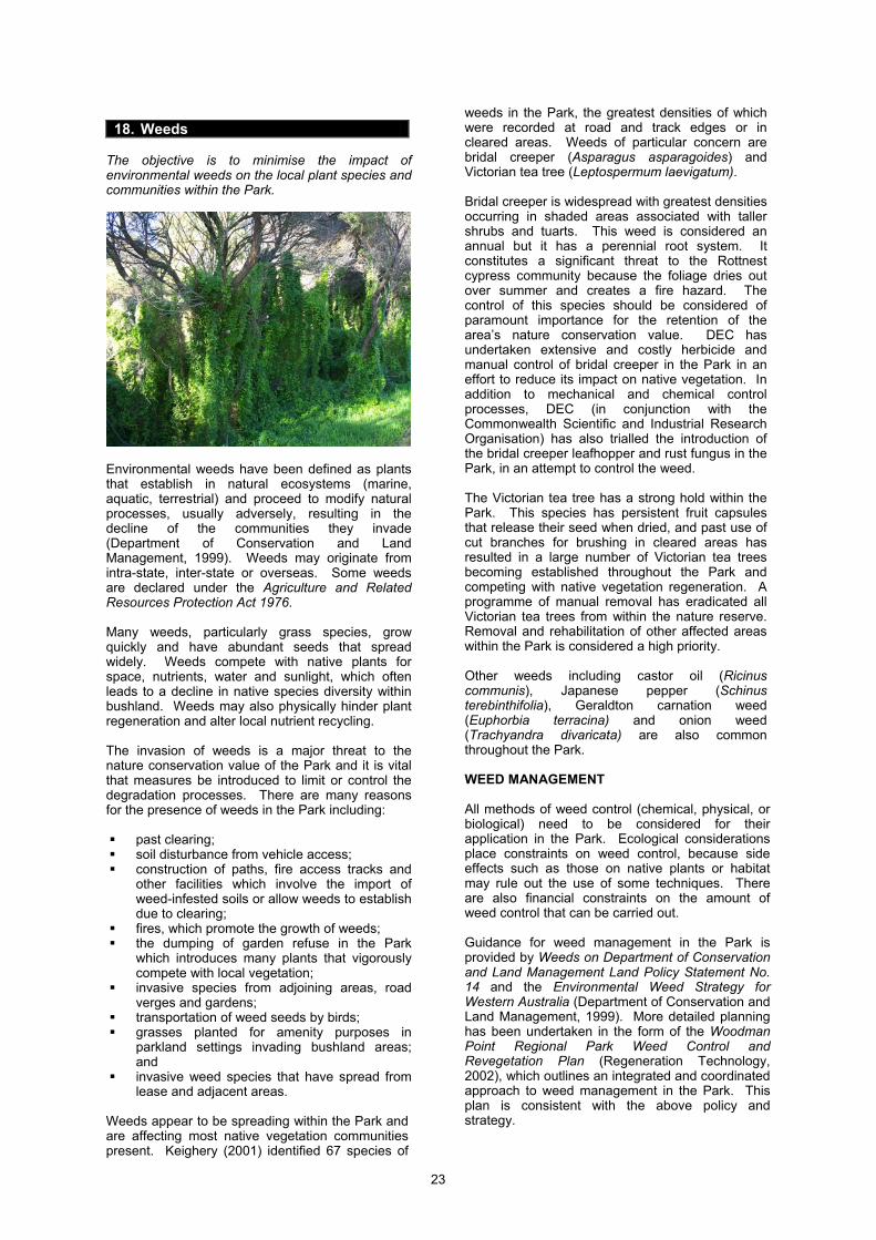
23
18. Weeds
The objective is to minimise the impact of environmental weeds on the local plant species and communities within the Park.
Environmental weeds have been defined as plants that establish in natural ecosystems (marine, aquatic, terrestrial) and proceed to modify natural processes, usually adversely, resulting in the decline of the communities they invade (Department of Conservation and Land Management, 1999). Weeds may originate from intra-state, inter-state or overseas. Some weeds are declared under the Agriculture and Related Resources Protection Act 1976. Many weeds, particularly grass species, grow quickly and have abundant seeds that spread widely. Weeds compete with native plants for space, nutrients, water and sunlight, which often leads to a decline in native species diversity within bushland. Weeds may also physically hinder plant regeneration and alter local nutrient recycling. The invasion of weeds is a major threat to the nature conservation value of the Park and it is vital that measures be introduced to limit or control the degradation processes. There are many reasons for the presence of weeds in the Park including:
past clearing; soil disturbance from vehicle access; construction of paths, fire access tracks and
other facilities which involve the import of weed-infested soils or allow weeds to establish due to clearing;
fires, which promote the growth of weeds; the dumping of garden refuse in the Park
which introduces many plants that vigorously compete with local vegetation;
invasive species from adjoining areas, road verges and gardens;
transportation of weed seeds by birds; grasses planted for amenity purposes in
parkland settings invading bushland areas; and
invasive weed species that have spread from lease and adjacent areas.
Weeds appear to be spreading within the Park and are affecting most native vegetation communities present. Keighery (2001) identified 67 species of
weeds in the Park, the greatest densities of which were recorded at road and track edges or in cleared areas. Weeds of particular concern are bridal creeper (Asparagus asparagoides) and Victorian tea tree (Leptospermum laevigatum). Bridal creeper is widespread with greatest densities occurring in shaded areas associated with taller shrubs and tuarts. This weed is considered an annual but it has a perennial root system. It constitutes a significant threat to the Rottnest cypress community because the foliage dries out over summer and creates a fire hazard. The control of this species should be considered of paramount importance for the retention of the area’s nature conservation value. DEC has undertaken extensive and costly herbicide and manual control of bridal creeper in the Park in an effort to reduce its impact on native vegetation. In addition to mechanical and chemical control processes, DEC (in conjunction with the Commonwealth Scientific and Industrial Research Organisation) has also trialled the introduction of the bridal creeper leafhopper and rust fungus in the Park, in an attempt to control the weed. The Victorian tea tree has a strong hold within the Park. This species has persistent fruit capsules that release their seed when dried, and past use of cut branches for brushing in cleared areas has resulted in a large number of Victorian tea trees becoming established throughout the Park and competing with native vegetation regeneration. A programme of manual removal has eradicated all Victorian tea trees from within the nature reserve. Removal and rehabilitation of other affected areas within the Park is considered a high priority. Other weeds including castor oil (Ricinus communis), Japanese pepper (Schinus terebinthifolia), Geraldton carnation weed (Euphorbia terracina) and onion weed (Trachyandra divaricata) are also common throughout the Park. WEED MANAGEMENT All methods of weed control (chemical, physical, or biological) need to be considered for their application in the Park. Ecological considerations place constraints on weed control, because side effects such as those on native plants or habitat may rule out the use of some techniques. There are also financial constraints on the amount of weed control that can be carried out. Guidance for weed management in the Park is provided by Weeds on Department of Conservation and Land Management Land Policy Statement No. 14 and the Environmental Weed Strategy for Western Australia (Department of Conservation and Land Management, 1999). More detailed planning has been undertaken in the form of the Woodman Point Regional Park Weed Control and Revegetation Plan (Regeneration Technology, 2002), which outlines an integrated and coordinated approach to weed management in the Park. This plan is consistent with the above policy and strategy.
24
The Woodman Point Regional Park Weed Control and Revegetation Plan outlines the extent and abundance of priority weeds and the most effective methods for controlling priority weed species within the Park (Regeneration Technology, 2002). In determining ongoing weed control programs DEC considers the following matters: recognition of weed potential (invasiveness,
distribution and environmental impact); maintenance of areas in the Park that have
vegetation in good condition as a priority; and control of weeds that impact on significant
species and threatened ecological communities as a priority.
It is important to discuss weed control with leaseholders and park neighbours to enable a more regional effort of weed control to be implemented. The planting of non-local plant species within the Park should be discouraged and discussions may be needed with the City of Cockburn, DoT, DSR, leaseholders and other stakeholders to ensure that species indigenous to the area are planted in the Park and on road verges surrounding the Park. Weed control can greatly benefit from community involvement. The involvement of the community in the Park’s management is critical to the successful implementation of this Plan. Managing agencies have limited resources and weed control can be very labour-intensive. The managing agencies acknowledge the considerable efforts by the community in undertaking works to control weeds. Volunteer groups have successfully undertaken weed control projects within the Park for a significant time. Members of the community wanting to be involved in weed control programmes in the Park can do so by joining the community volunteer groups active within the Park and participating in activities organised by the managing agencies. Strategies 1. Implement the Woodman Point Regional
Park Weed Control and Revegetation Plan. The plan provides: an assessment of bushland condition; maps of weed distribution; priorities for weed removal based on
invasiveness, distribution and environmental impacts; and
revegetation strategies (Section 21). (DEC, DSR, DoT, CoC) [High]
2. Set boundaries for grassed areas used for
recreation and control the spread of grasses outside these areas. (DEC, DSR, DoT, CoC) [High]
3. Use interpretive and educational material to
inform Park visitors, lessees and park neighbours about the effects of: dumping rubbish and garden refuse in
the Park; and invasive plants that pose a threat to the
biodiversity of the Park. (DEC, CoC) [Medium]
4. Encourage volunteer community groups to become involved with weed control and rehabilitation projects in the Park. (DEC, CoC) [Ongoing]
5. Coordinate community involvement in weed
control and rehabilitation projects in the Park. (CoC, DEC) [Ongoing]
KPIs for weeds The success of these strategies will be measured by: 1. Changes in the abundance and distribution of
priority environmental weeds, as identified in the Park’s weed control and rehabilitation plan.
2. Changes in populations of high priority weeds as identified in the Environmental Weeds Strategy for Western Australia.
3. Existence of a weed control and rehabilitation plan.
Target: 1. No increase in the abundance and distribution
of priority environmental weeds from 2002 levels.
2. No new populations of weed species rated high in the Environmental Weeds Strategy for Western Australia over the next ten years.
3. Implementation of the weed control and rehabilitation plan.
Reporting: 1. Every 5 years. 2. Every 5 years. 3. Every 5 years. 19. Fire
The objective is to manage fire to protect and promote the conservation of biodiversity and natural values whilst also providing for the protection of human life and community assets. Wildfire is a significant threat to the Park and the risk of wildfire needs to be managed. Wildfires can threaten biodiversity, human life, property and cultural values of the Park. Increasing visitor use of the Park is likely to increase the incidence of unplanned fire. Restricting access to high risk areas can reduce the incidence of unplanned fire. The potential risk of fire in the Park is greatest within areas of high vegetation density and in areas where there is an understorey of weed species that dry in summer. Rottnest cypress (Callitris preissii) and Rottnest tea tree (Melaleuca lanceolata) woodland communities are particularly fire sensitive as the overstorey will die if burnt. A succession of fires at short intervals may also exhaust the trees’ seed stock and limit their ability to reseed (Powell and Emberson, 1981). Like many trees, the age of Rottnest cypress may be estimated from growth rings in the trunk. Because this species regenerates readily after fire, the age of a cypress may indicate the length of time that has elapsed since the last fire (Powell and Emberson, 1981). Using this method it has been suggested that fire may not have occurred in areas
25
of the nature reserve for at least 170 years (Powell and Emberson, 1981). The absence of successive fires within the nature reserve contributes greatly to its conservation value. Fire is also a potential threat to the tuarts (Eucalyptus gomphocephala) in the Park. If fires are frequent the trees have insufficient time for recovery and may be further affected should another fire occur (Powell and Emberson, 1981). FIRE MANAGEMENT Fire suppression at the Park is the responsibility of the Fire and Emergency Services Authority (FESA) in liaison with the managing agencies of the Park, because the Park is located in the gazetted fire district. Pre-suppression works and post-suppression follow-up works in the Park are the land managers’ responsibilities. An important consideration in these works is the protection of environmentally sensitive areas. When managing fire, DEC is guided by the Bush Fires Act 1954, and Fire Management Policy Statement No. 19. A Fire Response Plan for the Park has been developed by DEC in conjunction with FESA and the City of Cockburn to help ensure effective response to wildfire fire by the responsible agencies and outlines practices such as: protecting environmentally sensitive areas from
unplanned fire; undertaking pre-suppression activities including
reducing fuel loads by mowing or slashing large open grassed areas. Mown or slashed areas should be delineated so that mowing practices do not adversely affect natural regeneration and fauna habitat;
maintaining a fire record system of all fires in the Park including date and cause; and
ensuring an effective network of fire access tracks is maintained.
If selected prescribed burning is being considered for the Park, further consultation will occur with the Conservation Commission, the City of Cockburn and other stakeholders. Strategies 1. Implement and periodically update the
Park’s Fire Response Plan. (DEC, DSR, DoT, CoC) [High]
2. Coordinate revegetation works with fire
prevention requirements. Fire management will be considered in implementing the Woodman Point Regional Park Weed Control and Revegetation Plan (Section 21). (DEC, CoC) [High]
3. Initiate measures in pre-suppression works
and post-suppression follow-up works to minimise the spread of plant diseases and weeds in the Park. (DEC, CoC) [High]
4. Ensure that recreation planning takes into
account fire prevention requirements. For example when constructing or upgrading paths in the Park, consider building them to a standard that will carry fire control vehicles, so that access is improved for fire management (Section 31). (DEC, CoC) [Ongoing]
5. Install signs within the nature reserve
indicating the location of gates in case of wildfire. (DEC) [High]
20. Pets and Problem Animals
The objective is to minimise the environmental and social impact of pets and problem animals in the Park. PETS The presence of domesticated animals in, or in close proximity to the Park may impact on the natural environment of the Park. Domestic animals are generally not permitted in national parks, conservation parks and nature reserves. Provisions can be made to allow domestic animals in certain designated areas of national parks and conservation parks if they are under control and managed. Domestic animals are not permitted in nature reserves. Cats and dogs are not permitted in either of the caravan parks in the Park. Cats Domestic cats from nearby residences hunt for birds, reptiles and other animals in the Park. Cat owners should be encouraged to keep cats at home, especially at night, and have them de-sexed to help control feral populations. Research undertaken by Murdoch University has indicated that there is broad community support within suburban Perth for cat control measures such as compulsory sterilisation, registering of cats, restricting cats’ ability to roam and stipulating a maximum number of cats per property (Grayson et al., 2002). The City of Cockburn does not have local laws for controlling cats, however this should be considered. The Keeping and Control of Cats Local Law (City of Stirling, 1999) provides a model for consideration. This local law enables Stirling City Council to declare: a cat prohibited area, by designating areas on
which cats are prohibited from entering or remaining; and
a fauna protection buffer zone, which is land extending 200 metres from the boundary of a cat prohibited area and includes all the properties within that buffer zone. A person shall not keep more than one cat on any premises in a fauna protection zone except in accordance with a valid permit in relation to those premises.
26
The implementation of a similar local law by the City of Cockburn is likely to have significant benefits for native fauna residing and breeding within the Park. The City has indicated a preference for awaiting the outcome of proposed State legislation prior to making any such local laws. The City provides information on responsible cat ownership, and subsidises cat sterilisation. Dogs Dog walking is a common activity in the Park and a legitimate activity in certain areas. However appropriate restraint of dogs is necessary if they are not to have an adverse affect on wildlife and activities of other Park visitors. The City of Cockburn is responsible for administering and enforcing the Dog Act 1976 within its municipality. The Act states that a dog shall not be in a public place unless it is: (a) held by a person who is capable of controlling
the dog; or (b) securely tethered for a temporary purpose, (c) by means of a chain, cord, leash or harness of
sufficient strength and not exceeding the prescribed length.
A dog is exempt from the above requirements if it is in an area specified by a local government as a ‘dog exercise area’. The City of Cockburn has designated dog exercise areas under the provisions of the Dog Act 1976. Within a dog exercise area, dogs are permitted off leashes so long as the owner is in reasonable proximity to the dog. The owner is also required to carry and be capable of attaching a leash for the purpose of controlling the dog. Local governments are also able to designate dog prohibited areas under the Dog Act 1976. At Woodman Point, dogs are not permitted in the nature reserve, on the headland nor the beaches adjoining the Park. Dogs are not permitted on the grassed areas of John Graham Recreation Reserve because they may cause a nuisance to visitors. The exception to this is guide dogs. Elsewhere in the Park, dogs are to be kept on a lead and under effective control at all times. The small beach east of the boat ramps at Jervoise Bay is designated as a dog exercise area by the City of Cockburn. DoT does not support the use of this beach as a dog exercise area, given the proposed upgrade of the Recreational Boating Precinct. The City of Cockburn proposes to create a new dog exercise area, extending along the beach for approximately 300 metres from the western end of the Recreational Boating Precinct. DEC supports this proposal. INTRODUCED AND PROBLEM ANIMALS Problem animals are those species that have the potential to cause serious impact on natural systems through direct effects such as predation, habitat destruction, competition for food and territory, and introduction of disease, and through environmental degradation, for instance from over-grazing. Problem animals can be either native
species that are impacting on nature conservation values (for instance, from unsustainable populations) or introduced species that have become established as wild or naturalised populations. Introduced animals such as cats, foxes, rabbits and others occur in the Park and all have a detrimental effect on conservation values. The control and removal of these animals will help protect the Park’s fauna and flora. Rabbits can be particularly destructive in rehabilitation sites, and also inhibit natural regeneration of vegetation. Rabbits are controlled using the Regional Parks Pest Animal Control Plan as a guide. Priority is given to the nature reserve and other fenced areas, with a view to eradicating rabbits from the nature reserve. Rabbits are also a problem at DSR’s Recreation Camp and coordinated action between the DSR and DEC to control rabbits is supported. There is a number of introduced birds present in the Park that might compete with native species for nest hollows, such as rainbow lorikeets, galahs, and corellas. These will be controlled when and as necessary in accordance with operational priorities, but at the time of writing, these species were not considered to be a significant problem in the Park. The introduced honeybee (Apis mellifera) is present in the Park and can have detrimental effects on native insects, hollow-using animals and vegetation. Competition between honeybees, native bees and other native pollinators for flora resources usually favours the more aggressive foraging of the introduced bee, resulting in a decline of native insects. Other possible consequences are inefficient pollination of some local plants, destruction of flowers and hybridisation of some native plant species by cross-pollination of different native species. Beekeeping is not considered appropriate in the Park, as discussed in Section 35. With regard to the removal of pest and problem animals in the Park, the managing agencies will need to determine the extent and impacts of animals and then, where appropriate, implement control options. The Regional Parks Pest Animal Control Plan provides a guide. In managing problem animals, DEC is directed by the proposed policy Management of Pest Animals on DEC Managed Land (subject to final consultation). Strategies 1. Use interpretive material to inform the
community about the adverse effects of pets and introduced animals on native fauna. Include information explaining restrictions on pet access and encouraging responsible pet ownership (Section 41). (DEC, CoC) [High]
2. Investigate the introduction of local laws for
managing cats and protecting native fauna. (CoC) [High]
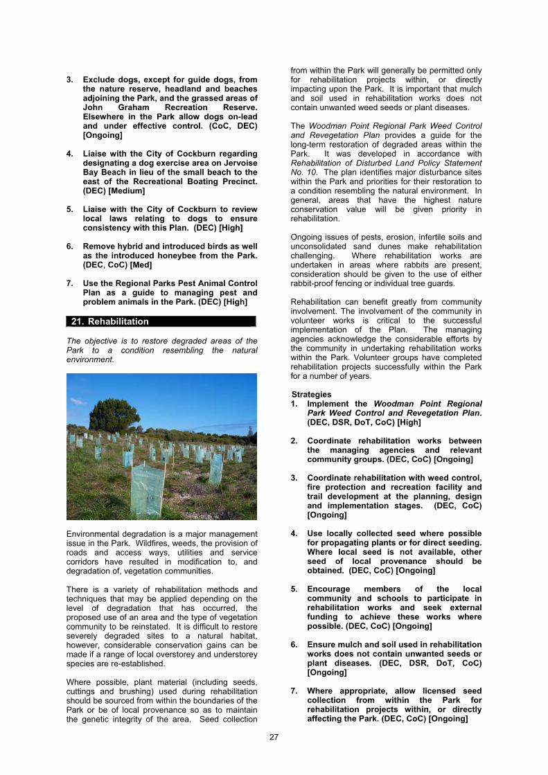
27
3. Exclude dogs, except for guide dogs, from
the nature reserve, headland and beaches adjoining the Park, and the grassed areas of John Graham Recreation Reserve. Elsewhere in the Park allow dogs on-lead and under effective control. (CoC, DEC) [Ongoing]
4. Liaise with the City of Cockburn regarding
designating a dog exercise area on Jervoise Bay Beach in lieu of the small beach to the east of the Recreational Boating Precinct. (DEC) [Medium]
5. Liaise with the City of Cockburn to review
local laws relating to dogs to ensure consistency with this Plan. (DEC) [High]
6. Remove hybrid and introduced birds as well
as the introduced honeybee from the Park. (DEC, CoC) [Med]
7. Use the Regional Parks Pest Animal Control
Plan as a guide to managing pest and problem animals in the Park. (DEC) [High]
21. Rehabilitation
The objective is to restore degraded areas of the Park to a condition resembling the natural environment.
Environmental degradation is a major management issue in the Park. Wildfires, weeds, the provision of roads and access ways, utilities and service corridors have resulted in modification to, and degradation of, vegetation communities. There is a variety of rehabilitation methods and techniques that may be applied depending on the level of degradation that has occurred, the proposed use of an area and the type of vegetation community to be reinstated. It is difficult to restore severely degraded sites to a natural habitat, however, considerable conservation gains can be made if a range of local overstorey and understorey species are re-established. Where possible, plant material (including seeds, cuttings and brushing) used during rehabilitation should be sourced from within the boundaries of the Park or be of local provenance so as to maintain the genetic integrity of the area. Seed collection
from within the Park will generally be permitted only for rehabilitation projects within, or directly impacting upon the Park. It is important that mulch and soil used in rehabilitation works does not contain unwanted weed seeds or plant diseases. The Woodman Point Regional Park Weed Control and Revegetation Plan provides a guide for the long-term restoration of degraded areas within the Park. It was developed in accordance with Rehabilitation of Disturbed Land Policy Statement No. 10. The plan identifies major disturbance sites within the Park and priorities for their restoration to a condition resembling the natural environment. In general, areas that have the highest nature conservation value will be given priority in rehabilitation. Ongoing issues of pests, erosion, infertile soils and unconsolidated sand dunes make rehabilitation challenging. Where rehabilitation works are undertaken in areas where rabbits are present, consideration should be given to the use of either rabbit-proof fencing or individual tree guards. Rehabilitation can benefit greatly from community involvement. The involvement of the community in volunteer works is critical to the successful implementation of the Plan. The managing agencies acknowledge the considerable efforts by the community in undertaking rehabilitation works within the Park. Volunteer groups have completed rehabilitation projects successfully within the Park for a number of years. Strategies 1. Implement the Woodman Point Regional
Park Weed Control and Revegetation Plan. (DEC, DSR, DoT, CoC) [High]
2. Coordinate rehabilitation works between
the managing agencies and relevant community groups. (DEC, CoC) [Ongoing]
3. Coordinate rehabilitation with weed control,
fire protection and recreation facility and trail development at the planning, design and implementation stages. (DEC, CoC) [Ongoing]
4. Use locally collected seed where possible
for propagating plants or for direct seeding. Where local seed is not available, other seed of local provenance should be obtained. (DEC, CoC) [Ongoing]
5. Encourage members of the local
community and schools to participate in rehabilitation works and seek external funding to achieve these works where possible. (DEC, CoC) [Ongoing]
6. Ensure mulch and soil used in rehabilitation
works does not contain unwanted seeds or plant diseases. (DEC, DSR, DoT, CoC) [Ongoing]
7. Where appropriate, allow licensed seed
collection from within the Park for rehabilitation projects within, or directly affecting the Park. (DEC, CoC) [Ongoing]
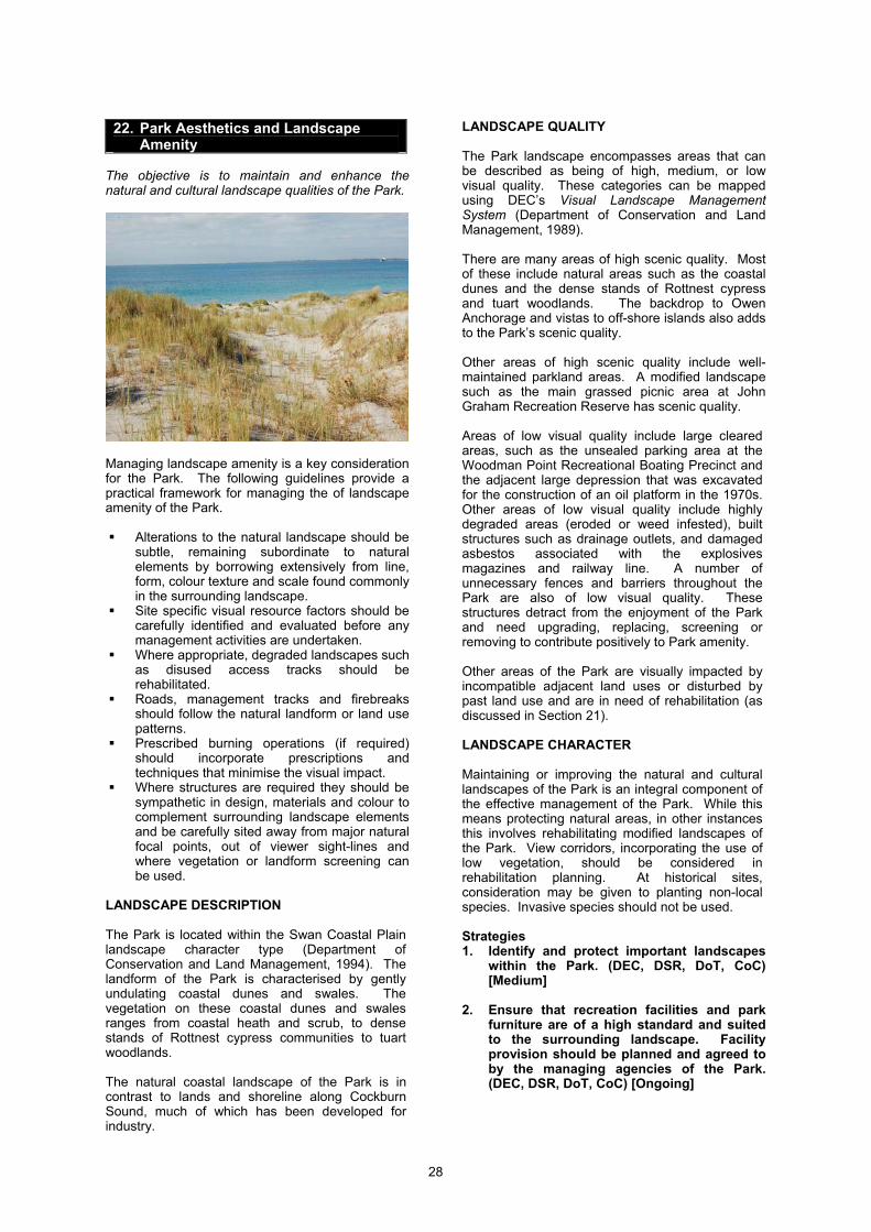
28
22. Park Aesthetics and Landscape
Amenity The objective is to maintain and enhance the natural and cultural landscape qualities of the Park.
Managing landscape amenity is a key consideration for the Park. The following guidelines provide a practical framework for managing the of landscape amenity of the Park.
Alterations to the natural landscape should be subtle, remaining subordinate to natural elements by borrowing extensively from line, form, colour texture and scale found commonly in the surrounding landscape.
Site specific visual resource factors should be carefully identified and evaluated before any management activities are undertaken.
Where appropriate, degraded landscapes such as disused access tracks should be rehabilitated.
Roads, management tracks and firebreaks should follow the natural landform or land use patterns.
Prescribed burning operations (if required) should incorporate prescriptions and techniques that minimise the visual impact.
Where structures are required they should be sympathetic in design, materials and colour to complement surrounding landscape elements and be carefully sited away from major natural focal points, out of viewer sight-lines and where vegetation or landform screening can be used.
LANDSCAPE DESCRIPTION The Park is located within the Swan Coastal Plain landscape character type (Department of Conservation and Land Management, 1994). The landform of the Park is characterised by gently undulating coastal dunes and swales. The vegetation on these coastal dunes and swales ranges from coastal heath and scrub, to dense stands of Rottnest cypress communities to tuart woodlands. The natural coastal landscape of the Park is in contrast to lands and shoreline along Cockburn Sound, much of which has been developed for industry.
LANDSCAPE QUALITY The Park landscape encompasses areas that can be described as being of high, medium, or low visual quality. These categories can be mapped using DEC’s Visual Landscape Management System (Department of Conservation and Land Management, 1989). There are many areas of high scenic quality. Most of these include natural areas such as the coastal dunes and the dense stands of Rottnest cypress and tuart woodlands. The backdrop to Owen Anchorage and vistas to off-shore islands also adds to the Park’s scenic quality. Other areas of high scenic quality include well-maintained parkland areas. A modified landscape such as the main grassed picnic area at John Graham Recreation Reserve has scenic quality. Areas of low visual quality include large cleared areas, such as the unsealed parking area at the Woodman Point Recreational Boating Precinct and the adjacent large depression that was excavated for the construction of an oil platform in the 1970s. Other areas of low visual quality include highly degraded areas (eroded or weed infested), built structures such as drainage outlets, and damaged asbestos associated with the explosives magazines and railway line. A number of unnecessary fences and barriers throughout the Park are also of low visual quality. These structures detract from the enjoyment of the Park and need upgrading, replacing, screening or removing to contribute positively to Park amenity. Other areas of the Park are visually impacted by incompatible adjacent land uses or disturbed by past land use and are in need of rehabilitation (as discussed in Section 21). LANDSCAPE CHARACTER Maintaining or improving the natural and cultural landscapes of the Park is an integral component of the effective management of the Park. While this means protecting natural areas, in other instances this involves rehabilitating modified landscapes of the Park. View corridors, incorporating the use of low vegetation, should be considered in rehabilitation planning. At historical sites, consideration may be given to planting non-local species. Invasive species should not be used. Strategies 1. Identify and protect important landscapes
within the Park. (DEC, DSR, DoT, CoC) [Medium]
2. Ensure that recreation facilities and park
furniture are of a high standard and suited to the surrounding landscape. Facility provision should be planned and agreed to by the managing agencies of the Park. (DEC, DSR, DoT, CoC) [Ongoing]
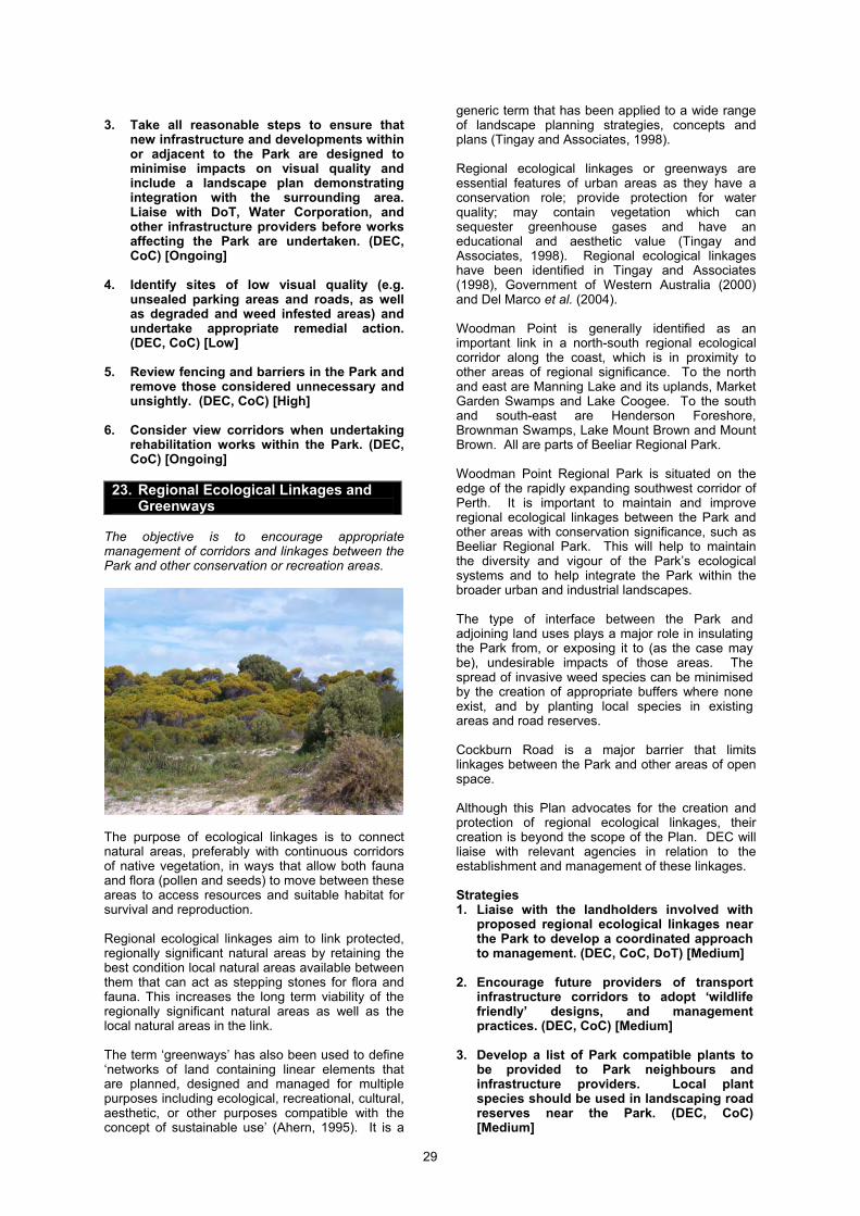
29
3. Take all reasonable steps to ensure that
new infrastructure and developments within or adjacent to the Park are designed to minimise impacts on visual quality and include a landscape plan demonstrating integration with the surrounding area. Liaise with DoT, Water Corporation, and other infrastructure providers before works affecting the Park are undertaken. (DEC, CoC) [Ongoing]
4. Identify sites of low visual quality (e.g.
unsealed parking areas and roads, as well as degraded and weed infested areas) and undertake appropriate remedial action. (DEC, CoC) [Low]
5. Review fencing and barriers in the Park and
remove those considered unnecessary and unsightly. (DEC, CoC) [High]
6. Consider view corridors when undertaking
rehabilitation works within the Park. (DEC, CoC) [Ongoing]
23. Regional Ecological Linkages and
Greenways The objective is to encourage appropriate management of corridors and linkages between the Park and other conservation or recreation areas.
The purpose of ecological linkages is to connect natural areas, preferably with continuous corridors of native vegetation, in ways that allow both fauna and flora (pollen and seeds) to move between these areas to access resources and suitable habitat for survival and reproduction. Regional ecological linkages aim to link protected, regionally significant natural areas by retaining the best condition local natural areas available between them that can act as stepping stones for flora and fauna. This increases the long term viability of the regionally significant natural areas as well as the local natural areas in the link. The term ‘greenways’ has also been used to define ‘networks of land containing linear elements that are planned, designed and managed for multiple purposes including ecological, recreational, cultural, aesthetic, or other purposes compatible with the concept of sustainable use’ (Ahern, 1995). It is a
generic term that has been applied to a wide range of landscape planning strategies, concepts and plans (Tingay and Associates, 1998). Regional ecological linkages or greenways are essential features of urban areas as they have a conservation role; provide protection for water quality; may contain vegetation which can sequester greenhouse gases and have an educational and aesthetic value (Tingay and Associates, 1998). Regional ecological linkages have been identified in Tingay and Associates (1998), Government of Western Australia (2000) and Del Marco et al. (2004). Woodman Point is generally identified as an important link in a north-south regional ecological corridor along the coast, which is in proximity to other areas of regional significance. To the north and east are Manning Lake and its uplands, Market Garden Swamps and Lake Coogee. To the south and south-east are Henderson Foreshore, Brownman Swamps, Lake Mount Brown and Mount Brown. All are parts of Beeliar Regional Park. Woodman Point Regional Park is situated on the edge of the rapidly expanding southwest corridor of Perth. It is important to maintain and improve regional ecological linkages between the Park and other areas with conservation significance, such as Beeliar Regional Park. This will help to maintain the diversity and vigour of the Park’s ecological systems and to help integrate the Park within the broader urban and industrial landscapes. The type of interface between the Park and adjoining land uses plays a major role in insulating the Park from, or exposing it to (as the case may be), undesirable impacts of those areas. The spread of invasive weed species can be minimised by the creation of appropriate buffers where none exist, and by planting local species in existing areas and road reserves. Cockburn Road is a major barrier that limits linkages between the Park and other areas of open space. Although this Plan advocates for the creation and protection of regional ecological linkages, their creation is beyond the scope of the Plan. DEC will liaise with relevant agencies in relation to the establishment and management of these linkages. Strategies 1. Liaise with the landholders involved with
proposed regional ecological linkages near the Park to develop a coordinated approach to management. (DEC, CoC, DoT) [Medium]
2. Encourage future providers of transport
infrastructure corridors to adopt ‘wildlife friendly’ designs, and management practices. (DEC, CoC) [Medium]
3. Develop a list of Park compatible plants to
be provided to Park neighbours and infrastructure providers. Local plant species should be used in landscaping road reserves near the Park. (DEC, CoC) [Medium]
Part D. Managing Cultural Heritage
30
D. MANAGING CULTURAL HERITAGE
24. Guiding Principles for Managing Cultural Heritage
1. Conservation and protection of cultural
heritage The Park will be managed in a way that delivers community benefits by maintaining cultural traditions and attributes. Heritage sites will be preserved and maintained for their inherent cultural and social values. Impacts from human use and management practices will be minimised in order to maintain heritage values. 2. Consistency of management policies The land managers involved in the Park will apply management actions that are consistent with state, national and international cultural heritage legislation, conventions and guidelines. 3. Community involvement The community will be involved in managing sites of heritage value. Aboriginal people are especially encouraged to be involved and should be provided with appropriate consultation opportunities in the management of the Park. 4. Research and interpretation Where appropriate, interpretive information will be provided to enhance community understanding of, and appreciation for heritage sites. 5. Restoration of cultural heritage Where possible, heritage sites will be restored to protect and maintain their value. Sites with high heritage significance will be considered priorities. Strategy 1. Apply the above principles as required
in managing the cultural heritage of the Park. (DEC, DSR, DoT, CoC) [Ongoing]
25. Aboriginal Cultural Heritage
The objective is to identify, protect and appropriately manage sites with Aboriginal cultural heritage value in the Park. ABORIGINAL ASSOCIATION AND USE Research suggests that there was a large Aboriginal presence in the Cockburn region prior to European settlement. The census of 1837 found thirty-nine Aboriginal people at Mangles Bay, at the southern end of Cockburn Sound (Powell and Emberson, 1981). These people formed part of the Nyoongar people, who lived throughout the south-west of Western Australia. The Nyoongar people moved up and down the coast between estuaries and water sources. Woodman Point and Coogee were used for beach camping. Cobbler fishing and mussel gathering
were popular activities at Woodman Point. Local Nyoongar Elders have indicated a concern for the vegetation in the Woodman Point area (McDonald, Hales and Associates, 1997). Local plants from Woodman Point such as the quandong (Santalum acuminatum) were used for jam making and other plants were used for medicinal purposes. No archeological evidence has been found of Aboriginal habitation at Woodman Point (Powell and Emberson, 1981), however local Nyoongar Elders have expressed the potential for archeological material, including burials, to be located in the dune systems along the coastline (McDonald, Hales and Associates, 1997). There is a listed Aboriginal site in the Park, which is a site of mythological significance. Part of the seabed adjacent to the Park has also been listed as an Aboriginal site and there are other sites to the east of the Park. Research undertaken by McDonald, Hales and Associates (1997), in consultation with local Aboriginal Elders, provides details on two sites in the vicinity of Woodman Point. Both are of mythological significance and are described below. The first site relates to the limestone ridge which runs parallel to the coastline and ranges approximately 200 -400 metres inland to the east of the Park. The myth concerns a sparrow and a hawk that flew to the round hole in the earth where the moon rested (to the north-east of the Park). The birds stole fire from the moon in the form of a burning stick. They flew along the ridge where the bush caught fire. The moon called in its uncle, the ocean. The ocean rose to extinguish the fire. Nyoongars were drowned and the lakes were formed in the area, including Lake Coogee. This story has resonance with another myth that explains the origin of the offshore islands (McDonald, Hales and Associates, 1997). The second site relates to Woodman Point itself and its important mythological significance associated with the origins of death. According to the local Nyoongar Elder consulted, there was no death for Nyoongars originally and everyone was immortal. That state was maintained by a man who threw a boomerang, which returned to be thrown again. As long as the boomerang could be maintained in flight, there would be no death. His son begged the man for a chance to throw the boomerang. The man denied him for a long time but finally relented. The boy could not keep the boomerang in flight; death began and the earth stood still. The dead henceforth travelled to Kooranup, the land of dead over the sea. The Nyoongar Elder consulted pointed out that Woodman Point is shaped like a boomerang. Another version of this myth is similar in theme, and relates to the area between Woodman Point and the mouth of the Murray River (McDonald, Hales and Associates, 1997).
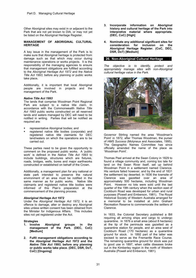
Part D. Managing Cultural Heritage
31
Other Aboriginal sites may exist in or adjacent to the Park that are not yet known to DIA, or may not yet be listed on the Aboriginal Heritage Register. MANAGEMENT OF ABORIGINAL CULTURAL HERITAGE A key issue in the management of the Park is to make sure that Aboriginal heritage is protected from damage such as that which may occur during maintenance operations or works projects. It is the responsibility of the managing agencies to ensure that management obligations are fulfilled according to the Aboriginal Heritage Act 1972 and the Native Title Act 1993, before any planning or public works take place. Additionally, it is important that local Aboriginal people are involved in projects and the management of the Park. Native Title Act 1993 The lands that comprise Woodman Point Regional Park are subject to a native title claim. In accordance with the Commonwealth Native Title Act 1993 public works constructed on all reserved lands and waters managed by DEC will need to be notified in writing. Parties that will be notified as required are: representative Aboriginal bodies; and registered native title bodies (corporate) and
registered native title claimants for DEC land/waters on which the operations are to be carried out.
These parties need to be given the opportunity to comment on the proposed public works. A ‘public work’ is defined in the Native Title Act 1993 to include buildings, structures which are fixtures, roads, bridges, wells, bores and major earthworks constructed or established on behalf of the Crown. Additionally, a management plan for any national or state park intended to preserve the natural environment of an area must be notified in the same manner as for public works. Native title claimants and registered native title bodies were informed of this Plan’s preparation at the commencement of the planning process. Aboriginal Heritage Act 1972 Under the Aboriginal Heritage Act 1972, it is an offence to damage, alter or destroy any Aboriginal sites unless written consent has been obtained from the Minister for Indigenous Affairs. This includes sites not yet registered under the Act. Strategies 1. Involve Aboriginal groups in the
management of the Park. (DEC, CoC) [Medium]
2. Fulfil management obligations according to
the Aboriginal Heritage Act 1972 and the Native Title Act 1993, before any planning or public works take place. (DEC, DSR, DoT, CoC) [Ongoing]
3. Incorporate information on Aboriginal history and cultural heritage of the Park into interpretive material where appropriate. (DEC, CoC) [High]
4. Nominate any additional significant sites for
consideration for inclusion on the Aboriginal Heritage Register. (CoC, DEC, DSR, DoT) [Medium]
26. Non-Aboriginal Cultural Heritage
The objective is to identify, protect and appropriately manage sites with non-Aboriginal cultural heritage value in the Park.
Governor Stirling named the area ‘Woodman's Point’ in 1872, after Thomas Woodman, the purser of HMS Success (Molyneux and Associates, 1995). The Geographic Names Committee has since officially amended the name of the place as ‘Woodman Point’. Thomas Peel arrived at the Swan Colony in 1829 to found a village community and, coming too late for land on the Swan River itself, set up behind Woodman Point in a settlement named Clarence. His venture failed however, and by the end of 1831 the settlement lay deserted. In 1836 the townsite of Clarence was gazetted over an area of approximately 500 hectares, including Woodman Point. However no lots were sold until the last quarter of the 19th century when the section east of Cockburn Road was developed for urban and rural purposes (Powell and Emberson, 1981). The Royal Historical Society of Western Australia arranged for a memorial to be installed at John Graham Recreation Reserve to commemorate the settlers of Clarence. In 1833, the Colonial Secretary published a Bill requiring all arriving ships and cargo to undergo quarantine. In 1876 a small area (about 8 hectares) at the tip of the peninsula was gazetted as a quarantine station for people, and an area west of Cockburn Road (170 hectares) as a quarantine ground for stock. In 1892 part of the latter was excised to serve as the Fremantle Race Course. The remaining quarantine ground for stock was put to good use in 1897, when cattle diseases broke out in the Kimberley region in the north of Western Australia (Powell and Emberson, 1981).
Part D. Managing Cultural Heritage
32
In 1903 and 1904, the quarantine station for people was expanded to 50 hectares (plus a 300 metre strip of the bordering sea). The rest of the peninsula behind the station, together with the racecourse, became a reserve for explosives, because the previous depot at Robb Jetty was considered unsafe. The railway was carried south from Robb Jetty, explosives magazines were laid out in lines, a large pier was built for the unloading of explosives and the reserve was fenced (Powell and Emberson, 1981). Before the First World War a grandiose plan was adopted to turn the whole peninsula into a naval base. The Point was built out about 400 metres and then extended a similar distance south-westwards; the first part of its proposed 2000 metres. After five years’ work, however, the project was abandoned in 1918 (Powell and Emberson, 1981). Meanwhile, in 1909, the Commonwealth had taken over the quarantine station. It was used to quarantine thousands of troops returning from the First World War, and thereafter intermittently for cases or possible cases of infectious disease, chiefly smallpox (Powell and Emberson, 1981). Memorials have been erected in honour of Sister Rosa O’Kane, who died from an illness contracted from soldiers in quarantine, and to a group of men who were cremated at the quarantine station and had their ashes scattered in the area. In 1942, during the Second World War, three munitions magazines were built to house explosive materials. The buildings still exist, located on Conservation Close. Each is surrounded by a distinctive barrier berm, built from a stack of concrete ‘pillows’ designed to absorb the impact of a possible explosion (Heritage Council of Western Australia, 2001). The munitions magazines are particularly significant because they were used for the storage of cordite, used in the manufacture of munitions at a factory in Welshpool, and because no similar structures were built in Western Australia (Heritage Council of Western Australia, 2001). Two large ammunition stores were built in what is now the Recreational Boating Precinct. One still exists as the Cockburn Pleasure Boat Storage Facility. These were connected to the explosives magazines by rail and the ammunition was exported via a landing at Jervoise Bay. During the 1950s, thousands of immigrants passed through the quarantine station on their day of arrival in Australia, to have their clothes and luggage fumigated as a safeguard against the accidental introduction of foot-and-mouth disease (Powell and Emberson, 1981). The western end of Woodman Point was modified in 1967 by the construction of another lengthy mole, from which WAPET drilled unsuccessfully for oil (Powell and Emberson, 1981). In 1971 Cockburn Cement Ltd established its operations on the artificial end of the Point. A road allowing public access to the end of Woodman Point was constructed to service the operation.
In the south-east of the Park, a large basin was excavated in what is now the Recreational Boating Precinct, for the construction of the Ocean Endeavour oil-rig in 1973-74. The land on which the rig was constructed was excavated to allow the rig to literally float to sea. In 1979 the State government purchased the quarantine station from the Commonwealth Government and closed down the operation. The buildings were considered suitable for a recreation camp and were vested in the Recreation Camps and Reserve Board. The former Department of Youth, Sport and Recreation and the former Public Works Department spent considerable funds renovating the buildings for use as a recreation camp. Public boat launching facilities and private sailing clubs were established on the south coast after 1980. The explosives reserve was vacated in 1982, and in 1984 it came under the interim management of DSR. Heritage of Western Australia Act 1990 The Heritage Council of Western Australia maintains a Register of Heritage Places in accordance with the Heritage of Western Australia Act 1990. Under the Act, places entered in the State Register are given legal protection and all development proposals affecting these places are required to be referred to the Heritage Council for advice. Within the Park, the former munitions magazines and former quarantine station are permanently listed on the State Register of Heritage Places. The quarantine station, of which numerous surviving buildings comprise parts of the DSR Recreation Camp, is included on the Register of the National Estate and is classified by the National Trust. The Government Heritage Property Disposal Process is a policy that provides a process for the identification and assessment of heritage value of government property under consideration for disposal, and for relevant protection to be provided where appropriate. DEC will liaise with the Heritage Council of Western Australia where property is to be disposed of on Crown land and where heritage values may exist. Local governments are required by the Heritage of Western Australia Act 1990 to maintain a heritage inventory, and they have the power to protect these sites by including them in the local Town Planning Scheme. The Quarantine Station Complex, a number of tuart trees near Cockburn Road, the Munitions Magazines, Coogee Beach and Jetty, and Woodman Point (Magazine) Jetty are included in the City of Cockburn Municipal Heritage Inventory. Near the Park are other places of heritage significance. Coogee Hotel and Post Office, the lighthouse and lighthouse keepers’ cottages, the Munster channel marker and trigonometric beacon, and the former lime kilns are permanently listed on the State Register of Heritage Places. The Coogee
Part D. Managing Cultural Heritage
33
Hotel and Post Office, the lighthouse and lighthouse keepers’ cottages, and the former lime kilns are also on the City of Cockburn Municipal Heritage Inventory. There are two known shipwrecks to the west of the Park. The James Mathews (1841) lies on the north side of Woodman Point in Owen Anchorage, adjacent to the Cockburn Cement Ltd Jetty and about 100 metres from the shore. The wreck lies buried in sand in 2 to 3 metres of water. The Omeo (1905) lies in the nearshore zone adjacent to Ocean Road, Coogee. The wreck is visible from the shore and has formed a habitat for marine flora and fauna. With respect to non-Aboriginal heritage sites, key issues that need to be addressed include general maintenance and management of sites in the Park and development of appropriate processes to involve interested parties in restoring and utilising sites of cultural significance. Strategies 1. Involve historic groups in the management
of the Park. (DEC, CoC) [Medium] 2. Incorporate information on non-Aboriginal
history of the Park into interpretive material where appropriate. (DEC, CoC) [High]
3. Nominate additional significant sites for
heritage listing on either the City of Cockburn Municipal Heritage Inventory, or State and National Heritage Registers. (CoC, DEC, DSR, DoT) [Medium]
4. Develop management guidelines for
historic sites in consultation with other appropriate heritage organisations, such as the Heritage Council of Western Australia, WA Museum, National Trust, Australian Heritage Council and historical societies. (DEC, CoC) [Medium]
5. Ensure that development proposals that
may affect registered Heritage Places are referred to appropriate heritage agencies for advice. (DEC, CoC, DoT, DSR) [Ongoing]
6. Liaise with the Heritage Council and other
appropriate heritage agencies where property is to be disposed of on Crown land and where heritage values may exist. (DEC, CoC, DoT, DSR)
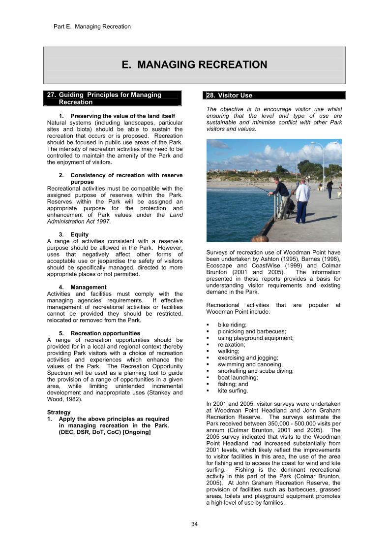
Part E. Managing Recreation
34
E. MANAGING RECREATION
27. Guiding Principles for Managing Recreation
1. Preserving the value of the land itself
Natural systems (including landscapes, particular sites and biota) should be able to sustain the recreation that occurs or is proposed. Recreation should be focused in public use areas of the Park. The intensity of recreation activities may need to be controlled to maintain the amenity of the Park and the enjoyment of visitors.
2. Consistency of recreation with reserve purpose
Recreational activities must be compatible with the assigned purpose of reserves within the Park. Reserves within the Park will be assigned an appropriate purpose for the protection and enhancement of Park values under the Land Administration Act 1997.
3. Equity A range of activities consistent with a reserve’s purpose should be allowed in the Park. However, uses that negatively affect other forms of acceptable use or jeopardise the safety of visitors should be specifically managed, directed to more appropriate places or not permitted.
4. Management Activities and facilities must comply with the managing agencies’ requirements. If effective management of recreational activities or facilities cannot be provided they should be restricted, relocated or removed from the Park.
5. Recreation opportunities A range of recreation opportunities should be provided for in a local and regional context thereby providing Park visitors with a choice of recreation activities and experiences which enhance the values of the Park. The Recreation Opportunity Spectrum will be used as a planning tool to guide the provision of a range of opportunities in a given area, while limiting unintended incremental development and inappropriate uses (Stankey and Wood, 1982). Strategy 1. Apply the above principles as required
in managing recreation in the Park. (DEC, DSR, DoT, CoC) [Ongoing]
28. Visitor Use The objective is to encourage visitor use whilst ensuring that the level and type of use are sustainable and minimise conflict with other Park visitors and values.
Surveys of recreation use of Woodman Point have been undertaken by Ashton (1995), Barnes (1998), Ecoscape and CoastWise (1999) and Colmar Brunton (2001 and 2005). The information presented in these reports provides a basis for understanding visitor requirements and existing demand in the Park. Recreational activities that are popular at Woodman Point include: bike riding; picnicking and barbecues; using playground equipment; relaxation; walking; exercising and jogging; swimming and canoeing; snorkelling and scuba diving; boat launching; fishing; and kite surfing.
In 2001 and 2005, visitor surveys were undertaken at Woodman Point Headland and John Graham Recreation Reserve. The surveys estimate the Park received between 350,000 - 500,000 visits per annum (Colmar Brunton, 2001 and 2005). The 2005 survey indicated that visits to the Woodman Point Headland had increased substantially from 2001 levels, which likely reflect the improvements to visitor facilities in this area, the use of the area for fishing and to access the coast for wind and kite surfing. Fishing is the dominant recreational activity in this part of the Park (Colmar Brunton, 2005). At John Graham Recreation Reserve, the provision of facilities such as barbecues, grassed areas, toilets and playground equipment promotes a high level of use by families.
Part E. Managing Recreation
35
The surveys indicate that a large proportion of visitors to the Park live locally, and the majority are repeat visitors who go to the Park approximately once per week. Most visitors arrive by private vehicle (Colmar Brunton, 2005). Visitor numbers to the Park are expected to increase over time with continued residential development north and east of the Park. In a regional context, the Park contains some of the few remaining areas of undeveloped coastline between Fremantle and Rockingham. It offers opportunities for beach access and coastal recreation in an increasingly developed region. The boat launching facilities in the Park receive continually high use and are the busiest recreational boating facilities in the metropolitan area. The demand for these facilities is forecast to increase based on existing trends in boat usage and ownership (Department of Transport, 2000). The existing high level of visitation to the Park, plus increasing development in the surrounding areas, suggest continuing high demand for existing and planned recreation facilities in the Park. Specific visitor use surveys will be necessary prior to any significant recreation developments occurring in the Park. INAPPROPRIATE VISITOR USES Vandalism and other forms of anti-social behaviour Vandalism, thefts from cars, illicit drug use and other forms of anti-social behaviour are predominant problems that occur at the Park. DEC will need to undertake a range of actions to reduce the level of anti-social behaviour in the Park. Consideration will be given to closing areas of the Park at night to help manage the problem. Unauthorised camping Camping within the Park is only allowed in the two caravan and camping parks - Coogee Beach Holiday Park and Woodman Point Holiday Park. Unauthorised camping is not allowed within other lease areas or the rest of the Park. Golfing The grassed area on O’Kane Court has been used for golf practice in the past. This creates a hazard for other users of the Park. Golfing is prohibited in the Park. Nude Bathing A small number of people have been bathing nude on beaches adjoining the Park. The beaches are not gazetted for nude bathing and the City of Cockburn and DEC have received numerous complaints about the activity.
While operationally the beaches themselves are not contained within the Park, many visitors travel to the Park in order to access the beaches. Given the high levels of visitation and broad range of people and family groups who frequent the Park, the City of Cockburn and DEC believe nude bathing is not an appropriate activity at the beaches. The City of Cockburn administers local laws that can be used to control nude bathing on beaches within its municipality. Strategies 1. Continue the visitor survey programme to
better understand of visitor use, numbers and satisfaction within the Park, and use the information in managing the Park. Use DEC’s VISTAT (a quantitative system for recording and monitoring visitor levels) as a basis for the programme. (DEC, CoC) [High].
2. Implement measures to reduce anti-social
behaviour in the Park by: improving vehicle and pedestrian
circulation in appropriate areas of the Park;
upgrading or redesigning parking areas to improve the visibility of parked cars;
undertaking security patrols; consider the installation of video
surveillance; and consider restricting access to
recreation areas within the Park at night. (DEC) [High]
3. Ensure there is no unauthorised camping in
the Park. (DEC) [Ongoing] 4. Ensure there is no golfing in the Park.
(DEC) [Ongoing] 5. Maintain the current non-gazettal of nude
bathing at beaches adjoining the Park. (CoC) [High]
KPIs for visitor use The success of these strategies will be measured by: 1. Changes in visitor numbers and satisfaction
levels. 2. Provision of formalised access in the Park (as
per Section 29 – Recreation Masterplan). 3. Completion of a visitor survey programme. Target: 1. No decline in visitor satisfaction from 2005
levels. 2. Complete access and circulation components
of the Recreation Masterplan within ten years of completion of this Plan.
3. Visitor survey programme completed by 2012. Reporting: 1. Every 5 years. 2. Completed by 2019. 3. Every 5 years.
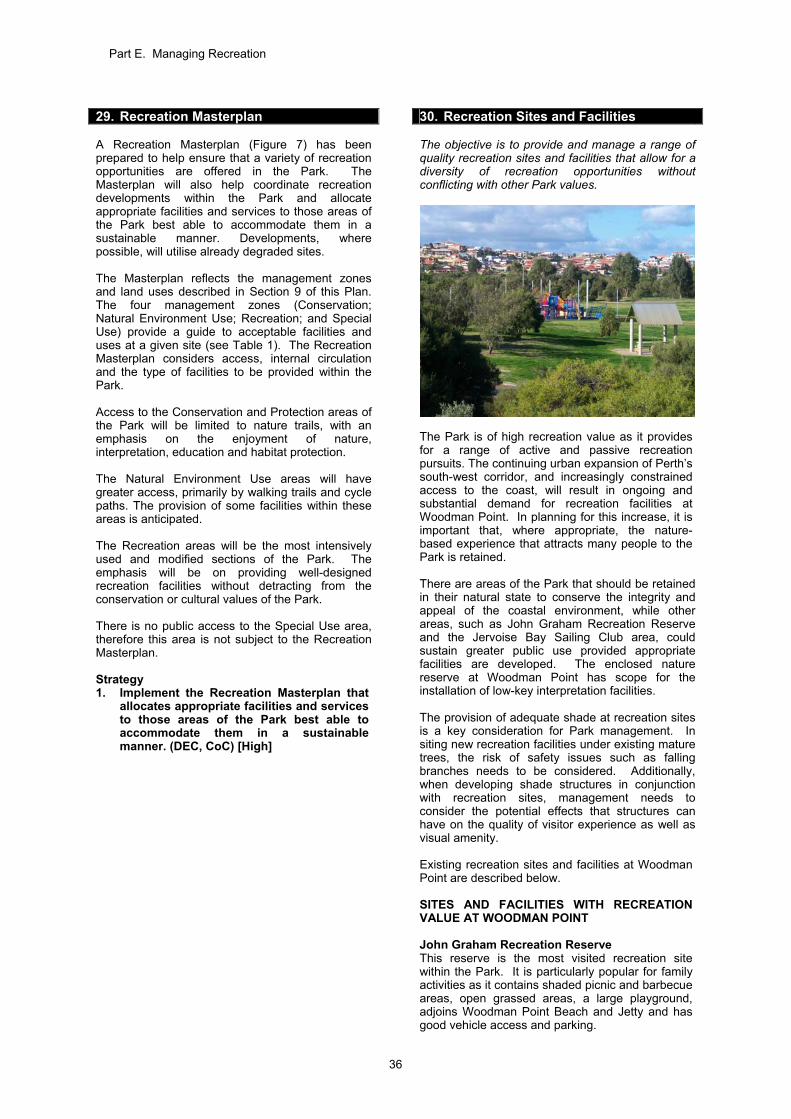
Part E. Managing Recreation
36
29. Recreation Masterplan A Recreation Masterplan (Figure 7) has been prepared to help ensure that a variety of recreation opportunities are offered in the Park. The Masterplan will also help coordinate recreation developments within the Park and allocate appropriate facilities and services to those areas of the Park best able to accommodate them in a sustainable manner. Developments, where possible, will utilise already degraded sites. The Masterplan reflects the management zones and land uses described in Section 9 of this Plan. The four management zones (Conservation; Natural Environment Use; Recreation; and Special Use) provide a guide to acceptable facilities and uses at a given site (see Table 1). The Recreation Masterplan considers access, internal circulation and the type of facilities to be provided within the Park. Access to the Conservation and Protection areas of the Park will be limited to nature trails, with an emphasis on the enjoyment of nature, interpretation, education and habitat protection. The Natural Environment Use areas will have greater access, primarily by walking trails and cycle paths. The provision of some facilities within these areas is anticipated. The Recreation areas will be the most intensively used and modified sections of the Park. The emphasis will be on providing well-designed recreation facilities without detracting from the conservation or cultural values of the Park. There is no public access to the Special Use area, therefore this area is not subject to the Recreation Masterplan. Strategy 1. Implement the Recreation Masterplan that
allocates appropriate facilities and services to those areas of the Park best able to accommodate them in a sustainable manner. (DEC, CoC) [High]
30. Recreation Sites and Facilities The objective is to provide and manage a range of quality recreation sites and facilities that allow for a diversity of recreation opportunities without conflicting with other Park values.
The Park is of high recreation value as it provides for a range of active and passive recreation pursuits. The continuing urban expansion of Perth’s south-west corridor, and increasingly constrained access to the coast, will result in ongoing and substantial demand for recreation facilities at Woodman Point. In planning for this increase, it is important that, where appropriate, the nature-based experience that attracts many people to the Park is retained. There are areas of the Park that should be retained in their natural state to conserve the integrity and appeal of the coastal environment, while other areas, such as John Graham Recreation Reserve and the Jervoise Bay Sailing Club area, could sustain greater public use provided appropriate facilities are developed. The enclosed nature reserve at Woodman Point has scope for the installation of low-key interpretation facilities. The provision of adequate shade at recreation sites is a key consideration for Park management. In siting new recreation facilities under existing mature trees, the risk of safety issues such as falling branches needs to be considered. Additionally, when developing shade structures in conjunction with recreation sites, management needs to consider the potential effects that structures can have on the quality of visitor experience as well as visual amenity. Existing recreation sites and facilities at Woodman Point are described below. SITES AND FACILITIES WITH RECREATION VALUE AT WOODMAN POINT John Graham Recreation Reserve This reserve is the most visited recreation site within the Park. It is particularly popular for family activities as it contains shaded picnic and barbecue areas, open grassed areas, a large playground, adjoins Woodman Point Beach and Jetty and has good vehicle access and parking.
Part E. Managing Recreation
37
Works completed under the Jervoise Bay Conservation and Recreation Enhancement Plan focussed on upgrading parking areas and facilities at John Graham Recreation Reserve, that were degraded from high levels of use and vandalism. The works at the reserve have improved the appearance and visibility of parking areas, and created new grass picnic and sitting areas. Tree planting has also taken place to enhance the natural coastal vegetation, and protect the dunes from erosion. In the future, DEC may consider establishing a lease or licence for a café/ kiosk at the site. Further planning will be required to determine the feasibility of this proposal. This is discussed in Section 35. Woodman Point Nature Reserve Woodman Point has a fascinating history and is of cultural significance to both Aboriginal and non-Aboriginal people, as discussed in Chapter D. The restricted public access associated with these previous uses has contributed to the preservation of a unique coastal vegetation remnant. The rich combination of cultural and natural history has the potential to be highlighted in the nature reserve via an interpretation trail which could link to John Graham Recreation Reserve. The interpretation trail could provide information on the coastal vegetation and threatened ecological community of Rottnest cypress and Rottnest tea tree, as well as the cultural values of the site. Heritage assessments may be necessary to determine whether it is feasible to upgrade the heritage buildings in the nature reserve. If it is determined that upgrading the buildings is not feasible, it may be desirable to provide interpretive information explaining this. Guided tours of the nature reserve are periodically available through programmes run by DEC such as ‘Nearer to Nature’. There may be potential to expand this type of activity to enhance the education and interpretation value of the site. Woodman Point View and Woodman Point Headland Woodman Point View allows easy access to the beach and affords good views of Jervoise Bay and Rockingham. Woodman Point Headland is a natural terminating point and is a popular location for fishing and for wind surfing and kite surfing. A sealed access road and parking areas have been installed along Woodman Point View and at the Headland. Sitting and lookout areas have also been developed so that visitors can enjoy the views across Cockburn Sound. At both sites, extensive rehabilitation works have taken place using local coastal species. Jervoise Bay Sailing Club Site The Jervoise Bay Sailing Club is located at Woodman Point Beach, immediately to the east of Cockburn Cement Ltd. The site offers shelter from the predominant south-west summer winds, shaded picnic areas, and good views of the coast towards Fremantle. Owen Anchorage provides unique opportunities on the Perth metropolitan coastline for
sailing in conditions sheltered from south-west winds. The Club is in negotiations with DEC for a lease agreement to provide greater security of tenure. The lease for Jervoise Bay Sailing Club is discussed in Section 35. Proposed Coogee Beach Surf Life Saving Club at Poore Grove Poore Grove is currently a low key recreation area which receives low levels of community use. The City of Cockburn has received approval from the WAPC to develop facilities for the Coogee Beach Surf Life Saving Club at Poore Grove. As part of development concept plans for the club, suitable management strategies will need to be put in place to protect the threatened ecological community of Rottnest cypress woodland that occurs in the area and to manage the various pressures that may be associated with that level of development. Should the surf life saving club development proceed at Poore Grove, the City would take on management responsibility for the site and facilities, including some land currently vested in the Conservation Commission and managed by DEC. Woodman Point Jetty Near to John Graham Recreation Reserve, the Woodman Point Jetty provides a focus for fishing, scuba diving and swimming. Presently, the jetty is unlicensed, however it was previously managed by Fremantle Ports. DoT is responsible for licensing the jetty and has raised concerns regarding its condition. Discussions will continue between the relevant agencies to determine what works are required and to resolve future management arrangements. Coogee Beach and Jetty Coogee Beach has been a popular beach recreation destination in the Cockburn area for many years. The beach and adjacent café and caravan park will continue to be managed by the City of Cockburn. Woodman Point Recreation Camp The Woodman Point Recreation Camp, which is located at the end of O’Kane Court, is managed by DSR. The camp includes the former quarantine station buildings, which have been upgraded. It provides fully catered overnight accommodation. The camp is popular with schools and community groups. Owen Anchorage is easily accessible from the camp and many activities organised by the camp managers are water-based recreation activities. Access from the camp to the beach is provided through land managed by DEC and is the subject of an agreement between DSR and DEC. Woodman Point Recreational Boating Precinct The Woodman Point Recreational Boating Precinct is important to recreational boat users and fishers as one of the few public launching facilities on the coast in the metropolitan area. It contains eight boat launch ramps as well as two lease sites, occupied by the Cockburn Power Boats Association and Cockburn Pleasure Boat Storage.
Part E. Managing Recreation
38
The Woodman Point Recreational Boating Precinct is vested in the Minister for Transport. DoT manages numerous maritime facilities and is the most appropriate agency to develop and manage the precinct in response to growing demand from the recreational boating community. The area will continue to be managed as part of the Park. Part of the precinct supports remnant vegetation, and accordingly this area is zoned ‘Natural Environment Uses’. Intensive recreation and commercial facilities in the precinct will be provided in the area zoned ‘Recreation’. The boat launching facilities have been upgraded to better cope with demand. DoT has produced a Concept Development Plan for the broader precinct that provides for additional parking, improved access and circulation, a boat stacking facility with additional jetties, and additional recreational marine-related services. It is intended that more detailed site planning for the precinct will be undertaken by DoT in consultation with DEC, other relevant stakeholders, and the community. The introduction of parking fees for vehicles and trailers may be considered as part of the upgrade works following further community consultation. Protection of remnant vegetation, rehabilitation of degraded areas, enhancing the visual amenity of the area and integration of the precinct with the rest of the Park will also be major considerations in subsequent planning for the precinct. There is potential to establish additional commercial concessions in the precinct related to recreational marine activities, to service the strong recreational boating demand. Any lease opportunities at the site would be subject to a competitive expression of interest process, which would be managed by DoT. Strategies 1. Prepare and implement site development
plans for significant works within the Park. (DEC, DSR, DoT, CoC) [Ongoing]
2. Develop suitable and safe facilities and
structures in a manner that is environmentally appropriate and sympathetic to the surrounding landscape, to cater for existing and anticipated future recreation demands. (DEC, DSR, DoT, CoC) [Ongoing]
3. Seek funding for capital works at recreation
sites within the Park. (DEC) [Ongoing]
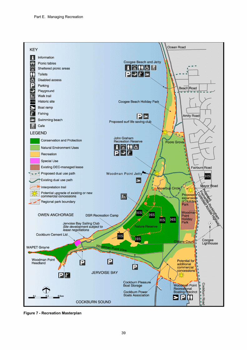
Part E. Managing Recreation
39
Figure 7 - Recreation Masterplan
Part E. Managing Recreation
40
31. Park Access and Circulation The objective is to provide safe, convenient and structured access to, and within the Park, that is consistent with Park values. Managing access to the Park is a major issue due to its proximity to urban areas and its popularity as a regional destination. Whilst access for recreation and education purposes is legitimate, uncontrolled vehicle and pedestrian access has severely eroded and degraded some areas in the past. Park access and circulation are key components of the Recreation Masterplan (see Figure 7). ROAD ACCESS The Park is accessed via Cockburn Road, a major north-south road linking Fremantle to Kwinana and Rockingham. Existing access from Cockburn Road into the Park occurs at the following locations:
Powell Road; Poore Grove; Nyyerbup Circle; Magazine Court (enters the Woodman Point
Holiday Park but only provides access for caravan park users); and
O'Kane Court. Additional roads will only be constructed in the Park if they are for management purposes or as part of recreation, educational or commercial development. DoT is investigating the potential for improved access to the Recreational Boating Precinct direct from Cockburn Road. Should the Fremantle-Rockingham Controlled Access Highway be constructed near the eastern boundary of the Park, there may be modifications to the road entrances to the Park. As a means of addressing recurring vandalism and anti-social behaviour occurring within the Park, consideration will be given to restricting access to recreation areas at night. PARKING AREAS Parking areas are located at Coogee Beach, Poore Grove, John Graham Recreation Reserve, the Woodman Point Recreational Boating Precinct, Woodman Point View and Woodman Point Headland. Three key issues relating to parking are: 1. providing safe and convenient parking to
facilitate access; 2. reducing the undesirable effects of uncontrolled
parking and access; and 3. reducing the level of anti-social behaviour such
as car theft and vandalism. Substantial work has been undertaken to provide additional formal parking facilities and to redesign and upgrade existing facilities at John Graham Recreation Reserve, Woodman Point View and Woodman Point Headland. These works were implemented as part of the Jervoise Bay Conservation and Recreation Enhancement Plan
(Department of Conservation and Land Management, 2001). Traffic flow and parking improvements were undertaken as part of the first stage of development of the Recreational Boating Precinct. The second stage will further improve public access and improve parking in the precinct. Development of parking areas in the Park needs to be cognisant of future demand. Where appropriate, additional parking will be provided on already degraded sites where environmental impacts will be minimised. BICYCLE AND PEDESTRIAN ACCESS The Recreation Masterplan illustrates that the pathway network creates a circuit, allowing visitors to travel around the coastal perimeter of the Park and to facilitate better access to the beach (Figure 7). In the past, informal pedestrian access, particularly to the beaches, has resulted in degradation of sensitive dunes through trampling of vegetation and exposure to erosion. Informal paths will be rationalised to channel use on to formed paths that are more appropriately located and that allow visitors to experience the diverse recreation opportunities and settings within the Park. Existing pedestrian and vehicle access will be retained between the Woodman Point Recreation Camp and the beach. The two existing walkways and the vehicle access track will be maintained. For heritage and interpretive purposes an additional access way may be required in the future, possibly where the original Woodman Point quarantine jetty met the beach and a small railway track led to the isolation hospital within the camp. ACCESS FOR ALL Universal access standards are applicable to dual use paths throughout the Park and some facilities at John Graham Recreation Reserve. The Woodman Point Jetty is also accessible by wheelchair. Where required, some path surfaces will be upgraded to allow access for all. Appropriate pathways and ramps will need to be provided to allow all people to experience the diverse settings within the Park. All paths within the Park will be designed in accordance with Australian Standards. PRIVATE VEHICLE AND MOTORCYCLE ACCESS The unauthorised driving of vehicles on pathways, grass areas, beaches and other recreation areas is not permitted. Private vehicle access is restricted to designated parking areas and access roads. Access outside these areas may endanger other Park visitors, cause damage to the landscape and adversely affect wildlife.
Part E. Managing Recreation
41
Access to Northern Harbour Breakwater Managing vehicle and pedestrian access to the breakwater will be considered as part of the concept development plan for the Woodman Point Recreational Boating Precinct (Section 30). Beach Access for Commercial Fishing The Department of Fisheries has allocated licences to commercial fishers to catch bait fish in Cockburn Sound under a managed programme. The main method of fishing used by the bait fishers at Cockburn Sound is beach seine operations. This involves the use of non-motorised dinghies to row nets around schools of fish in the near-shore area. Nets are tied to an anchor point on the beach and to the dinghies. The beach seine fishers have been accessing the southern beaches of Woodman Point for the past 40 years. Vehicle access to the beach is important to the fishers for unloading and loading of dinghies, nets and catch. The fishers only access the beaches when bait fish have been sighted in close proximity to the shoreline and when ocean conditions are calm. Given the limited and infrequent beach access requirements of the fishers, the opportunity to further control beach access through designated access points and the fact that the fishing activities are occurring under a licensed fishing programme of the Department of Fisheries, beach access will be permitted at designated points for licensed professional fishers only. Access will be allowed at Jervoise Bay Beach and the beach south-west of Cockburn Cement Ltd installation adjoining Owen Anchorage. Access provided to the fishers may be restricted at specified times to help ensure there is minimal conflict with other Park visitors and beach users. A lack of compliance with access restrictions may result in further restrictions or closure of designated beach access points. ACCESS FOR MAINTENANCE VEHICLES Access for maintenance vehicles is provided at many points throughout the Park. Vehicle use within the Park must be justified and appropriately controlled. BOAT LAUNCHING Both commercial and recreational boat users make use of the facilities available at the Woodman Point Recreational Boating Precinct. These are considered the busiest recreational boating facilities in the metropolitan area (Department of Transport, 2000). The facilities offer good access to Cockburn Sound and nearby islands, which are popular destinations for recreational boaters. DoT is considered the most appropriate State government agency to upgrade and manage the Recreational Boating Precinct, given its expertise and experience in recreational boating facilities planning and management. As discussed in Section 30, detailed site planning for the whole of
the precinct will be undertaken by DoT with all relevant stakeholders. The Woodman Point Recreational Boating Precinct will contain the only boat launch in the Park promoted for public use as it is the only launch that provides appropriate deep-water access. All boat launching facilities are to be maintained to meet relevant standards. The Cockburn Power Boats Association provides private launching facilities and trailer parking to its members. The Jervoise Bay Sailing Club, located on the northern side of Woodman Point, caters for small sailboats and provides facilities for members only. DoT is responsible for safety and navigation in the waters surrounding the Park. All boats are restricted to a speed of 8 knots within 100 metres of the shore around Woodman Point. HORSES AND OTHER ANIMALS Riding of horses or other animals is considered to be in conflict with the conservation values of the Park and other recreation uses, and as such is not permitted. Strategies 1. Continue implementation of the Recreation
Masterplan, that will: coordinate access and circulation
allowing visitors to move safely and conveniently throughout the Park. Park access should be integrated with surrounding community and regional path networks;
provide appropriate recreation facilities and services;
provide adequate parking facilities at major recreation nodes; and
help restrict private vehicles to designated parking areas and access roads.
(DEC, CoC) [High] 2. Consider restricting access to recreation
areas within the Park at night, as a means of addressing the ongoing vandalism and anti-social behaviour. (DEC) [High]
3. Allow for emergency response within the
Park and where appropriate, ensure new paths provide emergency and management vehicle access. (DEC, CoC) [High]
4. Where appropriate, provide access for all in
accordance with Australian Standards. (DEC, DSR, DoT, CoC) [Ongoing]
5. Prohibit unauthorised motorcycle riding
and the riding of horses and other animals in the Park. (DEC, CoC) [Ongoing]
6. Continue to allow designated beach access
for the licensed commercial fishers. (DEC, CoC) [High]

Part E. Managing Recreation
42
32. Signs
The objective is to provide a system of signs that communicates the location of the Park features, provides orientation assistance, identifies hazards, leads to appropriate use of the recreation areas and helps communicate information about the Park. Signs play an important role in notifying visitors about access and use, and communicating information about the Park's identity and values. Signs need to be designed and located to provide messages in a consistent way and without compromising the quality of the area in which they are sited. Sign System DEC has prepared a sign system for Perth’s regional parks and a sign plan for the Park to help ensure signs are designed and located appropriately. The regional parks sign system includes detailed design specifications for all signs provided in the Park. It aims to introduce a suite of signs that are of a high standard, are robust and have a consistent and contemporary style. The signs system includes directional and orientation signs, management signs, risk warning signs and interpretive signs. It also includes a brand image or logo for each regional park. The Woodman Point Regional Park brand image, which depicts a fish, will be used on a number of sign types to enhance public recognition of the Park. The City of Cockburn, DSR and DoT will be encouraged to adopt the Regional Parks Signs System and brand image for signs in areas of the Park under their jurisdiction. Sign Plan The sign plan will direct the placement of signs within the Park. Informative, directional and interpretive signs will be placed at prescribed locations within the Park. Strategies 1. Implement the regional parks sign system
and the sign plan for the Park. (DEC, CoC) [High]
2. Encourage the City of Cockburn, DSR and
DoT to adopt the regional parks sign system and park logo to ensure consistency of signs within the Park. (DEC) [Ongoing]
33. Visitor Safety The objective is to take all reasonable and practical steps to ensure the safety of visitors in the Park. There is always an element of risk in outdoor recreation activities. Nevertheless, all reasonable and practical efforts will be taken to minimise risks to visitors. Visitor safety will be promoted through information and education about potential problems and risks.
Visitor safety will also be considered in the design of recreation sites and facilities. Management actions to reduce safety hazards should, if possible, be consistent with the values of the Park and should not intrude unduly on the experience of visitors. Visitor safety will be an integral component in undertaking maintenance and capital developments within the Park. When managing risk, DEC is guided by Visitor Risk Management Policy Statement No. 53. Coogee Beach Surf Life Saving Club The Coogee Beach Surf Life Saving Club is situated in the Park and provides services to improve the safety of Park visitors and beach-goers. Strategies 1. Implement and regularly review the visitor
risk management programme to ensure all known risks are managed and monitored. (DEC, DSR, DoT, CoC) [Ongoing]
2. Ensure that visitor safety and risk
management are an integral component in design of sites and facilities and in undertaking works programmes, capital developments and facility maintenance within the Park. (DEC, DSR, DoT, CoC) [Ongoing]
3. Provide information to visitors highlighting
potentially hazardous areas, activities and appropriate preventative actions and emergency procedures. (DEC, DSR, DoT, CoC) [Medium]
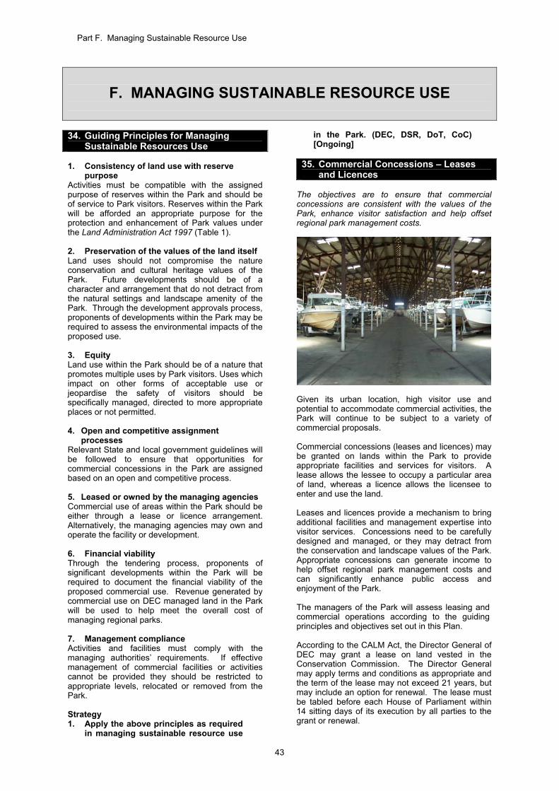
Part F. Managing Sustainable Resource Use
43
F. MANAGING SUSTAINABLE RESOURCE USE
34. Guiding Principles for Managing Sustainable Resources Use
1. Consistency of land use with reserve
purpose Activities must be compatible with the assigned purpose of reserves within the Park and should be of service to Park visitors. Reserves within the Park will be afforded an appropriate purpose for the protection and enhancement of Park values under the Land Administration Act 1997 (Table 1). 2. Preservation of the values of the land itself Land uses should not compromise the nature conservation and cultural heritage values of the Park. Future developments should be of a character and arrangement that do not detract from the natural settings and landscape amenity of the Park. Through the development approvals process, proponents of developments within the Park may be required to assess the environmental impacts of the proposed use. 3. Equity Land use within the Park should be of a nature that promotes multiple uses by Park visitors. Uses which impact on other forms of acceptable use or jeopardise the safety of visitors should be specifically managed, directed to more appropriate places or not permitted. 4. Open and competitive assignment
processes Relevant State and local government guidelines will be followed to ensure that opportunities for commercial concessions in the Park are assigned based on an open and competitive process. 5. Leased or owned by the managing agencies Commercial use of areas within the Park should be either through a lease or licence arrangement. Alternatively, the managing agencies may own and operate the facility or development. 6. Financial viability Through the tendering process, proponents of significant developments within the Park will be required to document the financial viability of the proposed commercial use. Revenue generated by commercial use on DEC managed land in the Park will be used to help meet the overall cost of managing regional parks. 7. Management compliance Activities and facilities must comply with the managing authorities’ requirements. If effective management of commercial facilities or activities cannot be provided they should be restricted to appropriate levels, relocated or removed from the Park. Strategy 1. Apply the above principles as required
in managing sustainable resource use
in the Park. (DEC, DSR, DoT, CoC) [Ongoing]
35. Commercial Concessions – Leases
and Licences The objectives are to ensure that commercial concessions are consistent with the values of the Park, enhance visitor satisfaction and help offset regional park management costs.
Given its urban location, high visitor use and potential to accommodate commercial activities, the Park will continue to be subject to a variety of commercial proposals. Commercial concessions (leases and licences) may be granted on lands within the Park to provide appropriate facilities and services for visitors. A lease allows the lessee to occupy a particular area of land, whereas a licence allows the licensee to enter and use the land. Leases and licences provide a mechanism to bring additional facilities and management expertise into visitor services. Concessions need to be carefully designed and managed, or they may detract from the conservation and landscape values of the Park. Appropriate concessions can generate income to help offset regional park management costs and can significantly enhance public access and enjoyment of the Park. The managers of the Park will assess leasing and commercial operations according to the guiding principles and objectives set out in this Plan. According to the CALM Act, the Director General of DEC may grant a lease on land vested in the Conservation Commission. The Director General may apply terms and conditions as appropriate and the term of the lease may not exceed 21 years, but may include an option for renewal. The lease must be tabled before each House of Parliament within 14 sitting days of its execution by all parties to the grant or renewal.
Part F. Managing Sustainable Resource Use
44
Under the same Act, the Director General of DEC may grant a licence in writing to any person to enter and use certain land. Commercial concessions must be consistent with the purpose of the reserve and the protection of its values. All commercial concessions on land managed by DEC within the Park will be established and managed in accordance with Recreation, Tourism and Visitor Services Policy Statement No. 18. The tendering process for proponents of commercial concessions within the Park will be consistent with State and local government tendering processes. Leases for recreation clubs and associations are not subject to the same tendering processes. Leases and licences pertaining to areas managed by the City of Cockburn, DSR and DoT will require approval from those respective agencies. The Park managers will manage the leases to ensure that they are operated in accordance with this Plan. Particularly significant issues include maintaining vegetation within the lease areas, managing weeds and rubbish, and ensuring adequate public access is maintained as appropriate. Advertising within the Park requires the approval of the relevant managing agency. The locations of existing and potential sites for commercial visitor services are illustrated in Figure 7 - Recreation Masterplan. EXISTING CONCESSIONS FOR VISITOR SERVICES Existing concessions for visitor services (including recreation clubs) within the Park are as follows: Cockburn Pleasure Boat Storage; Cockburn Power Boats Association; Coogee Beach Holiday Park; Woodman Point Holiday Park; and Coogee Cafe
Leases for Cockburn Pleasure Boat Storage and Cockburn Power Boats Association are managed by DoT as part of the Recreational Boating Precinct. Leases for Coogee Beach Holiday Park and Coogee Café are managed by the City of Cockburn. DEC is responsible for managing the lease for the Woodman Point Holiday Park. Cockburn Pleasure Boat Storage Located at the Woodman Point Recreational Boating Precinct, Cockburn Pleasure Boat Storage provides undercover and outdoor boat storage, boat maintenance services, petrol, fast foods, bait, fishing tackle and boating accessories. Given the high demand for recreational boating at the Park, commercial boat storage is considered an acceptable visitor service within the Park. With the vesting of the Woodman Point Recreational Boating Precinct in the Minister for Transport, DoT assumed management responsibility for leasing arrangements for Cockburn Pleasure Boat Storage.
Cockburn Power Boats Association The Cockburn Power Boats Association was first established in 1961 at Clarence Rocks. It was then known as the Cockburn Sound Small Boat Owners Association. In September 1980, the State government agreed to relocate the Club and public boat launching facilities from an area set aside for the off-shore petroleum industry to the current site in the Park. Facilities currently offered by the club include boat ramps, short term boat pens, boat preparation bays, boat wash down bays and parking for motor vehicles and boat trailers. With the vesting of the Woodman Point Recreational Boating Precinct in the Minister for Transport, DoT assumed management responsibility for leasing arrangements for Cockburn Power Boats Association. Cockburn Volunteer Search and Sea Rescue operates from the site under an arrangement with the Association. Given the high demand for recreational boating in the region, the current use of the lease site is considered appropriate within the Park. Coogee Beach Holiday Park Coogee Beach Holiday Park is located off Powell Road and is operated by Aspen Parks. The land is leased from the City of Cockburn until 31 May 2011, and the lessee may exercise options to extend the lease until 31 May 2016 or 31 May 2021. The caravan park accommodates both short term and long term residents and is considered an appropriate land use within the Park. Woodman Point Holiday Park Woodman Point Holiday Park is operated by Aspen Parks and occupies land adjacent to Cockburn Road. The Holiday Park has operated in its current location since 1988 and the lease expires in 2023. The lease provides for both short-stay accommodation and permanent residents. The operators of the Holiday Park are in negotiations with DEC to expand the lease area of the Holiday Park to the north. The proposal is to allow the lessee to provide a range of accommodation styles. The potential to expand the Holiday Park to the south into a grassed area was considered, however it was not preferred as the northward expansion would allow for the use of Conservation Close and provide for the upgrade and management of two dilapidated former explosives magazines. Should the proposed expansion proceed, the main entrance to Woodman Point Holiday Park may be changed from Magazine Court to Nyyerbup Circle. This may improve security measures at the main entrance to the Park. For the proposal to expand the Holiday Park to proceed, a site concept plan and a business plan will need to be prepared and approved by DEC. As part of planning for the site, environmental considerations such as the impact on vegetation and land amenity will need to be assessed. The existing lease would need to be altered to allow for
Part F. Managing Sustainable Resource Use
45
the proposed extension, or a new lease would be prepared. Coogee Café The Coogee Café operates within the Coogee Beach Reserve managed by the City of Cockburn. The lease is managed by the City. Jervoise Bay Sailing Club In addition to the existing concessions, the Jervoise Bay Sailing Club was relocated from the shipyard area at Jervoise Bay to a site east of the Cockburn Cement Ltd installation at Owen Anchorage. The club has exclusive use of a boat ramp for the purpose of hand-launching boats from the beach (Woodman Point Community Taskforce, 1988). Facilities currently offered by the Club include a launching ramp, secured and unsecured boat storage, equipment and tool storage and parking for vehicles and boat trailers. The Club operates a bar on a restricted liquor licence. The Club has a resident caretaker who lives on-site. The Club has been occupying the site on the northern side of Woodman Point Headland for approximately 25 years without a lease for the area. Agreement was reached with DSR (as the previous land manager) to enter into a lease which provides the club with an area set back from the beach for a club house and boat storage as well as a licensed area to enable public access to the beach front. The Club is in negotiations with DEC for a lease agreement to provide greater security of tenure for the Club. DEC considers that a lease for Jervoise Bay Sailing Club is appropriate. Reviewing public access is an important consideration, and the boundary and extent of the lease area is to be discussed between DEC and the Club. The Club had previously expressed an interest to operate mooring facilities adjacent to its clubhouse at Owen Anchorage. It subsequently advised that it was no longer interested in pursuing this proposal. NEW OPPORTUNITIES FOR COMMERCIAL VISITOR SERVICES Recreational Boating Precinct The existing and projected high level of use of the Woodman Point Recreational Boating Precinct) suggests that there is potential to establish additional commercial operations in the precinct to service this demand (Department of Transport, 2000). Further investigation into the feasibility of such operations and the requirements of visitors will be carried out by DoT as part of the proposed upgrade to the area. Site planning will be undertaken by DoT, in consultation with DEC and other stakeholders, and will address issues such as access and circulation, landscape amenity, recreational use, conservation of the vegetated area adjacent to O’Kane Court, and opportunities for commercial concessions relating to recreational boating. Once site development planning has been completed and approved by the WAPC, expressions of interest would be sought by DoT to
facilitate development of the site and the provision of leases, in accordance with State government requirements. The Water Corporation has advised that the Recreational Boating Precinct falls within the odour buffer for the Woodman Point wastewater treatment plant, and this should be taken into consideration in planning for additional commercial concessions in this area. Coogee Beach Surf Life Saving Club Coogee Beach Surf Life Saving Club is located at Coogee Beach. Given that the Club provides valuable services for Park visitors, it is beneficial to have it located within the Park. The City of Cockburn has proposed new facilities for the club at Poore Grove to overcome existing crowding issues (as discussed in Section 30). The new facilities are proposed to be constructed on the southern extremity of Reserve 24306 vested in the City of Cockburn, with parking and associated facilities on Reserve 49220 managed by DEC on behalf of the Conservation Commission. The proposed new parking and associated facilities would be included in the Coogee Beach Reserve, and would replace the existing degraded parking facilities at Poore Grove. The interface between the proposed new development and the nearby threatened ecological communities of Rottnest Island Cypress and Rottnest Island Tea Tree need to be carefully designed and managed. The Club would be offered a lease arrangement by the City of Cockburn, pending relevant approvals. Mobile Food and Bicycle Hire Outlets Businesses such as ice cream vans, mobile food outlets or bicycle hire may operate in the Park, subject to the issuing of an appropriate licence by the managing agencies. Such activities must comply with the managing agencies’ requirements, as well as the City of Cockburn’s health and building requirements. Café, Kiosk or Shop John Graham Recreation Reserve has been identified as a possible site for a café, kiosk or shop. The high number of visits to the area, estimated in the vicinity of 130,000 per year (Colmar Brunton, 2005), illustrates a strong demand for the area as a recreation node. John Graham Recreation Reserve is easily accessible by bicycle, pedestrian pathways and by vehicle, and it contains extensive parking. Mobile food outlets have operated successfully at the reserve, indicating a demand for such services. Should it proceed, revenue generated from lease arrangements would be used to assist in managing regional parks. The sensitive siting and design of a café, kiosk or shop at John Graham Recreation Reserve would promote greater visitation and improve services for visitors without significant impacts upon the conservation values of the Park. Planning for the establishment of any facilities in the Park needs to consider the potential market for other existing or proposed facilities, to avoid the duplication of resources and to provide a variety of services.
Part F. Managing Sustainable Resource Use
46
For the development of a café, kiosk or shop to proceed, expressions of interest would be sought in accordance with State government requirements. A concept development plan and business plan would be likely requirements of the expression of interest process. Normal development approval via the WAPC would also be required. Community and Special Events There is a significant demand for using sites at Woodman Point, particularly John Graham Recreation Reserve, for community and special events. The appropriateness of community or special events within the Park will be assessed by the managing agency controlling the respective area. A concession arrangement (licence or once-off permit) may be required between the event-organiser and the managing agency for the right to use a site and to cover the operational and administrative costs incurred by the managing agency. The guiding principles established for managing sustainable resource use will be used as a means of determining the appropriateness of proposed activities. The City of Cockburn's planning, environmental health or other requirements must also be met. CONCESSIONS FOR PURPOSES OTHER THAN VISITOR SERVICES Commercial concessions for purposes other than visitor services are generally not considered appropriate within the Park unless there is a considerable benefit to the Park or they comprise a historical land use. Cockburn Cement Limited Cockburn Cement Ltd manufactures cement and lime at its works in Munster. The company is the largest lime producer in Australia. Lime is an essential raw material for Western Australia’s mineral processing industry, especially alumina and gold processing (Cockburn Cement Ltd, 2009). Calcium carbonate is the sole raw material for lime production and the main raw material used for the production of cement. Cockburn Cement Ltd obtains this raw material from dredging shell sand from Success and Parmelia Banks in Owen Anchorage under the Cement Works (Cockburn Cement Limited) Agreement Act 1971. The Act gives Cockburn Cement Ltd the right to extract shellsand until the year 2011, with rights of extension to 2021 (Cockburn Cement Ltd, 2009). Additionally the Cement Works Agreement Act states – ‘If and when it should become impracticable for the Company to obtain shellsand pursuant to this clause, the State will use every endeavour to find other shellsand within a reasonably economic distance from the jetty, and if other shellsand is not available, then other equivalent material’ Cement Works (Cockburn Cement Limited) Agreement Act 1971.
Under current operations at Cockburn Cement Ltd, the shellsand is dredged and loaded onto barges for transport to shore. It is then deposited on the seabed along-side the reclaimer jetty at Woodman Point, before being pumped through to the washing plant where the seawater is removed and replaced with freshwater. This sand/water mixture is then pumped seven kilometres through a pipeline to a sand stockpile at the Munster works (Cockburn Cement Ltd, 2009). The pipeline can be seen running parallel to Woodman Point View. As discussed in Section 8, Cockburn Cement Ltd leases a portion of Lot 59 Woodman Point View, which contains the shell washing plant. Cockburn Cement Ltd also has the right to construct and maintain an electricity supply, use roads, park vehicles, and construct and maintain pipelines for pumping water, sand or spoil in specified locations within the Park. The access road (Lots 52 and 55) along Jervoise Bay constitutes part of the land set aside for Cockburn Cement Ltd access (Woodman Point Community Taskforce, 1988). The Cement Works (Cockburn Cement Limited) Agreement Act 1971 confers a number of rights and obligations on both the Company and the State. Importantly the Act states – ‘The company will pay to the Lessor the whole or equitable part of the cost of making good any damage to or deterioration of the roads and ways as may be reasonable required by the Lessor having regard to the use of those roads and ways by others’ Cement Works (Cockburn Cement Limited) Agreement Act 1971. This Plan acknowledges the rights of Cockburn Cement Ltd to remain at its present location within the Park in accordance with the Cement Works (Cockburn Cement Limited) Agreement Act 1971. Under the Park’s zoning (see Section 9) the area is identified as Special Use, which allows management of the area for purposes other than conservation, recreation or visitor services. Additionally the area is identified as a private lease with no public access. Beekeeping DEC may grant permits to beekeepers to use Crown land under the CALM Act. Permits are granted on the provision that biodiversity and conservation objectives are not compromised, where the activity is compatible with other land uses. DEC’s Beekeeping on Public Land Policy Statement No. 41 provides that current apiary site permits will be maintained and renewed, but no additional permits will be granted on land reserved or proposed to be reserved primarily for conservation purposes, unless allowed for under a completed management plan. The introduced honeybee (Apis mellifera) can have detrimental effects on native insects, hollow-using animals and vegetation, as discussed in Section 20. Given the high visitation to the Park and its proximity to residential areas, no permits will be granted for beekeeping in the Park.
Part F. Managing Sustainable Resource Use
47
Any non-registered beehives found in the Park will be removed in accordance with operational priorities. Strategies 1. Establish and manage commercial
operations on DEC-managed land in accordance with DEC’s Recreation, Tourism and Visitor Services Policy Statement No. 18 and this Plan. Concessions in the Park may be permitted if they are consistent with the relevant reserve purpose. (DEC) [Ongoing]
2. Ensure any commercial activities on DEC-
managed land are consistent with the guiding principles for sustainable resource use, conditions are fulfilled by concession holders and an appropriate fee is paid that contributes an income to the management of regional parks. (DEC, DSR, DoT, CoC) [Ongoing]
3. Seek expressions of interest for any
commercial activities in the Park, in accordance with State government guidelines. (DEC, DSR, DoT) [Ongoing]
4. Where appropriate, allow for community
organisation and club activities that are consistent with the reserve purpose. (DEC, CoC) [Ongoing]
5. Develop management guidelines for
advertising within the Park. (DEC, CoC) [Medium]
6. Continue negotiations with the proponent
for the proposed extension to the Woodman Point Holiday Park lease area. (DEC) [High]
7. Continue to negotiate with the Jervoise Bay
Sailing Club to finalise a lease for the existing location. (DEC) [High]
8. Investigate the feasibility of locating a
mobile food van, café, kiosk or shop at the John Graham Recreation Reserve. (DEC, CoC) [Low]
9. Assess community and special events in
accordance with the guiding principles for sustainable resource use. (DEC, CoC) [Ongoing]
10. Liaise with the Department of State
Development to ensure that Cockburn Cement Ltd complies with the obligations of the Cement Works (Cockburn Cement Limited) Agreement Act 1971. (DEC) [Ongoing]
11. Liaise with Cockburn Cement Ltd in
managing the environment around the lease site. (DEC) [Ongoing]
12. Exclude beekeeping activities from the
Park. (DEC) [Ongoing]
36. Mining and the Extraction of Basic Raw Materials
The objective is to protect the Park’s values from exploration, mining and the extraction of basic raw materials. The Conservation Commission does not consider mining and the extraction of basic raw materials as an appropriate land use in the Park, hence there is a presumption against these activities. EXTRACTION OF BASIC RAW MATERIALS Depending on the land tenure involved there are different legislative requirements for extraction or mining of basic raw materials. On freehold land basic raw materials (including sand, limestone, limesand, clay, gravel and hard rock) are not defined as ‘minerals’ under the Mining Act 1978 and commercial extraction is subject to extractive industry licences under the Local Government Act 1995. Any freehold property in the Park that is subject to an extractive industry licence will be processed under the Local Government Act 1995. Given the Park is reserved for Parks and Recreation in the MRS, any extractive industry licence will be determined by WAPC. Basic raw materials sought on reserves vested with the Conservation Commission or other Crown land will be processed under the Mining Act 1978. Extraction of basic raw materials from within the Park is unlikely to be environmentally acceptable and such proposals will be referred to the EPA for assessment. The EPA will then determine the level of assessment of any such proposal and depending on the level of assessment may make recommendations to the Minister for Environment. MINING Applications for mining within regional parks will be processed under the Mining Act 1978. In processing applications, regional parks are recognised by the Department of Mines and Petroleum (DMP) under the “Guidelines for Mineral Exploration and Mining within Conservation Reserves and Other Environmentally Sensitive Lands in Western Australia” (Department of Minerals and Energy, 1998). Applications affecting the Park will also be subject to The Mineral Exploration and Development Memorandum of Understanding (MoU) between the EPA and DMP. (Department of Minerals and Energy, 1995). The MoU clarifies referral arrangements for mineral exploration and mining proposals to the EPA and DEC where these proposals occur within conservation reserves and other environmentally sensitive lands. Mineral exploration in national parks, class ‘A’ nature reserves and class ‘A’ conservation parks (in the southwest of Western Australia) is subject to the concurrence of the Minister for Environment and the Minister for Mines and Petroleum. Approval for mining to occur in the Park is subject to EPA
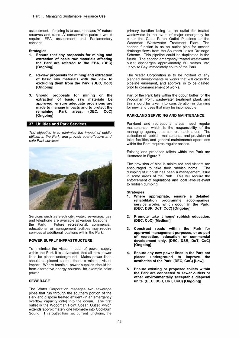
Part F. Managing Sustainable Resource Use
48
assessment. If mining is to occur in class ‘A’ nature reserves and class ‘A’ conservation parks it would require EPA assessment and Parliamentary consent. Strategies 1. Ensure that any proposals for mining and
extraction of basic raw materials affecting the Park are referred to the EPA. (DEC) [Ongoing]
2. Review proposals for mining and extraction
of basic raw materials with the view to excluding them from the Park. (DEC, CoC) [Ongoing]
3. Should proposals for mining or the
extraction of basic raw materials be approved, ensure adequate provisions are made to manage impacts and to protect the remaining Park areas. (DEC, CoC) [Ongoing]
37. Utilities and Park Services The objective is to minimise the impact of public utilities in the Park, and provide cost-effective and safe Park services.
Services such as electricity, water, sewerage, gas and telephone are available at various locations in the Park. Future recreational, commercial, educational, or management facilities may require services at additional locations within the Park. POWER SUPPLY INFRASTRUCTURE To minimise the visual impact of power supply within the Park it is advocated that all new power lines be placed underground. Mains power lines should be placed so that there is minimal visual impact. Where feasible, power supplies should be from alternative energy sources, for example solar power. SEWERAGE The Water Corporation manages two sewerage pipes that run through the southern portion of the Park and dispose treated effluent (in an emergency overflow capacity only) into the ocean. The first outlet is the Woodman Point Ocean Outlet, which extends approximately one kilometre into Cockburn Sound. This outlet has two current functions, the
primary function being as an outlet for treated wastewater in the event of major emergency for either the Cape Peron Outlet Pipelines or the Woodman Wastewater Treatment Plant. The second function is as an outlet pipe for excess drainage flows from the Southern Lakes Drainage Scheme. This pipeline could be duplicated in the future. The second emergency treated wastewater outlet discharges approximately 50 metres into Jervoise Bay immediately south of the Park. The Water Corporation is to be notified of any planned developments or works that will cross the pipeline easement, and approval is to be gained prior to commencement of works. Part of the Park falls within the odour buffer for the Woodman Point wastewater treatment plant, and this should be taken into consideration in planning for new land uses that may be incompatible. PARKLAND SERVICING AND MAINTENANCE Parkland and recreational areas need regular maintenance, which is the responsibility of the managing agency that controls each area. The collection of rubbish, maintenance and provision of toilet facilities and general maintenance operations within the Park requires regular access. Existing and proposed toilets within the Park are illustrated in Figure 7. The provision of bins is minimised and visitors are encouraged to take their rubbish home. The dumping of rubbish has been a management issue in some areas of the Park. This will require the enforcement of regulations and local laws relevant to rubbish dumping. Strategies 1. Where appropriate, ensure a detailed
rehabilitation programme accompanies service works, which occur in the Park. (DEC, DSR, DoT, CoC) [Ongoing]
2. Promote ‘take it home’ rubbish education.
(DEC, CoC) [Medium] 3. Construct roads within the Park for
approved management purposes, or as part of recreation, education or commercial development only. (DEC, DSR, DoT, CoC) [Ongoing]
4. Ensure any new power lines in the Park are
placed underground to improve the aesthetics of the Park. (DEC, CoC) [Low].
5. Ensure existing or proposed toilets within
the Park are connected to sewer outlets or other environmentally acceptable disposal units. (DEC, DSR, DoT, CoC) [Ongoing]
Part F. Managing Sustainable Resource Use
49
38. Development Proposals Affecting the
Park The objective is to ensure that developments do not adversely affect the values of the Park. Being located within a developing urban area, the Park will continue to be subjected to development and infrastructure proposals that may threaten its values. Proposals relevant to the Park include further development within the DoT Recreational Boating Precinct, the proposed Coogee Beach Surf Life Saving Club development at Poore Grove, the proposed extension to the Woodman Point Holiday Park, and the proposed Fremantle to Rockingham highway to the east of the Park. It is important that the Park’s managing agencies liaise with service providers to avoid or at least limit disturbance in the Park. Additionally, there should be no physical impacts, either during or post construction to the lands or waters that comprise the Park from developments that adjoin the Park. This can be achieved by ensuring appropriate conditions are placed on the proponent of developments when they are seeking development approvals. Where service corridors are required within the Park, they should be rationalised by combining utility requirements. Strategies 1. Request that appropriate conditions that
help protect the values of the Park are placed on the proponents of developments during planning and environmental approvals processes. (DEC, CoC) [Ongoing]
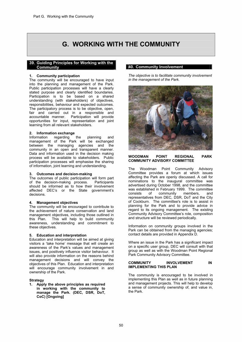
Part G. Working with the Community
50
G. WORKING WITH THE COMMUNITY
39. Guiding Principles for Working with the
Community 1. Community participation The community will be encouraged to have input into the planning and management of the Park. Public participation processes will have a clearly stated purpose and clearly identified boundaries. Participation is to be based on a shared understanding (with stakeholders) of objectives, responsibilities, behaviour and expected outcomes. The participatory process is to be objective, open, fair and carried out in a responsible and accountable manner. Participation will provide opportunities for input, representation and joint learning from all relevant stakeholders. 2. Information exchange Information regarding the planning and management of the Park will be exchanged between the managing agencies and the community in an open and transparent manner. Data and information used in the decision making process will be available to stakeholders. Public participation processes will emphasise the sharing of information, joint learning and understanding. 3. Outcomes and decision-making The outcomes of public participation will form part of the decision-making process. Participants should be informed as to how their involvement affected DEC’s or the State government’s decisions. 4. Management objectives The community will be encouraged to contribute to the achievement of nature conservation and land management objectives, including those outlined in this Plan. This will help to build community awareness, understanding and commitment to these objectives. 5. Education and interpretation Education and interpretation will be aimed at giving visitors a ‘take home’ message that will create an awareness of the Park’s values and management issues, and positively influence visitor behaviour. It will also provide information on the reasons behind management decisions and will convey the objectives of this Plan. Education and interpretation will encourage community involvement in and ownership of the Park. Strategy 1. Apply the above principles as required
in working with the community to manage the Park. (DEC, DSR, DoT, CoC) [Ongoing]
40. Community Involvement The objective is to facilitate community involvement in the management of the Park.
WOODMAN POINT REGIONAL PARK COMMUNITY ADVISORY COMMITTEE The Woodman Point Community Advisory Committee provides a forum at which issues affecting the Park are openly discussed. A call for nominations to the inaugural committee was advertised during October 1998, and the committee was established in February 1999. The committee consists of community members, and representatives from DEC, DSR, DoT and the City of Cockburn. The committee's role is to assist in planning for the Park and to provide advice in regard to its ongoing management. The existing Community Advisory Committee’s role, composition and structure will be reviewed periodically. Information on community groups involved in the Park can be obtained from the managing agencies; contact details are provided in Appendix D. Where an issue in the Park has a significant impact on a specific user group, DEC will consult with that group as well as with the Woodman Point Regional Park Community Advisory Committee. COMMUNITY INVOLVEMENT IN IMPLEMENTING THIS PLAN The community is encouraged to be involved in implementing this Plan as well as in future planning and management projects. This will help to develop a sense of community ownership of, and value in, the Park.
Part G. Working with the Community
51
To facilitate community involvement in the Park, DEC has prepared a Regional Park Volunteer Information Package. When consulting with the community on issues regarding the Park, DEC is also guided by Community Involvement (Public Participation and Volunteers) Policy Statement No. 15. Residents who live in close proximity to the Park can have a great impact on the Park, both positive and negative. It is important to seek the cooperation and involvement of nearby landowners to protect the values of the Park. This can be done through educational programmes, which promote responsible use of the Park and inform the community of management roles and responsibilities. There are a number of different ways members of the community can be involved in assisting with the implementation of this Plan, including: joining community volunteer groups such as
‘Friends of Woodman Point’; joining DEC’s schools-based Bush Rangers
Programme; contacting members of the Woodman Point
Regional Park Community Advisory Committee;
reporting problems and issues to the managing agencies; and
becoming involved in clean-up days (e.g. Clean-up Australia Day) and revegetation planting days.
Strategies 1. Consult with the Woodman Point Regional
Park Community Advisory Committee in implementing this Plan. (DEC, DSR, DoT, CoC) [Ongoing]
2. Periodically review the role and
composition of the Woodman Point Regional Park Community Advisory Committee. (DEC) [Ongoing]
3. Provide opportunities for the community to
be involved in developing subsidiary plans for the Park. (DEC, CoC, DoT, DSR) [Ongoing]
4. Maintain active liaison with community
groups involved in the Park (DEC, CoC, DoT, DSR) [Ongoing]
5. Encourage and support the formation and
activities of volunteers, community groups, schools and associations interested in the Park. (DEC, CoC, DSR, DoT) [High]
6. Facilitate community involvement in the
Park by using the Regional Park Volunteer Information Package. (DEC) [Ongoing]
7. Inform the community and other
organisations of management actions, programmes and developments within the Park. (DEC, CoC, DSR, DoT) [Ongoing]
KPIs for community involvement The success of these strategies will be measured by: 1. Change in volunteer hours contributed to the
management of the Park. 2. Existence of an active community advisory
committee. Target: 1. No decrease in volunteer hours contributed to
the management of the Park. 2. Maintain an active community advisory
committee for the Park. Reporting: 1. Every 5 years. 2. Every 5 years. 41. Information, Interpretation and
Education The objectives are to increase the community’s awareness, appreciation and understanding of the Park’s values and management practices and to involve the community in implementing this management plan. An effective communication programme is essential to achieve the objectives of this Plan. It informs the public of attractions, facilities and recreation opportunities available within the Park and provides an avenue to promote an appreciation and greater understanding of the natural environment. Additionally, it fosters appropriate behaviour so that adverse impacts on the environment are minimised. A communication plan for the regional parks in Perth has been prepared by DEC. The communication plan and programme has three integrated parts: 1. information – providing an overview of
recreation opportunities and details of facilities, activities and regulations;
2. interpretation – explaining natural and cultural features; and
3. education – providing detailed materials and programmes designed to facilitate learning, focussing on target groups (e.g. school groups, community groups).
The communication programme is being implemented by way of signs, displays, publications (such as brochures and Park notes) and guided activities. An Interpretation Plan has been prepared for the Park. This plan outlines how information is provided to visitors to help them plan their visit, enjoy and appreciate the Park's values and assist them to recall their experience when they depart. The Park offers many opportunities for developing an enriching body of interpretive material. Key areas of interpretation and education include: flora and fauna; cultural heritage (both Aboriginal and non-
Aboriginal); recreational opportunities;
Part G. Working with the Community
52
the regional park entity, its management and evolution; and
caring for the Park and using it responsibly. The interpretation values associated with the former quarantine station, the crematorium, ammunition storage bunkers, cemetery, limestone roads and the unique coastal vegetation of the area are of special interest. As discussed in Section 30, this rich combination of cultural and natural history may be presented through the provision of an interpretation trail in the nature reserve. The development of interpretive material should be undertaken in a coordinated way to ensure the most effective use of available resources and to present a well integrated, consistent body of information about the Park. Involvement of the community in Park operations, ongoing liaison with community groups and the provision of interpretive and educational materials will be important for maintaining the values of the Park and to maximise its use as an educational resource. Existing Park Information, Interpretation and Education At present there is little interpretive material available in the Park. Guided tours of the nature reserve are periodically available through programmes such as of DEC’s ‘Nearer to Nature’ programme, and there may be potential to expand this type of activity to enhance education and interpretation opportunities in the Park. DEC will develop further opportunities for Park information to be presented, consistent with the communication plan for regional parks and the interpretation plan for Woodman Point Regional Park. Strategies 1. Implement and periodically update the
Regional Park Communication Plan. The plan provides direction on: community education; community involvement; and interpretive strategies and techniques.
(DEC) [High] 2. Continue to implement the interpretation
plan for Woodman Point Regional Park. (DEC, CoC, DSR, DoT) [High]
3. Continue to liaise with interest groups and
the community to ensure a coordinated approach to information provision, interpretation and education on and adjacent to the Park. (DEC, CoC, DoT, DSR) [Ongoing]
4. Develop an interpretive trail within the
nature reserve that includes information on the natural and cultural values of the area. (DEC) [High]
Part H. Implementing and Evaluating the Plan
53
H. IMPLEMENTING AND EVALUATING THE PLAN
42. Priorities, Staff and Funding
Arrangements The objective is to manage the Park according to the priorities developed for implementation. PRIORITIES AND TIMELINES The priorities for managing the Park have been established by the Park’s managing agencies and appear in brackets behind each strategy in the Plan. They represent the priorities at the start of the planning process and will be reviewed in reference to changing circumstances during the term of the Plan. There are many strategies outlined in this Plan, while some are guidelines others are prescriptions for specific actions. The City of Cockburn, DSR, DoT and DEC will implement this Plan within the framework of available resources. Subsidiary plans and implementation programmes In implementing the Plan, more detailed subsidiary plans will be prepared prior to significant works taking place within the Park (see Figure 1). Subsidiary plans to be (or that have been) prepared as part of the Woodman Point Regional Park planning process include: Weed Control and Rehabilitation Plan (Section
18 and Section 21); Fire Response Plan (Section 19); Pest and Problem Animal Control Plan (Section
20); Visitor Survey Programme (Section 28); Recreation Masterplan (Section 29); Site Enhancement Plans for specific areas of
the Park (Section 30); Sign System and Sign Plan (Section 32); Visitor Risk Management Programme (Section
33); Communication Plan for regional parks
(Section 41); Interpretation Plan (Section 41); and Volunteer Information Package (Section 40).
An annual projects list will be prepared by DEC to guide the implementation of the Plan in the areas of the Park vested with the Conservation Commission. The City of Cockburn, DSR, DoT and the Woodman Point Community Advisory Committee will be consulted by DEC in the preparation of the annual projects list. STAFFING The City of Cockburn manages Council reserves within the Park using staff from the Parks Department and Environmental Management Section, and contractors as required.
DSR manages the Woodman Point Recreation Camp with staff from the Facilities and Camps Branch, and has a number of staff on-site. DoT manages the Recreational Boating Precinct with staff from the Coastal Infrastructure Business Unit. DEC services its management obligations with staff from the Community and Regional Parks Branch, and with contractors as required. FUNDING ARRANGEMENTS The City of Cockburn, DSR and DoT and DEC will finance and manage their respective land areas (Figure 4). DEC has been allocated a recurrent budget for the maintenance of regional parks from State Treasury. Strategies 1. Prepare and implement an annual projects
list, taking into account the priorities identified in this Plan. Consult with the Woodman Point Community Advisory Committee and other management agencies involved in the Park when preparing this list. (DEC,) [High]
2. Explore sponsorship opportunities and
other funding arrangements to contribute to Park management where appropriate. (DEC, CoC, DSR, DoT) [Ongoing]
43. Term of the Plan This Plan will guide management of the Park for a period of ten years from the date it is gazetted. During this time, amendments are allowed under Section 61 of the CALM Act. If an amendment is necessary, the proposed changes will be released for public comment. At the end of the ten-year period, this Plan may be reviewed and a new management plan prepared. The management planning process requires full public consultation and approval from the Minister for Environment. If the Plan is not reviewed and replaced by the end of the ten-year period, Section 55(2) of the CALM Act allows the Plan to remain in force in its original form, unless it is either revoked by the Minister or until a new plan is approved. 44. Performance Assessment The Conservation Commission will measure the success of this Plan in accordance with its performance assessment function under Section 19(1)(g)(iii) of the CALM Act by using performance indicators and other mechanisms as appropriate.
Part H. Implementing and Evaluating the Plan
54
It is not efficient to measure all aspects of management given resource and technical impediments – consequently indicators will target ‘key’ components of the Plan. KPIs are identified in relevant sections throughout the Plan and are also presented in summary in Table 3. Each KPI comprises evaluation of a measure, target and reporting requirements. DEC is responsible for providing information to the Conservation Commission to allow it to assess the performance of DEC in implementing and complying with this Plan. The frequency of reporting will depend upon the requirements of each KPI, the establishment of baseline information against which to assess performance, and any unforeseen changes to the environmental conditions. Where a report identifies a target shortfall, a response to the Conservation Commission may be required. The response may identify factors that have lead to the target shortfall, and propose alternative management where appropriate. The Conservation Commission will consider DEC’s response on the target shortfall and evaluate the need for action. The Conservation Commission will make the results of performance assessments available to the public. The adequacy of the range of selected KPIs and management strategies will be reviewed following each performance assessment. DEC will undertake a review of this Plan in preparing an annual projects list for the Park. The Woodman Point Regional Park Community Advisory Committee will be consulted in preparing the annual projects list. Strategies 1. Audit the overall effectiveness of Park
management based on the KPIs (Table 3). (Conservation Commission) [Ongoing]
2. Review the implementation of this Plan
annually in preparing an annual projects list. (DEC) [Ongoing]
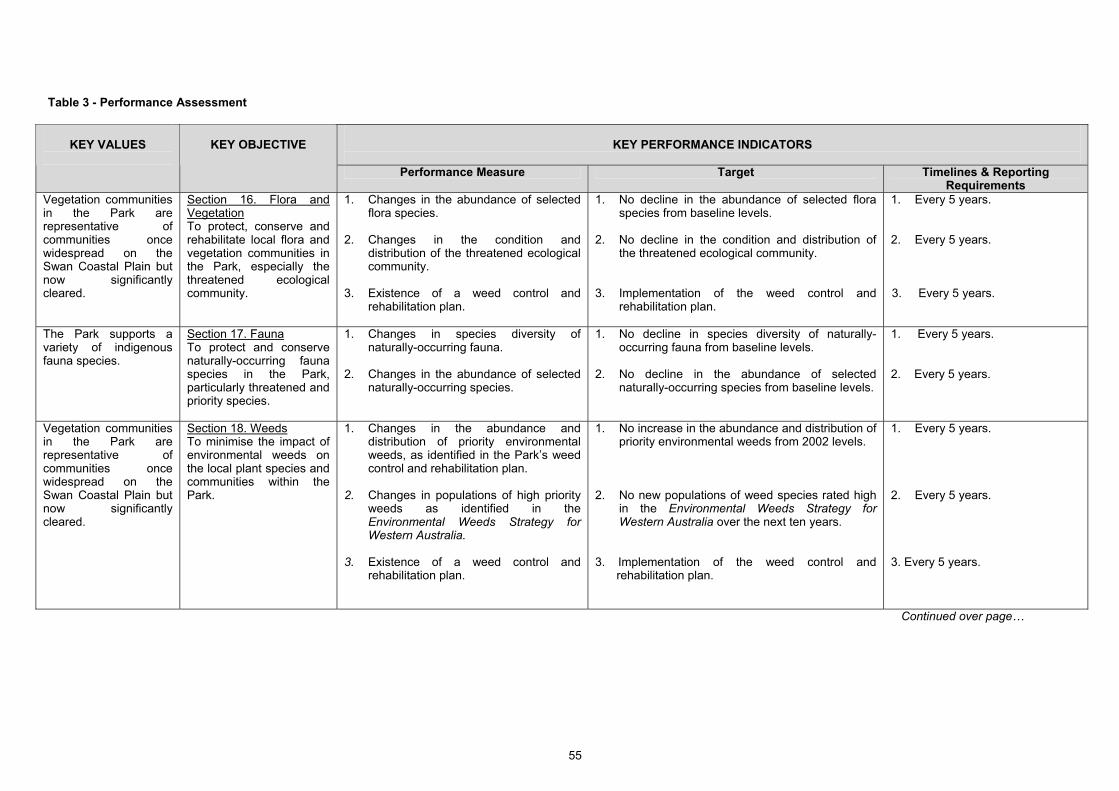
55
Table 3 - Performance Assessment
KEY PERFORMANCE INDICATORS
KEY VALUES
KEY OBJECTIVE
Performance Measure Target Timelines & Reporting Requirements
Vegetation communities in the Park are representative of communities once widespread on the Swan Coastal Plain but now significantly cleared.
Section 16. Flora and Vegetation To protect, conserve and rehabilitate local flora and vegetation communities in the Park, especially the threatened ecological community.
1. Changes in the abundance of selected flora species.
2. Changes in the condition and
distribution of the threatened ecological community.
3. Existence of a weed control and
rehabilitation plan.
1. No decline in the abundance of selected flora species from baseline levels.
2. No decline in the condition and distribution of
the threatened ecological community. 3. Implementation of the weed control and
rehabilitation plan.
1. Every 5 years. 2. Every 5 years. 3. Every 5 years.
The Park supports a variety of indigenous fauna species.
Section 17. Fauna To protect and conserve naturally-occurring fauna species in the Park, particularly threatened and priority species.
1. Changes in species diversity of naturally-occurring fauna.
2. Changes in the abundance of selected
naturally-occurring species.
1. No decline in species diversity of naturally-occurring fauna from baseline levels.
2. No decline in the abundance of selected
naturally-occurring species from baseline levels.
1. Every 5 years. 2. Every 5 years.
Vegetation communities in the Park are representative of communities once widespread on the Swan Coastal Plain but now significantly cleared.
Section 18. Weeds To minimise the impact of environmental weeds on the local plant species and communities within the Park.
1. Changes in the abundance and distribution of priority environmental weeds, as identified in the Park’s weed control and rehabilitation plan.
2. Changes in populations of high priority
weeds as identified in the Environmental Weeds Strategy for Western Australia.
3. Existence of a weed control and
rehabilitation plan.
1. No increase in the abundance and distribution of priority environmental weeds from 2002 levels.
2. No new populations of weed species rated high
in the Environmental Weeds Strategy for Western Australia over the next ten years.
3. Implementation of the weed control and
rehabilitation plan.
1. Every 5 years. 2. Every 5 years. 3. Every 5 years.
Continued over page…
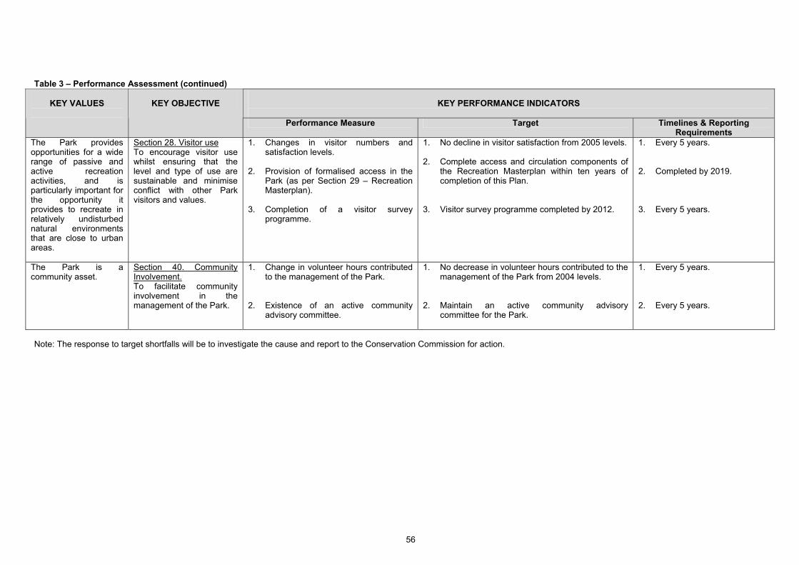
56
Table 3 – Performance Assessment (continued)
KEY PERFORMANCE INDICATORS
KEY VALUES
KEY OBJECTIVE
Performance Measure Target Timelines & Reporting Requirements
The Park provides opportunities for a wide range of passive and active recreation activities, and is particularly important for the opportunity it provides to recreate in relatively undisturbed natural environments that are close to urban areas.
Section 28. Visitor use To encourage visitor use whilst ensuring that the level and type of use are sustainable and minimise conflict with other Park visitors and values.
1. Changes in visitor numbers and satisfaction levels.
2. Provision of formalised access in the
Park (as per Section 29 – Recreation Masterplan).
3. Completion of a visitor survey
programme.
1. No decline in visitor satisfaction from 2005 levels. 2. Complete access and circulation components of
the Recreation Masterplan within ten years of completion of this Plan.
3. Visitor survey programme completed by 2012.
1. Every 5 years. 2. Completed by 2019. 3. Every 5 years.
The Park is a community asset.
Section 40. Community Involvement. To facilitate community involvement in the management of the Park.
1. Change in volunteer hours contributed to the management of the Park.
2. Existence of an active community
advisory committee.
1. No decrease in volunteer hours contributed to the management of the Park from 2004 levels.
2. Maintain an active community advisory
committee for the Park.
1. Every 5 years. 2. Every 5 years.
Note: The response to target shortfalls will be to investigate the cause and report to the Conservation Commission for action.
References and Bibliography
57
REFERENCES AND BIBLIOGRAPHY Ahern, J. (1995) Greenways as a Planning Strategy, Journal of Landscape Urban Planning Vol 33 pp 131 – 156. ANZECC (2000) Best Practice in Protected Area Management Planning, ANZECC Working Group on National
Parks and Protected Area Management Benchmarking and Best Practice Programme. Ashton, D. (1995) South West Metropolitan Beach Use Survey, a report prepared for the City of Cockburn. Barnes, S. (1998) Visitor Survey of Designated Regional Parks, Department of Conservation and Land
Management, Perth, Western Australia. Bastian, L. V. (1996) Residual Soil Mineralogy and Dune Subdivision, Swan Coastal Plain, Western Australia,
Australian Journal of Earth Sciences, Vol 43, pp 31-44. Beer, T. (1997) Environmental Oceanography, CRC Press, Boca Raton. Bikewest (1991) Bicycle Facilities Design Guidelines, Perth, Western Australia. Bowman, Bishaw, Gorham (2001) Port Catherine Environmental Review, Metropolitan Region Scheme
Amendment No. 1010/33, Western Australian Planning Commission, Perth, Western Australia. Cement Works (Cockburn Cement Limited) Agreement Act 1971. City of Cockburn (2004) Draft Proposed Coogee Beach Structure Plan, Perth, Western Australia. City of Cockburn (2008) Draft Cockburn Coast Beach Usage Report, Perth, Western Australia. City of Stirling (1999) Keeping and Control of Cats Local Law Perth, Western Australia. Cockburn Cement Limited Web Page (2009), www.cockburncement.com.au Colmar Brunton (2001) DEC Regional Parks Usage Survey 2001, Research Report prepared for DEC. Colmar Brunton (2005) DEC Regional Parks Usage Survey 2005, Research Report prepared for DEC. Conservation and Land Management Act 1984. Del Marco, A., Taylor, R., Clarke, K., Savage, K., Cullity, J. and Miles, C. (2004) Local Government Biodiversity
Planning Guidelines for the Perth Metropolitan Region, Western Australian Local Government Association, Perth, Western Australia.
Department of Conservation and Environment (1980) Coastal Management in Western Australia, Bulletin
No 49 (9). Department of Conservation and Environment (1983) Conservation Reserves for Western Australia as
recommended by the Environmental Protection Authority – 1983, Report No. 13, Perth, Western Australia. Department of Conservation and Land Management (1986a) Weeds on DEC Land Policy Statement No. 14,
Perth, Western Australia. Department of Conservation and Land Management (1986b) Rehabilitation of Disturbed Land Policy Statement
No. 10, Perth, Western Australia. Department of Conservation and Land Management (1989) Visual Landscape Management System, Perth,
Western Australia. Department of Conservation and Land Management (1991) Community Involvement (Public Participation and
Volunteers) Policy Statement No. 15, Perth, Western Australia. Department of Conservation and Land Management (1992) Beekeeping on Public Land Policy Statement No. 41,
Perth, Western Australia. Department of Conservation and Land Management (1993) Local Government Authority Access to Basic Raw
Material from State Forest and Timber Reserves, Perth, Western Australia. Department of Conservation and Land Management (1994) Reading the Remote, Landscape Character Types of
Western Australia, Perth, Western Australia. Department of Conservation and Land Management (1997) Visitor Risk Management Policy, Statement No. 53,
Perth, Western Australia.
References and Bibliography
58
Department of Conservation and Land Management (1999) Environmental Weed Strategy for Western Australia,
Perth Western Australia. Department of Conservation and Land Management (1991a) Proposed Management of Pest Animals on DEC –
Managed Lands Policy Statement (Subject to final consultation), Perth, Western Australia. Department of Conservation and Land Management (2001) Jervoise Bay Conservation and Recreation
Enhancement Plan, Prepared for and funded by the Department of Industry and Technology, Perth, Western Australia.
Department of Conservation and Land Management (2003) Indigenous Ownership and Joint Management of
Conservation Lands in Western Australia, Consultation Paper, Perth, Western Australia. Department of Conservation and Land Management (2004) Pest Animal Control Plan for Perth’s Regional Parks,
Perth, Western Australia. Department of Conservation and Land Management (2005) Fire Management Policy Statement No. 19, Perth,
Western Australia. Department of Conservation and Land Management Sign Manual, Perth, Western Australia. Department of Environment and Conservation (2006) Recreation, Tourism and Visitor Services Policy Statement
No. 18, Perth, Western Australia. Department of Environment and Conservation Corporate Plan 2007 - 2009 Department of Minerals & Energy (1986) Environmental Geology Series Perth, Perth, Western Australia. Department of Minerals and Energy (1995) The Mineral Exploration and Development Memorandum of
Understanding, Unpublished. Department of Minerals and Energy (1998) Guidelines for Mineral Exploration and Mining within Conservation
Reserves and Other Environmentally Sensitive Lands in Western Australia, DME Information Series No. 11, Perth, Western Australia.
Department for Planning and Infrastructure (2009) The Perth Recreational Boating Facilities Study 2008 –
Technical report No. 444, Study 2008, Perth, Western Australia. Department of Planning and Urban Development and Department of Conservation and Land Management (1991)
Task Force Report on the Administration, Planning and Management of Region Open Space and Regional Parks in Perth, Western Australia, Report to Cabinet, Perth, Western Australia.
Department of Planning and Urban Development (1992) Beeliar Regional Park – Proposals for Establishment,
Administration and Use, Perth, Western Australia. Department of Sport and Recreation (1982) Woodman Point Recreation Camp: a History 1886 – 1982, Perth,
Western Australia Department of Transport, Shoreline Movement Maps (1942 to 1994), Drawing Numbers: 374-03-02, 374-04-02, 374-05-02, Perth, Western Australia. Department of Transport (2000) Recreational boating facilities in Western Australia, a study of user needs,
Perth, Western Australia. Ecoscape (Australia) Pty Ltd and CoastWise (1999) Integrated Coastal Management Strategy for the City of
Cockburn, a report prepared for the City of Cockburn. English, V., Keighery, G. and Blyth, J. (1996) ‘Threatened plant communities on the Swan Coastal Plain’,
Landscope Vol 12 Number 1, Department of Conservation and Land Management, Perth, Western Australia.
Environmental Protection Authority (2003) Red Book Status Report on the implementation of Conservation
Reserves for Western Australia, Perth, Western Australia. Environmental Protection Authority and Department of Minerals and Energy (1995) Mineral Exploration and
Development Memorandum of Understanding. Feilman Planning Consultants (1978) Cockburn Sound Recreation Study. Gibson, N., Keighery, B., Keighery, G., Burbidge, A. and Lyons, M. (1994) A Floristic Survey of the Southern
Swan Coastal Plain.
References and Bibliography
59
Government of Western Australia (2000) Bush Forever, Perth, Western Australia. Grayson, J., Calver, M. and Styles, I. (2002) ‘Attitudes of suburban Western Australians to proposed cat control
legislation’ in Australian Veterinary Journal, Vol 80 (9): pp 536-543. Halpern Glick Maunsell (1997) Jervoise Bay Infrastructure Masterplan, a report prepared for the Department of
Commerce and Trade, Landcorp and Main Roads Western Australia. Heritage Council of Western Australia (2001) Documentation of Places for Entry in the Register of Heritage
Places - Woodman Point Munitions Magazines (fmr), Unpublished. How, R.A., Harvey, M.S., Bell, J. and Waldock, J.M. (1996) Ground Fauna of Urban Bushland Remnants in
Perth: Report to the Australian Heritage Commission, NEP Grant N 93/04 Keighery, B.J., Gibson, N. and Keighery, G.J. (1997) ‘The regional significance of the flora and vegetation of
Garden Island’, Proceedings of the Royal Australian Navy Energy and Environment Conference, 14/15 April 1997.
Keighery, G.J. (2001) Vascular Flora of Woodmans Point Nature Reserve, Unpublished list for DEC, Como,
Western Australia. Lord, D. A. and Associates (1995) Sedimentology of Success and Parmelia Banks, Owen Anchorage, Western
Australia, a report prepared for Cockburn Cement Ltd. Marchant, N.G., Wheeler, J.R., Rye, B.L., Bennett, E.M., Lander, N.S. and Macfarlane, T.D. (1987) Flora of the
Perth Region Part 1 and 2 Department of Agriculture, Perth, Western Australia. McArthur, W.M. and Bettenay, E. (1960) The Development and Distribution of the Soils of the Swan Coastal
Plain, Western Australia, Commonwealth Scientific and Industrial Research Organisation, Melbourne, Victoria.
McDonald Hales and Associates Pty Ltd (1997) Aboriginal Heritage Study of the Jervoise Bay Infrastructure
Planning Precinct. Perth, Western Australia. Molyneux, I. and Associates (1995) An Assessment of Cultural Heritage Significance and a Conservation
Plan for Woodman Point Recreation Camp (The Former Woodman's Point Quarantine Station) Perth, Western Australia.
Neal, P. (1994) Green Values Landscape Design No 227, U.K. Landscape Institute Journal, Surrey, England. Newman, P. (ed.) (1976) The Cockburn Wetlands: An Environmental Study, Perth, Western Australia. O’Brien Planning Consultants (1993) Lake Coogee Environmental Management Plan, a report prepared for the
City of Cockburn. O’Brien Planning Consultants (1996) Coogee Beach Development Plan, a report prepared for the City of
Cockburn. O’Brien Planning Consultants (1997) Municipal Heritage Inventory, a report prepared for the City of Cockburn. Oma, V.P.M., Clayton, D.M., Brain, J.B. and Keating, C.D.M. (1992) Coastal Rehabilitation Manual, Bulletin
4248, Agriculture Western Australia, Perth, Western Australia. Powell, R. (1990) Leaf and Branch. Trees and Tall Shrubs of Perth, Department of Conservation and Land
Management. Perth, Western Australia. Powell, R. and Emberson, J. (1981) Woodman Point a Relic of Perth's Coastal Vegetation, Artlook, Perth,
Western Australia. Regeneration Technology (2002) Woodman Point Regional Park Weed Control and Revegetation Plan,
Department of Conservation and Land Management, Perth, Western Australia. Rippey, E. and Rowland, B. (1995) Plants of the Perth Coast and Islands, University of Western Australia Press,
Perth, Western Australia. Rogers, M. P. and Associates Pty Ltd (1995) Owen Anchorage Shoreline Monitoring Report, report prepared for
Cockburn Cement Ltd. Rogers, M. P. and Associates Pty Ltd (1998) Port Catherine Development Coastal Engineering Study, report
prepared for Port Catherine Developments Pty Ltd.
References and Bibliography
60
Rogers, M.P. and Associates Pty Ltd (1999) Woodman Point West Beach, Stage 1 Report, report prepared for the Department of Commerce and Trade, Perth, Western Australia.
Rogers, M.P. and Associates Pty Ltd (1999) Woodman Point West Beach, Stage 2 Report, report prepared
for the Department of Commerce and Trade, Perth, Western Australia. Royal Australasian Ornithologists Union, (1996), Database of Western Australian Birds Project, (RAOU tracking
database). Searle, D. J. and Semeniuk V. (1985) The Natural Sectors of the Inner Rottnest Shelf and Coast Adjoining the
Swan Coastal Plain, Journal Royal Society Western Australia, Vol 67, Parts 3 and 4. Searle, D. J., Semeniuk V. and Woods P. J. (1988) Geomorphology, Stratigraphy and Holocene History of the
Rockingham-Becher Plain, Southwestern Australia, Journal Royal Society Western Australia, Vol 70, Part 4.
Seddon, G. (1972) Sense of Place, University of Western Australia Press, Perth, Western Australia. Semeniuk, V., Cresswell I. D. and Wurm, P. A. S. (1989) The Quindalup Dunes: the Regional System, Physical
Framework and Vegetation Habits, Journal of the Royal Society Western Australia, Vol 71, Vol 2 and 3. Shearer, B., Crane, C. E., Fairman, R. G. and Grant, M. J. (1998) Susceptibility of plant species in coastal dune
vegetation of south-western Australia to killing by Armillaria luteobubalina, CSIRO, East Melbourne, Victoria.
Stankey, G. H. and Wood J. (1982) The Recreation Opportunity Spectrum: An Introduction. Australian Parks and
Recreation, Feb 1982, pp 6 – 15. State Weed Plan Steering Group (2001) A Weed Plan for Western Australia, Department of Agriculture, Perth,
Western Australia. Stephenson, G. and Hepburn, J. (1955) Plan for the Metropolitan Region Perth and Fremantle Western Australia,
Government Printer, Perth, Western Australia. Tingay and Associates (1998) A Strategic Plan for Perth’s Greenways, Final Report, Perth, Western Australia. Van Delft, R. (1997) Birding sites around Perth, University of Western Australia Press, Nedlands, Western
Australia. Water and Rivers Commission (1997) Perth Groundwater Atlas, Perth, Western Australia. Western Australian Planning Commission (2005) Planning Report No. 6. Western Australia Tomorrow:
Population projections for planning regions 2004-2031 and local government areas 2004-2021, Perth, Western Australia.
Woodman Point Community Taskforce (1988) Woodman Point – A Regional Recreation / Conservation Park,
Concept and Development Plans, Perth, Western Australia.
Appendices
61
APPENDICES Appendix A – Department of Environment and Conservation Policies Referred to in this Plan
Rehabilitation of Disturbed Land, Policy Statement No. 10 Weeds on DEC Land, Policy Statement No. 14 Community Involvement (Public Participation and Volunteers), Policy Statement No. 15 Recreation, Tourism and Visitor Services Policy Statement No. 18 Fire Management Policy, Policy Statement No. 19 Beekeeping on Public Land, Policy Statement No. 41 Visitor Risk Management, Policy Statement No. 53 Proposed Management of Pest Animals on DEC-managed Lands [subject to final consultation]
Appendices
62
Appendix B - Abbreviations used in this Plan
CALM Act Conservation and Land Management Act 1994 CAMBA China Australia Migratory Bird Agreement Conservation Commission
Conservation Commission of Western Australia
CoC City of Cockburn DEC Department of Environment and Conservation DIA Department of Indigenous Affairs DMP Department of Mines and Petroleum DoP Department of Planning DoT Department of Transport DPUD Department of Planning and Urban Development (former; now Department of
PlanningDSD Department of State Development DSR Department of Sport and Recreation DRDL Department of Regional Development and Lands EPA Environmental Protection Authority FESA Fire and Emergency Services Authority JAMBA Japan Australia Migratory Bird Agreement MoU Memorandum of Understanding MRS Metropolitan Region Scheme ROKAMBA Republic of Korea Migratory Bird Agreement WAPC Western Australian Planning Commission WAPET West Australian Petroleum Pty Ltd
Appendices
63
Appendix C - Glossary
Class ‘A’ Reserves Under Section 42 of the Land Administration Act 1997, the Minister for Lands may by order classify a reserve as a class ‘A’ reserve, for one or more purposes in the public interest. The Act outlines special procedures that apply to certain changes to class ‘A’ reserves and conservation reserves. (Land Administration Act 1997, Sections 41, 41 and 43)
Declared Rare Flora Declared Rare Flora is generally referred to as threatened flora; plant species which are declared rare under Section 23F of the Wildlife Conservation Act 1950 as flora likely to become extinct or which are rare or otherwise in need of special protection. To be declared rare, plant species must meet well-defined criteria, which include the thoroughness of searches for the species, its rarity and the danger of extinction. A number of criteria are used to define Declared Rare Flora. These are related to the taxon being well defined and readily identifiable and the extent to which the taxon's distribution in the wild has been recently determined by competent botanists. The status of a threatened plant in cultivation has no bearing on the matter.
Fauna ‘Specially Protected’ under the Wildlife Conservation Act 1950
Under the Wildlife Conservation Act 1950 the Minister for Environment may declare a species of fauna to be ‘Specially Protected’ if they are likely to become extinct, or are rare, or are birds protected under and international agreement, or are otherwise in need of special protection. These species are considered threatened fauna and receive special consideration in management by DEC.
High Water Mark In relation to tidal waters, means ordinary high water mark at spring tides. (Land Administration Act 1997, Section 3)
Priority Fauna Listings DEC maintains a list of Priority Fauna. Taxa may be assigned one of five categories, as follows: Priority One: – Taxa with few, poorly known populations on threatened lands. Taxa which are known from few specimens or sight records from one or a few localities on lands not managed for conservation, e.g. agricultural or pastoral lands, urban areas, active mineral leases. The taxon needs urgent survey and evaluation of conservation status before consideration can be given to declaration as threatened fauna. Priority Two: – Taxa with few, poorly known populations on conservation lands. Taxa which are known from few specimens or sight records from one or a few localities on lands not under immediate threat of habitat destruction or degradation, e.g. national parks, conservation parks, nature reserves, State forest, unallocated Crown land, water reserves, etc. The taxon needs urgent survey and evaluation of conservation status before consideration can be given to declaration as threatened fauna. Priority Three: – Taxa with several, poorly known populations, some on conservation lands. Taxa which are known from few specimens or sight records from several localities, some of which are on lands not under immediate threat of habitat destruction or degradation. The taxon needs urgent survey and evaluation of conservation status before consideration can be given to declaration as threatened fauna. Priority Four: – Taxa in need of monitoring. Taxa which are considered to have been adequately surveyed, or for which sufficient knowledge is available, and which are considered not currently threatened or in need of special protection, but could if present circumstances change. These taxa are usually represented on conservation lands. Priority Five: - Taxa in need of monitoring. Taxa which are not considered threatened but are subject to a specific conservation program, the cessation of which would result in the species becoming threatened within five years.
Appendices
64
Priority Flora Listings DEC maintains a list of Priority Flora. Taxa may be assigned one of four
categories, as follows: Priority One – Poorly known: taxa which are known from one or a few (generally less than five) populations which are under threat, either due to small population size, or being on lands under immediate threat, e.g. road verges, urban areas, farmland, active mineral leases, etc., or the plants are under threat, e.g. from disease, grazing by feral animals, etc. May include taxa with threatened populations on protected lands. Such taxa are under consideration for declaration as ‘rare flora’, but are in urgent need of further survey. Priority Two – Poorly known: taxa which are known from one or a few (generally less than five) populations, at least some of which are not believed to be under immediate threat (i.e. not currently endangered). Such taxa are under consideration for declaration as ‘rare flora’ but are in urgent need of further survey. Priority Three: – Poorly known: taxa which are known from several populations, at least some of which are not believed to be under immediate threat (i.e. not currently endangered). Such taxa are under consideration for declaration as ‘rare flora’, but are in need of further survey. Priority Four: – Rare: taxa which are considered to have been adequately surveyed and which, whilst being rare (in Australia), are not currently threatened by any identifiable factors. These taxa require monitoring every 5 – 10 years.
Threatened ecological community
DEC has developed a procedure for identifying ‘Threatened Ecological Communities’. Ecological communities are defined as ‘naturally occurring biological assemblages that occur in a particular type of habitat’. Threatened Ecological Communities are those that have been assessed and assigned to one of four categories related to the status of the threat to the community. The categories are: presumed totally destroyed; critically endangered; endangered; vulnerable.
The threatened ecological community in Woodman Point Regional Park is the Rottnest cypress and Rottnest tea tree forests and woodlands, which has been classified as ‘vulnerable’. This category refers to an ecological community which has been adequately surveyed and found to be declining and/ or has declined in distribution and/ or condition and whose ultimate security has not been assured and/ or a community which is still widespread but is believed likely to move into a category of higher threat in the near future if threatening processes continue or begin operating throughout its range.

Appendices
65
Appendix D - Contacts Department of Environment and Conservation Community and Regional Parks Branch Level 1, 4-6 Short Street (PO Box 1535) Fremantle WA 6959 9431 6500 Department of Environment and Conservation State Headquarters Locked Bag 104 Bentley Delivery Centre WA 6983 9334 0333 www.dec.wa.gov.au Department of Environment and Conservation Swan Coastal District 5 Dundebar Road Wanneroo WA 6065 9405 0700 City of Cockburn 9 Coleville Crescent Spearwood WA 6163 9411 3444 www.cockburn.wa.gov.au Department of Sport and Recreation 246 Vincent Street (PO Box 329) Leederville WA 6903 9492 9700 www.dsr.wa.gov.au Department of Transport 1 Essex Street (PO Box 402) Fremantle WA 6959 9216 8999 www.dpi.wa.gov.au Friends of Woodman Point c/- 40 Cliff Street Fremantle WA 6160