wooden well at the first farmers’ settlement area in
TRANSCRIPT
61PAMÁTKY ARCHEOLOGICKÉ CXI, 2020
DOI: 10.35686/PA2020.2 61–111
Wooden Well at the First Farmers’ Settlement Area in Uničov, Czech Republic
Studna s dřevěnou konstrukcí z osady prvních zemědělců v Uničově, Česká republika
Ivana Vostrovská – Jan Petřík – Libor Petr – Petr Kočár – Romana Kočárová – Zbyněk Hradílek – Josef Kašák – Zdeňka Sůvová – Katarína Adameková – Zdeněk Vaněček –
Jaroslav Peška – Bernhard Muigg – Michal Rybníček – Tomáš Kolář – Willy Tegel – Marek Kalábek – Pavlína Kalábková
Redakci předloženo v prosinci 2019, upravená verze v dubnu 2020
Some of the most extraordinary finds from the Early Neolithic period are wooden wells. These constructions permit unusual insightsinto Neolithic settlements, their subsistence and environment, as well as into the surrounding landscape. A recent excavation ofa Neo lithic settlement at Uničov in central Moravia, Czech Republic, yielded the discovery of a wooden well with a sediment infillfrom the beginning of the Neolithic period and allowed to study an array of topics by a multi-proxy approach using a set of comple-mentary methods. Our study of the wooden lining demonstrates the carpeting skills of the first farmers, required also for building so-called ‘longhouses’. By comparing dendrochronological and radiocarbon dating, we estimated the time span of the well’s existence.The construction was used repeatedly over a longer time and was finally filled in intentionally. Studies of the well’s infill shed lighton its usage and decline, providing a great proxy for the study of living dynamics and handling of waste in a Neolithic village. Theenvironmental record extracted from botanical residues indicates that the immediate surroundings of the settlement were covered byan open-canopy woodland with a dominance of oak and hazel, and a large proportion of open habitats, whereas the surroundinglandscape was not noticeably affected by humans.
Wooden well, past environment, subsistence strategy, Linearbandkeramik, Uničov, eastern Central Europe
Jedním z nejpozoruhodnějších nálezů ze starého neolitu jsou studny s dřevěnou konstrukcí. Tyto objekty umožňují neobvyklý vhleddo neolitických osad, na strategie obživy a prostředí, jakož i na okolní krajinu. Nedávný výzkum neolitického sídliště v Uničově nastřední Moravě v České republice přinesl objev dřevěné studny s výplní z počátku neolitu a umožnil studovat toto téma multi-proxypřístupem za použití sady metod. Prezentovaná studie o dřevěné konstrukci demonstruje tesařské dovednosti prvních zemědělců,potřebné také pro stavbu tzv. dlouhých domů. Porovnáním dendrochronologických a radiokarbonových dat jsme odhadli časovérozpětí existence studny. Objekt byl používán opakovaně po delší dobu a nakonec byl záměrně zaplněn. Studie výplně studny osvětlilyjejí využití a zánik, což je skvělým prostředkem pro studium dynamiky života a nakládání s odpady v neolitické osadě. Z environ-mentálního záznamu získaného z botanických zbytků vyplývá, že bezprostřední okolí osady bylo pokryto lesem s otevřeným zápojems dominancí dubu a lísky a velkým podílem otevřených stanovišť, zatímco okolní krajina nebyla lidmi znatelně ovlivněna.
Studna s dřevěnou konstrukcí, minulé prostředí, strategie obživy, kultura s lineární keramikou, Uničov, středo -východní Evropa
1. Introduction
Hunter-gatherer communities in the Near East wereable to consolidate and spread the farming lifestylesthat led to the exponential population growth humanshave maintained since Neolithic times, more than10,000 years ago. Even though water has retainedmany of its wild and free characteristics, we should con-sider it a domesticated natural resource, since its nat-ural properties have been constrained and manipulatedto cater for human need (Mithen 2010, 5250). Neolithicwater subsistence is characterized by active behaviourto secure and optimize the biotic and abiotic conditions
by which food and other water-dependent productswere made available. For this reason, the role of watermanagement increased, entailing the planning, devel-opment, distribution and managed usage of water re-sources. Storage and land-use are the key socio-eco-nomic sectors in which new water techniques influence,trigger and protect new modes in sedentary life. It isspecially the storage aspect that makes water a subjectof domestication, not to mention the ‘neolithization ofwater’ (Gebel 2004). Securing a sustainable watersource was an important part of the construction of

every new settlement. The active digging of permanentwells reaching the underground water table reflects an innovative approach to water provisioning in the first farmers’ communities. Such wells provided themwith their own water supply, so they did not have to rely solely on local rainfall. Water in a well is isolatedand controlled, unlike water in a river, which is open topollution by humans or animals. Finally, a well couldhave functioned as a status symbol, indicating the su-periority of certain parts of the site over others. It isa testimony to the hydrological knowledge and techno-logical capacities of the first farmers (Garfinkel – Vered –Bar-Yosef 2006).
Around the mid-6th millennium BC, the transition tothe Neolithic way of life took place in the Middle Danuberegion (Bánffy – Oross 2010), and over 100–200 yearsthe new way of life spread to eastern Romania andthrough Central Europe to eastern Belgium. Thisbrought the onset of what we now refer to as the LinearPottery culture (Linearbandkeramik, LBK), which hasbeen dated for the region of eastern Central Europe tothe period of 5500–4950 BC (Kuča et al. 2012), espe-cially ca 5400–4800 BC1 (Manning et al. 2014, 1077).The uniformity of architecture, artifacts, burials, sub-sistence and settlement plans that characterized thesecommunities is extraordinary and represents a furtherextension of the Neolithic way of life. The sedentary wayof life was related to plant cultivation and livestockbreeding, and, as a result, people lived in larger groupsand constructed permanent settlements (Price 2000;Barker 2011).
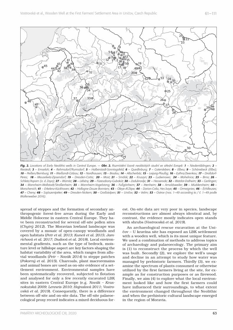
In Czechia, Neolithic wooden wells have so far beenfound only rarely. The first of the Neolithic wells witha preserved wooden lining dated to the LBK was foundat the settlement by the town of Mohelnice in Moraviain 1970 (Tichý 1972). One more well was excavated by
1 The study area encompasses Central and Northwest Europe. Be-ginning and end dates estimated using the three different me-thods, accompanied by the mean and standard deviation usingan improved normally distributed model.
62 PAMÁTKY ARCHEOLOGICKÉ CXI, 2020
Vostrovská et al., Wooden Well at the First Farmers’ Settlement Area in Uničov, Czech Republic 61–111
Fig. 1. Geographical site position. — Obr. 1. Geografická poloha lokality.
the town of Most in northwest Bohemia in 1976 (Rulf –Velímský 1993) and another was discovered in 2007 inthe Bohunice district of the city of Brno (Přichystal2008). Neither of them yielded any evidence of anywooden lining. Over the past five years, three more wellswere uncovered, all with a wooden lining: Uničov inMoravia in 2015 (Fig. 1; Kalábek 2016), Velim in centralBohemia in 2016 (Chlup 2017) and Ostrov in easternBohemia in 2018 (Sedláček et al. 2019). More than 100wells from 53 Early Neolithic sites have been docu-mented throughout Europe (Fig. 2). To date, the largestnumber of wells have been recorded in Saxony, Saxony-Anhalt and the Rhineland, where more than half thewells discovered have been investigated closely (Windl1998; Zimmermann 2009; Tegel et al. 2012; Füzesi et al.2015; Király – Tóth 2015; Kretschmer et al. 2016; Weiner2016; Fülöp et al. 2018; Stäuble 2018, 78). Several Eu-ropean LBK wells have been described in great detail(Weiner 1994; Koschik 1998; Herbig et al. 2012/2013;Zerl – Herbig 2012; Tinapp – Schneider – Stäuble 2013;Stäuble – Veit 2016; Friederich 2017). On the otherhand, out of the total number of six water wells in theCzech Republic, none has been evaluated and pub-lished in detail. However, there are some chronologicallyyounger wells which have been analysed with a multi-proxy approach that resulted in local landscape recon-struction. The wooden construction of the well and itsinfilling is the extraordinary evidence from the Romanperiod at Dražkovice in eastern Bohemia (Sedláček et al. 2008) and at Hurbanovo in southwest Slovakia(Haj nalová et al. 2018). From the Migration period, theexcavation at Hostivice in the western district of the cityof Prague in 2002 allowed the investigation of a settle-ment and a group of contemporary wells with woodenstructures (Pleinerová 2005).
Water wells and their sedimentary infill are prehis-toric archives of proxy data. They can provide informa-tions about water treatment and timberwork and aboutthe subsistence of the first farmers, which was very dif-ferent from that of previous Mesolithic hunters andgatherers. It has been proved that they adhered to in-tensive garden cultivation and herding. A functional in-terdependence exists between crops and animal hus-bandry, as crop products and by-products were usedas fodder. Available evidence of livestock breeding bythe first farmers within the loess belt, again, suggestssmall-scale intensive management (Bogaard 2005).Their diet was based on crops such as einkorn wheat,emmer wheat and some other plants such as pea, lentiland opium poppy (Kreuz et al. 2005; Salavert 2011), andherded cattle and pigs (Hachem 2018). The results ofmacroremains analyses are important for understand-ing the post-glacial migration of plant species. Numer-ous present-day ruderal plant species are consideredarchaeophytes (Pyšek et al. 2012; Pokorná et al. 2018),which are believed to have migrated during the neolithi-zation process, or later. But their origins and length ofpresence in our region are uncertain.
However, this environmental material does not onlytestify as to the subsistence strategy of the first farm-ers, but also as to the environment and vegetation.Among others, detailed reconstruction of the environ-ment contributes to the unravelling of the genesis and
spread of steppes and the formation of secondary an-thropogenic forest-free areas during the Early and Middle Holocene in eastern Central Europe. They ha-ve been reconstructed for several off-site pollen sites(Chytrý 2012). The Moravian lowland landscape wascovered by a mosaic of open-canopy woodlands andopen habitats (Petr et al. 2013; Kuneš et al. 2015; Jam-richová et al. 2017; Dudová et al. 2018). Local environ-mental gradients, such as the type of bedrock, mois-ture level or hillslope aspect are key factors shaping thehabitat variability of the area, which ranges from allu-vial woodlands (Petr – Novák 2014) to steppe patches(Pokorný et al. 2015). Charcoals, plant macroremainsand animal bones are used as on-site evidence of a set-tlement environment. Environmental samples havebeen systematically recovered, subjected to flotationand analysed for only a few recently excavated LBKsites in eastern Central Europe (e.g. Novák – Kras-nokutská 2009; Lenneis 2010; Hajnalová 2011; Vostro-vská et al. 2019). Consequently, there is a differencebetween off-site and on-site data. The off-site palaeoe-cological proxy record indicates a mixed deciduous for-
est. On-site data are very poor in species, landscapereconstructions are almost always identical and, bycontrast, the evidence mostly indicates open standswith shrubs (Vostrovská et al. 2019).
An archaeological rescue excavation at the Uni-čov – U kravína site has exposed an LBK settlementwith a wooden well, which is its most unique feature.We used a combination of methods to address topicsof archaeology and palaeoecology. The primary aimis (1) to reconstruct the process by which the wellwas built. Secondly (2), we explore the well’s usageand decline in an attempt to study how water wasmanaged by prehistoric farmers. Thirdly (3), we ex-amine the spectrum of plants consumed or otherwiseutilized by the first farmers living at the site, for ex-ample as for construction purposes or as firewood.Finally, we aim (4) to explore what the local environ-ment looked like and how the first farmers couldhave influenced their surroundings, to what extentthe environment changed throughout the Neolithicand when the prehistoric cultural landscape emergedin the region of Moravia.
63PAMÁTKY ARCHEOLOGICKÉ CXI, 2020
Vostrovská et al., Wooden Well at the First Farmers’ Settlement Area in Uničov, Czech Republic 61–111
4647
37 33
34
3536
324244
4543
41
3840
39
3112
5
12
3
67
8 9
1011
14 131516
417 18
50 19
4920
52 53 24 51
25
26
27
28
30
29 48
21
2322
Fig. 2. Locations of Early Neolithic wells in Central Europe. — Obr. 2. Rozmístění časně neolitických studní ve střední Evropě: 1 – Niederröblingen; 2 –Riestedt; 3 – Emseloh; 4 – Rehmsdorf/Rumsdorf; 5 – Halberstadt-Sonntagsfeld; 6 – Quedlinburg; 7 – Gatersleben; 8 – Elbeu; 9 – Schönebeck (Elbe); 10 – Peißen/Bernburg; 11 – Weißandt-Gölzau; 12 – Nordhausen; 13 – Brodau; 14 – Altscherbitz; 15 – Leipzig-Plaußig; 16 – Eythra/Zwenkau; 17 – Droßdorf-Peres; 18 – Meuselwitz-Zipsendorf; 19 – Dresden-Cotta; 20 – Most; 21 – Smólsk; 22 – Kruszyn; 23 – Ludwinowo; 24 – Mohelnice; 25 – Brno; 26 –Schletz/Asparn (a. d. Zaya); 27 – Würnitz; 28 – Lébény; 29 – Füzesabony-Gubakút; 30 – Zadubravlje; 31 – Hesserode; 32 – Wetzlar-Dalheim; 33 – Gerlingen;34 – Mannheim-Wallstadt/Straßenheim; 35 – Mannheim-Vogelstang; 36 – Fußgönheim; 37 – Ittenheim; 38 – Arnoldsweiler; 39 – Müddersheim; 40 –Morschenich; 41 – Erkelenz-Kückhoven; 42 – Hollogne-Douze Bonniers; 43 – Oleye-Al Zèpe; 44 – Darion-Colia, Hes baye; 45 – Ormeignies; 46 – Échilleuses;47 – Cheny; 48 – Sajószentpéter; 49 – Dresden-Nickern; 50 – Großstolpen; 51 – Uničov; 52 – Velim; 53 – Ostrov (nos. 1–49 according to / č. 1–49 podleWollenweber 2016).

2. Material and methods
2.1. Site description
The town of Uničov is situated in the northeastern tipof central Moravia, at the foothills of the Nízký Jeseníkhighland (Culek et al. 2005). Its environmental condi-tions make this region relatively secluded, which is re-flected in its prehistoric development. The bedrock con-sists of gravel-sand fluvial deposits mostly overlaid byloess, which is covered with fertile soil. The site is situ-
ated ca 230 m from the left bank of the now regulatedriver bed of the Lukavice stream. This is probably theclosest surface water source in the Neolithic period. An-other watercourse is the Oskava stream located about1,100 m away. It is a tributary of the river Morava andcomprises a broad alluvium at elevations of 233–234 mASL (Fig. 3). The present-day average annual tempera-ture and rainfall are 9°C and 550 mm, respectively.
In November and December 2015, the ArchaeologicalCentre Olomouc conducted an archaeological rescueexcavation at the construction site of a factory hall and
64 PAMÁTKY ARCHEOLOGICKÉ CXI, 2020
Vostrovská et al., Wooden Well at the First Farmers’ Settlement Area in Uničov, Czech Republic 61–111
Fig. 3. Site location – marked in red (©ČÚZK).— Obr. 3. Umístění lokality – vyznačeno čer-veně (©ČÚZK).
Fig. 4. Linearbandkeramiksettlement at the Uničovsite (author I. Vostrovská).— Obr. 4. Sídliště kulturys lineární keramikou v Uni-čově (autorka I. Vostrovská).0 50 m
N

an access road on the southwest border of the town ofUničov at a place called U kravína. On an area of 0.7 ha,556 features of the LBK and two settlement pits of theJordanów culture were explored (Kalábek 2016). Theexcavation unearthed one part of a settlement area ofthe LBK with 12 ‘longhouse’ layouts with a five-rowpost-construction, building pits, irregular compositepits, storage pits and ovens. An exceptional find wasa water well with a preserved timber lining (feature 184).The well was situated in the immediate neighbourhoodof house S2 and house S3 (Fig. 4).
2.2. Fieldwork
After the removal of the topsoil layer, the well had theform of an oval pit sized 580 x 550 cm, oriented in thenortheast-southwest direction (Fig. 5). The feature wasdivided into six sectors which were gradually excavated.The excavation was carried out crosswise in oppositeparts in order to make the cross-section through thisfeature as long as possible (Fig. 6). The uppermost layerof the feature consisted of dark brown silty soil 80 cmin thickness (context 300). A total of 110 ceramic frag-ments were found in the infill of the funnel-shaped wellpit (Fig. 7: 1–15). However, it soon became evident thatthe infill of the pit narrowed towards the centre and thatits structure and colour varied. About one metre deeper,the moderately inclined funnel-shaped mouth of the pitturned abruptly into a nearly vertical wall falling downto a depth of 325 cm. This funnel was filled with yellow-brown compacted clayey soil (context 302).
In the middle of this infill, at a depth of 120 cm belowthe surface, a dark black, clayey, irregular rhombicground plan was detected, indicating the original timberlining of the well shaft. The length of its sides was 90–100 cm and the infill consisted of water-saturatedbrown-black silty clay with many organic remains (con-text 315). Only two whole ceramic vessels and 11 ce-ramic vessel fragments were found in the well shaft
(Fig. 7: 16–23). The outer side of the timber lining of thewell shaft was daubed with an approximately 6-cmlayer of grey clay (context 316; Fig. 8) and a total of nineceramic fragments were found in it (Fig. 7: 24–26). Theupper groundwater level was reached at a depth of170 cm below the surface after the removal of topsoil,where the preserved wooden lining began to appear.This construction was gradually dismantled and con-tinued to the depth of 320 cm. The whole infill of thewell shaft was removed in 10- and 20-cm layers downto the depth of 325 cm. The sediment from the infill wasput into plastic bags for detailed multi-proxy palaeoe-cological analyses. It was not possible to take out moresediment because the large amount of groundwater inthe well could not be pumped off.
At a depth of 260 cm, two parallel cores were sam-pled from the wet well infill using an open tube 8 cm indiameter and 100 cm long (manufactured by Eilkamp)to obtain a precise stratigraphy of the well infill. Thefirst core reached the gravel bedrock at a depth of345 cm and thin-section samples 3 cm thick were sam-pled for micromorphological, palynological and geo-chemical analyses. The second core only reacheda depth of 310 cm. It was sampled every 5 cm and thematerial was put into zip lock bags and stored ina fridge for future use.
2.3. Dendrochronology and radiocarbon dating
We took samples from all wooden elements of the wellthat were suitable for dendrochronological analysis,with an increment borer or chainsaw. In total, 16 sam-ples were measured using the VIAS TimeTable mea-suring system devised by SCIEM (©SCIEM). Tree-ringwidth (TRW) series were measured with an accuracy of0.01 mm and synchronized using the software PAST4(©SCIEM). The mean TRW series were dated accordingto the oak TRW chronology from Saxony (Tegel et al.2012). The degree of similarity between the TRW series
65PAMÁTKY ARCHEOLOGICKÉ CXI, 2020
Vostrovská et al., Wooden Well at the First Farmers’ Settlement Area in Uničov, Czech Republic 61–111
Fig. 5. Oval well pit with a moderately inclinedfunnel-shaped mouth abruptly turning intoa nearly vertical wall of the well shaft (photoby M. Kalábek). — Obr. 5. Oválná jámastudny s mírně se svažujícím trychtýřovitýmústím, které se náhle mění v téměř svisloustěnu šachty studny (foto M. Kalábek).

was assessed by t-tests (Gleichläufigkeit: Eckstein –Bauch 1969; TBP: Baillie – Pilcher 1973; THO: Hollstein1980). Woody plants were mainly determined by ma-croscopic observation. The anatomical determination
of woody plants was based on the following literatu-re: Schweingruber (1990; 1990b), Grosser (2007) andSchoch et al. (2004).
66 PAMÁTKY ARCHEOLOGICKÉ CXI, 2020
Vostrovská et al., Wooden Well at the First Farmers’ Settlement Area in Uničov, Czech Republic 61–111
2 m
2 m
1 m
Fig. 6. Ground plan and vertical sec-tion of the well infill (authors P. Gre-nar and I. Vostrovská). — Obr. 6. Pů-dorys a profil studny (autoři P. Grenara I. Vostrovská).

67PAMÁTKY ARCHEOLOGICKÉ CXI, 2020
Vostrovská et al., Wooden Well at the First Farmers’ Settlement Area in Uničov, Czech Republic 61–111
Fig. 7. Finds of LBK pottery. — Obr. 7. Nálezy lineární keramiky: finds from the well infill of the funnel-shaped well pit / nálezy z výplně trychtýřovité studničníjámy: 1 – 17/2015-300-1; 2 – 17/2015-300-2; 3 – 17/2015-300-8; 4 – 17/2015-300-9; 5 – 17/2015-300-10; 6 – 17/2015-300-11; 7 – 17/2015-300-12; 8 – 17/2015-300-13; 9 – 17/2015-300-14; 10 – 17/2015-300-15; 11 – 17/2015-300-16; 12 – 17/2015-300-17; 13 – 17/2015-300-20; 14 – 17/2015-300-21;15 – 17/2015-300-25. Finds from the well shaft / nálezy z šachty studny: 16 – 17/2015-315-1; 17 – 17/2015-315-4; 18 – 17/2015-315-6; 19 – 17/2015-315-9;20 – 17/2015-315-10; 21 – 17/2015-315-15; 22 – 17/2015-315-17; 23 – 17/2015-315-33. Finds from the daub layer of grey clay / nálezy z vrstvy omazu šedýmjílem: 24 – 17/2015-316-4; 25 – 17/2015-316-1; 26 – 17/2015-316-7 (drawing by / kresba A. Pešková, layout by / rozvržení I. Vostrovská).
1
context 300
context 315
context 316
5
6 7
11
12
13
1415
182221
16
19 20
17
23
24 25 26
8
9
10
2 3 4
5 cm

To independently verify the dendrochronological results, a total of 20 samples for radiocarbon datingwere taken from the well’s lining and infill. These werecharred and non-charred plant macroremains, woodand tar coming from the middle and lower part of theinfill (from a depth of 180–325 cm). The material wasanalysed by accelerator mass spectrometry at followinglaboratories: Isotoptech Zrt. Debrecen, Labor für Ionen-strahlphysik ETH Zürich and at the Curt-Engelhorn-Zentrum Archäometrie Mannheim. The obtained datawere calibrated using OxCal version 4.3 (95.4 % ± 2 σ;μ ± 1 σ). To compare the accuracy of the data, in sixcases, samples of charred and non-charred macrore-mains from the same depth (achenes of Onopordum andChenopodium; grains of Triticum dicoccum and Triticummonococcum) were dated independently at two labora-tories.
2.4. Trace evidence
The 47 wooden objects from the construction and infillof the well exhibited a variety of tool marks and indirectevidence of woodworking. Scale drawings of the cross-sections were produced for all wooden objects to inves-tigate dendrological parameters (pith, sapwood, waneyedge, orientation of tree-rings and rays) and to establishtheir position in the trunk. From this information, min-imum stem diameters and indications on the longitudi-nal splitting processes were obtained. Single tool markswere documented to obtain minimum blade widths.Manufacturing procedures were identified on the ba-sis of techno-morphological features and in consulta-tion of archaeological (e.g. Böhm – Pleyer 1990; Weiner
– Lehmann 1998; Elburg 2008; Tegel et al. 2012) andethno-archaeological research (e.g. Pétrequin – Pétrequin1993) as well as experimental studies and experience(Meier 1990; Choulot et al. 1997; Arnold 2003; Lobisser2005; Elburg et al. 2015). The results of these analyseswere evaluated by the laboratory Jahrringlabor der Pro-fessur für Waldwachstum und Dendroökologie der Uni-versität Freiburg.
2.5. Lithostratigraphy
A basic macroscopic description of the lithostratigraphywas carried out on site and during the sampling of coresin the laboratory. The recognized layers were analysedin detail in thin sections sampled at certain depths fromtwo parallel cores (core 1: samples 1, 9, 10, 11 and 12;core 2: samples 2, 3, 4 and 5) and from blocks of sedi-ment collected during the fieldwork (samples 6, 7 and8). Thin sections sized 2.5 x 5 cm were air-dried, im-pregnated, cut into slices, installed on a glass slide andpolished to a thickness of about 30 μm. They were thenanalysed under a polarizing microscope in plane-polar-ized light (PPL) and under cross-polarized light (XPL),following the standard guidelines (Bullock et al. 1985;Stoops – Eswaran 1986; Stoops 2003). The weight per-centage of organic matter was determined by means ofloss on ignition (LOI 550), which indicates the propor-tion of organic matter (Heiri – Lotter – Lemcke 2001).Samples were dried at 105 °C for 24 hours and com-busted for three hours at 550 °C. Magnetic susceptibil-ity was measured using an Agico Kappabridge MFK1-FA device set at two frequencies (976 Hz and 15,616 Hz)operating with a magnetic field amplitude of 200 A/m.
68 PAMÁTKY ARCHEOLOGICKÉ CXI, 2020
Vostrovská et al., Wooden Well at the First Farmers’ Settlement Area in Uničov, Czech Republic 61–111
Fig. 8. Layer of grey clay daub (context 316)on the outer side of the wooden construction(photo by M. Kalábek). — Obr. 8. Vrstvaomazu šedým jílem (kontext 316) na vnějšístraně dřevěné konstrukce (foto M. Kalábek).

Frequency-dependent magnetic susceptibility was cal-culated for each sample from the frequencies obtained.Chemical composition was determined using an ED-XRFspectrometer Rigaku NexCG with a 50-W Pd tube usingan SSD detector with 145-eV resolution. The durationof each measurement was 120 seconds for every sec-ondary target. Samples were measured in the form ofhomogenized pressed pellets. Quantification was per-formed for the following elements: Al, Si, P, S, K, Ca, Ti,Mn, Fe, Ni, Cu, Zn, As, Rb, Sr, Sb and Pb.
2.6. Palynology
All 28 samples were processed using the standard ace-tolysis method (Moore – Webb – Collingson 1991) forpollen analysis. The volume of individual samples wasapproximately 1 cm³. First of all, each sample wasboiled for 10 minutes in 10% KOH and was then wet-sieved. Afterwards it underwent 24 hours of leaching inHF without boiling. The next procedure was boiling for 5 minutes in an acetolysis mixture of sulfuric acid(H2SO4) and acetic anhydride [(CH3CO)2O] at a ratio of 1:9. The sample was then transferred to a mixture ofwater and glycerol. Pollen samples were coloured withsafranin to emphasize pollen grain against the rest ofthe organic matter. Each sample was examined undera standard optical microscope at 400x magnification.A pollen atlas was used for pollen grain identification(Beug 2004). Pollen diagrams were plotted in POLPAL(Walanus – Nalepka 1999). The pollen sum in each sam-ple was at least 200 grains, excluding aquatic types andnon-pollen objects.
2.7. Anthracology, xylotomy, plant macroremains,mosses, zoology and entomology
The methodology of the sampling was implemented soas to enable multi-proxy research. Different samplingstrategies were used throughout the excavation. A totalof 57 samples of sediment were recovered from well’sinfill. The whole infill of the well shaft was sampled forfurther analysis. Because of the lack of apparent strat-ification of the vertical section, bulk samples of the sed-iment were taken from layers 10 or 20 cm in thickness(1–3 samples per layer). All samples were wet-sieved ona 2-mm sieve and the coarse fraction was sorted intocharcoals, wood fragments and large seeds. Only 20 sam-ples of 2 l volume were also processed using a 0.25-mmsieve because of the high concentration of environ-mental material. Smaller seeds, fruits and other plantmacroremains were sorted directly from wet-sieved sam-ples. The remaining heavy residue was sorted immedi-ately after flotation (Pearsall 2001). In total, 572 l of sed-iment were processed. The environmental material wassorted and identified under a stereomicroscope.
In total, 57 samples containing charcoals and woodfragments were analysed. Transverse, radial and tan-gential sections were made on each fragment, and freshfracture surfaces were directly examined using an epis-cope interference microscope with 50x, 100x and 200xmagnification. The total weight of charcoal in each sam-ple was weighed with the accuracy of 0.001 g, and an-
thracomass in mg of charcoal per kg of sediment wasdetermined based on charcoals larger than 1 mm (Talon –Carcaillet – Thin 1998). Wood species identification, inclu-ding charcoals, was performed according to Schweingru-ber (1990a; 1990b).
The macroremains assemblage was represented by20 samples. The residuum of the > 2 mm fraction wasscanned for wood fragments. Seeds, fruits and otherplant macroremains were sorted out from wet samples.Their determination was performed using a referencecollection, atlases and keys to seeds (Anderberg 1994;Berggren 1981; Beijerinck 1947; Cappers – Bekker –Jans 2006; Jacomet 2006).
Photographs of mosses were made using an Olym-pus BX60 microscope equipped with an Olympus DP 72camera, using QuickPHOTO CAMERA 3.0 software. Thenomenclature of mosses follows the last edition of theChecklist and Red List of Bryophytes of the Czech Re-public (Kučera – Váňa – Hradílek 2012).
The assemblage of the microfauna was analysed bystandard methods of archaeozoology, see for exampleReitz – Wing 2008. Bone determination was carried outusing both an osteological collection and osteological at-lases (Schmid 1972; Anděra – Horáček 1982; Červený –Komárek – Štěrba 1999). Because of the tiny weight ofremains, in the case of the assemblage obtained byflotation, only the number of finds and minimum num-ber of individuals were recorded; for the quantificationmethods in archaeozoology, see Kyselý 2004.
Insect remains were identified according to compar-ative collections and modern keys for particular groups.Individuals in the assemblage were quantified as thenumber of identified specimens (NISP) and the mini-mum number of individuals (MNI; Lyman 2008).
3. Results and interpretation
3.1. Dendrochronology and radiocarbon dating
The well-preserved wooden construction provided nineabsolutely dated TRW series of oak (Quercus spp.). Thesamples originate from the well’s lining as well as fromthe infill. Most of the dated oak wood samples still con-tained sapwood, so the analysed samples could bedated more precisely. The number of sapwood tree ringsdetected in the dated Quercus samples falls within therange (5–25 rings) defined by Prokop et al. (2017). Thetrees used for the well construction were cut between5093 and 5085 BC (Rybníček et al. 2018, 100–101).
After calibration of the radiocarbon data, the timberlining and well filling fell within a rather wide intervalof 5464–4615 cal. BC (Tab. 1), a result compatible withthe dendrochronological dating. The data for achenes,seeds and cereals from the filling (5302–4979 cal. BC)and wood from the lining (5290–5026 cal. BC) are com-parable (Fig. 9). A total of three samples stand out fromthe whole series of radiocarbon data. A hornbeam seed(Carpinus betulus) was dated to the interval of 5464–5220 cal. BC, which is the oldest of all the samples. Twosamples were obtained from moss residues (Drepano -cladus aduncus). The value for the first sample, 4836–4615 cal. BC, deviates from the series as the youngest
69PAMÁTKY ARCHEOLOGICKÉ CXI, 2020
Vostrovská et al., Wooden Well at the First Farmers’ Settlement Area in Uničov, Czech Republic 61–111

date and the second sample (5209–4910 cal. BC) is atthe lower end of the series of analysed samples. If welook at the overall dating of the well’s vertical section,excluding the unclear cases of the oldest hornbeam andthe youngest moss, there is no outsize difference in theresults. Most of the data are almost the same, whichcould indicate a rapid filling of the well with settlementwaste after its primary function ended. The phases ofthe functioning and decline of the well cannot be dis-tinguished by radiocarbon dating.
3.2. Trace evidence
All of the 47 examined wooden objects were classifiedas oak (Quercus sp.). Individual species, which can betaken into consideration for Central Europe, namely pe-dunculate oak (Quercus robur), sessile oak (Quercus pe-traea) and downy oak (Quercus pubescens), and theirhybrids, cannot be distinguished anatomically (Schochet al. 2004; Dobrovolný et al. 2016).
The preservation state of wood from the well’s liningis generally good. Several pieces exhibit typical signs ofdecay of various intensity. Most of the timbers are stillmechanically stable and relatively well preserved. Thisenabled the constructional classification of building el-ements and analysis of technical details. The oak welllining rested in four corner posts. Each of these postswas equipped with two longitudinal grooves perpendic-ular to each other. Rectangular boards were embeddedin these grooves and formed the shaft wall. The edgesof individual boards were chamfered, so that they fitwell into the grooves of the corner posts. The construc-tion of the well had a total of four preserved walls, inwhich 7–9 pieces of board were set. The preserved welllining had a height of 86–126 cm (Fig. 10). Along theboard walls, irregularly placed posts were detected in
the inner space of the shaft. Three boards of the liningwere found leaning on one of them, as their right endwas dislocated from the groove of the corner post.
The majority of the wood pieces examined (Tab. 2)represent radially split wood. Round wood was used intwelve cases, particularly with vertical posts (Fig. 11–13: nos. 700–707), but also with three wood pieces fromthe well infill. In two cases, the boards were split off thetree trunk tangentially (Fig. 16–17: nos. 723 and 725).Several oak timbers contain a fairly large number of treerings (100–200). Based on very high TBP values anda visual comparison of the tree-ring width series, we canassume that seven of these construction elements camefrom only two different trunks (Rybníček et al. 2018,101).
Despite considerable surface erosion, the wooden ob-jects still exhibit well visible and well documentable toolmarks. The observation and identification of woodwork-ing and use-wear marks on sub-fossil wooden materialallows to draw conclusions with regard to the techno-logical development and processual and ergologicalknowledge of forestry and raw material use. On the cor-ner posts, pairs of grooves were observed. The width ofthe grooves varied between 3.5 and 7 cm, and the depthwas 4 to 6 cm. In one case (Fig. 12: no. 704) it was pos-sible to measure the height of the middle part dividingthe two grooves (2.5 cm). On the same piece of wood,a worked tip was observed. The point was producedwith the help of cutting tools and shows seven facetswith a maximum width of 4.3 cm. The thickness of ra-dially split boards or planks varies between 3 and 8 cm,and the thickness of tangential planks (Fig. 16–17: nos.723 and 725) is approximately 8 or 9 cm. Towards bothends, the grain sides the split wood boards of the well’slining have bilaterally chamfered edges reducing thethickness of the boards to 1–2.5 cm (e.g. Fig. 16: no. 723).
70 PAMÁTKY ARCHEOLOGICKÉ CXI, 2020
Vostrovská et al., Wooden Well at the First Farmers’ Settlement Area in Uničov, Czech Republic 61–111
Sample Stratigraphic unit
Absolut depth (cm) Material Lab Code 14C age Oxcal cal 95.4%
interval (± 2 σ)Oxcal cal μ
(± 1 σ)
Uničov, f. 184 315 120–130 charred Cerealia, Sambucus, Canium DeA-21499 6005 ± 39 BP 4996–4796 BC 4896 ± 55 BC
Uničov, f. 184 315 180–190 uncharred Cerealia DeA-13934 6208 ± 30 BP 5292–5056 BC 5154 ± 64 BC
Unicov, f. 184 315 180–190 uncharred Onopordum acanthium ETH84332.1.1 6130 ± 25 BP 5209–4993 BC 5088 ± 71 BC
Uničov, f. 184, 17/2015-316-4 316 200–210 tar from pottery DeA-17682 6151 ± 40 BP 5221–4981 BC 5109 ± 69 BC
Uničov, f. 184 315 220–230 uncharred Onopordum DeA-13933 6129 ± 30 BP 5211–4979 BC 5087 ± 72 BC
Uničov, f. 184 315 220–230 uncharred Carpinus betulus DeA-17378 6338 ± 34 BP 5464–5220 BC 5319 ± 52 BC
Uničov, f. 184 315 220–230 charred Cerealia ETH84333.1.1 6185 ± 25 BP 5221–5047 BC 5133 ± 50 BC
Uničov, f. 184 315 230–240 uncharred Onopordum DeA-13932 6138 ± 30 BP 5211–4996 BC 5100 ± 69 BC
Uničov, f. 184 315 230–240 charred Triticum dicoccum ETH84334.1.1 6220 ± 30 BP 5300–5061 BC 5176 ± 71 BC
Uničov, f. 184 315 230–240 charred Triticum monococcum ETH84335.1.1 6195 ± 30 BP 5289–5042 BC 5140 ± 57 BC
Uničov, f. 184, 714 B 1 714 260–275 wood MAMS-26872 6166 ± 30 BP 5215–5027 BC 5124 ± 54 BC
Uničov, f. 184, 714 B 2 714 260–275 wood MAMS-26873 6165 ± 29 BP 5215–5030 BC 5124 ± 54 BC
Uničov, f. 184, 734-1 734 260–275 wood MAMS-26874 6205 ± 30 BP 5290–5055 BC 5150 ± 60 BC
Uničov, f. 184, 734-2 734 260–275 wood MAMS-26875 6168 ± 31 BP 5216–5026 BC 5125 ± 54 BC
Uničov, f. 184 315 280–300 uncharred Onopordum DeA-13930 6168 ± 31 BP 5218–5022 BC 5125 ± 57 BC
Uničov, f. 184 315 280–300 uncharred Drepanocladus aduncus DeA-15368 5865 ± 41 BP 4836–4615 BC 4735 ± 51 BC
Uničov, f. 184 315 300–325 uncharred Chenopodium DeA-13931 6145 ± 29 BP 5211–5001 BC 5109 ± 66 BC
Uničov, f. 184 315 300–325 uncharred Drepanocladus aduncus DeA-15401 6101 ± 40 BP 5209–4910 BC 5039 ± 81 BC
Uničov, f. 184 315 300–325 charred Triticum monococcum ETH84336.1.1 6230 ± 25 BP 5302–5071 BC 5205 ± 68 BC
Uničov, f. 184 315 300–325 charred Triticum dicoccum ETH84337.1.1 6200 ± 25 BP 5286–5051 BC 5141 ± 55 BC
Tab. 1. Radiocarbon results. — Tab. 1. Výsledky radiokarbonového datování.

The length of the chamfer varies between 2 and 11 cm.In one case a small offset was observed after 5.5 cm (Fig.17: no. 724). The split faces of the boards were modifiedon their whole surface by flat tangential transverse cuts(e.g. Fig. 15: no. 719 and Fig. 18: no. 732). The narrowsides also are thoroughly treated and edged, but individ-ual tool marks are not preserved.
Although the general preservation state of the woodis good, the possibility to interpret individual blows islimited because of degradation of the wood surface. Thewidth of individual tool marks could be measured inonly a few cases. It varies between 2.2 and 3.6 cm forthe split faces of the boards. The cut marks emergedduring the tangential surface treatment of the split
faces, most probably with the help of an adze. Widermarks were only observed on tangentially split wood no. 723 (Fig. 16), on the sapwood split face (maximumwidth 7.5 cm). However, in this case it is a trace ofrough processing rather than of dressing its edge. Themeasured widths of individual traces do not necessarilycorrespond to the width of the cutting edges of individ-ual tools. Nevertheless, they indicate their minimumwidth. In one case, a split-off along the whole length ofthe board was observed (Fig. 14: no. 718). Traces ofbrowsing by insects were identified on two pieces ofwood. The wood-worm holes were approximately 0.2 cmwide and they were observed mainly near the sapwood(Fig. 15–16: nos. 720 and 723).
71PAMÁTKY ARCHEOLOGICKÉ CXI, 2020
Vostrovská et al., Wooden Well at the First Farmers’ Settlement Area in Uničov, Czech Republic 61–111
Fig. 9. Summary of calibrated datesfrom timbers of the well’s constructionand its infill (Reimer et al. 2013; BronkRamsey 2017). — Obr. 9. Sumarizacekalibrovaných dat z dřev z konstrukcestudny a její výplně (Reimer et al. 2013;Bronk Ramsey 2017).

3.3. Lithostratigraphy
The infill of the Neolithic well was composed of severallayers, which greatly differed genetically. These layerswere macroscopically divided into five lithostratigraph-ical units (for a description of the units, see Fig. 19). Theindividual units were classified into nine sedimentaryfacies on the basis of a microscopic study of thin sec-
tions (Fig. 20). Selected details of individual facies aredepicted in Tab. 3.
Facies 1 (343–336 cm, sample 1 – bottom part) waslimited to sandy material at the bottom of the well. Thelayer arose very quickly during the construction of thewell, its clearing or during its repair. It was formed byredeposited fluvial sands surrounding the bottom partof the well’s construction.
72 PAMÁTKY ARCHEOLOGICKÉ CXI, 2020
Vostrovská et al., Wooden Well at the First Farmers’ Settlement Area in Uničov, Czech Republic 61–111
Wood no. Object Taxon Sawn timberNumber
of tree rings (approx.)
Length (cm)
Width (cm)
Strength (cm)
700 Post Quercus sp. Logs 25 76 9 9
701 Post Quercus sp. Logs 20 60 8.5 8.5
702 Post Quercus sp. Logs 20 116 10 10
703 Post Quercus sp. Logs 26 73 8 8
704 Post Quercus sp. Logs 23 114 13 13
705 Post Quercus sp. Logs 20 80.5 12 12
705/2 Post Quercus sp. Logs 20 47 18 18
706 Post Quercus sp. Logs 30 76 17 17
707 Post Quercus sp. Logs 25 81 12.5 12.5
708 Plank Quercus sp. Radially splitting wood 70 69 9.5 4
709 Plank Quercus sp. Radially splitting wood 65 82 11.5 4
710 Board Quercus sp. Radially splitting wood 70 80.5 14.5 4.8
711 Board Quercus sp. Radially splitting wood 35 81 12 5
712 Board Quercus sp. Radially splitting wood 90 78 16 5
713 Plank Quercus sp. Radially splitting wood 20 14 4 3
714 Board Quercus sp. Radially splitting wood 156 83 20 6.5
715 Board Quercus sp. Radially splitting wood 80 82 11.5 5
716 Plank Quercus sp. Radially splitting wood 65 112 10.5 3
717 Plank Quercus sp. Radially splitting wood 56 82 15.5 4
718 Board Quercus sp. Radially splitting wood 70 85.5 14 6.5
719/1 Board Quercus sp. Radially splitting wood 120 83 18 5.5
720 Board Quercus sp. Radially splitting wood 52 84 15 4.5
721 Splinter Quercus sp. Radially splitting wood < 20 15 6 1
722 Plank Quercus sp. Radially splitting wood 40 81 10.5 2
723 Board Quercus sp. Tangentially splitting wood 30 85.5 25 9
724 Board Quercus sp. Radially splitting wood 66 81.5 16 6
725/1 Board Quercus sp. Tangentially splitting wood 40 79 20 8
726 Plank Quercus sp. Radially splitting wood 60 46.5 10 3.5
727 Plank Quercus sp. Radially splitting wood 40 50 9 4
728 Plank Quercus sp. Radially splitting wood 70 83.5 11 3
729 Board Quercus sp. Radially splitting wood 70 83 16 6
730 Plank Quercus sp. Radially splitting wood 50 83 14.5 4
731 Board Quercus sp. Radially splitting wood 58 82 12.5 7
732 Board Quercus sp. Radially splitting wood 94 68 15 4.5
733 Board Quercus sp. Radially splitting wood 100 80 19 8
733A Board Quercus sp. Radially splitting wood 65 48 12.5 5.5
734 Board Quercus sp. Radially splitting wood 113 78 15 4.5
735 Board Quercus sp. Radially splitting wood 60 64 13 5.5
736 Board Quercus sp. Radially splitting wood 71 83 14.5 5
737 Plank Quercus sp. Radially splitting wood 61 18.5 45 4
1509A Fragment Quercus sp. Logs 18 19 7.5 7.5
1509B Fragment (Plank) Quercus sp. Radially splitting wood 55 14 13.5 2
Hloubka140cm_1 Fragment (Plank) Quercus sp. Radially splitting wood 65 25 10 4
Hloubka140cm_2 Fragment Quercus sp. Logs 5 12 4.5 2.5
Hloubka140cm_3 Fragment Quercus sp. Logs 15 10.5 9 6.5
Hloubka140cm_4 Fragment (Plank) Quercus sp. Radially splitting wood 65 15 9 3
Hloubka140cm_5 Fragment (Plank) Quercus sp. Radially splitting wood 65 11 9 2.5
Tab. 2. List of analysed tim-ber pieces from the well’sconstruction. — Tab. 2. Se-znam analyzovaných kusůdřeva z konstrukce studny.

73PAMÁTKY ARCHEOLOGICKÉ CXI, 2020
Vostrovská et al., Wooden Well at the First Farmers’ Settlement Area in Uničov, Czech Republic 61–111
Fig. 10. 3D model of the timber lining. Because of the reflective nature of the surface of the conserved timber, we decided to use 3D photogrammetry insteadof a 3D laser scanner. For every fragment of timber, we took approximately 150–200 images using a Nikon D7200 camera with a Nikkor 18–140 mm f/3.5–5.6G ED VR lens and stationary lights. A 3D model of each fragment was constructed using the photogrammetric software Agisoft Metashape and then a multi-part digital model of the wooden well and its structure was constructed according to the original field documentation using Blender 2.8 software (author V. Nosek).— Obr. 10. 3D model dřevěné konstrukce. Protože povrch fragmentů dřev byl díky konzervačnímu procesu značně lesklý, byla pro dokumentaci vybrána metodaobrazové korelace namísto 3D skenování. Fragmenty byly snímány samostatně v sériích 150–200 fotografií za použití Nikonu D7200 s objektivem Nikkor 18–140 mm f/3.5–5.6G ED VR. Pro každý kus dřeva byl prostřednictvím softwaru Agisoft Metashape zvlášť vytvořen 3D model a poté byly tyto modely využityna prostorovou digitální rekonstrukci celé studny v nálezovém stavu podle původní dokumentace za použití softwaru Blender 2.8 (autor V. Nosek).

The lowermost facies was overlaid by the well-sortedhomogenized silty sediment of facies 2 (336–299 cm and296–282 cm, samples 1 – bottom part, 6 – bottom part,
7, 5, 3 – bottom part, 4 – top part). This material hadsedimented in a relatively calm aqueous environmentand was probably homogenized by pulling water up
74 PAMÁTKY ARCHEOLOGICKÉ CXI, 2020
Vostrovská et al., Wooden Well at the First Farmers’ Settlement Area in Uničov, Czech Republic 61–111
700
701
702
703
702
Fig. 11. Individual wooden parts of the well’s construction: vertical posts nos. 700–703 (photo by W. Tegel). — Obr. 11. Jednotlivé dřevěné části konstrukce studny:svislé kůly č. 700–703 (foto W. Tegel).

from the well. The source material were older floodplainsediments and also aeolic dust that fell into the openwell. Bioturbation in this facies was only observedin the case of sample 5 and for the bottom part of sam-ple 3, which were intruded by plant roots from the su-perincumbent facies 3.
Facies 3 (299–298 cm, middle part of sample 3) rep-resents a redeposited and bioturbated sandy-silty ma-terial with charcoal pieces evidencing anthropogenic activities in the neighbourhood of the well. Traces ofgrowing plants prove that there was no water columnat the bottom of the well when this facies emerged.
75PAMÁTKY ARCHEOLOGICKÉ CXI, 2020
Vostrovská et al., Wooden Well at the First Farmers’ Settlement Area in Uničov, Czech Republic 61–111
704
705
705
706
Fig. 12. Individual wooden parts of the well’s construction: vertical post no. 704 with a pair of grooves and a worked point and vertical posts nos. 705–706 with grooves (photo by W. Tegel). — Obr. 12. Jednotlivé dřevěné části konstrukce studny: svislý kůl č. 704 s párem drážek a opracovaným hrotem a svislé kůlyč. 705–706 s drážkami (foto W. Tegel).

The following layer was facies 4 (298–297 cm, upper-most part of sample 3), which overlays facies 3. It wasrepresented by a pale heterogeneous silty material con-taining large amounts of dark soil aggregates. The ma-terial probably landed in the well as a result of intrusionand redeposition of part of the surface soil horizon fromthe neighbourhood of the well and its intermingling withfluvial silts in which the well was dug. The top of the se-quence was again represented by the silty sediment offacies 2 (top part of sample 4) with the inclusion of fa-cies 5 (bottom part of sample 4).
Facies 5 (297–295 cm) was characterized by fine lam-ination given by alternating silt and fine clayey silt,which was an indication of a periodic sedimentationprocess. This poses the question whether this processwas caused by the way the well was utilized or whether
it resulted from meteorological phenomena. The siltysediment of these facies attested to the recurrent pres-ence of water in the well. Facies 4 did not exhibit anytraces of bioturbation. It means that the well must havebeen again filled with water within a relatively short pe-riod of time, which did not allow for the development of vegetation cover on the surface of facies 4.
The matrix of facies 6 (282–275 cm, samples 2, 8Aand 8B) was composed of coarse silt with an admixtureof decomposed organic matter. The facies most probablyemerged by the washing down of the original fluvial silt.At the time when this layer sedimented, the water wassupposedly polluted by plant remains, which was in-dicated by the presence of partly decomposed plant tissues. The large amount of organic matter most prob-ably resulted in eutrophication of the water. Increased
76 PAMÁTKY ARCHEOLOGICKÉ CXI, 2020
Vostrovská et al., Wooden Well at the First Farmers’ Settlement Area in Uničov, Czech Republic 61–111
Fig. 14. Individual wooden parts of the well’s construction: radially split wood nos. 716–718 with bevelled edges on both sides (photo by W. Tegel). — Obr. 14.Jednotlivé dřevěné části konstrukce studny: radiálně štípané dřevo č. 716–718 se zkosenými konci na obou stranách (foto W. Tegel).
Fig. 13. Individual wooden parts of the well’s construction: vertical post no. 707 with a pair of grooves and radially split wood nos. 708–709 with bevelled edgeson both sides (photo by W. Tegel). — Obr. 13. Jednotlivé dřevěné části konstrukce studny: svislý kůl č. 707 s párem drážek a radiálně štípané dřevo č. 708–709se zkosenými konci na obou stranách (foto W. Tegel).
707
708
709

77PAMÁTKY ARCHEOLOGICKÉ CXI, 2020
Vostrovská et al., Wooden Well at the First Farmers’ Settlement Area in Uničov, Czech Republic 61–111
716
717
718

organic matter content is reflected also by the LOI 550curve at 270–280 cm (facies 6 and 7).
The deformed fine sand micro-lamination in superpo-sition above facies 6 represents facies 7 (275–274 cm).
It might have emerged as a result of repeated usage of thewell, although its water was no longer suitable for con-sumption. An early end of usage of the well was evidentwith the subsequent facies 8 (samples 9, 10 and 11).
78 PAMÁTKY ARCHEOLOGICKÉ CXI, 2020
Vostrovská et al., Wooden Well at the First Farmers’ Settlement Area in Uničov, Czech Republic 61–111
719
720
Fig. 15. Individual wooden parts of the well’s construction: radially split wood nos. 719–720 with bevelled edges on both sides (photo by W. Tegel). — Obr. 15.Jednotlivé dřevěné části konstrukce studny: radiálně štípané dřevo č. 719–720 se zkosenými konci na obou stranách (foto W. Tegel).

79PAMÁTKY ARCHEOLOGICKÉ CXI, 2020
Vostrovská et al., Wooden Well at the First Farmers’ Settlement Area in Uničov, Czech Republic 61–111
721
722
723
Fig. 16. Individual wooden parts of the well’s construction: radially split wood nos. 721–722 and tangentially split wood no. 723 with bevelled edges on bothsides (photo by W. Tegel). — Obr. 16. Jednotlivé dřevěné části konstrukce studny: radiálně štípané dřevo č. 721–722 a tangenciálně štípané dřevo č. 723 se zkosenými konci na obou stranách (foto W. Tegel).

The curves of all examined proxy indicators in facies 1–7(depth 280–345 cm) were fluctuating. Weight-dependentmagnetic susceptibility (KMass) was increased at depths
between 290 and 310 cm. This was possibly caused bythe source material or by pedogenesis, which took placeduring periods when the well was dry. The variability
80 PAMÁTKY ARCHEOLOGICKÉ CXI, 2020
Vostrovská et al., Wooden Well at the First Farmers’ Settlement Area in Uničov, Czech Republic 61–111
724
725
Fig. 17. Individual wooden parts of the well’s construction: radially split wood no. 724 with bevelled edges on both sides and tangentially split wood no. 725 withone bevelled edge (photo by W. Tegel). — Obr. 17. Jednotlivé dřevěné části konstrukce studny: radiálně štípané dřevo č. 724 se zkosenými konci na obou stranácha tangenciálně štípané dřevo č. 725 se zkoseným koncem na jedné straně (foto W. Tegel).
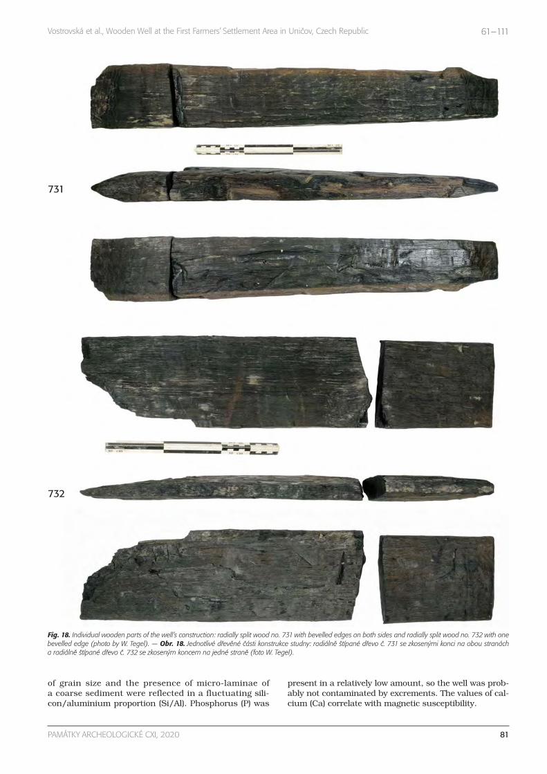
of grain size and the presence of micro-laminae ofa coarse sediment were reflected in a fluctuating sili-con/aluminium proportion (Si/Al). Phosphorus (P) was
present in a relatively low amount, so the well was prob-ably not contaminated by excrements. The values of cal-cium (Ca) correlate with magnetic susceptibility.
81PAMÁTKY ARCHEOLOGICKÉ CXI, 2020
Vostrovská et al., Wooden Well at the First Farmers’ Settlement Area in Uničov, Czech Republic 61–111
731
732
Fig. 18. Individual wooden parts of the well’s construction: radially split wood no. 731 with bevelled edges on both sides and radially split wood no. 732 with onebevelled edge (photo by W. Tegel). — Obr. 18. Jednotlivé dřevěné části konstrukce studny: radiálně štípané dřevo č. 731 se zkosenými konci na obou stranácha radiálně štípané dřevo č. 732 se zkoseným koncem na jedné straně (foto W. Tegel).

Facies 8 (274–180 cm) was composed of dark coarsesilt which contains pale greyish-beige pellets of siltysediment and dark brown humic soil aggregates withpassage features. The matrix and soil aggregates prob-ably come from the surrounding surface soil horizon of
the well. Pellets originated from the outer sealing of thewell, identified during the archaeological excavation.The heterogeneous character of the infill is illustratedalso by the oscillating curve of LOI 550 and indicatesrapid or even single-event deposition of material (see the
82 PAMÁTKY ARCHEOLOGICKÉ CXI, 2020
Vostrovská et al., Wooden Well at the First Farmers’ Settlement Area in Uničov, Czech Republic 61–111
Fig. 19. Lithostratigraphic and facial scheme of the well’s infill with the positions of micromorpholo gical samples, their interpretation and dating. — Obr. 19. Litostra-tigrafické a faciální schéma výplně studny s pozicemi mikromorfologických vzorků, jejich interpretace a datování.

results of radiocarbon dating), which filled the majorpart of the well. Perhaps the well was backfilled inten-tionally. At the time of the accumulation of this facies,the well certainly no longer served its original purpose.
Facies 9 (180–160 cm, sample 12) represents a con-tinuation of the well’s infill, with evident passage fea-
tures and pores created by plant roots. This all atteststo intensive pedogenic processes near the surface of thebackfilled pit. Facies 8 and 9 exhibit relatively mono-tonous, low values of magnetic susceptibility, which areincreased only in the uppermost part of the section asa result of pedogenic processes. The silicon/aluminium
83PAMÁTKY ARCHEOLOGICKÉ CXI, 2020
Vostrovská et al., Wooden Well at the First Farmers’ Settlement Area in Uničov, Czech Republic 61–111
Fig. 20. Thin sections (for location see Fig. 19). A – sample 1, facies 1: poorly sorted sandy sediment composed mostly of quartz grains and fragments of meta-morphic rocks (PPL); B – sample 7, facies 2: well-sorted silty sediment, crack microstructure (XPL); C – sample 3, facies 4: dark brown soil aggregates surroundedby pale groundmass (PPL); D – sample 3, facies 3: silty sandy sediment with an example of plant remains (PPL); E – sample 4, facies 5: silty and clayey siltymicro-laminae (XPL); F – sample 8, facies 6: well-sorted coarse silt with remains of plant tissue (PPL); G – sample 2, facies 7: deformed sandy micro-laminaesurrounded by well-sorted coarse silty sediment (PPL); H – sample 2, facies 7: example of plant remains with internal structure (PPL); I – sample 9, facies 8:fecal pellet containing plant remains (PPL); J – sample 10, facies 8: bone fragment (PPL); K – sample 11, facies 8: dark coarse silt containing pale greyish-beigeclasts of silty sediment, charcoal fragment with internal structure (PPL); L – sample 12, facies 9: moderately sorted coarse silt, crack microstructure and fragmentof charcoal with internal structure (PPL). Photo by K. Adameková. — Obr. 20. Mikrofotografie výbrusových preparátů (přesná lokalizace viz obr. 19). A – vzorek1, facie 1: slabě vytříděný písčitý sediment složený hlavně z minerálních zrn křemene a fragmentů metamorfovaných hornin (PPL); B – vzorek 7, facie 2: dobřevytříděný prachovitý sediment, puklinová mikrostruktura (XPL); C – vzorek 3, facie 4: tmavě hnědý půdní agregát obklopený světlou základní hmotou (PPL); D –vzorek 3, facie 3: prachovito-písčitý sediment se zbytky rostlinných pletiv (PPL); E – vzorek 4, facie 5: prachovité a jílovito-prachovité mikrolaminy (XPL); F – vzorek8, facie 6: dobře vytříděný hrubě zrnitý prachovitý sediment se zbytky rostlinných pletiv (PPL); G – vzorek 2, facie 7: deformovaná písčitá mikrolamina obklopenádobře vytříděným hrubě zrnitým prachem (PPL); H – vzorek 2, facie 7: pozůstatek rostlinného pletiva (PPL); I – vzorek 9, facie 8: exkrement obsahující zbytkyrostlin (PPL); J – vzorek 10, facie 8: fragment kosti (PPL); K – vzorek 11, facie 8: tmavý hrubě zrnitý prach obsahující světle šedo-béžové klasty prachovitého se-dimentu, fragment uhlíku s viditelnou vnitřní strukturou (PPL); L – vzorek 12, facie 9: středně vytříděný hrubě zrnitý prach, puklinová mikrostruktura a fragmentuhlíku s viditelnou vnitřní strukturou (PPL). Foto K. Adameková.

proportion (Si/Al) reflects a greater variability of grainsize in the bottom part of the section. The values ofphosphorus (P) and calcium (Ca), which probably re-fer to an anthropogenic influence, were increased atthe base of facies 8 and in the uppermost part of fa-cies 9.
Grain size oscillation caused by disturbances of sed-iments, or possibly a change of source materials, is re-flected by the curve of the Si to Al ratio. Facies 2–5 ex-hibit slightly increased values of frequency-related
magnetic (Kfreq) and significantly increased values ofweight-dependent magnetic (Kmass) susceptibility abo-ve depth of 320 cm. It correlates with increased valuesof Ca. The last phase of water presence is connectedwith facies 6 and 7, which exhibits the maximum valuesof the Si to Al ratio (influx of coarser grained sediment)and also increased values of Ca. Increased values of P and S are visible at the base of facies 8 and also in facies 9, which were interpreted as infilling with pedo-genesis in the upper part.
84 PAMÁTKY ARCHEOLOGICKÉ CXI, 2020
Vostrovská et al., Wooden Well at the First Farmers’ Settlement Area in Uničov, Czech Republic 61–111
Dep
th (c
m)
Sam
ple
Mic
rost
ruct
ure
Void
s
Text
ure
and
sort
ing
C/F
rela
ted
dist
ribu
tion
Colo
ur o
f gro
undm
ass
(PPL
)
B-f
abri
c (X
PL)
Mineraland rock fragments
Char
red
orga
nic
mat
ter
Org
anic
fine
mat
eria
l
Plan
t re
sidu
es
Bon
es
Coat
ing
Hyp
ocoa
ting
Nod
ules
Soil
aggr
egat
es
Excr
emen
ts
Fabr
ic p
edof
eatu
res
Seco
ndar
y ca
rbon
ates
172.5 12 Cr Cr, Pl, Chn, and Chm, V CS, MS porphyric dark
brown striatedangular to subangular quartz, feldspar, micas, fragments of rocks
* ** ** * clay *** *
222.5 11 M rare Chn or Cr CS, MS porphyric dark brown striated
angular to subangular quartz, feldspar, micas, fragments of rocks
* ** ** * *** *
242.5 10 Ch Chn, Cr CS, MS porphyric brown striatedangular to subangular quartz, feldspar, micas, fragments of rocks
** ** *** * *
266.5 9 Ch occasional Chn or Cr CS, MS porphyric brown striated
angular to subangular quartz, feldspar, micas, fragments of rocks
** ** * Ca *** * * *
275.5 2 M rare Cr or Chn CS, WS porphyric brownish
gray striated subrounded to subangular quartz, feldspar, micas, glauconite ** **
278.5 8 SB Cr, Chn CS, WS porphyric brownish gray striated
subrounded to subangular quartz, feldspar, micas, glauconite, amphibole, zircon, fragments of rocks
** ** * clay * Ca **
295.5 4 M rare Cr S, WS porphyric grayish beige striated
subrounded to subangular quartz, feldspar, micas, glauconite, fragments of metamorphic rocks
** ** * Ca **
298 3 C dominant Chn and C SS, US porphyric grayish
beigestriated,
crystallitic
angular to subangular quartz, feldspar, micas, glauconite, zircon, fragments of metamorphic rocks
* *** *** * Ca **
307.5 5 M rare Cr or Chn S, MS porphyric grayish
beige striatedrounded to subangular quartz, feldspar, micas, glauconite, fragments of metamorphic rocks
** ** * Fe/Mn
317.5 7 Cr or M occasional Cr S, WS porphyric grayish
beige striatedrounded to subangular quartz, feldspar, micas, glauconite, fragments of metamorphic rocks
** **
329.5 6 Cr occasional Cr S, WS, Sa, WS porphyric grayish
beige
striated, grano-striated
rounded to subangular quartz, feldspar, micas, amphibole, glauconite, fragments of metamorphic rocks
** ** * Fe/Mn
334.5 1 M rare Chn or Cr
Sa, PS, S, WS porphyric grayish
beige
striated, grano-striated
subrounded to subangular quartz, feldspar, micas, glauconite, fragments of metamorphic rocks
** **
Tab. 3. Results of micromorphological analysis. Microstructure: SB – subangular blocky; Cr – crack; M – massive; V – vughy; P – platy; Ch – channel; C – complex.Voids: Cr – crack; Pl – plane; Chn – channel; Chm – chamber; V – vugh; C – complex packing voids. Texture: S – silt; CS – coarse silt; SS – silty sandy; Sa – sand.Sorting: WS – well sorted; MS – moderately sorted; PS – poorly sorted; US – unsorted. * very few (< 5%); ** common (5–20%); *** abundant (> 20%). —Tab. 3. Výsledky mikromorfologické analýzy. Mikrostruktura: SB – subangulárně polyedrická; Cr – puklinová; M – masivní; V – dutinkovitá; P – destičkovitá; Ch – kanálkovitá; C – komplexní. Póry: Cr – puklinovitý; Pl – plošný; Chn – kanálkovitý; Chm – komůrkovitý; V – dutinkovitý; C – komplexní (póry nakládání).Textura: S – prachovitá; CS – hrubě prachovitá; SS – prachovito-písčitá; Sa – písčitá. Vytřídění: WS – dobře vytříděný; MS – středně vytříděný; PS – slabě vytříděný;US – nevytříděný. * občasný (< 5 %); ** běžný (5–20 %); *** častý (> 20 %).

3.4. Palynology
Pollen grains were quite well preserved, but in very lowconcentrations. The pollen record comprised three dis-tinct lithostratigraphic layers (Fig. 21). The bottom, greysand-clay-dusty layer at a depth of 330–300 cm (facie 2)contained pollen of pine (Pinus), Cyperacae and Gra-mineae. Spruce (Picea) was common, but broadleaftrees were missing, with the exception of hazel (Corylus)and alder (Alnus). Cereal pollen were rare, too. Possiblypresent were Pollemonium and Armeria pollen grains,which are highly unusual in Middle Holocene lowlands.Similar is the case of Helianthemum-type pollen, whichwas very common in the Late Glacial and persiststhrough the Holocene to this day, but it is very rare inthe Holocene pollen spectrum. Unusual was the presenceof Juglans-type pollen, which can be attributed to Tertiaryredeposition. Interesting is the abundance of green algae(Pediastrum boryanum agg., P. integrum and Pediastrumduplex). These green algae are typical of cold, little eu-trophicated lakes. Their abundance is very unusual foran artificial water well. This is followed by a short phaseof drying at a depth of 300–294 cm (facies 3–5).
The other two layers of fine sand to clay from a depthof 294–275 cm (facies 2) and above it grey-black dustyclay at a depth of 275–249 cm (facies 8) show a differentpollen spectrum. Microcharcoals distinctly prevailed inthe pollen preparations. They originated from grassesbased on their shape, which was elongate, often withvisible shapes of grass cells. For this reason, the pollenconcentration was very low. The arboreal part of thepollen spectrum amounted to around 30 or 40%. Theprevalent taxon was Corylus. Quite common were Pinus,Betula, Picea, Fraxinus and Alnus. Interesting was a lowabundance of Quercus, Tilia and Ulmus. This tree com-
position generally corresponds with the pollen spectraof natural profiles from the valley of the river Morava,which have been dated to the Middle Holocene. Elder(Sambucus nigra) is element of synanthropic vegetation.A high abundance of Corylus might indicate a locallydisturbed woodland, but there is no direct evidence.Grass pollen, Artemisia and Chenopodiaceae were dom-inant. Together with Carduus, Anthemis-type, Labia -teae, Valeriana and Polygonum aviculare-type they rep-resent ruderal vegetation of a settlement. Their diversitywas quite high, but by pollen analysis it cannot be de-termined to the level of species. Carduus-type pollen canbe linked to Onopordum acanthium, recorded amongplant macroremains. Mercurialis indicates disturbed andfresh bare soil, or possibly gardens. Interesting is a lowabundance of cereal pollen, reaching 5% in the overallspectrum. Even more interesting is that cereal macro-remains were present. Based on morphology, size andshape of the poruses (Beug 2004), it corresponds towheat (Triticum) type. This fact affects the interpretationof natural pollen profiles dated to the Neolithic periodand the interpretation of primary anthropogenic indica-tors, for example cereal pollen.
Cyperaceae pollen was present, but its abundancewas lower than in the bottom grey sand-clay-dusty partof the section; green algae were missing. The upper partof the section contained decomposed pollen grains, sothe pollen record was missing and the rare fragmentsof pollen grains could not be used in the interpretation.The change in the palynological record at 294 cm deepcorresponds perfectly to the transition between facies 2and 3–5. That is, the phase that was interpreted as dry-ing, as evidenced by the sudden loss of algae. Anotherlithological change at a depth of 275 cm is not reflectedin the palynological record.
85PAMÁTKY ARCHEOLOGICKÉ CXI, 2020
Vostrovská et al., Wooden Well at the First Farmers’ Settlement Area in Uničov, Czech Republic 61–111
Fig. 21. Simplified percentage pollen diagram. — Obr. 21. Zjednodušený procentuální pylový diagram.

were usually adjacent to forest-free spaces within settle-ment areas. Other taxa were oak (Quercus) and lime(Tilia; 16%), ash (Fraxinus; 6%), maple (Acer; 4%) andalder (Alnus; 3%), poplar (Populus) and poplar/willow(Populus/Salix; 3%), and elm (Ulmus; 1%). Admixed witha frequency of less than 1% were beech (Fagus), horn-beam (Carpinus) and shrubs (Cornus, Euonymus).
Charcoals of Carpinus and Fagus are the most ex-traordinary finds. The collection of 20 pieces of Carpi-nus seeds represents the oldest evidence from Czechia(5464–5220 BC; Tab. 1). Carpinus was detected at Neo -lithic sites in the Czech Republic in 22 cases. Higherconcentrations of Carpinus charcoals are known fromthe sites in the eastern part of the Czech Republic,
3.5. Anthracology and xylotomy
Our analyses of charcoal and wood fragments helped toidentify 15 wood taxa (Tab. 4). Analysis of 244 charcoalsweighing 5.03 g yielded more interesting and taxonom-ically more variegated data (Fig. 22). The balanced fre-quency and weight proportions indicate that the data
are representative. This is also attested by the resultsof the micromorphological analysis of the well infill.
The dominant component of the assemblage was ha-zel (Corylus), which represented almost one-half of allcharcoal pieces analysed. Its high proportion indicatesshrubs emerging around the settlement as a result of thefirst farmers’ economic activities (Fig. 23). Shrub stands
86 PAMÁTKY ARCHEOLOGICKÉ CXI, 2020
Vostrovská et al., Wooden Well at the First Farmers’ Settlement Area in Uničov, Czech Republic 61–111
0,29
2,00
0,14
93,8
5
2,72
1,00
0,23
2,24
0,08
95,3
2
1,80
0,32
0
20
40
60
80
100
120
Alnu
s
Corylu
s
cf. P
opulu
s/Sa
lix
Quercu
s Til
ia
cf. Ti
lia
%
quantity (pcs)
weight (g)
Fig. 24. Results of xylotomic analysis. — Obr. 24. Výsledky xylotomické analýzy.
3,69
2,46
0,41
0,41
0,82
48,7
7
0,41
0,41
5,74
0,41
0,82
1,23
2,05
15,5
7
15,5
7
1,23
3,07
3,16
0,31
0,35
0,39
50,6
4
0,33
0,28
3,78
0,11
1,04
1,07
1,47
18,3
7
15,1
4
0,49
0
10
20
30
40
50
60
Acer
Alnu
s
cf. B
etula/
Alnu
s
Carpin
us
Cornu
s
Corylu
s
Euon
ymus
Fagu
s
Fraxin
us
cf. Fr
axinu
s
Pom
oidea
e
Popu
lus
cf. P
opulu
s/Sa
lix
Quercu
s Til
ia
Ulmus
%
quantity (pcs)
weight (g)
Fig. 22. Results of anthracological analysis. — Obr. 22. Výsledky antrakologické analýzy.
Fig. 23. Hazel stands outside the village ofJarov (dist. Plzeň-South). Photo by P. Kočár. —Obr. 23. Stanoviště lísky u obce Jarov (okr.Plzeň-jih). Foto P. Kočár.

87PAMÁTKY ARCHEOLOGICKÉ CXI, 2020
Vostrovská et al., Wooden Well at the First Farmers’ Settlement Area in Uničov, Czech Republic 61–111
Dep
th (c
m)
Acer
Alnu
s
Betu
la/A
lnus
Carp
inus
Corn
us
Cory
lus
Euon
ymus
Fagu
s
Frax
inus
cf. F
raxi
nus
Pom
oide
ae
Popu
lus
Popu
lus/
Salix
cf. P
opul
us/S
alix
Que
rcus
Tilia
cf. T
ilia
Ulm
us
Inde
term
inat
a
In to
tal
ch. ch. w. ch. ch. ch. ch. w. ch. ch. ch. ch. ch. ch. ch. w. ch. w. ch. w. w. ch. w. (b.) w. (d.) w.
150–160 1 2 3 3 2 11
160–170 3 1 1 5
170–180 1 2 3
180–190 1 5 2 30 2 1 1 5 47
180–230 2 3 1 2 42 10 1 5 1 4 1 13 161 7 1 2 12 14 8 290
200–210 1 5 3 9
210–220 2 1 1 8 12
210–260 3 2 14 4 23
220–230 1 1 2 1 1 1 1 15 5 2 2 2 34
230–240 1 1 2 3 4 10 3 1 25
240–260 1 1 1 17 3 2 1 2 87 2 9 126
260–280 1 10 1 2 51 4 1 4 2 76
280–300 1 15 5 149 8 7 5 11 201
300–325 4 53 3 3 3 12 78
mix 1 1 10 1 2 2 70 4 6 7 9 113
Total sum 9 6 2 1 1 2 119 14 1 1 14 1 2 3 5 1 38 656 38 19 7 3 26 67 17 1053
Tab. 4. Summary of anthracological and xylotomic analyses (ch. – charcoal; w. – wood; d. – deciduous; b. – bark). — Tab. 4. Shrnutí antrakologické a xylotomickéanalýzy (ch. – uhlík; w. – dřevo; d. – opadavý; b. – kůra).
Fig. 25. Drawn reconstruction of the landscape in the vicinity of the Uničov well: 1 – wooden well; 2 – ‘longhouse’; 3 – building pit; 4 – field; 5 – Bos taurus; 6 – Sus domesticus; 7 – Onopordum acanthium; 8 – Carduus nutans; 9 – Arctium nemorosum; 10 – Urtica sp.; 11 – Quercus sp.; 12 – Corylus avellana (authorV. Jarema). — Obr. 25. Kresebná rekonstrukce krajiny v okolí uničovské studny: 1 – studna s dřevěnou konstrukcí; 2 – dlouhý dům; 3 – stavební jáma; 4 – pole;5 – Bos taurus; 6 – Sus domesticus; 7 – Onopordum acanthium; 8 – Carduus nutans; 9 – Arctium nemorosum; 10 – Urtica sp.; 11 – Quercus sp.; 12 – Corylusavellana (autor V. Jarema).
11
6
8 10
1
2
12
58 7
3
4
9

where the published assemblages with frequenciesabove 100 determinations originate, for example Koutyu Kravař (Opravil 1965), Sloup cave (Hadač – Hašek1949) and of course the wood from Mohelnice (Opravil1972; 1979a; 1979b). Unfortunately, neither of thesefindings has been independently radiocarbon-dated. Theassemblage of Carpinus macro-residues we found is thefirst undisputed evidence of this species in eastern Cen-tral Europe. Likewise, Fagus has rarely been identifiedin the pollen record of the northern Pannonian Basinfrom the LBK period (Petr et al. 2013; Šolcová et al.2018). Its expansion and vegetation dominance at higherelevations, together with fir (Abies), have been dated toaround 2000 BC (Jamrichová et al. 2017; Dudová et al.2018).
The assemblage of 809 non-carbonized wood frag-ments, weighing 64.4 g, was mainly composed of Quer-cus wood fragments (Fig. 24), probably the remnants of selected constructional wood. A similar example isknown from the Neolithic water well at Velim, where theassemblage of non-carbonized wood prevailingly con-tained Tilia wood because this well was reinforced witha hollow lime tree stem (Rybníček et al. 2018, 100).Other wood taxa that were identified in the form of non-carbonized wood might have originated from successivestands. The growth of hygrophilous vegetation in theneighbourhood of the well might be indicated by thepresence of non-carbonized Alnus and Salix wood. Alter-natively, the area of the settlement may have been over-grown with woody vegetation, including the nitrophilousTilia and light-demanding Corylus (Fig. 25). Further fromthe settlement, we can assume the existence of sparsewoodland or forest-steppe vegetation influenced mainlyby grazing. On the tree floor we assume mainly solitaryQuercus trees and under them Corylus shrubs and un-dergrowth with a dominance of grasses (Fig. 26).
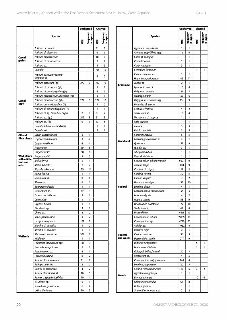
3.6. Plant macroremains and mosses
Out of the 20 samples from the well’s infill, a total of46,486 plant macroremains were obtained froma 0.25-mm sieve and a total of 115 plant macroremainswere recovered from a 2-mm sieve. All came from thefull length of the well shaft, which is from depths be-tween 120 and 325 cm, and fewer than 1.5% of macro-remains were charred (Tab. 5). The only comparable research in Czechia that has been published was con-ducted at Mohelnice (Opravil 1979a; 1979b), where theinfill has been examined in a smaller volume and was,therefore, poorer in species. Quantitatively, only assem-blages from Velim (Chlup et al. in preparation) and Os-trov (Sedláček et al. 2019; Kočár – unpublished data)are comparable.
Cultivated plants account for only 3% of the macrore-mains, but almost all were burnt (91%). Einkorn wheat(Triticum monococcum) and emmer wheat (Triticum di -coccum) predominated. For Triticum monococcum, theratio of spikelet forks to corns was 4.6 : 1 and for Triticumdicoccum the ratio of glumes to corns was 4.3 : 1 (Hillman1981). Other crops present were fine-grained tetraploidwheat (Triticum durum/turgidum), so-called ‘new weedwheat’, and oilseeds such as poppy (Papaver somnife-rum/setigerum; Fig. 27: A) and flax (Linum usitatissi-mum; Fig. 27: B). The gathered fruits represent the re-mains of hazelnut fruits (Corylus avellana), strawberries(Fragaria cf. vesca), apple tree seeds (Malus sylvestris)and bladder cherries (Physalis alkekengi).
A total of 92% of the assemblage came from synan-thropic plant species, especially Chenopodium spp. andUrtica dioica (Fig. 27: C). Anthriscus caucalis, Agrostemmagithago (Fig. 27: D), Arctium sp., Descurainia sophia, Fal-lopia convolvulus, Hyoscyamus niger (Fig. 27: E), Nepeta
88 PAMÁTKY ARCHEOLOGICKÉ CXI, 2020
Vostrovská et al., Wooden Well at the First Farmers’ Settlement Area in Uničov, Czech Republic 61–111
Fig. 26. Woodland pasturage on the hillKružínský vrch near the town of Podbořany(south-west Bohemia). The canopy layer al-most does not rejuvenate because of inten-sive browsing. The herb layer comprisesa wide spectrum of species (photo byP. Kočár). — Obr. 26. Lesní pastvina na kopciKružínský vrch u města Podbořany (jihozá-padní Čechy). Staré stromové patro téměřnezmlazuje v důsledku intenzivní pastvy.V podrostu lesa je druhově bohaté bylinnépatro (foto P. Kočár).

cataria, Onopordum acanthium (Fig. 27: F), Plantagomajor and Polygonum aviculare agg. were similarly com-mon but significantly less numerous. Wetland speciessuch as Batrachium sp., Iris pseudacorus, Lycopus eu-ropaeus, Potamogeton sp. or Ranunculus sceleratus andspecies of other (semi-)natural habitats (e.g. Carpinus be-tulus) occurred in smaller numbers.
Organic- and mineral-rich substrates were indicatedby annual and biennial species of rich ruderal vegetationsuch as Hyosciamus niger, Urtica dioica, Onopordum acan-thium, Carduus cf. crispus, Arctium sp. Rarely presentwere other ruderal species, for example Anthriscus cau-calis, Lamium album/maculatum, Lamium purpureum,Linaria vulgaris, Nepeta cataria, Silene alba/dioica, cf.Capsella bursa-pastoris, Descurainia sophia, Echinochloa/Setaria, Galeopsis bifida/tetrahit and cf. Verbascum sp.
Another ecological group were species of dry openhabitats, which are otherwise recorded very rarely inLBK archaeobotanical material from Czechia. It in-cludes species of dry grasslands, such as Cerastiumfontanum, Fragaria vesca, Hypericum perforatum, Orig-anum vulgare and Vicia sepium, or ruderal and pasturecommunities, for example Agrimonia eupathoria, cf.Achillea sp., Potentilla cf. erecta, Rumex obtusifoliusand Taraxacum sp. Wetter grasslands are indicated by
species such as Carex cf. contigua, Cirsium oleraceum,cf. Juncus sp., Lychnis flos-cuculi, Scirpus sylvaticus andRanunculus cf. repens.
The broad ecological group of field weeds and speciesof ruderal communities is represented Bromus arvensis,Fallopia convolvulus, Galium spurium, Setaria sp. andSetaria cf. verticillata.
The assemblage of plant macroremains obtainedduring this research is extraordinary among Neolithicstructures unearthed in Czechia. This is thanks to thepermanently humid environment inside the well, which,together with a lack of oxygen, allowed the preservationof a huge amount of unburnt plant macroremains.Thanks to this, the assemblage constitutes the oldestevidence of many species found in Czechia. Hyoscya-mus niger has been known from the LBK settlement atTěšetice-Kyjovice (Vostrovská et al. 2019), so the findpresented here is the second oldest made in Czechia.The find of Agrostemma githago is one of the first docu-menting the occurrence of this specialized weed of win-ter cereals during the Neolithic period. The oldest evi-dence has been dated to the Eneolithic (Kočár – Pokorná– Sádlo 2018; Pokorná et al. 2018). Next is Onopordumacanthium, known from the Early Iron Age, accompa-nied by Linaria vulgaris, Anthriscus caucalis and Nepeta
89PAMÁTKY ARCHEOLOGICKÉ CXI, 2020
Vostrovská et al., Wooden Well at the First Farmers’ Settlement Area in Uničov, Czech Republic 61–111
Fig. 27. Cultivated plants: A – Papaver som-niferum; B – Linum usitatissimum. Wild plantspecies: C – Urtica kioviensis; D – Agrostemmagithago; E – Hyoscyamus niger; F – Onopor-dum acanthium (photo by P. Kočár, J. Štelcl andZ. Vaněček). — Obr. 27. Kultivované rostliny:A – Papaver somniferum; B – Linum usitatissi-mum. Divoké druhy rostlin: C – Urtica kiovien-sis; D – Agrostemma githago; E – Hyoscyamusniger; F – Onopordum acanthium (foto P. Ko-čár, J. Štelcl and Z. Vaněček).
90 PAMÁTKY ARCHEOLOGICKÉ CXI, 2020
Vostrovská et al., Wooden Well at the First Farmers’ Settlement Area in Uničov, Czech Republic 61–111
Species
Uncharred Charred
MN
I
Freq
uenc
y in
laye
rs
MN
I
Freq
uenc
y in
laye
rs
Cereal grains
Triticum dicoccum 21 8
Triticum cf. dicoccum 6 3
Triticum monococcum 18 8
Triticum cf. monococcum 2 2
Triticum sp. 4 3
Cerealia 195 13
Cereal chaff
Triticum aestivum/durum/turgidum (ri) 4 2
Triticum dicoccum (gb) 277 8 108 10
Triticum cf. dicoccum (gb) 1 1
Triticum dicoccum/spelta (gb) 4 1
Triticum monococcum/dicoccon (gb) 8 1
Triticum monococcum (gb) 232 9 237 12
Triticum durum/turgidum (ri) 3 2
Triticum cf. durum/turgidum (ri) 2 1
Triticum cf. sp. “new-type” (gb) 2 1 11 2
Triticum sp. (gb) 212 8 91 9
Triticum sp. (ri) 9 3 13 5
Cerealia (straw internodium) 7 4
Cerealia (ri) 3 1
Oil and fibre plants
Linum usitatissimum 2 1
Papaver somniferum 3 2
Wild plants with edible fruits or nuts
Corylus avellana 4 4
Fragaria sp. 19 6
Fragaria vesca 58 6
Fragaria viridis 9 2
Malus/Pyrus 3 1
Malus sylvestris 2 2
Physalis alkekengi 75 11
Rubus idaeus 1 1
Sambucus sp. 8 6
Wetlands
Alisma sp. 6 3
Barbarea vulgaris 1 1
Batrachium sp. 12 9
Carex cf. acutiformis 2 1
Carex hirta 1 1
Cyperus fuscus 1 1
Eleocharis sp. 3 1
Chara sp. 4 2
Iris cf. pseudacorus 3 2
Lycopus europaeus 151 7
Mentha cf. aquatica 3 2
Mentha cf. arvensis 1 1
Myosoton aquaticum 537 9
Nitella sp. 1 1
Persicaria lapathifolia agg. 141 9
Peucedanum palustre 1 1
Potamogeton sp. 4 1
Potentilla supina 8 2
Ranunculus sceleratus 21 7
Rorippa palustris 2 2
Rumex cf. maritimus 4 2
Rumex obtusifolius s.l. 10 3
Rumex crispus/obtusifolius 10 4
cf. Scirpus sp. 3 1
Scutellaria galericulata 6 4
Urtica kioviensis 10 3
Species
Uncharred Charred
MN
I
Freq
uenc
y in
laye
rs
MN
I
Freq
uenc
y in
laye
rs
Grassland
Agrimonia eupathoria 1 1
Arenaria serpyllifolia aggr. 19 6
Carex cf. contigua 1 1
Carex leporina 2 1
Carex muricata 3 1
Cerastium fontanum 1 1
Cirsium oleraceum 2 1
Hypericum perforatum 49 11
Juncus sp. 2 1
Lychnis flos-cuculi 10 4
Origanum vulgare 21 7
Plantago major 37 6
Polygonum aviculare agg. 131 9
Potentilla cf. erecta 1 1
Scirpus sylvaticus 4 2
Taraxacum sp. 10 4
Verbascum cf. thapsus 1 1
Vicia sepium 1 1
Woodland
Alnus sp. 3 3
Betula pendula 3 3
Carpinus betulus 6 5
Lamium galeobdolon s.l. 4 1
Quercus sp. 32 9
cf. Salix sp. 3 1
Tilia platiphyllos 1 1
Viola cf. riviniana 1 1
Ruderal
Chenopodium album/murale 5007 9
Arctium lappa 108 9
Carduus cf. crispus 11 2
Carduus nutans 30 5
Cirsium vulgare 7 2
Hyoscyamus niger 33 10
Lamium album 4 1
Lamium album/maculatum 33 3
Linaria vulgaris 4 2
Nepeta cataria 55 9
Onopordum acanthium 72 10
Torilis japonica 44 8
Urtica dioica 4618 13
Ruderaland weeds
Chenopodium album 27025 14
Chenopodium sp. 4799 12
Atriplex sp. 1082 8
Brassica nigra 2 1
Cirsium arvense 35 3
Descurainia sophia 217 9
Digitaria sanguinalis 5 1
Echinochloa/Setaria 1 1
Galeopsis bifida/tetrahit 30 7
Verbascum sp. 4 3
Weeds
Chenopodium polyspermum 246 4
Lamium purpureum 20 5
Setaria verticillata/viridis 46 5 3 2
Agrostemma githago 1 1
Bromus arvensis 10 4
Fallopia convolvulus 63 8
Galium spurium 1 1
Scleranthus annuus s.str. 2 2

cataria, which have so far been known only from theEarly Medieval period (Pokorná et al. 2018). Finally,Physalis alkekengi has previously been documented tooccur only in the High Medieval period (Opravil 1996)and was also found in a Renaissance context (Kočár et al.2007).
Remains of mosses were present almost throughoutthe vertical section of the well’s infill. The thickness ofthe analysed vertical section of the well was 205 cm.This section was situated between actual depths of 120–325 cm below the hidden subsoil level. The moss re-mains were surprisingly well preserved, so they couldmostly be determined down to the level of species. In 26samples from the vertical section of the well, we identi-fied 21 taxa of mosses in total (Tab. 6). Most taxa (14)were found at depths between 280 and 300 cm in thevertical section of the well.
The whole section of the well was dominated by thewetland Knieff’s hook-moss (Drepanocladus aduncus;Fig. 28: A), which is still abundant in lowland habitatswith stagnant water. The remaining species were pre-sent in much lower quantity. The species detected wereprobably naturally growing in the well or fell into it fromtrees or buildings in the neighbourhood. The well wasmost probably open, which was indicated by the pres-ence of phototrophic mosses.
The mosses found in the sediments belong to threeecological groups: (i) wetland mosses – Drepanocladusaduncus, Hygroamblystegium varium, Leptodictyum ri-parium, Palustriella commutata and Hygrohypnum sp.,(ii) epiphytic mosses – Alleniella complanata, Ambly-stegium serpens, Anomodon longifolius, Anomodon viti-culosus (Fig. 28: B), Hypnum cupressiforme, Leucodon sciuroides, Neckera pennata, Orthotrichum sp., Sciuro-
91PAMÁTKY ARCHEOLOGICKÉ CXI, 2020
Vostrovská et al., Wooden Well at the First Farmers’ Settlement Area in Uničov, Czech Republic 61–111
Fig. 28. A – Drepanocladus aduncus; B – remains of a moss leaf of Anomodon viticulosus (photo by Z. Hradílek). — Obr. 28. A – Drepanocladus aduncus; B – zbytky listu mechu Anomodon viticulosus (foto Z. Hradílek).
Species
Uncharred Charred
MN
I
Freq
uenc
y in
laye
rs
MN
I
Freq
uenc
y in
laye
rs
Unknowor various habitats
Achillea sp. 1 1
Aphanes sp. 1 1
Betula sp. 2 1
Brassica/Sinapis 1 1
Bromus sp. 16 5 17 8
cf. Bromus sp. 2 1
Carex flacca/flava 2 2
Carex sp. (2D) – bicarpelate 1 1
Carex sp. (3D) – tricarpelate 5 4
Cirsium/Carduus 101 9
Cuscuta sp. 20 3
Cyperus sp. 10 1
Fragaria/Potentilla 4 2
Galium sp. 1 1
Lamium sp. 63 8
Species
Uncharred Charred
MN
I
Freq
uenc
y in
laye
rs
MN
I
Freq
uenc
y in
laye
rs
Unknowor various habitats
Mentha sp. 3 2
Poaceae 11 7 11 5
Potentilla sp. 52 10
Ranunculus sp. 3 2
Ranunculus acris/repens 2 2
Rumex sp. 13 3
Setaria sp. 7 3 18 6
Silene sp. 2 1
Silene alba/dioica 5 2
Stachys sp. 2 1
Stellaria cf. neglecta 1 1
Stellaria sp. 4 2
Viola sp. 13 6
Total sum 46157 15 804 15
Tab. 5. Results of macroremains analysis (MNI – minimal number of individuals; ri – rachis internode; gb – glume base). — Tab. 5. Výsledky makrozbytkovéanalýzy (MNI – minimální počet jedinců; ri – článek vřetene klasu; gb – báze plevy).

hypnum populeum and Syntrichia sp., and (iii) terrestrialmosses – Brachythecium rutabulum and Oxyrrhynchiumhians. The moss Neckera pennata today representsa rare epiphytic species growing in our best-preservedforests. Most mosses in the well (86%) are perennial ormulti-annual species.
In the vertical section of the well’s infill, we can dis-cern three more or less distinct layers with slightly dif-ferent spectra of species: (i) 120–140 cm of the well’s in-fill – the layer mostly contains remains of terrestrialmosses, which are still to this day abundant in sur-rounding forests; (ii) 150–250 cm – the wetland mossDrepanocladus aduncus begins to dominate togetherwith other hygrophilous species like Hygroamblyste-gium varium and Palustriella commutata, and some layers contain isolated remains of terrestrial mosses –Amblystegium serpens, Brachythecium rutabulum, Oxyr -rhynchium hians; and (iii) 260–325 cm – besides theever-present hygrophilous species, we can also iden-tify some sporadic, but not isolated, remains of mos-ses that can be classified as facultative epiphytes – Alleniella complanata, Amblystegium serpens, Anomo-don longifolius, A. viticulosus, Leucodon sciuroides andNeckera pennata, Orthotrichum sp.
3.7. Zoology
The assemblage contained around 1,171 finds. At least29 individuals of 16 animal species were identified inthis assemblage (Tab. 7). Remains of various vertebrate
groups were recorded, namely fish, amphibians, rep-tiles, birds and mammals, but most of the finds were ofmammalian origin. No malacofauna has been preservedbecause of the too acidic environment at the site. Theremains of small vertebrates made up a mostly au-tochthonic assemblage of wild animals that probablydied at the site.
Fish were represented by a single find of a scale. Re-mains of amphibians, namely frogs and toads, were morecommon (Bufo viridis, Bufo sp., Rana arvalis, Rana sp.,Anura). Herpetofauna was supplemented with Lacerta sp.Undetermined birds and small species of songbirds(Passeriformes) were found at the site.
Three groups of mammals were documented: insec-tivores, rodents and carnivores. From the first group,remains of shrews and white-toothed shrews were discovered: Crocidura suaveolens, Crocidura sp., Sorexcf. araneus, Sorex cf. minutus and Soricidae. Only onespecies of carnivore was detected, the common weasel(Mustela nivalis).
Abundant remains of rodents were discovered in thewell’s infill. Finds of the European hamster (Cricetuscricetus) were the most numerous. Four species of voleswere recorded in the assemblage: Arvicola terrestris,Clethrionomys glareolus, Microtus arvalis and Microtusoeconomus, which is a species of damp tundra habitats.The find of this vole at the Uničov site is one of theyoungest from Czechia because it disappeared duringthe Neolithic period (Horáček – Ložek 1988). Other findswere determined as Microtus sp. Mice were also present,
92 PAMÁTKY ARCHEOLOGICKÉ CXI, 2020
Vostrovská et al., Wooden Well at the First Farmers’ Settlement Area in Uničov, Czech Republic 61–111
Dep
th (c
m)
Dre
pano
clad
us a
dunc
us
Ambl
yste
gium
ser
pens
Hyg
roam
blys
tegi
um v
ariu
m
Lept
odic
tyum
ripa
rium
Palu
strie
lla c
omm
utat
a
Leuc
odon
sci
uroi
des
Anom
odon
viti
culo
sus
Brac
hyth
eciu
m ru
tabu
lum
Oxy
rrhy
nchi
um h
ians
Alle
niel
la c
ompl
anat
a
Calli
ergo
nella
cus
pida
ta
Nec
kera
pen
nata
Anom
odon
long
ifoliu
s
Hyg
rohy
pnum
sp.
Ort
hotri
chum
sp.
Taxi
phyl
lum
wis
sgril
lii
Thui
dium
ass
imile
/del
icat
ulum
Hyp
num
cup
ress
iform
e
Sciu
ro-h
ypnu
m p
opul
eum
Cera
todo
n pu
rpur
eus
Synt
richi
a sp
.
120–130 2 + 92 5
130–140 + + 70 1 29 +
140–150 99 1
150–160 100
160–170 + +
170–180 62 17 3 + 7 7 4
180–190 83 10 7 +
190–200 85 7 8 +
200–210 67 25 8 +
210–220 65 31 4 +
220–230 65 29 6 +
230–240 70 28 2
240–250 80 10 1
250–260 95 4 1 +
260–270 98 2 + +
270–280 90 4 1 + 1 + 2 1 1 + + +
280–290 91 3 1 + 1 + 2 1 1 + + +
290–300 92 3 1 + 1 1 + 1 + + + + + +
300–310 95 + 1 1 + +
310–325 97 + 1 1 + +
Total sum 18 18 13 6 6 5 5 4 3 3 3 3 3 3 3 3 3 1 1 1 1
Tab. 6. Estimates of the rel-ative proportions of mossspecies in layers of the ver-tical section (cross indicatesthe quantity below 1%). —Tab. 6. Odhady relativníchpodílů druhů mechu vevrstvách profilu (křížek zna-mená množství pod 1 %).

namely Apodemus flavicollis/sylvaticus, Micromys mi -nutus, Mus musculus and Muridae. Further 556 frag-ments were classified as rodents and 507 fragments asundetermined mammals.
Looking closer at the depth of the finds, between 150and 160 cm only the fish scale was recorded. In thelower part (180–230 cm) of the remaining vertical sec-tion, finds of Bufo, Crocidura, Sorex cf. araneus, Crice-
tus, Arvicola, Clethrionomys, Microtus arvalis, Microtusoeconomus, Apodemus, and Mus were discovered. Themiddle part (230–280 cm) contained the remains ofBufo, Lacerta, an unknown songbird, Sorex cf. araneus,Sorex cf. minutus, Cricetus, Arvicola, Microtus, Apode-mus, Micromys, Mus and Mustela. The bottom part(280–325 cm) was poorer in finds, Rana, birds, Cricetus,Microtus arvalis, Apodemus and Mus being found.
Regarding the taphonomy of the assemblage, no findswith cutting or gnawing marks were recorded whereassigns of burning appeared in six cases. Two fragmentswere partially burnt black, one fragment was burntblack, one fragment was burnt black to white, and twofragments were burnt white.
3.8. Entomology
The acquired material included 671 fragments of 422insect individuals (MNI). The largest group was repre-sented by 380 individuals (at least 220 species andgenera) of well-sclerotized beetles (Coleoptera; Fig. 29).Other recorded taxa were Hymenoptera (especially For-micidae), Heteroptera and Auchenorrhyncha. The anal-ysed samples also included six specimens of mites(Acari, mainly Oribatida). These are preliminary resultsand a separate article will be devoted to the overallevaluation.
The identified insect species at the same time indi-cate the presence of a variegated mosaic of biotopes inthe neighbourhood of the well. Distinctly representedwere: (a) disturbed early succession biotopes, often xe-rothermic, (b) pastures, (c) grasslands, (d) forests and(e) various types of riparian biotopes. Based on our pre-liminary analysis, it can be stated that of the above-mentioned groups of species, those of early-successionhabitats of different natural abundance were the mostsignificant. Widespread species of ruderal habitats andfield edges were present in the material (Bembidion lam-pros and Chrysolina fastuosa), as were stenoid beetlesof naturally rich xerothermic stands and steppes (Cen-tricnemus leucogrammum and Pleurophorus sp.). A lowfrequency of woodland species (e.g. Molops piceus) and,
93PAMÁTKY ARCHEOLOGICKÉ CXI, 2020
Vostrovská et al., Wooden Well at the First Farmers’ Settlement Area in Uničov, Czech Republic 61–111
Species Taxon n MNI
Pisces indet. undet. fish 1 1
Anura frogs and toads 10
Bufo sp. toad 2
Bufo viridis European green toad 1 1
Rana sp. frog 1
Rana arvalis moor frog 5 1
Lacerta sp. lizard 3 1
Aves indet. undet. birds 3 1
Passeriformes singing birds 2 1
Mammalia indet. undet. mammals 507
Soricidae shrews 5
Crocidura sp. white-toothed shrew 1
Crocidura suaveolens lesser w.-t. shrew 4 2
Sorex cf. araneus common shrew 5 2
Sorex cf. minutus Eurasian pygmy shrew 1 1
Rodentia rodents 556
Cricetus cricetus European hamster 23 5
Arvicola terrestris European water vole 7 2
Microtus sp. vole 12 1
Microtus arvalis common vole 7 3
Microtus oeconomus tundra vole 1 1
Clethrionomys glareolus bank vole 1 1
Muridae mice 1
Apodemus flavicollis/sylvaticus wood mouse 3 1
Mus musculus house mouse 3 + 1 cf. 2
Micromys minutus Eurasian harvest mouse 2 1
Mustela nivalis least weasel 3 1
Total sum 1171 29
Tab. 7. Summary of small vertebrate finds (n – number of finds; MNI – mi-nimum number of individuals). — Tab. 7. Shrnutí nálezů malých obratlovců (n – počet nálezů; MNI – minimální počet jedinců).
Fig. 29. Number of individuals of beetles(Coleoptera) along the vertical section of thewell. — Obr. 29. Počet jedinců brouků (Co-leoptera) v profilu studny.

conversely, a greater abundance of pasture-bound co-prophages (Onthophagus spp. and Aphodinae) then sug-gests the presence of a rather open grassland withwoody vegetation (Hellqvist 1999; Whitehouse – Smith2010). Naturally rich river bank habitats, such as opensandy benches, were probably also represented in thesurroundings, as evidenced, for example, by the occur-rence of ripicel ground beetles of the genus Dyschirius.
In addition to the insect remains themselves, larvalgalleries of wood-boring insects, for example longh-orned beetles (Cerambycidae) and ambrosia beetles(Xyloterus sp.), were documented on the timbers.These beetles can only live in dead wood and begantheir development before the wood was used for theconstruction.
Our preliminary analysis of the observed communityof other insect groups, namely true bugs and ants,paints a similar picture as in the case of beetles. Despitethe relatively small number of individuals, it can be saidthat there was a colourful mosaic of different habitatsin a relatively small area around the well. This is evi-denced by the presence of species of habitats such asopen dry places (i.e. Microporus nigrita, Formica cf. cu-nicularia), sparse woodlands (Dolichoderus quadripunc-tatus), wastegrounds and woodland edges (Tritomegasbicolor), and wet habitats (Netioglossa pusila).
4. Discussion
4.1. Construction and function of the wooden well
The results pertaining to the absolute chronology of thewooden lining and the infill of the Uničov well can beevaluated as synchronous. It has been proved that boththe construction and the subsequent usage of the welldate back to the 51st century BC, that is, to the MiddleLBK. If we compare the results of dendrochronologicaldating of recently excavated LBK wells in Czechia, theUničov well from 5093–5085 BC is the youngest. Velimwell is from the turn of 5196 and 5195 BC (Rybníček et al. 2018, 100–101) and the oldest is the Ostrov wellfrom the turn of 5256 and 5255 BC (Rybníček et al.2020). Other European LBK wells from which dendro-dates have been obtained fall within a similar time interval. The youngest among them is the Erkelenz-Kückhoven well from 5091 BC, which is almost con-temporary with the Uničov well. A few years older arethe Eythra well no. 17 from 5098/5097 BC and theSchkeuditz-Altscherbitz well from 5099 BC. Three of theseven LBK wells from Droßdorf have also been dateddendrochronologically: well no. 3174 = 5134 BC, wellno. 3682 = 5145 ± 10 BC and well no. 3679 = 5198 ±10 BC. These wells are slightly older, just like the Bro-dau well from 5190 ± 10 BC and the two-phase Eythrawell no. 21 from 5196 ± 10 BC with repairs from ap-proximately 5127 BC. The Eythra well no. 22 is notolder than 5193 ± 10 BC. Furthermore, the well atLeipzig-Plaußig provided very interesting dendrochrono-logical data for the period of 5260–5080 BC, being thelongest used LBK well with evidence of repairs or re-building activities (Tegel et al. 2012; Kretschmer et al.2016; Friedrich 2017, 421–440).
Even though we apply state-of-the-art calibrationtools, the probability interval for exact dating using theradiocarbon method logically remains much wider com-pared to dendrochronology. On the other hand, the ra-diocarbon method can be used for the absolute datingof wells with a low number of tree-rings or withouta preserved wooden lining. Radiocarbon dates for thewooden lining and infill of the Uničov well fall within thewide interval of 5464–4615 cal. BC. The Ostrov well hasa similar range (5341–4934 BC), but it ends 319 yearsearlier (Rybníček et al. 2020). The dating of the Mohel-nice well, where one date of 5533 ± 65 cal. BC contra-dicts other dates of 5193 ± 94 cal. BC (Schmidt – Gruhle2003, 56), 5174 ± 104 cal. BC and 5270 ± 163 cal. BC(Neustupny – Vesely 1977, 185), remains to be resolved.The material from the Velim well, whose interval is alsomuch shorter 5216–4811 BC (Chlup et al. in prepara-tion), proved to be more recent. The Asparn-Schletz wellfrom 5312–4962 BC, without wooden lining, is essen-tially contemporary with the Uničov well (Windl 1998).Seven radiocarbon dates within the interval of 5300–4966 BC from the wells at Droßdorf (Kretschmer et al.2016) also correspond to the Uničov and Asparn-Schletz wells.
LBK settlements were mostly supplied with surfacewater from rivers and streams. The first farmers werefamiliar with the landscape and they probably had basicknowledge of hydrology (Pavlů – Zápotocká 2013, 56).The location for the water well and for the settlement inthe vicinity of Uničov was chosen for several reasons.The builders of the well probably supposed that thegroundwater level at this place would be easily accessi-ble because of the nearby stream. The presence ofgroundwater was also indicated by vegetation. The pa-lynological and anthracological spectra prove that thealluvium had already formed in the neighbourhood ofthe site. The Uničov well was situated in the immediateneighbourhood of two houses on the eastern edge of thesettlement area. However, anchoring the well in thecontext of the site is difficult. According to radiocarbondating, the well infilling is probably older than theexcavated part of the settlement area (Vostrovská –unpublished data). Thus, the chronological horizonfrom the settlement area is not comparable to that ofa well. It seems that the well was coeval with anunexcavated part of the settlement areal alternatively,human activity from the time of the construction andutilization of the well is not archaeologically detectable.
Before the construction of the wooden lining of thewell, a pit must have been dug out down to the sandy-gravelly water-bearing horizon. The well pit thereforemust have reached the groundwater level (Weiner 1998,200). The well was subsequently built in this construc-tion pit. Baskets with spoil may have been pulled upwith the help of a pulley and thick ropes. Digging toolssuch as hoes and spades as well as pulleys have beenfound at the Erkelenz-Kückhoven site (Weiner 1992a).The bottom of the well pit at Uničov was neither modi-fied nor reinforced, because the sandy-gravelly subsoildid not demand such adjustments. On the other hand,rubble was stacked at the bottom of the Ostrov well(Kočár – personal communication) and the hollow trunkconstruction of well no. 3684 at Droßdorf was sup-
94 PAMÁTKY ARCHEOLOGICKÉ CXI, 2020
Vostrovská et al., Wooden Well at the First Farmers’ Settlement Area in Uničov, Czech Republic 61–111
ported by stones at the bottom (Kretschmer et al. 2016).The bottom of the well at Erkelenz-Kückhoven was cov-ered with loose boards (Weiner 1994; 1997). Many treebranches were discovered at the bottom of well no. 2013at Arnoldsweiler (Husmann – Cziesla 2014, 102–103).
Not only Neolithic wells (Tegel et al. 2012), but alsoProtohistoric wells (Pleinerová 2005; Sedláček et al.2008) in Central Europe, were mostly built of oak wood.Selected oaks were felled with adzes and their trunksthen had to be sawn into pieces and debarked. Thecross-sections of building elements and the sequence oftree-rings prove that the oak trunks were split radially.This method may have produced at least 12 pieces ofsplit wood from each log. The necessary amount of woodplanks was then probably transported to the construc-tion site (Weiner 1998, 208–209). Tool marks of polishedaxes and shoe-adzes, mostly made of metabasites, canbe observed especially on the notches on each post andthe tapered ends of the horizontal boards from theUničov well (Rybníček et al. 2018, 101). The wooden lin-ing of the well was intended to reinforce the walls of thewell shaft and prevent them from collapsing, and to pro-tect the wellspring from being polluted by externalwater. The internal construction of the Uničov well wascomposed of four corner posts with longitudinal grooves,in which horizontal boards were embedded. However, onepost was found at the bottom of the shaft, on whichleaned three boards, whose right end dropped out fromthe groove of the corner post. Lateral pressure of thewater-bearing sediment disrupted the integrity of thewooden lining and the first farmers solved this problemby creating a post barrier. This constitutes direct evi-dence that the construction was repaired at a time whenthe well was in operation. Until now, it was assumed thatthe grooved construction was not used in the Neolithicperiod. Wells in the Neolithic period were usually tube-like or consisted of a chest-like log construction with splitwooden planks (e.g. Tegel et al. 2012). Comparablegrooved construction, except the last LBK well found atOstrov (Rybníček et al. 2020), are only known from theBronze Age, the Roman period and the Middle Ages, thatis at least three thousand years later (Gollnisch-Moos1999; Rageth 1986; Tegel et al. 2012).
The space between the wooden lining and the wall ofthe pit was usually very thoroughly filled with some ad-ditional material. The wooden lining of the Uničov wellwas daubed from the outside with an approximately6 cm thick layer of grey clay. We suppose that it wasa shield sealing of the well construction. Nowadays, clayis used to protect wellsprings from leaking contami-nated external water. Moreover, the boards fitted verytightly into one another, so they did not require addi-tional fixing. Similarly, the wall of the Velim well woodenlining was daubed (Chlup et al. in preparation). In log-built wells, on the other hand, the chinks between logswere filled with moss. This way of caulking has beendocumented in the wells from Erkelenz-Kückhoven,where an up to 2 cm thick layer of compressed feltedmoss was found at irregular intervals in spaces betweentimbers (Weiner 1992b, 32). Moss caulking is also knownfrom Zipsendorf (Einicke 1998, 77), Eythra (Stäuble –Campen 1998, 8), Altscherbitz (Elburg – Herold 2010,24−27) and Leipzig-Plaußig (Rösch 2017, 404–405).
During the excavation of the well at Uničov, no post-holes or other evidence of an aboveground constructionwere detected in the upper part of the well. Such findsare only known from the LBK well at Erkelenz-Kück-hoven. Dressed round wood with incisions, discoveredin the well shaft, was interpreted as a possible winch.The incisions on this round wood might have been im-printed by a rope, with the help of which vessels withwater were pulled up from the well (Weiner 1995). Therhombic layout of the well shaft at Uničov was identifiedat a depth of 120 cm below the hidden surface. Our in-terpretation is that subsurface water was accessedthrough the mouth of a wide funnel-shaped pit. The lin-ing itself most probably originally began at the above-mentioned depth of 120 cm. The well was apparentlyopen during its operation period, which is also con-firmed by the presence of aeolian dust sedimented in-side. We can say with certainty that the mouth of thewell was not completely covered with a lid, which is cor-roborated by the analysis of mosses and plant macrore-mains. The detected species are mostly light-demandingand they grew spontaneously in the well.
4.2. Usage, infilling and decline of the well
The accumulation of sediments inside the well wasstudied to explore the water management and usage ofthe well itself. Several layers were recognized in the in-fill, reflecting different sedimentary environments andmodes of infilling. The results of micromorphologicalanalysis and environmental analysis indicate whichevents took place inside the well. A number of differentdevelopment facies were recognized there. Generally,there is a sandy construction infill (possibly associatedwith repair work) at the base followed by well-sortedsilty sediment related to an influx of dust, probably of aeolian origin, possibly redeposited by water fromsurrounding sediments and homogenized by the dailypulling of water up from the well. Similarly, the pres-ence of aeolian dust in the well has also been docu-mented at the Roitzschjora site from the Eneolithic pe-riod, where it is associated with deposition in a waterenvironment in an open structure (Tolksdorf et al.2017). A similar type of infill has also been identified inthe LBK well at the Brodau site, where evidence of sed-imentation under calm conditions beneath the waterlinehas been documented (Tinapp – Schneider – Stäuble2013, 543).
Based on the evidence of that the well was repaired,we suppose that the sandy sediment at the base doesnot reflect the real beginning of the use of the well. Therepair was probably done to clear the well and removethe original infill, so the lowermost sediment at the basecan be interpreted as sand redeposited from the sur-rounding subsoil during the repair. The infill from thebase up to the depth of 300 cm did not contain manycharcoal pieces, plant macroremains or insect remains,which testifies to the cleanness of the water during theusage of the well after the repair. In the following phase,the environment in the well at least once turned intoa muddy environment penetrated by plant roots, whichindicates that the underground water level had de-creased. This is in accordance with the presence of wet-land mosses and semiaquatic mosses tolerant a fluctu-
95PAMÁTKY ARCHEOLOGICKÉ CXI, 2020
Vostrovská et al., Wooden Well at the First Farmers’ Settlement Area in Uničov, Czech Republic 61–111

ating water level. The recovery of the water level was fol-lowed by several phases of microlamination. They reflecta series of events that caused repeated influx of coarsesilt into the well. The lamination might refer to differentusage of the well in individual phases or to a possibleinfluence of meteorological phenomena such as heavyrain. The presence of wetland plants also supports theidea of a fluctuating water level. Later in the sequencewe can observe deposition of a similar sediment as thatbefore desiccation, but the well was probably graduallypolluted by organic material, as is evident from quanti-tative curves of charcoal, macroremains and entomo-logical material. In this phase of the well infilling, wecan also identify remnants of epiphytic mosses (depth270–300 cm), which might have fallen into the open wellfrom surrounding trees. A similar situation was detectedwith the wetland sediment at the Santovka site (Šolcováet al. 2018). The increased amount of organic materialis connected with a shift to more eutrophic conditions.This variable stage was followed by a quick, possibly sin-gle-phase infilling with the upper soil horizon mixed withpellets of pale clay from the outer well sealing and withsettlement waste (130–225 cm). This means that the wellwas probably backfilled intentionally and not by gradualsilting or a spontaneous collapse of its structure, as hasbeen suggested for the well at Roitzschjora (Tolksdorf et al. 2017). This idea is also supported by results of radiocarbon dating, which does not indicate gradual infilling, but rather deposition of mixed material of var-ious ages. The usage, infilling and decline of the welltook place in such a short time interval that radiocarbondata are not able to detect. The overall curve of cali-brated radiocarbon dates for samples from the well infillhas much greater dispersion than that for the woodenlining. This is caused by the presence of older andyounger ages for various dated samples. It is clear thatthe age of the samples is not related to the depth fromwhich they were taken. This supports the idea that mostof well infill is composed of a mixture of various surfacematerials and that it was accumulated over a short pe-riod, maybe even in one event. Older ages possibly relateto older settlement waste that was accumulated near thewell for a long time before its construction.
Material from the upper dark layer of the well infill (facies 8) contains coprophagous and saproxylic beetles,for example the wheat weevil (Sitophilus granarius), whichare bound to decomposing plants and various agricul-tural material, so it can be said that the infill materialpartly consisted of organic waste. The bones of the housemouse (Mus musculus) were also found. It is which isa synanthropic species that spread with the first farmers.This is also evidenced by the quantity of plant macrore-mains and anthracomass between 180 cm and 280 cmof depth. This mixture of household waste is similar tothe well infills from Erkelenz-Kückhoven and Brodau (Zerl– Herbig 2012). The uppermost part of the well infill underexamination was affected by pedogenesis.
4.3. Subsistence strategy of the first farmers
The macroremains analysis performed yielded a highnumber of cultivated crops, weeds and fruits of shrubs,and pollen samples revealed a rich spectrum of herbs.
Because of the water-logged environment, 98.5% of themacroremains were uncharred, as in other Neolithicwells in Europe, for example that at Erkelenz-Kück-hoven with 96.4% (Zerl – Herbig 2012), that at Eythrawith 98.8% or that at Brodau with 86.9% (Herbig et al.2012/2013) of uncharred remains. In the infill of theMohelnice well, charred macroremains were completelymissing (Opravil 1979a; 1979b). These data make itpossible to reconstruct crop husbandry practices andsubsistence strategies of the first farmers. Cultivatedplants found in the Uničov well represent only 3% of theplant macroremains assemblage, and this part of thecollection was clearly dominated by einkorn wheat(Triticum monococcum) and emmer wheat (Triticum di -coccum). The well infill contained much more glumesthan would correspond to the natural ratio of spikesfrom the two aforesaid wheat species (Hillman 1981), sowe can assume that both types of wheat rather repre-sent waste from the sieving of cereals. However, the in-terpretation is not (Triticum durum/turgidum) entirelyclear. The well’s infill also contained a large number ofsmall grain fragments of undetermined cereals (Cere-alia). In addition to Triticum monococcum and Triticumdicoccum, a third type of wheat was also identified.However, this fine-grained tetraploid wheat (Triticumdurum/turgidum) was not very significant for the firstfarmers’ economy. Its importance did not increase untilthe Late Iron Age (Dreslerová – Kočár 2013).
Based on these results, we can assume that bothwheat species were cultivated, processed and stored fora long time. The glumes/spikelet forks-to-grains ratiosin the Uničov well infill are very similar in Triticummonococcum and Triticum dicoccum. However, separatehandling cannot be excluded. The charred waste couldonly have landed in the well infill after the threshing of grains. The joint occurrence of both wheat species at the Neolithic sites of Central Europe, for exampleEythra well no. 17 (Herbig et al. 2012/2013), Erkelenz-Kückhoven and Brodau (Zerl – Herbig 2012), is so fre-quent that their mixed cultivation is sometimes consid-ered (Bogaard 2004, 64; Hajnalová 2012, 100). Thestorage of cereals is confirmed by the find of the wheatweevil (Sitophilus granarius), which is a synanthropicinsect that develops in grains of stored cereals (Plarre2010). It has previously been found in other Neolithicwells such as those at Erkelenz-Kückhoven (Schmidt1998), Leipzig-Plaußig (Schmidt 2017) or Droßdorf(Schell – Herbig 2018). Small and heavy seeds (Cera-stium fontanum, Echinochloa/Setaria, Poaceae, Poten-tilla sp. and Setaria sp.) and large and light seeds (Aster-aceae, Bromus sp.) predominate in the assemblage ofweed diaspores from the infill of the well described here,confirming the hypothesis of the fine sieving of cereals(Jones 1984).
We only identified a few species of typical cerealweeds (Agrostemma githago, Galium spurium). The old-est find of an Agrostemma githago seed in Czechiapoints to the origins of the spread of this typical weed,which is mainly associated with winter varieties cereals.The species is a good indicator of cereal cultivation, par-ticularly because it does not grow permanently in rud-eral vegetation. A low proportion of this species can sig-nify intensive spring cultivation of winter cereals by
96 PAMÁTKY ARCHEOLOGICKÉ CXI, 2020
Vostrovská et al., Wooden Well at the First Farmers’ Settlement Area in Uničov, Czech Republic 61–111

weeding or hoeing. By contrast, LBK field managementhas been reconstructed as a simple agricultural systemwith emphasis on summer crop growing. Permanentfields were cultivated using hoes, digging sticks or sim-ilar tools, sown in spring and grazed in autumn andwinter. Nevertheless, Triticum monococcum can be grownas a summer or as a winter crop. There also exist sum-mer and winter varieties of Triticum dicoccum (Kreuz –Schäfer 2011). Galium spurium, on the other hand, isnot clearly ecologically defined, being located some-where on the transition between cereal weeds and rootcrops. This species is one of the most common in ar-chaeobotanical assemblages from prehistoric sites inCzechia (Pokorná et al. 2018). Therefore, it seems thatit might also be an important indicator of prehistoricfield management. The wells at Erkelenz-Kückhovenand Brodau predominantly contained a stable spectrumof weeds, which demonstrates relatively uniform cerealcultivation in western and central Germany (Zerl – Her-big 2012).
The fossilization conditions in the Uničov well alsoenabled the preservation of other crop plants, namelypoppy (Papaver somniferum/setigerum) and flax (Linumusitatissimum). The seeds of Papaver somniferum/setigerum represent one of the oldest records of thiscrop in Czechia. Seeds of Papaver somniferum/setige-rum have so far only been found in the Velim well (Chlupet al. in preparation) and at the Těšetice-Kyjovice settle-ment (Vostrovská et al. 2019). No rich find of this cropis known from the Neolithic period in Czechia, so thecultivation of Papaver somniferum/setigerum remainsto be proved. Rich finds are documented from the Neo -lithic wells in Germany. More than 3,500 seeds havebeen found in five wells at Eythra, Leipzig-Plaußig, Bro-dau and Schkeuditz-Altscherbitz (Herbig et al. 2012/2013). An assemblage of more than 6,000 seeds of Papaver somniferum was obtained from the Erkelenz-Kückhoven well (Knörzer 1998). Only two seeds ofLinum usitatissimum were found in the Uničov well. TheVelim well, on the other hand, yielded over 30 seeds ofLinum usitatissimum and secondary usage of the well asa steeping pit is assumed (Chlup et al. in preparation).Linum usitatissimum has also been documented in thewells at Erkelenz-Kückhoven and Brodau (Zerl – Herbig2012). Other crops, such as pea (Pisum sativum) andlentil (Lens culinaris), are commonly known from LBKsettlements in Czechia (Dreslerová – Kočár 2013). How-ever, they were not found in the Uničov well, althoughthey were identified in plant macroremains assemblagesfrom the wells at Velim (Chlup et al. in preparation),Erkelenz-Kückhoven and Brodau (Zerl – Herbig 2012).
Besides being a source of timber and firewood, wood-lands could also be used as a source of fruits and plantmedications (Dreslerová – Sádlo 2000; Dreslerová 2012).Gathering was not primarily done in woodland stands,but mainly in open-canopy shrublands, forest-steppesand grazed woodlands, clearings and open-canopywoodland stands or woodland edges. A large number ofcracked hazelnuts (Corylus avellana) was found in theUničov well’s infill. Isolated finds of strawberry (Fragariavesca, Fragaria cf. moschata) and raspberry (Rubusidaeus) diaspores suggest knowledge of other fruit plantspecies. However, no clear proof of gathering has been
produced. Apple seeds (Malus sylvestris) were also found.Surprisingly, fruits of the bladder cherry (Physalis alke-kengi) was gathered, too. This species could be used asa medicinal plant or delicacy. It grows in deciduousforests and synanthropic habitats. Analogous finds areknown from Neolithic wells in Saxony (Herbig et al.2012/2013). The find of this plant at Uničov may pro-vide a clue as to the possible origin of this species inCzechia.
Nettle leaves (Urtica dioica) or mint leaves (Mentha cf.aquatica) could be gathered in the undergrowth of aldertrees. In particular, a number of plant species growingon the floors of sparse woodlands could be a source ofherbal remedies (e.g. Hypericum perforatum, Origanumvulgare, Plantago major, Nepeta cataria and cf. Verbas-cum sp.). The obtained evidence of elderberry seeds(Sambucus nigra) probably came from ruderal or alluvialvegetation, but the species is also a source of ediblefruits and medicinal flowers. Acorns could also be gath-ered. However, only one piece of acorn of common oak(Quercus cf. robur) was identified.
4.4. Landscape and vegetation in the Early Neolithic period
The results of our archaeobotanical analysis spana range of natural habitats and vegetation types. Firstly,the presence of aquatic species, such as Potamogetonsp. and Batrachium sp. and both genera of Charophytagreen algae, Chara sp. and Nitella sp., proves a watersurface habitat directly in the well, which seems sur-prising considering its size. Nevertheless, temporarydrying out is sufficient for the occurrence of theseplants. Evidence of their occurrence is also known fromother Neolithic wells in Saxony, for example Eythrawells no. 17 and 21/22, Leipzig-Plaußig and Schkeu-ditz-Altscherbitz (Herbig et al. 2012/2013). Birds werethe most probable vectors for the transport of seeds ofaquatic plants (Green – Figuerola – Sánchez 2002). Thismight also be true of other wetland species such as Irispseudacorus, Mentha aquatica and Ranunculus sceler-atus. However, birds cannot be invoked as an explana-tion for the presence of Charophyta algae, as these algaeindicate a high content of minerals in the environment.In addition to aquatic and wetland plants in the Uničovwell, there was also a significant proportion of animalsassociated with humid environments (frogs, Arvicola,Microtus oeconomus and Micromys).
Secondly, wastegrounds, field edges or other steppehabitats were evidenced in the vicinity of the well. TheUničov well was filled up intentionally, which led to theoccurrence of plants associated with wet and disturbedhabitats, such as Chenopodium album and Atriplex sp.They represent more than two-thirds of all seeds in theassemblage under study. By contrast, the proportion ofthese species in Eythra well no. 21/22 and the well atLeipzig-Plaußig was less than one-third (Herbig et al.2012/2013). Ruderal vegetation was represented byspecies such as Polygonum aviculare and Plantagomajor, which commonly occur on trampled sites. Thesespecies are well-known from archaeobotanical recordsof the LBK period (e.g. Vostrovská et al. 2019). The soil
97PAMÁTKY ARCHEOLOGICKÉ CXI, 2020
Vostrovská et al., Wooden Well at the First Farmers’ Settlement Area in Uničov, Czech Republic 61–111
in the surroundings of the Uničov well was rich in ni-trogen and illustrated the sequence of gradual infillingand vegetation succession. These plant communitiesrepresent a transition between natural open habitatsand later ruderal communities strictly tied to humansettlement. This is supported by the presence of a beetlecommunity that was significantly represented by bee-tles living in ruderal habitats with nitrophilous vegeta-tion, such as field edges, dung dumps and trampledareas. Moreover, the open-land microfauna (e.g. Crice-tus, Microtus, Crocidura and Mustela) predominates inthe well infill. During the Middle Holocene, the steppeenvironment with all of its inhabitants, including volesand hamsters, was almost gone in eastern Central Eu-rope (Horáček – Ložek 1988). In this case, the abun-dance of the open-land microfauna was undoubtedly re-lated to the occurrence of secondary steppes such asfields. LBK settlement areas were enclaves within openwoodlands, shrub thickets and grassy patches (Kočár –Pokorná – Sádlo 2018), as has been demonstrated atTěšetice-Kyjovice (Vostrovská et al. 2019).
The third identified habitat was an open-canopywoodland with shrubs on the edges. Around 48.9% ofhazel (Corylus) was detected in anthracological recordsfrom all explored LBK wells in Czechia. By contrast, anabout 3% abundance was evidenced in dry conditionswithin the first farmers’ settlements (Opravil 1972;1977; 1979a; 1979b; Kočárová – unpublished data).The greater abundance of Corylus can indicate a humanimpact on the surrounding woodland, where it took theplace of the pioneer tree replacing the previously domi-nant Quercus. Another possible explanation of the greatabundance of Corylus is the presence of remnants ofwickerwork constructions and woven artifacts, which iscommon under generally dry conditions. This corre-sponds to evidence from the Mohelnice well (Opravil1979a; 1979b). Corylus exhibits higher abundance alsoin the pollen record, but it depends on the individualsite and region (Jamrichová et al. 2017; Šolcová et al.2018). Interesting is the contrast between the abun-dance of Pinus in the natural pollen record (Chytrý2012) and the scarce occurrence of Pinus charcoals inthe anthracological record from LBK settlements in theCzech lowlands. It could be explained by the particulardifferentiation of the local bedrock such as loess plainsor sandy soils (Kočár – Šumberová – Kočárová 2014).Generally, it probably reflects different taphonomy ofboth proxy records (Novák et al. 2017). The human im-pact of the first farmers on the surrounding vegetationis under debate (Willis – Bennett 1994). Some studiessuppose changes in woodland composition (Magyari et al. 2012), but a regional overview does not show anychanges in the vegetation pattern during the LBK period(Petr et al. 2013; Jamrichová et al. 2017). Human impactduring the Late Neolithic is only visible on the localscale (Šolcová et al. 2018).
Analysis of timbers revealed the presence of Quercustrees of various ages, from the youngest specimens to200-year-old trees, in the open-canopy woodland. Theirdifferent age and diameter can reflect the dynamics andspatial composition of the woodland. The mosaic struc-ture of the surrounding woodland can be explained bythe existence of old Quercus trees, representing the
cores of woodland patches, and young Quercus treesand common Corylus, which lined the edges of wood-land patches. Some species of the Pomoideae subfamilywere also part of open-canopy woodland edges. Thisstructure of vegetation (Petr et al. 2013; Kuneš et al.2015; Šolcová et al. 2018) allows for the occurrence oflight-demanding species and an absence of typical for-est species dependant on a closed canopy. It could havepreserved the richness of grassland habitats through-out the Middle Holocene (Jamrichová et al. 2017; Di-víšek et al. 2020) until a later period of agricultural pre-history (Pokorný et al. 2015).
The last recorded habitat was the nearby alluvium,which had a different character than today. The allu-vium was not covered by overbank deposits. This envi-ronment was characterized by open-shore gravel-sandbenches, which are proved by finds of ground beetles(Carabidae). Thin, columnar oak trunks with wider treerings possibly originated from the alluvium, where thelocal wetness conditions were favourable for fastergrowth. This is also supported by macroremains of theflowering species Myosoton aquaticum, Stellaria cf. ne-glecta and the diagnostic species of alder forests Lyco-pus europaeus, Mentha cf. aquatica, Persicaria lapathi-folia agg., Scutellaria galericulata and Sium cf. latifolium.An interesting find is Urtica kioviensis, which is tied toalluvial woodlands. Fossil evidence of Urtica kioviensishas rarely been found at other Neolithic sites in Czechia(e.g. Elbe alluvium; Kočár – unpublished data) or inrecords from the Mesolithic period in northeast Ger-many (Wolters – Bittmann – Kummer 2005). It illustrateschanges in the alluvium during the Holocene period,when the sedimentation of overbank deposits createdan oxbow and gravel-sandy bars in the alluvium. Char-coal evidence reflects the vicinity of a river, as does thepresence of Salix and Alnus (Novák et al. 2017).
The climate of the LBK period was reconstructed withthe same annual average temperature as today, butwith milder winters and lower precipitation rates. Thisled to higher evaporation and an increasing importanceof drought stress (Dabkowski et al. 2019). This corre-sponds to plant species associated with deciduouswoodlands, mainly their herbaceous undergrowth, andseveral saproxylophages, but species with lower envi-ronmental demands prevailed. Neither the assemblageof insects itself, nor the occurrence of larval galleries ofwood-boring beetles, for example longhorned (Ceramby-cidae) and ambrosia (Xyloterus sp.) beetles on the tim-bers from the Uničov well can provide additional inde-pendent evidence pertaining to the climate during thistime. However, larval galleries of the thermophilic greatcapricorn beetle (Cerambyx cerdo L.) were detected in27% of the timbers from wells in Germany (Tegel et al.2012).
5. Conclusions
Neolithic wooden wells are a remarkable phenomenonbecause they played an important part in how humansredesigned domestic and public spaces. The active dig-ging of wells reaching the underground water table re-flects an innovative approach to water provisioning insedentary communities. Last but not least, water wells
98 PAMÁTKY ARCHEOLOGICKÉ CXI, 2020
Vostrovská et al., Wooden Well at the First Farmers’ Settlement Area in Uničov, Czech Republic 61–111

and their sedimentary infills are prehistoric archives ofpalaeoecological data. A unique discovery of one suchwell has enabled us to study the broad topic of palaeo -ecology by taking a multi-proxy approach combininga set of methods.
The construction and subsequent usage of the wellprovably date back to the 51st century BC, that is, theMiddle LBK. The internal construction of the Uničovwell was composed of four oak corner posts with longi-tudinal grooves, in which horizontal oak boards wereembedded. The whole wooden lining was daubed fromthe outside with a thick layer of grey clay as a shieldsealing against contaminated external water. The waterlevel was accessed through the mouth of a wide funnel-shaped pit. The wooden lining itself most probably orig-inally reached down to its bottom. No evidence of anyaboveground construction was detected in the upperpart of the well. Neolithic wells were usually tube-likeor consisted of a chest-like log construction with splitwooden planks. Comparable constructions are other-wise only known from the Bronze Age, the Romanperiod and the Middle Ages. The construction withplanks inserted into grooves of corner posts had beenunknown for the European Neolithic until the recentfind described herein.
A number of different development facies were recog-nized inside the well’s infill. It was possible to indicatewhich events have taken place there. At the beginning,the infilling process was quick and related to the usageof the well. After it was destroyed and repaired, the welllasted for a longer period of time. We have managed toprove that water was pulled from the well daily, that thewell was cleared out and that the original infill was re-moved during the repair. In the following phase, the en-vironment in the well changed at least once, as the un-derground water level dropped and then recovered.Finally, the well was backfilled intentionally with mate-rial partly consisting of organic waste.
The well infill contained remains of a great numberof cultivated crops, weeds and shrub fruits, as well asa rich spectrum of herbs. We can assume intensivespring cultivation of winter cereals, as well as the pro-cessing and storage of both wheat species. The cultiva-tion of other crop plants, namely poppy and flax, is alsodocumented. The gathered fruits represent the remainsof hazelnut fruits, strawberries, raspberries, apple treeseeds and bladder cherries. Medicinal drugs such asnettle or mint could be gathered in the undergrowth ofalder trees. Elderberry was also a source of edible fruitsand medicinal flowers. Hazel and oak served as con-structional and craft timber or as firewood. Oak acornswere also possibly gathered.
The results of our archaeobotanical analysis spana broad range of natural habitats and vegetation types.Firstly, the presence of aquatic species proves a watersurface habitat directly in the well. Secondly, there isevidence of waste grounds, field edges or other steppehabitats. The well was probably filled in intentionally,which led to occurrence of plants associated with wetand disturbed habitats. The soil in the surroundings ofthe well is rich in nitrogen and illustrates the sequenceof gradual infilling and vegetation succession. The thirdidentified habitat is an open-canopy woodland withshrubs lining its edges. The increased abundance of
99PAMÁTKY ARCHEOLOGICKÉ CXI, 2020
Vostrovská et al., Wooden Well at the First Farmers’ Settlement Area in Uničov, Czech Republic 61–111
hazel possibly indicates that humans influenced thesurrounding woodland, where it took the place of thepioneer tree replacing oak, which dominated previously.The mosaic structure of the surrounding woodland canbe explained by the existence of old oak trees represent-ing the cores of woodland patches and young oak treesand common hazel lining the edges of woodland patches.The last recorded habitat is the nearby alluvium, whichwas characterized by open-shore gravel-sand benches.Thin columnar oak trunks with wider tree rings possiblyoriginated from the alluvium, where the local wetnessconditions were favourable for faster growth. The firstfarmers’ settlement area at Uničov was an enclaveamong open woodlands, shrub thickets and grassypatches. We can reconstruct the site environment asa farming village in a mosaic-like landscape forested andforest-free areas such as xerothermic pastures anda river in the surroundings. Our palaeoecological recon-struction has only local interpretative utility, but thegeneral ecological relationship between biological proxiesor even species can significantly contribute to our know-ledge of the environment inhabited by the first farmersin eastern Central Europe.
Acknowledgements
We would like to thank the anonymous reviewers fortheir help, insightful comments and suggestions. Wealso thank Jana Kličová and Frederick Rooks for trans-lations and language revisions of our text.
This work was supported by the Czech Science Foun-dation under the grant entitled ‘The origin of the cul-tural landscape in Moravia: investigation of the uniqueNeolithic well from Uničov’ (GAČR 17-11711S). JanPetřík appreciates the use of the infrastructure sup-ported by the Ministry of Education, Youth and Sportsof the Czech Republic (projects LM2015078 andZ.02.1.01/0.0/0.0/16_013/0001708).
English by Jana Kličová and Frederick Rooks
Souhrn
1. ÚvodAktivní hloubení trvalých studen dosahujících k hladině podzemnívody odráží inovativní přístup k získávání vody v komunitách prv-ních zemědělců. Tyto studny jim zajišťovaly vlastní zásobovánívodou a zemědělci se tak nemuseli spoléhat pouze na místní sráž-ky. Voda ve studni je izolovaná a kontrolovatelná, na rozdíl od vodyv řece, která je náchylná ke znečištění lidmi nebo zvířaty. Studnamohla také fungovat jako statutární symbol, tedy odrážet nadřa-zenost určitých osad nad ostatními (Garfinkel – Vered – Bar-Yosef2006). Kolem poloviny 6. tisíciletí př. Kr. došlo k přechodu na neo-litický způsob života ve středním Podunají (Bánffy – Oross 2010)a za 100–200 let se nový způsob života rozšířil do východního Ru-munska a také přes střední Evropu až do východní Belgie. Tytoprvní zemědělské komunity jsou označovány jako kultura s line-ární keramikou (Linearbandkeramik, LBK), která je pro regionstřední Evropy datována absolutně do období 5500–4950 př. Kr.(Kuča et al. 2012), zejména do intervalu cca 5400–4800 př. Kr.(Manning et al. 2014, 1077).2
2 Studovaná oblast zahrnuje střední a severozápadní Evropu. Po-čáteční a konečná data se odhadují pomocí tří různých metod,doplněných průměrem a standardní odchylkou za použití vylep-šeného normálně distribuovaného modelu.

První ze studní se zachovanou dřevěnou konstrukcí přiřazenýchLBK na našem území byla nalezena v osadě v Mohelnici na Moravěv roce 1970 (Tichý 1972). Studny bez dřevěné konstrukce byly od-kryty v Mostě v severozápadních Čechách v roce 1976 (Rulf – Ve-límský 1993) a v Brně-Bohunicích v roce 2007 (Přichystal 2008).Za posledních pět let byly objeveny tři další studny a všechny mělydřevěnou konstrukci: v Uničově na Moravě v roce 2015 (obr. 1; Ka-lábek 2016), ve Velimi ve středních Čechách v roce 2016 (Chlup2017) a v Ostrově ve východních Čechách v roce 2018 (Sedláček et al. 2019). V celé Evropě bylo zdokumentováno více než 100studní z 53 časně neolitických lokalit (obr. 2; Windl 1998; Zimmer-mann 2009; Tegel et al. 2012; Füzesi et al. 2015; Király – Tóth 2015;Kretschmer et al. 2016; Weiner 2016; Fülöp et al. 2018; Stäuble2018, 78). Několik evropských LBK studní bylo publikováno velmipodrobně (Weiner 1994; Koschik 1998; Herbig et al. 2012; Zerl –Herbig 2012; Tinapp – Schneider – Stäuble 2013; Stäuble – Veit2016; Friederich 2017). Naproti tomu z celkového počtu šesti LBKstudní v České republice nebyla žádná z nich zatím podrobně vy-hodnocena a publikována. Existují však některé chronologickymladší studny, které byly analyzovány pomocí přístupu multi-proxy (Pleinerová 2005; Sedláček et al. 2008; Hajnalová et al. 2018).
Studny a jejich sedimentární výplně mohou poskytnout infor-mace o využívání vody, tesařské práci a o výživě a hospodářstvíprvních zemědělců, jejichž strava byla založena na plodinách jakoje pšenice jednozrnka a dvouzrnka, hrách, čočka, mák (Kreuz et al. 2005; Salavert 2011) a na mase chovaného skotu a prasat(Hachem 2018). Studny jako environmentální archiv však svědčípředevším o životním prostředí a krajině na počátku neolitu. Mo-ravská nížinná krajina byla pokryta mozaikou lesů s otevřeným zá-pojem a otevřených stanovišť (Petr et al. 2013; Kuneš et al. 2015;Jamrichová et al. 2017; Dudová et al. 2018). Klíčovým faktorem provariabilitu stanovišť od nivních lesů (Petr – Novák 2014) po stepníenklávy (Pokorný et al. 2015) jsou místní environmentální gradi-enty, jako je skalní podloží, vlhkost nebo expozice svahu. Environ-mentální materiál byl systematicky odebírán, podroben flotaci a pu-blikován pouze z několika nedávno zkoumaných lokalit LBK vestřední Evropě (např. Novák – Krasnokutská 2009; Lenneis 2010;Hajnalová 2011; Vostrovská et al. 2019). Off-site záznam paleoeko-logického proxy dokládá smíšený listnatý les. On-site data jsou dru-hově velmi chudá, rekonstrukce krajiny je téměř vždy identickáa naopak svědčí většinou o otevřených stanovištích s keři.
Archeologický záchranný výzkum v lokalitě Uničov – U kravínaodhalil LBK osadu s dřevěnou studnou. Naším primárním cílem jerekonstruovat proces stavby studny. Za druhé se pokusíme pro-zkoumat využívání studny až k jejímu zániku a hospodařenís vodou v první zemědělské společnosti. Za třetí chceme také zjistit,které rostliny první zemědělci jedli a jaké dřevo použili pro stavbustudny nebo jako palivo. Čtvrtým cílem je prozkoumat, jak vypa-dalo místní prostředí a jak jej první zemědělci mohli ovlivnit, dojaké míry se prostředí v neolitu změnilo a kdy se pravěká krajinana Moravě změnila v kulturní krajinu. K řešení těchto otázek bylapoužita kombinace různých metod vycházejících z archeologie i bio-logických a geovědních oborů.
2. Materiál a metody2.1. Popis lokality
Lokalita se nachází cca 230 m od levého břehu potoka Lukavice.Dalším tokem je potok Oskava ve vzdálenosti přibližně 1100 m,přítok řeky Moravy zahrnující široké lužní území ve výšce 233–234 m n. m. (obr. 3). Výzkum odhalil jednu část sídelního areáluLBK s 12 dlouhými domy s pětiřadou sloupovou konstrukcí, sta-vební jámy, nepravidelné hliníky, zásobní jámy a pece. Výjimečnýmnálezem byla studna se zachovalým dřevěným obložením (obj. 184).Studna byla umístěna v bezprostředním sousedství domu S2a domu S3 (obr. 4).
2.2. Terénní práce
Po odstranění nadloží měla studna půdorys oválné jámy o velikosti580 x 550 cm, orientované na SV–JZ (obr. 5). Výkop byl provedenpříčně v protilehlých částech (obr. 6). Ve výplni studny ve tvarutrychtýře bylo nalezeno celkem 110 keramických fragmentů (obr.7: 1–15). Asi o 1 m hlouběji se nálevkovitá jáma náhle změnila natéměř svislou šachtu sahající do hloubky 325 cm. Uprostřed tétošachty byl detekován tmavě černý jílovitý nepravidelný kosočtve-
rečný půdorys, který naznačoval původní dřevěnou konstrukcistudny. V šachtě studny byly nalezeny pouze dvě celé keramickénádoby a 11 fragmentů keramických nádob (obr. 7: 16–23). Dře-věné obložení šachty bylo na vnější straně omazáno asi 6cmvrstvou šedého jílu (obr. 8) a bylo v něm nalezeno celkem devět ke-ramických fragmentů (obr. 7: 24–26). Hladina spodní vody byla do-sažena v hloubce 170 cm v místě, kde se začala objevovat zacho-vaná dřevěná konstrukce studny. Tato konstrukce pokračovala dohloubky 320 cm. Celá výplň šachty byla vybrána po mechanických10 nebo 20cm vrstvách do hloubky 325 cm. V hloubce 260 cm bylyprovedeny dva paralelní vrty, aby byla zjištěna přesná stratigrafiezbytku výplně studny.
2.3. Dendrochronologie a radiokarbonové datování
Celkem bylo měřeno 16 vzorků pomocí měřicího systému VIAS TimeTable vytvořeného SCIEM (© SCIEM). Série letokruhů (TRW)byly měřeny s přesností 0,01 mm a synchronizovány pomocí soft-waru PAST4 (© SCIEM). Průměrné série TRW byly datovány podledubové chronologie TRW ze Saska (Tegel et al. 2012). Stupeň po-dobnosti řady TRW byl hodnocen t-testy (Gleichläufigkeit: Eckstein– Bauch 1969; TBP: Baillie – Pilcher 1973; THO: Hollstein 1980).Anatomické stanovení dřevin bylo založeno na následující litera-tuře: Schweingruber (1990a; 1990b), Grosser (2007) a klíč k iden-tifikaci dřevin podle Schocha (Schoch et al. 2004).
Pro radiokarbonové datování bylo odebráno celkem 20 vzorkůz konstrukce a výplně studny. Materiál byl analyzován za použitíAMS v laboratořích Isotoptech Zrt. Debrecen, Labor für Ionenstrahl -physik ETH Zürich a Curt-Engelhorn-Zentrum ArchäometrieMannheim. Získaná data byla kalibrována pomocí OxCal verze 4.3(95,4 % ± 2 σ; μ ± 1 σ).
2.4. Doklady opracování
Na všech 47 kusech dřeva z konstrukce a výplně studny se nachá-zely stopy po opracování. Pro všechny předměty byly vytvořeny mě-řítkové výkresy pro zkoumání dendrologických parametrů a pro stanovení jejich polohy v kmeni. Z této informace byly získány mi-nimální průměry dříku a indikace podélných procesů štěpení. Vý-robní postupy byly identifikovány na základě techno-morfologickýchznaků a po konzultaci s archeologickým (např. Böhm – Pleyer 1990;Weiner – Lehmann 1998; Elburg 2008; Tegel et al. 2012) a etnoar-cheologickým výzkumem (např. Pétrequin – Pétrequin 1993), jakoži s experimentálními studiemi a zkušenostmi (Meier 1990; Choulotet al. 1997; Arnold 2003; Lobisser 2005; Elburg et al. 2015). Výsledkytěchto analýz byly vyhodnoceny v Jahrringlabor der Professur fürWaldwachstum und Dendroökologie der Universität Freiburg.
2.5. Litostratigrafie
Základní makroskopický popis byl proveden na místě a při odběruvzorků z vrtných jader v laboratoři. Rozpoznané vrstvy byly po-drobně analyzovány na výbrusových preparátech ze vzorků se-dimentu. Výbrusy byly analyzovány polarizačním mikroskopempodle standardních postupů (Bullock et al. 1985; Stoops – Eswaran1986; Stoops 2003). Magnetická susceptibilita byla měřena za po-užití zařízení Agico Kappabridge MFK1-FA. Chemické složení bylostanoveno pomocí ED-XRF spektrometru.
2.6. Palynologie
Všech 28 vzorků bylo zpracováno za použití standardní metodyacetolýzy (Moore – Webb – Collingson 1991) pro analýzu pylu. Projednotlivé vzorky byl použit přibližně 1 cm3 sedimentu. Pro identi-fikaci pylových zrn byl použit pylový atlas (Beug 2004). Pro vykre-slování pylových diagramů byl použit program POLPAL (Walanus –Nalepka 1999).
2.7. Antrakologie, xylotomie, rostlinné makrozbytky, mechy,zoologie a entomologie
Celkem 57 vzorků sedimentu bylo získáno při vybírání výplněšachty. Všechny vzorky byly prosety za mokra na sítu s oky o veli-kosti 2 mm a hrubá frakce byla roztříděna na uhlíky, fragmentydřeva a velká semena. Pouze 20 vzorků o objemu 2 l bylo také zpra-cováno na sítu s oky o velikosti 0,25 mm kvůli vysoké koncentraci
100 PAMÁTKY ARCHEOLOGICKÉ CXI, 2020
Vostrovská et al., Wooden Well at the First Farmers’ Settlement Area in Uničov, Czech Republic 61–111

environmentálního materiálu (Pearsall 2001). Celkem bylo zpraco-váno 572 l sedimentu. Environmentální materiál byl roztříděna identifikován pod stereomikroskopem.
Fragmenty byly analyzovány pomocí interferenčního mikro-skopu s episkopem se zvětšením 50x, 100x a 200x. Celková hmot-nost uhlíků v každém vzorku byla zvážena s přesností na 0,001 g(Talon – Carcaillet – Thinon et al. 1998). Identifikace dřevin, včetněuhlíků, byla provedena podle Schweingrubera (Schweingruber1990a; 1990b).
Soubor rostlinných makrozbytků pochází z 20 vzorků. Semena,plody a další rostlinné makrozbytky byly vytříděny z vlhkých pro-setých vzorků. Stanovení bylo provedeno pomocí referenčníhosběru, atlasů a klíčů k semenům (Anderberg 1994; Berggren 1981;Beijerinck 1947; Cappers – Bekker – Jans 2006; Jacomet 2006).
Nomenklatura mechů vychází z posledního vydání kontrolníhoseznamu a Červeného seznamu mechorostů České republiky (Ku-čera – Váňa – Hradílek 2012).
Soubor mikrofauny byl analyzován standardními metodami ar-cheozoologie (Reitz – Wing 2008). Stanovení kostí bylo provedenopomocí osteologického sběru i osteologických atlasů (Schmid 1972;Anděra – Horáček 1982; Červený – Komárek – Štěrba 1999). Vzhle-dem k malé hmotnosti fragmentů byl v případě souboru získanéhoplavením detekován pouze počet nálezů a minimální počet jedinců;kvantifikační metody v archeozoologii viz Kyselý 2004.
Zbytky hmyzu byly identifikovány podle srovnávacích sbíreka moderních klíčů jednotlivých skupin. Jednotlivci ve shromážděníbyli kvantifikováni metodami počet identifikovaných vzorků (NISP)a minimální počet jednotlivců (MNI; Lyman 2008).
3. Výsledky a interpretace3.1. Dendrochronologie a radiokarbonové datování
Dřeva ze zachované dřevěné konstrukce poskytla devět absolutnědatovaných sérií dubu (Quercus spp.). Počet letokruhů bělovéhodřeva detekovaných ve vzorcích spadá do rozmezí definovaného O. Prokopem (Prokop et al. 2017). Stromy použité pro stavbu stud-ny byly pokáceny mezi 5093 a 5085 př. Kr. (Rybníček et al. 2018,100–101).
Po kalibraci radiokarbonových dat spadá dřevěná konstrukcea výplň studny do širokého intervalu 5464–4615 cal. BC (tab. 1).Výsledek odpovídá dendrochronologickému datování. Údaje zí-skané z nažek, semen a obilovin z výplně (5302–4979 cal. BC)a dřeva z konstrukce (5290–5026 cal. BC) jsou srovnatelné (obr. 9).
3.2. Trasologie
Všech 47 zkoumaných dřev bylo klasifikováno jako dub (Quercussp.). Dubová konstrukce byla založena na čtyřech rohových kůlech.Každý z těchto kůlů byl vybaven dvěma podélnými na sebe kol-mými drážkami. Do těchto drážek byla zasazena prkna. Konce jed-notlivých prken byly zkosené, takže dobře zapadly do drážek roho-vých kůlů. Konstrukce studny měla celkem čtyři zachované zdi, vekterých bylo umístěno 7–9 kusů prken. Zachovaná konstrukcestudny měla výšku 86–126 cm (obr. 10). Pod stěnami konstrukcebyly ve vnitřním prostoru šachty detekovány nepravidelně umís-těné kůly. Tři prkna měla pravý konec uvolněný z drážky rohovéhokůlu.
Většina zkoumaných dřev (tab. 2) představuje radiálně štípanédřevo. Kulaté dřevo bylo použito ve dvanácti případech, zejménau svislých kůlů (obr. 11–13). Ve dvou případech byla prkna štípánatangenciálně (obr. 16–17). Šířka drážek na rohových kůlech se po-hybovala mezi 3,5 a 7 cm, hloubka byla 4 až 6 cm. V jednom pří-padě (obr. 12) bylo možné změřit výšku střední části dělící dvě drážky(2,5 cm). Na stejném kusu dřeva byl pozorován opracovaný hrot.Tloušťka radiálně štípaných prken se pohybuje mezi 3 a 8 cm,tloušťka tangenciálních prken (obr. 16–17) je přibližně 8 nebo 9 cm.Směrem k oběma koncům mají prkna oboustranně zkosené hrany,které zmenšují tloušťku desek na 1–2,5 cm (obr. 16). Povrch prkenbyl upraven plochým tangenciálním příčným sekáním (obr. 15), při-čemž stopy sekání, pravděpodobně pomocí kopytovitých klínů, zů-staly patrné. Širší stopy byly pozorovány pouze u tangenciálně ští-paného dřeva č. 723 (obr. 16). V tomto případě se však jedná spíšeo stopu hrubého zpracování než o opracování konce prkna. V jednom
případě bylo pozorováno oddělení po celé délce prkna (obr. 14). Nadvou kusech dřeva byly identifikovány stopy po hmyzu (obr. 15–16).
3.3. Litostratigrafie
Výplň studny byla makroskopicky rozdělena do pěti litostratigrafic-kých jednotek (popis jednotek viz obr. 19). Na základě mikroskopic-kého studia výbrusů bylo identifikováno devět sedimentárních facií(obr. 20). Charakteristiky jednotlivých facií jsou uvedeny v tab. 3.
Facie 1 (343–336 cm) byla identifikována pouze na dně studnya je tvořena písčitým materiálem. Vznikla velmi rychle běhemstavby studny nebo jejího čištění či opravy. Následně byla překrytadobře vytříděným prachovitým sedimentem (facie 2, 336–299 cma 296–282 cm), který se uložil v relativně klidném vodním prostředía pravděpodobně byl homogenizován při čerpání vody ze studny.Zdrojem materiálu byly starší nivní sedimenty a pravděpodobnětaké eolický prach, který padal do otevřené studny. Facie 3 (299–298 cm) byla popsána jako písčitý prach obsahující kanálky po kořenech rostlin, které dokládají dočasné vyschnutí studny. V se-dimentu byly přítomny fragmenty uhlíků, jež ukazují na antropo-genní aktivity v okolí studny. Následující facie 4 (298–297 cm) jetvořena světlým heterogenním prachovým materiálem, který sepravděpodobně dostal do studny v důsledku napadání půdy z okol-ního povrchu. Facie 5 (297–295 cm) se vyznačuje jemnou laminací,která odráží opakující se cyklus sedimentace jemného jílového ná-nosu a prachu (režim využívání studny nebo vliv silných dešťů).Facie 6 (282–275 cm) se skládá z hrubého prachu s příměsí rozlo-žené organické hmoty. Z velkého množství organické hmoty lzeusuzovat, že voda ve studni byla v této době silně eutrofizovaná.Přítomnost pískových mikrolamin ve facii 7 (275–274 cm) vzniklav důsledku opakovaného čerpání vody, i když voda ve studni již ne-byla čistá. Facie 8 (274–180 cm) je tvořena tmavým hrubým pra-chem. Heterogenní charakter výplně naznačuje spíše rychlé, do-konce jednorázové uložení materiálu, které vyplnilo větší částšachty studny. Mohlo se jednat o úmyslné zasypání studny. V doběvzniku této facie již studna nesloužila původnímu účelu. Svrchníčást dokumentované výplně studny vyčleněná jako facie 9 (180–160 cm) byla ovlivněna pedogenozí.
Oscilace zrnitosti způsobené disturbancemi sedimentů ve stud-ni, případně změnou zdroje materiálu je možné sledovat na křivcepoměru křemíku (Si) a hliníku (Al). Facie 2–5 vykazují od hloubkycca 320 cm mírně zvýšené hodnoty frekvenční magnetické suscep-tibility (Kfreq), a především výrazně zvýšené hodnoty hmotnostnímagnetické susceptibility (KMass), které korelují se zvýšeným ob-sahem vápníku (Ca). Poslední fáze přítomnosti vody ve studni a je-jího možného využívání jsou spojovány s faciemi 6 a 7, které vy-kazují maxima v poměru křemíku (Si) a hliníku (Al) a zvýšený váp-ník (Ca). Zvýšené hodnoty fosforu (P) a síry (S) jsou patrné na bázifacie 8 a ve facii 9, které jsou interpretovány jako zásyp studnys doklady pedogeneze ve svrchní části.
3.4. Palynologie
Pylová zrna jsou celkem dobře zachována, ale ve velmi nízké koncentraci. Pylový záznam zahrnuje tři výrazné litostratigrafic-ké vrstvy (obr. 21). Spodní šedá písčito-jílovo-prachovitá vrstvav hloubce 330–300 cm (facie 2) obsahuje pyl borovice (Pinus), Cy-peracae a Gramineae. Smrk (Picea) je běžný, ale listnáče chybí s vý-jimkou lísky (Corylus) a olše (Alnus). Pyl obilnin je také vzácný,stejně jako pyl typu Helianthemum, který je v pozdní době ledovévelmi běžný, ale ve spektru pylů holocénu je raritní. Neobvyklý jetyp Juglans, který lze dokonce považovat za terciární redepozici.Zachycené zelené řasy jsou typické pro studená jezera s nízkou eu-trofizací. Jejich hojnost je v umělé studni velmi neobvyklá. Násle-duje krátká fáze vysušení v hloubce 300–294 cm (facie 3–5).
Další dvě vrstvy jemně písčitá až jílovitá od 294–275 cm (facie 2)a nad ní šedo-černý prachový jíl v hloubce 275–249 cm (facie 8)vykazují odlišné pylové spektrum. Převažujícím taxonem je Cory-lus, celkem běžné jsou Pinus, bříza (Betula), Picea, jasan (Fraxinus)a Alnus. Zajímavé je nízké množství dubu (Quercus), lípy (Tilia)a jilmu (Ulmus). Toto složení obecně odpovídá pylovému spektruz přírodních profilů v údolí Moravy, které jsou datovány do střed-ního holocénu. Bez (Sambucus nigra) je součástí synantropní ve-getace. Vysoká hojnost Corylus může naznačovat místní těžené
101PAMÁTKY ARCHEOLOGICKÉ CXI, 2020
Vostrovská et al., Wooden Well at the First Farmers’ Settlement Area in Uničov, Czech Republic 61–111

lesy. Mercurialis označuje narušenou a čerstvou holou půdu nebodokonce zahrady. Zajímavá je nízká četnost pylů obilovin dosahu-jících 5 % z celkového spektra.
Změna v palynologickém záznamu v hloubce 294 cm perfektněodpovídá přechodu mezi faciemi 2 a 3–5, tedy fázi, která byla in-terpretována jako vysušení, což dokládá i náhlý úbytek řas. Dalšílitologická změna v hloubce 275 cm se v palynologickém záznamuneprojevuje.
3.5. Antrakologie a xylotomie
Analýzy uhlíků a fragmentů dřeva umožnily identifikovat 15 ta-xonů (tab. 4). Analýza uhlíků poskytla taxonomicky pestrá data(obr. 22). Vysoký podíl lísky (Corylus) naznačuje keře, které se ob-jevily kolem osady v důsledku hospodářských činností prvních ze-mědělců (obr. 23). Keřové porosty obvykle následují bezlesá místav sídelním areálu. Dalšími taxony jsou dub (Quercus) a lípa (Tilia),jasan (Fraxinus), javor (Acer) a olše (Alnus), topol (Populus) a topol/vrba (Populus/Salix) a jilm (Ulmus).
Soubor dřev obsahoval hlavně fragmenty dubu (obr. 24), prav-děpodobně zbytky konstrukčního dřeva. Přítomnost dřeva Alnusa Salix může indikovat růst vlhkomilné vegetace v sousedstvístudny. Sídelní areál mohl být porostlý dřevinami včetně nitrofilnílípy a na světlo náročné lísky (obr. 25). Dále od osady můžeme před-pokládat existenci světlých lesních nebo leso-stepních porostůovlivněných hlavně pastvou. Ve stromovém patře předpokládámepřevážně osamělý Quercus a pod nimi křoví Corylus a podrost s do-minancí trav (obr. 26).
3.6. Rostlinné makrozbytky a mechy
Z pěstovaných rostlin převládala pšenice jednozrnka (Triticum mo-nococcum) a pšenice dvouzrnka (Triticum dicoccum). Dalšími pří-tomnými plodinami byla jemnozrnná tetraploidní pšenice (Triticumdurum/turgidum) a olejniny, jako je mák (Papaver somniferum/se-tigerum; obr. 27: A) a len (Linum usitatissimum; obr. 27: B). Sbíranéplody představují zbytky lískových ořechů (Corylus avellana), ja-hody (Fragaria cf. vesca), semena jabloní (Malus sylvestris) a mo-chyně židovské třešně (Physalis alkekengi). Celkem 92 % souborupocházelo ze synantropních druhů rostlin, zejména z Chenopodiumspp. a Urtica dioica (obr. 27: C). Agrostemma githago (obr. 27: D),Hyoscyamus niger (obr. 27: E), Onopordum acanthium (obr. 27: F)byly podobně běžné. Další ekologické skupiny jsou druhy suchýchotevřených stanovišť, které jsou jinak v archeobotanickém mate-riálu LBK v České republice velmi vzácné. Jsou to druhy suchýchtravních porostů nebo ruderálů a pastvin.
Soubor obsahuje nejstarší doklady několika druhů na územíČeské republiky. Hyoscyamus niger byl znám z osady LBK v Těše-ticích-Kyjovicích (Vostrovská et al. 2019). Agrostemma githago jejedním z prvních dokladů specializovaných plevelů zimních obilo-vin pro neolitické období. Nejstarší doklad byl znám z eneolitu(Kočár – Pokorná – Sádlo 2018; Pokorná et al. 2018). Další je Ono-pordum acanthium známé z halštatu, dále Linaria vulgaris, Anthris-cus caucalis, Nepeta cataria, které byly doposud známy až od ra-ného středověku (Pokorná et al. 2018). Nakonec je to Physalisalkekengi, která byla zaznamenána ve středověkém (Opravil 1996)a renesančním kontextu (Kočár et al. 2007).
Většina taxonů mechu byla nalezena v hloubce 280–300 cm.V celém profilu studny dominuje mokřadní mech srpnatka za-hnutá (Drepanocladus aduncus; obr. 28: A), který je dodnes hoj-ný na nížinných stanovištích se stojatou vodou. Všechny zjištěnédruhy pravděpodobně ve studni přirozeně rostly nebo spadly dostudny ze stromů nebo domů v okolí. Jedná se o mokřadní, epi-fytické (např. Anomodon viticulosus; obr. 28: B) a suchozemskémechy. Mech Neckera pennata dnes představuje vzácný epifytickýdruh, který roste v našich nejlépe dochovaných lesích. Výplňstudny v hloubce 120–140 cm většinou obsahuje zbytky sucho-zemských mechů; v hloubce 150–250 cm začíná dominovat mo-křadní mech Drepanocladus aduncus společně s dalšími hygrofil-ními druhy a izolovanými zbytky suchozemských mechů; v hloubce260–325 cm můžeme také identifikovat kromě dosud přítomnýchvlhkomilných druhů některé sporadické zbytky epifytů.
3.7. Zoologie
V souboru byly zaznamenány kosti různých skupin obratlovců:ryby, obojživelníci, plazi, ptáci a savci. Běžné byly zbytky obojživel-níků, konkrétně žáby a ropuchy (Bufo viridis, Bufo sp., Rana arva-lis, Rana sp., Anura). Z hmyzožravců byly objeveny zbytky rejskůa bělozubek: Crocidura suaveolens, Crocidura sp., Sorex cf. ara-neus, Sorex cf. minutus a Soricidae. Byl zjištěn pouze jeden druhmasožravců, a to lasice kolčava (Mustela nivalis). Ve studni se ob-jevily hojné zbytky hlodavců. Nález Microtus oeconomus v Uničověje jedním z nejmladších z České republiky, protože během neolitutento druh vlhkých stanovišť tundry mizí (Horáček – Ložek 1988).Co se týče tafonomie souboru, nebyly zaznamenány žádné nálezyse stopami po řezání nebo ohlodání, zatímco v šesti případech seobjevilo opálení.
3.8. Entomologie
Z hmyzu představovalo největší skupinu 380 jedinců Coleoptera(obr. 29). Další zaznamenané taxony byly Hymenoptera, Heteropteraa Auchenorrhyncha. Analyzované vzorky také obsahovaly šestvzorků roztočů (Acari, hlavně Oribatida). Identifikované druhyhmyzu naznačují přítomnost pestré mozaiky stanovišť: narušenépostupně zarůstající stanoviště, pastviny, travní porosty, lesya různé typy stanovišť říčních břehů. V materiálu byly přítomnyjak rozšířené, tak nenáročné druhy ruderálů a okrajů polí (Bembi-dion lampros a Chrysolina fastuosa), jakož i stenoidní brouci při-rozeně bohatých teplých a suchých stanovišť a stepí (Centricnemusleucogrammum a Pleurophorus sp.). Nízká četnost lesních druhů(např. Molops piceus) a naopak vyšší hojnost koprofágů vázanýchna pastviny (Onthophagus spp. a Aphodinae) pak naznačuje pří-tomnost spíše otevřených travních porostů s dřevinami (Hellqvist1999; Whitehouse – Smith 2014). V okolí byla pravděpodobně za-stoupena také přirozeně bohatá stanoviště říčních břehů (Dyschi-rius). Na dřevěných prvcích konstrukce studny byly zjištěny po-žerky tesaříkovitých (Cerambycidae) a dřevokazů (Xyloterus sp.).
4. Diskuse4.1. Konstrukce a fungování studny
Stavba i následné využití studny jsou datovány do 51. století př. Kr. Porovnáme-li výsledky dendrochronologického datování ne-dávno zkoumaných studní LBK v České republice, uničovskástudna z let 5093–5085 př. Kr. je nejmladší. Starší je velimskástudna z přelomu 5196/5195 př. Kr. (Rybníček et al. 2018, 100–101) a nejstarší je studna z Ostrova z přelomu 5256/5255 př. Kr.(Rybníček et al. 2020). Další evropské LBK studny, ze kterých bylazískána dendrodata, spadají do podobného časového intervalu(Tegel et al. 2012; Kretschmer et al. 2016; Friedrich 2017, 421–440).
Stavitelé studny pravděpodobně předpokládali, že hladina pod-zemní vody v tomto místě bude díky nedalekému toku snadno do-stupná, což dokládá i zjištěná vegetace. Uničovská studna se na-cházela v bezprostředním sousedství dvou domů na východnímokraji osady. Ukotvení studny v kontextu sídliště je však obtížné.Podle radiokarbonového datování je výplň studny pravděpodobněstarší než zkoumaná část sídliště (nepublikovaná data I. Vostrov-ské). Chronologický horizont prozkoumaného sídliště tedy nenísoučasný se studnou. Zdá se, že studna byla současná s nezjiště-nou částí sídliště, nebo že lidská činnost z doby stavby a fungovánístudny není archeologicky detekovatelná.
Neolitické studny ve střední Evropě byly většinou stavěny z du-bového dřeva (Tegel et al. 2012) a stejně tak i studna z Uničova.Vybrané duby byly pokáceny kopytovitými klíny a kmeny stromůpak musely být rozřezány na kusy a odkorněny. Průřezy staveb-ních dřev a průběh letokruhů dokazují, že kmeny byly většinou dě-leny radiálně. Stopy po opracování lze pozorovat na každém kůlua zkosených koncích vodorovných desek z Uničova (Rybníček et al.2018, 101). Vnitřní konstrukce uničovské studny se skládá ze čtyřrohových kůlů s podélnými drážkami, do kterých byly zapuštěnyvodorovné desky. Ve spodní části šachty byl nalezen jeden kůl,o který se opíraly tři desky, jejichž pravý konec vypadl z drážky ro-hového kůlu. Jedná se o přímý doklad opravy konstrukce. Dřevěnékonstrukce neolitických studní byly obvykle srubové nebo byly tvo-řeny dutým kmenem stromu (např. Tegel et al. 2012). Drážková
102 PAMÁTKY ARCHEOLOGICKÉ CXI, 2020
Vostrovská et al., Wooden Well at the First Farmers’ Settlement Area in Uničov, Czech Republic 61–111

konstrukce byla, kromě LBK studny z Ostrova (Rybníček et al.2020), známa pouze z doby bronzové, doby římské a ze středověku(Gollnisch-Moos 1999; Rageth 1986; Tegel et al. 2012).
Dno studny v Uničově nebylo upraveno ani zpevněno. Dřevěnákonstrukce studny byla z vnější strany omazána asi 6 cm silnouvrstvou šedého jílu jako ochrana před kontaminovanou povrcho-vou vodou. Obdobně byla omazána i konstrukce velimské studny(Chlup et al. in preparation). V jiných případech byly spáry mezikonstrukčními prvky často ucpány mechem (Weiner 1992b, 32;Einicke 1998, 77; Stäuble – Campen 1998, 8; Elburg – Herold 2010,24–27; Rösch 2017, 404–405). Při odkryvu uničovské studny ne-byly v její horní části detekovány žádné kůlové jamky ani jiné do-klady nadzemní stavby. Kosočtvercový půdorys šachty v Uničověbyl zjištěn v hloubce 120 cm pod skrytým povrchem. Tuto situaciinterpretujeme tak, že hladina vody byla postupně přístupnáústím široké nálevkovité jámy. Samotná konstrukce pravděpo-dobně původně začínala ve výše zmíněné hloubce 120 cm. Studnabyla zřejmě otevřená. Můžeme s jistotou říci, že ústí studny nebylozcela zakryto víkem, což potvrzuje analýza mechů a rostlinnýchmakrozbytků.
4.2. Využití, zaplnění a zánik studny
Dno studny tvoří písčitá výplň související s její stavbou nebo opra-vou a čištěním. Následuje vrstva s dobře vytříděným prachovitýmsedimentem souvisejícím s ukládáním prachu ze starších nivníchsedimentů a pravděpodobně také nafoukaného prachu z okolístudny. Tento sediment byl homogenizován každodenním vytaho-váním vody ze studny. Výplň ze dna do hloubky 300 cm neobsa-huje mnoho uhlíků, rostlinných makrozbytků nebo hmyzu, cožsvědčí o čistotě vody během používání studny po opravě. V násle-dující fázi se prostředí ve studni alespoň jednou změnilo na bah-nité, prorostlé kořeny, což naznačuje, že hladina podzemní vodyklesla. Zvýšení hladiny vody bylo následováno několika fázemi mi-krolaminace, které mohou odkazovat na různé využití studny v jed-notlivých fázích nebo na možný vliv meteorologických jevů, jako jesilný déšť. Přítomnost mokřadních rostlin a mechů rovněž podpo-ruje úvahu o kolísání hladiny vody. Následně v profilu můžeme po-zorovat depozici podobného sedimentu jako před vysycháním, alestudna byla pravděpodobně postupně znečištěna organickým ma-teriálem. V této fázi zaplňování studny můžeme také identifikovatzbytky epifytických mechů (hloubka 270–300 cm), které mohlyspadnout do otevřené studny z okolních stromů. Podobná situacebyla zjištěna u mokřadního sedimentu v Santovce (Šolcová et al.2018).
Po tomto variabilním stadiu následovalo rychlé, případně jed-nofázové zaplnění horním horizontem půdy smíchaným se sídli-štním odpadem (130–225 cm). To znamená, že studna byla spíšezasypána úmyslně a nezanikla postupným zanášením nebo spon-tánním zhroucením konstrukce. Tuto myšlenku podporují takévýsledky radiokarbonového datování, které nenaznačují postupnézaplnění, ale spíše ukládání smíšeného materiálu různého stáří.Materiál z horní tmavé vrstvy výplně studny obsahuje pilouse čer-ného (Sitophilus granarius), který je vázán na rozklad rostlin,takže lze říci, že výplň částečně sestávala z organického odpa-du. Svědčí o tom také množství rostlinných makrozbytků a uhlí-ků v hloubce 180–280 cm. Byly rovněž nalezeny kosti myši do-mácí (Mus musculus). Tato směs sídlištního odpadu je podobnávýplním studní z Erkelenz-Kückhoven a Brodau (Zerl – Herbig2012). Nejvyšší část zdokumentované výplně studny byla ovliv-něna pedogenezí.
4.3. Strategie obživy prvních zemědělců
Vlivem mokrého prostředí se zachovaly i nezuhelnatělé rostlinnémarkozbytky. Kultivované rostliny představují pouze 3 % rostlin -ných makrozbytků, z nichž jasně dominuje pšenice jednozrnka(Triticum monococcum) a pšenice dvouzrnka (Triticum dicoccum).Identifikován byl i třetí typ, a to jemnozrnná tetraploidní pšenice(Triticum durum/turgidum), která nebyla až do pozdní doby železnépříliš významná (Dreslerová – Kočár 2013).
Na základě těchto výsledků můžeme předpokládat dlouhodoboukultivaci, zpracování a skladování obou druhů pšenice, které jsouna neolitických lokalitách střední Evropy tak časté (Zerl – Herbig
2012; Herbig et al. 2012/2013), že se někdy uvažuje o jejich smí-šené kultivaci (Bogaard 2004, 64; Hajnalová 2012, 100). Sklado-vání obilovin je potvrzeno nálezem pilouse černého (Sitophilus granarius), který je synantropním hmyzem a vyvíjí se v zrnech skladovaných obilovin (Plarre 2010). Byl nalezen i v jiných neoli-tických studnách (Schmidt 1998; 2017; Schell – Herbig 2018).
Z typických obilných plevelů jsme identifikovali pouze několikdruhů (např. Agrostemma githago). Jedná se o nejstarší nález se-mene tohoto plevele v České republice a odkazuje na původ jehošíření. Nízký podíl tohoto druhu může znamenat intenzivní jarnípěstování zimních obilovin. Polní management LBK je rekonstru-ován jako jednoduchý zemědělský systém s důrazem na pěstováníletních plodin. Nicméně Triticum monococcum lze pěstovat jako letnínebo zimní plodinu. Existují také letní a zimní formy Triticum di-coccum (Kreuz – Schäfer 2011). Relativně jednotný managementpěstování obilovin byl doložen ve studnách v západním a střednímNěmecku (Zerl – Herbig 2012).
Tafonomické podmínky v uničovské studni umožnily zachovánídalších kulturních plodin, konkrétně máku (Papaver somniferum/setigerum) a lnu (Linum usitatissimum). Semena Papaver somnife-rum/setigerum představují jeden z nejstarších nálezů této plodinyve střední Evropě. V České republice byla dosud prokázána pouzeve velimské studni (Chlup et al. in preparation) a na LBK sídlištiv Těšeticích-Kyjovicích (Vostrovská et al. 2019). Bohaté nálezy jsoudokumentovány z neolitických studen v Německu (Knörzer 1998;Herbig et al. 2012/2013). V Uničově byla nalezena pouze dvě se-mena Linum usitatissimum. Oproti tomu velimská studna poskytlavíce než 30 semen Linum usitatissimum a předpokládá se zde se-kundární použití studny jako močidla (Chlup et al. in preparation).Linum usitatissimum bylo také dokumentováno v německých stud-nách (Zerl – Herbig 2012).
Sběr ovoce a léčivých rostlin byl prováděn v keřových porostech,na lesní stepi a lesní pastvině, v lesních porostech a lesních svět-lých porostech nebo na okrajích lesů. Z výplně uničovské studnypochází velké množství prasklých lískových ořechů (Corylus avel-lana). Izolované nálezy diaspor jahod (Fragaria vesca, Fragaria cf.moschata) a malin (Rubus idaeus) naznačují znalost dalších druhůplodů. Nalezena byla také semena jablek (Malus sylvestris). Pře-kvapivě byly také sbírány plody mochyně židovské třešně (Physalisalkekengi). Analogický nález je znám z neolitických studní v Ně-mecku (Herbig et al. 2012/2013). Nález této rostliny v Uničověmůže být argumentem pro možný původ tohoto druhu v České re-publice.
Listy kopřivy (Urtica dioica) nebo listy máty (Mentha cf. aquatica)mohly být sbírány v olšovém podrostu. Nález semen bezu (Sambu-cus nigra) pravděpodobně pochází z ruderální nebo aluviální vege-tace. Sbírány mohly být také dubové žaludy. Byl však identifikovánpouze jeden kus žaludu dubu obecného (Quercus cf. robur).
4.4. Krajina a vegetace ve starém neolitu
Druhová spektra zjištěná archeobotanickou analýzou pokrývajířadu přírodních stanovišť a typů vegetace. Přítomnost vodních dru-hů jako je Potamogeton sp., Batrachium sp. a zelené řasy Chara sp.a Nitella sp. dokazuje vodní stanoviště přímo ve studni, což se zdábýt překvapivé vzhledem k její velikosti. Pro výskyt těchto rostlinvšak postačuje dočasné vysušení. Důkazy o jejich výskytu jsouznámy také z jiných neolitických studní v Německu (Herbig et al.2012/2013).
V okolí studny byly prokázány pastviny, okraje polí nebo jinástepní stanoviště. Uničovská studna byla záměrně zaplněna, cožvedlo k výskytu rostlin spojených s mokrými a narušenými stano-višti, jako je Chenopodium album a Atriplex sp. Ruderální vegetacebyla zastoupena druhy jako Polygonum aviculare a Plantago major,které se běžně vyskytují na pošlapávaných stanovištích. Tyto rost-liny představují přechod mezi přirozenými otevřenými stanovištia později ruderálními komunitami striktně vázanými na lidskéosídlení. S tím souvisí také přítomností brouků žijících na ruderál-ních stanovištích s nitrofilní vegetací. Kromě toho ve výplni studnypřevládá mikrofauna otevřených stanovišť (např. Cricetus, Microtus,Crocidura a Mustela), která je bezpochyby spojena s výskytem se-kundárních stepí, jako jsou pole. Osídlené oblasti LBK byly en-klávami v otevřených lesích, křovinných porostech a travnatých
103PAMÁTKY ARCHEOLOGICKÉ CXI, 2020
Vostrovská et al., Wooden Well at the First Farmers’ Settlement Area in Uničov, Czech Republic 61–111

plochách (Kočár – Pokorná – Sádlo 2018), jak bylo prokázáno např.v Těšeticích-Kyjovicích (Vostrovská et al. 2019).
Třetím identifikovaným stanovištěm byl les s otevřeným zápo-jem a s keři na okrajích. Asi 48,9 % lísky (Corylus) bylo detekovánov antrakologických záznamech ze všech prozkoumaných LBKstudní v Česku. Vyšší hojnost Corylus může naznačovat lidský vlivna okolní lesy, kde líska jako pionýrská dřevina nahradila dřívedominantní Quercus. Corylus vykazuje vyšší hojnost také v pylo-vém záznamu ve studni. O vlivu prvních zemědělců na okolní ve-getaci se diskutuje (Willis – Bennett 1994). Některé analýzy před-pokládají změny ve složení lesů (Magyari et al. 2012), ale regionálnístudie neukazují žádné změny ve složení vegetace v období LBK(Petr et al. 2013; Jamrichová et al. 2017). Vliv člověka na vegetaci je patrný v pozdním neolitu, a to pouze v lokálním měřítku (Šolcováet al. 2018).
Analýza dřeva z konstrukce studny odhalila přítomnost dubůrůzného věku. Jejich rozdílný věk a průměr může odrážet dyna-miku a prostorové členění lesa. Mozaiková struktura okolního lesamůže být tvořena existencí starých dubů, představujících jádra za-lesněných oblastí, a mladých dubů a lísek, které lemovaly okrajelesních oblastí. Některé druhy podčeledi Pomoideae byly také sou-částí okrajů lesních porostů s otevřeným zápojem. Tato strukturavegetace (Petr et al. 2013; Kuneš et al. 2015; Šolcová et al. 2018)umožňuje výskyt lehce náročných druhů a nepřítomnost typickýchlesních druhů závislých na uzavřeném zápoji.
Posledním zaznamenaným stanovištěm byla blízká niva, kteráměla jiný charakter než dnes. Toto prostředí bylo charakterizovánootevřeným břehem se štěrkopískovými lavicemi, o čemž svědčí ná-lezy brouků (Carabidae). Tenké dubové kmeny se širšími letokruhypravděpodobně pocházely z nivy, jejíž vlhké klima bylo příznivé prorychlejší růst. Niva je také doložena makrozbytky kvetoucích druhůMyosoton aquaticum, Stellaria cf. neglecta a typických druhů olšo-vých lesů Lycopus europaeus, Mentha cf. aquatica, Persicaria lapa-thifolia agg., Scutellaria galericulata a Sium cf. latifolium. Zajíma-vým nálezem je Urtica kioviensis, která je vázána na lužní lesy.Ilustruje změny v nivě během holocénního období, kdy sedimentacevytvořila v nivě náplavy a štěrkopískové lavice.
Klima období LBK bylo rekonstruováno se stejnou roční prů-měrnou teplotou jako dnes, ale s mírnějšími zimami a nižšími sráž-kami. To vedlo k vyššímu odpařování a rostoucímu stresu ze sucha(Dabkowski et al. 2019). Takové klima odpovídá druhům rostlinspojeným s listnatými lesy, zejména jejich bylinným podrostem.Samotný hmyz ani výskyt požerků, např. tesaříků (Cerambycidae)a dřevokazů (Xyloterus sp.), na dřevech z konstrukce uničovskéstudny nemohou poskytnout další nezávislé důkazy týkající se kli-matu. Naopak u 27 % dřev z německých studen byly zjištěny po-žerky teplomilného tesaříka obrovského (Cerambyx cerdo L.; Tegelet al. 2012).
5. ZávěrStavba neolitické studny z Uničova a její následné používání pro-kazatelně sahá do mladšího stupně LBK. Vnitřní konstrukce uni-čovské studny se skládala ze čtyř dubových rohových kůlů s po-délnými drážkami, do kterých byly vodorovně zasunuty dubovédesky. Srovnatelné typy konstrukcí byly zatím známy pouze z dobybronzové, římské a ze středověku. Výplň studny byla na začátkutvořena rychlý procesem, který souvisel s jejím používáním. Poté,co byla porušena a opravena, byla studna používána déle. V ná-sledující fázi se prostředí studny alespoň jednou změnilo, kdyžhladina podzemní vody klesla a následně se zase zvedla. Nakonecbyla studna úmyslně zaplněna materiálem částečně sestávajícímz organického odpadu.
Výplň studny poskytla velké množství kultivovaných plodin, ple-velů a keřů, jakož i bohaté spektrum bylin. Výsledky archeobota-nické analýzy doložily širokou škálu přírodních stanovišť a typůvegetace: vodní hladinu přímo ve studni, odpadové plochy, okrajepolí nebo jiných stepních stanovišť, les s otevřeným zápojem, jehožokraje lemují keře, a nedalekou nivu. Sídelní areál prvních země-dělců v Uničově byl enklávou mezi otevřenými lesy, křovinamia travnatými plochami. Prostředí lokality můžeme rekonstruovatjako zemědělskou osadu v mozaikovité krajině zalesněných a bez-lesých oblastí, jako jsou xerotermní pastviny a řeka v okolí. Naše
paleoekologická rekonstrukce má pouze lokální význam, ale obecnýekologický vztah mezi environmentálními daty může významně přispět k poznání prostředí, v němž žili první zemědělci ve středníEvropě.
Bibliography
Anderberg, A.-L. 1994:Atlas of seeds and small fruits of Northwest-European plantspecies (Sweden, Norway, Denmark, East Fennoscandia andIceland) with morphological descriptions. Part 4: Resedaceae-Umbelliferae. Stockholm: Swedish Museum of Natural History.
Anděra, M. – Horáček, I. 1982:Poznáváme naše savce. Praha: Mladá fronta.
Arnold, B. 2003:Haches en pierre, en bronze et en fer: abattage expérimentalde gros chênes destinés, en particulier, à la construction despirogues. Archäologie der Schweiz 26/4, 43–45.
Baillie, M. G. L. – Pilcher, J. R. 1973: A simple crossdating program for tree-ring research. Tree-RingBulletin 33, 7–14.
Bánffy, E. – Oross, K. 2010:The earliest and earlier phase of the LBK in Transdanubia. In:Gronenborn, D. – Petrasch, J. /eds./: Die Neolithisierung Mit-teleuropas. The spread of the Neolithic to Central Europe.Mainz: Verlag des Römisch-Germanischen Zentralmuseums,255–272.
Barker, G. 2011:The cost of cultivation. Nature 473, 163–164.
Beijerinck, W. 1947:Zadenatlas der Nederlandsche flora: ten behoeve van de bota-nie, palaeontologie, bodemcultuur en warenkennis. Wagenin-gen: Veenman & Zonen.
Berggren, G. 1981:Atlas of seeds and small fruits of Northwest-European plantspecies (Sweden, Norway, Denmark, East Fennoscandia andIceland) with morphological descriptions. Part 3: Salicaceae-Cruciferae. Stockholm: Swedish Museum of Natural History.
Beug, H.-J. 2004:Leitfaden der Pollenbestimmung für Mitteleuropa und angren-zende Gebiete. München: Verlag Dr. Friedrich Pfeil.
Bogaard, A. 2004:Neolithic Farming in Central Europe. An archaeobotanicalstudy of crop husbandry practices. London – New York: Rout-ledge.
Bogaard, A. 2005:‘Garden Agriculture’ and the Nature of Early Farming in Eu-rope and the Near East. World Archaeology 37/2, 177–196.DOI: 10.2307/40024228.
Böhm, K. – Pleyer, R. 1990:Geschliffene Geräte aus Felsgestein des älteren und mittlerenNeolithikums aus Altbayern: Herstellung, Schäftung, prakti-sche Anwendung. In: Fansa, M. /ed./: Experimentelle Archäo-logie in Deutschland. Archäologische Mitteilungen aus Nord-westdeutschland 4. Oldenburg: Isensee, 257–262.
Bronk Ramsey, C. 2017:OxCal 4.3 Manual. Online document available athttp://c14.arch.ox.ac.uk/oxcalhelp/hlp_contents.html. RetrievedAugust 29/2017.
Bullock et al. 1985:Bullock, P. – Fedoroff, N. – Jongerius, A. – Stoops, G. – Tursi-na, T. – Babel, T.:Handbook for soil thin section description. Wolverhampton:Waine Research Publications.
104 PAMÁTKY ARCHEOLOGICKÉ CXI, 2020
Vostrovská et al., Wooden Well at the First Farmers’ Settlement Area in Uničov, Czech Republic 61–111

Cappers, R. T. J. – Bekker, R. M. – Jans, J. E. A. 2006:Digitale Zadenatlas van Nederland / Digital Seed Atlas of theNetherlands. Groningen: Barkhuis Publishing.
Chlup, T. 2017:Záchranný archeologický výzkum neolitického sídliště ve Ve-limi (okr. Kolín) v roce 2016. Předběžná zpráva — The rescueexcavation at the Neolithic site of Velim, Kolín District, in 2016.A preliminary report. Archeologie ve Středních Čechách 21,63–72.
Chlup et al. in preparation:Chlup, T. – Kolář, T. – Rybníček, M. – Petr, L. – Horsák, M. –Kočár, P. – Kyncl, T. – Limburský, P. – Muigg, B. – Tegel, W. –Sůvová, Z. – Škrdlantová, M. – Drábková, K. – Bureš Víchová, J.:Studna kultury s lineární keramikou z Velimi.
Choulot et al. 1997:Choulot, S. – Ernst, T. – Joly, F. – Maréchal, D. – Monnier, J.-L. –Weller, O. – Pétrequin, P.: L’abattage et le façonnage des bois d’œvre. In: Pétrequin, P./ed./: Les sites littoraux néolithiques de Clairvaux-les-Lacs etde Chalain (Jura) III, Chalain Station 3, 3200–2900 av. J.-C.Paris: Editions de la Maison des Sciences de l’Homme, 187–210.
Chytrý, M. 2012:Vegetation of the Czech Republic: diversity, ecology, historyand dynamics. Preslia 84, 427–504.
Culek et al. 2005:Culek, M. /ed./ – Buček, A. – Grulich, V. – Hartl, P. – Hrabica,A. – Kocián, J. – Kyjovský, Š.:Biogeografické členění České republiky, II. díl. Praha: Agenturaochrany přírody a krajiny České republiky.
Červený, Č. – Komárek, V. – Štěrba, O. 1999:Koldův atlas veterinární anatomie. Praha: Grada.
Dabkowski et al. 2019:Dabkowski, J. – Frodlová, J. – Hájek, M. – Hájková, P. – Petr, L.– Fiorillo, D. – Dudová, L. – Horsák, M.:A complete Holocene climate and environment record for theWestern Carpathians (Slovakia) derived from a tufa deposit.The Holocene 29/3, 493–504. DOI: 10.1177/0959683618816443.
Divíšek et al. 2020:Divíšek, J. – Hájek, M. – Jamrichová, E. – Petr, L. – Večeřa, M. –Tichý, L. – Willner, W. –Horsák, M.:Holocene matters: Landscape history accounts for currentspecies richness of vascular plants in forests and grasslandsof eastern Central Europe. Journal of Biogeography 47/3,721–735. DOI: 10.1111/jbi.13787.
Dobrovolný et al. 2016:Dobrovolný, P. – Rybníček, M. – Büntgen, U. – Trnka, M. –Brázdil, R. – Stachoň, Z. – Prokop, O. – Kolář, T.:Recent growth coherence in long-term oak (Quercus spp.) ringwidth chronologies in the Czech Republic. Climate Research 70,133–141. DOI: 10.3354/cr01402.
Dreslerová, D. 2012:Les v pravěké krajině II — Forest in the prehistoric landscape II.Archeologické rozhledy 64, 199–236.
Dreslerová, D. – Kočár, P. 2013:Trends in cereal cultivation in the Czech Republic from the Neolithic to the Migration period (5500 B.C.–A.D. 580). Vege-tation History and Archaeobotany 22/3, 257–268. DOI: 10.1007/s00334-012-0377-8.
Dreslerová, D. – Sádlo, J. 2000:Les jako součást pravěké kulturní krajiny — The Forest asa Component of the Prehistoric Cultural Landscape. Archeolo -gické rozhledy 52, 330–346.
Dudová et al. 2018:Dudová, L. – Hájek, M. – Petr, L. – Jankovská, V.:Holocene vegetation history of the Jeseníky Mts: Deepening elevational contrast in pollen assemblages since late prehistory.Journal of Vegetation Science 29, 371–381. DOI: 10.1111/jvs.12612.
Eckstein, D. – Bauch, J. 1969:Beitrag zur Rationalisierung eines dendrochronologischen Verfahrens und zur Analyse seiner Aussagesicherheit. Forst-wissenschaftliches Centralblatt 88, 230–250.DOI: 10.1007/BF02741777.
Einicke, R. 1998:Zwei Altfunde bandkeramischer Brunnen aus Mitteldeutsch-land. In: Koschik, H. /ed./: Brunnen der Jungsteinzeit. Inter-nationales Symposium in Erkelenz, 27. bis 29. Oktober 1997.Materialen zur Bodendenkmalpflege im Rheinland 11. Köln:Rheinland-Verlag GmbH, 73–84.
Elburg, R. 2008:Eine Dechselklinge mit Schäftungsresten aus dem bandkera-mischen Brunnen von Altscherbitz. Arbeits- und Forschungs-berichte zur sächsischen Bodendenkmalpflege 50, 9–15.
Elburg et al. 2015:Elburg, R. – Hein, W. – Probst, A. – Walter, P. 2015:Field Trials in Neolithic Woodworking – (Re)Learning to UseEarly Neolithic Stone Adzes. Experimental Archaeology Jour-nal 2015/2. Online document available athttps://exarc.net/ark:/88735/10196.
Elburg, R. – Herold, P. 2010:Tiefe Einblicke in die Vergangenheit. Der jungsteinzeitlicheBrunnen aus Altscherbitz gibt Aufschluss über das Leben vor7100 Jahren. Archaeo 7, 23–27.
Friederich, S. 2017:Der linien-bandkeramische Brunnen von Leipzig-Plaußig. MitBeiträgen von Henriette Baron, Michael Friedrich, Dietrich Ha-kelberg, Ursula Maier, Manfred Rösch, Edith Schmidt, HaraldStäuble und Christian Tinapp. Veröffentlichungen des Lan-desamtes für Archäologie Sachsen 62. Dresden: Landesamtfür Archäologie Sachsen.
Friedrich, M. 2017:Dendrochronologische Untersuchungen der Hölzer aus drei li-nienbandkeramischen Brunnen bei Leipzig. In: Friederich, S./ed./: Der linienbandkeramische Brunnen von Leipzig-Plaußig.Veröffentlichungen des Landesamtes für Archäologie Sach-sen 62. Dresden: Landesamt für Archäologie Sachsen, 421–440.
Fülöp et al. 2018:Fülöp, K. – Lönhardt, D. M. – Szabó, N. – Váczi, G.:Preliminary report on the excavation of the site Tiszakürt-Zsilke-tanya. Dissertationes Archaeologicae ex Instituto Ar-chaeologico Universitatis de Rolando Eötvös nominatae 3/6,499–514.
Füzesi et al. 2015:Füzesi, A. – Bartus, D. – Fülöp, K. – Juhász, L. – Rupnik, L. –Siklósi, Z. – Szabó, G. V. – Szilágyi, M. – Váczi, G.:Preliminary report on the field surveys and excavations in thevicinity of Berettyóújfalu. Dissertationes Archaeologicae ex In-stituto Archaeologico Universitatis de Rolando Eötvös nomi-natae 3/3, 223–239.
Garfinkel, Y. – Vered, A. – Bar-Yosef, O. 2006:The domestication of water: the Neolithic well at Sha‘ar Hago-lan, Jordan Valley, Israel. Antiquity 80, 686–696. DOI: 10.1017/S0003598X00094138.
Gebel, H. G. K. 2004:The Domestication of Water. Evidence from Early NeolithicBa’ja? In: Bienert, H.-D. – Häser, J. /eds./: Men of Dikes and
105PAMÁTKY ARCHEOLOGICKÉ CXI, 2020
Vostrovská et al., Wooden Well at the First Farmers’ Settlement Area in Uničov, Czech Republic 61–111

Canals. The Archaeology of Water in the Middle East. Interna-tional Symposium held at Petra, Wadi Musa (H. K. of Jordan)15–20 June, 1999. Orient-Archäologie 13. Rahden/Westfalen:Verlag Marie Leidorf GmbH, 25–35.
Gollnisch-Moos, H. 1999:Ürschhausen-Horn: Haus- und Siedlungsstrukturen der spä-testbronzezeitlichen Siedlung (Archäologie im Thurgau). Thur-gau: Departement für Erziehung und Kultur.
Green, A. J. – Figuerola, J. – Sánchez, M. I. 2002:Implications of waterbird ecology for the dispersal of aquaticorganisms. Acta Oecologia 23, 177–189.
Grosser, D. 2007:Die Hölzer Mitteleuropas. Ein mikrophotographischer Lehrat-las. Reprint der 1. Auflage von 1977. Remagen: Verlag Kessel.
Hachem, L. 2018:Animals in LBK society: Identity and gender markers. Journalof Archaeological Science: Reports 20, 910–921. DOI: 10.1016/j.jasrep.2017.09.020.
Hadač, E. – Hašek, M. 1949:Remmants of Wood from the Prehistoric Fire Places in Bohe-mia. Studia Botanica Čechoslovaca, 135–148.
Hajnalová, M. 2011:Rastlinné makrozvyšky. In: Březinová, G. – Pažinová, N. /eds./:Neolitická osada Hurbanovo – Bohatá. Archaeologica SlovacaMonographiae. Catalogi 13. Nitra: Archeologický ústav SAVNitra, 142–187.
Hajnalová, M. 2012:Archeobotanika doby bronzovej na Slovensku. Štúdie ku klí-me, prírodnému prostrediu, poľnohospodárstvu a paleoekonó-mii — The Archaeobotany of Bronze Age in Slovakia. Studieson climate, the natural environment, agriculture and paleo -economics. Nitra: Filozofická fakulta Univerzity KonštantínaFilozofa v Nitre.
Hajnalová et al. 2018:Hajnalová, M. – Bielichová, Z. – Rajtár, J. – Krčová, D. – Čejka, T.– Šustek, Z. – Mihályiová, J.:A Roman Structure from Hurbanovo, SW Slovakia: MultiproxyInvestigation of Unique Waterlogged Deposit. InterdisciplinariaArchaeologica – Natural Sciences in Archaeology 9/1, 43–69.DOI: 10.24916/iansa.2018.1.4.
Heiri, O. – Lotter, A. F. – Lemcke, G. 2001:Loss on ignition as a method for estimating organic and car-bonate content in sediments: reproducibility and comparabilityof results. Journal of Paleolimnology 25, 101–110.
Hellqvist, M. 1999:Insect assemblages from iron age wells in central Sweden. Nor-wegian Archaeological Review 32, 1–17. DOI: 10.1080/002936599420876.
Herbig et al. 2012/2013:Herbig, C. – Maier, U. – Stäuble, H. – Elburg, R.:“Neolithische Füllhörner”. Archäobotanische Untersuchungenan fünf linienbandkeramischen Brunnen in Westsachsen. Offa69/70, 265–293.
Hillman, G. C. 1981:Reconstructing crop husbandry practices from charred re-mains of crops. In: Mercer, R. J. /ed./: Farming Practice inBritish Prehistory. Edinburgh: Edinburgh University Press,123–162.
Hollstein, E. 1980:Mitteleuropäische Eichenchronologie. Triererdendrochronolo-gische Forschungen zur Archäologie und Kunstgeschichte.Mainz am Rhein: Trierer Grabungen und Forschungen.
Horáček, I. – Ložek, V. 1988:Paleozoology and the Mid-European Quaternary past: scope ofthe approach and selected results. Rozpravy Československéakademie věd, řada matematických a přírodních věd 98/4.
Husmann, H. – Cziesla, E. 2014:Bandkeramische Häuser, Brunnnen und ein Erdwerk. In:Cziesla, E. – Ibeling, T. /eds./: Autobahn 4. Fundplatz der Ex-traklasse. Archäologie unter der neuen Bundesautobahn beiArnoldsweiler. Langenweissbach: Beier & Beran, 71–118.
Jacomet, S. 2006:Identification of Cereal Remains from Archaeological Sites. 2nd edition. Basel: Institute for Prehistory and ArchaeologicalScience.
Jamrichová et al. 2017:Jamrichová, E. – Petr, L. – Jiménez-Alfaro, B. – Jankovská, V.– Dudová, L. – Pokorný, P. – Kołaczek, P. – Zernitskaya, V. –Čierniková, M. – Břízová, E. – Syrovátka, V. – Hájková, P. –Hájek, M.:Pollen-inferred millennial changes in landscape patterns ata major biogeographical interface within Europe. Journal ofBiogeography 44/10, 2386–2397. DOI: 10.1111/jbi.13038.
Jones, G. 1984:Interpretation of archaeological plant remains: ethnographicmodels from Greece. In: van Zeist, W. – Casparie, W. A. /eds./:Plants and ancient man. Studies in palaeoethnobotany: pro-ceedings of the Sixth Symposium of the International WorkGroup for Palaeoethnobotany, Groningen, 30 May – 3 June1983. Rotterdam: A. A. Balkema, 43–61.
Kalábek, M. 2016:Uničov (okr. Olomouc). „U kravína“. Kultura s lineární kerami-kou. Sídliště. Záchranný archeologický výzkum. Přehled vý-zkumů 57/1, 178–180.
Király, Á. – Tóth, K. 2015:Preliminary Report on the Middle Neolithic Well from Sajó-szentpéter (North-Eastern Hungary). Dissertationes Archaeo-logicae ex Instituto Archaeologico Universitatis de RolandoEötvös nominatae 3/3, 213–221.
Knörzer, K.-H. 1998:Botanische Untersuchungen am bandkeramischen Brunnenvon Erkelenz-Kückhoven. In: Koschik, H. /ed./: Brunnen derJungsteinzeit. Internationales Symposium in Erkelenz, 27. bis29. Oktober 1997. Materialen zur Bodendenkmalpflege imRheinland 11. Köln: Rheinland-Verlag GmbH, 229–246.
Kočár et al. 2007:Kočár, P. – Sůvová, Z. – Kočárová, R. – Kyncl, T.:Environmental analysis of the content of Renaissance cesspitfrom Malá Strana in Prague. Studies in Post-Mediaeval Archaeo -logy 2, 383–400.
Kočár, P. – Pokorná, A. – Sádlo, J. 2018:Změny synantropní vegetace na území České republiky v ze-mědělském pravěku a raném středověku — Changes in synan-thropic vegetation of the Czech Republic in Prehistoric timesand Early Middle Ages (5600 BC – AD 1200). Zprávy České bo-tanické společnosti 53/2, 217–238.
Kočár, P. – Šumberová, R. – Kočárová, R. 2014:Antrakotomický soubor z neolitického sídliště u Kolína. Příspě-vek (nejen) k rekonstrukci lesní vegetace v neolitu České Re-publiky — An anthracological assemblage from the Neolithicsettlement near Kolín. On the reconstruction of forest vegeta-tion in the Neolithic period in the territory of the Czech Repu-blic, and related issues. Archeologické rozhledy 66, 391–414.
Koschik, H. /ed./ 1998:Brunnen der Jungsteinzeit. Internationales Symposium in Er-kelenz, 27. bis 29. Oktober 1997. Materialen zur Bodendenk-malpflege im Rheinland 11. Köln: Rheinland-Verlag GmbH.
106 PAMÁTKY ARCHEOLOGICKÉ CXI, 2020
Vostrovská et al., Wooden Well at the First Farmers’ Settlement Area in Uničov, Czech Republic 61–111

Kretschmer et al. 2016:Kretschmer, S. – Viol, P. – Stäuble, H. – Herbig, C. – Muigg, B. –Tegel, W. – Tinapp, C.:Der Fundplatz Droßdorf im Tegebaufeld Peres (Lkr. Leipzig).Ein früh-, mittel- und spätneolithisches Siedlungsareal mitzahlreichen Brunnen. Ausgrabungen in Sachsen 5, 30–57.
Kreuz et al. 2005:Kreuz, A. – Marinova, E. – Schäfer, E. – Wiethold, J.:A comparison of early Neolithic Crop and weed assemblagesfrom the Linearbandkeramik and Bulgarian Neolithic cultures:differences and similarities. Vegetation History and Archaeo-botany 14, 237–258. DOI: 10.1007/s00334-005-0080-0.
Kreuz, A. – Schäfer, E. 2011:Weed finds as indicators for the cultivation regime of the earlyNeolithic Bandkeramik culture? Vegetation History and Ar-chaeobotany 20, 333–348. DOI: 10.1007/s00334-011-0294-2.
Kuča et al. 2012:Kuča, M. – Kovář, J. J. – Nývltová Fišáková, M. – Škrdla, P. –Prokeš, L. – Vaškových, M. – Schenk, Z.:Chronologie neolitu na Moravě: předběžné výsledky — Chro-nology of the Moravian Neolithic: preliminary results. Přehledvýzkumů 53/1, 51–64.
Kučera, J. – Váňa, J. – Hradílek, Z. 2012:Bryophyte Flora of the Czech Republic: updated checklist andRed List and a brief analysis. Preslia 84, 813–850.
Kuneš et al. 2015:Kuneš, P. – Svobodová-Svitavská, H. – Kolář, J. – Hajnalová, M.– Abraham, V. – Macek, M. – Tkáč, P. – Szabó, P.:The origin of grasslands in the temperate forest zone of east-central Europe: long-term legacy of climate and human im-pact. Quaternary Science Reviews 116, 15–27. DOI: 10.1016/j.quascirev.2015.03.014.
Kyselý, R. 2004:Kvantifikační metody v archeozoologii — Quantification methodsin archaeozoology. Archeologické rozhledy 56, 279–296.
Lenneis, E. /ed./ 2010:Die bandkeramische Siedlung von Mold bei Horn in Nieder-österreich. Teil I: Naturwissenschaftliche Beiträge und Einzel-analysen. Internationale Archäologie 115. Rahden/Westfalen:Verlag Marie Leidorf GmbH.
Lobisser, W. F. A. 2005:Zum Nachbau eines linearbandkeramischen Brunnenkastensmit Werkzeugen aus Holz, Stein und Knochen. In: Both, F. –Vorlauf, D. /eds./: Von der Altsteinzeit über „Ötzi“ bis zum Mit-telalter. Ausgewählte Beiträge zur Experimentellen Archäologiein Europa von 1990–2003. Experimentelle Archäologie in Eu-ropa, Sonderband 1. Oldenburg: Isensee, 241–254.
Lyman, R. L. 2008:Quantitative Paleozoology. Cambridge – New York: CambridgeUniversity Press.
Magyari et al. 2012:Magyari, E. K. – Chapman J. – Fairbairn, A. S. – Francis, M. –de Guzman, M.:Neolithic human impact on the landscapes of North-East Hun-gary inferred from pollen and settlement records. VegetationHistory and Archaeobotany 21/4–5, 279–302. DOI: 10.1007/s00334-012-0350-6.
Manning et al. 2014:Manning, K. – Timpson, A. – Colledge, S. – Crema, E. – Edinbo-rough, K. – Kerig, T. – Shennan, S.:The chronology of culture: a comparative assessment of Euro-pean Neolithic dating approaches. Antiquity 88/342, 1065–1080. DOI: 10.1017/S0003598X00115327.
Meier, M. 1990:Das Arbeiten mit neolithischen Felsgesteinbeilen. In: Fansa, M./ed./: Experimentelle Archäologie in Deutschland. Archäolo-gische Mitteilungen aus Nordwestdeutschland 4. Oldenburg:Isensee, 273–278.
Miller, R. 1980:Water use in Syria and Palestine from the Neolithic to the Bron-ze Age. World Archaeology 11/3, 331–341.DOI: 10.1080/00438243.1980.9979771.
Mithen, S. 2010:The domestication of water: water management in the ancientworld and its prehistoric origins in the Jordan Valley. Philo-sophical Transactions of the Royal Society A: Mathematical,Physical and Engineering Sciences 368/1931, 5249–5274.DOI: 10.1098/rsta.2010.0191.
Moore, P. D. – Webb, J. A. – Collingson, M. E. 1991:Pollen Analysis. Oxford: Blackwell Scientific Publications.
Neustupny, E. F. – Vesely, K. 1977:Most Radiocarbon Dates I. Radiocarbon 19/2, 183–187. DOI: 10.1017/S0033822200003520.
Novák et al. 2017:Novák, J. – Abraham, V. – Kočár, P. – Petr, L. – Kočárová, R. –Nováková, K. – Houfková, P. – Jankovská, V. – Vaněček, Z.:Middle- and upper-Holocene woodland history in central Mo-ravia (Czech Republic) reveals biases of pollen and anthraco-logical analysis. The Holocene 27/3, 349–360. DOI: 10.1177/0959683616660166.
Novák, J. – Krasnokutská, T. 2009:Analýza uhlíků ze sídliště kultury s lineární keramikouv Bravanticích, okres Nový Jičín. In: Bém, M. – Peška, J./eds./: Ročenka 2008. Olomouc: Archeologické centrum Olo-mouc, 53–58.
Opravil, E. 1965:Zajímavý nález uhlíků z mladší doby kamenné na Opavsku.Zprávy (Arboretum Nový Dvůr u Opavy) 1, 17–18.
Opravil, E. 1972:Vorläufiger Bericht über die Bestimmung der Holzfunde ausMohelnice (Neolithikum, Äneolithikum), Bez. Šumperk. Pře-hled výzkumů 1971, 21–23.
Opravil, E. 1977:Nález rostlinných zbytků na neolitickém sídlišti v Mohelnici.Severní Morava 23, 34–37.
Opravil, E. 1979a:Rostlinné zbytky z Mohelnice 1 — Pflanzenreste aus Mohelni-ce 1. Časopis Slezského musea, série A, vědy přírodní 28/1,1–13.
Opravil, E. 1979b:Rostlinné zbytky z Mohelnice 2 — Pflanzenreste aus Mohelnice(Neolithikum, Bronzezeit). Časopis Slezského musea, série A,vědy přírodní 28/2, 97–109.
Opravil, E. 1996:Archeobotanické nálezy z historického jádra Opavy z výzkumnésezony 1993–1994. Časopis Slezského musea, série A, vědy pří-rodní 45, 1–15.
Pavlů, I. /ed./ – Zápotocká, M. 2013:The prehistory of Bohemia 2. The Neolithic. Praha: Archeologi -cký ústav AV ČR, Praha, v. v. i.
Pearsall, D. M. 2001:Paleoethnobotany. A Handbook of Procedures. San Diego –London: Academic Press.
Petr, L. – Novák, J. 2014:High vegetation and environmental diversity during the Late
107PAMÁTKY ARCHEOLOGICKÉ CXI, 2020
Vostrovská et al., Wooden Well at the First Farmers’ Settlement Area in Uničov, Czech Republic 61–111

Glacial and Early Holocene on the example of lowlands in theCzech Republic. Biologia 69/7, 847–862. DOI: 10.2478/s11756-014-0381-9.
Petr et al. 2013:Petr, L. – Žáčková, P. – Grygar, T. M. – Píšková, A. – Křížek, M. –Treml, V.:Šúr, a former late-glacial and Holocene lake at the western-most margin of the Carpathians. Preslia 85, 239–263.
Pétrequin, P. – Pétrequin, A.-M. 1993:Écologie d’un outil : la hache de pierre en Irian Jaya (Indoné-sie). Monographie du Centre de Recherches Archéologiques 12.Paris: CNRS Éditions.
Plarre, R. 2010:An attempt to reconstruct the natural and cultural history ofthe granary weevil, Sitophilus granarius (Coleoptera: Cur-culionidae). European Journal of Entomology 107, 1–11. DOI: 10.14411/eje.2010.001.
Pleinerová, I. 2005:Studny z doby stěhování národů v Hostivici-Paloukách (okr.Praha-západ) — Völkerwanderungszeitliche Brunnen in Hos-tivice-Palouky (Bez. Prag-West). Památky archeologické 96,105–126.
Pokorná et al. 2018:Pokorná, A. – Kočár, P. – Novák, J. – Šálková, T. – Žáčková, P. –Komárková, V. – Vaněček, Z. – Sádlo, J.: Ancient and Early Medieval man-made habitats in the Czech Re-public: colonization history and vegetation changes. Preslia 90,171–193.
Pokorný et al. 2015:Pokorný, P. – Chytrý, M. – Juřičková, L. – Sádlo, J. – Novák, J. –Ložek, V.: Mid-Holocene bottleneck for central European dry grasslands:Did steppe survive the forest optimum in northern Bohemia,Czech Republic? The Holocene 25/4, 716–726. DOI: 10.1177/0959683614566218.
Price, D. T. 2000:Europe’s first farmers: an introduction. In: Price, D. T. /ed./:Europe’s first farmers. Cambridge: Cambridge University Press,1–18. DOI: 10.1017/CBO9780511607851.
Prokop et al. 2017:Prokop, O. – Kolář, T. – Kyncl, T. – Rybníček, M.:Updating the Czech millennia-long oak tree-ring width chro-nology. Tree-ring research 73/1, 47–52. DOI: 10.3959/1536-1098-73.1.47.
Přichystal, M. 2008:Brno (k. ú. Bohunice, Nový a Starý Lískovec, okr. Brno-město).Přehled výzkumů 49/1, 271–272.
Pyšek et al. 2012:Pyšek, P. – Danihelka, J. – Sádlo, J. – Chrtek Jr., J. – Chytrý, M. –Jarošík, V. – Kaplan, Z. – Krahulec, F. – Moravcová, L. – Pergl, J.– Štajerová, K. – Tichý, L.:Catalogue of alien plants of the Czech Republic (2nd edition):checklist update, taxonomic diversity and invasion patterns —Nepůvodní flóra České republiky: aktualizace seznamu druhů,taxonomická diverzita a průběh invazí. Preslia 84, 155–255.
Rageth, J. 1986:Die wichtigsten Resultate der Ausgrabungen in der bronzezeit-lichen Siedlung auf dem Padnal bei Savognin (OberhalbsteinGR). Jahrbuch der Schweizerischen Gesellschaft für Ur- undFrühgeschichte 69, 62–103.
Reimer a kol. 2013:Reimer, P. J. – Bard, E. – Bayliss, A. – Beck, J. W. – Blackwell,P. G. – Brok Ramsey, Ch. – Buck, C. E. – Cheng, H. – Edwards,R. L. – Friedrich, M. – Grootes, P. M. – Guilderson, T. P. –
Haflidason, H. – Hajdas, I. – Hatté, Ch. – Heaton, T. J. –Hoffmann, D. L. – Hogg, A. G. – Hughen, K. A. – Kaiser, K. F. –Kromer, B. – Manning, S. W. – Niu, M. – Reimer, R. W. – Richards,D. A. – Scott, E. M. – Southon, J. R. – Staff, R. A. – Turney, Ch. S. M. – van der Plicht, J.: IntCal13 and Marine13 Radiocarbon Age Calibration Curves0–50,000 Years cal BP. Radiocarbon 55/4, 1869–1887. DOI: 10.2458/azu_js_rc.55.16947.
Reitz, E. J. – Wing, E. S. 2008:Zooarchaeology. Cambridge: Cambridge University Press. 2nd edition.
Rösch, M. 2017:Moosfunde aus drei linienbandkeramischen Brunnen in Sach-sen (Leipzig-Plaußig, Eythra Brunnen 1 und 2). In: Friede-rich, S. /ed./: Der linienbandkeramische Brunnen von Leipzig-Plaußig. Veröffentlichungen des Landesamtes für ArchäologieSachsen 62. Dresden: Landesamt für Archäologie Sachsen,401–419.
Rulf, J. – Velímský, T. 1993:A Neolithic well from Most. Archeologické rozhledy 45, 545–560.
Rybníček et al. 2018:Rybníček, M. – Chlup, T. – Kalábek, M. – Kalábková, P. – Kočár,P. – Kyncl, T. – Muigg, B. – Tegel, W. – Vostrovská, I. – Kolář, T.:New dendroarchaeological evidence of water well constructionsreveals advanced Early Neolithic craftman skills. Dendrochro-nologia 50, 98–104. DOI: 10.1016/j.dendro.2018.06.003.
Rybníček et al. 2020:Rybníček, M. – Kočár, P. – Muigg, B. – Peška, J. – Sedláček, R. –Tegel, W. – Kolář, T.: World’s oldest dendrochronologically dated archaeological woodconstruction. Journal of Archaeological Science 115, 105082.DOI: 10.1016/j.jas.2020.105082.
Salavert, A. 2011:Plant economy of the first farmers of central Belgium (Linear-bandkeramik, 5200–5000 B.C.). Vegetation History and Archaeo -botany 20, 321–332. DOI: 10.1007/s00334-011-0297-z.
Schell, F. – Herbig, Ch. 2018:Ein linienbandkeramischer Brunnen im Labor. Die Ausgra-bungen einer Blockbergung (Bef. 3682) aus Droßdorf (LKr.Leipzig). Ausgrabungen in Sachsen 6, 16–36.
Schmid, E. 1972:Atlas of Animal Bones: For Prehistorians, Archaeologists andQuaternary Geologists. Amsterdam: Elsevier.
Schmidt, E. 1998:Der Kornkäfer Sitophilus granarius Schoen. Curculionidae ausder Schuttschicht des bandkeramischen Brunnens von Erke-lenz-Kückhoven. In: Koschik, H. /ed./: Brunnen der Jung-steinzeit. Internationales Symposium in Erkelenz 27. bis 29.Oktober 1997. Materialen zur Bodendenkmalpflege im Rhein-land 11. Köln: Rheinland-Verlag GmbH, 261–269.
Schmidt, E. 2017:Die Insektenreste aus der linienbadkeramischen Brunnenan-lage Leipzig-Plaußig. In: Friederich, S. /ed./: Der linienband-keramische Brunnen von Leipzig-Plaußig. Veröffentlichungendes Landesamtes für Archäologie Sachsen 62. Dresden: Lan-desamt für Archäologie Sachsen, 285–345.
Schmidt, B. – Gruhle, W. 2003:Wuchshomogenität als ein neues Analyseverfahren zur Verbes-serung der dendrochronologischen Datierungsmethode. DieHölzer der neolithischen Brunnen von Erkelenz-Kückhoven,Zwenkau und Mohelnice sowie vom Fundplatz Kaster. In:Eckert, J. – Eisenhauer, U. – Zimmermann, A. /eds./: Archäo-logische Perspektiven. Analyse und Interpretationen im Wan-
108 PAMÁTKY ARCHEOLOGICKÉ CXI, 2020
Vostrovská et al., Wooden Well at the First Farmers’ Settlement Area in Uničov, Czech Republic 61–111

del. Festschrift für Jens Lüning zum 65. Geburtstag. Rahden/Westfalen: Verlag Marie Leidorf GmbH, 49–59.
Schoch et al. 2004:Schoch, W. – Heller, I. – Schweingruber, F. H. – Kienast, F. 2004:Wood anatomy of central European Species. Online version:http:www.woodanatomy.ch. Last access: October 20, 2019.
Schweingruber, F. H. 1990a:Anatomie europäischer Hölzer. Ein Atlas zur Bestimmung eu-ropäischer Baum-, Strauch- und Zwergstrauchhölzer. Bern –Stuttgart: Verlag Paul Haupt.
Schweingruber, F. H. 1990b:Mikroskopische Holzanatomie. Formenspektren mitteleuropäi-scher Stamm- und Zweighölzer zur Bestimmung von rezentemund subfossilem Material (3. Auflage). Birmensdorf: Eidgenös-sische Forschungsanstalt für Wald, Schnee und Landschaft.
Sedláček et al. 2008:Sedláček, R. – Beneš, J. – Čejková, A. – Kolář, T. – Komárková, V.– Kyncl, T. – Novák, J. – Nováková, K. – Světlík, I.:Studna z doby římské z Dražkovic u Pardubic: komplexní archeologická a archeobotanická analýza / The well from Draž-kovice by Pardubice: a complex archaeological and archaeo-botanical analysis. In: Beneš, J. – Pokorný, P. /eds./: Bio-archeologie v České republice / Bioarchaeology in the CzechRepublic. Praha: Jihočeská univerzita v Českých Budějovicích,Přírodovědecká fakulta – Archeologický ústav AV ČR, Praha,v. v. i., 285–330.
Sedláček et al. 2019:Sedláček, R. – Kočár, P. – Rybníček, M. – Kočárová, R. – Petr, L.– Horsák, M. – Vychronová, M. – Sůvová, Z. – Peška, J.:Nejstarší dendrochronologicky datovaná dřevěná konstrukcev Evropě: neolitická studna na katastru Ostrova – první vý-sledky výzkumu. In: Nerudová, Z. /ed./: Sborník abstraktů 15. Konference environmentální archeologie: „Historie neznákdyby“. Brno: Moravské zemské muzeum, 37–38.
Stäuble, H. 2018:Brunnen gehören zur Kultur der Linienbandkeramik. In:Wemhoff, M. – Rind, M. M. /eds./: Bewegte Zeiten: Archäologiein Deutschland. Katalog aus der Ausstellung (vom 21. Septem-ber 2018 bis 6. Januar 2019 im Martin-Gropius-Bau Berlin).Berlin: Michael Imhof Verlag, 78–81.
Stäuble, H. – Campen, I. 1998:7000 Jahre Brunnenbau im Südraum von Leipzig-Brunnender Jungsteinzeit. In: Koschik, H. /ed./: Brunnen der Jung-steinzeit. Internationales Symposium in Erkelenz, 27. bis 29. Oktober 1997. Materialen zur Bodendenkmalpflege imRheinland 11. Köln: Rheinland-Verlag GmbH, 51–71.
Stäuble, H. – Veit, U. /eds./ 2016:Der bandkeramische Siedlungsplatz Eythra in Sachsen. Stu-dien zur Chronologie und Siedlungsentwicklung. LeipzigerForschungen zur Ur- und Frühgeschichtlichen Archäologie 9.Leipzig: Professur für Ur- und Frühgeschichte der UniversitätLeipzig.
Stoops, G. 2003:Guidelines for Analysis and Description of Soil and RegolithThin Sections. Madison – Wisconsin: Soil Science Society ofAmerica.
Stoops, G. – Eswaran, H. 1986:Soil micromorphology. New York: Van Nostrand Reinhold Com-pany Inc.
Šolcová et al. 2018:Šolcová, A. – Petr, L. – Hájková, P. – Petřík, J. – Tóth, P. – Roho-vec, J. – Bátora, J. – Horsák, M.:Early and middle Holocene ecosystem changes at the WesternCarpathian/Pannonian border driven by climate and Neolithicimpact. Boreas 47/3, 897–909. DOI: 10.1111/bor.12309.
Talon, B. – Carcaillet, C. – Thinon, M. 1998:Études pédoanthracologiques des variations de la limite supé-rieure des arbres au cours de l’Holocène dans les Alpes fran-çaises. Géographie physique et Quaternaire 52, 195–208. DOI: 10.7202/004875ar.
Tegel et al. 2012:Tegel, W. – Elburg, R. – Hakelberg, D. – Stäuble, H. – Büntgen, U.:Early Neolithic Water Wells Reveal the World’s Oldest Wood Architecture. PloS ONE 7/12, e51374. DOI: 10.1371/journal.pone.0051374.
Tichý, R. 1972:XIII. Grabungssaison in Mohelnice (Bez. Šumperk). Přehledvýzkumů 16 (1971), 17–21, 153–163.
Tinapp, C. – Schneider, B. – Stäuble, H. 2013:Geochemical analysis of the sediments in and around an EarlyNeolithic well near Brodau, Germany. Archaeometry 55/3,533–544. DOI: 10.1111/j.1475-4754.2012.00700.x.
Tolksdorf et al. 2017:Tolksdorf, J. F. – Schmalfuß, G. – Herbig, C. – Köster, H. –Turner, F. – Stäuble, H.:End Neolithic Water Management in Central Germany Basedon Geoarchaeological and Palaeobotanical Analyses of Wells atthe Roitzschjora site, Northern Saxony. Journal of NeolithicArchaeology 19, 127–140. DOI: 10.12766/jna.2017.5.
Vostrovská et al. 2019:Vostrovská, I. – Bíšková, J. – Lukšíková, H. – Kočár, P. – Kočá-rová, R.:The Environment and Subsistence of the Early Neolithic Set-tlement Area at Těšetice-Kyjovice, Czech Republic. Environ-mental Archaeology: The Journal of Human Palaeoecology24/3, 248–262. DOI: 10.1080/14614103.2018.1424981.
Walanus, A. – Nalepka, D. 1999:POLPAL. Program for Counting Pollen Grains, Diagrams Plot-ting and Numerical Analysis. Acta Palaeobotanica – Supple-menta 2, 659–661.
Weiner, J. 1992a:Feuchtbodenfunde ohne Moor und Seeufer – Zwei Spatenaus dem bandkeramischen Brunnen von Erkelenz-Kückhoven.Archäologische Mitteilungen Aus Nordwestdeutschland 15,161–166.
Weiner, J. 1992b:Der früheste Nachweis der Blockbauweise. Zum Stand derAusgrabung des bandkeramischen Holzbrunnens. Archäologieim Rheinland 1991, 30–33.
Weiner, J. 1994:Well on my back – An update on the Bandkeramik wooden wellof Erkelenz-Kückhoven. NewsWARP 16, 5–17.
Weiner, J. 1995:Zum Abschluß der Ausgrabung des bandkeramischen Brun-nens in Kückhoven. Archäologie im Rheinland 1994, 21–25.
Weiner, J. 1997:A Bandkeramik Settlement with Wooden Well from Erkelenz-Kückhoven, Northrine-Westphalia (FRG). In: Jeunesse, C. /ed./:Le Néolithique danubien et ses marges entre Rhin et Seine.Actes du XXIIe colloque interrégional sur le Néolithique, Stras-bourg, 27–29 octobre 1995. Cahiers de l’Association pour lapromotion de la Recherche Archéologique en Alsace, supplé-ment 3. Strasbourg: A.P.R.A.A., 401–405.
Weiner, J. 1998:Neolithische Brunnen – Bemerkungen zur Terminologie, Typo-logie und Technologie mit einem Modell zur bandkeramischenWasserversorgung. In: Koschik, H. /ed./: Brunnen der Jung-steinzeit. Internationales Symposium in Erkelenz, 27. bis29. Oktober 1997. Materialen zur Bodendenkmalpflege imRheinland 11. Köln: Rheinland-Verlag GmbH, 193–213.
109PAMÁTKY ARCHEOLOGICKÉ CXI, 2020
Vostrovská et al., Wooden Well at the First Farmers’ Settlement Area in Uničov, Czech Republic 61–111

Weiner, J. 2016:Kühl, klar und köstlich. Wasserversorgung und Brunnen imNeolithikum. In: Otten, T. – Kunow, J. – Rind, M. M. – Trier, M./eds./: Revolution Jungsteinzeit. Archäologische Landesausstel-lung Nordrhein-Westfalen. Schriften zur Bodendenkmalpflege inNordrhein-Westfalen 11/1. Darmstadt: Theiss, 156–169.
Weiner, J. – Lehmann, J. 1998:Remarks Concerning Early Neolithic Woodworking: The Exampleof the Bandkeramic Well of Erkelenz-Kückhoven, Northrhine-Westfalia, Germany. In: Pessina, A. – Castelletti, L. /eds./: Intro-duzione all’archeologia degli spazi domestici. Archeologia dell’ItaliaSettentrionale 7. Como: Museo civico archeologico Giovio, 35–55.
Whitehouse, N. J. – Smith, D. 2010:How fragmented was the British Holocene wildwood? Perspec-tives on the “Vera” grazing debate from the fossil beetle record.Quarternary Science Reviews 29, 539–553. DOI: 0.1016/j.quascirev.2009.10.010.
Windl, H. J. 1998:Der Brunnen der Linearbandkeramik von Schletz/Asparn a. d.Zaya, p. B. Mistelbach, im Nordosten Österreichs. In: Koschik,H. /ed./: Brunnen der Jungsteinzeit. Internationales Sympo-sium in Erkelenz, 27. bis 29. Oktober 1997. Materialen zur Bo-dendenkmalpflege im Rheinland 11. Köln: Rheinland-VerlagGmbH, 85–93.
Willis, K. J. – Bennett, K. D. 1994:The Neolithic transition – fact or fiction? Palaeoecological evi-dence from the Balkans. The Holocene 4/3, 326–330. DOI: 10.1177/095968369400400313.
Wollenweber, R. 2016:One house like another? – Access to water wells as an indicatorof social inequality in the Linear and Stroke-Ornamented PotteryCultures. In: Meller, H. – Hahn, P. – Jung, R. – Risch, R. /eds./:Arm und Reich – Zur Ressourcenverteilung in prähistorischenGesellschaften / Rich and Poor – Competing for resources in pre-historic societies. Tagungen des Landesmuseums für Vorge-schichte Halle 14/I. Halle: Landesamt für Denkmalpflege undArchäologie Sachsen-Anhalt – Landesmuseum für VorgeschichteHalle, 165–180.
Wolters, S. – Bittmann, F. – Kummer, V. 2005:The first subfossil records of Urtica kioviensis Rogow. and theirconsequences for palaeoecological interpretations. VegetationHistory and Archaeobotany 14, 518–527. DOI: 10.1007/s00334-005-0084-9.
Zerl, T. – Herbig, C. 2012:„... bei dem kühlen Brunnenwasser ...“ Ein erster Vergleicharchäobotanischer Makrorestspektren aus den linienband-keramischen Brunnen von Erkelenz-Kückhoven (Nordrhein-Westfalen) und Brodau (Sachsen). In: Stobbe, A. – Tegtmeier,U. /eds./: Verzweigungen. Eine Würdigung für A. J. Kalisund J. Meurers-Balke. Bonn: Dr. Rudolf Habelt GmbH, 351–369.
Zimmermann, U. 2009:Ein linearbandkeramischer Sickerbrunnen und andere bemer-kenswerte Befunde in Würnitz. Fundberichte aus Österreich 48,349–356.
110 PAMÁTKY ARCHEOLOGICKÉ CXI, 2020
Vostrovská et al., Wooden Well at the First Farmers’ Settlement Area in Uničov, Czech Republic 61–111

111PAMÁTKY ARCHEOLOGICKÉ CXI, 2020
Vostrovská et al., Wooden Well at the First Farmers’ Settlement Area in Uničov, Czech Republic 61–111
Mgr. Ivana Vostrovská, Ph.D., Department of History, Faculty of Arts, Palacký University Olomouc (Katedra historie, Filozofická fakulta UniverzityPalackého v Olomouci), Na Hradě 5, 779 00 Olomouc, Czech Republic;
e-mail: [email protected]. Jan Petřík, Ph.D., Department of Geological Sciences, Faculty of Science, Masaryk University (Ústav geologických věd, Přírodovědeckáfakulta Masarykovy university), Kotlářská 2, 611 37 Brno, Czech Republic;
e-mail: [email protected]. Libor Petr, Ph.D., Department of Botany and Zoology, Faculty of Science, Masaryk University (Ústav botaniky a zoologie, Přírodovědeckáfakulta Masarykovy university), Kotlářská 2, 611 37 Brno, Czech Republic;
e-mail: [email protected]. Petr Kočár, Institute of Archaeology of the Czech Academy of Sciences, Prague (Archeologický ústav AV ČR, Praha, v. v. i.), Letenská 4,118 01 Praha, Czech Republic;
e-mail: [email protected]. Romana Kočárová, Department of Botany, Faculty of Science, Charles University (Katedra botaniky, Přírodovědecká fakulta UniverzityKarlovy), Benátská 433/2, 128 01 Praha 2, Czech Republic;
e-mail: [email protected]. Zbyněk Hradílek, Ph.D., Department of Botany, Faculty of Science, Palacký University Olomouc (Katedra botaniky, Přírodovědeckáfakulta Univerzity Palackého v Olomouci), Šlechtitelů 27, 783 71 Olomouc, Czech Republic;
e-mail: [email protected]. Josef Kašák, Ph.D., Department of Forest Protection and Wildlife Management, Faculty of Forestry and Wood Technology, Mendel Uni-versity in Brno (Ústav ochrany lesů a myslivosti, Lesnická a dřevařská fakulta Mendelovy univerzity v Brně), Zemědělská 3, 613 00 Brno, CzechRepublic;
e-mail: [email protected]. Zdeňka Sůvová, Czech Institute of Egyptology, Faculty of Arts, Charles University (Český egyptologický ústav, Filozofická fakulta UniverzityKarlovy), Celetná 20, 100 00 Praha, Czech Republic;
e-mail: [email protected]. Katarína Adameková, Department of Geological Sciences, Faculty of Science, Masaryk University (Ústav geologických věd, Přírodovědeckáfakulta Masarykovy university), Kotlářská 2, 611 37 Brno, Czech Republic;
e-mail: [email protected]. Zdeněk Vaněček, Department of History, Faculty of Arts, Palacký University Olomouc (Katedra historie, Filozofická fakulta Univerzity Pa-lackého v Olomouci), Na Hradě 5, 779 00 Olomouc, Czech Republic;
e-mail: [email protected]. PhDr. Jaroslav Peška, Ph.D., Archaeological Centre Olomouc (Archeologické centrum Olomouc), U Hradiska 6, 77900 Olomouc, CzechRepublic;
e-mail: [email protected]. Bernhard Muigg, Institute of Forest Sciences, University of Freiburg, Tennenbacher Str. 4, 79106 Freiburg, Germany;
e-mail: [email protected]. Ing. Michal Rybníček, Ph.D., Department of Wood Science and Technology, Faculty of Forestry and Wood Technology, Mendel Universityin Brno (Ústav nauky o dřevě a dřevařských technologií, Lesnická a dřevařská fakulta Mendelovy univerzity v Brně), Zemědělská 3, 613 00Brno, Czech Republic;
e-mail: [email protected]. Tomáš Kolář, Ph.D., Department of Wood Science and Technology, Faculty of Forestry and Wood Technology, Mendel University in Brno(Ústav nauky o dřevě a dřevařských technologií, Lesnická a dřevařská fakulta Mendelovy univerzity v Brně), Zemědělská 3, 613 00 Brno, CzechRepublic;
e-mail: [email protected]. rer. nat. Willy Tegel, Institute of Forest Sciences, University of Freiburg, Tennenbacher Str. 4, 79106 Freiburg, Germany;
e-mail: [email protected]. Marek Kalábek, Archaeological Centre Olomouc (Archeologické centrum Olomouc), U Hradiska 6, 779 00 Olomouc, Czech Republic;
e-mail: [email protected]. Pavlína Kalábková, Ph.D., Department of History, Faculty of Arts, Palacký University Olomouc (Katedra historie, Filozofická fakultaUniverzity Palackého v Olomouci), Na Hradě 5, 779 00 Olomouc, Czech Republic;
e-mail: [email protected]

112 PAMÁTKY ARCHEOLOGICKÉ CXI, 2020