wmo satellite activities (wmosa) dr donald e. hinsman senior scientific officer world meteorological...
TRANSCRIPT

WMO SATELLITE ACTIVITIES (WMOSA)
Dr Donald E. Hinsman
Senior Scientific Officer
World Meteorological Organization
Asia Pacific Satellite Applications Training Seminar - 2002

WMO and UN - Historical Background
Aug 1853 First International Meteorological Congress Sept 1873 IMO created as a non-governmental body Jun 1945 Creation of the United Nations Feb 1946 Extraordinary Conference of Directors of NMSs Sept 1947 Conference of Directors adopt WMO Convention Mar 1950 Entry into force of WMO Convention Dec 1951 Specialized Agency of UN
Membership ( May 2002): 185 States and Territories

Purposes of WMO
• To facilitate world-wide cooperation in the establishment of networks of stations for the making of meteorological observations as well as hydrological and other geophysical observations related to meteorology, and to promote the establishment and maintenance of centres charged with provision of meteorological and related services;
• To promote the establishment and maintenance of systems for the rapid exchange of meteorological and related information;
• To promote standardization of meteorological and related observations and to ensure the uniform publication of observations and statistics;
• To further the application of meteorology to aviation, shipping, water problems, agriculture and other human activities;
• To promote activities in operational hydrology and to further close cooperation between Meteorological and Hydrological Services;
• To encourage research and training in meteorology and, as appropriate, in related fields, and to assist in coordinating international aspects of such research and training.
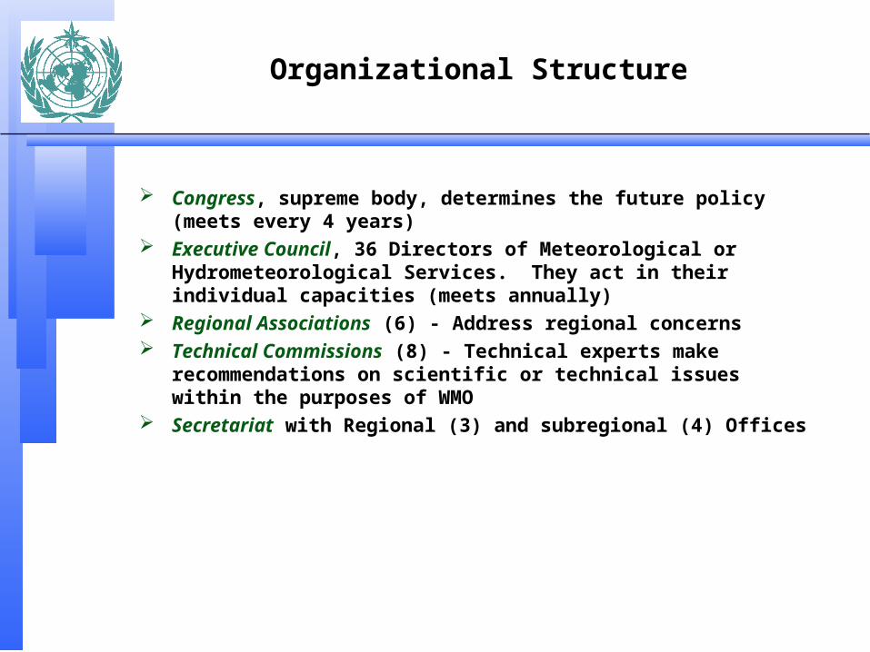
Organizational Structure
Congress, supreme body, determines the future policy (meets every 4 years)
Executive Council, 36 Directors of Meteorological or Hydrometeorological Services. They act in their individual capacities (meets annually)
Regional Associations (6) - Address regional concerns Technical Commissions (8) - Technical experts make
recommendations on scientific or technical issues within the purposes of WMO
Secretariat with Regional (3) and subregional (4) Offices


Monitoring and Predicting the Atmosphere(Weather and Climate)
World Weather Watch 1961 UN Res. 1721(XVI) - International Co-
operation in the Peaceful Uses of Outer Space WMO to assume leadership in use of satellites for atmospheric
monitoring Operational networks for monitoring of weather and climate
system and provision of related forecasts and warnings Free and unrestricted exchange of related data/products

WMOSA Main long-term objectives
(i) Participate in the development of the Global Observing System (GOS) as a composite system, particularly for upper-air observing based on an optimal mix of observing components, including ground-based remote-sensing, mobile observing platforms, satellite and Global Position System-Meteorology (GPS-MET). GOS support to meeting GCOS requirements for climate monitoring and prediction will also be a priority goal;
(ii) Assist Members in the transition of the low-resolution imagery satellite services
from analogue to digital under complex operational conditions;
(iii) Promote satellite-related high quality continuing education to keep the knowledge and skill of Members operational and scientific staff up-to-date with the latest technological innovations, and to provide the competence and skills needed in related fields, such as communication with users;
(iv) Provide information, advice and guidance to Members on satellite-related technological developments as well as on changes in relevant existing meteorological and hydrological operation systems to enable them to develop plans for objective and wise investment actions.

Space-based Global Observing System

Global System of Geostationary Satellites

Global System of Polar Orbiting Satellites

Status of implementation and operation of the space-based component of the GOS
• Meteorological Satellites: 40 Years of Service
• Status of the Space Based GOS

Pioneers in modern atmospheric science helped pave the way
• V2 Rocket photographic montage
• J. Bjerknes performed synoptic analyses using pictures such as this in 1948: likely the first serious attempt to analyze the atmosphere from “space”
• (WMO formed in 1950)

On April 1, 1960 the first U.S. weather satellite was launched from Cape Canaveral, FL
SATELLITES AND THE WWW
UN Resolution No. 1721 for “international co-operation in the peaceful uses of outer space” approved 20 December 1961
•Advent of satellites offered substantial opportunities for improvements in meteorological services
•Called on WMO to lead a study and report on recommendations of the UN Resolution
Report delivered in June 1962
•“First report on the advancement of atmospheric sciences and their application in the light of developments in outer space”
•Birth of World Weather Watch

On April 1, 1960 the first U.S. weather satellite was launched from Cape Canaveral, FL
First TIROS television vidicon pictures presented several challenges Image rectification
Navigation
Cloud type identification
Calibration

40 Years Later
• Meteorological satellites provide essential data for weather forecasting to national weather services across the globe
• APT – free and open direct broadcastsharing of data and science
• Satellite data are high resolution digital renderings from a variety of spectral bands whereby both qualitative and quantitative information about the atmosphere, clouds, and land and sea surface properties are deduced

40 Years Later
• Observations are provided by both low earth orbiting (mainly polar for global observing) and geostationary satellites (maximizing the temporal domain)
• We utilize many portions of the electromagnetic spectrum• Ultraviolet – Ozone profiling and monitoring
• Visible and Infrared - Observing various atmospheric, oceanic and land related properties
• Microwave – active and passive observations of sea state, land properties, precipitation, and diagnosing atmospheric thermodynamic structure

Status of implementation and operation of the Space-based component of the GOS
• Deep appreciation for the continued contribution made by satellite operators in providing valuable data, products and services from the space-based Global Observing System
– EUMETSAT– Japan– People’s Republic of China
(PRC)– Russian Federation– United States of America
• Operational Highlights– Geostationary
• EUMETSAT satellite over the data-sparse Indian Ocean @ 63E
• PRC’s FY-2B @ 105E– Polar
• PRC’s FY-1C direct broadcast of 10 channel MVISR, FY-1D launched 14 May 2002
• United States of America’s NOAA-15 & NOAA-16 with Advanced Microwave Sounding Unit as part of ATOVS (NOAA-M in June 2002)

Status of implementation and operation of the space-based component of the GOS
• Geostationary
– EUMETSAT • Meteosat-7 at 0°• Meteosat-5 at 63°E
– Russian Federation • GOMS-1 at 76°E
– People's Republic of China• FY-2B at 105°E
– Japan• GMS-5 at 140°E
– United States of America• GOES-10 at 135°W • GOES-8 at 75°W
• Polar Orbiting
– People's Republic of China• FY-1C, FY-1D
– Russian Federation • METEOR-2 and 3 series
– United States of America• NOAA-15• NOAA-16• NOAA-M

Current Geostationary Satellites
Sector Satellites currentlyin orbit (+type)
P: Pre-operationalOp: OperationalB: Back-upL: Limited availability
Operator Location Launchdate
Status
EAST-PACIFIC
(180°W-108°W)
GOES-10 (Op)
GOES-11 (B)GOES-12 (B)
USA/NOAA
USA/NOAAUSA/NOAA`
135°W
105°W95°W
04/97
5/007/01
Inverted, solar array anomaly, DCP interrogator on back-up
In orbit back-up, 48 hours availabilityIn commmissioning
WEST-ATLANTIC
(108°W-36°W)
GOES-8 (Op)
GOES-9 (L)
USA/NOAA
USA/NOAA
75°W
110°W
04/94
05/98
Minor sounder anomalies, loss of redundancies on somesub-systemsIn stand-by, lubricant starvation condition of momentumwheels
EAST
ATLANTIC
(36°W-36°E)
METEOSAT-6 (B)
METEOSAT-7 (Op)
EUMETSAT
EUMETSAT
9.5°W
0°
11/93
02/97
Minor gain anomaly on IR imagerFunctional
INDIAN
OCEAN
(36°E-108°E)
METEOSAT-5 (Op)
GOMS-N1 (B)
INSAT II-B (L)INSAT II-E (Op)INSAT I-D (Op)
EUMETSAT
RUSSIANFEDERATION
INDIAINDIAINDIA
63°E
76°E
93.5°E83°E74°E
03/91
11/94
07/9304/9906/90
Indian Ocean Data Coverage
Since 9/98 in stand-by
Cloud imagery for domestic usebut wind products available on WMO GTS
WEST-PACIFIC
(108°E-180°E)
GMS-5 (Op)
FY-2A (B)FY-2B (Op)
JAPAN
CHINACHINA
140° E
86.5E105E
03/ 95
06/9706/00
Operational, 1 °Inclindation becoming 3 ° by 2004Reduced scheduleExperimental SatelliteOperational in 1/01Transponder limitations

Current Polar-Orbiting Satellites
Orbit type
(equatorialcrossing times)
Satellites in orbit(+operation mode)
P=Pre-operationalOp=operationalB=back-upL=limited availability
Operator Crossing TimeA=NorthwD=Southw+Altitude
Launch date Status
Sun-synchr.“Morning”(6:00 – 12:00)(18:00 – 24:00)
NOAA-15 (Op)
NOAA-12 (L)
NOAA-10 (L)
DMSP-F15 (Op)DMSP-F14 (L)DMSP-F12 (B)
RESURS-01-4 (P)
USA/NOAA
USA/NOAA
USA/NOAA
USA/NOAAUSA/NOAAUSA/NOAA
Russian Federation
7:30 (D)
06:40 (D), 850 km
10:00 (D), 840 km
20:00 (A)20:42 (A)21:13 (A)
09:30 (A), 835
05/98
05/91
12/86
12/9904/978/94
7/98
Functional, ATOVS with AMSUFunctional (except sounding)Search and Rescue only
Defense satellites. Data available tocivilian usersthrough NOAA
Partly meteorological mission (APTbroadcast of TV images)
Sun-synchr.“Afternoon”(12:00 –16:00)(00:00 – 04:00)
NOAA-16 (Op)NOAA-14 (B)
NOAA-11 (L)
USA/NOAAUSA/NOAA
USA/NOAA
13:30 (A)14:00 (A), 850 km
14:00 (D)
09/0012/94
09/88
ATOVS with AMSUFunctional, one OBP is unusableSounding only
Sun-synchr.“Earlymorning”( 4:00 - 6:00)(16:00 – 18:00)
DMSP-F13 (Op)DMSP-F11 (B)
USA/NOAAUSA/NOAA
17:40 (A)19:32 (A)
03/9711/91
Defense satellites. Data available tocivilian usersthrough NOAA
Sun-synchr.“morning”
FY-1C (Op) China 8:40 (A), 860 km 5/99 Functional
Non sun-Synchronousor unspecifiedorbits
METEOR 2-21 (Op)
METEOR 3-5 (Op)
Russian Federation
Russian Federation
950 km
1200 km
08/93
08/91
Functional, except IR scanning instrument(APT only)Functional, except IR scanning instrument(APT only)

Approved plans for geostationary orbit
Sector Future additional satellites Operator Planned launch (Planned location)Other remarks
EAST-PACIFIC
(180°W-108°W)
GOES-NGOES-O
USA/NOAAUSA/NOAA
01/200304/2004
135° W and75° W
WEST-ATLANTIC
(108°W-36°W)
GOES-PGOES-QGOES-R
USA/NOAAUSA/NOAAUSA/NOAA
TBCTBCTBC
Contractual options not yet exercised
ABI, ABS, 7 year lifetime
EAST –ATLANTIC
(36°W-36°E)MSG-1MSG-2MSG-3
EUMETSATEUMETSATEUMETSAT
06/200220052008
0°0°0°
INDIAN
OCEAN
(36°E-108°E)
GOMS-N2
INSAT III-AMETSATINSAT III-D
Russian Fed
INDIAINDIAINDIA
2005
03/200203/20022004
76° E, SEVIRI like imager
Like INSAT-II EDedicated meteorological mission6 channel imager, sounder
WEST-PACIFIC(108°E- 180°E)
MTSAT-1RMTSAT-2
FY-2CFY-2DFY-2E
JAPANJAPAN
ChinaChinaChina
03/20032004
200320062009
Multi-functional Transport Satellites, 140°E,MSTSAT-2 operational in 2008
Improved FY-2 series, 5 channel VISSR,LRIT
Future Geostationary Satellites

Approved plans for polar orbit
Orbit type
(equatorialcrossing times)
Future AdditionalSatellites
Operator Planned launch date Other information
Sun-synchr.“Morning”(6:00 – 12:00)(18:00 – 24:00)
METOP-1METOP-2METOP-3
NOAA-MNPOESS-liteNPOESS-lite
FY-1DFY-3AFY-3B
METEOR 3M-1METEOR 3M-2
EUMETSATEUMETSATEUMETSAT
USA/NOAAUSA/NOAAUSA/NOAA
ChinaChinaChina
Russian FedRussian Fed
7/2005TBCTBC
03/200220082013
200120042006
11/20012004
(827 km) (9:30) AHRPT(827 km) (9:30) AHRPT(827 km) (9:30) AHRPT
Last NOAA AM satellite0930, formation, AHRPT0930, formation, AHRPT
(09:30), CHRPT(10:10), CHRPT(10:10), CHRPT
(9:15)(10:30) or (16:30), HRPT
Sun-synchr.“Afternoon”(12:00 – 16:00)(00:00 – 04:00)
NOAA-NNOAA-N’NPOESS-1NPOESS-3
USA/NOAAUSA/NOAAUSA/NOAAUSA/NOAA
6/200403/200820082013
(13.30)(13.30)(13:30)(13.30)
Sun-synchr.“Early morning”( 4:00 - 6:00)(16:00 – 18:00)
DMSP-S16DMSP-S17DMSP-S18DMSP-S19DMSP-S20NPOESS-2NPOESS-4
USA/NOAAUSA/NOAAUSA/NOAAUSA/NOAAUSA/NOAAUSA/NOAAUSA/NOAA
2001200220032005200720102015
Future Polar-Orbiting Satellites

The Space Based Global Observing System, 2002A Combination of Geostationary and Polar Orbiting Satellites
850 KM
35 800 KmSUBSATELLITE POINT
GOMS (Russian Federation)
76E
METEOSAT
(EUMETSAT) 63 E
GMS (J apan)
140E
FY-2 (China)
105E
GOES-E (USA) 75W
TIROS (USA)
GOES-W (USA) 135W
GE
OST
ATIO
NARY ORBIT
METEOR (Russian Federation)
Pola
r orbit
METEOSAT
(EUMETSAT) 0 Longitude
(China)FY-1
Unparalleled international cooperation has been achieved in satellite activities*
*5th WMO Long Term Plan

Typical Polar Orbiting Sounder Coverage for Global NWPAssimilated Microwave from NOAA-14 MSU (Ch 3, blue) and
NOAA-15 AMSU (Ch 7, red) for 00Z, Feb. 22, 1999

25
Coverge provided by GOES mid and upper level
high density winds from May 2, 1998
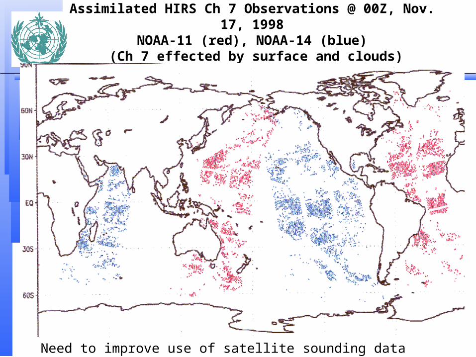
Assimilated HIRS Ch 7 Observations @ 00Z, Nov. 17, 1998NOAA-11 (red), NOAA-14 (blue)
(Ch 7 effected by surface and clouds)
Need to improve use of satellite sounding data over land!!!

Satellite derived wind observations

Satellite derived soundings

– Satellite data are an integral part of our environmental monitoring system, and must be fully exploited
We should expect great strides forward with improvements in global space based observing systems
The advancement to improved microwave sensors and hyper-spectral imaging
and sounding is a natural progression, and provides exciting new opportunities and challenges with truly adaptive observing systems
The explosion in satellite data volume and sophistication expected over the next decade requires maximum efforts in data assimilation and NWP

WWW Implementation GoalsPercentage of Members with at least one polar-orbiting and one geostationary
receiver
%
%

Future Space Based Global Observing System
850 KM
35 800 KmSUBSATELLITE POINT
GOMS (Russian Federation)
76E
MSG
(EUMETSAT) 63 E
MTSAT (J apan)
140E
FY-2 (China)
105E
GOES-E (USA) 75W
NPOESS (USA)
GOES-W (USA) 135W
GE
OST
ATIO
NARY ORBIT
Oceanographic Missions
AtmosphericChemistryMissions
HydrologicalMissions
High-resolutionLand useMissions
METEOR 3M(Russian Federation)
Pola
r orbit
R &
D o
rbit
METEOSAT
(EUMETSAT) 0 Longitude
(China)FY-1
Metop (EUMETSAT)
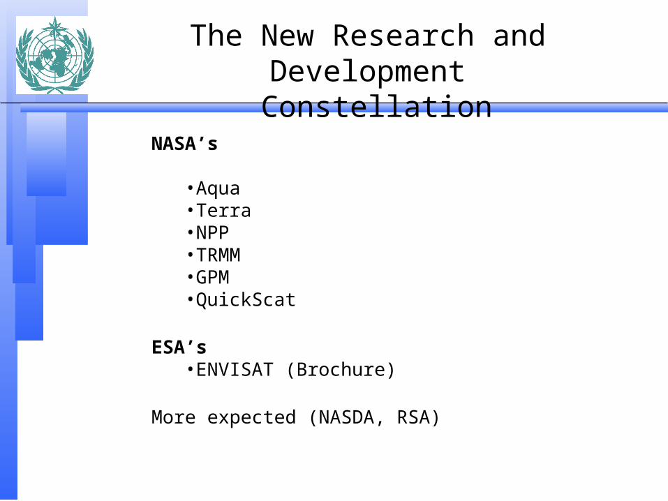
The New Research and Development Constellation
NASA’s
•Aqua•Terra•NPP•TRMM•GPM•QuickScat
ESA’s•ENVISAT (Brochure)
More expected (NASDA, RSA)

NASA’s AQUA Satellite

WMO Satellite Activities Web Sitehttp://www.wmo.ch/hinsman/satsun.html
Goals, objectives and publicationsSatellite operator status reports Global Observing System (GOS) status reportsOther satellite related organizationsOnline database informationAPT/WEFAX to LRPT/LRIT transitionOnline satellite imagery sitesWorking documents for Upcoming MeetingsEducation and Training Materials
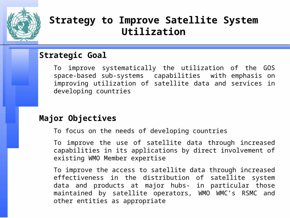
Strategy to Improve Satellite System Utilization
Strategic Goal
To improve systematically the utilization of the GOS space-based sub-systems capabilities with emphasis on improving utilization of satellite data and services in developing countries
Major Objectives
To focus on the needs of developing countries
To improve the use of satellite data through increased capabilities in its applications by direct involvement of existing WMO Member expertise
To improve the access to satellite data through increased effectiveness in the distribution of satellite system data and products at major hubs- in particular those maintained by satellite operators, WMO WMC’s RSMC and other entities as appropriate

Strategy to Improve Satellite System Utilization
Proposed Action Topics by Projects
1) Improve benefits, mainly through promotion
Foster improved promotion of systems use at User Forum
Favour multiagency strategy promoting satellite system benefits
Focus on improved warning and monitoring of environmental hazards such as severe weather, volcanic ash, air and ocean pollution etc.

Strategy to Improve Satellite System Utilization
Proposed Action Topics by Projects
2) Data processing and development of new methodologies
Study the concept of specialised centres and networks to assist NMHSs in the use of satellite data, e.g. new applications, NWP products
Promote better transfer from research to operational applications
Focus in high identified priority user requirements for satellite applications
Assure closer operational development links with PIs
Implement operational distributed database system
Study specifications for improved WMC/RSMC satellite products

Strategy to Improve Satellite System Utilization
Proposed Action Topics by Projects
3) Education and Training
Favour the implementation of specific satellite E&T programmesin RMTC’s and organisation of other relevant WMO trainingactivities
Expand US-based virtual lab network in RA III & IV
Focus on better use of polar -orbiting data and products
(Menzel’s Notes)

Strategy to Improve Satellite System Utilization
Proposed Action Topics by Projects
4) Infrastructure, including receiving stations
Evaluate the status of aid projects (Swiss, Italian...)Seek CGMS help for assuring the continuity of Indian Ocean/RA II satellite coveragePropose major WMO project on low-cost satellite workstationPromote the expansion of EUMETSAT MDD system use in RA I &IIFocus on effective use of LRIT in RA II & V (with MTSAT-1)Focus on a smooth transition from WEFAX/APT to LRIT/LRPTFocus initial funding on work station and networkingExpand use of DCP/DRS for agriculture and HydrologyPursue improved performance of the MTN and GTS toaccommodate increasing flows of satellite dataPromote a better use of Internet and systems such as VSAT

Strategy to Improve Satellite System Utilization
Proposed Action Topics by Projects
5) Continuous review and monitoring activities
Continuously perform critical review process of satellite dataavailability and use linking monitoring to action plans
Review WMO requirements for new Earth Observation Satellite data

What Awaits Us
New remote sensing capabilitieshigher spatial resolutionhigher temporal resolutionmore spectral bandshigher spectral resolutionbetter science
Opportunities to be realized
new approachesinternational partnershipsearly involvement in science teamsand associated field programs
Distinction shrinking betweenpolar and geostationary sensors research and operational sensors international sensor capability