wmo publication nosot.jcommops.org/vos/documents/pub47_documentation_version4.pdfwmo-no. 47,...
TRANSCRIPT

1
WMO-No. 47
International list of Voluntary Observing Ships
Metadata fields & descriptions, exchange formats and code tables
Metadata Format Version 04
(Document Revision 4.2)
Prepared for the World Meteorological Organization by the JCOMM Ship Observations Team
(Effective 1 April 2017)

2
WMO-No. 47
Metadata Format Version 04
Version Control
Metadata Format Version Document Revision Date of Issue Prepared By
01 1.0 WMO
02 2.0 8 July 2002 WMO
03 3.0 1 June 2006 SOT TT-Pub47
03 3.1 22 June 2006 SOT TT-Pub47
03 3.2 8 May 2007 SOT TT-Pub47
03 3.3 3 June 2008 SOT TT-Pub47
03 3.4 25 February 2010 SOT TT-Pub47
03 3.5 15 July 2011 SOT TT-Pub47
04 4.0 18 December 2012 SOT TT-Pub47
04 4.1 4 February 2013 SOT TT-Pub47
04 4.2 16 October 2015 SOT TT-Pub47
3
WMO-No. 47
Metadata Format Version 04
Contents
Introduction 4
Obligations for WMO Members 5
General notes on exchange formats and XML schema 6
Annex 1. Semi-colon delimited exchange format – fields and descriptions 7
Annex 2. XML exchange format – fields and descriptions 11
Annex 3. XML File Structure 15
Annex 4. Code Tables 19
Annex 5. Ship’s Layout Diagram 36 Annex 6. Vessel Digital Images 37

4
WMO-No. 47
Metadata Format Version 04
Introduction
WMO maintains a catalogue of ships participating in the global Voluntary Observing Ship (VOS) Scheme. The catalogue is produced from the national VOS lists submitted by WMO Members. The catalogue, which contains a comprehensive range of ship’s metadata, was originally available as a WMO publication, WMO-No. 47 (commonly referred to as Pub 47). Due to increasing printing and distribution costs, the publication was suspended in the late 1990s. An electronic version of the catalogue became available on the WMO website < http://www.wmo.ch/web/www/ois/pub47/pub47-home.htm > during 2003. Despite the changed method of distribution, the electronic file retains the name of the original publication. Because of changing demands for ship’s metadata, the Ship Observations Team (SOT) formed a Task Team at SOT-II (July 2003, London, UK) to revise the metadata requirements of WMO-No. 47. The proposed changes were subsequently approved at JCOMM-II (September 2006, Halifax, Canada). This document describes the field descriptions, presentation layout and file exchange formats for WMO-No. 47, Metadata Format Version 04, approved at JCOMM-II. These changes come into effect on 1 June 2013. Summary of changes in this version
1. Type of meteorological reporting ships vsslM (Code Table 2202):
a. Add new code 80 for manually reporting third party support ship. b. Add new code 85 for AWS-equipped third party support ship.
2. Exposure of the hygrometer hgrE, exposure of the dry-bulb thermometer thmE (Code Table 0801)
a. Add new code HH for hand held digital thermometer/humidity sensor. b. Add new code RS for radiation shield (e.g. cylindrical / Gill multi-plate radiation shield).
3. Recruiting country rcnty, country of registration reg (Code Table 1801)
a. Add new code ZZ for third party support ships.
4. Change in the location referenced in the XML Schema namespace variable.
5
WMO-No. 47
Metadata Format Version 04
Obligations for WMO Members
1. The Manual on the Global Observing System, WMO-No. 544, requires WMO Members operating a VOS Program to provide the WMO Secretariat with a copy of their national VOS list.
2. Because of frequent changes in merchant fleets, and to ensure that WMO-No. 47 remains as current as is
practicable, particularly for quality monitoring applications, members are asked to make regular submissions of their national VOS list to the Secretariat.
a. The Guide to Marine Meteorological Services, WMO-No. 471 (paragraph 6.2.5) asks members to
provide the Secretariat with an updated VOS lists every quarter. b. The Ship Observations Team at its fifth session (SOT-V, Geneva, 2009) asked members,
wherever possible, to provide the Secretariat with an updated VOS list every month. 3. WMO Members submitting to WMO-No. 47 should note the following:
a. To comply with the decision of the WMO Expert Team on Marine Climatology, only mobile
platforms, including ships either temporarily or semi-permanently at anchor, shall be reported in WMO-No. 47. Fixed platforms shall be reported under the JCOMM ODAS metadata scheme.
b. The list of ships shall be sorted alphabetically by name. c. Only mobile platforms recruited by the WMO Member shall be included in its national VOS list.
d. Ship’s digital images and drawings shall be retained by the NMS.
4. WMO Members should ensure that ships they intend to recruit are not already members of another
country’s VOS fleet by consulting the WMO-No. 47. 5. The following mandatory fields represent the minimum suite of metadata that can be submitted for a ship:
a. rcnty (recruiting country) b. call (callsign) c. vosR (VOS recruitment date) d. vsslM (type of meteorological reporting vessel) e. atm (general observing practice)
6. Operators are strongly encouraged to use the search facility provided by the E-Surfmar VOS Database at
< http://esurfmar.meteo.fr/doc/vosmetadata_v6/ > to check for the multiple recruitment of ships in their national VOS fleet. In such cases, the recruiting countries should resolve the issue through bilateral agreement.
7. The national VOS list shall be emailed to the WMO Secretariat at: [email protected] whereby the updated
list will automatically be distributed to WMO, JCOMMOPS and E-SURFMAR.

6
WMO-No. 47
Metadata Format Version 04
General notes on exchange formats and XML schema WMO-No. 47, Metadata Format Version 04, now gives WMO Members the choice of submitting their national VOS list as either a semi-colon delimited text file as in the past, or an XML (eXtensible Markup Language) file. CSV (Semi-colon delimited) file
1. The file shall contain one line, comprising 120 metadata elements, for each platform. 2. The sequence of elements is given in Annex 1.
3. Each metadata element includes a semi-colon (;) delimiter as the last character as shown in Annex 1.
XML file
1. The sequence of elements in the XML file is given in Annex 3 . 2. The XML file shall consist of a top-level header: <?xml version="1.0"?>. 3. The dataset shall begin with an opening tag:
<pub47dataset country="" version="04" prepared=”” namespace>, where namespace consists of two parts, (a) and (b) below, separated by a space:
a. xmlns:xsi=”http://www.w3.org/2001/XMLSchema-instance” b. xsi:noNamespaceSchemaLocation="http://sot.jcommops.org/vos/pub47/v4pub47.xsd"
4. The dataset shall end with a closing tag: </pub47dataset>. 5. Each ship record in the dataset will comprise 98 metadata elements and section headers, and shall:
a. Begin with an opening tag: <pub47record nmsID=””> b. End with a closing tag </pub47record>.

7
Annex 1
WMO-No. 47
Metadata Format Version 04
Semi-colon delimited exchange format – element descriptions, formats and sequence
Order Code Name Explanation Table Format Footnote Example
1 rcnty; Recruiting country. 1801 No
2 ver; Metadata format version No 04
3 prepared; Date of report preparation. ddmmyyyy No
4 name; Ship's name. No
5 reg; Country of registration. 1801 No
6 call; Call sign or WMO Number. Some sea stations are identified by a WMO Number instead of a call sign. No
7 IMOn; IMO Number. Unique identifying number assigned by Lloyd's Register to the hull of the ship. No
8 vssl; Vessel type. 2201 Yes
9 vsslP; Vessel digital image. 2203 No
10 lenvsslD; Length overall of the ship, ignoring bulbous bow. 0.0 m No
11 brdvsslD; Moulded breadth. The greatest breadth amidships. 0.0 m No
12 frbvsslD; Freeboard. The average height of the upper deck above the maximum Summer load line. 0.0 m No
13 drfvsslD; Draught. The average depth of the keel below the maximum Summer load line. 0.0 m No
14 chtvsslD; Cargo height. Maximum height above the maximum Summer load line. 0.0 m No
15 brdg; Distance of the bridge from the bow. 0.0 m No
16 spd; Maximum operating speed of the vessel on normal service. 0 kts No
17 rte; Route No.1. 1802 Yes
18 rte; Route No.2. 1802 Yes
19 rte; Route No.3. 1802 Yes
20 rte; Route No.4. 1802 Yes
21 rte; Route No.5. 1802 Yes
22 rte; Route No.6. 1802 Yes
23 rte; Route No.7 1802 Yes
24 rte; Route No.8. 1802 Yes

8
25 rte; Route No.9. 1802 Yes
26 rte; Route No.10. 1802 Yes
27 vosR; Recruitment date of the current VOS participation. ddmmyyyy No
28 vosD; De-recruitment date of the last VOS participation (report only if the vessel has been re-recruited). ddmmyyyy No
29 vclmR; Last VOSClim recruitment date if within the current period of VOS participation. ddmmyyyy No
30 vclmD; Last VOSClim de-recruitment date if within the current period of VOS participation. ddmmyyyy No
31 vsslM; Type of meteorological reporting ship. 2202 Yes
32 atm; General observing practice. 0105 Yes
33 freq; Routine observing frequency. 0602 Yes
34 prST; Transmission system for sending weather reports. 1601 Yes
35 logE; Name and version of the electronic logbook software. No TurboWin 3.5
36 wwH; Visual wind/wave observing height. 0.0 m No
37 anmU; General wind observing practice. 0103 No
38 blc; Baseline check of the automatic weather station. 0203 No
39 awsM; Make and model of the automatic weather station. No Vaisala Milos 500
40 awsP; Name and version of the automatic weather station processing software. No Milos 500 2.56
41 awsC; Name and version of the automatic weather station data entry/display software. No Yourlink 1.03.20
42 barm; Primary barometer type. 0202 Yes
43 barm; Secondary barometer type. 0202 Yes
44 bMS; Make and model of the primary barometer. No Vaisala PTB220B
45 bMS; Make and model of the secondary barometer. No
46 brmH; Height of the primary barometer above the maximum Summer load line. 0.0 m No
47 brmH; Height of the secondary barometer above the maximum Summer load line. 0.0 m No
48 brmL; Location of the primary barometer. 0204 Yes
49 brmL; Location of the secondary barometer. 0204 Yes
50 brmU; Pressure units of the primary barometer. No hPa
51 brmU; Pressure units of the secondary barometer. No
52 brmC; Most recent calibration date of the primary barometer. ddmmyyyy No
53 brmC; Most recent calibration date of the secondary barometer. ddmmyyyy No
54 thrm; Dry bulb thermometer type No.1. 2002 Yes
55 thrm; Dry bulb thermometer type No.2. 2002 Yes
56 thMS; Make and model of the dry bulb thermometer No.1. No Rosemount ST401

9
57 thMS; Make and model of the dry bulb thermometer No.2. No
58 thmE; Exposure of the dry bulb thermometer No.1. 0801 Yes
59 thmE; Exposure of the dry bulb thermometer No.2. 0801 Yes
60 thmL; Location of dry bulb thermometer No.1 and hgyrometer No.1. 2001 Yes
61 thmL; Location of dry bulb thermometer No.2 and hgyrometer No.2. 2001 Yes
62 thmH; Height of the dry bulb thermometer No.1 and hygrometer No.1 above the maximum Summer load line. 0.0 m No
63 thmH; Height of the dry bulb thermometer No.2 and hygrometer No.2 above the maximum Summer load line. 0.0 m No
64 tscale; General reporting practice for dry bulb thermometer No.1 and hygrometer No.1. 2003 Yes
65 tscale; General reporting practice for dry bulb thermometer No.2 and hygrometer No.2. 2003 Yes
66 hygr; Hygrometer type No.1. 0802 Yes
67 hygr; Hygrometer type No.2. 0802 Yes
68 hgrE; Exposure of the hygrometer No.1. 0801 No
69 hgrE; Exposure of the hygrometer No.2. 0801 No
70 sstM; Primary method of obtaining the sea surface temperature. 1901 Yes
71 sstM; Secondary method of obtaining the sea surface temperature. 1901 Yes
72 sstD; Depth of the primary sea surface temperature observation below the maximum Summer load line. 0.0 m No
73 sstD; Depth of the secondary sea surface temperature observation below the maximum Summer load line. 0.0 m No
74 barg; Primary barograph type, or method of determining pressure tendency. 0201 Yes
75 barg; Secondary barograph type, or method of determining pressure tendency. 0201 Yes
76 anmT; Primary anemometer type. 0102 Yes
77 anmT; Secondary anemometer type. 0102 Yes
78 anmM; Make and model of the primary anemometer. No Vaisala WAV151 & WAA151
79 anmM; Make and model of the secondary anemometer. No
80 anmL; Location of the primary anemometer. 0101 Yes
81 anmL; Location of the secondary anemometer. 0101 Yes
82 anDB; Distance of the primary (fixed) anemometer from the bow. 0.0 m No
83 anDB; Distance of the secondary (fixed) anemometer from the bow. 0.0 m No
84 anDC; Distance of the primary (fixed) anemometer from the centre line. 0.0 m No
85 anSC; Side indicator of the primary (fixed) anemometer from the centre line, if appropriate. 0104 No
86 anDC; Distance of the secondary (fixed) anemometer from the centre line. 0.0 m No
87 anSC; Side indicator of the secondary (fixed) anemometer from the centre line, if appropriate. 0104 No
88 anHL; Height of the primary (fixed) anemometer above the maximum Summer load line. 0.0 m No

10
89 anHL; Height of the secondary (fixed) anemometer above the maximum Summer load line. 0.0 m No
90 anHD; Height of the primary (fixed) anemometer above the deck on which it is installed. 0.0 m No
91 anHD; Height of the secondary (fixed) anemometer above the deck on which it is installed. 0.0 m No
92 anmC; Most recent calibration date of the primary anemometer. ddmmyyyy No
93 anmC; Most recent calibration date of the secondary anemometer. ddmmyyyy No
94 othI; Other meteorological/oceanographic instrument No.1. 1501 Yes
95 othI; Other meteorological/oceanographic instrument No.2. 1501 Yes
96 othI; Other meteorological/oceanographic instrument No.3. 1501 Yes
97 othI; Other meteorological/oceanographic instrument No.4. 1501 Yes
98 othI; Other meteorological/oceanographic instrument No.5. 1501 Yes
99 othI; Other meteorological/oceanographic instrument No.6. 1501 Yes
100 chgd; Last date of change to any metadata value. ddmmyyyy No
101 fieldabbrev; Code name of the field to which footnote No. 1 applies. 0601 vssl
102 fieldabbrev; Code name of the field to which footnote No. 2 applies. 0601 thmE
103 fieldabbrev; Code name of the field to which footnote No. 3 applies. 0601 rte
104 fieldabbrev; Code name of the field to which footnote No. 4 applies. 0601
105 fieldabbrev; Code name of the field to which footnote No. 5 applies. 0601
106 fieldabbrev; Code name of the field to which footnote No. 6 applies. 0601
107 fieldabbrev; Code name of the field to which footnote No. 7 applies. 0601
108 fieldabbrev; Code name of the field to which footnote No. 8 applies. 0601
109 fieldabbrev; Code name of the field to which footnote No. 9 applies. 0601
110 fieldabbrev; Code name of the field to which footnote No. 10 applies. 0601
111 footID; Footnote No. 1 (Mandatory extra details if code OT is reported. Optional if Yes in footnote column) Ice strengthened
112 footID; Footnote No. 2 (Mandatory extra details if code OT is reported. Optional if Yes in footnote column) Plastic screen 113 footID; Footnote No. 3 (Mandatory extra details if code OT is reported. Optional if Yes in footnote column) Area 73 – Austral
Summer only 114 footID; Footnote No. 4 (Mandatory extra details if code OT is reported. Optional if Yes in footnote column)
115 footID; Footnote No. 5 (Mandatory extra details if code OT is reported. Optional if Yes in footnote column)
116 footID; Footnote No. 6 (Mandatory extra details if code OT is reported. Optional if Yes in footnote column)
117 footID; Footnote No. 7 (Mandatory extra details if code OT is reported. Optional if Yes in footnote column)
118 footID; Footnote No. 8 (Mandatory extra details if code OT is reported. Optional if Yes in footnote column)
119 footID; Footnote No. 9 (Mandatory extra details if code OT is reported. Optional if Yes in footnote column)
120 footID; Footnote No. 10 (Mandatory extra details if code OT is reported. Optional if Yes in footnote column)

11
Annex 2
WMO-No. 47
Metadata Format Version 04
XML exchange format – element descriptions, formats and sequence
Order Code Name Header Code Name Explanation Table Format Footnote* Example
1 country Recruiting country. 1801 No
2 version Metadata format version No 04
3 prepared Date of report preparation. yyyymmdd No
Order Code Name Record Code Name Explanation Table Format Footnote* Example
1 nmsID NMS reference number. Unique reference or identifier assigned by the NMS to the ship (if applicable). No
2 name Ship's name. No
3 reg Country of registration. 1801 No
4 call Call sign or WMO Number. Some sea stations are identified by a WMO Number instead of a call sign. No
5 IMOn IMO Number. Unique identifying number assigned by Lloyd's Register to the hull of the ship. No
6 vssl Vessel type. 2201 Yes
7 vsslP Vessel digital image. 2203 No
8 lenvsslD Length overall of the ship, ignoring bulbous bow. 0.0 m No
9 brdvsslD Moulded breadth. The greatest breadth amidships. 0.0 m No
10 frbvsslD Freeboard. The average height of the upper deck above the maximum Summer load line. 0.0 m No
11 drfvsslD Draught. The average depth of the keel below the maximum Summer load line. 0.0 m No
12 chtvsslD Cargo height. Maximum height above the maximum Summer load line. 0.0 m No
13 brdg Distance of the bridge from the bow. 0.0 m No
14 spd Maximum operating speed of the vessel on normal service. 0 kts No
15 rte Route No.1. 1802 Yes
16 rte Route No.2. 1802 Yes
17 rte Route No.3. 1802 Yes
18 rte Route No.4. 1802 Yes

12
19 rte Route No.5. 1802 Yes
20 rte Route No.6. 1802 Yes
21 rte Route No.7 1802 Yes
22 rte Route No.8. 1802 Yes
23 rte Route No.9. 1802 Yes
24 rte Route No.10. 1802 Yes
25 vosR Recruitment date of the current VOS participation. yyyymmdd No
26 vosD De-recruitment date of the last VOS participation (report only if the vessel has been re-recruited). yyyymmdd No
27 vclmR Last VOSClim recruitment date if within the current period of VOS participation. yyyymmdd No
28 vclmD Last VOSClim de-recruitment date if within the current period of VOS participation. yyyymmdd No
29 vsslM Type of meteorological reporting ship. 2202 Yes
30 atm General observing practice. 0105 Yes
31 freq Routine observing frequency. 0602 Yes
32 prST Transmission system for sending weather reports. 1601 Yes
33 logE Name and version of the electronic logbook software. No TurboWin 3.5
34 wwH Visual wind/wave observing height. 0.0 m No
35 anmU General wind observing practice. 0103 Yes
36 blc Baseline check of the automatic weather station. 0203 Yes
37 awsM Make and model of the automatic weather station. No Vaisala Milos 500
38 awsP Name and version of the automatic weather station processing software. No Milos 500 2.56
39 awsC Name and version of the automatic weather station data entry/display software. No Yourlink 1.03.20
40 barm Primary barometer type. 0202 Yes
41 bMS Make and model of the primary barometer. No Vaisala PTB220B
42 brmH Height of the primary barometer above the maximum Summer load line. 0.0 m No
43 brmL Location of the primary barometer. 0204 Yes
44 brmU Pressure units of the primary barometer. No hPa
45 brmC Most recent calibration date of the primary barometer. yyyymmdd No
46 barm Secondary barometer type. 0202 Yes
47 bMS Make and model of the secondary barometer. No
48 brmH Height of the secondary barometer above the maximum Summer load line. 0.0 m No
49 brmL Location of the secondary barometer. 0204 Yes
50 brmU Pressure units of the secondary barometer. No
51 brmC Most recent calibration date of the secondary barometer. yyyymmdd No

13
52 thrm Dry bulb thermometer type No.1. 2002 Yes
53 thMS Make and model of the dry bulb thermometer No.1. No Rosemount ST401
54 thmE Exposure of the dry bulb thermometer No.1. 0801 Yes
55 thmL Location of dry bulb thermometer No.1 and hgyrometer No.1. 2001 Yes
56 thmH Height of the dry bulb thermometer No.1 and hygrometer No.1 above the maximum Summer load line. 0.0 m No
57 tscale General reporting practice for dry bulb thermometer No.1 and hygrometer No.1. 2003 Yes
58 thrm Dry bulb thermometer type No.2. 2002 Yes
59 thMS Make and model of the dry bulb thermometer No.2. No
60 thmE Exposure of the dry bulb thermometer No.2. 0801 Yes
61 thmL Location of dry bulb thermometer No.2 and hgyrometer No.2. 2001 Yes
62 thmH Height of the dry bulb thermometer No.2 and hygrometer No.2 above the maximum Summer load line. 0.0 m No
63 tscale General reporting practice for dry bulb thermometer No.2 and hygrometer No.2. 2003 Yes
64 hygr Hygrometer type No.1. 0802 Yes
65 hgrE Exposure of the hygrometer No.1. 0801 Yes
66 hygr Hygrometer type No.2. 0802 Yes
67 hgrE Exposure of the hygrometer No.2. 0801 Yes
68 sstM Primary method of obtaining the sea surface temperature. 1901 Yes
69 sstD Depth of the primary sea surface temperature observation below the maximum Summer load line. 0.0 m No
70 sstM Secondary method of obtaining the sea surface temperature. 1901 Yes
71 sstD Depth of the secondary sea surface temperature observation below the maximum Summer load line. 0.0 m No
72 barg Primary barograph type, or method of determining pressure tendency. 0201 Yes
73 barg Secondary barograph type, or method of determining pressure tendency. 0201 Yes
74 anmT Primary anemometer type. 0102 Yes
75 anmM Make and model of the primary anemometer. No Vaisala WAV151 & WAA151
76 anmL Location of the primary anemometer. 0101 Yes
77 anDB Distance of the primary (fixed) anemometer from the bow. 0.0 m No
78 anDC Distance of the primary (fixed) anemometer from the centre line. 0.0 m No
79 anSC Side indicator of the primary (fixed) anemometer from the centre line, if appropriate. 0104 No
80 anHL Height of the primary (fixed) anemometer above the maximum Summer load line. 0.0 m No
81 anHD Height of the primary (fixed) anemometer above the deck on which it is installed. 0.0 m No
82 anmC Most recent calibration date of the primary anemometer. yyyymmdd No
83 anmT Secondary anemometer type. 0102 Yes

14
84 anmM Make and model of the secondary anemometer. No
85 anmL Location of the secondary anemometer. 0101 Yes
86 anDB Distance of the secondary (fixed) anemometer from the bow. 0.0 m No
87 anDC Distance of the secondary (fixed) anemometer from the centre line. 0.0 m No
88 anSC Side indicator of the secondary (fixed) anemometer from the centre line, if appropriate. 0104 No
89 anHL Height of the secondary (fixed) anemometer above the maximum Summer load line. 0.0 m No
90 anHD Height of the secondary (fixed) anemometer above the deck on which it is installed. 0.0 m No
91 anmC Most recent calibration date of the secondary anemometer. yyyymmdd No
92 othI Other meteorological/oceanographic instrument No.1. 1501 Yes
93 othI Other meteorological/oceanographic instrument No.2. 1501 Yes
94 othI Other meteorological/oceanographic instrument No.3. 1501 Yes
95 othI Other meteorological/oceanographic instrument No.4. 1501 Yes
96 othI Other meteorological/oceanographic instrument No.5. 1501 Yes
97 othI Other meteorological/oceanographic instrument No.6. 1501 Yes
98 chgd Last date of change to any metadata value. yyyymmdd No
* Provision to report a footnote (Mandatory extra detail if OT is selected from a Code Table. Optional if Yes in footnote column)

15
Annex 3
WMO-No. 47
Metadata Format Version 04
XML File Structure and element sequence <?xml version="1.0"?> <pub47dataset country="" version="04" prepared="" namespace> <pub47record nmsID=""> <name/> <reg/> <call/> <IMOn/> <vssl footnote=""/> <digital_image> <vsslP/> </digital_image> <dimensions> <lenvsslD/> <brdvsslD/> <frbvsslD/> <drfvsslD/> <chtvsslD/> <brdg/>
<spd/> </dimensions> <operations> <rte Id="1" footnote=""/> <rte Id="2" footnote=""/> <rte Id="3" footnote=""/> <rte Id="4" footnote=""/> <rte Id="5" footnote=""/> <rte Id="6" footnote=""/> <rte Id="7" footnote=""/> <rte Id="8" footnote=""/> <rte Id="9" footnote=""/>
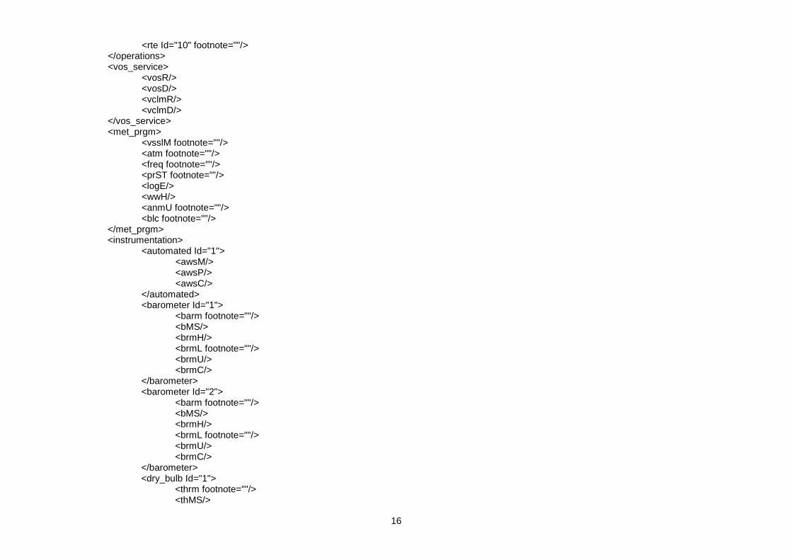
16
<rte Id="10" footnote=""/> </operations> <vos_service> <vosR/> <vosD/> <vclmR/> <vclmD/> </vos_service> <met_prgm> <vsslM footnote=""/> <atm footnote=""/> <freq footnote=""/> <prST footnote=””/> <logE/> <wwH/> <anmU footnote=""/> <blc footnote=""/> </met_prgm> <instrumentation> <automated Id="1"> <awsM/> <awsP/> <awsC/> </automated> <barometer Id="1"> <barm footnote=""/> <bMS/> <brmH/> <brmL footnote=""/> <brmU/> <brmC/> </barometer> <barometer Id="2"> <barm footnote=""/> <bMS/> <brmH/> <brmL footnote=""/> <brmU/> <brmC/> </barometer> <dry_bulb Id="1"> <thrm footnote=""/> <thMS/>

17
<thmE footnote=""/> <thmL footnote=""/> <thmH/> <tscale footnote=""/> </dry_bulb> <dry_bulb Id="2"> <thrm footnote=""/> <thMS/> <thmE footnote=""/> <thmL footnote=""/> <thmH/> <tscale footnote=""/> </dry_bulb> <hygrometer Id="1"> <hygr footnote=""/> <hygE footnote=""/> </hygrometer> <hygrometer Id="2"> <hygr footnote=""/> <hygE footnote=""/> </hygrometer> <sea_temp Id="1"> <sstM footnote=""/> <sstD/> </sea_temp> <sea_temp Id="2"> <sstM footnote=""/> <sstD/> </sea_temp> <barograph Id="1"> <barg footnote=""/> </barograph> <barograph Id="2"> <barg footnote=""/> </barograph>

18
<anemometer Id="1"> <anmT footnote=""/> <anmM/> <anmL footnote=""/> <anDB/> <anDC/> <anSC/> <anHL/> <anHD/> <anmC/> </anemometer> <anemometer Id="2"> <anmT footnote=""/> <anmM/> <anmL footnote=""/> <anDB/> <anDC/> <anSC/> <anHL/> <anHD/> <anmC/> </anemometer> <other> <othI Id="1" footnote=""/> <othI Id="2" footnote=""/> <othI Id="3" footnote=""/> <othI Id="4" footnote=""/> <othI Id="5" footnote=""/> <othI Id="6" footnote=""/> </other> </instrumentation> <chgd/> </pub47record> </pub47dataset> namespace specification for Pub47 XML Schema, version 4.0: xmlns:xsi=”http://www.w3.org/2001/XMLSchema-instance” xsi:noNamespaceSchemaLocation="http://sot.jcommops.org/vos/pub47/v4pub47.xsd"

19
Annex 4
WMO-No. 47
Metadata Format Version 04
Code Tables
Table Code Description
0101 anmL Location of the anemometer.
0102 anmT Anemometer type.
0103 anmU General wind observing practice.
0104 anSC Side indicator of the (fixed) anemometer from the centre line, if appropriate.
0105 atm General observing practice.
0201 barg Barograph type, or method of determining pressure tendency.
0202 barm Barometer type.
0203 blc Baseline check of the automatic weather station.
0204 brmL Location of the barometer.
0601 fieldabbrev Code name of the field to which the footnote applies (in order of reporting in pub47).
0602 freq Routine observing frequency.
0801 hgrE Exposure of the hygrometer.
thmE Exposure of the dry bulb thermometer.
0802 hygr Hygrometer type.
1501 othI Other meteorological/oceanographic instrument.
1601 prST Transmission system for sending weather reports.
1801 rcnty Recruiting country.
reg Country of registration.
1802 rte Route
1901 sstM Method of obtaining the sea surface temperature.
2001 thmL Location of the dry bulb thermometer and hygrometer
2002 thrm Dry bulb thermometer type.
2003 tscale General temperature reporting practice.
2201 vssl Vessel type.
2202 vsslM Type of meteorological reporting ship.
2203 vsslP Vessel digital image.

20
0101
anmL Location of the anemometer.
Code Description
1 Not fitted. 2 Mainmast. 3 Mainmast port yardarm. 4 Mainmast starboard yardarm. 5 Aft mast. 6 Foremast. 7 Foremast port yardarm. 8 Foremast starboard yardarm. 9 Meteorological mast. 10 Mast on wheelhouse top. 11 Mast on wheelhouse top port yardarm. 12 Mast on wheelhouse top starboard yardarm. 13 Handheld. OT Other (specify in footnote).
0102
anmT Anemometer type.
Code Description
AN Anemograph. CCV Cup anemometer and wind vane (combined unit). SCV Cup anemometer and wind vane (separate instruments). HA Handheld anemometer. PV Propeller vane.
SON Sonic anemometer. OT Other (specify in footnote).
0103
anmU General wind observing practice.
Code Description
1 Anemometer, true wind computed. 2 Anemometer, true wind manual. 3 Visual estimates (sea state). 4 Visual estimate (open sea), anemometer (near port).
0104
anSC Side indicator of the (fixed) anemometer from the centre line, if appropriate.
Code Description
P Port S Starboard

21
0105
atm General observing practice.
Code Description
1 Fully automated. 2 Always supplemented by manual input. 3 Occasionally supplemented by manual input. 4 Unknown. 5 Fully manual (no automation).
0201
barg Barograph type, or method of determining pressure tendency.
Code Description
OS Open Scale barograph. OS1 Open Scale barograph with 1 day clock. OS2 Open Scale barograph with 2 day clock. OS3 Open Scale barograph with 3 day clock. OS4 Open Scale barograph with 4 day clock. OS5 Open Scale barograph with 5 day clock. OS6 Open Scale barograph with 6 day clock. OS7 Open Scale barograph with 7 day clock. OS8 Open Scale barograph with 8 day clock. OS9 Open Scale barograph with 9 day clock. SS Small Scale barograph. ET Tendency obtained from an electronic digital barometer. OT Other (specify in footnote).
0202
barm Barometer type.
Code Description
AN Aneroid barometer (issued by the PMO or a NMS). DA Digital aneroid barometer (aka Precision Aneroid Barometer). ELE Electronic digital barometer (consisting of one or more pressure transducers). MER Mercury barometer. SAN Ship's aneroid barometer. OT Other (specify in footnote).
0203
blc Baseline check of the automatic weather station.
Code Description
1 Yes - periodic baseline check to ensure system operating satisfactorily. 2 No. 3 No automation.
22
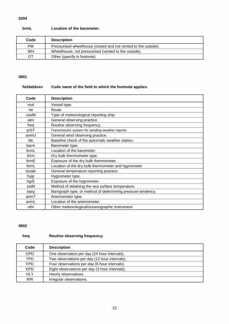
0204
brmL Location of the barometer.
Code Description
PW Pressurised wheelhouse (closed and not vented to the outside). WH Wheelhouse, not pressurised (vented to the outside). OT Other (specify in footnote).
0601
fieldabbrev Code name of the field to which the footnote applies.
Code Description
vssl Vessel type. rte Route
vsslM Type of meteorological reporting ship. atm General observing practice. freq Routine observing frequency. prST Transmission system for sending weather reports anmU General wind observing practice.
blc Baseline check of the automatic weather station. barm Barometer type. brmL Location of the barometer. thrm Dry bulb thermometer type. thmE Exposure of the dry bulb thermometer. thmL Location of the dry bulb thermometer and hgyrometer tscale General temperature reporting practice. hygr Hygrometer type. hgrE Exposure of the hygrometer. sstM Method of obtaining the sea surface temperature. barg Barograph type, or method of determining pressure tendency. anmT Anemometer type. anmL Location of the anemometer. othI Other meteorological/oceanographic instrument.
0602
freq Routine observing frequency.
Code Description
OPD One observation per day (24 hour intervals). TPD Two observations per day (12 hour intervals). FPD Four observations per day (6 hour intervals). EPD Eight observations per day (3 hour intervals). HLY Hourly observations. IRR Irregular observations.

23
0801
hgrE Exposure of the hygrometer. thmE Exposure of the dry bulb thermometer.
Code Description
A Aspirated (Assmann type). S Screen (non ventilated, i.e. natural ventilation).
HH Hand-held digital temperature/humidity sensor VS Screen (ventilated, i.e. assisted ventilation). RS Radiation Shield (e.g. cylindrical / Gill multi-plate radiation shield) SN Ship's screen (property of the ship). SG Ship's sling (property of the ship). US Unscreened. W Whirling or Sling psychrometer.
0802
hygr Hygrometer type.
Code Description
C Capacitance. CM Chilled mirror. E Electric. H Hair hygrometer.
HG Hygristor. P Psychrometer. T Torsion.
OT Other (specify in footnote).

24
1501
othI Other meteorological/oceanographic instrument.
Code Description
BAT Bathythermometer. BT Bathythermograph (towed).
FLM Fluorometer. LWR Long wave radiation. MAX Maximum thermometer. MIN Minimum thermometer. NTE Nitrate sensor. NTT Nutrient sensor.
P Pilot balloon equipment. CO2 pCO2 system. PLK Plankton recorder. PRS Photosynthetic radiation sensor. PYG Pyrogeometer.
R Radiosonde equipment. RG Rain gauge.
RSD Radar storm and meteorological phenomena detection. RT Reversing thermometer.
SKY Sky camera. SLM Solarimeter. ST Sea thermograph.
SWR Short wave radiation. TSD Temperature/salinity/depth probe. TUR Turbidity sensor. W Radiowind or radarwind equipment.
WR Wave Recorder XBT Expendable bathythermograph. OT Other (specify in footnote).

25
1601
prST Transmission system for sending weather reports.
Code Description
Cos
ts b
orne
by
the
ship
SVCE Voice (ship). The observation is sent to a NMS through the telephone network. The communication may use Inmarsat, Iridium, Vsat, VHF
SMAI Email (ship). The observation is sent to a NMS through an email. The WMO message is attached to this email. The satellite communication provider may be Inmarsat, Iridium, Vsat
SWEB Web (ship). The observation is sent through the Web (example: TurboWeb). The satellite communication provider may be Inmarsat, Iridium, Vsat
Con
vent
iona
l VO
S
CT41 Inmarsat-C (FM13, SAC41). Standard procedure used to report observations (FM13 messages) from conventional VOS for many years. Collect call system: the NMS which receives the observations pays the communication costs
CTX Inmarsat-C (FM13, other SAC). FM13 messages are sent to a dedicated SAC (other than SAC41) established at one, or more LES. In general, communications are paid by the country who recruited the ship
CTH Inmarsat-C (EUHC). Text messages containing compressed data (E-SURFMAR format) are sent ashore through Inmarsat-C to a dedicated SAC and LES. Communications are paid by the country who recruited the ship
CDS Inmarsat-C (SEAS). SEAS binary messages sent through Inmarsat-C Data Mode to a dedicated SAC and LES. Communications are paid by NOAA/NWS
Ship
boar
d A
utom
atic
Wea
ther
Sta
tions
AIS Automated Identification System (direct or through satellite)
ARG Argos system
TDUP Cellular (Dial-up). Dial-up communication using terrestrial wireless networks (GSM, GPRS)
TSMS Cellular (SMS). SMS sent through terrestrial wireless networks (GSM, GPRS)
GBS Globalstar communication system
GMS GMS (DCP). Data Collecting Platform of Geostationary Meteorological Satellites
ISBD Iridium (SBD). Short Burst Data service of Iridium communication system
IMAI Iridium (Email). Email sent through Iridium (e.g. Easymail)
IDUP Iridium (Dial-up). Dial-up communication using Iridium
CDM Inmarsat-C (Data Mode). Data Mode service of Inmarsat-C used by S-AWS. See above for SEAS which also uses this service for conventional VOS
CMAI Inmarsat-C (Email). Email sent through Inmarsat-C
ORBC Orbcomm communication system
VMAI Vsat (Email). Email sent through Vsat
VDUP Vsat (Dial-up). Dial-up communication using Vsat
DMO Delayed Mode only
OT Other (specify in footnote).

26
1801 (Source: IS0 3166-1, 2 June 2008)
rcnty Recruiting country. reg Country of registration.
Code Description
AF AFGHANISTAN AX ÅLAND ISLANDS AL ALBANIA DZ ALGERIA AS AMERICAN SAMOA AD ANDORRA AO ANGOLA AI ANGUILLA AQ ANTARCTICA AG ANTIGUA AND BARBUDA AR ARGENTINA AM ARMENIA AW ARUBA AU AUSTRALIA AT AUSTRIA AZ AZERBAIJAN BS BAHAMAS BH BAHRAIN BD BANGLADESH BB BARBADOS BY BELARUS BE BELGIUM BZ BELIZE BJ BENIN BM BERMUDA BT BHUTAN BO BOLIVIA BA BOSNIA AND HERZEGOVINA BW BOTSWANA BV BOUVET ISLAND BR BRAZIL IO BRITISH INDIAN OCEAN TERRITORY BN BRUNEI DARUSSALAM BG BULGARIA BF BURKINA FASO BI BURUNDI KH CAMBODIA CM CAMEROON CA CANADA CV CAPE VERDE KY CAYMAN ISLANDS CF CENTRAL AFRICAN REPUBLIC TD CHAD CL CHILE CN CHINA CX CHRISTMAS ISLAND CC COCOS (KEELING) ISLANDS CO COLOMBIA KM COMOROS

27
CG CONGO CD CONGO, THE DEMOCRATIC REPUBLIC OF THE CK COOK ISLANDS CR COSTA RICA CI CÖTE D'IVOIRE HR CROATIA CU CUBA CY CYPRUS CZ CZECH REPUBLIC DK DENMARK DJ DJIBOUTI DM DOMINICA DO DOMINICAN REPUBLIC EC ECUADOR EG EGYPT SV EL SALVADOR GQ EQUATORIAL GUINEA ER ERITREA EE ESTONIA ET ETHIOPIA FK FALKLAND ISLANDS (MALVINAS) FO FAROE ISLANDS FJ FIJI FI FINLAND FR FRANCE GF FRENCH GUIANA PF FRENCH POLYNESIA TF FRENCH SOUTHERN TERRITORIES GA GABON GM GAMBIA GE GEORGIA DE GERMANY GH GHANA GI GIBRALTAR GR GREECE GL GREENLAND GD GRENADA GP GUADELOUPE GU GUAM GT GUATEMALA GG GUERNSEY GN GUINEA GW GUINEA-BISSAU GY GUYANA HT HAITI HM HEARD ISLAND AND MCDONALD ISLANDS VA HOLY SEE (VATICAN CITY STATE) HN HONDURAS HK HONG KONG HU HUNGARY IS ICELAND IN INDIA ID INDONESIA IR IRAN, ISLAMIC REPUBLIC OF IQ IRAQ
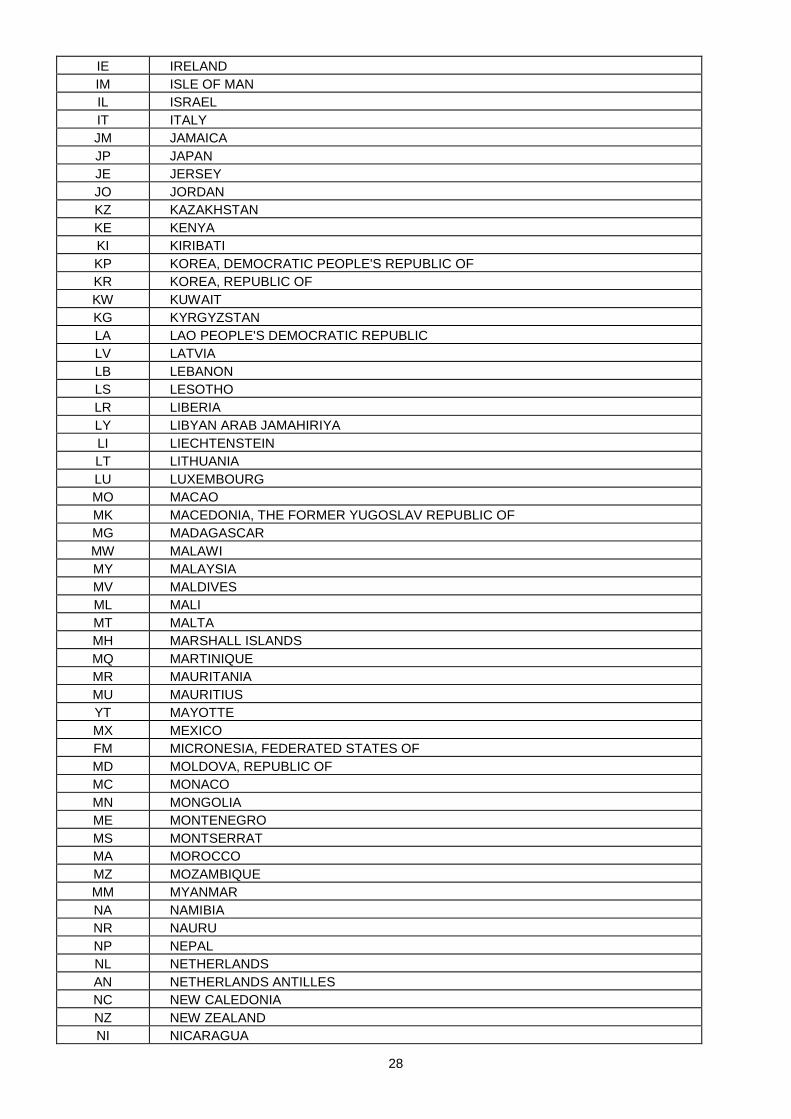
28
IE IRELAND IM ISLE OF MAN IL ISRAEL IT ITALY JM JAMAICA JP JAPAN JE JERSEY JO JORDAN KZ KAZAKHSTAN KE KENYA KI KIRIBATI KP KOREA, DEMOCRATIC PEOPLE'S REPUBLIC OF KR KOREA, REPUBLIC OF KW KUWAIT KG KYRGYZSTAN LA LAO PEOPLE'S DEMOCRATIC REPUBLIC LV LATVIA LB LEBANON LS LESOTHO LR LIBERIA LY LIBYAN ARAB JAMAHIRIYA LI LIECHTENSTEIN LT LITHUANIA LU LUXEMBOURG MO MACAO MK MACEDONIA, THE FORMER YUGOSLAV REPUBLIC OF MG MADAGASCAR MW MALAWI MY MALAYSIA MV MALDIVES ML MALI MT MALTA MH MARSHALL ISLANDS MQ MARTINIQUE MR MAURITANIA MU MAURITIUS YT MAYOTTE MX MEXICO FM MICRONESIA, FEDERATED STATES OF MD MOLDOVA, REPUBLIC OF MC MONACO MN MONGOLIA ME MONTENEGRO MS MONTSERRAT MA MOROCCO MZ MOZAMBIQUE MM MYANMAR NA NAMIBIA NR NAURU NP NEPAL NL NETHERLANDS AN NETHERLANDS ANTILLES NC NEW CALEDONIA NZ NEW ZEALAND NI NICARAGUA

29
NE NIGER NG NIGERIA NU NIUE NF NORFOLK ISLAND MP NORTHERN MARIANA ISLANDS NO NORWAY OM OMAN PK PAKISTAN PW PALAU PS PALESTINIAN TERRITORY, OCCUPIED PA PANAMA PG PAPUA NEW GUINEA PY PARAGUAY PE PERU PH PHILIPPINES PN PITCAIRN PL POLAND PT PORTUGAL PR PUERTO RICO QA QATAR RE REUNION RO ROMANIA RU RUSSIAN FEDERATION RW RWANDA BL SAINT BARTHÉLEMY SH SAINT HELENA KN SAINT KITTS AND NEVIS LC SAINT LUCIA MF SAINT MARTIN PM SAINT PIERRE AND MIQUELON VC SAINT VINCENT AND THE GRENADINES WS SAMOA SM SAN MARINO ST SAO TOME AND PRINCIPE SA SAUDI ARABIA SN SENEGAL RS SERBIA SC SEYCHELLES SL SIERRA LEONE SG SINGAPORE SK SLOVAKIA SI SLOVENIA SB SOLOMON ISLANDS SO SOMALIA ZA SOUTH AFRICA GS SOUTH GEORGIA AND THE SOUTH SANDWICH ISLANDS ES SPAIN LK SRI LANKA SD SUDAN SR SURINAME SJ SVALBARD AND JAN MAYEN SZ SWAZILAND SE SWEDEN CH SWITZERLAND SY SYRIAN ARAB REPUBLIC

30
TW TAIWAN, PROVINCE OF CHINA TJ TAJIKISTAN TZ TANZANIA, UNITED REPUBLIC OF TH THAILAND TL TIMOR-LESTE TG TOGO TK TOKELAU TO TONGA TT TRINIDAD AND TOBAGO TN TUNISIA TR TURKEY TM TURKMENISTAN TC TURKS AND CAICOS ISLANDS TV TUVALU UG UGANDA UA UKRAINE AE UNITED ARAB EMIRATES GB UNITED KINGDOM US UNITED STATES UM UNITED STATES MINOR OUTLYING ISLANDS UY URUGUAY UZ UZBEKISTAN VU VANUATU VE VENEZUELA VN VIET NAM VG VIRGIN ISLANDS, BRITISH VI VIRGIN ISLANDS, U.S.
WF WALLIS AND FUTUNA EH WESTERN SAHARA YE YEMEN ZM ZAMBIA ZW ZIMBABWE ZZ THIRD PARTY SUPPORT SHIPS
31
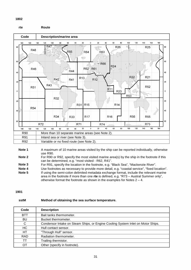
1802
rte Route
Code Description/marine area
R90 More than 10 separate marine areas (see Note 2). R91 Inland sea or river (see Note 3). R92 Variable or no fixed route (see Note 2).
Note 1 A maximum of 10 marine areas visited by the ship can be reported individually, otherwise
use R90.
Note 2 For R90 or R92, specify the most visited marine area(s) by the ship in the footnote if this can be determined, e.g. “most visited - R62, R41”.
Note 3 For R91, specify the location in the footnote, e.g. “Black Sea”, “Mackenzie River”. Note 4 Use footnotes as necessary to provide more detail, e.g. “coastal service”, “fixed location”. Note 5 If using the semi-colon delimited metadata exchange format, include the relevant marine
area in the footnote if more than one rte is defined, e.g. “R73 – Austral Summer only”, otherwise format the footnote as shown in the examples for Notes 2 – 4.
1901
sstM Method of obtaining the sea surface temperature.
Code Description
BTT Bait tanks thermometer. BU Bucket thermometer. C Condensor Intake on Steam Ships, or Engine Cooling System Inlet on Motor Ships.
HC Hull contact sensor. HT "Through Hull" sensor.
RAD Radiation thermometer. TT Trailing thermistor. OT Other (specify in footnote).

32
2001
thmL Location of the dry bulb thermometer and hgyrometer
Code Description
1 Bridge wing port. 2 Bridge wing starboard. 3 Bridge wing both sides. 4 Bridge wing windward side. 5 Wheelhouse top port. 6 Wheelhouse top starboard. 7 Wheelhouse top both. 8 Wheelhouse top center. 9 Wheelhouse top windward side. 10 Mainmast. 11 Foremast. 12 Mast on wheelhouse top. 13 Main deck port side. 14 Main deck starboard side. 15 Main deck both sides. OT Other (specify in footnote).
2002
thrm Dry bulb thermometer type.
Code Description
ALC Alcohol thermometer. MER Dry bulb mercury thermometer. ELE Electric (resistance) thermometer.
2003
tscale General temperature reporting practice.
Code Description
1 Centigrade to tenths. 2 Half degrees centigrade. 3 Whole degree centigrade. 4 Whole degree fahrenheit. 5 Fahrenheit to tenths. 6 Dry bulb centigrade, wet bulb fahrenheit. 7 Dry bulb fahrenheit, wet bulb centigrade.
OT Other combinations or scale (specify in footnote).

33
2201
vssl Vessel type.
Code Description
BA Barges, including crane barges and tank barges. BC Bulk Carriers, including Ore/Bulk/Oil (OBO) carriers and Ore/Oil carriers. CA Cable ships. CG Coastguard cutters, patrol ships and launches.
CS Container ships, including open and closed container ships and refrigerated container ships.
DR Dredgers including bucket, hopper, grab and suction dredgers. FE Passenger ferries (carrying passengers only). FP Floating Production and Storage Units. FV Fishing Vessels including purse seiners, long liners etc., but excluding trawlers. GC General Cargo ships with one or more holds. GT Liquefied gas carriers/tankers including LNG and LPG carriers.
IC Icebreaking vessels (dedicated vessel). If the vessel fits in another category and is ice strengthened then include ‘ice strengthened’ as a footnote.
LC Livestock Carrier (dedicated ship for the carriage of livestock).
LT Liquid tankers including oil product tankers, chemical tankers and crude oil tankers (including VLCC’s and ULCC’s).
LV Light vessels. MI Mobile installations, including mobile offshore drill ships, jack-up rigs, semi-submersibles. MS Military ships. OW Ocean Weather Ships (dedicated weather ship). PI Pipe Layers. PS Passenger ships and Cruise liners. RF Ro Ro ferries (carrying passengers and laden vehicles).
RR Ro Ro cargo ships for carriage of road and/or rail vehicles and cargo, including containerised cargo.
RS Refrigerated cargo ships including banana ships.
RV Research Vessels, including oceanographic, meteorological and hydrographic research ships and seismographic research ships.
SA Large sailing vessels, including sail training vessels.
SV Support vessels including offshore support vessels, offshore supply vessels, stand-by vessels, pipe carriers, anchor handling vessels, buoy tenders (including coastguard vessels engaged solely on buoy tending duties), diving support vessels, etc.
TR Trawler fishing vessels. TU Tugs, including fire-fighting tugs, salvage tugs, pusher tugs, pilot vessels, tenders etc.
VC Vehicle Carriers: dedicated multi deck ships for the carriage of new unladen road vehicles.
YA Yachts and pleasure craft. OT Other (specify in footnote).

34
2202
vsslM Type of meteorological reporting ship.
Code Description
10
Selected Definition: A mobile ship station equipped with sufficient certified meteorological instruments for making observations, transmits regular weather reports and enters the observations in a meteorological logbook. A Selected ship should have at least a barometer, a thermometer to measure SST, a psychrometer (for AT and humidity), a barograph and possibly an anemometer.
15
Selected (AWS) Definition: an AWS system equipped with certified meteorological instruments to measure at least at least air pressure, pressure change, temperature and humidity. Optional sensors would include wind speed and direction and sea temperature measurement. The AWS may or may not have the facility for manual input of the visual elements, and transmit reports at least three hourly or more frequently. The AWS should have the facility to log the data.
30
VOSClim – VOS Climate Definition: A mobile ship station equipped with sufficient certified meteorological instruments for making observations, transmits regular and timely weather reports, enters the observations in an IMMT compliant electronic logbook including the extra VOSClim delayed-mode groups, and has a proven record of providing high quality observations. The ship should have at least a barometer, a thermometer to measure SST, a psychrometer (for AT and humidity), a barograph and possibly an anemometer. The ship should be inspected at less than six month intervals.
35
VOSClim (AWS) – VOS Climate (AWS) Definition An AWS system equipped with certified meteorological instruments to measure at least air pressure, pressure change, temperature and humidity. Optional sensors would include wind speed and direction and sea temperature measurement. The AWS may have a facility for manual input of the visual elements, and transmit reports at least three hourly or more frequently. The AWS must have the facility to log the data including the additional IMMT delayed-mode VOSClim groups. The ship should be inspected at less than six month intervals.
40 Supplementary Definition: A mobile ship station equipped with a limited number of certified meteorological instruments for making observations. It transmits regular weather reports and enters the observations in a meteorological logbook.
45 Supplementary (AWS) Definition: an AWS system equipped with a limited number of certified meteorological instruments that reports regularly. The AWS should at least measure air pressure.
70 Auxiliary Definition: A mobile ship station normally without certified meteorological instruments, which transmits in a reduced code form or in plain language, either on a routine basis or on request, in certain areas and under certain conditions.
75 Auxiliary (AWS) Definition: an AWS system using non-certified meteorological instruments and reporting regularly. The AWS should at least measure air pressure.
80 Third Party Support Definition: A mobile ship station, normally without certified meteorological instruments, which is not recruited to a Members national fleet but is recruited under country code ZZ (Table 1801).
85 Third Party Support (AWS) Definition: An AWS system, normally using non-certified meteorological instruments, which is not recruited to a Members national fleet but is recruited under country code ZZ (Table 1801).
OT Other (specify in footnote).

35
2203
vsslP Vessel digital image.
Code Description
AV Available in separate digital file (see Note 2). NA Not available. PA Photo available but not yet scanned.
Note 1 See Annex 6 for the recommended VOS and VOSClim minimum suite of digital images and drawings
Note 2 Digital image file-naming convention: “00” & “IMO Number” & “image_description” & “date”, where the date format shall be YYYYMMDD, e.g. 007417868aerial_starboard_profile_from_stern20030717.jpg

36
Annex 5
WMO-No. 47
Metadata Format Version 04
Ship’s Layout Diagram

37
Annex 6
WMO-No. 47
Metadata Format Version 04
Vessel Digital Images (Code Table 2203)
1. Recommended minimum suite of digital images/photographs
Description VOSClim Sel / Supp / Aux Exposure of screen(s) showing the location of any adjacent obstructions, over-hangings, etc Yes Yes
Exposure of anemometer (if applicable) Yes Yes
Exposure of other meteorological instruments Yes Optional
Ship’s profile – quayside or at sea if possible Yes Yes
Deck cargo stowage (if applicable) Yes Optional 2. Suggested descriptions of profile photographs
3. Suggested drawings/sketches
Description VOSClim Sel / Supp / Aux Ship’s general profile – basic sketch showing instrument location and dimensions Yes Optional
Navigational Bridge Deck/wheelhouse plan – basic sketch showing instrument location Yes Optional
General Arrangement Plan or drawing Yes Optional

38
4. Sample sketches
Navigating Bridge Deck
Wheelhouse Funnel
Port Screen
Starboard Screen
Barometer & Barograph
8 m
7.3 m
MSLL
Anemometer
35.7 m
10.3 m
14.1 m
33.9 m 31.5 m 28.8 m 26.1 m
245.2 m Hull Sensor
10.1 m
Ship’s Profile
Vent